Total solar eclipse of 11/30/0810
| Day of week: | Tuesday |
| Maximum duration of eclipse: | 01m08s |
| Maximum width of eclipse path: | 138 km |
| Saros cycle: | 84 |
| Coverage: | 100% |
| Magnitude: | 1.0139 |
| Gamma: | 0.9373 |
Wo kann man die Sonnenfinsternis vom 11/30/0810 sehen?
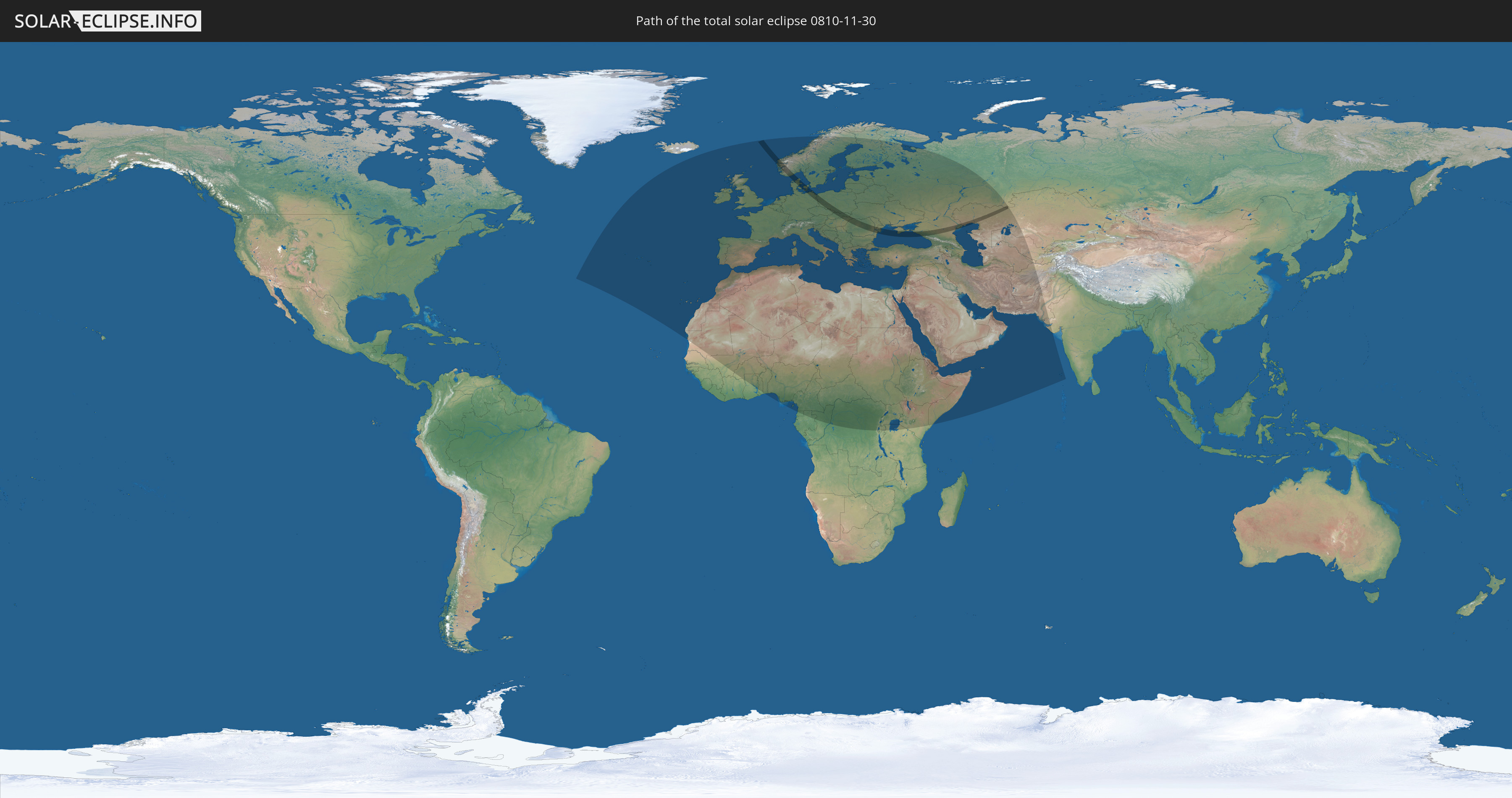
Die Sonnenfinsternis am 11/30/0810 kann man in 105 Ländern als partielle Sonnenfinsternis beobachten.
Der Finsternispfad verläuft durch 12 Länder. Nur in diesen Ländern ist sie als total Sonnenfinsternis zu sehen.
In den folgenden Ländern ist die Sonnenfinsternis total zu sehen
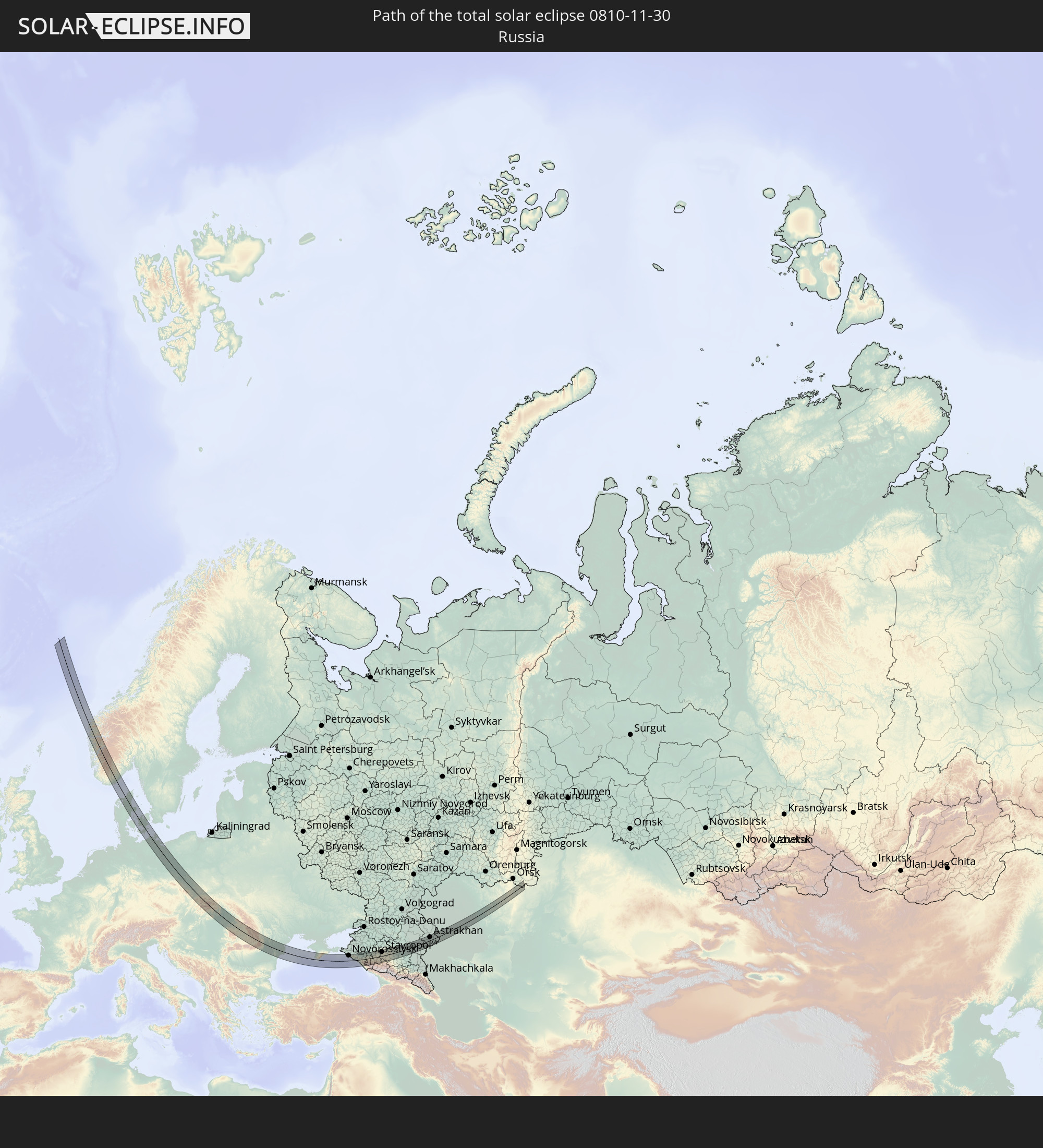 Russia
 Norway
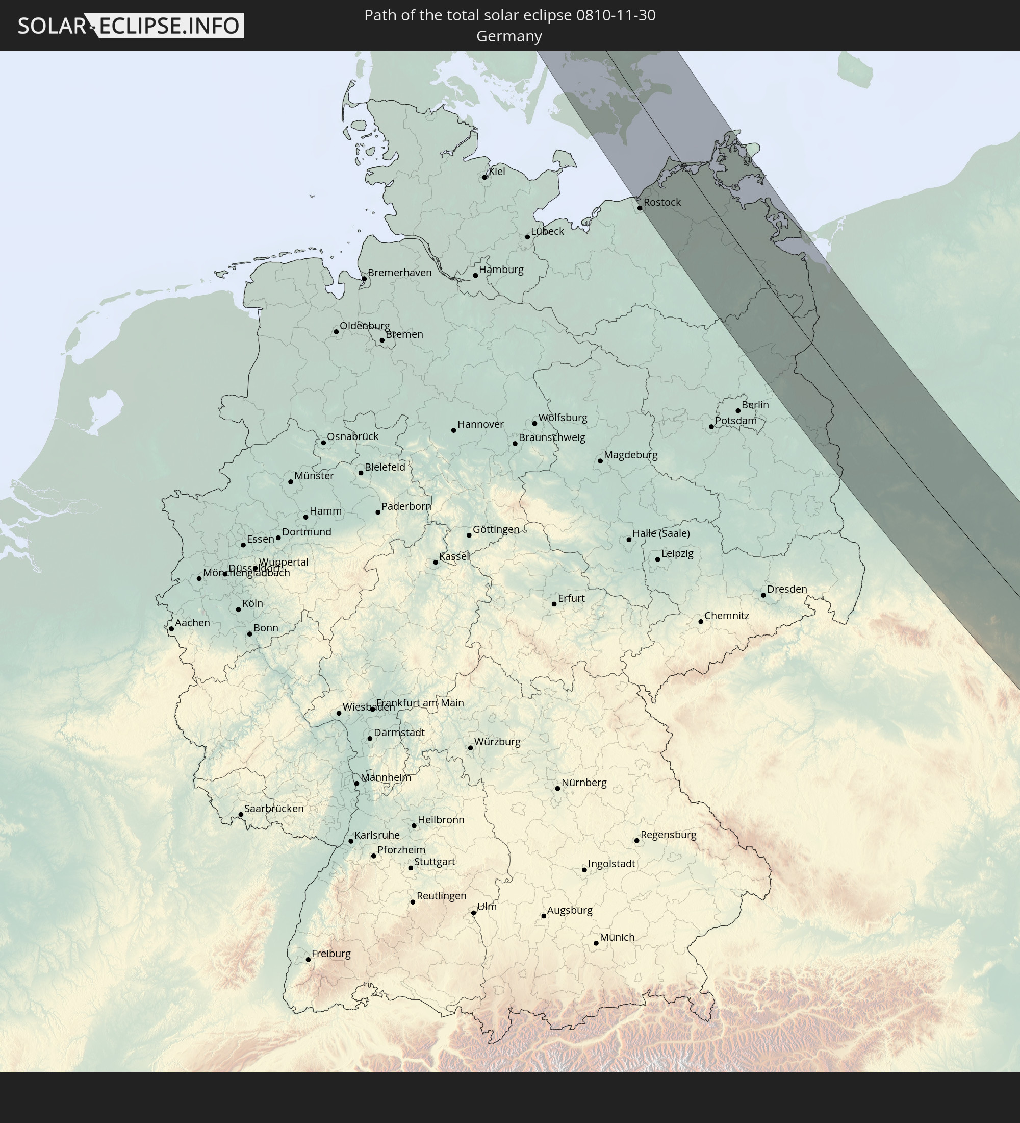 Germany
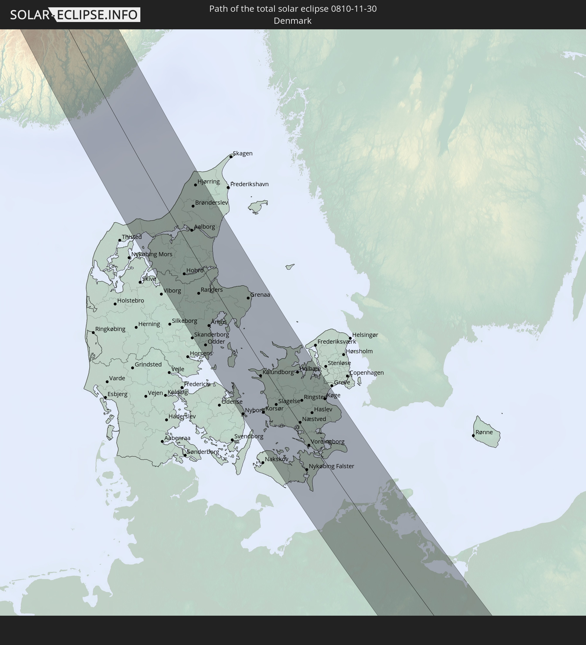 Denmark
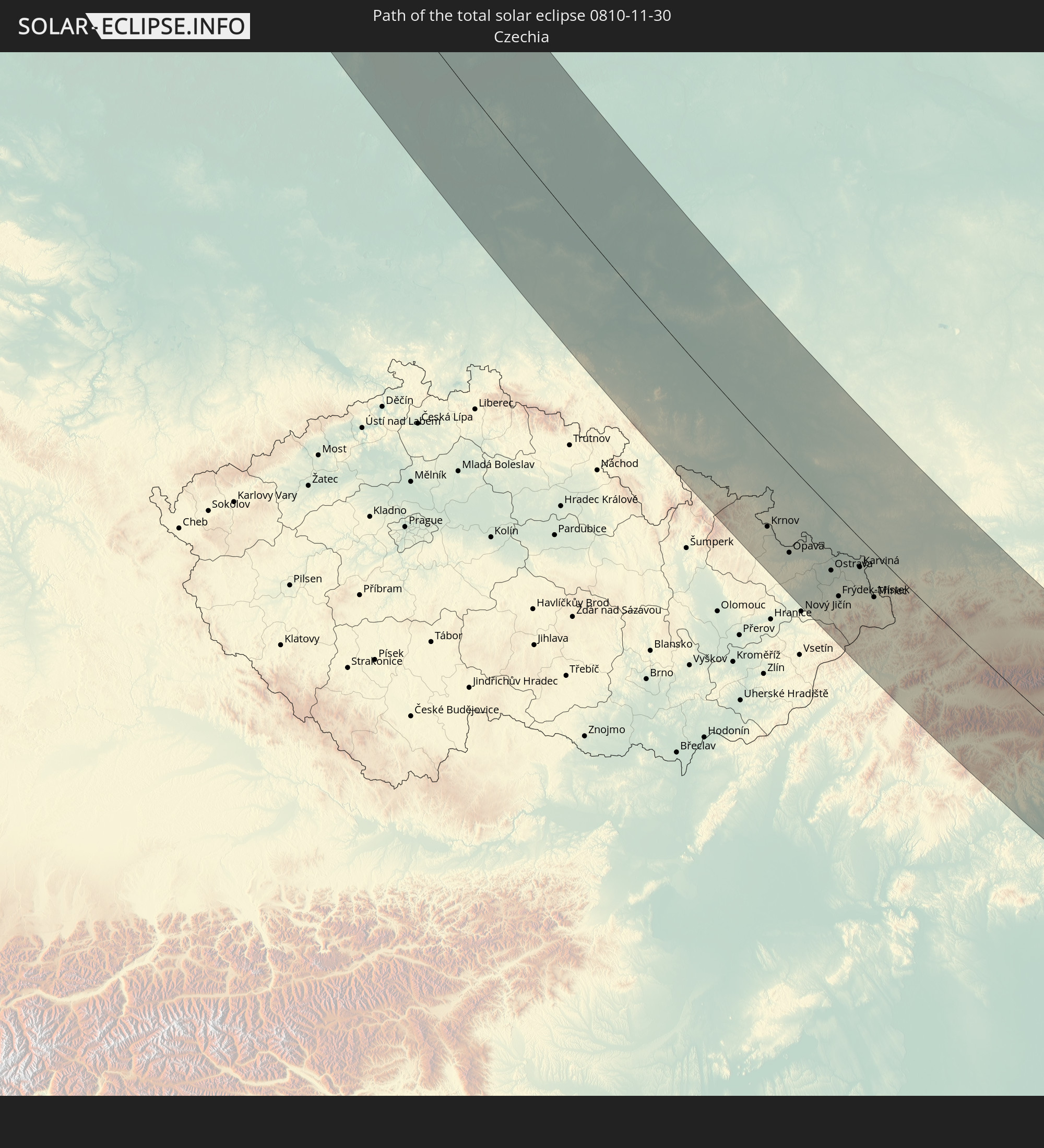 Czechia
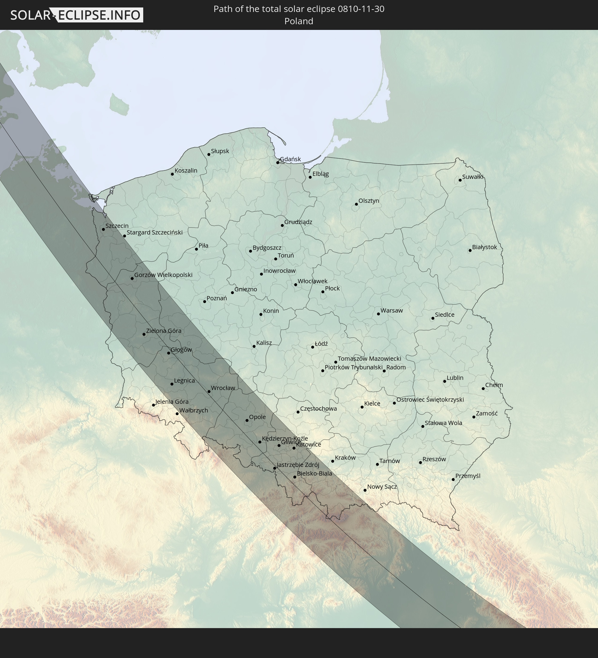 Poland
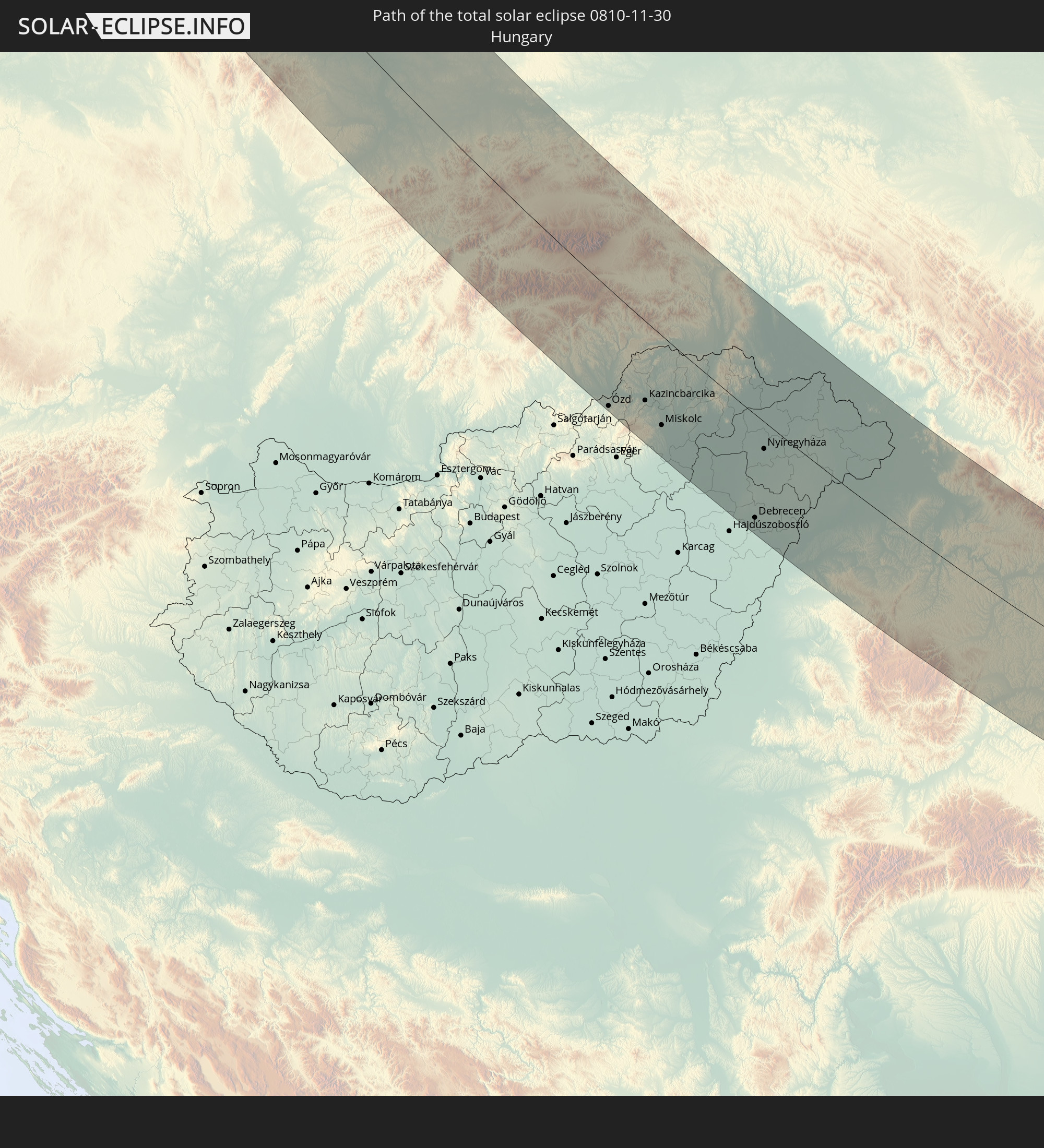 Hungary
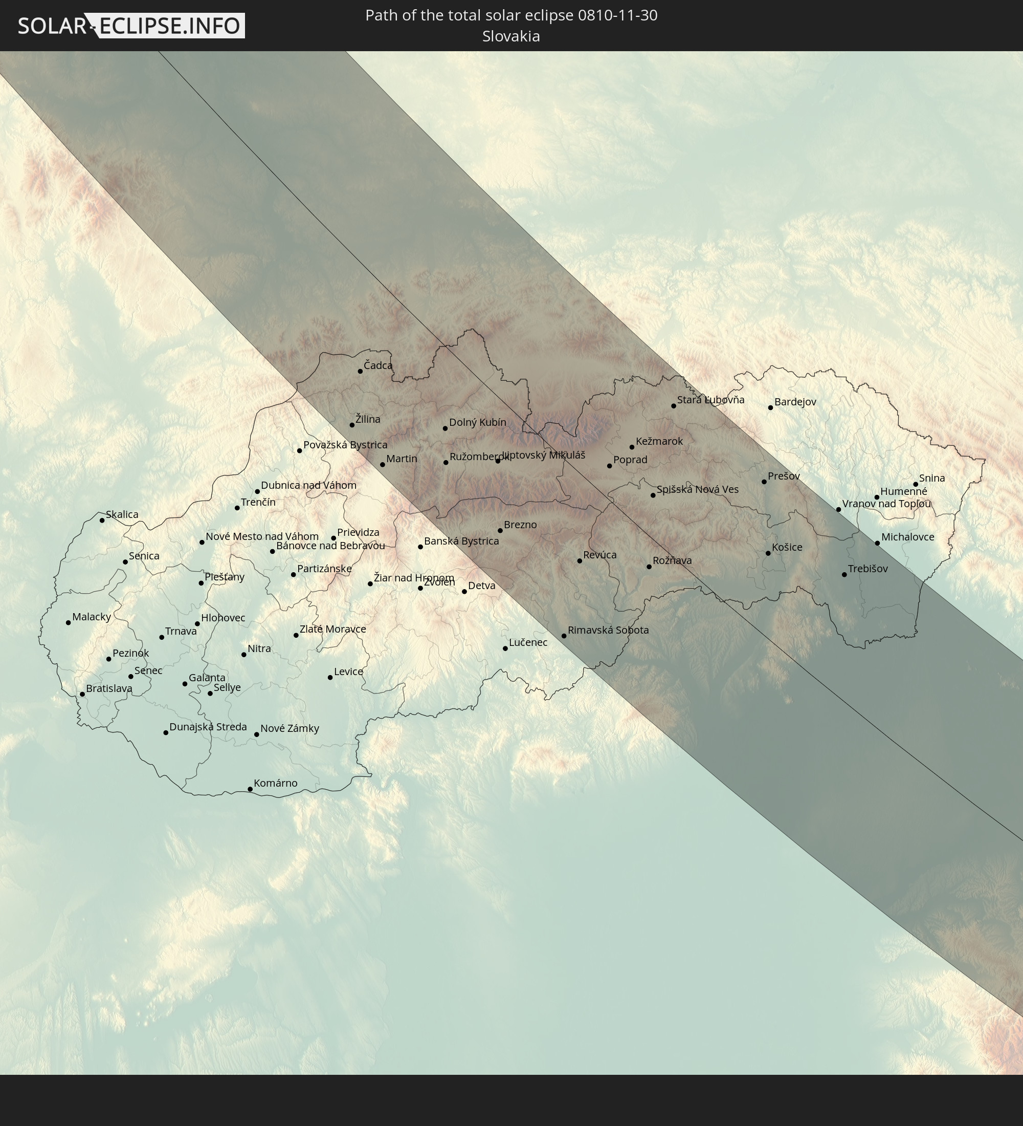 Slovakia
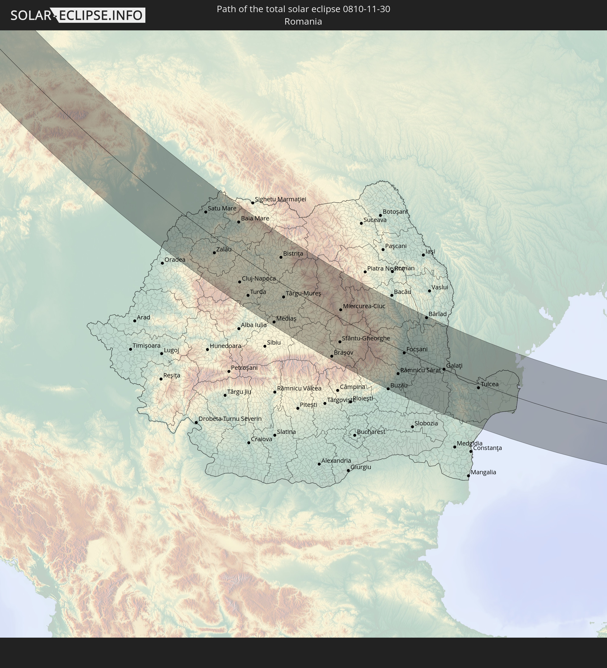 Romania
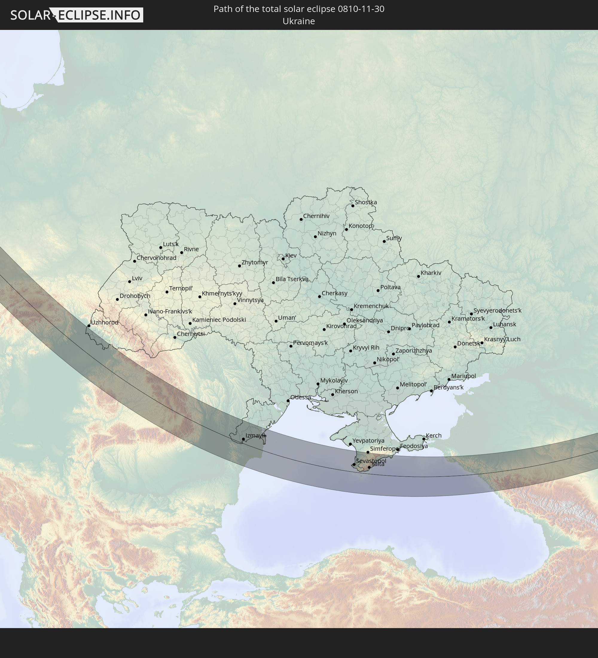 Ukraine
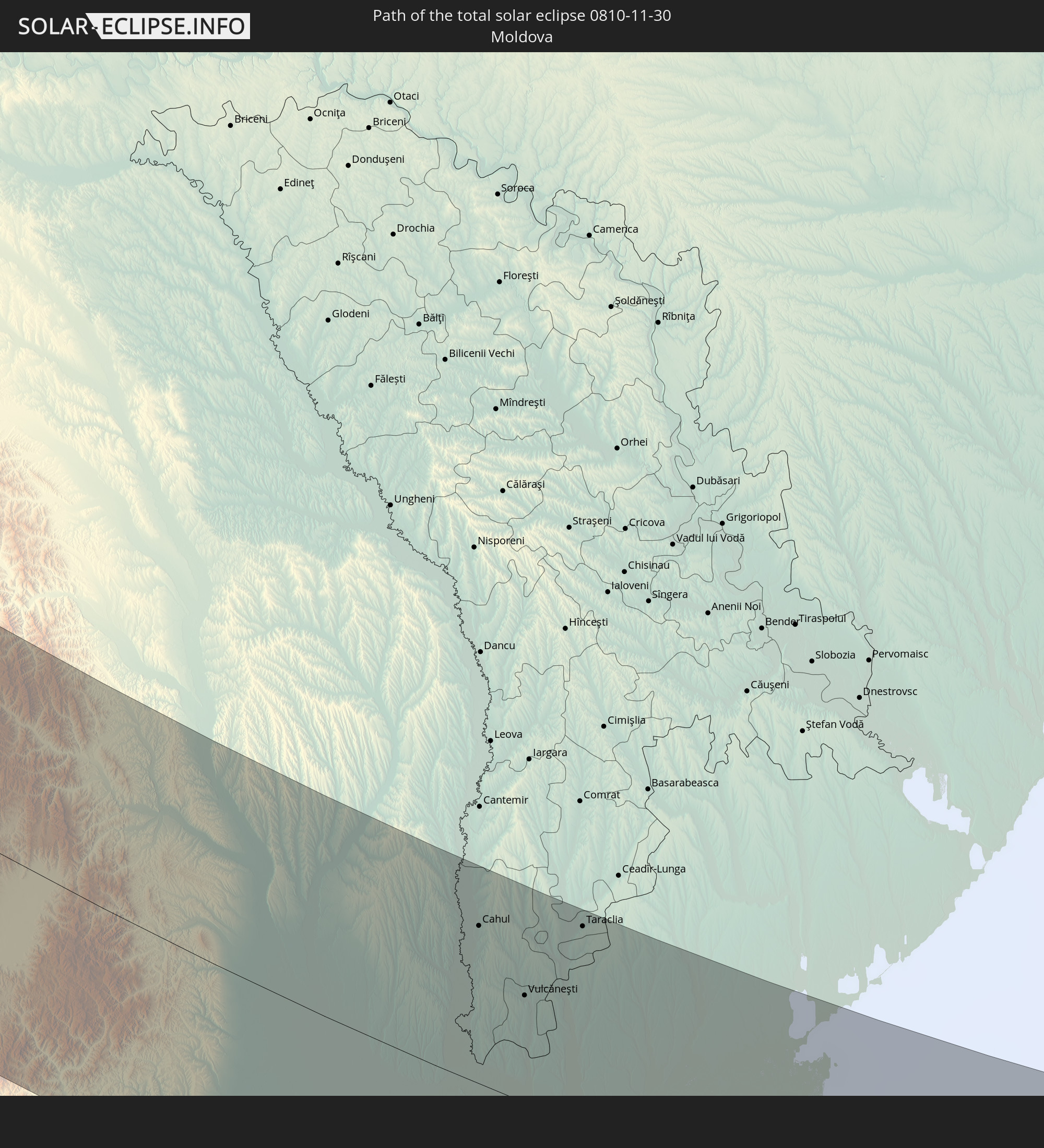 Moldova
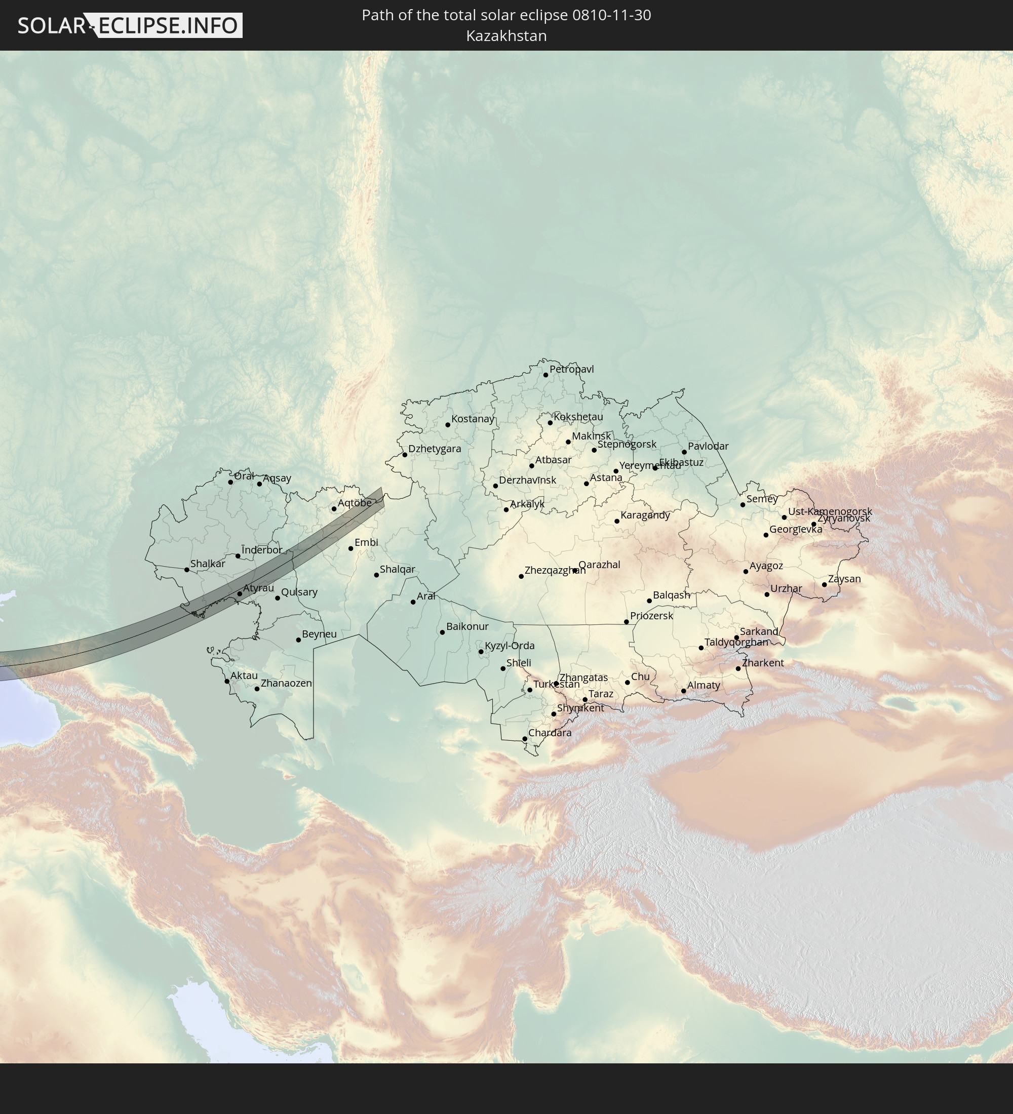 Kazakhstan
In den folgenden Ländern ist die Sonnenfinsternis partiell zu sehen
 Russia
 Portugal
 Spain
Spain
 Mauritania
 Morocco
 Mali
Mali
 Republic of Ireland
 Algeria
 United Kingdom
 Ivory Coast
 Faroe Islands
 Burkina Faso
 Gibraltar
 France
 Isle of Man
 Ghana
Ghana
 Guernsey
 Jersey
 Togo
Togo
 Niger
Niger
 Benin
Benin
 Andorra
 Belgium
 Nigeria
 Netherlands
 Norway
 Equatorial Guinea
 Luxembourg
 Germany
 Switzerland
 Italy
Italy
 Monaco
 Tunisia
 Denmark
 Cameroon
 Gabon
Gabon
 Libya
Libya
 Liechtenstein
 Austria
 Sweden
 Republic of the Congo
 Czechia
 Democratic Republic of the Congo
 San Marino
 Vatican City
 Slovenia
 Chad
Chad
 Croatia
 Poland
 Malta
Malta
 Central African Republic
 Bosnia and Herzegovina
 Hungary
 Slovakia
 Montenegro
 Serbia
 Albania
 Åland Islands
 Greece
 Romania
 Republic of Macedonia
 Finland
 Lithuania
 Latvia
 Estonia
 Sudan
Sudan
 Ukraine
 Bulgaria
 Belarus
 Egypt
Egypt
 Turkey
 Moldova
 Rwanda
 Burundi
 Tanzania
 Uganda
 Cyprus
 Ethiopia
 Kenya
Kenya
 State of Palestine
 Israel
 Saudi Arabia
 Jordan
 Lebanon
 Syria
Syria
 Eritrea
 Iraq
Iraq
 Georgia
 Somalia
 Djibouti
 Yemen
Yemen
 Armenia
 Iran
Iran
 Azerbaijan
 Kazakhstan
 Kuwait
 Bahrain
 Qatar
Qatar
 United Arab Emirates
 Oman
Oman
 Turkmenistan
 Uzbekistan
 Afghanistan
 Pakistan
 India
India
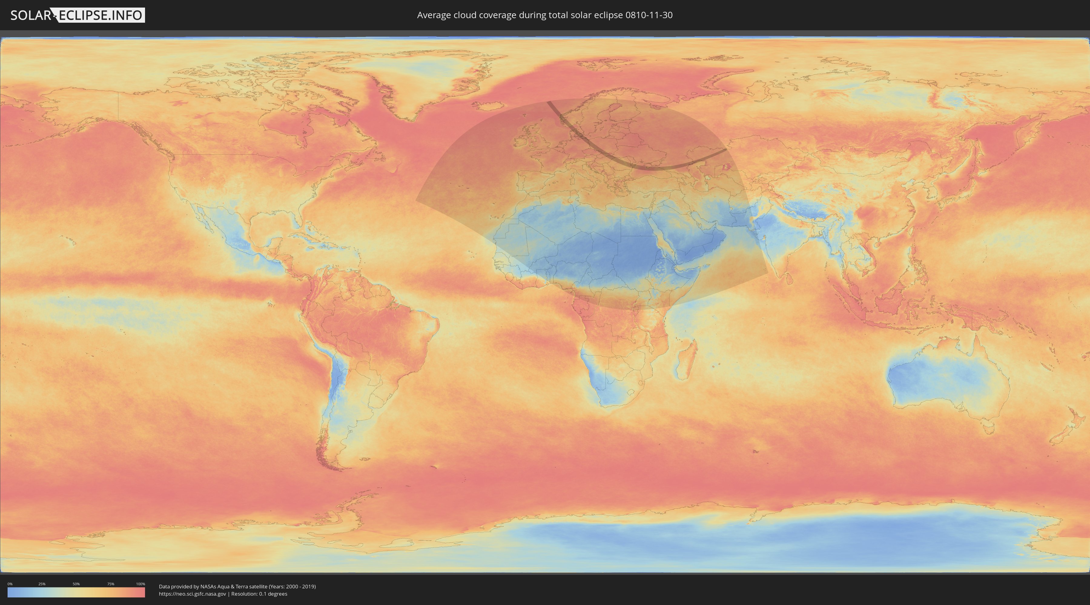
How will be the weather during the total solar eclipse on 11/30/0810?
Where is the best place to see the total solar eclipse of 11/30/0810?
The following maps show the average cloud coverage for the day of the total solar eclipse.
With the help of these maps, it is possible to find the place along the eclipse path, which has the best
chance of a cloudless sky.
Nevertheless, you should consider local circumstances and inform about the weather of your chosen
observation site.
The data is provided by NASAs satellites
AQUA and TERRA.
The cloud maps are averaged over a period of 19 years (2000 - 2019).

Detailed country maps
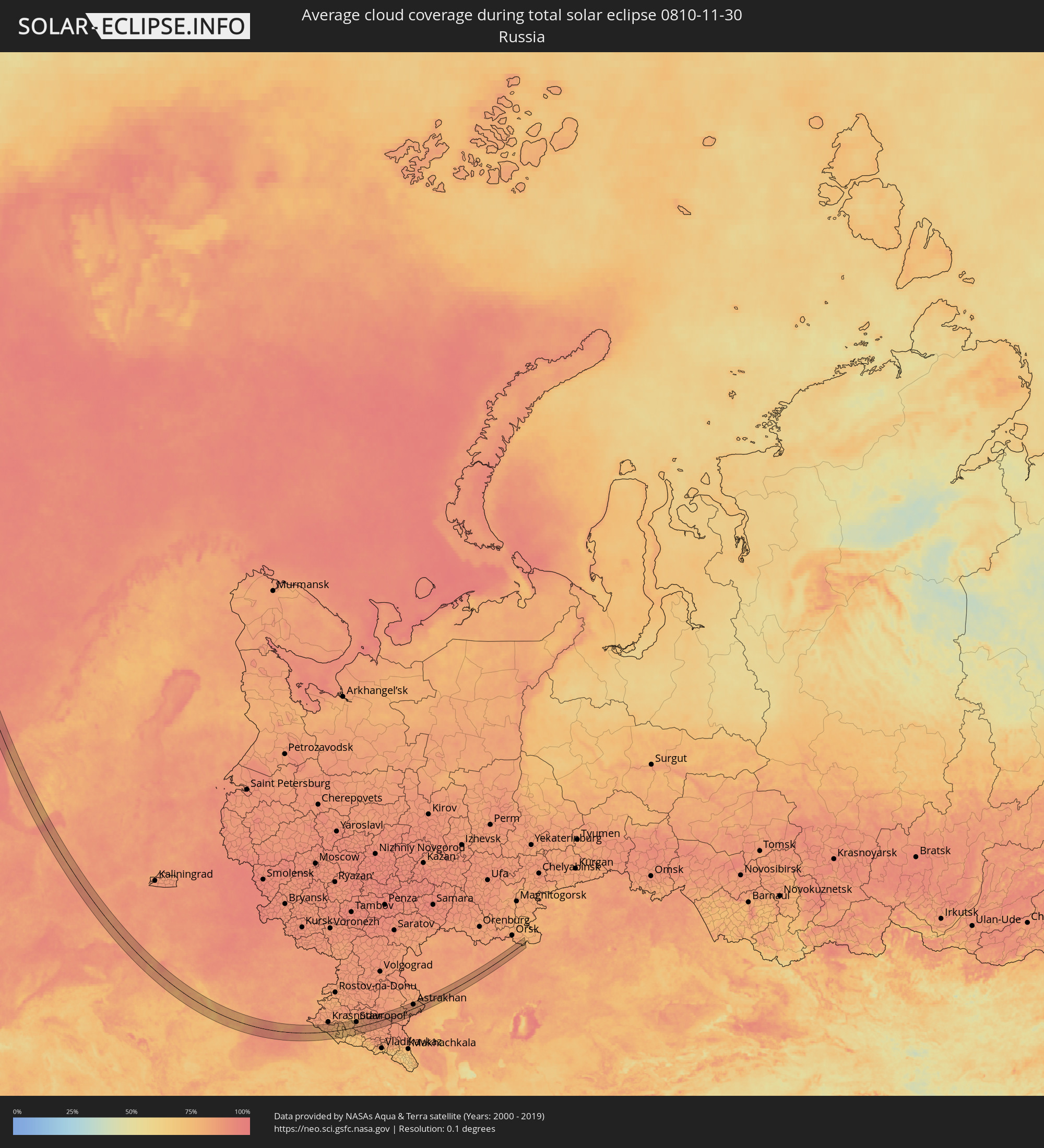 Russia
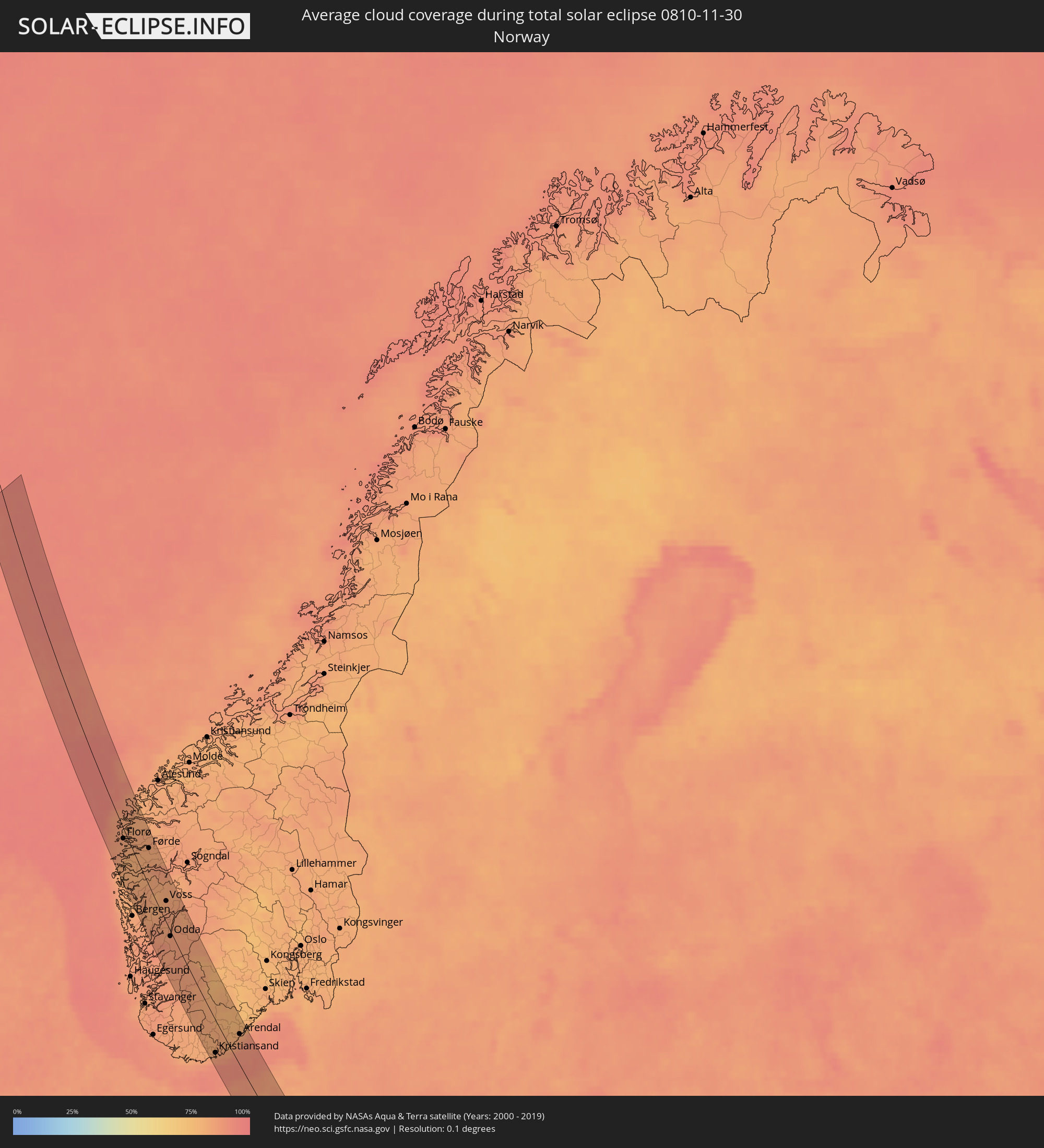 Norway
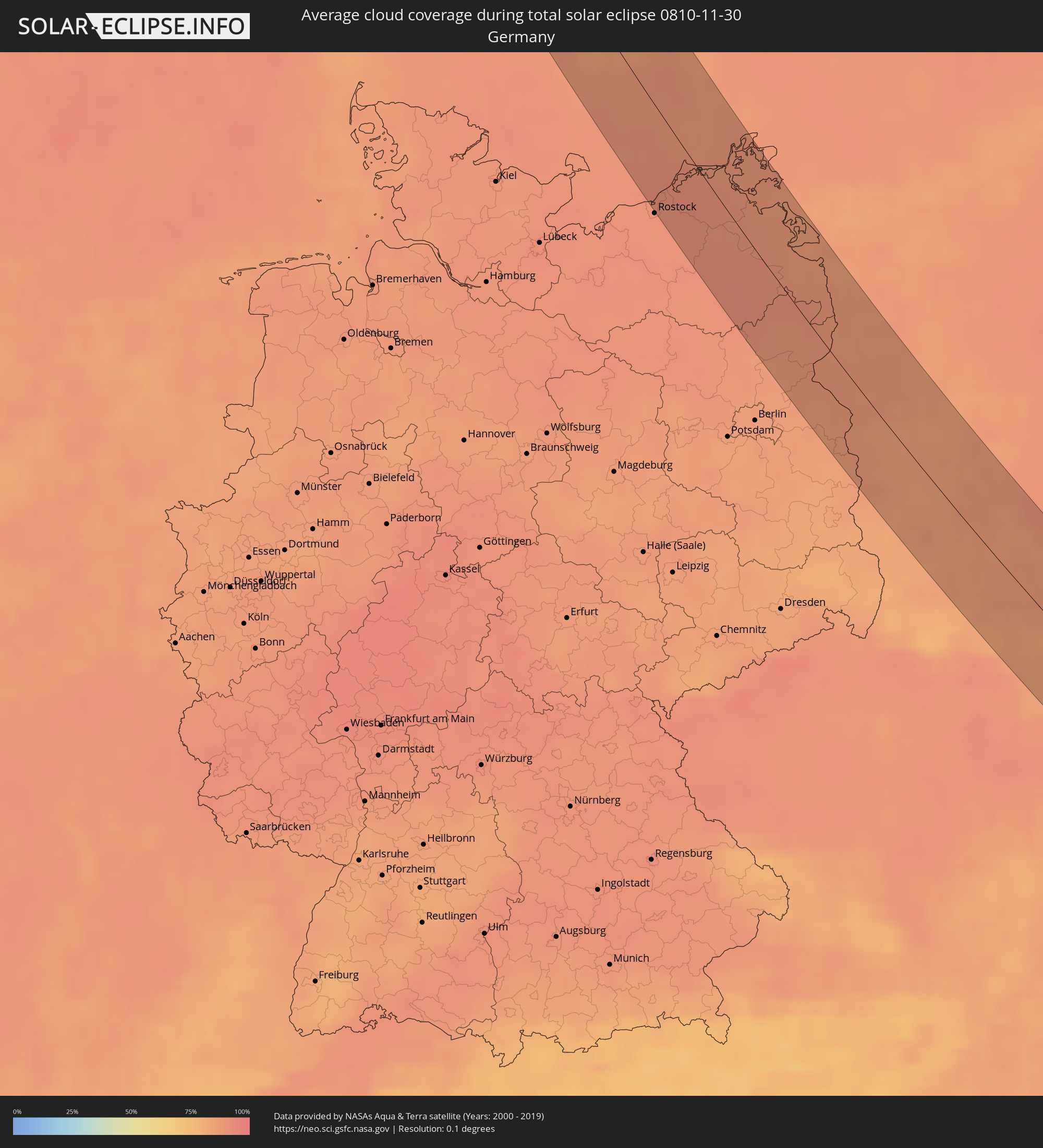 Germany
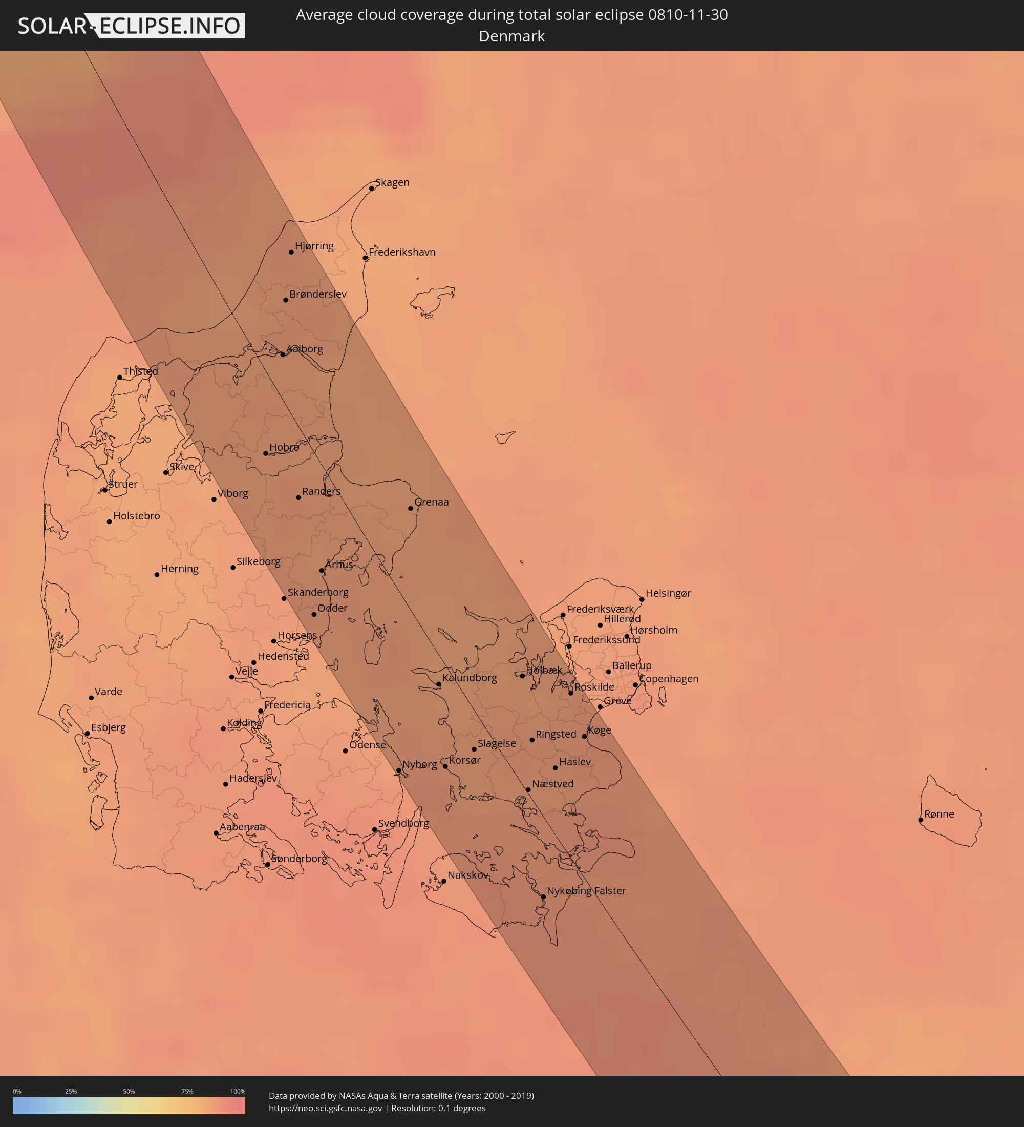 Denmark
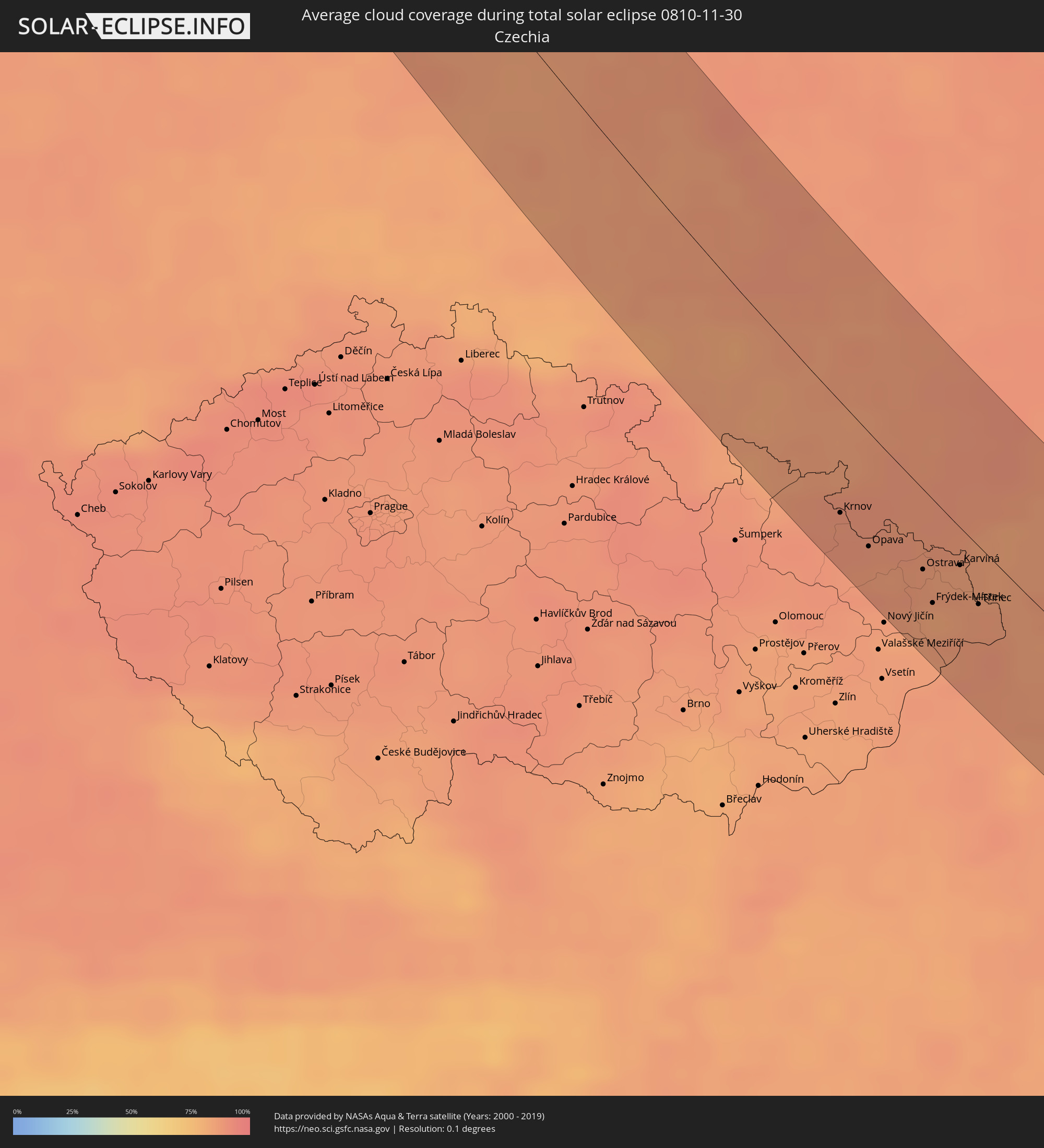 Czechia
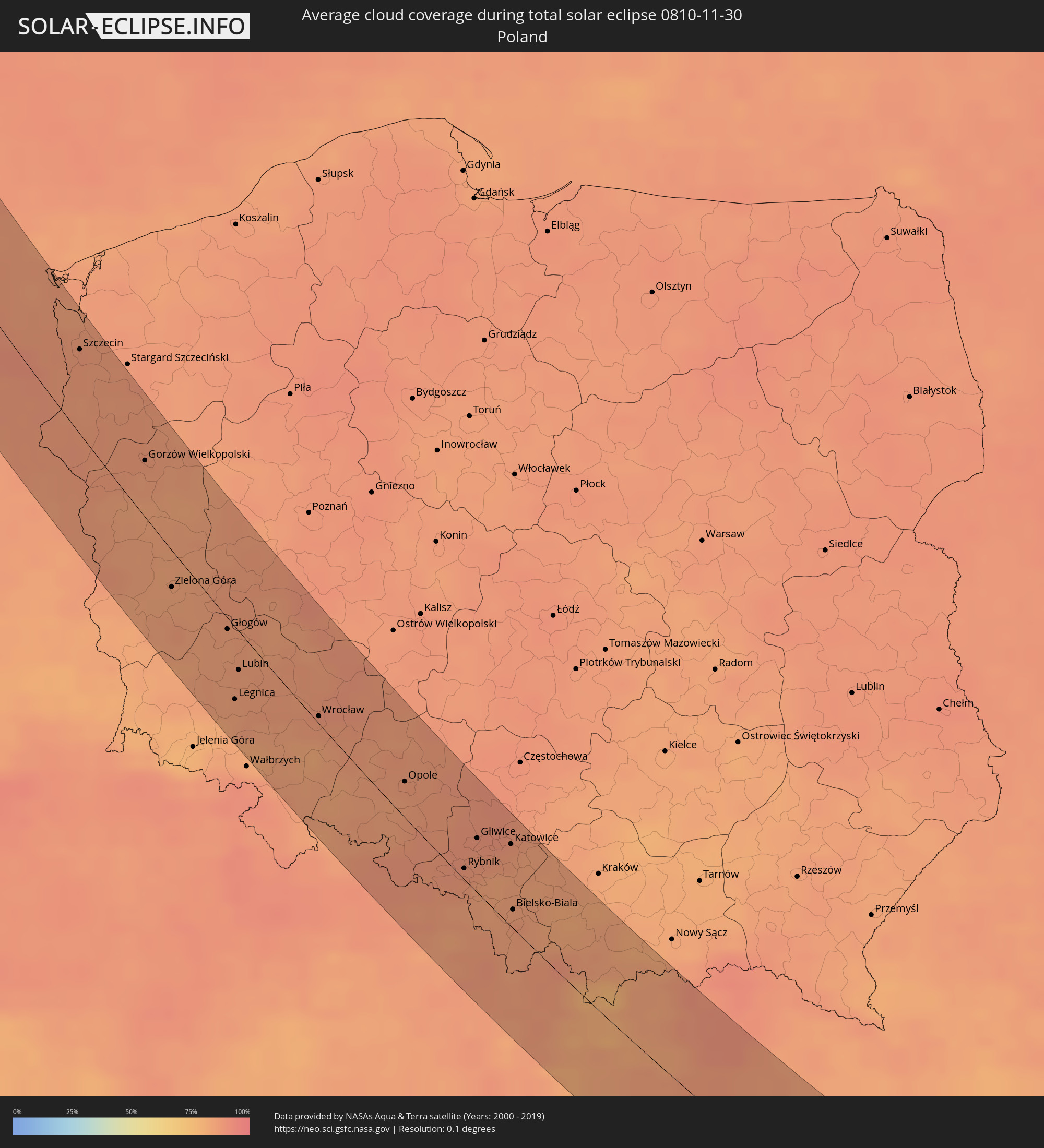 Poland
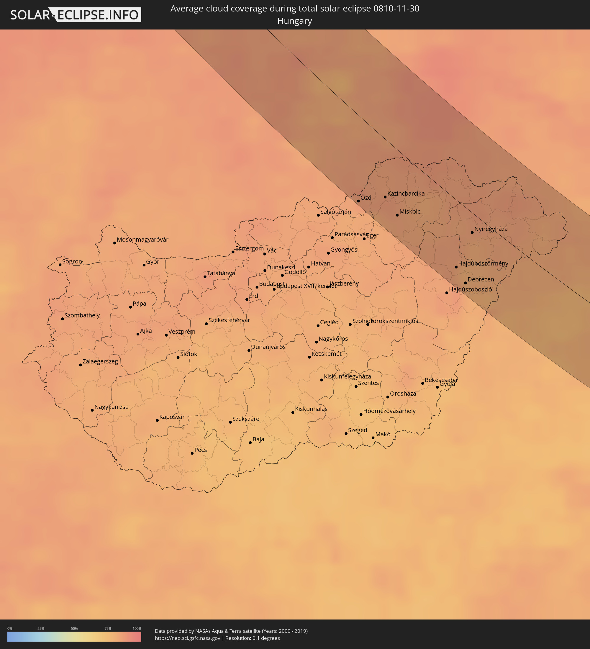 Hungary
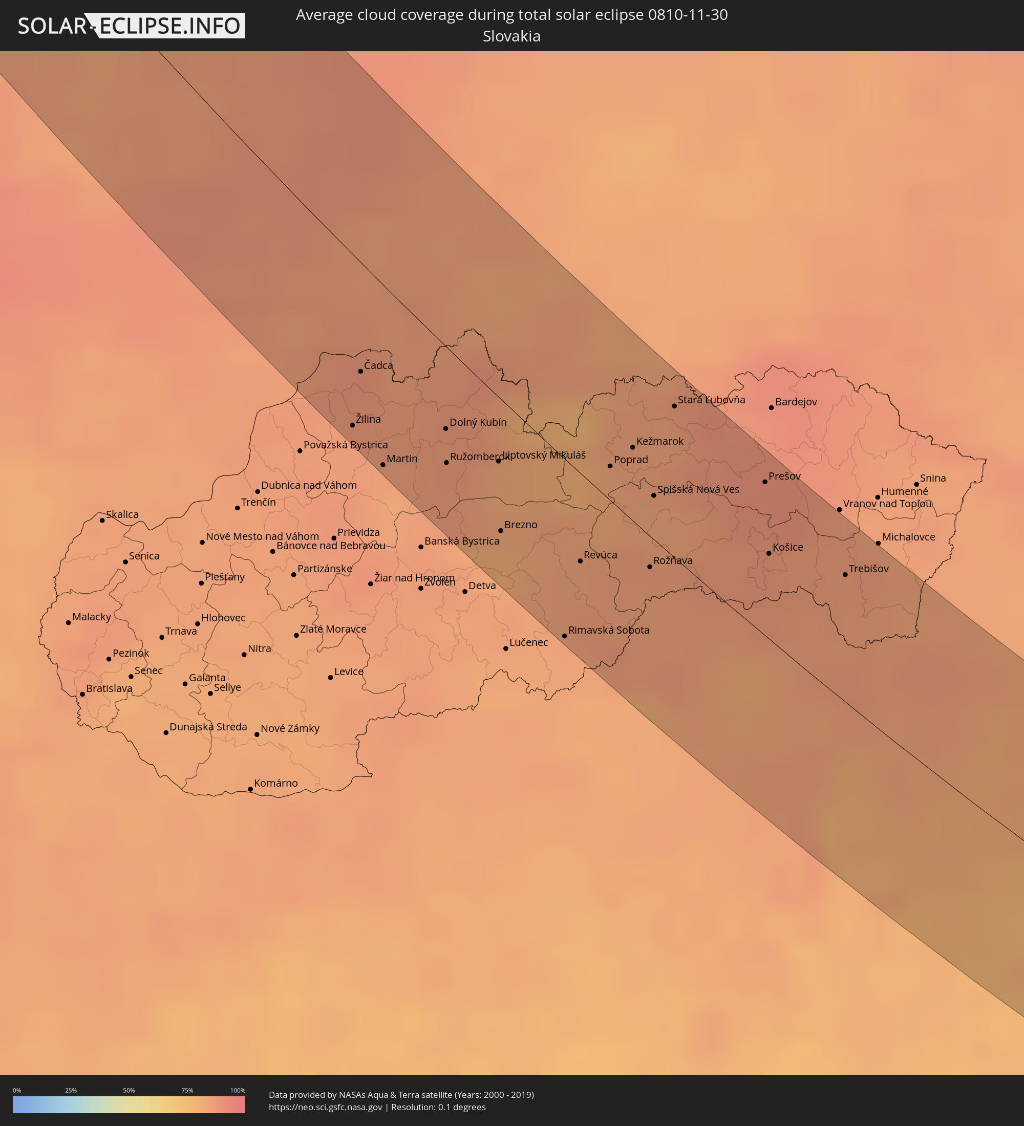 Slovakia
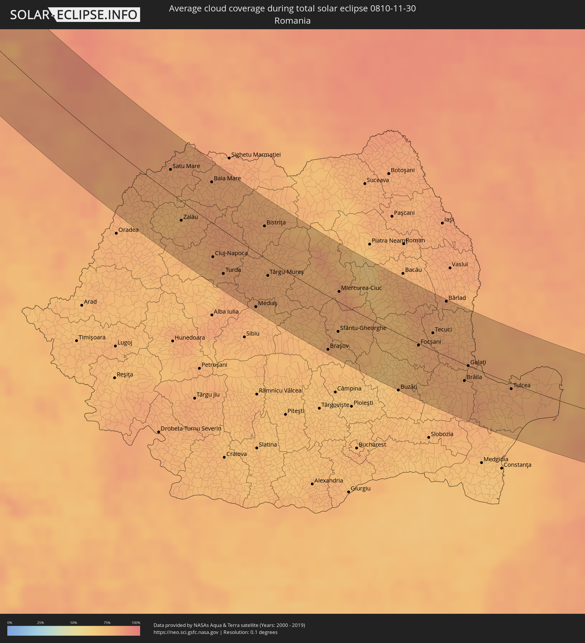 Romania
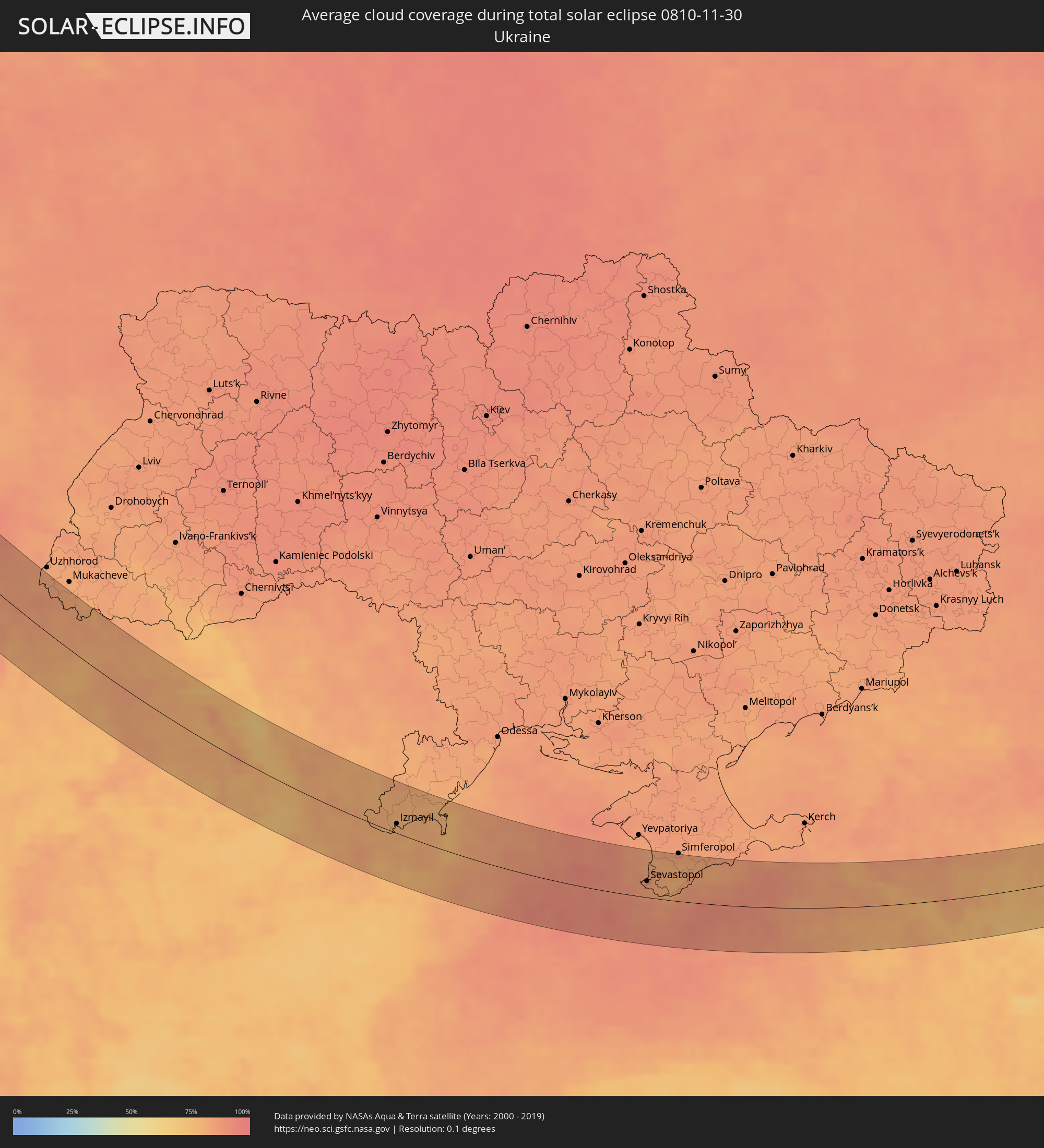 Ukraine
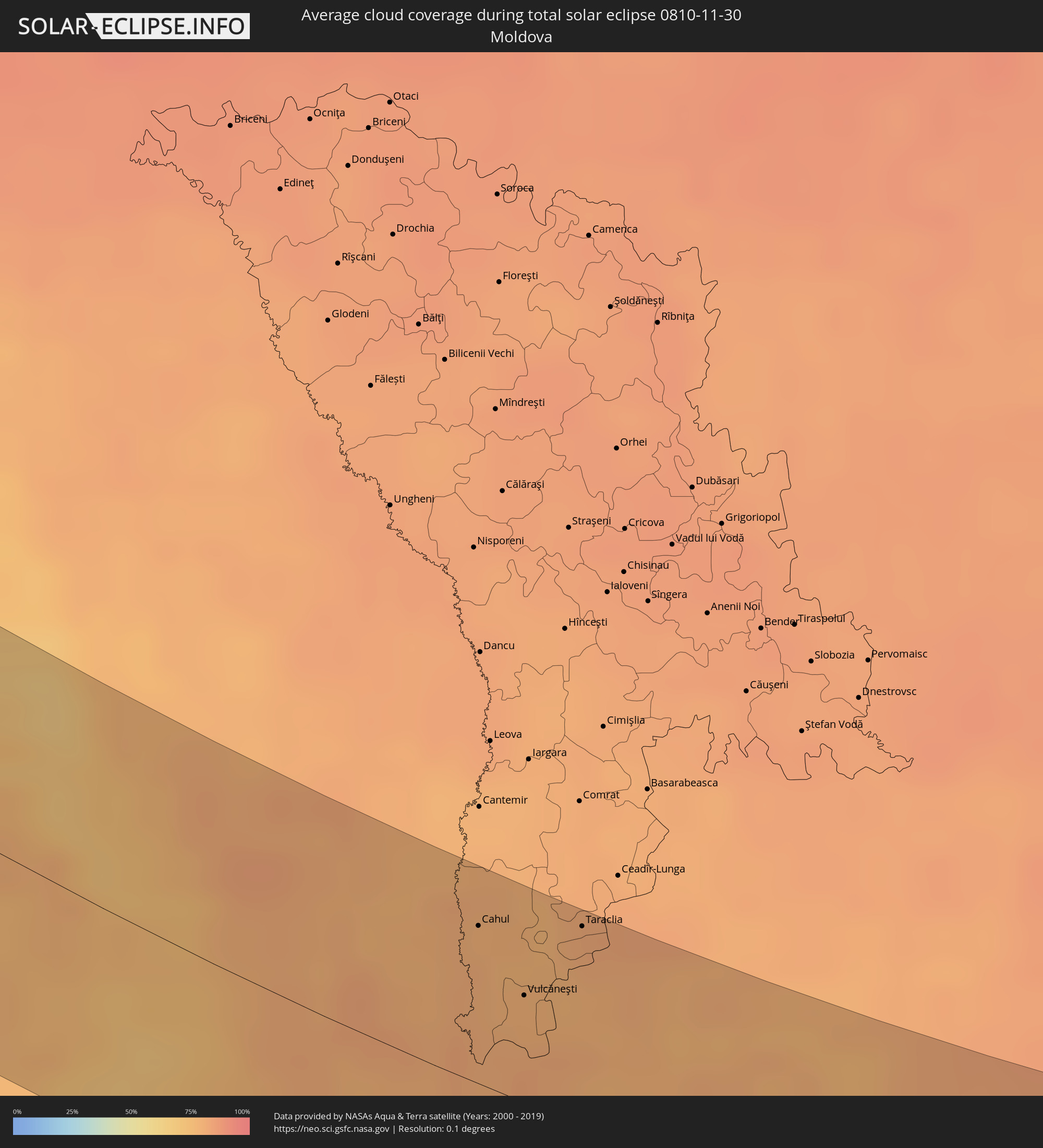 Moldova
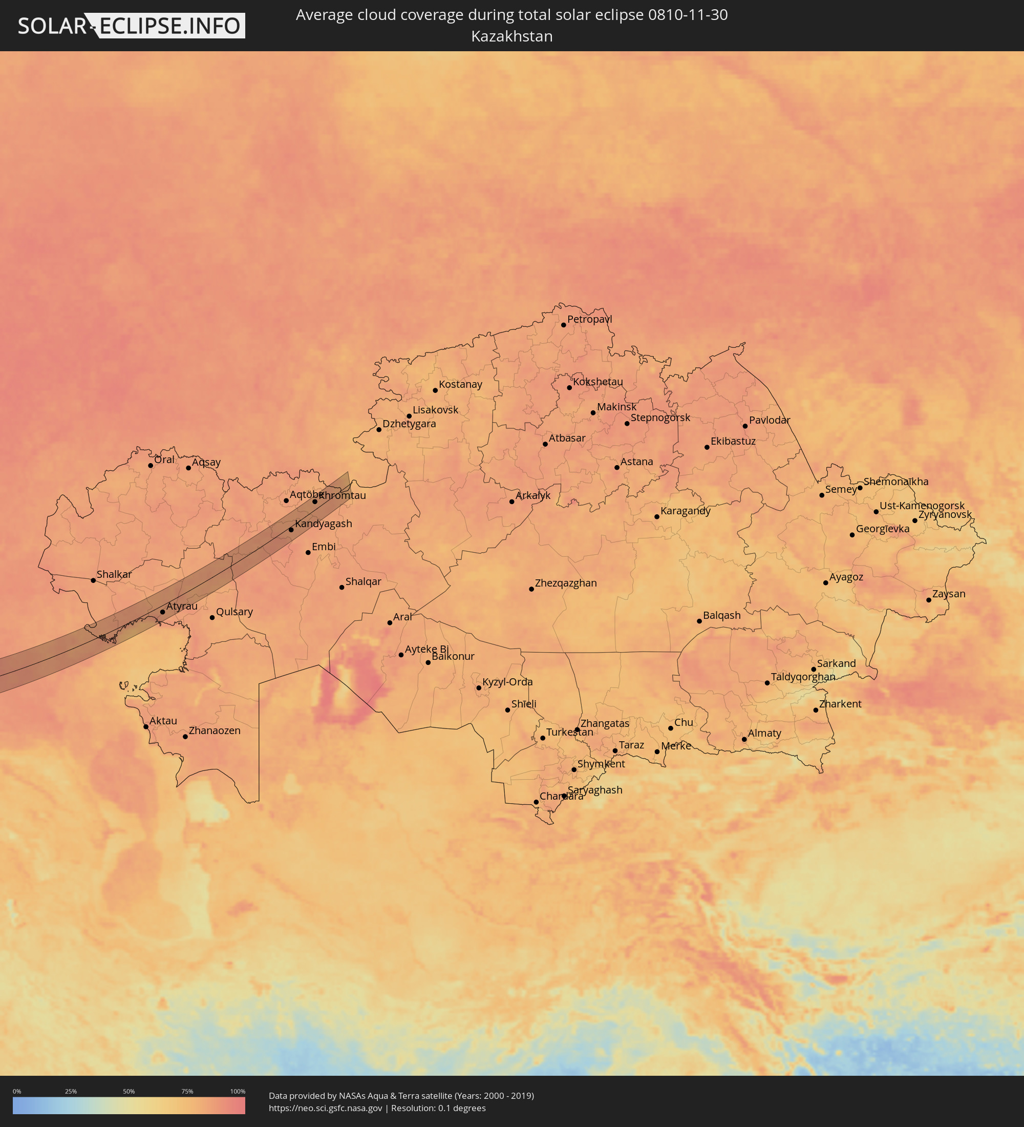 Kazakhstan
Cities inside the path of the eclipse
The following table shows all locations with a population of more than 5,000 inside the eclipse path. Cities which have more than 100,000 inhabitants are marked bold. A click at the locations opens a detailed map.
| City | Type | Eclipse duration | Local time of max. eclipse | Distance to central line | Ø Cloud coverage |
|
Florø, Sogn og Fjordane
|
total | - | 11:40:16 UTC+01:00 | 7 km | 84% |
|
Førde, Sogn og Fjordane
|
total | - | 11:41:02 UTC+01:00 | 27 km | 82% |
|
Voss, Hordaland
|
total | - | 11:41:21 UTC+01:00 | 16 km | 81% |
|
Odda, Hordaland
|
total | - | 11:41:19 UTC+01:00 | 4 km | 85% |
|
Søgne, Vest-Agder
|
total | - | 11:42:13 UTC+01:00 | 43 km | 85% |
|
Vennesla, Vest-Agder
|
total | - | 11:42:28 UTC+01:00 | 23 km | 81% |
|
Kristiansand, Vest-Agder
|
total | - | 11:42:28 UTC+01:00 | 29 km | 86% |
|
Lillesand, Aust-Agder
|
total | - | 11:42:56 UTC+01:00 | 4 km | 84% |
|
Grimstad, Aust-Agder
|
total | - | 11:43:12 UTC+01:00 | 12 km | 84% |
|
Arendal, Aust-Agder
|
total | - | 11:43:25 UTC+01:00 | 28 km | 82% |
|
Hobro, North Denmark
|
total | - | 11:44:23 UTC+01:00 | 19 km | 85% |
|
Aalborg, North Denmark
|
total | - | 11:44:35 UTC+01:00 | 11 km | 84% |
|
Brønderslev, North Denmark
|
total | - | 11:44:38 UTC+01:00 | 24 km | 86% |
|
Hjørring, North Denmark
|
total | - | 11:44:42 UTC+01:00 | 37 km | 86% |
|
Randers, Central Jutland
|
total | - | 11:44:41 UTC+01:00 | 17 km | 86% |
|
Århus, Central Jutland
|
total | - | 11:44:52 UTC+01:00 | 25 km | 85% |
|
Nyborg, South Denmark
|
total | - | 11:45:34 UTC+01:00 | 45 km | 87% |
|
Grenaa, Central Jutland
|
total | - | 11:45:44 UTC+01:00 | 25 km | 84% |
|
Kalundborg, Zealand
|
total | - | 11:45:58 UTC+01:00 | 7 km | 83% |
|
Korsør, Zealand
|
total | - | 11:46:01 UTC+01:00 | 26 km | 87% |
|
Slagelse, Zealand
|
total | - | 11:46:18 UTC+01:00 | 10 km | 85% |
|
Holbæk, Zealand
|
total | - | 11:46:46 UTC+01:00 | 28 km | 84% |
|
Næstved, Zealand
|
total | - | 11:46:50 UTC+01:00 | 1 km | 87% |
|
Ringsted, Zealand
|
total | - | 11:46:52 UTC+01:00 | 16 km | 85% |
|
Nykøbing Falster, Zealand
|
total | - | 11:46:59 UTC+01:00 | 21 km | 88% |
|
Roskilde, Zealand
|
total | - | 11:47:15 UTC+01:00 | 43 km | 86% |
|
Køge, Zealand
|
total | - | 11:47:23 UTC+01:00 | 37 km | 87% |
|
Ribnitz-Damgarten, Mecklenburg-Vorpommern
|
total | - | 11:47:48 UTC+01:00 | 24 km | 90% |
|
Demmin, Mecklenburg-Vorpommern
|
total | - | 11:48:36 UTC+01:00 | 14 km | 88% |
|
Neustrelitz, Mecklenburg-Vorpommern
|
total | - | 11:48:43 UTC+01:00 | 48 km | 90% |
|
Stralsund, Mecklenburg-Vorpommern
|
total | - | 11:48:38 UTC+01:00 | 14 km | 88% |
|
Neubrandenburg, Mecklenburg-Vorpommern
|
total | - | 11:48:58 UTC+01:00 | 24 km | 90% |
|
Greifswald, Mecklenburg-Vorpommern
|
total | - | 11:49:05 UTC+01:00 | 16 km | 87% |
|
Bergen auf Rügen, Mecklenburg-Vorpommern
|
total | - | 11:49:07 UTC+01:00 | 40 km | 87% |
|
Templin, Brandenburg
|
total | - | 11:49:21 UTC+01:00 | 41 km | 86% |
|
Anklam, Mecklenburg-Vorpommern
|
total | - | 11:49:31 UTC+01:00 | 17 km | 87% |
|
Wolgast, Mecklenburg-Vorpommern
|
total | - | 11:49:37 UTC+01:00 | 34 km | 86% |
|
Eberswalde, Brandenburg
|
total | - | 11:49:50 UTC+01:00 | 44 km | 86% |
|
Prenzlau, Brandenburg
|
total | - | 11:49:50 UTC+01:00 | 9 km | 87% |
|
Angermünde, Brandenburg
|
total | - | 11:50:04 UTC+01:00 | 22 km | 87% |
|
Bad Freienwalde, Brandenburg
|
total | - | 11:50:08 UTC+01:00 | 36 km | 87% |
|
Schwedt (Oder), Brandenburg
|
total | - | 11:50:28 UTC+01:00 | 4 km | 87% |
|
Frankfurt (Oder), Brandenburg
|
total | - | 11:50:58 UTC+01:00 | 38 km | 85% |
|
Szczecin, West Pomeranian Voivodeship
|
total | - | 12:14:47 UTC+01:24 | 35 km | 86% |
|
Eisenhüttenstadt, Brandenburg
|
total | - | 11:51:09 UTC+01:00 | 47 km | 86% |
|
Gorzów Wielkopolski, Lubusz
|
total | - | 12:15:53 UTC+01:24 | 25 km | 85% |
|
Zielona Góra, Lubusz
|
total | - | 12:16:27 UTC+01:24 | 16 km | 83% |
|
Głogów, Lower Silesian Voivodeship
|
total | - | 12:17:23 UTC+01:24 | 5 km | 85% |
|
Legnica, Lower Silesian Voivodeship
|
total | - | 12:17:37 UTC+01:24 | 34 km | 84% |
|
Lubin, Lower Silesian Voivodeship
|
total | - | 12:17:38 UTC+01:24 | 18 km | 85% |
|
Leszno, Greater Poland Voivodeship
|
total | - | 12:18:05 UTC+01:24 | 33 km | 84% |
|
Wrocław, Lower Silesian Voivodeship
|
total | - | 12:18:59 UTC+01:24 | 4 km | 86% |
|
Jeseník, Olomoucký
|
total | - | 11:55:32 UTC+01:00 | 53 km | 85% |
|
Krnov, Moravskoslezský
|
total | - | 11:56:22 UTC+01:00 | 38 km | 87% |
|
Opava, Moravskoslezský
|
total | - | 11:56:44 UTC+01:00 | 39 km | 87% |
|
Opole, Opole Voivodeship
|
total | - | 12:20:31 UTC+01:24 | 18 km | 86% |
|
Kravaře, Moravskoslezský
|
total | - | 11:56:54 UTC+01:00 | 35 km | 86% |
|
Bílovec
|
total | - | 11:56:59 UTC+01:00 | 48 km | 88% |
|
Studénka
|
total | - | 11:57:06 UTC+01:00 | 47 km | 86% |
|
Kopřivnice, Moravskoslezský
|
total | - | 11:57:15 UTC+01:00 | 53 km | 83% |
|
Příbor, Moravskoslezský
|
total | - | 11:57:14 UTC+01:00 | 50 km | 83% |
|
Frenštát pod Radhoštěm, Moravskoslezský
|
total | - | 11:57:23 UTC+01:00 | 54 km | 85% |
|
Kędzierzyn-Koźle, Opole Voivodeship
|
total | - | 12:21:06 UTC+01:24 | 9 km | 88% |
|
Ostrava, Moravskoslezský
|
total | - | 11:57:23 UTC+01:00 | 28 km | 85% |
|
Vratimov
|
total | - | 11:57:27 UTC+01:00 | 32 km | 85% |
|
Frýdek-Místek, Moravskoslezský
|
total | - | 11:57:33 UTC+01:00 | 36 km | 83% |
|
Frýdlant nad Ostravicí, Moravskoslezský
|
total | - | 11:57:36 UTC+01:00 | 43 km | 86% |
|
Rychvald
|
total | - | 11:57:31 UTC+01:00 | 21 km | 85% |
|
Petřvald, Moravskoslezský
|
total | - | 11:57:33 UTC+01:00 | 23 km | 85% |
|
Karviná, Moravskoslezský
|
total | - | 11:57:47 UTC+01:00 | 13 km | 85% |
|
Rybnik, Silesian Voivodeship
|
total | - | 12:21:42 UTC+01:24 | 6 km | 87% |
|
Jastrzębie Zdrój, Silesian Voivodeship
|
total | - | 12:21:48 UTC+01:24 | 4 km | 86% |
|
Třinec, Moravskoslezský
|
total | - | 11:58:04 UTC+01:00 | 21 km | 86% |
|
Gliwice, Silesian Voivodeship
|
total | - | 12:21:50 UTC+01:24 | 28 km | 88% |
|
Žilina, Žilinský
|
total | - | 11:58:22 UTC+01:00 | 53 km | 86% |
|
Čadca, Žilinský
|
total | - | 11:58:21 UTC+01:00 | 34 km | 87% |
|
Tarnowskie Góry, Silesian Voivodeship
|
total | - | 12:22:04 UTC+01:24 | 49 km | 89% |
|
Martin, Žilinský
|
total | - | 11:58:44 UTC+01:00 | 57 km | 85% |
|
Katowice, Silesian Voivodeship
|
total | - | 12:22:24 UTC+01:24 | 43 km | 87% |
|
Bielsko-Biala, Silesian Voivodeship
|
total | - | 12:22:37 UTC+01:24 | 10 km | 85% |
|
Dąbrowa Górnicza, Silesian Voivodeship
|
total | - | 12:22:42 UTC+01:24 | 58 km | 85% |
|
Dolný Kubín, Žilinský
|
total | - | 11:59:17 UTC+01:00 | 26 km | 86% |
|
Ružomberok, Žilinský
|
total | - | 11:59:21 UTC+01:00 | 37 km | 87% |
|
Liptovský Mikuláš, Žilinský
|
total | - | 11:59:52 UTC+01:00 | 21 km | 82% |
|
Brezno, Banskobystrický
|
total | - | 12:00:01 UTC+01:00 | 43 km | 80% |
|
Rimavská Sobota, Banskobystrický
|
total | - | 12:00:51 UTC+01:00 | 59 km | 85% |
|
Revúca, Banskobystrický
|
total | - | 12:00:52 UTC+01:00 | 29 km | 83% |
|
Poprad, Prešovský
|
total | - | 12:00:59 UTC+01:00 | 11 km | 83% |
|
Ózd, Borsod-Abaúj-Zemplén
|
total | - | 12:01:24 UTC+01:00 | 59 km | 82% |
|
Rožňava, Košický
|
total | - | 12:01:35 UTC+01:00 | 10 km | 85% |
|
Spišská Nová Ves, Košický
|
total | - | 12:01:28 UTC+01:00 | 15 km | 83% |
|
Kazincbarcika, Borsod-Abaúj-Zemplén
|
total | - | 12:01:57 UTC+01:00 | 40 km | 86% |
|
Stará Ľubovňa, Prešovský
|
total | - | 12:01:30 UTC+01:00 | 50 km | 86% |
|
Miskolc, Borsod-Abaúj-Zemplén
|
total | - | 12:02:17 UTC+01:00 | 46 km | 83% |
|
Tiszaújváros, Borsod-Abaúj-Zemplén
|
total | - | 12:02:52 UTC+01:00 | 46 km | 83% |
|
Sabinov, Prešovský
|
total | - | 12:02:16 UTC+01:00 | 54 km | 89% |
|
Szerencs, Borsod-Abaúj-Zemplén
|
total | - | 12:02:58 UTC+01:00 | 20 km | 81% |
|
Prešov, Prešovský
|
total | - | 12:02:33 UTC+01:00 | 52 km | 90% |
|
Košice, Košický
|
total | - | 12:02:45 UTC+01:00 | 29 km | 87% |
|
Hajdúnánás, Hajdú-Bihar
|
total | - | 12:03:31 UTC+01:00 | 37 km | 84% |
|
Hajdúböszörmény, Hajdú-Bihar
|
total | - | 12:03:45 UTC+01:00 | 49 km | 82% |
|
Debrecen, Hajdú-Bihar
|
total | - | 12:04:02 UTC+01:00 | 55 km | 81% |
|
Sátoraljaújhely, Borsod-Abaúj-Zemplén
|
total | - | 12:03:35 UTC+01:00 | 21 km | 84% |
|
Újfehértó, Szabolcs-Szatmár-Bereg
|
total | - | 12:03:58 UTC+01:00 | 29 km | 80% |
|
Nyíregyháza, Szabolcs-Szatmár-Bereg
|
total | - | 12:03:56 UTC+01:00 | 14 km | 82% |
|
Trebišov, Košický
|
total | - | 12:03:33 UTC+01:00 | 44 km | 85% |
|
Létavértes, Hajdú-Bihar
|
total | - | 12:04:34 UTC+01:00 | 56 km | 82% |
|
Nyíradony, Hajdú-Bihar
|
total | - | 12:04:25 UTC+01:00 | 27 km | 81% |
|
Kisvárda, Szabolcs-Szatmár-Bereg
|
total | - | 12:04:24 UTC+01:00 | 26 km | 85% |
|
Nyírbátor, Szabolcs-Szatmár-Bereg
|
total | - | 12:04:42 UTC+01:00 | 6 km | 83% |
|
Chop, Zakarpattia
|
total | - | 13:06:32 UTC+02:02 | 50 km | 85% |
|
Vásárosnamény, Szabolcs-Szatmár-Bereg
|
total | - | 12:04:50 UTC+01:00 | 28 km | 84% |
|
Mátészalka, Szabolcs-Szatmár-Bereg
|
total | - | 12:04:57 UTC+01:00 | 14 km | 83% |
|
Berehove, Zakarpattia
|
total | - | 13:07:25 UTC+02:02 | 50 km | 83% |
|
Satu Mare, Satu Mare
|
total | - | 12:50:22 UTC+01:44 | 25 km | 81% |
|
Vynohradiv, Zakarpattia
|
total | - | 13:08:05 UTC+02:02 | 62 km | 82% |
|
Zalău, Sălaj
|
total | - | 12:51:03 UTC+01:44 | 21 km | 80% |
|
Baia Mare, Satu Mare
|
total | - | 12:51:40 UTC+01:44 | 43 km | 80% |
|
Cluj-Napoca, Cluj
|
total | - | 12:52:17 UTC+01:44 | 37 km | 82% |
|
Turda, Cluj
|
total | - | 12:52:45 UTC+01:44 | 47 km | 83% |
|
Mediaş, Sibiu
|
total | - | 12:54:01 UTC+01:44 | 62 km | 78% |
|
Bistriţa, Bistriţa-Năsăud
|
total | - | 12:53:36 UTC+01:44 | 35 km | 79% |
|
Târgu-Mureş, Mureş
|
total | - | 12:54:07 UTC+01:44 | 18 km | 80% |
|
Braşov, Braşov
|
total | - | 12:56:37 UTC+01:44 | 63 km | 73% |
|
Sfântu-Gheorghe, Covasna
|
total | - | 12:56:46 UTC+01:44 | 35 km | 76% |
|
Miercurea-Ciuc, Harghita
|
total | - | 12:56:25 UTC+01:44 | 12 km | 82% |
|
Focșani, Vrancea
|
total | - | 12:59:22 UTC+01:44 | 2 km | 79% |
|
Tecuci, Galaţi
|
total | - | 12:59:40 UTC+01:44 | 21 km | 80% |
|
Bârlad, Vaslui
|
total | - | 12:59:46 UTC+01:44 | 67 km | 79% |
|
Brăila, Brăila
|
total | - | 13:01:08 UTC+01:44 | 21 km | 80% |
|
Galaţi, Galaţi
|
total | - | 13:01:06 UTC+01:44 | 0 km | 81% |
|
Cahul, Cahul
|
total | - | 13:11:34 UTC+01:55 | 51 km | 80% |
|
Reni, Odessa
|
total | - | 13:19:11 UTC+02:02 | 8 km | 80% |
|
Vulcăneşti, Găgăuzia
|
total | - | 13:12:07 UTC+01:55 | 35 km | 79% |
|
Bolhrad, Odessa
|
total | - | 13:19:33 UTC+02:02 | 41 km | 79% |
|
Taraclia, Taraclia
|
total | - | 13:12:22 UTC+01:55 | 65 km | 80% |
|
Tulcea, Tulcea
|
total | - | 13:02:40 UTC+01:44 | 7 km | 79% |
|
Izmayil, Odessa
|
total | - | 13:20:14 UTC+02:02 | 13 km | 80% |
|
Kiliya, Odessa
|
total | - | 13:20:53 UTC+02:02 | 36 km | 80% |
|
Vylkove, Odessa
|
total | - | 13:21:29 UTC+02:02 | 39 km | 78% |
|
Sevastopol, Gorod Sevastopol
|
total | - | 13:43:00 UTC+02:16 | 24 km | 85% |
|
Inkerman, Gorod Sevastopol
|
total | - | 13:43:07 UTC+02:16 | 28 km | 84% |
|
Bakhchisaray, Republic of Crimea
|
total | - | 13:43:23 UTC+02:16 | 46 km | 81% |
|
Alupka, Republic of Crimea
|
total | - | 13:44:04 UTC+02:16 | 10 km | 86% |
|
Gaspra, Republic of Crimea
|
total | - | 13:44:08 UTC+02:16 | 12 km | 87% |
|
Yalta, Republic of Crimea
|
total | - | 13:44:10 UTC+02:16 | 21 km | 87% |
|
Gurzuf, Republic of Crimea
|
total | - | 13:44:19 UTC+02:16 | 26 km | 87% |
|
Alushta, Republic of Crimea
|
total | - | 13:44:23 UTC+02:16 | 42 km | 84% |
|
Sudak, Republic of Crimea
|
total | - | 13:45:08 UTC+02:16 | 65 km | 81% |
|
Novorossiysk, Krasnodarskiy
|
total | - | 14:04:04 UTC+02:30 | 52 km | 79% |
|
Gelendzhik, Krasnodarskiy
|
total | - | 14:04:46 UTC+02:30 | 32 km | 76% |
|
Tuapse, Krasnodarskiy
|
total | - | 14:06:52 UTC+02:30 | 26 km | 75% |
|
Lazarevskoye, Krasnodarskiy
|
total | - | 14:07:30 UTC+02:30 | 50 km | 74% |
|
Apsheronsk, Krasnodarskiy
|
total | - | 14:07:26 UTC+02:30 | 8 km | 80% |
|
Belorechensk, Krasnodarskiy
|
total | - | 14:07:16 UTC+02:30 | 40 km | 77% |
|
Maykop, Adygeya
|
total | - | 14:07:49 UTC+02:30 | 19 km | 77% |
|
Kurganinsk, Krasnodarskiy
|
total | - | 14:08:13 UTC+02:30 | 43 km | 78% |
|
Labinsk, Krasnodarskiy
|
total | - | 14:08:44 UTC+02:30 | 14 km | 76% |
|
Armavir, Krasnodarskiy
|
total | - | 14:08:51 UTC+02:30 | 47 km | 79% |
|
Nevinnomyssk, Stavropol'skiy
|
total | - | 14:10:30 UTC+02:30 | 5 km | 81% |
|
Stavropol’, Stavropol'skiy
|
total | - | 14:10:01 UTC+02:30 | 39 km | 84% |
|
Cherkessk, Karachayevo-Cherkesiya
|
total | - | 14:11:12 UTC+02:30 | 51 km | 77% |
|
Svetlograd, Stavropol'skiy
|
total | - | 14:10:53 UTC+02:30 | 54 km | 86% |
|
Blagodarnyy, Stavropol'skiy
|
total | - | 14:12:00 UTC+02:30 | 17 km | 88% |
|
Budënnovsk, Stavropol'skiy
|
total | - | 14:13:26 UTC+02:30 | 32 km | 87% |
|
Astrakhan, Astrakhan
|
total | - | 15:06:18 UTC+03:20 | 29 km | 84% |
|
Maloye Ganyushkino, Atyraū
|
total | - | 15:12:28 UTC+03:25 | 16 km | 82% |
|
Makhambet, Atyraū
|
total | - | 15:13:29 UTC+03:25 | 43 km | 82% |
|
Balyqshy, Atyraū
|
total | - | 15:14:40 UTC+03:25 | 26 km | 83% |
|
Atyrau, Atyraū
|
total | - | 15:14:37 UTC+03:25 | 22 km | 83% |
|
Dossor, Atyraū
|
total | - | 15:15:09 UTC+03:25 | 21 km | 83% |
|
Maqat, Atyraū
|
total | - | 15:15:18 UTC+03:25 | 22 km | 81% |
|
Bayganin, Aqtöbe
|
total | - | 15:16:11 UTC+03:25 | 21 km | 85% |
|
Shubarkuduk, Aqtöbe
|
total | - | 15:16:02 UTC+03:25 | 3 km | 88% |
|
Kandyagash, Aqtöbe
|
total | - | 15:16:21 UTC+03:25 | 11 km | 84% |
|
Khromtau, Aqtöbe
|
total | - | 15:15:58 UTC+03:25 | 18 km | 82% |