Total solar eclipse of 10/29/0878
| Day of week: | Saturday |
| Maximum duration of eclipse: | 01m50s |
| Maximum width of eclipse path: | 250 km |
| Saros cycle: | 115 |
| Coverage: | 100% |
| Magnitude: | 1.0246 |
| Gamma: | 0.9411 |
Wo kann man die Sonnenfinsternis vom 10/29/0878 sehen?
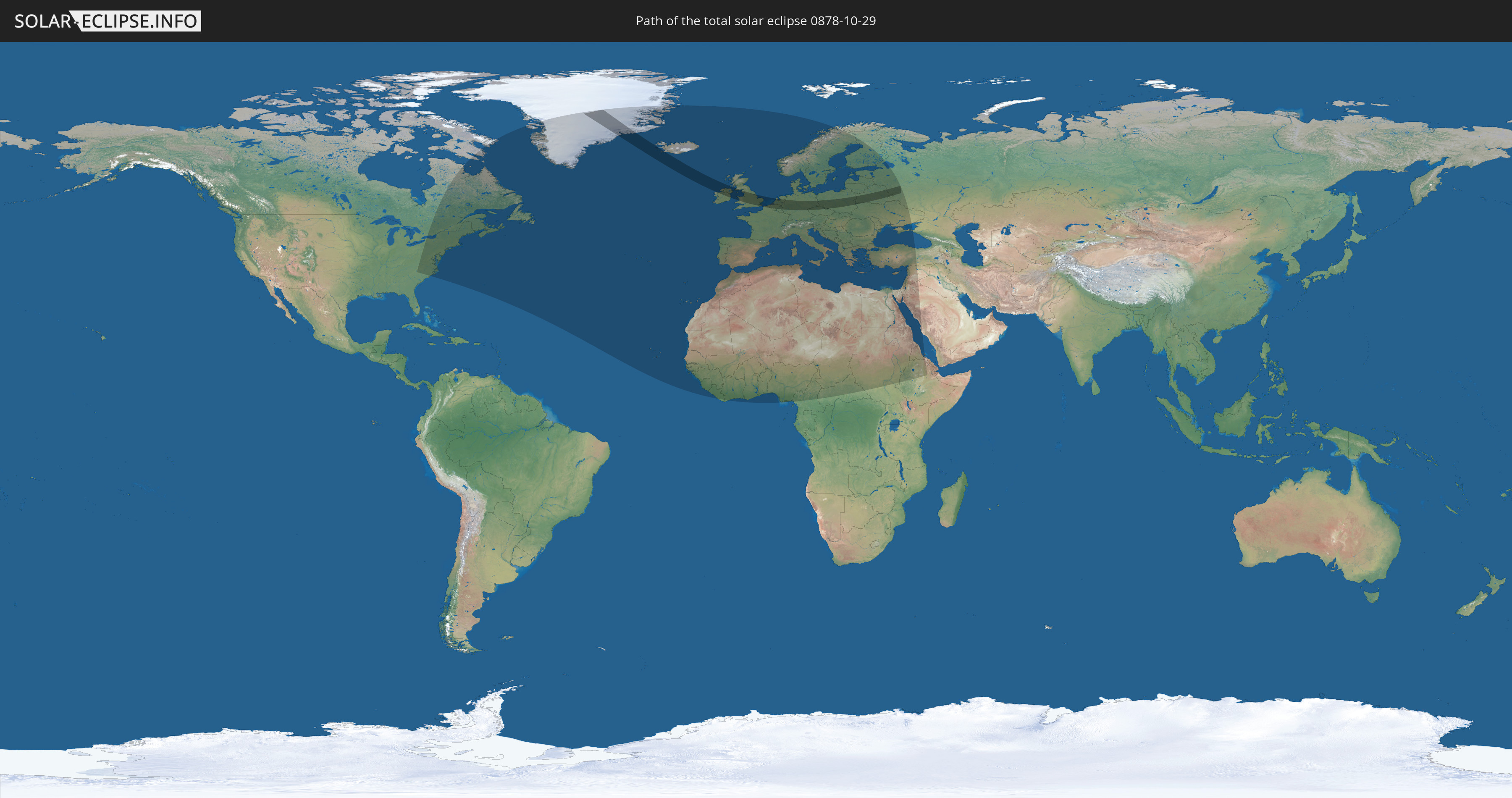
Die Sonnenfinsternis am 10/29/0878 kann man in 91 Ländern als partielle Sonnenfinsternis beobachten.
Der Finsternispfad verläuft durch 14 Länder. Nur in diesen Ländern ist sie als total Sonnenfinsternis zu sehen.
In den folgenden Ländern ist die Sonnenfinsternis total zu sehen
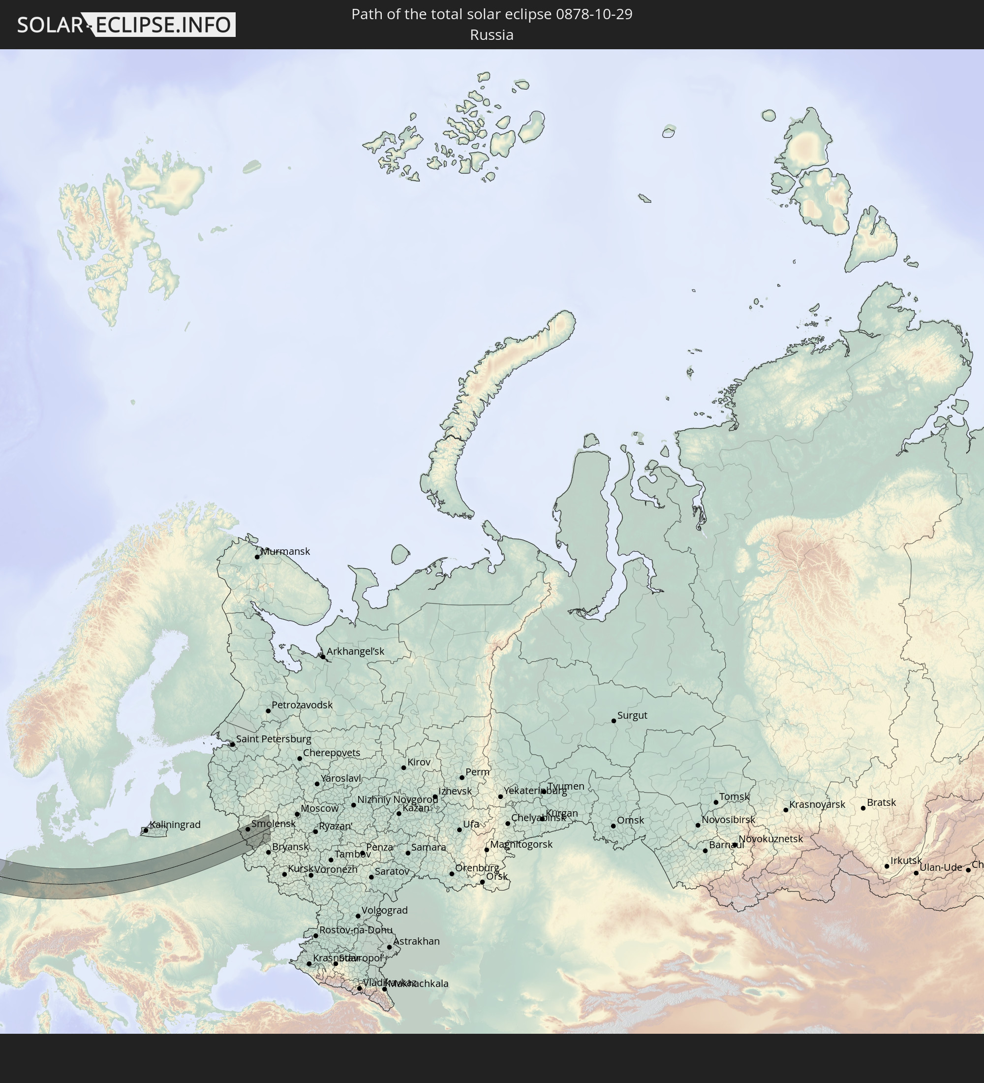 Russia
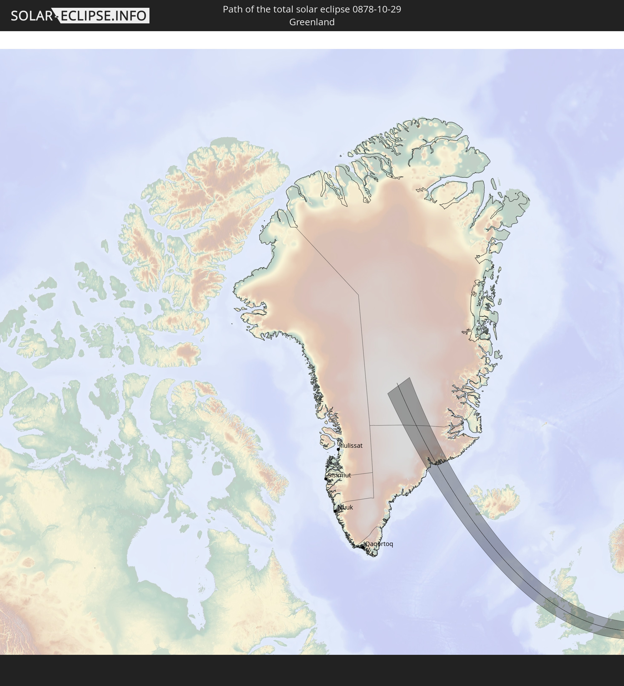 Greenland
 Iceland
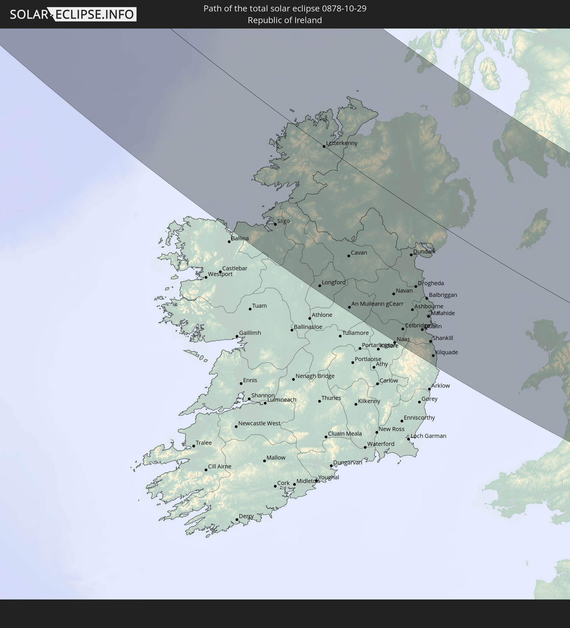 Republic of Ireland
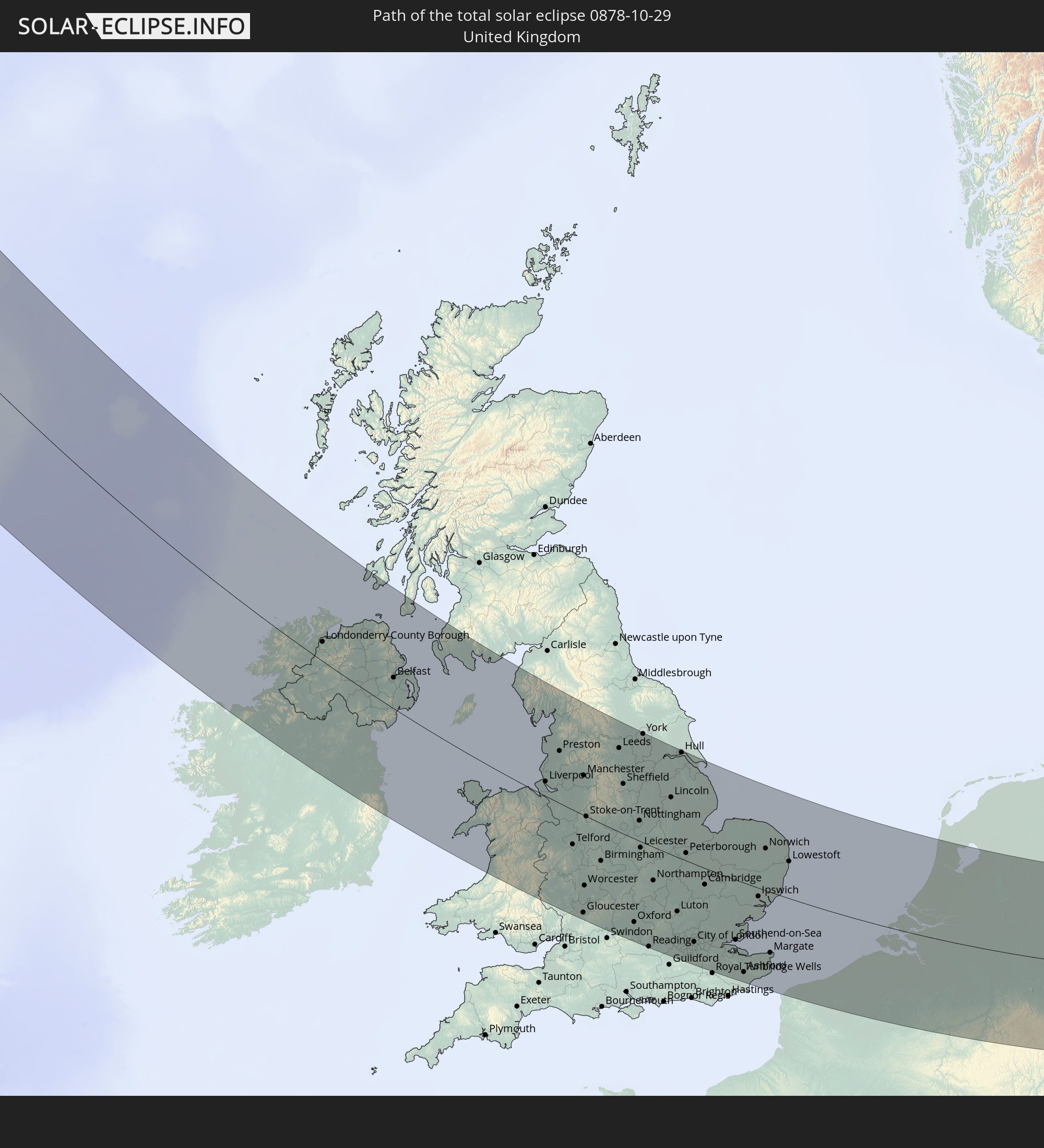 United Kingdom
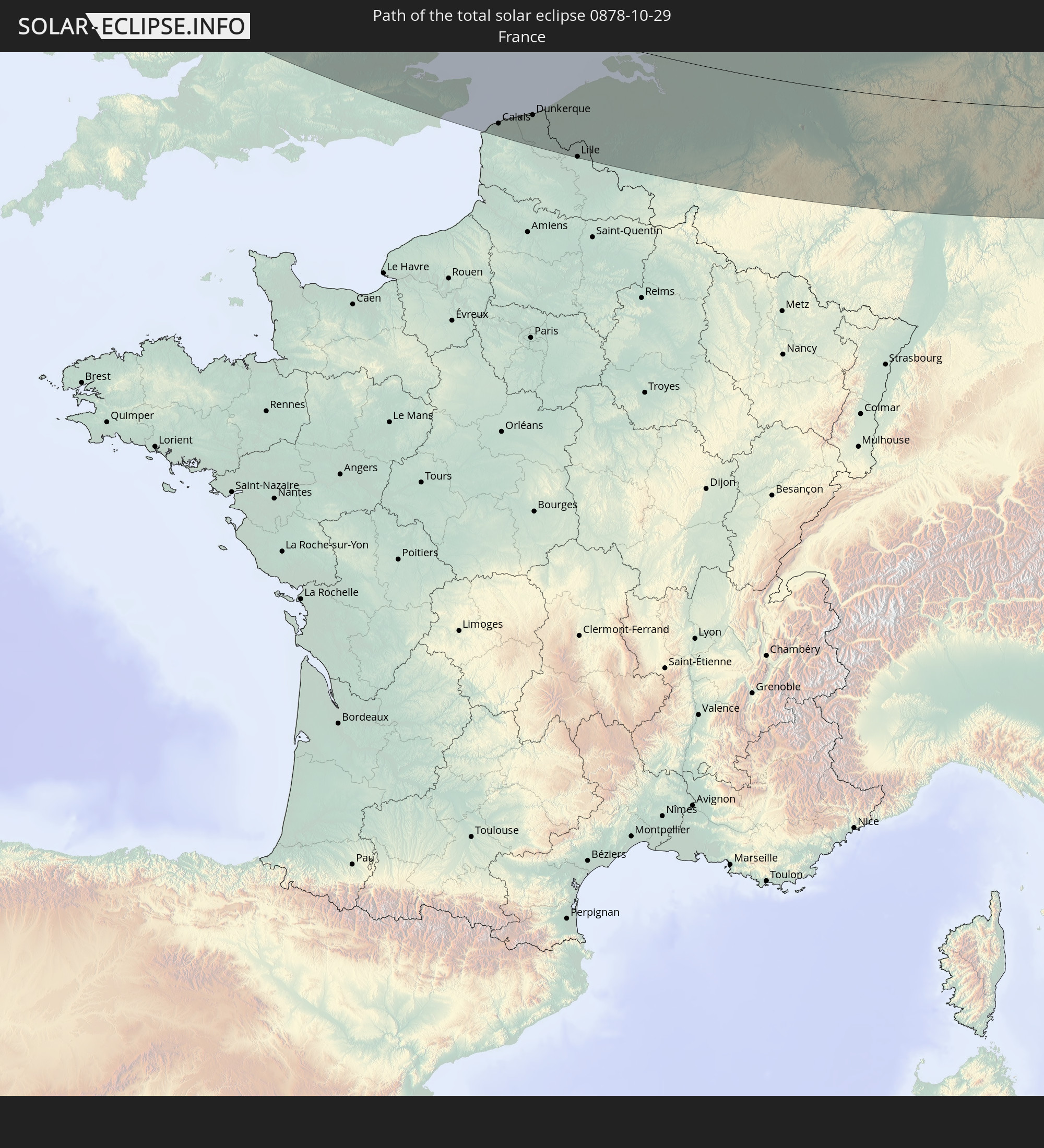 France
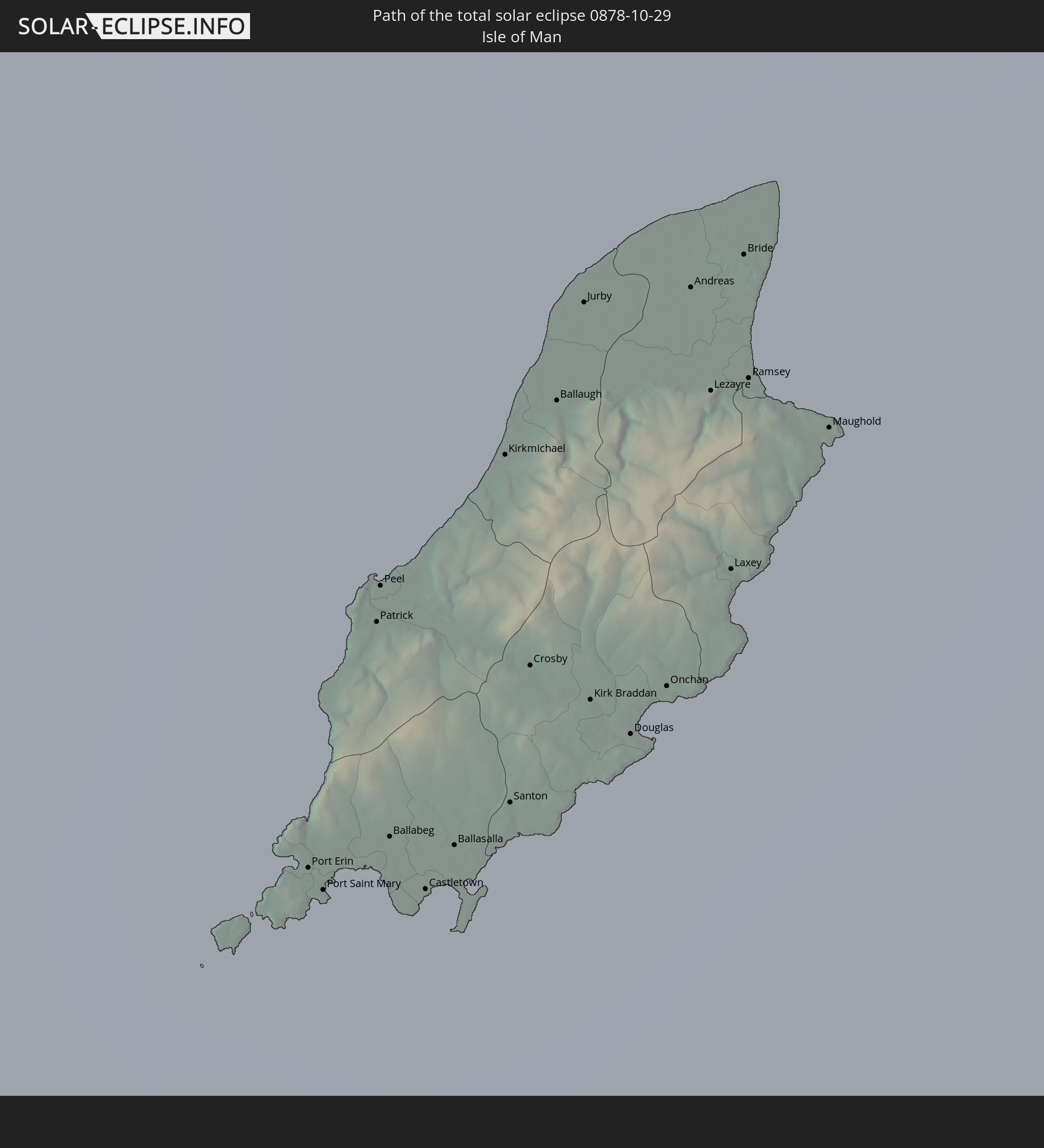 Isle of Man
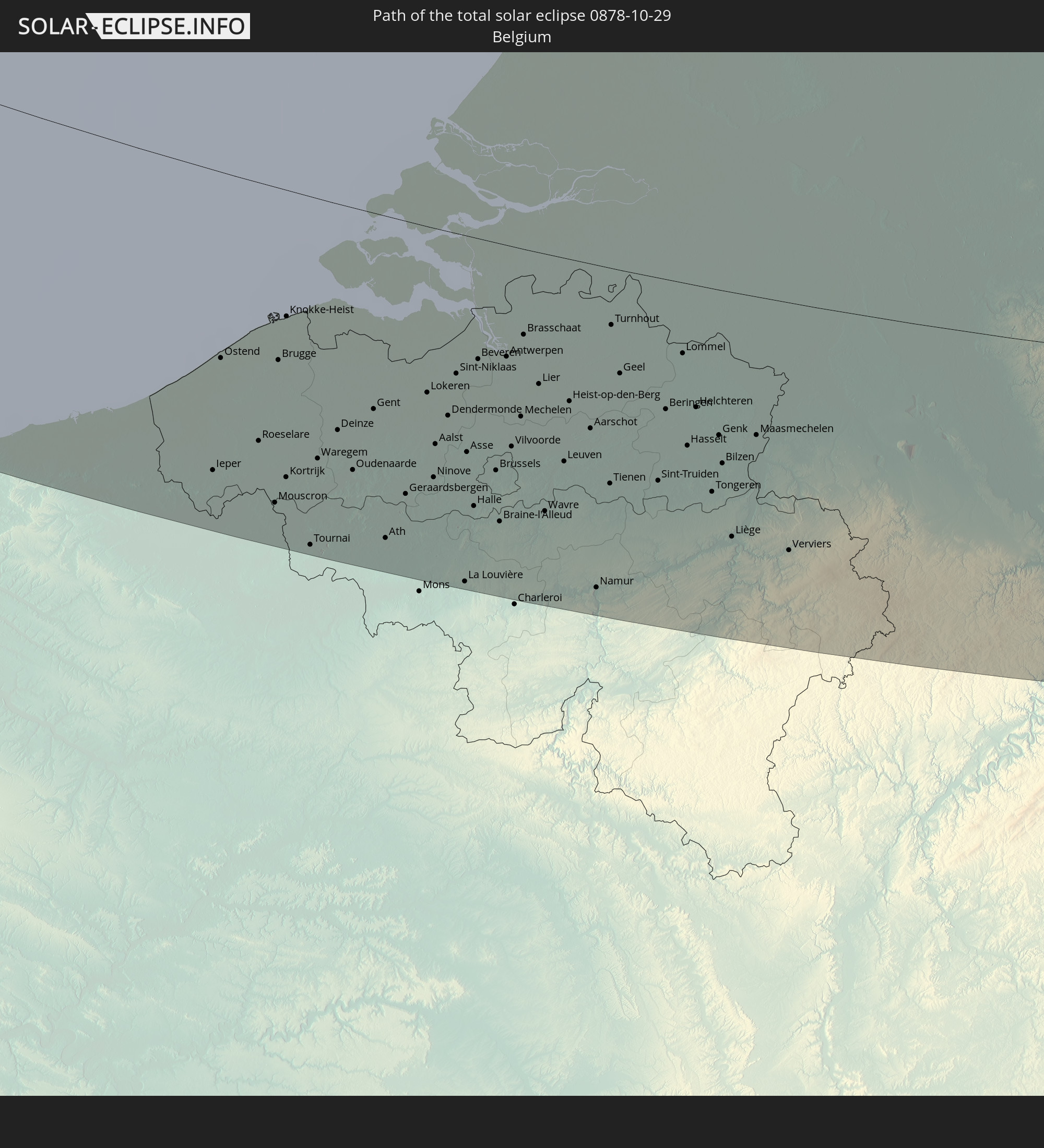 Belgium
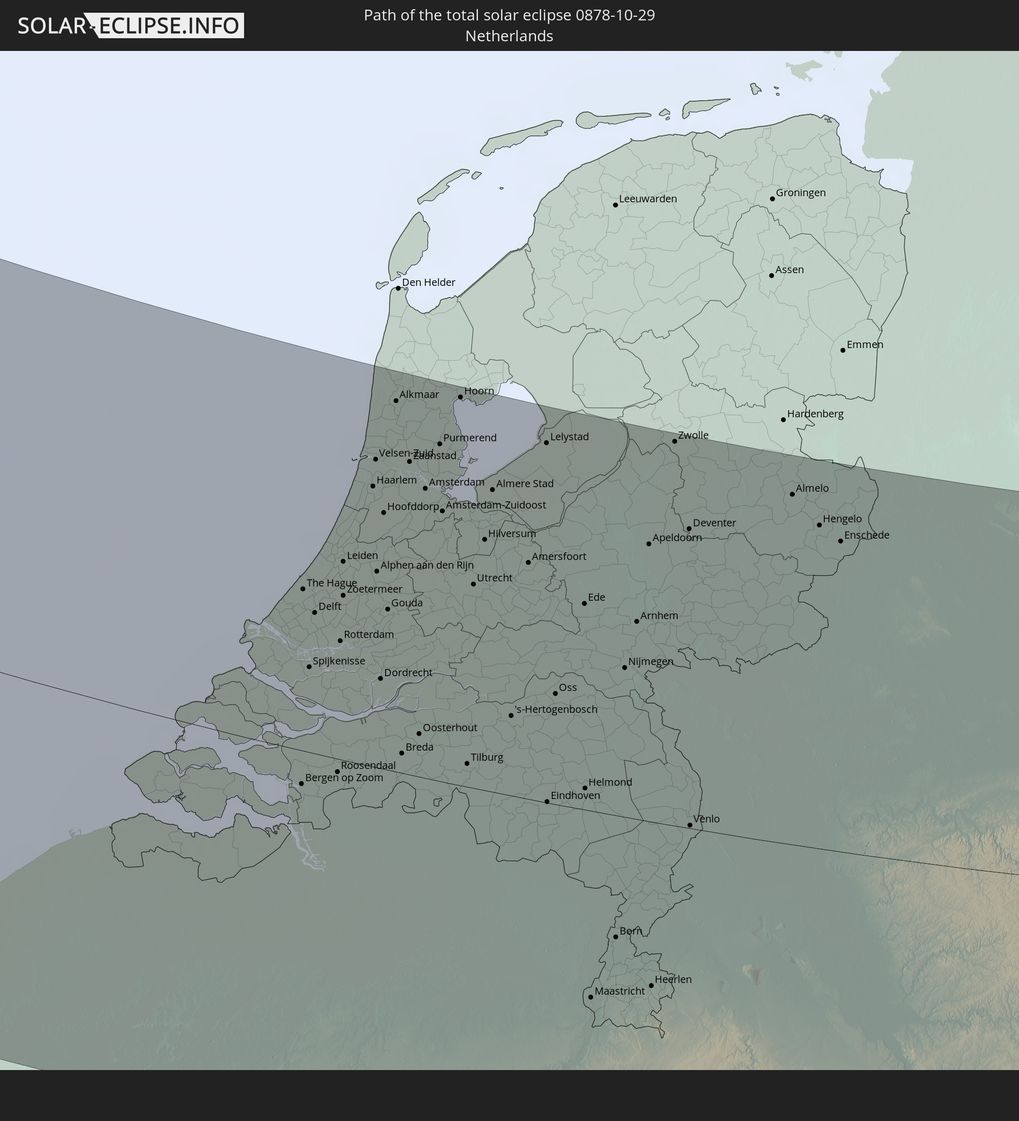 Netherlands
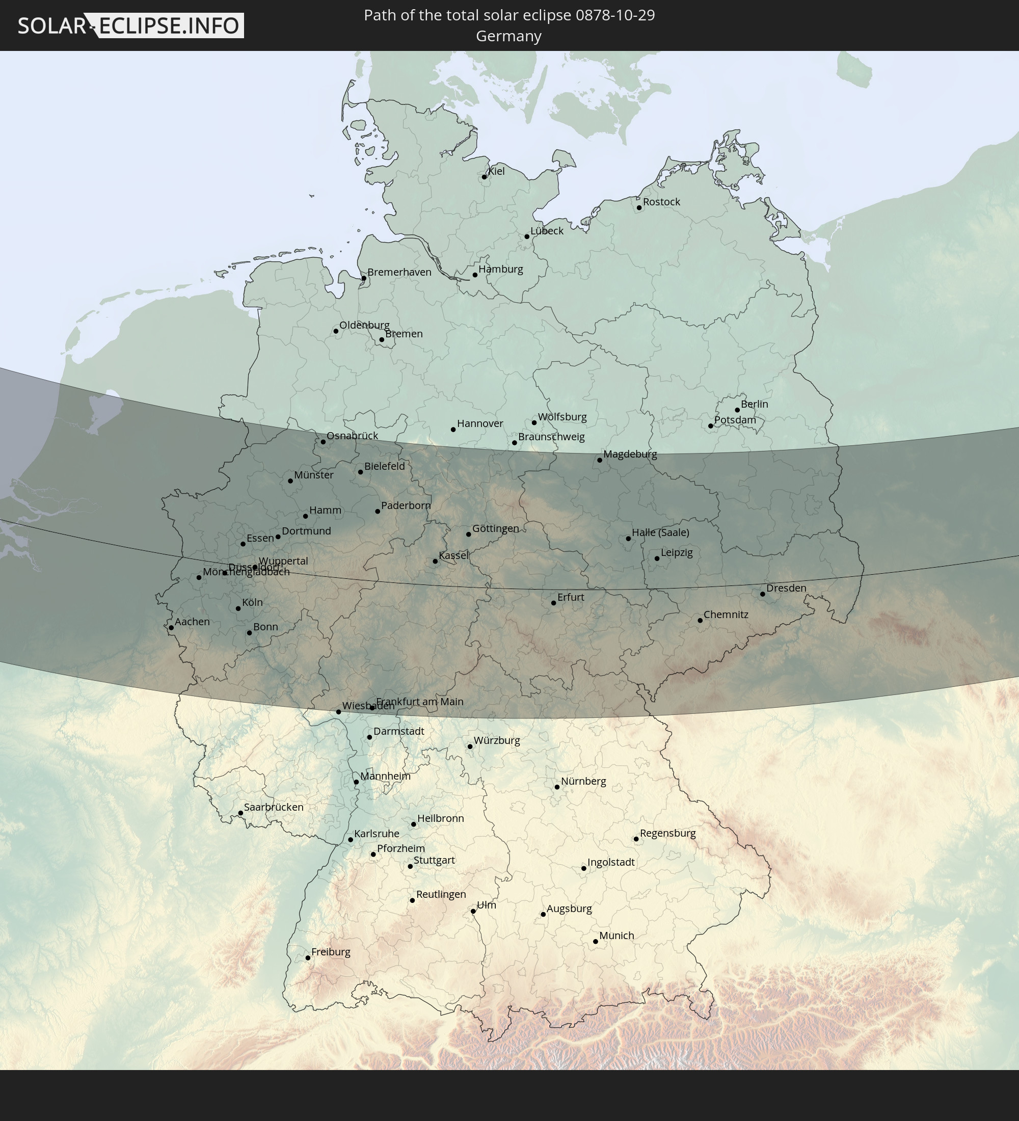 Germany
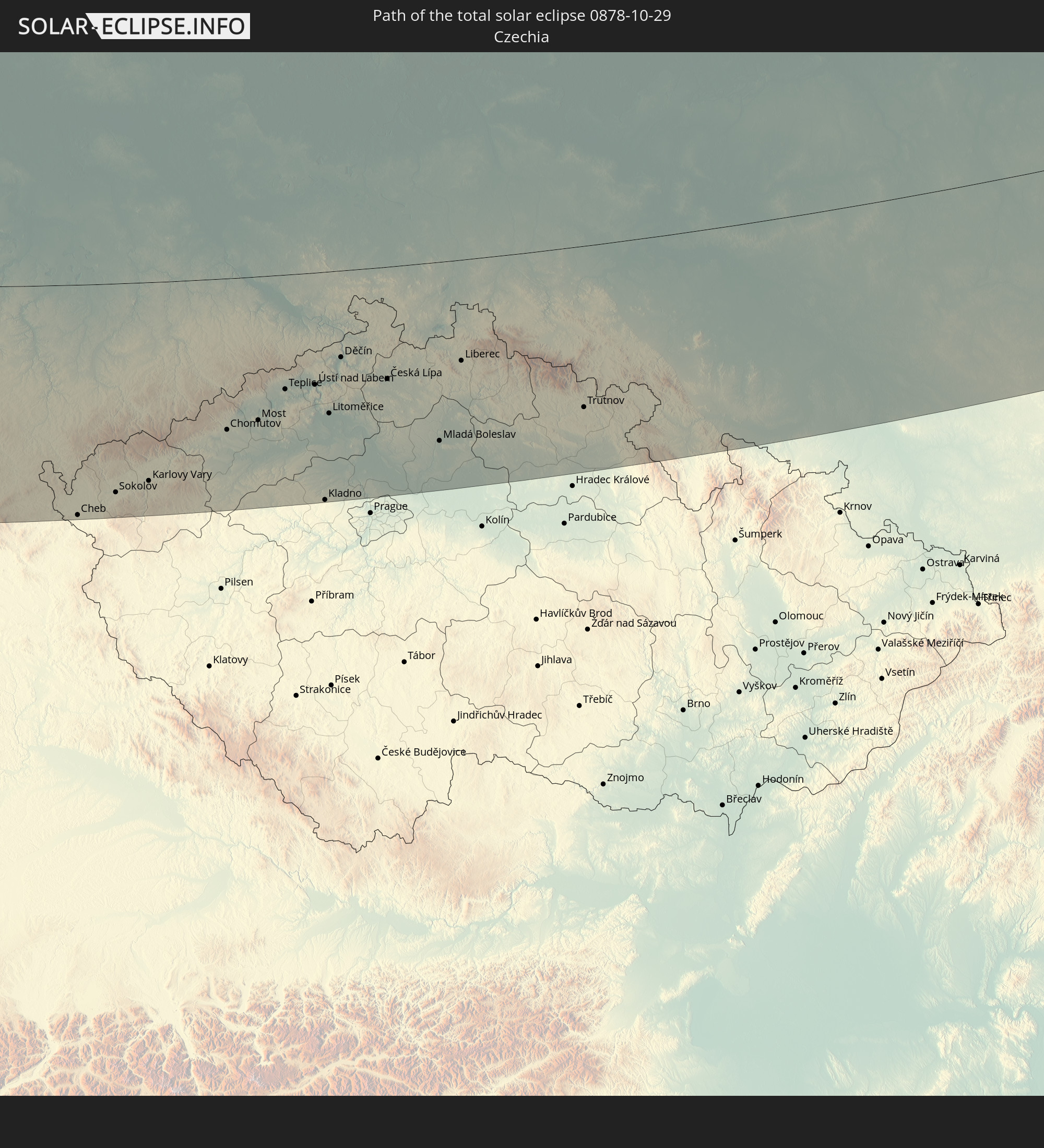 Czechia
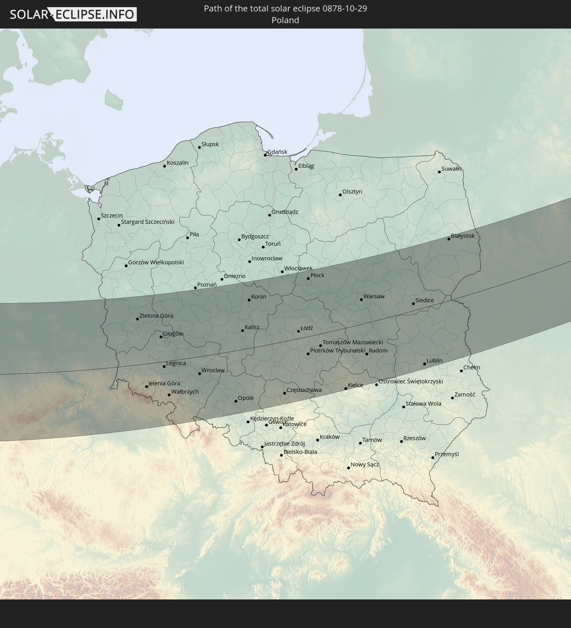 Poland
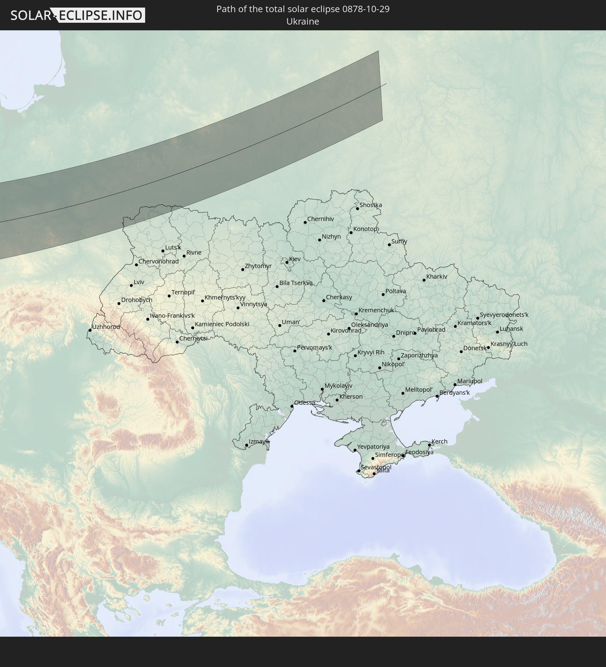 Ukraine
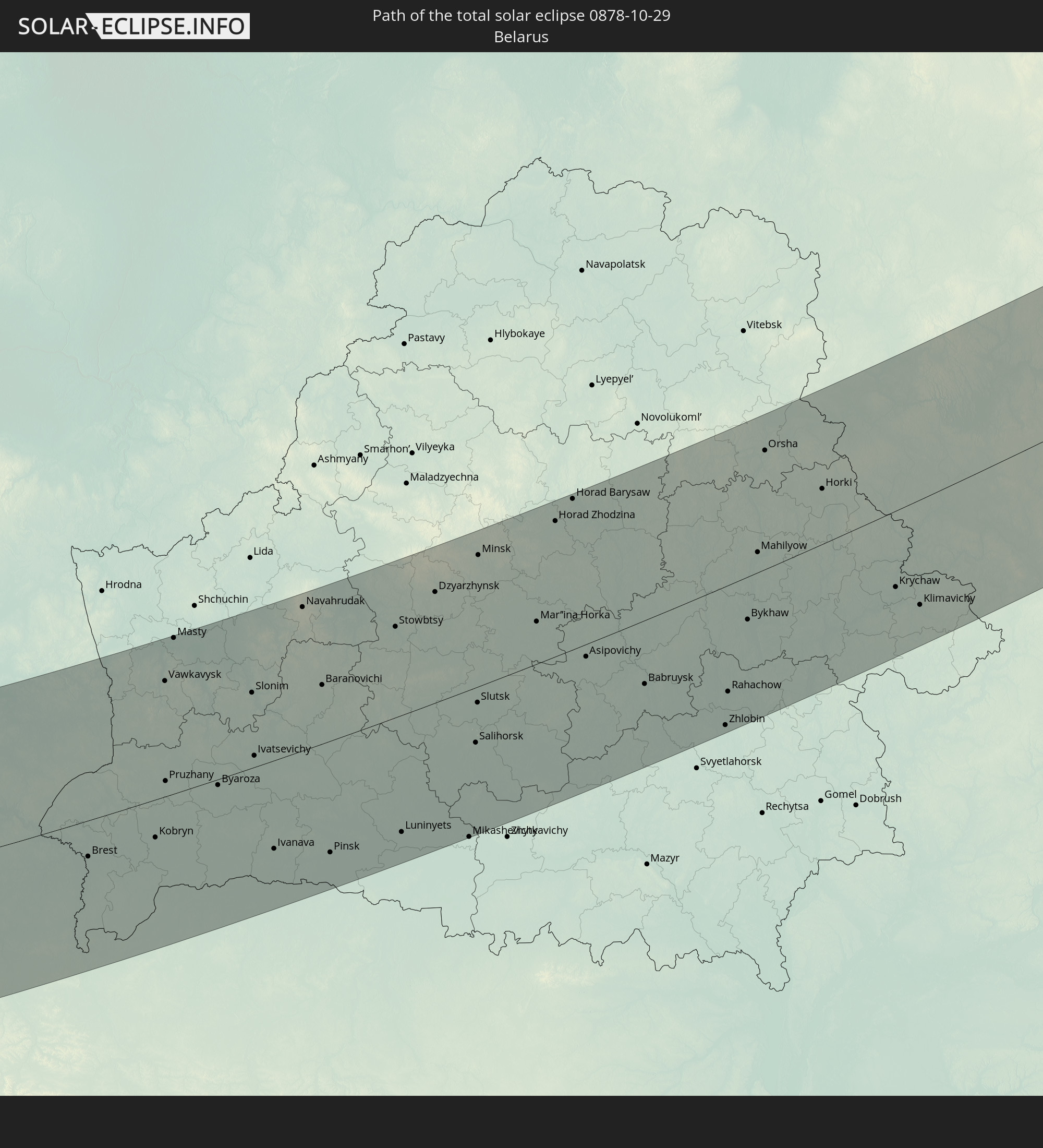 Belarus
In den folgenden Ländern ist die Sonnenfinsternis partiell zu sehen
 Russia
 United States
 Canada
 Greenland
 Bermuda
 Saint Pierre and Miquelon
 Portugal
 Cabo Verde
 Iceland
 Spain
Spain
 Senegal
 Mauritania
 The Gambia
 Guinea-Bissau
 Guinea
 Sierra Leone
 Morocco
 Mali
Mali
 Liberia
 Republic of Ireland
 Svalbard and Jan Mayen
 Algeria
 United Kingdom
 Ivory Coast
 Faroe Islands
 Burkina Faso
 Gibraltar
 France
 Isle of Man
 Ghana
Ghana
 Guernsey
 Jersey
 Togo
Togo
 Niger
Niger
 Benin
Benin
 Andorra
 Belgium
 Nigeria
 Netherlands
 Norway
 Luxembourg
 Germany
 Switzerland
 Italy
Italy
 Monaco
 Tunisia
 Denmark
 Cameroon
 Libya
Libya
 Liechtenstein
 Austria
 Sweden
 Czechia
 San Marino
 Vatican City
 Slovenia
 Chad
Chad
 Croatia
 Poland
 Malta
Malta
 Central African Republic
 Bosnia and Herzegovina
 Hungary
 Slovakia
 Montenegro
 Serbia
 Albania
 Åland Islands
 Greece
 Romania
 Republic of Macedonia
 Finland
 Lithuania
 Latvia
 Estonia
 Sudan
Sudan
 Ukraine
 Bulgaria
 Belarus
 Egypt
Egypt
 Turkey
 Moldova
 Cyprus
 Ethiopia
 State of Palestine
 Israel
 Saudi Arabia
 Jordan
 Lebanon
 Syria
Syria
 Eritrea
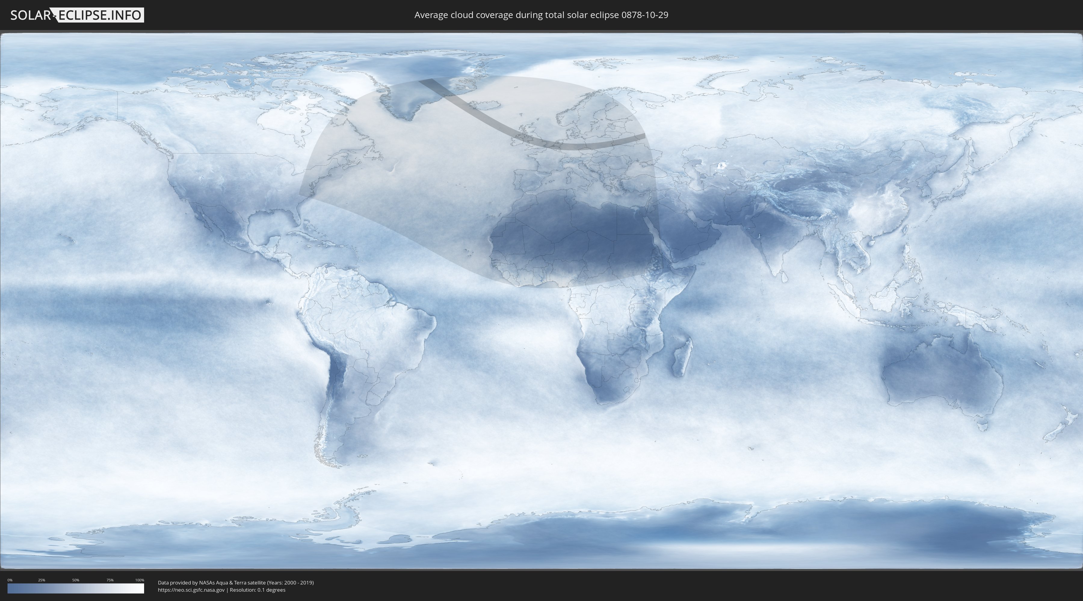
How will be the weather during the total solar eclipse on 10/29/0878?
Where is the best place to see the total solar eclipse of 10/29/0878?
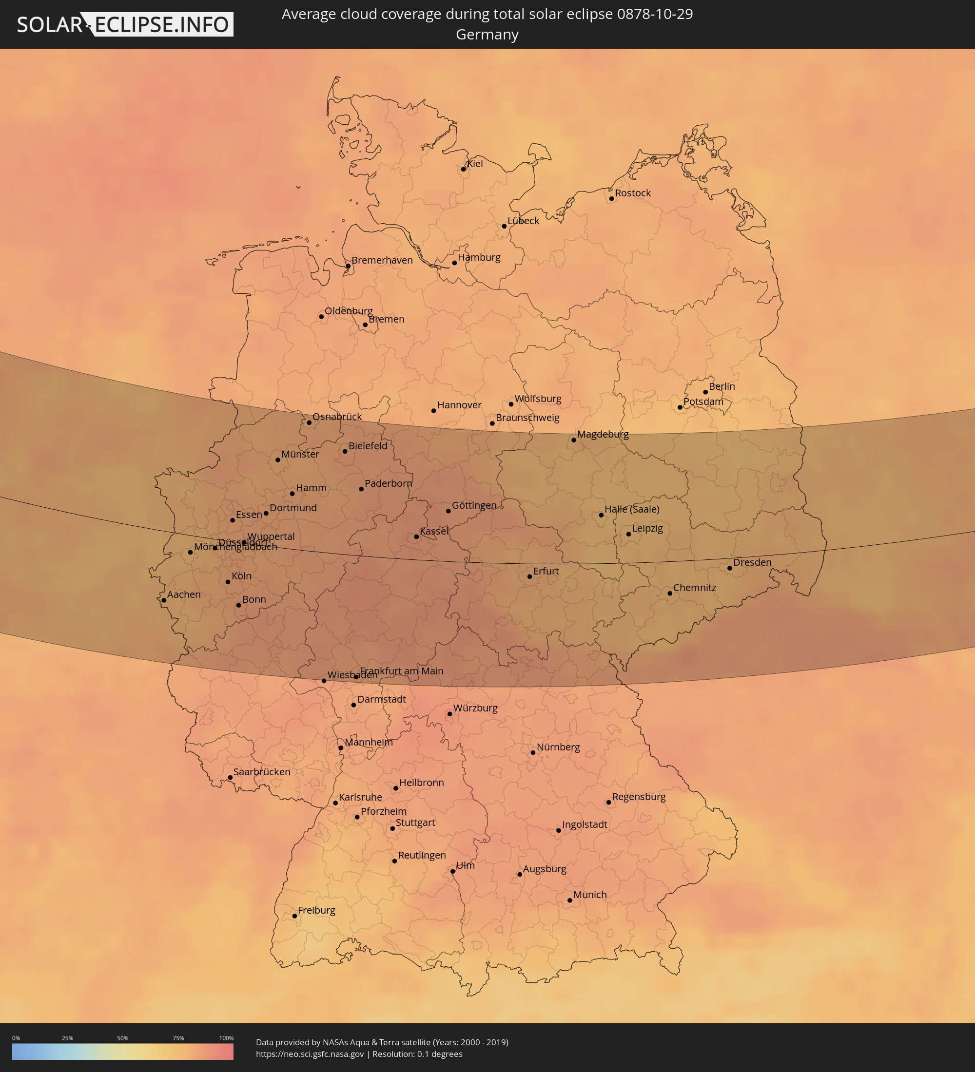
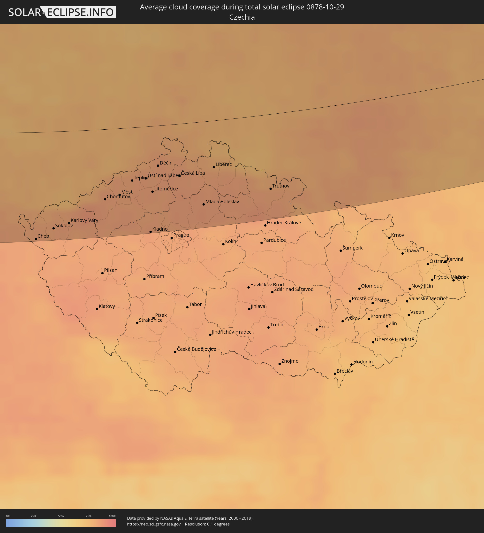
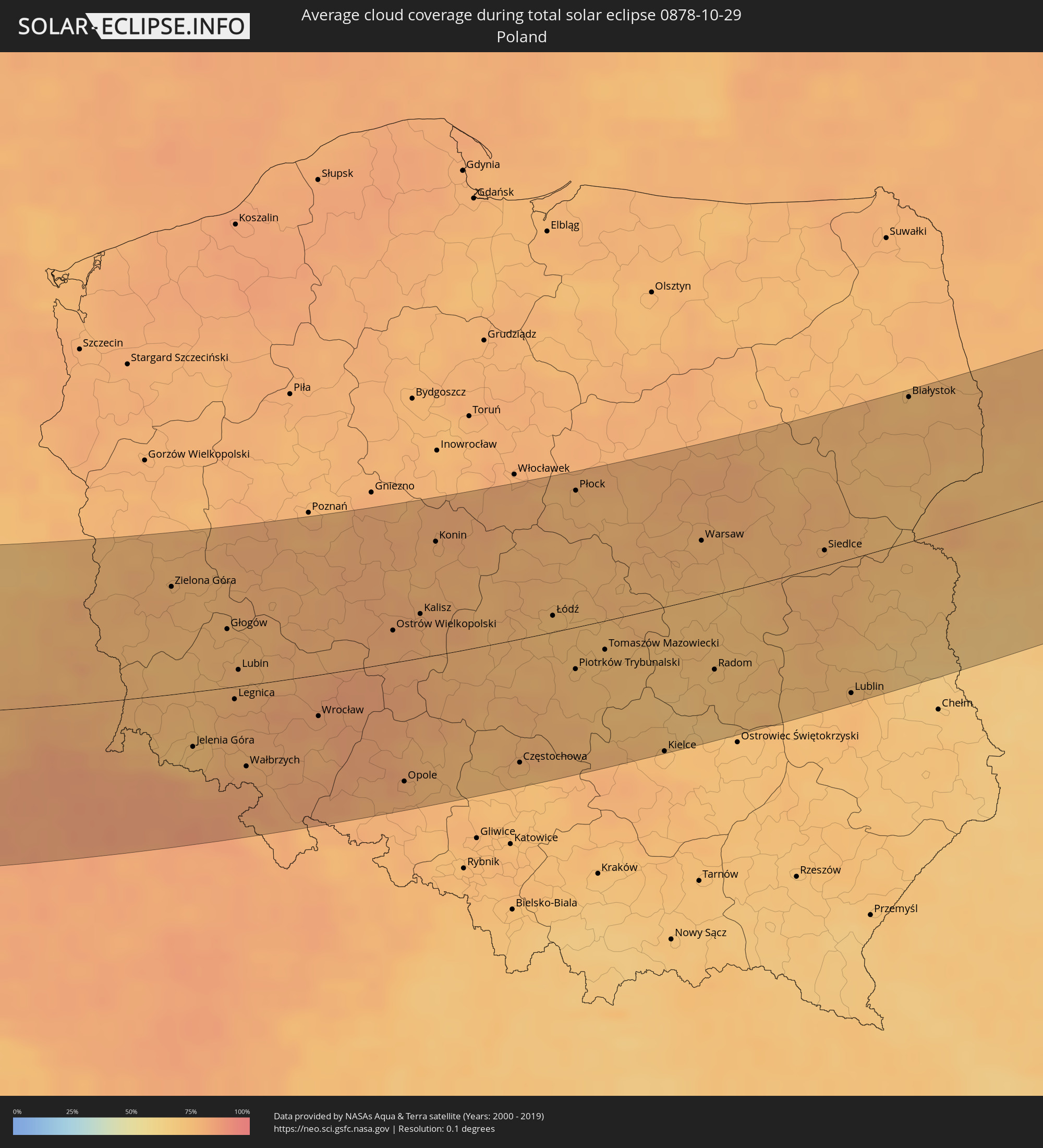
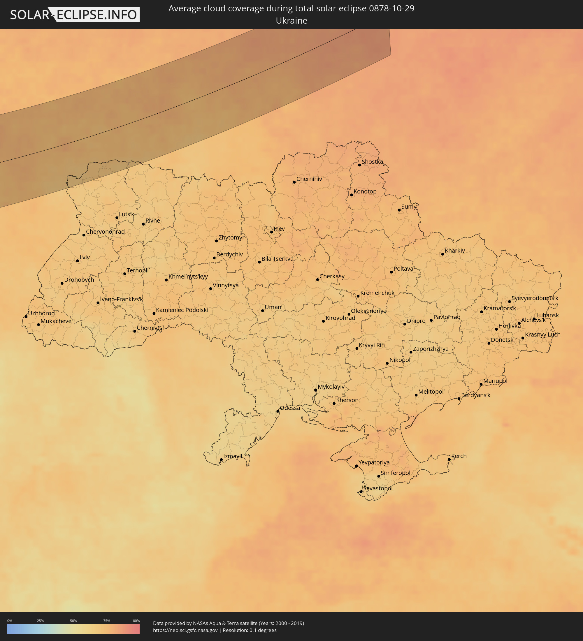
The following maps show the average cloud coverage for the day of the total solar eclipse.
With the help of these maps, it is possible to find the place along the eclipse path, which has the best
chance of a cloudless sky.
Nevertheless, you should consider local circumstances and inform about the weather of your chosen
observation site.
The data is provided by NASAs satellites
AQUA and TERRA.
The cloud maps are averaged over a period of 19 years (2000 - 2019).

Detailed country maps
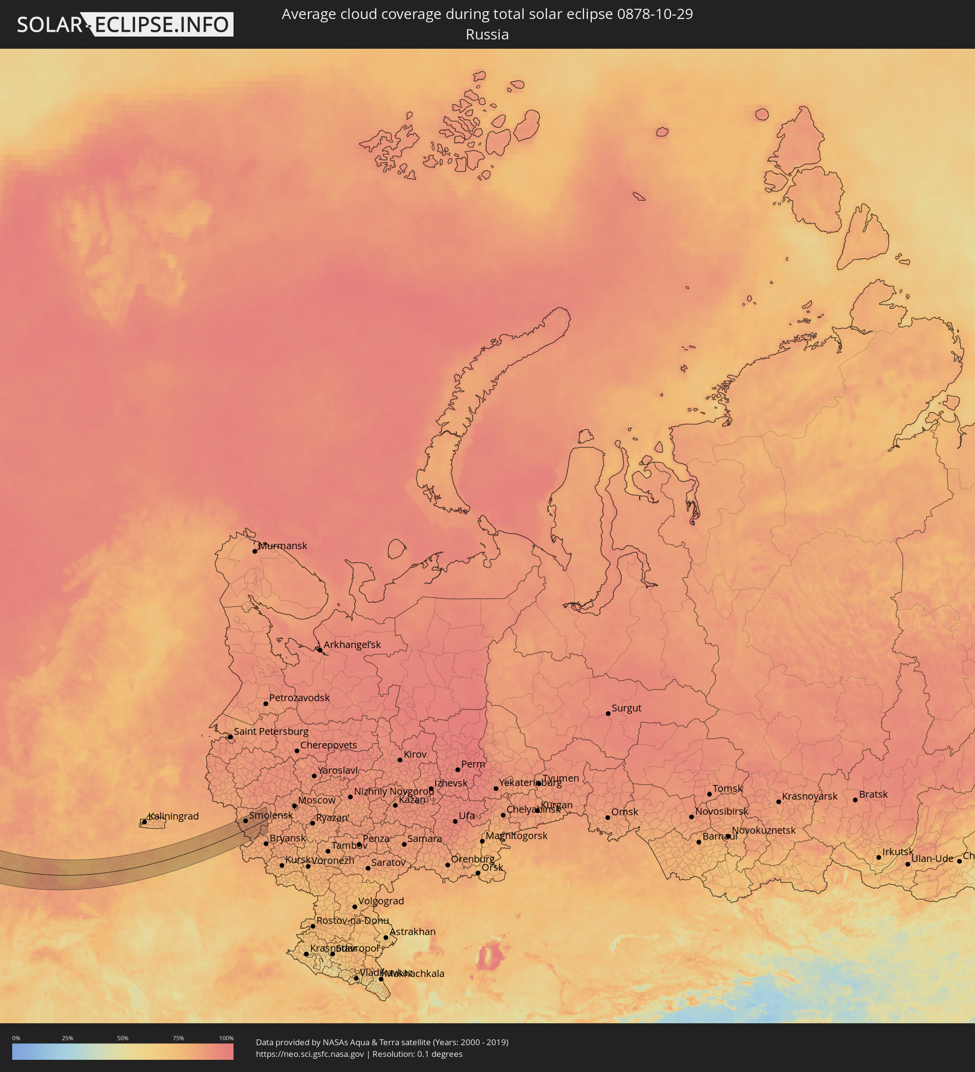 Russia
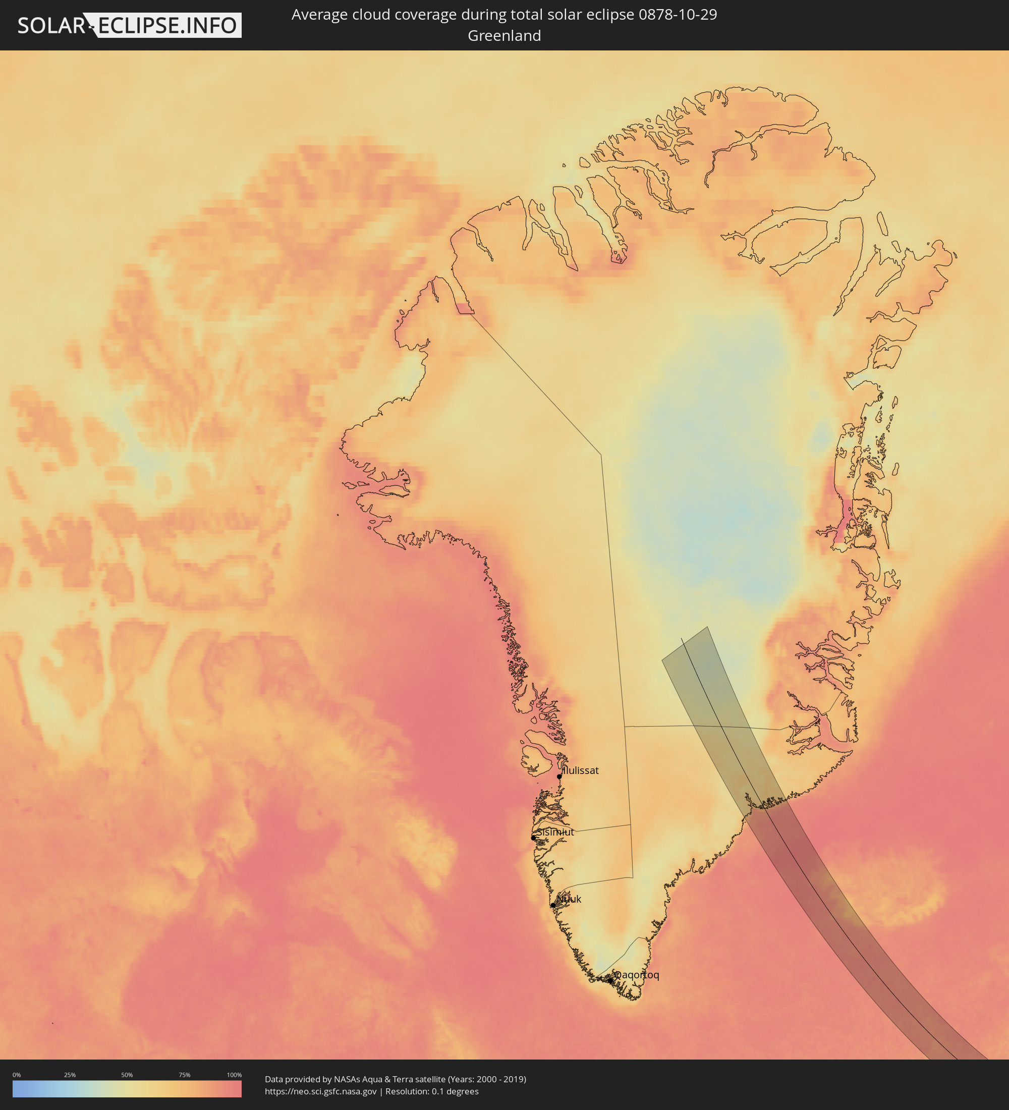 Greenland
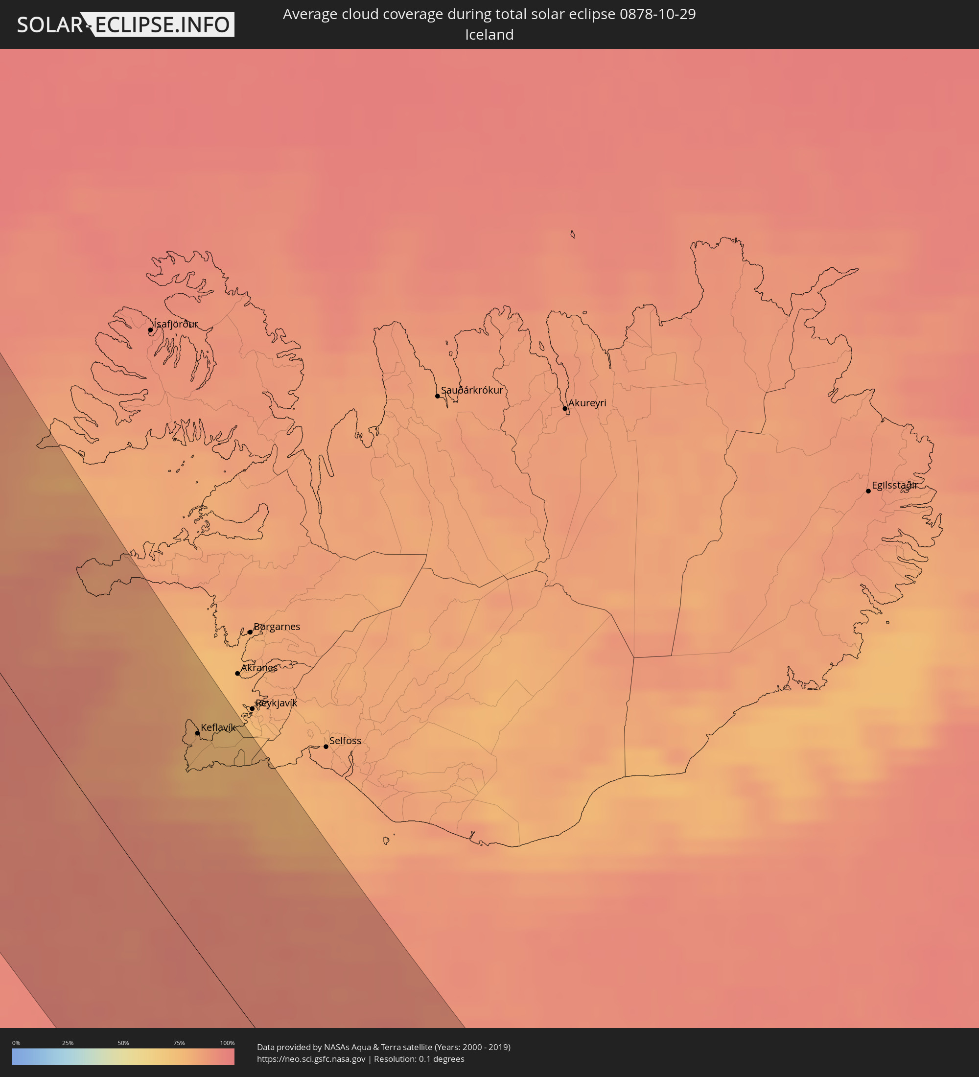 Iceland
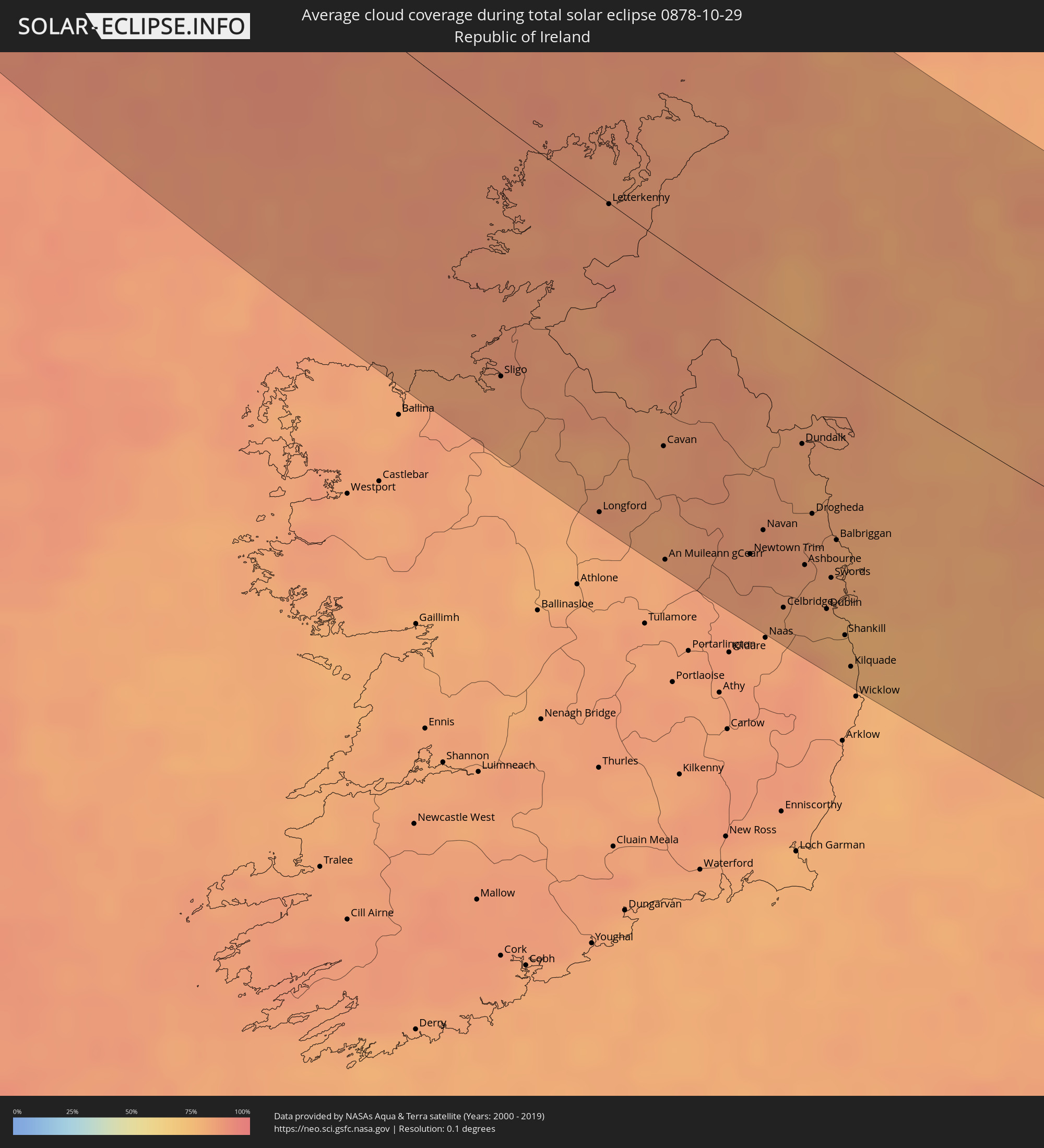 Republic of Ireland
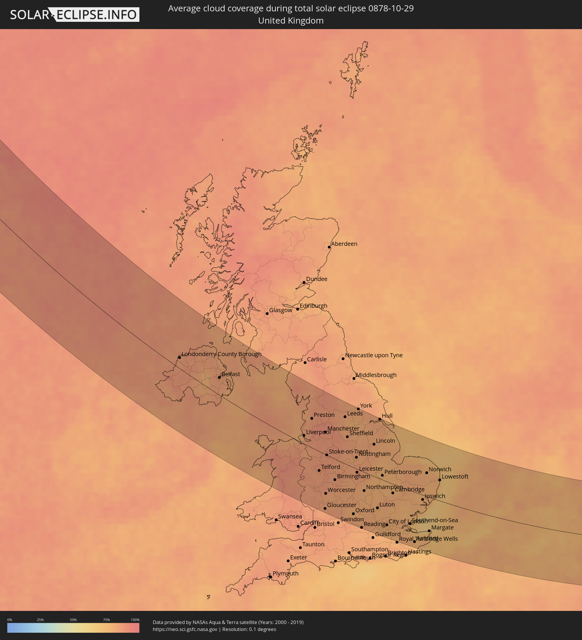 United Kingdom
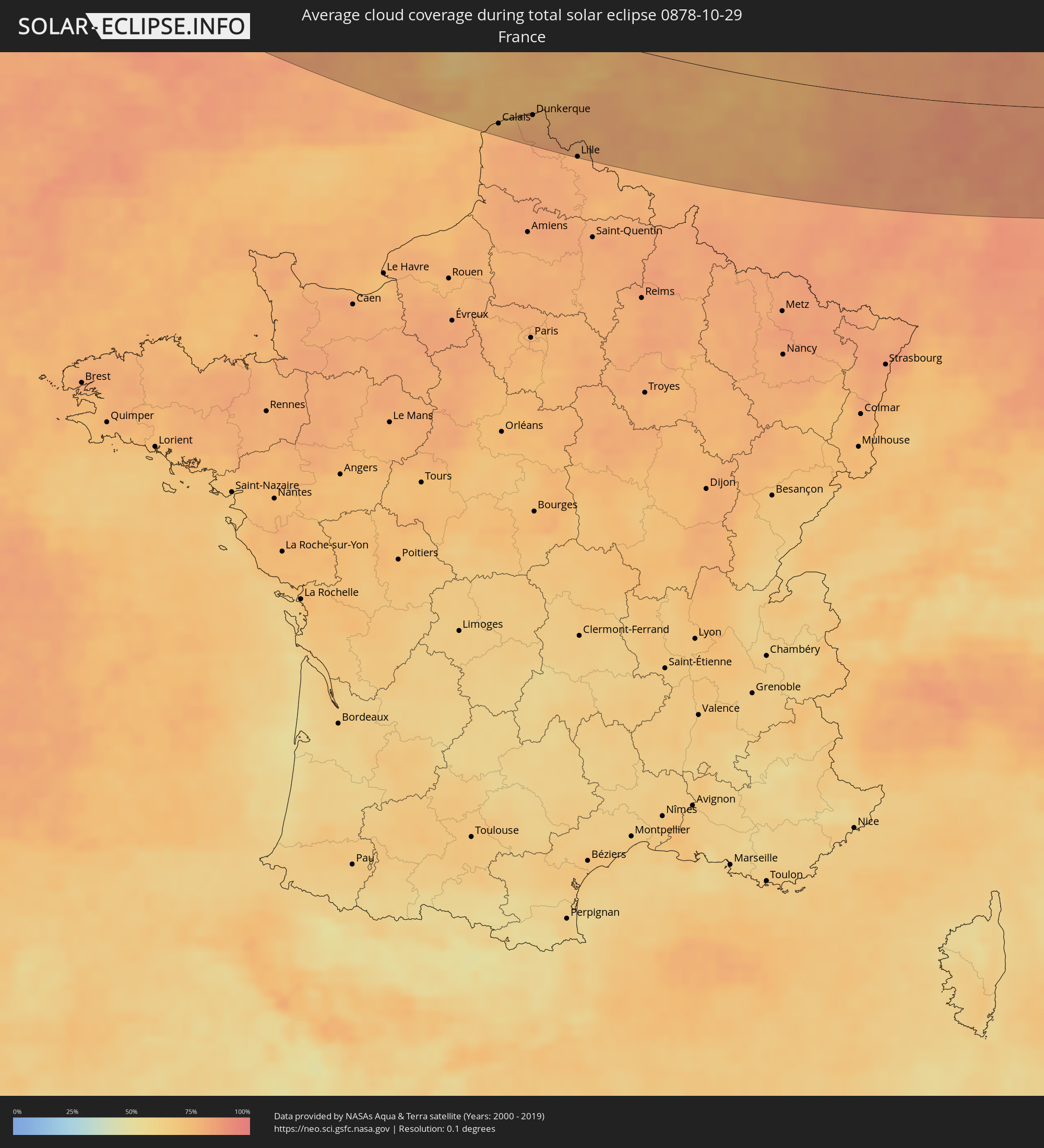 France
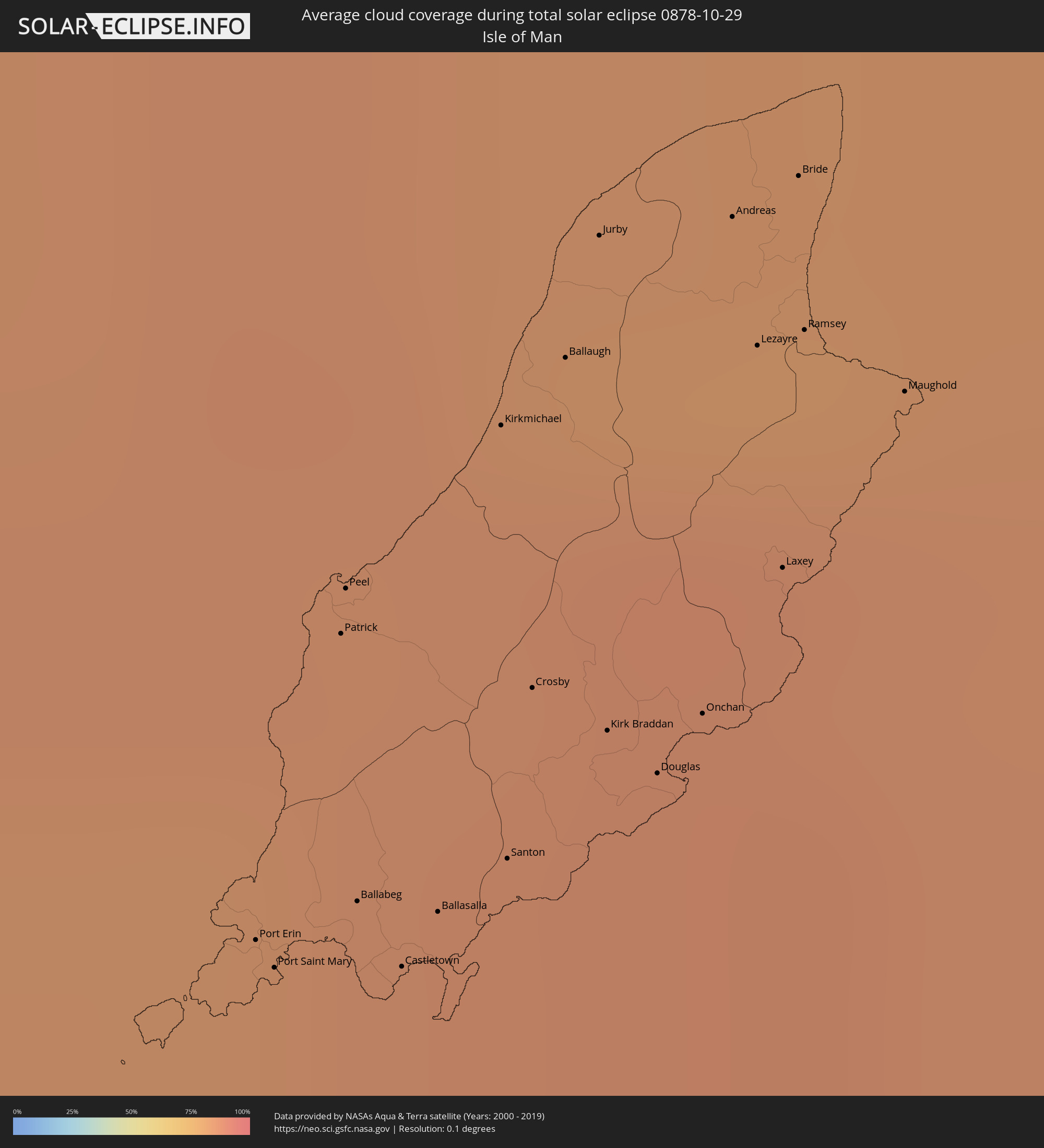 Isle of Man
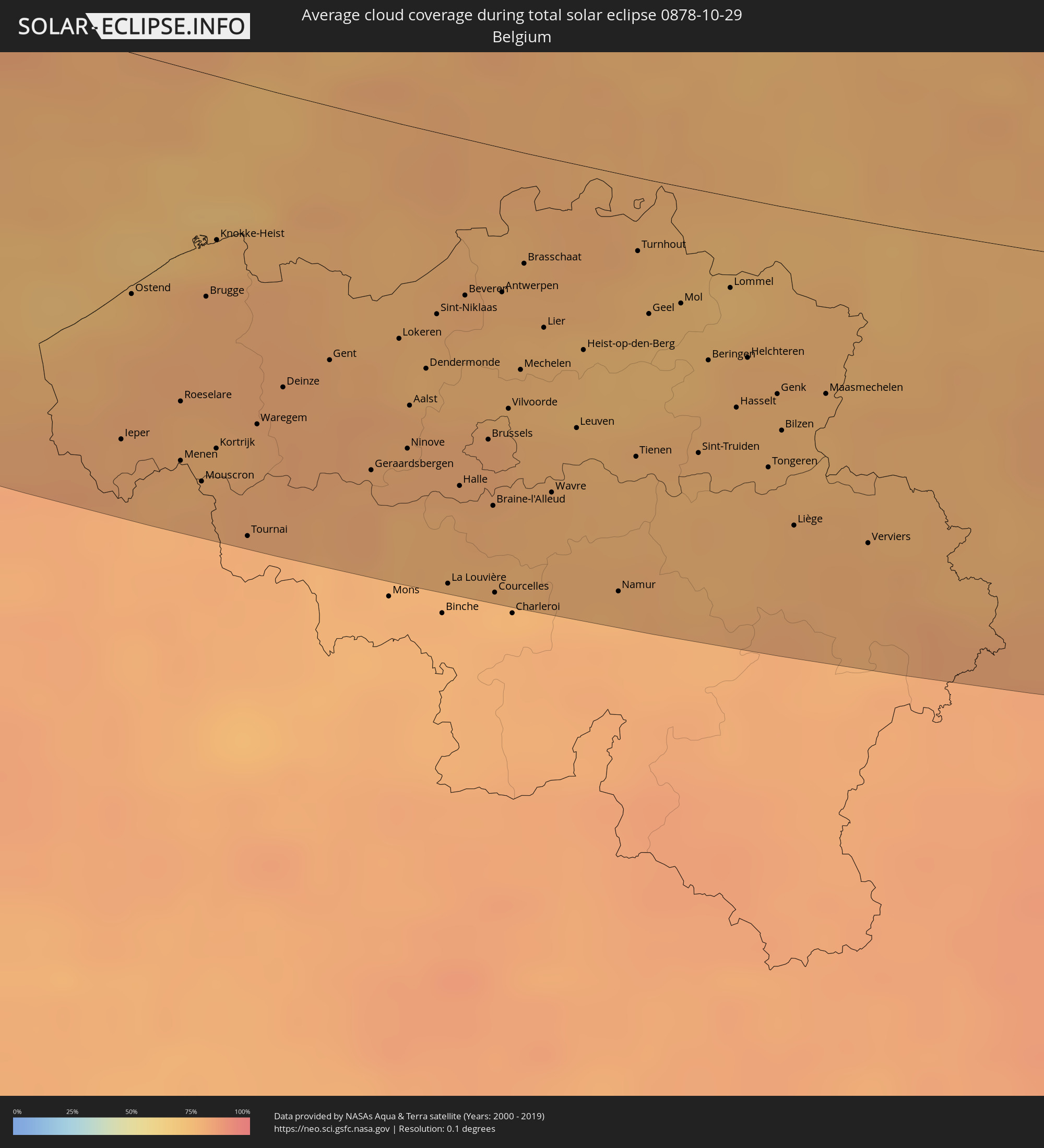 Belgium
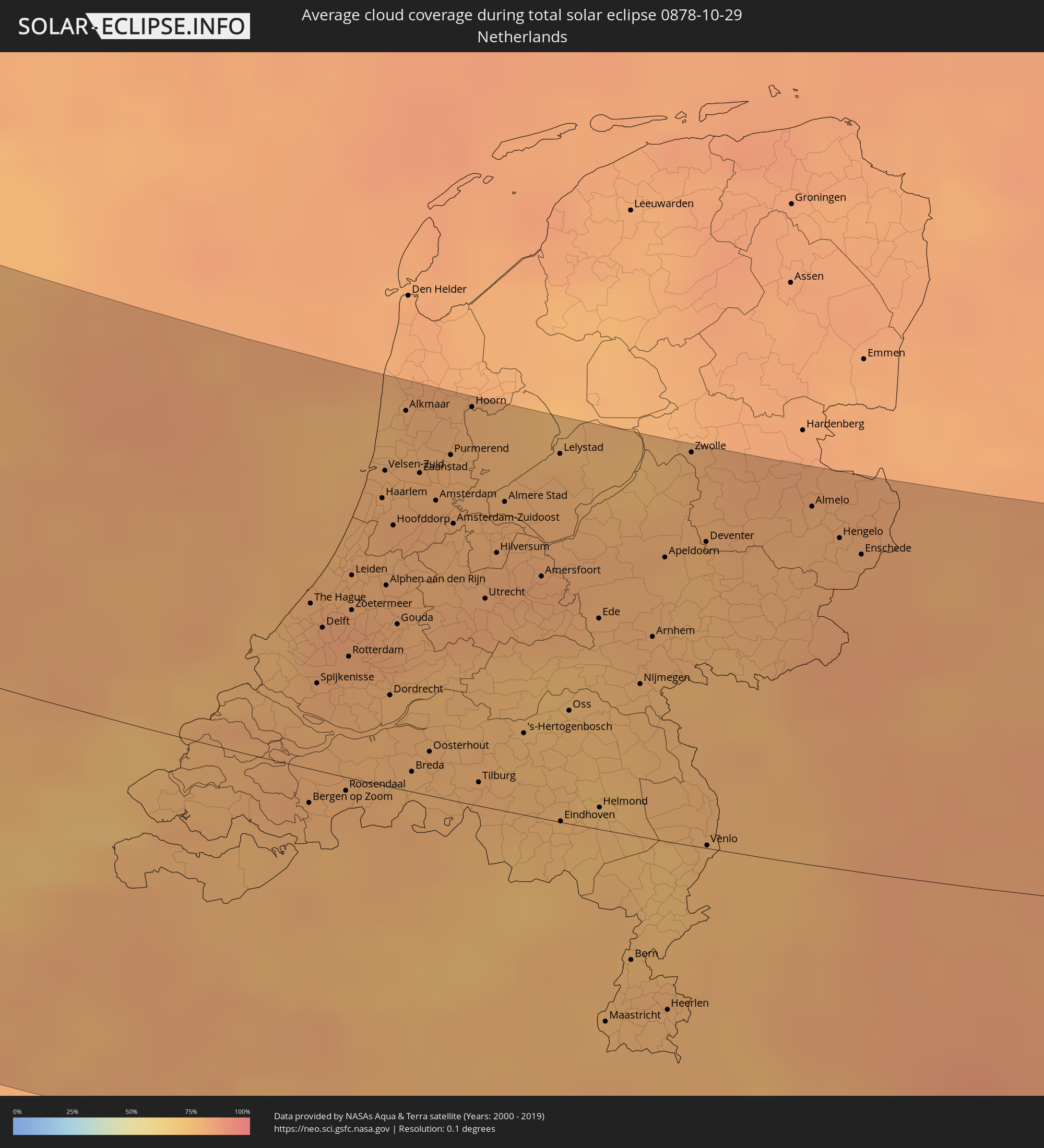 Netherlands
 Germany
 Czechia
 Poland
 Ukraine
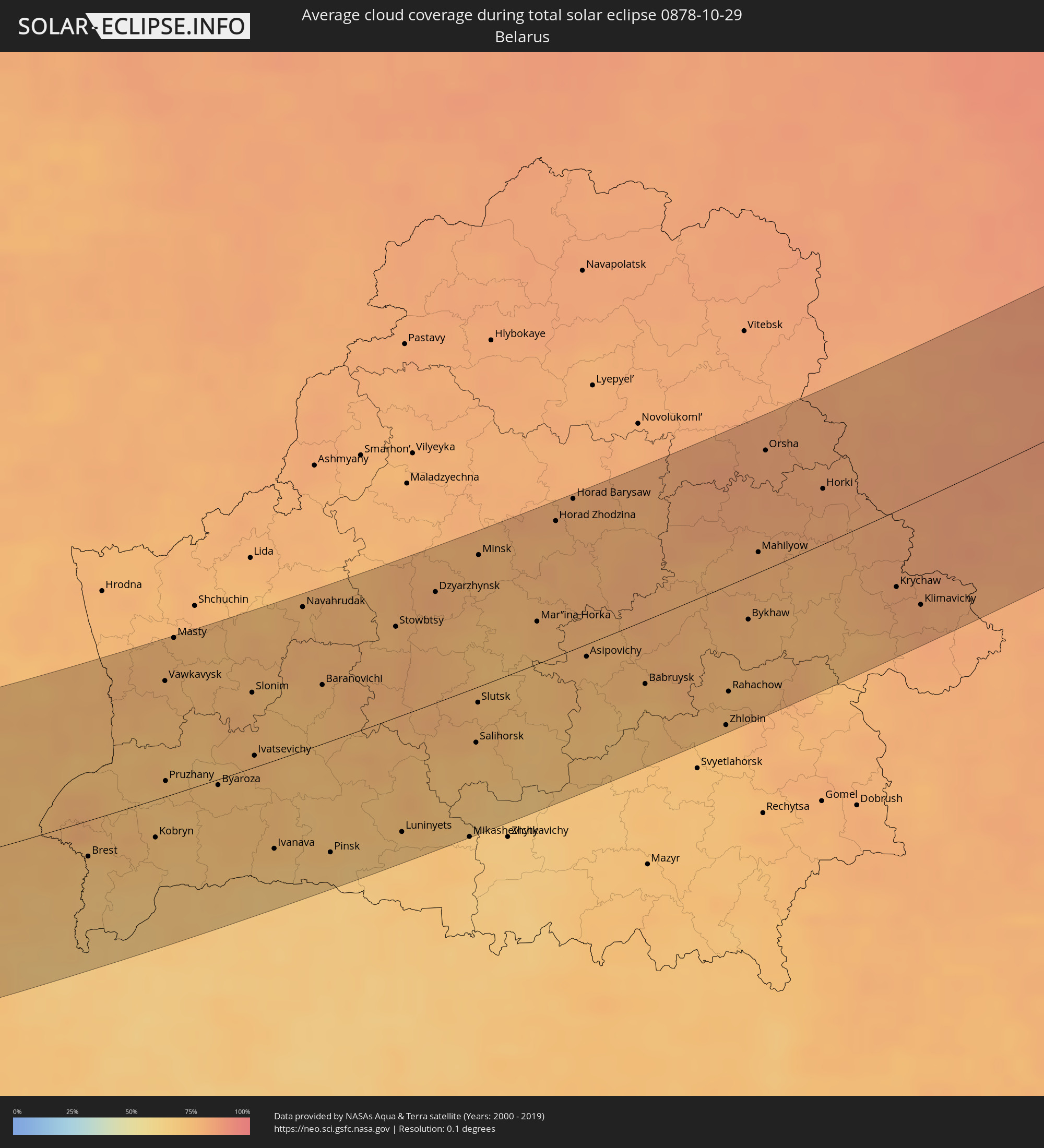 Belarus
Cities inside the path of the eclipse
The following table shows all locations with a population of more than 5,000 inside the eclipse path. Cities which have more than 100,000 inhabitants are marked bold. A click at the locations opens a detailed map.
| City | Type | Eclipse duration | Local time of max. eclipse | Distance to central line | Ø Cloud coverage |
|
Keflavík, Southern Peninsula
|
total | - | 11:26:27 UTC-01:28 | 76 km | 76% |
|
Sligo, Connaught
|
total | - | 12:48:33 UTC-00:25 | 90 km | 84% |
|
Longford, Leinster
|
total | - | 12:49:52 UTC-00:25 | 115 km | 83% |
|
Letterkenny, Ulster
|
total | - | 12:49:04 UTC-00:25 | 0 km | 84% |
|
Cavan, Ulster
|
total | - | 12:50:16 UTC-00:25 | 75 km | 83% |
|
An Muileann gCearr, Leinster
|
total | - | 12:50:38 UTC-00:25 | 117 km | 81% |
|
Monaghan, Ulster
|
total | - | 12:50:37 UTC-00:25 | 37 km | 87% |
|
Navan, Leinster
|
total | - | 12:51:28 UTC-00:25 | 82 km | 86% |
|
Celbridge, Leinster
|
total | - | 12:51:54 UTC-00:25 | 107 km | 82% |
|
Hartstown, Leinster
|
total | - | 12:52:01 UTC-00:25 | 98 km | 82% |
|
Dundalk, Leinster
|
total | - | 12:51:33 UTC-00:25 | 40 km | 83% |
|
Ashbourne, Leinster
|
total | - | 12:51:58 UTC-00:25 | 86 km | 83% |
|
Drogheda, Leinster
|
total | - | 12:51:52 UTC-00:25 | 64 km | 83% |
|
Ballymun, Leinster
|
total | - | 12:52:14 UTC-00:25 | 92 km | 81% |
|
Dublin, Leinster
|
total | - | 12:52:18 UTC-00:25 | 98 km | 78% |
|
Balbriggan, Leinster
|
total | - | 12:52:11 UTC-00:25 | 69 km | 82% |
|
Kilquade
|
total | - | 12:52:44 UTC-00:25 | 114 km | 82% |
|
Belfast, Northern Ireland
|
total | - | 13:17:05 UTC+00:00 | 33 km | 83% |
|
Port Erin, Port Erin
|
total | - | 13:19:05 UTC+00:00 | 25 km | 83% |
|
Port Saint Mary, Port St Mary
|
total | - | 13:19:06 UTC+00:00 | 24 km | 84% |
|
Peel, Peel
|
total | - | 13:19:02 UTC+00:00 | 40 km | 84% |
|
Ballasalla, Malew
|
total | - | 13:19:14 UTC+00:00 | 30 km | 85% |
|
Kirkmichael, Michael
|
total | - | 13:19:07 UTC+00:00 | 50 km | 85% |
|
Santon, Santon
|
total | - | 13:19:16 UTC+00:00 | 34 km | 85% |
|
Crosby, Marown
|
total | - | 13:19:14 UTC+00:00 | 41 km | 85% |
|
Ballaugh, Ballaugh
|
total | - | 13:19:10 UTC+00:00 | 54 km | 86% |
|
Jurby, Jurby
|
total | - | 13:19:09 UTC+00:00 | 59 km | 81% |
|
Kirk Braddan, Braddan
|
total | - | 13:19:19 UTC+00:00 | 41 km | 86% |
|
Douglas, Douglas
|
total | - | 13:19:23 UTC+00:00 | 40 km | 86% |
|
Onchan, Onchan
|
total | - | 13:19:24 UTC+00:00 | 43 km | 86% |
|
Andreas, Andreas
|
total | - | 13:19:16 UTC+00:00 | 63 km | 81% |
|
Lezayre, Lezayre
|
total | - | 13:19:20 UTC+00:00 | 58 km | 85% |
|
Bride, Bride
|
total | - | 13:19:18 UTC+00:00 | 66 km | 81% |
|
Ramsey, Ramsey
|
total | - | 13:19:22 UTC+00:00 | 60 km | 85% |
|
Liverpool, England
|
total | - | 13:22:04 UTC+00:00 | 17 km | 83% |
|
Manchester, England
|
total | - | 13:22:59 UTC+00:00 | 46 km | 87% |
|
Stoke-on-Trent, England
|
total | - | 13:23:31 UTC+00:00 | 0 km | 87% |
|
Wolverhampton, England
|
total | - | 13:24:00 UTC+00:00 | 40 km | 85% |
|
Birmingham, England
|
total | - | 13:24:25 UTC+00:00 | 45 km | 84% |
|
Leeds, England
|
total | - | 13:23:36 UTC+00:00 | 98 km | 79% |
|
Coventry, England
|
total | - | 13:25:01 UTC+00:00 | 41 km | 82% |
|
Derby, England
|
total | - | 13:24:33 UTC+00:00 | 12 km | 82% |
|
Sheffield, England
|
total | - | 13:24:07 UTC+00:00 | 59 km | 85% |
|
Nottingham, England
|
total | - | 13:24:58 UTC+00:00 | 24 km | 81% |
|
Leicester, England
|
total | - | 13:25:18 UTC+00:00 | 7 km | 84% |
|
Reading, England
|
total | - | 13:26:44 UTC+00:00 | 125 km | 80% |
|
Hull, England
|
total | - | 13:25:14 UTC+00:00 | 127 km | 83% |
|
London, England
|
total | - | 13:27:51 UTC+00:00 | 98 km | 77% |
|
Bexley, England
|
total | - | 13:28:18 UTC+00:00 | 99 km | 78% |
|
Calais, Hauts-de-France
|
total | - | 13:40:31 UTC+00:09 | 113 km | 76% |
|
Grand-Fort-Philippe, Hauts-de-France
|
total | - | 13:40:48 UTC+00:09 | 103 km | 78% |
|
Gravelines, Hauts-de-France
|
total | - | 13:40:51 UTC+00:09 | 104 km | 78% |
|
Bourbourg, Hauts-de-France
|
total | - | 13:40:59 UTC+00:09 | 107 km | 80% |
|
Loon-Plage, Hauts-de-France
|
total | - | 13:40:58 UTC+00:09 | 101 km | 79% |
|
Cappelle-la-Grande, Hauts-de-France
|
total | - | 13:41:09 UTC+00:09 | 98 km | 80% |
|
Dunkerque, Hauts-de-France
|
total | - | 13:41:08 UTC+00:09 | 94 km | 80% |
|
Téteghem, Hauts-de-France
|
total | - | 13:41:14 UTC+00:09 | 94 km | 80% |
|
Hazebrouck, Hauts-de-France
|
total | - | 13:41:42 UTC+00:09 | 124 km | 81% |
|
Nieppe, Hauts-de-France
|
total | - | 13:42:08 UTC+00:09 | 121 km | 80% |
|
Houplines, Hauts-de-France
|
total | - | 13:42:15 UTC+00:09 | 120 km | 80% |
|
Ostend, Flanders
|
total | - | 13:32:19 UTC+00:00 | 64 km | 77% |
|
Pérenchies, Hauts-de-France
|
total | - | 13:42:21 UTC+00:09 | 122 km | 79% |
|
Quesnoy-sur-Deûle, Hauts-de-France
|
total | - | 13:42:21 UTC+00:09 | 117 km | 79% |
|
Lille, Hauts-de-France
|
total | - | 13:42:31 UTC+00:09 | 125 km | 80% |
|
Linselles, Hauts-de-France
|
total | - | 13:42:25 UTC+00:09 | 113 km | 79% |
|
Roeselare, Flanders
|
total | - | 13:32:53 UTC+00:00 | 90 km | 79% |
|
Halluin, Hauts-de-France
|
total | - | 13:33:05 UTC+00:00 | 107 km | 78% |
|
Brugge, Flanders
|
total | - | 13:32:43 UTC+00:00 | 60 km | 79% |
|
Kortrijk, Flanders
|
total | - | 13:33:13 UTC+00:00 | 100 km | 79% |
|
Tournai, Wallonia
|
total | - | 13:33:39 UTC+00:00 | 122 km | 79% |
|
Gent, Flanders
|
total | - | 13:33:33 UTC+00:00 | 68 km | 80% |
|
Aalst, Flanders
|
total | - | 13:34:07 UTC+00:00 | 76 km | 79% |
|
Sint-Niklaas, Flanders
|
total | - | 13:33:59 UTC+00:00 | 49 km | 77% |
|
La Louvière, Wallonia
|
total | - | 13:34:51 UTC+00:00 | 122 km | 78% |
|
The Hague, South Holland
|
total | - | 13:52:37 UTC+00:19 | 52 km | 80% |
|
Brussels, Brussels Capital
|
total | - | 13:34:38 UTC+00:00 | 80 km | 80% |
|
Antwerpen, Flanders
|
total | - | 13:34:15 UTC+00:00 | 39 km | 76% |
|
Mechelen, Flanders
|
total | - | 13:34:35 UTC+00:00 | 59 km | 76% |
|
Rotterdam, South Holland
|
total | - | 13:53:02 UTC+00:19 | 38 km | 79% |
|
Haarlem, North Holland
|
total | - | 13:52:41 UTC+00:19 | 90 km | 79% |
|
Leuven, Flanders
|
total | - | 13:35:03 UTC+00:00 | 72 km | 77% |
|
Breda, North Brabant
|
total | - | 13:53:49 UTC+00:19 | 6 km | 76% |
|
Namur, Wallonia
|
total | - | 13:35:47 UTC+00:00 | 114 km | 78% |
|
Amsterdam, North Holland
|
total | - | 13:53:00 UTC+00:19 | 94 km | 80% |
|
Tilburg, North Brabant
|
total | - | 13:54:16 UTC+00:19 | 8 km | 78% |
|
Utrecht, Utrecht
|
total | - | 13:53:39 UTC+00:19 | 66 km | 80% |
|
Almere Stad, Flevoland
|
total | - | 13:53:25 UTC+00:19 | 98 km | 79% |
|
's-Hertogenbosch, North Brabant
|
total | - | 13:54:21 UTC+00:19 | 26 km | 76% |
|
Hasselt, Flanders
|
total | - | 13:35:49 UTC+00:00 | 57 km | 77% |
|
Amersfoort, Utrecht
|
total | - | 13:53:54 UTC+00:19 | 77 km | 81% |
|
Eindhoven, North Brabant
|
total | - | 13:54:54 UTC+00:19 | 0 km | 74% |
|
Liège, Wallonia
|
total | - | 13:36:29 UTC+00:00 | 87 km | 78% |
|
Maastricht, Limburg
|
total | - | 13:55:54 UTC+00:19 | 62 km | 76% |
|
Nijmegen, Gelderland
|
total | - | 13:54:52 UTC+00:19 | 49 km | 77% |
|
Arnhem, Gelderland
|
total | - | 13:54:46 UTC+00:19 | 65 km | 78% |
|
Apeldoorn, Gelderland
|
total | - | 13:54:33 UTC+00:19 | 91 km | 77% |
|
Aachen, North Rhine-Westphalia
|
total | - | 14:36:58 UTC+01:00 | 65 km | 77% |
|
Mönchengladbach, North Rhine-Westphalia
|
total | - | 14:36:54 UTC+01:00 | 16 km | 76% |
|
Krefeld, North Rhine-Westphalia
|
total | - | 14:36:53 UTC+01:00 | 2 km | 77% |
|
Duisburg, North Rhine-Westphalia
|
total | - | 14:37:00 UTC+01:00 | 14 km | 80% |
|
Düsseldorf, North Rhine-Westphalia
|
total | - | 14:37:17 UTC+01:00 | 9 km | 79% |
|
Enschede, Overijssel
|
total | - | 13:55:41 UTC+00:19 | 102 km | 80% |
|
Köln, North Rhine-Westphalia
|
total | - | 14:37:52 UTC+01:00 | 39 km | 82% |
|
Essen, North Rhine-Westphalia
|
total | - | 14:37:16 UTC+01:00 | 19 km | 80% |
|
Bonn, North Rhine-Westphalia
|
total | - | 14:38:18 UTC+01:00 | 60 km | 83% |
|
Wuppertal, North Rhine-Westphalia
|
total | - | 14:37:42 UTC+01:00 | 0 km | 81% |
|
Dortmund, North Rhine-Westphalia
|
total | - | 14:37:45 UTC+01:00 | 30 km | 83% |
|
Münster, North Rhine-Westphalia
|
total | - | 14:37:22 UTC+01:00 | 81 km | 79% |
|
Bielefeld, North Rhine-Westphalia
|
total | - | 14:38:22 UTC+01:00 | 95 km | 83% |
|
Frankfurt am Main, Hesse
|
total | - | 14:41:06 UTC+01:00 | 116 km | 83% |
|
Leipzig, Saxony
|
total | - | 14:43:44 UTC+01:00 | 27 km | 75% |
|
Cheb, Karlovarský
|
total | - | 14:45:32 UTC+01:00 | 114 km | 83% |
|
Sokolov, Karlovarský
|
total | - | 14:45:41 UTC+01:00 | 103 km | 82% |
|
Karlovy Vary, Karlovarský
|
total | - | 14:45:53 UTC+01:00 | 98 km | 83% |
|
Chemnitz, Saxony
|
total | - | 14:45:05 UTC+01:00 | 31 km | 76% |
|
Chomutov, Ústecký
|
total | - | 14:46:10 UTC+01:00 | 74 km | 84% |
|
Žatec, Ústecký
|
total | - | 14:46:30 UTC+01:00 | 90 km | 83% |
|
Most, Ústecký
|
total | - | 14:46:20 UTC+01:00 | 70 km | 83% |
|
Dresden, Saxony
|
total | - | 14:45:39 UTC+01:00 | 10 km | 75% |
|
Ústí nad Labem, Ústecký
|
total | - | 14:46:32 UTC+01:00 | 55 km | 84% |
|
Kladno, Central Bohemia
|
total | - | 14:47:22 UTC+01:00 | 112 km | 83% |
|
Litoměřice, Ústecký
|
total | - | 14:46:50 UTC+01:00 | 69 km | 82% |
|
Děčín, Ústecký
|
total | - | 14:46:34 UTC+01:00 | 42 km | 83% |
|
Mělník, Central Bohemia
|
total | - | 14:47:28 UTC+01:00 | 92 km | 85% |
|
Česká Lípa, Liberecký
|
total | - | 14:47:03 UTC+01:00 | 55 km | 84% |
|
Mladá Boleslav, Central Bohemia
|
total | - | 14:47:51 UTC+01:00 | 88 km | 86% |
|
Liberec, Liberecký
|
total | - | 14:47:29 UTC+01:00 | 49 km | 82% |
|
Zielona Góra, Lubusz
|
total | - | 15:10:13 UTC+01:24 | 77 km | 78% |
|
Jelenia Góra, Lower Silesian Voivodeship
|
total | - | 15:11:59 UTC+01:24 | 40 km | 72% |
|
Trutnov, Královéhradecký
|
total | - | 14:48:41 UTC+01:00 | 79 km | 83% |
|
Legnica, Lower Silesian Voivodeship
|
total | - | 15:11:58 UTC+01:24 | 9 km | 79% |
|
Náchod, Královéhradecký
|
total | - | 14:49:09 UTC+01:00 | 97 km | 83% |
|
Wałbrzych, Lower Silesian Voivodeship
|
total | - | 15:12:45 UTC+01:24 | 59 km | 78% |
|
Wrocław, Lower Silesian Voivodeship
|
total | - | 15:13:00 UTC+01:24 | 30 km | 81% |
|
Opole, Opole Voivodeship
|
total | - | 15:14:32 UTC+01:24 | 86 km | 81% |
|
Kalisz, Greater Poland Voivodeship
|
total | - | 15:13:02 UTC+01:24 | 31 km | 79% |
|
Konin, Greater Poland Voivodeship
|
total | - | 15:12:29 UTC+01:24 | 80 km | 78% |
|
Częstochowa, Silesian Voivodeship
|
total | - | 15:15:30 UTC+01:24 | 88 km | 75% |
|
Łódź, Łódź Voivodeship
|
total | - | 15:14:20 UTC+01:24 | 11 km | 73% |
|
Płock, Masovian Voivodeship
|
total | - | 15:13:19 UTC+01:24 | 95 km | 76% |
|
Kielce, Świętokrzyskie
|
total | - | 15:16:46 UTC+01:24 | 102 km | 74% |
|
Warsaw, Masovian Voivodeship
|
total | - | 15:14:58 UTC+01:24 | 40 km | 76% |
|
Radom, Masovian Voivodeship
|
total | - | 15:16:23 UTC+01:24 | 52 km | 72% |
|
Lublin, Lublin Voivodeship
|
total | - | 15:17:51 UTC+01:24 | 93 km | 75% |
|
Białystok, Podlasie
|
total | - | 15:15:20 UTC+01:24 | 97 km | 75% |
|
Brest, Brest
|
total | - | 15:43:25 UTC+01:50 | 23 km | 71% |
|
Shats’k, Volyn
|
total | - | 15:56:38 UTC+02:02 | 92 km | 67% |
|
Kobryn, Brest
|
total | - | 15:43:45 UTC+01:50 | 24 km | 73% |
|
Vawkavysk, Grodnenskaya
|
total | - | 15:42:19 UTC+01:50 | 73 km | 77% |
|
Ratne, Volyn
|
total | - | 15:56:50 UTC+02:02 | 86 km | 70% |
|
Slonim, Grodnenskaya
|
total | - | 15:43:05 UTC+01:50 | 48 km | 76% |
|
Baranovichi, Brest
|
total | - | 15:43:31 UTC+01:50 | 37 km | 74% |
|
Pinsk, Brest
|
total | - | 15:45:13 UTC+01:50 | 71 km | 70% |
|
Salihorsk, Minsk
|
total | - | 15:45:10 UTC+01:50 | 34 km | 72% |
|
Slutsk, Minsk
|
total | - | 15:44:47 UTC+01:50 | 10 km | 75% |
|
Minsk, Minsk City
|
total | - | 15:43:21 UTC+01:50 | 81 km | 77% |
|
Horad Zhodzina, Minsk
|
total | - | 15:43:32 UTC+01:50 | 82 km | 78% |
|
Horad Barysaw, Minsk
|
total | - | 15:43:26 UTC+01:50 | 91 km | 79% |
|
Babruysk, Mogilev
|
total | - | 15:45:42 UTC+01:50 | 39 km | 72% |
|
Zhlobin, Gomel
|
total | - | 15:46:37 UTC+01:50 | 85 km | 75% |
|
Rahachow, Gomel
|
total | - | 15:46:18 UTC+01:50 | 65 km | 74% |
|
Mahilyow, Mogilev
|
total | - | 15:45:07 UTC+01:50 | 12 km | 79% |
|
Orsha, Vitebsk
|
total | - | 15:44:10 UTC+01:50 | 70 km | 82% |
|
Smolensk, Smolensk
|
total | - | 16:24:56 UTC+02:30 | 54 km | 82% |
|
Pochinok, Smolensk
|
total | - | 16:25:47 UTC+02:30 | 5 km | 85% |
|
Yartsevo, Smolensk
|
total | - | 16:24:49 UTC+02:30 | 64 km | 85% |
|
Roslavl’, Smolensk
|
total | - | 16:26:47 UTC+02:30 | 52 km | 82% |
|
Yel’nya, Smolensk
|
total | - | 16:25:54 UTC+02:30 | 2 km | 85% |
|
Safonovo, Smolensk
|
total | - | 16:24:57 UTC+02:30 | 58 km | 85% |
|
Desnogorsk, Smolensk
|
total | - | 16:26:41 UTC+02:30 | 44 km | 83% |
|
Dorogobuzh, Smolensk
|
total | - | 16:25:24 UTC+02:30 | 32 km | 84% |
|
Verkhnedneprovskiy, Smolensk
|
total | - | 16:25:19 UTC+02:30 | 37 km | 86% |
|
Spas-Demensk, Kaluga
|
total | - | 16:26:38 UTC+02:30 | 39 km | 85% |
|
Vyaz’ma, Smolensk
|
total | - | 16:25:25 UTC+02:30 | 33 km | 86% |
|
Kirov, Kaluga
|
total | - | 16:27:21 UTC+02:30 | 81 km | 84% |