Total solar eclipse of 06/26/0884
| Day of week: | Monday |
| Maximum duration of eclipse: | 05m43s |
| Maximum width of eclipse path: | 197 km |
| Saros cycle: | 99 |
| Coverage: | 100% |
| Magnitude: | 1.0596 |
| Gamma: | -0.1087 |
Wo kann man die Sonnenfinsternis vom 06/26/0884 sehen?
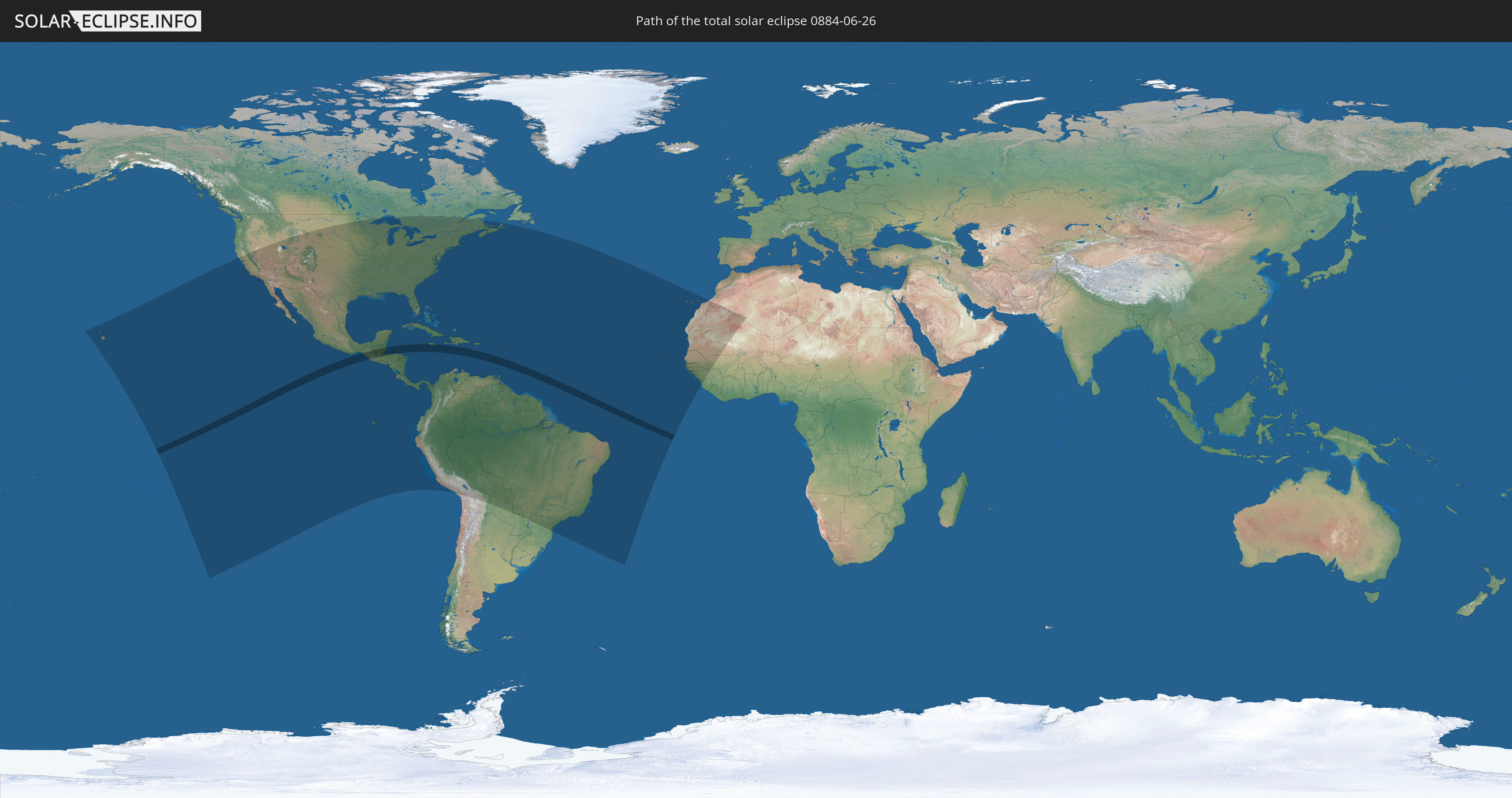
Die Sonnenfinsternis am 06/26/0884 kann man in 62 Ländern als partielle Sonnenfinsternis beobachten.
Der Finsternispfad verläuft durch 10 Länder. Nur in diesen Ländern ist sie als total Sonnenfinsternis zu sehen.
In den folgenden Ländern ist die Sonnenfinsternis total zu sehen
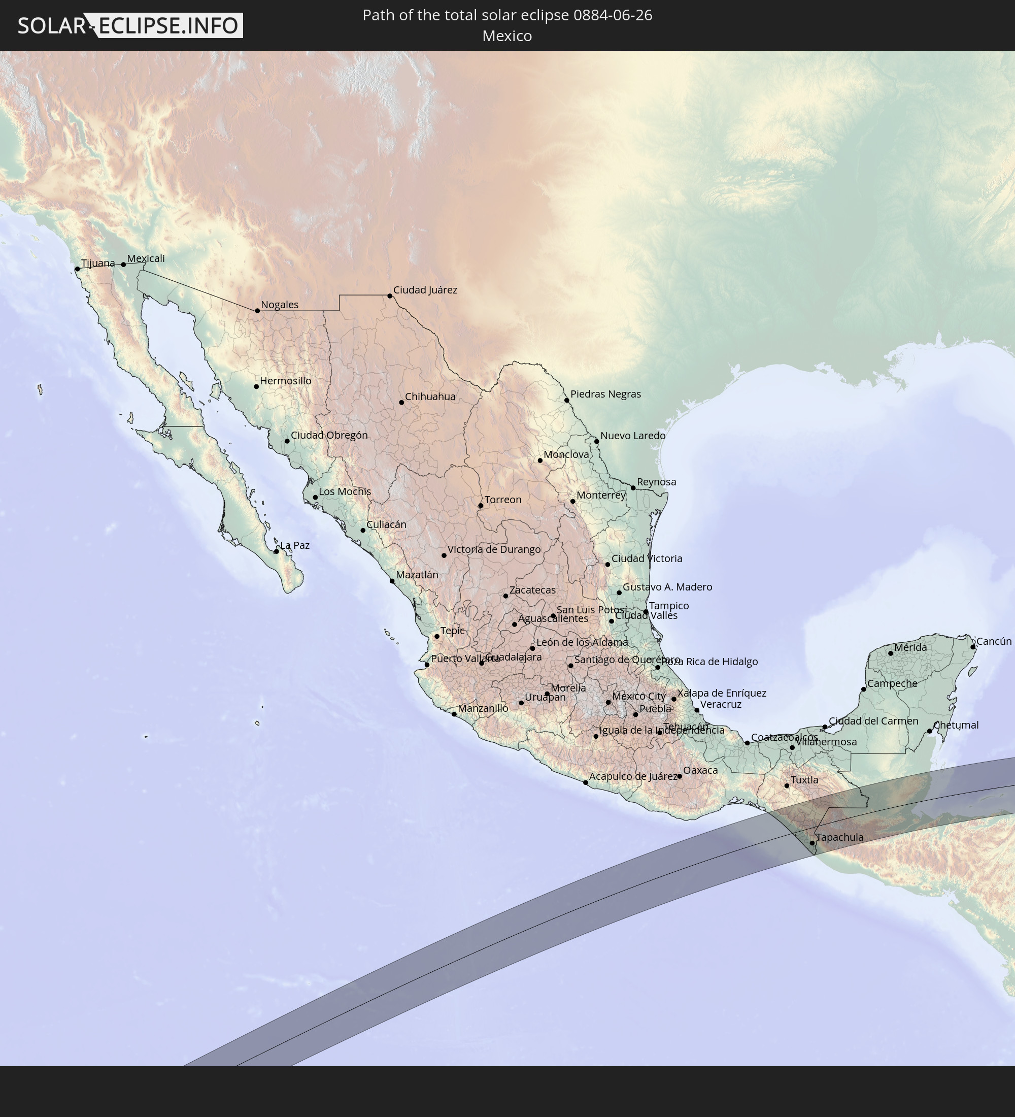 Mexico
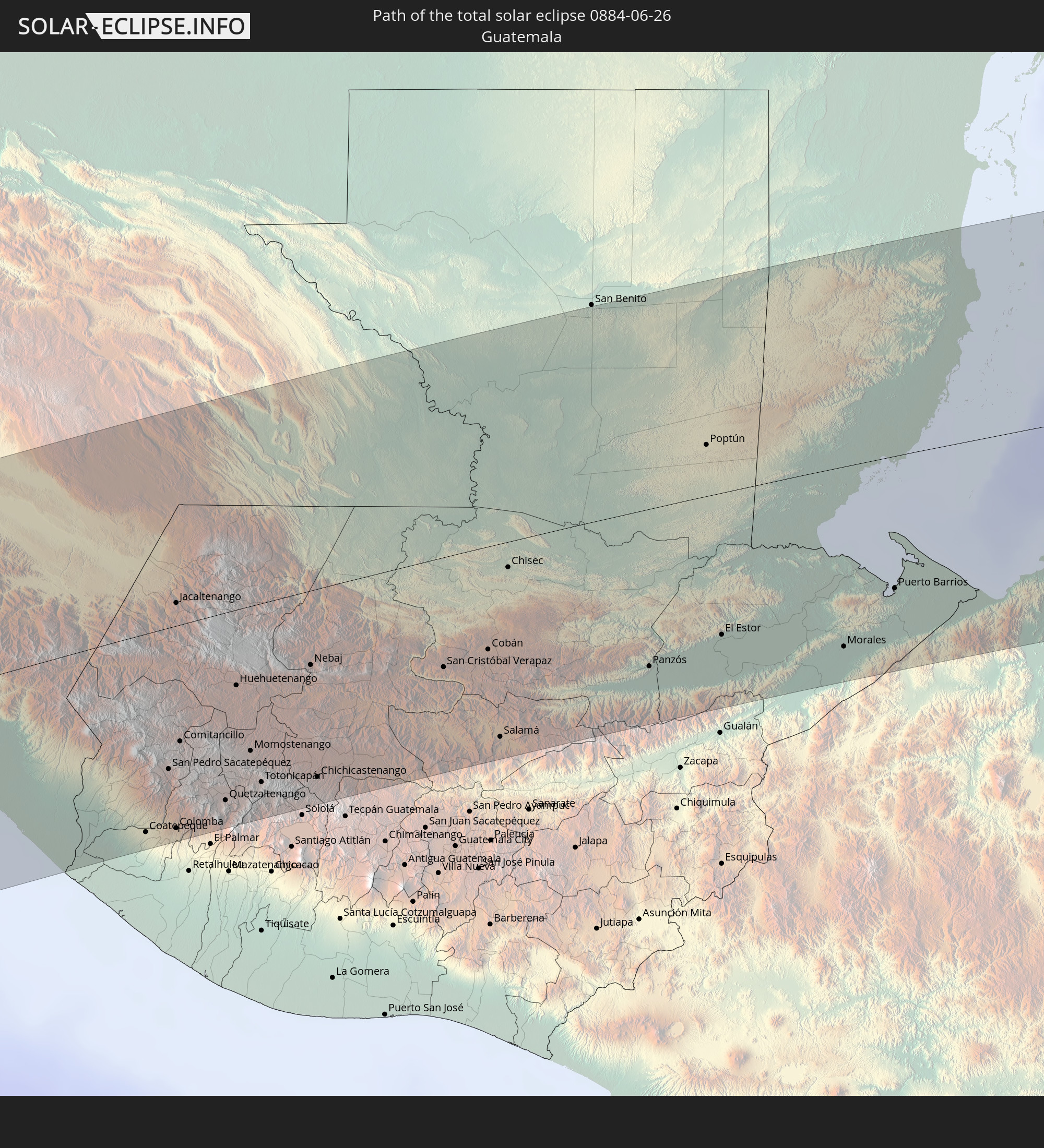 Guatemala
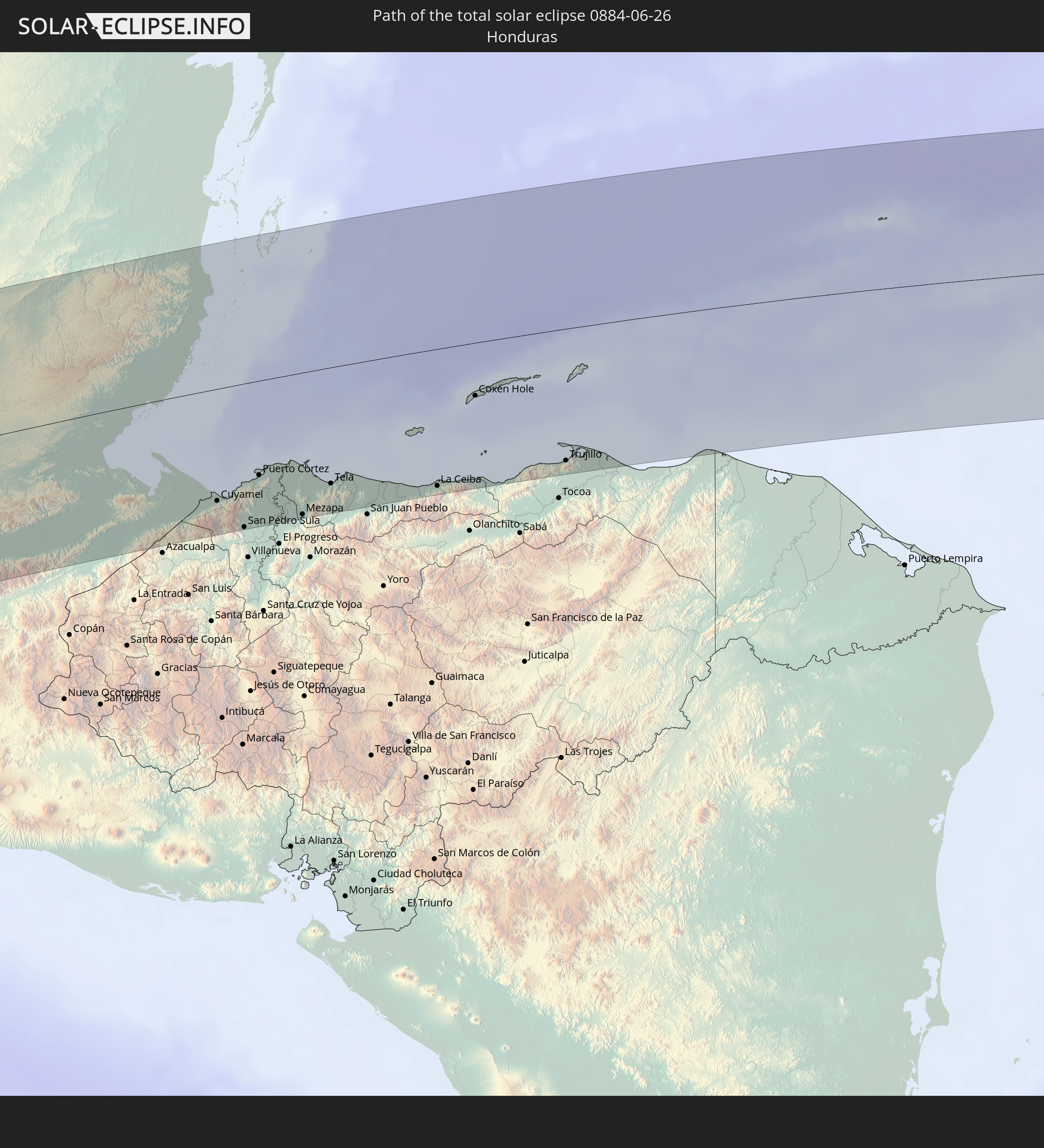 Honduras
 Belize
 Jamaica
 Dominican Republic
 Saint Vincent and the Grenadines
 Martinique
 Saint Lucia
 Barbados
In den folgenden Ländern ist die Sonnenfinsternis partiell zu sehen
 United States
 United States Minor Outlying Islands
 French Polynesia
 Canada
 Pitcairn Islands
 Mexico
 Chile
Chile
 Guatemala
 Ecuador
 El Salvador
 Honduras
 Belize
 Nicaragua
 Costa Rica
 Cuba
Cuba
 Panama
 Colombia
 Cayman Islands
 Peru
Peru
 The Bahamas
 Jamaica
 Haiti
Haiti
 Brazil
 Venezuela
 Turks and Caicos Islands
 Dominican Republic
 Aruba
Aruba
 Bolivia
 Puerto Rico
 United States Virgin Islands
 Bermuda
 British Virgin Islands
 Anguilla
 Collectivity of Saint Martin
 Saint Barthélemy
 Saint Kitts and Nevis
 Paraguay
 Antigua and Barbuda
 Montserrat
 Trinidad and Tobago
 Guadeloupe
 Grenada
 Dominica
 Saint Vincent and the Grenadines
 Guyana
 Martinique
 Saint Lucia
 Barbados
 Suriname
 French Guiana
 Portugal
 Cabo Verde
 Spain
Spain
 Senegal
 Mauritania
 The Gambia
 Guinea-Bissau
 Guinea
 Sierra Leone
 Morocco
 Mali
Mali
 Algeria
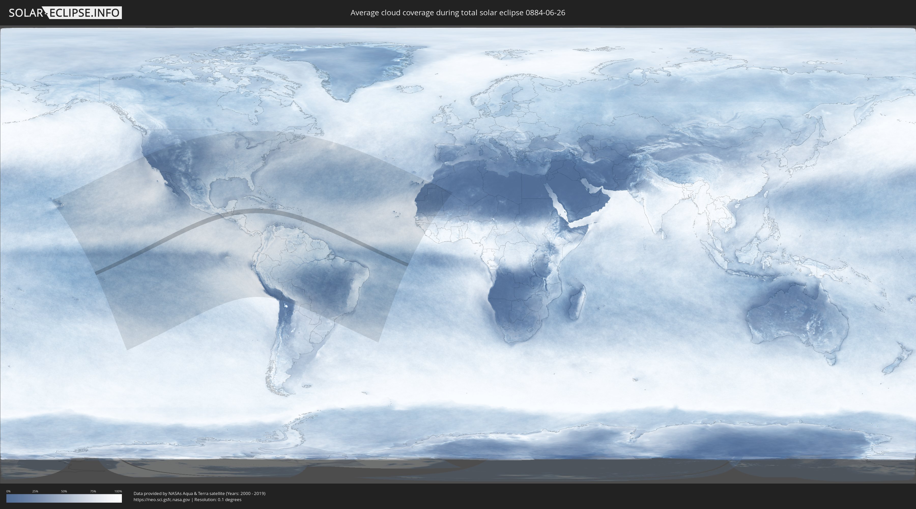
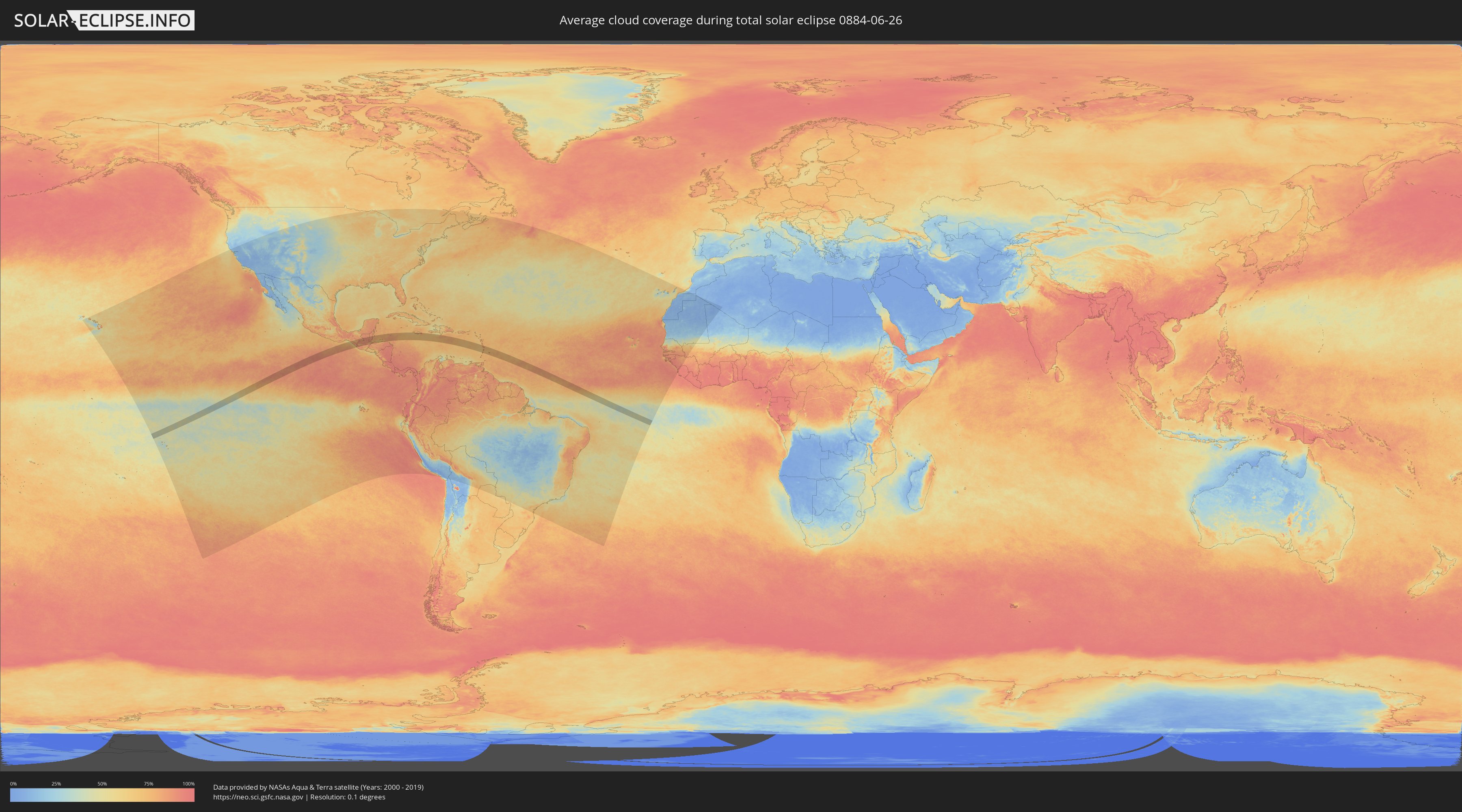
How will be the weather during the total solar eclipse on 06/26/0884?
Where is the best place to see the total solar eclipse of 06/26/0884?
The following maps show the average cloud coverage for the day of the total solar eclipse.
With the help of these maps, it is possible to find the place along the eclipse path, which has the best
chance of a cloudless sky.
Nevertheless, you should consider local circumstances and inform about the weather of your chosen
observation site.
The data is provided by NASAs satellites
AQUA and TERRA.
The cloud maps are averaged over a period of 19 years (2000 - 2019).
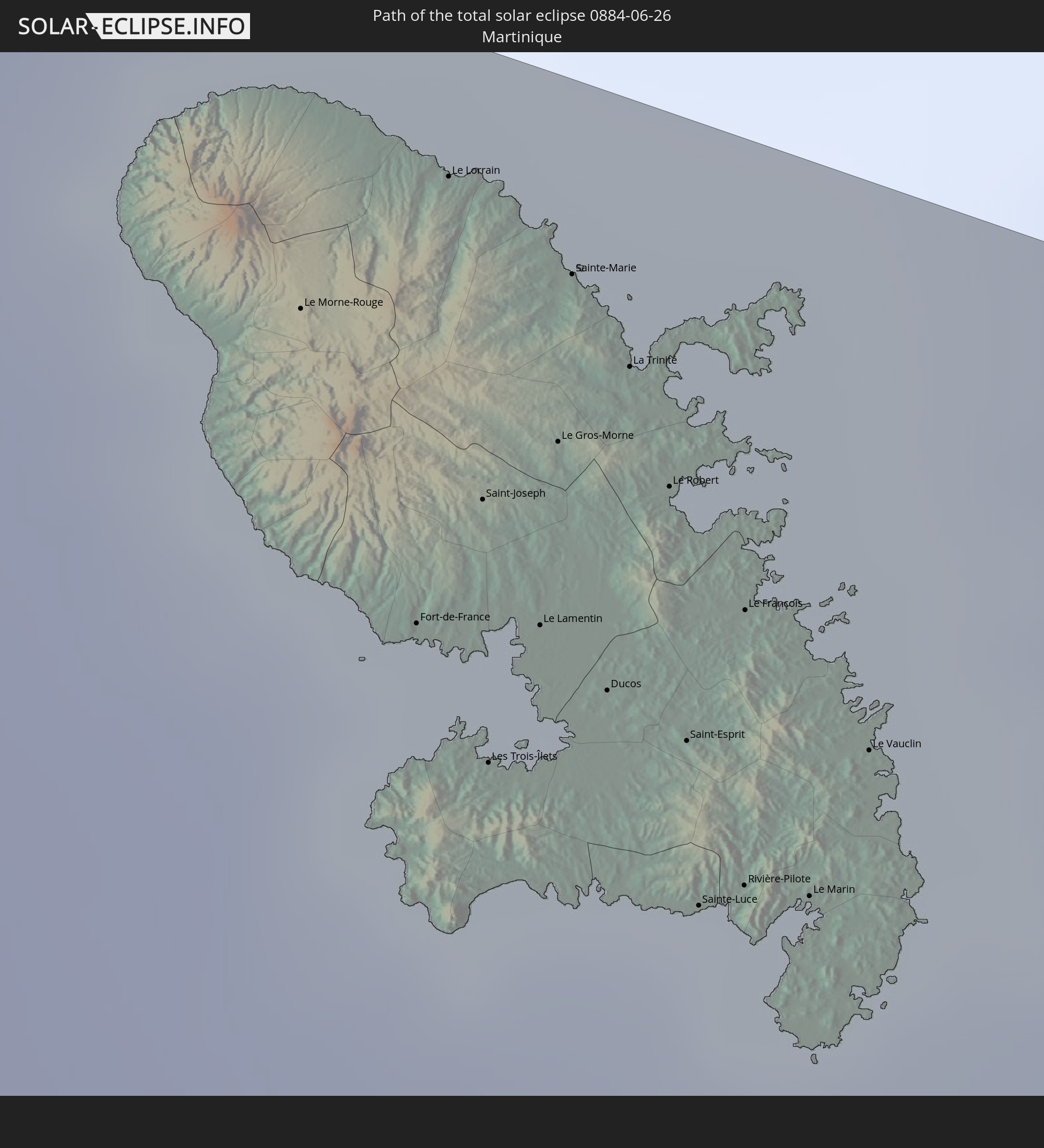
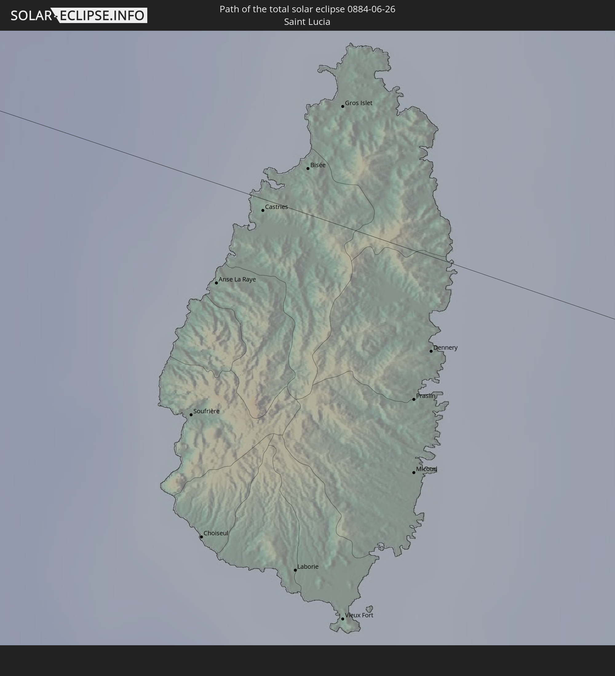
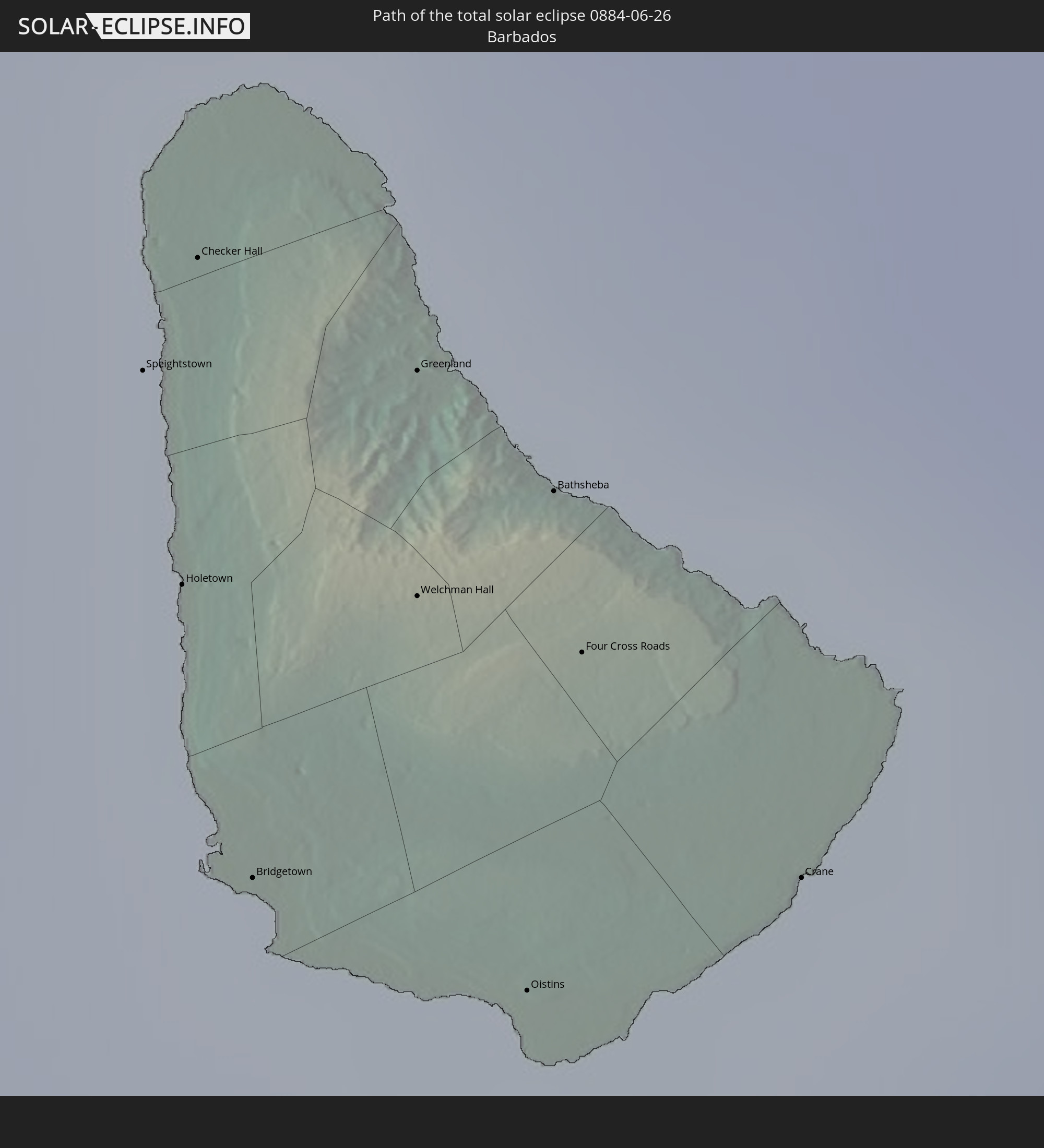
Detailed country maps
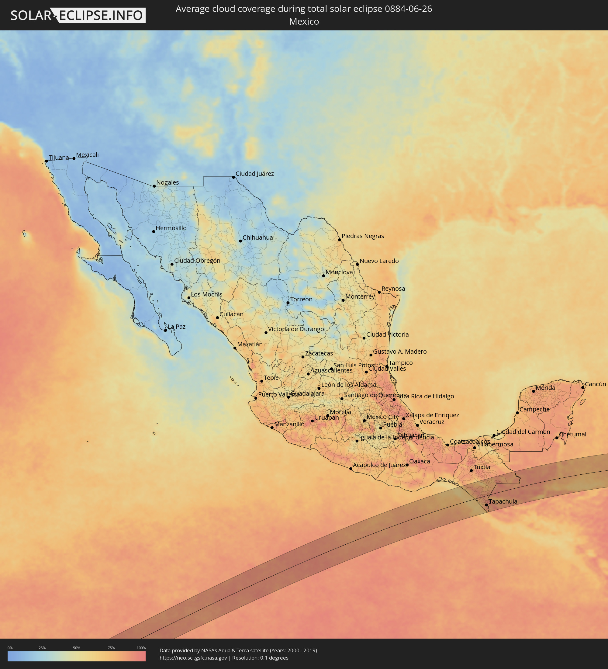 Mexico
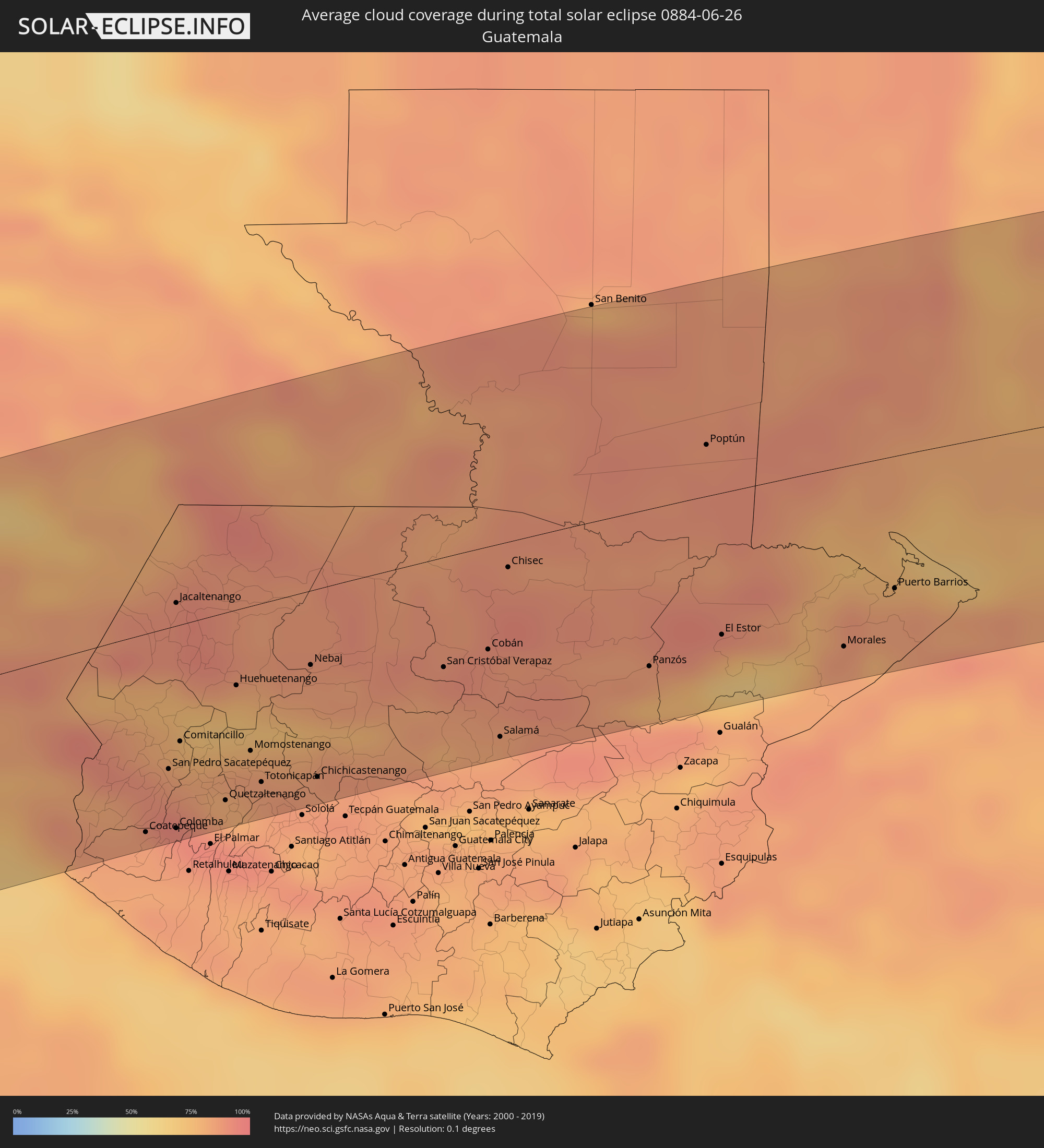 Guatemala
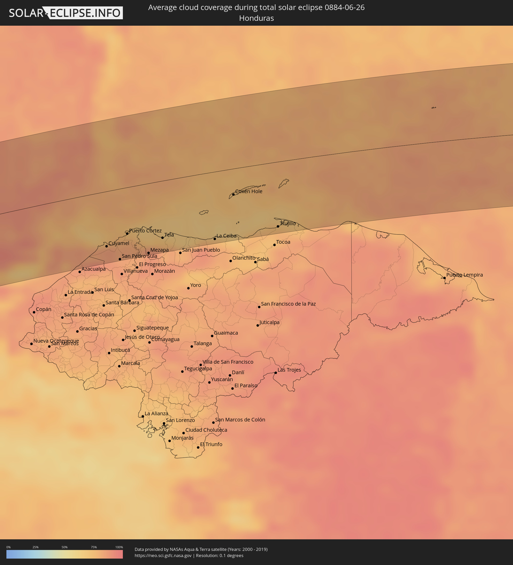 Honduras
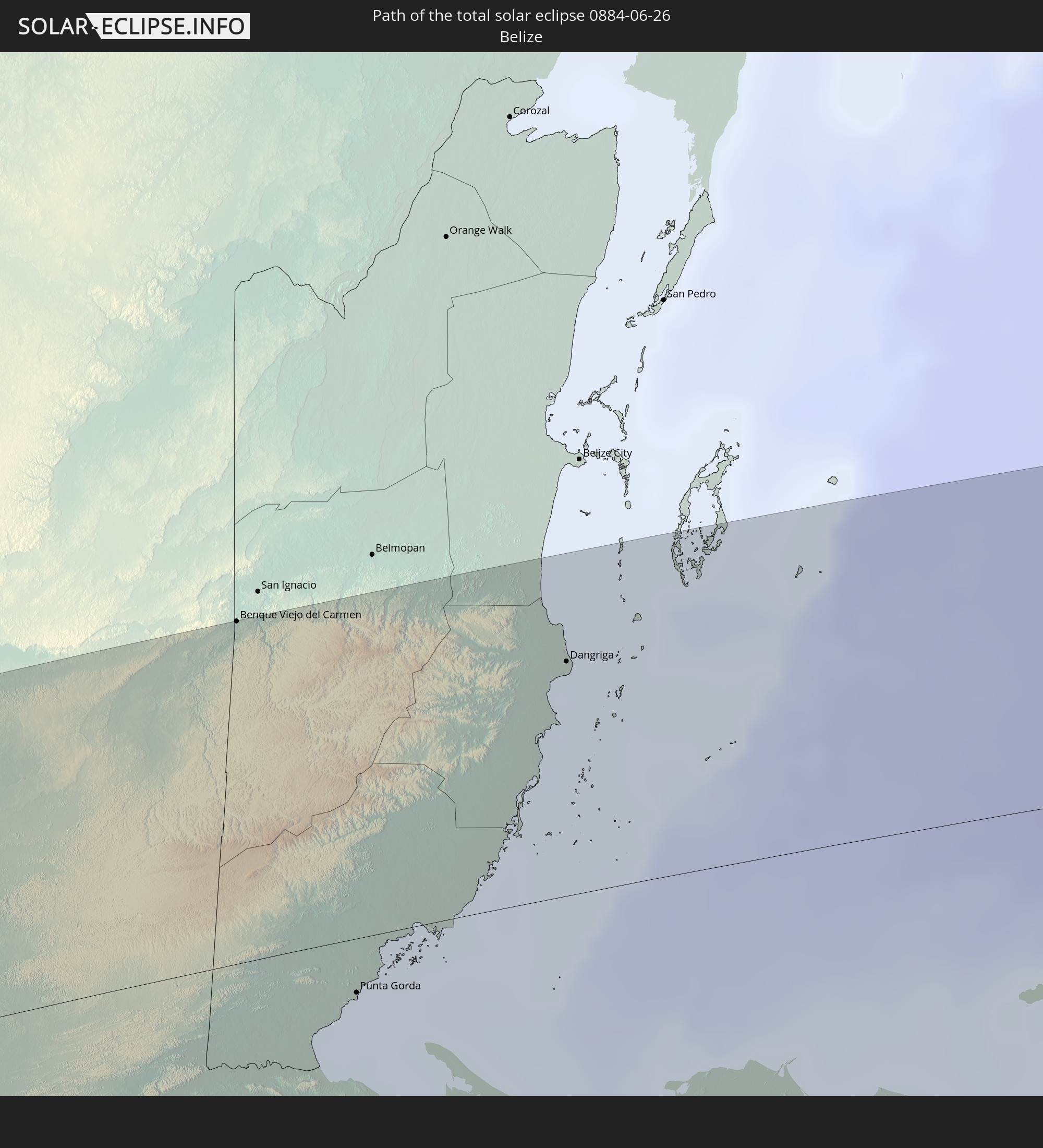
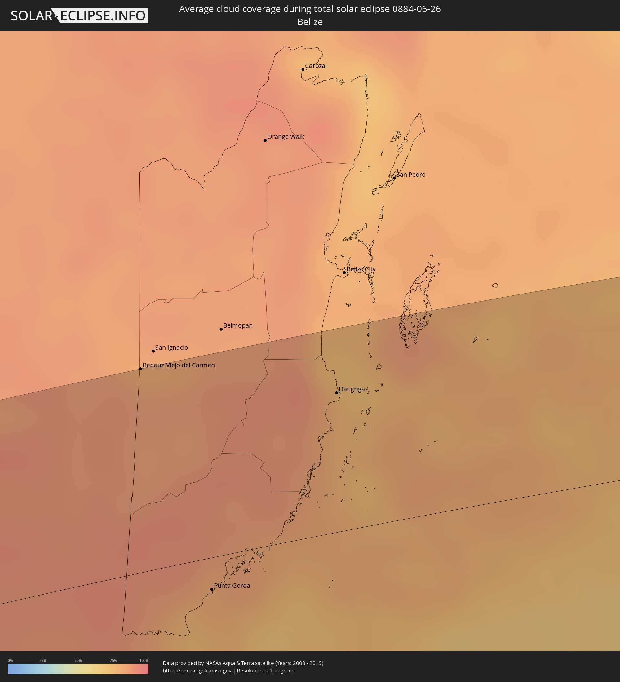 Belize
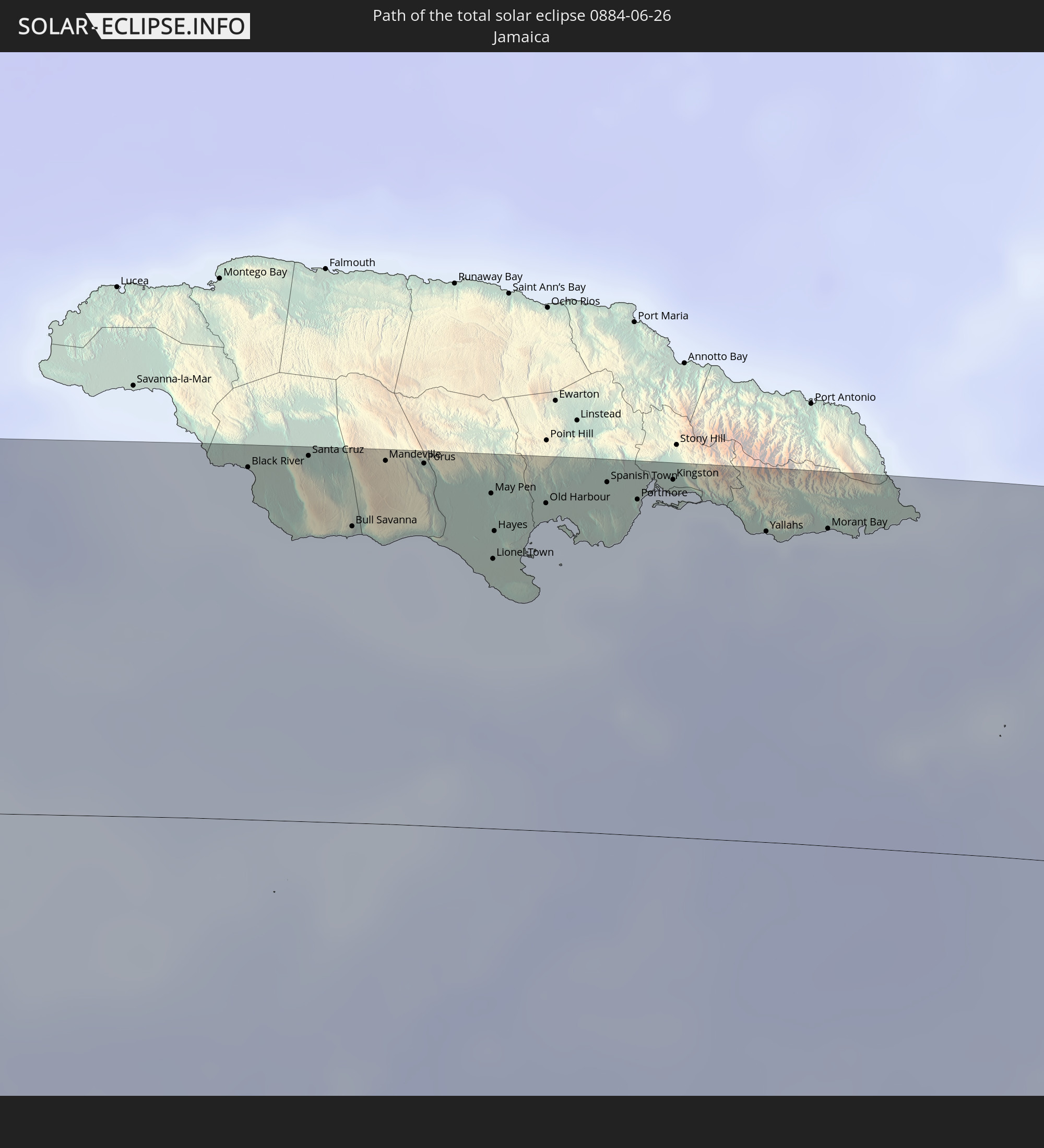
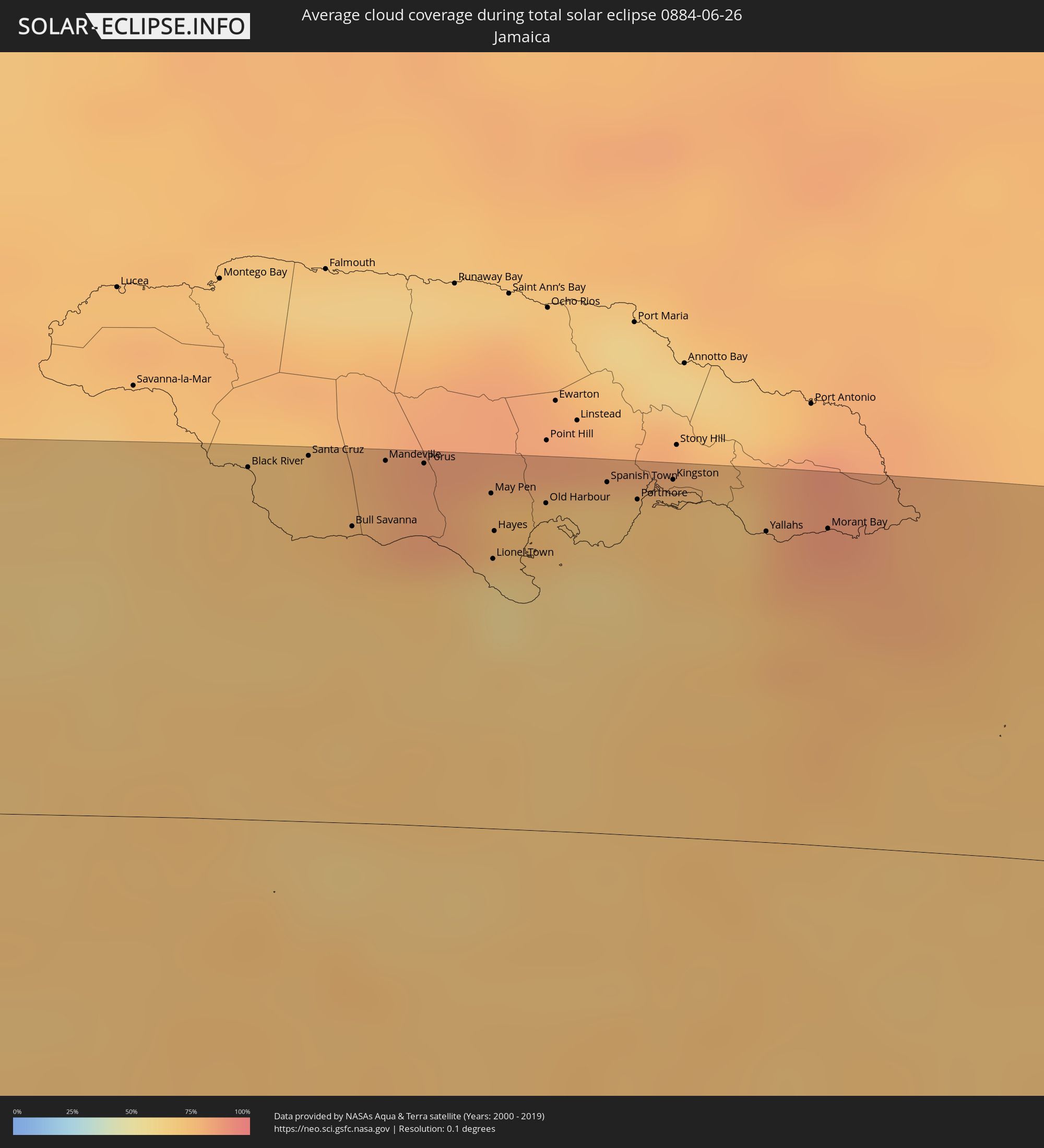 Jamaica
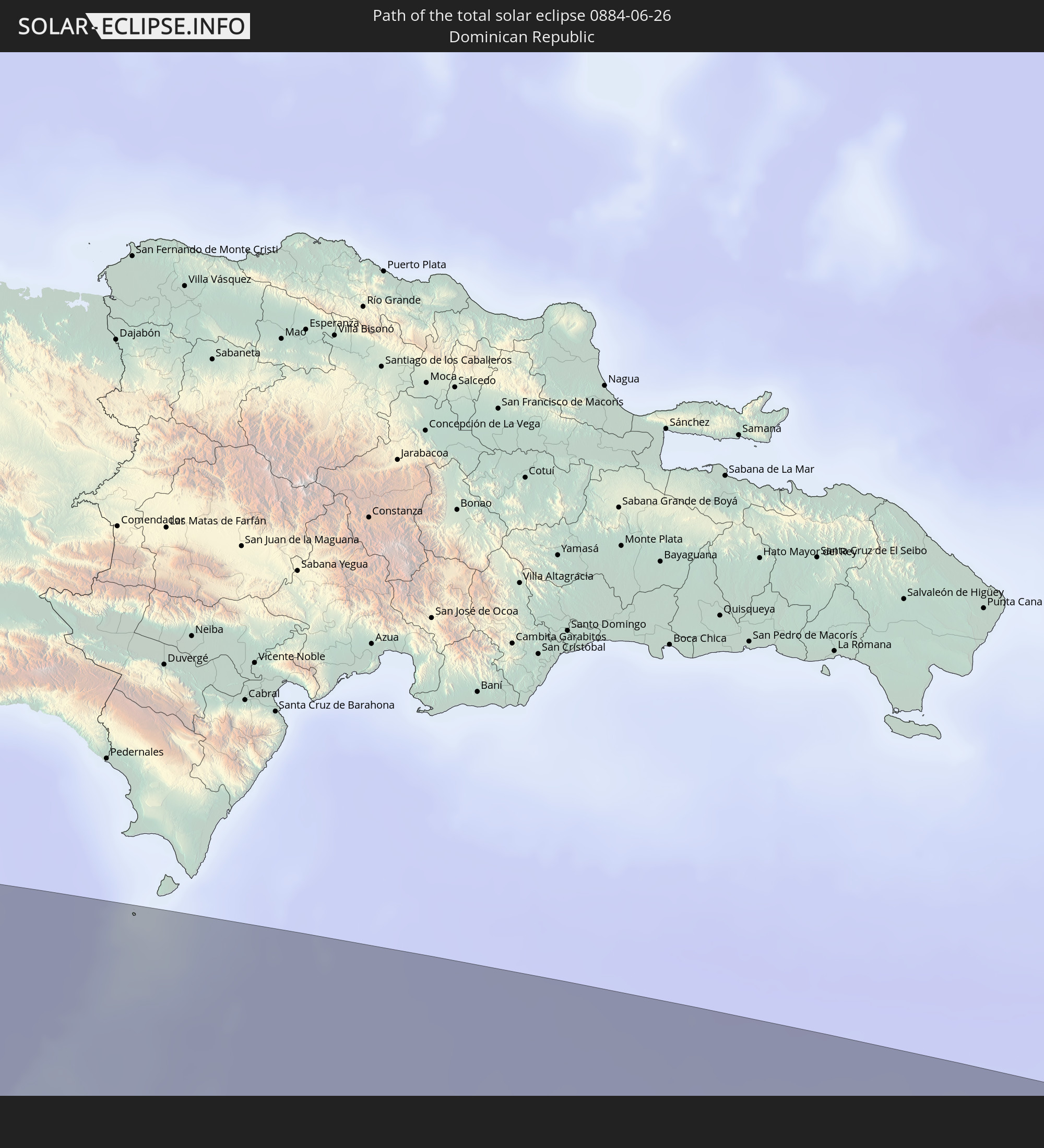
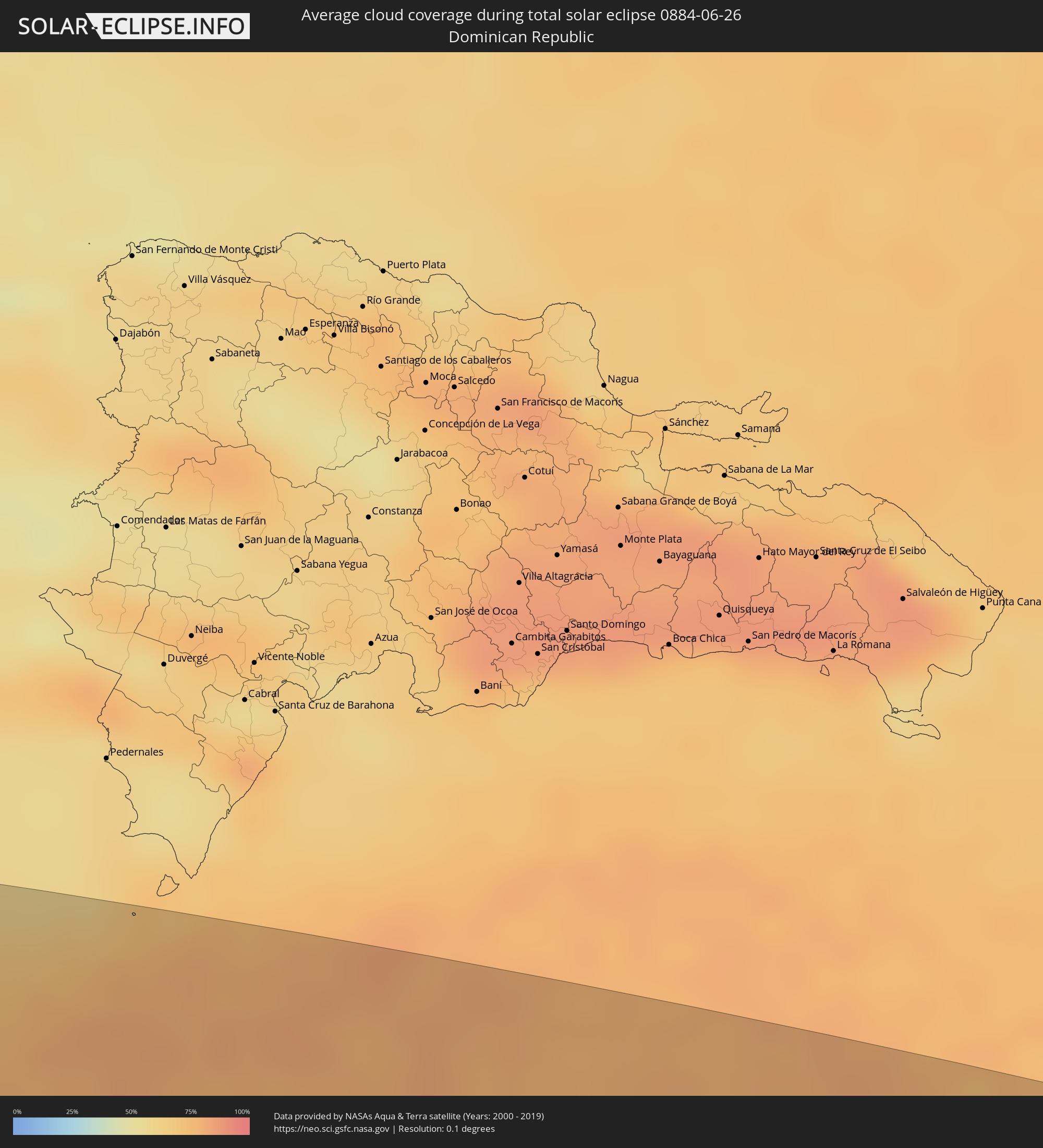 Dominican Republic
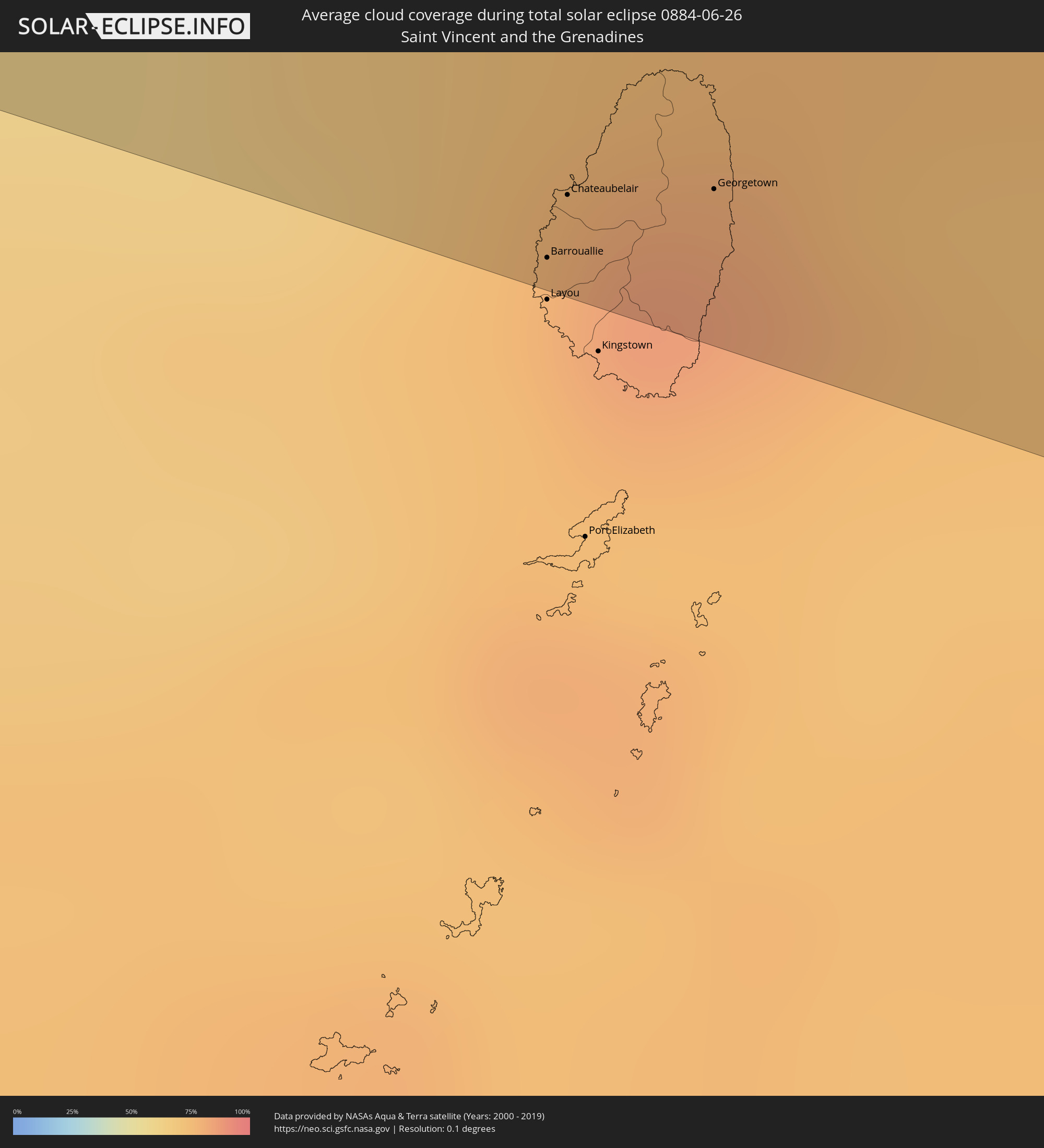 Saint Vincent and the Grenadines
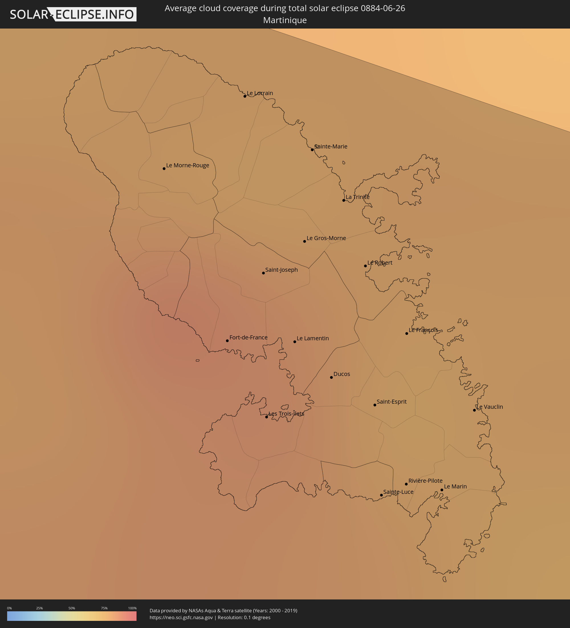 Martinique
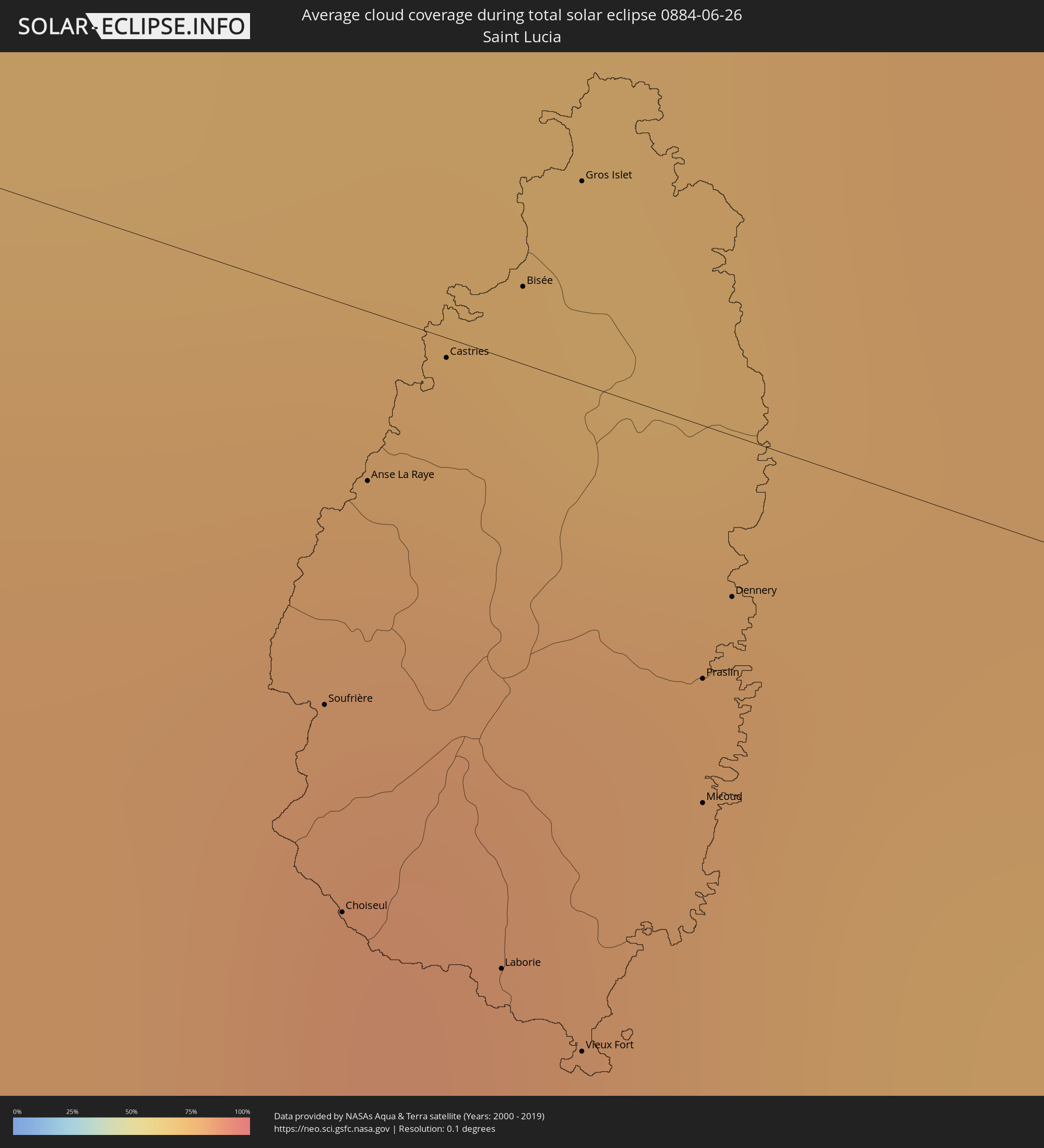 Saint Lucia
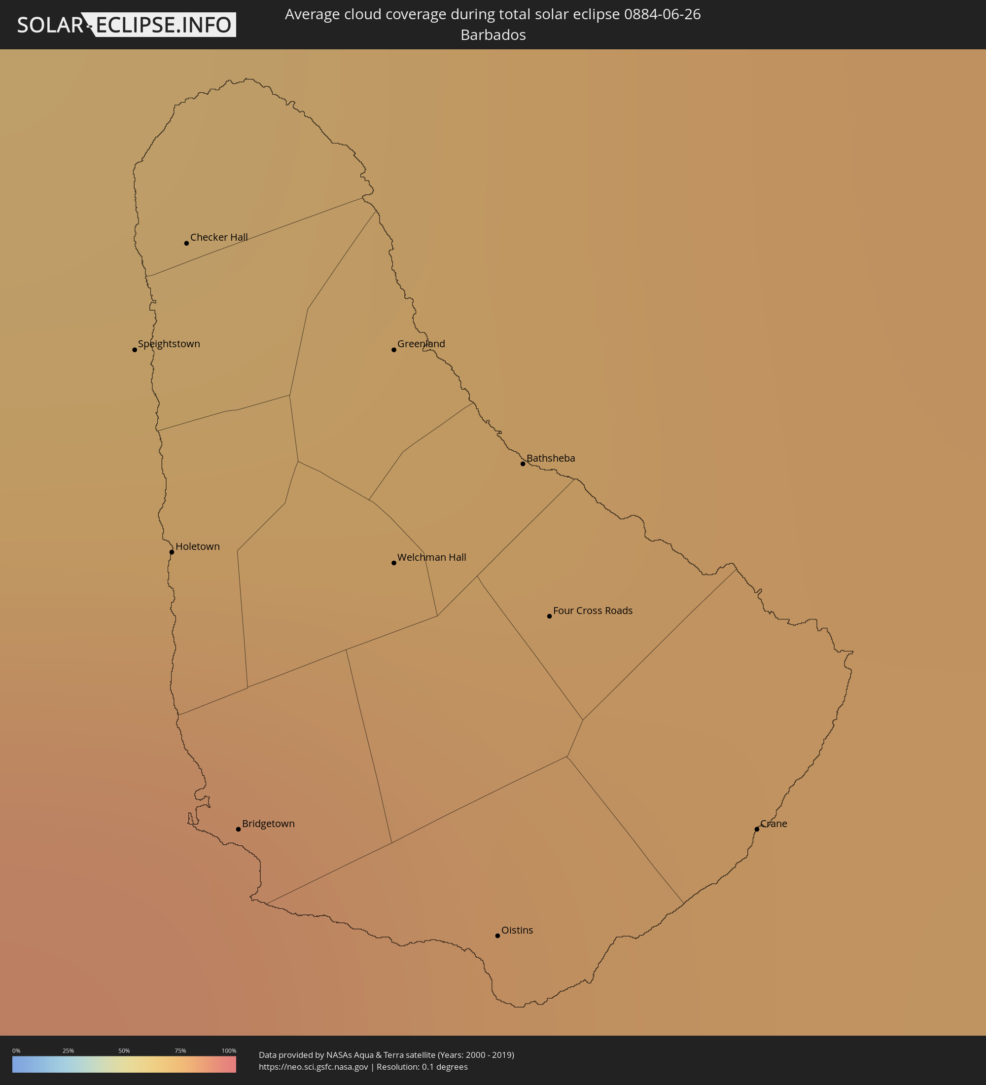 Barbados
Cities inside the path of the eclipse
The following table shows all locations with a population of more than 5,000 inside the eclipse path. Cities which have more than 100,000 inhabitants are marked bold. A click at the locations opens a detailed map.
| City | Type | Eclipse duration | Local time of max. eclipse | Distance to central line | Ø Cloud coverage |
|
Pijijiapan, Chiapas
|
total | - | 10:16:50 UTC-06:36 | 55 km | 76% |
|
San Pedro Buenavista, Chiapas
|
total | - | 10:17:23 UTC-06:36 | 95 km | 80% |
|
Mapastepec, Chiapas
|
total | - | 10:17:29 UTC-06:36 | 19 km | 72% |
|
Nueva Palestina, Chiapas
|
total | - | 10:18:09 UTC-06:36 | 54 km | 87% |
|
Angel Albino Corzo, Chiapas
|
total | - | 10:18:17 UTC-06:36 | 61 km | 82% |
|
Acapetahua, Chiapas
|
total | - | 10:17:56 UTC-06:36 | 4 km | 78% |
|
Acacoyagua, Chiapas
|
total | - | 10:18:01 UTC-06:36 | 2 km | 78% |
|
Escuintla, Chiapas
|
total | - | 10:18:03 UTC-06:36 | 1 km | 78% |
|
Villa Comaltitlán, Chiapas
|
total | - | 10:18:12 UTC-06:36 | 14 km | 79% |
|
Huixtla, Chiapas
|
total | - | 10:18:27 UTC-06:36 | 25 km | 77% |
|
Puerto Madero, Chiapas
|
total | - | 10:18:17 UTC-06:36 | 72 km | 68% |
|
Huehuetán, Chiapas
|
total | - | 10:18:36 UTC-06:36 | 41 km | 82% |
|
Vida Mejor I, Chiapas
|
total | - | 10:18:42 UTC-06:36 | 59 km | 88% |
|
Tapachula, Chiapas
|
total | - | 10:18:52 UTC-06:36 | 57 km | 88% |
|
Motozintla, Chiapas
|
total | - | 10:19:13 UTC-06:36 | 7 km | 79% |
|
Brisas Barra de Suchiate, Chiapas
|
total | - | 10:53:14 UTC-06:02 | 97 km | 71% |
|
Tuxtla Chico, Chiapas
|
total | - | 10:19:08 UTC-06:36 | 56 km | 86% |
|
Cacahoatán, Chiapas
|
total | - | 10:19:11 UTC-06:36 | 50 km | 82% |
|
Frontera Comalapa, Chiapas
|
total | - | 10:19:43 UTC-06:36 | 21 km | 85% |
|
Comitán, Chiapas
|
total | - | 10:20:09 UTC-06:36 | 84 km | 78% |
|
Malacatán, San Marcos
|
total | - | 10:53:57 UTC-06:02 | 62 km | 83% |
|
La Trinitaria, Chiapas
|
total | - | 10:20:17 UTC-06:36 | 68 km | 80% |
|
Las Margaritas, Chiapas
|
total | - | 10:20:37 UTC-06:36 | 87 km | 76% |
|
Coatepeque, Quetzaltenango
|
total | - | 10:54:21 UTC-06:02 | 90 km | 84% |
|
San Pedro Sacatepéquez, San Marcos
|
total | - | 10:54:49 UTC-06:02 | 64 km | 89% |
|
Jacaltenango, Huehuetenango
|
total | - | 10:55:23 UTC-06:02 | 10 km | 92% |
|
Quetzaltenango, Quetzaltenango
|
total | - | 10:55:25 UTC-06:02 | 85 km | 90% |
|
San Mateo Ixtatán, Huehuetenango
|
total | - | 10:56:13 UTC-06:02 | 21 km | 87% |
|
Huehuetenango, Huehuetenango
|
total | - | 10:55:53 UTC-06:02 | 34 km | 71% |
|
Momostenango, Totonicapán
|
total | - | 10:55:52 UTC-06:02 | 66 km | 84% |
|
Totonicapán, Totonicapán
|
total | - | 10:55:55 UTC-06:02 | 81 km | 83% |
|
Barillas, Huehuetenango
|
total | - | 10:56:39 UTC-06:02 | 14 km | 85% |
|
Nebaj, Quiché
|
total | - | 10:56:52 UTC-06:02 | 34 km | 84% |
|
Chichicastenango, Quiché
|
total | - | 10:56:38 UTC-06:02 | 85 km | 88% |
|
Joyabaj, Quiché
|
total | - | 10:57:33 UTC-06:02 | 87 km | 81% |
|
Benemérito de las Américas, Chiapas
|
total | - | 10:24:27 UTC-06:36 | 73 km | 80% |
|
San Cristóbal Verapaz, Alta Verapaz
|
total | - | 10:58:31 UTC-06:02 | 50 km | 84% |
|
Cobán, Alta Verapaz
|
total | - | 10:59:07 UTC-06:02 | 47 km | 88% |
|
Salamá, Baja Verapaz
|
total | - | 10:59:02 UTC-06:02 | 88 km | 85% |
|
Chisec, Alta Verapaz
|
total | - | 10:59:35 UTC-06:02 | 12 km | 89% |
|
Panzós, Alta Verapaz
|
total | - | 11:01:07 UTC-06:02 | 72 km | 76% |
|
Poptún, Petén
|
total | - | 11:02:24 UTC-06:02 | 23 km | 89% |
|
El Estor, Izabal
|
total | - | 11:02:07 UTC-06:02 | 65 km | 68% |
|
Benque Viejo del Carmen, Cayo
|
total | - | 11:12:54 UTC-05:52 | 98 km | 82% |
|
Morales, Izabal
|
total | - | 11:03:40 UTC-06:02 | 82 km | 83% |
|
Punta Gorda, Toledo
|
total | - | 11:13:18 UTC-05:52 | 16 km | 79% |
|
Lívingston, Izabal
|
total | - | 11:04:04 UTC-06:02 | 46 km | 79% |
|
Puerto Barrios, Izabal
|
total | - | 11:04:28 UTC-06:02 | 61 km | 84% |
|
Dangriga, Stann Creek
|
total | - | 11:15:29 UTC-05:52 | 67 km | 77% |
|
Cuyamel, Cortés
|
total | - | 11:18:48 UTC-05:48 | 76 km | 84% |
|
San Pedro Sula, Cortés
|
total | - | 11:19:15 UTC-05:48 | 97 km | 86% |
|
Choloma, Cortés
|
total | - | 11:19:31 UTC-05:48 | 86 km | 85% |
|
Puerto Cortez, Cortés
|
total | - | 11:19:42 UTC-05:48 | 64 km | 80% |
|
Baracoa, Cortés
|
total | - | 11:19:55 UTC-05:48 | 72 km | 80% |
|
Mezapa, Atlántida
|
total | - | 11:20:25 UTC-05:48 | 96 km | 85% |
|
Tela, Atlántida
|
total | - | 11:21:04 UTC-05:48 | 79 km | 74% |
|
La Ceiba, Atlántida
|
total | - | 11:23:08 UTC-05:48 | 93 km | 77% |
|
Coxen Hole, Bay Islands
|
total | - | 11:24:09 UTC-05:48 | 36 km | 73% |
|
Trujillo, Colón
|
total | - | 11:25:45 UTC-05:48 | 90 km | 76% |
|
Black River, St. Elizabeth
|
total | - | 12:32:54 UTC-05:07 | 93 km | 70% |
|
Santa Cruz, St. Elizabeth
|
total | - | 12:33:22 UTC-05:07 | 96 km | 72% |
|
Bull Savanna, St. Elizabeth
|
total | - | 12:33:42 UTC-05:07 | 78 km | 71% |
|
Mandeville, Manchester
|
total | - | 12:33:56 UTC-05:07 | 96 km | 79% |
|
Porus, Manchester
|
total | - | 12:34:14 UTC-05:07 | 95 km | 83% |
|
May Pen, Clarendon
|
total | - | 12:34:44 UTC-05:07 | 88 km | 75% |
|
Lionel Town, Clarendon
|
total | - | 12:34:46 UTC-05:07 | 71 km | 59% |
|
Hayes, Clarendon
|
total | - | 12:34:46 UTC-05:07 | 78 km | 61% |
|
Old Harbour, Saint Catherine
|
total | - | 12:35:09 UTC-05:07 | 86 km | 65% |
|
Old Harbour Bay, Saint Catherine
|
total | - | 12:35:11 UTC-05:07 | 83 km | 65% |
|
Spanish Town, Saint Catherine
|
total | - | 12:35:36 UTC-05:07 | 92 km | 69% |
|
Portmore, Saint Catherine
|
total | - | 12:35:50 UTC-05:07 | 88 km | 70% |
|
Half Way Tree, St. Andrew
|
total | - | 12:36:04 UTC-05:07 | 96 km | 73% |
|
Kingston, Kingston
|
total | - | 12:36:05 UTC-05:07 | 94 km | 73% |
|
New Kingston, St. Andrew
|
total | - | 12:36:07 UTC-05:07 | 95 km | 73% |
|
Yallahs, St. Thomas
|
total | - | 12:36:48 UTC-05:07 | 82 km | 73% |
|
Morant Bay, St. Thomas
|
total | - | 12:37:15 UTC-05:07 | 83 km | 82% |
|
Barrouallie, Saint Patrick
|
total | - | 14:21:09 UTC-04:06 | 90 km | 74% |
|
Chateaubelair, Saint David
|
total | - | 14:21:10 UTC-04:06 | 84 km | 76% |
|
Le Morne-Rouge, Martinique
|
total | - | 14:22:07 UTC-04:04 | 76 km | 87% |
|
Georgetown, Charlotte
|
total | - | 14:21:25 UTC-04:06 | 80 km | 82% |
|
Fort-de-France, Martinique
|
total | - | 14:22:21 UTC-04:04 | 62 km | 82% |
|
Le Lorrain, Martinique
|
total | - | 14:22:14 UTC-04:04 | 86 km | 87% |
|
Soufrière, Soufrière
|
total | - | 14:21:11 UTC-04:06 | 17 km | 79% |
|
Choiseul, Choiseul Quarter
|
total | - | 14:21:16 UTC-04:06 | 26 km | 77% |
|
Saint-Joseph, Martinique
|
total | - | 14:22:23 UTC-04:04 | 69 km | 84% |
|
Anse La Raye, Anse-la-Raye
|
total | - | 14:21:10 UTC-04:06 | 7 km | 84% |
|
Les Trois-Îlets, Martinique
|
total | - | 14:22:29 UTC-04:04 | 55 km | 81% |
|
Le Lamentin, Martinique
|
total | - | 14:22:29 UTC-04:04 | 64 km | 81% |
|
Castries, Castries Quarter
|
total | - | 14:21:12 UTC-04:06 | 1 km | 80% |
|
Le Gros-Morne, Martinique
|
total | - | 14:22:27 UTC-04:04 | 74 km | 84% |
|
Sainte-Marie, Martinique
|
total | - | 14:22:24 UTC-04:04 | 83 km | 82% |
|
Laborie, Laborie Quarter
|
total | - | 14:21:25 UTC-04:06 | 26 km | 77% |
|
Ducos, Martinique
|
total | - | 14:22:35 UTC-04:04 | 61 km | 81% |
|
Bisée, Castries Quarter
|
total | - | 14:21:15 UTC-04:06 | 3 km | 80% |
|
La Trinité, Martinique
|
total | - | 14:22:30 UTC-04:04 | 79 km | 84% |
|
Gros Islet, Gros-Islet
|
total | - | 14:21:16 UTC-04:06 | 9 km | 76% |
|
Vieux Fort, Vieux-Fort
|
total | - | 14:21:31 UTC-04:06 | 28 km | 75% |
|
Le Robert, Martinique
|
total | - | 14:22:35 UTC-04:04 | 73 km | 74% |
|
Saint-Esprit, Martinique
|
total | - | 14:22:42 UTC-04:04 | 60 km | 77% |
|
Sainte-Luce, Martinique
|
total | - | 14:22:46 UTC-04:04 | 52 km | 77% |
|
Rivière-Pilote, Martinique
|
total | - | 14:22:49 UTC-04:04 | 54 km | 77% |
|
Le François, Martinique
|
total | - | 14:22:43 UTC-04:04 | 68 km | 77% |
|
Micoud, Micoud Quarter
|
total | - | 14:21:33 UTC-04:06 | 16 km | 76% |
|
Praslin, Praslin
|
total | - | 14:21:31 UTC-04:06 | 11 km | 79% |
|
Dennery, Dennery Quarter
|
total | - | 14:21:31 UTC-04:06 | 7 km | 79% |
|
Le Marin, Martinique
|
total | - | 14:22:53 UTC-04:04 | 54 km | 77% |
|
Le Vauclin, Martinique
|
total | - | 14:22:54 UTC-04:04 | 63 km | 70% |
|
Speightstown, Saint Peter
|
total | - | 14:32:11 UTC-03:58 | 31 km | 79% |
|
Holetown, Saint James
|
total | - | 14:32:15 UTC-03:58 | 37 km | 83% |
|
Checker Hall, Saint Lucy
|
total | - | 14:32:12 UTC-03:58 | 27 km | 72% |
|
Bridgetown, Saint Michael
|
total | - | 14:32:22 UTC-03:58 | 46 km | 79% |
|
Greenland, Saint Andrew
|
total | - | 14:32:21 UTC-03:58 | 28 km | 72% |
|
Welchman Hall, Saint Thomas
|
total | - | 14:32:24 UTC-03:58 | 35 km | 83% |
|
Oistins, Christ Church
|
total | - | 14:32:33 UTC-03:58 | 46 km | 78% |
|
Bathsheba, Saint Joseph
|
total | - | 14:32:28 UTC-03:58 | 30 km | 78% |
|
Four Cross Roads, Saint John
|
total | - | 14:32:31 UTC-03:58 | 35 km | 78% |
|
Crane, Saint Philip
|
total | - | 14:32:42 UTC-03:58 | 39 km | 78% |