Annular solar eclipse of 04/05/0916
| Day of week: | Sunday |
| Maximum duration of eclipse: | 02m28s |
| Maximum width of eclipse path: | 101 km |
| Saros cycle: | 92 |
| Coverage: | 97.5% |
| Magnitude: | 0.9753 |
| Gamma: | 0.4911 |
Wo kann man die Sonnenfinsternis vom 04/05/0916 sehen?
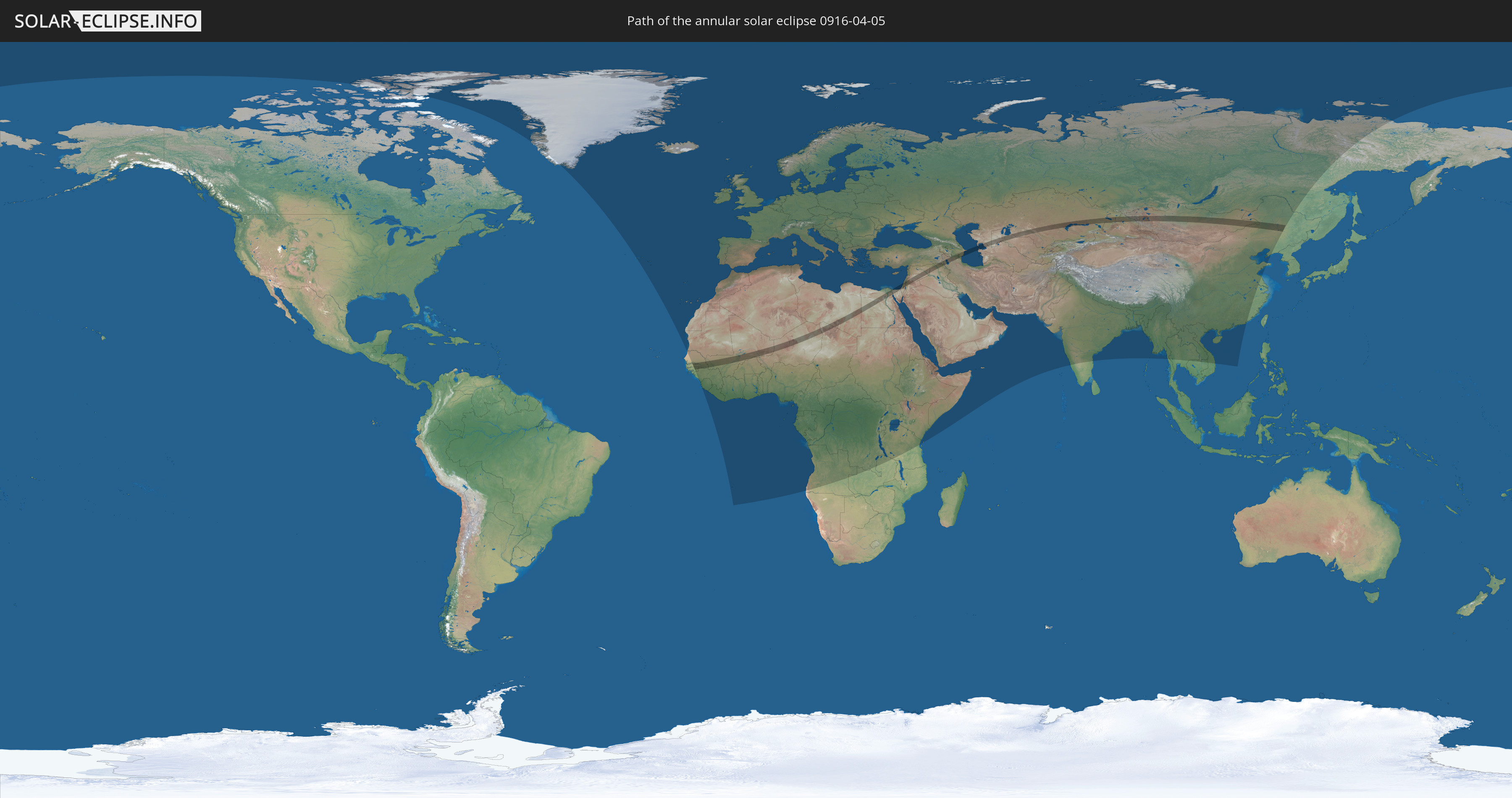
Die Sonnenfinsternis am 04/05/0916 kann man in 133 Ländern als partielle Sonnenfinsternis beobachten.
Der Finsternispfad verläuft durch 23 Länder. Nur in diesen Ländern ist sie als annular Sonnenfinsternis zu sehen.
In den folgenden Ländern ist die Sonnenfinsternis annular zu sehen
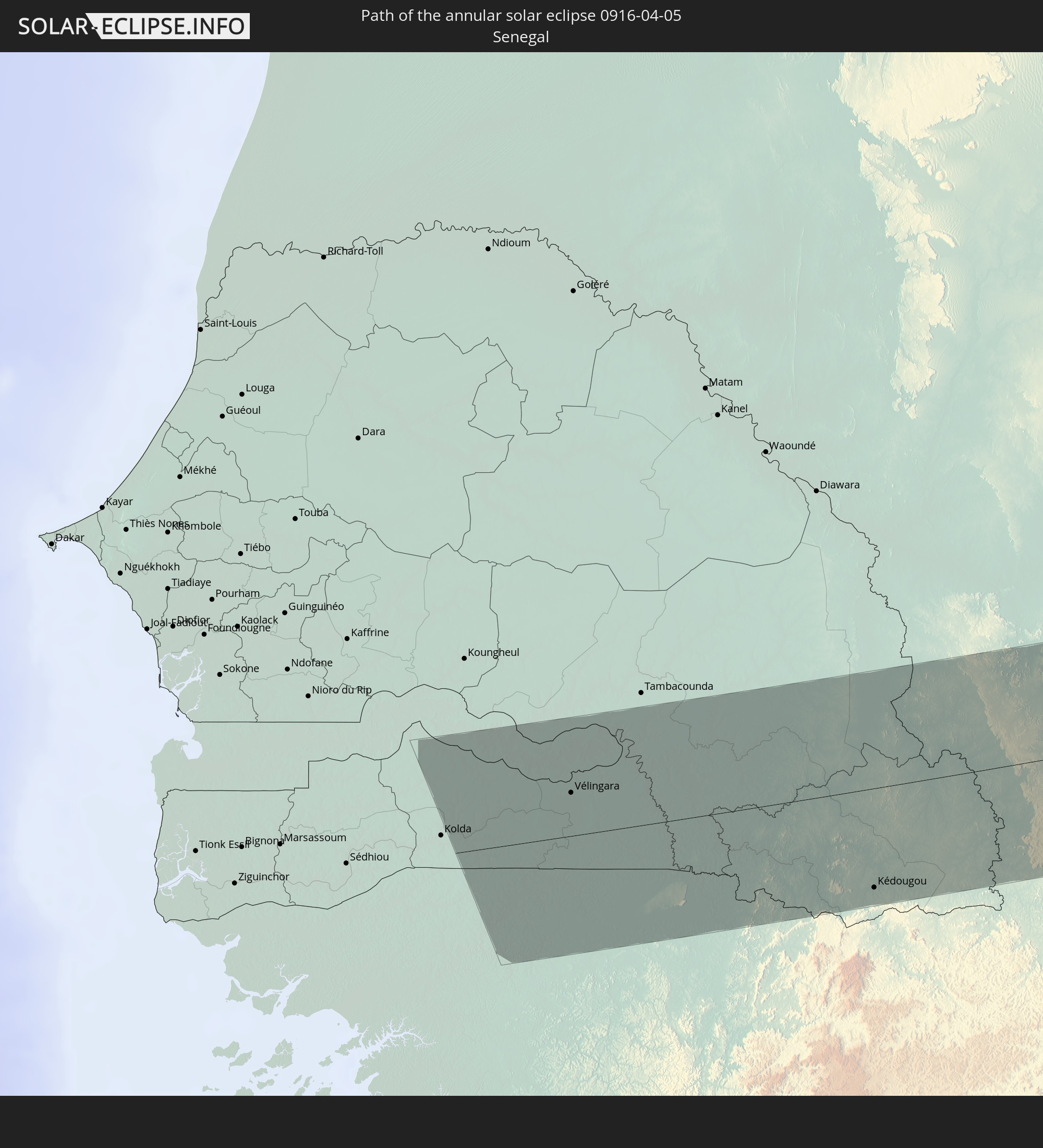 Senegal
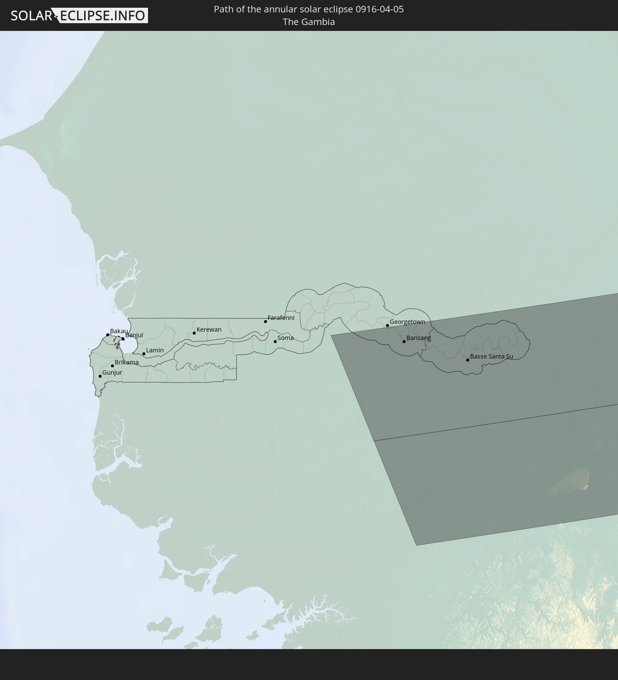 The Gambia
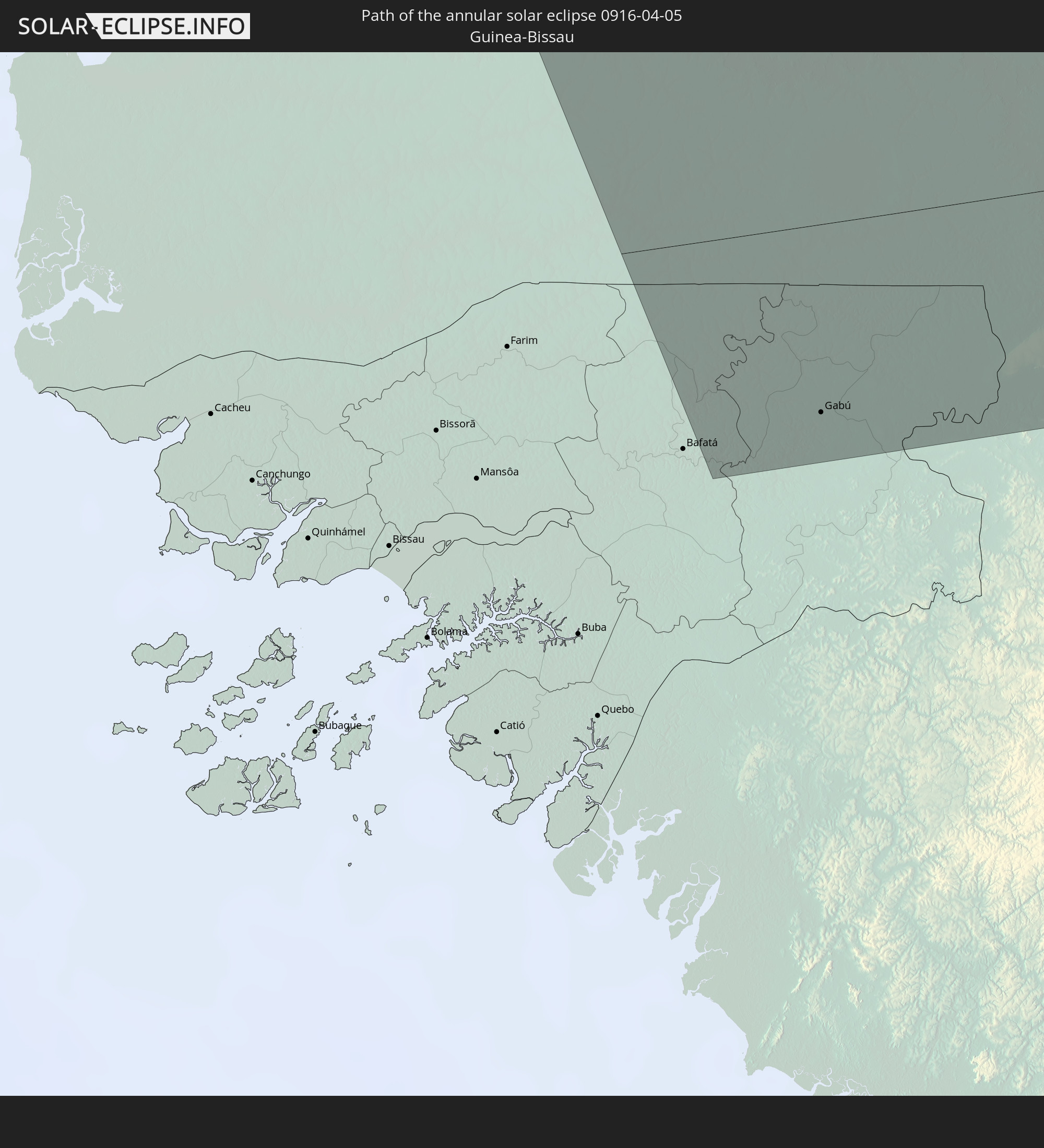 Guinea-Bissau
 Guinea
 Mali
Mali
 Burkina Faso
 Niger
Niger
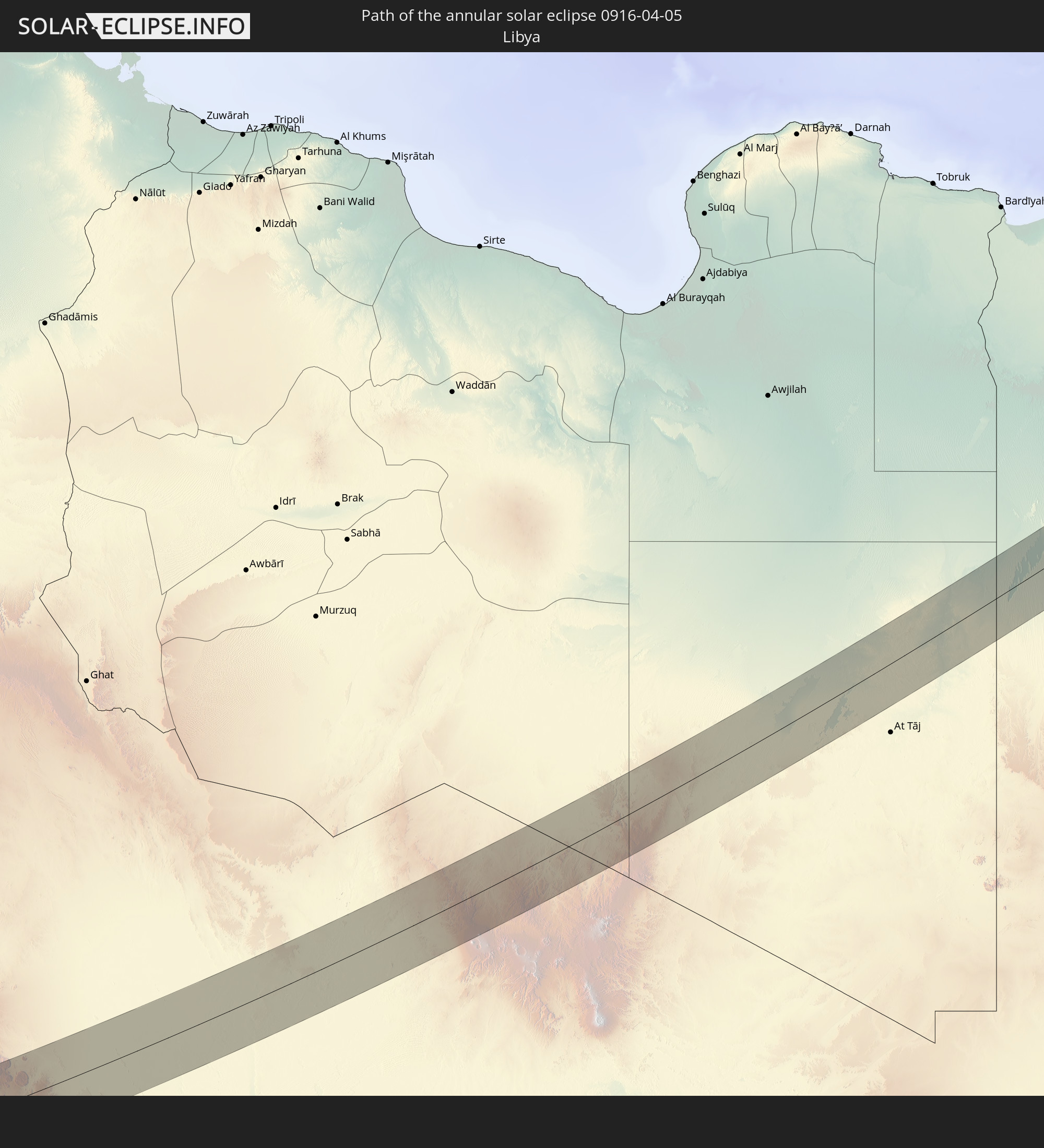 Libya
Libya
 Chad
Chad
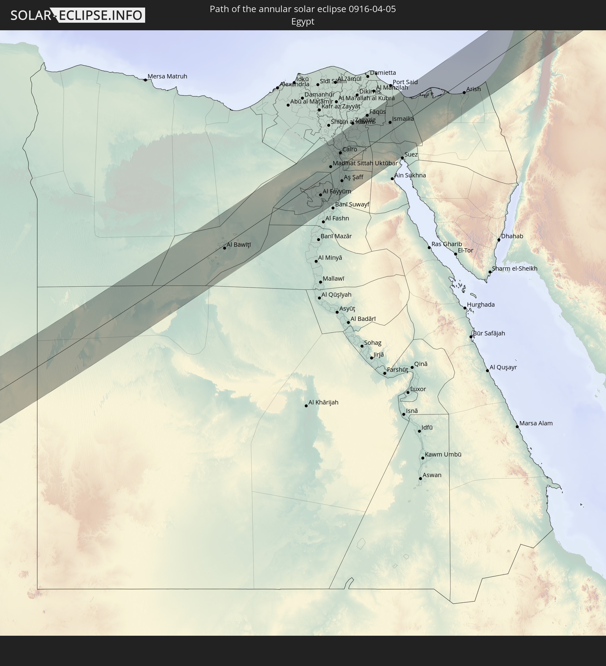 Egypt
Egypt
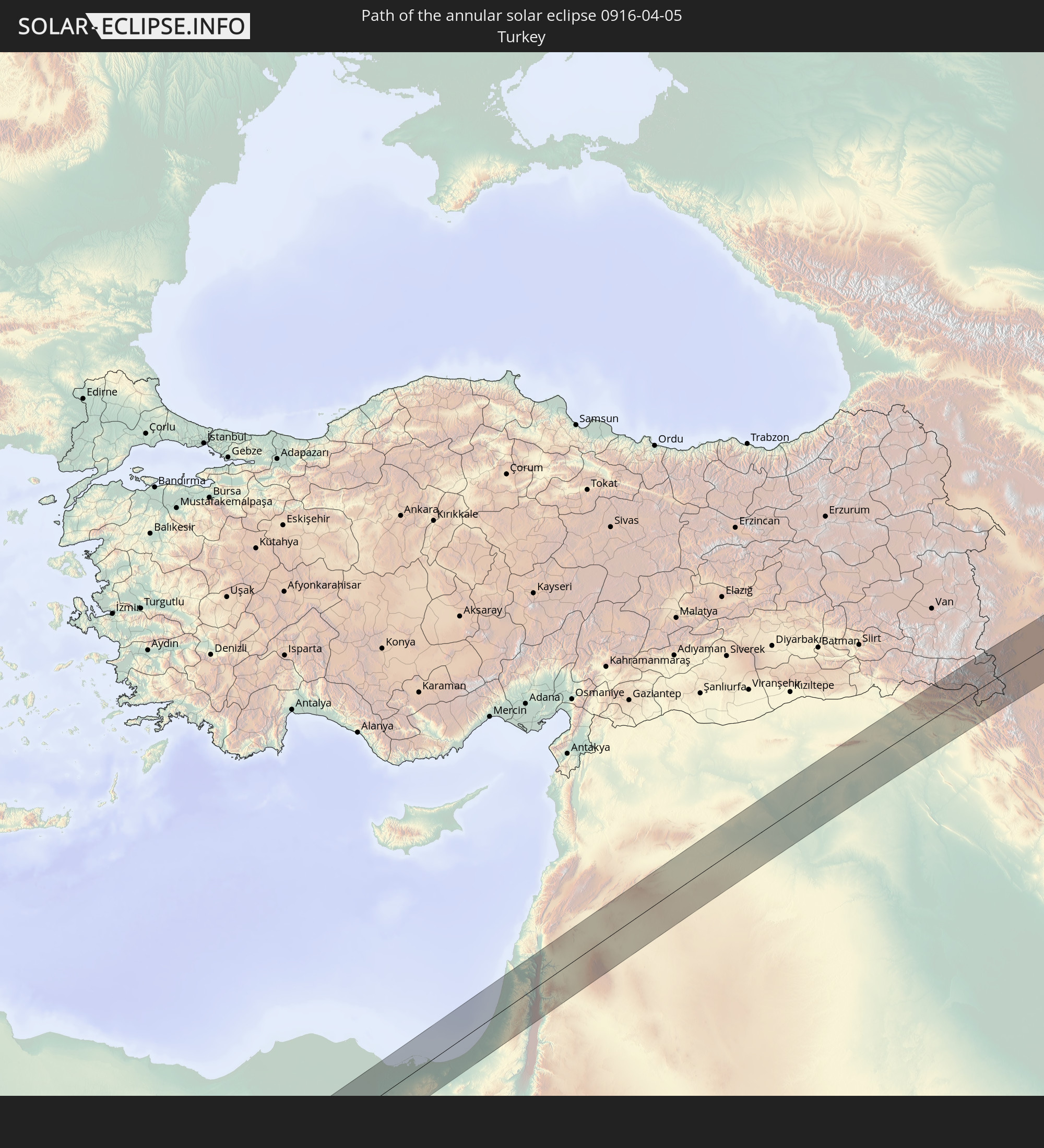 Turkey
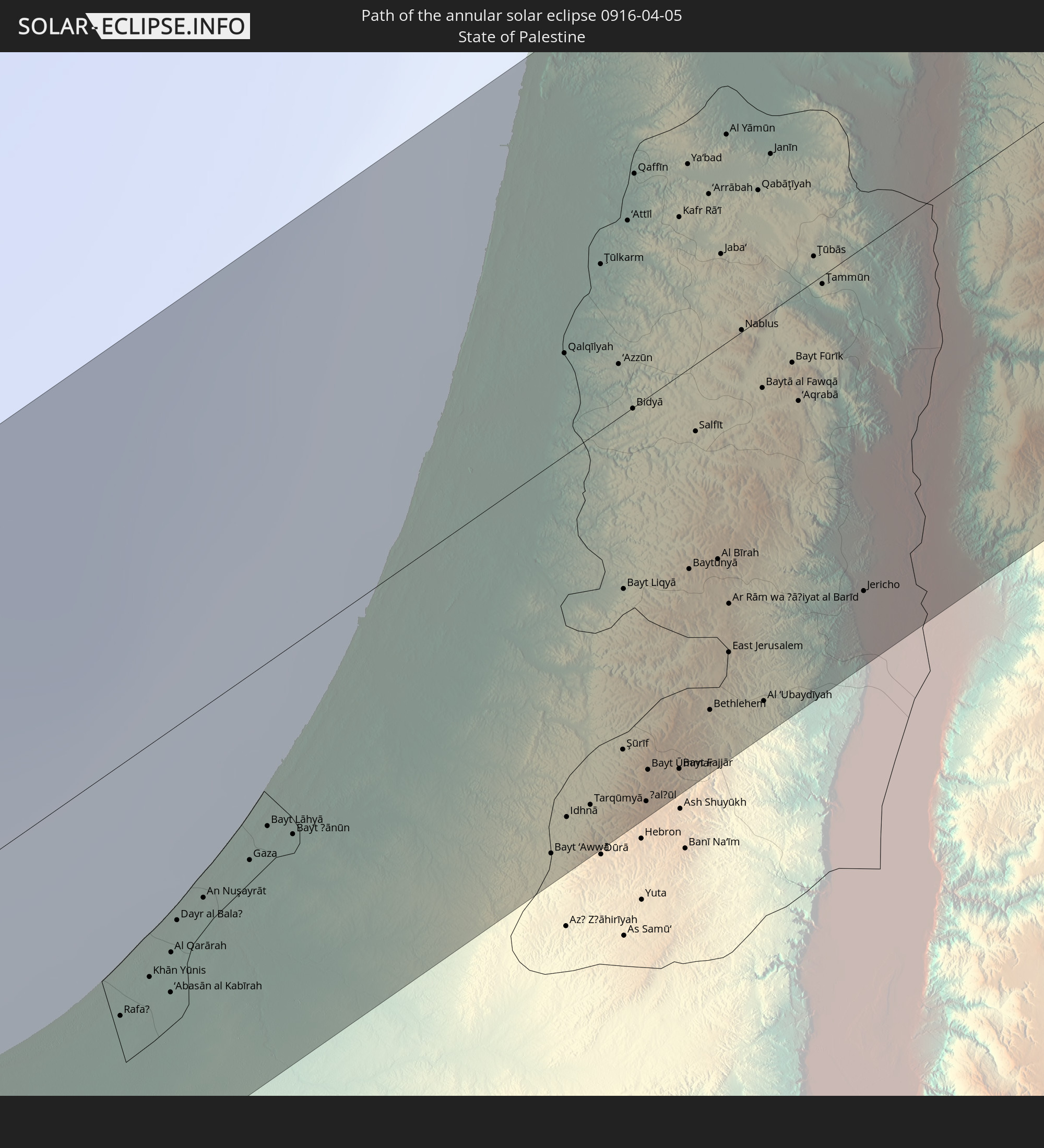 State of Palestine
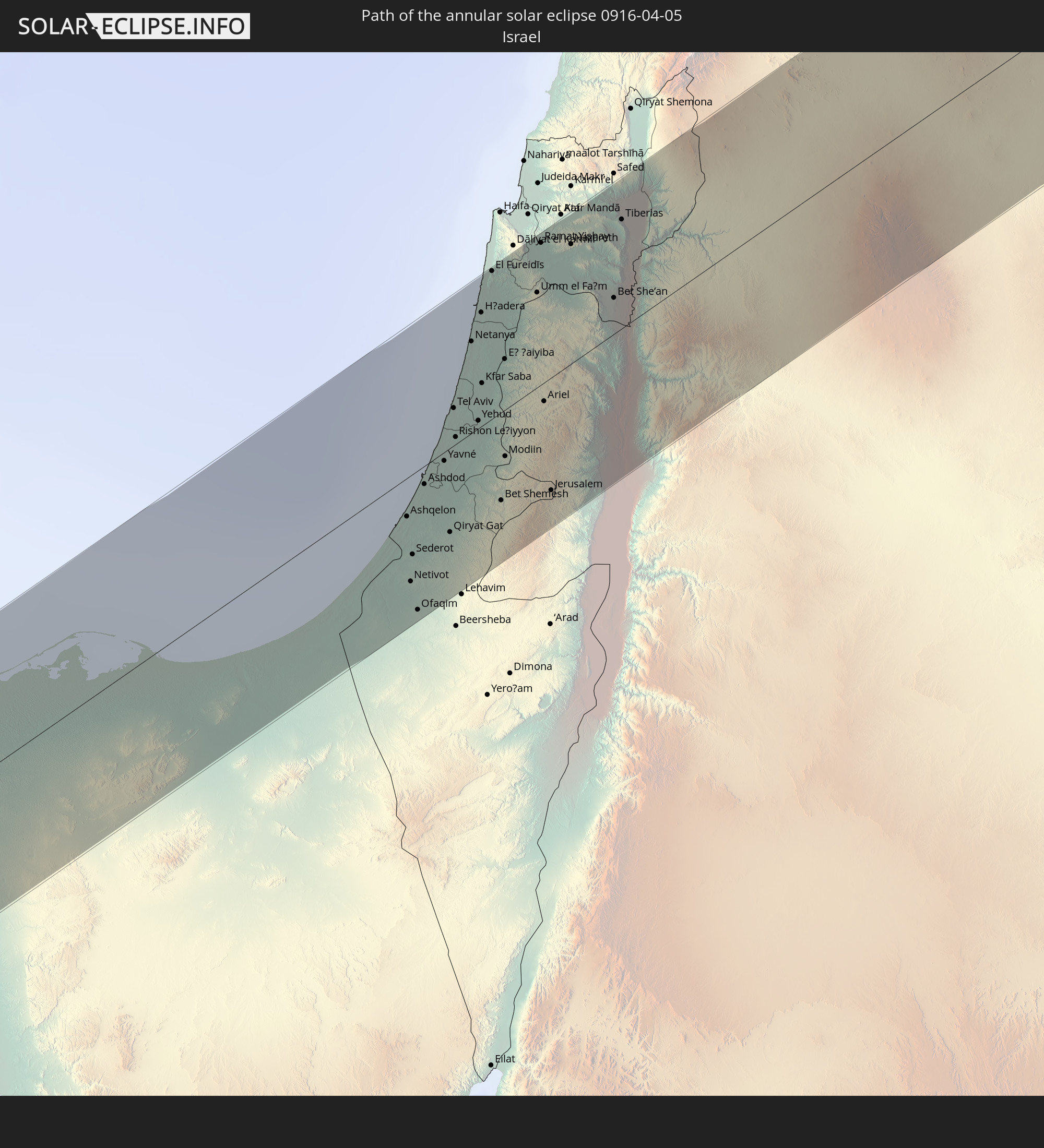 Israel
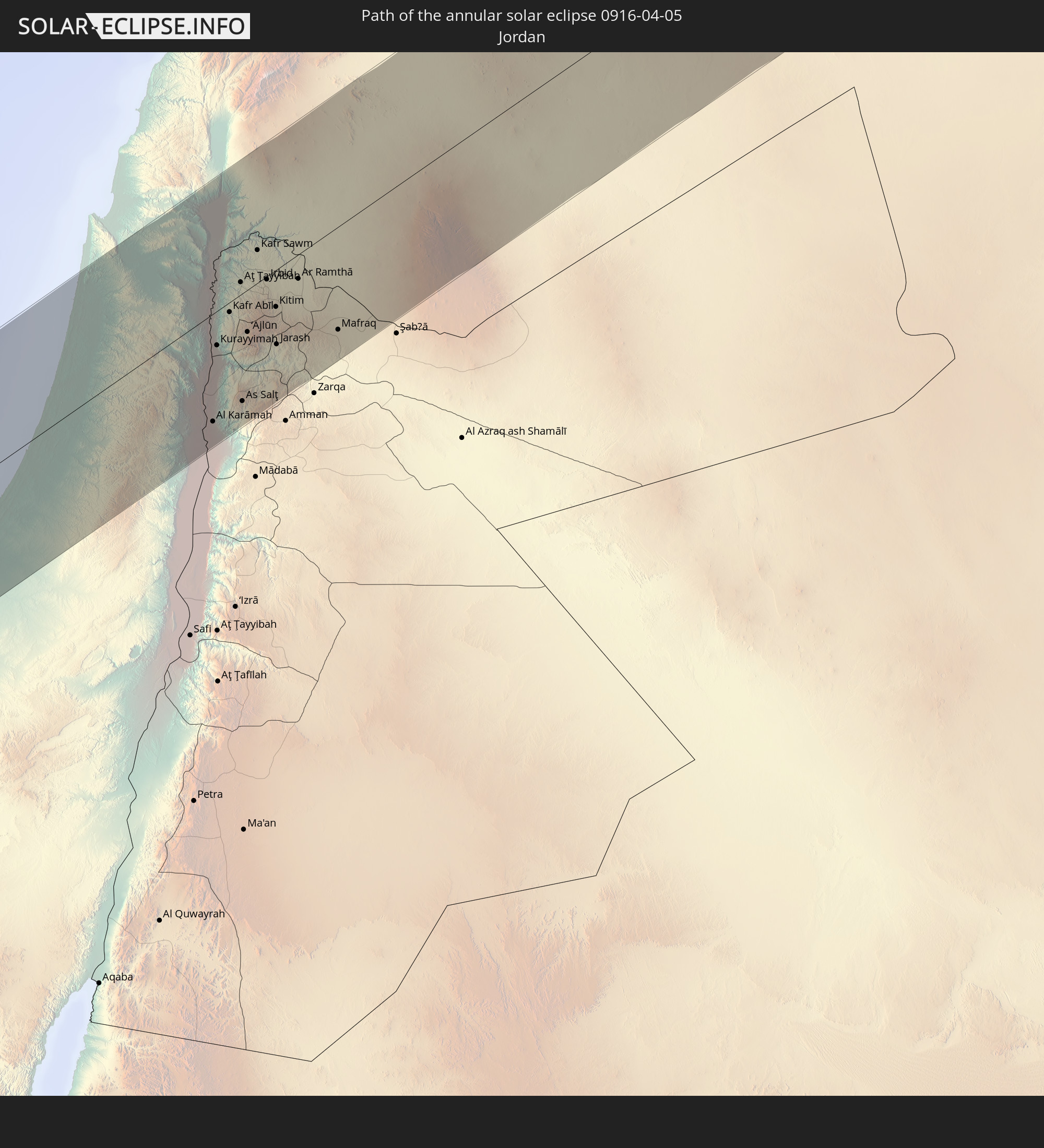 Jordan
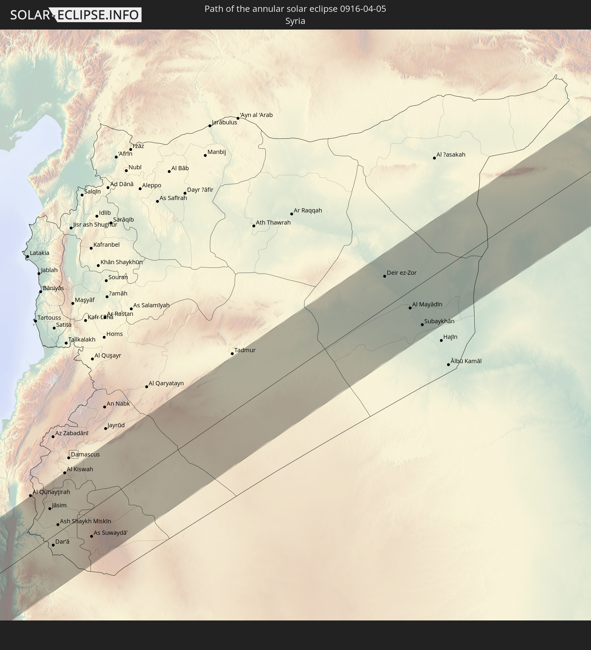 Syria
Syria
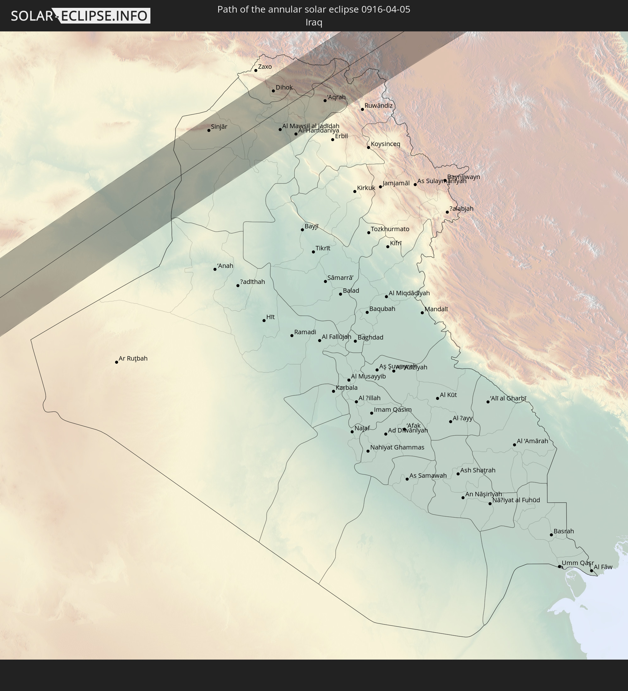 Iraq
Iraq
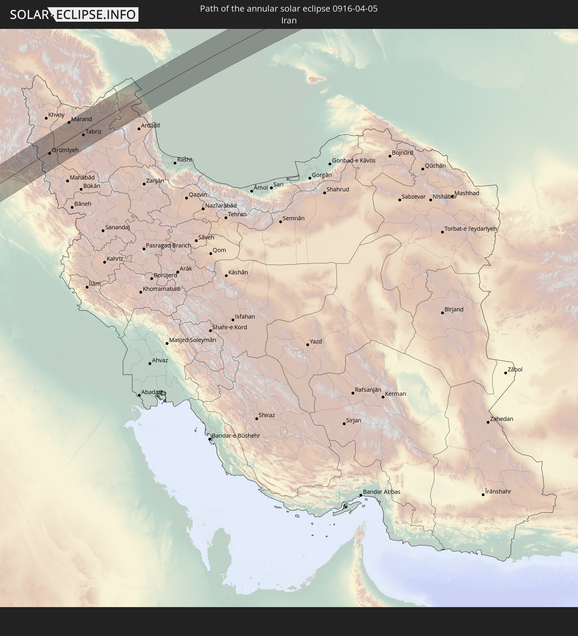 Iran
Iran
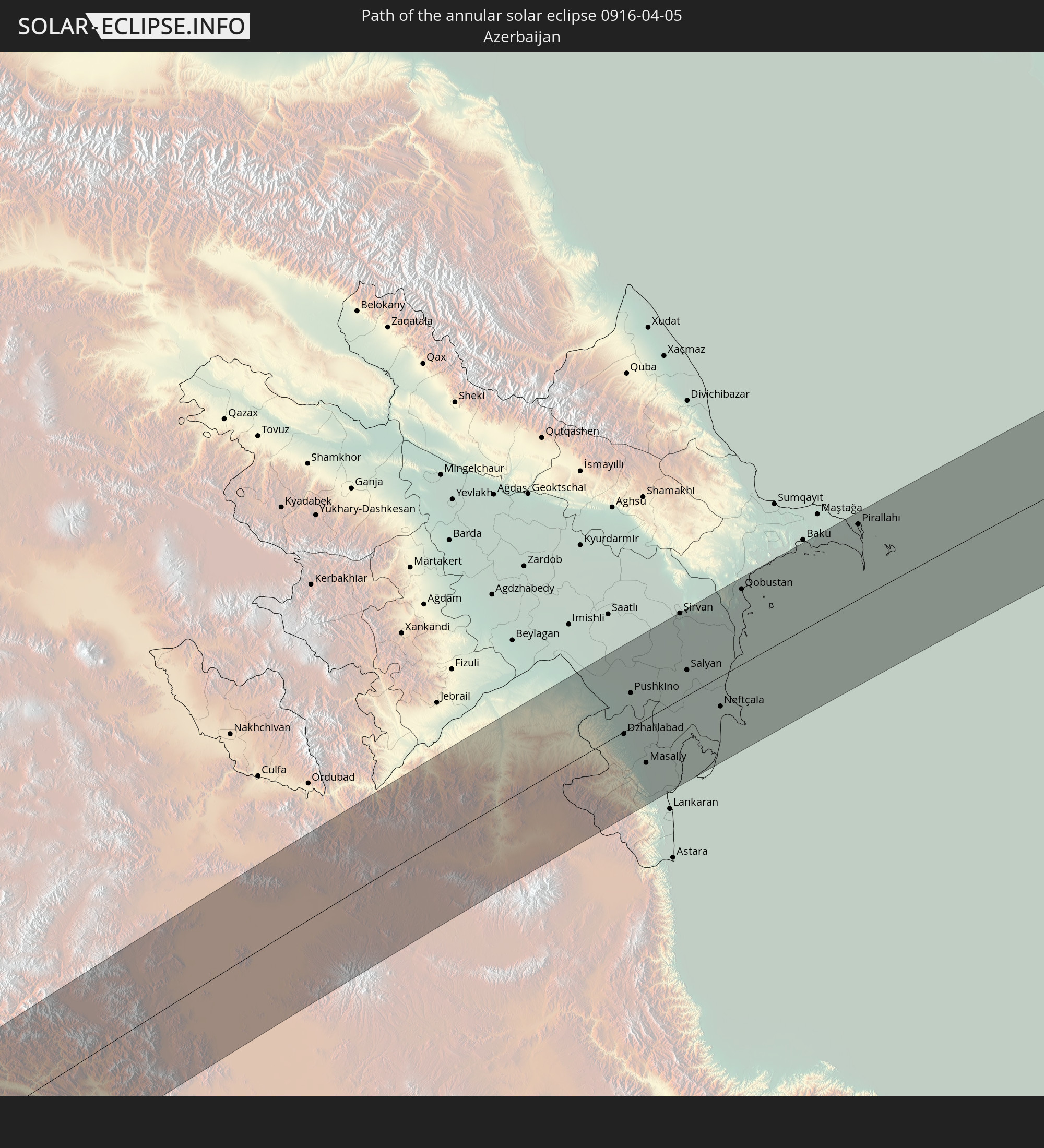 Azerbaijan
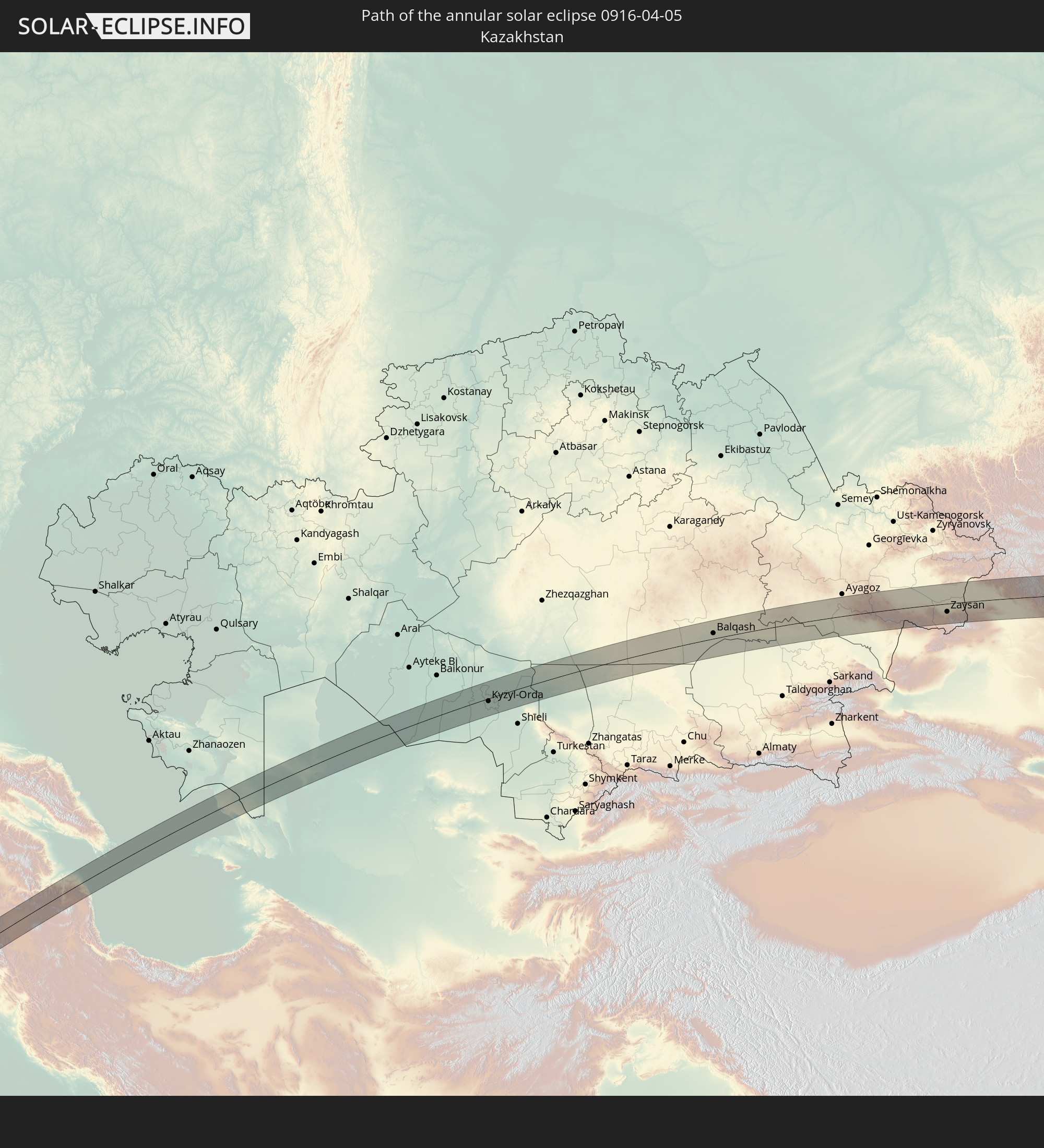 Kazakhstan
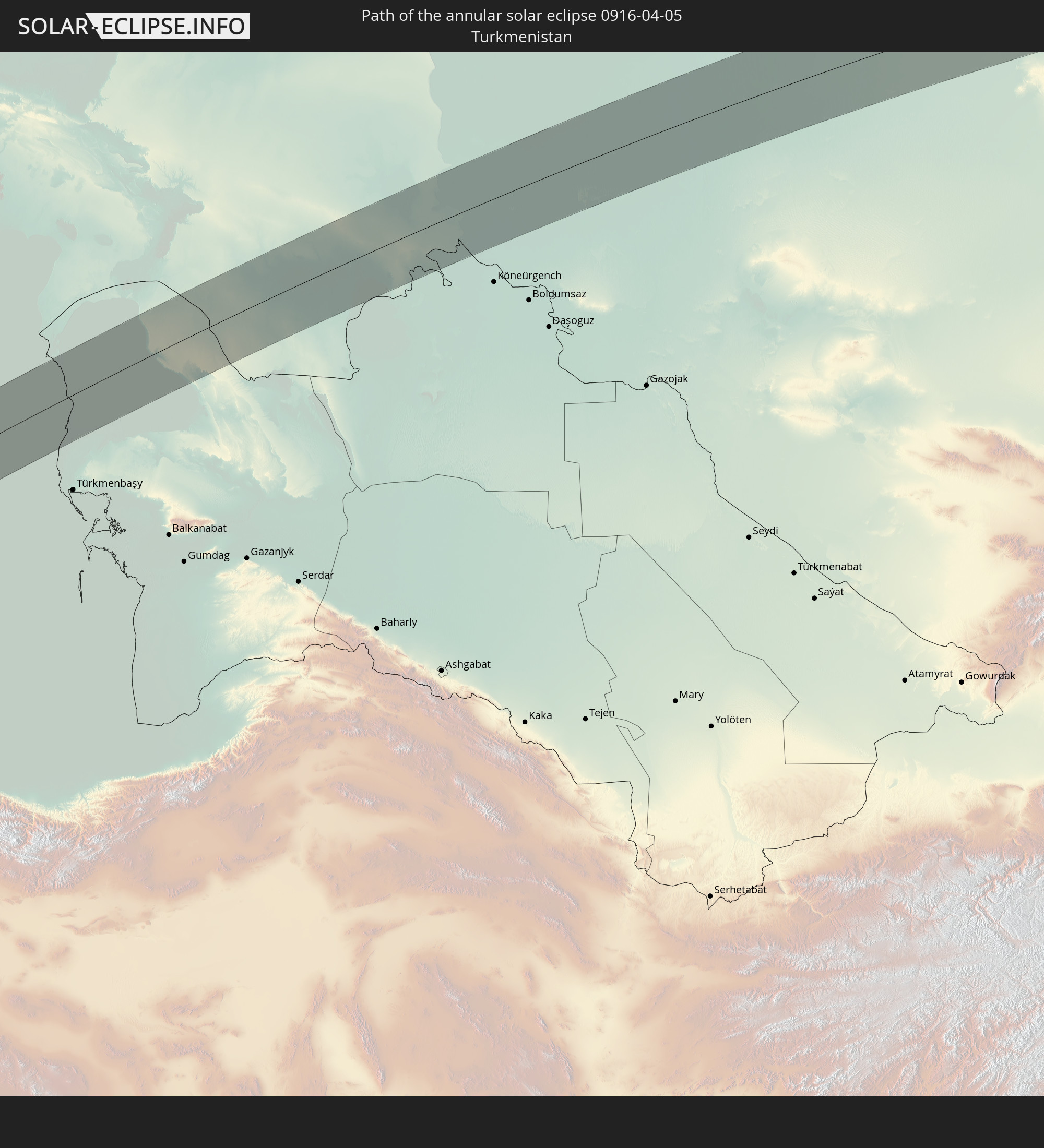 Turkmenistan
 Uzbekistan
 China
China
 Mongolia
In den folgenden Ländern ist die Sonnenfinsternis partiell zu sehen
 Russia
 Canada
 Greenland
 Portugal
 Iceland
 Spain
Spain
 Senegal
 Mauritania
 The Gambia
 Guinea-Bissau
 Guinea
 Saint Helena, Ascension and Tristan da Cunha
 Sierra Leone
 Morocco
 Mali
Mali
 Liberia
 Republic of Ireland
 Svalbard and Jan Mayen
 Algeria
 United Kingdom
 Ivory Coast
 Faroe Islands
 Burkina Faso
 Gibraltar
 France
 Isle of Man
 Ghana
Ghana
 Guernsey
 Jersey
 Togo
Togo
 Niger
Niger
 Benin
Benin
 Andorra
 Belgium
 Nigeria
 Netherlands
 Norway
 Equatorial Guinea
 Luxembourg
 Germany
 Switzerland
 São Tomé and Príncipe
 Italy
Italy
 Monaco
 Tunisia
 Denmark
 Cameroon
 Gabon
Gabon
 Libya
Libya
 Liechtenstein
 Austria
 Sweden
 Republic of the Congo
 Angola
 Czechia
 Democratic Republic of the Congo
 San Marino
 Vatican City
 Slovenia
 Chad
Chad
 Croatia
 Poland
 Malta
Malta
 Central African Republic
 Bosnia and Herzegovina
 Hungary
 Slovakia
 Montenegro
 Serbia
 Albania
 Åland Islands
 Greece
 Romania
 Republic of Macedonia
 Finland
 Lithuania
 Latvia
 Estonia
 Sudan
Sudan
 Zambia
 Ukraine
 Bulgaria
 Belarus
 Egypt
Egypt
 Turkey
 Moldova
 Rwanda
 Burundi
 Tanzania
 Uganda
 Cyprus
 Ethiopia
 Kenya
Kenya
 State of Palestine
 Israel
 Saudi Arabia
 Jordan
 Lebanon
 Syria
Syria
 Eritrea
 Iraq
Iraq
 Georgia
 Somalia
 Djibouti
 Yemen
Yemen
 Armenia
 Iran
Iran
 Azerbaijan
 Kazakhstan
 Kuwait
 Bahrain
 Qatar
Qatar
 United Arab Emirates
 Oman
Oman
 Turkmenistan
 Uzbekistan
 Afghanistan
 Pakistan
 Tajikistan
 India
India
 Kyrgyzstan
 China
China
 Nepal
Nepal
 Mongolia
 Bangladesh
 Bhutan
 Myanmar
 Thailand
 Laos
Laos
 Vietnam
 Cambodia
 Macau
Macau
 Hong Kong
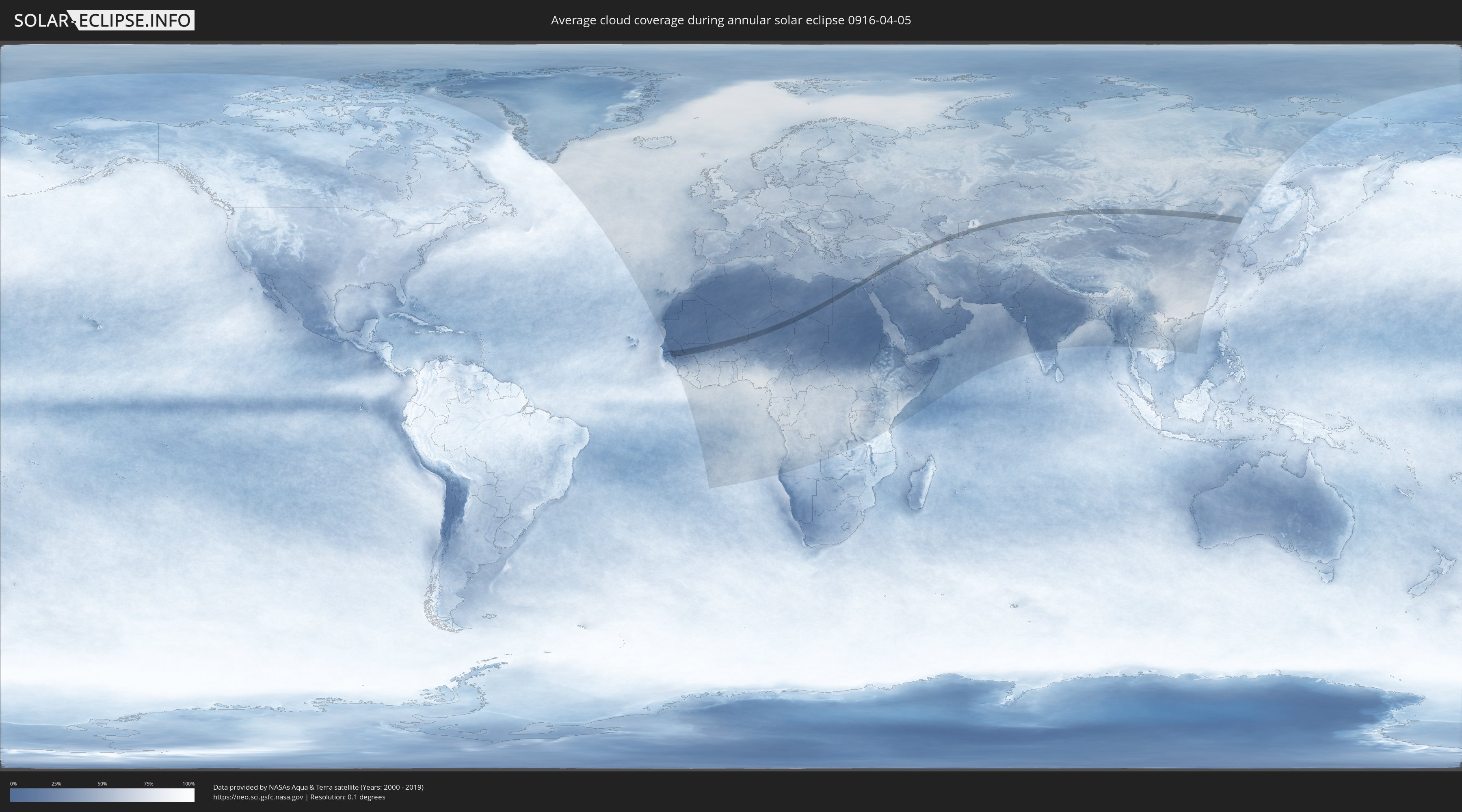
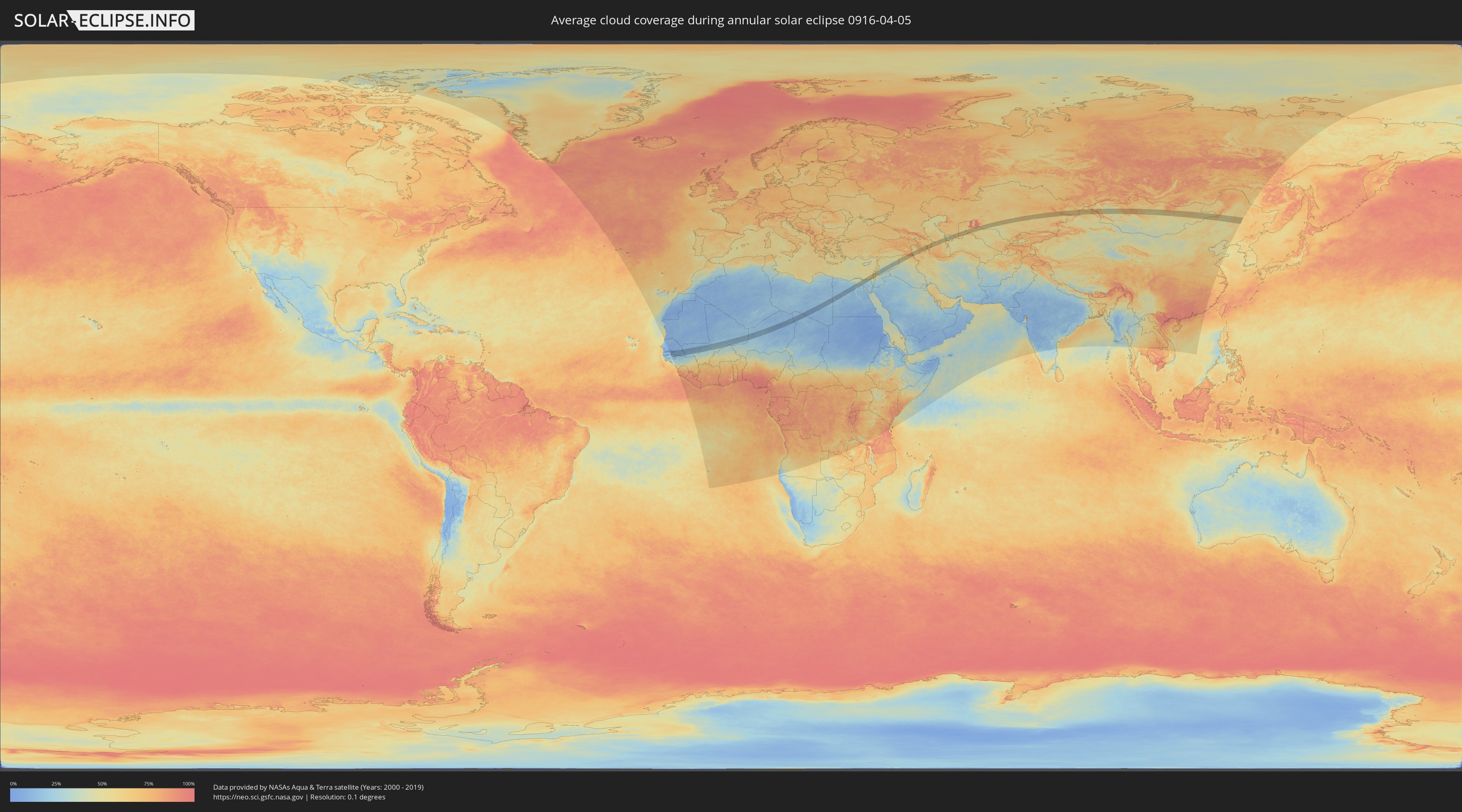
How will be the weather during the annular solar eclipse on 04/05/0916?
Where is the best place to see the annular solar eclipse of 04/05/0916?
The following maps show the average cloud coverage for the day of the annular solar eclipse.
With the help of these maps, it is possible to find the place along the eclipse path, which has the best
chance of a cloudless sky.
Nevertheless, you should consider local circumstances and inform about the weather of your chosen
observation site.
The data is provided by NASAs satellites
AQUA and TERRA.
The cloud maps are averaged over a period of 19 years (2000 - 2019).
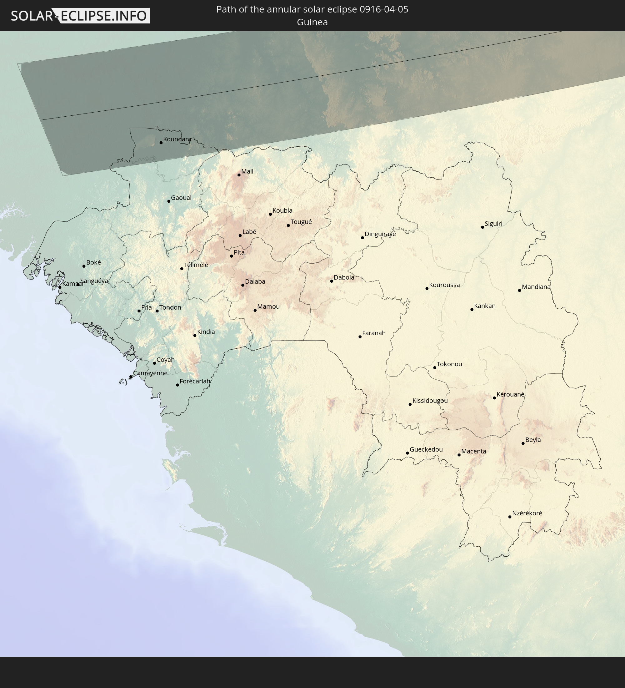
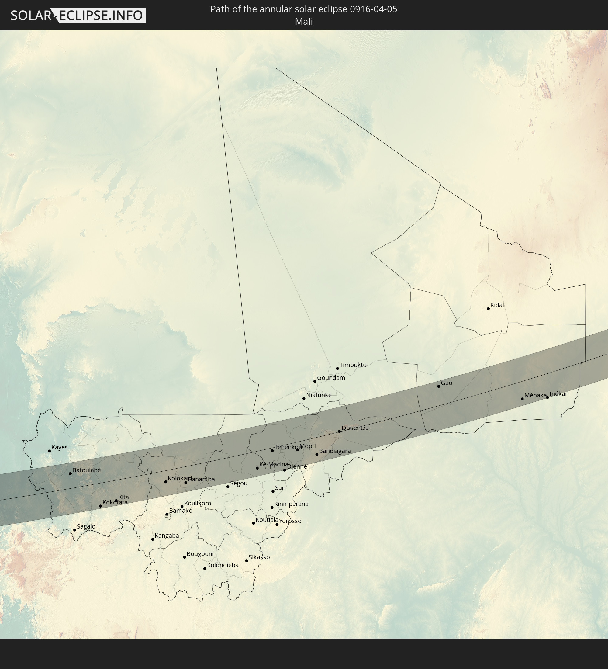
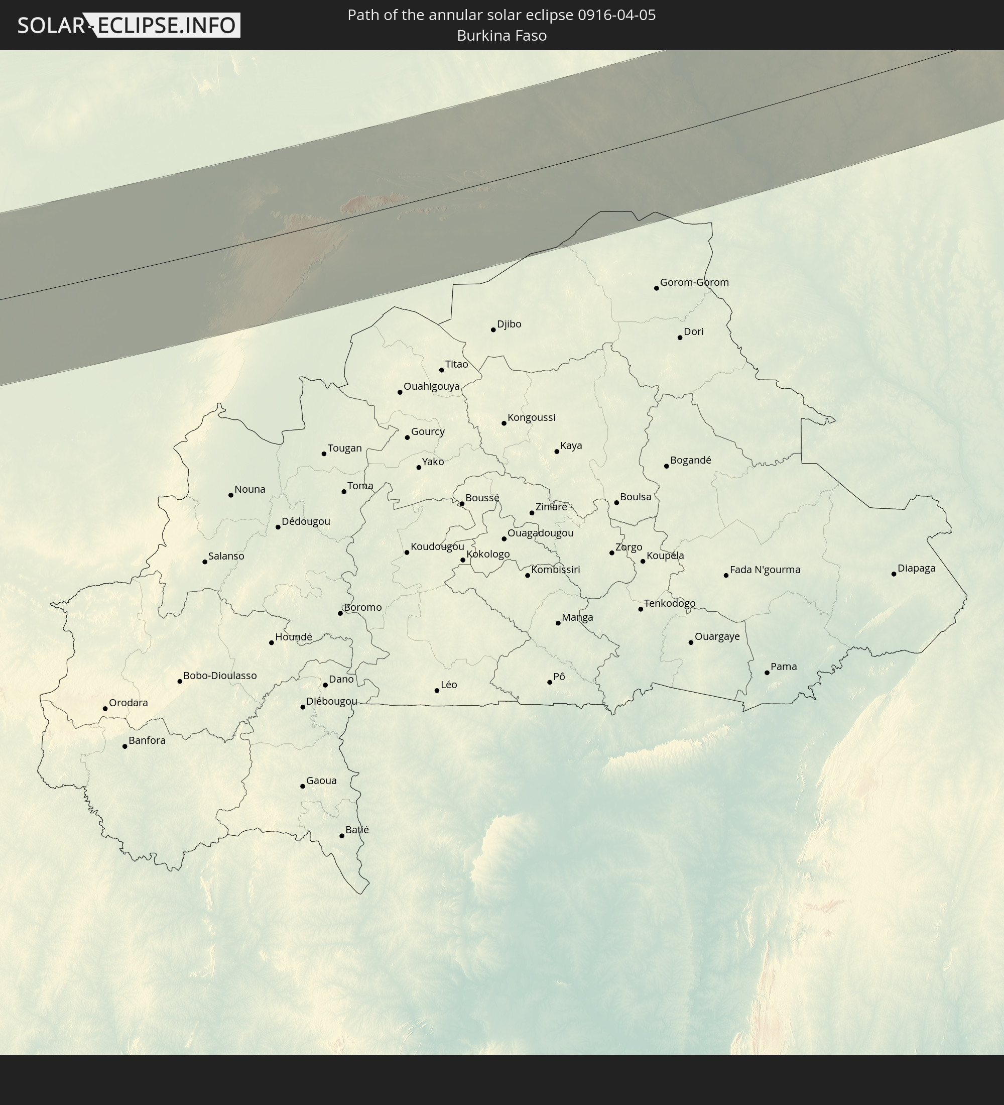
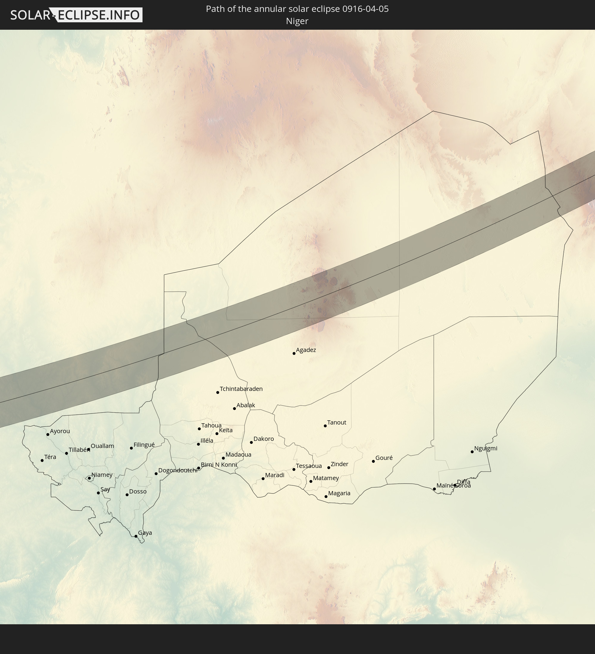
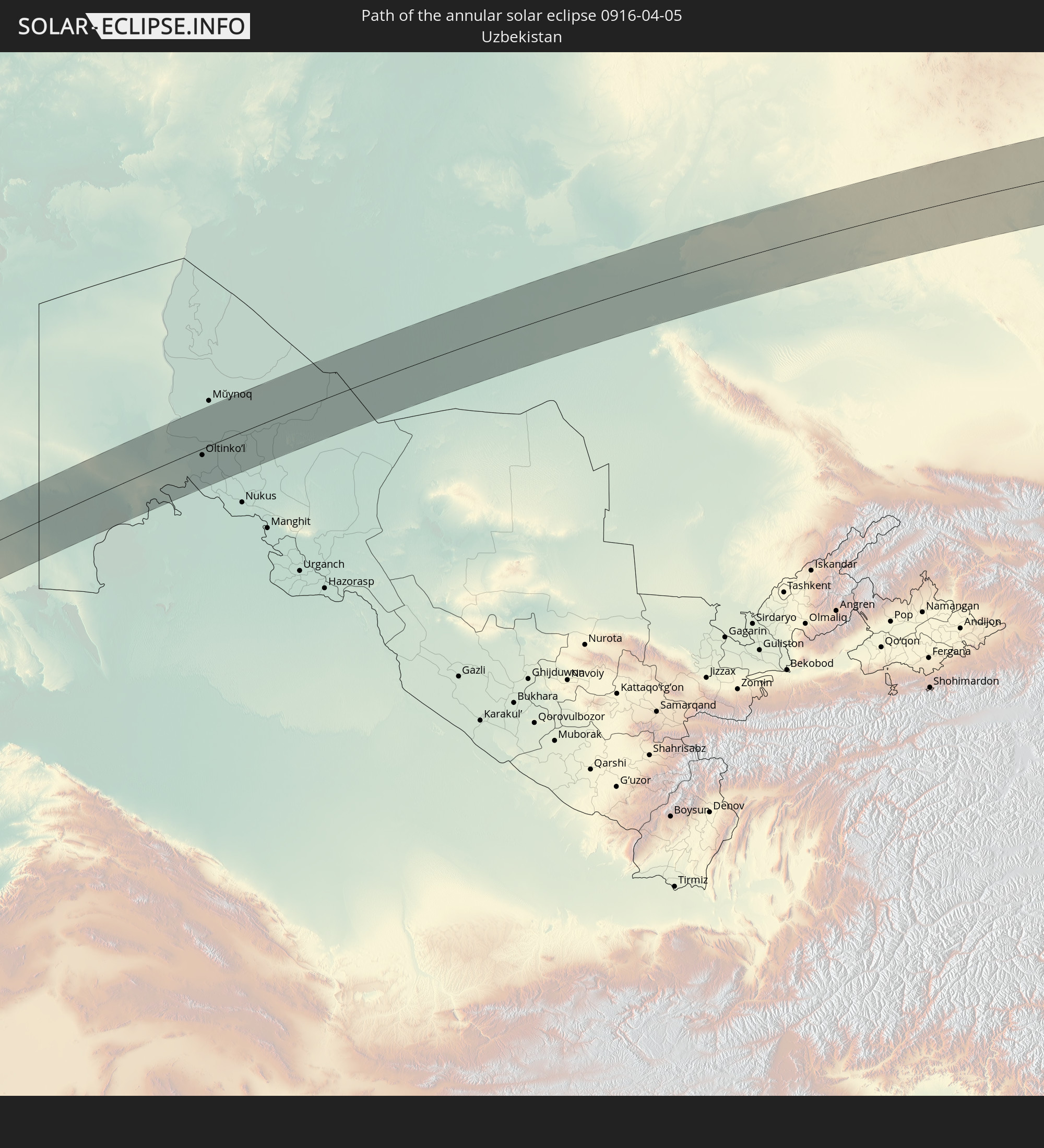
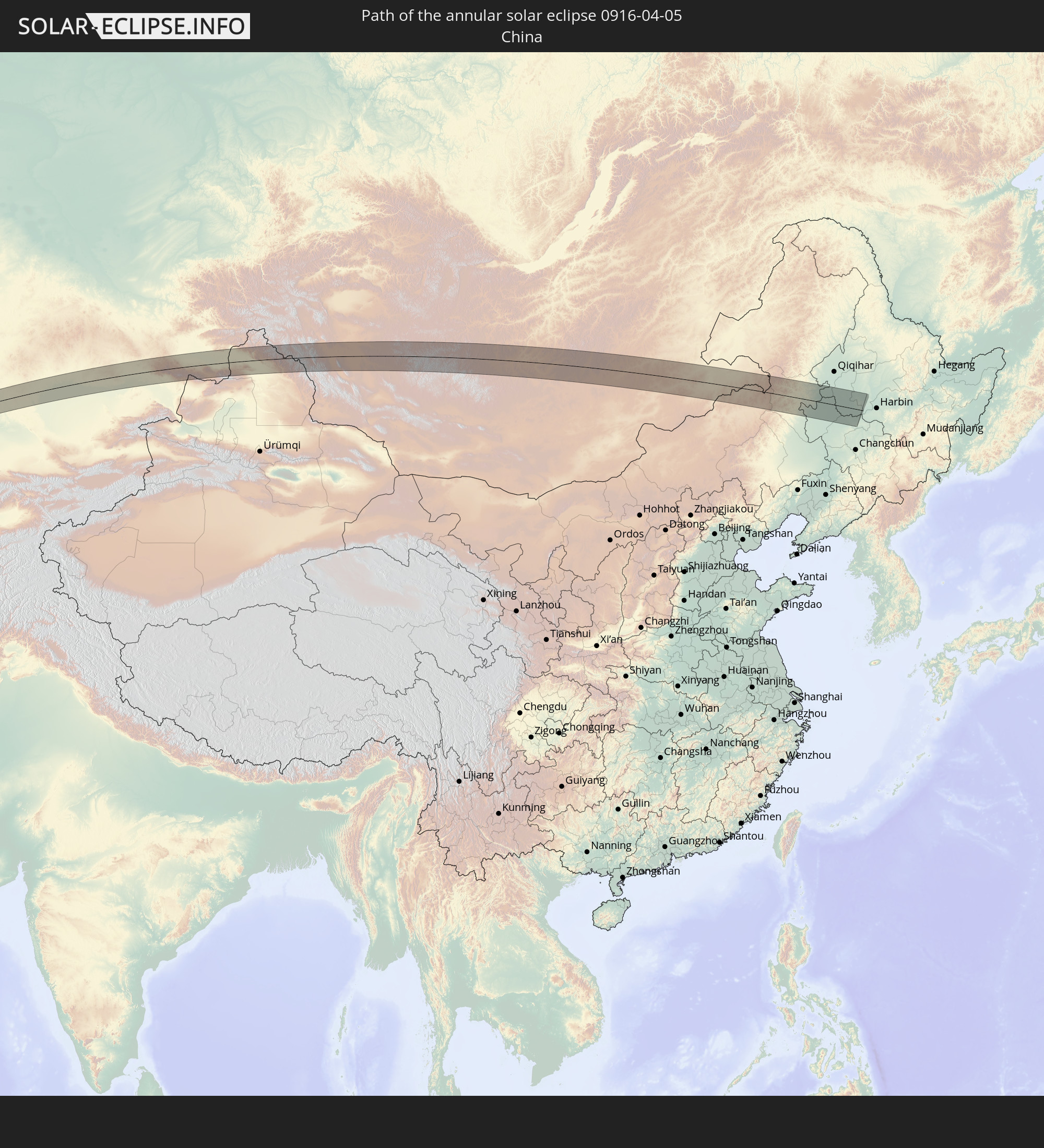
Detailed country maps
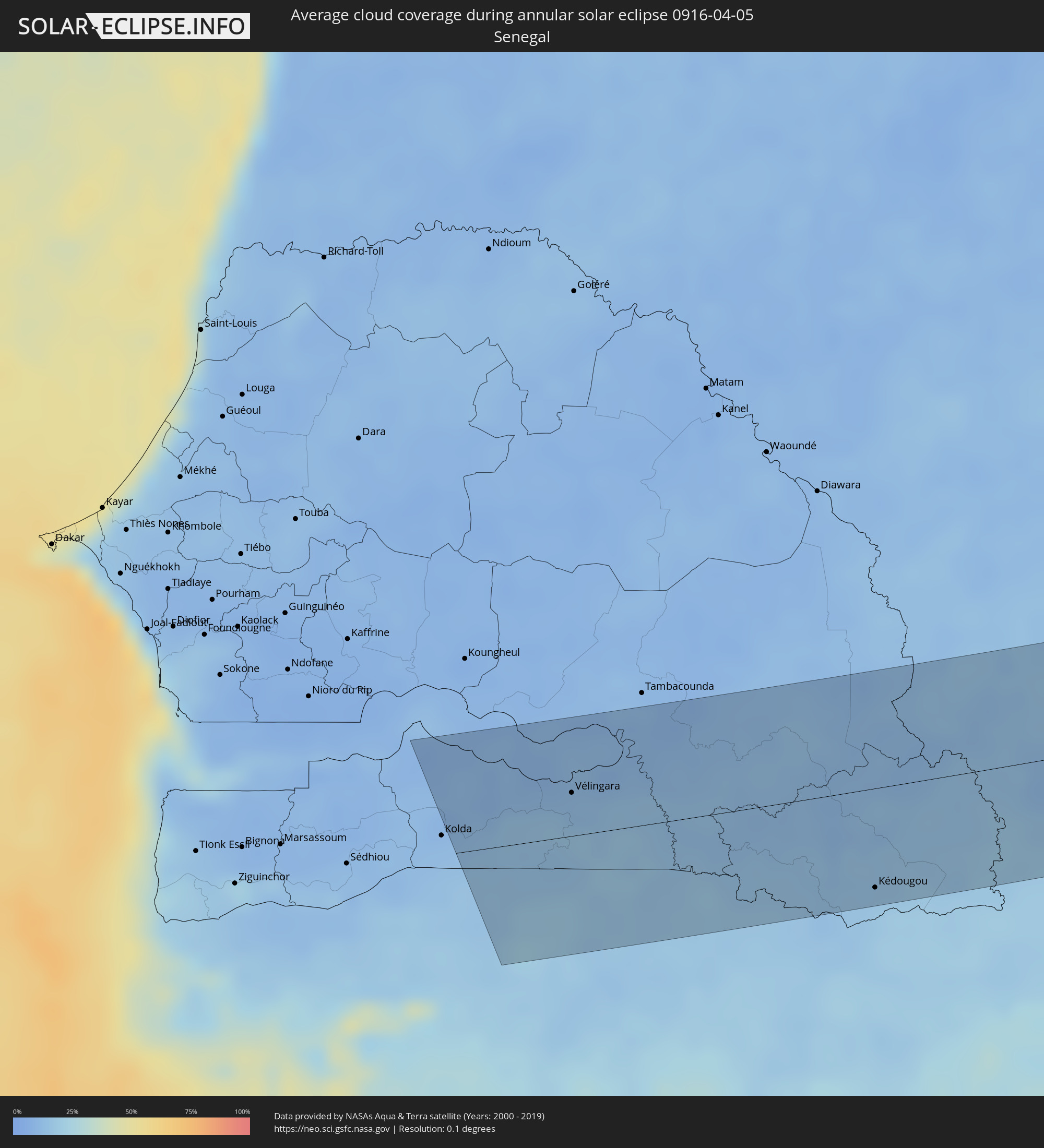 Senegal
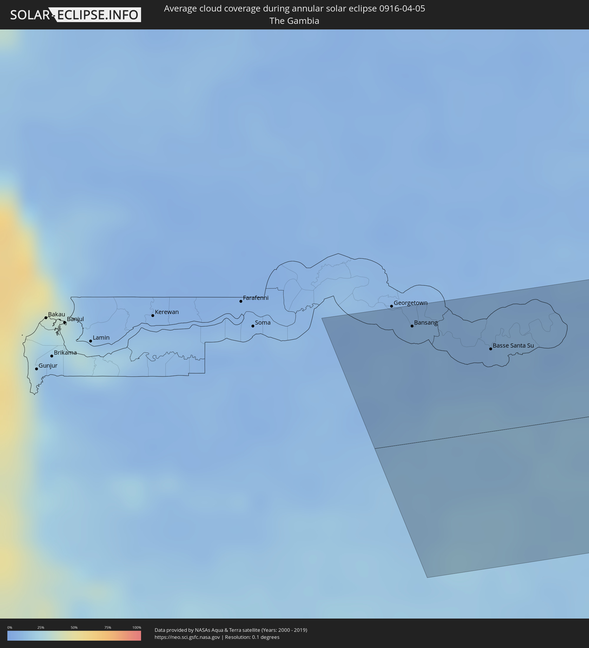 The Gambia
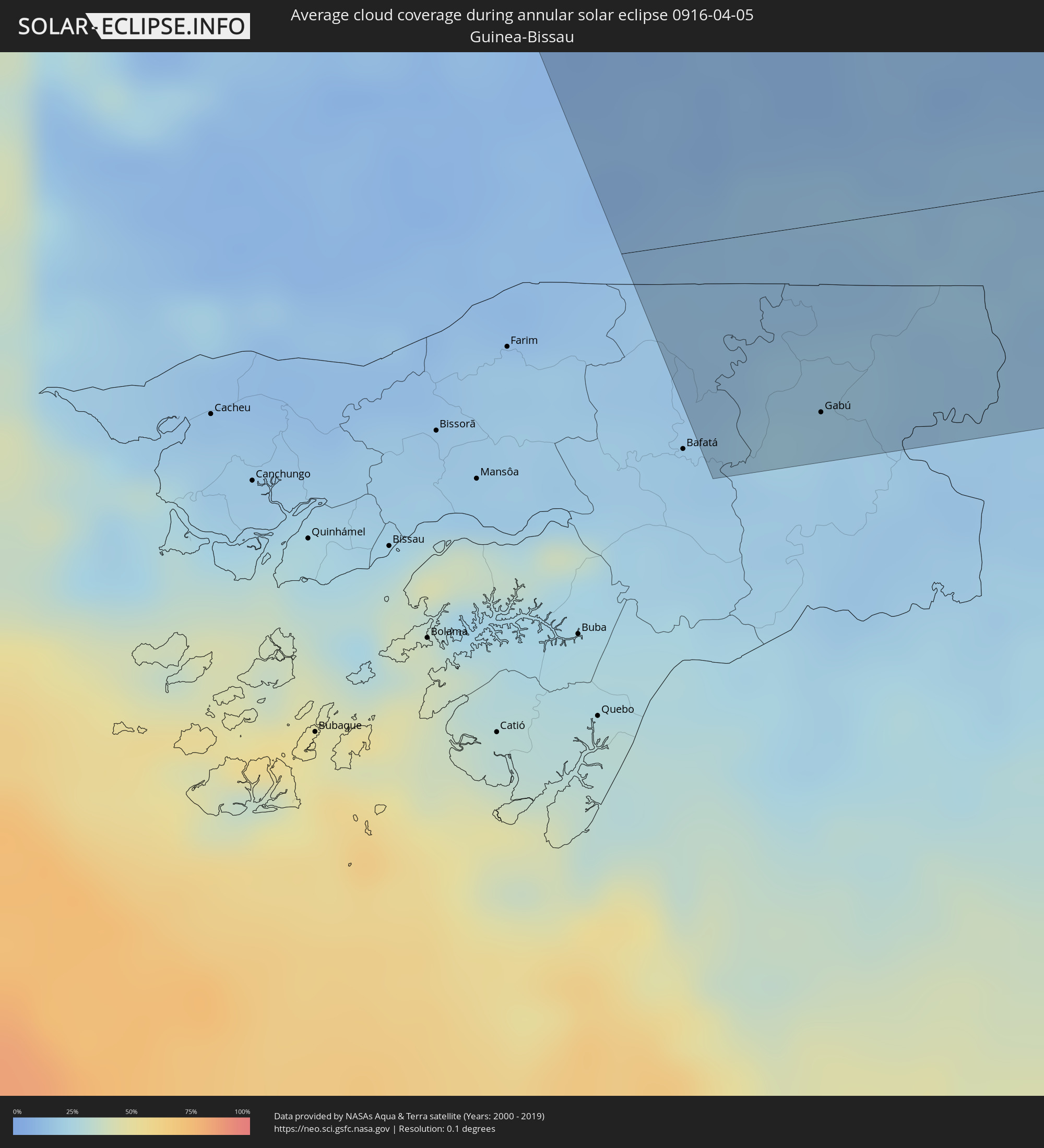 Guinea-Bissau
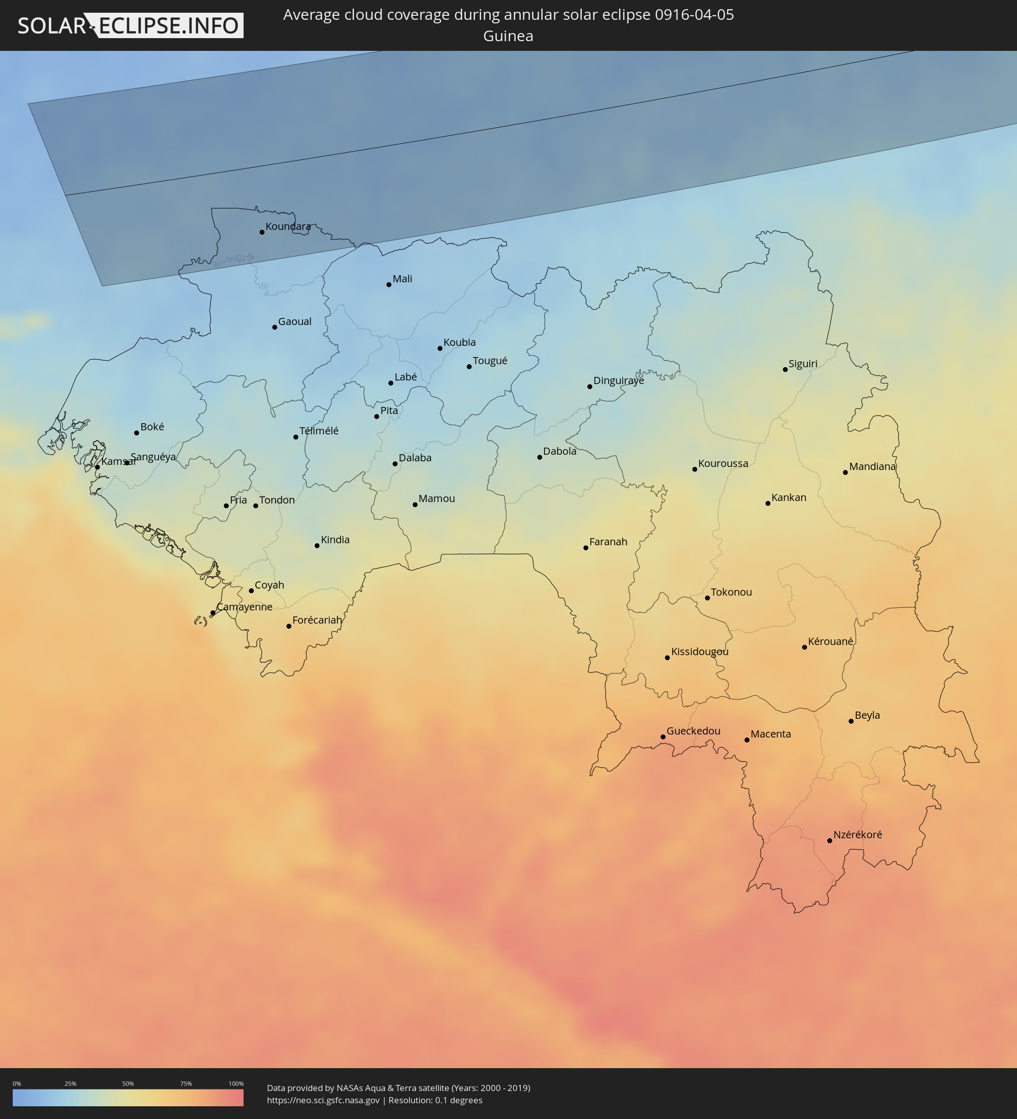 Guinea
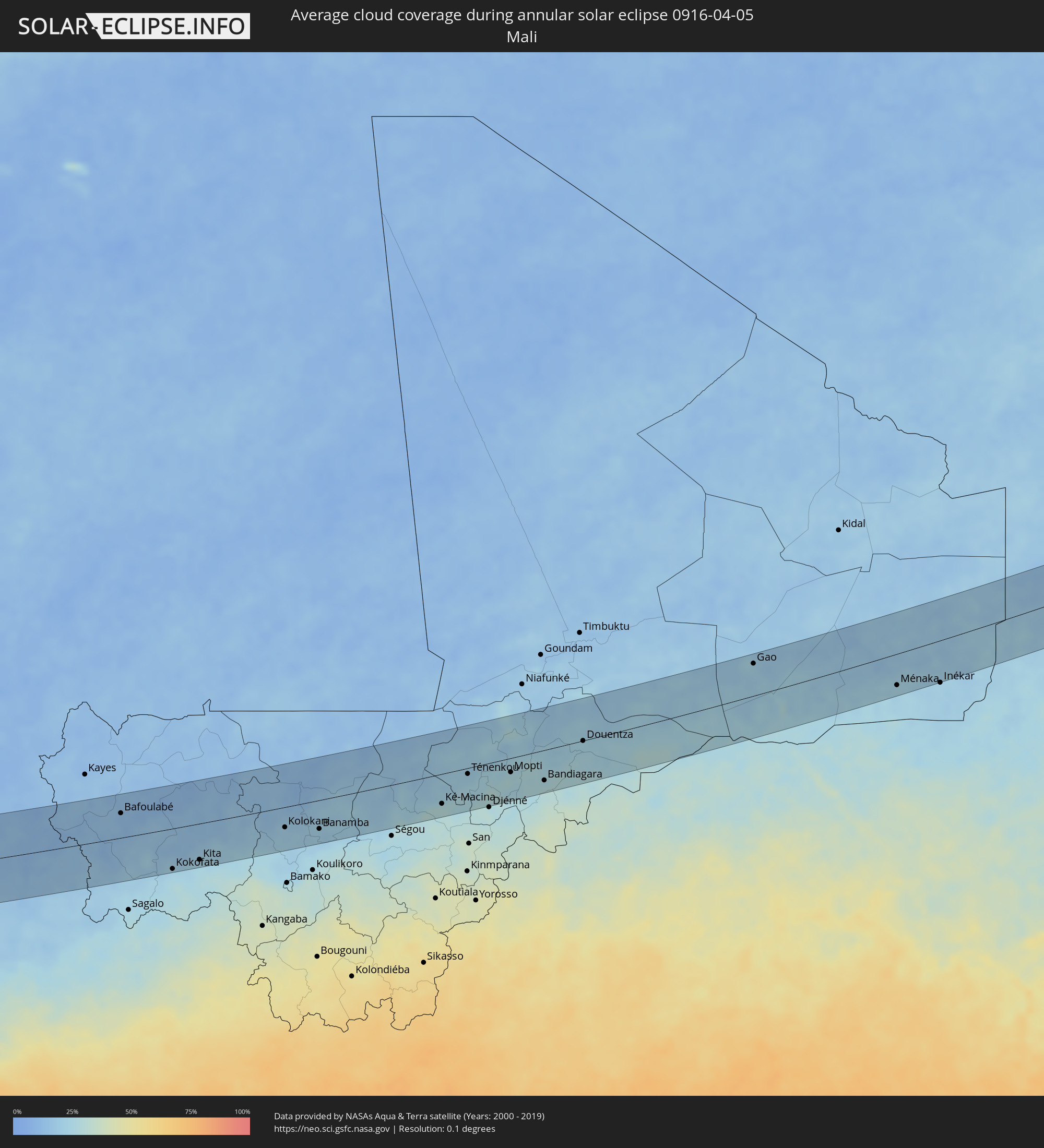 Mali
Mali
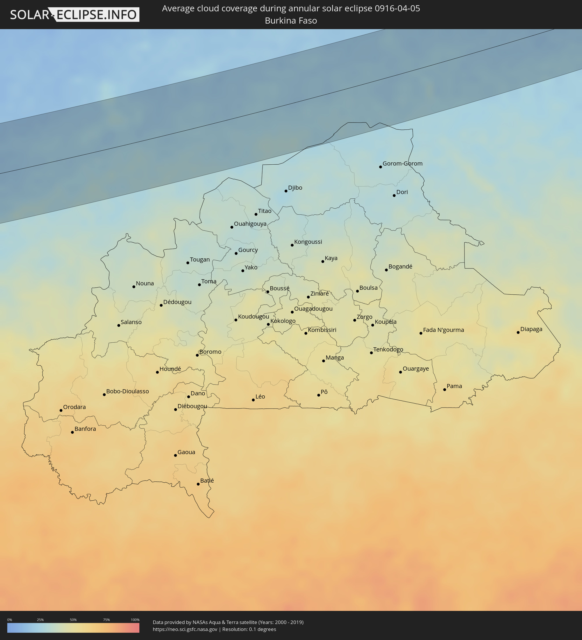 Burkina Faso
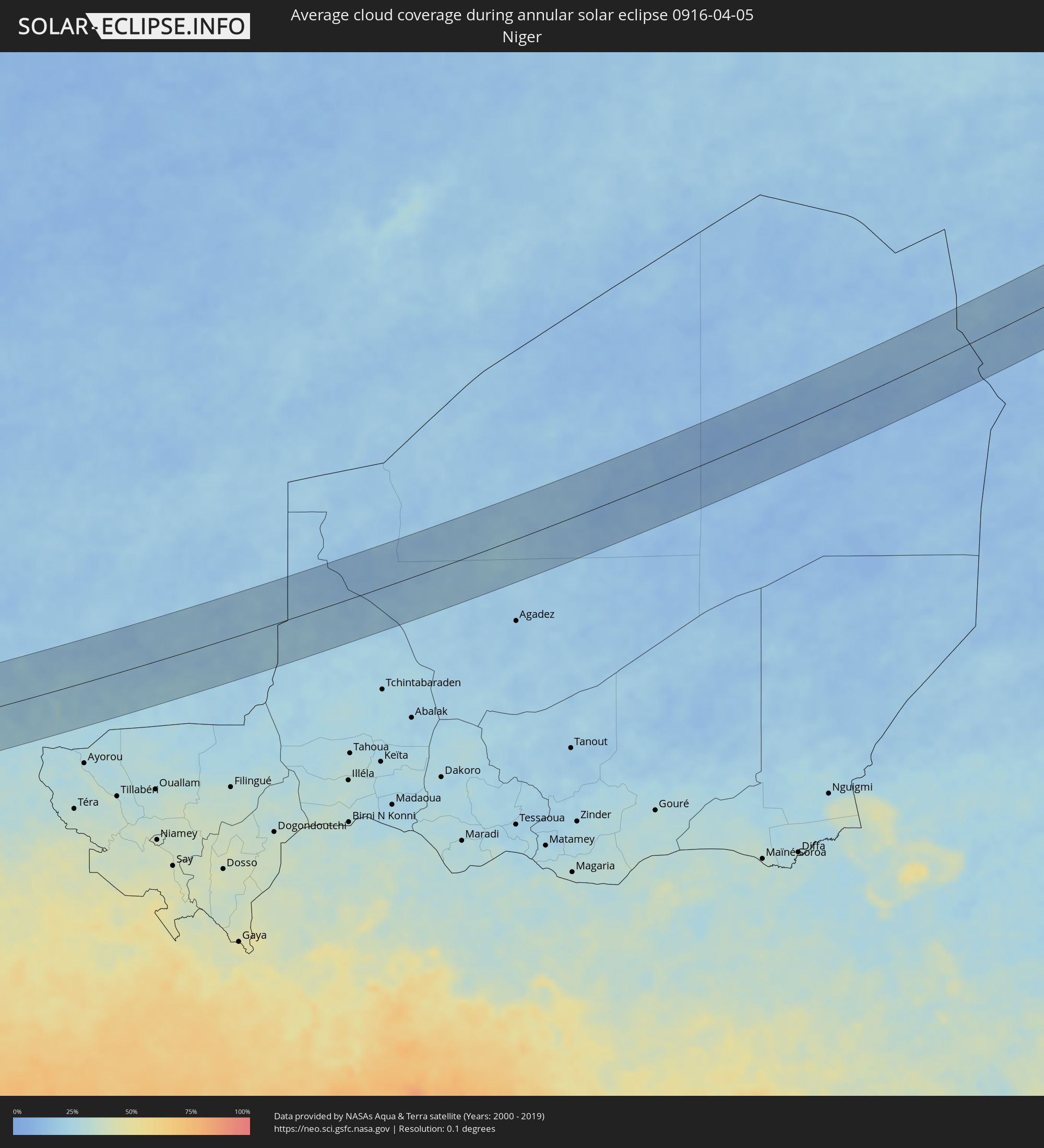 Niger
Niger
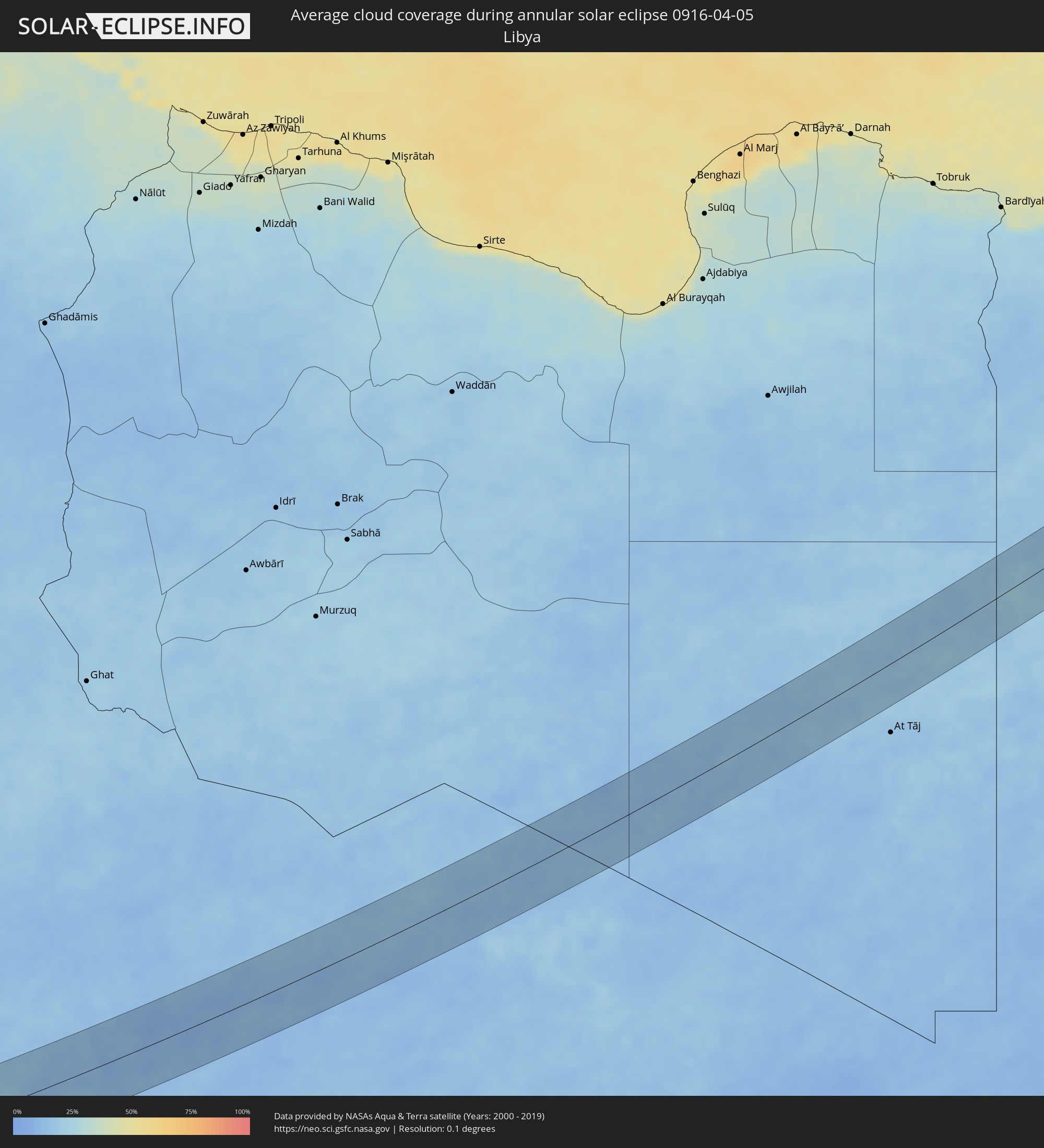 Libya
Libya
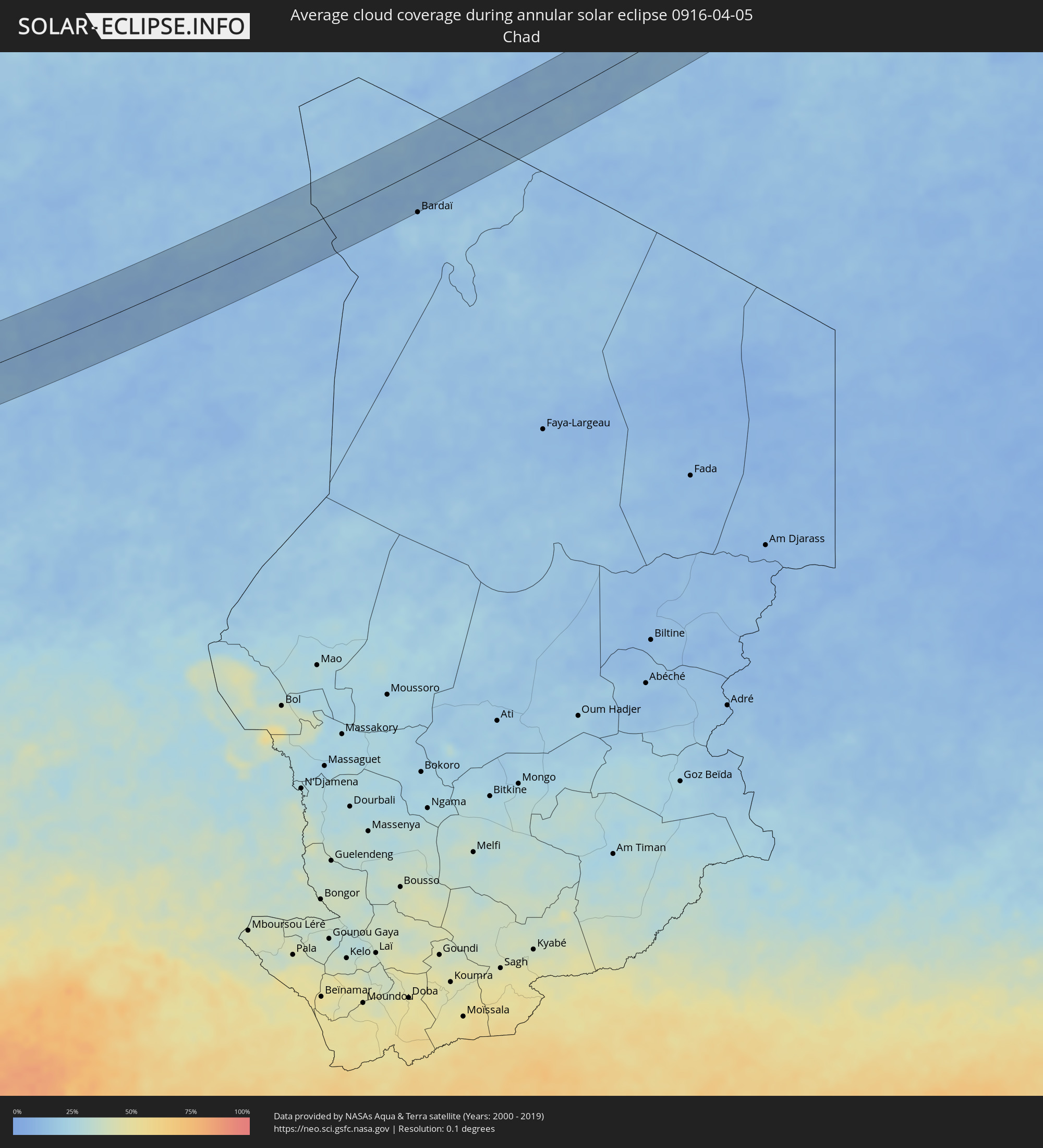 Chad
Chad
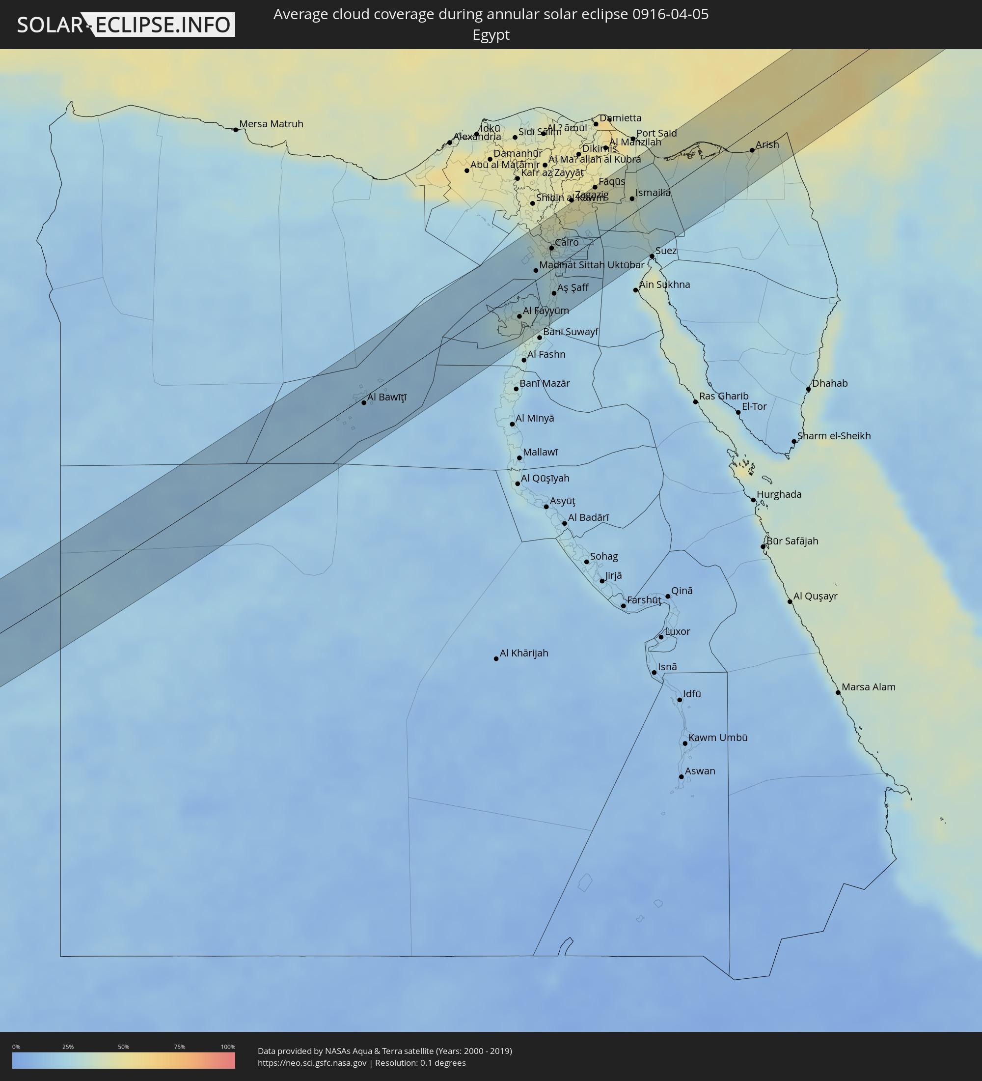 Egypt
Egypt
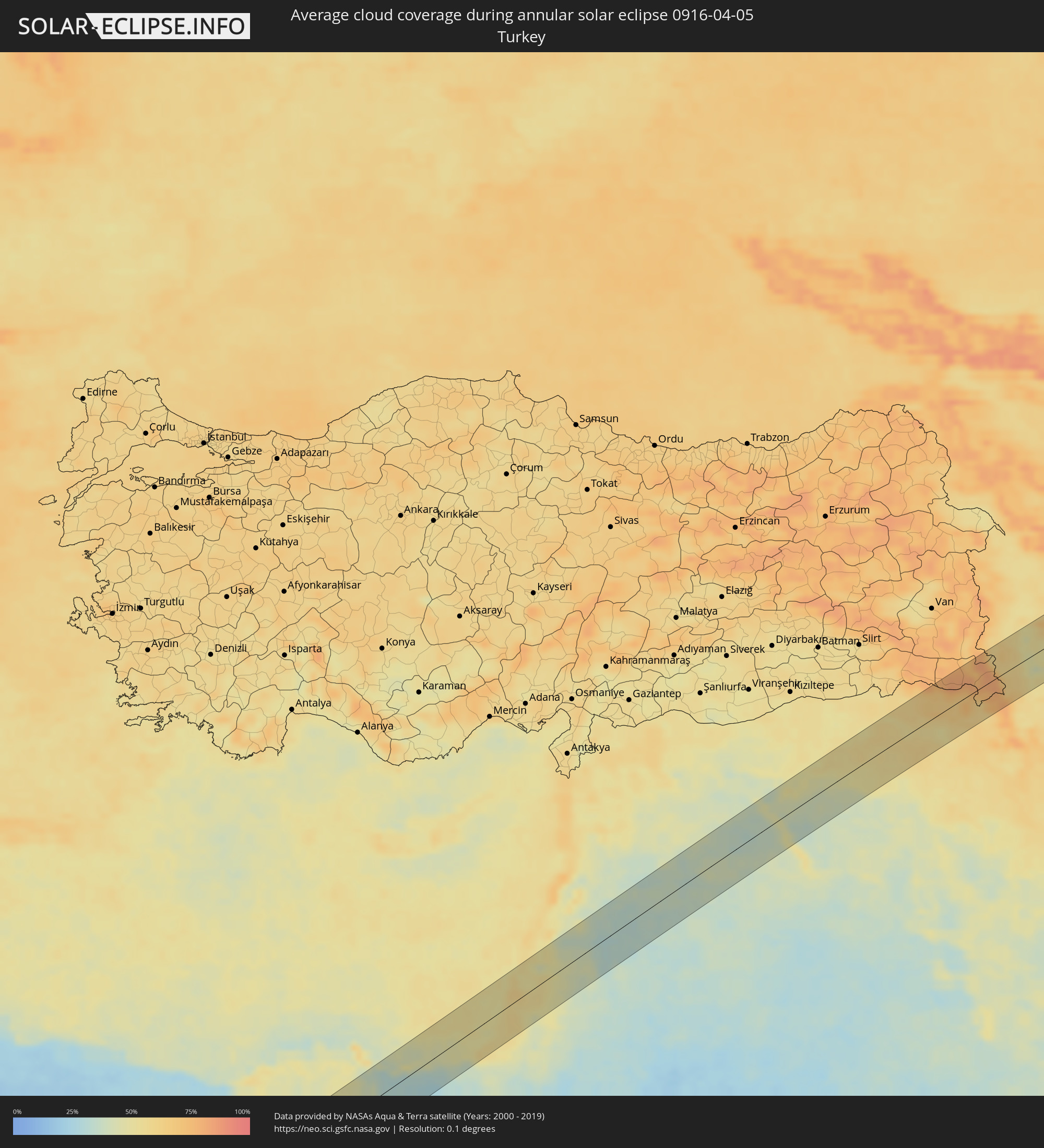 Turkey
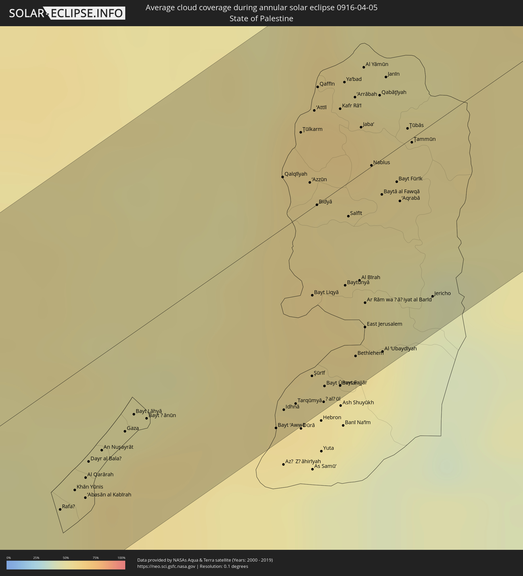 State of Palestine
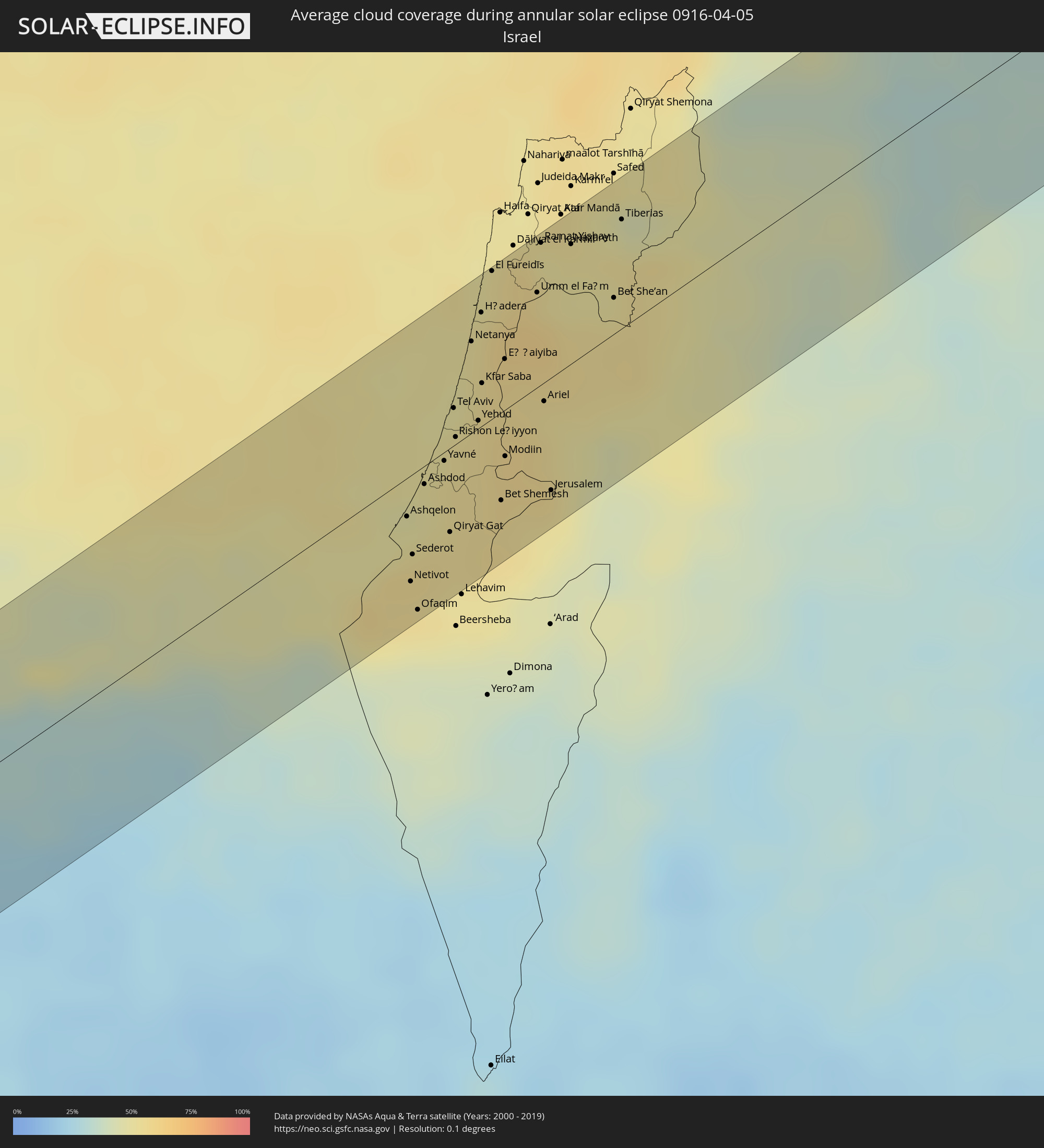 Israel
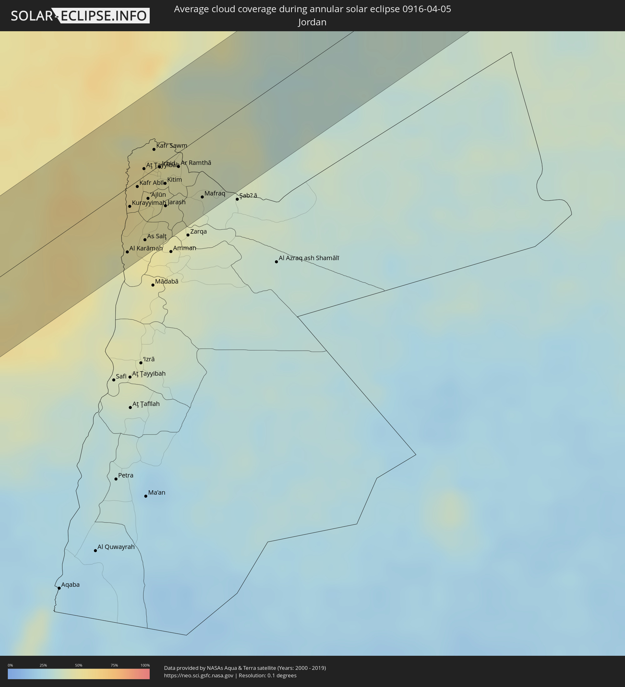 Jordan
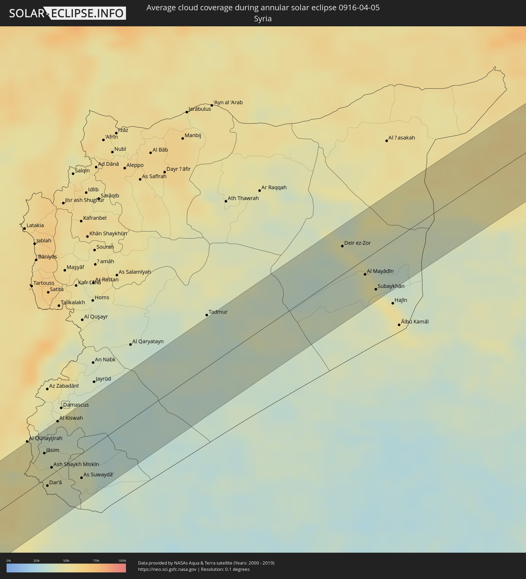 Syria
Syria
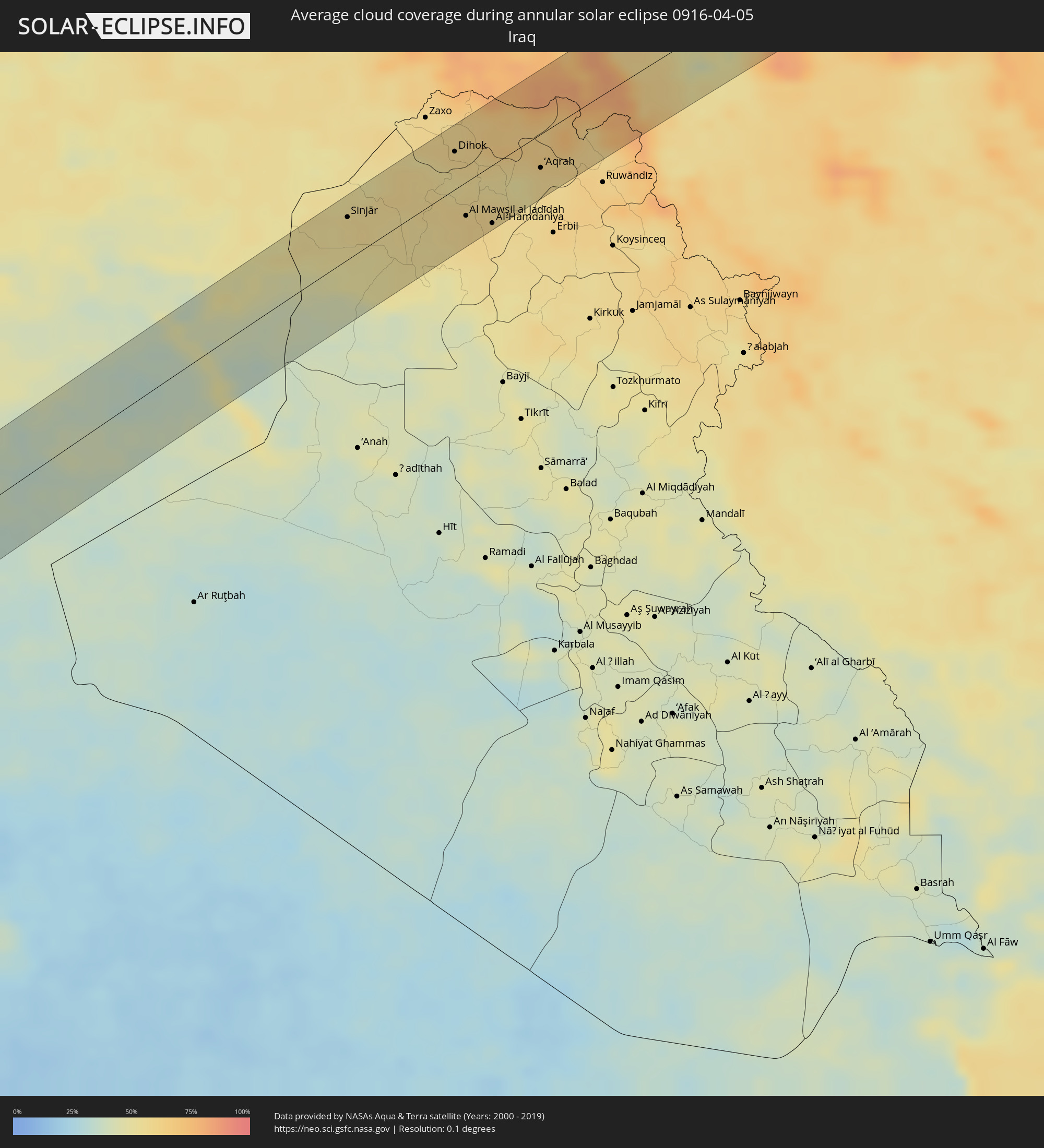 Iraq
Iraq
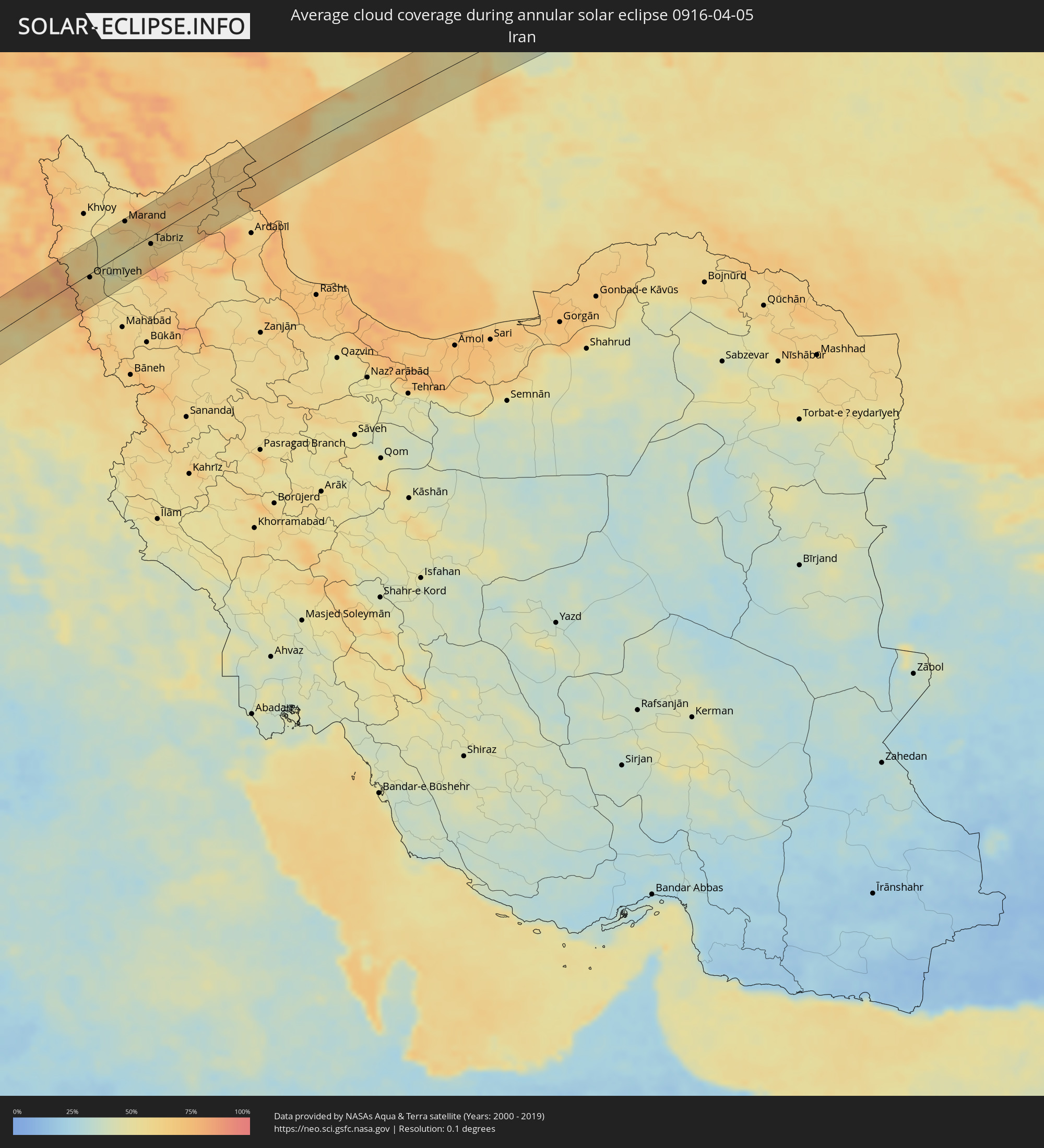 Iran
Iran
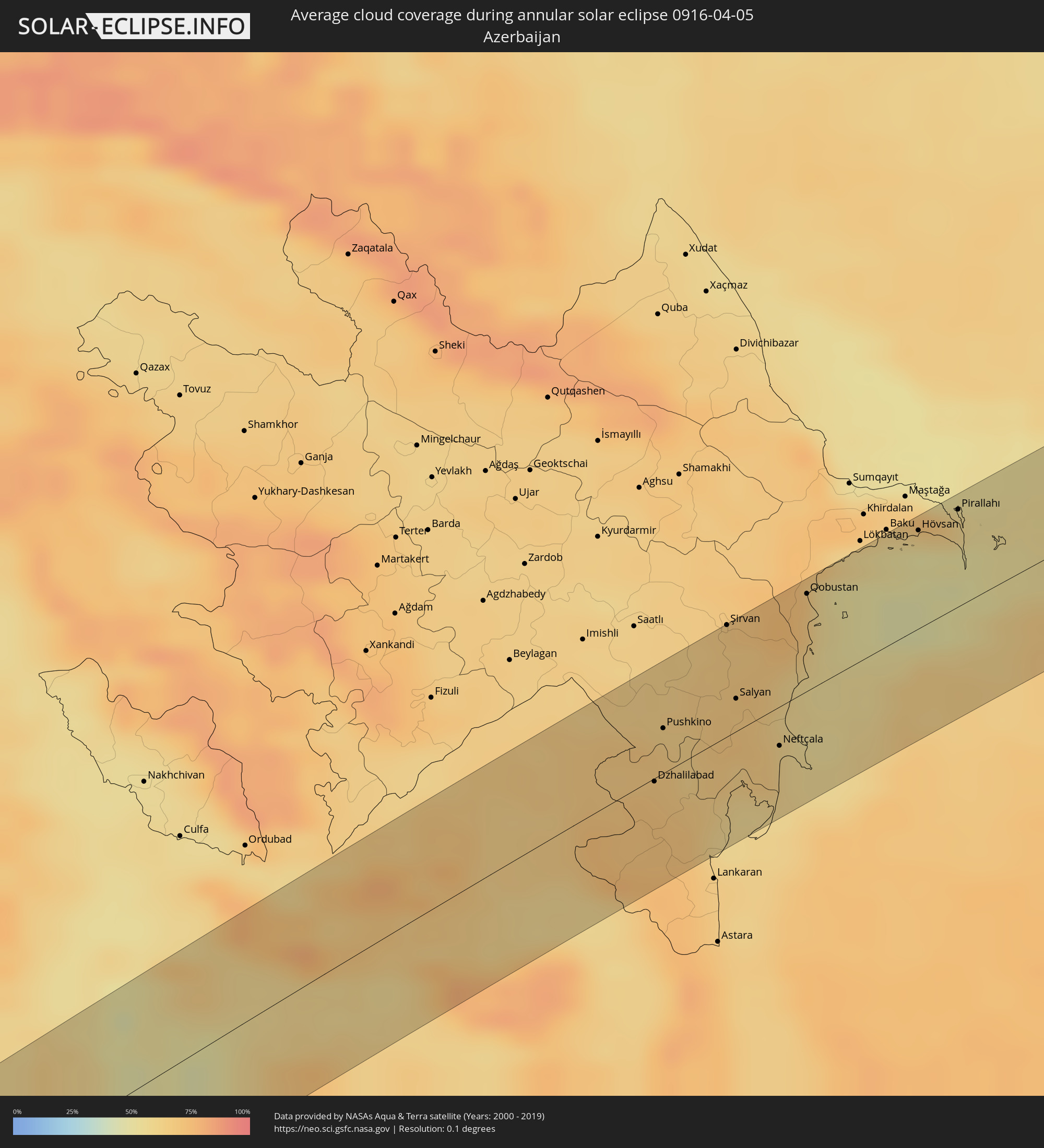 Azerbaijan
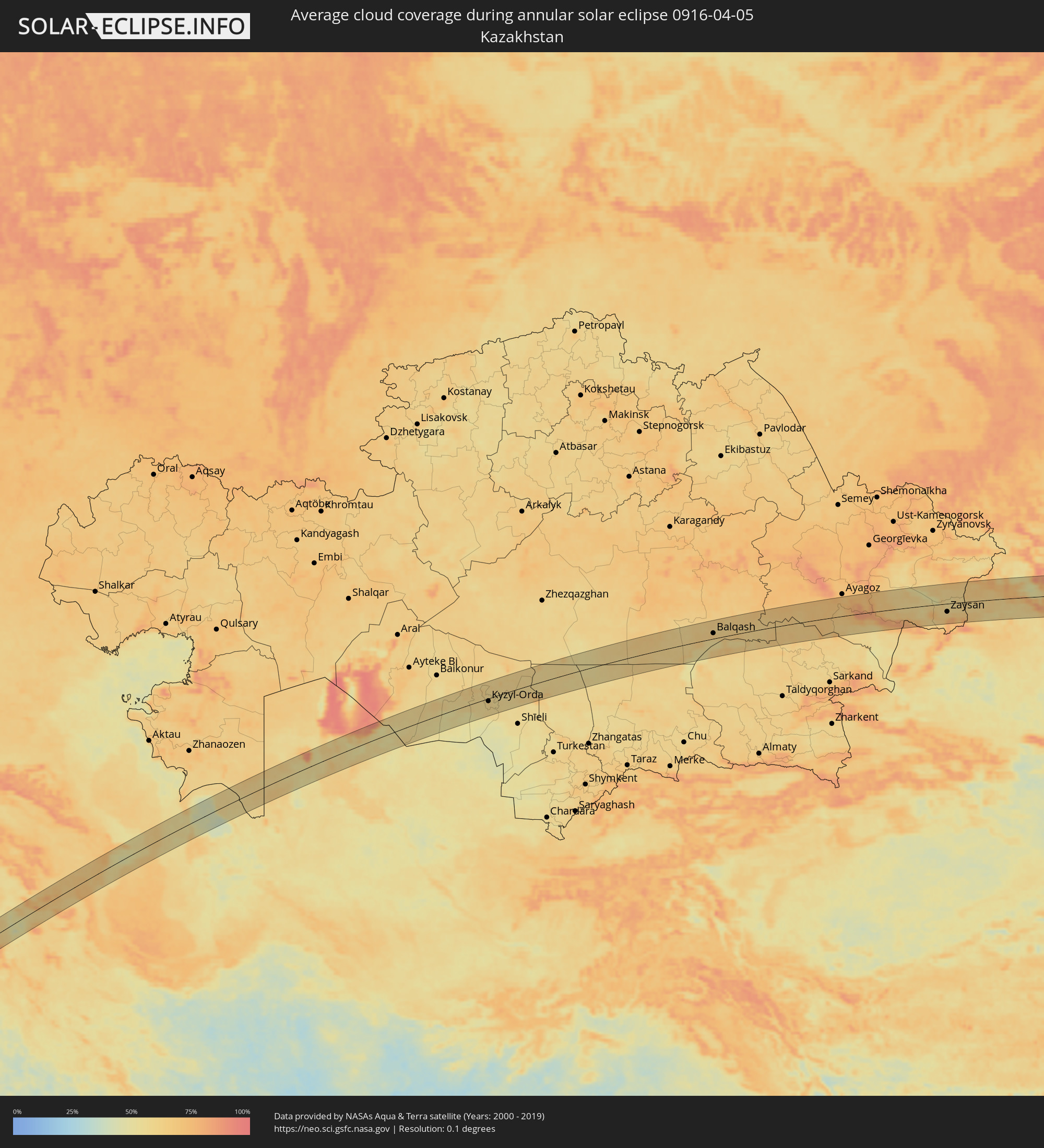 Kazakhstan
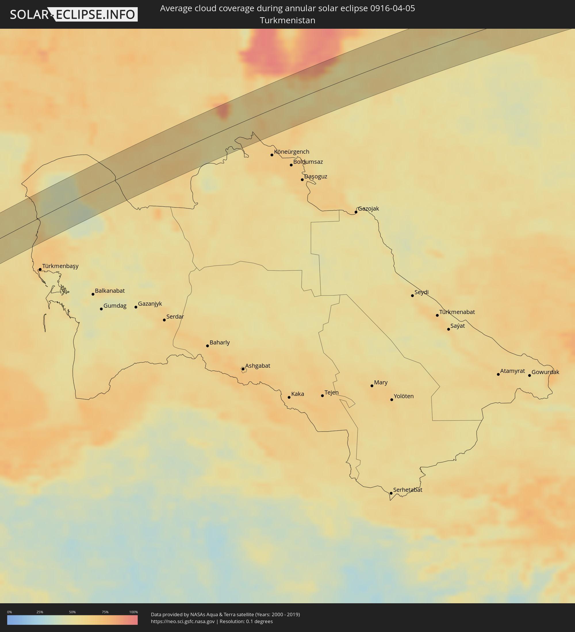 Turkmenistan
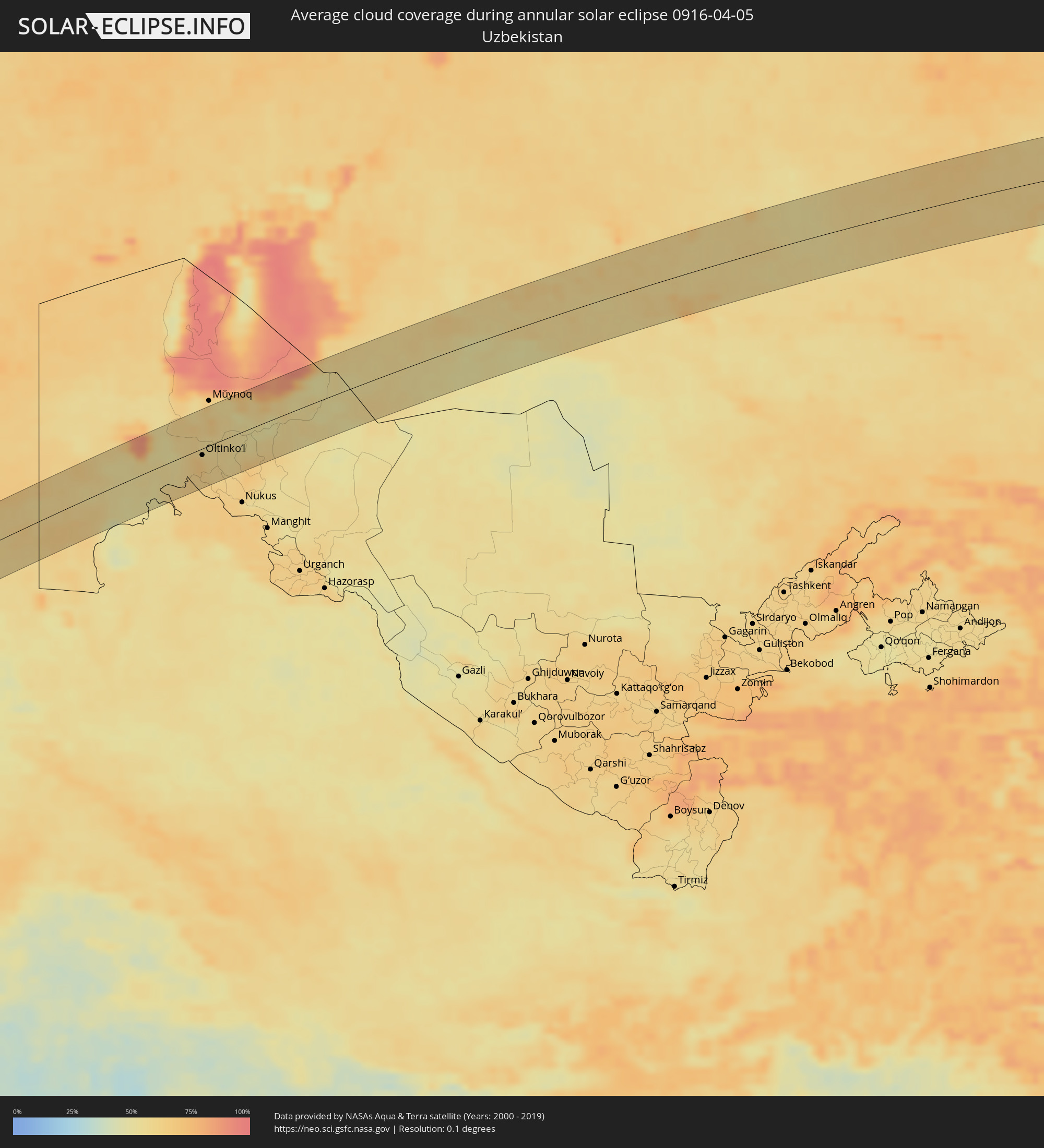 Uzbekistan
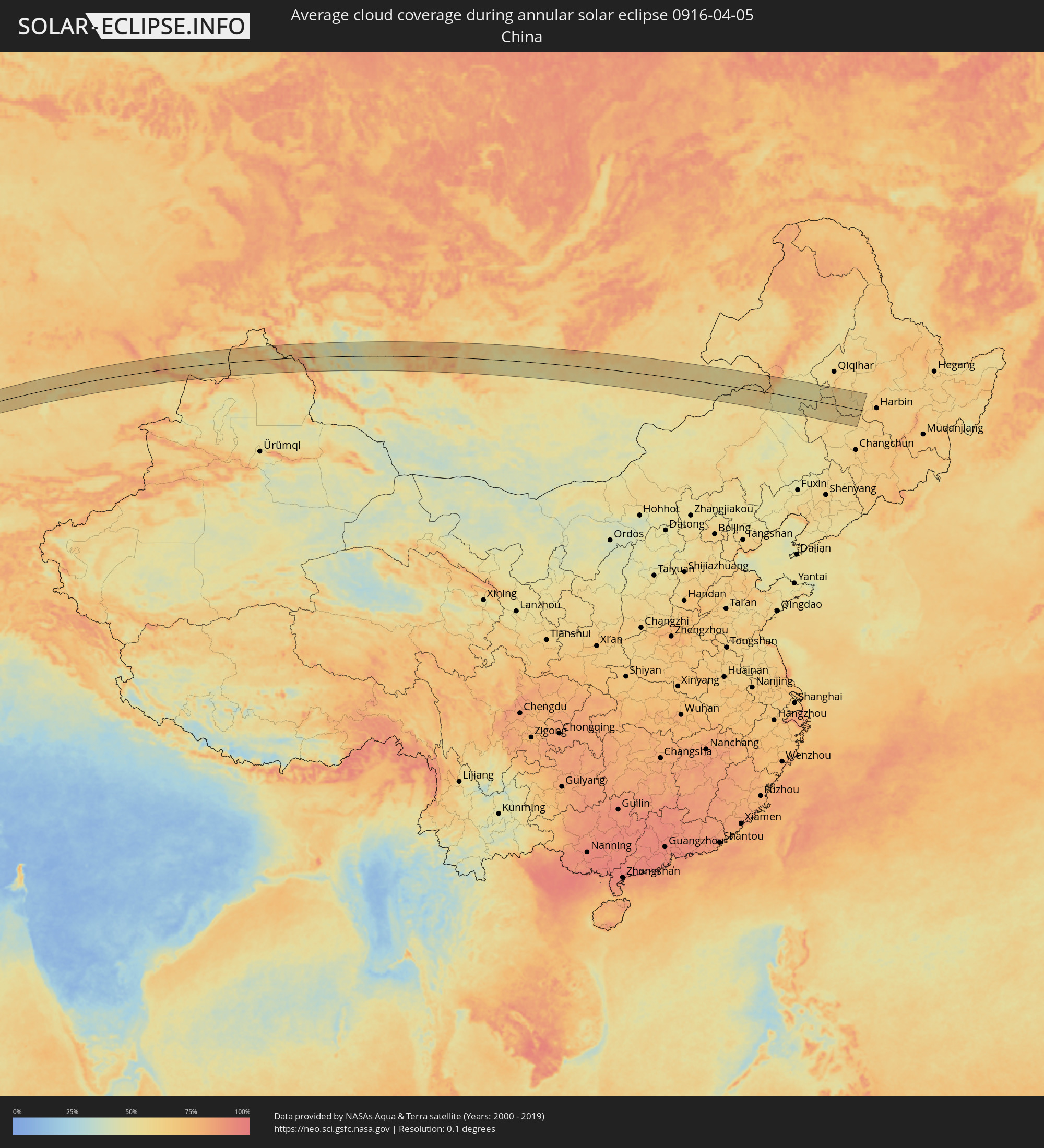 China
China
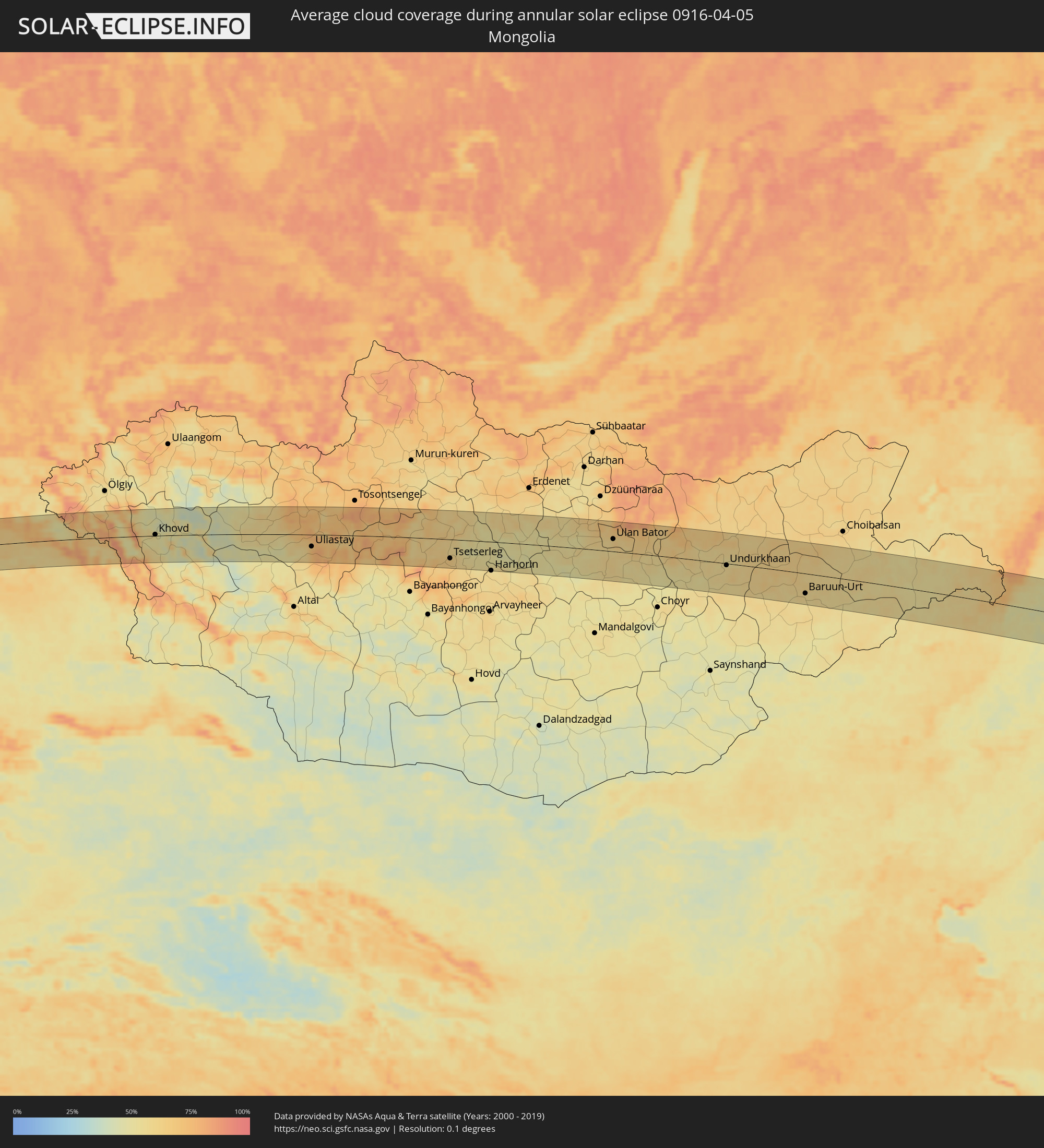 Mongolia
Cities inside the path of the eclipse
The following table shows all locations with a population of more than 5,000 inside the eclipse path. Cities which have more than 100,000 inhabitants are marked bold. A click at the locations opens a detailed map.
| City | Type | Eclipse duration | Local time of max. eclipse | Distance to central line | Ø Cloud coverage |
|
Bansang, Central River
|
annular | - | 06:37:39 UTC-00:16 | 69 km | 10% |
|
Gabú, Gabú
|
annular | - | 05:50:13 UTC-01:02 | 64 km | 18% |
|
Basse Santa Su, Upper River
|
annular | - | 06:37:28 UTC-00:16 | 49 km | 10% |
|
Sabi, Upper River
|
annular | - | 06:37:23 UTC-00:16 | 40 km | 12% |
|
Vélingara, Kolda
|
annular | - | 06:37:17 UTC-00:16 | 30 km | 12% |
|
Koundara, Boke
|
annular | - | 06:36:31 UTC-00:16 | 57 km | 16% |
|
Youkounkoun, Boke
|
annular | - | 06:36:32 UTC-00:16 | 55 km | 17% |
|
Kédougou, Kédougou
|
annular | - | 06:36:29 UTC-00:16 | 68 km | 14% |
|
Bafoulabé, Kayes
|
annular | - | 06:37:46 UTC-00:16 | 45 km | 12% |
|
Kokofata
|
annular | - | 06:36:45 UTC-00:16 | 73 km | 22% |
|
Kolokani, Koulikoro
|
annular | - | 06:37:35 UTC-00:16 | 37 km | 20% |
|
Banamba, Koulikoro
|
annular | - | 06:37:36 UTC-00:16 | 52 km | 21% |
|
Markala, Ségou
|
annular | - | 06:37:55 UTC-00:16 | 66 km | 27% |
|
Ké-Macina, Ségou
|
annular | - | 06:38:20 UTC-00:16 | 54 km | 29% |
|
Ténenkou, Mopti
|
annular | - | 06:39:00 UTC-00:16 | 10 km | 21% |
|
Mopti, Mopti
|
annular | - | 06:39:10 UTC-00:16 | 25 km | 29% |
|
Bandiagara, Mopti
|
annular | - | 06:39:08 UTC-00:16 | 54 km | 27% |
|
Douentza, Mopti
|
annular | - | 06:40:06 UTC-00:16 | 1 km | 24% |
|
Gao, Gao
|
annular | - | 06:42:39 UTC-00:16 | 57 km | 22% |
|
Ménaka, Gao
|
annular | - | 06:43:12 UTC-00:16 | 55 km | 23% |
|
Ibshawāy, Faiyum
|
annular | - | 09:56:05 UTC+02:00 | 13 km | 33% |
|
Al Fayyūm, Faiyum
|
annular | - | 09:56:18 UTC+02:00 | 26 km | 33% |
|
Al Qanāţir al Khayrīyah, Qalyubia
|
annular | - | 09:58:34 UTC+02:00 | 39 km | 35% |
|
Toukh, Qalyubia
|
annular | - | 09:59:00 UTC+02:00 | 50 km | 42% |
|
Cairo, Cairo
|
annular | - | 09:58:32 UTC+02:00 | 21 km | 31% |
|
Ḩalwān, Cairo
|
annular | - | 09:58:12 UTC+02:00 | 2 km | 29% |
|
Al Khānkah, Qalyubia
|
annular | - | 09:59:02 UTC+02:00 | 28 km | 29% |
|
Bilbays, Sharqia
|
annular | - | 09:59:49 UTC+02:00 | 36 km | 32% |
|
At Tall al Kabīr, Ismailia
|
annular | - | 10:00:29 UTC+02:00 | 36 km | 36% |
|
Fāqūs, Sharqia
|
annular | - | 10:00:53 UTC+02:00 | 52 km | 45% |
|
Ismailia, Ismailia
|
annular | - | 10:01:33 UTC+02:00 | 14 km | 39% |
|
Arish, North Sinai
|
annular | - | 10:05:34 UTC+02:00 | 21 km | 36% |
|
Khān Yūnis, Gaza Strip
|
annular | - | 10:06:59 UTC+02:00 | 29 km | 46% |
|
Gaza, Gaza Strip
|
annular | - | 10:07:36 UTC+02:00 | 23 km | 55% |
|
Ashqelon, Southern District
|
annular | - | 10:28:48 UTC+02:20 | 13 km | 49% |
|
Ashdod, Southern District
|
annular | - | 10:29:11 UTC+02:20 | 6 km | 47% |
|
Qiryat Gat, Southern District
|
annular | - | 10:29:05 UTC+02:20 | 29 km | 54% |
|
Tel Aviv, Tel Aviv
|
annular | - | 10:30:00 UTC+02:20 | 13 km | 49% |
|
Netanya, Central District
|
annular | - | 10:30:37 UTC+02:20 | 32 km | 52% |
|
Kfar Saba, Central District
|
annular | - | 10:30:26 UTC+02:20 | 15 km | 53% |
|
Bayt ‘Awwā, West Bank
|
annular | - | 10:08:36 UTC+02:00 | 48 km | 53% |
|
Bet Shemesh, Jerusalem
|
annular | - | 10:29:46 UTC+02:20 | 30 km | 54% |
|
Modiin, Central District
|
annular | - | 10:30:07 UTC+02:20 | 16 km | 56% |
|
Ţūlkarm, West Bank
|
annular | - | 10:10:16 UTC+02:00 | 21 km | 56% |
|
Bayt Liqyā, West Bank
|
annular | - | 10:09:31 UTC+02:00 | 22 km | 57% |
|
Ḩalḩūl, West Bank
|
annular | - | 10:09:03 UTC+02:00 | 50 km | 53% |
|
Umm el Faḥm, Haifa
|
annular | - | 10:31:34 UTC+02:20 | 33 km | 58% |
|
Salfīt, West Bank
|
annular | - | 10:10:09 UTC+02:00 | 8 km | 53% |
|
Jerusalem, Jerusalem
|
annular | - | 10:30:18 UTC+02:20 | 39 km | 54% |
|
East Jerusalem, West Bank
|
annular | - | 10:30:22 UTC+02:20 | 39 km | 54% |
|
Nablus, West Bank
|
annular | - | 10:10:33 UTC+02:00 | 1 km | 54% |
|
Janīn, West Bank
|
annular | - | 10:11:05 UTC+02:00 | 19 km | 54% |
|
Nazareth, Northern District
|
annular | - | 10:32:12 UTC+02:20 | 41 km | 51% |
|
Ţūbās, West Bank
|
annular | - | 10:10:58 UTC+02:00 | 3 km | 54% |
|
Jericho, West Bank
|
annular | - | 10:10:18 UTC+02:00 | 43 km | 43% |
|
Tiberias, Northern District
|
annular | - | 10:32:50 UTC+02:20 | 37 km | 49% |
|
Al Karāmah, Balqa
|
annular | - | 10:34:27 UTC+02:23 | 42 km | 46% |
|
Kurayyimah, Irbid
|
annular | - | 10:35:06 UTC+02:23 | 13 km | 54% |
|
Waqqāş, Irbid
|
annular | - | 10:35:36 UTC+02:23 | 11 km | 54% |
|
Şammā, Irbid
|
annular | - | 10:35:49 UTC+02:23 | 9 km | 52% |
|
As Salţ, Balqa
|
annular | - | 10:34:55 UTC+02:23 | 42 km | 48% |
|
‘Ajlūn, Ajlun
|
annular | - | 10:35:31 UTC+02:23 | 16 km | 48% |
|
Saḩam al Kaffārāt, Irbid
|
annular | - | 10:36:14 UTC+02:23 | 16 km | 52% |
|
Raymūn, Jerash
|
annular | - | 10:35:34 UTC+02:23 | 25 km | 48% |
|
Al Kittah, Jerash
|
annular | - | 10:35:36 UTC+02:23 | 26 km | 48% |
|
Irbid, Irbid
|
annular | - | 10:36:08 UTC+02:23 | 1 km | 48% |
|
Aţ Ţurrah, Irbid
|
annular | - | 10:36:34 UTC+02:23 | 1 km | 46% |
|
Jāsim, Daraa
|
annular | - | 10:38:50 UTC+02:25 | 27 km | 43% |
|
Ţafas, Daraa
|
annular | - | 10:38:22 UTC+02:25 | 4 km | 45% |
|
Dar‘ā, Daraa
|
annular | - | 10:38:14 UTC+02:25 | 9 km | 46% |
|
Inkhil, Daraa
|
annular | - | 10:39:01 UTC+02:25 | 26 km | 43% |
|
Ash Shaykh Miskīn, Daraa
|
annular | - | 10:38:44 UTC+02:25 | 7 km | 45% |
|
Aş Şanamayn, Daraa
|
annular | - | 10:39:14 UTC+02:25 | 28 km | 42% |
|
Mafraq, Mafraq
|
annular | - | 10:36:29 UTC+02:23 | 40 km | 42% |
|
Al Kiswah, Rif-dimashq
|
annular | - | 10:39:52 UTC+02:25 | 51 km | 39% |
|
Al Ḩarāk, Daraa
|
annular | - | 10:38:54 UTC+02:25 | 8 km | 42% |
|
As Suwaydā’, As-Suwayda
|
annular | - | 10:39:22 UTC+02:25 | 26 km | 41% |
|
Deir ez-Zor, Deir ez-Zor
|
annular | - | 10:51:30 UTC+02:25 | 29 km | 39% |
|
Al Mayādīn, Deir ez-Zor
|
annular | - | 10:51:39 UTC+02:25 | 16 km | 48% |
|
Subaykhān, Deir ez-Zor
|
annular | - | 10:51:41 UTC+02:25 | 39 km | 51% |
|
Sinjār, Nīnawá
|
annular | - | 11:29:12 UTC+02:57 | 33 km | 55% |
|
Dihok, Dahūk
|
annular | - | 11:32:26 UTC+02:57 | 29 km | 59% |
|
Sīnah, Dahūk
|
annular | - | 11:32:27 UTC+02:57 | 21 km | 57% |
|
Al Mawşil al Jadīdah, Nīnawá
|
annular | - | 11:31:53 UTC+02:57 | 26 km | 59% |
|
Mosul, Nīnawá
|
annular | - | 11:31:55 UTC+02:57 | 27 km | 59% |
|
Tallkayf, Nīnawá
|
annular | - | 11:32:10 UTC+02:57 | 12 km | 57% |
|
Al-Hamdaniya, Nīnawá
|
annular | - | 11:32:23 UTC+02:57 | 45 km | 57% |
|
Çukurca, Hakkâri
|
annular | - | 10:33:41 UTC+01:56 | 35 km | 64% |
|
‘Aqrah, Nīnawá
|
annular | - | 11:34:11 UTC+02:57 | 26 km | 57% |
|
Yüksekova, Hakkâri
|
annular | - | 10:35:36 UTC+01:56 | 33 km | 72% |
|
Şemdinli, Hakkâri
|
annular | - | 10:35:51 UTC+01:56 | 5 km | 77% |
|
Orūmīyeh, Āz̄ārbāyjān-e Gharbī
|
annular | - | 12:06:05 UTC+03:25 | 6 km | 58% |
|
Marand, East Azerbaijan
|
annular | - | 12:08:47 UTC+03:25 | 45 km | 64% |
|
Tabriz, East Azerbaijan
|
annular | - | 12:09:27 UTC+03:25 | 12 km | 60% |
|
Ahar, East Azerbaijan
|
annular | - | 12:11:39 UTC+03:25 | 9 km | 63% |
|
Dzhalilabad, Jalilabad
|
annular | - | 12:09:16 UTC+03:19 | 2 km | 69% |
|
Pushkino, Bilǝsuvar
|
annular | - | 12:09:40 UTC+03:19 | 20 km | 64% |
|
Prishibinskoye, Jalilabad
|
annular | - | 12:09:22 UTC+03:19 | 15 km | 69% |
|
Masally, Masally
|
annular | - | 12:09:26 UTC+03:19 | 26 km | 69% |
|
Şirvan, Shirvan
|
annular | - | 12:11:01 UTC+03:19 | 50 km | 66% |
|
Salyan, Salyan
|
annular | - | 12:10:45 UTC+03:19 | 15 km | 67% |
|
Neftçala, Neftçala
|
annular | - | 12:11:05 UTC+03:19 | 18 km | 64% |
|
Qobustan, Baki
|
annular | - | 12:12:12 UTC+03:19 | 44 km | 70% |
|
Qaraçuxur, Baki
|
annular | - | 12:13:43 UTC+03:19 | 51 km | 59% |
|
Türkan, Baki
|
annular | - | 12:14:12 UTC+03:19 | 38 km | 62% |
|
Zyrya, Baki
|
annular | - | 12:14:21 UTC+03:19 | 35 km | 61% |
|
Pirallahı, Baki
|
annular | - | 12:14:31 UTC+03:19 | 44 km | 62% |
|
Oltinko’l, Karakalpakstan
|
annular | - | 13:42:17 UTC+04:27 | 9 km | 64% |
|
Dzhalagash, Qyzylorda
|
annular | - | 13:47:17 UTC+04:21 | 37 km | 60% |
|
Terenozek, Qyzylorda
|
annular | - | 13:47:50 UTC+04:21 | 25 km | 59% |
|
Kyzyl-Orda, Qyzylorda
|
annular | - | 13:48:43 UTC+04:21 | 9 km | 59% |
|
Kyzylorda, Qyzylorda
|
annular | - | 13:48:44 UTC+04:21 | 9 km | 62% |
|
Tasböget, Qyzylorda
|
annular | - | 13:48:48 UTC+04:21 | 18 km | 59% |
|
Priozersk
|
annular | - | 14:01:27 UTC+04:21 | 51 km | 61% |
|
Balqash, Qaraghandy
|
annular | - | 14:02:54 UTC+04:21 | 17 km | 59% |
|
Urzhar, East Kazakhstan
|
annular | - | 14:11:07 UTC+04:21 | 39 km | 57% |
|
Tūghyl, East Kazakhstan
|
annular | - | 14:13:28 UTC+04:21 | 8 km | 60% |
|
Zaysan, East Kazakhstan
|
annular | - | 14:14:22 UTC+04:21 | 25 km | 62% |
|
Altay, Xinjiang Uyghur Autonomous Region
|
annular | - | 17:55:20 UTC+08:00 | 3 km | 59% |
|
Khovd, Hovd
|
annular | - | 16:04:47 UTC+06:06 | 3 km | 53% |
|
Uliastay, Dzabkhan
|
annular | - | 16:08:46 UTC+06:06 | 29 km | 71% |
|
Tsetserleg, Arhangay
|
annular | - | 17:12:35 UTC+07:07 | 47 km | 64% |
|
Harhorin, Övörhangay
|
annular | - | 17:13:32 UTC+07:07 | 72 km | 58% |
|
Ulan Bator, Ulaanbaatar
|
annular | - | 17:14:20 UTC+07:07 | 31 km | 62% |
|
Зуунмод, Central Aimak
|
annular | - | 17:14:35 UTC+07:07 | 9 km | 57% |
|
Dzuunmod, Central Aimak
|
annular | - | 17:14:35 UTC+07:07 | 9 km | 57% |
|
Undurkhaan, Hentiy
|
annular | - | 17:16:03 UTC+07:07 | 4 km | 57% |
|
Baruun-Urt, Sühbaatar
|
annular | - | 17:17:15 UTC+07:07 | 50 km | 57% |
|
Ulanhot, Inner Mongolia
|
annular | - | 18:10:47 UTC+08:00 | 8 km | 52% |
|
Guangming, Jilin
|
annular | - | 18:11:30 UTC+08:00 | 80 km | 57% |
|
Baicheng, Jilin
|
annular | - | 18:11:13 UTC+08:00 | 49 km | 54% |
|
Zhenlai, Jilin
|
annular | - | 18:10:56 UTC+08:00 | 16 km | 57% |
|
Tailai, Heilongjiang
|
annular | - | 18:10:21 UTC+08:00 | 45 km | 54% |
|
Dalai, Jilin
|
annular | - | 18:11:11 UTC+08:00 | 39 km | 57% |
|
Fuyu, Jilin
|
annular | - | 18:11:27 UTC+08:00 | 66 km | 60% |
|
Qianguo, Jilin
|
annular | - | 18:11:31 UTC+08:00 | 73 km | 60% |
|
Honggang, Heilongjiang
|
annular | - | 18:10:11 UTC+08:00 | 68 km | 60% |
|
Anda, Heilongjiang
|
annular | - | 18:10:08 UTC+08:00 | 74 km | 57% |
|
Zhaozhou, Heilongjiang
|
annular | - | 18:10:52 UTC+08:00 | 4 km | 60% |