Annular solar eclipse of 02/03/0938
| Day of week: | Monday |
| Maximum duration of eclipse: | 05m11s |
| Maximum width of eclipse path: | 160 km |
| Saros cycle: | 94 |
| Coverage: | 95.8% |
| Magnitude: | 0.9583 |
| Gamma: | 0.3294 |
Wo kann man die Sonnenfinsternis vom 02/03/0938 sehen?
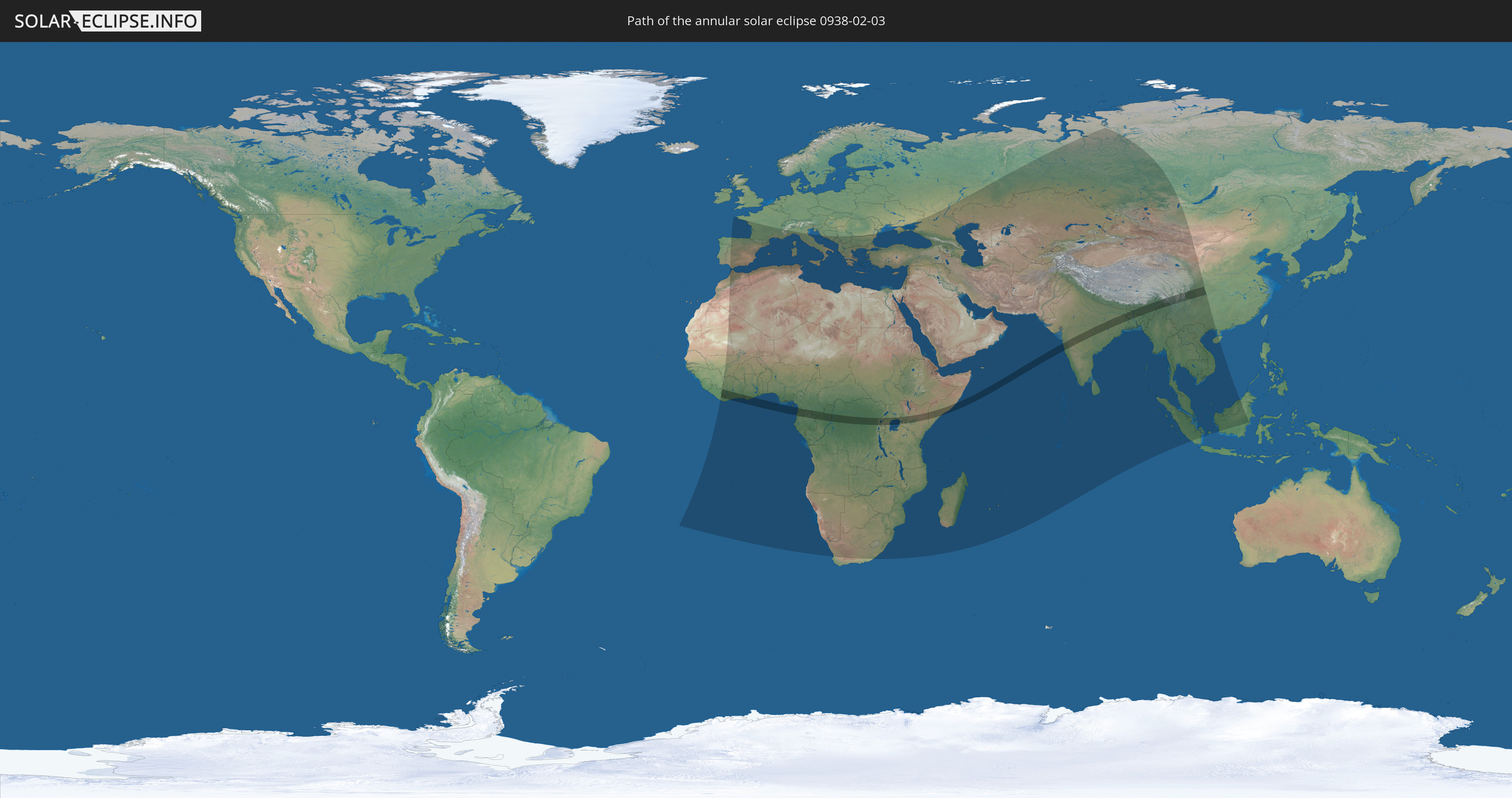
Die Sonnenfinsternis am 02/03/0938 kann man in 116 Ländern als partielle Sonnenfinsternis beobachten.
Der Finsternispfad verläuft durch 19 Länder. Nur in diesen Ländern ist sie als annular Sonnenfinsternis zu sehen.
In den folgenden Ländern ist die Sonnenfinsternis annular zu sehen
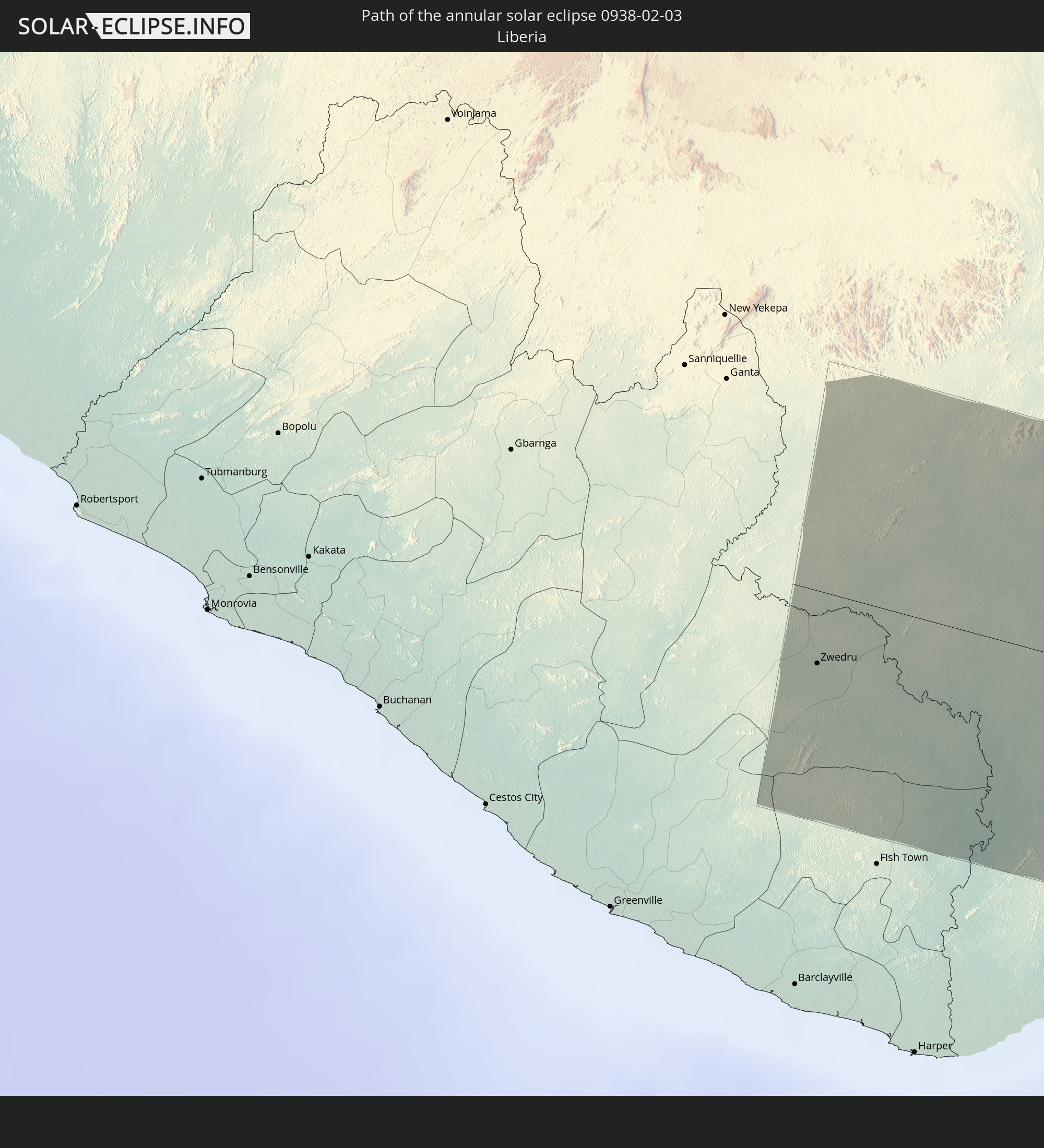 Liberia
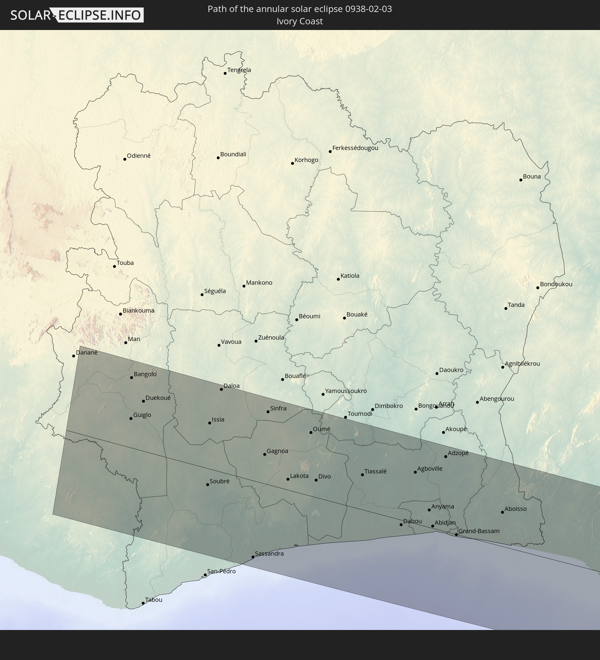 Ivory Coast
 Ghana
Ghana
 Equatorial Guinea
 São Tomé and Príncipe
 Cameroon
 Gabon
Gabon
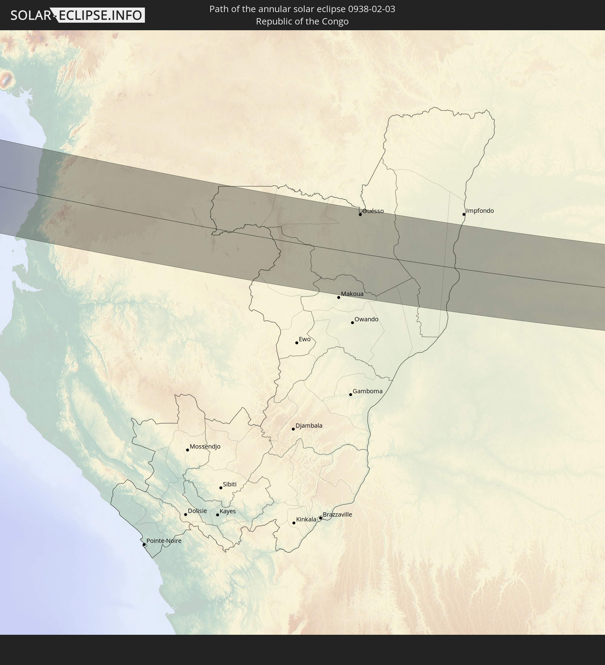 Republic of the Congo
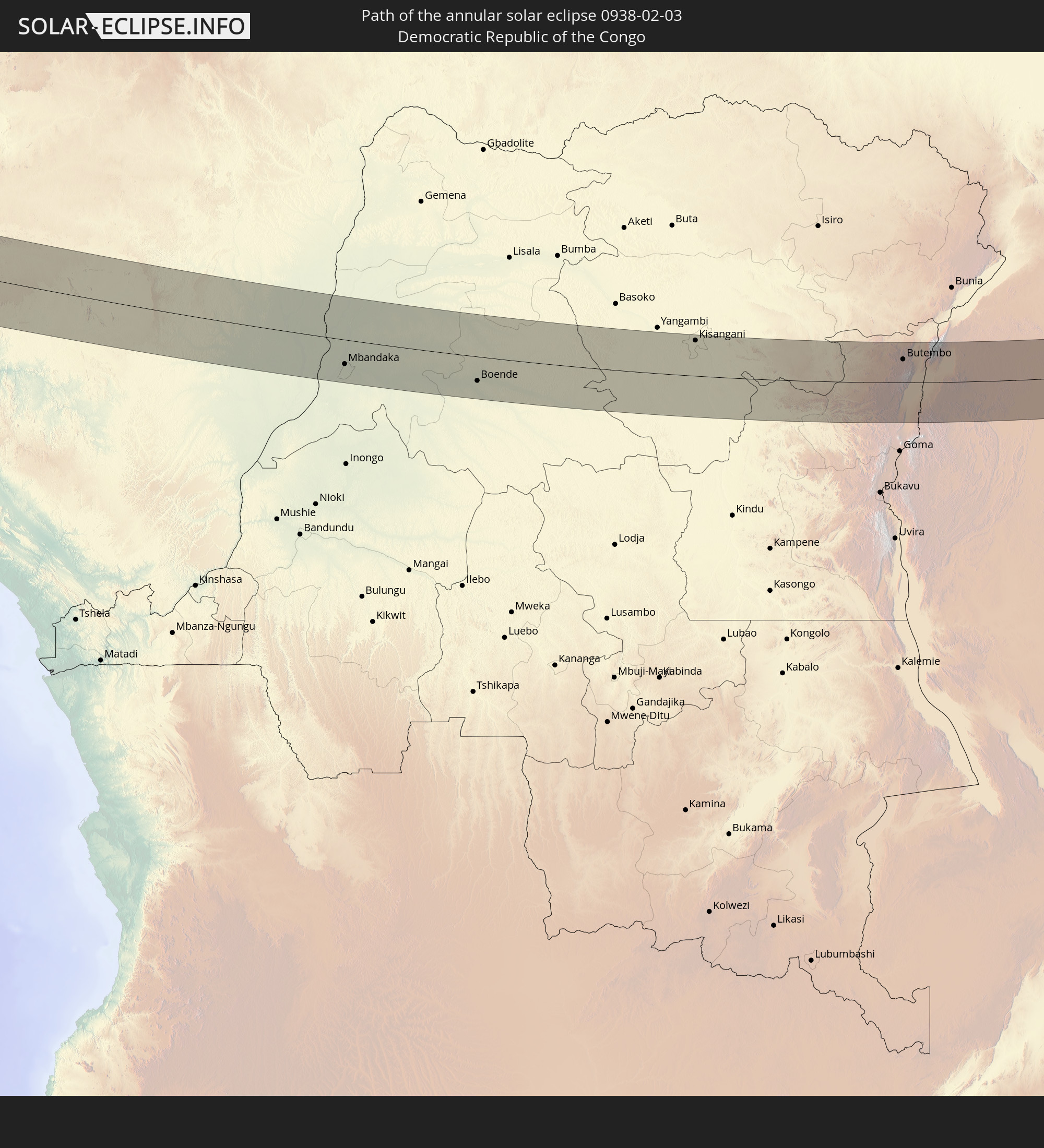 Democratic Republic of the Congo
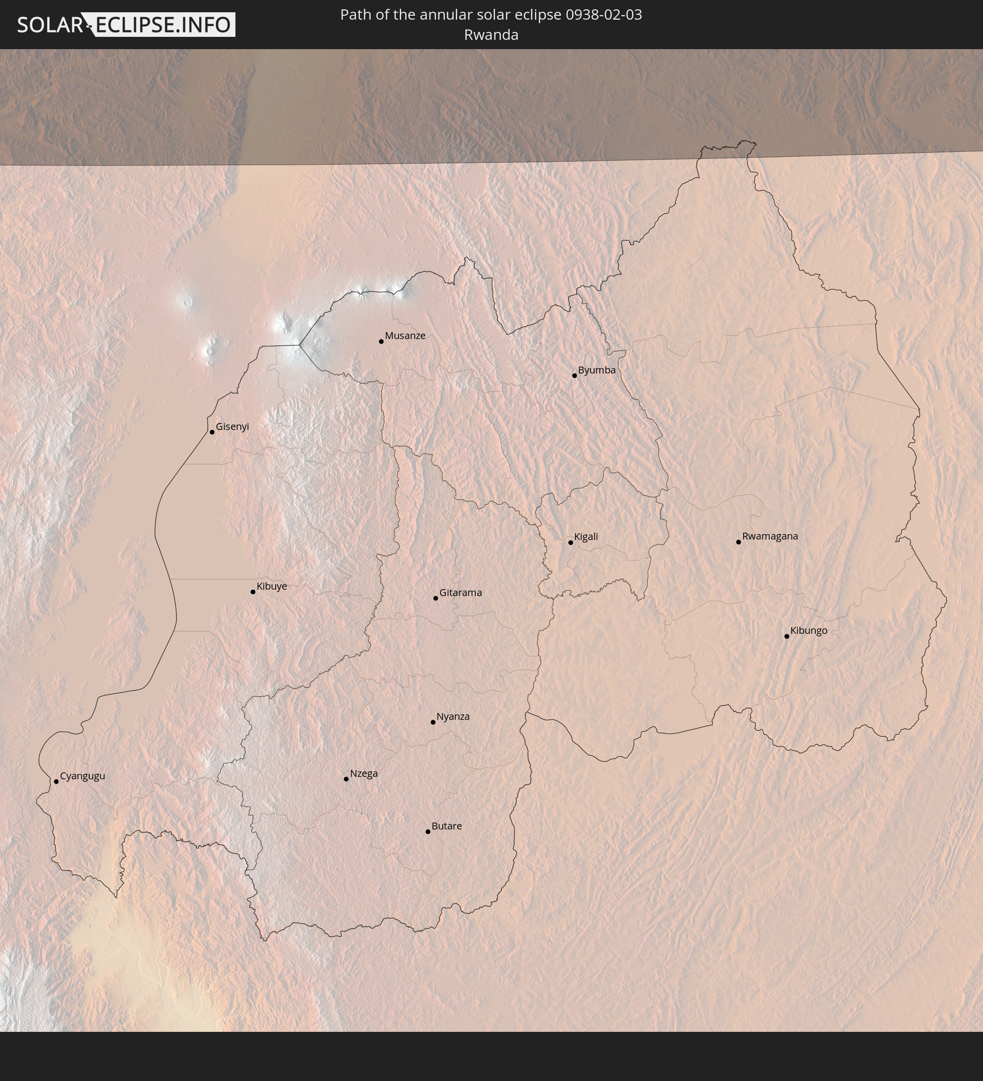 Rwanda
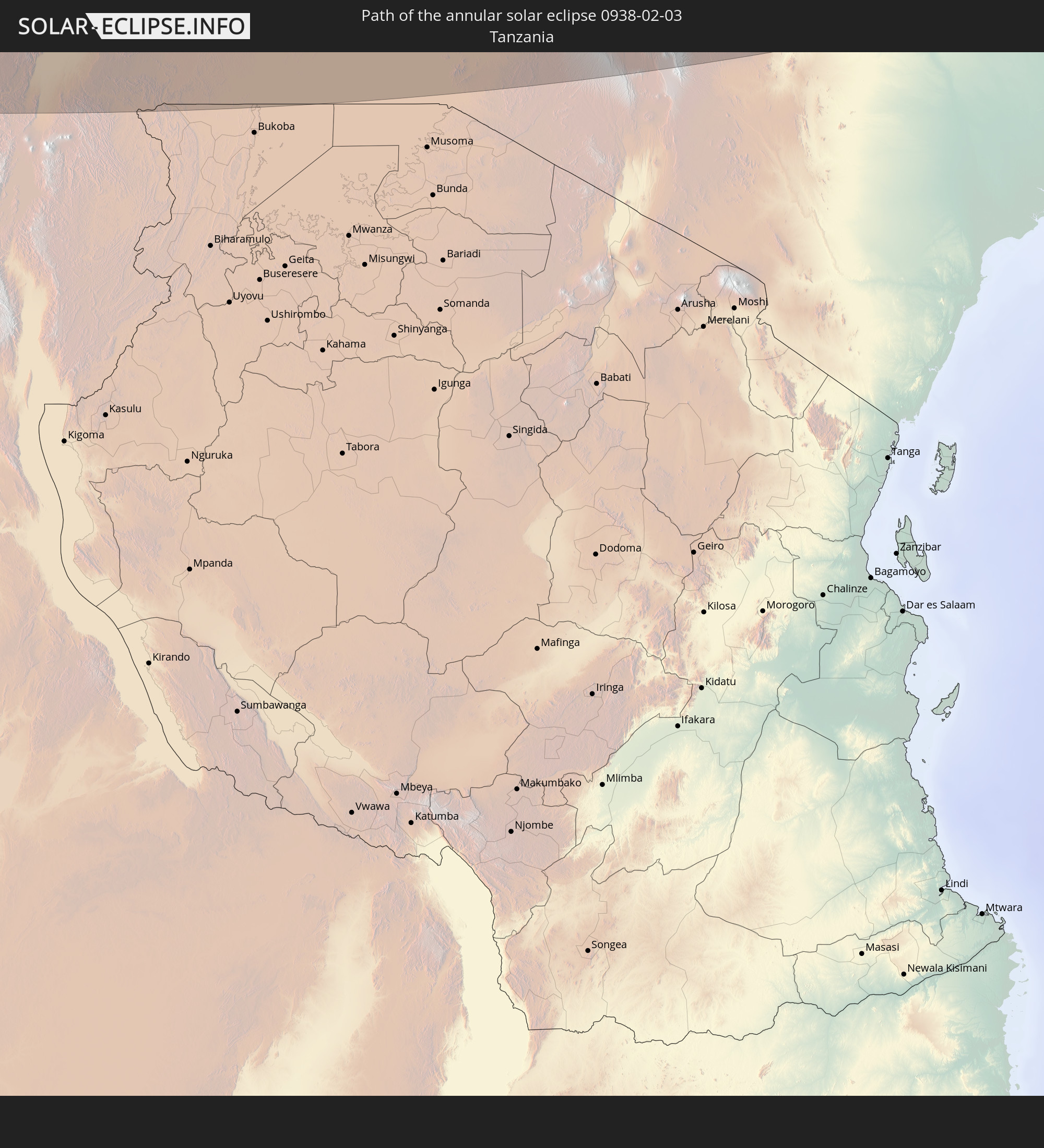 Tanzania
 Uganda
 Kenya
Kenya
 Somalia
 India
India
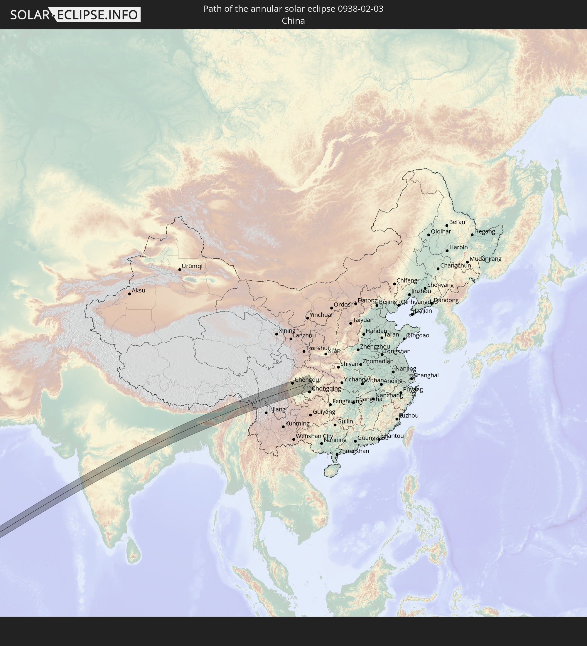 China
China
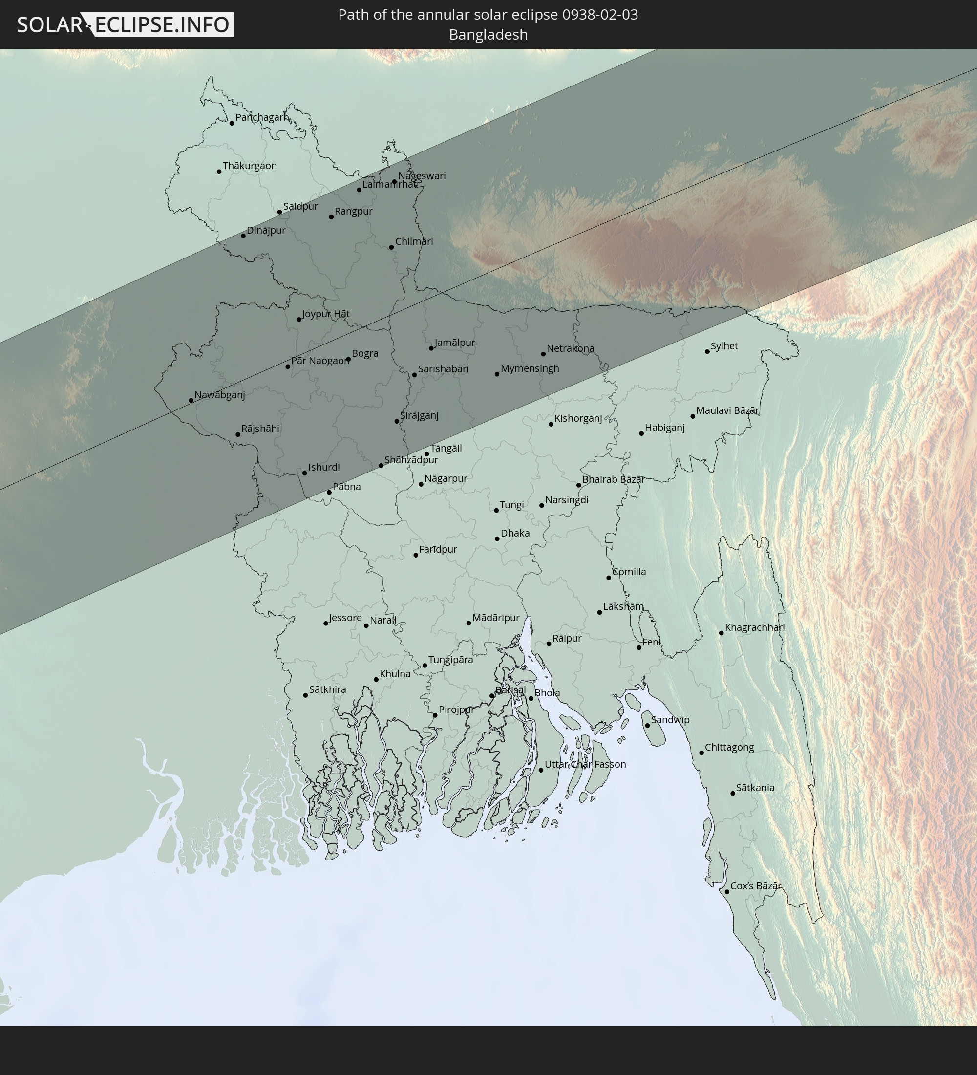 Bangladesh
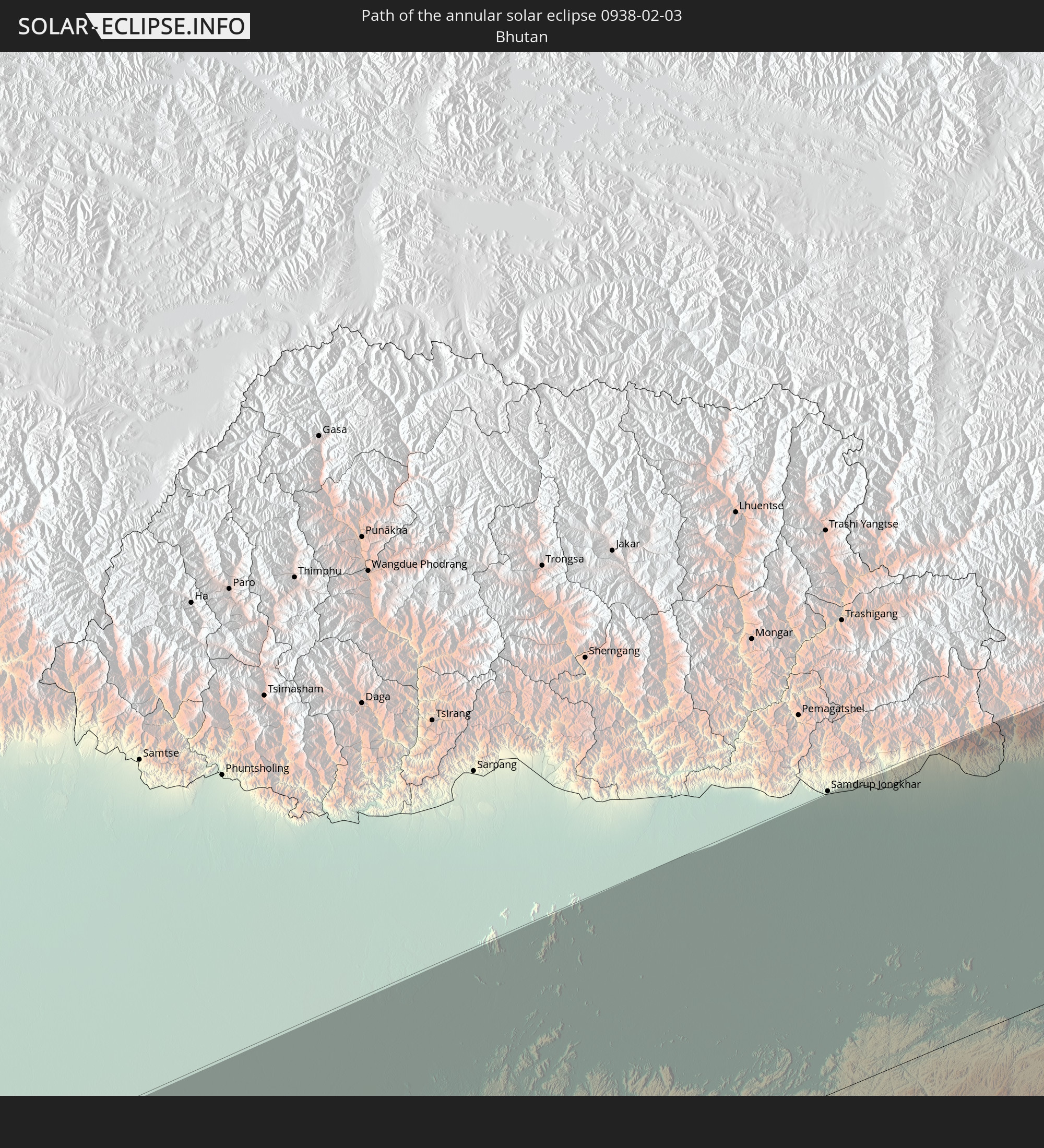 Bhutan
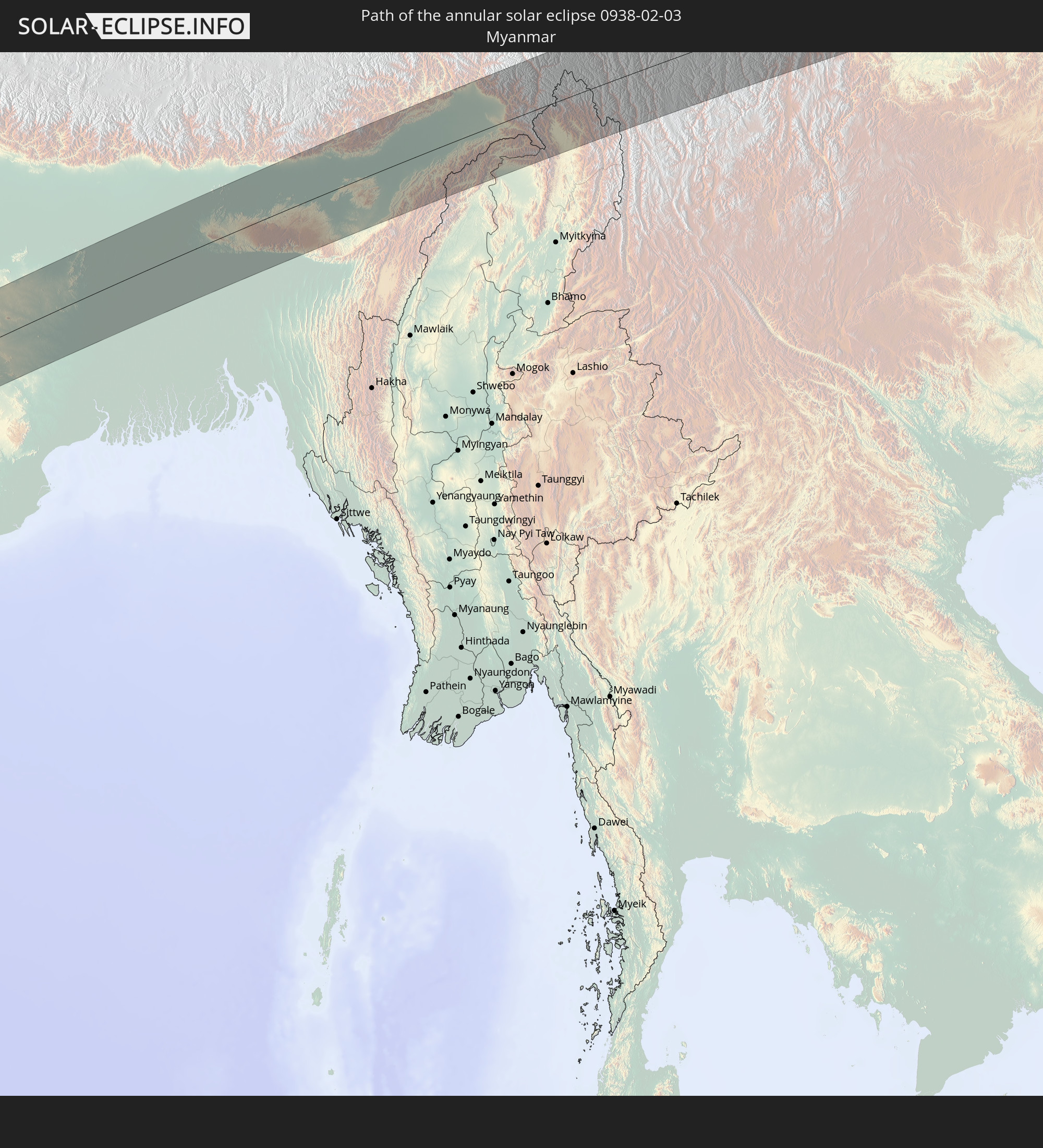 Myanmar
In den folgenden Ländern ist die Sonnenfinsternis partiell zu sehen
 Russia
 Spain
Spain
 Mauritania
 Guinea
 Saint Helena, Ascension and Tristan da Cunha
 Morocco
 Mali
Mali
 Liberia
 Algeria
 Ivory Coast
 Burkina Faso
 Gibraltar
 France
 Ghana
Ghana
 Togo
Togo
 Niger
Niger
 Benin
Benin
 Andorra
 Nigeria
 Equatorial Guinea
 São Tomé and Príncipe
 Italy
Italy
 Monaco
 Tunisia
 Cameroon
 Gabon
Gabon
 Libya
Libya
 Republic of the Congo
 Angola
 Namibia
 Democratic Republic of the Congo
 San Marino
 Vatican City
 Chad
Chad
 Croatia
 Malta
Malta
 Central African Republic
 Bosnia and Herzegovina
 South Africa
 Montenegro
 Serbia
 Albania
 Greece
 Botswana
 Romania
 Republic of Macedonia
 Sudan
Sudan
 Zambia
 Ukraine
 Bulgaria
 Egypt
Egypt
 Zimbabwe
 Turkey
 Lesotho
 Rwanda
 Burundi
 Tanzania
 Uganda
 Mozambique
 Swaziland
 Cyprus
 Malawi
 Ethiopia
 Kenya
Kenya
 State of Palestine
 Israel
 Saudi Arabia
 Jordan
 Lebanon
 Syria
Syria
 Eritrea
 Iraq
Iraq
 Georgia
 French Southern and Antarctic Lands
 Somalia
 Djibouti
 Yemen
Yemen
 Madagascar
 Comoros
 Armenia
 Iran
Iran
 Azerbaijan
 Mayotte
 Seychelles
 Kazakhstan
 Kuwait
 Bahrain
 Qatar
Qatar
 United Arab Emirates
 Oman
Oman
 Turkmenistan
 Réunion
 Uzbekistan
 Mauritius
 Afghanistan
 Pakistan
 Tajikistan
 India
India
 Kyrgyzstan
 British Indian Ocean Territory
 Maldives
 China
China
 Sri Lanka
 Nepal
Nepal
 Mongolia
 Bangladesh
 Bhutan
 Myanmar
 Indonesia
 Thailand
 Malaysia
 Laos
Laos
 Vietnam
 Cambodia
 Singapore
 Brunei
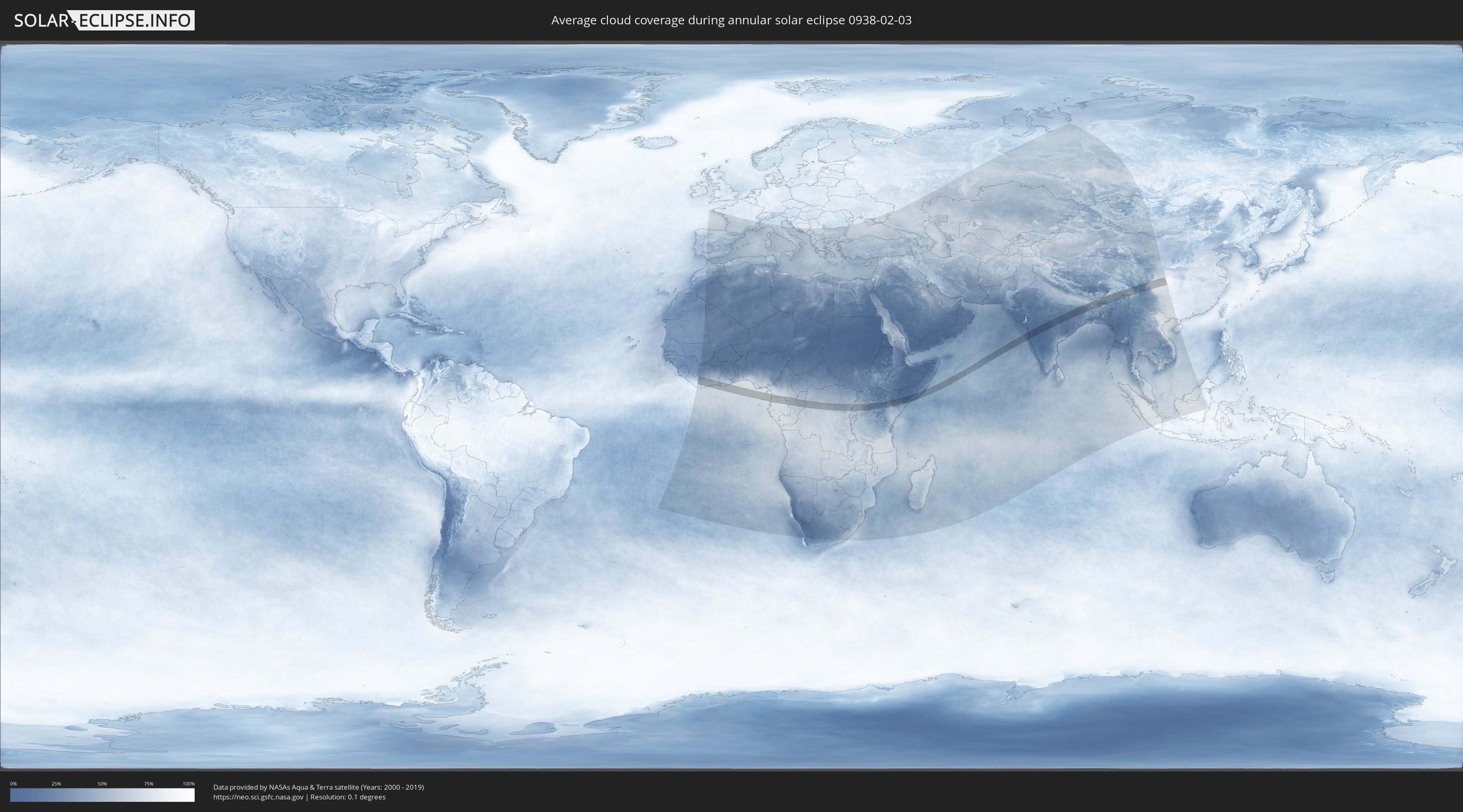
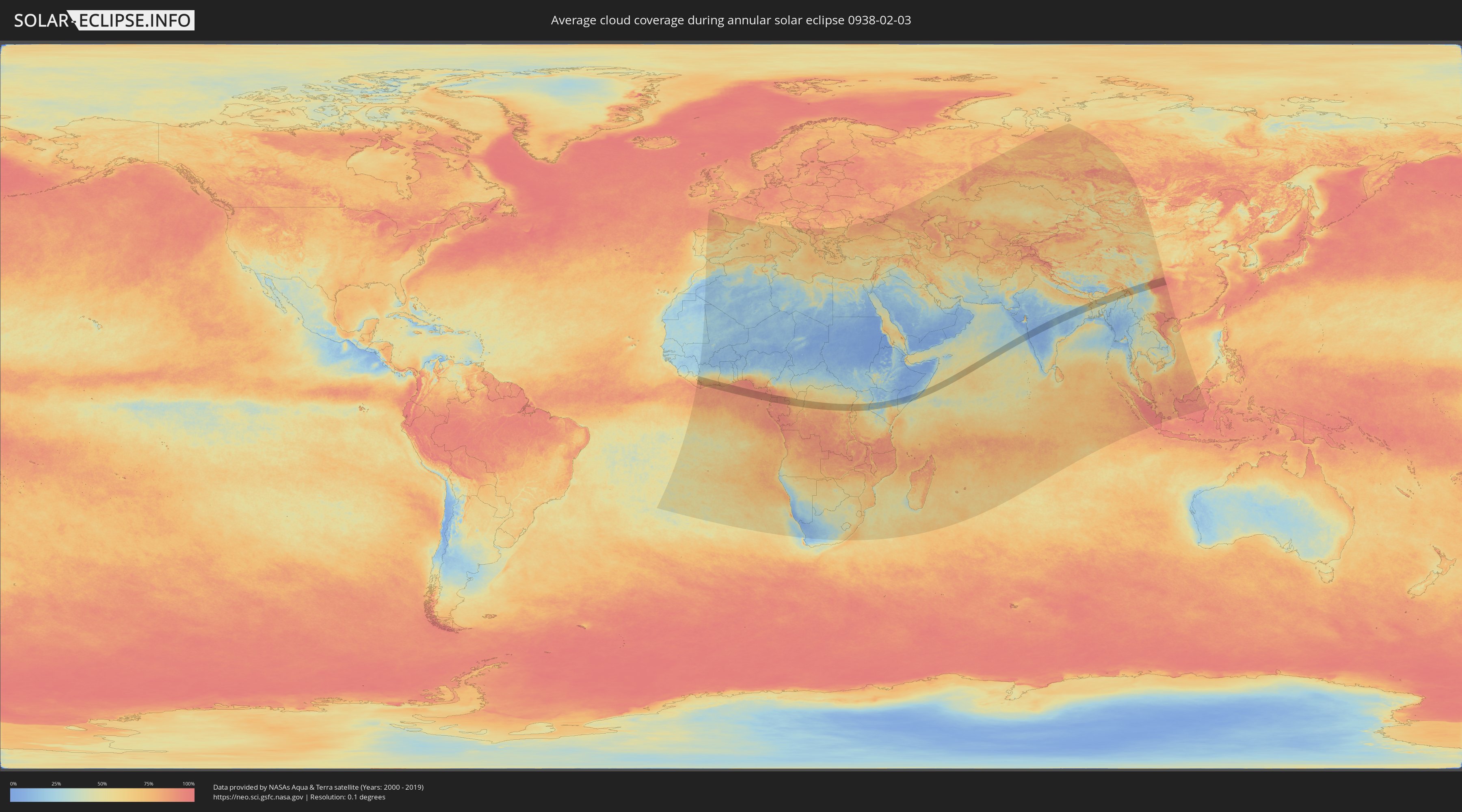
How will be the weather during the annular solar eclipse on 02/03/0938?
Where is the best place to see the annular solar eclipse of 02/03/0938?
The following maps show the average cloud coverage for the day of the annular solar eclipse.
With the help of these maps, it is possible to find the place along the eclipse path, which has the best
chance of a cloudless sky.
Nevertheless, you should consider local circumstances and inform about the weather of your chosen
observation site.
The data is provided by NASAs satellites
AQUA and TERRA.
The cloud maps are averaged over a period of 19 years (2000 - 2019).
Detailed country maps
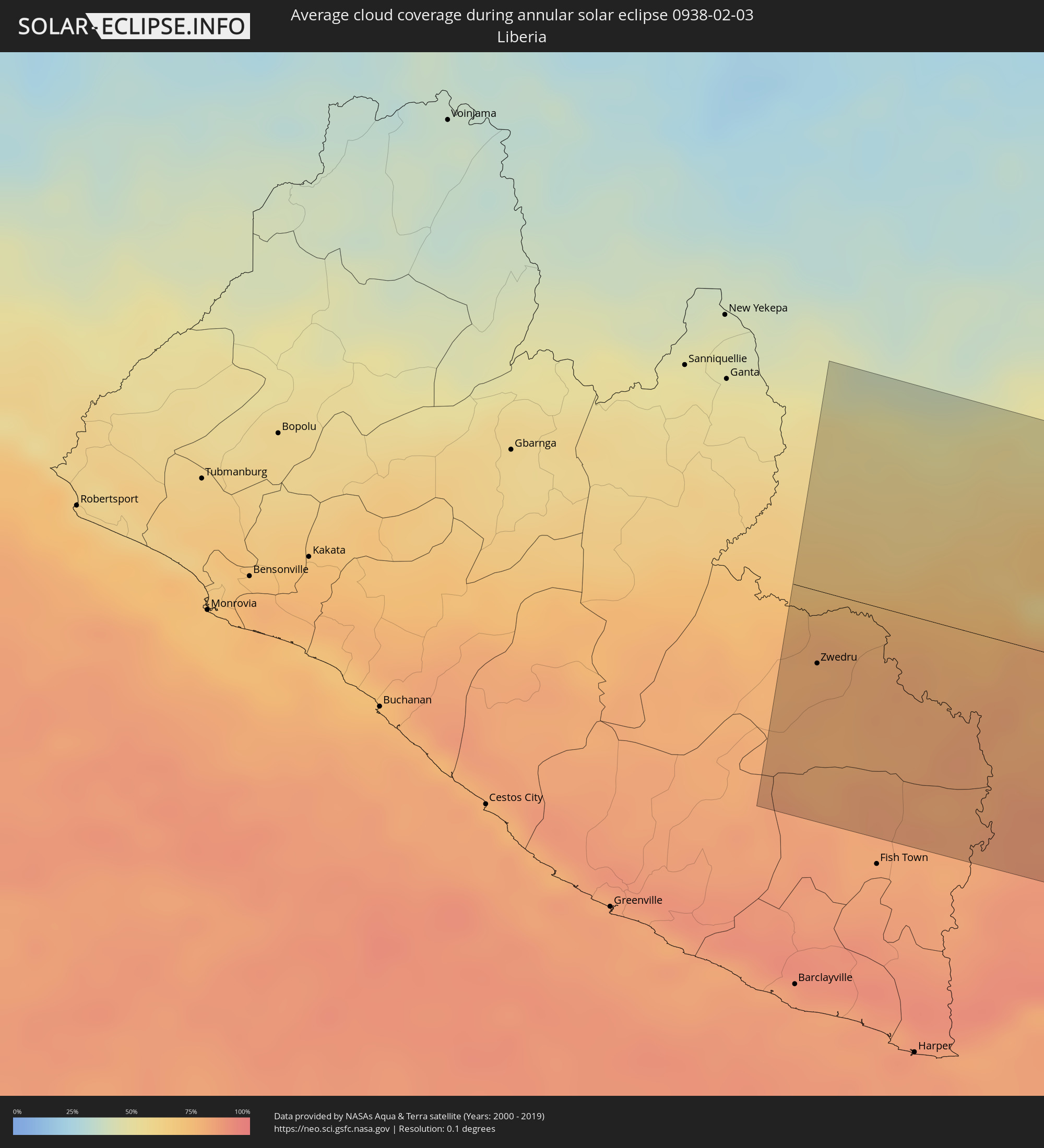 Liberia
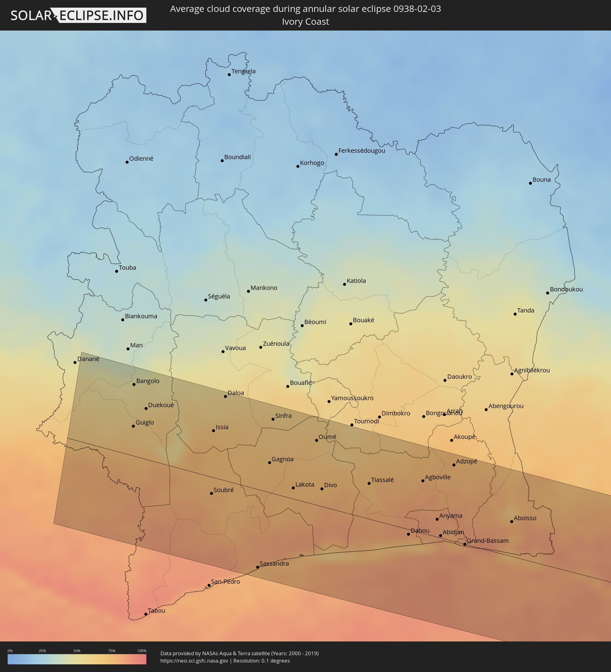 Ivory Coast
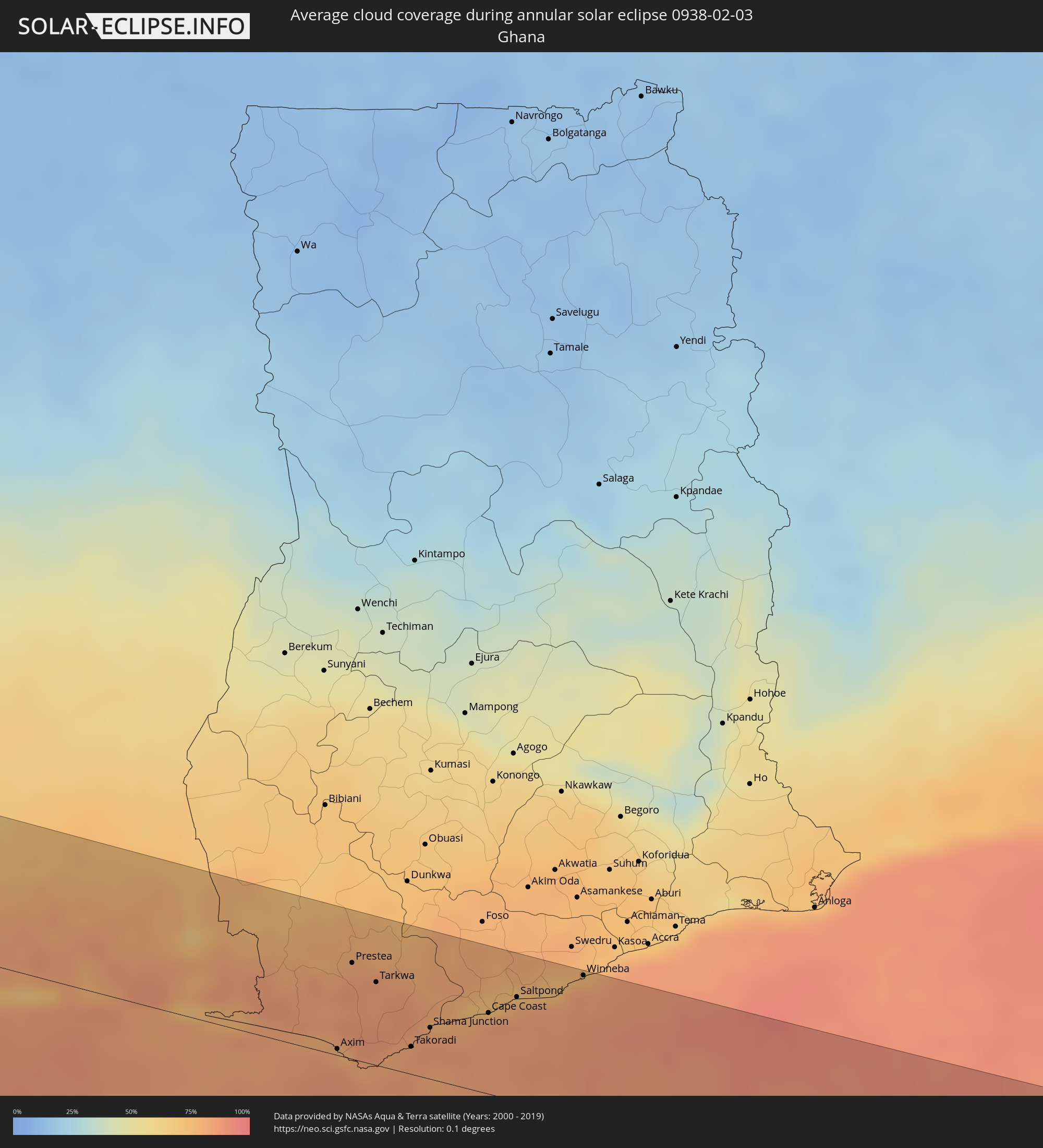 Ghana
Ghana
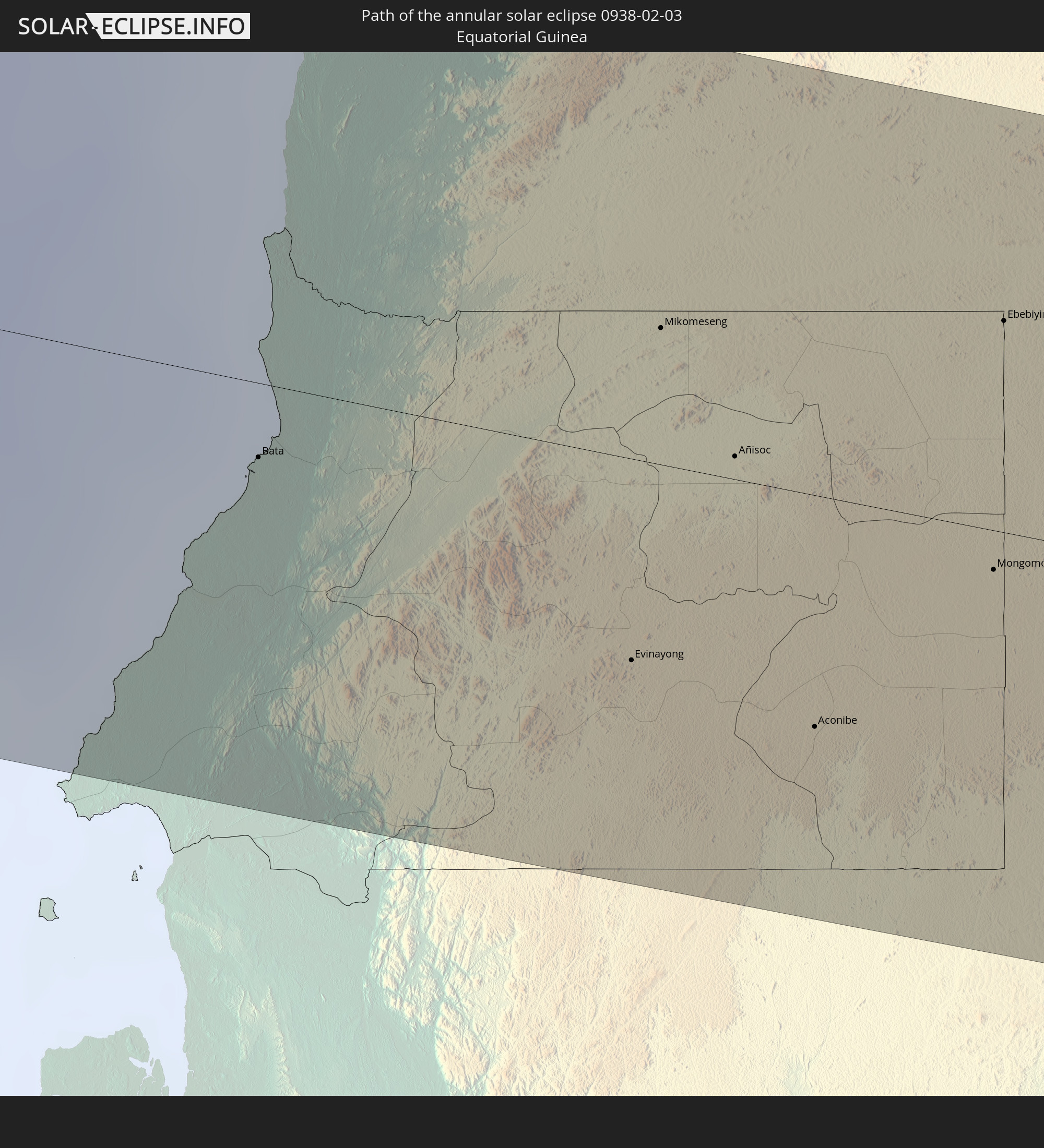
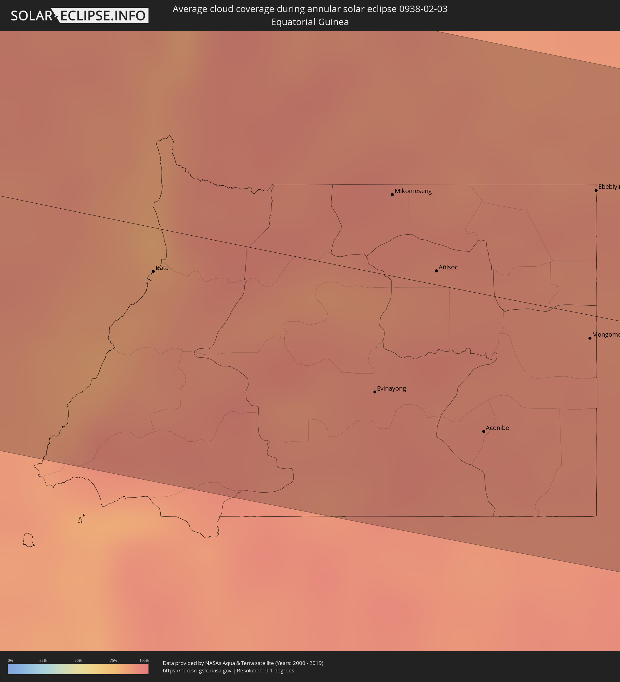 Equatorial Guinea
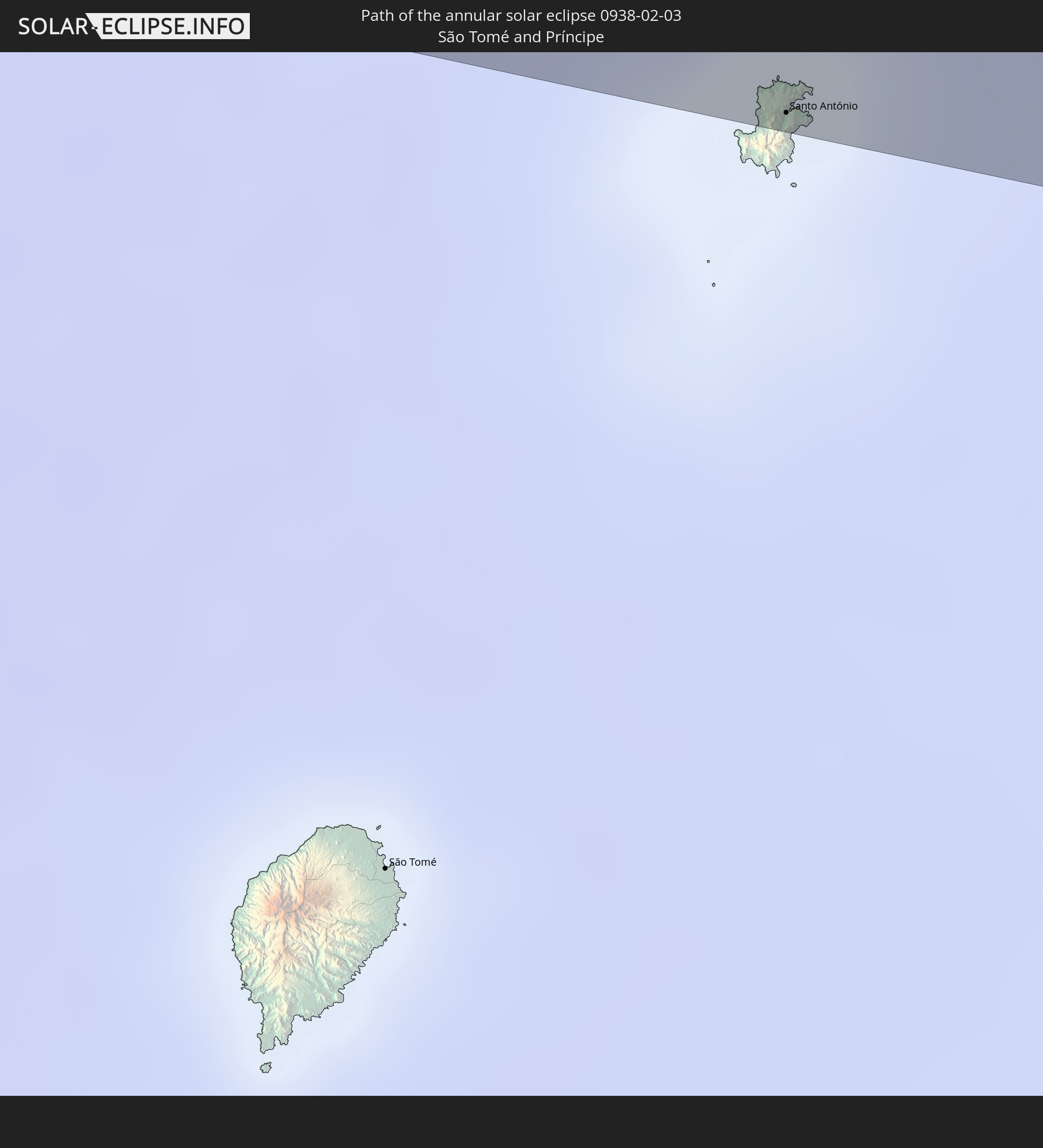
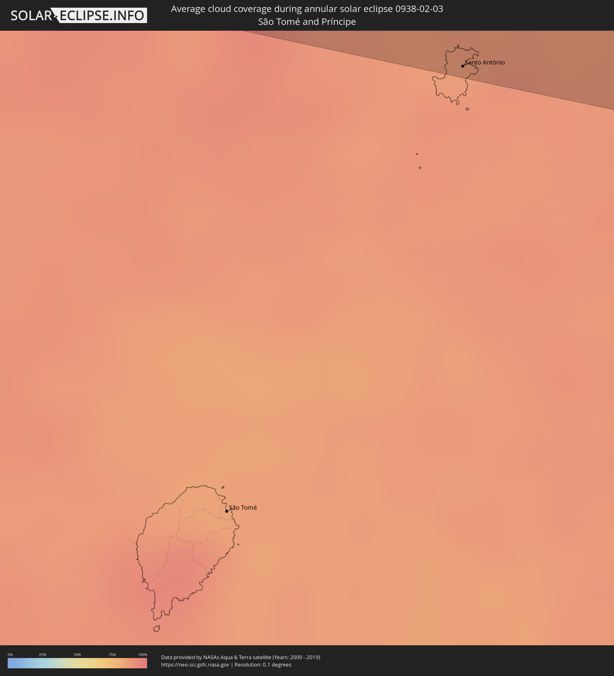 São Tomé and Príncipe
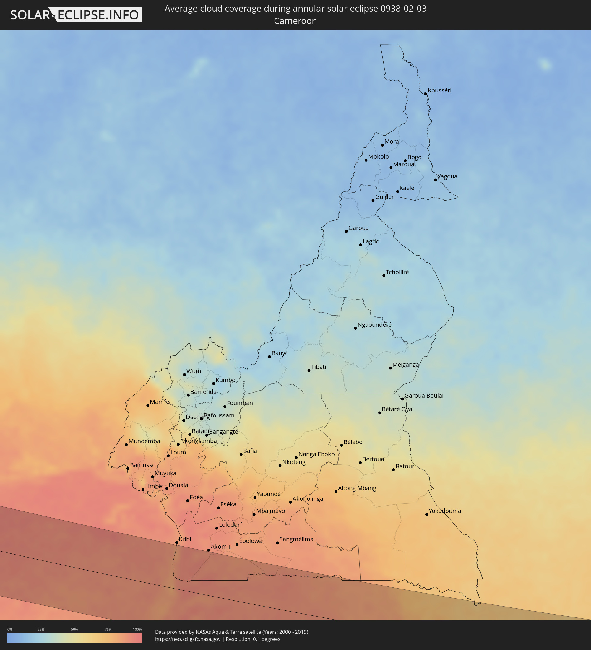 Cameroon
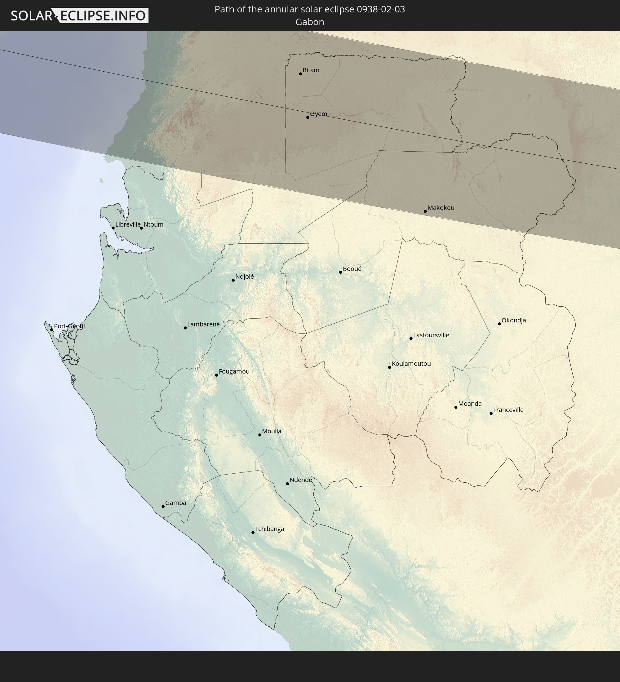
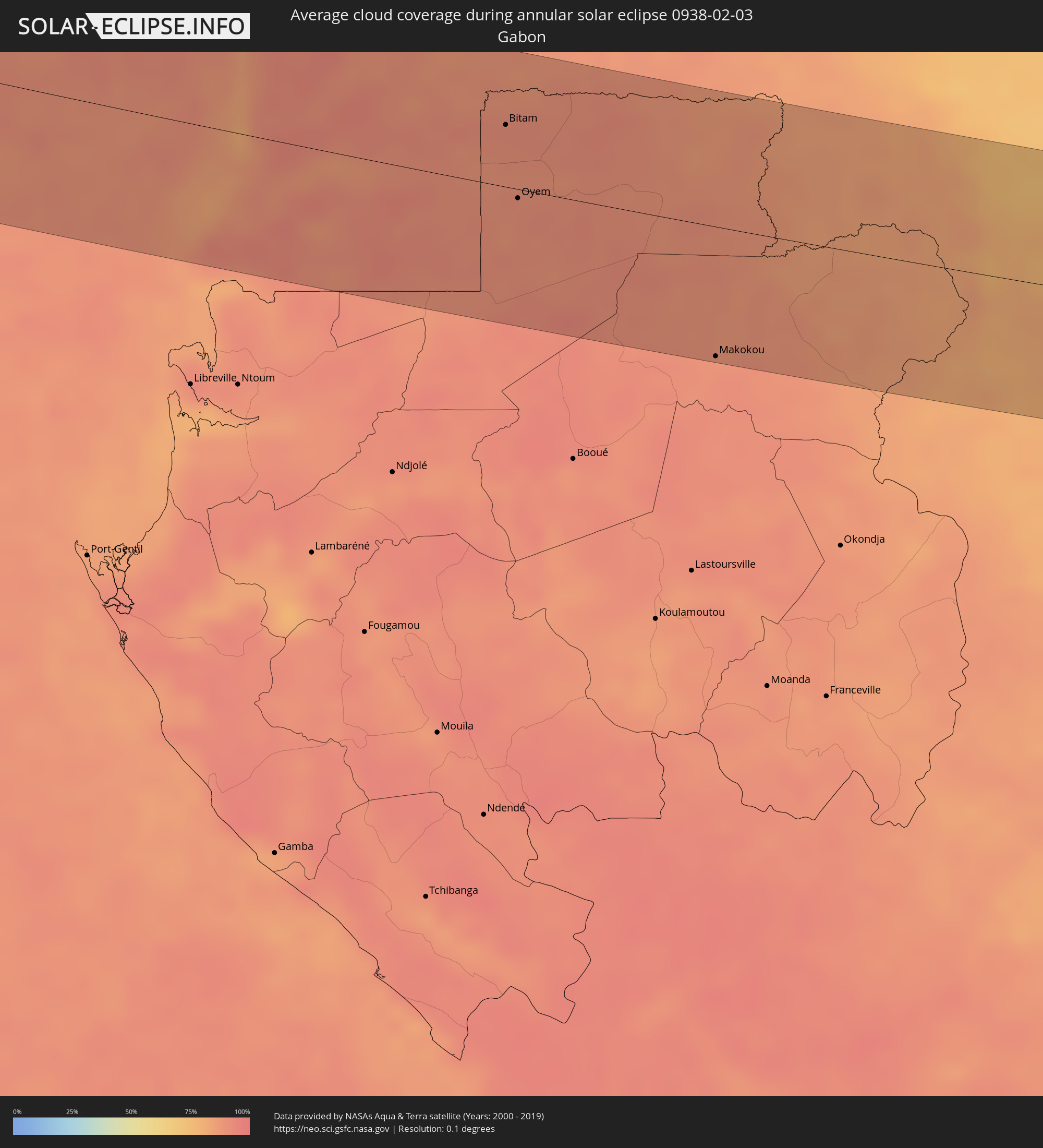 Gabon
Gabon
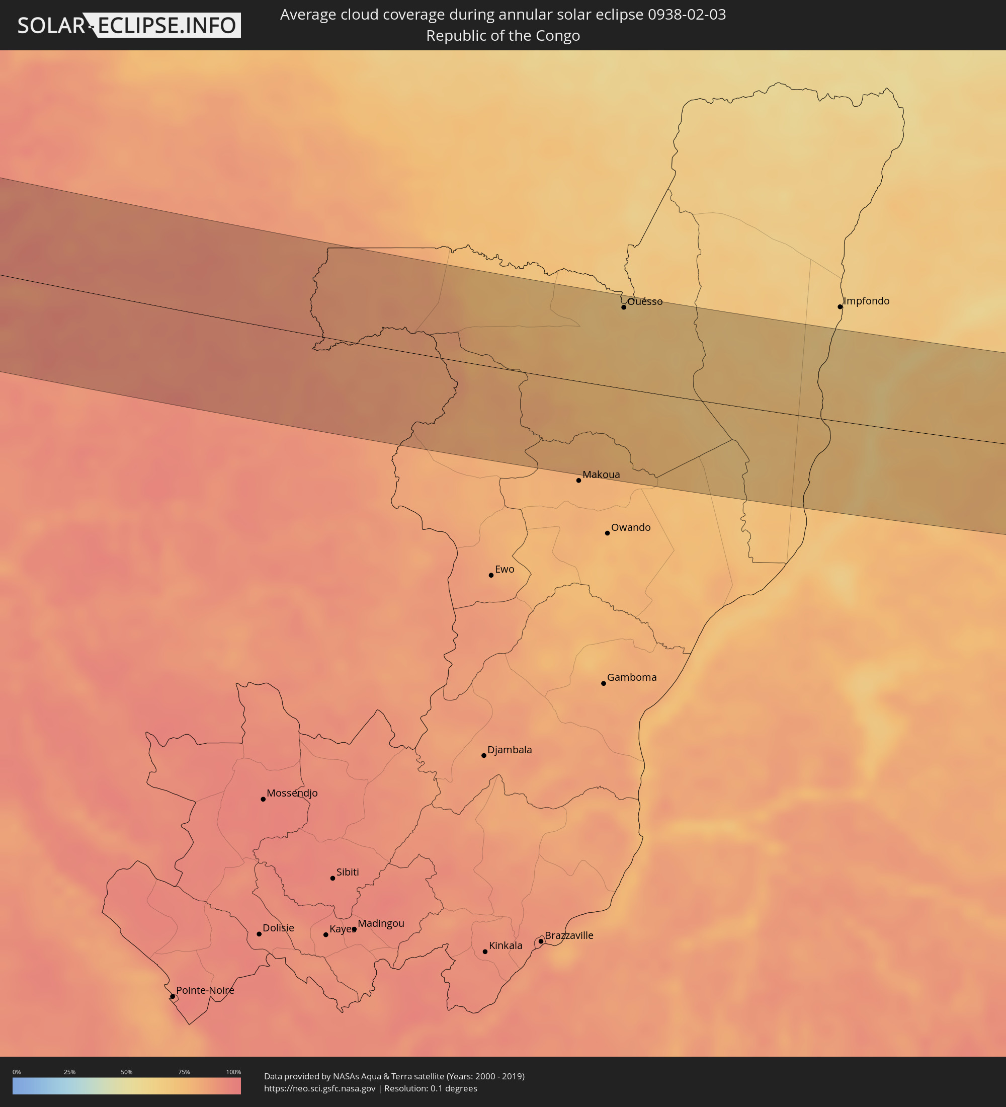 Republic of the Congo
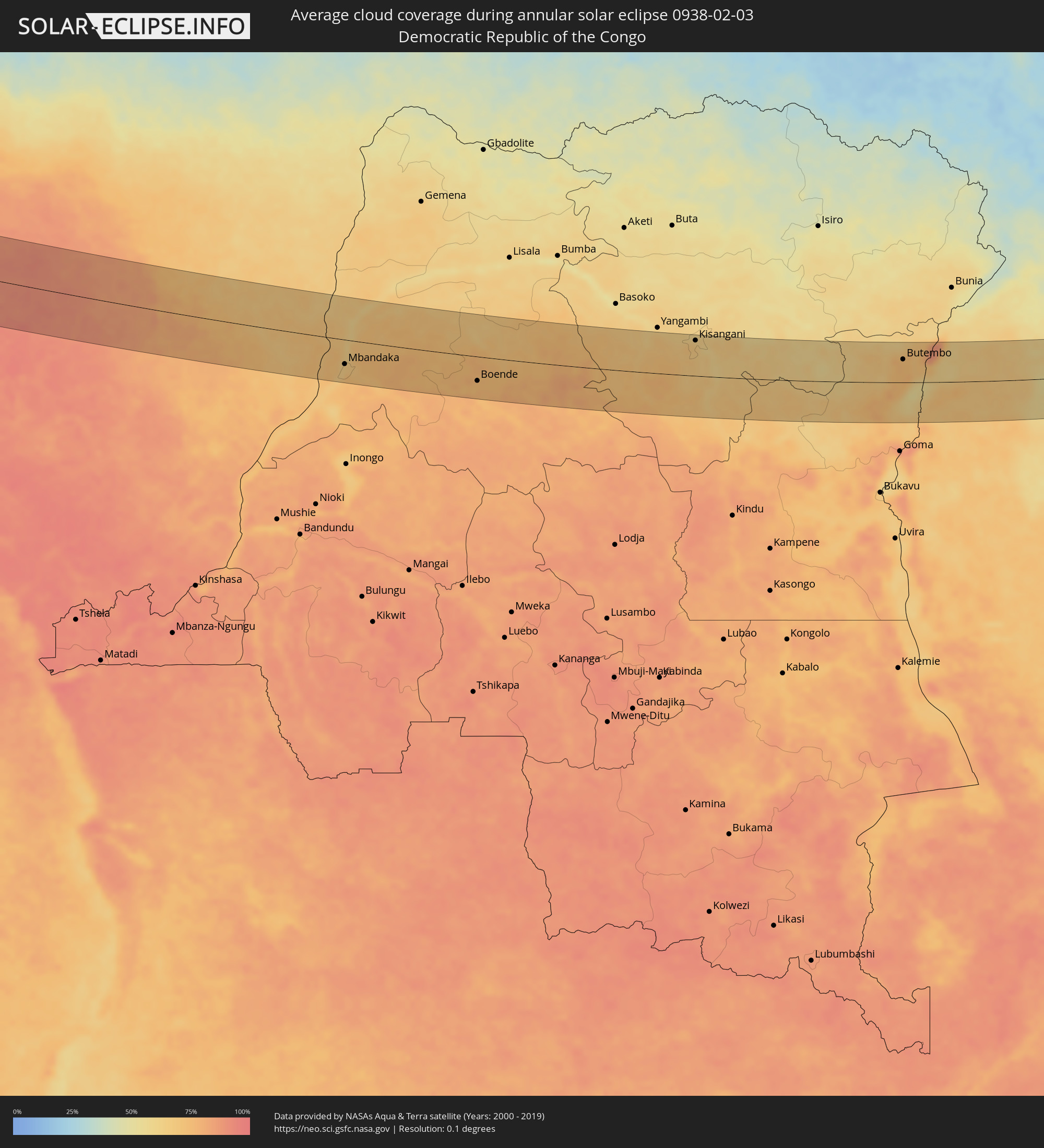 Democratic Republic of the Congo
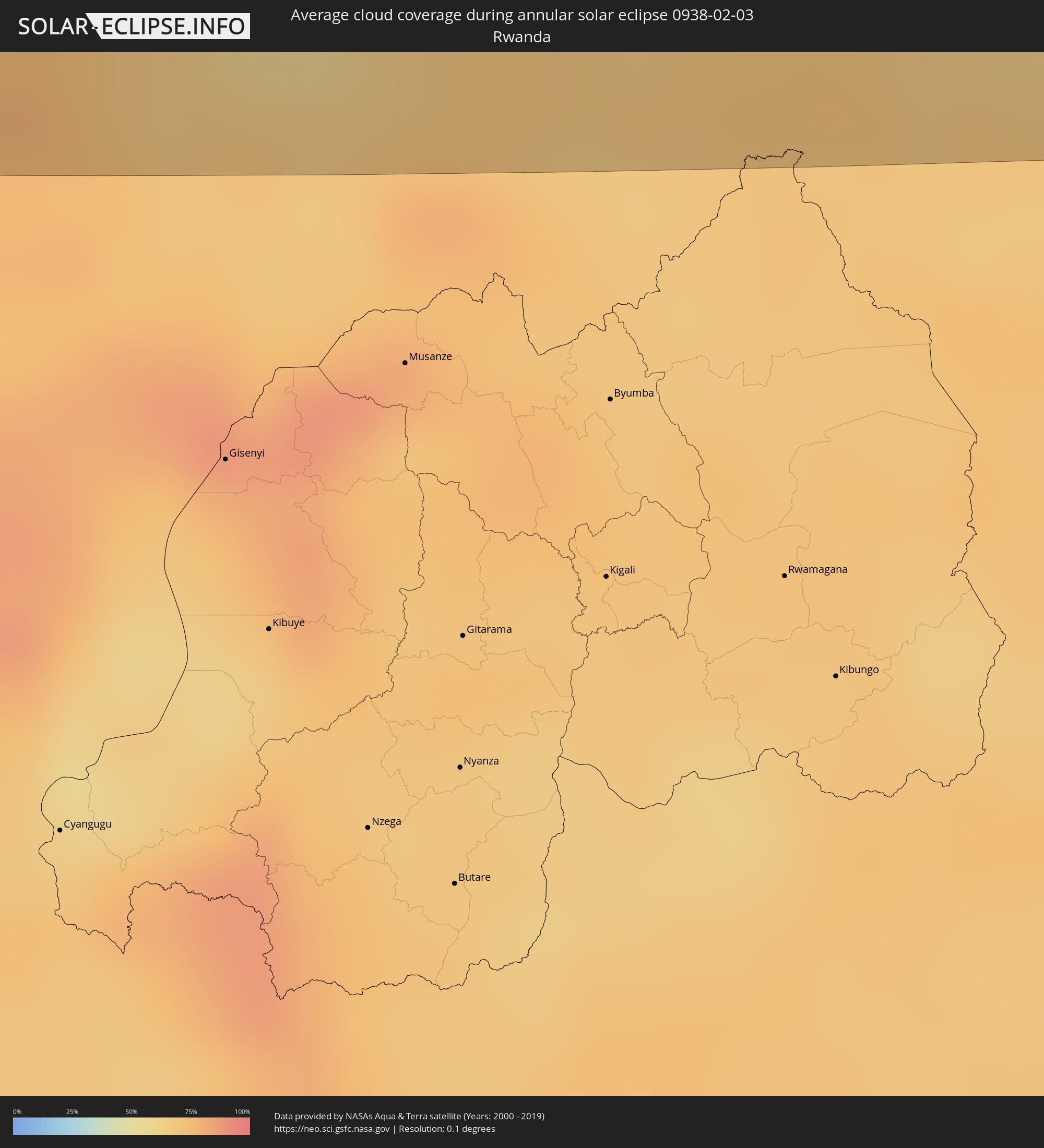 Rwanda
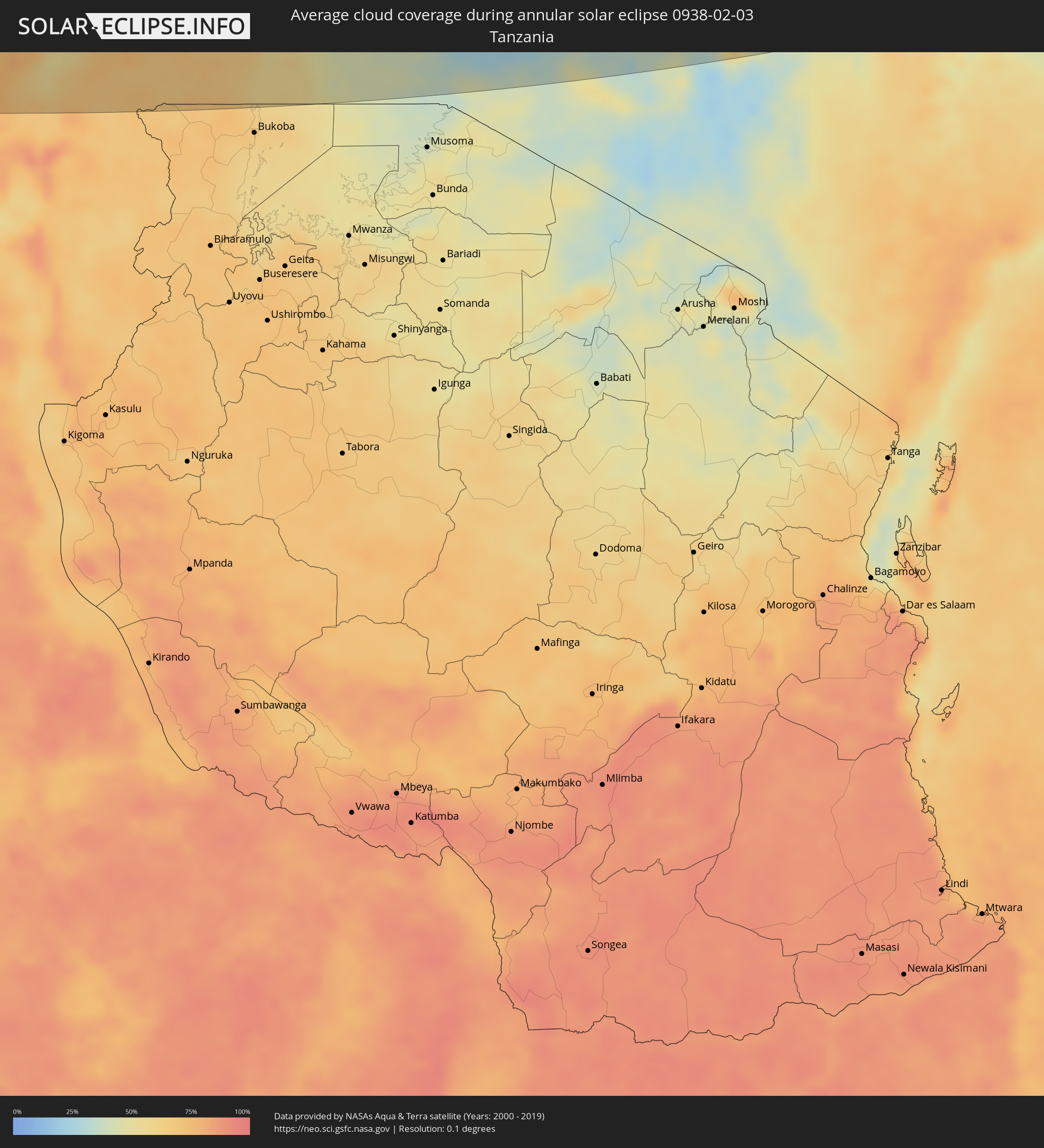 Tanzania
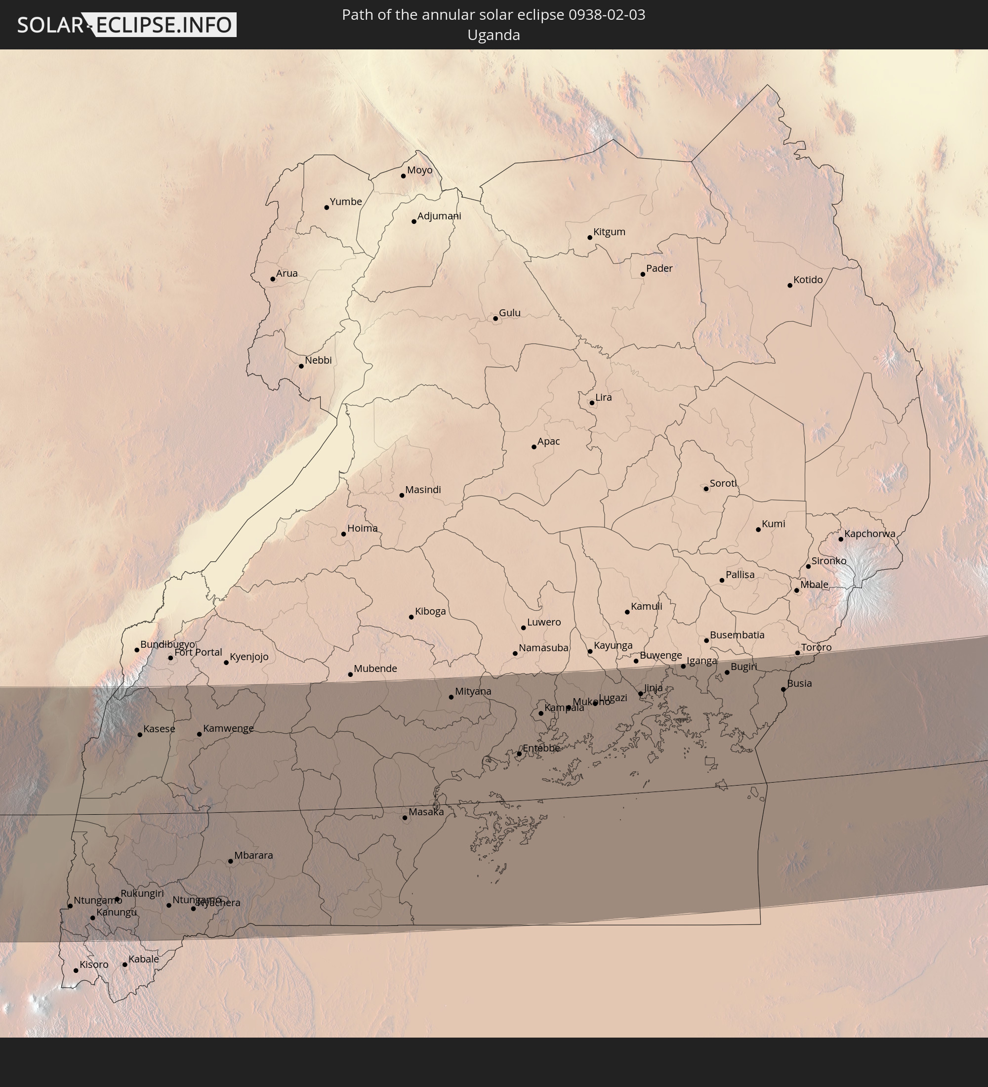
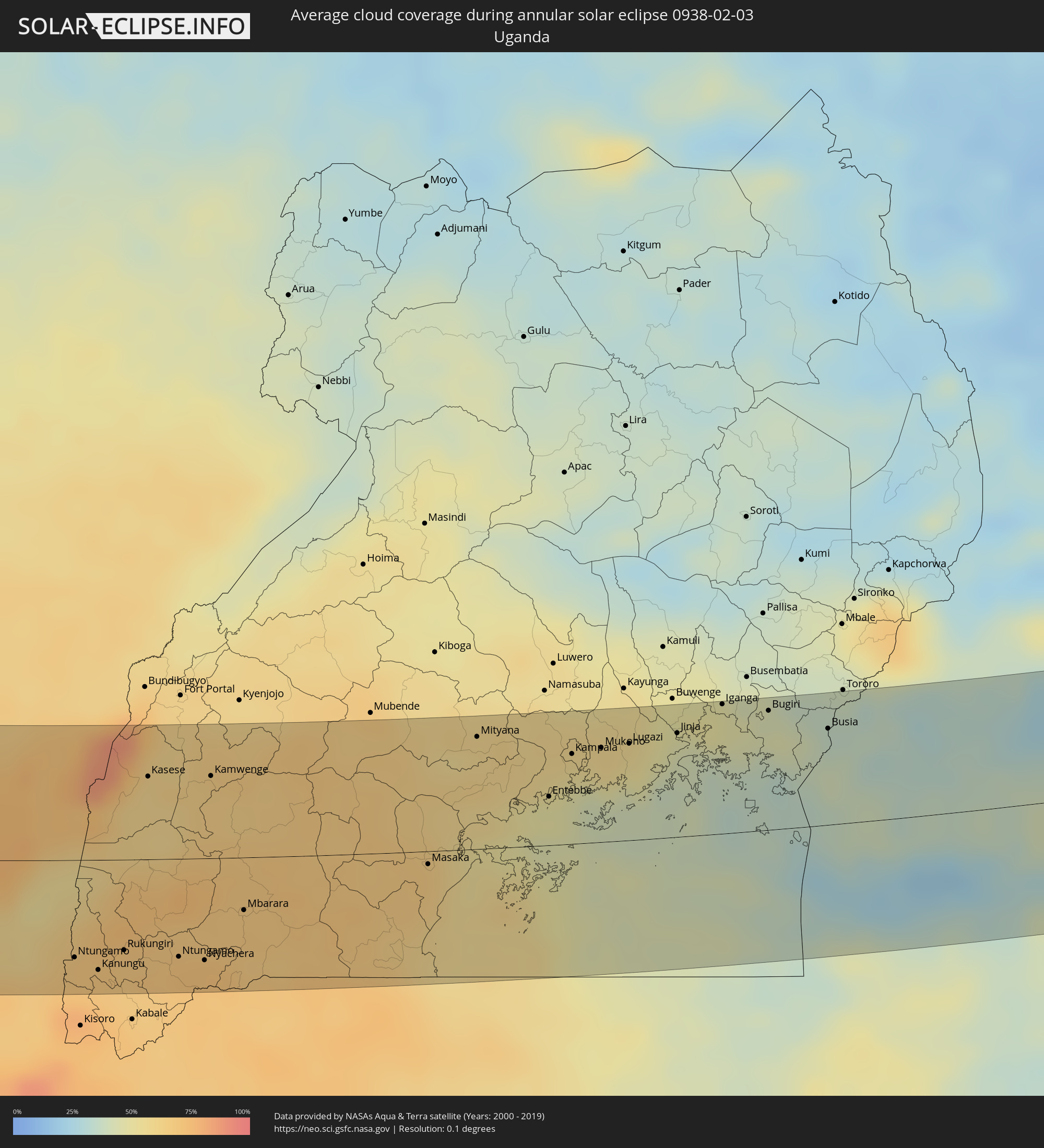 Uganda
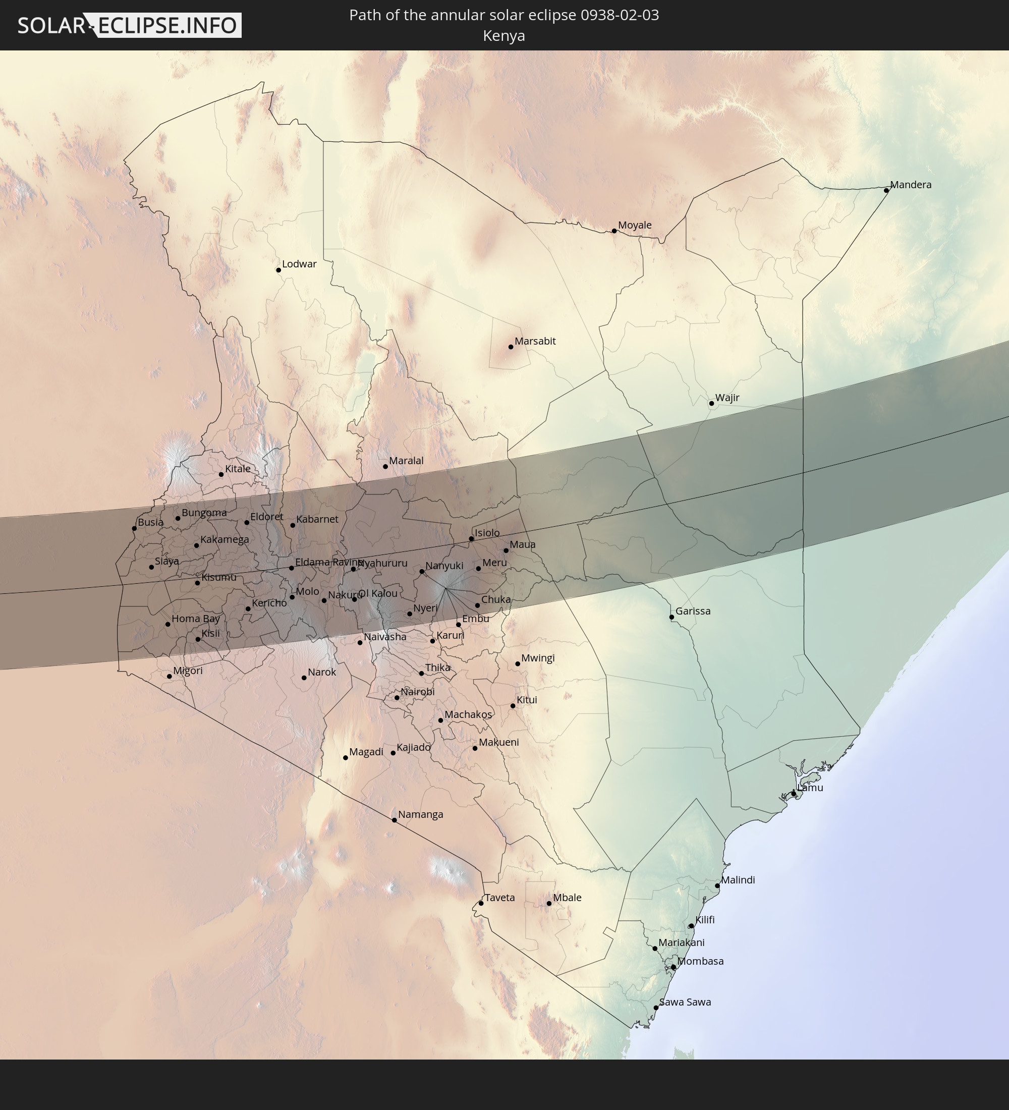
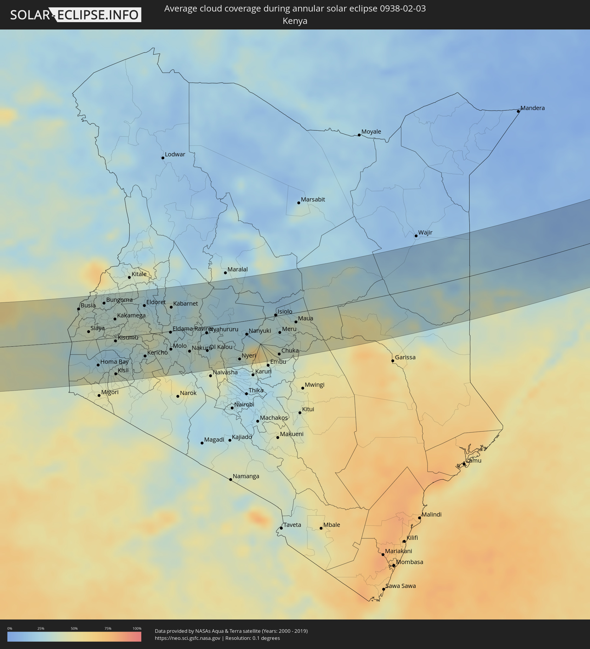 Kenya
Kenya
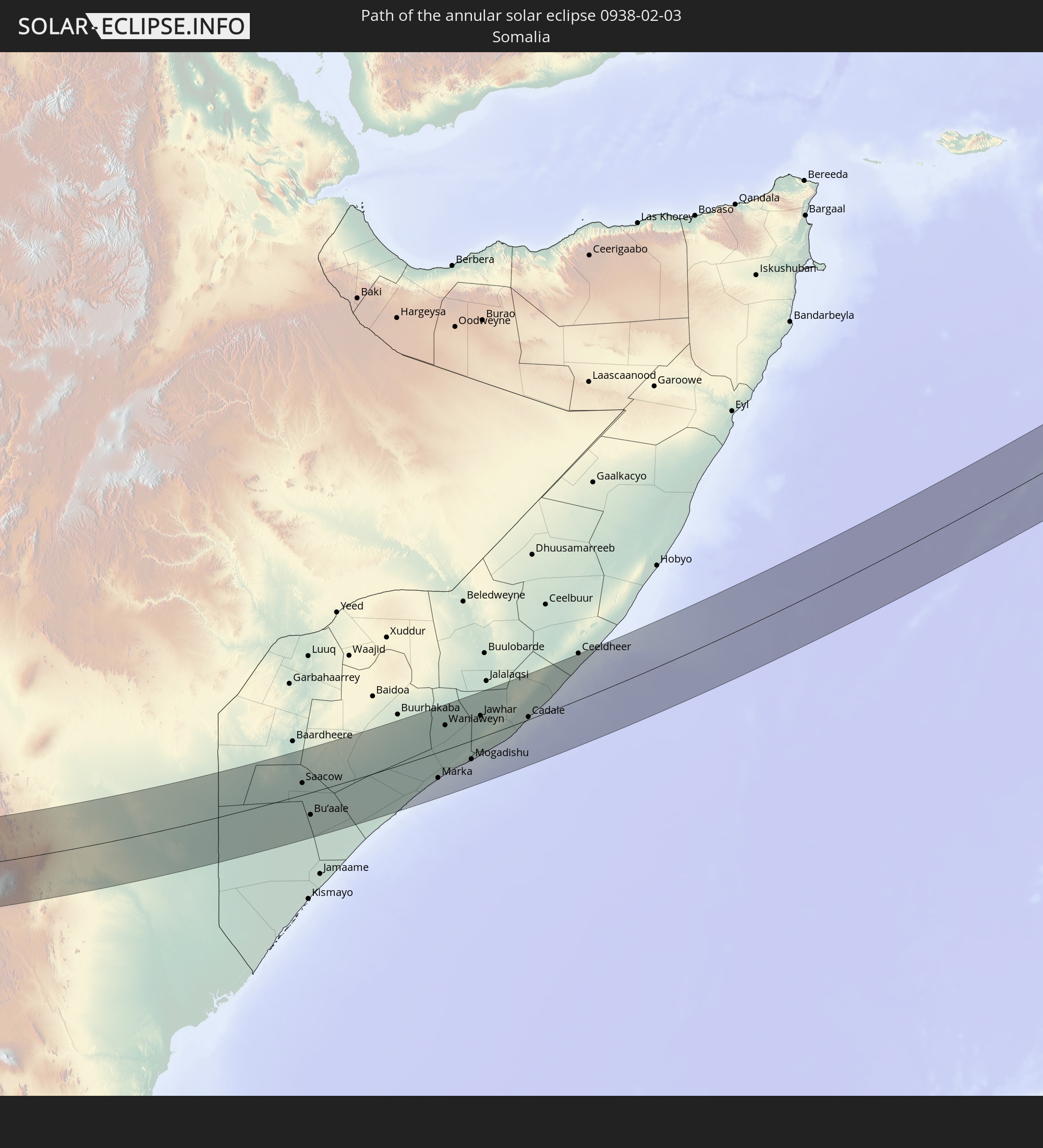
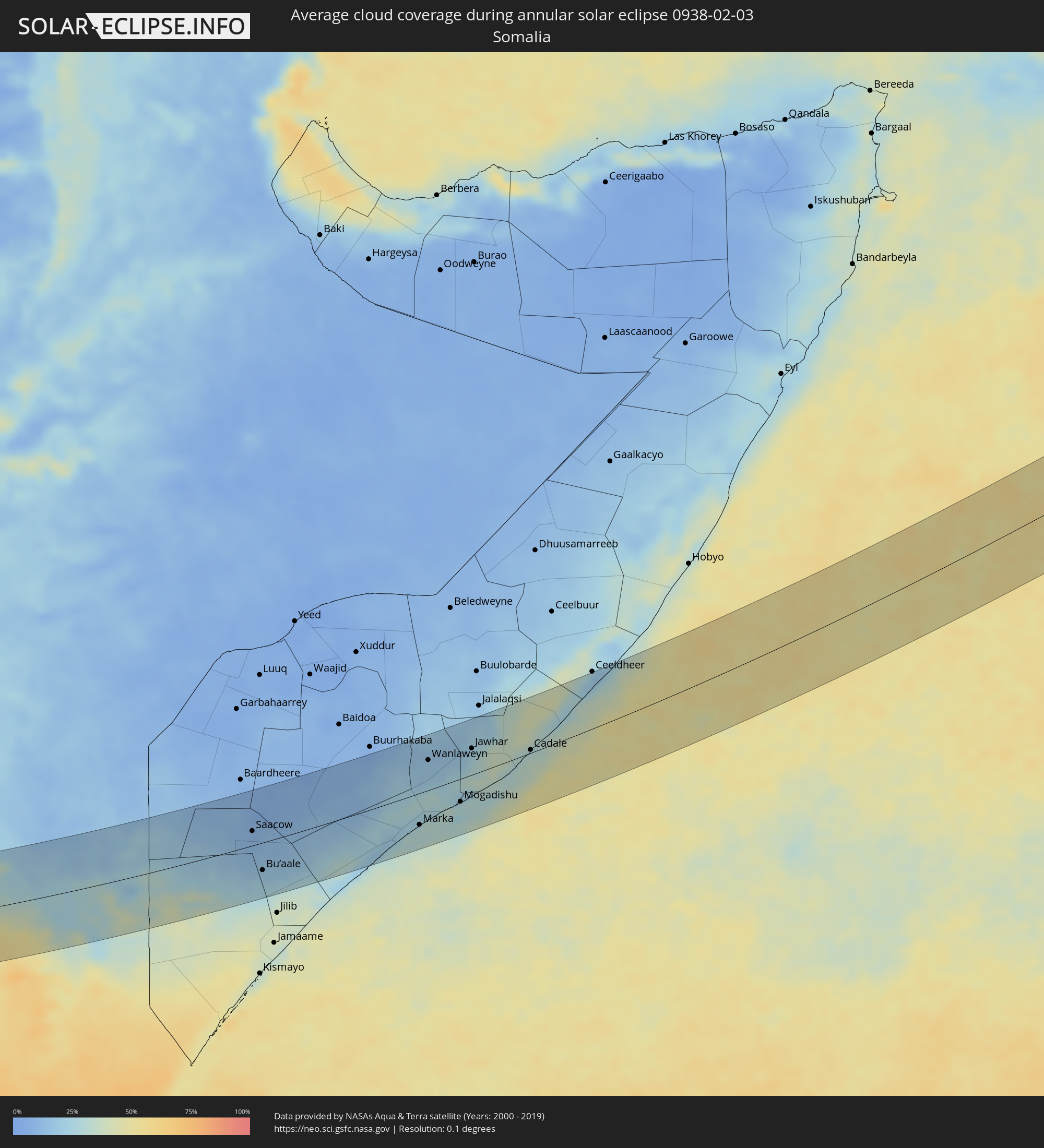 Somalia
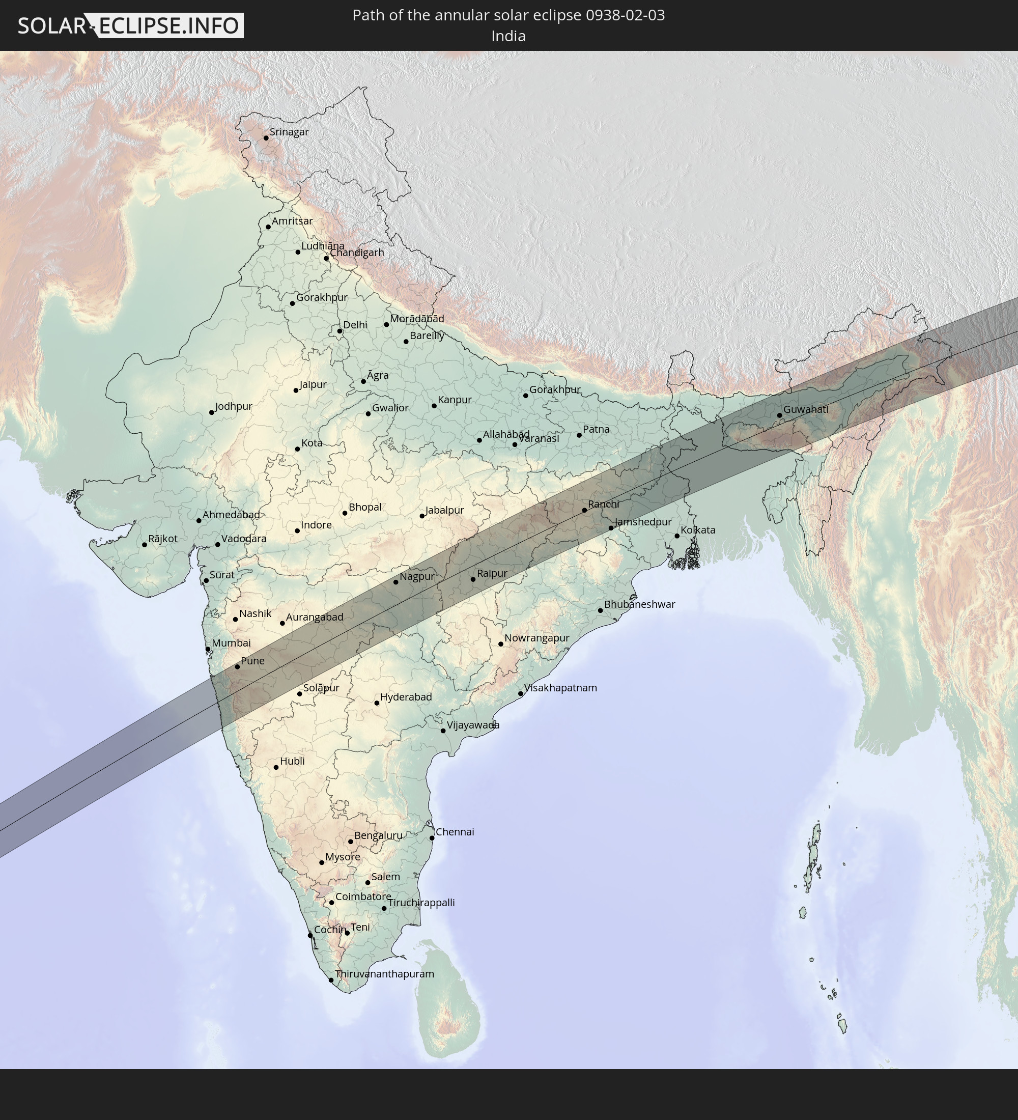
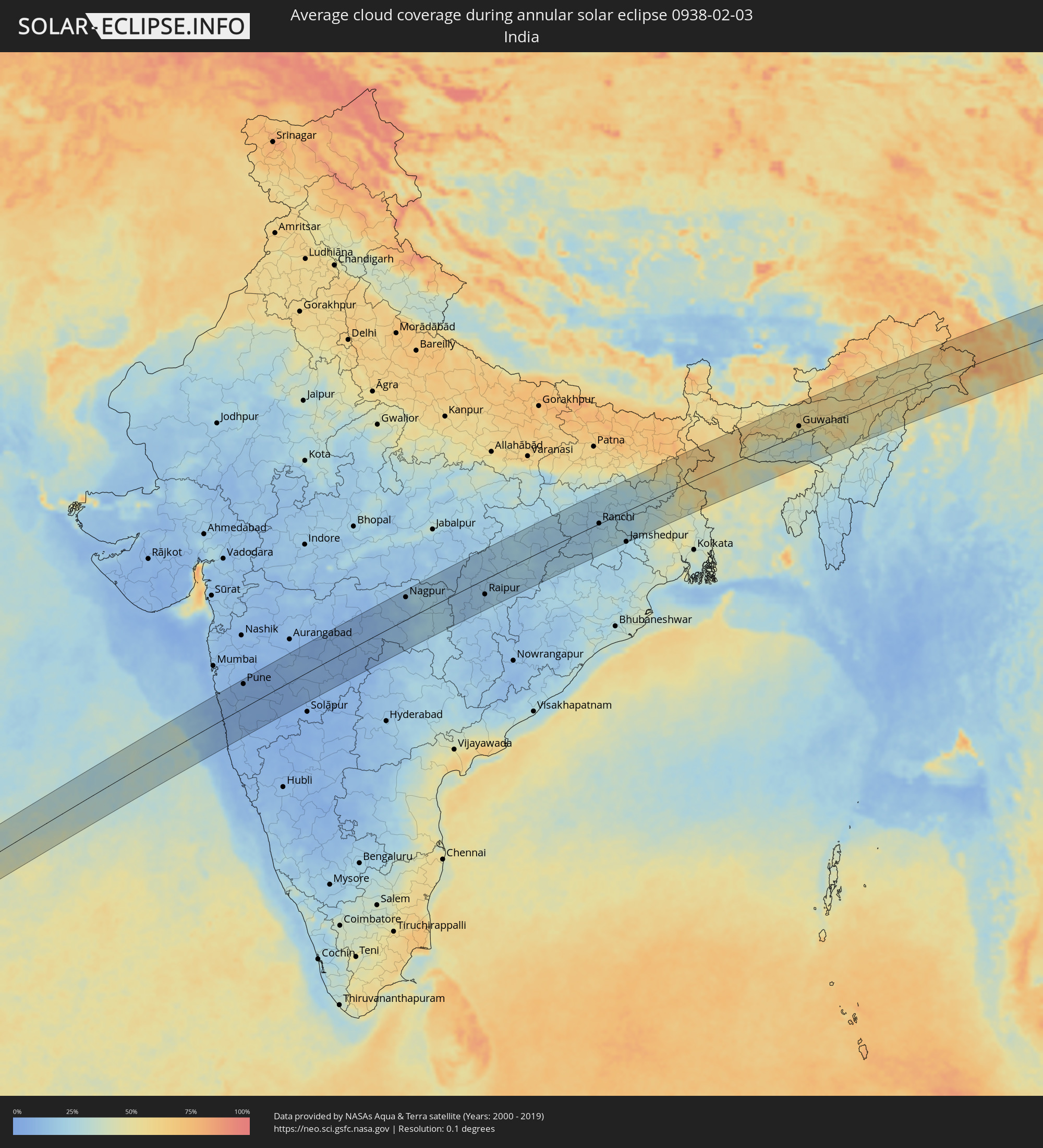 India
India
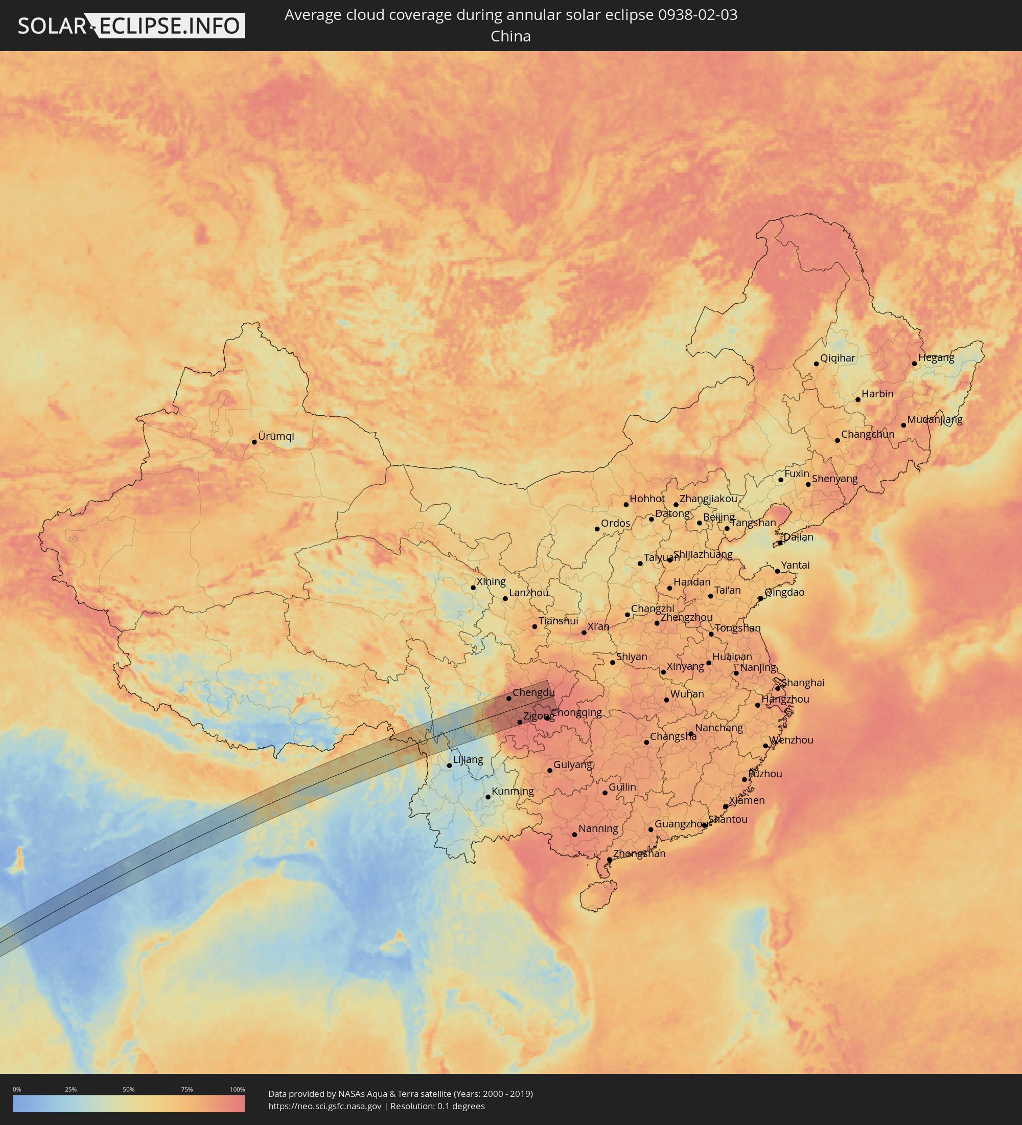 China
China
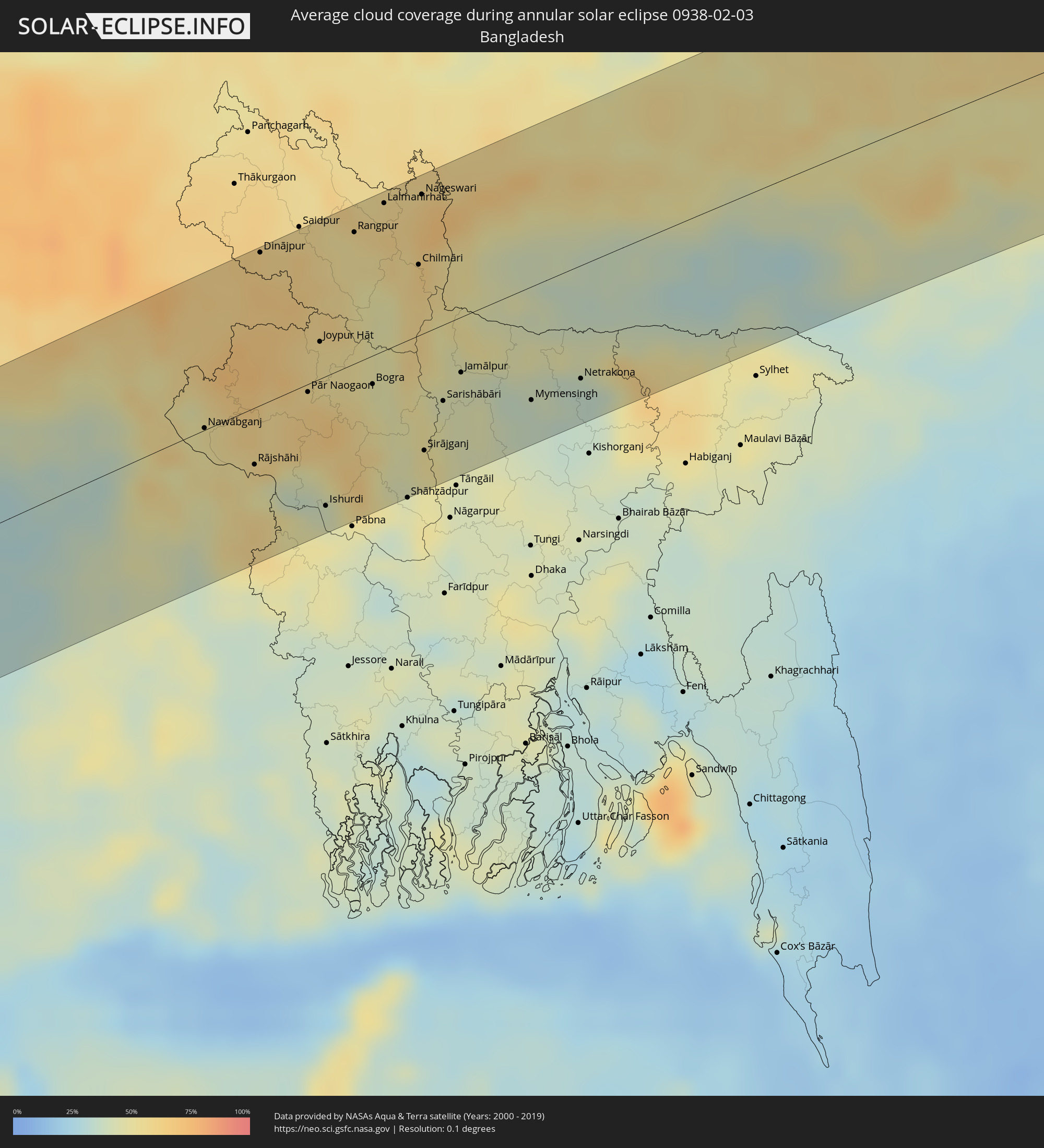 Bangladesh
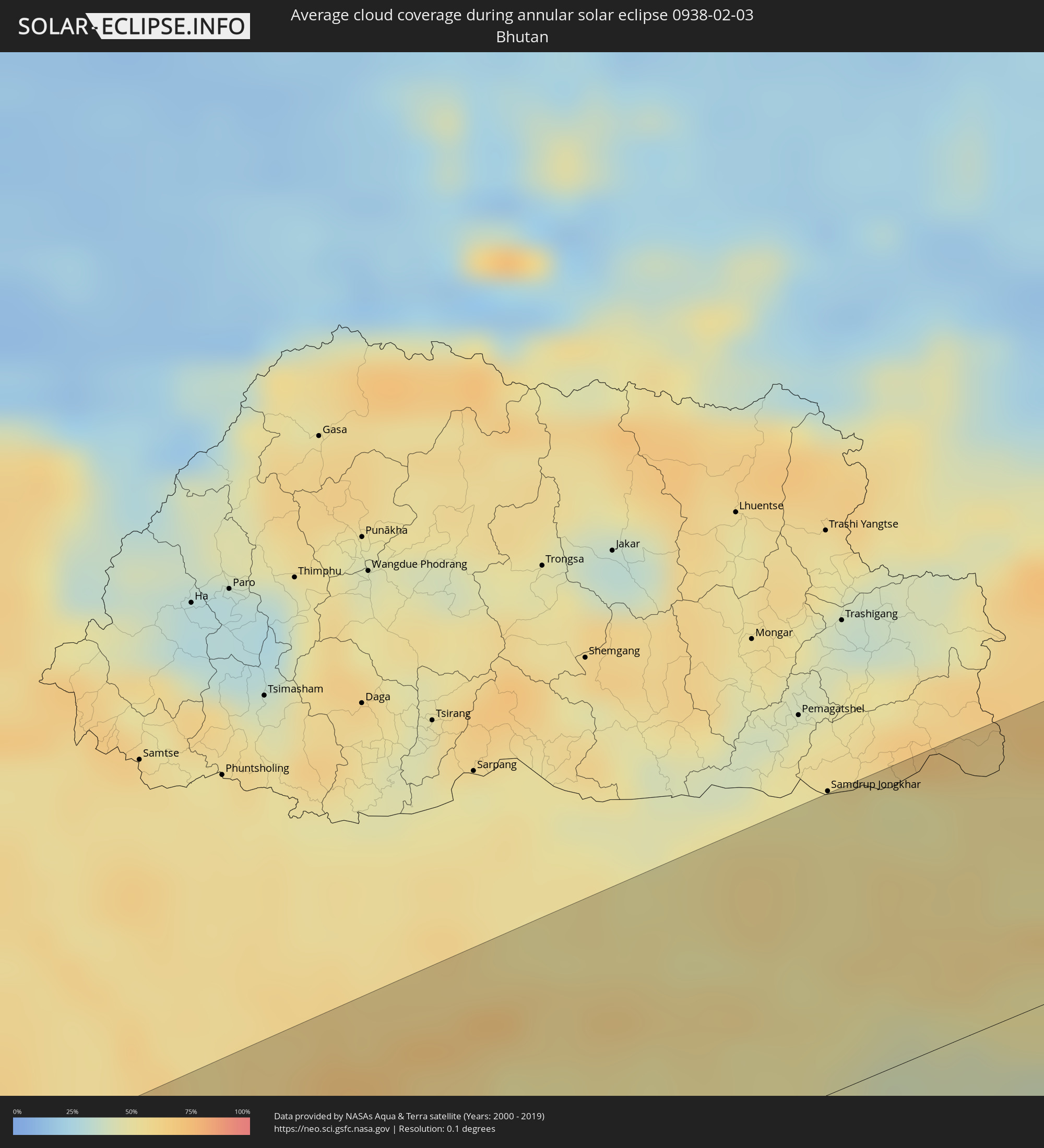 Bhutan
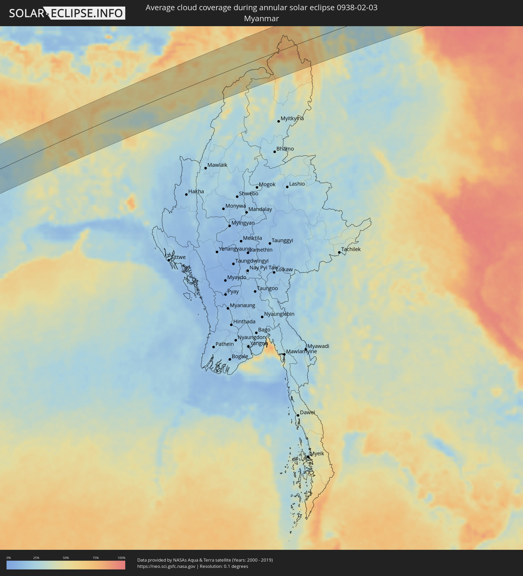 Myanmar
Cities inside the path of the eclipse
The following table shows all locations with a population of more than 5,000 inside the eclipse path. Cities which have more than 100,000 inhabitants are marked bold. A click at the locations opens a detailed map.
| City | Type | Eclipse duration | Local time of max. eclipse | Distance to central line | Ø Cloud coverage |
|
Zwedru, Grand Gedeh
|
annular | - | 06:12:51 UTC-00:43 | 34 km | 78% |
|
Soubré, Bas-Sassandra
|
annular | - | 06:39:57 UTC-00:16 | 20 km | 77% |
|
Issia, Sassandra-Marahoué
|
annular | - | 06:40:15 UTC-00:16 | 56 km | 72% |
|
Daloa, Sassandra-Marahoué
|
annular | - | 06:40:26 UTC-00:16 | 102 km | 59% |
|
Gagnoa, Gôh-Djiboua
|
annular | - | 06:40:13 UTC-00:16 | 36 km | 73% |
|
Sinfra, Zanzan
|
annular | - | 06:40:26 UTC-00:16 | 90 km | 67% |
|
Oumé, Gôh-Djiboua
|
annular | - | 06:40:26 UTC-00:16 | 78 km | 68% |
|
Divo, Gôh-Djiboua
|
annular | - | 06:40:13 UTC-00:16 | 21 km | 77% |
|
Dabou, Lagunes
|
annular | - | 06:40:15 UTC-00:16 | 6 km | 71% |
|
Agboville, Lagunes
|
annular | - | 06:40:33 UTC-00:16 | 63 km | 79% |
|
Anyama, Abidjan
|
annular | - | 06:40:25 UTC-00:16 | 21 km | 83% |
|
Abidjan, Abidjan
|
annular | - | 06:40:21 UTC-00:16 | 2 km | 82% |
|
Bingerville, Abidjan
|
annular | - | 06:40:24 UTC-00:16 | 11 km | 78% |
|
Adzopé, Lagunes
|
annular | - | 06:40:43 UTC-00:16 | 92 km | 76% |
|
Grand-Bassam, Comoé
|
annular | - | 06:40:23 UTC-00:16 | 1 km | 85% |
|
Axim, Western
|
annular | - | 06:56:00 UTC-00:00 | 4 km | 77% |
|
Prestea, Western
|
annular | - | 06:56:16 UTC-00:00 | 68 km | 84% |
|
Tarkwa, Western
|
annular | - | 06:56:16 UTC-00:00 | 59 km | 83% |
|
Aboso
|
annular | - | 06:56:18 UTC-00:00 | 66 km | 81% |
|
Takoradi, Western
|
annular | - | 06:56:11 UTC-00:00 | 19 km | 82% |
|
Sekondi-Takoradi, Western
|
annular | - | 06:56:13 UTC-00:00 | 26 km | 85% |
|
Shama Junction, Western
|
annular | - | 06:56:17 UTC-00:00 | 36 km | 83% |
|
Elmina, Central
|
annular | - | 06:56:25 UTC-00:00 | 52 km | 79% |
|
Cape Coast, Central
|
annular | - | 06:56:28 UTC-00:00 | 57 km | 84% |
|
Saltpond, Central
|
annular | - | 06:56:35 UTC-00:00 | 73 km | 79% |
|
Mumford, Central
|
annular | - | 06:56:44 UTC-00:00 | 87 km | 76% |
|
Apam, Central
|
annular | - | 06:56:45 UTC-00:00 | 90 km | 83% |
|
Winneba, Central
|
annular | - | 06:56:50 UTC-00:00 | 101 km | 78% |
|
Santo António, Príncipe
|
annular | - | 06:24:36 UTC-00:36 | 96 km | 89% |
|
Bata, Litoral
|
annular | - | 07:17:09 UTC+00:13 | 17 km | 86% |
|
Evinayong, Centro Sur
|
annular | - | 07:17:47 UTC+00:13 | 46 km | 92% |
|
Mikomeseng, Kié-Ntem
|
annular | - | 07:18:06 UTC+00:13 | 31 km | 91% |
|
Añisoc, Wele-Nzas
|
annular | - | 07:18:10 UTC+00:13 | 5 km | 90% |
|
Aconibe, Wele-Nzas
|
annular | - | 07:18:08 UTC+00:13 | 53 km | 92% |
|
Ambam, South
|
annular | - | 07:18:55 UTC+00:13 | 73 km | 89% |
|
Mongomo, Wele-Nzas
|
annular | - | 07:18:39 UTC+00:13 | 9 km | 90% |
|
Ebebiyin, Kié-Ntem
|
annular | - | 07:18:53 UTC+00:13 | 49 km | 90% |
|
Bitam, Woleu-Ntem
|
annular | - | 07:19:02 UTC+00:13 | 44 km | 91% |
|
Oyem, Woleu-Ntem
|
annular | - | 07:18:56 UTC+00:13 | 6 km | 90% |
|
Makokou, Ogooué-Ivindo
|
annular | - | 07:20:01 UTC+00:13 | 92 km | 89% |
|
Ouésso, Sangha
|
annular | - | 07:24:34 UTC+00:13 | 82 km | 69% |
|
Mbandaka, Équateur
|
annular | - | 07:27:13 UTC+00:13 | 53 km | 73% |
|
Boende, Équateur
|
annular | - | 07:31:27 UTC+00:13 | 53 km | 75% |
|
Kisangani, Orientale
|
annular | - | 09:37:06 UTC+02:10 | 78 km | 65% |
|
Butembo, Nord Kivu
|
annular | - | 09:46:31 UTC+02:10 | 50 km | 74% |
|
Kasese, Western Region
|
annular | - | 10:05:31 UTC+02:27 | 54 km | 60% |
|
Nyachera, Western Region
|
annular | - | 10:05:37 UTC+02:27 | 67 km | 69% |
|
Mbarara, Western Region
|
annular | - | 10:06:26 UTC+02:27 | 35 km | 67% |
|
Masaka, Central Region
|
annular | - | 10:09:32 UTC+02:27 | 8 km | 66% |
|
Mityana, Central Region
|
annular | - | 10:10:55 UTC+02:27 | 74 km | 58% |
|
Entebbe, Central Region
|
annular | - | 10:11:49 UTC+02:27 | 32 km | 48% |
|
Wakiso, Central Region
|
annular | - | 10:12:08 UTC+02:27 | 70 km | 58% |
|
Kampala, Central Region
|
annular | - | 10:12:24 UTC+02:27 | 59 km | 53% |
|
Mukono, Central Region
|
annular | - | 10:12:56 UTC+02:27 | 62 km | 58% |
|
Lugazi, Central Region
|
annular | - | 10:13:25 UTC+02:27 | 63 km | 55% |
|
Jinja, Eastern Region
|
annular | - | 10:14:17 UTC+02:27 | 68 km | 43% |
|
Iganga, Eastern Region
|
annular | - | 10:15:12 UTC+02:27 | 85 km | 47% |
|
Bugiri, Eastern Region
|
annular | - | 10:15:58 UTC+02:27 | 78 km | 43% |
|
Busia, Eastern Region
|
annular | - | 10:16:54 UTC+02:27 | 63 km | 35% |
|
Busia, Busia
|
annular | - | 10:16:57 UTC+02:27 | 62 km | 35% |
|
Lugulu, Busia
|
annular | - | 10:17:28 UTC+02:27 | 53 km | 34% |
|
Homa Bay, Homa Bay
|
annular | - | 10:17:07 UTC+02:27 | 51 km | 32% |
|
Mumias, Kakamega
|
annular | - | 10:17:57 UTC+02:27 | 44 km | 34% |
|
Bungoma, Bungoma
|
annular | - | 10:18:23 UTC+02:27 | 69 km | 30% |
|
Kakamega, Kakamega
|
annular | - | 10:18:42 UTC+02:27 | 36 km | 33% |
|
Kisumu, Kisumu
|
annular | - | 10:18:24 UTC+02:27 | 7 km | 25% |
|
Eldoret, Uasin Gishu
|
annular | - | 10:20:29 UTC+02:27 | 56 km | 27% |
|
Kericho, Kericho
|
annular | - | 10:19:43 UTC+02:27 | 43 km | 39% |
|
Nakuru, Nakuru
|
annular | - | 10:22:11 UTC+02:27 | 44 km | 33% |
|
Ol Kalou, Nyandarua
|
annular | - | 10:23:10 UTC+02:27 | 47 km | 35% |
|
Nyeri, Nyeri
|
annular | - | 10:24:47 UTC+02:27 | 73 km | 29% |
|
Nanyuki, Laikipia
|
annular | - | 10:25:36 UTC+02:27 | 27 km | 30% |
|
Meru, Meru
|
annular | - | 10:27:29 UTC+02:27 | 34 km | 32% |
|
Saacow, Middle Juba
|
annular | - | 10:45:17 UTC+02:27 | 22 km | 11% |
|
Bu’aale, Middle Juba
|
annular | - | 10:45:06 UTC+02:27 | 41 km | 18% |
|
Qoryooley, Lower Shabeelle
|
annular | - | 10:52:47 UTC+02:27 | 30 km | 24% |
|
Marka, Lower Shabeelle
|
annular | - | 10:53:32 UTC+02:27 | 46 km | 31% |
|
Wanlaweyn, Lower Shabeelle
|
annular | - | 10:55:10 UTC+02:27 | 44 km | 18% |
|
Afgooye, Lower Shabeelle
|
annular | - | 10:55:20 UTC+02:27 | 15 km | 28% |
|
Mogadishu, Banaadir
|
annular | - | 10:55:58 UTC+02:27 | 33 km | 30% |
|
Jawhar, Middle Shabele
|
annular | - | 10:57:32 UTC+02:27 | 39 km | 22% |
|
Mahaddayweyne, Middle Shabele
|
annular | - | 10:57:55 UTC+02:27 | 57 km | 21% |
|
Cadale, Middle Shabele
|
annular | - | 11:00:25 UTC+02:27 | 4 km | 28% |
|
Pune, Maharashtra
|
annular | - | 15:27:16 UTC+05:21 | 70 km | 7% |
|
Ahmadnagar, Maharashtra
|
annular | - | 15:28:59 UTC+05:21 | 81 km | 6% |
|
Latur, Maharashtra
|
annular | - | 15:31:27 UTC+05:21 | 80 km | 9% |
|
Nanded, Maharashtra
|
annular | - | 15:32:53 UTC+05:21 | 42 km | 8% |
|
Nagpur, Maharashtra
|
annular | - | 15:36:00 UTC+05:21 | 67 km | 15% |
|
Bhilai, Chhattisgarh
|
annular | - | 15:38:54 UTC+05:21 | 38 km | 17% |
|
Raipur, Chhattisgarh
|
annular | - | 15:39:09 UTC+05:21 | 45 km | 16% |
|
Korba, Chhattisgarh
|
annular | - | 15:40:34 UTC+05:21 | 17 km | 21% |
|
Ranchi, Jharkhand
|
annular | - | 15:43:22 UTC+05:21 | 1 km | 21% |
|
Bokāro, Jharkhand
|
annular | - | 15:44:00 UTC+05:21 | 18 km | 22% |
|
Jamshedpur, Jharkhand
|
annular | - | 15:44:09 UTC+05:21 | 92 km | 24% |
|
Āsansol, West Bengal
|
annular | - | 15:44:55 UTC+05:21 | 37 km | 30% |
|
Durgapur, West Bengal
|
annular | - | 15:45:12 UTC+05:21 | 67 km | 35% |
|
Nawābganj, Rājshāhi
|
annular | - | 16:18:11 UTC+05:53 | 1 km | 51% |
|
Rājshāhi, Rājshāhi
|
annular | - | 16:18:27 UTC+05:53 | 34 km | 52% |
|
Dinājpur, Rangpur Division
|
annular | - | 16:18:26 UTC+05:53 | 92 km | 66% |
|
Pār Naogaon, Rājshāhi
|
annular | - | 16:18:43 UTC+05:53 | 5 km | 61% |
|
Joypur Hāt, Rājshāhi
|
annular | - | 16:18:46 UTC+05:53 | 22 km | 56% |
|
Ishurdi, Rājshāhi
|
annular | - | 16:18:49 UTC+05:53 | 78 km | 45% |
|
Rangpur, Rangpur Division
|
annular | - | 16:18:53 UTC+05:53 | 79 km | 54% |
|
Bogra, Rājshāhi
|
annular | - | 16:19:02 UTC+05:53 | 17 km | 47% |
|
Lalmanirhat, Rangpur Division
|
annular | - | 16:19:01 UTC+05:53 | 88 km | 59% |
|
Sirājganj, Rājshāhi
|
annular | - | 16:19:18 UTC+05:53 | 71 km | 51% |
|
Sarishābāri, Dhaka
|
annular | - | 16:19:23 UTC+05:53 | 46 km | 44% |
|
Jamālpur, Dhaka
|
annular | - | 16:19:28 UTC+05:53 | 33 km | 44% |
|
Mymensingh, Dhaka
|
annular | - | 16:19:48 UTC+05:53 | 69 km | 37% |
|
Netrakona, Dhaka
|
annular | - | 16:20:02 UTC+05:53 | 68 km | 35% |
|
Guwahati, Assam
|
annular | - | 15:48:25 UTC+05:21 | 25 km | 47% |
|
Shangri-La, Yunnan
|
annular | - | 18:30:52 UTC+08:00 | 93 km | 45% |
|
Kangding, Sichuan
|
annular | - | 18:30:51 UTC+08:00 | 67 km | 59% |
|
Leshan, Sichuan
|
annular | - | 18:31:27 UTC+08:00 | 41 km | 92% |
|
Tianpeng, Sichuan
|
annular | - | 18:30:57 UTC+08:00 | 103 km | 90% |
|
Luocheng, Sichuan
|
annular | - | 18:31:34 UTC+08:00 | 68 km | 92% |
|
Chengdu, Sichuan
|
annular | - | 18:31:06 UTC+08:00 | 66 km | 92% |
|
Yanjiang, Sichuan
|
annular | - | 18:31:26 UTC+08:00 | 10 km | 91% |
|
Zigong, Sichuan
|
annular | - | 18:31:44 UTC+08:00 | 96 km | 94% |
|
Neijiang, Sichuan
|
annular | - | 18:31:42 UTC+08:00 | 79 km | 95% |
|
Suining, Sichuan
|
annular | - | 18:31:26 UTC+08:00 | 4 km | 93% |
|
Nanlong, Sichuan
|
annular | - | 18:31:09 UTC+08:00 | 79 km | 91% |
|
Nanchong, Sichuan
|
annular | - | 18:31:24 UTC+08:00 | 19 km | 93% |
|
Hechuan, Chongqing
|
annular | - | 18:31:44 UTC+08:00 | 72 km | 94% |
|
Beibei, Chongqing
|
annular | - | 18:31:49 UTC+08:00 | 94 km | 95% |