Total solar eclipse of 07/19/0939
| Day of week: | Sunday |
| Maximum duration of eclipse: | 05m42s |
| Maximum width of eclipse path: | 267 km |
| Saros cycle: | 109 |
| Coverage: | 100% |
| Magnitude: | 1.0748 |
| Gamma: | 0.4172 |
Wo kann man die Sonnenfinsternis vom 07/19/0939 sehen?
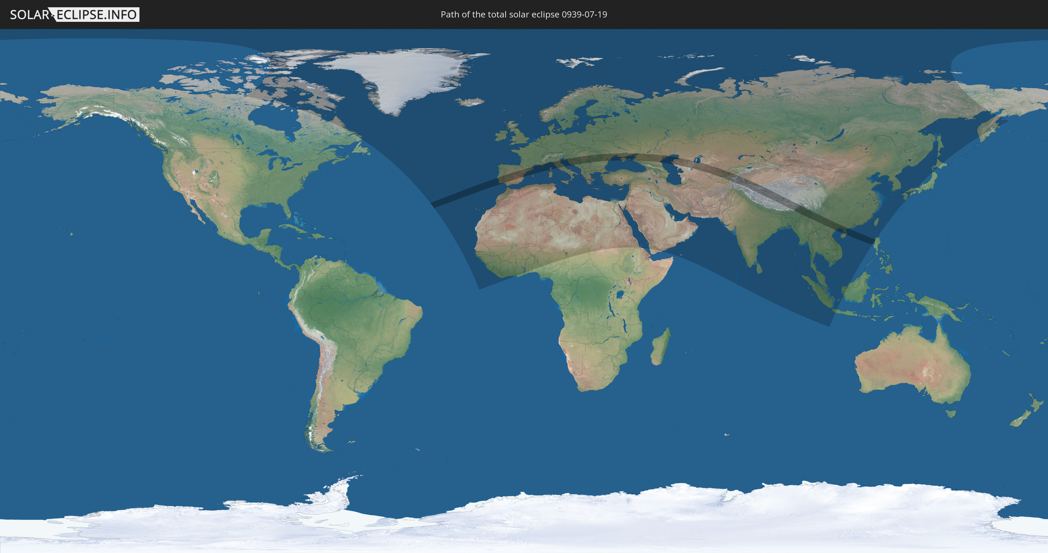
Die Sonnenfinsternis am 07/19/0939 kann man in 128 Ländern als partielle Sonnenfinsternis beobachten.
Der Finsternispfad verläuft durch 27 Länder. Nur in diesen Ländern ist sie als total Sonnenfinsternis zu sehen.
In den folgenden Ländern ist die Sonnenfinsternis total zu sehen
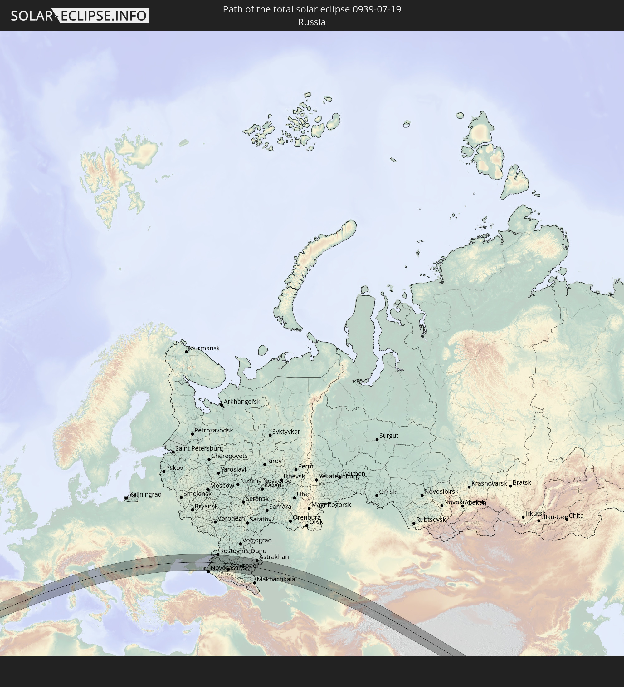 Russia
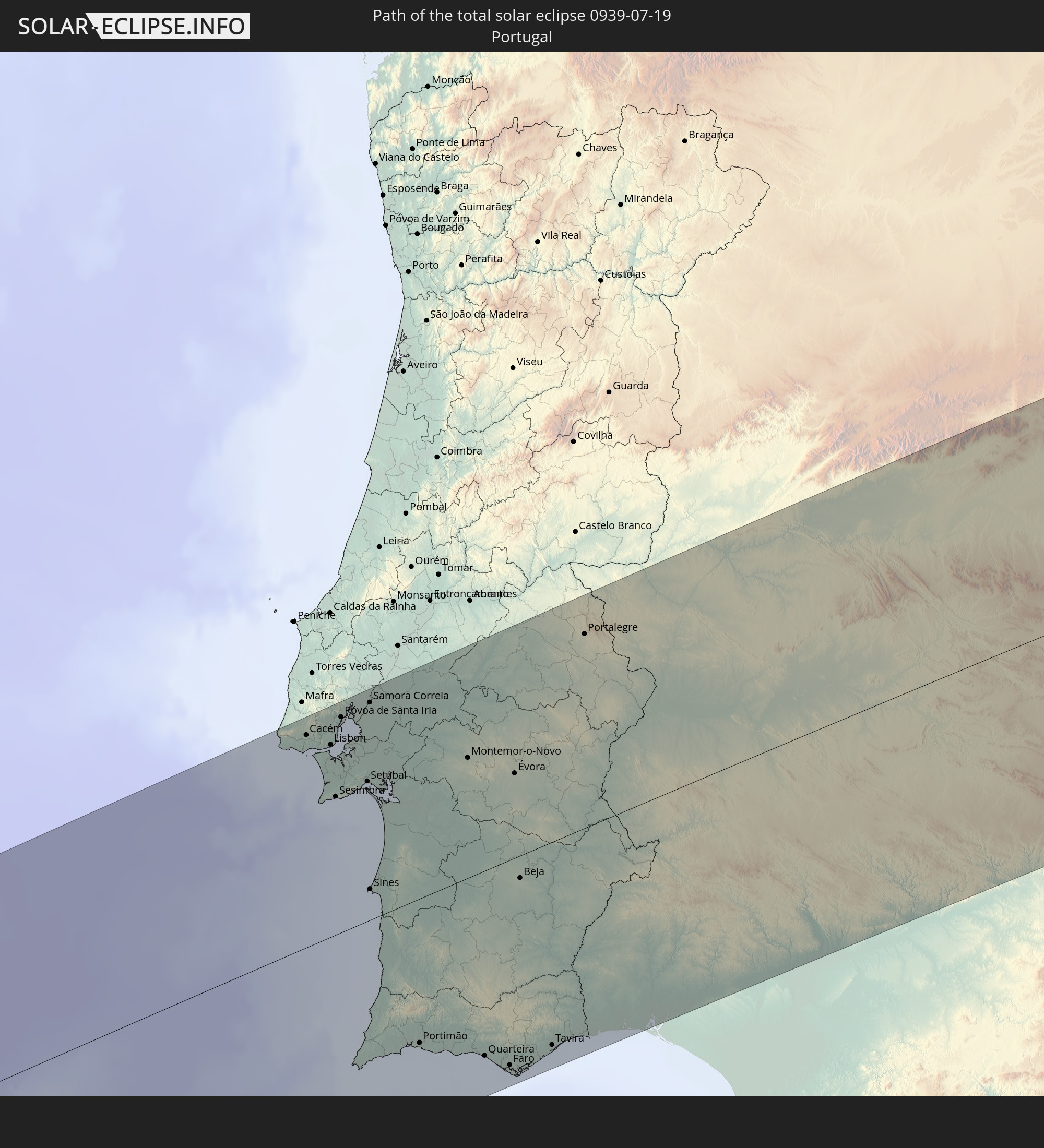 Portugal
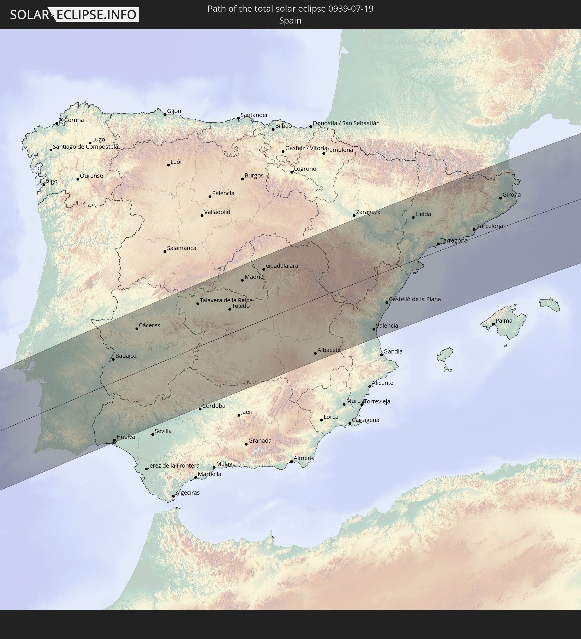 Spain
Spain
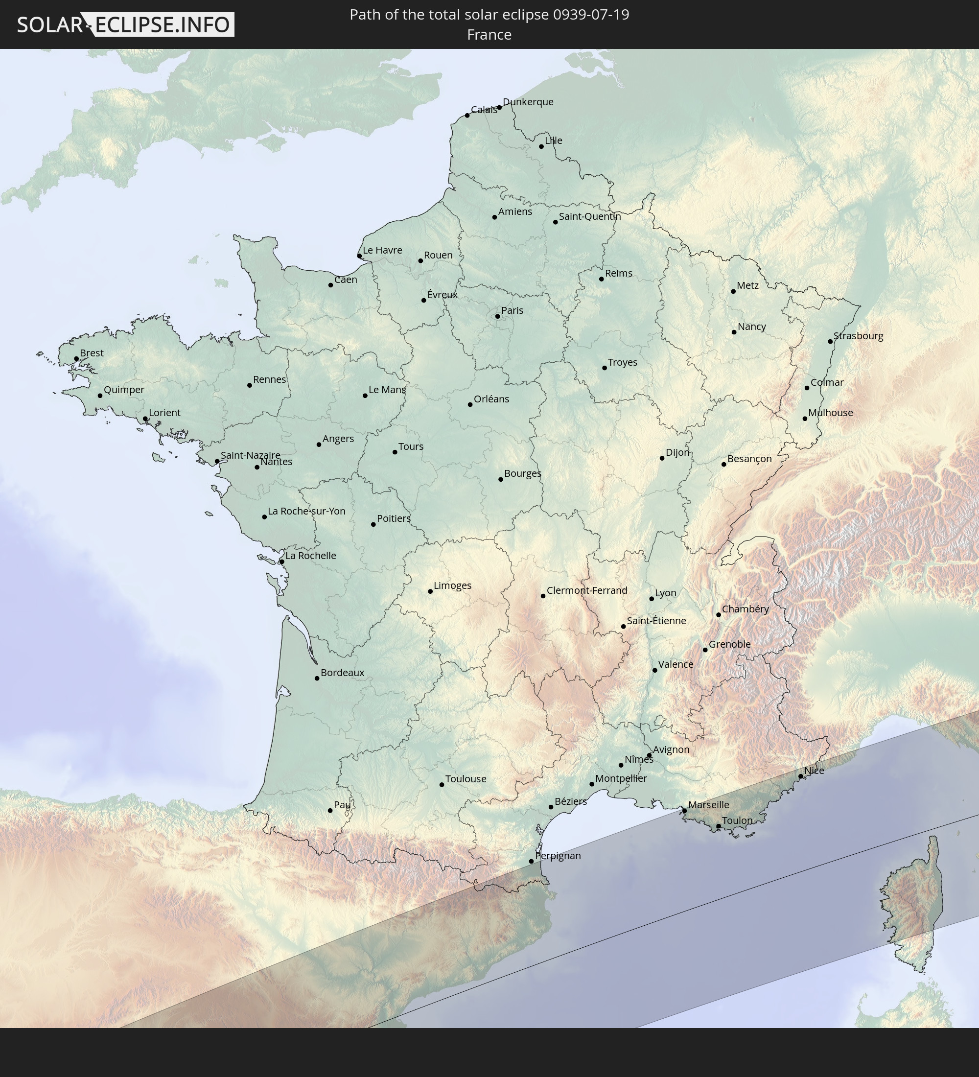 France
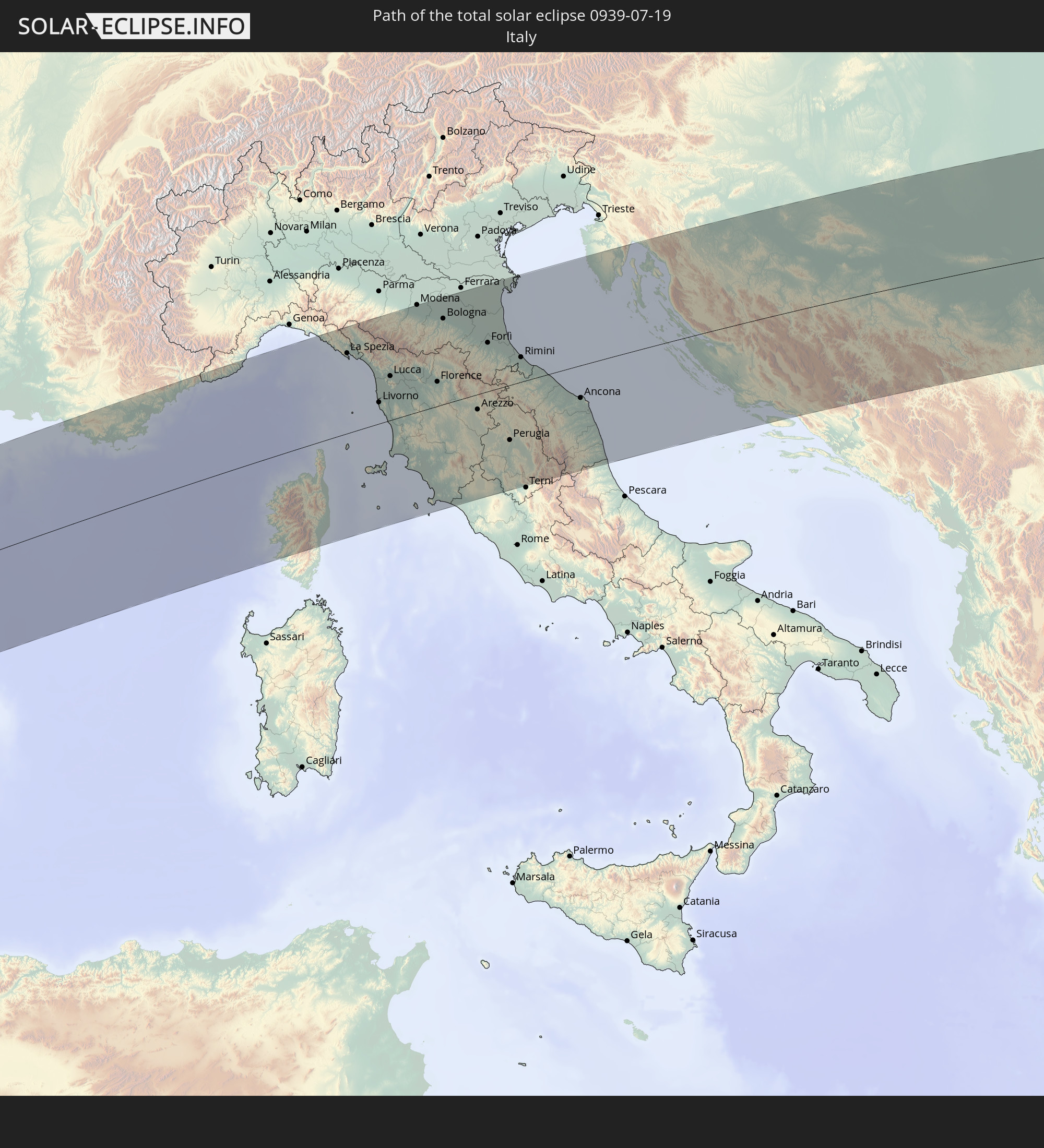 Italy
Italy
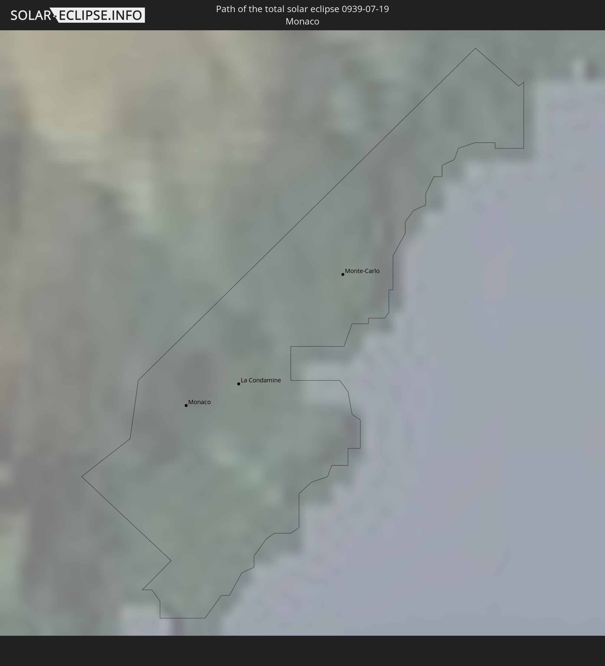 Monaco
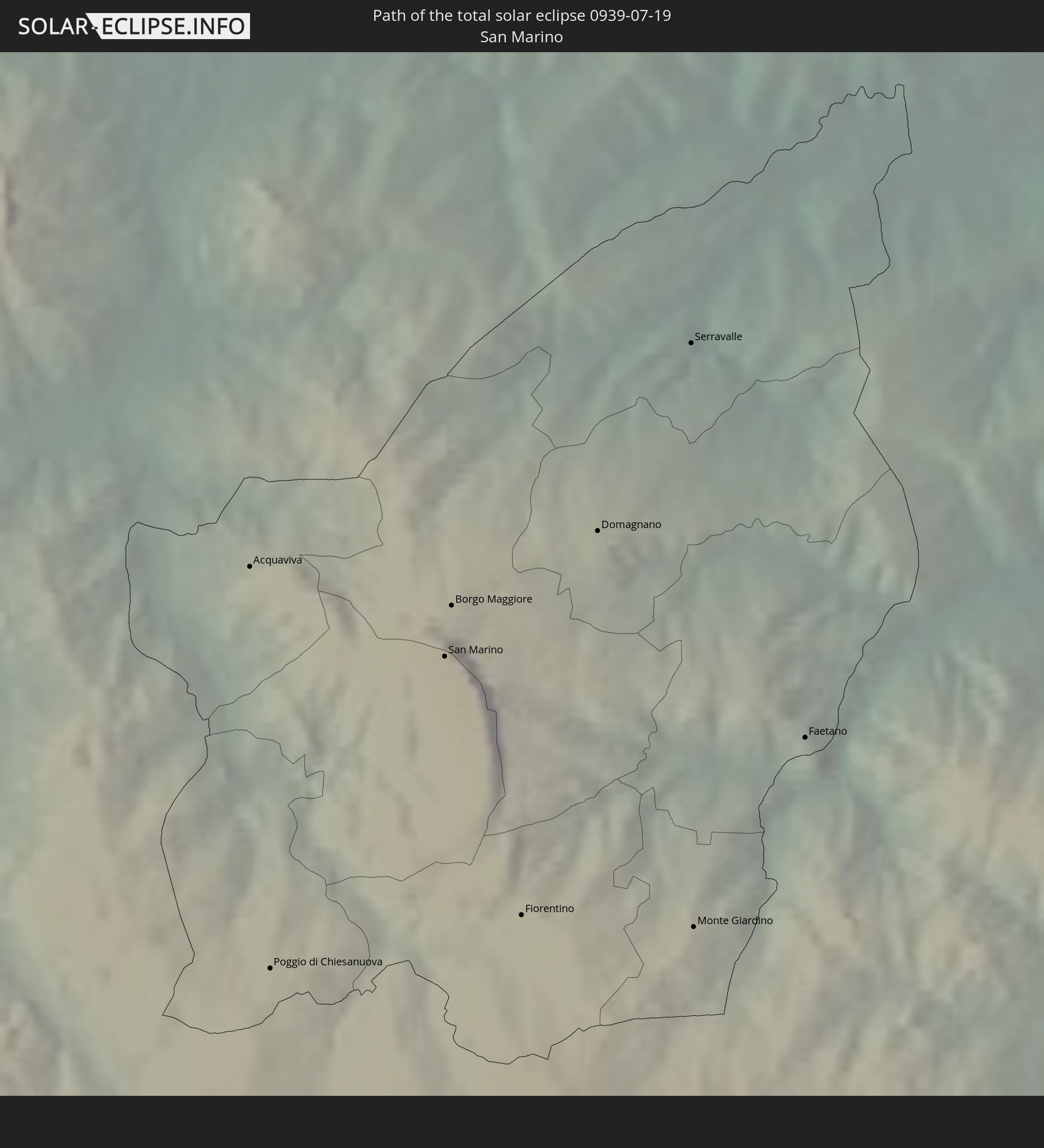 San Marino
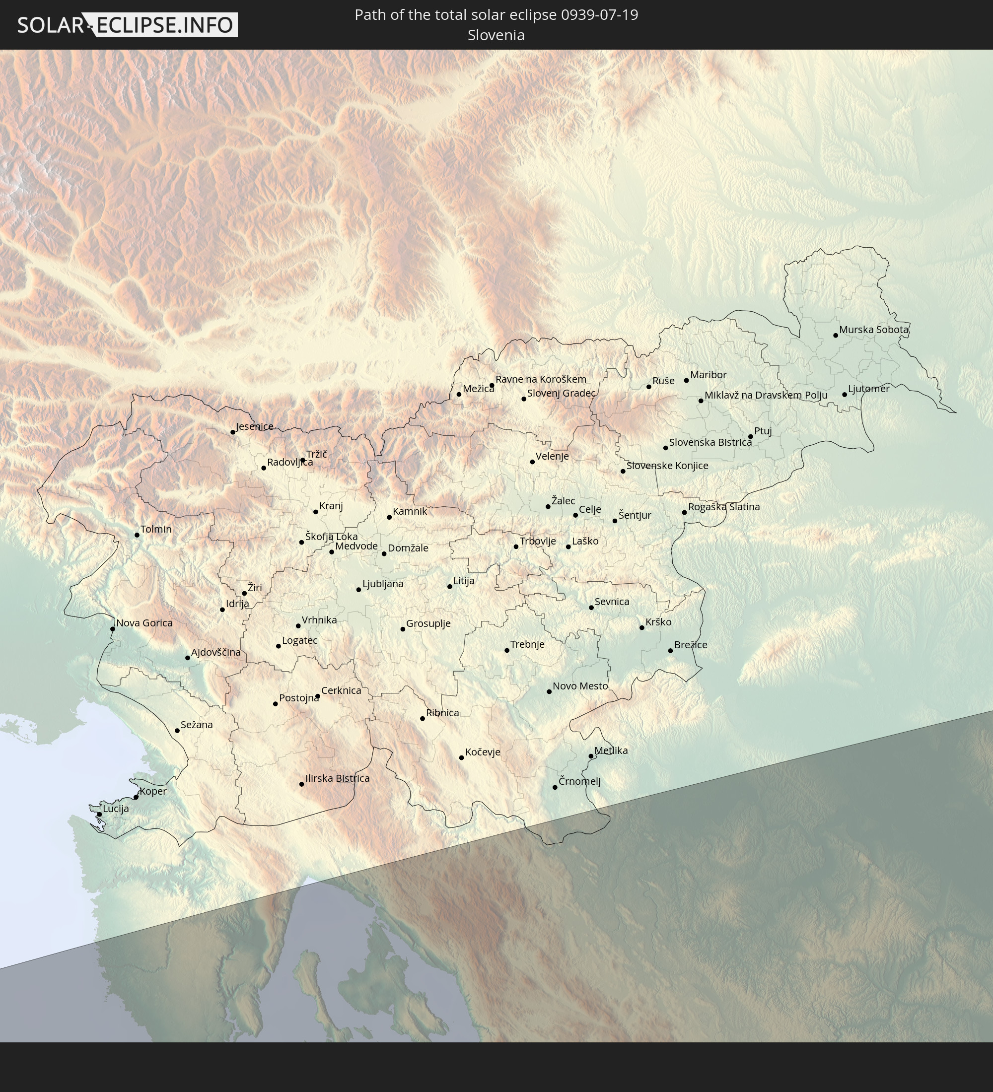 Slovenia
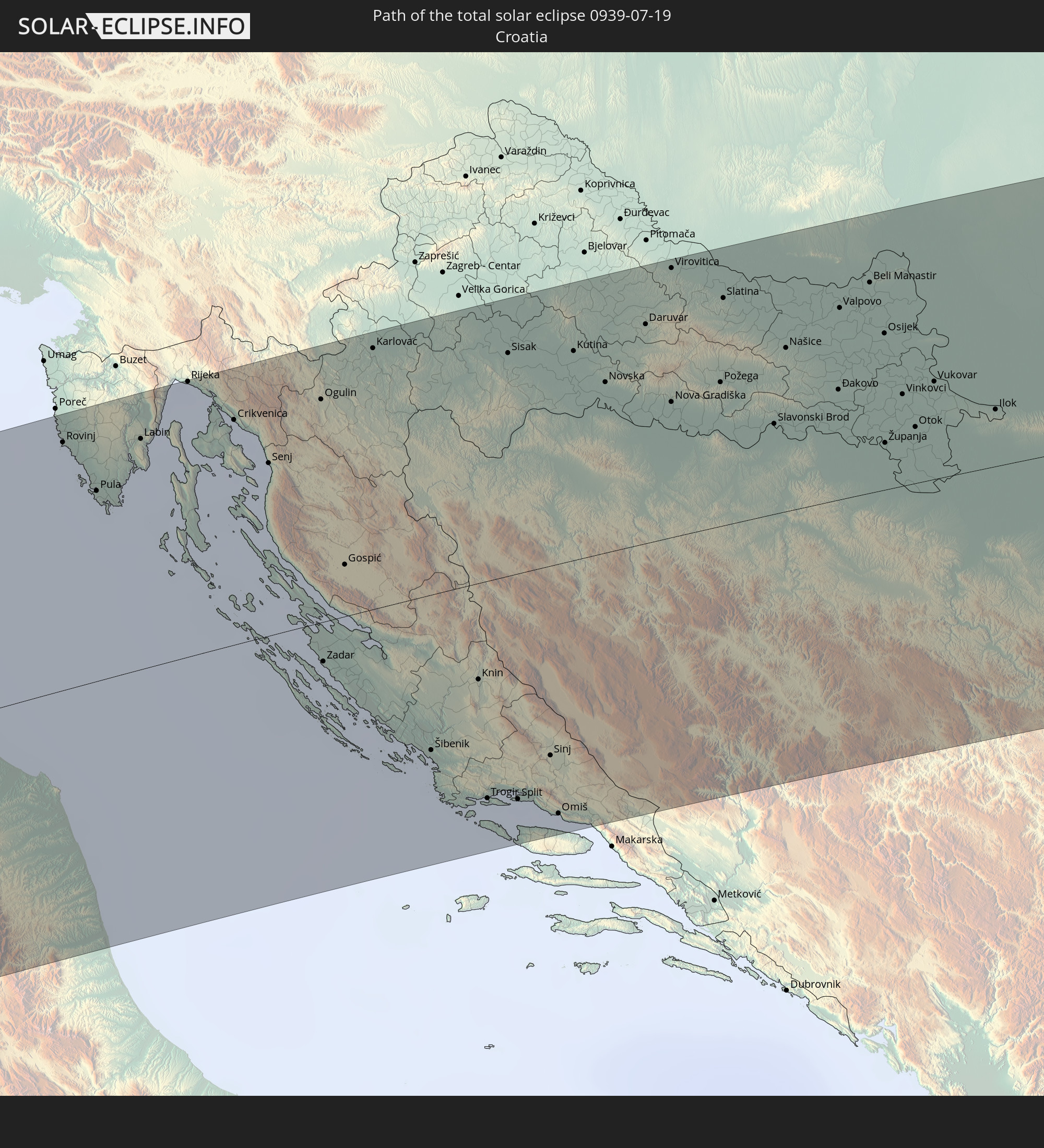 Croatia
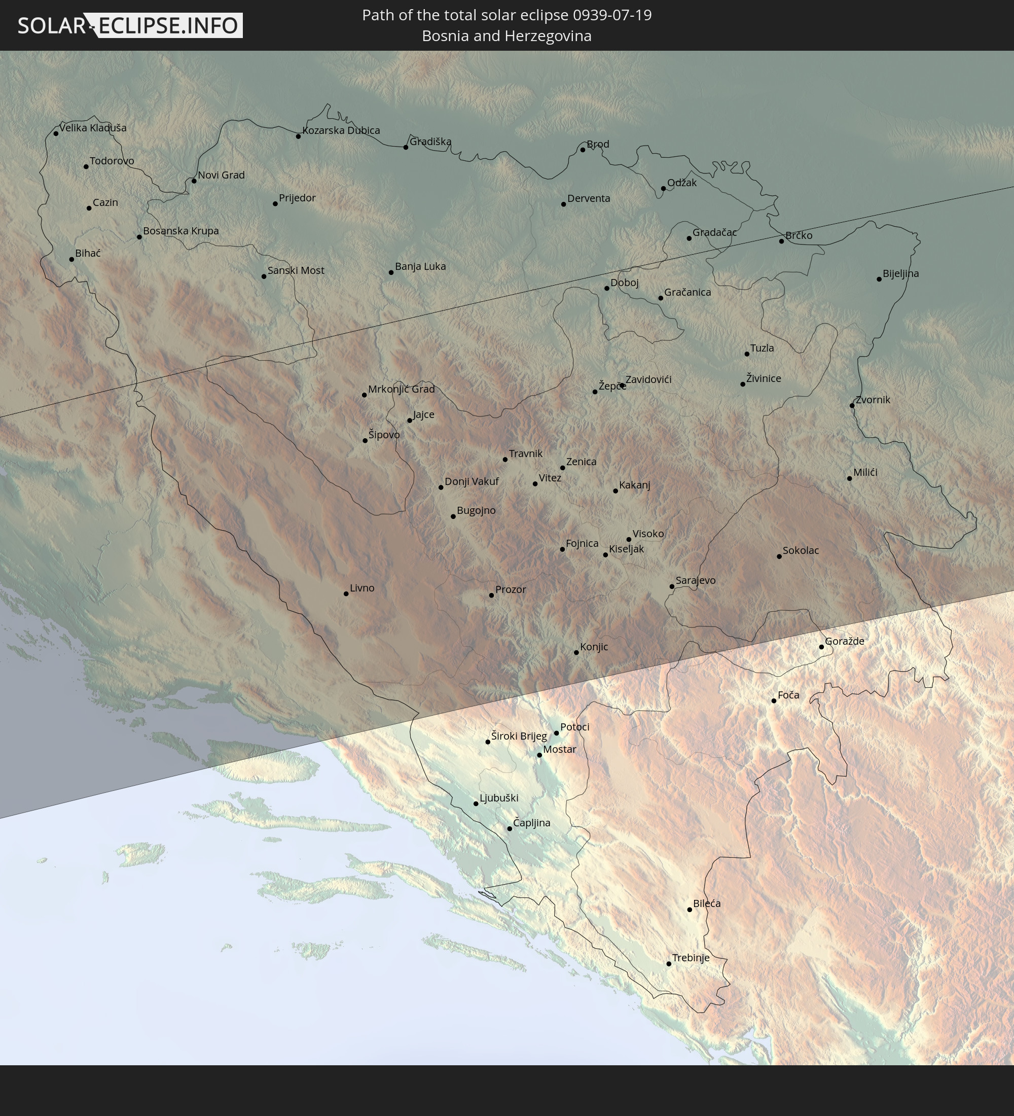 Bosnia and Herzegovina
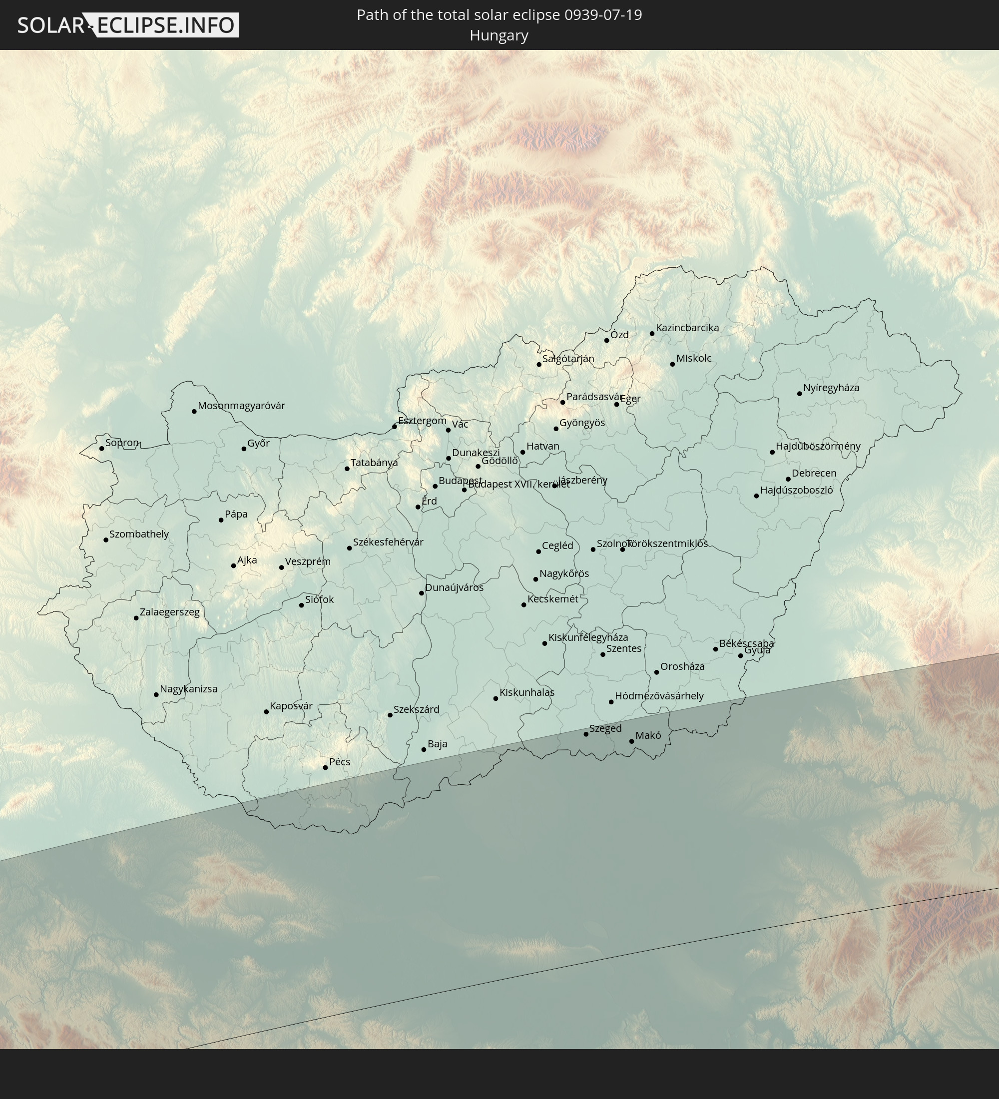 Hungary
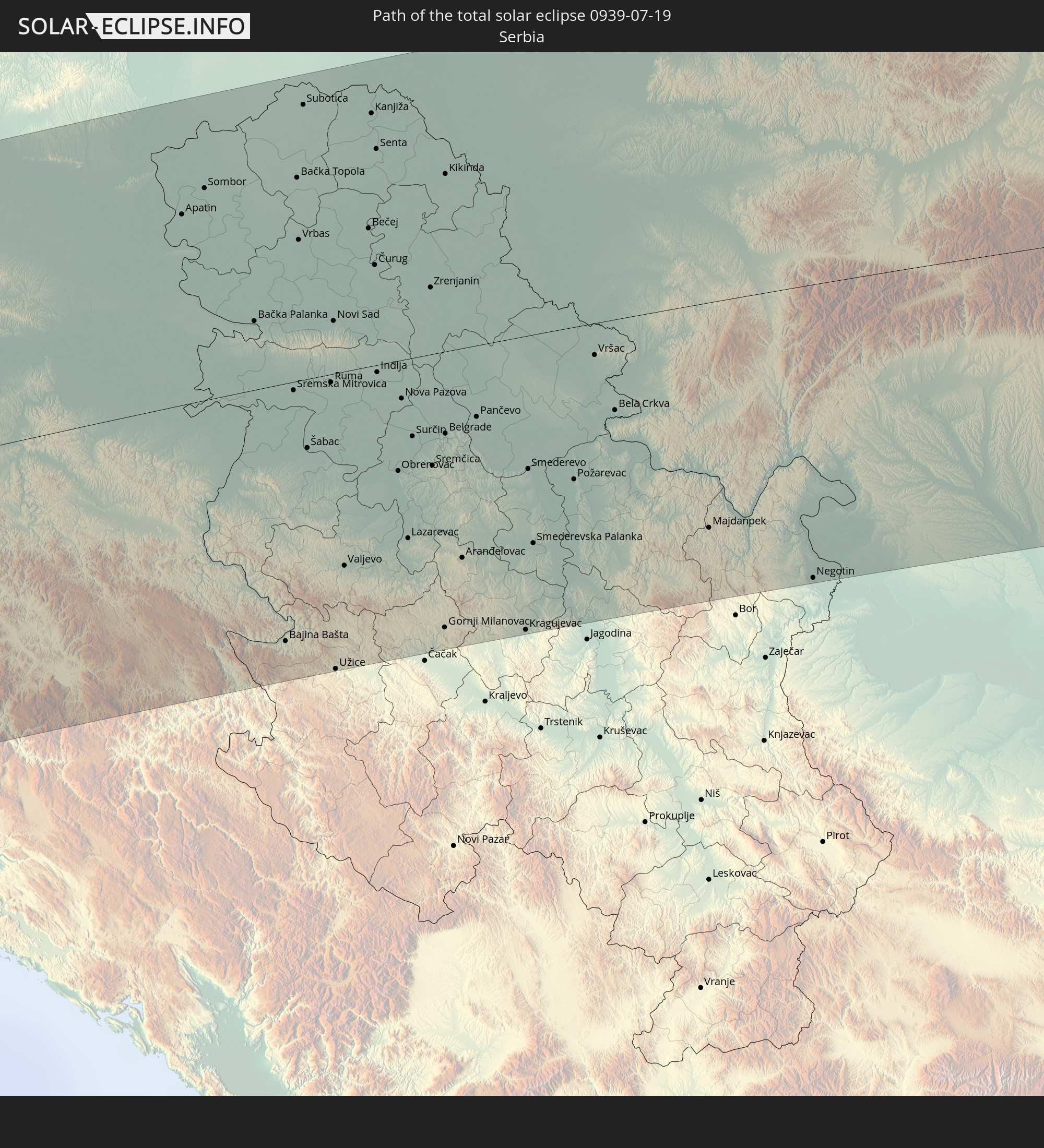 Serbia
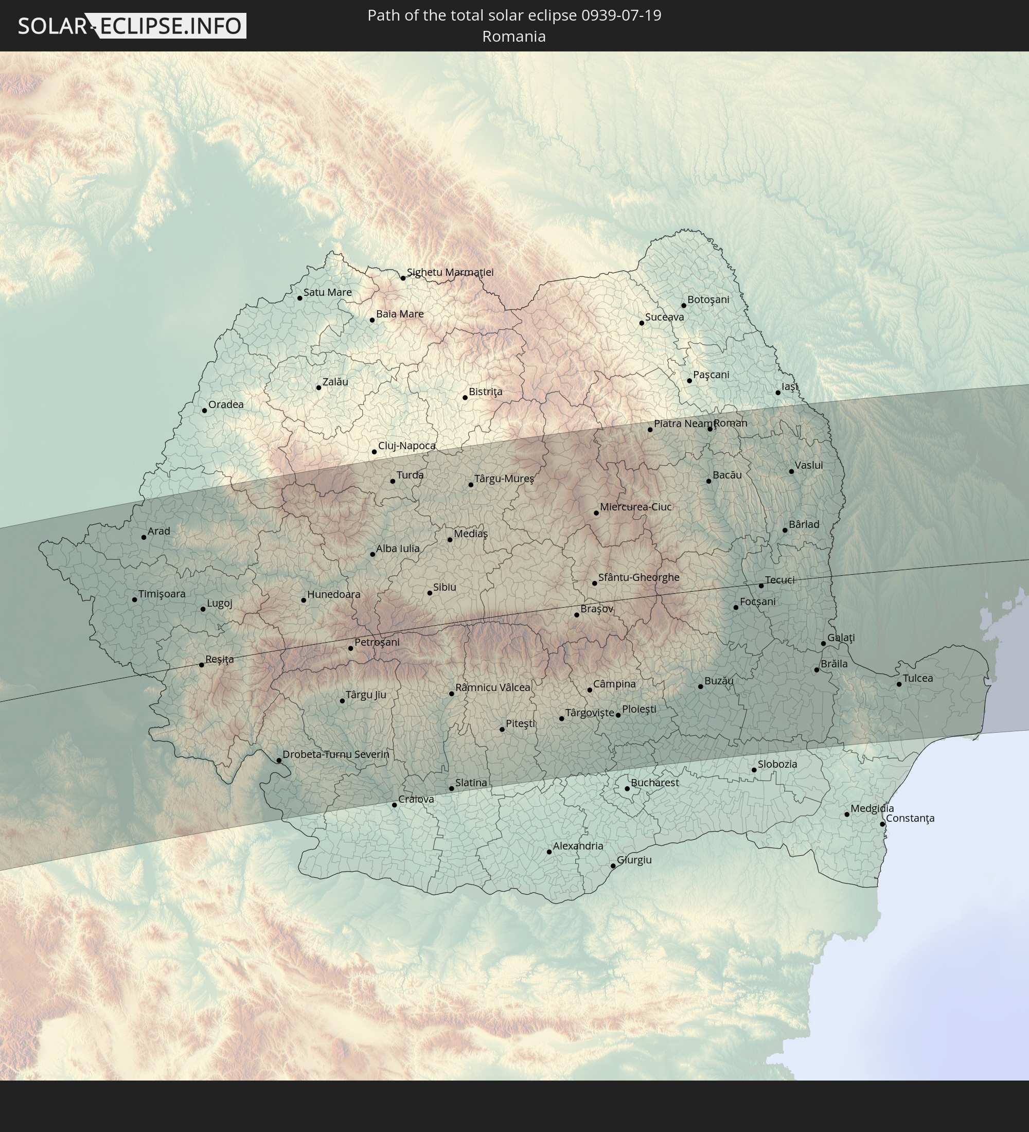 Romania
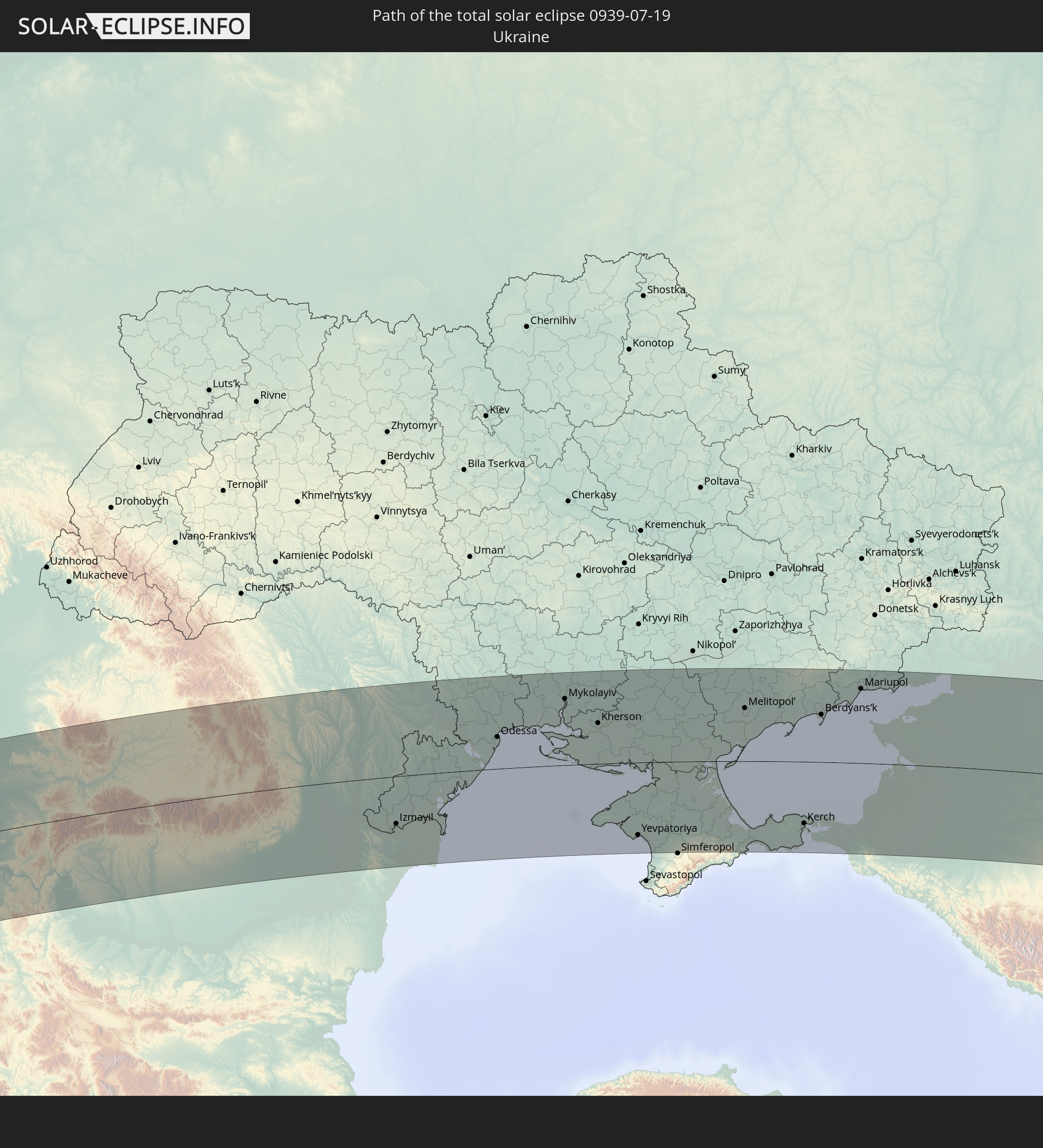 Ukraine
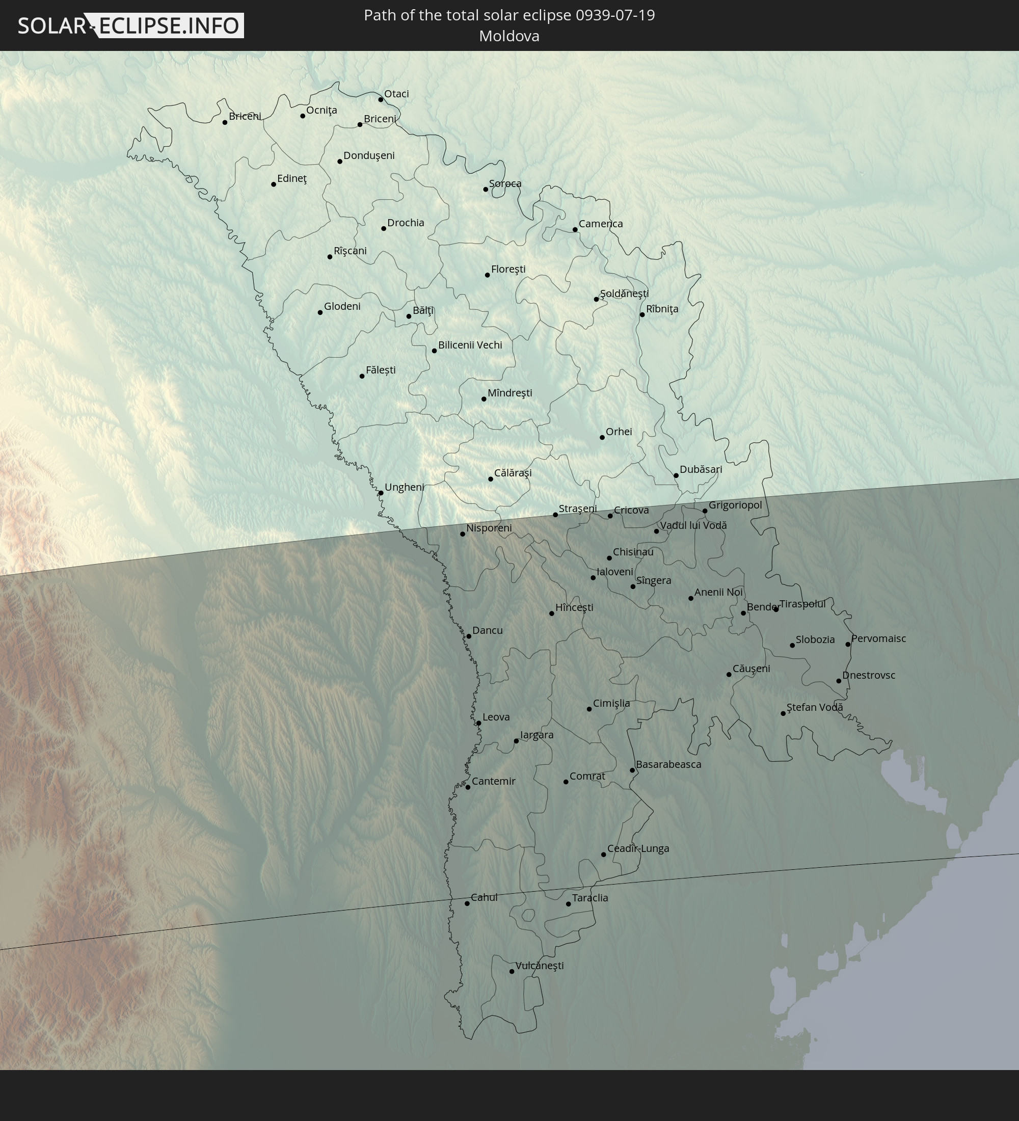 Moldova
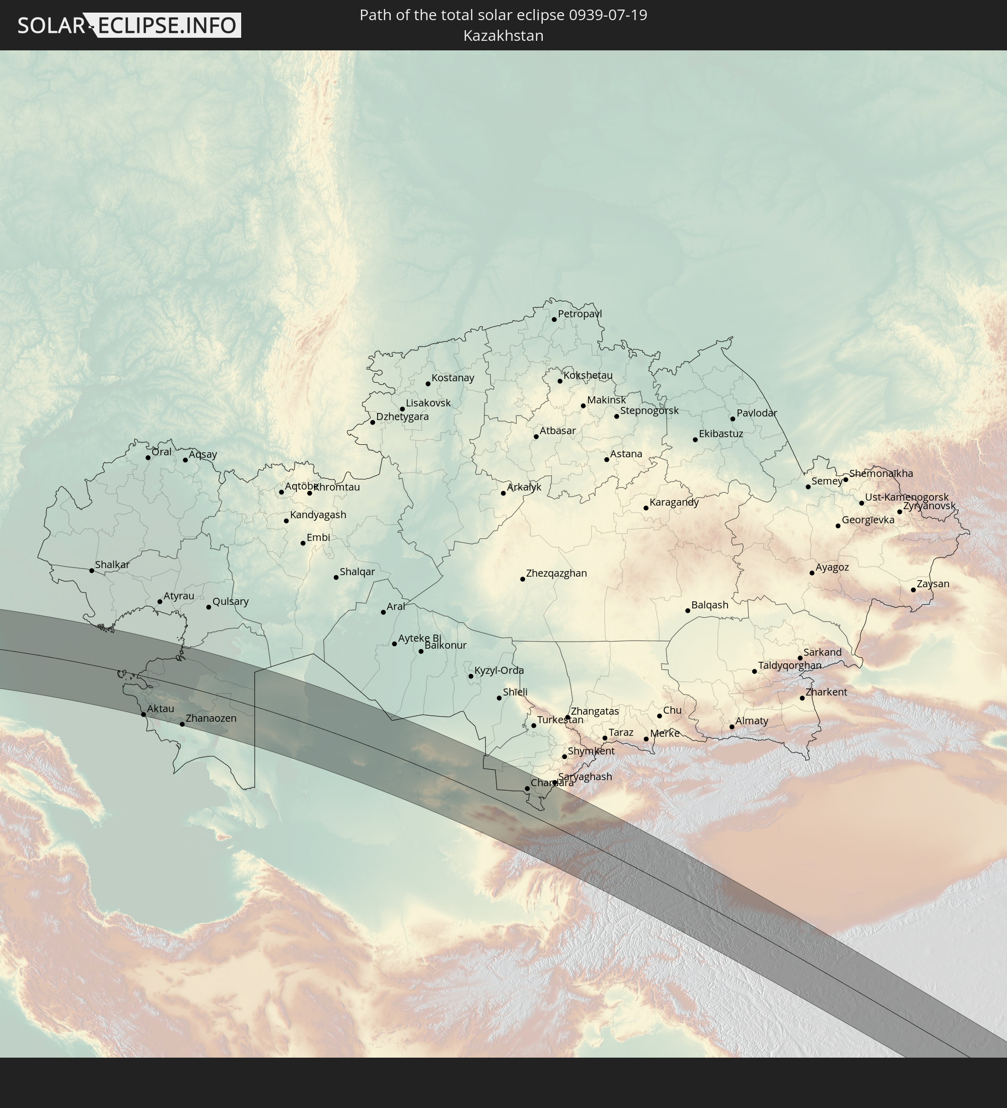 Kazakhstan
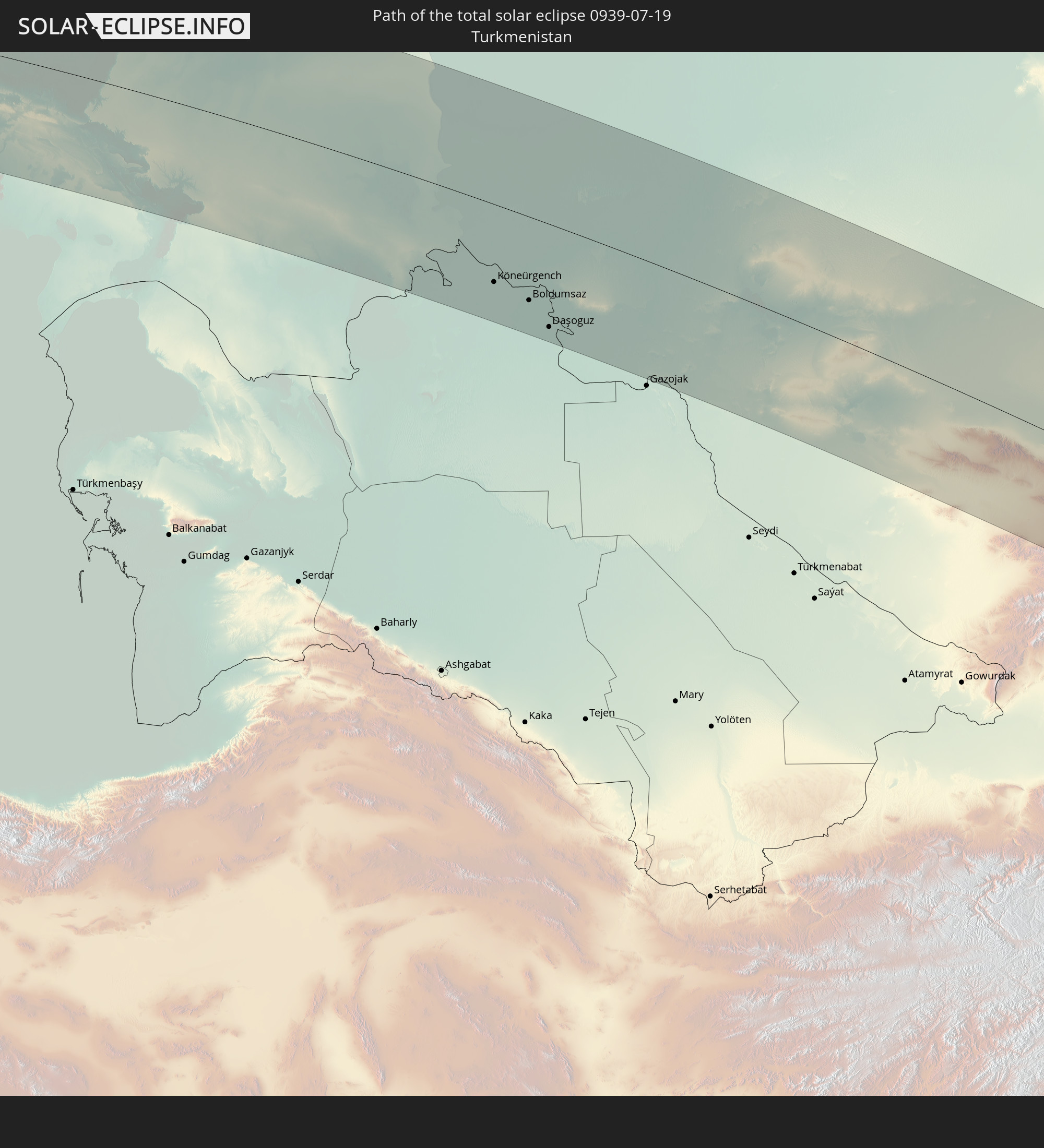 Turkmenistan
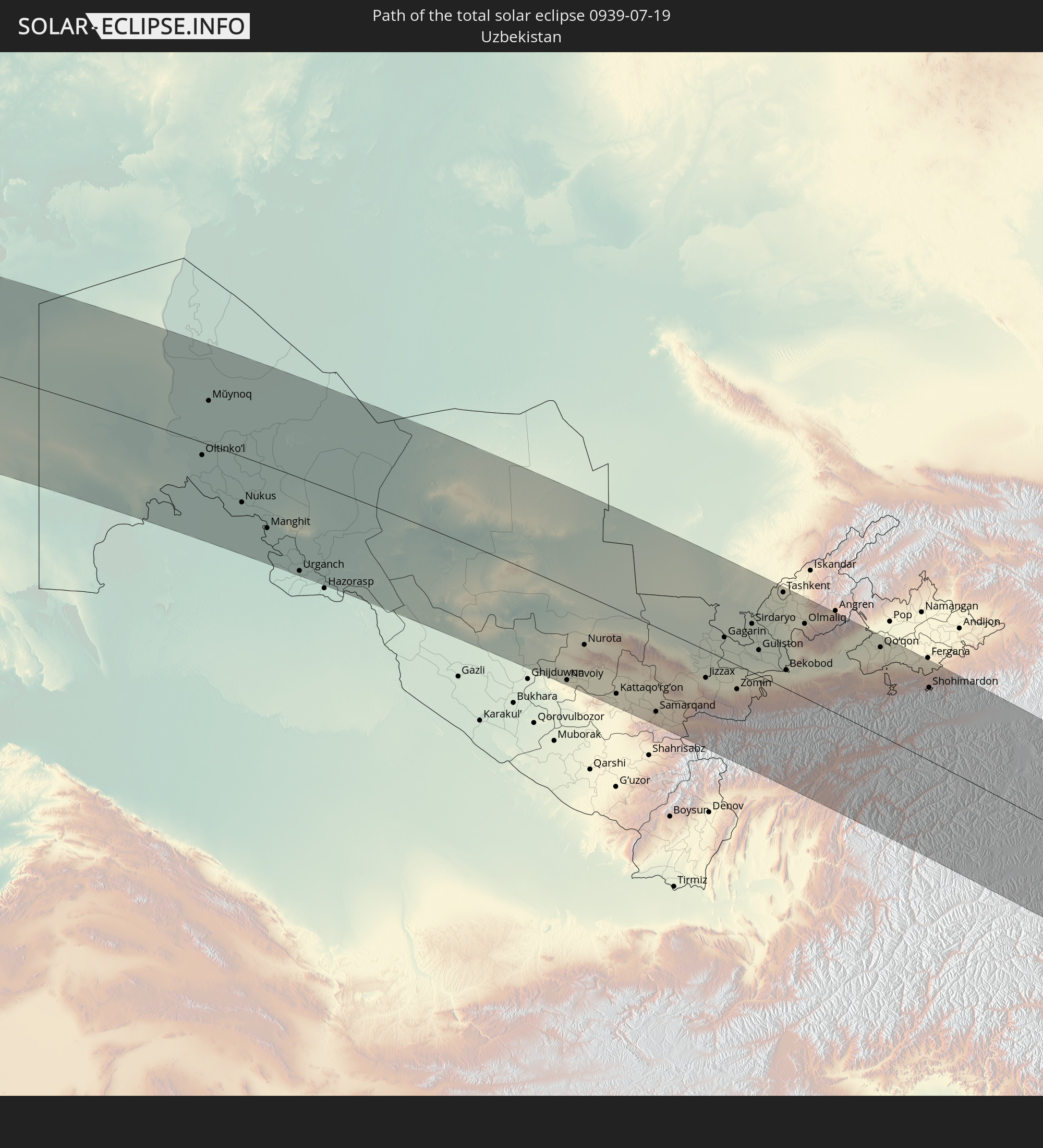 Uzbekistan
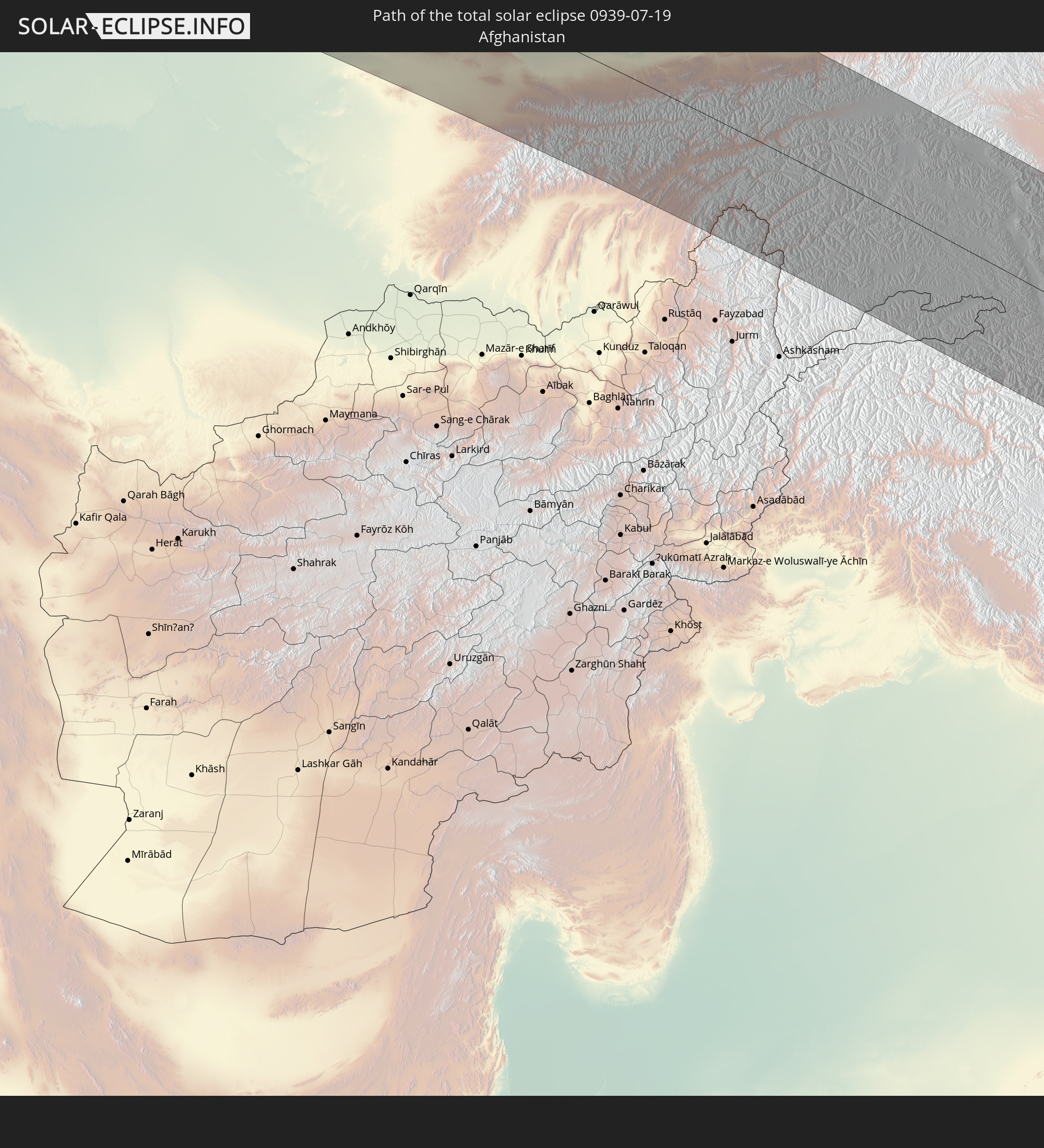 Afghanistan
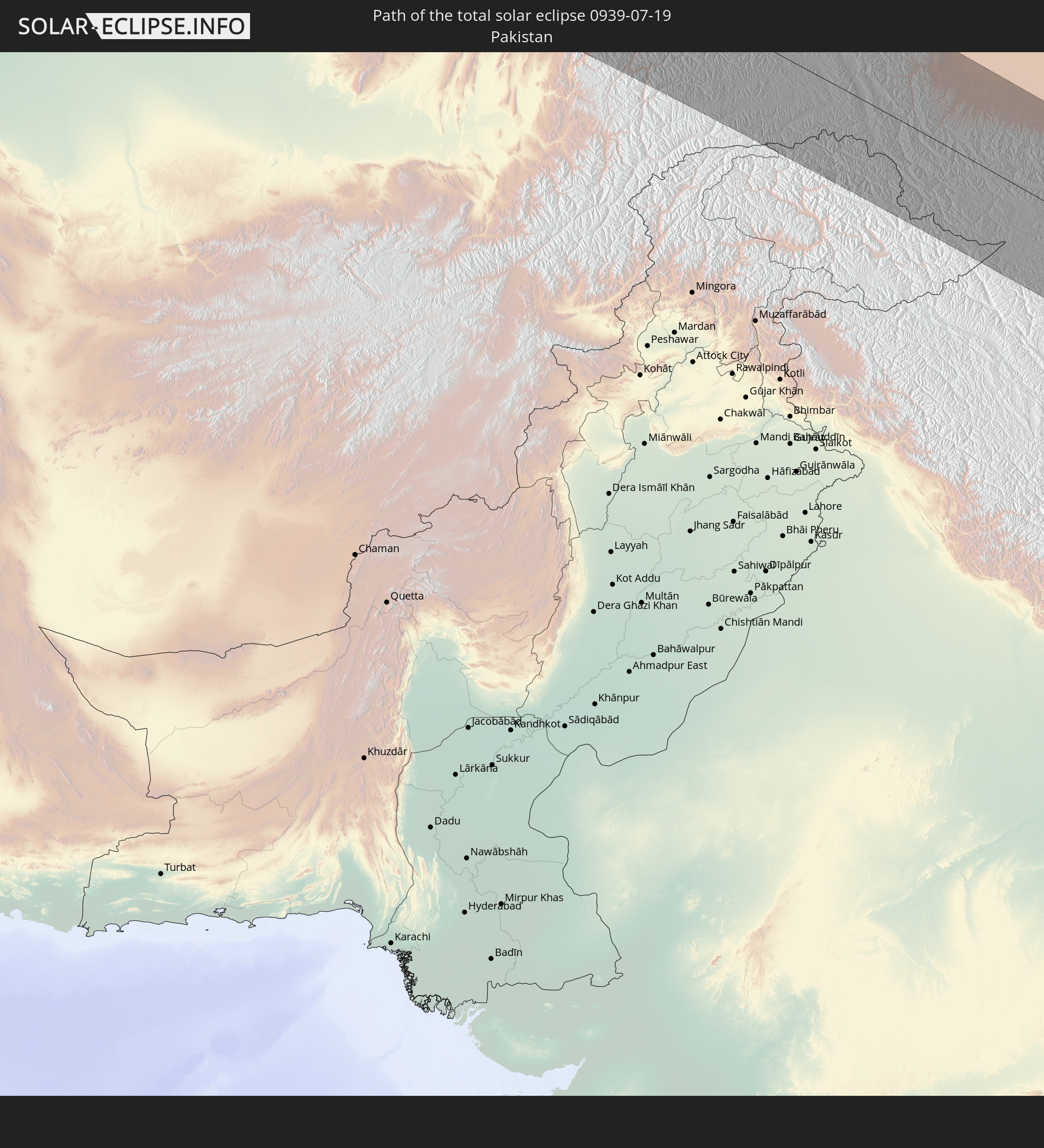 Pakistan
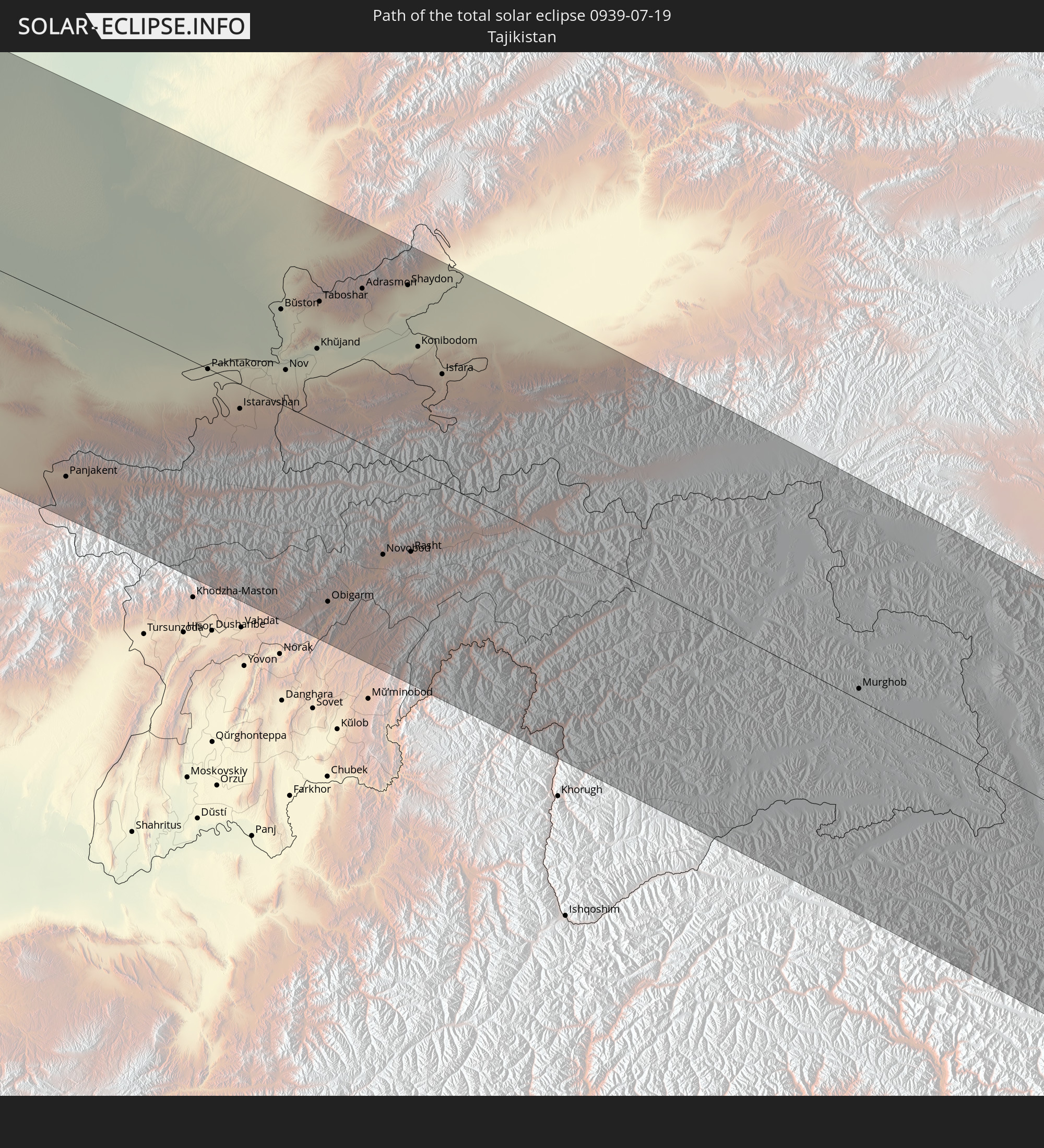 Tajikistan
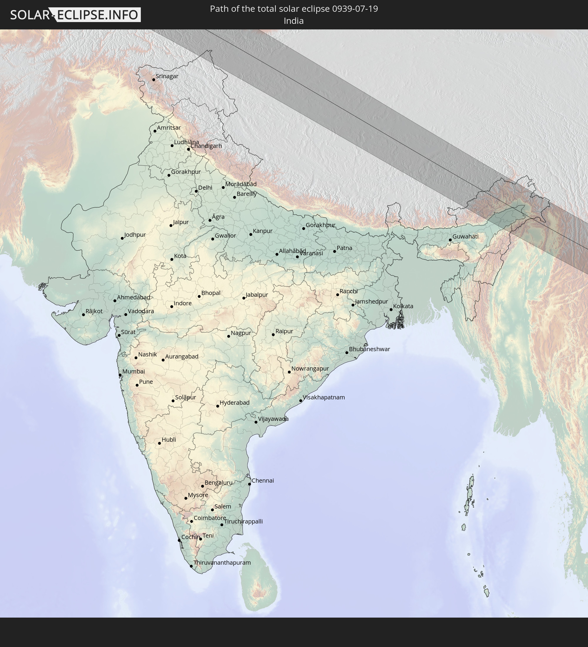 India
India
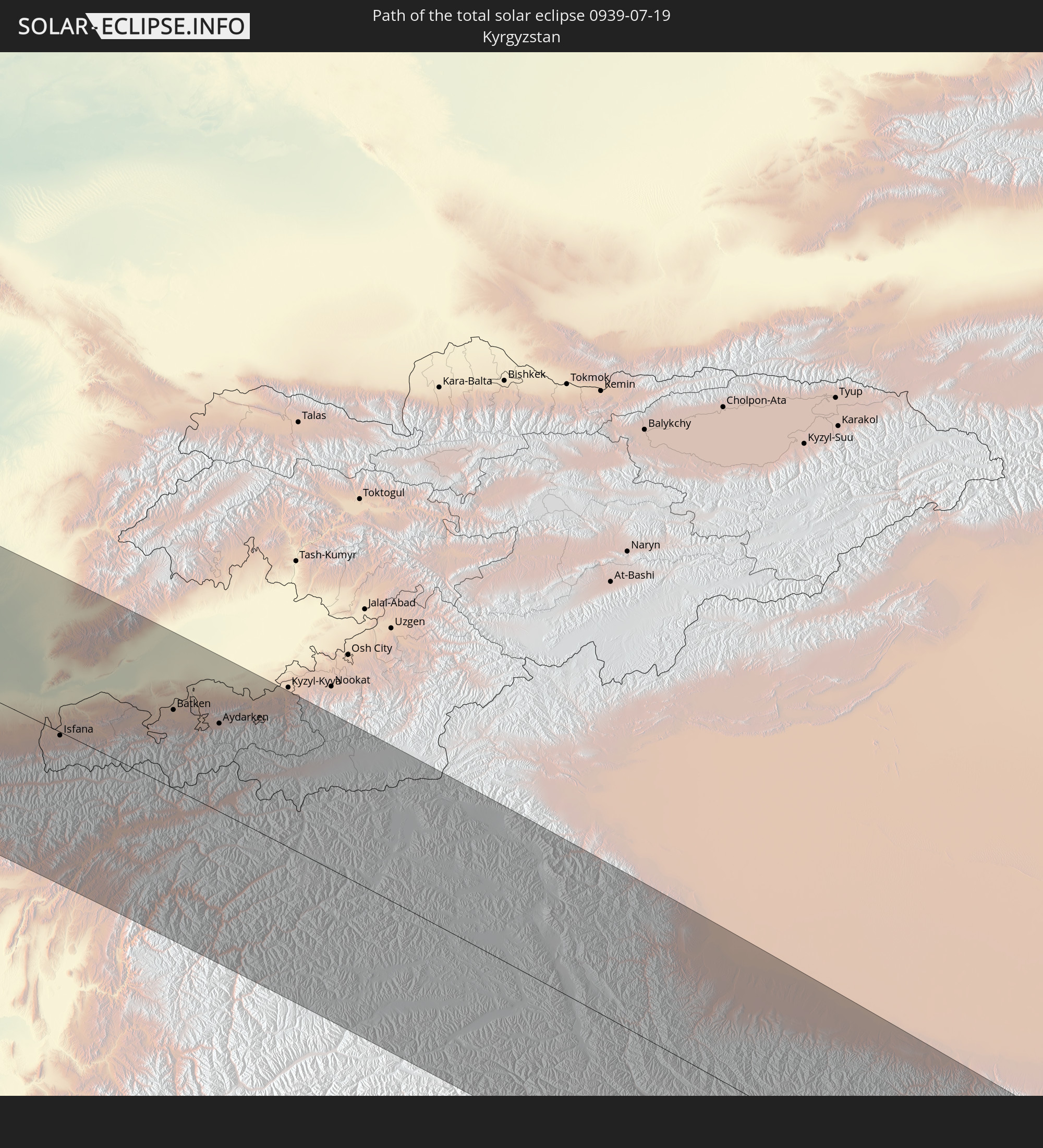 Kyrgyzstan
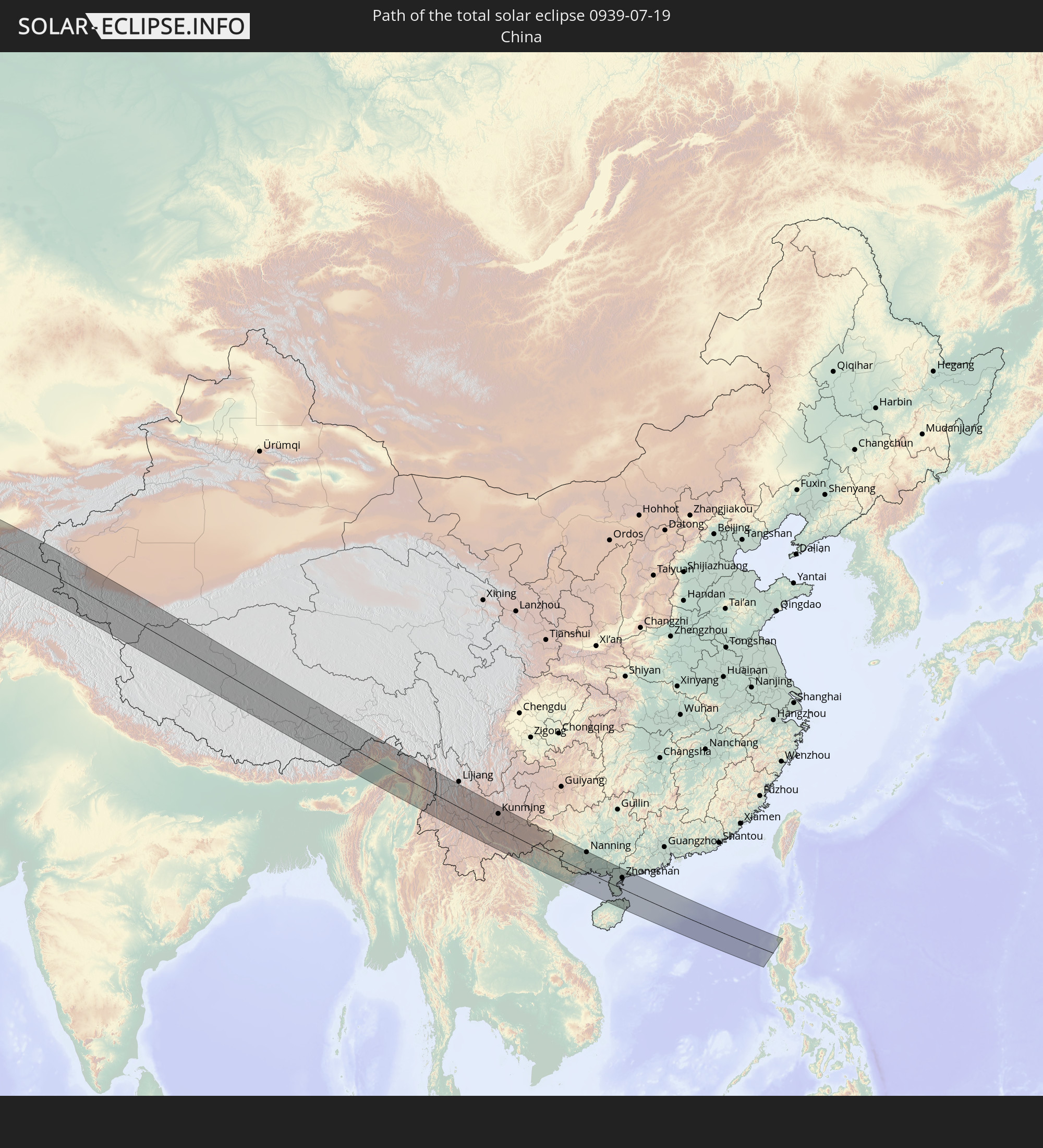 China
China
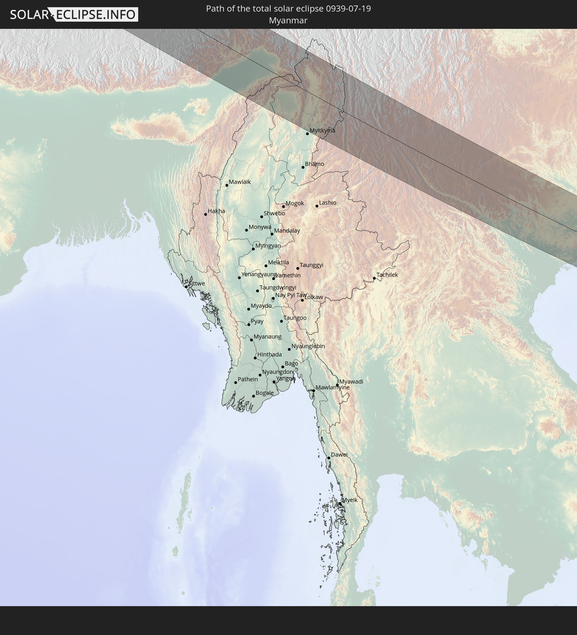 Myanmar
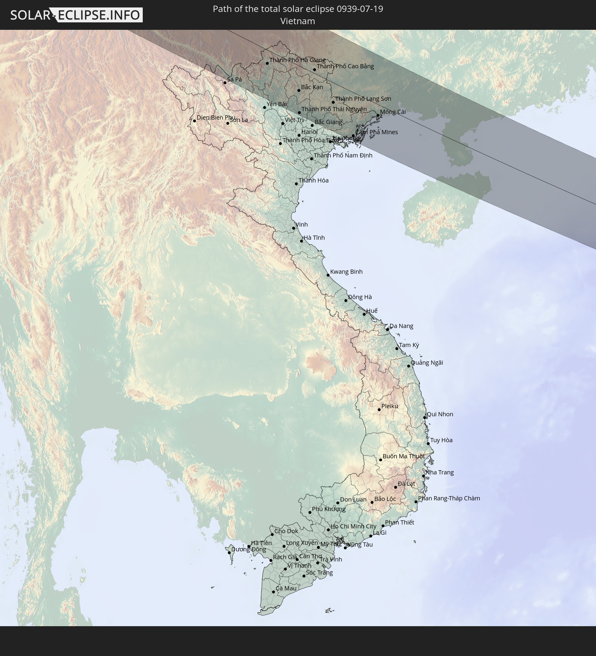 Vietnam
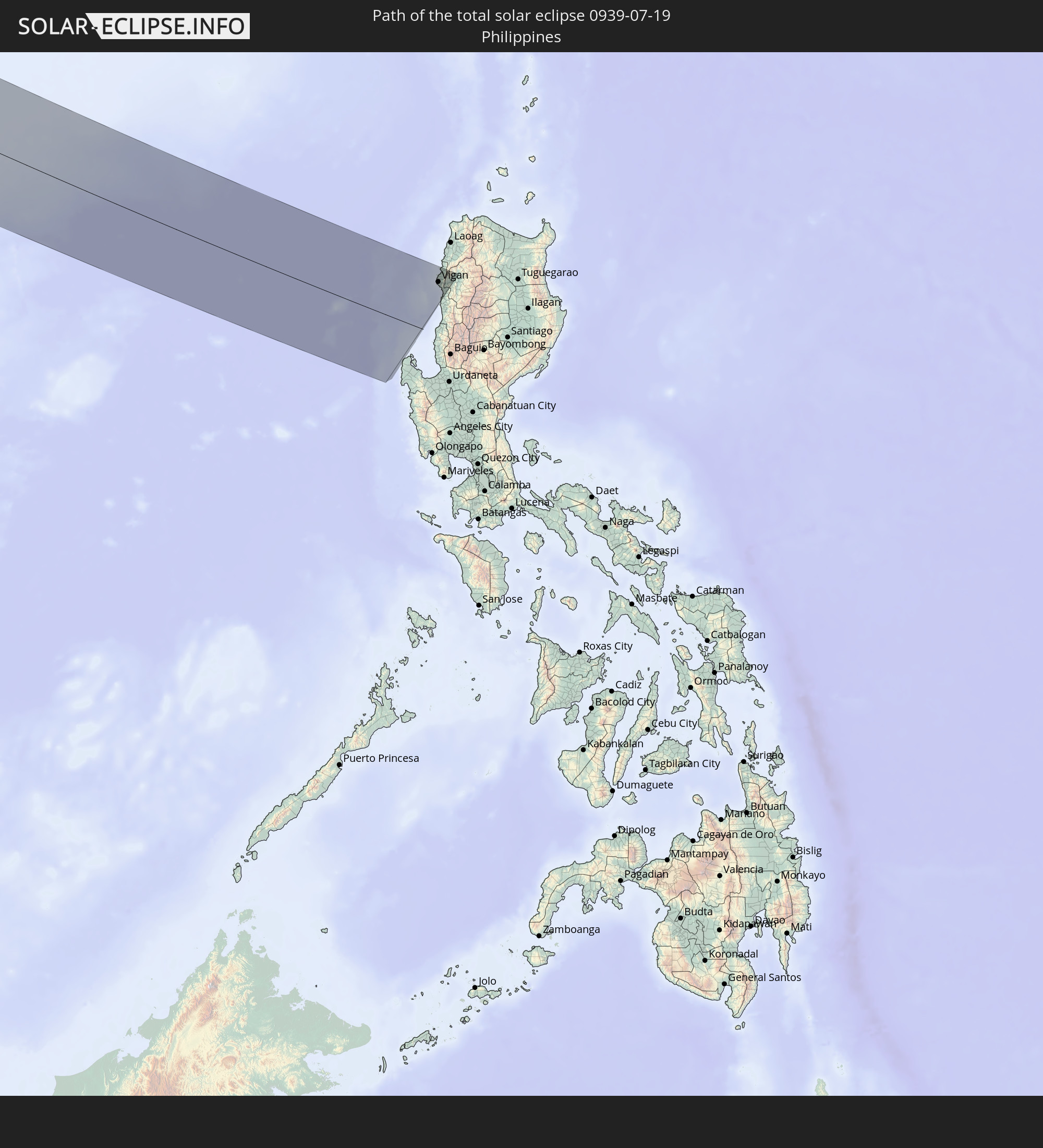 Philippines
In den folgenden Ländern ist die Sonnenfinsternis partiell zu sehen
 Russia
 Canada
 Greenland
 Portugal
 Cabo Verde
 Iceland
 Spain
Spain
 Senegal
 Mauritania
 The Gambia
 Guinea-Bissau
 Guinea
 Sierra Leone
 Morocco
 Mali
Mali
 Liberia
 Republic of Ireland
 Svalbard and Jan Mayen
 Algeria
 United Kingdom
 Ivory Coast
 Faroe Islands
 Burkina Faso
 Gibraltar
 France
 Isle of Man
 Ghana
Ghana
 Guernsey
 Jersey
 Togo
Togo
 Niger
Niger
 Benin
Benin
 Andorra
 Belgium
 Nigeria
 Netherlands
 Norway
 Luxembourg
 Germany
 Switzerland
 Italy
Italy
 Monaco
 Tunisia
 Denmark
 Cameroon
 Libya
Libya
 Liechtenstein
 Austria
 Sweden
 Czechia
 San Marino
 Vatican City
 Slovenia
 Chad
Chad
 Croatia
 Poland
 Malta
Malta
 Bosnia and Herzegovina
 Hungary
 Slovakia
 Montenegro
 Serbia
 Albania
 Åland Islands
 Greece
 Romania
 Republic of Macedonia
 Finland
 Lithuania
 Latvia
 Estonia
 Sudan
Sudan
 Ukraine
 Bulgaria
 Belarus
 Egypt
Egypt
 Turkey
 Moldova
 Cyprus
 State of Palestine
 Israel
 Saudi Arabia
 Jordan
 Lebanon
 Syria
Syria
 Eritrea
 Iraq
Iraq
 Georgia
 Yemen
Yemen
 Armenia
 Iran
Iran
 Azerbaijan
 Kazakhstan
 Kuwait
 Bahrain
 Qatar
Qatar
 United Arab Emirates
 Oman
Oman
 Turkmenistan
 Uzbekistan
 Afghanistan
 Pakistan
 Tajikistan
 India
India
 Kyrgyzstan
 Maldives
 China
China
 Sri Lanka
 Nepal
Nepal
 Mongolia
 Bangladesh
 Bhutan
 Myanmar
 Indonesia
 Thailand
 Malaysia
 Laos
Laos
 Vietnam
 Cambodia
 Singapore
 Christmas Island
 Macau
Macau
 Hong Kong
 Taiwan
 Philippines
 Japan
Japan
 North Korea
 South Korea
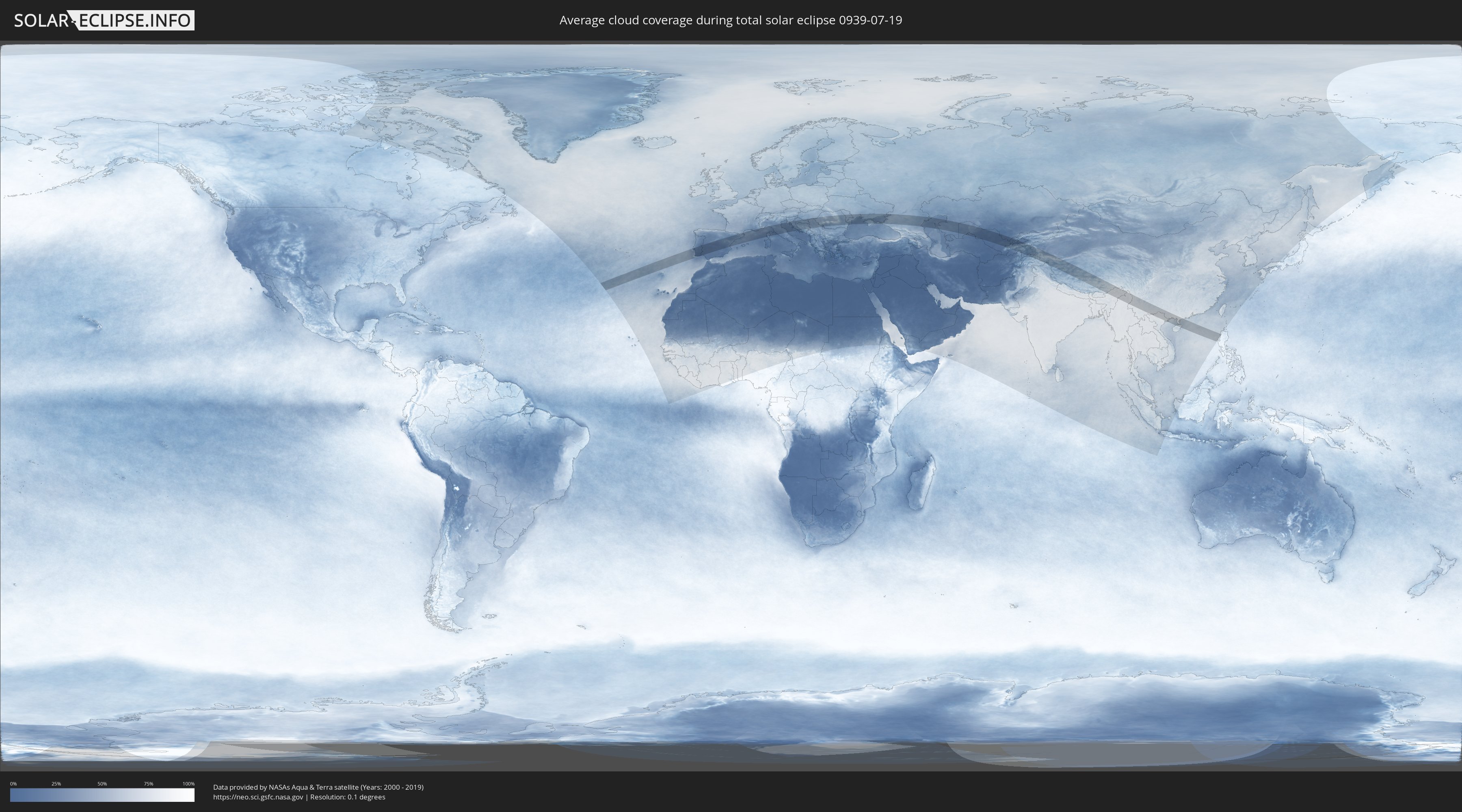
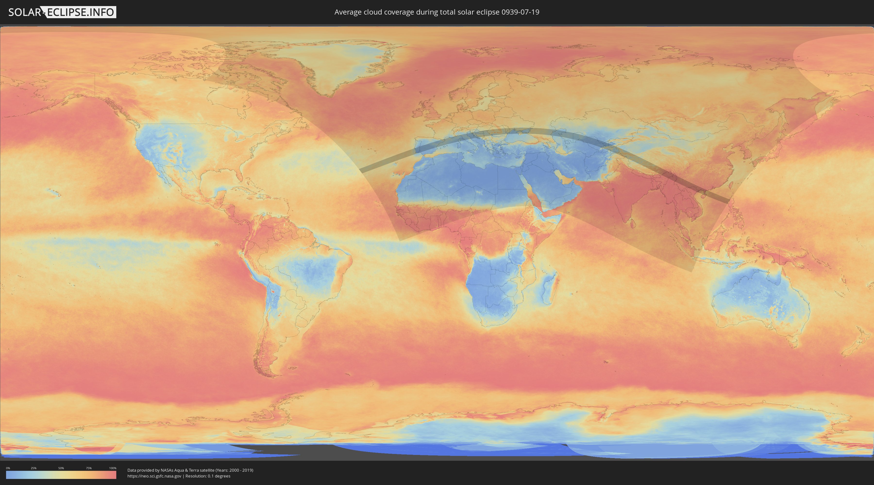
How will be the weather during the total solar eclipse on 07/19/0939?
Where is the best place to see the total solar eclipse of 07/19/0939?
The following maps show the average cloud coverage for the day of the total solar eclipse.
With the help of these maps, it is possible to find the place along the eclipse path, which has the best
chance of a cloudless sky.
Nevertheless, you should consider local circumstances and inform about the weather of your chosen
observation site.
The data is provided by NASAs satellites
AQUA and TERRA.
The cloud maps are averaged over a period of 19 years (2000 - 2019).
Detailed country maps
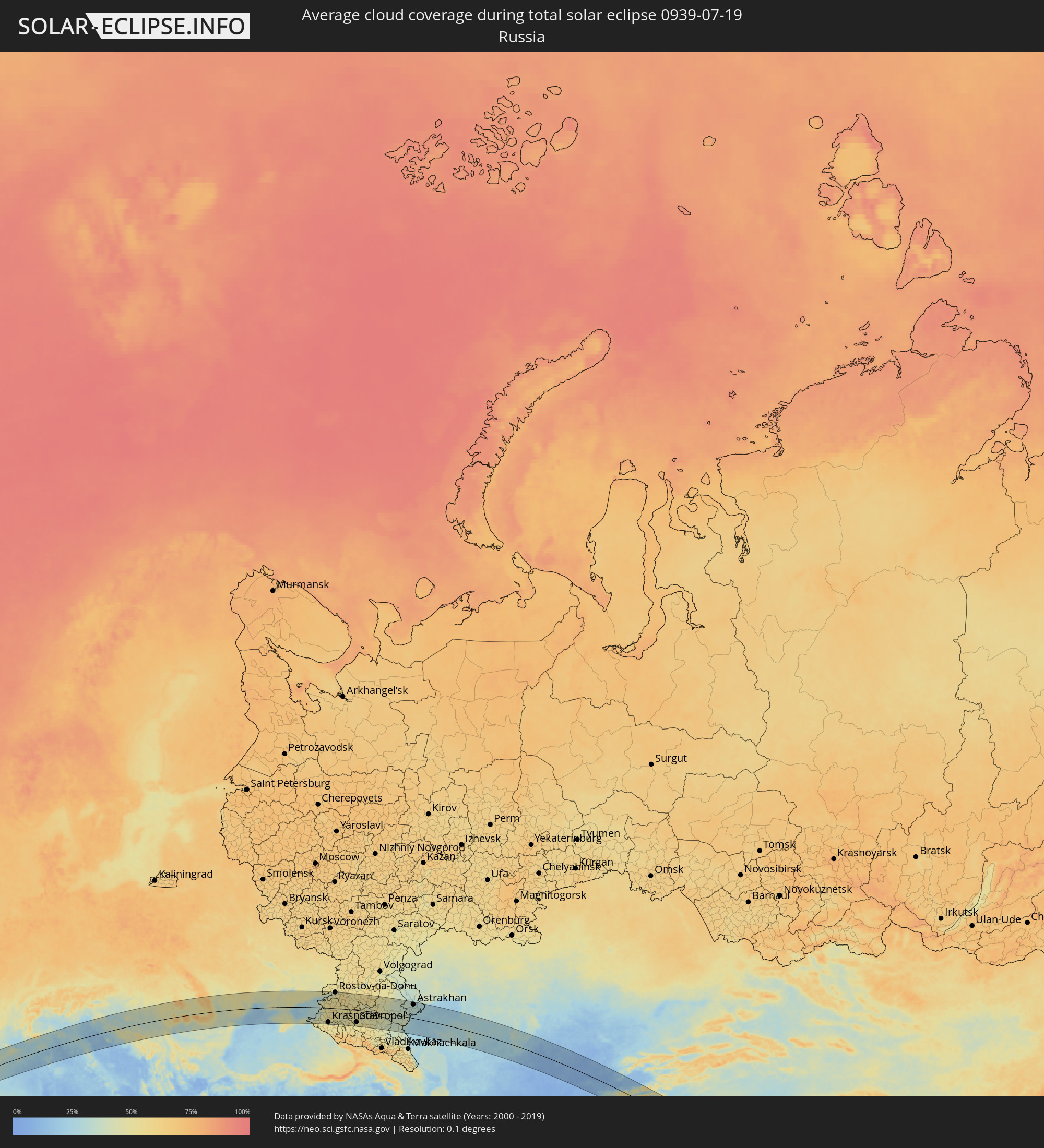 Russia
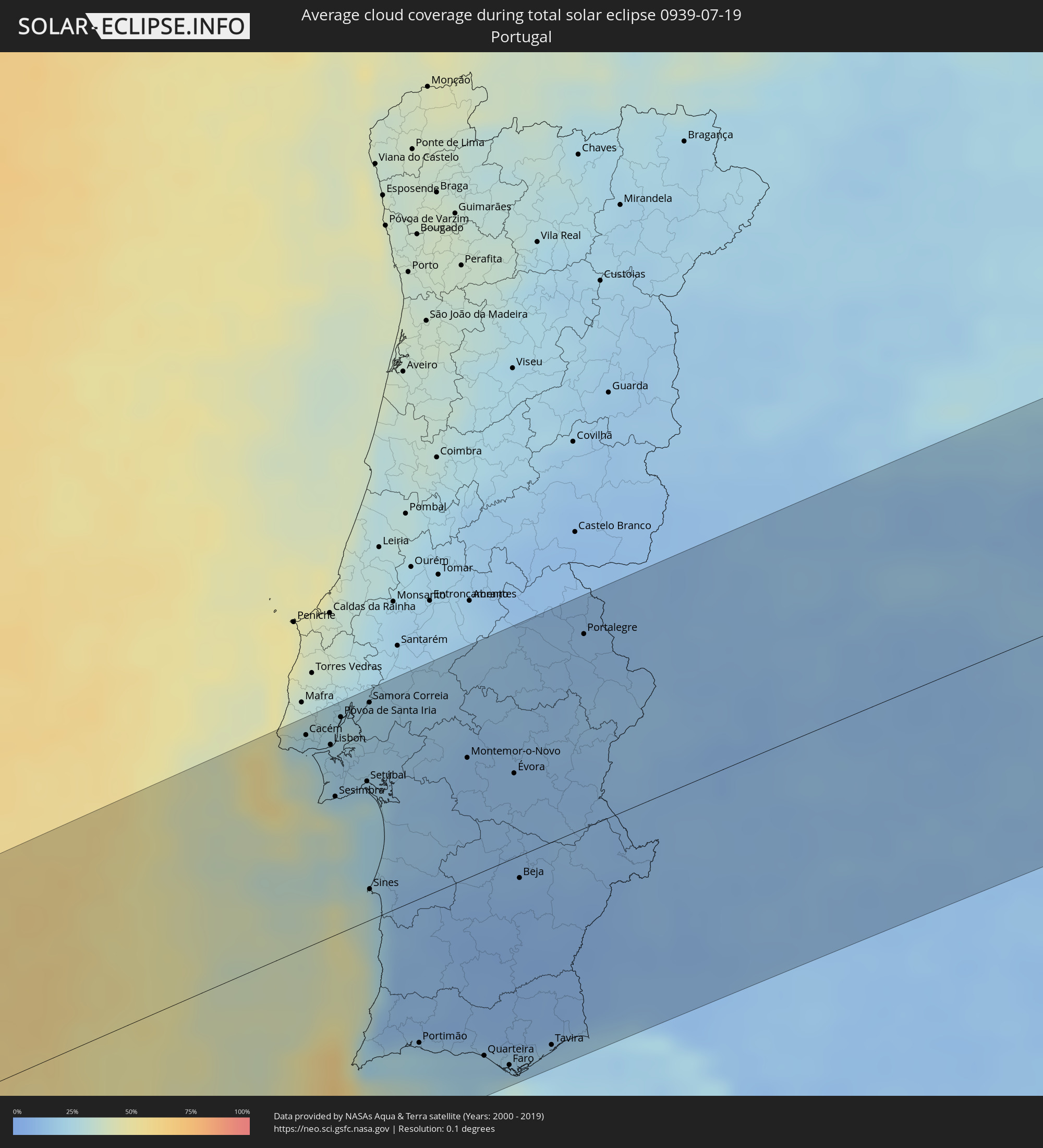 Portugal
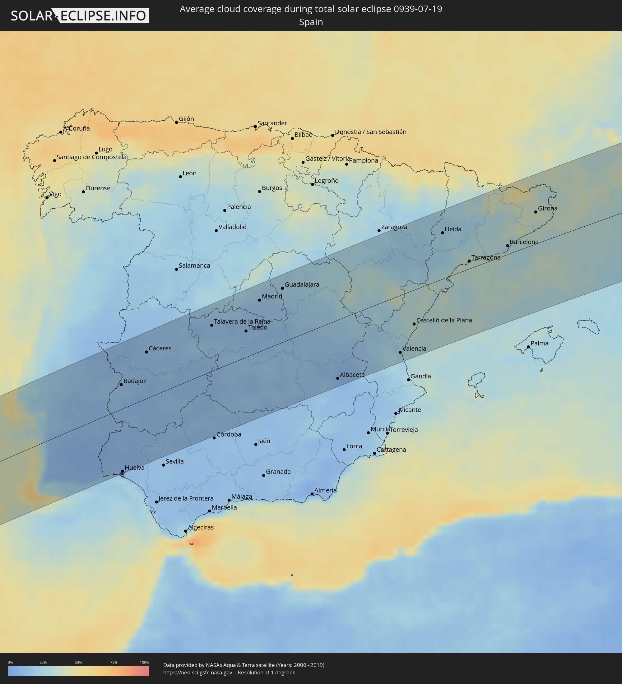 Spain
Spain
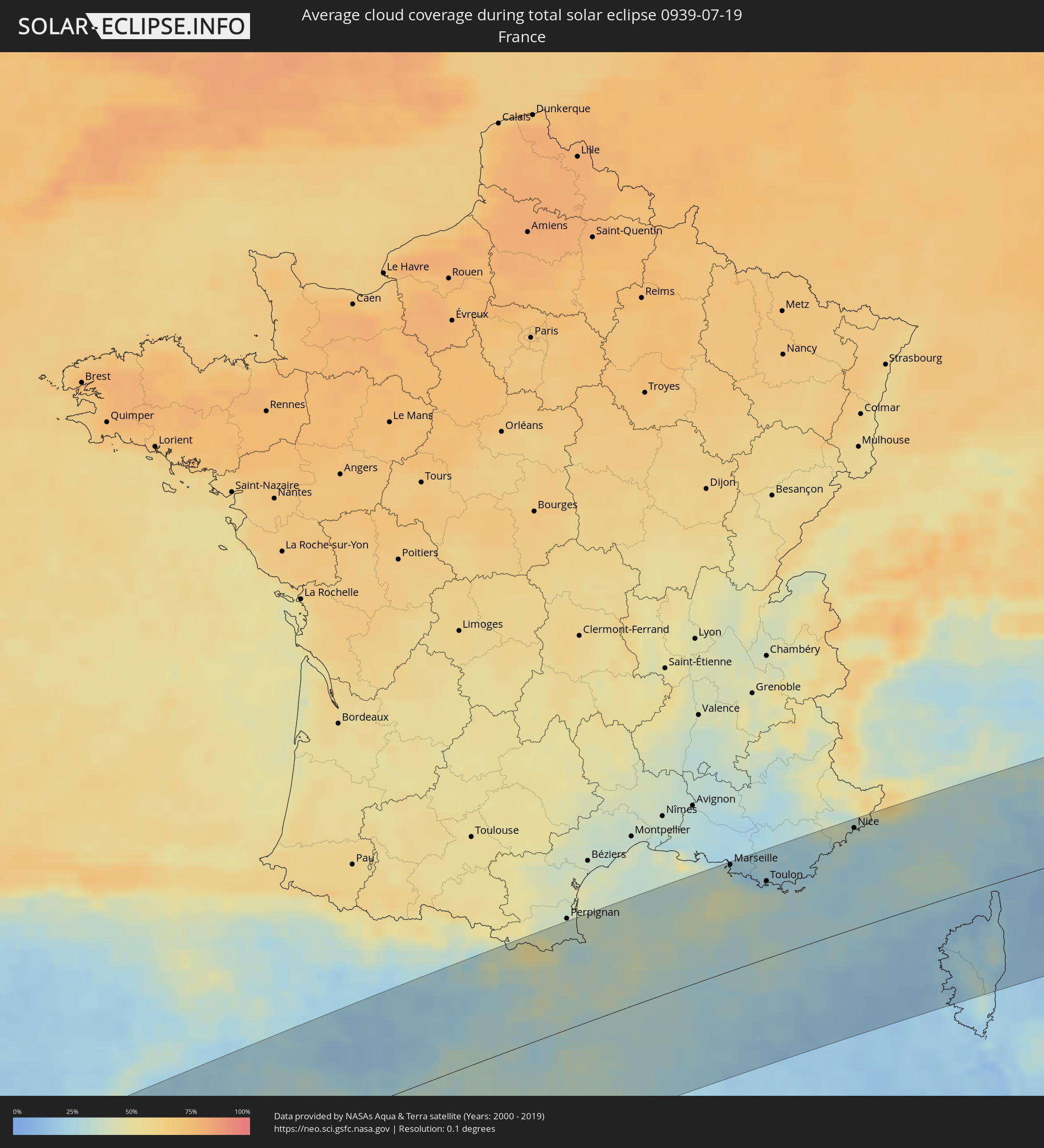 France
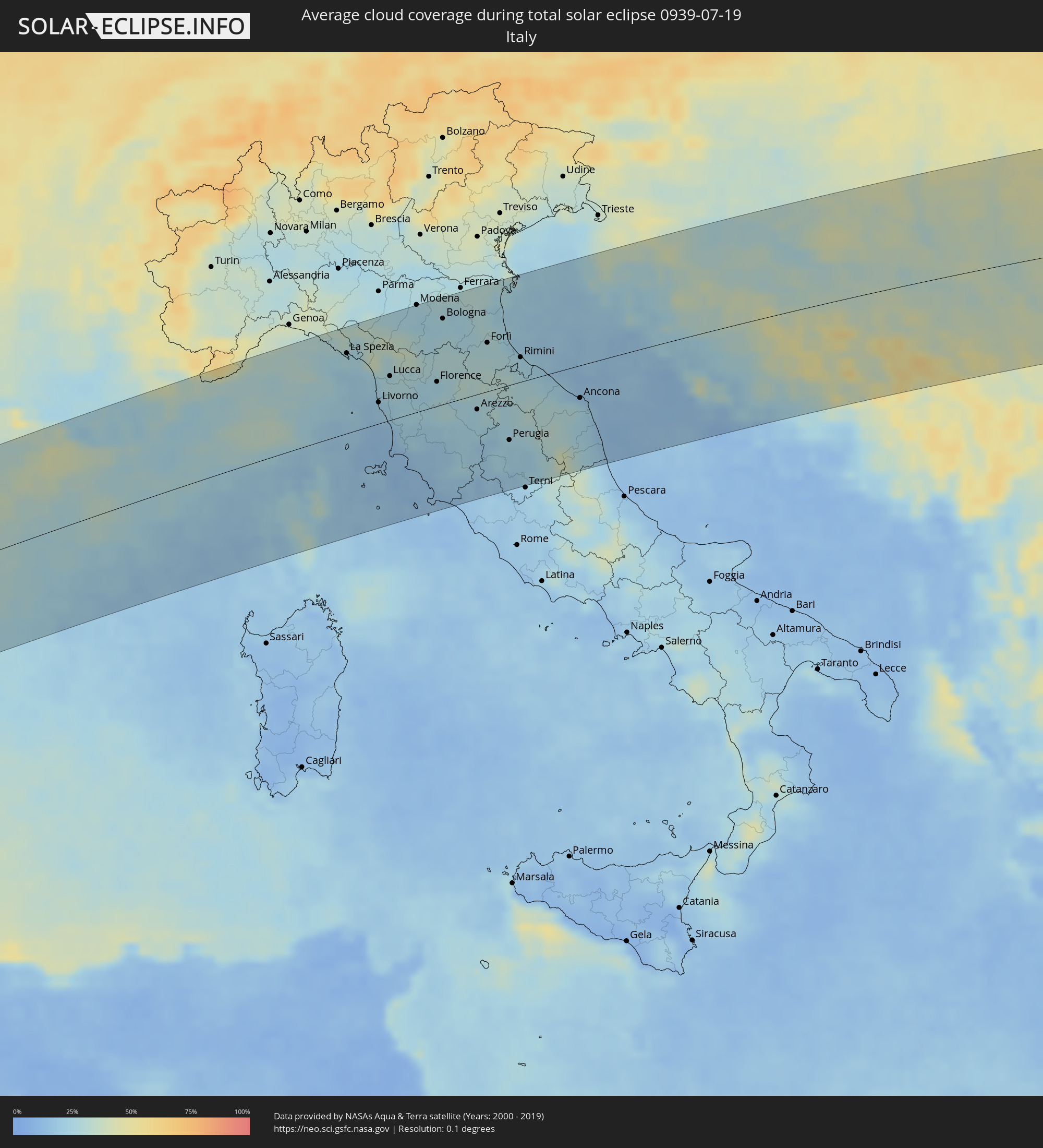 Italy
Italy
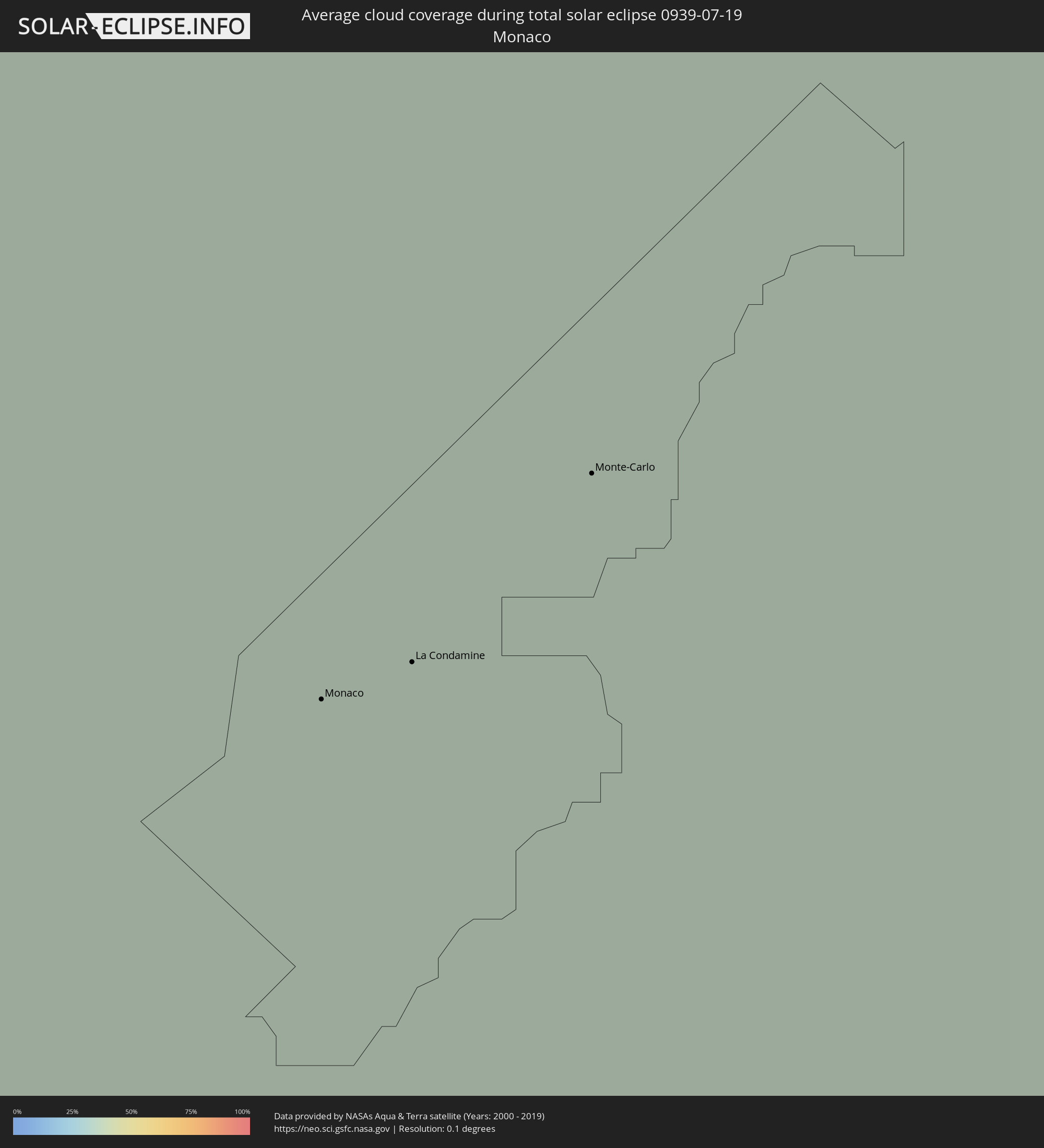 Monaco
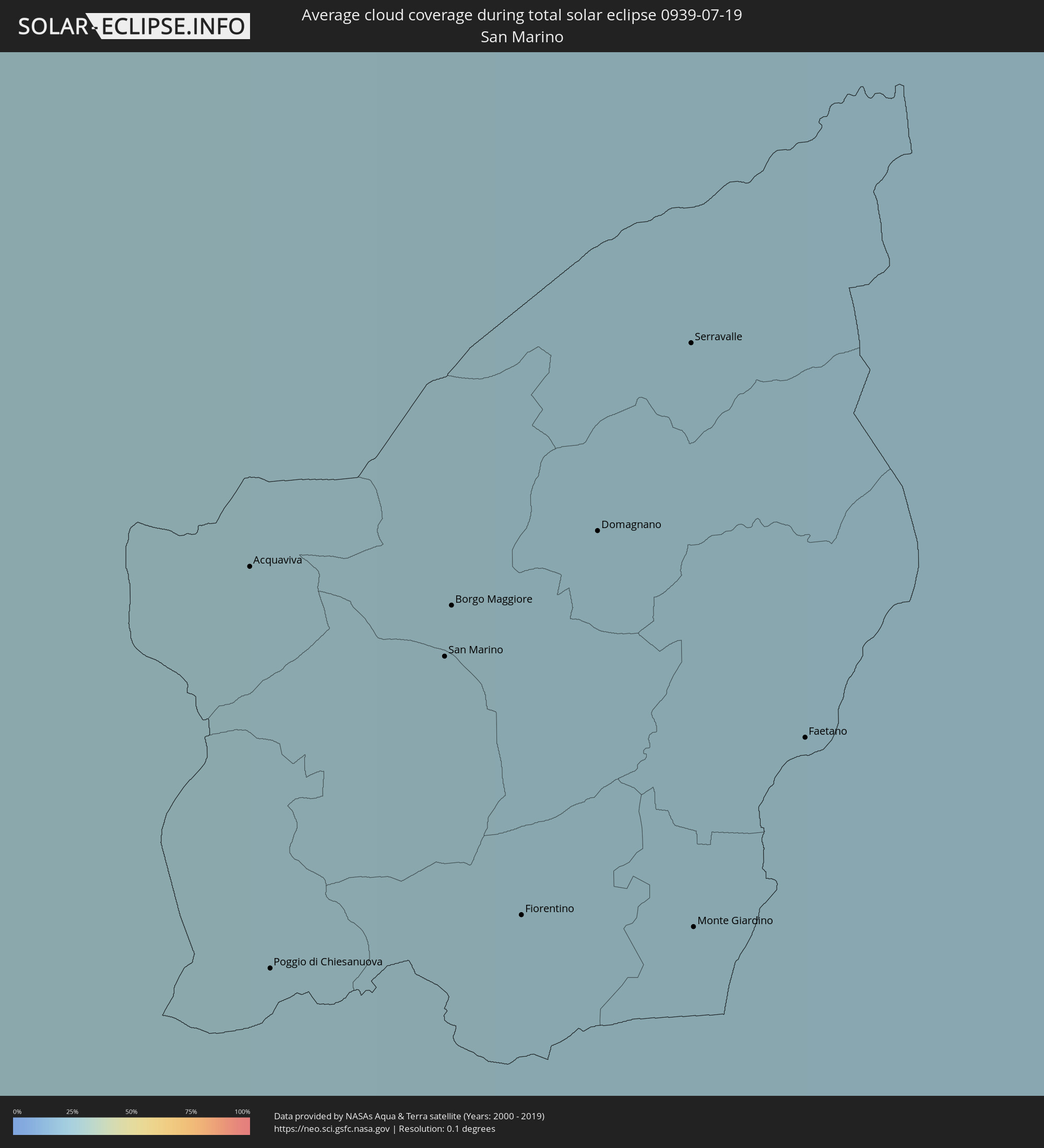 San Marino
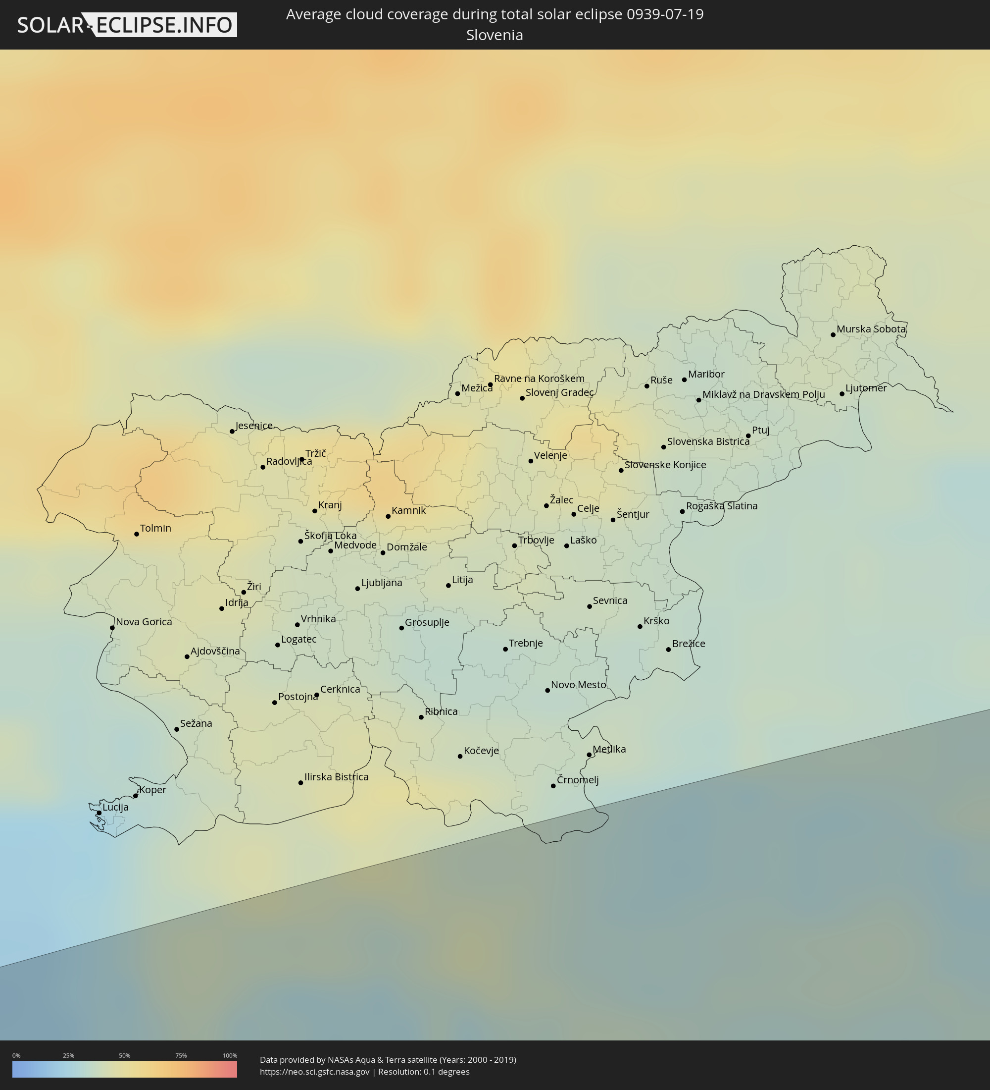 Slovenia
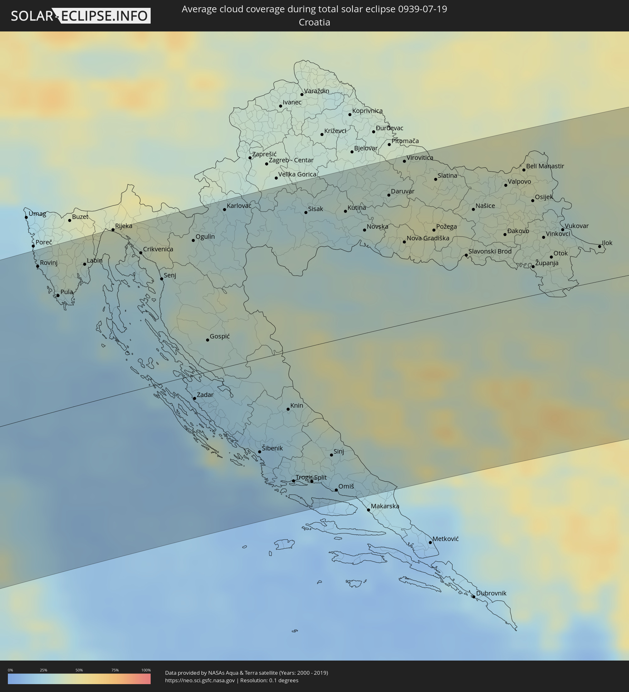 Croatia
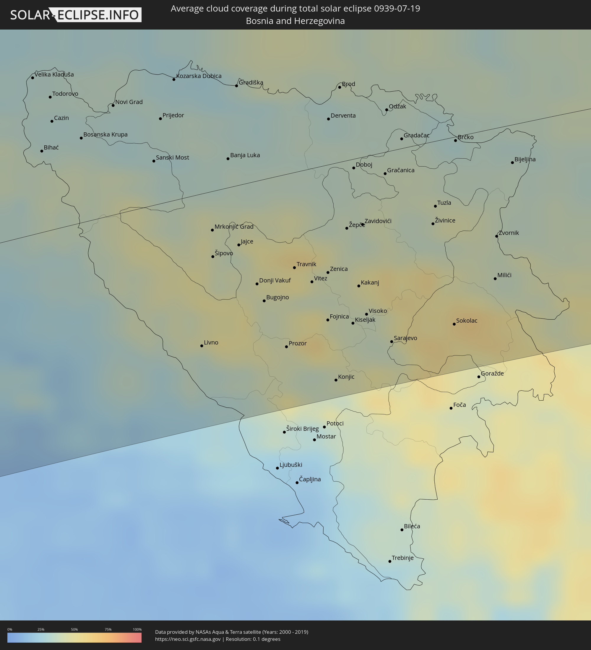 Bosnia and Herzegovina
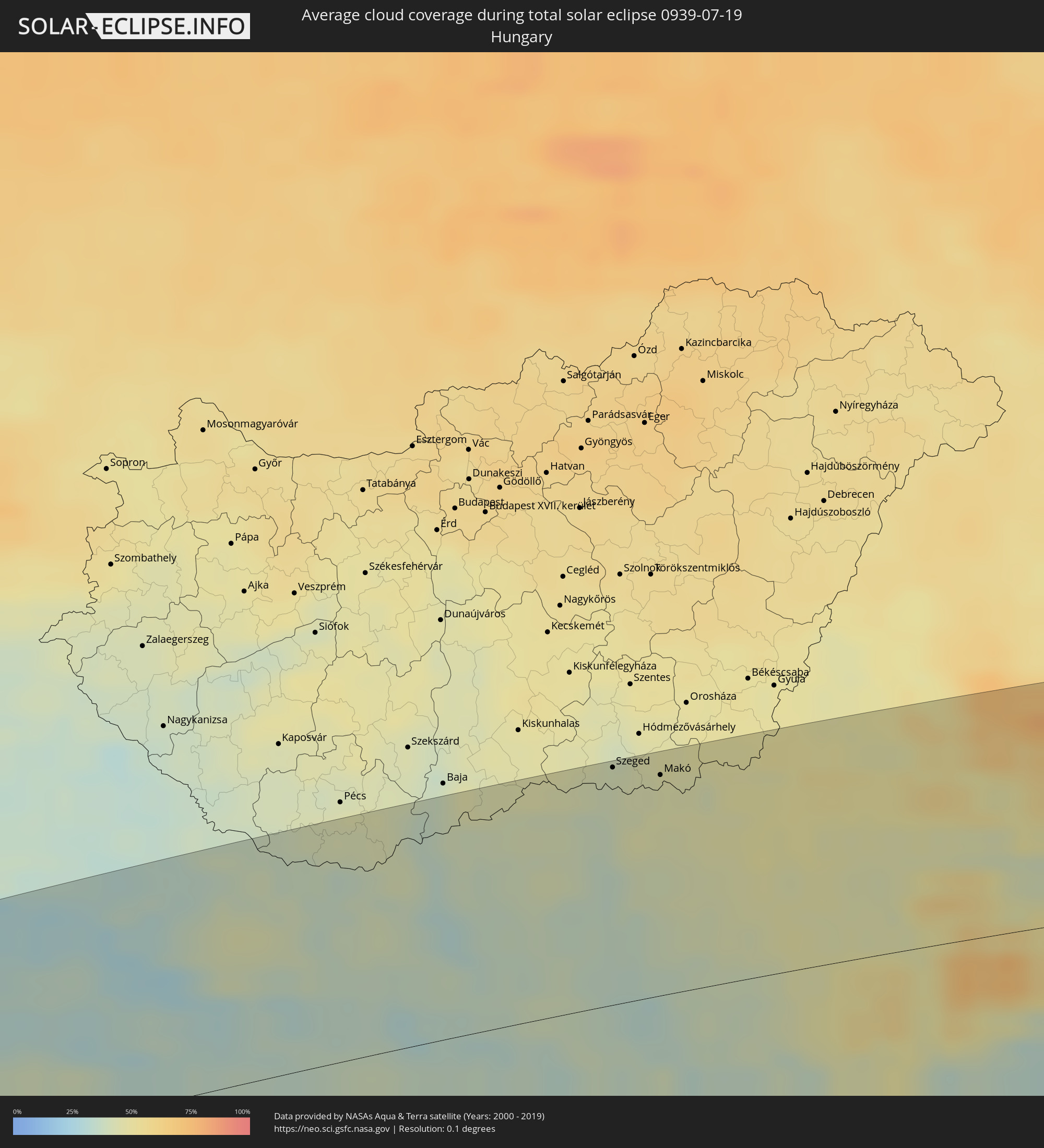 Hungary
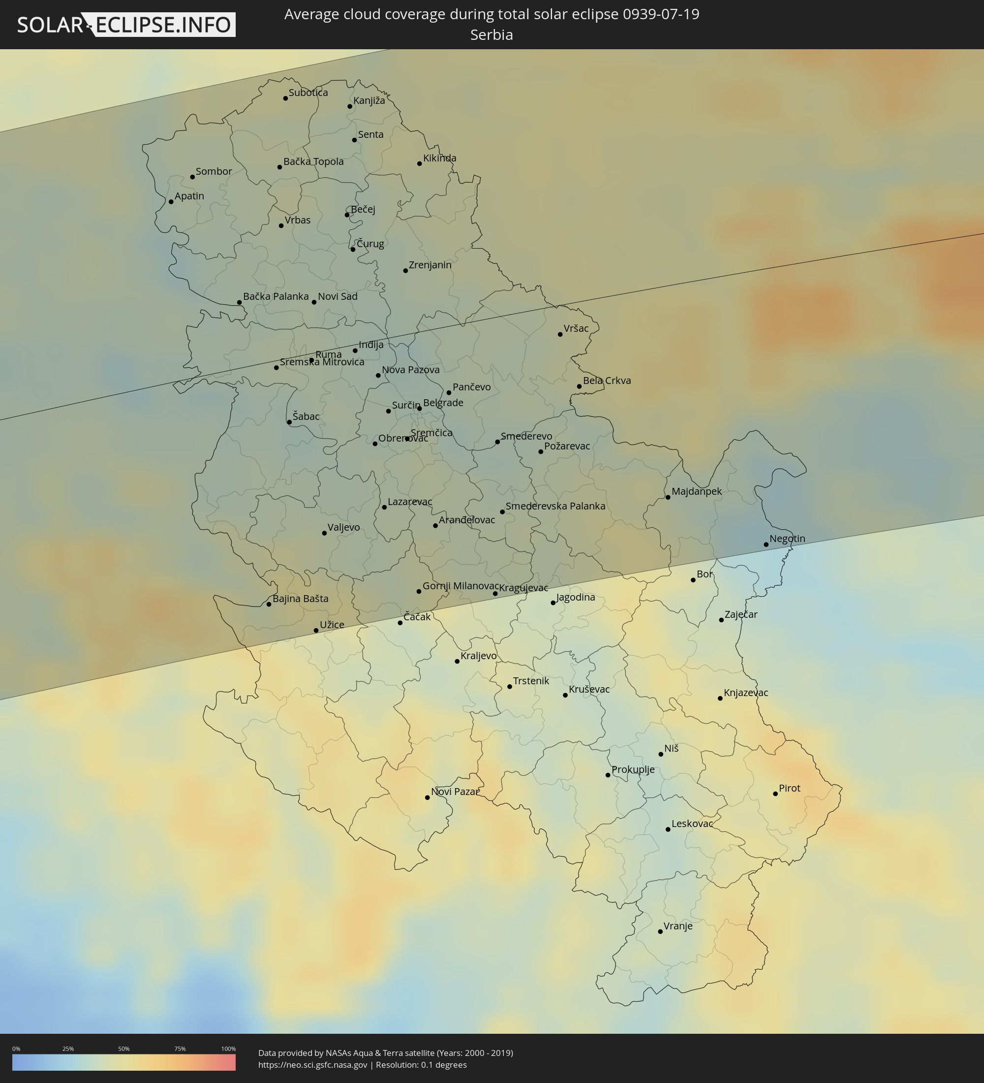 Serbia
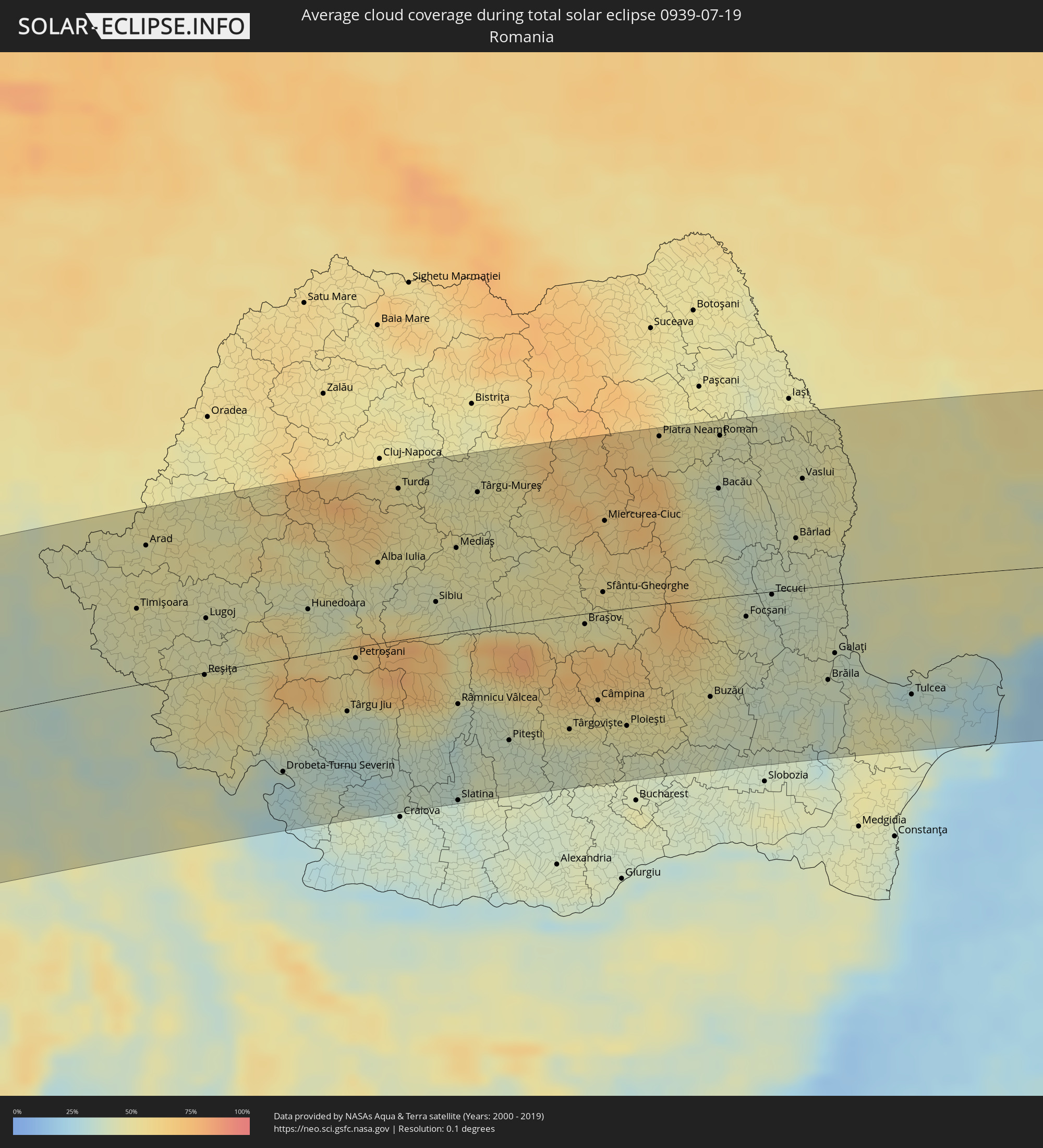 Romania
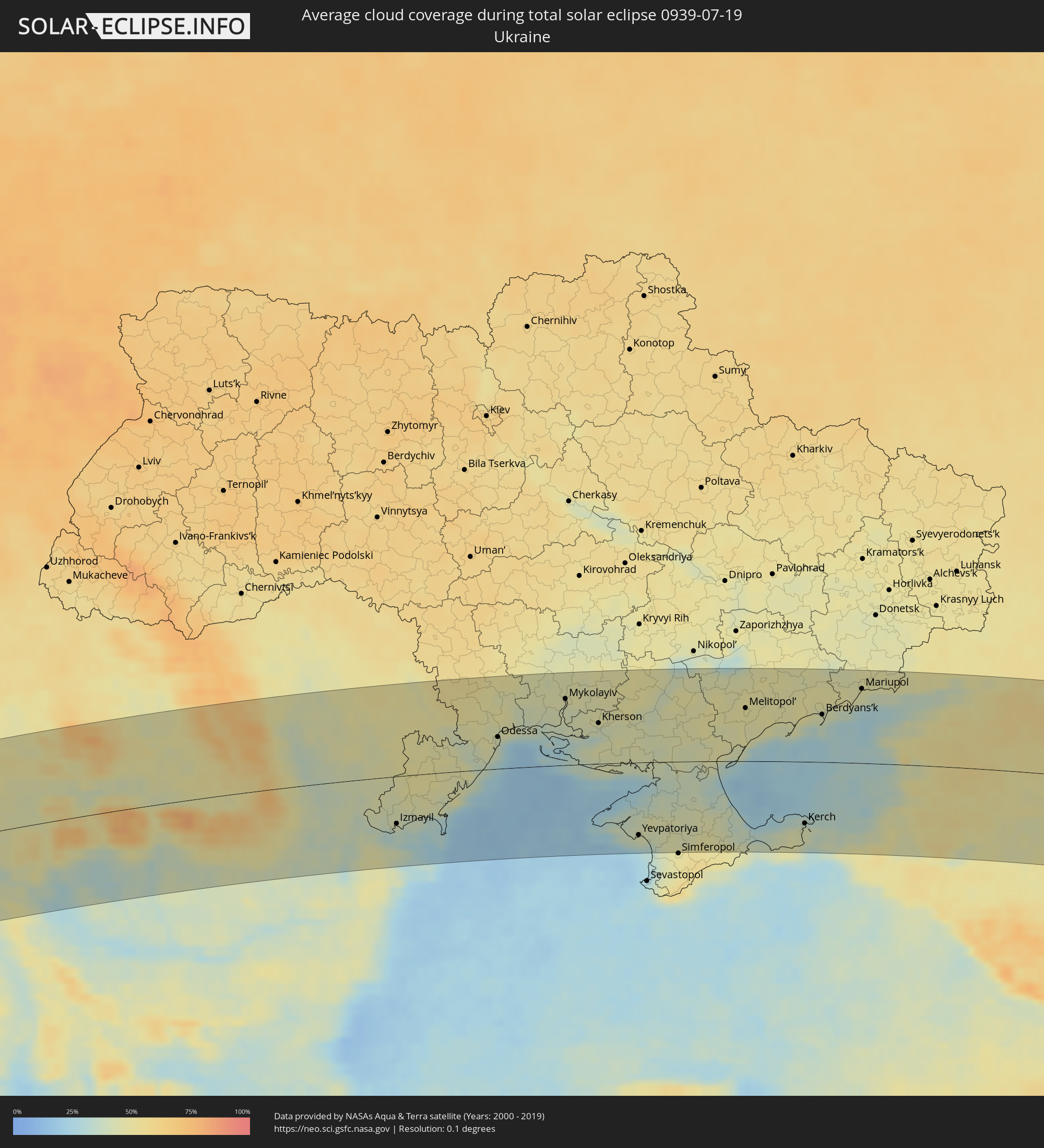 Ukraine
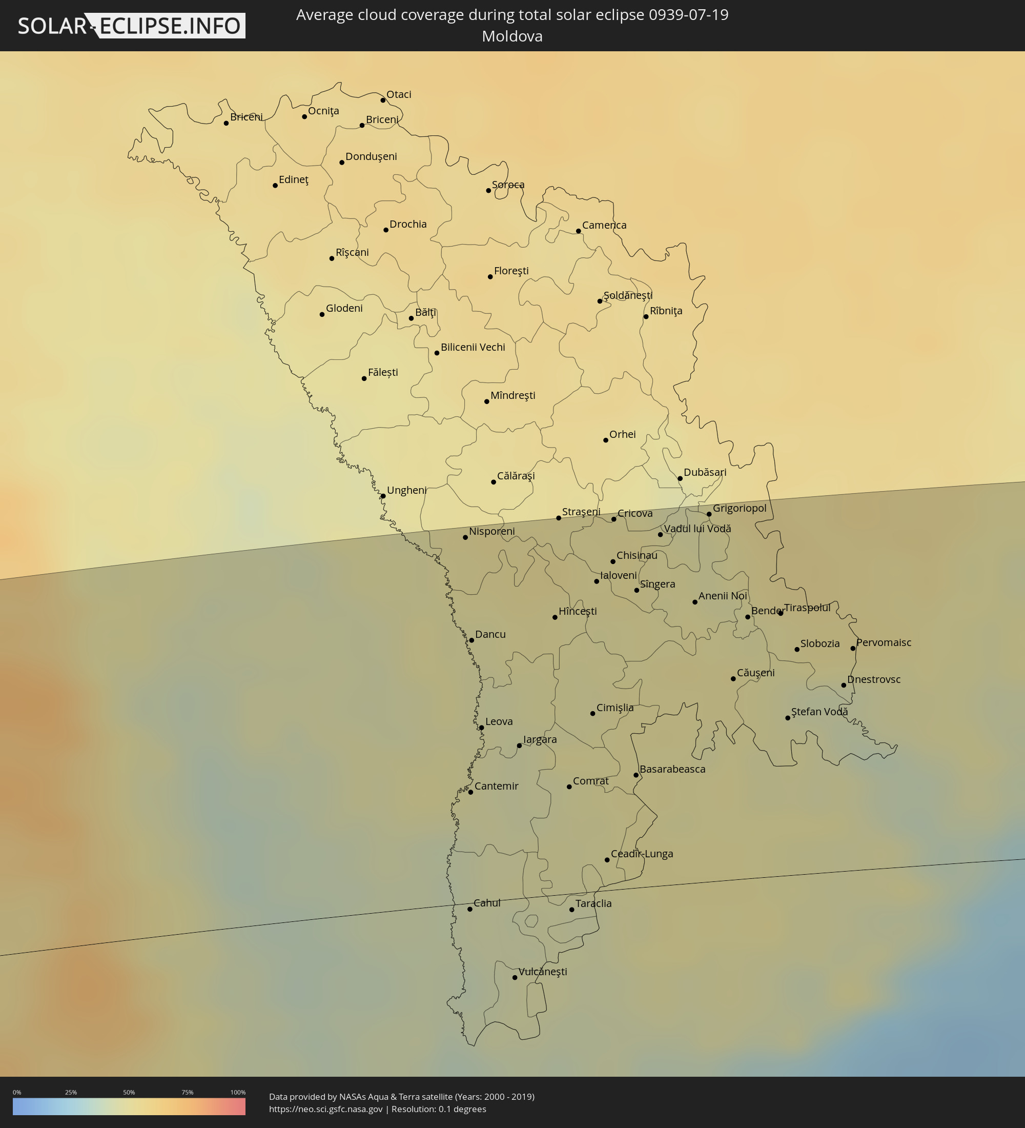 Moldova
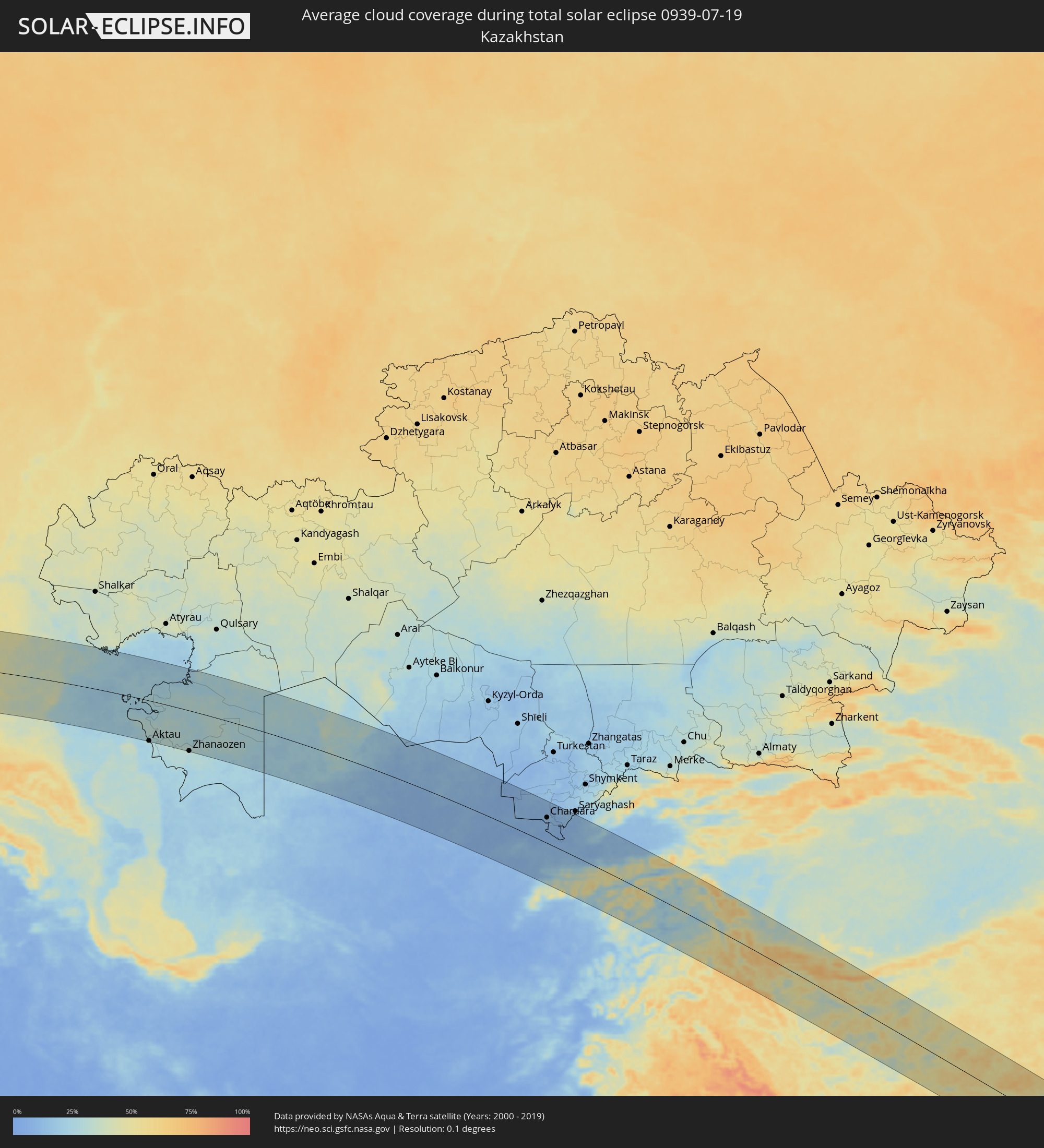 Kazakhstan
 Turkmenistan
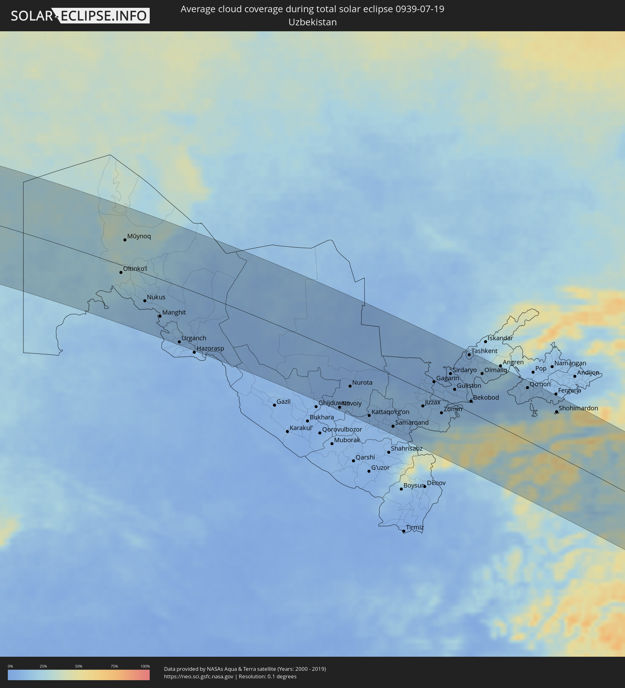 Uzbekistan
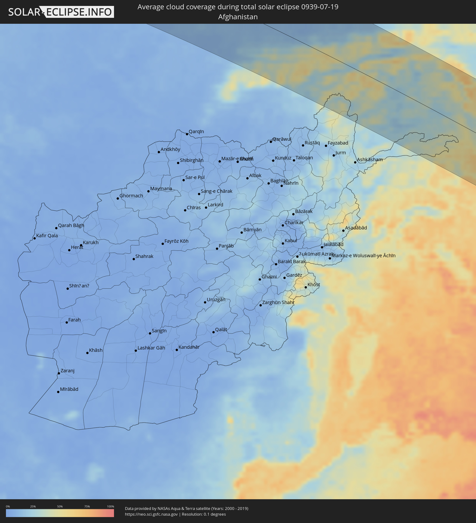 Afghanistan
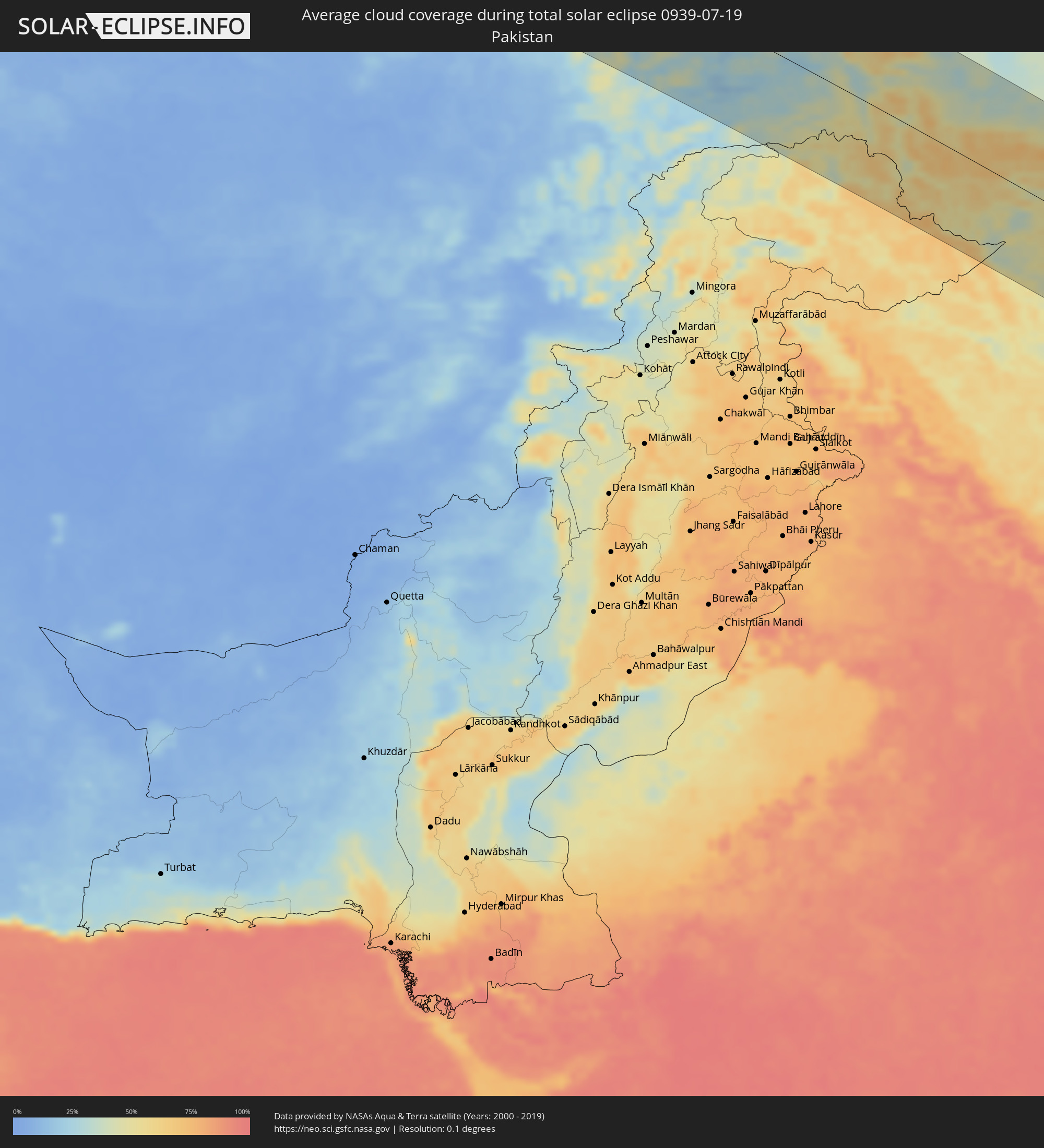 Pakistan
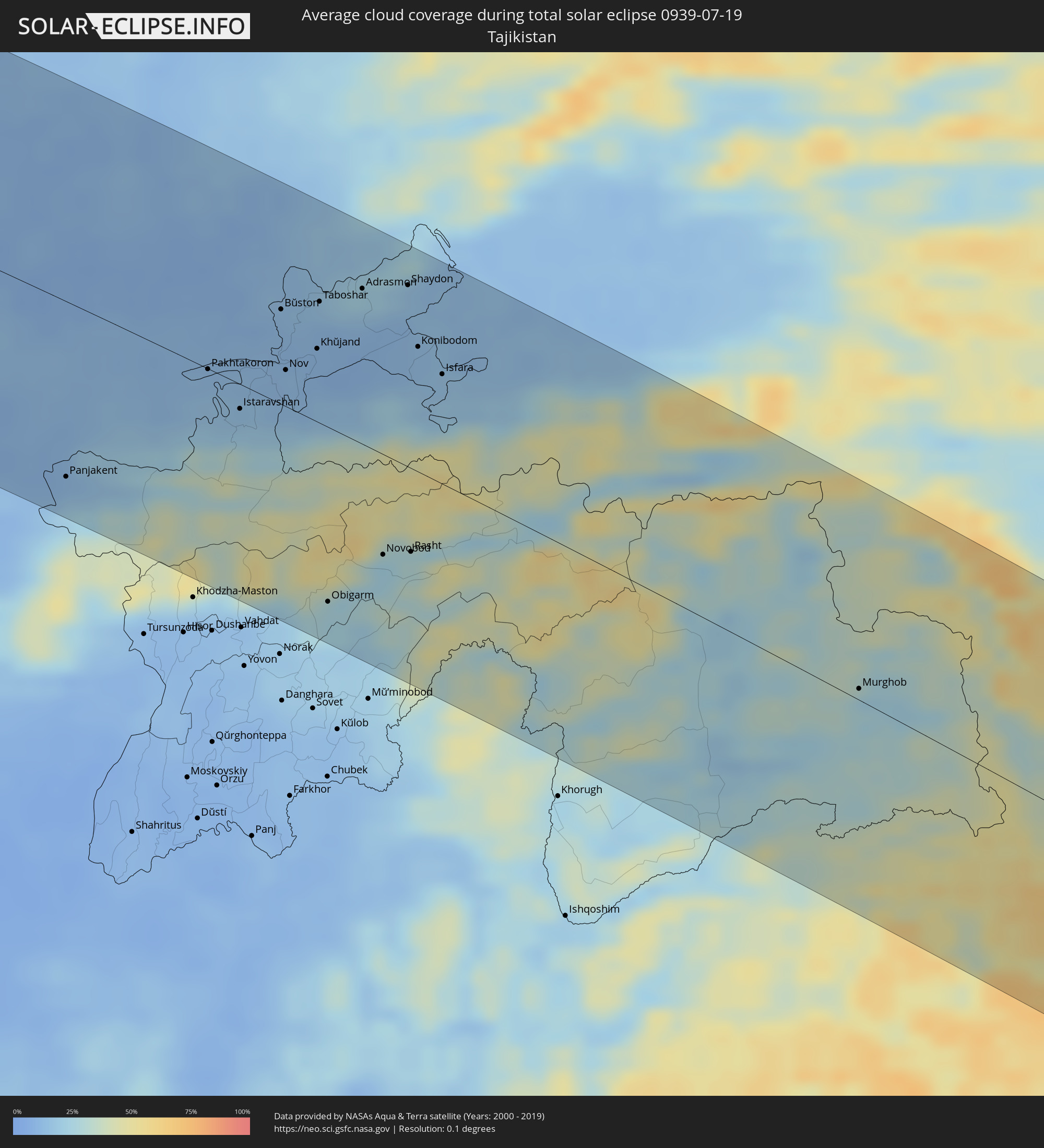 Tajikistan
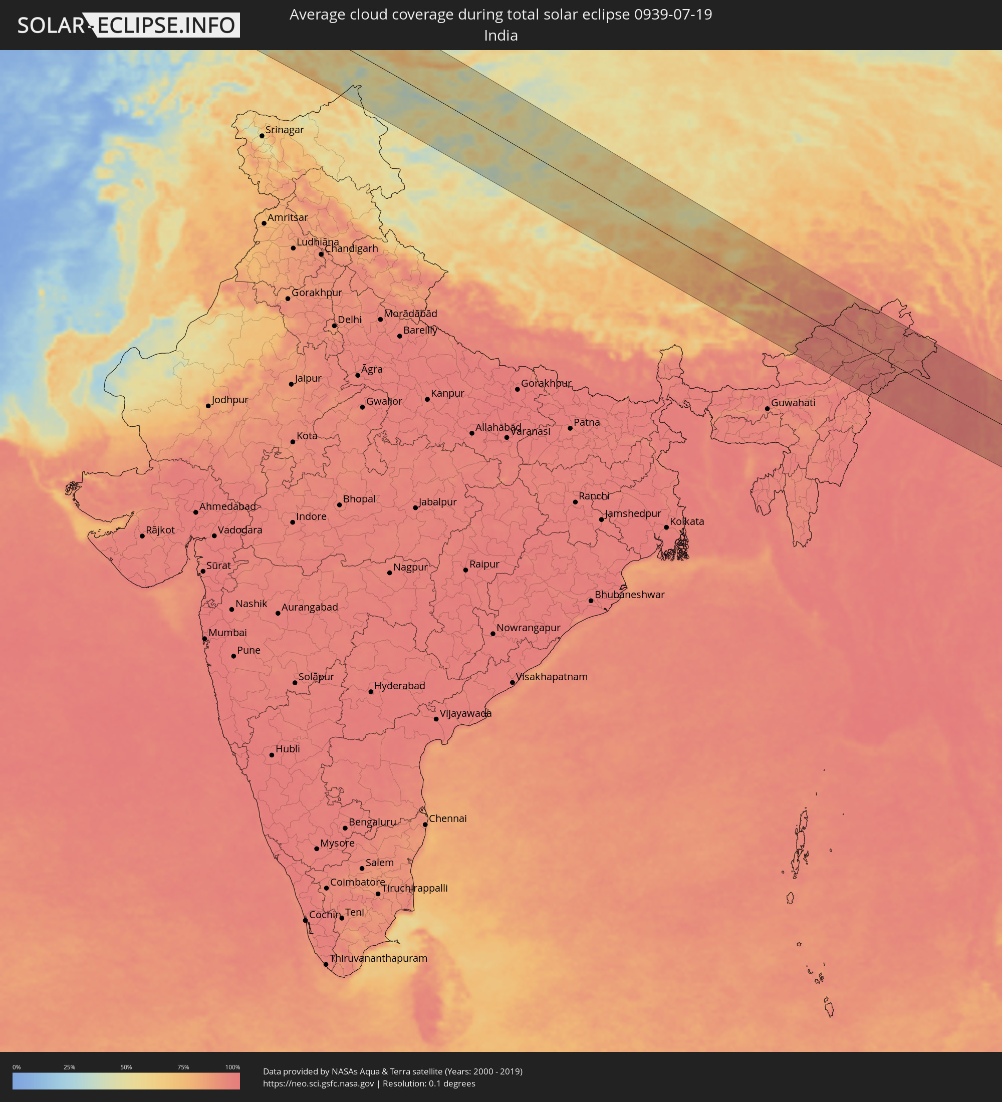 India
India
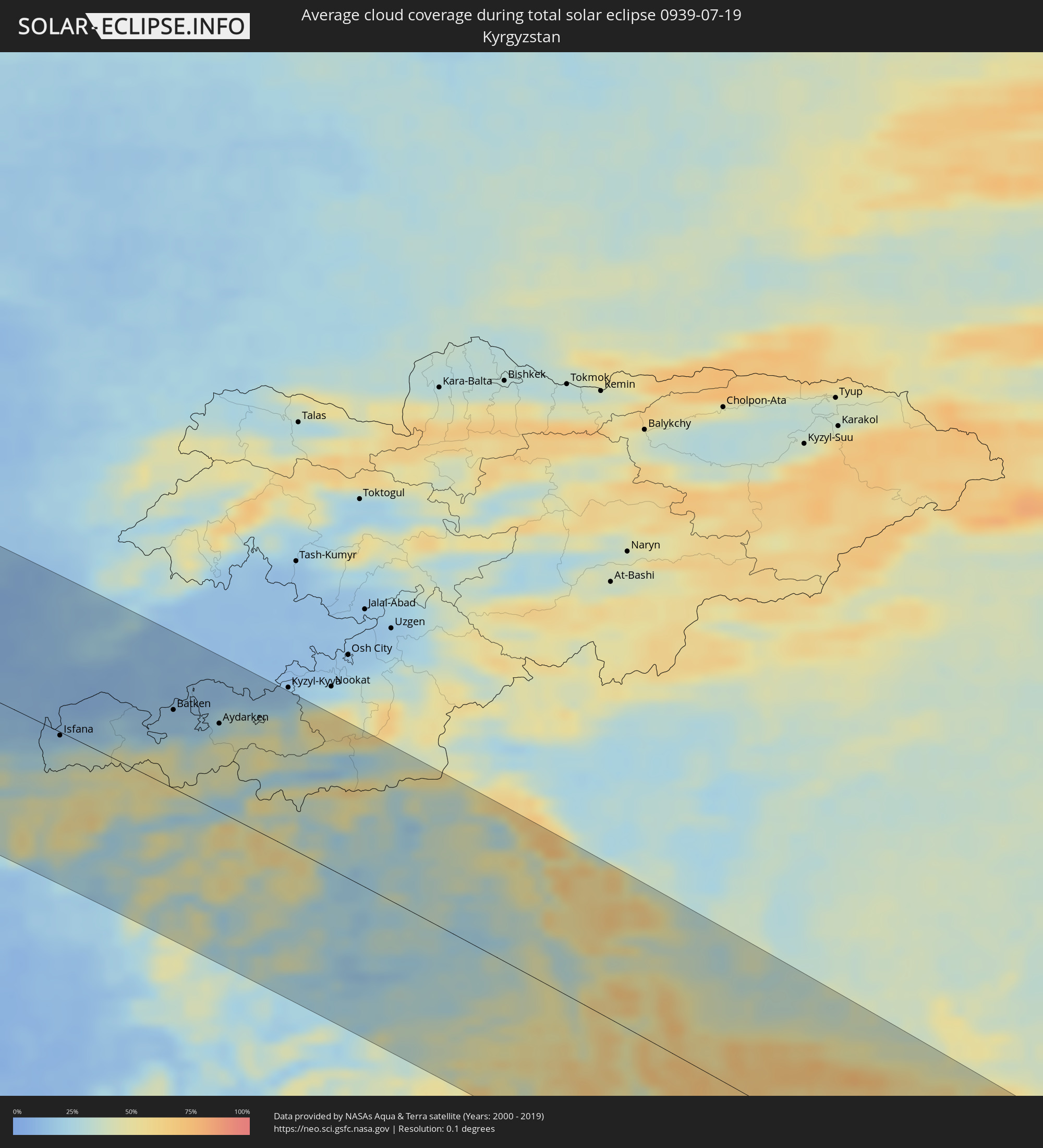 Kyrgyzstan
 China
China
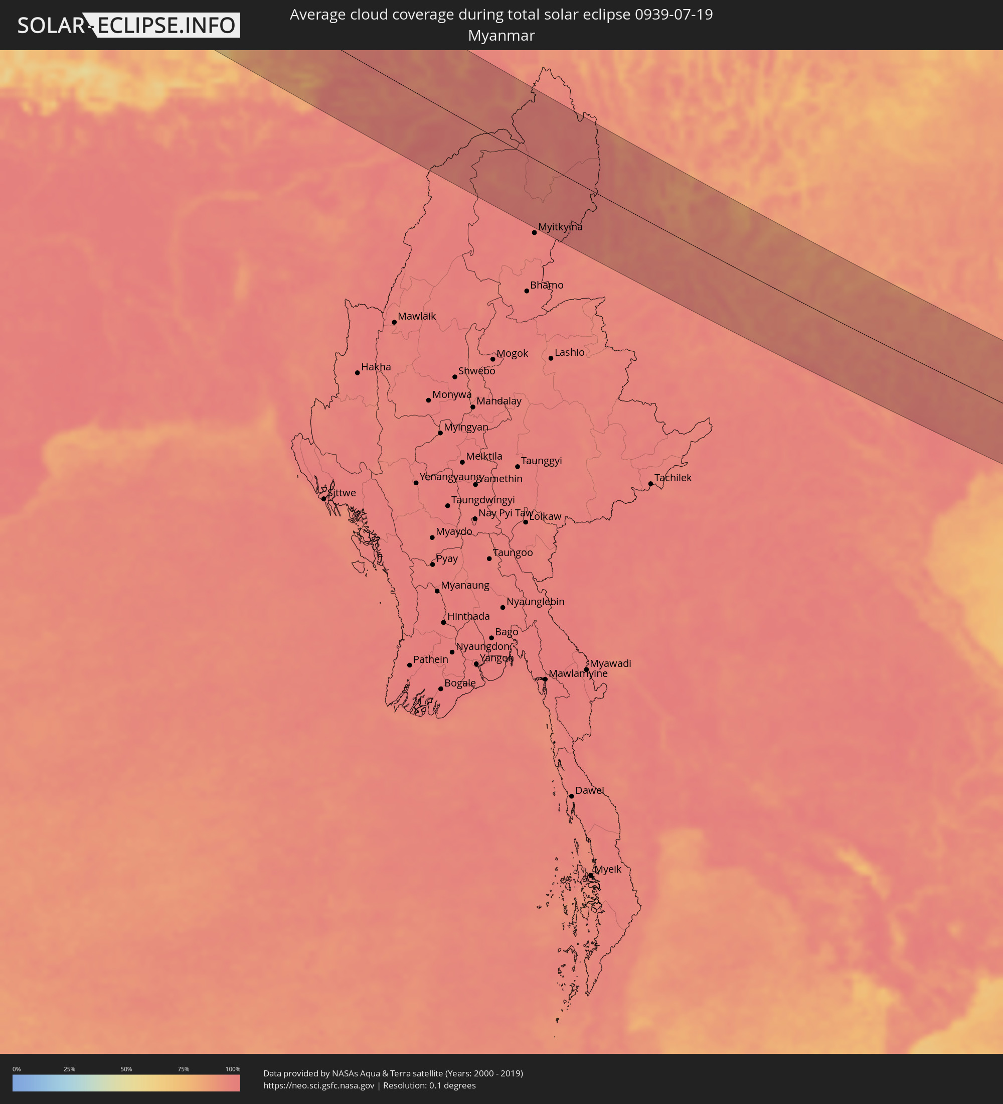 Myanmar
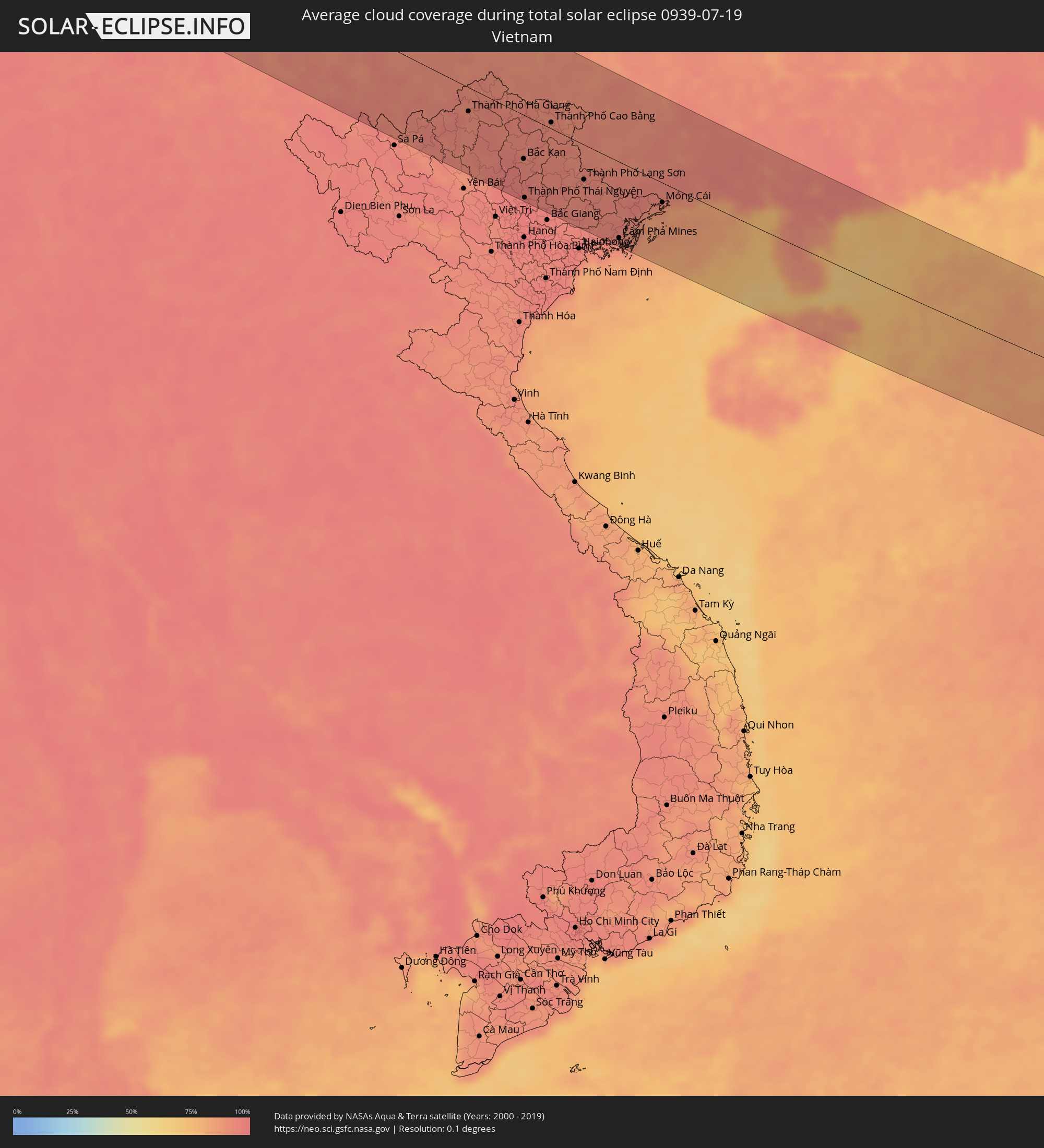 Vietnam
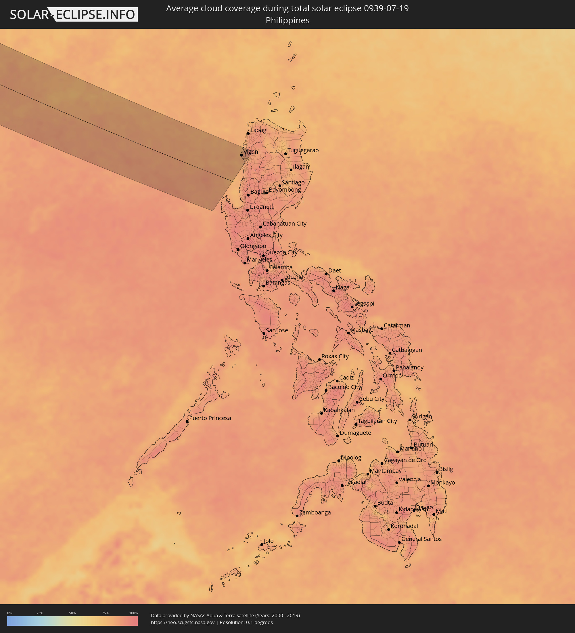 Philippines
Cities inside the path of the eclipse
The following table shows all locations with a population of more than 5,000 inside the eclipse path. Cities which have more than 100,000 inhabitants are marked bold. A click at the locations opens a detailed map.
| City | Type | Eclipse duration | Local time of max. eclipse | Distance to central line | Ø Cloud coverage |
|
Cacém, Lisbon
|
total | - | 06:55:06 UTC-00:36 | 114 km | 25% |
|
Lisbon, Lisbon
|
total | - | 06:55:06 UTC-00:36 | 103 km | 20% |
|
Sesimbra, Setúbal
|
total | - | 06:54:47 UTC-00:36 | 75 km | 38% |
|
Póvoa de Santa Iria, Lisbon
|
total | - | 06:55:18 UTC-00:36 | 116 km | 25% |
|
Setúbal, Setúbal
|
total | - | 06:54:57 UTC-00:36 | 75 km | 30% |
|
Portimão, Faro
|
total | - | 06:53:27 UTC-00:36 | 79 km | 23% |
|
Faro, Faro
|
total | - | 06:53:31 UTC-00:36 | 112 km | 30% |
|
Évora, Évora
|
total | - | 06:55:21 UTC-00:36 | 46 km | 12% |
|
Beja, Beja
|
total | - | 06:54:43 UTC-00:36 | 12 km | 10% |
|
Huelva, Andalusia
|
total | - | 07:30:57 UTC+00:00 | 121 km | 13% |
|
Móstoles, Madrid
|
total | - | 07:36:01 UTC+00:00 | 91 km | 14% |
|
Madrid, Madrid
|
total | - | 07:36:13 UTC+00:00 | 95 km | 14% |
|
Alcalá de Henares, Madrid
|
total | - | 07:36:29 UTC+00:00 | 91 km | 16% |
|
Albacete, Castille-La Mancha
|
total | - | 07:35:30 UTC+00:00 | 111 km | 12% |
|
Valencia, Valencia
|
total | - | 07:36:58 UTC+00:00 | 108 km | 23% |
|
Castelló de la Plana, Valencia
|
total | - | 07:37:48 UTC+00:00 | 64 km | 33% |
|
Terrassa, Catalonia
|
total | - | 07:41:08 UTC+00:00 | 38 km | 31% |
|
Barcelona, Catalonia
|
total | - | 07:41:01 UTC+00:00 | 15 km | 31% |
|
Marseille, Provence-Alpes-Côte d'Azur
|
total | - | 07:55:12 UTC+00:09 | 125 km | 31% |
|
Aubagne, Provence-Alpes-Côte d'Azur
|
total | - | 07:55:21 UTC+00:09 | 119 km | 22% |
|
Toulon, Provence-Alpes-Côte d'Azur
|
total | - | 07:55:26 UTC+00:09 | 91 km | 34% |
|
Hyères, Provence-Alpes-Côte d'Azur
|
total | - | 07:55:37 UTC+00:09 | 86 km | 33% |
|
Fréjus, Provence-Alpes-Côte d'Azur
|
total | - | 07:56:30 UTC+00:09 | 103 km | 28% |
|
Grasse, Provence-Alpes-Côte d'Azur
|
total | - | 07:56:57 UTC+00:09 | 123 km | 34% |
|
Antibes, Provence-Alpes-Côte d'Azur
|
total | - | 07:57:00 UTC+00:09 | 107 km | 34% |
|
Nice, Provence-Alpes-Côte d'Azur
|
total | - | 07:57:18 UTC+00:09 | 118 km | 32% |
|
Monaco
|
total | - | 07:57:28 UTC+00:09 | 117 km | 31% |
|
La Condamine
|
total | - | 07:57:28 UTC+00:09 | 117 km | 31% |
|
Monte-Carlo
|
total | - | 07:57:29 UTC+00:09 | 118 km | 31% |
|
Ajaccio, Corsica
|
total | - | 07:56:31 UTC+00:09 | 107 km | 21% |
|
Livorno, Tuscany
|
total | - | 08:50:38 UTC+01:00 | 26 km | 19% |
|
Modena, Emilia-Romagna
|
total | - | 08:52:31 UTC+01:00 | 130 km | 25% |
|
Prato, Tuscany
|
total | - | 08:51:48 UTC+01:00 | 44 km | 26% |
|
Florence, Tuscany
|
total | - | 08:51:50 UTC+01:00 | 30 km | 25% |
|
Bologna, Emilia-Romagna
|
total | - | 08:52:45 UTC+01:00 | 104 km | 25% |
|
Forlì, Emilia-Romagna
|
total | - | 08:53:10 UTC+01:00 | 59 km | 27% |
|
Perugia, Umbria
|
total | - | 08:52:16 UTC+01:00 | 67 km | 23% |
|
Acquaviva, Acquaviva
|
total | - | 08:53:15 UTC+01:00 | 21 km | 32% |
|
Poggio di Chiesanuova, Chiesanuova
|
total | - | 08:53:12 UTC+01:00 | 17 km | 32% |
|
San Marino, San Marino
|
total | - | 08:53:16 UTC+01:00 | 20 km | 32% |
|
Borgo Maggiore, Borgo Maggiore
|
total | - | 08:53:16 UTC+01:00 | 20 km | 32% |
|
Fiorentino, Fiorentino
|
total | - | 08:53:15 UTC+01:00 | 17 km | 29% |
|
Domagnano, Domagnano
|
total | - | 08:53:18 UTC+01:00 | 21 km | 29% |
|
Serravalle, Serravalle
|
total | - | 08:53:21 UTC+01:00 | 22 km | 27% |
|
Monte Giardino, Montegiardino
|
total | - | 08:53:16 UTC+01:00 | 16 km | 29% |
|
Faetano, Faetano
|
total | - | 08:53:19 UTC+01:00 | 18 km | 29% |
|
Rimini, Emilia-Romagna
|
total | - | 08:53:32 UTC+01:00 | 30 km | 24% |
|
Ancona, The Marches
|
total | - | 08:54:02 UTC+01:00 | 40 km | 22% |
|
Pula, Istarska
|
total | - | 08:55:50 UTC+01:00 | 90 km | 29% |
|
Rijeka, Primorsko-Goranska
|
total | - | 08:56:59 UTC+01:00 | 130 km | 36% |
|
Zadar, Zadarska
|
total | - | 08:56:36 UTC+01:00 | 19 km | 22% |
|
Karlovac, Karlovačka
|
total | - | 08:58:25 UTC+01:00 | 123 km | 29% |
|
Bihać, Federation of Bosnia and Herzegovina
|
total | - | 08:58:05 UTC+01:00 | 44 km | 39% |
|
Šibenik, Šibensko-Kniniska
|
total | - | 08:56:57 UTC+01:00 | 74 km | 27% |
|
Sisak, Sisačko-Moslavačka
|
total | - | 08:59:22 UTC+01:00 | 105 km | 30% |
|
Split, Splitsko-Dalmatinska
|
total | - | 08:57:22 UTC+01:00 | 108 km | 22% |
|
Prijedor, Republic of Srspka
|
total | - | 08:59:15 UTC+01:00 | 46 km | 32% |
|
Banja Luka, Republic of Srspka
|
total | - | 08:59:37 UTC+01:00 | 16 km | 35% |
|
Bugojno, Federation of Bosnia and Herzegovina
|
total | - | 08:59:11 UTC+01:00 | 67 km | 40% |
|
Zenica, Federation of Bosnia and Herzegovina
|
total | - | 08:59:54 UTC+01:00 | 60 km | 39% |
|
Slavonski Brod, Slavonski Brod-Posavina
|
total | - | 09:01:01 UTC+01:00 | 43 km | 34% |
|
Siklós, Baranya
|
total | - | 09:02:05 UTC+01:00 | 113 km | 40% |
|
Sarajevo, Federation of Bosnia and Herzegovina
|
total | - | 09:00:08 UTC+01:00 | 106 km | 45% |
|
Tuzla, Federation of Bosnia and Herzegovina
|
total | - | 09:01:13 UTC+01:00 | 36 km | 37% |
|
Mohács, Baranya
|
total | - | 09:02:41 UTC+01:00 | 122 km | 38% |
|
Osijek, Osječko-Baranjska
|
total | - | 09:02:16 UTC+01:00 | 74 km | 38% |
|
Brčko, Brčko
|
total | - | 09:01:44 UTC+01:00 | 2 km | 34% |
|
Bijeljina, Republic of Srspka
|
total | - | 09:02:08 UTC+01:00 | 21 km | 36% |
|
Bácsalmás, Bács-Kiskun
|
total | - | 09:03:38 UTC+01:00 | 126 km | 43% |
|
Subotica, Vojvodina
|
total | - | 09:04:02 UTC+01:00 | 118 km | 41% |
|
Novi Sad, Vojvodina
|
total | - | 09:03:26 UTC+01:00 | 23 km | 39% |
|
Užice, Central Serbia
|
total | - | 09:02:06 UTC+01:00 | 129 km | 44% |
|
Mórahalom, Csongrád
|
total | - | 09:04:25 UTC+01:00 | 128 km | 43% |
|
Valjevo, Central Serbia
|
total | - | 09:02:34 UTC+01:00 | 85 km | 41% |
|
Szeged, Csongrád
|
total | - | 09:04:47 UTC+01:00 | 127 km | 41% |
|
Zrenjanin, Vojvodina
|
total | - | 09:04:16 UTC+01:00 | 29 km | 38% |
|
Belgrade, Central Serbia
|
total | - | 09:03:50 UTC+01:00 | 36 km | 40% |
|
Makó, Csongrád
|
total | - | 09:05:11 UTC+01:00 | 118 km | 45% |
|
Pančevo, Vojvodina
|
total | - | 09:04:07 UTC+01:00 | 31 km | 35% |
|
Mezőhegyes, Bekes
|
total | - | 09:05:43 UTC+01:00 | 125 km | 45% |
|
Kragujevac, Central Serbia
|
total | - | 09:03:42 UTC+01:00 | 129 km | 43% |
|
Smederevo, Central Serbia
|
total | - | 09:04:19 UTC+01:00 | 58 km | 34% |
|
Battonya, Bekes
|
total | - | 09:05:57 UTC+01:00 | 118 km | 47% |
|
Timişoara, Timiş
|
total | - | 09:50:08 UTC+01:44 | 57 km | 47% |
|
Arad, Arad
|
total | - | 09:50:39 UTC+01:44 | 103 km | 49% |
|
Sibiu, Sibiu
|
total | - | 09:54:12 UTC+01:44 | 25 km | 45% |
|
Piteşti, Argeş
|
total | - | 09:54:28 UTC+01:44 | 88 km | 38% |
|
Braşov, Braşov
|
total | - | 09:56:11 UTC+01:44 | 8 km | 66% |
|
Ploieşti, Prahova
|
total | - | 09:56:16 UTC+01:44 | 89 km | 48% |
|
Bacău, Bacău
|
total | - | 09:58:47 UTC+01:44 | 81 km | 40% |
|
Brăila, Brăila
|
total | - | 09:59:31 UTC+01:44 | 71 km | 39% |
|
Galaţi, Galaţi
|
total | - | 09:59:44 UTC+01:44 | 52 km | 37% |
|
Cahul, Cahul
|
total | - | 10:10:52 UTC+01:55 | 2 km | 42% |
|
Vulcăneşti, Găgăuzia
|
total | - | 10:11:03 UTC+01:55 | 28 km | 45% |
|
Hînceşti, Hînceşti
|
total | - | 10:12:04 UTC+01:55 | 97 km | 48% |
|
Straşeni, Strășeni
|
total | - | 10:12:18 UTC+01:55 | 132 km | 53% |
|
Comrat, Găgăuzia
|
total | - | 10:11:50 UTC+01:55 | 38 km | 48% |
|
Ceadîr-Lunga, Găgăuzia
|
total | - | 10:11:57 UTC+01:55 | 11 km | 47% |
|
Izmayil, Odessa
|
total | - | 10:18:35 UTC+02:02 | 68 km | 33% |
|
Chisinau, Chişinău
|
total | - | 10:12:35 UTC+01:55 | 115 km | 51% |
|
Căuşeni, Căuşeni
|
total | - | 10:13:12 UTC+01:55 | 71 km | 48% |
|
Tiraspolul, Stînga Nistrului
|
total | - | 10:13:39 UTC+01:55 | 92 km | 48% |
|
Odessa, Odessa
|
total | - | 10:22:14 UTC+02:02 | 46 km | 44% |
|
Mykolayiv, Mykolaiv
|
total | - | 10:24:29 UTC+02:02 | 95 km | 42% |
|
Kherson, Kherson
|
total | - | 10:25:19 UTC+02:02 | 58 km | 42% |
|
Yevpatoriya, Republic of Crimea
|
total | - | 10:39:51 UTC+02:16 | 105 km | 37% |
|
Melitopol’, Zaporizhia
|
total | - | 10:29:53 UTC+02:02 | 76 km | 48% |
|
Kerch, Republic of Crimea
|
total | - | 10:45:16 UTC+02:16 | 90 km | 44% |
|
Berdyans’k, Zaporizhia
|
total | - | 10:32:15 UTC+02:02 | 68 km | 42% |
|
Mariupol, Donetsk
|
total | - | 10:33:34 UTC+02:02 | 106 km | 46% |
|
Yeysk, Krasnodarskiy
|
total | - | 11:02:57 UTC+02:30 | 65 km | 42% |
|
Taganrog, Rostov Oblast
|
total | - | 11:04:05 UTC+02:30 | 126 km | 41% |
|
Krasnodar, Krasnodarskiy
|
total | - | 11:03:56 UTC+02:30 | 117 km | 48% |
|
Azov, Rostov Oblast
|
total | - | 11:04:57 UTC+02:30 | 114 km | 43% |
|
Rostov-na-Donu, Rostov Oblast
|
total | - | 11:05:29 UTC+02:30 | 129 km | 47% |
|
Armavir, Krasnodarskiy
|
total | - | 11:07:50 UTC+02:30 | 111 km | 50% |
|
Stavropol’, Stavropol'skiy
|
total | - | 11:09:23 UTC+02:30 | 99 km | 49% |
|
Elista, Kalmykiya
|
total | - | 11:13:22 UTC+02:30 | 61 km | 49% |
|
Astrakhan, Astrakhan
|
total | - | 12:10:05 UTC+03:20 | 111 km | 31% |
|
Aktau, Mangghystaū
|
total | - | 12:22:07 UTC+03:25 | 132 km | 26% |
|
Zhetibay, Mangghystaū
|
total | - | 12:23:52 UTC+03:25 | 120 km | 30% |
|
Shetpe, Mangghystaū
|
total | - | 12:23:34 UTC+03:25 | 58 km | 30% |
|
Zhanaozen, Mangghystaū
|
total | - | 12:25:30 UTC+03:25 | 132 km | 28% |
|
Beyneu, Mangghystaū
|
total | - | 12:28:16 UTC+03:25 | 130 km | 28% |
|
Köneürgench, Daşoguz
|
total | - | 13:05:58 UTC+03:53 | 88 km | 15% |
|
Akdepe
|
total | - | 13:06:38 UTC+03:53 | 111 km | 13% |
|
Nukus, Karakalpakstan
|
total | - | 13:41:00 UTC+04:27 | 63 km | 15% |
|
Yylanly, Daşoguz
|
total | - | 13:07:21 UTC+03:53 | 126 km | 13% |
|
Boldumsaz, Daşoguz
|
total | - | 13:07:05 UTC+03:53 | 95 km | 13% |
|
Daşoguz, Daşoguz
|
total | - | 13:07:54 UTC+03:53 | 117 km | 13% |
|
Urganch, Xorazm
|
total | - | 13:43:44 UTC+04:27 | 128 km | 11% |
|
Navoiy, Navoiy
|
total | - | 13:53:32 UTC+04:27 | 128 km | 8% |
|
Samarqand, Samarqand
|
total | - | 13:56:39 UTC+04:27 | 116 km | 10% |
|
Panjakent, Viloyati Sughd
|
total | - | 14:05:12 UTC+04:35 | 109 km | 12% |
|
Jizzax, Jizzax
|
total | - | 13:57:26 UTC+04:27 | 38 km | 12% |
|
Chardara, Ongtüstik Qazaqstan
|
total | - | 13:50:06 UTC+04:21 | 82 km | 12% |
|
Asyqata, Ongtüstik Qazaqstan
|
total | - | 13:51:11 UTC+04:21 | 60 km | 8% |
|
Atakent, Ongtüstik Qazaqstan
|
total | - | 13:51:27 UTC+04:21 | 60 km | 8% |
|
Slavyanka, Ongtüstik Qazaqstan
|
total | - | 13:51:46 UTC+04:21 | 43 km | 10% |
|
Istaravshan, Viloyati Sughd
|
total | - | 14:06:48 UTC+04:35 | 15 km | 17% |
|
Tashkent, Toshkent Shahri
|
total | - | 13:57:58 UTC+04:27 | 128 km | 11% |
|
Bekobod, Toshkent
|
total | - | 13:59:28 UTC+04:27 | 25 km | 12% |
|
Bŭston, Viloyati Sughd
|
total | - | 14:06:28 UTC+04:35 | 58 km | 12% |
|
Proletar, Viloyati Sughd
|
total | - | 14:07:12 UTC+04:35 | 29 km | 11% |
|
Isfana, Batken
|
total | - | 14:30:53 UTC+04:58 | 3 km | 24% |
|
Suluktu, Batken
|
total | - | 14:30:49 UTC+04:58 | 8 km | 18% |
|
Olmaliq, Toshkent
|
total | - | 13:59:06 UTC+04:27 | 100 km | 15% |
|
Khŭjand, Viloyati Sughd
|
total | - | 14:07:13 UTC+04:35 | 45 km | 11% |
|
Adrasmon, Viloyati Sughd
|
total | - | 14:07:15 UTC+04:35 | 95 km | 16% |
|
Shaydon, Viloyati Sughd
|
total | - | 14:07:45 UTC+04:35 | 111 km | 14% |
|
Konibodom, Viloyati Sughd
|
total | - | 14:08:23 UTC+04:35 | 76 km | 13% |
|
Isfara, Viloyati Sughd
|
total | - | 14:08:54 UTC+04:35 | 67 km | 14% |
|
Batken, Batken
|
total | - | 14:32:28 UTC+04:58 | 68 km | 15% |
|
Qo‘qon, Fergana
|
total | - | 14:01:28 UTC+04:27 | 119 km | 13% |
|
Aydarken, Batken
|
total | - | 14:33:23 UTC+04:58 | 77 km | 36% |
|
North Lakhimpur, Assam
|
total | - | 15:37:16 UTC+05:21 | 117 km | 95% |
|
Sibsāgar, Assam
|
total | - | 15:37:52 UTC+05:21 | 115 km | 96% |
|
Dibrugarh, Assam
|
total | - | 15:37:20 UTC+05:21 | 54 km | 95% |
|
Sonāri, Assam
|
total | - | 15:38:00 UTC+05:21 | 93 km | 94% |
|
Mon, Nagaland
|
total | - | 15:38:25 UTC+05:21 | 119 km | 94% |
|
Pāsighāt, Arunachal Pradesh
|
total | - | 15:36:45 UTC+05:21 | 23 km | 93% |
|
Tinsukia, Assam
|
total | - | 15:37:33 UTC+05:21 | 31 km | 97% |
|
Dum Duma, Assam
|
total | - | 15:37:32 UTC+05:21 | 14 km | 94% |
|
Margherita, Arunachal Pradesh
|
total | - | 15:37:58 UTC+05:21 | 36 km | 96% |
|
Kunming, Yunnan
|
total | - | 18:22:02 UTC+08:00 | 81 km | 86% |
|
Gejiu, Yunnan
|
total | - | 18:24:07 UTC+08:00 | 65 km | 92% |
|
Kaiyuan, Yunnan
|
total | - | 18:23:45 UTC+08:00 | 24 km | 90% |
|
Lào Cai, Lào Cai
|
total | - | 17:31:56 UTC+07:06 | 114 km | 91% |
|
Wenshan City, Yunnan
|
total | - | 18:24:18 UTC+08:00 | 14 km | 91% |
|
Thành Phố Hà Giang, Hà Giang
|
total | - | 17:31:41 UTC+07:06 | 34 km | 91% |
|
Thành Phố Tuyên Quang, Tuyên Quang
|
total | - | 17:32:50 UTC+07:06 | 123 km | 93% |
|
Bắc Kạn, Bắc Kạn
|
total | - | 17:32:32 UTC+07:06 | 62 km | 95% |
|
Thành Phố Thái Nguyên, Thái Nguyên
|
total | - | 17:33:09 UTC+07:06 | 117 km | 97% |
|
Thành Phố Cao Bằng, Cao Bằng
|
total | - | 17:32:00 UTC+07:06 | 9 km | 91% |
|
Thành Phố Lạng Sơn, Lạng Sơn
|
total | - | 17:32:56 UTC+07:06 | 50 km | 92% |
|
Cẩm Phả Mines, Quảng Ninh
|
total | - | 17:33:52 UTC+07:06 | 109 km | 91% |
|
Móng Cái, Quảng Ninh
|
total | - | 17:33:21 UTC+07:06 | 28 km | 88% |
|
Nanning, Guangxi Zhuang Autonomous Region
|
total | - | 18:25:17 UTC+08:00 | 117 km | 94% |
|
Beihai, Guangxi Zhuang Autonomous Region
|
total | - | 18:26:44 UTC+08:00 | 18 km | 87% |
|
Haikou, Hainan
|
total | - | 18:28:11 UTC+08:00 | 73 km | 87% |
|
Zhanjiang, Guangdong
|
total | - | 18:26:55 UTC+08:00 | 52 km | 93% |
|
Zhongshan, Guangdong
|
total | - | 18:26:52 UTC+08:00 | 66 km | 87% |
|
Vigan, Ilocos
|
total | - | 18:28:38 UTC+08:00 | 88 km | 81% |
|
Bantay, Ilocos
|
total | - | 18:28:38 UTC+08:00 | 89 km | 81% |
|
Cabugao, Ilocos
|
total | - | 18:28:26 UTC+08:00 | 113 km | 88% |