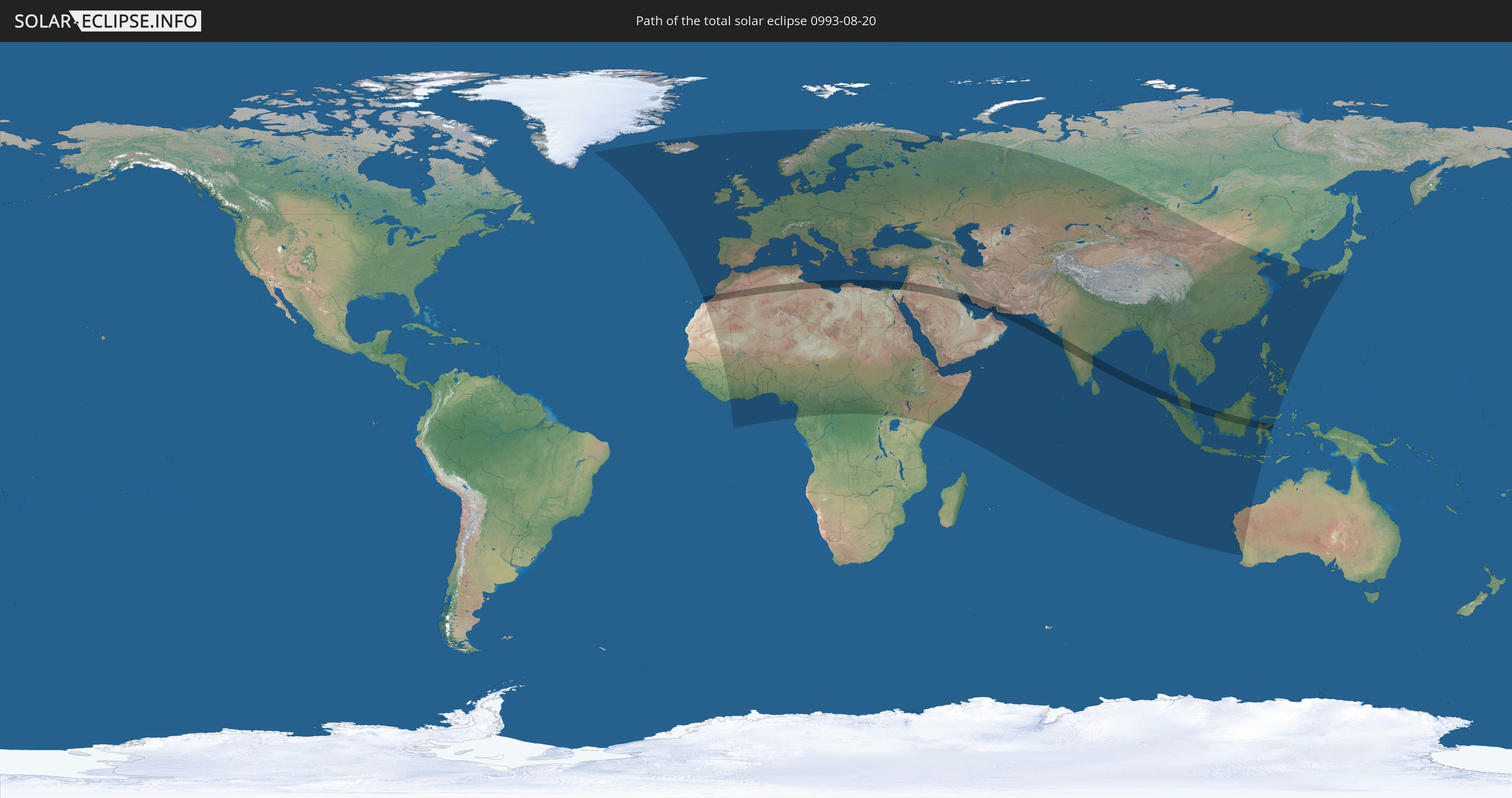
Total solar eclipse of 08/20/0993
| Day of week: | Tuesday |
| Maximum duration of eclipse: | 05m37s |
| Maximum width of eclipse path: | 220 km |
| Saros cycle: | 109 |
| Coverage: | 100% |
| Magnitude: | 1.0654 |
| Gamma: | 0.235 |
Wo kann man die Sonnenfinsternis vom 08/20/0993 sehen?
Die Sonnenfinsternis am 08/20/0993 kann man in 134 Ländern als partielle Sonnenfinsternis beobachten.
Der Finsternispfad verläuft durch 19 Länder. Nur in diesen Ländern ist sie als total Sonnenfinsternis zu sehen.
In den folgenden Ländern ist die Sonnenfinsternis total zu sehen
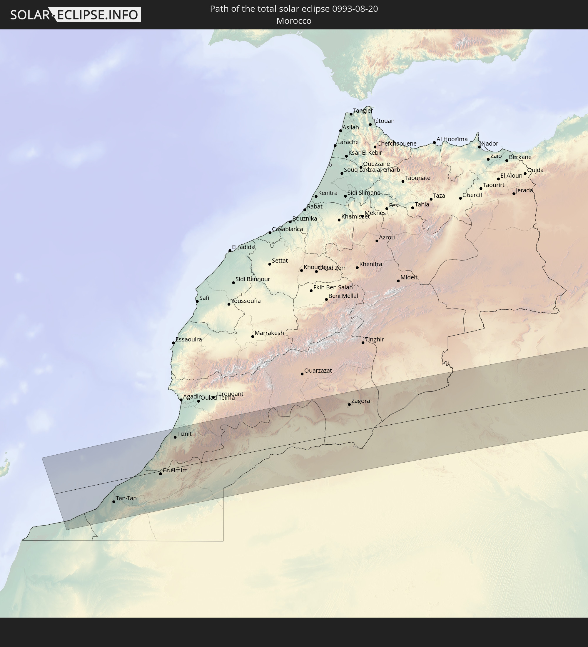 Morocco
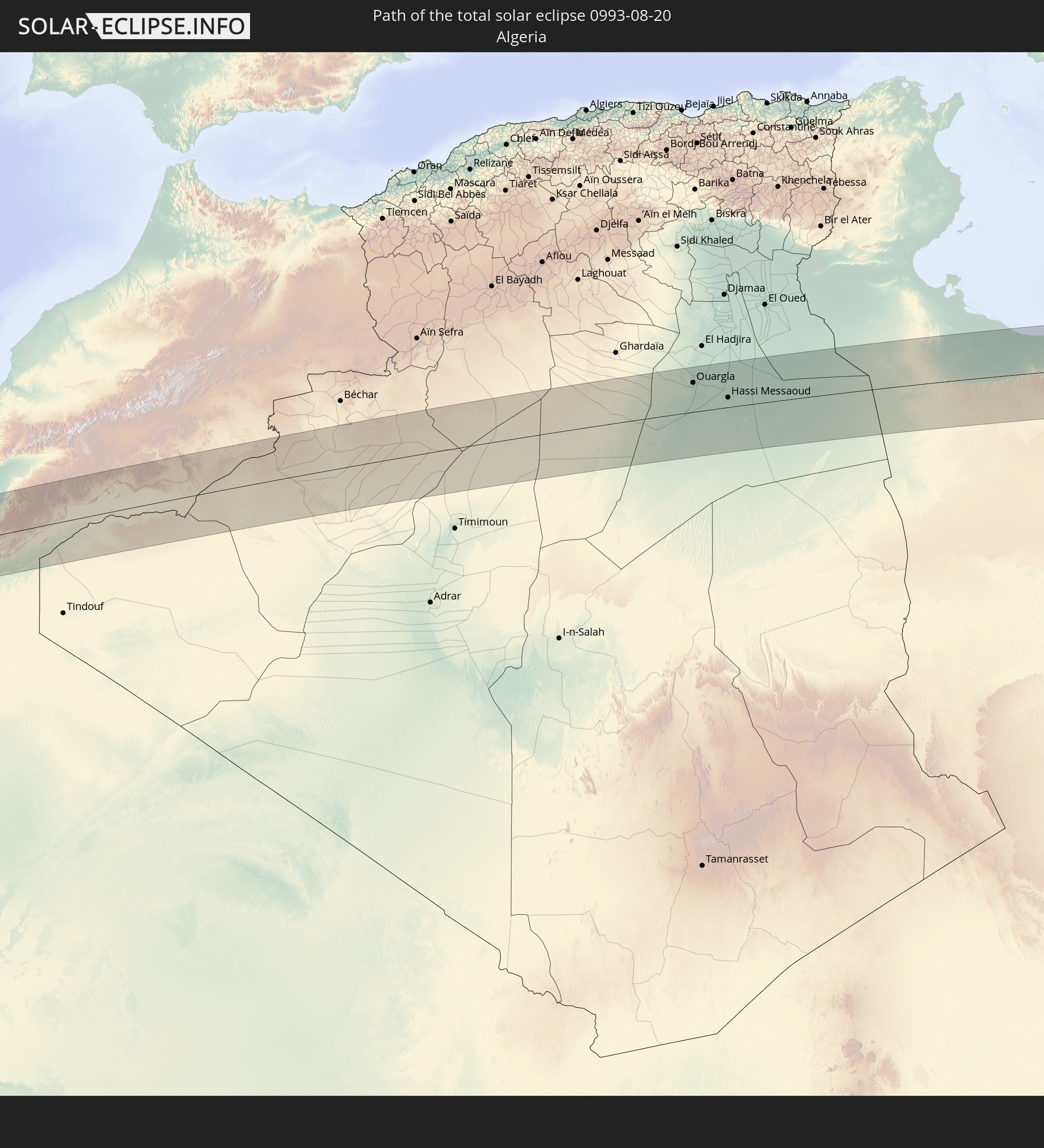 Algeria
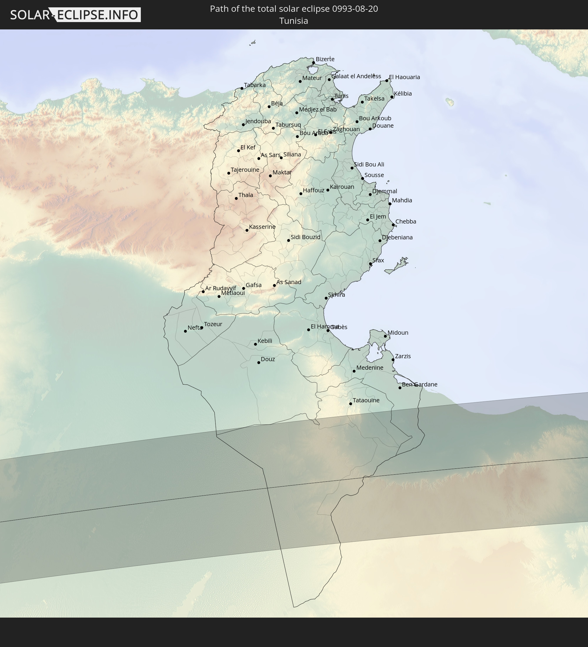 Tunisia
 Libya
Libya
 Egypt
Egypt
 State of Palestine
 Israel
 Saudi Arabia
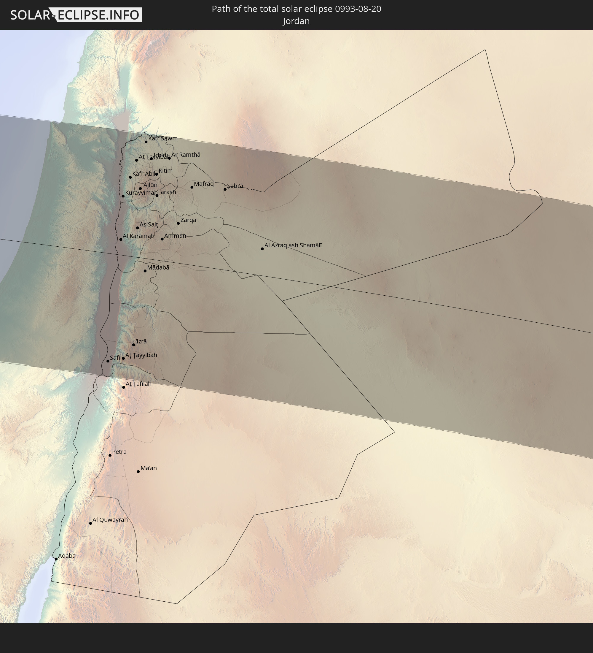 Jordan
 Syria
Syria
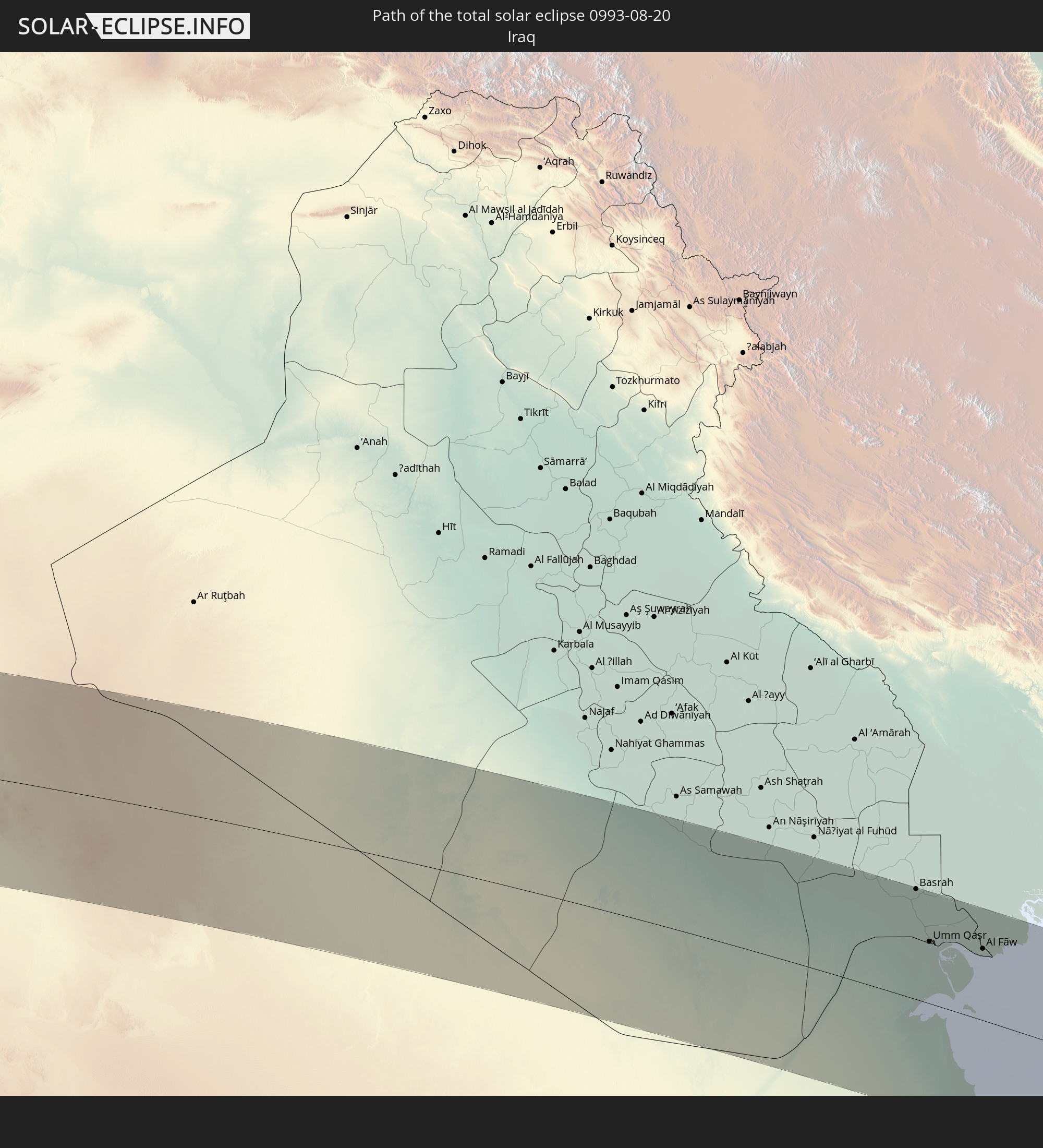 Iraq
Iraq
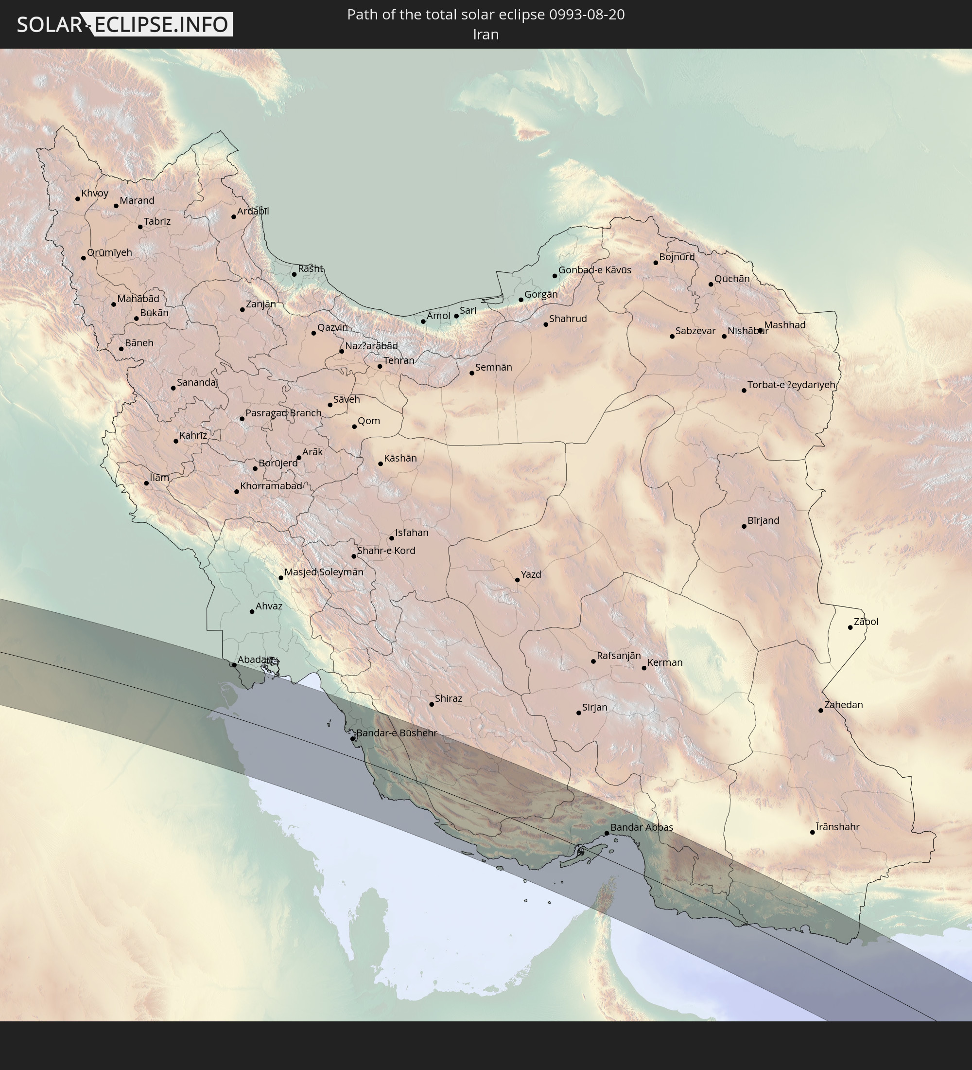 Iran
Iran
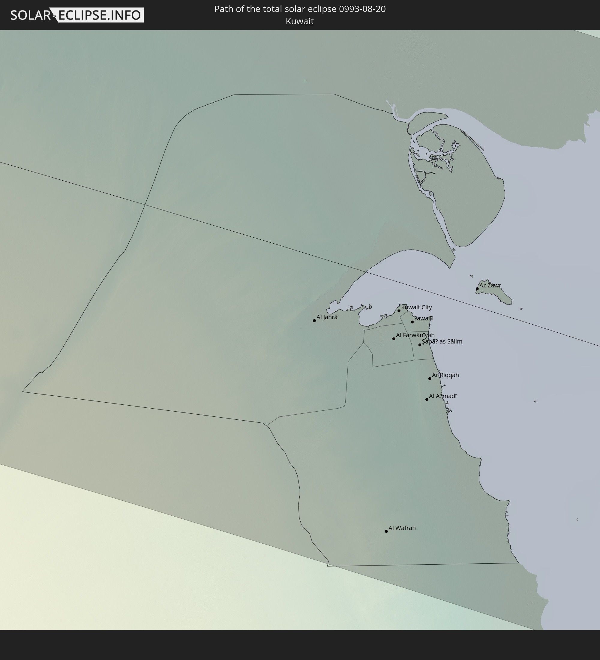 Kuwait
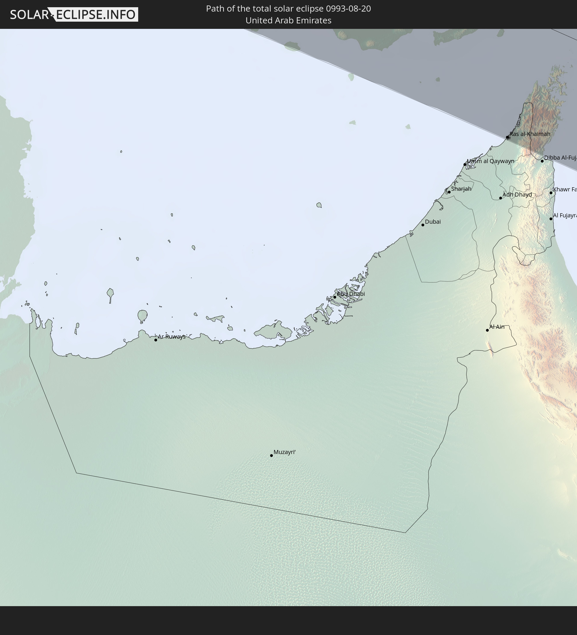 United Arab Emirates
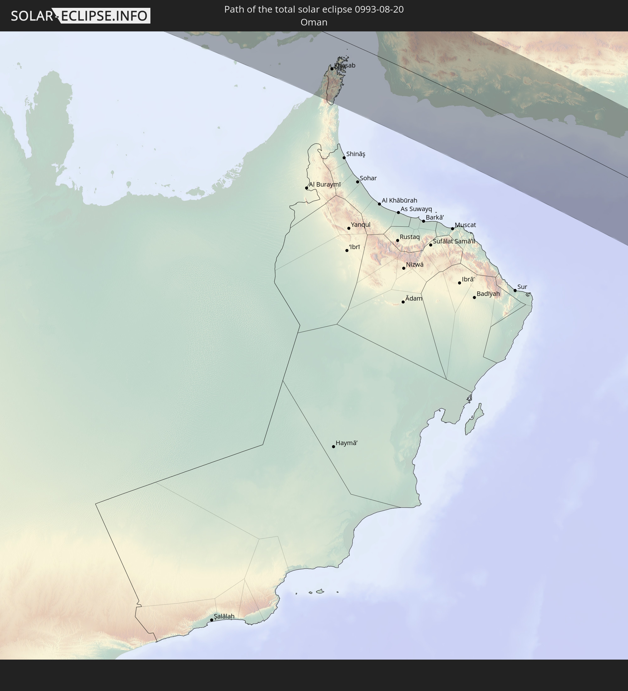 Oman
Oman
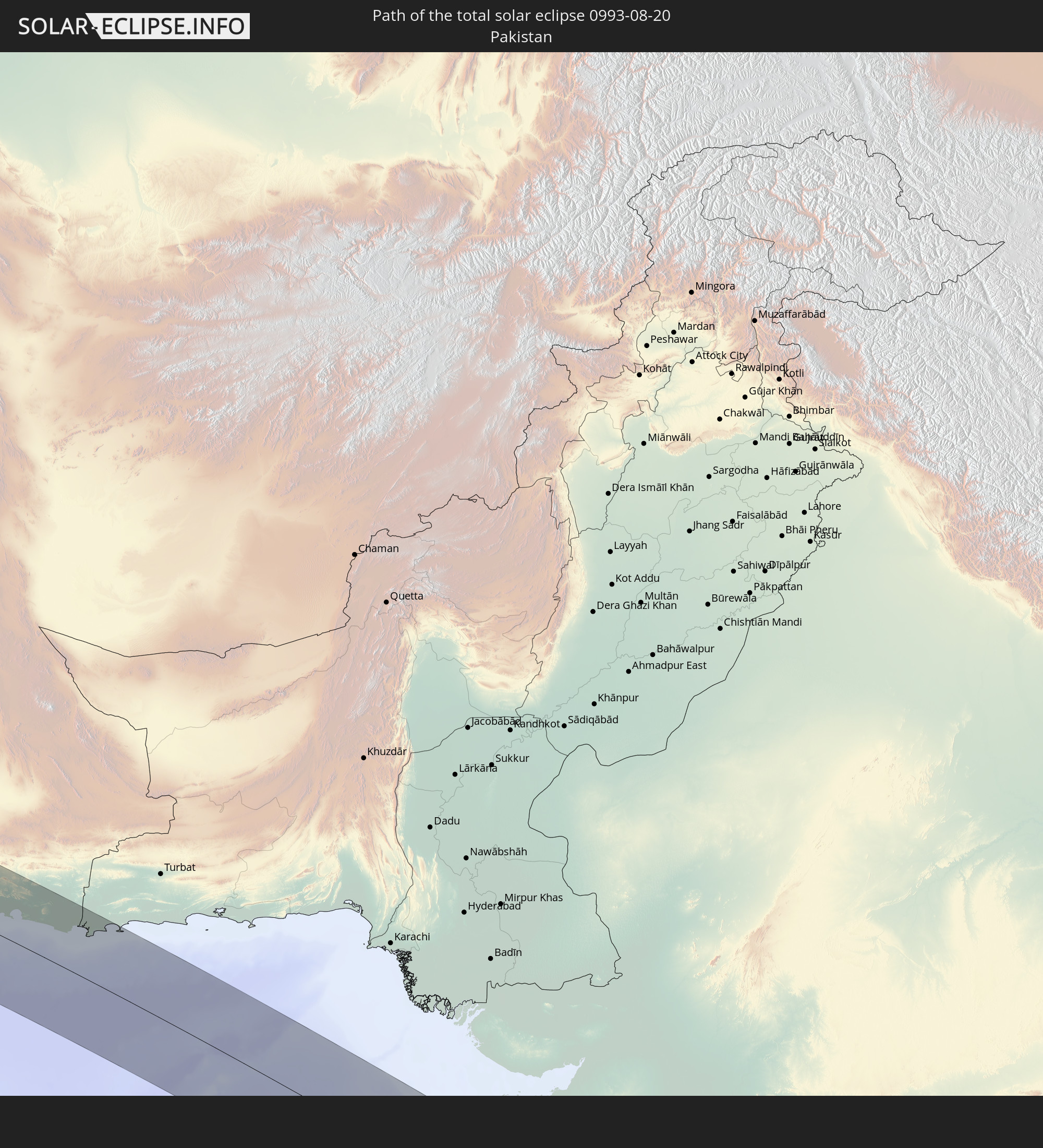 Pakistan
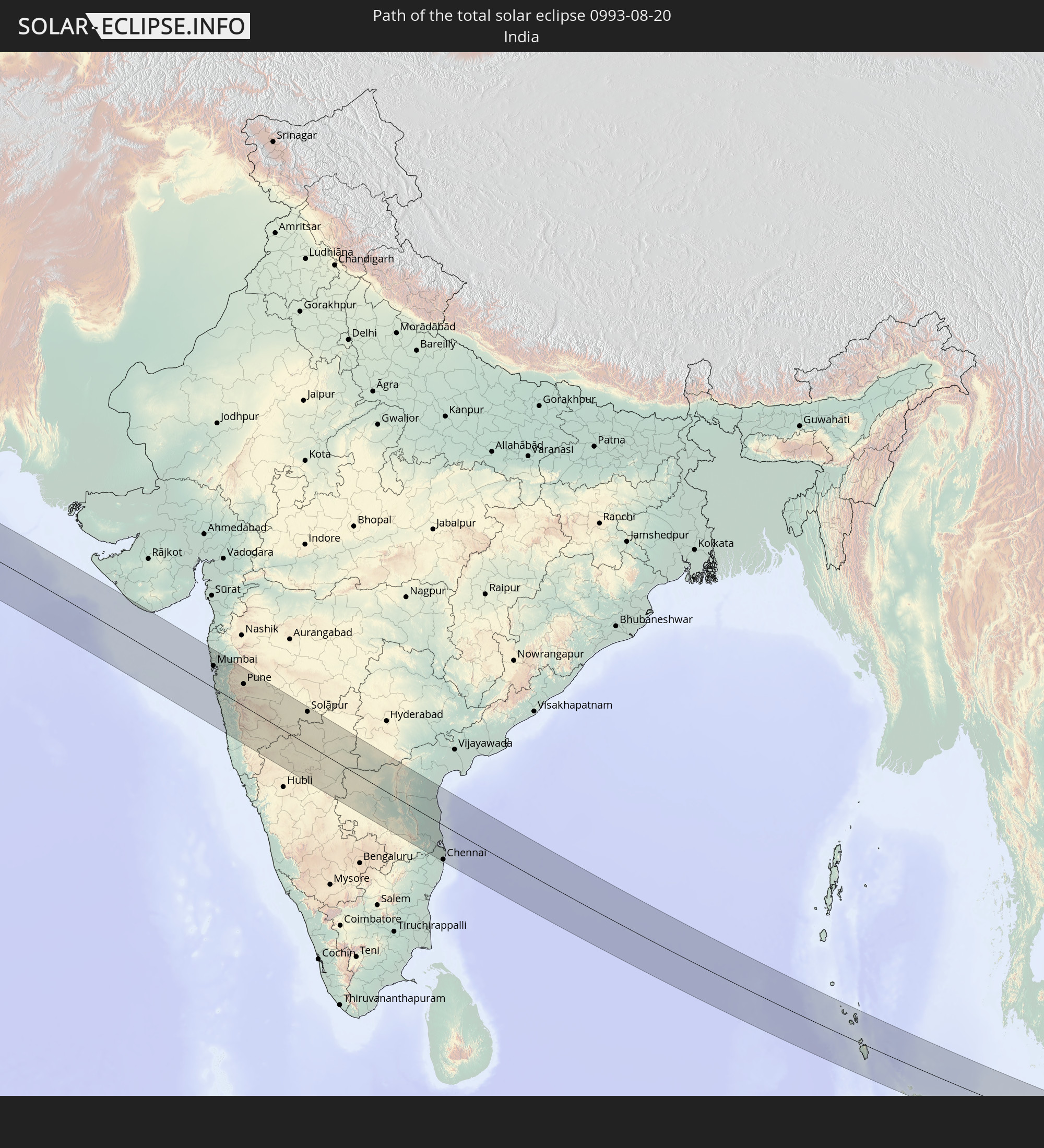 India
India
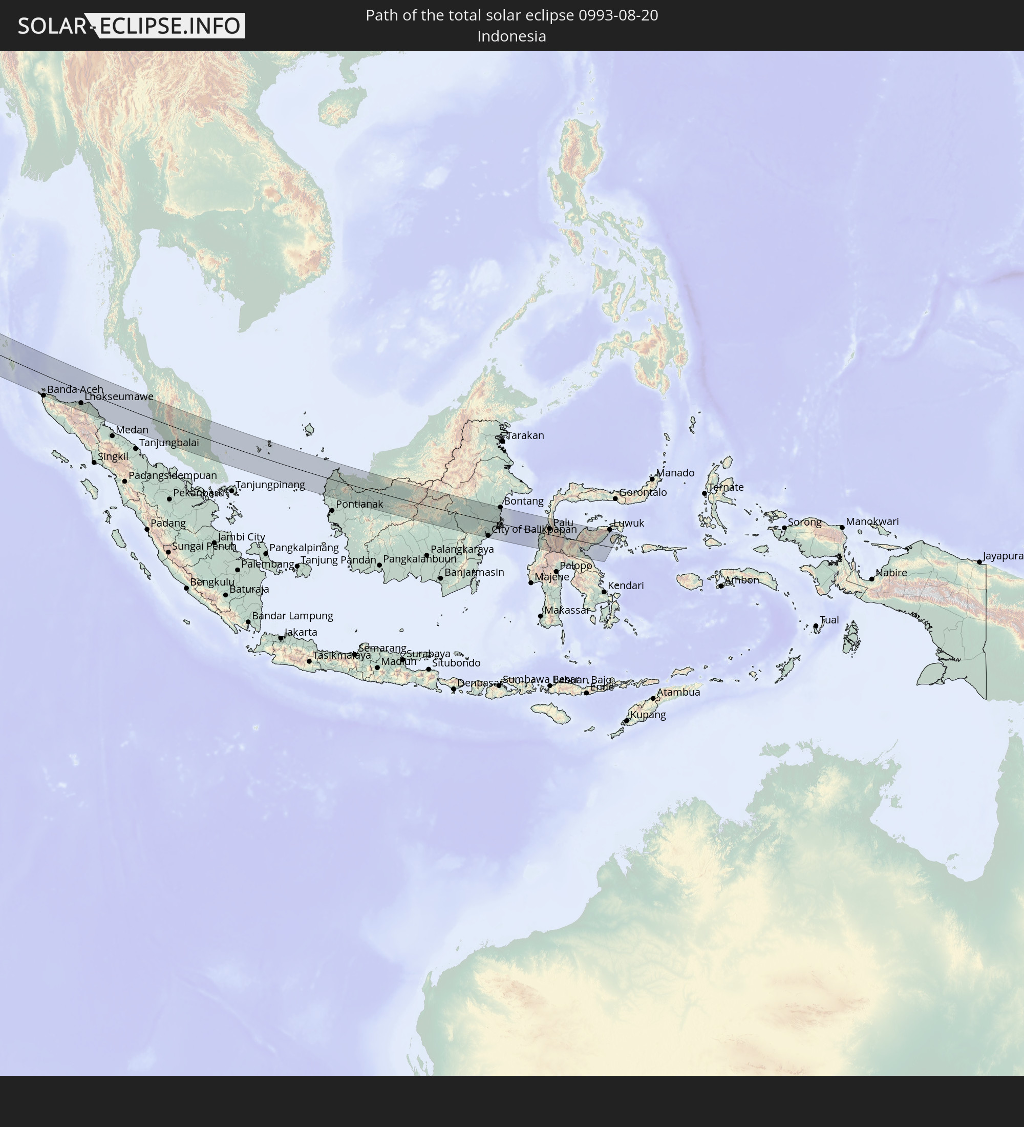 Indonesia
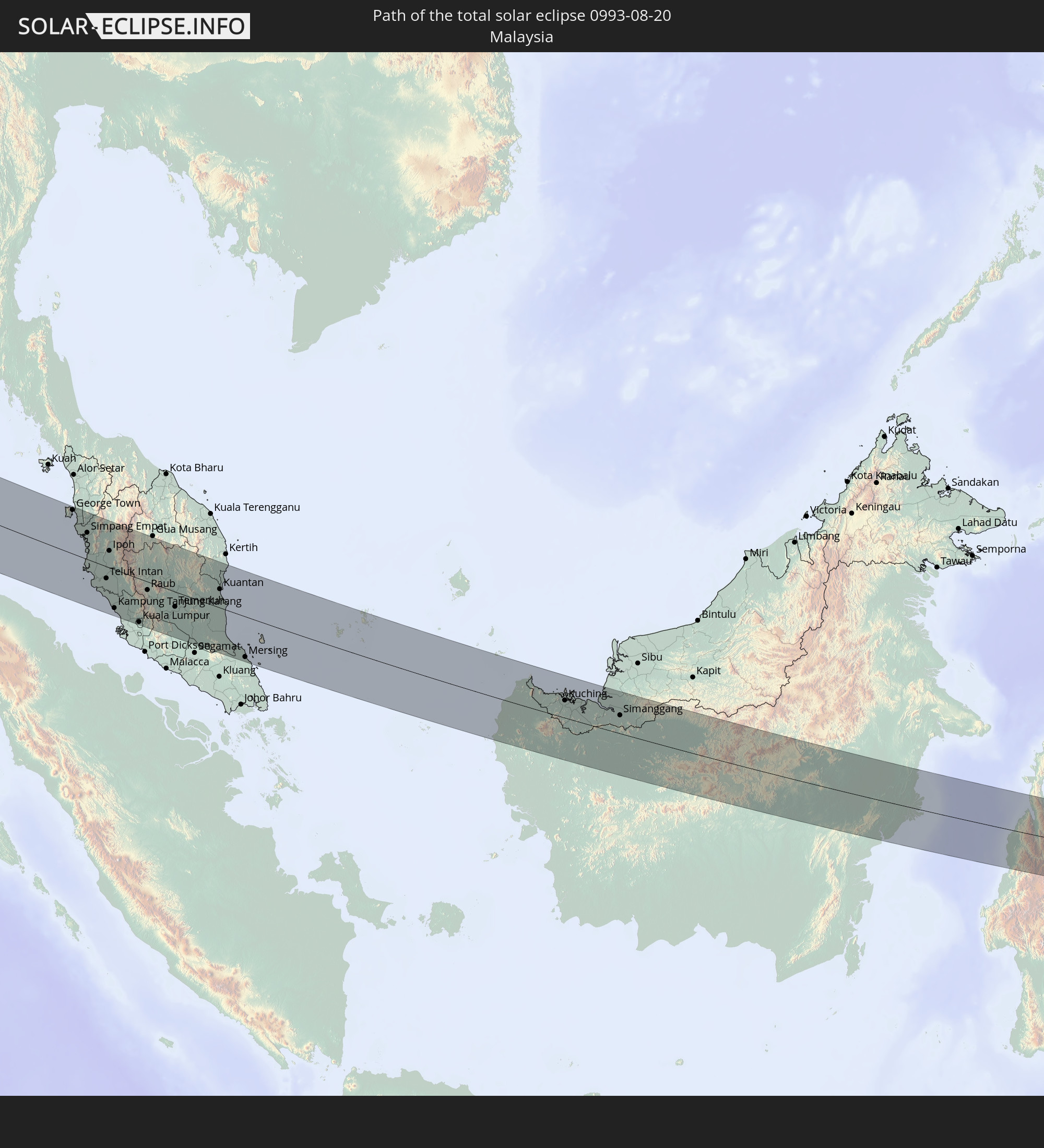 Malaysia
In den folgenden Ländern ist die Sonnenfinsternis partiell zu sehen
 Russia
 Portugal
 Iceland
 Spain
Spain
 Mauritania
 Morocco
 Mali
Mali
 Republic of Ireland
 Algeria
 United Kingdom
 Ivory Coast
 Faroe Islands
 Burkina Faso
 Gibraltar
 France
 Isle of Man
 Ghana
Ghana
 Guernsey
 Jersey
 Togo
Togo
 Niger
Niger
 Benin
Benin
 Andorra
 Belgium
 Nigeria
 Netherlands
 Norway
 Equatorial Guinea
 Luxembourg
 Germany
 Switzerland
 São Tomé and Príncipe
 Italy
Italy
 Monaco
 Tunisia
 Denmark
 Cameroon
 Gabon
Gabon
 Libya
Libya
 Liechtenstein
 Austria
 Sweden
 Republic of the Congo
 Czechia
 Democratic Republic of the Congo
 San Marino
 Vatican City
 Slovenia
 Chad
Chad
 Croatia
 Poland
 Malta
Malta
 Central African Republic
 Bosnia and Herzegovina
 Hungary
 Slovakia
 Montenegro
 Serbia
 Albania
 Åland Islands
 Greece
 Romania
 Republic of Macedonia
 Finland
 Lithuania
 Latvia
 Estonia
 Sudan
Sudan
 Ukraine
 Bulgaria
 Belarus
 Egypt
Egypt
 Turkey
 Moldova
 Uganda
 Cyprus
 Ethiopia
 Kenya
Kenya
 State of Palestine
 Israel
 Saudi Arabia
 Jordan
 Lebanon
 Syria
Syria
 Eritrea
 Iraq
Iraq
 Georgia
 Somalia
 Djibouti
 Yemen
Yemen
 Armenia
 Iran
Iran
 Azerbaijan
 Seychelles
 Kazakhstan
 Kuwait
 Bahrain
 Qatar
Qatar
 United Arab Emirates
 Oman
Oman
 Turkmenistan
 Uzbekistan
 Afghanistan
 Pakistan
 Tajikistan
 India
India
 Kyrgyzstan
 British Indian Ocean Territory
 Maldives
 China
China
 Sri Lanka
 Nepal
Nepal
 Mongolia
 Bangladesh
 Bhutan
 Myanmar
 Indonesia
 Cocos Islands
 Thailand
 Malaysia
 Laos
Laos
 Vietnam
 Cambodia
 Singapore
 Christmas Island
 Australia
 Macau
Macau
 Hong Kong
 Brunei
 Taiwan
 Philippines
 Japan
Japan
 North Korea
 South Korea
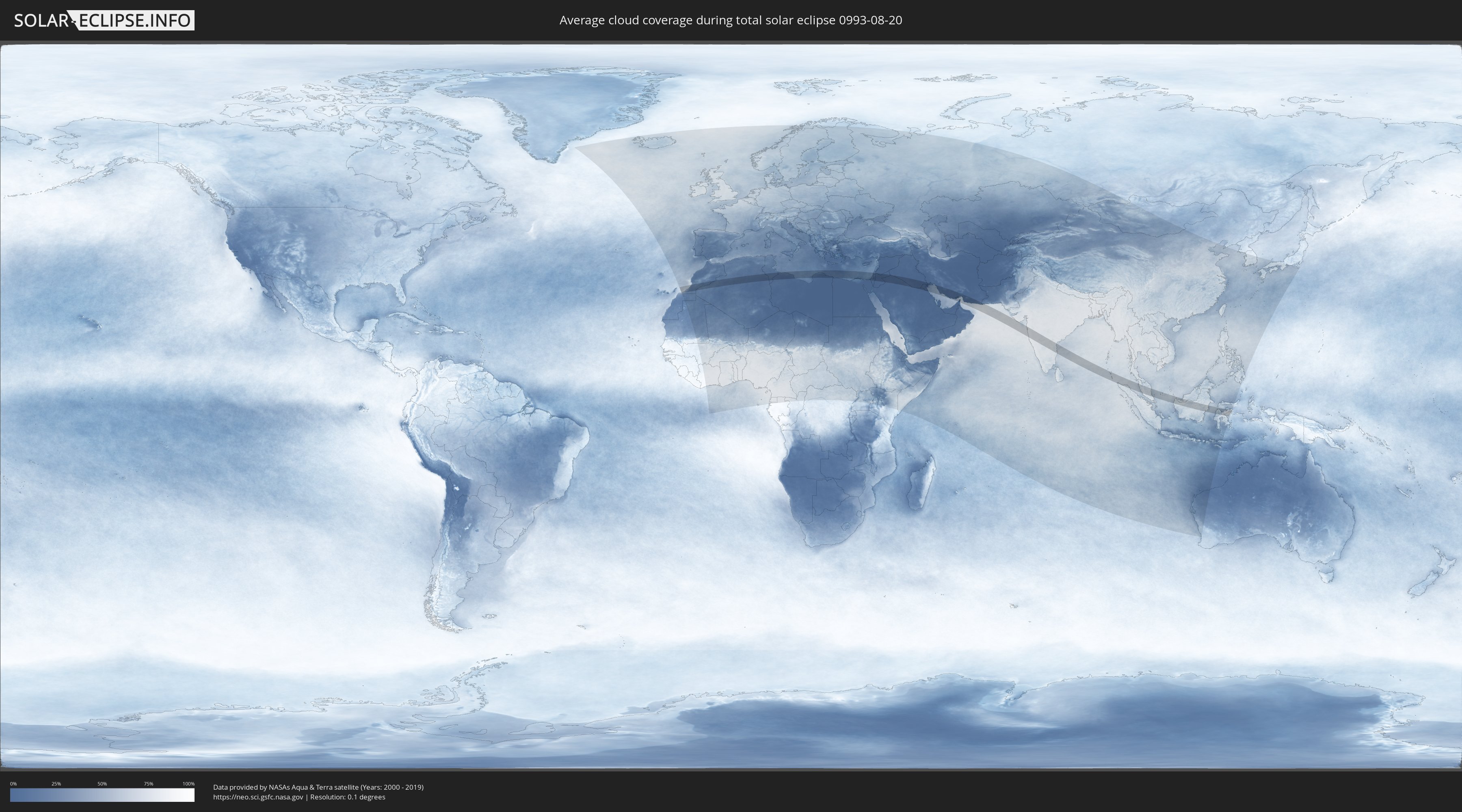
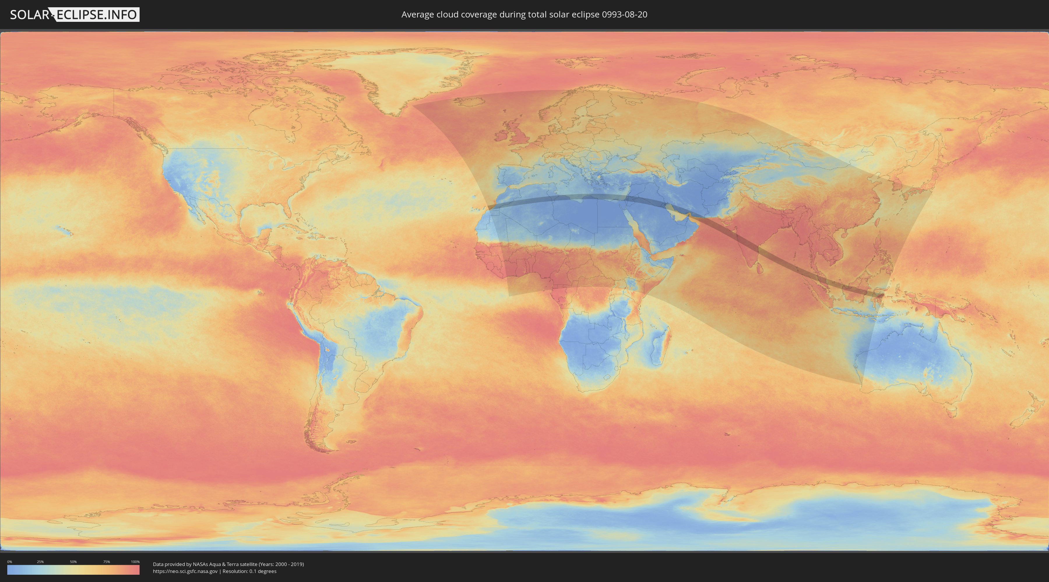
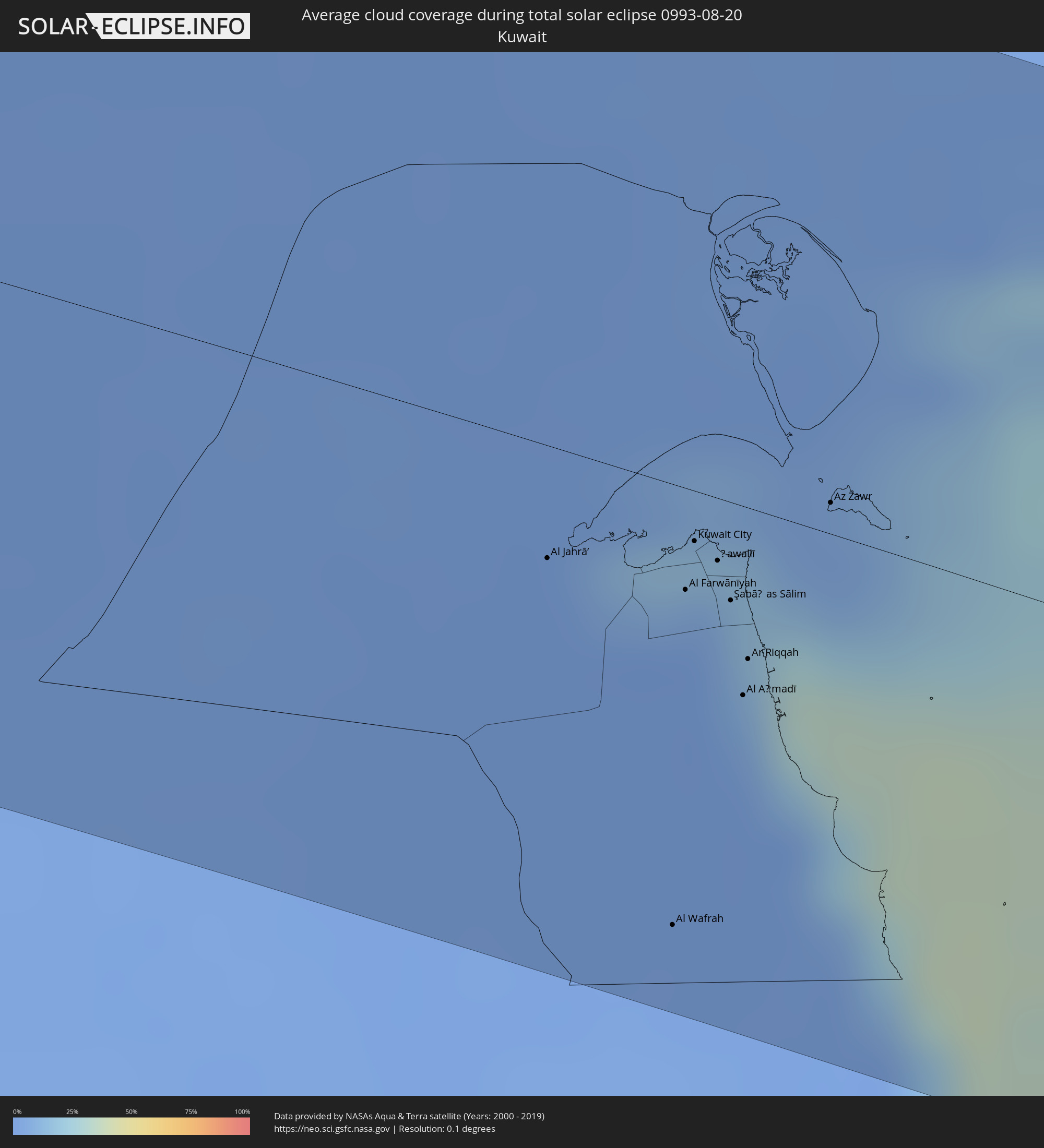
How will be the weather during the total solar eclipse on 08/20/0993?
Where is the best place to see the total solar eclipse of 08/20/0993?
The following maps show the average cloud coverage for the day of the total solar eclipse.
With the help of these maps, it is possible to find the place along the eclipse path, which has the best
chance of a cloudless sky.
Nevertheless, you should consider local circumstances and inform about the weather of your chosen
observation site.
The data is provided by NASAs satellites
AQUA and TERRA.
The cloud maps are averaged over a period of 19 years (2000 - 2019).
Detailed country maps
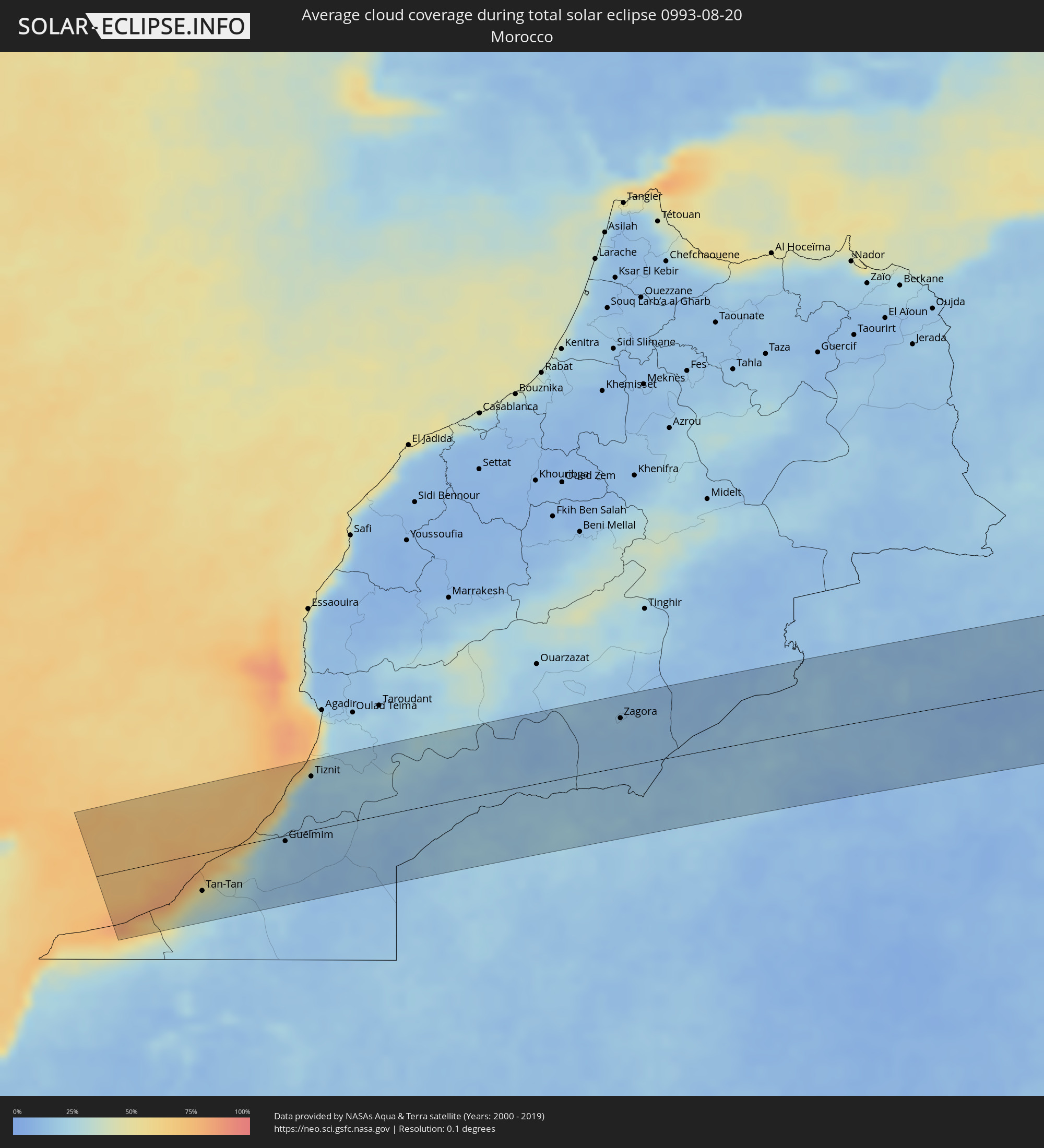 Morocco
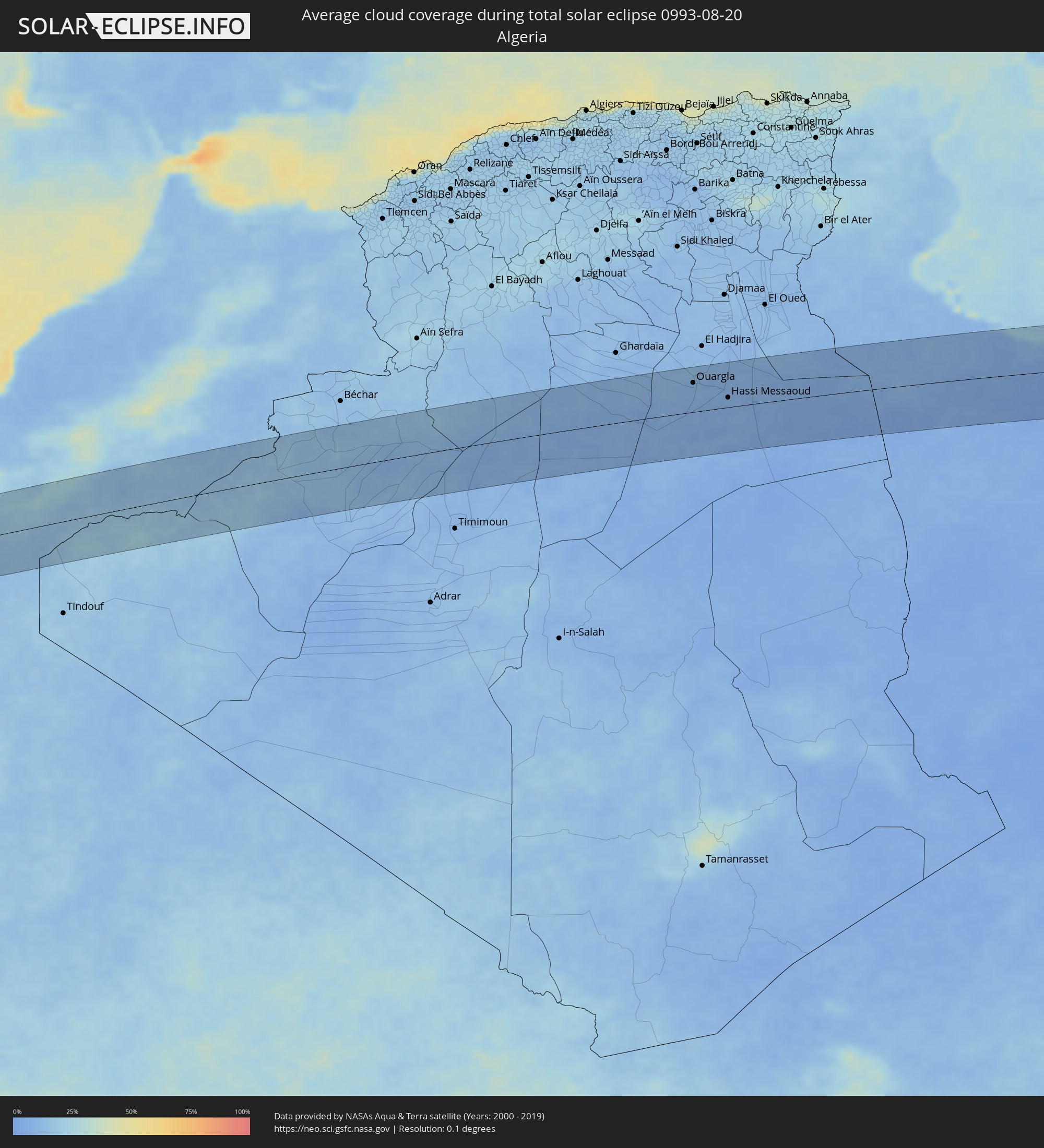 Algeria
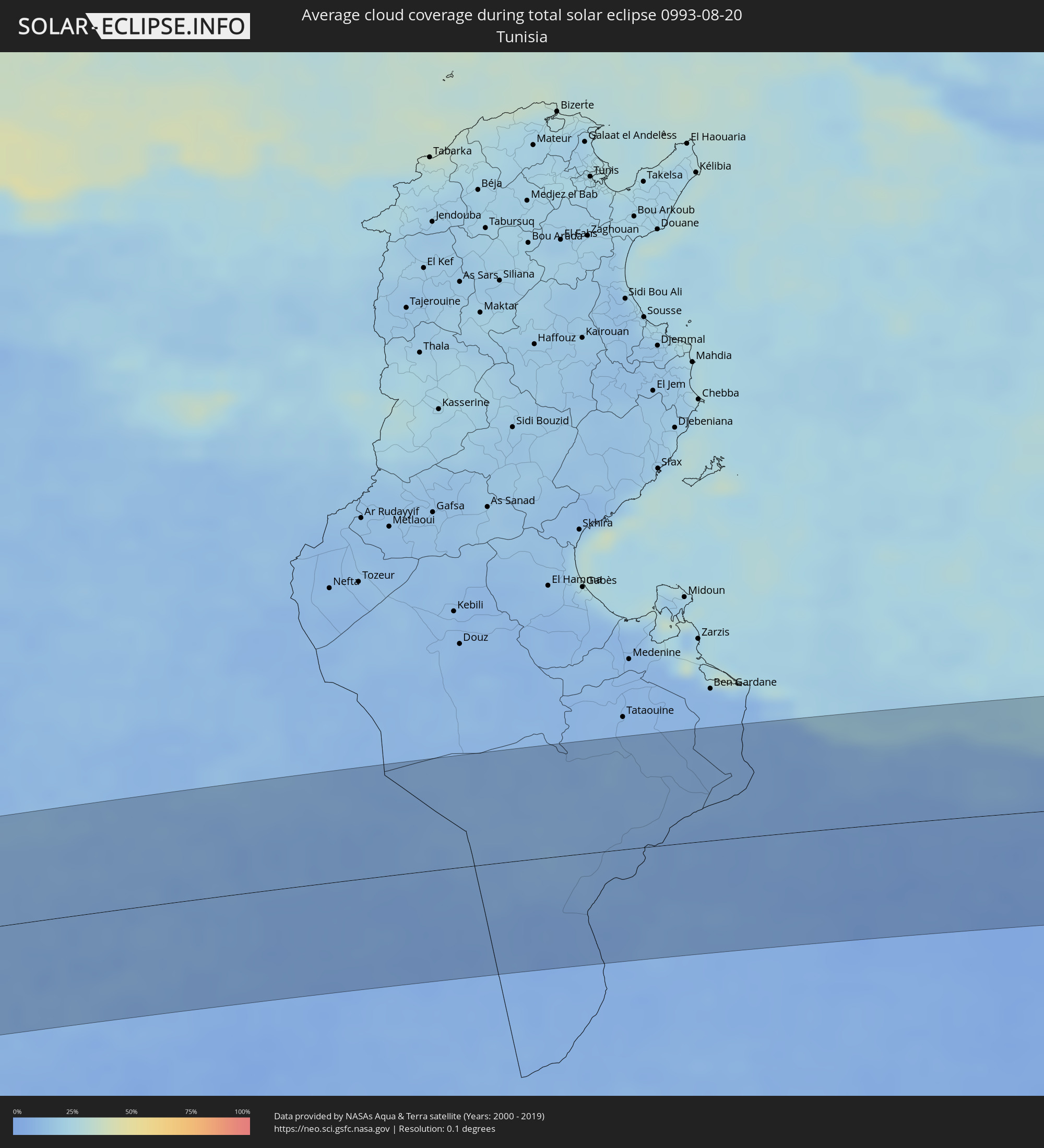 Tunisia
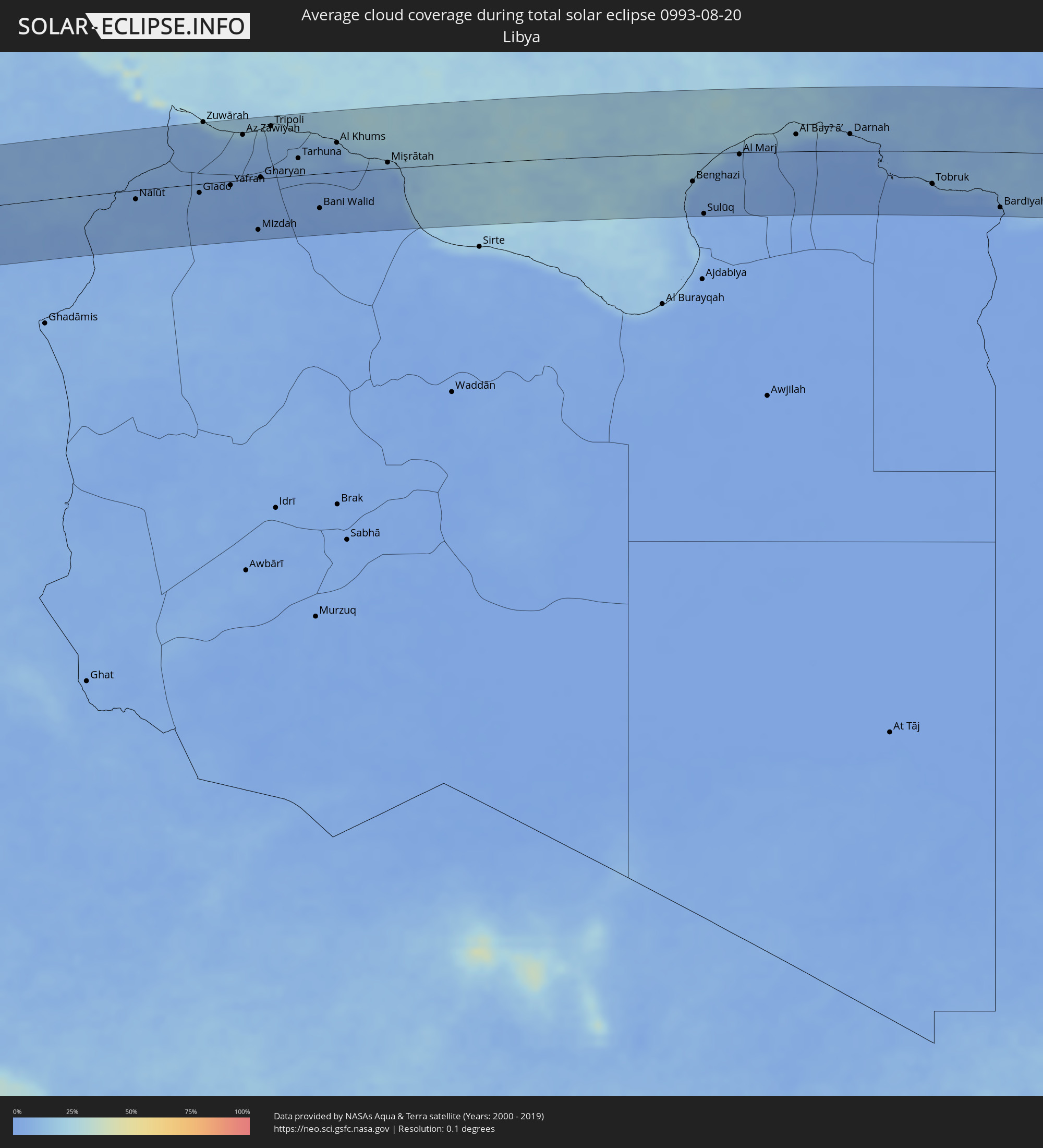 Libya
Libya
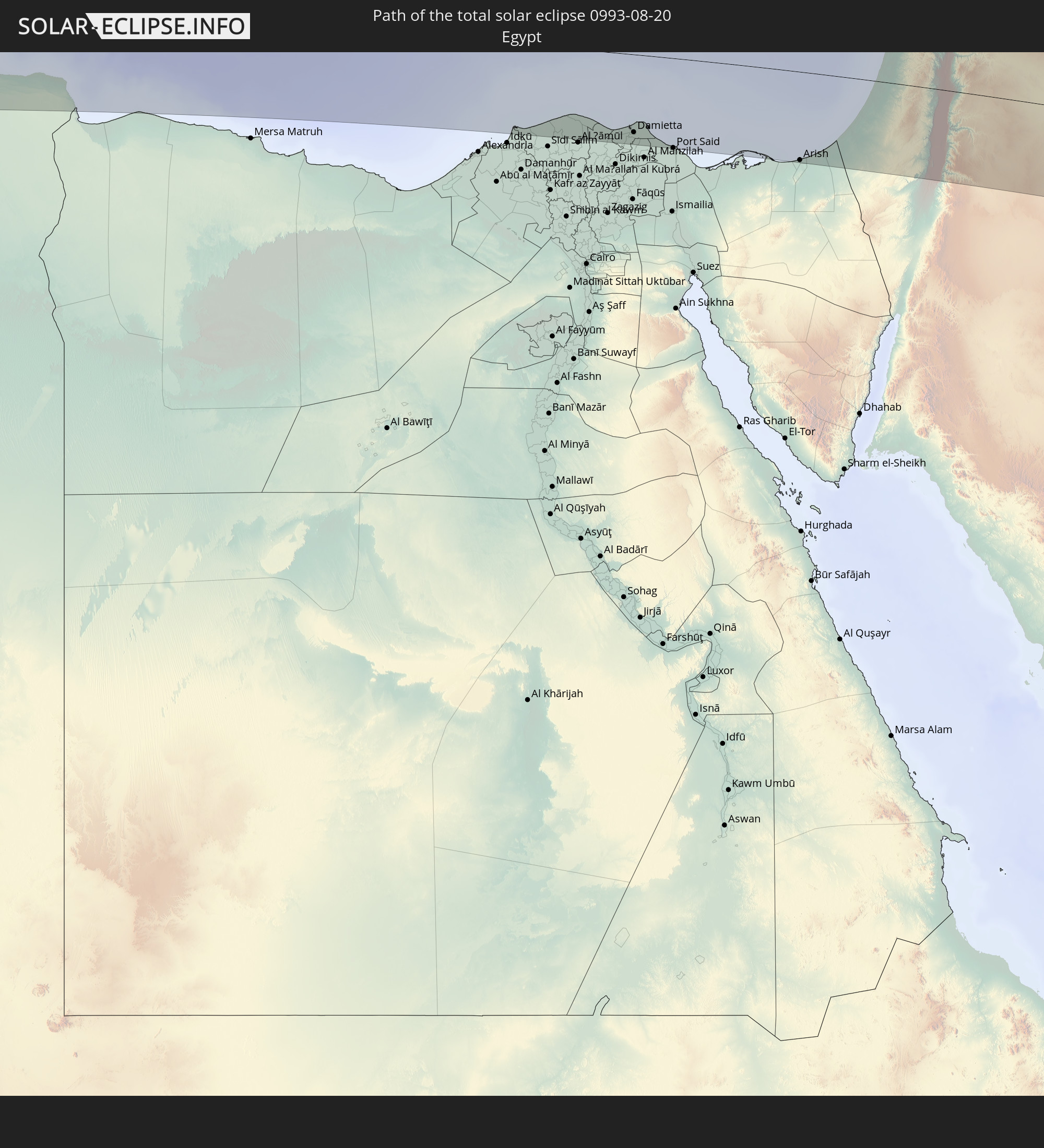
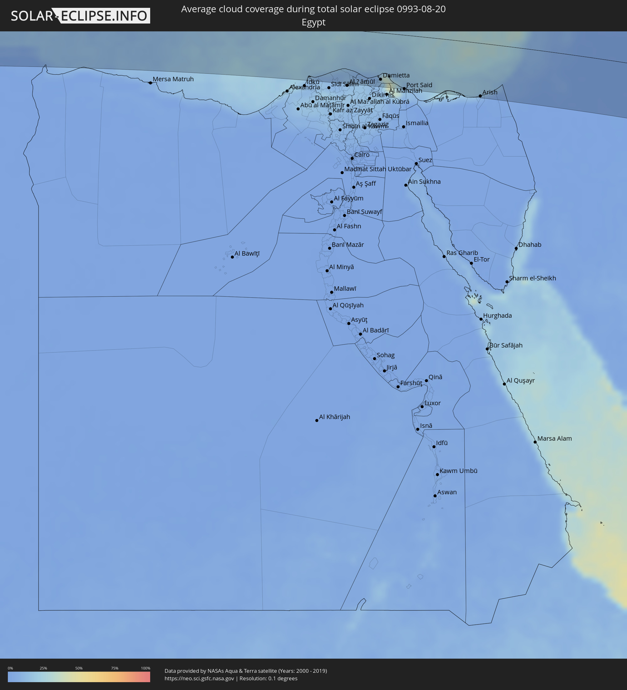 Egypt
Egypt
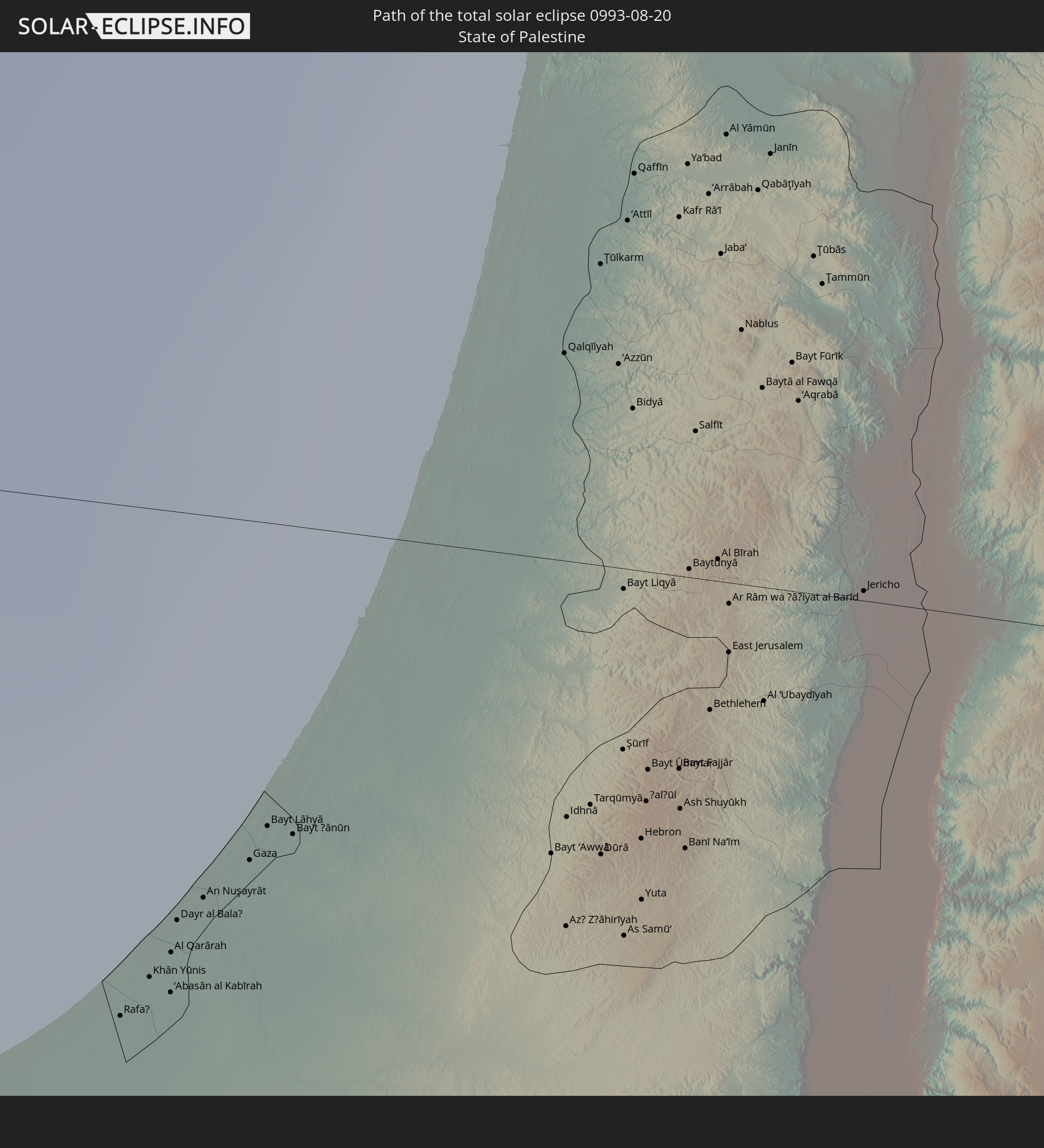
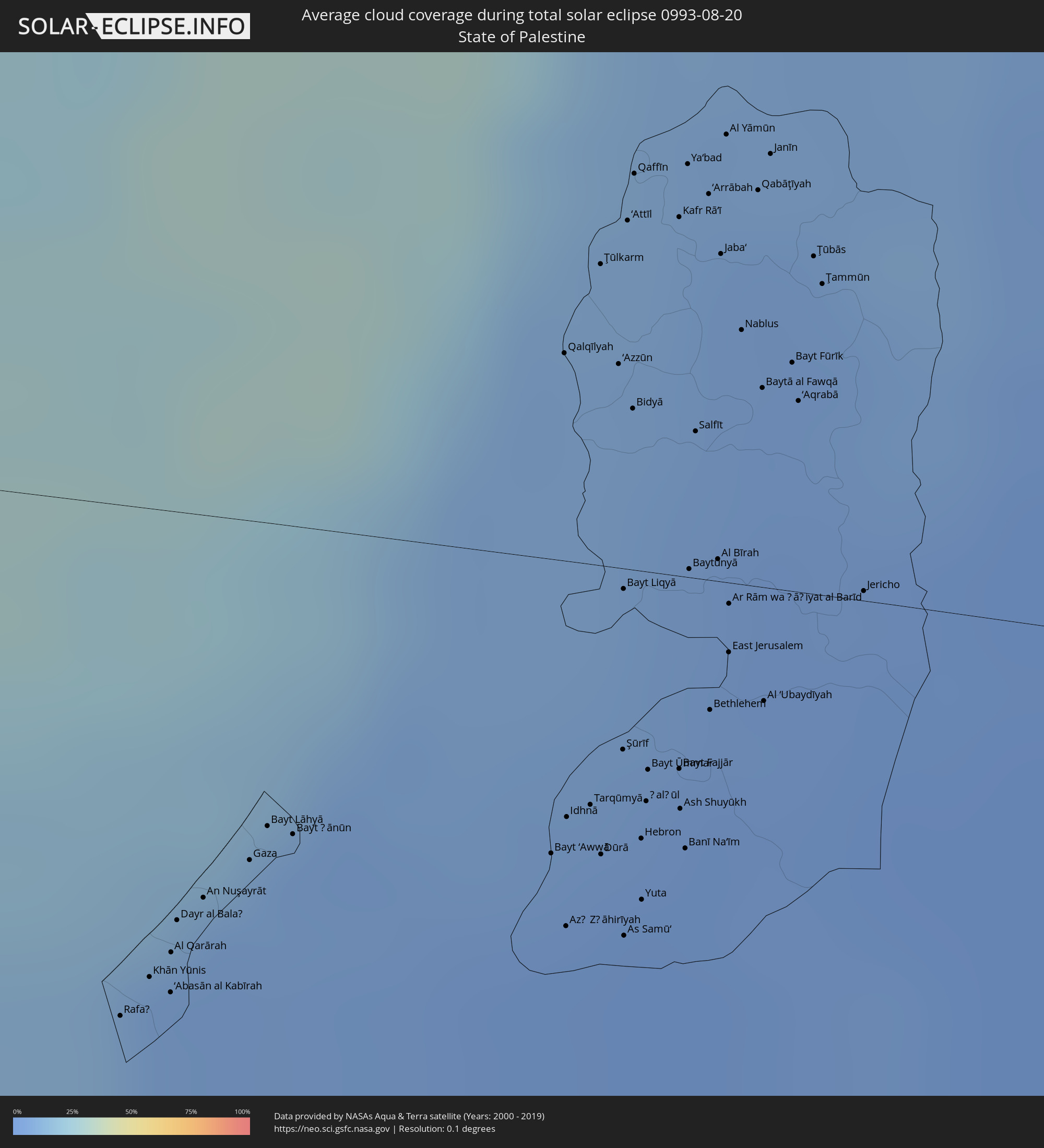 State of Palestine
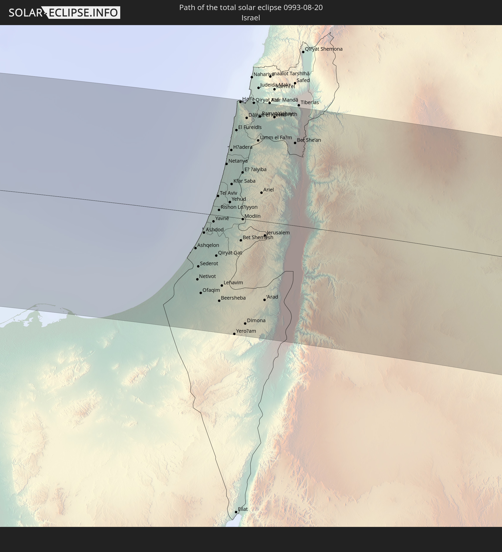
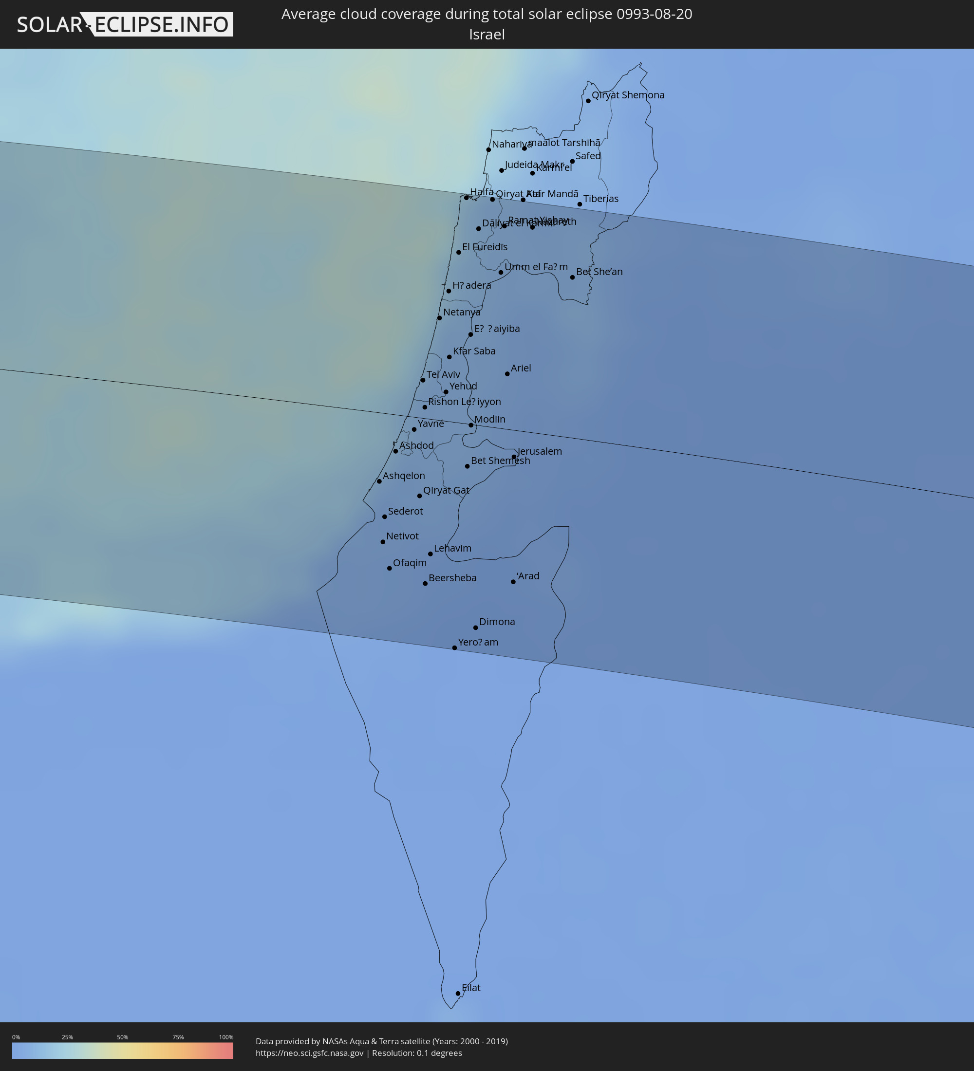 Israel
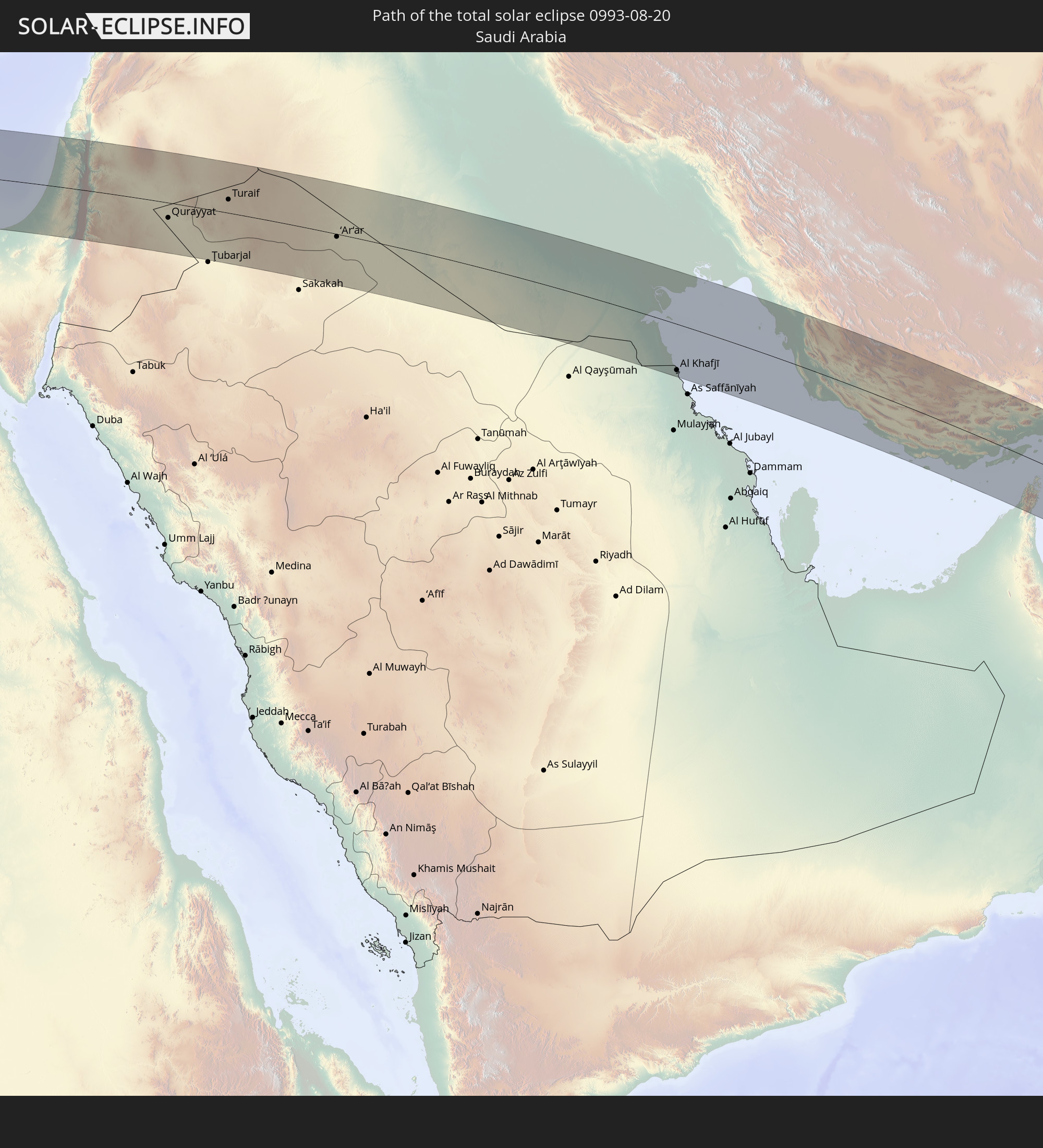
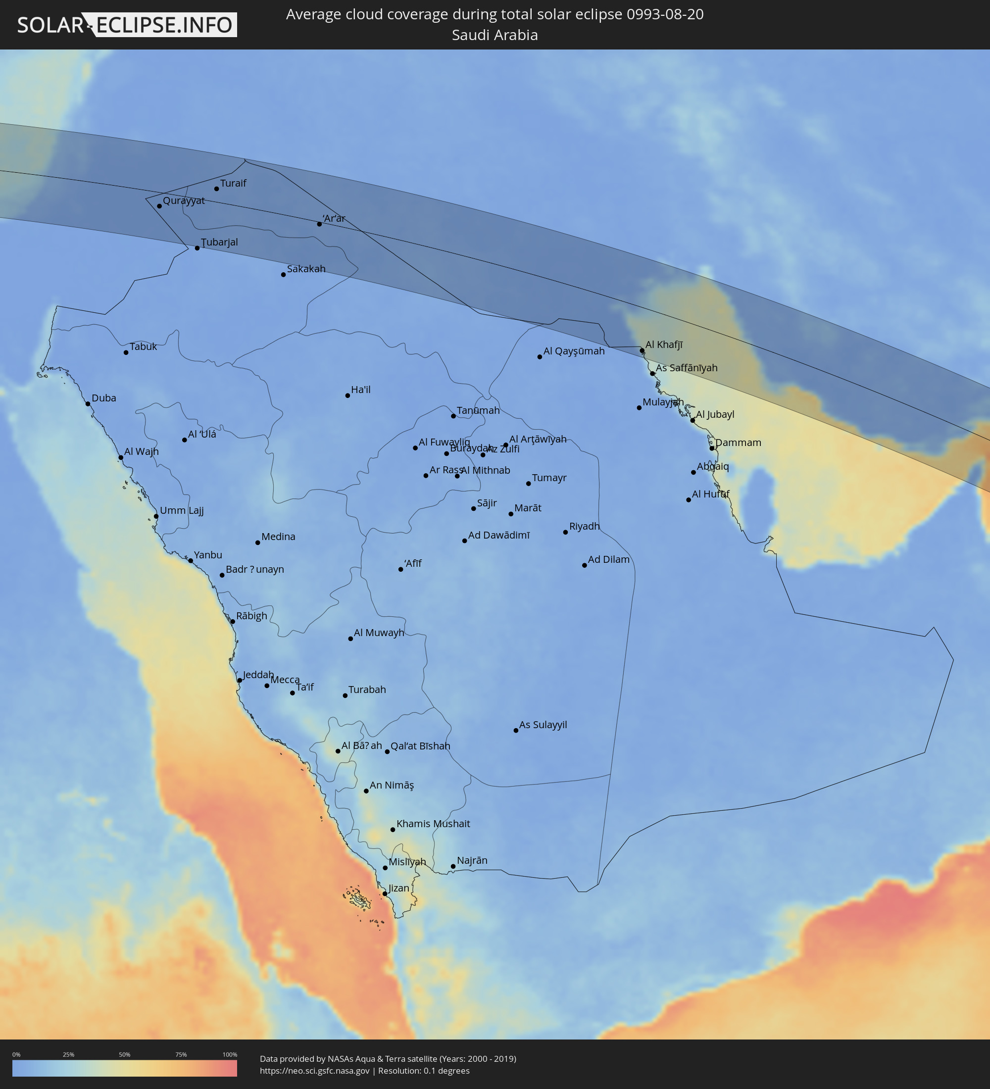 Saudi Arabia
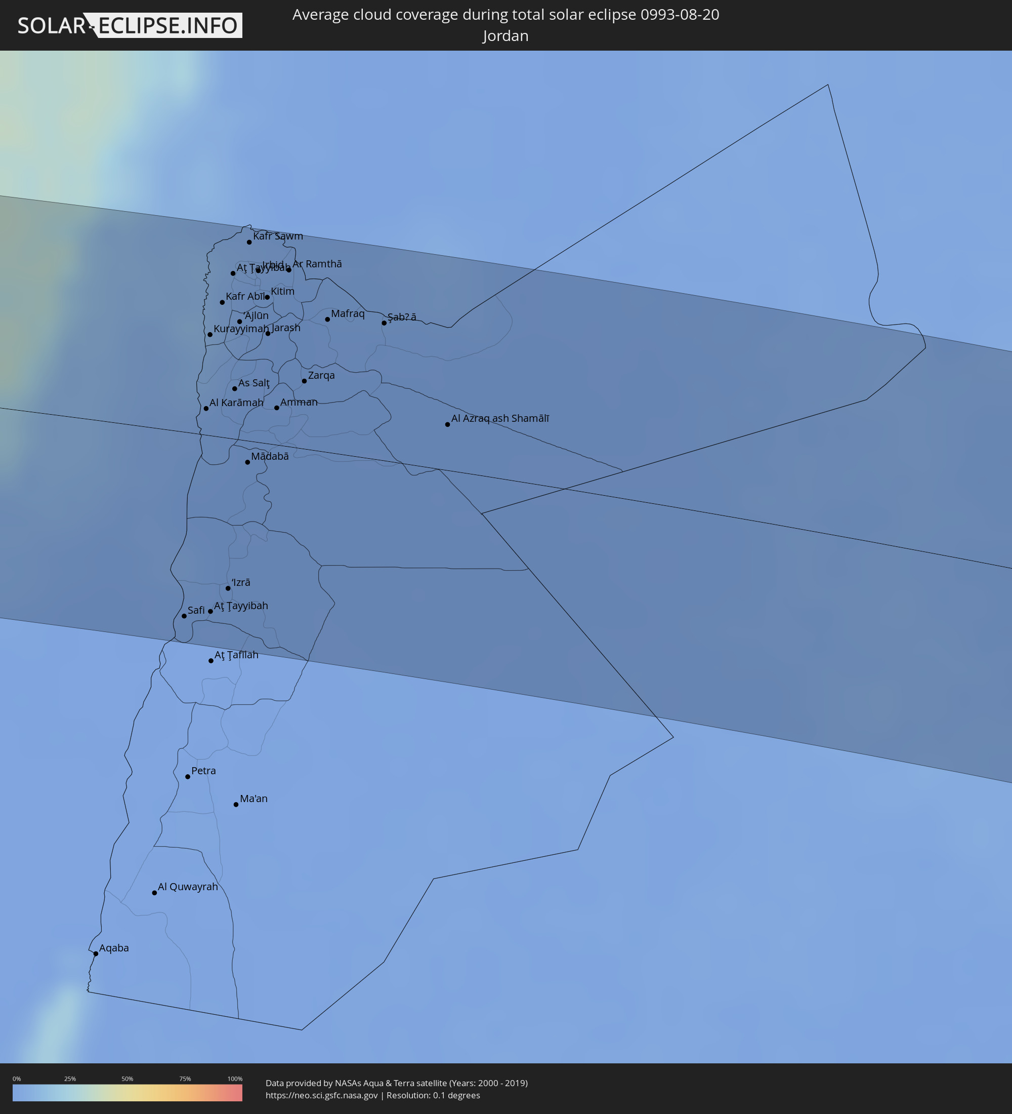 Jordan
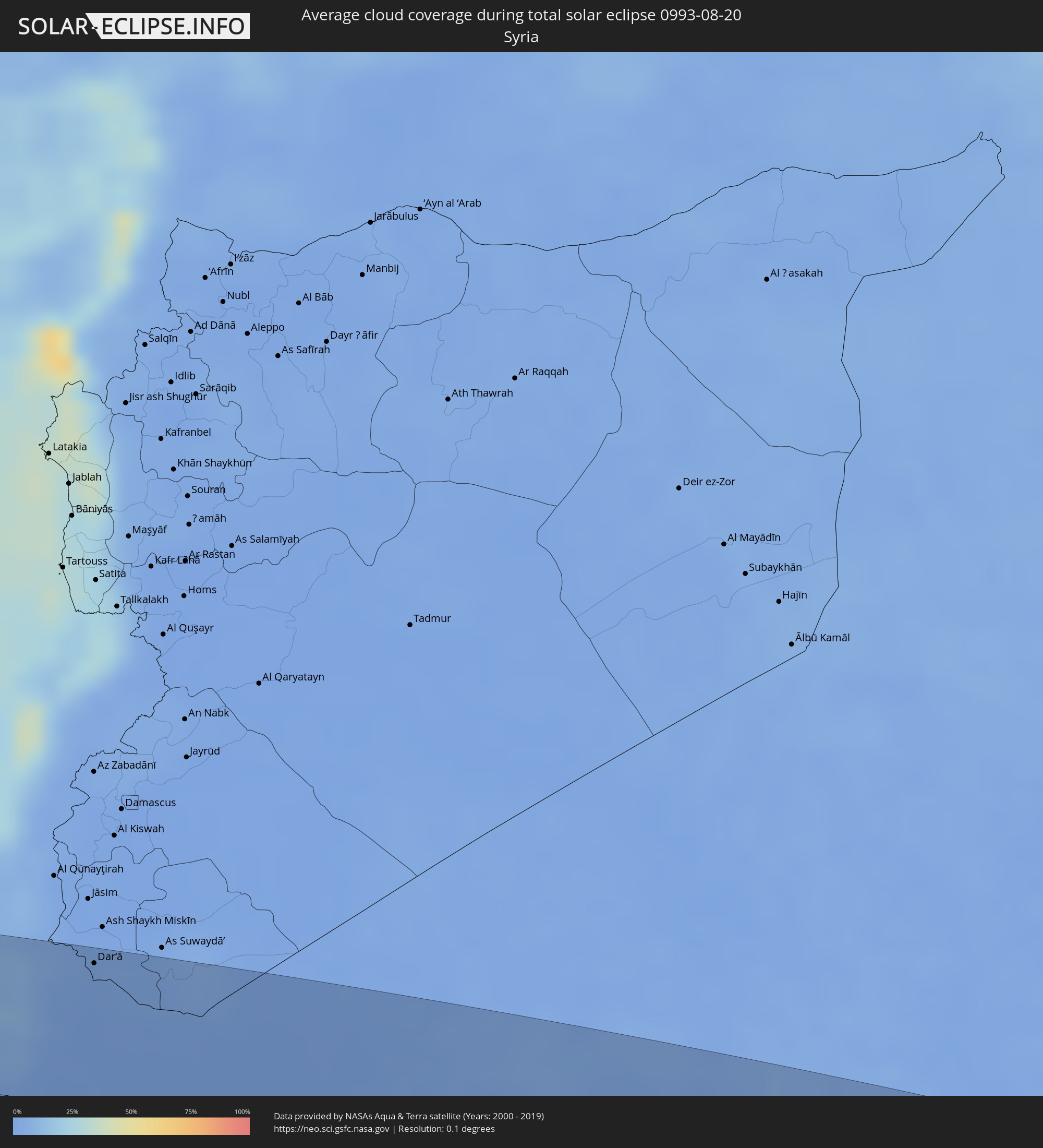 Syria
Syria
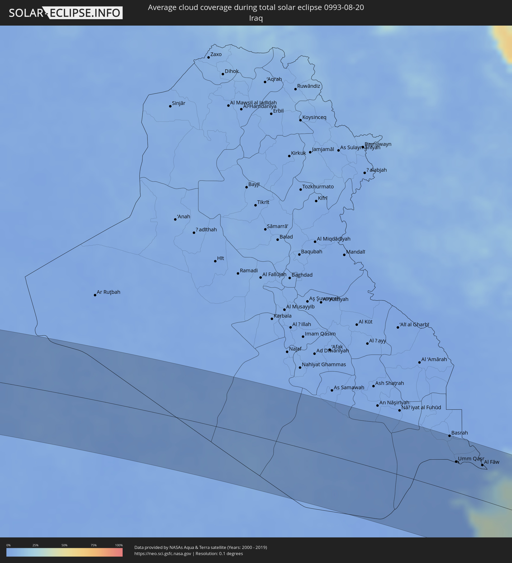 Iraq
Iraq
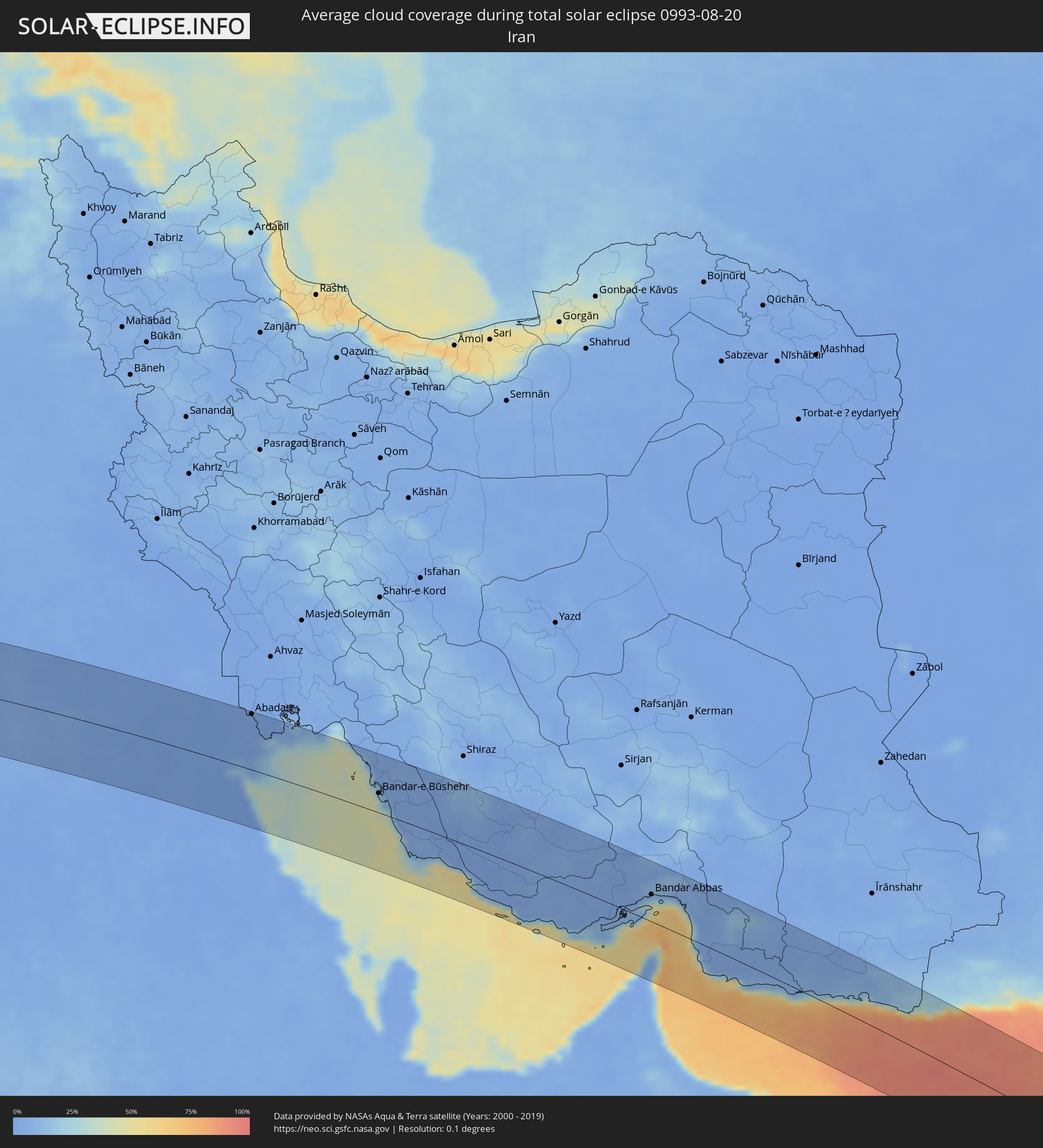 Iran
Iran
 Kuwait
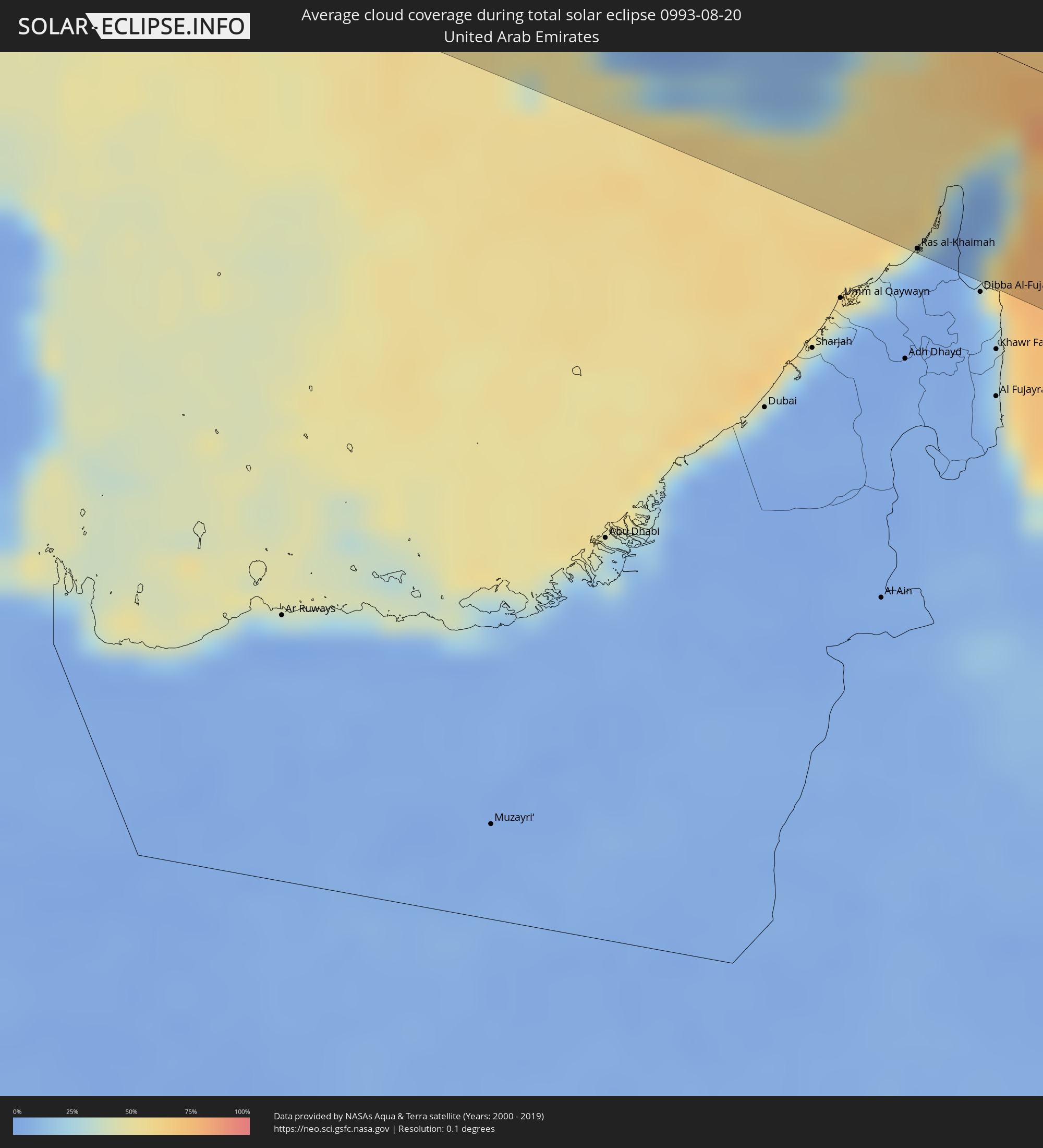 United Arab Emirates
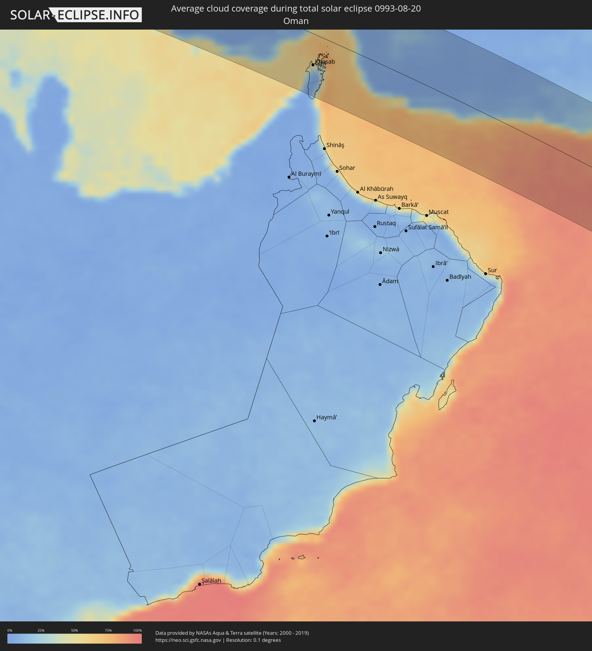 Oman
Oman
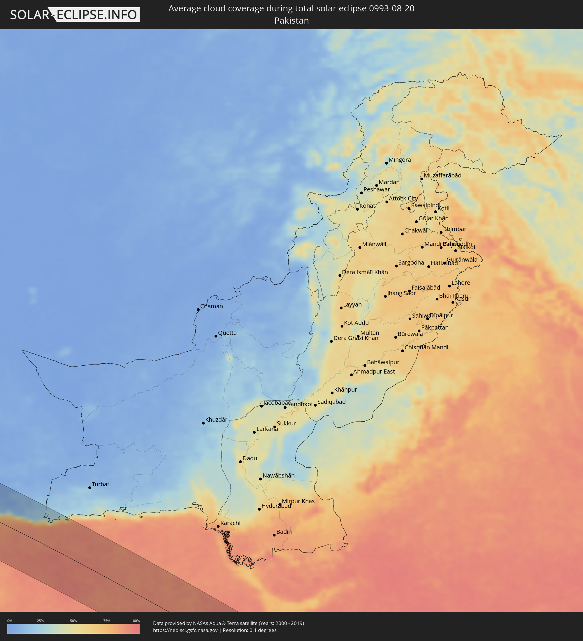 Pakistan
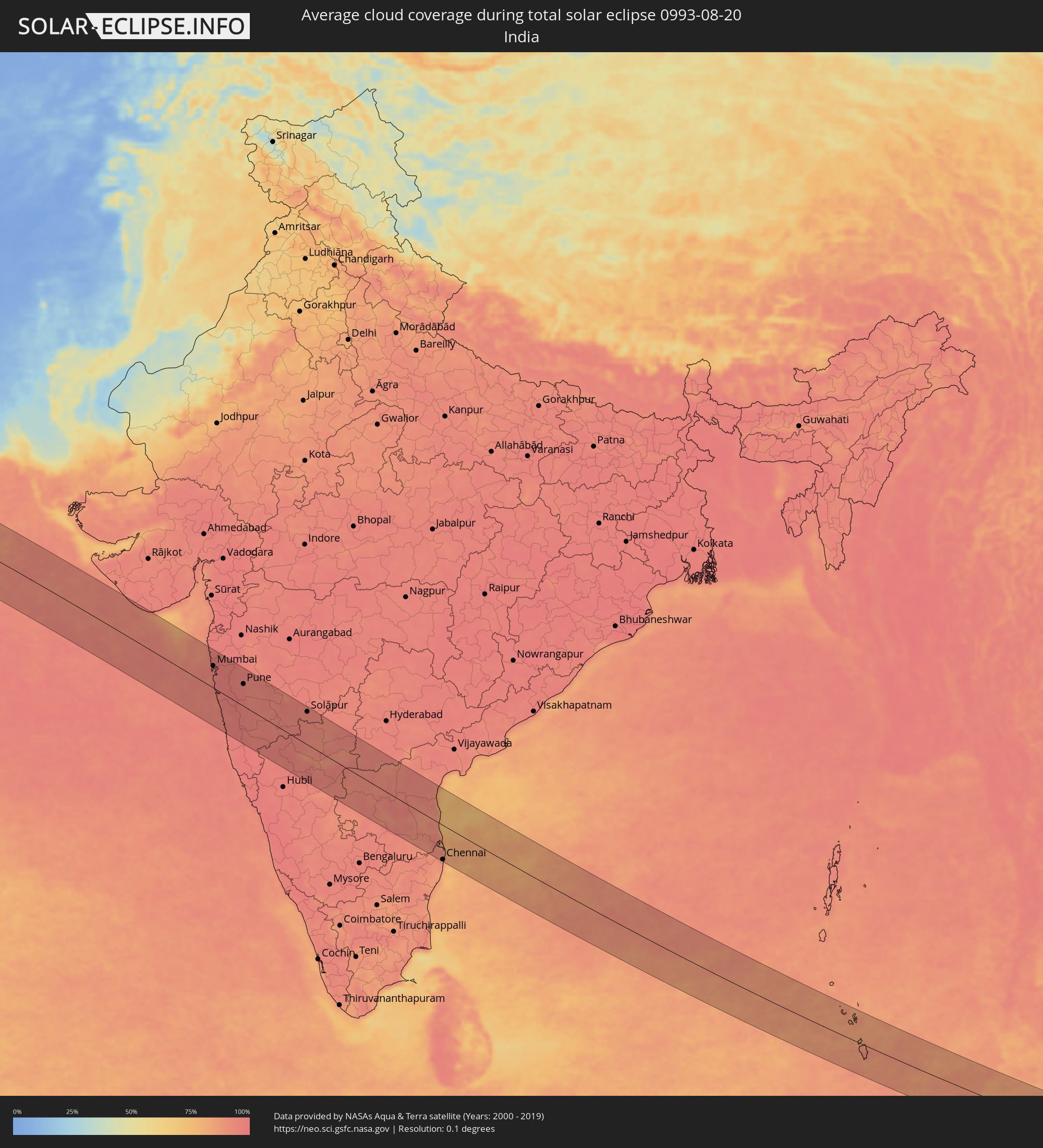 India
India
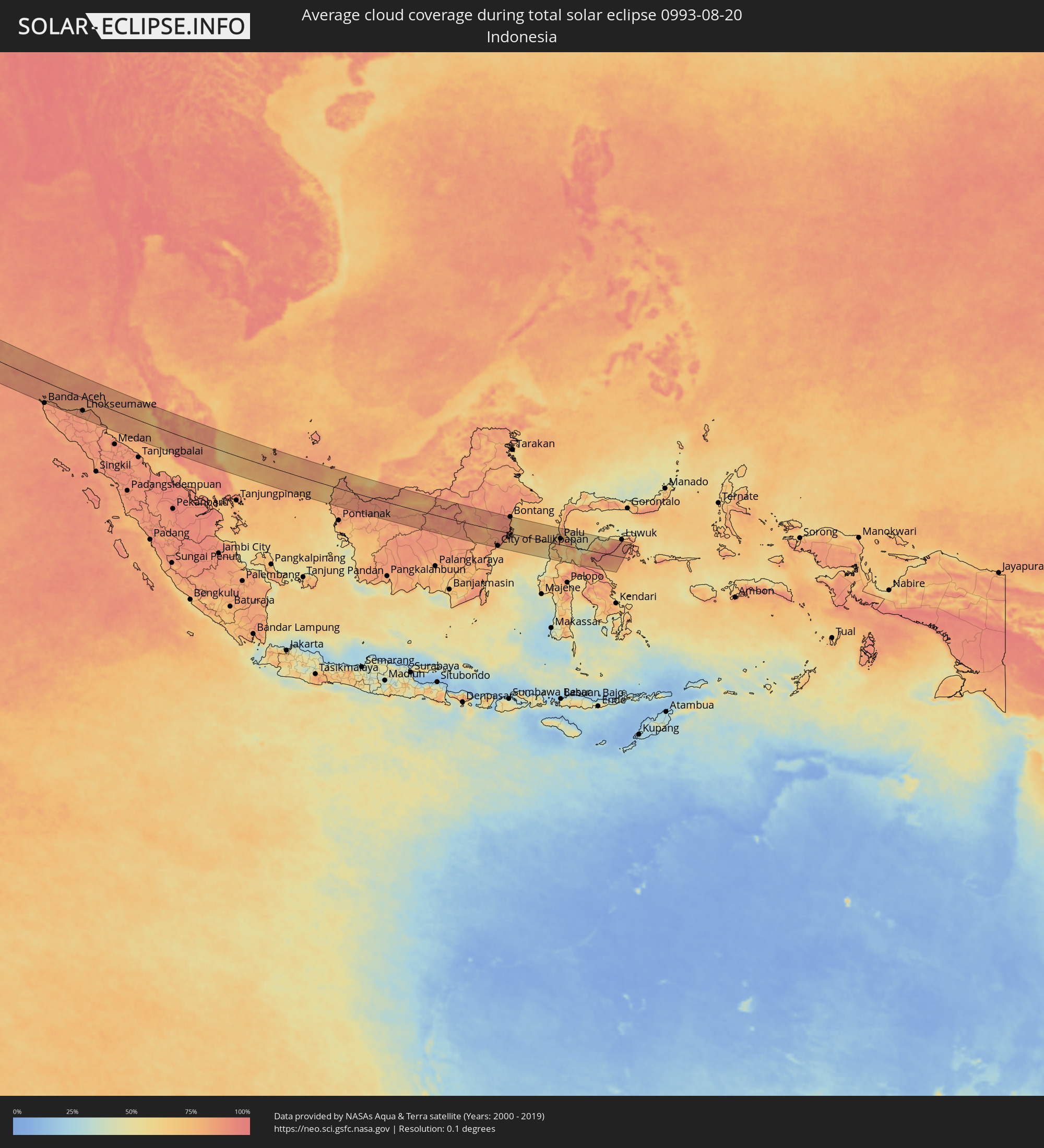 Indonesia
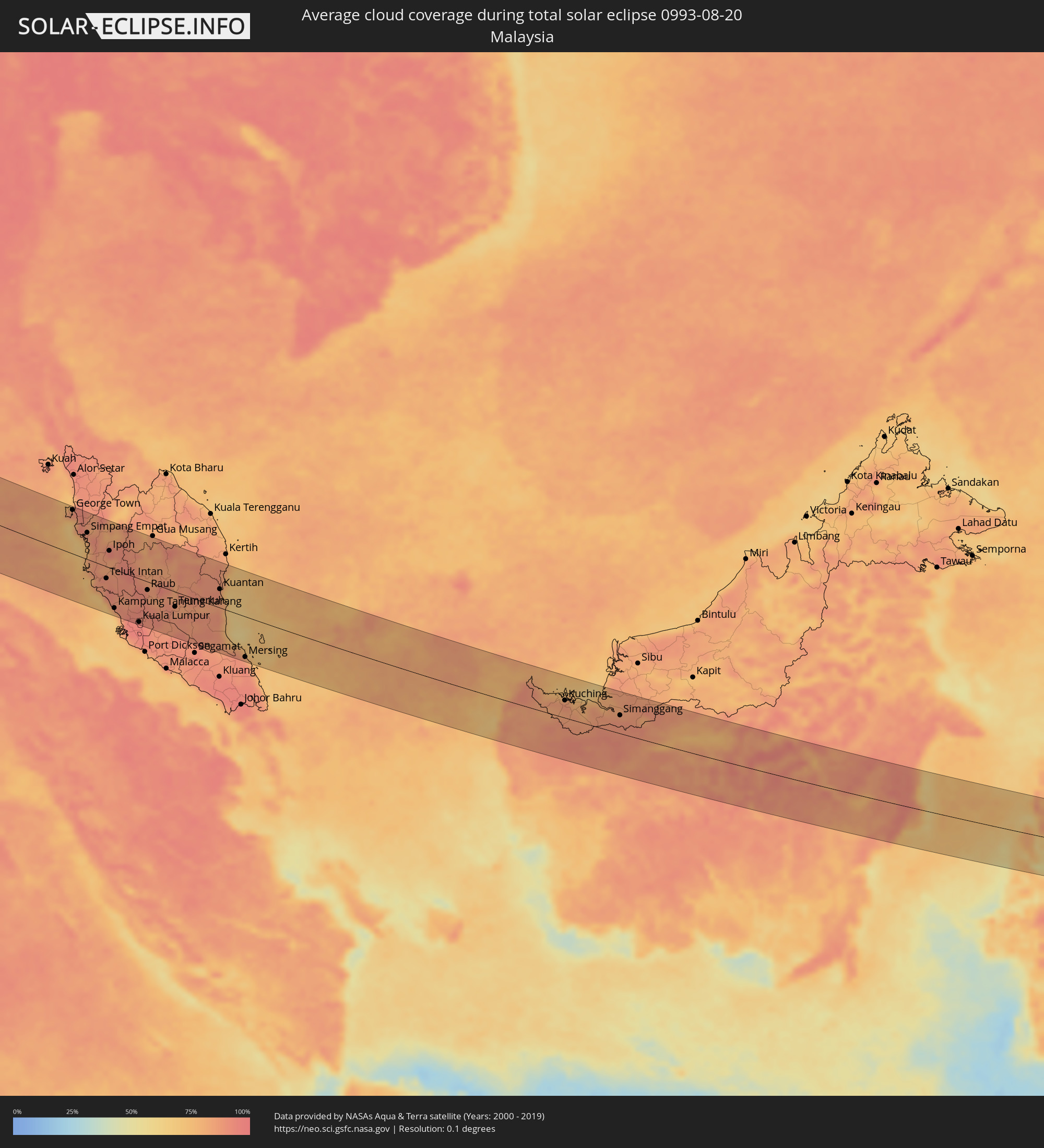 Malaysia
Cities inside the path of the eclipse
The following table shows all locations with a population of more than 5,000 inside the eclipse path. Cities which have more than 100,000 inhabitants are marked bold. A click at the locations opens a detailed map.
| City | Type | Eclipse duration | Local time of max. eclipse | Distance to central line | Ø Cloud coverage |
|
Tan-Tan, Guelmim-Es Smara
|
total | - | 05:56:11 UTC-00:30 | 45 km | 35% |
|
Sidi Ifni, Souss-Massa-Drâa
|
total | - | 05:56:39 UTC-00:30 | 38 km | 52% |
|
Guelmim, Guelmim-Es Smara
|
total | - | 05:56:26 UTC-00:30 | 7 km | 18% |
|
Tiznit, Souss-Massa-Drâa
|
total | - | 05:56:49 UTC-00:30 | 64 km | 20% |
|
Zagora, Souss-Massa-Drâa
|
total | - | 05:57:18 UTC-00:30 | 58 km | 15% |
|
Mhamid, Souss-Massa-Drâa
|
total | - | 05:57:00 UTC-00:30 | 0 km | 17% |
|
Ouargla, Ouargla
|
total | - | 06:40:49 UTC+00:09 | 59 km | 8% |
|
Rouissat, Ouargla
|
total | - | 06:40:49 UTC+00:09 | 56 km | 10% |
|
Hassi Messaoud, Ouargla
|
total | - | 06:41:00 UTC+00:09 | 20 km | 8% |
|
Şabrātah, Az Zāwiyah
|
total | - | 07:28:48 UTC+00:52 | 75 km | 10% |
|
Az Zāwīyah, Az Zāwiyah
|
total | - | 07:28:56 UTC+00:52 | 69 km | 13% |
|
Gharyan, Jabal al Gharbi District
|
total | - | 07:28:48 UTC+00:52 | 2 km | 4% |
|
Tripoli, Tripoli
|
total | - | 07:29:20 UTC+00:52 | 78 km | 14% |
|
Tagiura, Tripoli
|
total | - | 07:29:28 UTC+00:52 | 78 km | 13% |
|
Tarhuna, Al Marqab
|
total | - | 07:29:24 UTC+00:52 | 26 km | 9% |
|
Al Khums, Al Marqab
|
total | - | 07:30:01 UTC+00:52 | 45 km | 8% |
|
Zliten, Mişrātah
|
total | - | 07:30:09 UTC+00:52 | 23 km | 9% |
|
Mişrātah, Mişrātah
|
total | - | 07:30:30 UTC+00:52 | 9 km | 8% |
|
Benghazi, Banghāzī
|
total | - | 07:34:54 UTC+00:52 | 43 km | 8% |
|
Al Marj, Al Marj
|
total | - | 07:35:53 UTC+00:52 | 3 km | 7% |
|
Tobruk, Sha‘bīyat al Buţnān
|
total | - | 07:39:13 UTC+00:52 | 50 km | 5% |
|
Rosetta, Beheira
|
total | - | 08:54:54 UTC+02:00 | 101 km | 10% |
|
Fāraskūr, Damietta
|
total | - | 08:56:51 UTC+02:00 | 98 km | 13% |
|
Damietta, Damietta
|
total | - | 08:57:01 UTC+02:00 | 88 km | 11% |
|
‘Izbat al Burj, Dakahlia
|
total | - | 08:57:05 UTC+02:00 | 77 km | 11% |
|
Port Said, Port Said
|
total | - | 08:57:44 UTC+02:00 | 101 km | 14% |
|
Arish, North Sinai
|
total | - | 09:00:10 UTC+02:00 | 99 km | 1% |
|
Khān Yūnis, Gaza Strip
|
total | - | 09:01:01 UTC+02:00 | 71 km | 3% |
|
Gaza, Gaza Strip
|
total | - | 09:01:18 UTC+02:00 | 51 km | 6% |
|
Ashqelon, Southern District
|
total | - | 09:22:10 UTC+02:20 | 31 km | 6% |
|
Ashdod, Southern District
|
total | - | 09:22:18 UTC+02:20 | 17 km | 10% |
|
Qiryat Gat, Southern District
|
total | - | 09:22:29 UTC+02:20 | 35 km | 6% |
|
Tel Aviv, Tel Aviv
|
total | - | 09:22:33 UTC+02:20 | 17 km | 8% |
|
Beersheba, Southern District
|
total | - | 09:22:30 UTC+02:20 | 75 km | 2% |
|
Netanya, Central District
|
total | - | 09:22:43 UTC+02:20 | 46 km | 8% |
|
Kfar Saba, Central District
|
total | - | 09:22:46 UTC+02:20 | 29 km | 7% |
|
Az̧ Z̧āhirīyah, West Bank
|
total | - | 09:02:09 UTC+02:00 | 55 km | 1% |
|
Haifa, Haifa
|
total | - | 09:22:59 UTC+02:20 | 101 km | 15% |
|
Bet Shemesh, Jerusalem
|
total | - | 09:22:52 UTC+02:20 | 19 km | 6% |
|
Modiin, Central District
|
total | - | 09:22:55 UTC+02:20 | 1 km | 7% |
|
Ţūlkarm, West Bank
|
total | - | 09:02:19 UTC+02:00 | 45 km | 8% |
|
Bayt Liqyā, West Bank
|
total | - | 09:02:21 UTC+02:00 | 3 km | 6% |
|
Hebron, West Bank
|
total | - | 09:02:22 UTC+02:00 | 40 km | 1% |
|
Salfīt, West Bank
|
total | - | 09:02:33 UTC+02:00 | 22 km | 5% |
|
Jerusalem, Jerusalem
|
total | - | 09:23:15 UTC+02:20 | 12 km | 4% |
|
East Jerusalem, West Bank
|
total | - | 09:23:17 UTC+02:20 | 10 km | 4% |
|
Nablus, West Bank
|
total | - | 09:02:41 UTC+02:00 | 38 km | 4% |
|
Janīn, West Bank
|
total | - | 09:02:47 UTC+02:00 | 65 km | 5% |
|
Nazareth, Northern District
|
total | - | 09:23:29 UTC+02:20 | 91 km | 8% |
|
Ţūbās, West Bank
|
total | - | 09:02:54 UTC+02:00 | 51 km | 4% |
|
Jericho, West Bank
|
total | - | 09:02:59 UTC+02:00 | 1 km | 2% |
|
Safi, Karak
|
total | - | 09:26:42 UTC+02:23 | 90 km | 0% |
|
Kurayyimah, Irbid
|
total | - | 09:27:00 UTC+02:23 | 49 km | 7% |
|
‘Izrā, Karak
|
total | - | 09:27:06 UTC+02:23 | 73 km | 0% |
|
As Salţ, Balqa
|
total | - | 09:27:12 UTC+02:23 | 24 km | 1% |
|
‘Ajlūn, Ajlun
|
total | - | 09:27:16 UTC+02:23 | 57 km | 2% |
|
Mādabā, Madaba
|
total | - | 09:27:18 UTC+02:23 | 11 km | 0% |
|
Irbid, Irbid
|
total | - | 09:27:27 UTC+02:23 | 83 km | 2% |
|
Amman, Amman
|
total | - | 09:27:34 UTC+02:23 | 18 km | 0% |
|
Aţ Ţurrah, Irbid
|
total | - | 09:27:42 UTC+02:23 | 93 km | 1% |
|
Zarqa, Zarqa
|
total | - | 09:27:49 UTC+02:23 | 33 km | 0% |
|
Dar‘ā, Daraa
|
total | - | 09:29:21 UTC+02:25 | 93 km | 1% |
|
Mafraq, Mafraq
|
total | - | 09:28:02 UTC+02:23 | 64 km | 1% |
|
Al Azraq ash Shamālī, Zarqa
|
total | - | 09:29:06 UTC+02:23 | 22 km | 0% |
|
Qurayyat, Al Jawf
|
total | - | 10:13:08 UTC+03:06 | 31 km | 0% |
|
Turaif, Northern Borders
|
total | - | 10:15:30 UTC+03:06 | 27 km | 3% |
|
‘Ar‘ar, Northern Borders
|
total | - | 10:20:02 UTC+03:06 | 6 km | 3% |
|
Al Jahrā’, Al Jahrāʼ
|
total | - | 10:34:18 UTC+03:06 | 23 km | 0% |
|
Az Zubayr, Basra Governorate
|
total | - | 10:24:35 UTC+02:57 | 91 km | 1% |
|
Basrah, Basra Governorate
|
total | - | 10:24:41 UTC+02:57 | 105 km | 1% |
|
Al Başrah al Qadīmah, Basra Governorate
|
total | - | 10:24:46 UTC+02:57 | 106 km | 1% |
|
Umm Qaşr, Basra Governorate
|
total | - | 10:25:14 UTC+02:57 | 59 km | 1% |
|
Al Wafrah, Al Aḩmadī
|
total | - | 10:35:17 UTC+03:06 | 89 km | 1% |
|
Ar Rābiyah, Al Asimah
|
total | - | 10:34:55 UTC+03:06 | 19 km | 0% |
|
Ash Shāmīyah, Al Asimah
|
total | - | 10:34:57 UTC+03:06 | 13 km | 2% |
|
Janūb as Surrah, Al Farwaniyah
|
total | - | 10:35:02 UTC+03:06 | 21 km | 2% |
|
Ad Dasmah, Al Asimah
|
total | - | 10:35:02 UTC+03:06 | 10 km | 7% |
|
Ḩawallī, Hawalli
|
total | - | 10:35:07 UTC+03:06 | 13 km | 2% |
|
Bayān, Hawalli
|
total | - | 10:35:10 UTC+03:06 | 15 km | 2% |
|
Al Aḩmadī, Al Aḩmadī
|
total | - | 10:35:22 UTC+03:06 | 38 km | 7% |
|
Al Finţās, Al Aḩmadī
|
total | - | 10:35:24 UTC+03:06 | 27 km | 11% |
|
Al Mahbūlah, Al Aḩmadī
|
total | - | 10:35:26 UTC+03:06 | 30 km | 7% |
|
Az Zawr, Al Asimah
|
total | - | 10:35:35 UTC+03:06 | 6 km | 9% |
|
Abadan, Khuzestan
|
total | - | 10:54:02 UTC+03:25 | 102 km | 1% |
|
Al Fāw, Basra Governorate
|
total | - | 10:26:28 UTC+02:57 | 68 km | 9% |
|
Al Khafjī, Eastern Province
|
total | - | 10:36:39 UTC+03:06 | 94 km | 12% |
|
Bandar-e Ganāveh, Bushehr
|
total | - | 10:59:19 UTC+03:25 | 89 km | 25% |
|
Bandar-e Būshehr, Bushehr
|
total | - | 11:00:27 UTC+03:25 | 36 km | 20% |
|
Borāzjān, Bushehr
|
total | - | 11:01:06 UTC+03:25 | 80 km | 4% |
|
Fīrūzābād, Fars
|
total | - | 11:04:28 UTC+03:25 | 81 km | 8% |
|
Kīsh, Hormozgan
|
total | - | 11:09:48 UTC+03:25 | 103 km | 39% |
|
Gerāsh, Fars
|
total | - | 11:09:04 UTC+03:25 | 15 km | 4% |
|
Bandar-e Lengeh, Hormozgan
|
total | - | 11:11:51 UTC+03:25 | 70 km | 19% |
|
Ras al-Khaimah, Raʼs al Khaymah
|
total | - | 11:30:38 UTC+03:41 | 107 km | 27% |
|
Khasab, Musandam
|
total | - | 11:30:58 UTC+03:41 | 55 km | 16% |
|
Qeshm, Hormozgan
|
total | - | 11:14:46 UTC+03:25 | 24 km | 57% |
|
Bandar Abbas, Hormozgan
|
total | - | 11:14:33 UTC+03:25 | 49 km | 26% |
|
Mīnāb, Hormozgan
|
total | - | 11:16:30 UTC+03:25 | 76 km | 6% |
|
Chabahar, Sistan and Baluchestan
|
total | - | 11:27:01 UTC+03:25 | 44 km | 70% |
|
Jīwani, Balochistān
|
total | - | 12:32:24 UTC+04:28 | 71 km | 88% |
|
Gwadar, Balochistān
|
total | - | 12:33:40 UTC+04:28 | 105 km | 84% |
|
Bhayandar, Maharashtra
|
total | - | 13:58:52 UTC+05:21 | 84 km | 96% |
|
Mumbai, Maharashtra
|
total | - | 13:59:17 UTC+05:21 | 64 km | 96% |
|
Thāne, Maharashtra
|
total | - | 13:59:16 UTC+05:21 | 80 km | 97% |
|
Kalyān, Maharashtra
|
total | - | 13:59:33 UTC+05:21 | 94 km | 97% |
|
Pune, Maharashtra
|
total | - | 14:02:11 UTC+05:21 | 64 km | 95% |
|
Kolhāpur, Maharashtra
|
total | - | 14:05:49 UTC+05:21 | 89 km | 96% |
|
Ichalkaranji, Maharashtra
|
total | - | 14:06:18 UTC+05:21 | 77 km | 96% |
|
Sāngli, Maharashtra
|
total | - | 14:06:15 UTC+05:21 | 55 km | 95% |
|
Solāpur, Maharashtra
|
total | - | 14:07:38 UTC+05:21 | 96 km | 95% |
|
Bellary, Karnataka
|
total | - | 14:13:34 UTC+05:21 | 89 km | 91% |
|
Nellore, Andhra Pradesh
|
total | - | 14:20:14 UTC+05:21 | 12 km | 88% |
|
Chennai, Tamil Nadu
|
total | - | 14:22:49 UTC+05:21 | 103 km | 87% |
|
Sabang, Aceh
|
total | - | 16:38:13 UTC+07:07 | 69 km | 83% |
|
Reuleuet, Aceh
|
total | - | 16:39:49 UTC+07:07 | 96 km | 87% |
|
Bireun, Aceh
|
total | - | 16:40:12 UTC+07:07 | 79 km | 88% |
|
Lhokseumawe, Aceh
|
total | - | 16:40:36 UTC+07:07 | 63 km | 86% |
|
George Town, Penang
|
total | - | 16:31:03 UTC+06:55 | 92 km | 87% |
|
Bukit Mertajam, Penang
|
total | - | 16:31:12 UTC+06:55 | 92 km | 92% |
|
Taiping, Perak
|
total | - | 16:31:54 UTC+06:55 | 49 km | 89% |
|
Teluk Intan, Perak
|
total | - | 16:32:54 UTC+06:55 | 25 km | 87% |
|
Ipoh, Perak
|
total | - | 16:32:24 UTC+06:55 | 35 km | 93% |
|
Kampung Baru Subang, Selangor
|
total | - | 16:34:04 UTC+06:55 | 97 km | 95% |
|
Rawang, Selangor
|
total | - | 16:33:56 UTC+06:55 | 77 km | 93% |
|
Kuala Lumpur, Kuala Lumpur
|
total | - | 16:34:10 UTC+06:55 | 92 km | 95% |
|
Temerluh, Pahang
|
total | - | 16:34:20 UTC+06:55 | 32 km | 86% |
|
Kuantan, Pahang
|
total | - | 16:34:32 UTC+06:55 | 40 km | 88% |
|
Cukai, Terengganu
|
total | - | 16:34:11 UTC+06:55 | 89 km | 84% |
|
Pemangkat, West Kalimantan
|
total | - | 16:51:08 UTC+07:07 | 46 km | 81% |
|
Singkawang, West Kalimantan
|
total | - | 16:51:20 UTC+07:07 | 73 km | 85% |
|
Kuching, Sarawak
|
total | - | 17:05:25 UTC+07:21 | 38 km | 85% |
|
City of Balikpapan, East Kalimantan
|
total | - | 17:44:47 UTC+07:57 | 79 km | 79% |
|
Loa Janan, East Kalimantan
|
total | - | 17:44:24 UTC+07:57 | 2 km | 93% |
|
Samarinda, East Kalimantan
|
total | - | 17:44:21 UTC+07:57 | 9 km | 91% |
|
Bontang, East Kalimantan
|
total | - | 17:43:58 UTC+07:57 | 85 km | 81% |
|
Palu, Central Sulawesi
|
total | - | 17:44:41 UTC+07:57 | 30 km | 70% |
|
Poso, Central Sulawesi
|
total | - | 17:44:56 UTC+07:57 | 3 km | 53% |