Total solar eclipse of 11/04/1119
| Day of week: | Tuesday |
| Maximum duration of eclipse: | 03m14s |
| Maximum width of eclipse path: | 113 km |
| Saros cycle: | 109 |
| Coverage: | 100% |
| Magnitude: | 1.0336 |
| Gamma: | 0.0194 |
Wo kann man die Sonnenfinsternis vom 11/04/1119 sehen?
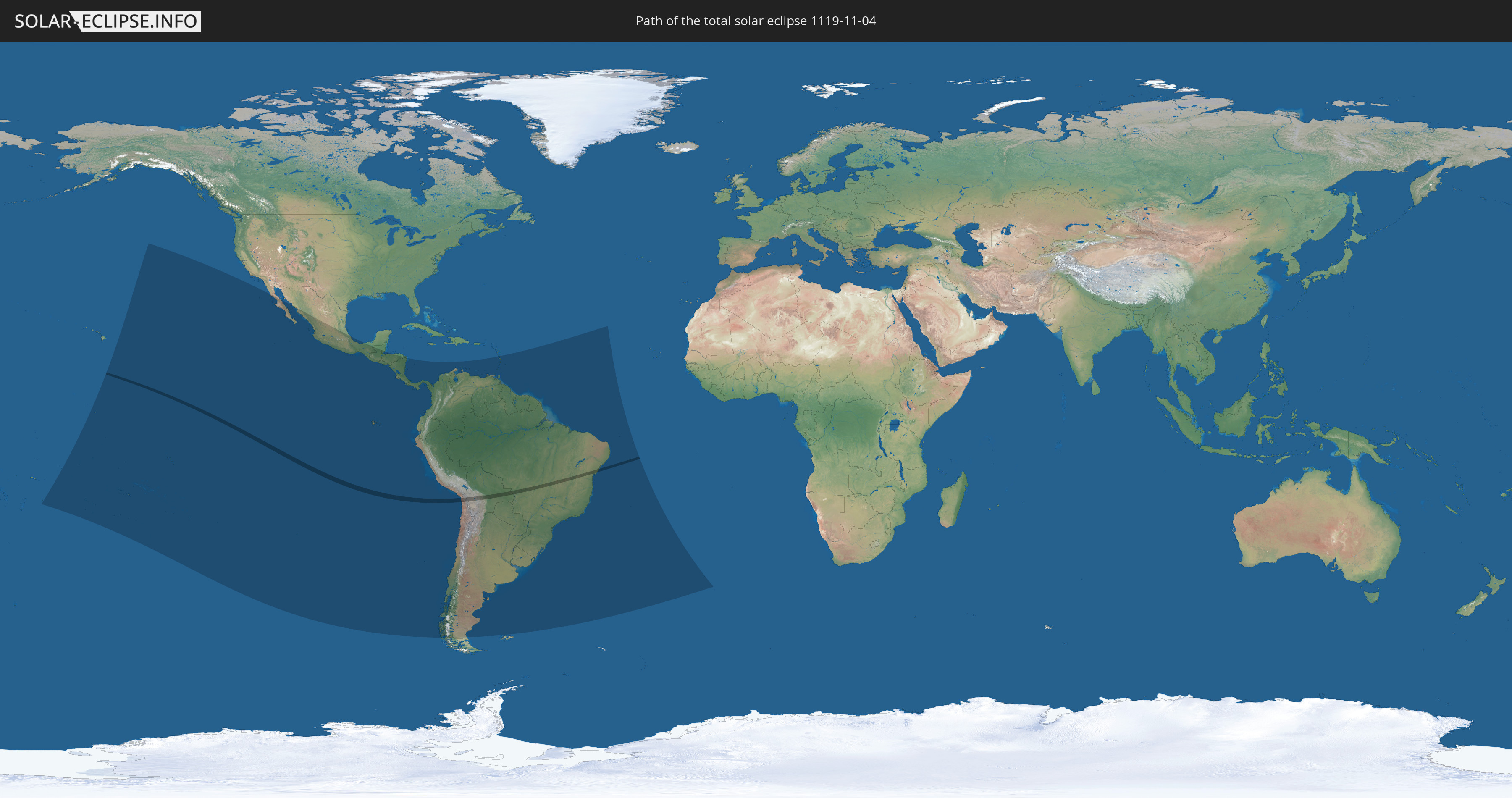
Die Sonnenfinsternis am 11/04/1119 kann man in 34 Ländern als partielle Sonnenfinsternis beobachten.
Der Finsternispfad verläuft durch 3 Länder. Nur in diesen Ländern ist sie als total Sonnenfinsternis zu sehen.
In den folgenden Ländern ist die Sonnenfinsternis total zu sehen
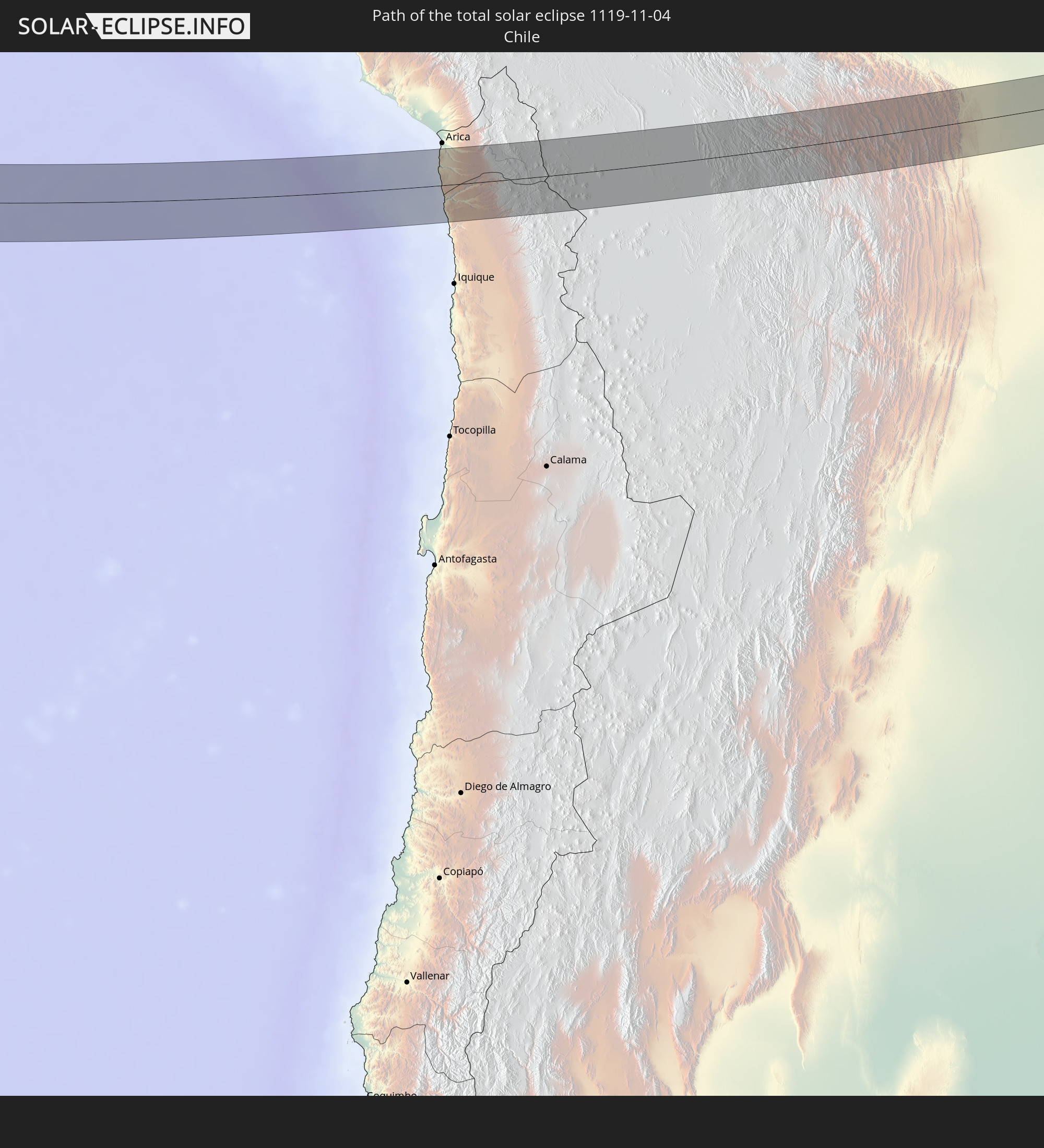 Chile
Chile
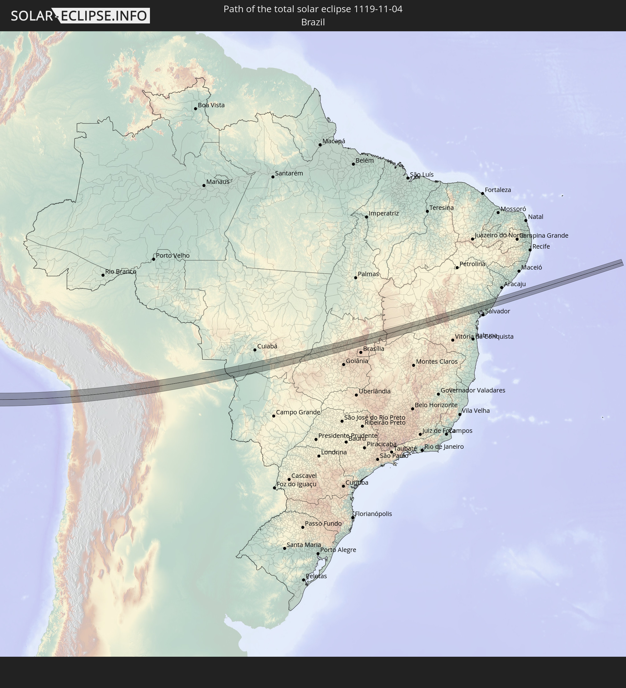 Brazil
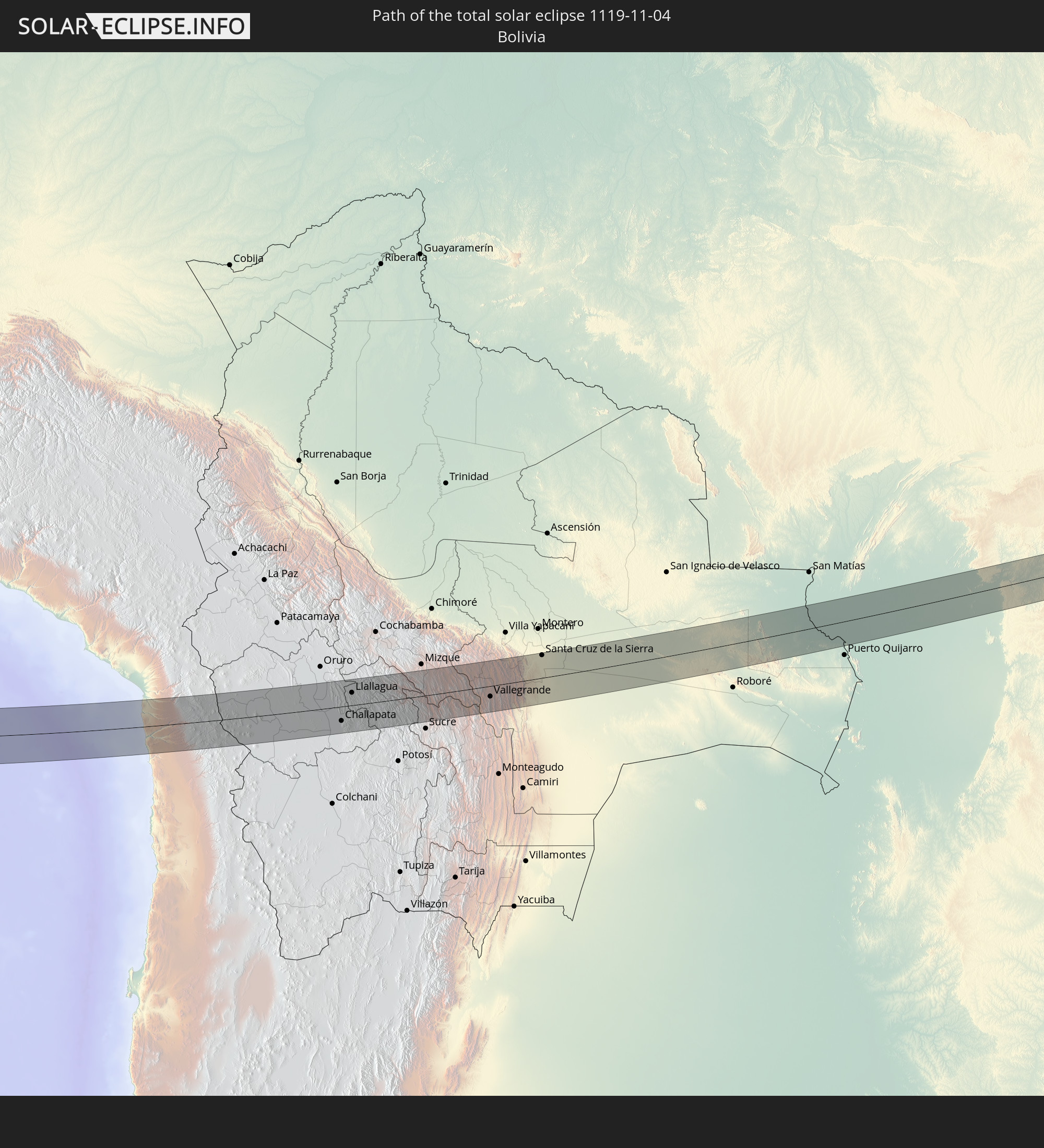 Bolivia
In den folgenden Ländern ist die Sonnenfinsternis partiell zu sehen
 Kiribati
 Cook Islands
 French Polynesia
 Pitcairn Islands
 Mexico
 Chile
Chile
 Guatemala
 Ecuador
 El Salvador
 Honduras
 Belize
 Nicaragua
 Costa Rica
 Panama
 Colombia
 Peru
Peru
 Brazil
 Argentina
 Venezuela
 Aruba
Aruba
 Bolivia
 Paraguay
 Trinidad and Tobago
 Grenada
 Saint Vincent and the Grenadines
 Falkland Islands
 Guyana
 Martinique
 Saint Lucia
 Barbados
 Uruguay
 Suriname
 French Guiana
 Saint Helena, Ascension and Tristan da Cunha
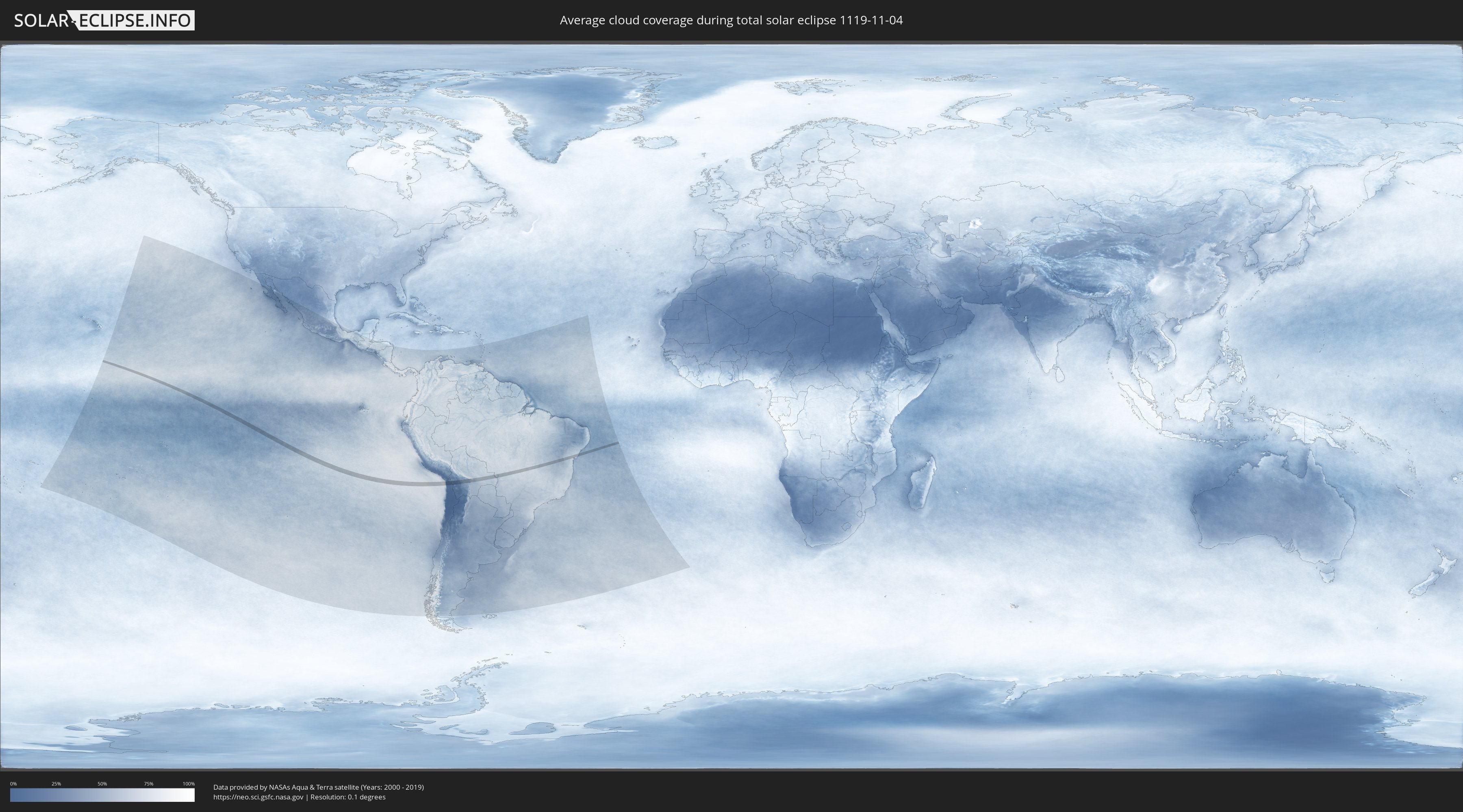
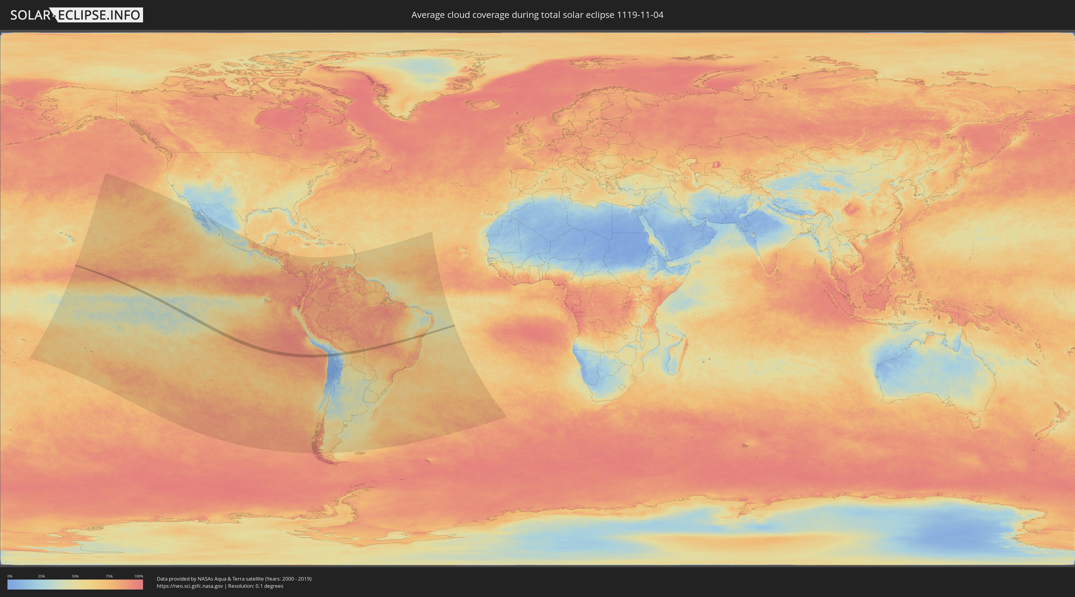
How will be the weather during the total solar eclipse on 11/04/1119?
Where is the best place to see the total solar eclipse of 11/04/1119?
The following maps show the average cloud coverage for the day of the total solar eclipse.
With the help of these maps, it is possible to find the place along the eclipse path, which has the best
chance of a cloudless sky.
Nevertheless, you should consider local circumstances and inform about the weather of your chosen
observation site.
The data is provided by NASAs satellites
AQUA and TERRA.
The cloud maps are averaged over a period of 19 years (2000 - 2019).
Detailed country maps
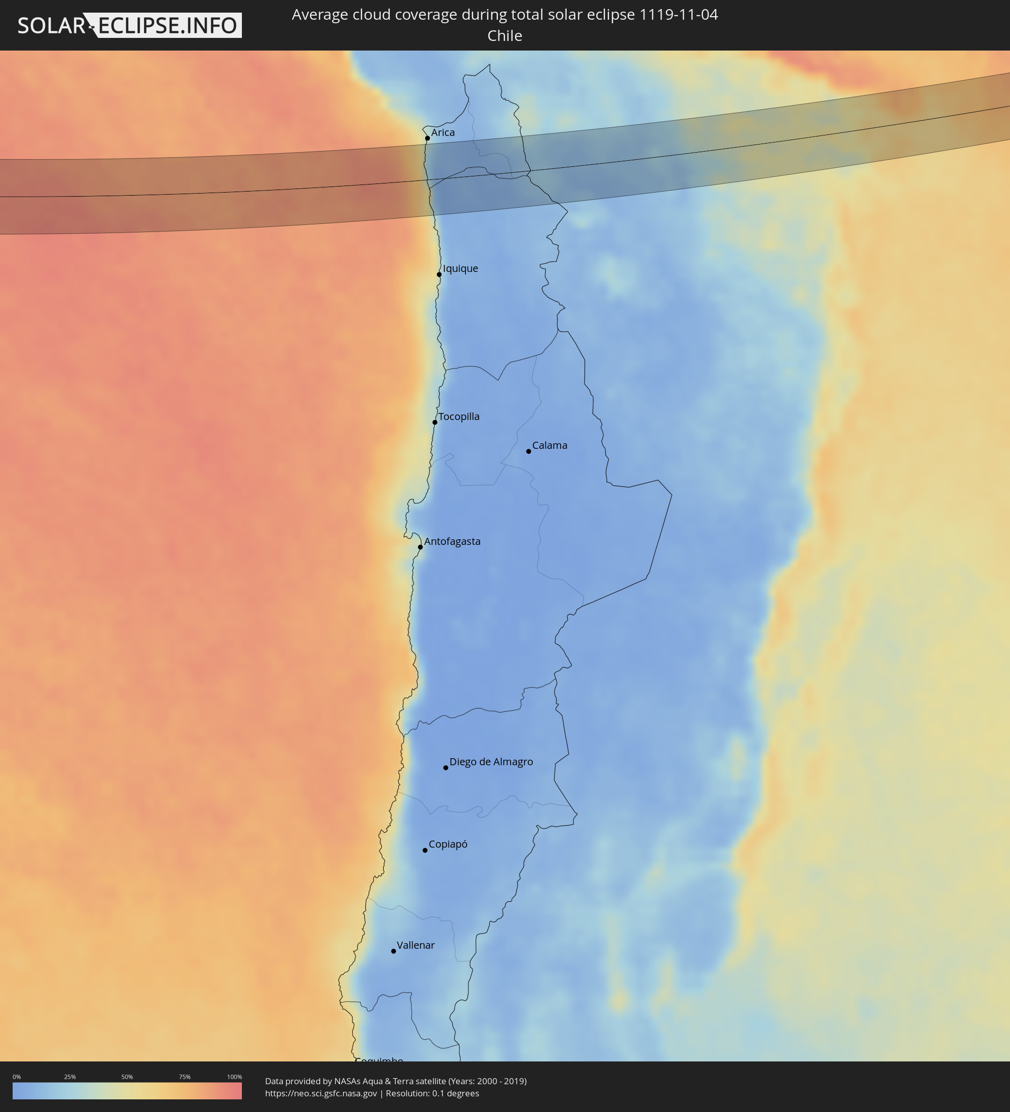 Chile
Chile
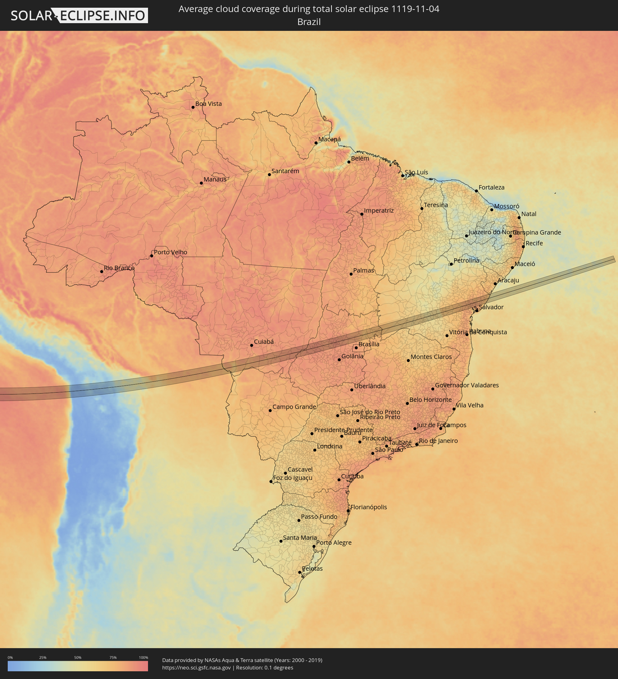 Brazil
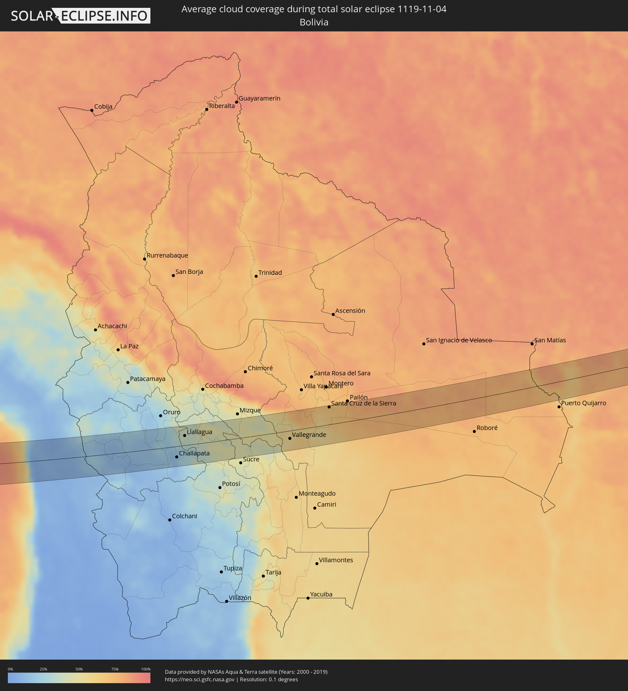 Bolivia
Cities inside the path of the eclipse
The following table shows all locations with a population of more than 5,000 inside the eclipse path. Cities which have more than 100,000 inhabitants are marked bold. A click at the locations opens a detailed map.
| City | Type | Eclipse duration | Local time of max. eclipse | Distance to central line | Ø Cloud coverage |
|
Huanuni, Oruro
|
total | - | 14:42:07 UTC-04:32 | 42 km | 33% |
|
Challapata, Oruro
|
total | - | 14:42:04 UTC-04:32 | 27 km | 17% |
|
Llallagua, Potosí
|
total | - | 14:42:32 UTC-04:32 | 24 km | 35% |
|
Aiquile, Cochabamba
|
total | - | 14:45:05 UTC-04:32 | 28 km | 46% |
|
Vallegrande, Santa Cruz
|
total | - | 14:46:48 UTC-04:32 | 20 km | 57% |
|
Santiago del Torno, Santa Cruz
|
total | - | 14:48:09 UTC-04:32 | 24 km | 58% |
|
Santa Cruz de la Sierra, Santa Cruz
|
total | - | 14:48:32 UTC-04:32 | 42 km | 72% |
|
Cotoca, Santa Cruz
|
total | - | 14:48:44 UTC-04:32 | 37 km | 69% |
|
San Julian, Santa Cruz
|
total | - | 14:49:02 UTC-04:32 | 37 km | 70% |
|
Rondonópolis, Mato Grosso
|
total | - | 15:54:36 UTC-03:38 | 8 km | 82% |
|
Guiratinga, Mato Grosso
|
total | - | 15:55:34 UTC-03:38 | 0 km | 87% |
|
Barra do Garças, Mato Grosso
|
total | - | 15:57:15 UTC-03:38 | 11 km | 86% |
|
Aragarças, Goiás
|
total | - | 15:57:15 UTC-03:38 | 10 km | 86% |
|
Itapirapuã, Goiás
|
total | - | 16:30:47 UTC-03:06 | 25 km | 88% |
|
Itapuranga, Goiás
|
total | - | 16:31:27 UTC-03:06 | 15 km | 86% |
|
Rubiataba, Goiás
|
total | - | 16:31:44 UTC-03:06 | 24 km | 88% |
|
Carmo do Rio Verde, Goiás
|
total | - | 16:31:44 UTC-03:06 | 1 km | 90% |
|
Uruana, Goiás
|
total | - | 16:31:42 UTC-03:06 | 16 km | 88% |
|
Ceres, Goiás
|
total | - | 16:31:50 UTC-03:06 | 3 km | 90% |
|
Rialma, Goiás
|
total | - | 16:31:51 UTC-03:06 | 2 km | 90% |
|
Goianésia, Goiás
|
total | - | 16:32:13 UTC-03:06 | 11 km | 85% |
|
Barro Alto, Goiás
|
total | - | 16:32:31 UTC-03:06 | 21 km | 87% |
|
Padre Bernardo, Goiás
|
total | - | 16:32:56 UTC-03:06 | 18 km | 82% |
|
Riacho de Santana, Bahia
|
total | - | 17:09:18 UTC-02:34 | 7 km | 61% |
|
Paramirim, Bahia
|
total | - | 17:09:42 UTC-02:34 | 11 km | 55% |
|
Itaberaba, Bahia
|
total | - | 17:10:51 UTC-02:34 | 27 km | 75% |
|
Iaçu, Bahia
|
total | - | 17:10:48 UTC-02:34 | 1 km | 75% |
|
Castro Alves, Bahia
|
total | - | 17:11:05 UTC-02:34 | 25 km | 82% |
|
Santo Estêvão, Bahia
|
total | - | 17:11:16 UTC-02:34 | 5 km | 80% |
|
Anguera, Bahia
|
total | - | 17:11:21 UTC-02:34 | 34 km | 81% |
|
Cruz das Almas, Bahia
|
total | - | 17:11:14 UTC-02:34 | 26 km | 79% |
|
Conceição da Feira, Bahia
|
total | - | 17:11:19 UTC-02:34 | 11 km | 80% |
|
São Gonçalo dos Campos, Bahia
|
total | - | 17:11:21 UTC-02:34 | 5 km | 83% |
|
Feira de Santana, Bahia
|
total | - | 17:11:24 UTC-02:34 | 13 km | 83% |
|
Cachoeira, Bahia
|
total | - | 17:11:18 UTC-02:34 | 23 km | 77% |
|
Conceição do Jacuípe, Bahia
|
total | - | 17:11:27 UTC-02:34 | 2 km | 82% |
|
Irará, Bahia
|
total | - | 17:11:32 UTC-02:34 | 30 km | 78% |
|
Coração de Maria, Bahia
|
total | - | 17:11:29 UTC-02:34 | 10 km | 80% |
|
Santo Amaro, Bahia
|
total | - | 17:11:24 UTC-02:34 | 25 km | 82% |
|
São Sebastião do Passé, Bahia
|
total | - | 17:11:29 UTC-02:34 | 28 km | 81% |
|
Alagoinhas, Bahia
|
total | - | 17:11:38 UTC-02:34 | 10 km | 78% |
|
Catu, Bahia
|
total | - | 17:11:34 UTC-02:34 | 15 km | 82% |
|
Entre Rios, Bahia
|
total | - | 17:11:47 UTC-02:34 | 20 km | 78% |
|
Esplanada, Bahia
|
total | - | 17:11:52 UTC-02:34 | 31 km | 78% |
|
Conde, Bahia
|
total | - | 17:11:58 UTC-02:34 | 18 km | 59% |