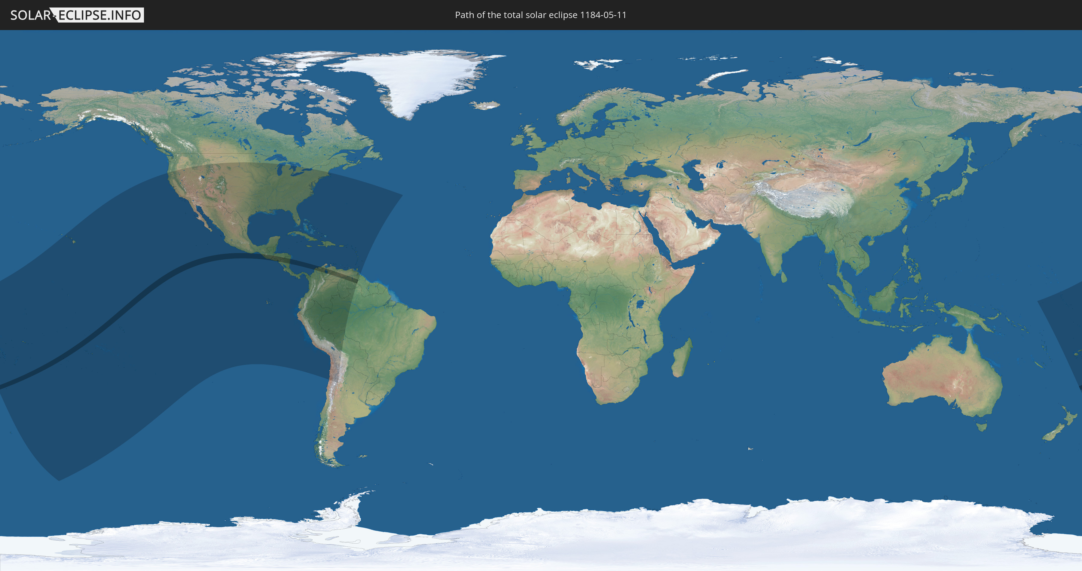
Total solar eclipse of 05/11/1184
| Day of week: | Friday |
| Maximum duration of eclipse: | 05m35s |
| Maximum width of eclipse path: | 204 km |
| Saros cycle: | 105 |
| Coverage: | 100% |
| Magnitude: | 1.0609 |
| Gamma: | -0.2094 |
Wo kann man die Sonnenfinsternis vom 05/11/1184 sehen?
Die Sonnenfinsternis am 05/11/1184 kann man in 60 Ländern als partielle Sonnenfinsternis beobachten.
Der Finsternispfad verläuft durch 10 Länder. Nur in diesen Ländern ist sie als total Sonnenfinsternis zu sehen.
In den folgenden Ländern ist die Sonnenfinsternis total zu sehen
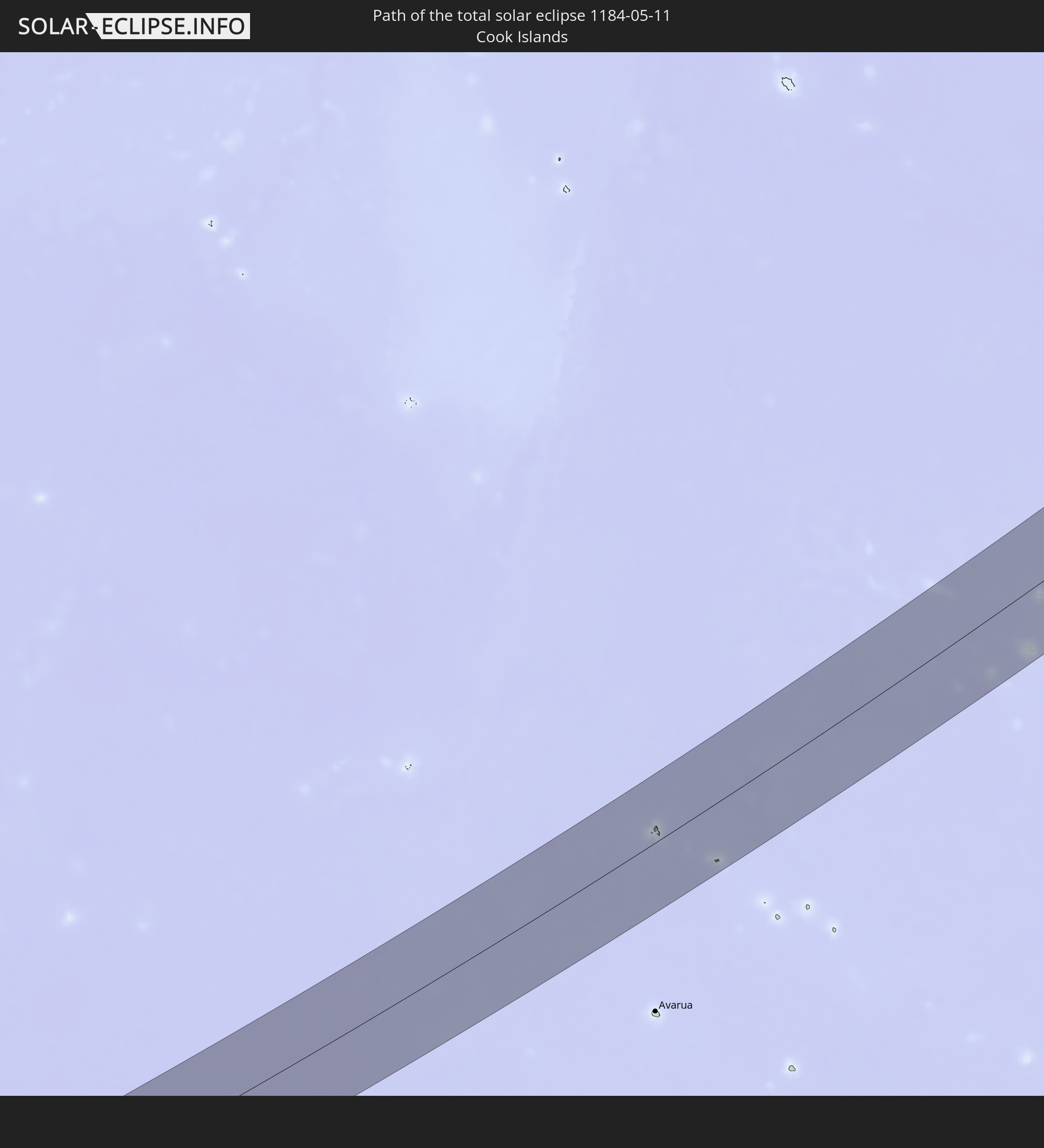 Cook Islands
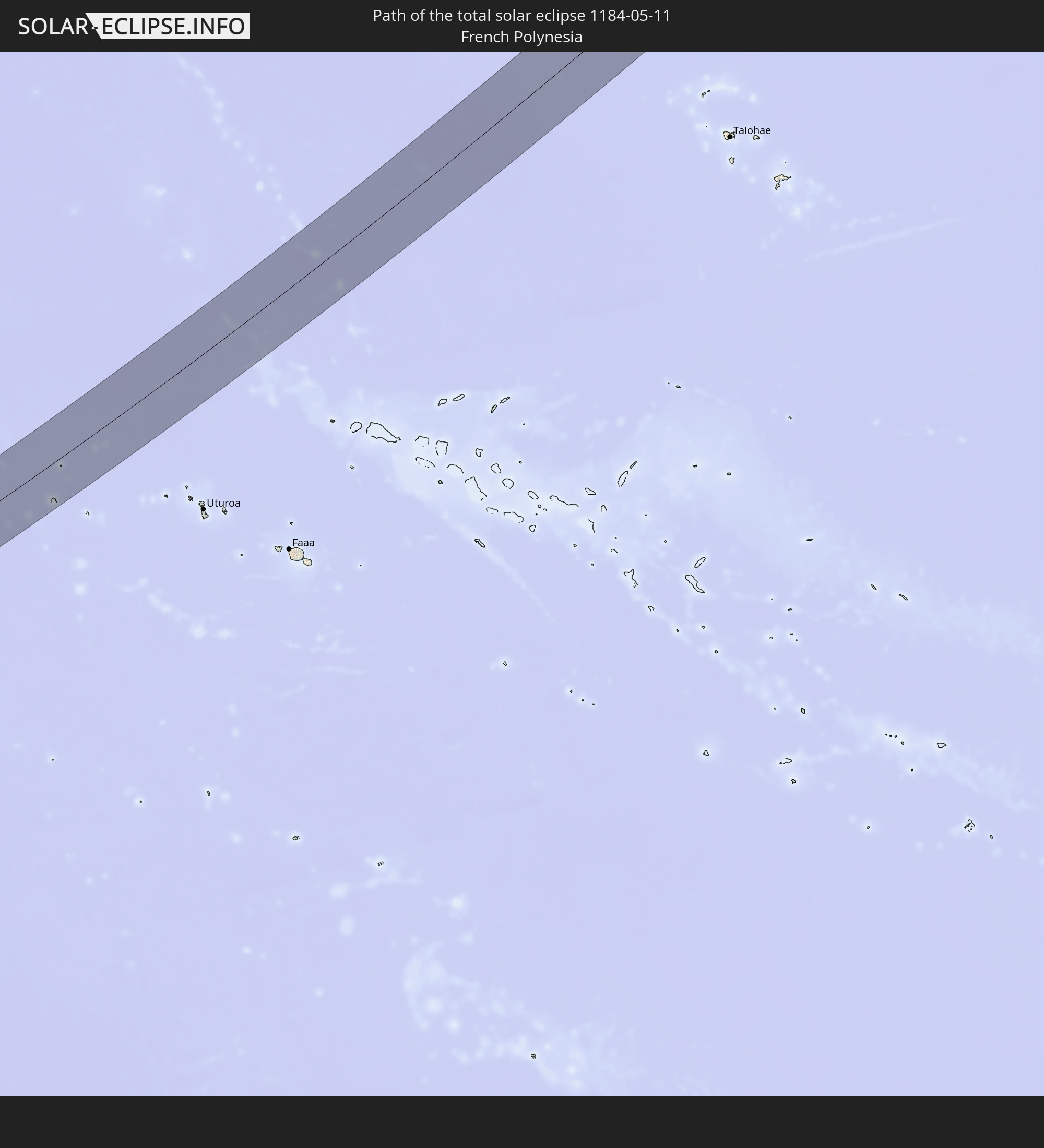 French Polynesia
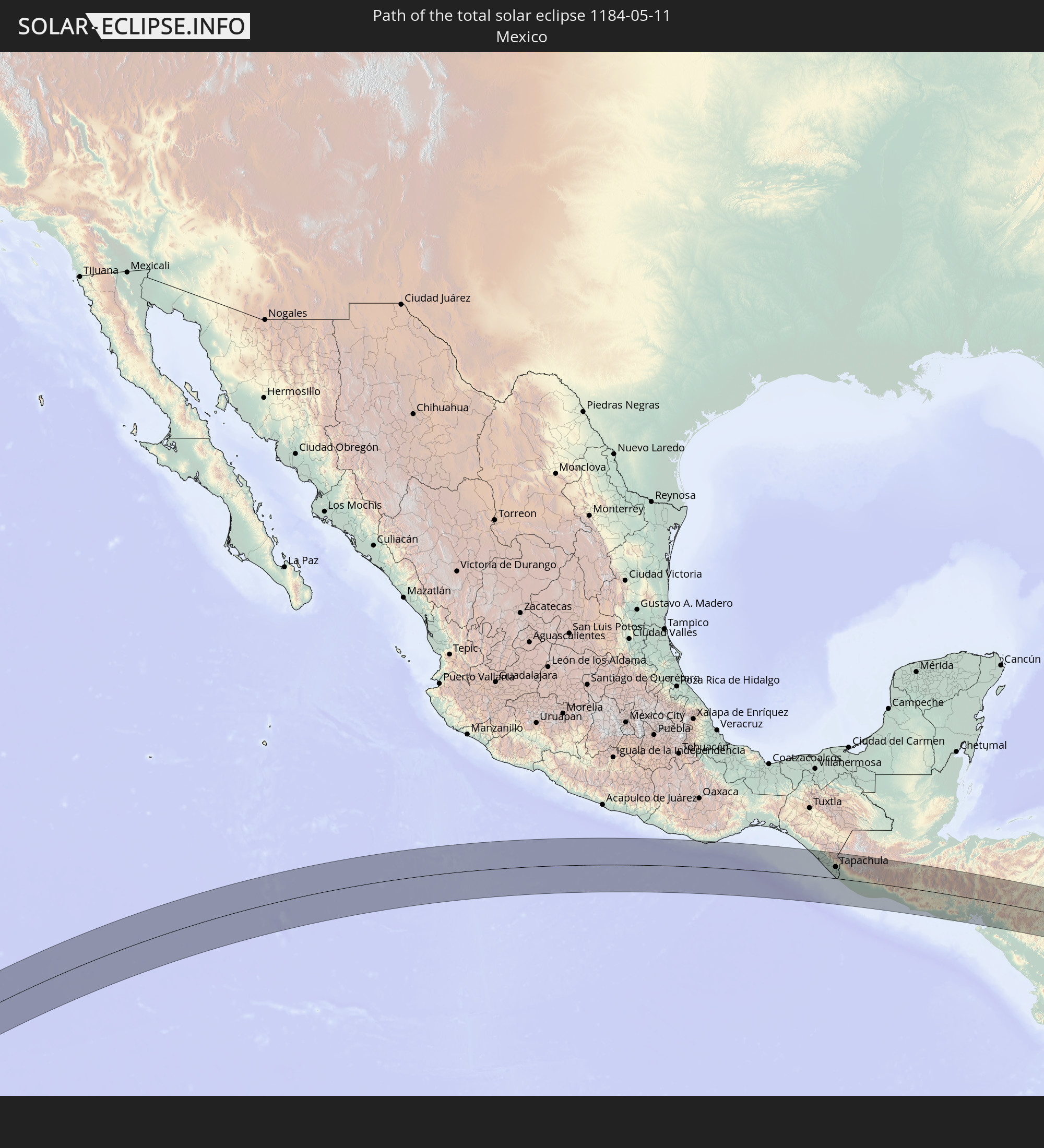 Mexico
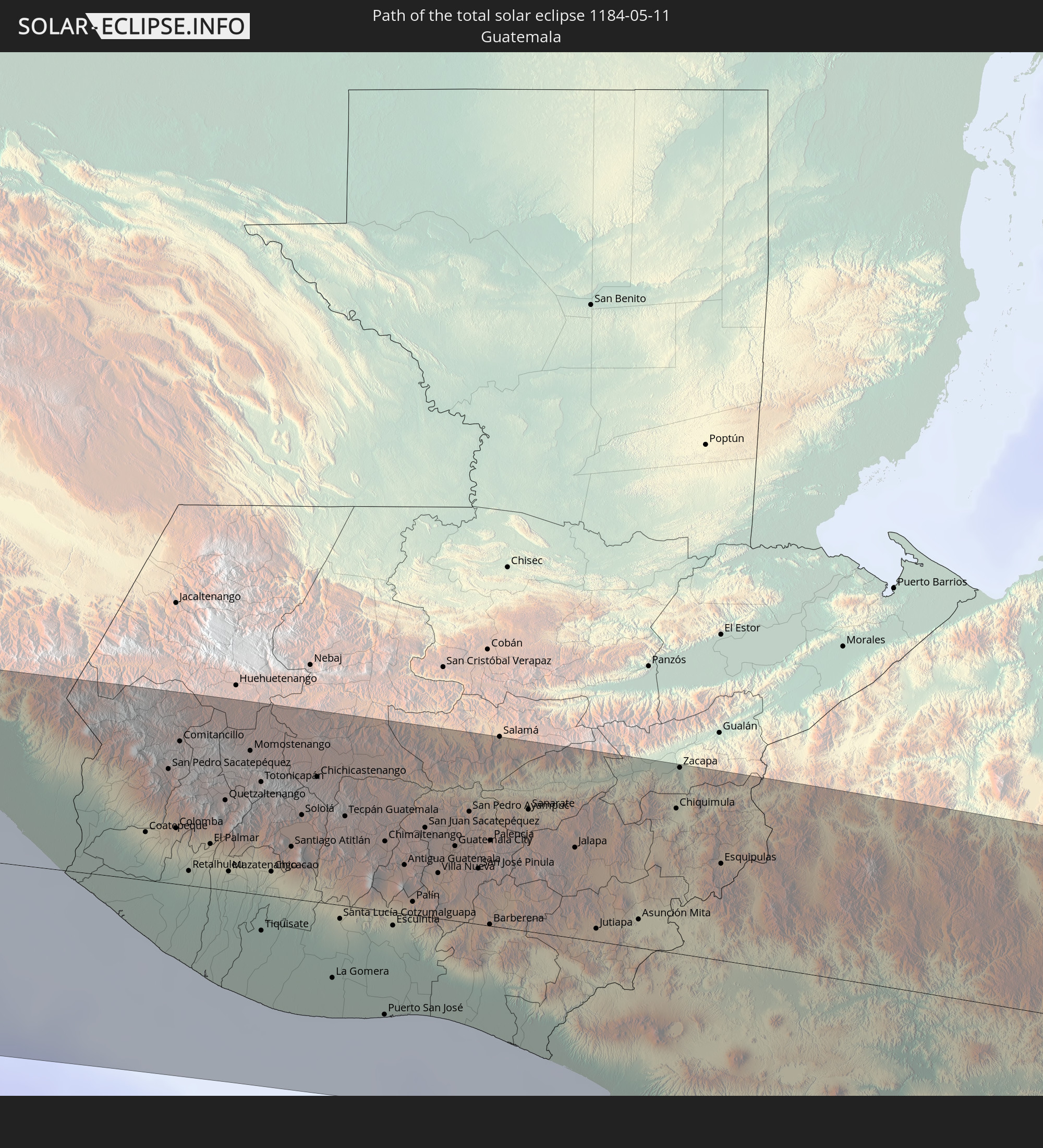 Guatemala
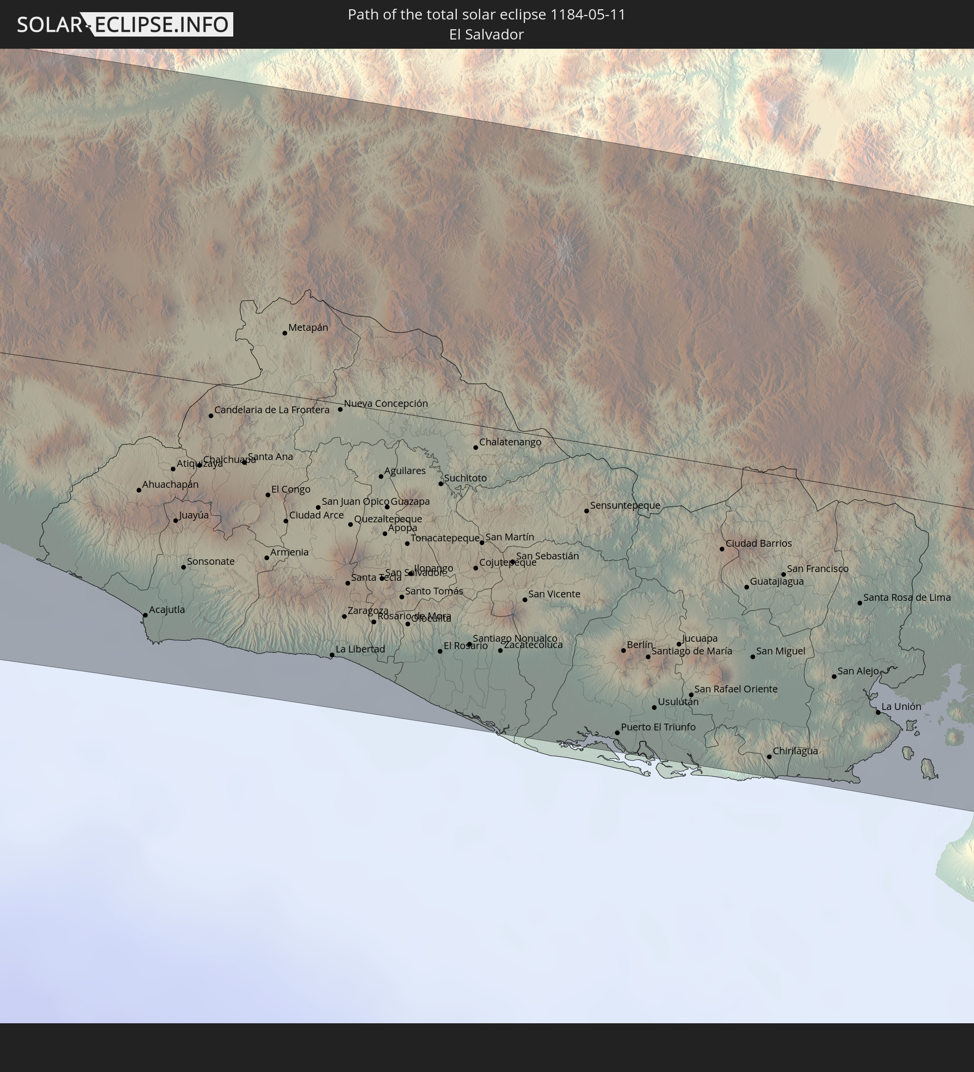 El Salvador
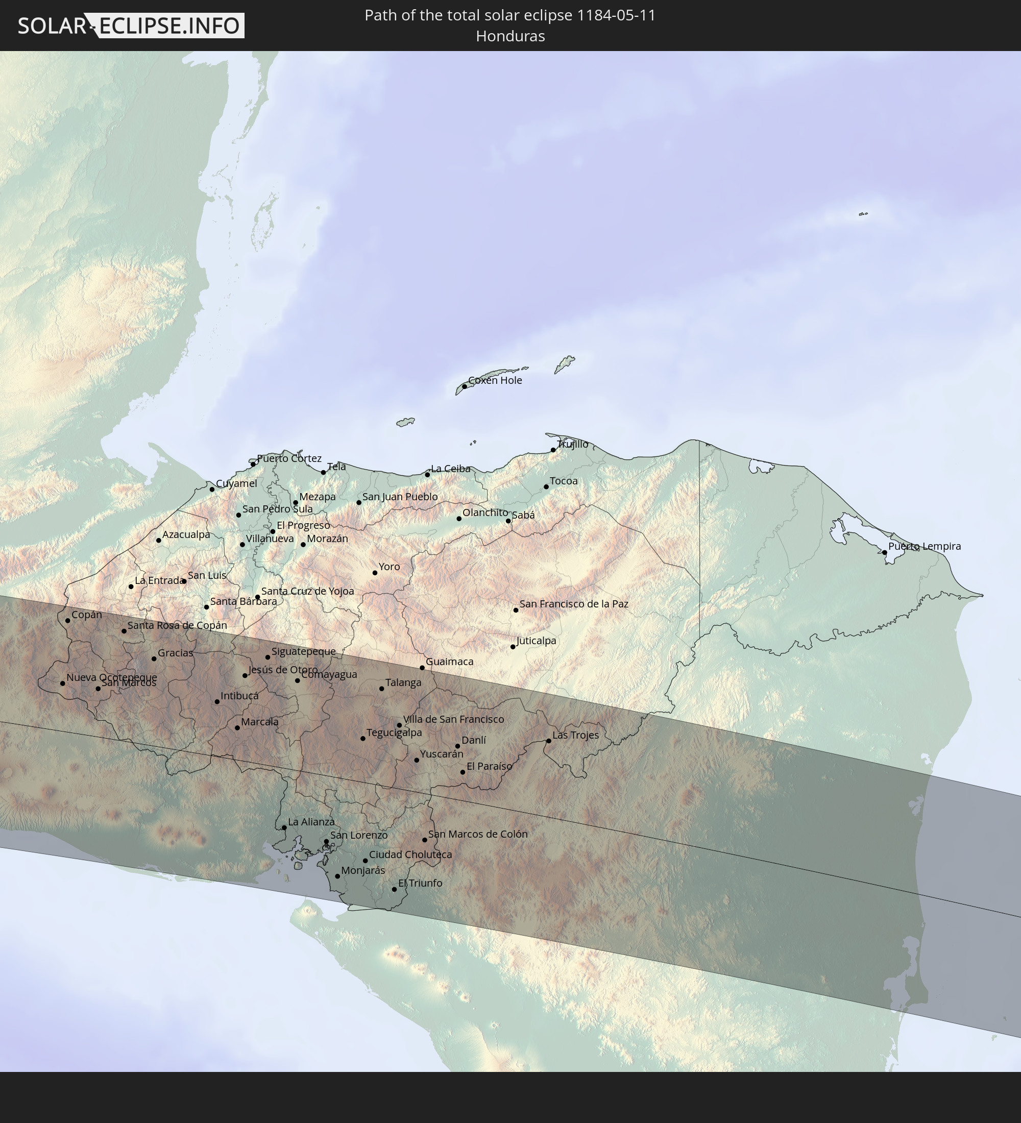 Honduras
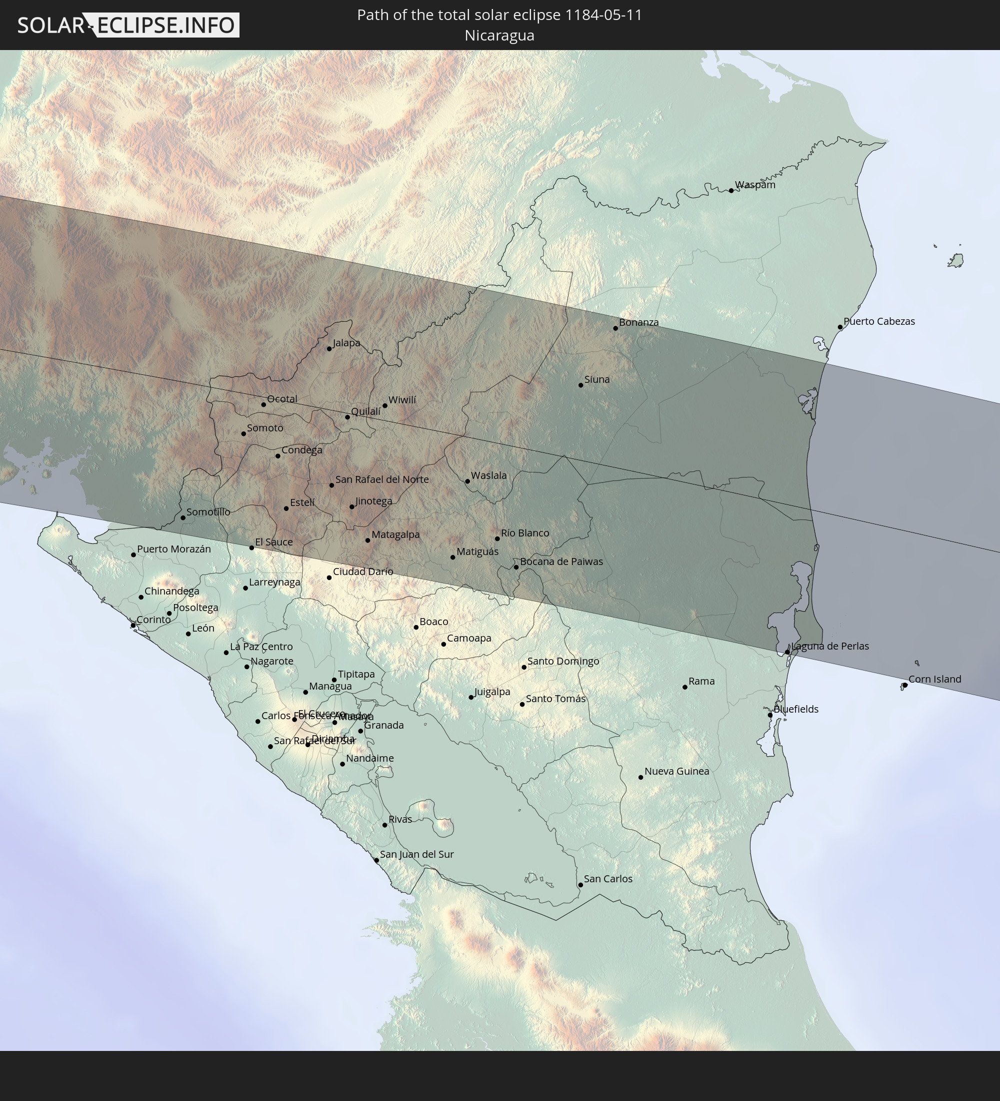 Nicaragua
 Colombia
 Venezuela
 Guyana
In den folgenden Ländern ist die Sonnenfinsternis partiell zu sehen
 Fiji
Fiji
 United States
 New Zealand
 United States Minor Outlying Islands
 Wallis and Futuna
 Tonga
Tonga
 Kiribati
 Samoa
Samoa
 Tokelau
 American Samoa
 Niue
Niue
 Cook Islands
 French Polynesia
 Canada
 Pitcairn Islands
 Mexico
 Chile
Chile
 Guatemala
 Ecuador
 El Salvador
 Honduras
 Belize
 Nicaragua
 Costa Rica
 Cuba
Cuba
 Panama
 Colombia
 Cayman Islands
 Peru
Peru
 The Bahamas
 Jamaica
 Haiti
Haiti
 Brazil
 Argentina
 Venezuela
 Turks and Caicos Islands
 Dominican Republic
 Aruba
Aruba
 Bolivia
 Puerto Rico
 United States Virgin Islands
 Bermuda
 British Virgin Islands
 Anguilla
 Collectivity of Saint Martin
 Saint Barthélemy
 Saint Kitts and Nevis
 Antigua and Barbuda
 Montserrat
 Trinidad and Tobago
 Guadeloupe
 Grenada
 Dominica
 Saint Vincent and the Grenadines
 Guyana
 Martinique
 Saint Lucia
 Barbados
 Nauru
Nauru
 Tuvalu
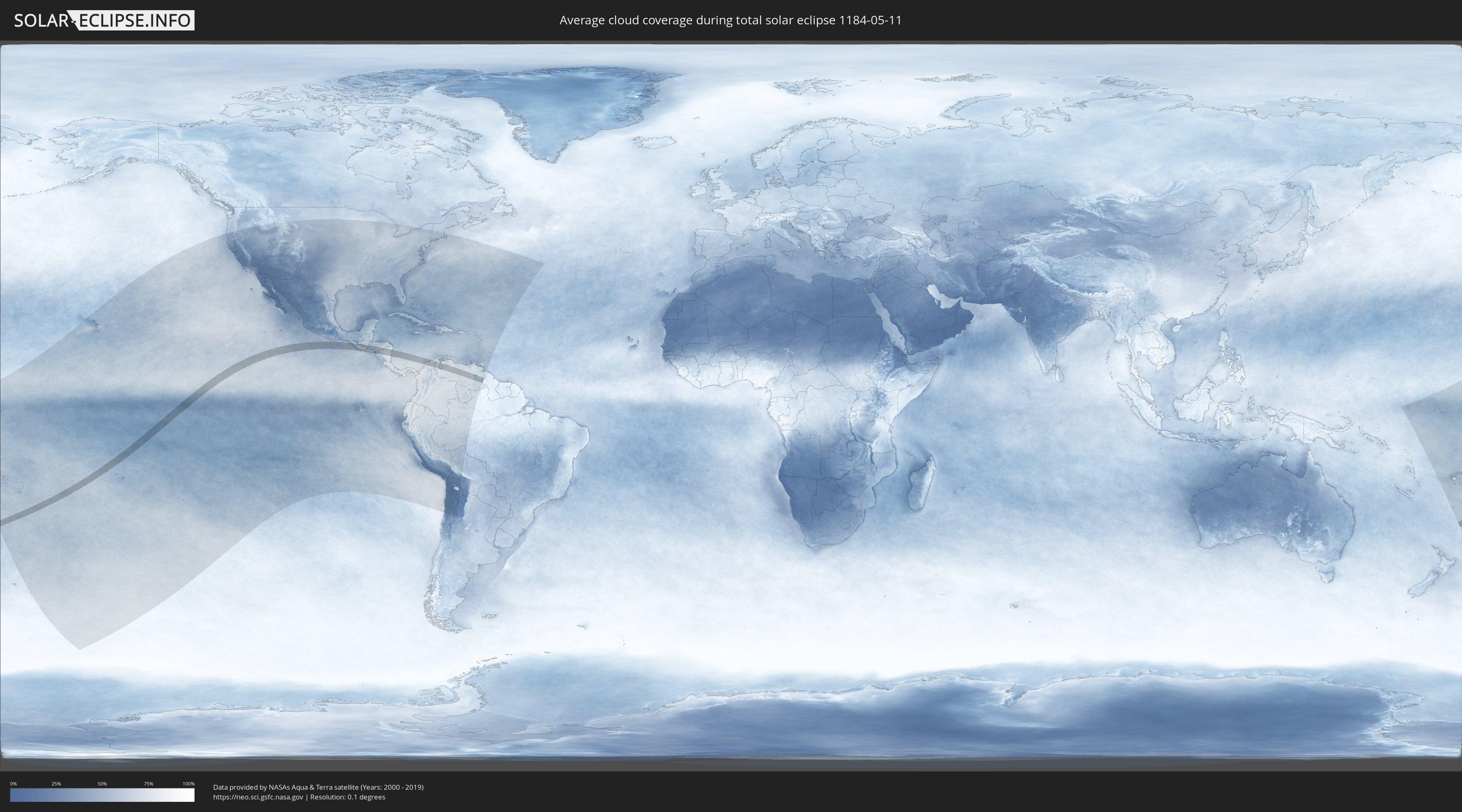
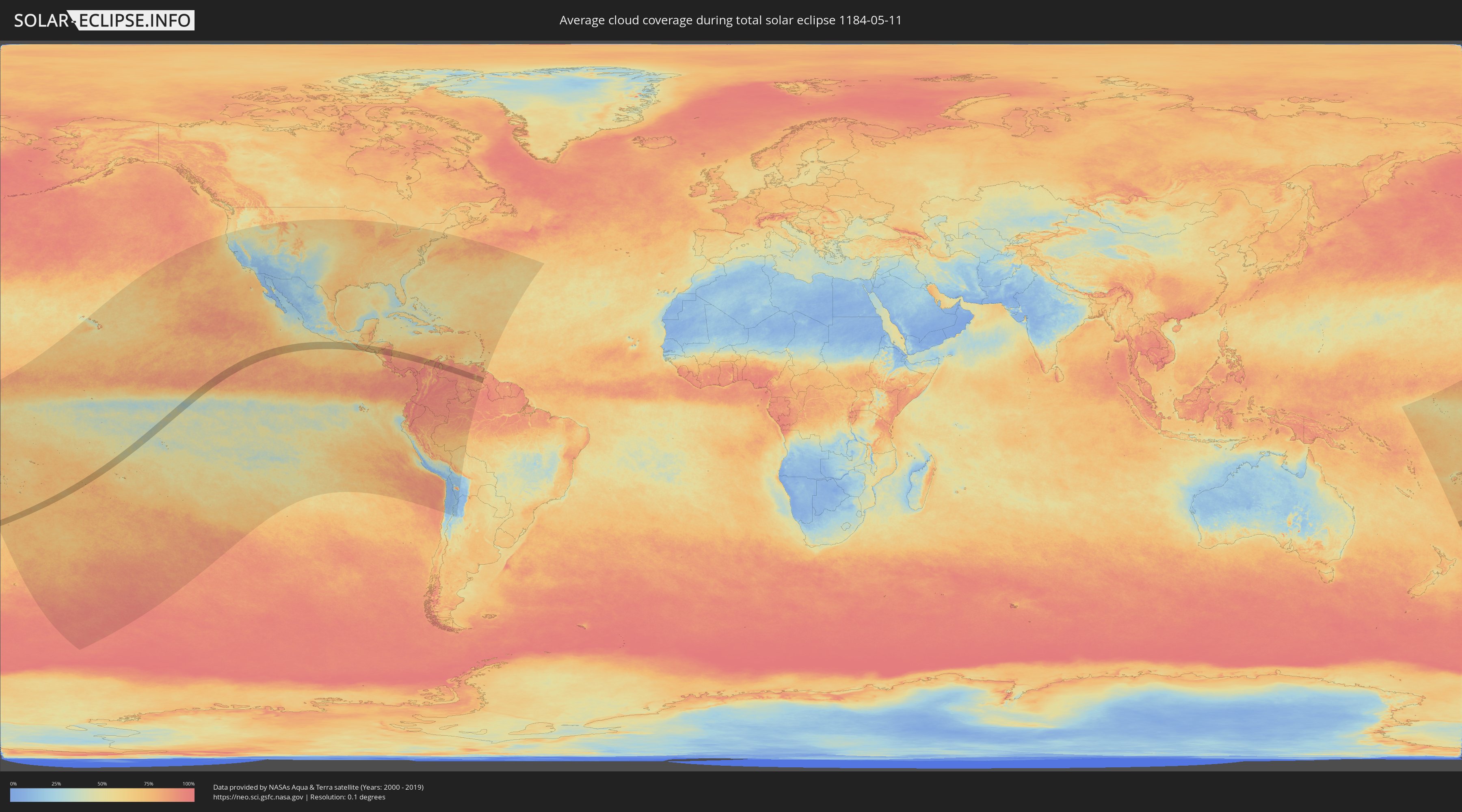
How will be the weather during the total solar eclipse on 05/11/1184?
Where is the best place to see the total solar eclipse of 05/11/1184?
The following maps show the average cloud coverage for the day of the total solar eclipse.
With the help of these maps, it is possible to find the place along the eclipse path, which has the best
chance of a cloudless sky.
Nevertheless, you should consider local circumstances and inform about the weather of your chosen
observation site.
The data is provided by NASAs satellites
AQUA and TERRA.
The cloud maps are averaged over a period of 19 years (2000 - 2019).
Detailed country maps
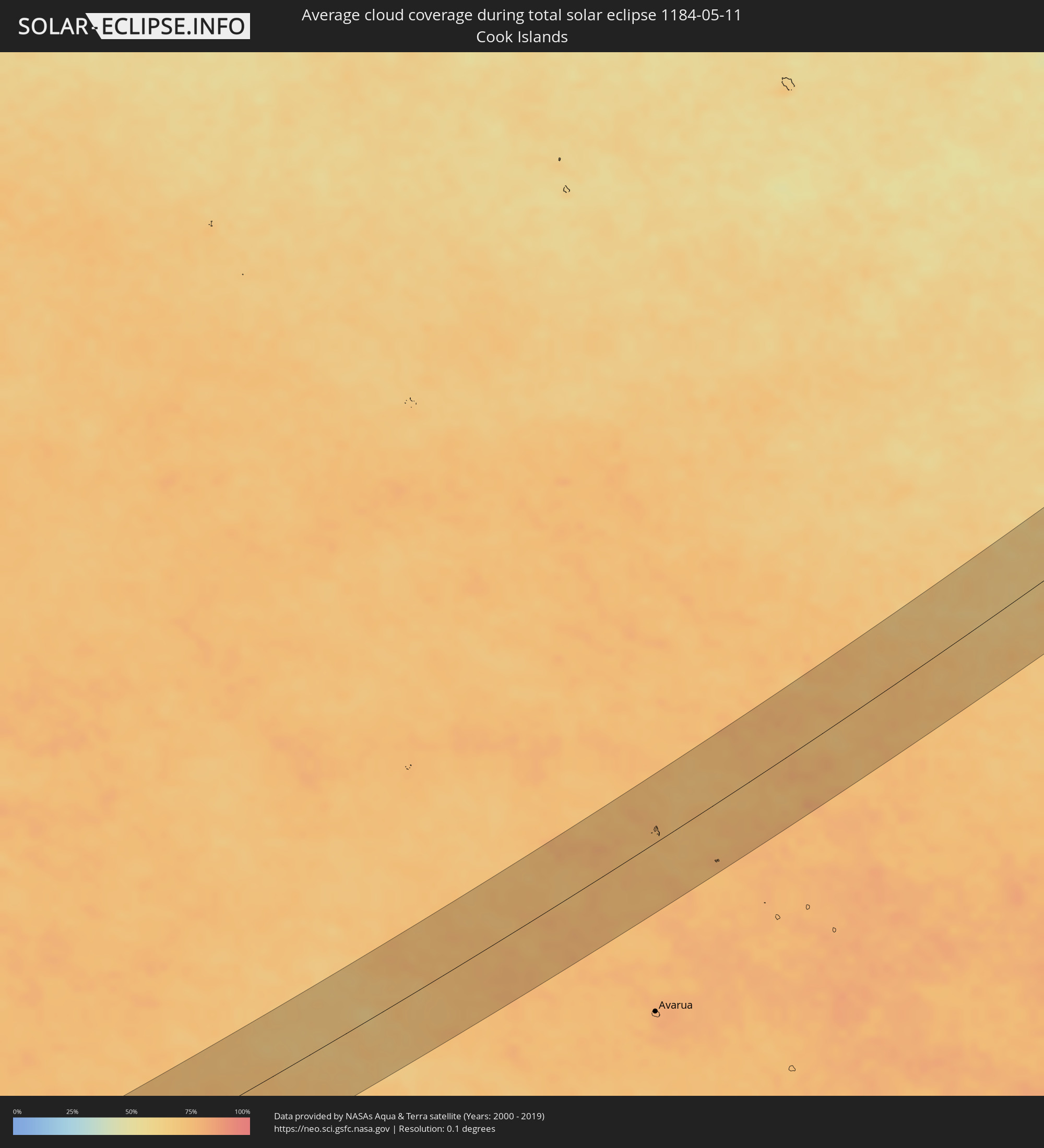 Cook Islands
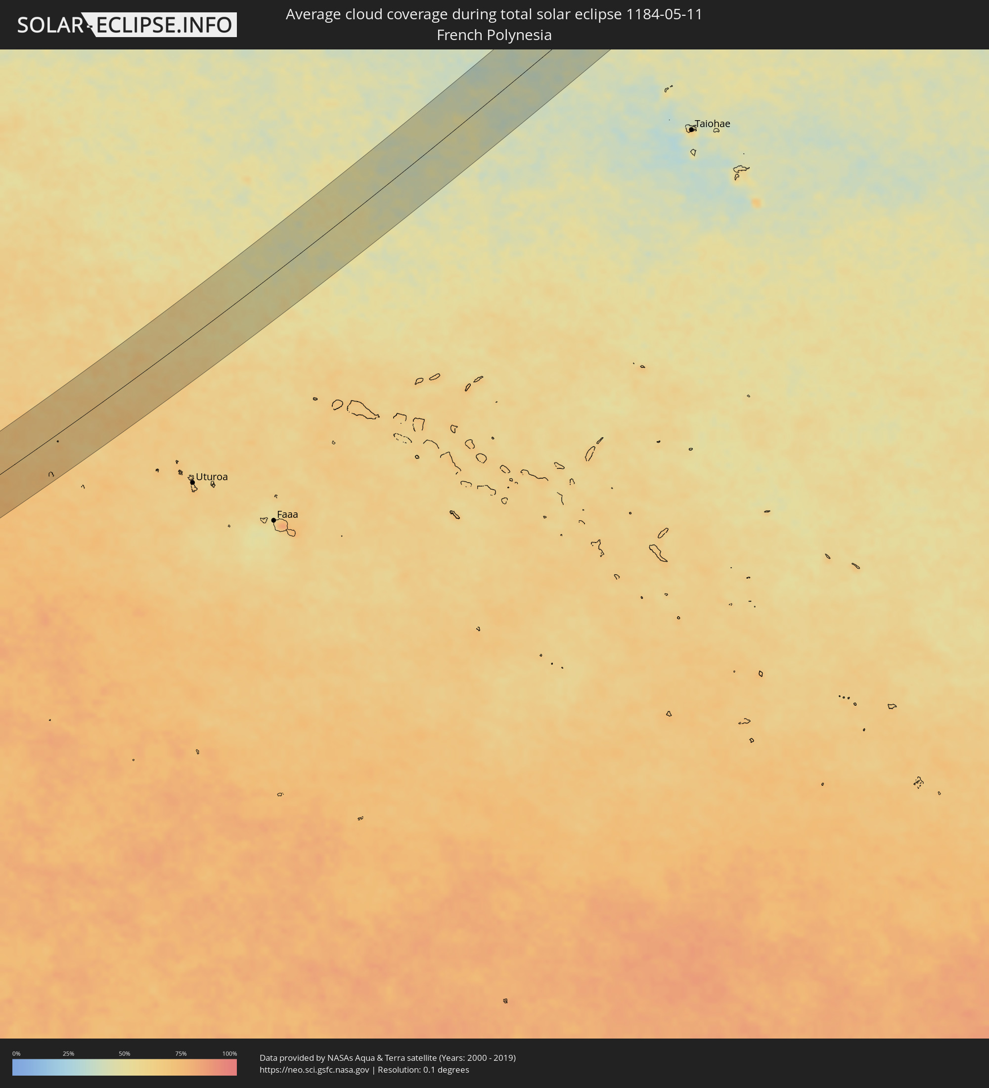 French Polynesia
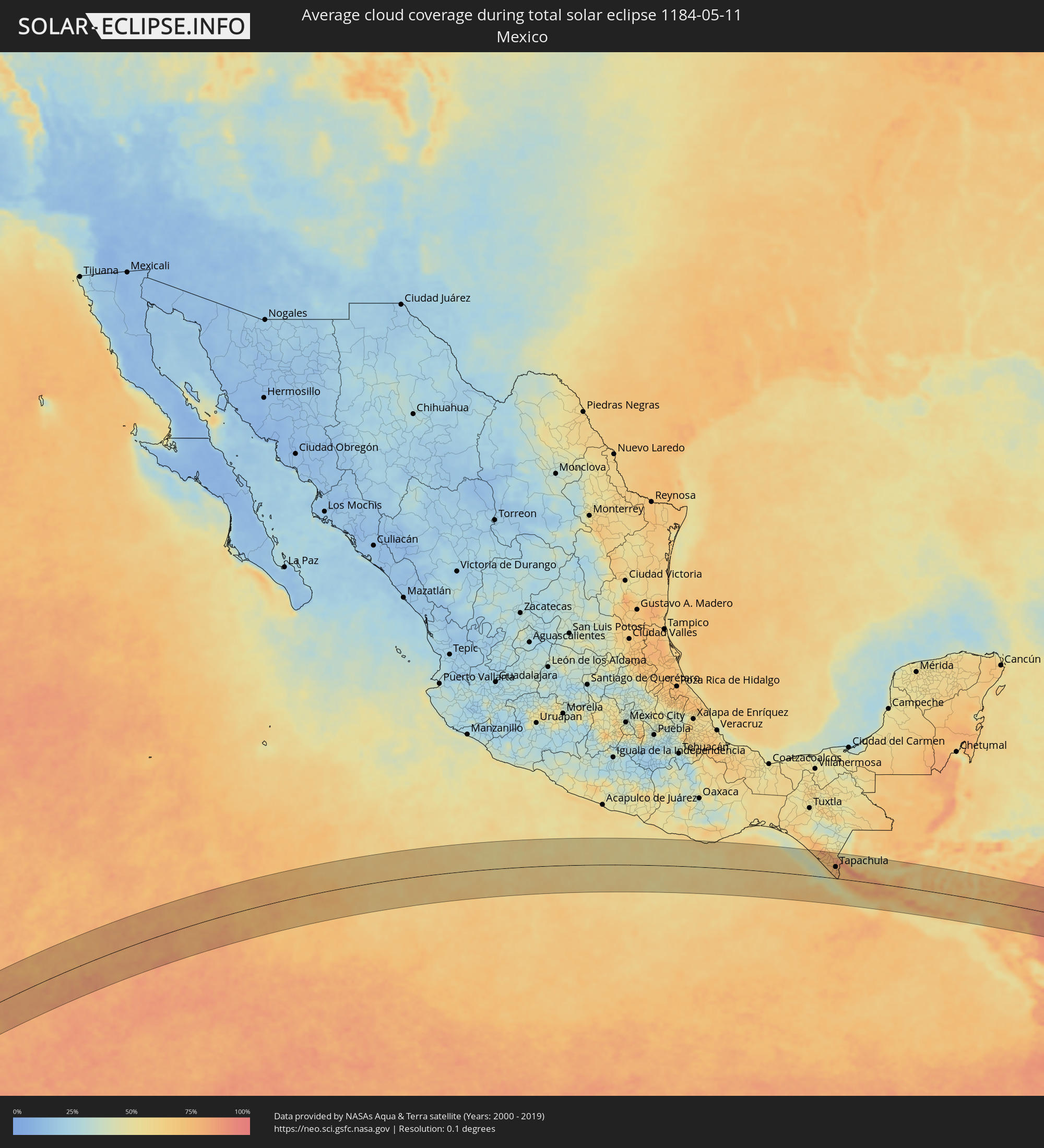 Mexico
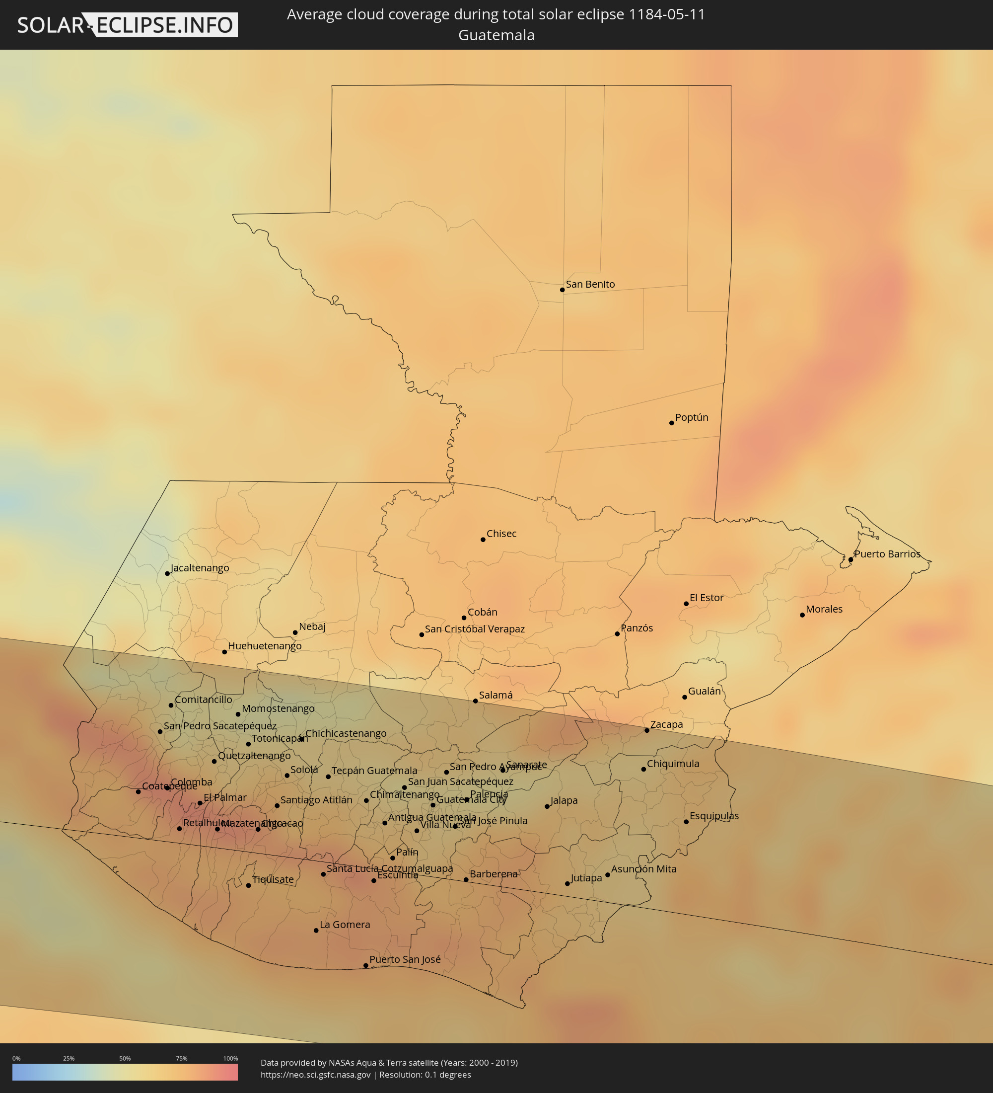 Guatemala
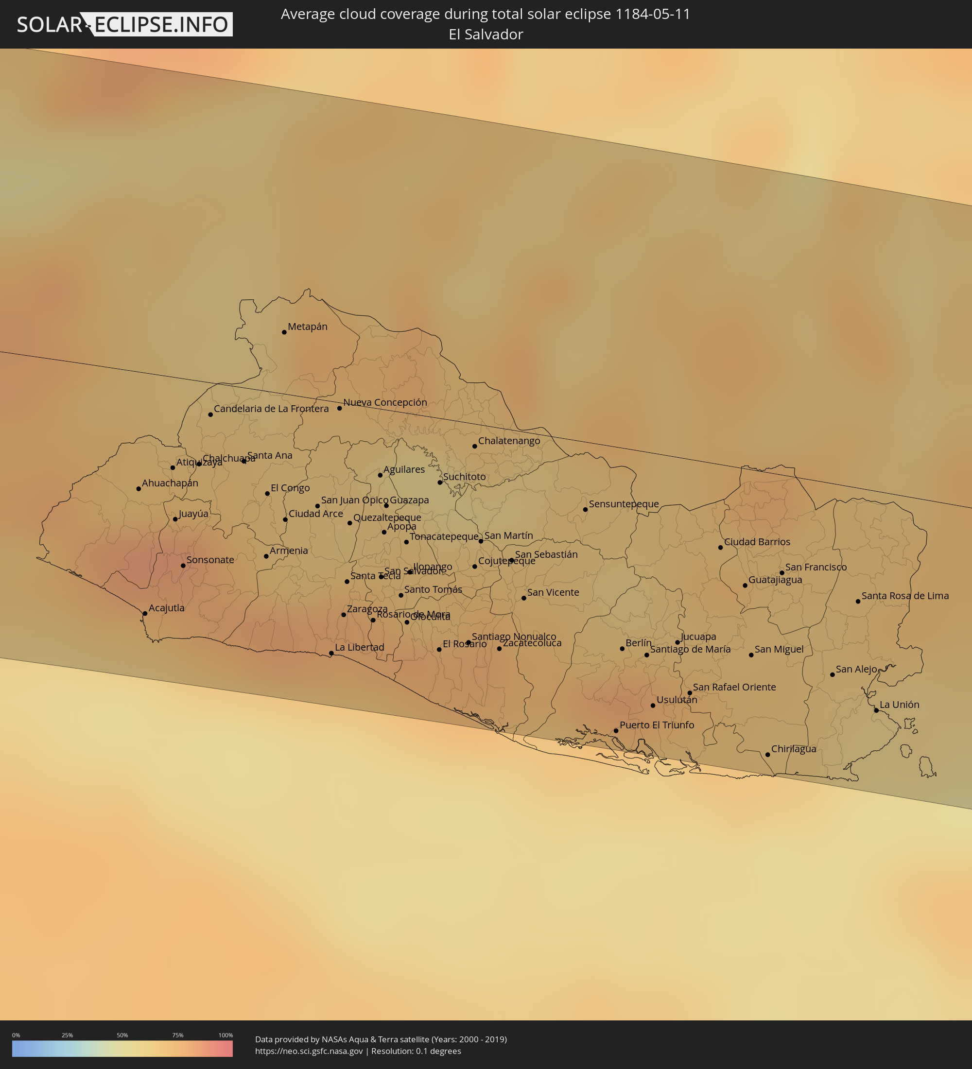 El Salvador
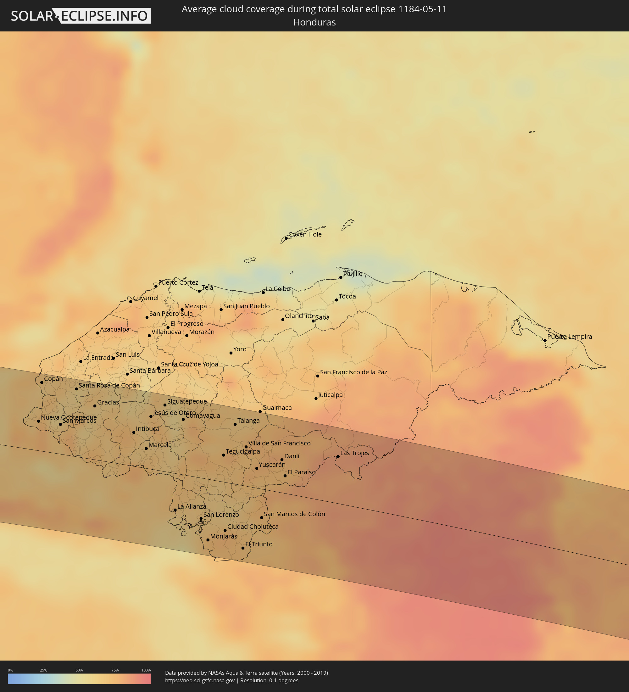 Honduras
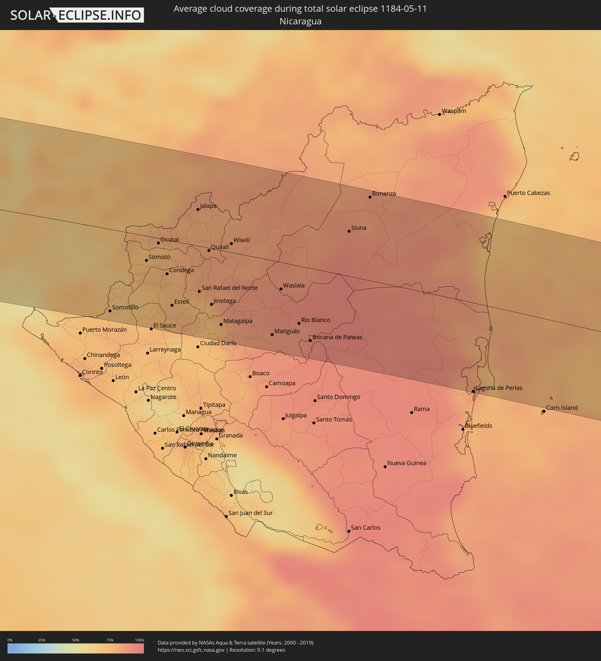 Nicaragua
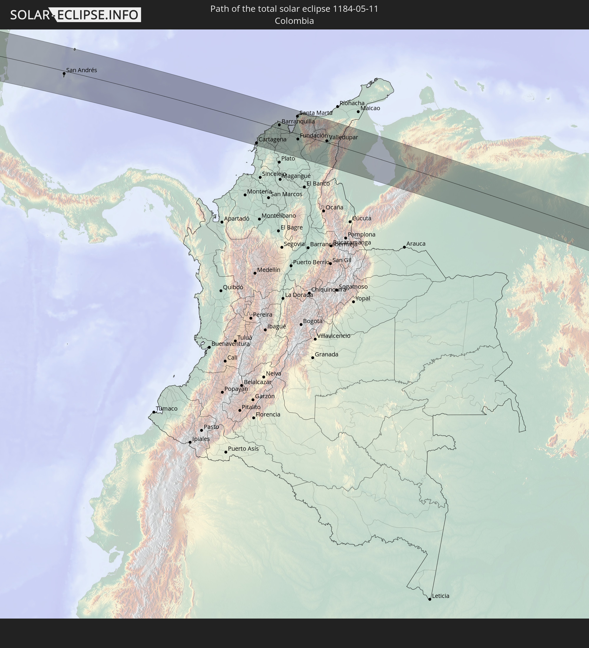
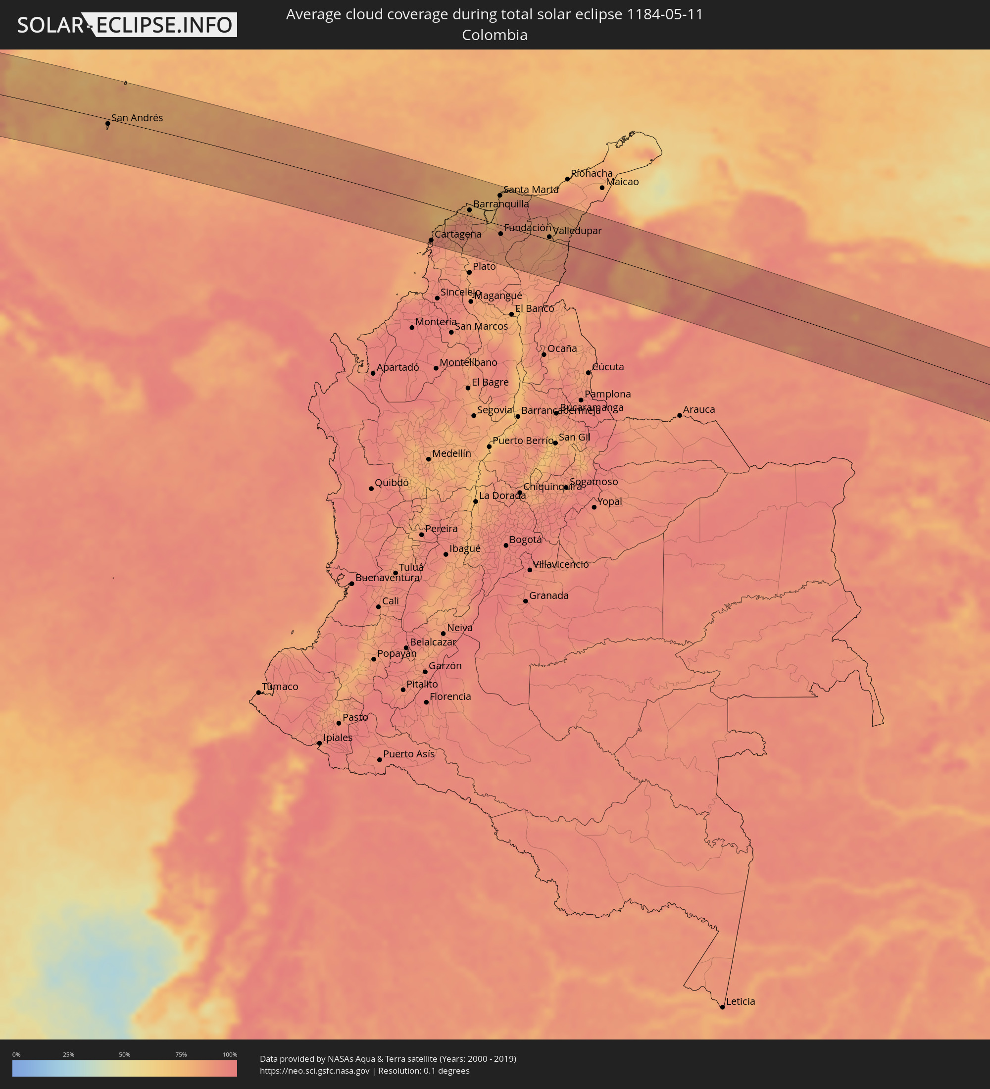 Colombia
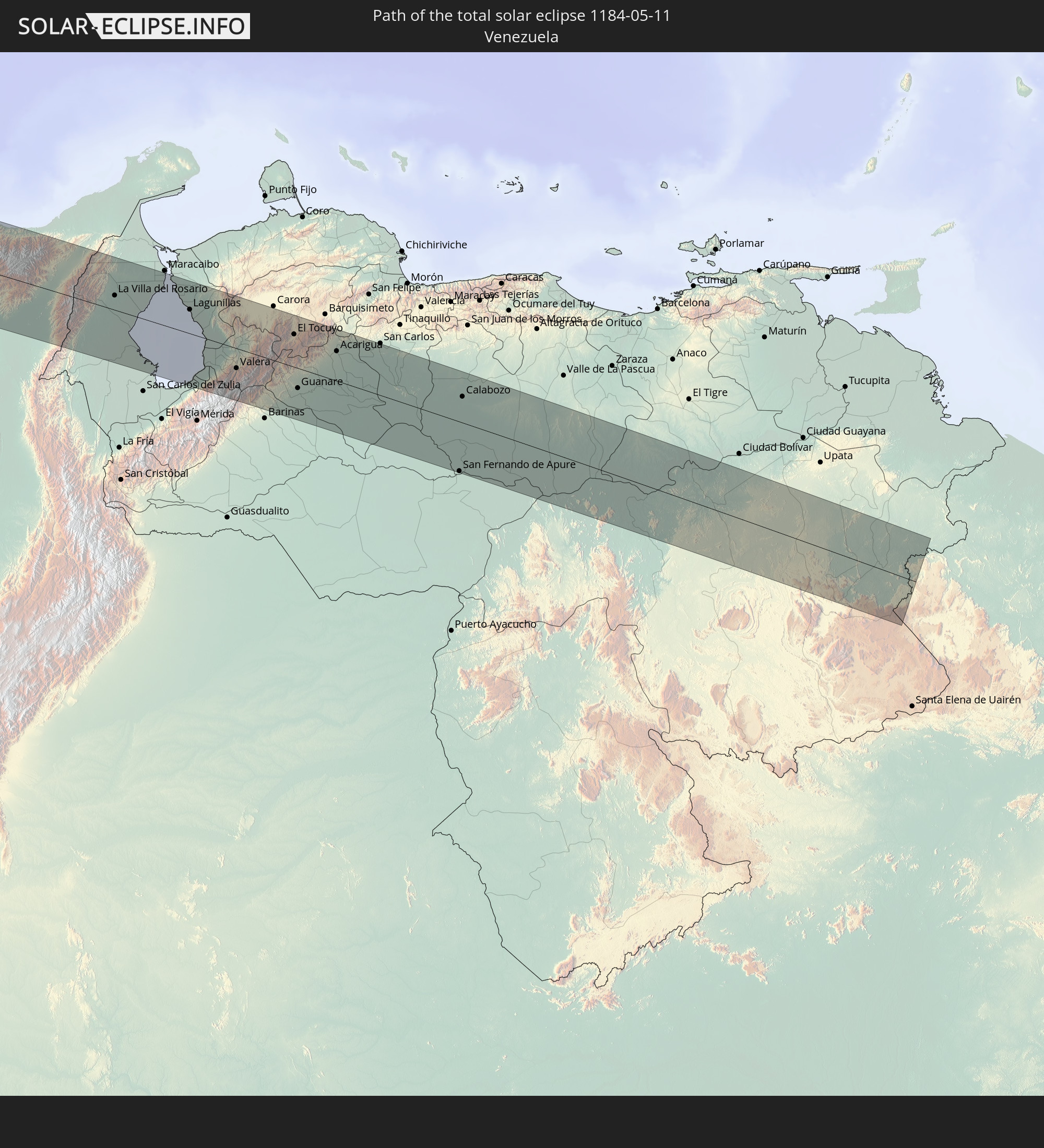
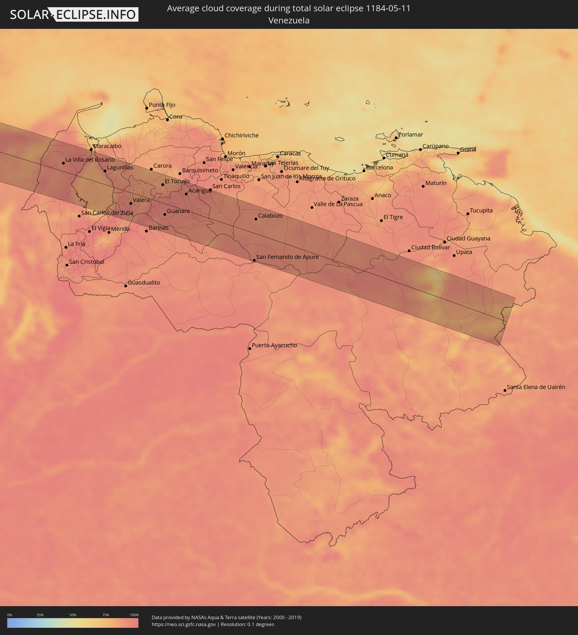 Venezuela
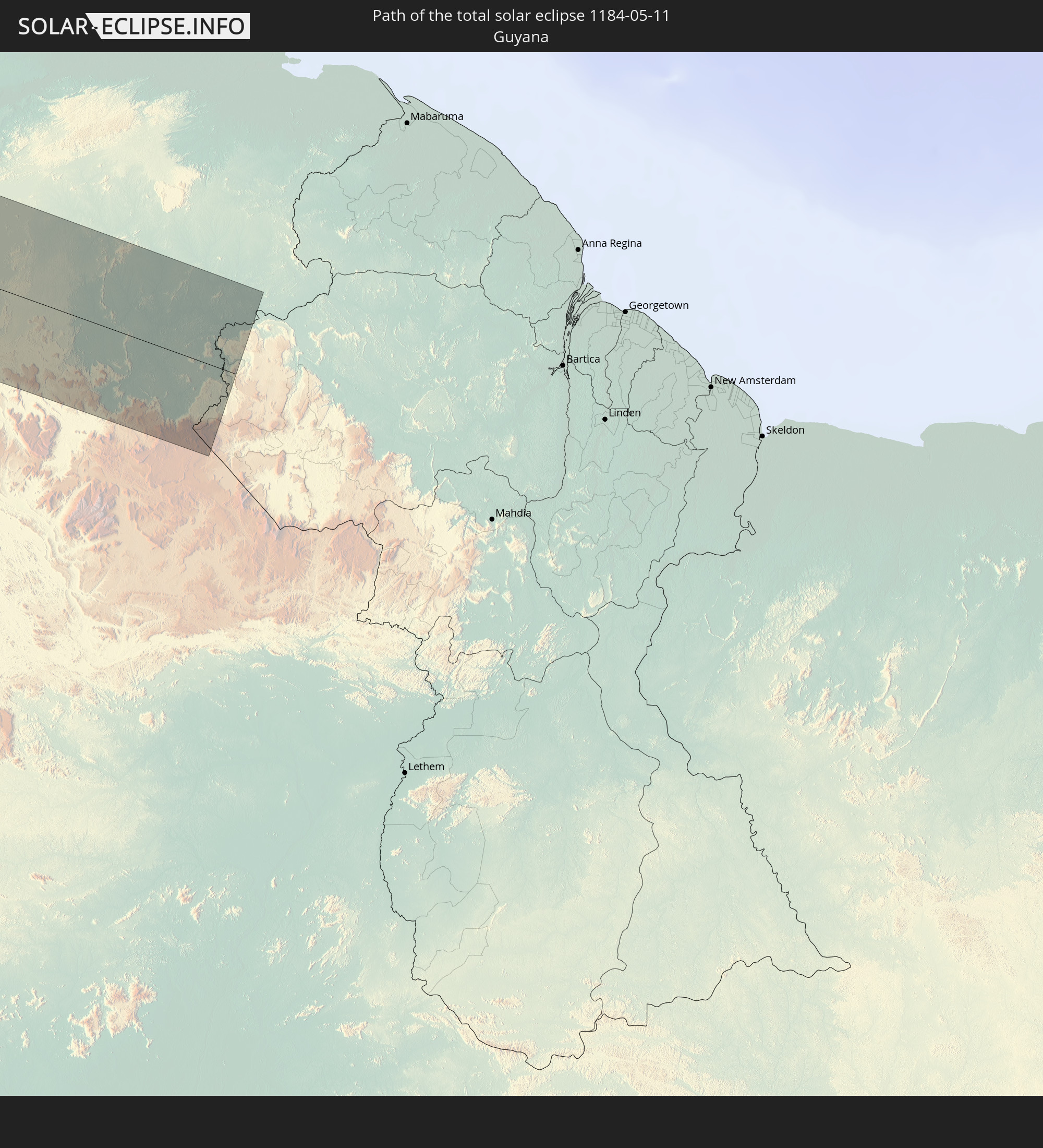
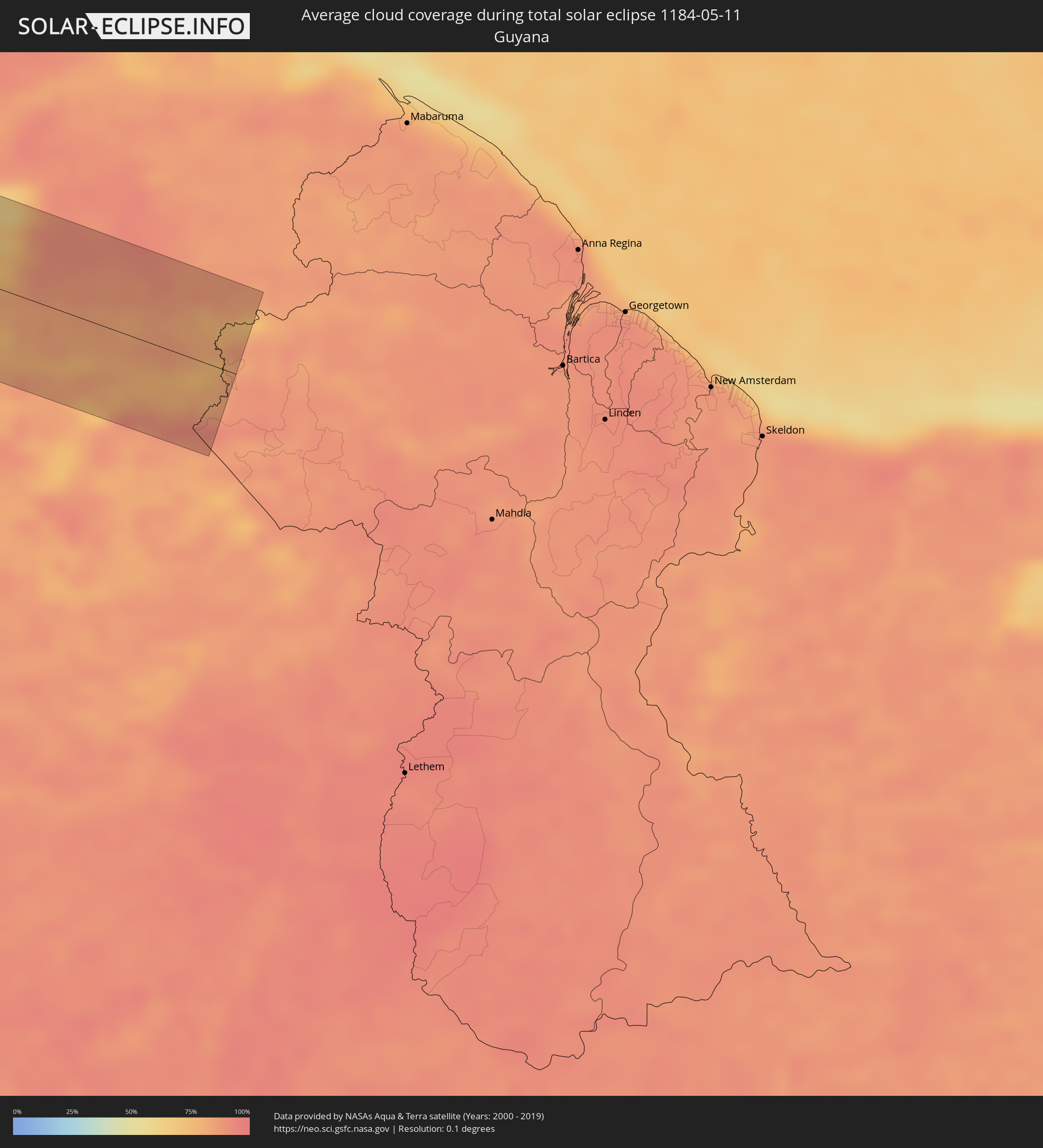 Guyana
Cities inside the path of the eclipse
The following table shows all locations with a population of more than 5,000 inside the eclipse path. Cities which have more than 100,000 inhabitants are marked bold. A click at the locations opens a detailed map.
| City | Type | Eclipse duration | Local time of max. eclipse | Distance to central line | Ø Cloud coverage |
|
Acapetahua, Chiapas
|
total | - | 15:09:55 UTC-06:36 | 77 km | 76% |
|
Acacoyagua, Chiapas
|
total | - | 15:09:57 UTC-06:36 | 83 km | 76% |
|
Escuintla, Chiapas
|
total | - | 15:09:58 UTC-06:36 | 81 km | 76% |
|
Villa Comaltitlán, Chiapas
|
total | - | 15:10:05 UTC-06:36 | 70 km | 74% |
|
Huixtla, Chiapas
|
total | - | 15:10:14 UTC-06:36 | 64 km | 77% |
|
Mazatán, Chiapas
|
total | - | 15:10:13 UTC-06:36 | 33 km | 68% |
|
Puerto Madero, Chiapas
|
total | - | 15:10:14 UTC-06:36 | 18 km | 59% |
|
Huehuetán, Chiapas
|
total | - | 15:10:20 UTC-06:36 | 51 km | 77% |
|
Vida Mejor I, Chiapas
|
total | - | 15:10:26 UTC-06:36 | 36 km | 78% |
|
Tapachula, Chiapas
|
total | - | 15:10:31 UTC-06:36 | 40 km | 78% |
|
Brisas Barra de Suchiate, Chiapas
|
total | - | 15:45:02 UTC-06:02 | 1 km | 57% |
|
Tuxtla Chico, Chiapas
|
total | - | 15:10:39 UTC-06:36 | 45 km | 77% |
|
Cacahoatán, Chiapas
|
total | - | 15:10:40 UTC-06:36 | 51 km | 75% |
|
Coatepeque, Quetzaltenango
|
total | - | 15:45:36 UTC-06:02 | 22 km | 75% |
|
San Pedro Sacatepéquez, San Marcos
|
total | - | 15:45:47 UTC-06:02 | 53 km | 80% |
|
Retalhuleu, Retalhuleu
|
total | - | 15:45:51 UTC-06:02 | 7 km | 77% |
|
Quetzaltenango, Quetzaltenango
|
total | - | 15:46:07 UTC-06:02 | 42 km | 82% |
|
Mazatenango, Suchitepeque
|
total | - | 15:46:06 UTC-06:02 | 9 km | 75% |
|
Momostenango, Totonicapán
|
total | - | 15:46:18 UTC-06:02 | 66 km | 62% |
|
Totonicapán, Totonicapán
|
total | - | 15:46:22 UTC-06:02 | 53 km | 68% |
|
Chicacao, Suchitepeque
|
total | - | 15:46:22 UTC-06:02 | 11 km | 73% |
|
Santiago Atitlán, Sololá
|
total | - | 15:46:31 UTC-06:02 | 24 km | 83% |
|
Sololá, Sololá
|
total | - | 15:46:36 UTC-06:02 | 40 km | 68% |
|
Chichicastenango, Quiché
|
total | - | 15:46:43 UTC-06:02 | 58 km | 63% |
|
La Gomera, Escuintla
|
total | - | 15:46:42 UTC-06:02 | 35 km | 78% |
|
Santa Lucía Cotzumalguapa, Escuintla
|
total | - | 15:46:47 UTC-06:02 | 6 km | 79% |
|
Tecpán Guatemala, Chimaltenango
|
total | - | 15:46:52 UTC-06:02 | 42 km | 69% |
|
Chimaltenango, Chimaltenango
|
total | - | 15:47:06 UTC-06:02 | 33 km | 66% |
|
Escuintla, Escuintla
|
total | - | 15:47:06 UTC-06:02 | 6 km | 80% |
|
Ciudad Vieja, Sacatepéquez
|
total | - | 15:47:10 UTC-06:02 | 19 km | 81% |
|
San Juan Sacatepéquez, Guatemala
|
total | - | 15:47:21 UTC-06:02 | 42 km | 64% |
|
Petapa, Guatemala
|
total | - | 15:47:27 UTC-06:02 | 19 km | 68% |
|
Guatemala City, Guatemala
|
total | - | 15:47:32 UTC-06:02 | 35 km | 65% |
|
San Pedro Ayampuc, Guatemala
|
total | - | 15:47:38 UTC-06:02 | 52 km | 56% |
|
San José Pinula, Guatemala
|
total | - | 15:47:39 UTC-06:02 | 26 km | 75% |
|
Barberena, Santa Rosa
|
total | - | 15:47:42 UTC-06:02 | 1 km | 75% |
|
Salamá, Baja Verapaz
|
total | - | 15:47:50 UTC-06:02 | 89 km | 62% |
|
Jalapa, Jalapa
|
total | - | 15:48:15 UTC-06:02 | 42 km | 72% |
|
Jutiapa, Jutiapa
|
total | - | 15:48:20 UTC-06:02 | 6 km | 66% |
|
Ahuachapán, Ahuachapán
|
total | - | 15:53:38 UTC-05:56 | 34 km | 84% |
|
Acajutla, Sonsonate
|
total | - | 15:53:37 UTC-05:56 | 70 km | 66% |
|
Atiquizaya, Ahuachapán
|
total | - | 15:53:46 UTC-05:56 | 26 km | 72% |
|
San Antonio del Monte, Sonsonate
|
total | - | 15:53:45 UTC-05:56 | 55 km | 77% |
|
Sonsonate, Sonsonate
|
total | - | 15:53:46 UTC-05:56 | 54 km | 77% |
|
Santa Ana, Santa Ana
|
total | - | 15:54:01 UTC-05:56 | 21 km | 70% |
|
Chiquimula, Chiquimula
|
total | - | 15:48:51 UTC-06:02 | 67 km | 63% |
|
Zacapa, Zacapa
|
total | - | 15:48:53 UTC-06:02 | 87 km | 61% |
|
Armenia, Sonsonate
|
total | - | 15:54:05 UTC-05:56 | 48 km | 81% |
|
El Congo, Santa Ana
|
total | - | 15:54:06 UTC-05:56 | 30 km | 68% |
|
Metapán, Santa Ana
|
total | - | 15:54:12 UTC-05:56 | 18 km | 62% |
|
Esquipulas, Chiquimula
|
total | - | 15:49:06 UTC-06:02 | 45 km | 71% |
|
La Libertad, La Libertad
|
total | - | 15:54:17 UTC-05:56 | 73 km | 69% |
|
Nueva Concepción, Chalatenango
|
total | - | 15:54:23 UTC-05:56 | 2 km | 65% |
|
Quezaltepeque, La Libertad
|
total | - | 15:54:23 UTC-05:56 | 35 km | 71% |
|
Aguilares, San Salvador
|
total | - | 15:54:31 UTC-05:56 | 19 km | 65% |
|
San Salvador, San Salvador
|
total | - | 15:54:29 UTC-05:56 | 49 km | 76% |
|
Nueva Ocotepeque, Ocotepeque
|
total | - | 16:02:30 UTC-05:48 | 33 km | 74% |
|
Copán, Copán
|
total | - | 16:02:35 UTC-05:48 | 78 km | 65% |
|
San Marcos, Ocotepeque
|
total | - | 16:02:48 UTC-05:48 | 33 km | 68% |
|
Santiago Nonualco, La Paz
|
total | - | 15:54:47 UTC-05:56 | 64 km | 76% |
|
Chalatenango, Chalatenango
|
total | - | 15:54:52 UTC-05:56 | 7 km | 58% |
|
Cojutepeque, Cuscatlán
|
total | - | 15:54:50 UTC-05:56 | 41 km | 74% |
|
Zacatecoluca, La Paz
|
total | - | 15:54:53 UTC-05:56 | 64 km | 76% |
|
San Vicente, San Vicente
|
total | - | 15:54:59 UTC-05:56 | 48 km | 74% |
|
Santa Rosa de Copán, Copán
|
total | - | 16:03:03 UTC-05:48 | 77 km | 62% |
|
Sensuntepeque, Cabañas
|
total | - | 15:55:14 UTC-05:56 | 20 km | 65% |
|
Jiquilisco, Usulután
|
total | - | 15:55:14 UTC-05:56 | 79 km | 65% |
|
Gracias, Lempira
|
total | - | 16:03:18 UTC-05:48 | 61 km | 64% |
|
Berlín, Usulután
|
total | - | 15:55:19 UTC-05:56 | 58 km | 80% |
|
Usulután, Usulután
|
total | - | 15:55:25 UTC-05:56 | 73 km | 75% |
|
Jucuapa, Usulután
|
total | - | 15:55:31 UTC-05:56 | 54 km | 76% |
|
El Tránsito, San Miguel
|
total | - | 15:55:33 UTC-05:56 | 71 km | 72% |
|
San Miguel, San Miguel
|
total | - | 15:55:46 UTC-05:56 | 54 km | 68% |
|
La Esperanza, Intibucá
|
total | - | 16:03:47 UTC-05:48 | 37 km | 73% |
|
Intibucá, Intibucá
|
total | - | 16:03:48 UTC-05:48 | 38 km | 73% |
|
San Francisco, Morazán
|
total | - | 15:55:54 UTC-05:56 | 28 km | 66% |
|
Marcala, La Paz
|
total | - | 16:03:57 UTC-05:48 | 22 km | 68% |
|
Jesús de Otoro, Intibucá
|
total | - | 16:04:02 UTC-05:48 | 60 km | 63% |
|
Santa Rosa de Lima, La Unión
|
total | - | 15:56:09 UTC-05:56 | 33 km | 67% |
|
La Unión, La Unión
|
total | - | 15:56:11 UTC-05:56 | 64 km | 57% |
|
Siguatepeque, Comayagua
|
total | - | 16:04:14 UTC-05:48 | 75 km | 64% |
|
La Alianza, Valle
|
total | - | 16:04:17 UTC-05:48 | 42 km | 60% |
|
Ajuterique, Comayagua
|
total | - | 16:04:23 UTC-05:48 | 54 km | 63% |
|
La Paz, La Paz
|
total | - | 16:04:24 UTC-05:48 | 47 km | 60% |
|
Comayagua, Comayagua
|
total | - | 16:04:28 UTC-05:48 | 63 km | 67% |
|
Villa de San Antonio, Comayagua
|
total | - | 16:04:29 UTC-05:48 | 48 km | 63% |
|
Nacaome, Valle
|
total | - | 16:04:35 UTC-05:48 | 35 km | 65% |
|
San Lorenzo, Valle
|
total | - | 16:04:37 UTC-05:48 | 47 km | 67% |
|
Monjarás, Choluteca
|
total | - | 16:04:41 UTC-05:48 | 70 km | 68% |
|
Tegucigalpa, Francisco Morazán
|
total | - | 16:04:58 UTC-05:48 | 30 km | 72% |
|
Ciudad Choluteca, Choluteca
|
total | - | 16:04:55 UTC-05:48 | 55 km | 75% |
|
Talanga, Francisco Morazán
|
total | - | 16:05:07 UTC-05:48 | 67 km | 70% |
|
El Triunfo, Choluteca
|
total | - | 16:05:08 UTC-05:48 | 72 km | 73% |
|
Villa de San Francisco, Francisco Morazán
|
total | - | 16:05:15 UTC-05:48 | 44 km | 73% |
|
Somotillo, Chinandega
|
total | - | 16:08:54 UTC-05:45 | 78 km | 77% |
|
Yuscarán, El Paraíso
|
total | - | 16:05:22 UTC-05:48 | 22 km | 72% |
|
San Marcos de Colón, Choluteca
|
total | - | 16:05:24 UTC-05:48 | 33 km | 68% |
|
Danlí, El Paraíso
|
total | - | 16:05:42 UTC-05:48 | 37 km | 73% |
|
Somoto, Madriz
|
total | - | 16:09:20 UTC-05:45 | 23 km | 76% |
|
El Paraíso, El Paraíso
|
total | - | 16:05:43 UTC-05:48 | 19 km | 74% |
|
Ocotal, Nueva Segovia
|
total | - | 16:09:28 UTC-05:45 | 5 km | 75% |
|
Condega, Estelí
|
total | - | 16:09:32 UTC-05:45 | 32 km | 79% |
|
Estelí, Estelí
|
total | - | 16:09:34 UTC-05:45 | 61 km | 77% |
|
Jalapa, Nueva Segovia
|
total | - | 16:09:53 UTC-05:45 | 34 km | 81% |
|
San Rafael del Norte, Jinotega
|
total | - | 16:09:51 UTC-05:45 | 43 km | 73% |
|
Quilalí, Nueva Segovia
|
total | - | 16:09:59 UTC-05:45 | 3 km | 85% |
|
Jinotega, Jinotega
|
total | - | 16:09:58 UTC-05:45 | 53 km | 75% |
|
Las Trojes, El Paraíso
|
total | - | 16:06:23 UTC-05:48 | 53 km | 83% |
|
Matagalpa, Matagalpa
|
total | - | 16:10:03 UTC-05:45 | 70 km | 79% |
|
Wiwilí, Nueva Segovia
|
total | - | 16:10:12 UTC-05:45 | 8 km | 85% |
|
Matiguás, Matagalpa
|
total | - | 16:10:34 UTC-05:45 | 70 km | 90% |
|
Waslala, Atlántico Norte (RAAN)
|
total | - | 16:10:41 UTC-05:45 | 25 km | 91% |
|
Río Blanco, Matagalpa
|
total | - | 16:10:50 UTC-05:45 | 55 km | 89% |
|
Bocana de Paiwas, Atlántico Sur
|
total | - | 16:10:56 UTC-05:45 | 69 km | 91% |
|
Siuna, Atlántico Norte (RAAN)
|
total | - | 16:11:22 UTC-05:45 | 42 km | 91% |
|
Bonanza, Atlántico Norte (RAAN)
|
total | - | 16:11:34 UTC-05:45 | 79 km | 87% |
|
Laguna de Perlas, Atlántico Sur
|
total | - | 16:12:27 UTC-05:45 | 84 km | 78% |
|
San Andrés, Archipiélago de San Andrés, Providencia y Santa Catalina
|
total | - | 17:03:17 UTC-04:56 | 10 km | 81% |
|
Cartagena, Bolívar
|
total | - | 17:07:54 UTC-04:56 | 72 km | 91% |
|
Santa Rosa, Bolívar
|
total | - | 17:07:59 UTC-04:56 | 62 km | 92% |
|
Villanueva, Bolívar
|
total | - | 17:08:02 UTC-04:56 | 60 km | 90% |
|
Luruaco, Atlántico
|
total | - | 17:08:07 UTC-04:56 | 37 km | 88% |
|
San Estanislao, Bolívar
|
total | - | 17:08:07 UTC-04:56 | 61 km | 86% |
|
Repelón, Atlántico
|
total | - | 17:08:08 UTC-04:56 | 50 km | 84% |
|
Puerto Colombia, Atlántico
|
total | - | 17:08:14 UTC-04:56 | 8 km | 84% |
|
Sabanalarga, Atlántico
|
total | - | 17:08:15 UTC-04:56 | 29 km | 90% |
|
Baranoa, Atlántico
|
total | - | 17:08:16 UTC-04:56 | 11 km | 89% |
|
Campo de la Cruz, Atlántico
|
total | - | 17:08:16 UTC-04:56 | 55 km | 83% |
|
Candelaria, Atlántico
|
total | - | 17:08:16 UTC-04:56 | 46 km | 87% |
|
Polonuevo, Atlántico
|
total | - | 17:08:18 UTC-04:56 | 11 km | 89% |
|
Barranquilla, Atlántico
|
total | - | 17:08:20 UTC-04:56 | 12 km | 85% |
|
Palmar de Varela, Atlántico
|
total | - | 17:08:21 UTC-04:56 | 12 km | 90% |
|
Ponedera, Atlántico
|
total | - | 17:08:21 UTC-04:56 | 22 km | 87% |
|
Sitionuevo, Atlántico
|
total | - | 17:08:22 UTC-04:56 | 7 km | 88% |
|
Pivijay, Magdalena
|
total | - | 17:08:25 UTC-04:56 | 37 km | 89% |
|
Puebloviejo, Magdalena
|
total | - | 17:08:37 UTC-04:56 | 30 km | 77% |
|
Ciénaga, Magdalena
|
total | - | 17:08:38 UTC-04:56 | 32 km | 83% |
|
Santa Marta, Magdalena
|
total | - | 17:08:40 UTC-04:56 | 59 km | 84% |
|
Fundación, Magdalena
|
total | - | 17:08:40 UTC-04:56 | 18 km | 88% |
|
Ariguaní, Cesar
|
total | - | 17:08:45 UTC-04:56 | 41 km | 88% |
|
Valledupar, Cesar
|
total | - | 17:09:09 UTC-04:56 | 6 km | 82% |
|
Agustín Codazzi, Cesar
|
total | - | 17:09:09 UTC-04:56 | 39 km | 85% |
|
La Paz, Cesar
|
total | - | 17:09:11 UTC-04:56 | 0 km | 83% |
|
San Juan del Cesar, La Guajira
|
total | - | 17:09:17 UTC-04:56 | 46 km | 79% |
|
Villanueva, La Guajira
|
total | - | 17:09:17 UTC-04:56 | 30 km | 86% |
|
Fonseca, La Guajira
|
total | - | 17:09:21 UTC-04:56 | 64 km | 81% |
|
Machiques, Zulia
|
total | - | 17:38:05 UTC-04:27 | 15 km | 87% |
|
La Villa del Rosario, Zulia
|
total | - | 17:38:12 UTC-04:27 | 21 km | 92% |
|
Santa Rita, Zulia
|
total | - | 17:38:33 UTC-04:27 | 70 km | 84% |
|
Cabimas, Zulia
|
total | - | 17:38:35 UTC-04:27 | 57 km | 90% |
|
Lagunillas, Zulia
|
total | - | 17:38:39 UTC-04:27 | 35 km | 83% |
|
Valera, Trujillo
|
total | - | 17:38:54 UTC-04:27 | 29 km | 93% |
|
Trujillo, Trujillo
|
total | - | 17:38:58 UTC-04:27 | 19 km | 87% |
|
El Tocuyo, Lara
|
total | - | 17:39:13 UTC-04:27 | 48 km | 86% |
|
Guanare, Portuguesa
|
total | - | 17:39:12 UTC-04:27 | 29 km | 92% |
|
Quíbor, Lara
|
total | - | 17:39:16 UTC-04:27 | 69 km | 86% |
|
Araure, Portuguesa
|
total | - | 17:39:24 UTC-04:27 | 43 km | 93% |
|
Acarigua, Portuguesa
|
total | - | 17:39:24 UTC-04:27 | 44 km | 93% |
|
Villa Bruzual, Portuguesa
|
total | - | 17:39:26 UTC-04:27 | 23 km | 94% |
|
San Fernando de Apure, Apure
|
total | - | 17:39:50 UTC-04:27 | 73 km | 90% |
|
Calabozo, Guárico
|
total | - | 17:39:54 UTC-04:27 | 38 km | 90% |