Total solar eclipse of 10/06/1241
| Day of week: | Sunday |
| Maximum duration of eclipse: | 03m38s |
| Maximum width of eclipse path: | 274 km |
| Saros cycle: | 102 |
| Coverage: | 100% |
| Magnitude: | 1.0494 |
| Gamma: | 0.8103 |
Wo kann man die Sonnenfinsternis vom 10/06/1241 sehen?
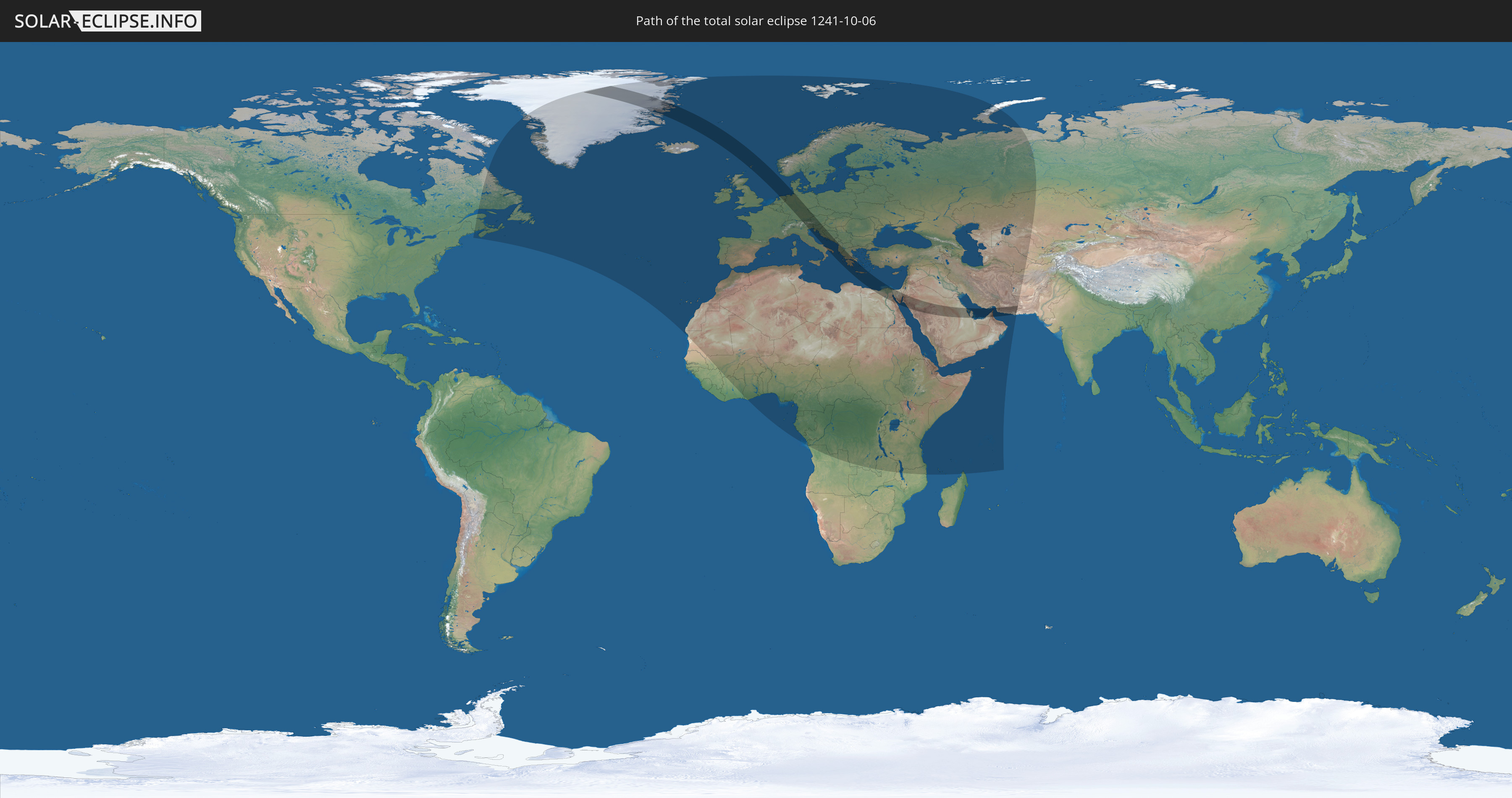
Die Sonnenfinsternis am 10/06/1241 kann man in 122 Ländern als partielle Sonnenfinsternis beobachten.
Der Finsternispfad verläuft durch 23 Länder. Nur in diesen Ländern ist sie als total Sonnenfinsternis zu sehen.
In den folgenden Ländern ist die Sonnenfinsternis total zu sehen
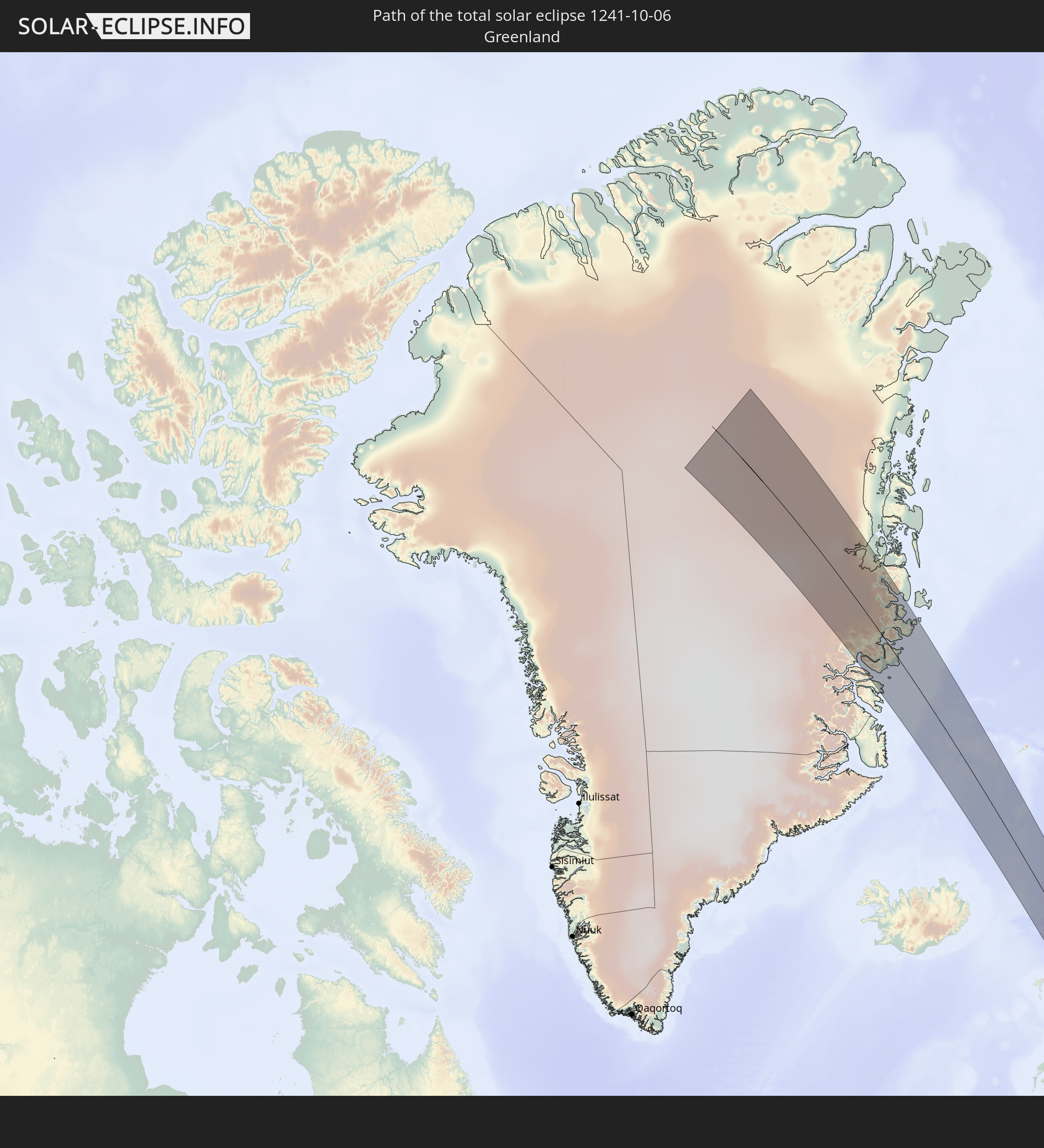 Greenland
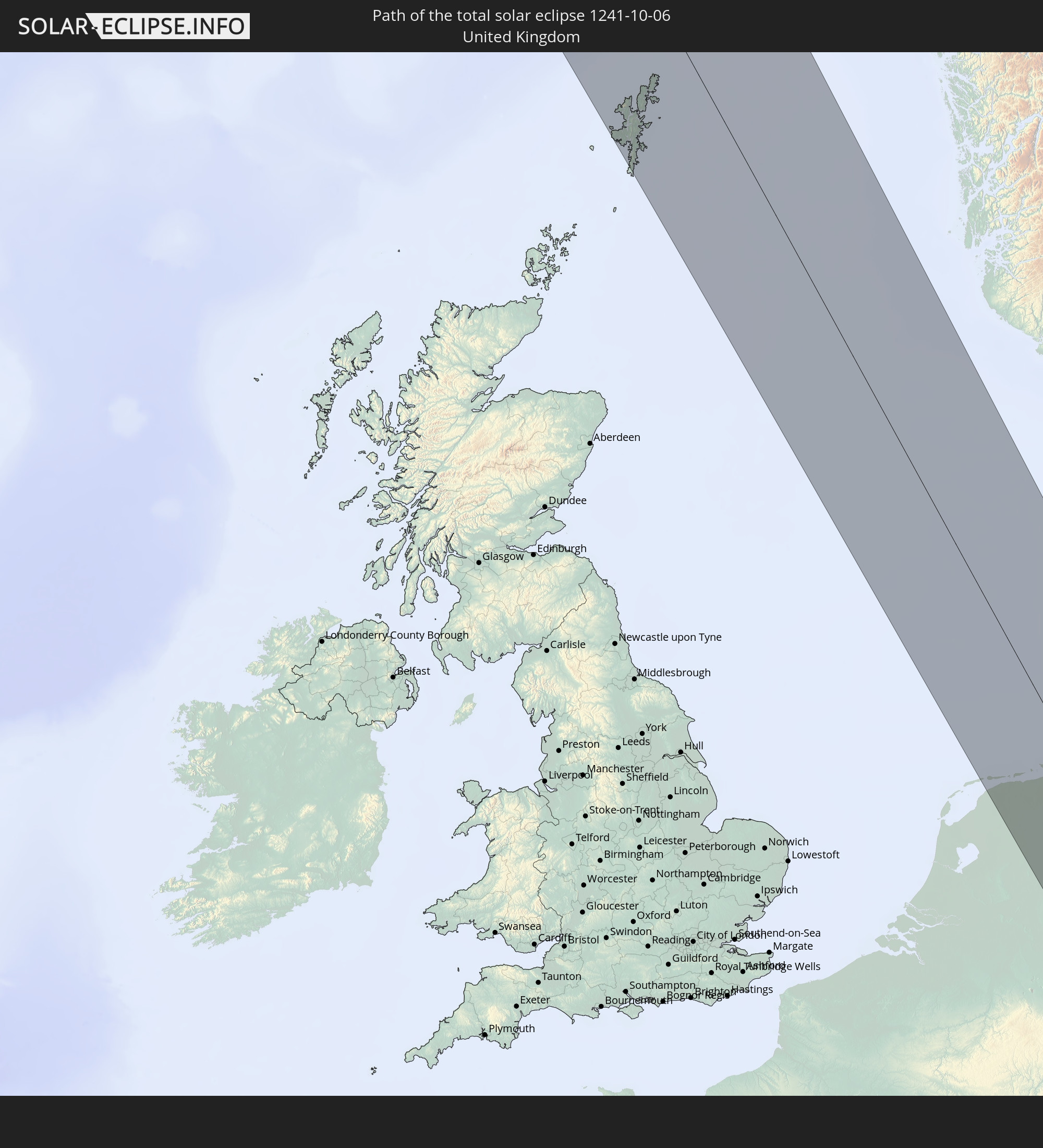 United Kingdom
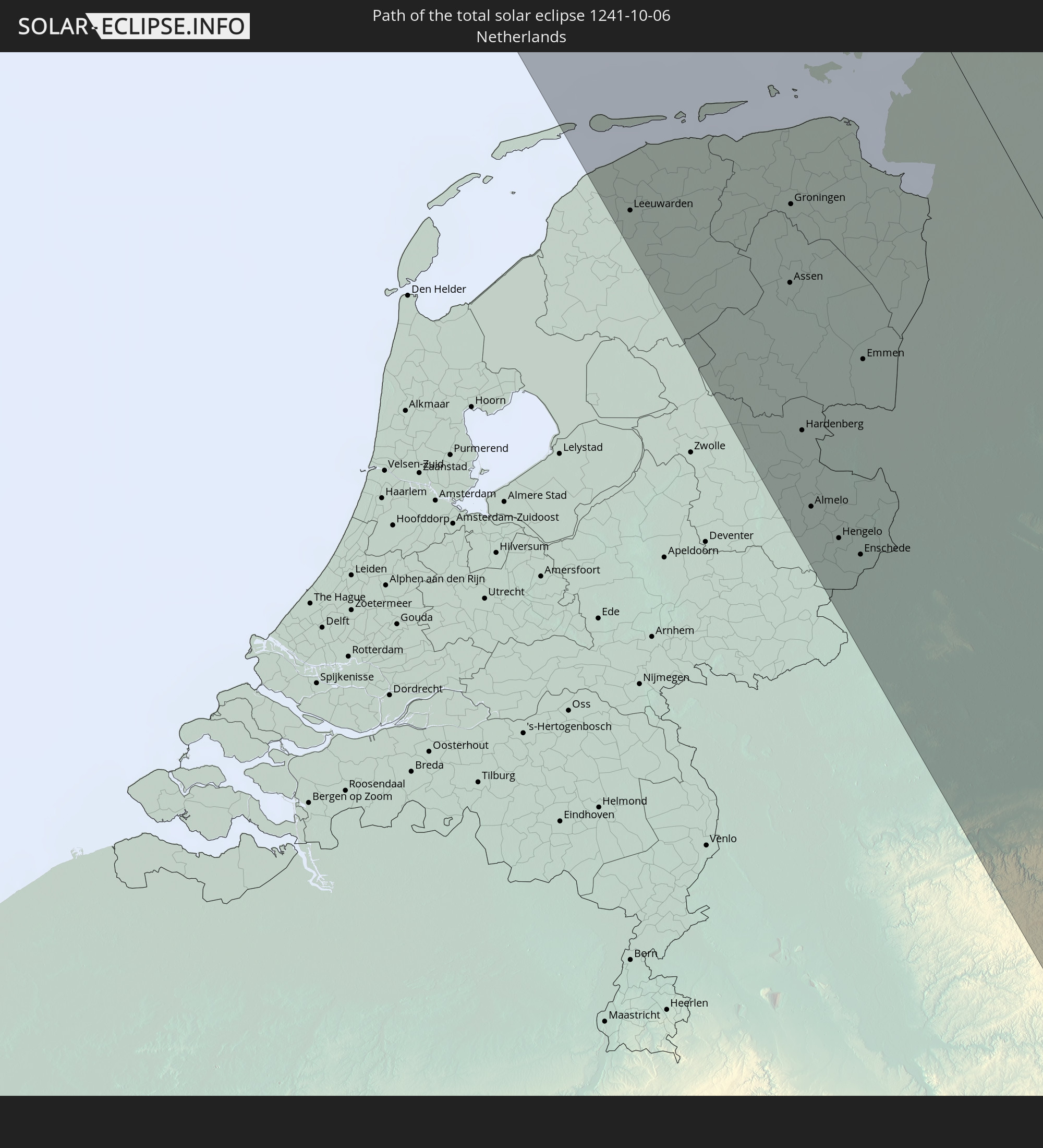 Netherlands
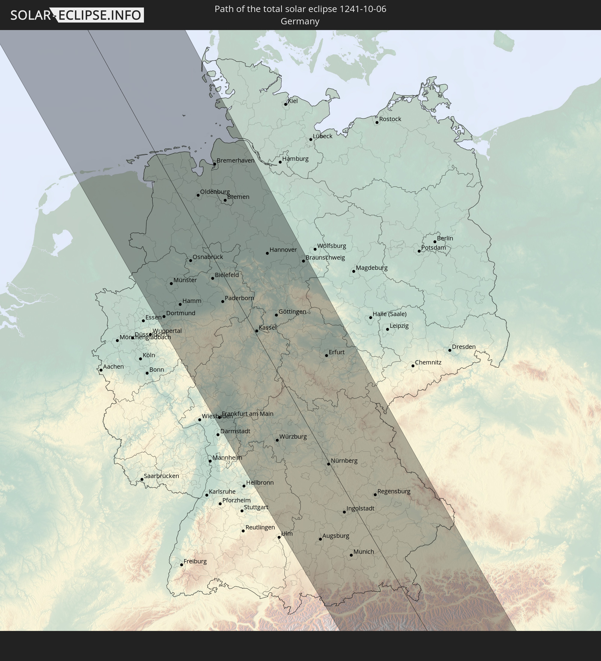 Germany
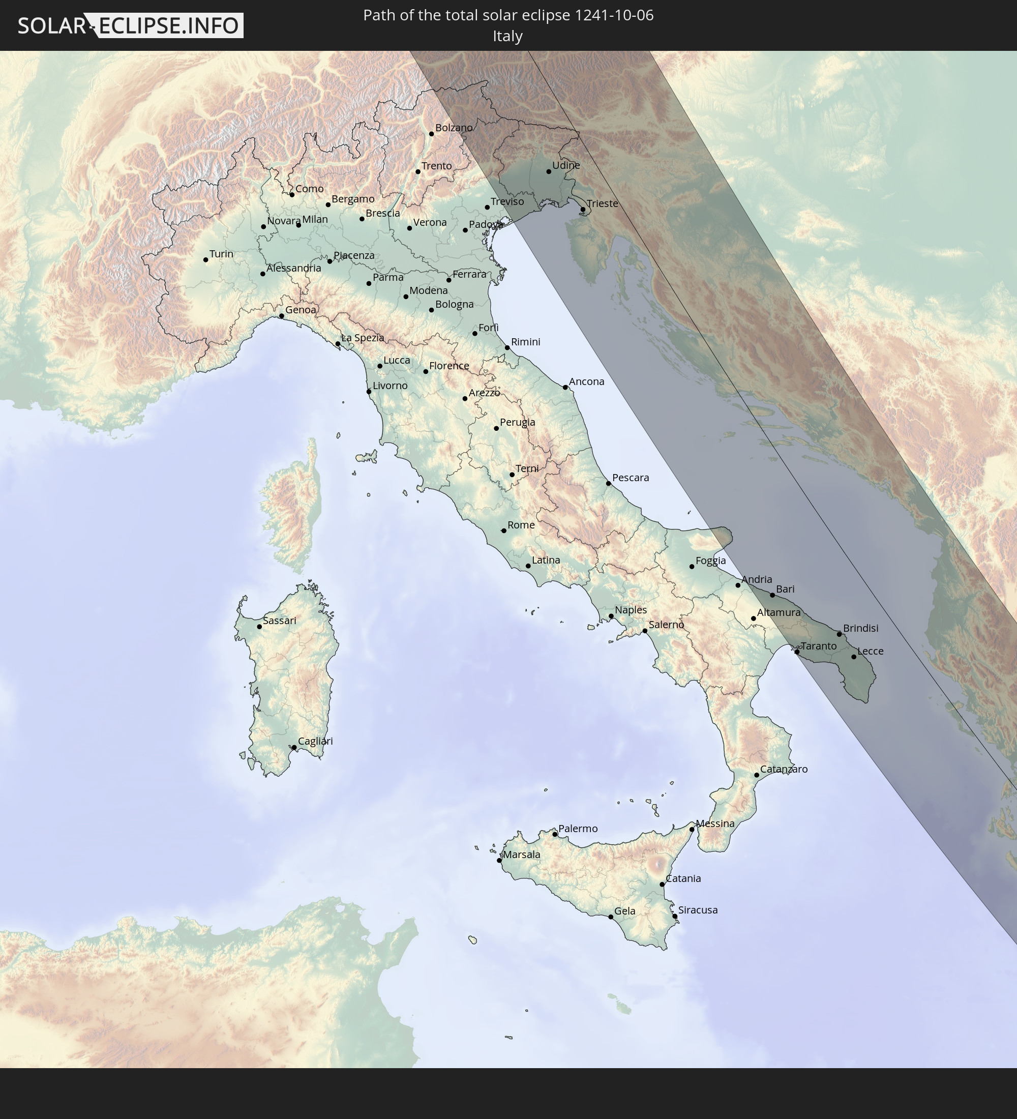 Italy
Italy
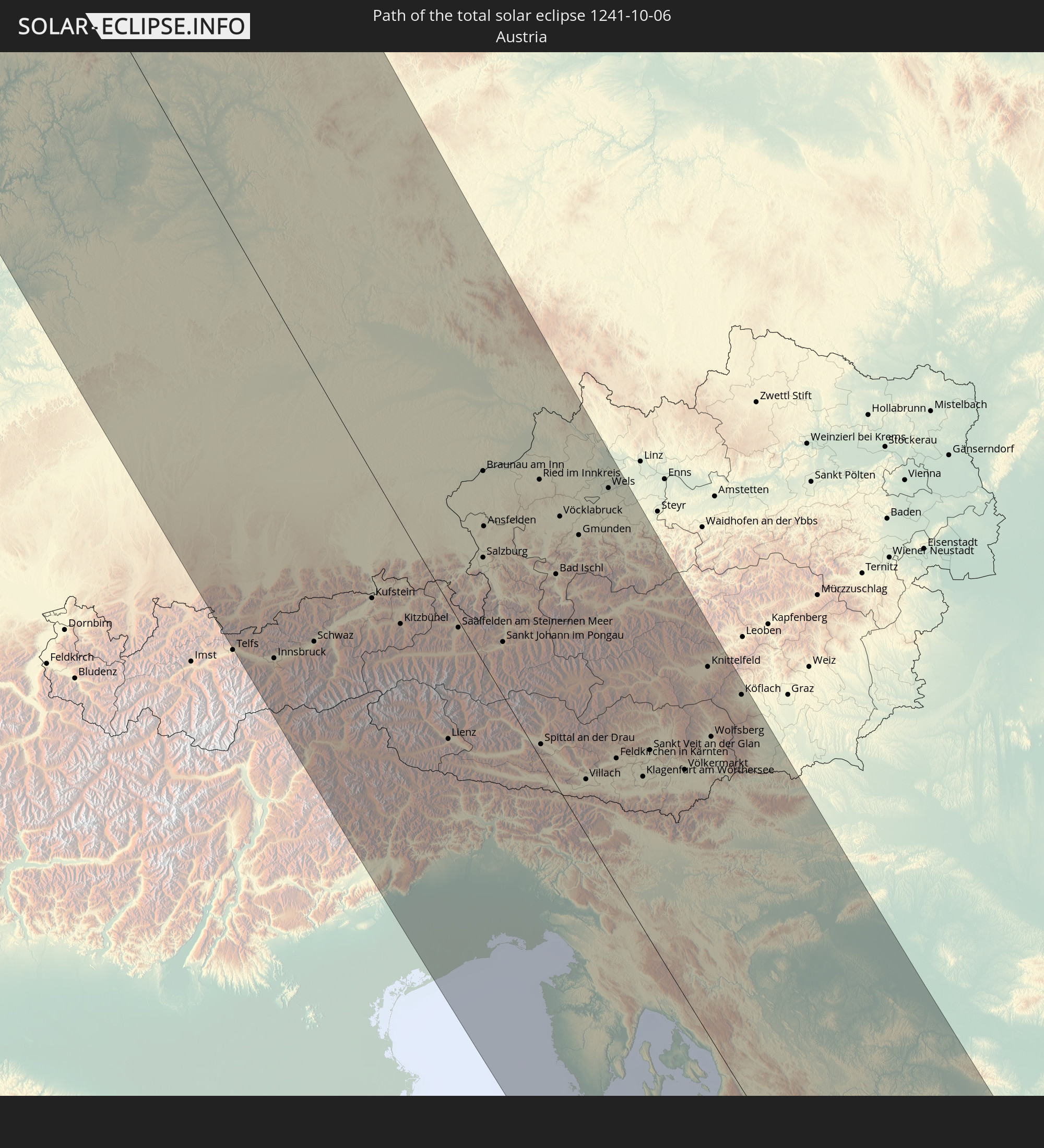 Austria
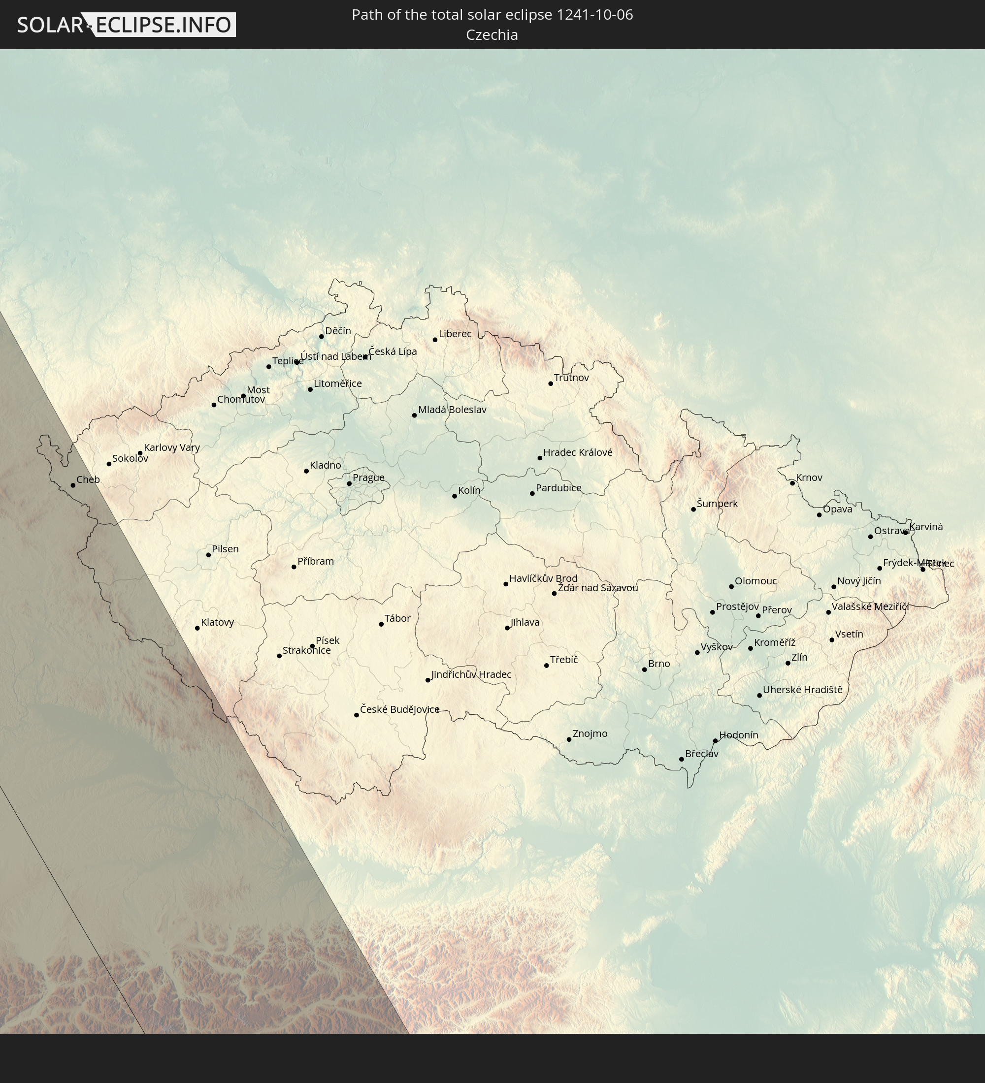 Czechia
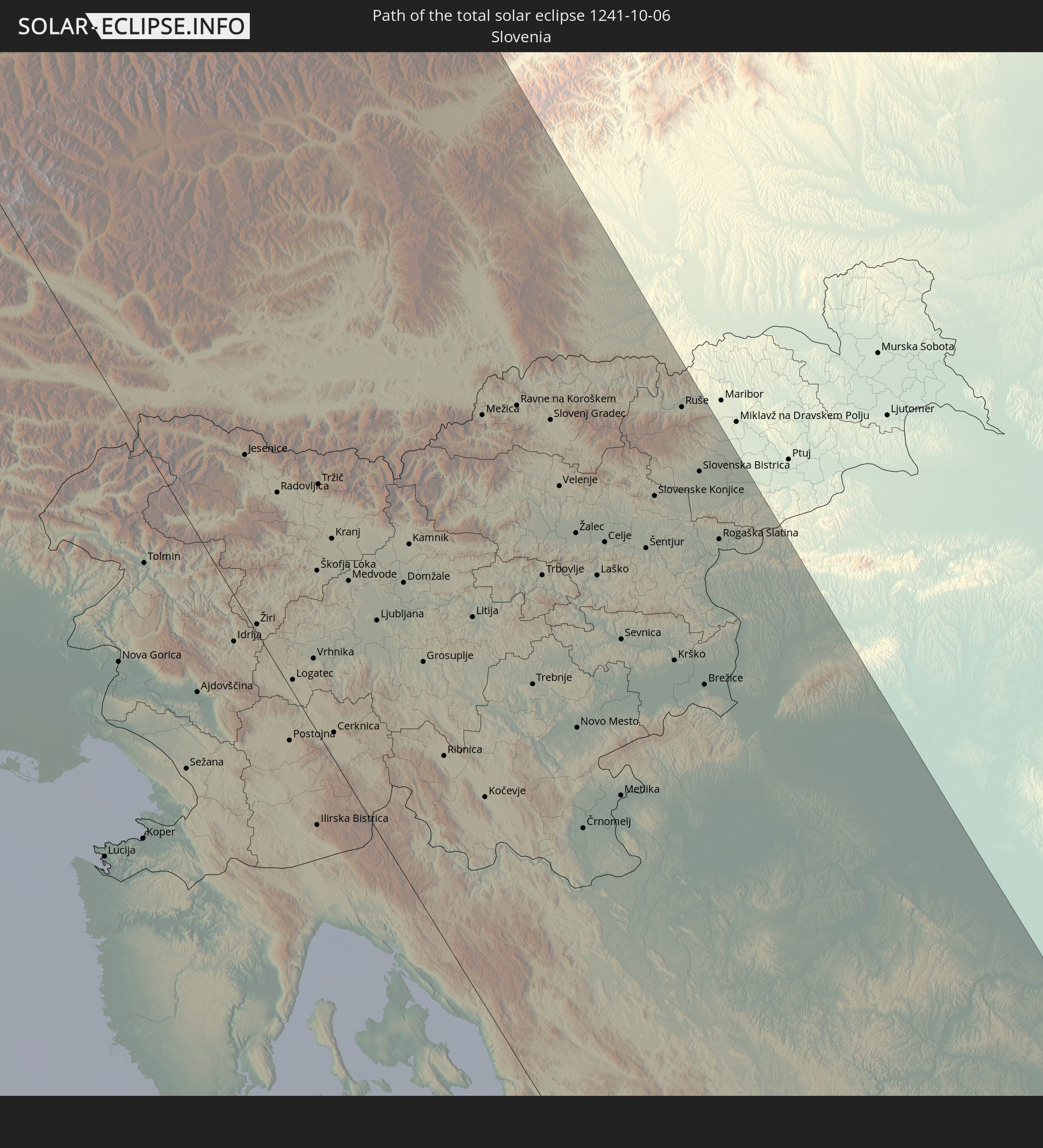 Slovenia
 Croatia
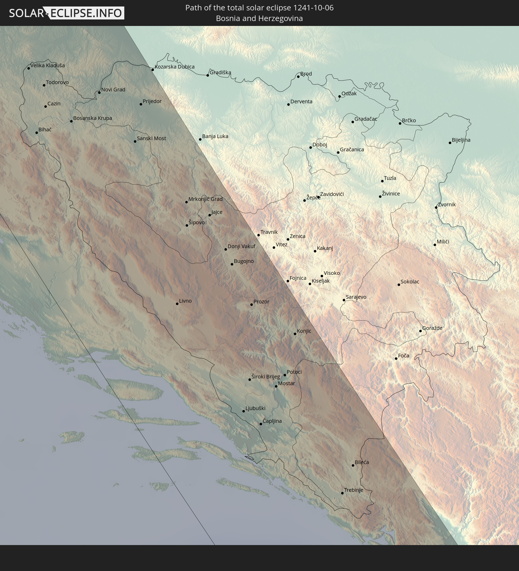 Bosnia and Herzegovina
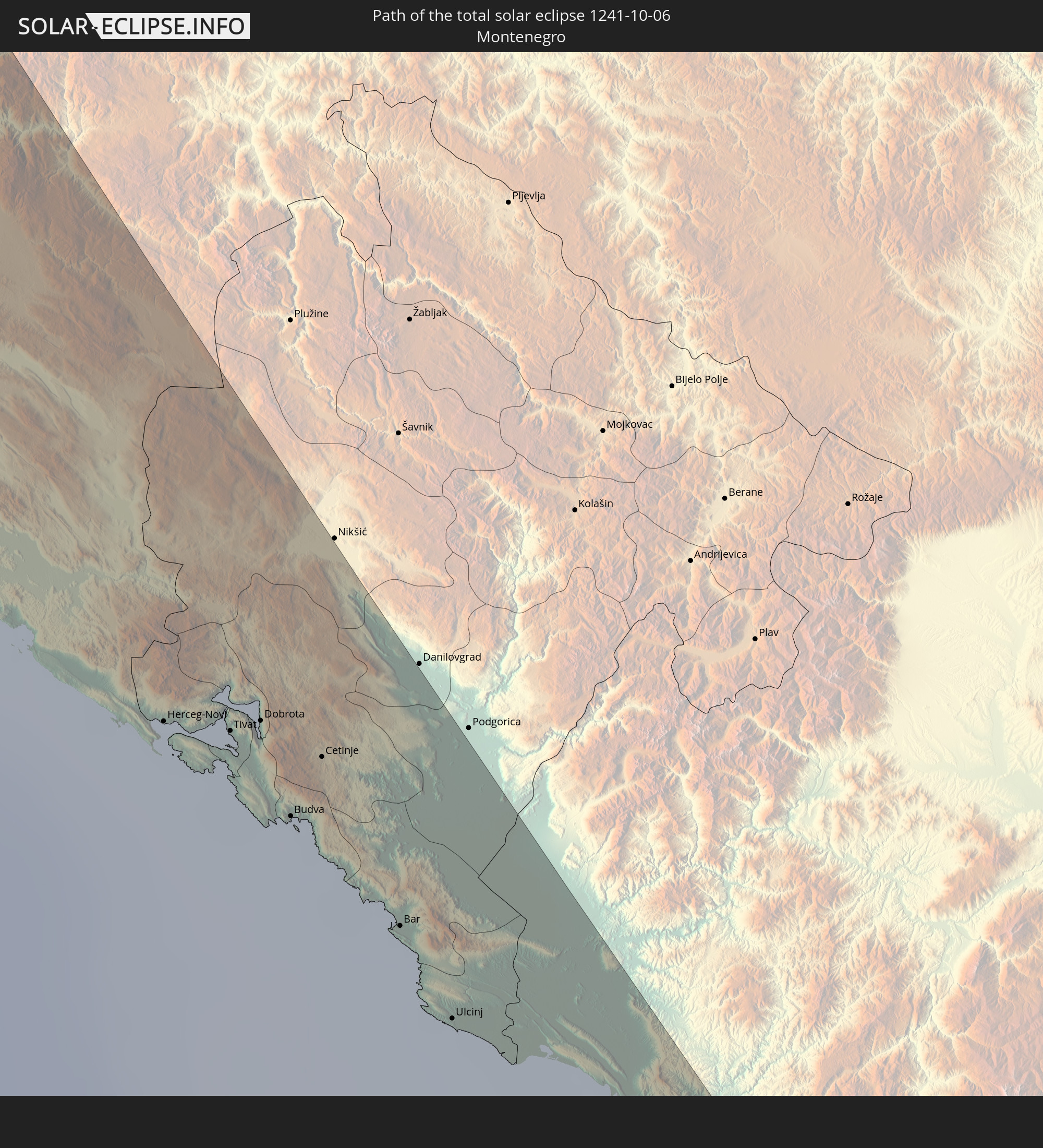 Montenegro
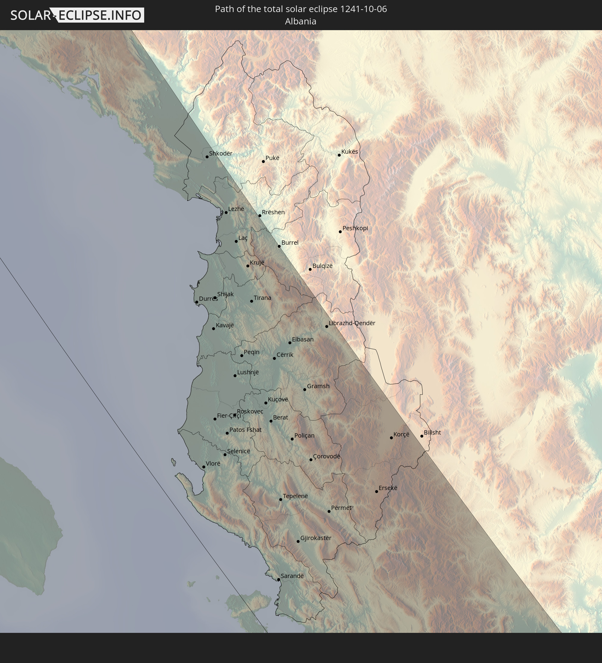 Albania
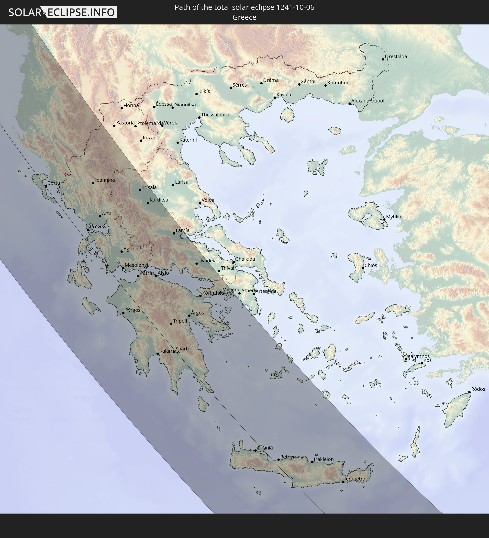 Greece
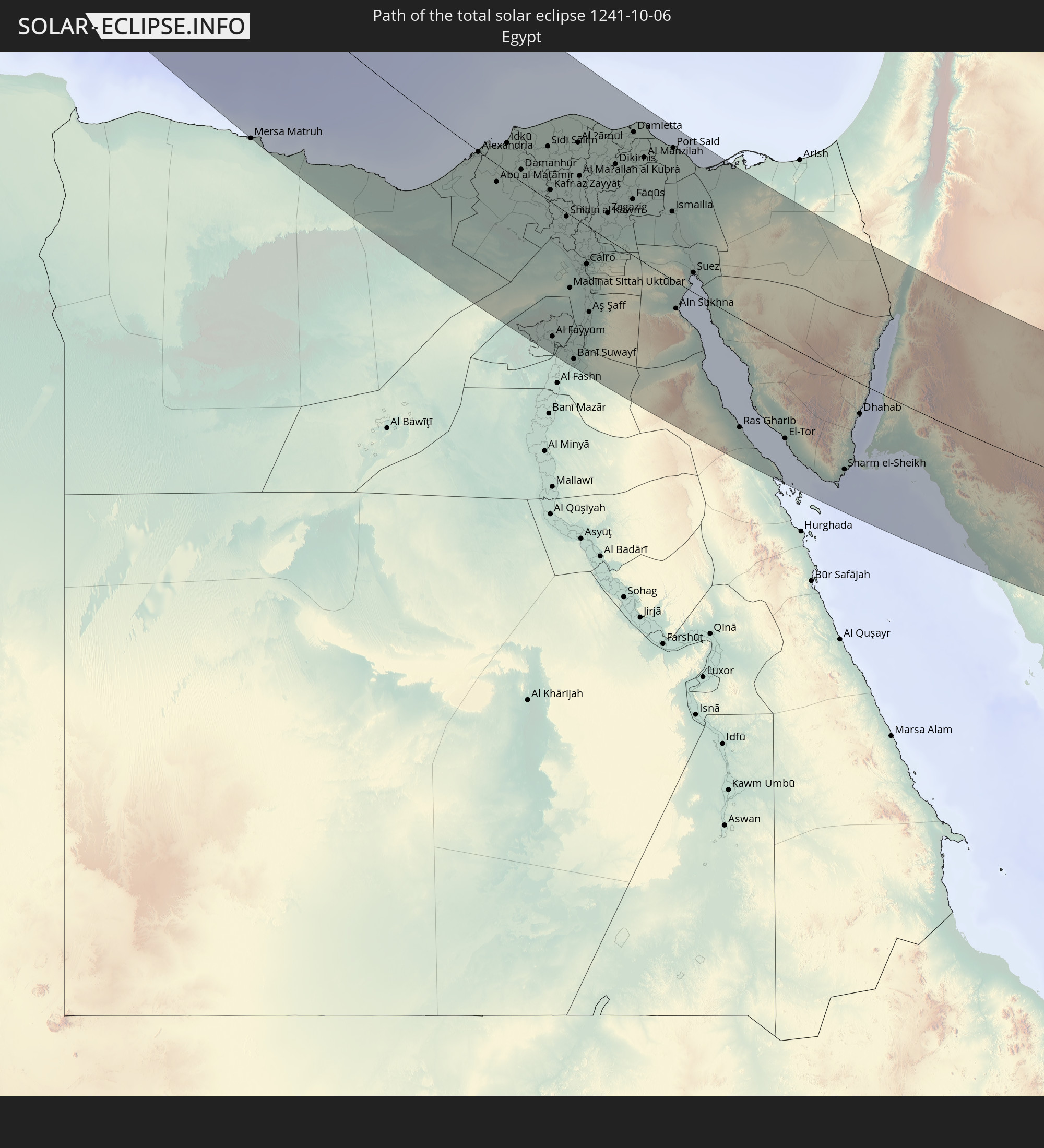 Egypt
Egypt
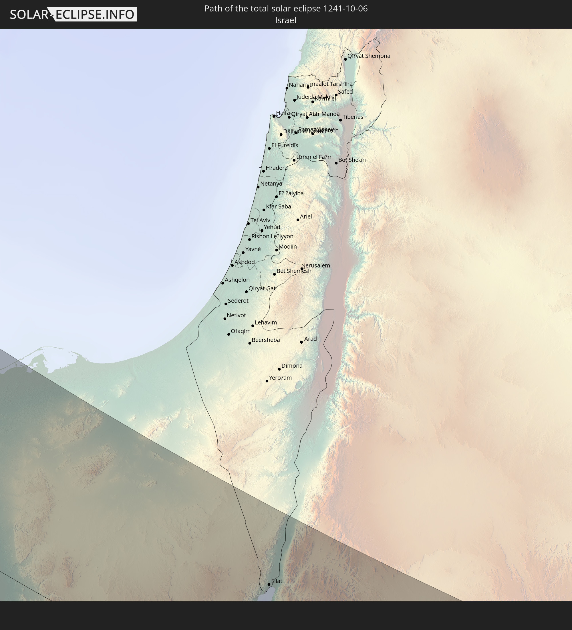 Israel
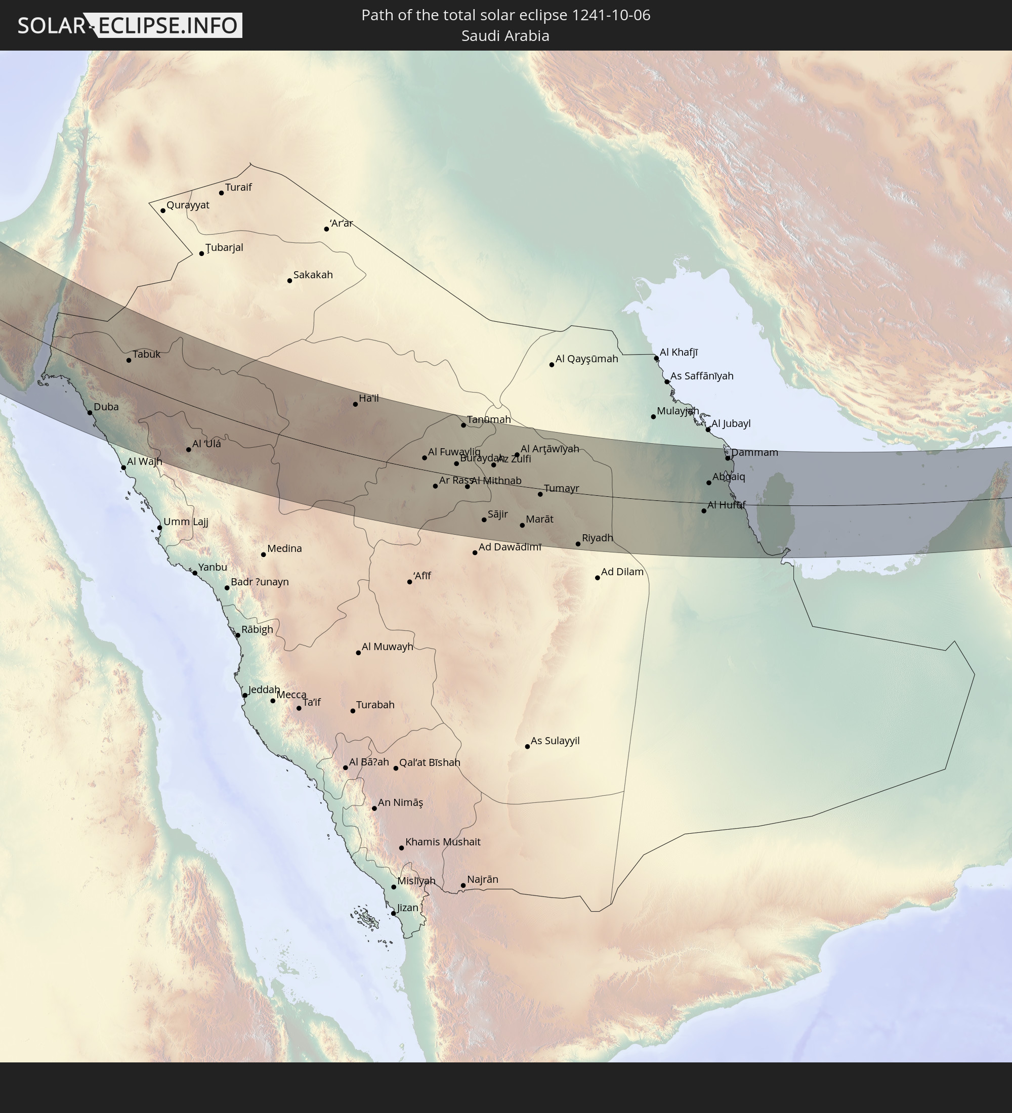 Saudi Arabia
 Jordan
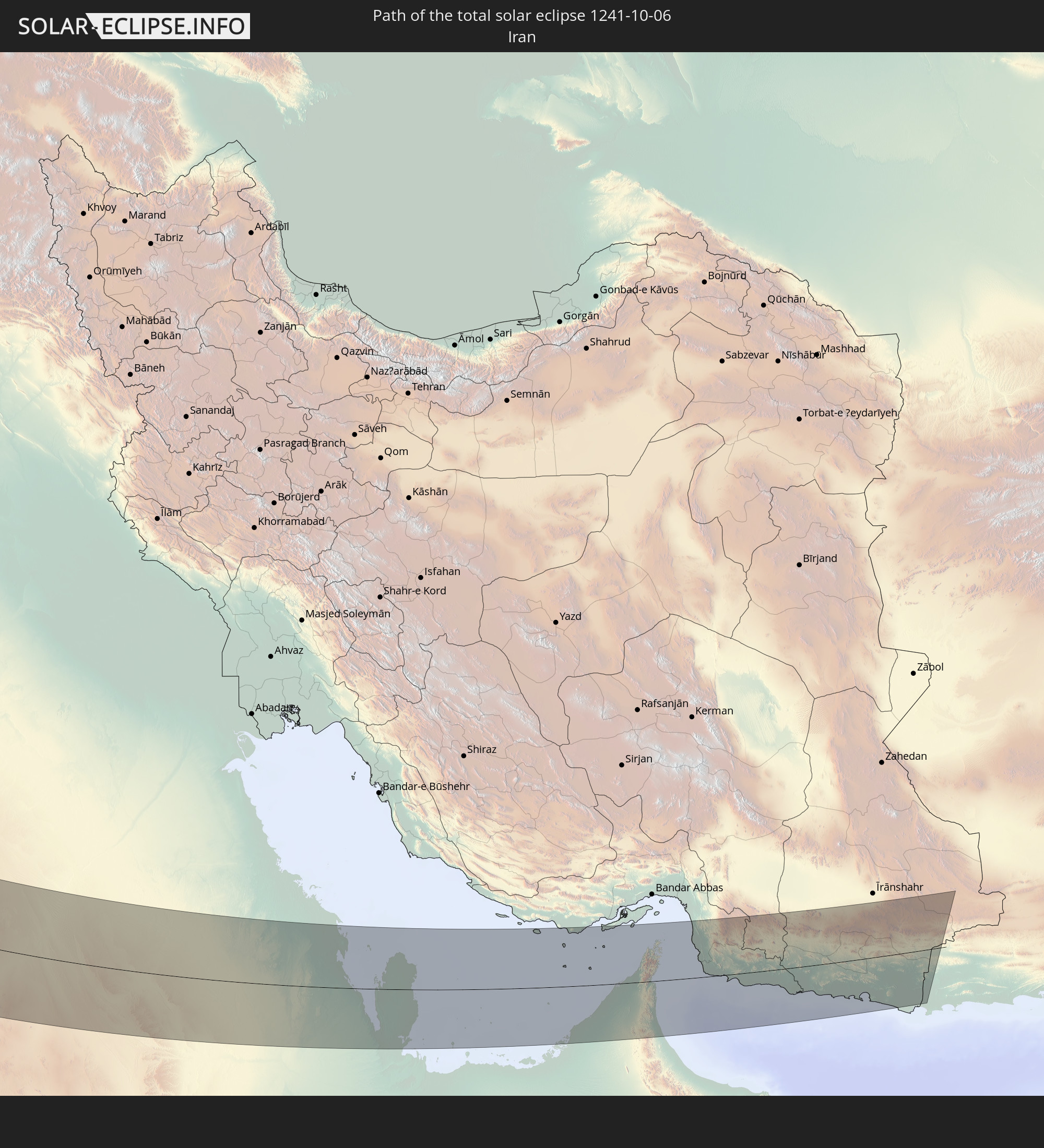 Iran
Iran
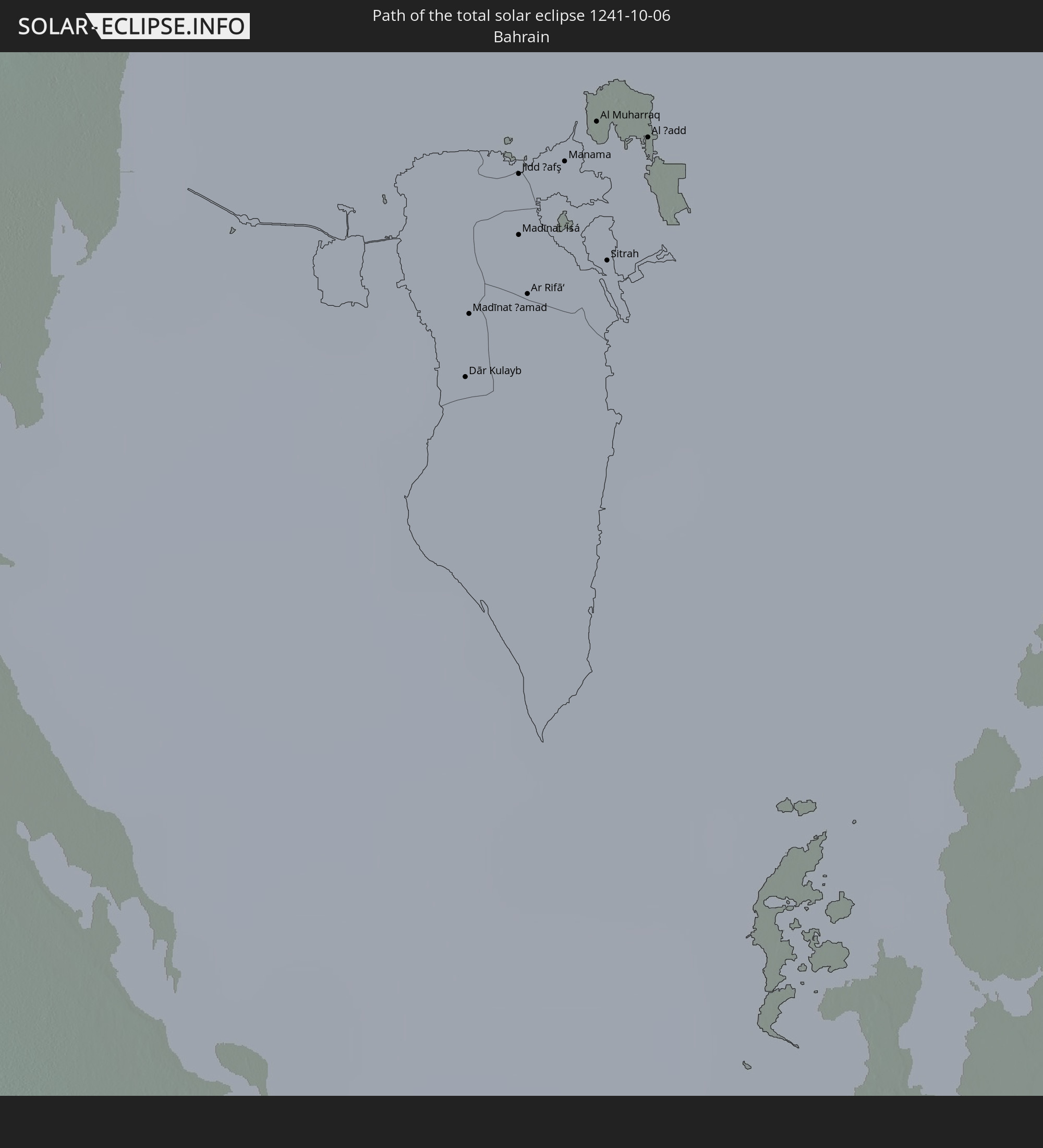 Bahrain
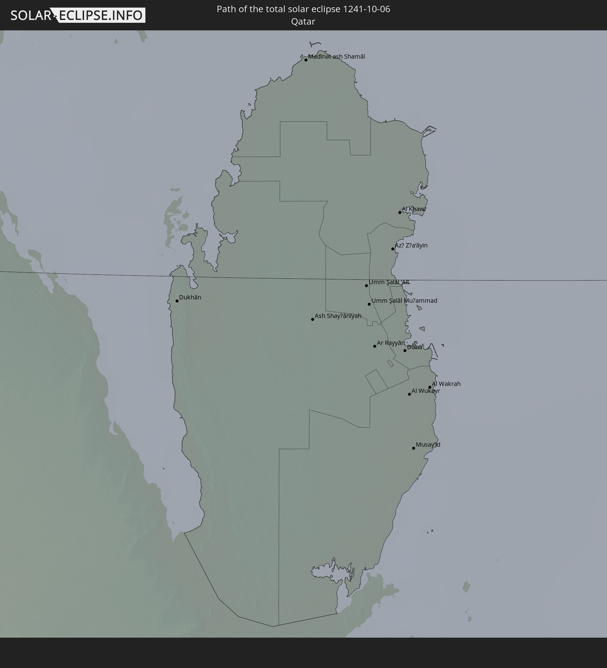 Qatar
Qatar
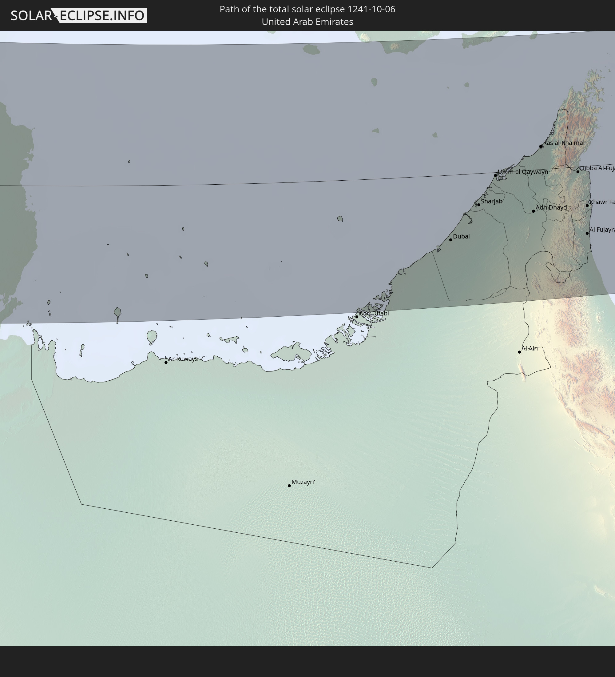 United Arab Emirates
 Oman
Oman
 Pakistan
In den folgenden Ländern ist die Sonnenfinsternis partiell zu sehen
 Russia
 United States
 Canada
 Greenland
 Saint Pierre and Miquelon
 Portugal
 Iceland
 Spain
Spain
 Mauritania
 Guinea
 Morocco
 Mali
Mali
 Republic of Ireland
 Svalbard and Jan Mayen
 Algeria
 United Kingdom
 Ivory Coast
 Faroe Islands
 Burkina Faso
 Gibraltar
 France
 Isle of Man
 Ghana
Ghana
 Guernsey
 Jersey
 Togo
Togo
 Niger
Niger
 Benin
Benin
 Andorra
 Belgium
 Nigeria
 Netherlands
 Norway
 Equatorial Guinea
 Luxembourg
 Germany
 Switzerland
 São Tomé and Príncipe
 Italy
Italy
 Monaco
 Tunisia
 Denmark
 Cameroon
 Gabon
Gabon
 Libya
Libya
 Liechtenstein
 Austria
 Sweden
 Republic of the Congo
 Angola
 Czechia
 Democratic Republic of the Congo
 San Marino
 Vatican City
 Slovenia
 Chad
Chad
 Croatia
 Poland
 Malta
Malta
 Central African Republic
 Bosnia and Herzegovina
 Hungary
 Slovakia
 Montenegro
 Serbia
 Albania
 Åland Islands
 Greece
 Romania
 Republic of Macedonia
 Finland
 Lithuania
 Latvia
 Estonia
 Sudan
Sudan
 Zambia
 Ukraine
 Bulgaria
 Belarus
 Egypt
Egypt
 Turkey
 Moldova
 Rwanda
 Burundi
 Tanzania
 Uganda
 Mozambique
 Cyprus
 Malawi
 Ethiopia
 Kenya
Kenya
 State of Palestine
 Israel
 Saudi Arabia
 Jordan
 Lebanon
 Syria
Syria
 Eritrea
 Iraq
Iraq
 Georgia
 French Southern and Antarctic Lands
 Somalia
 Djibouti
 Yemen
Yemen
 Madagascar
 Comoros
 Armenia
 Iran
Iran
 Azerbaijan
 Mayotte
 Seychelles
 Kazakhstan
 Kuwait
 Bahrain
 Qatar
Qatar
 United Arab Emirates
 Oman
Oman
 Turkmenistan
 Uzbekistan
 Mauritius
 Afghanistan
 Pakistan
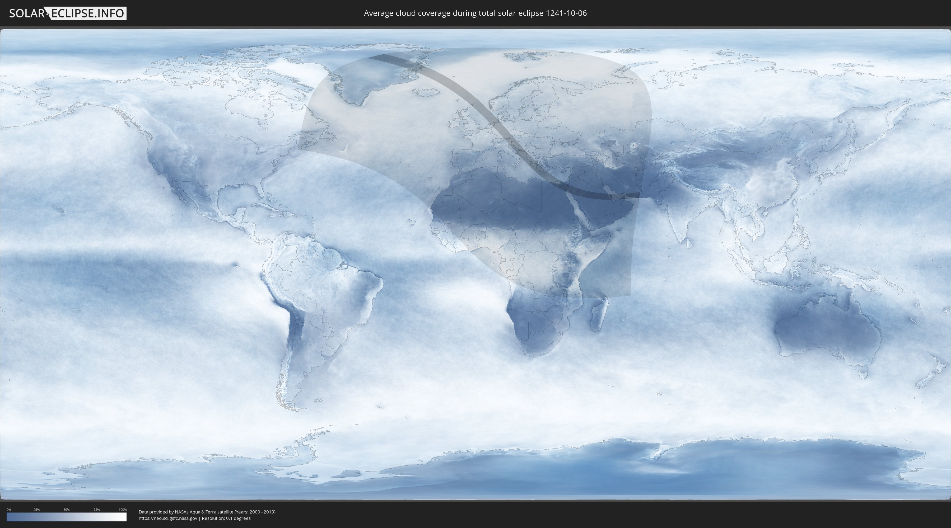
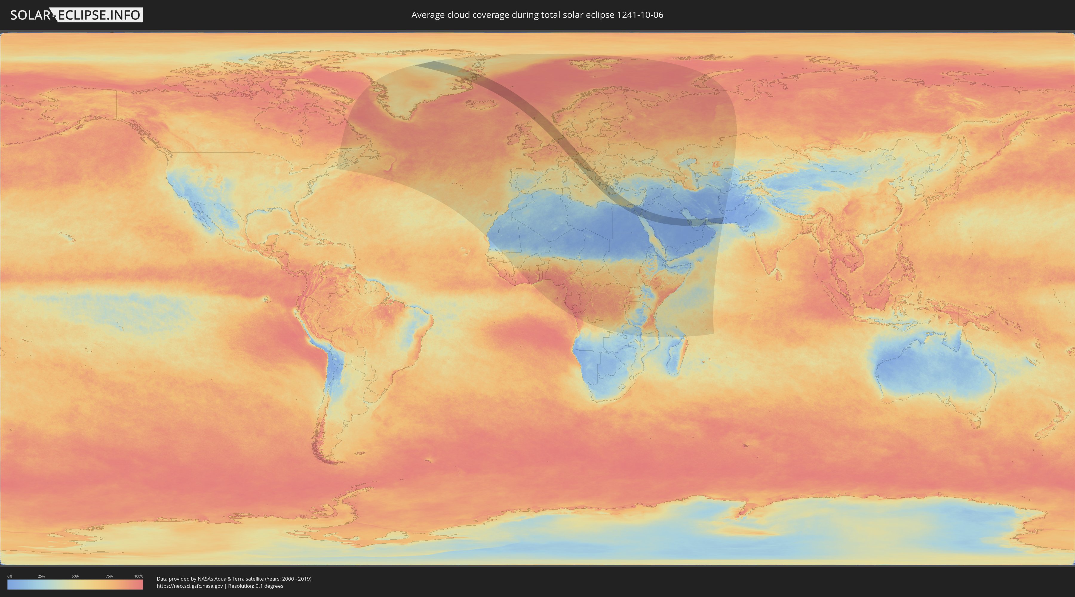
How will be the weather during the total solar eclipse on 10/06/1241?
Where is the best place to see the total solar eclipse of 10/06/1241?
The following maps show the average cloud coverage for the day of the total solar eclipse.
With the help of these maps, it is possible to find the place along the eclipse path, which has the best
chance of a cloudless sky.
Nevertheless, you should consider local circumstances and inform about the weather of your chosen
observation site.
The data is provided by NASAs satellites
AQUA and TERRA.
The cloud maps are averaged over a period of 19 years (2000 - 2019).
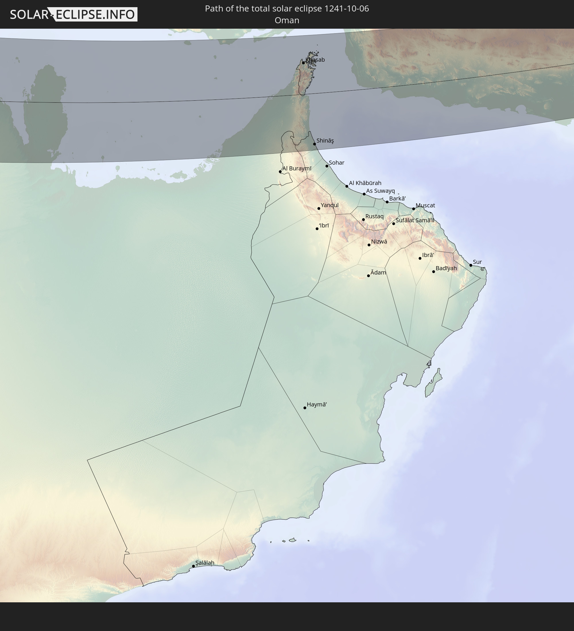
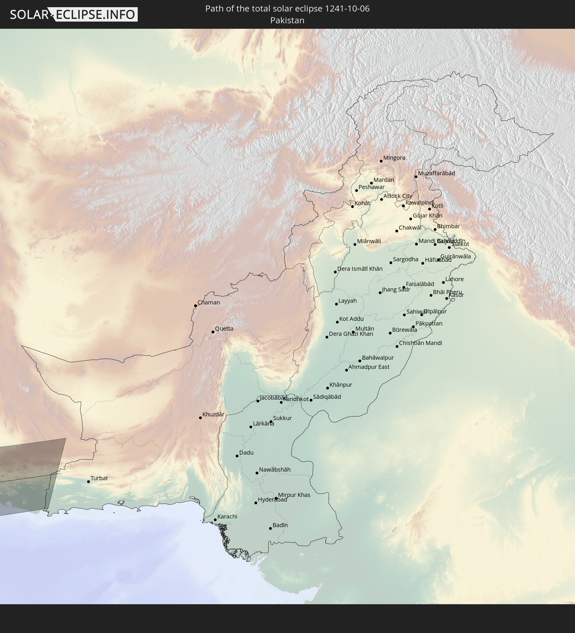
Detailed country maps
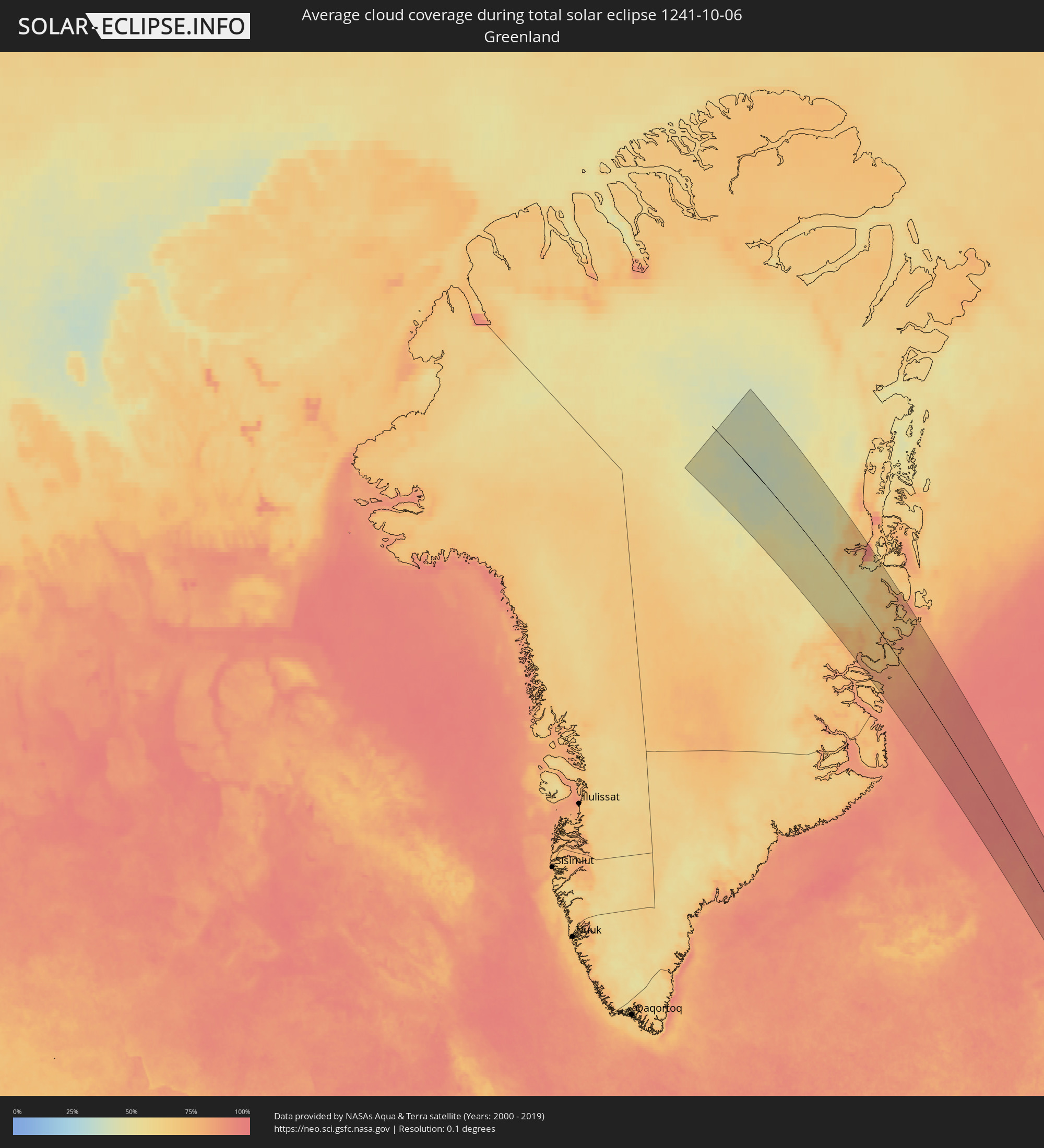 Greenland
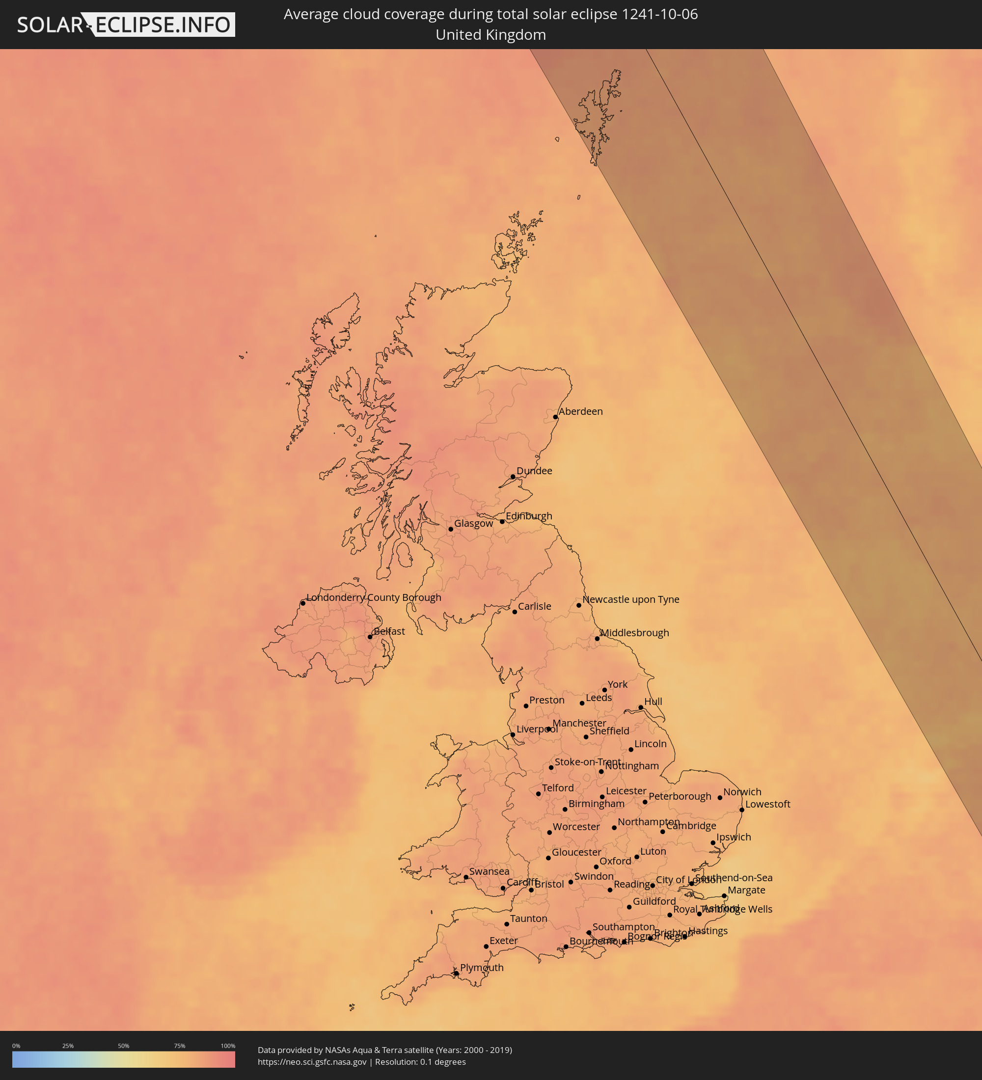 United Kingdom
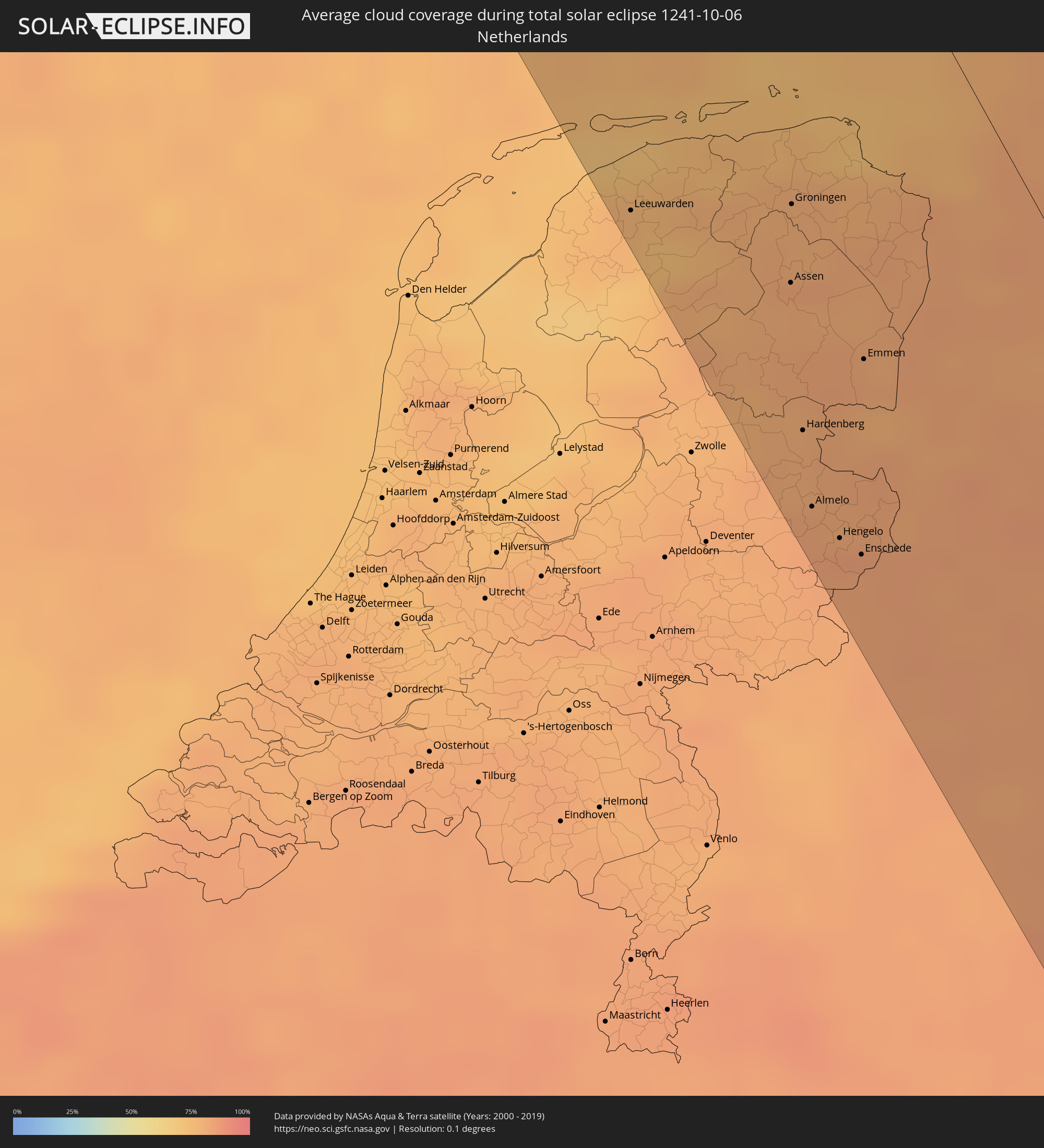 Netherlands
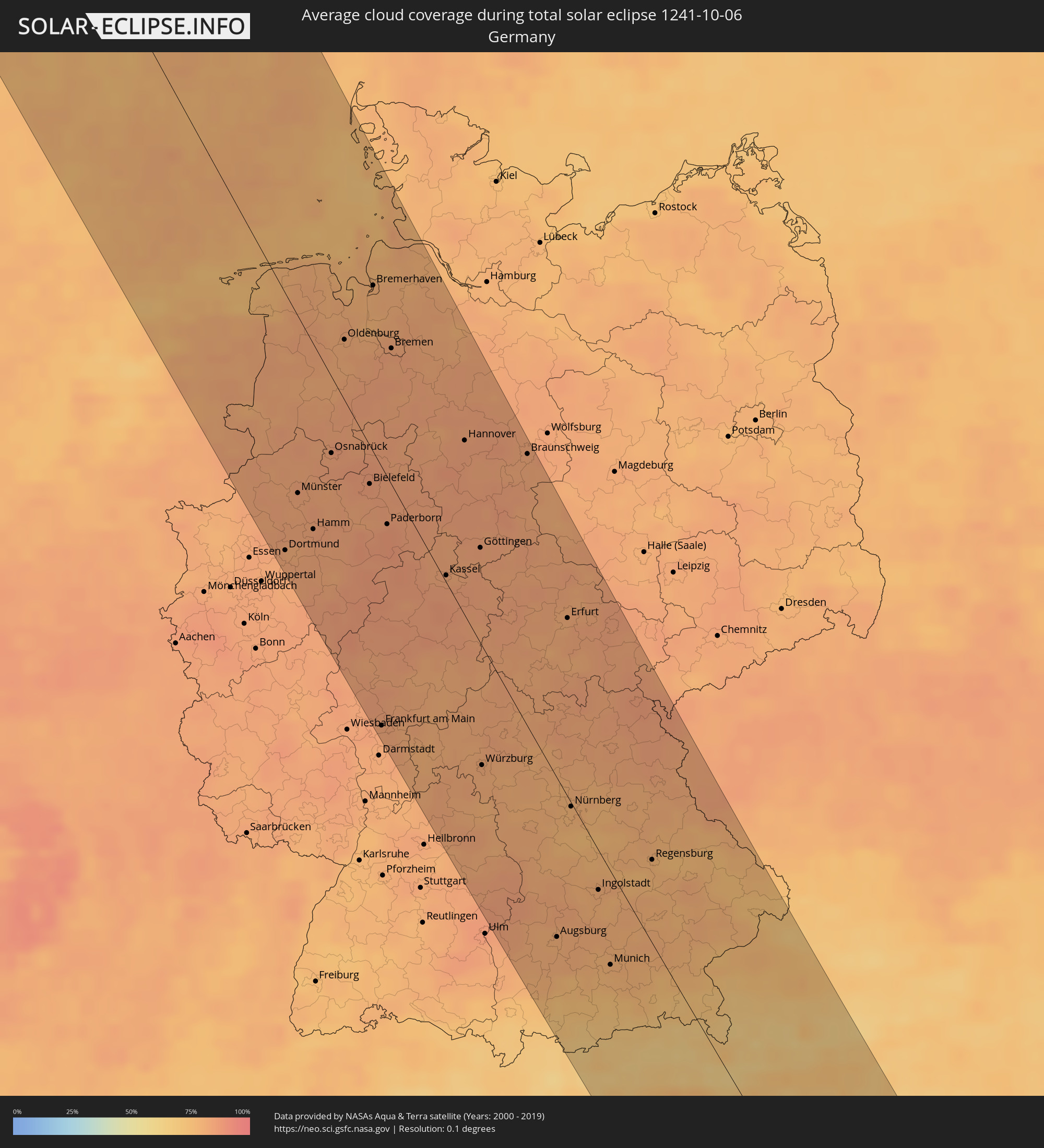 Germany
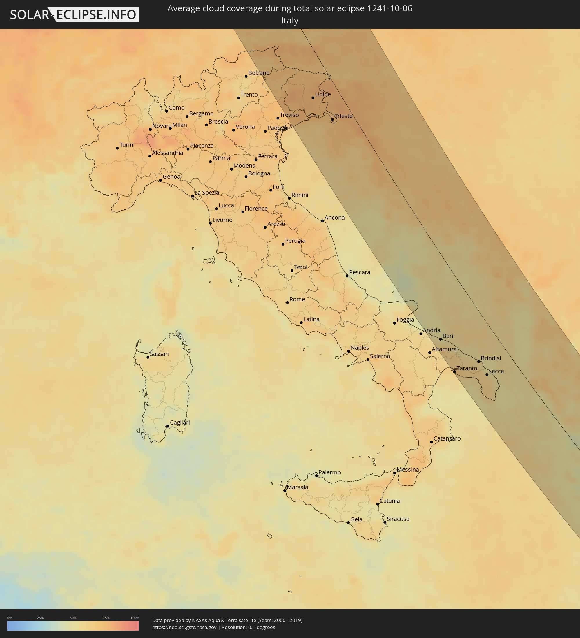 Italy
Italy
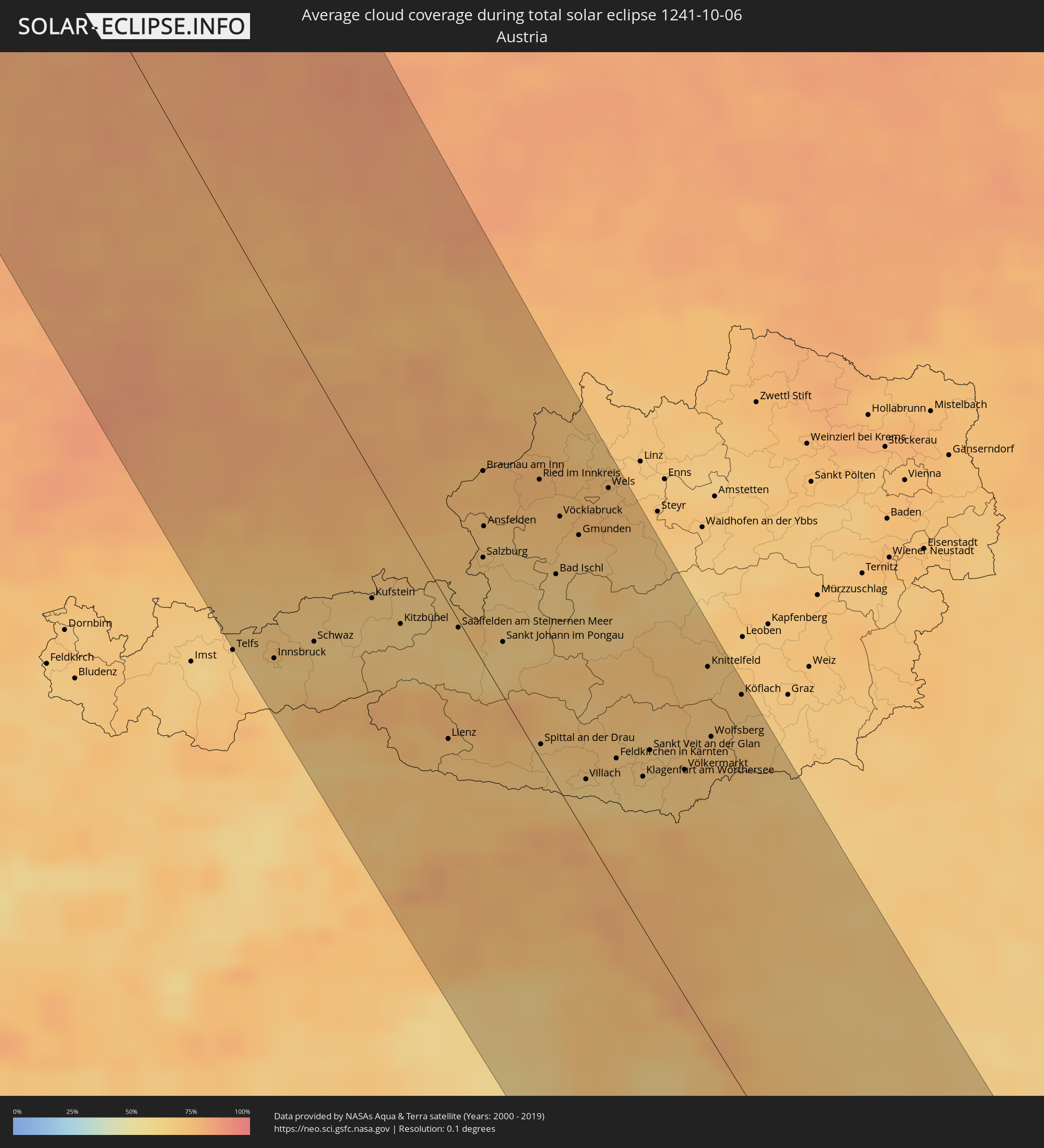 Austria
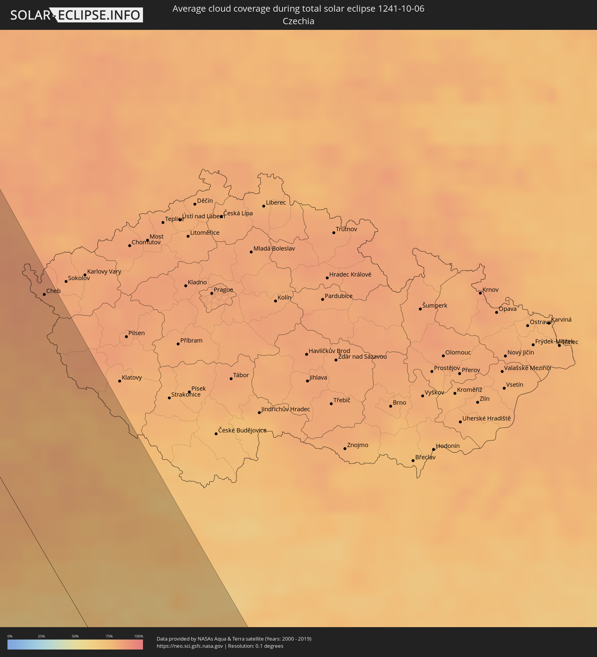 Czechia
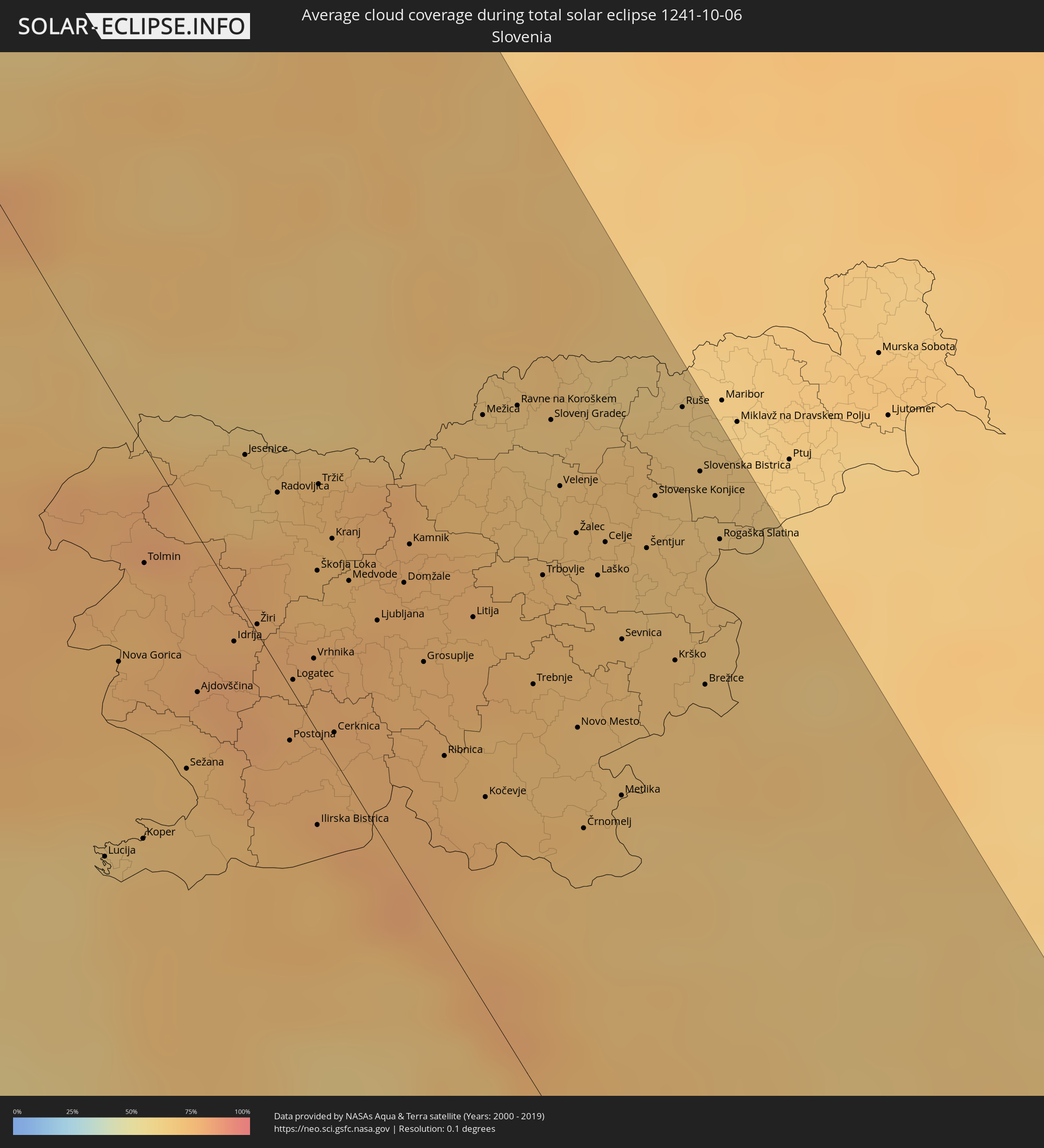 Slovenia
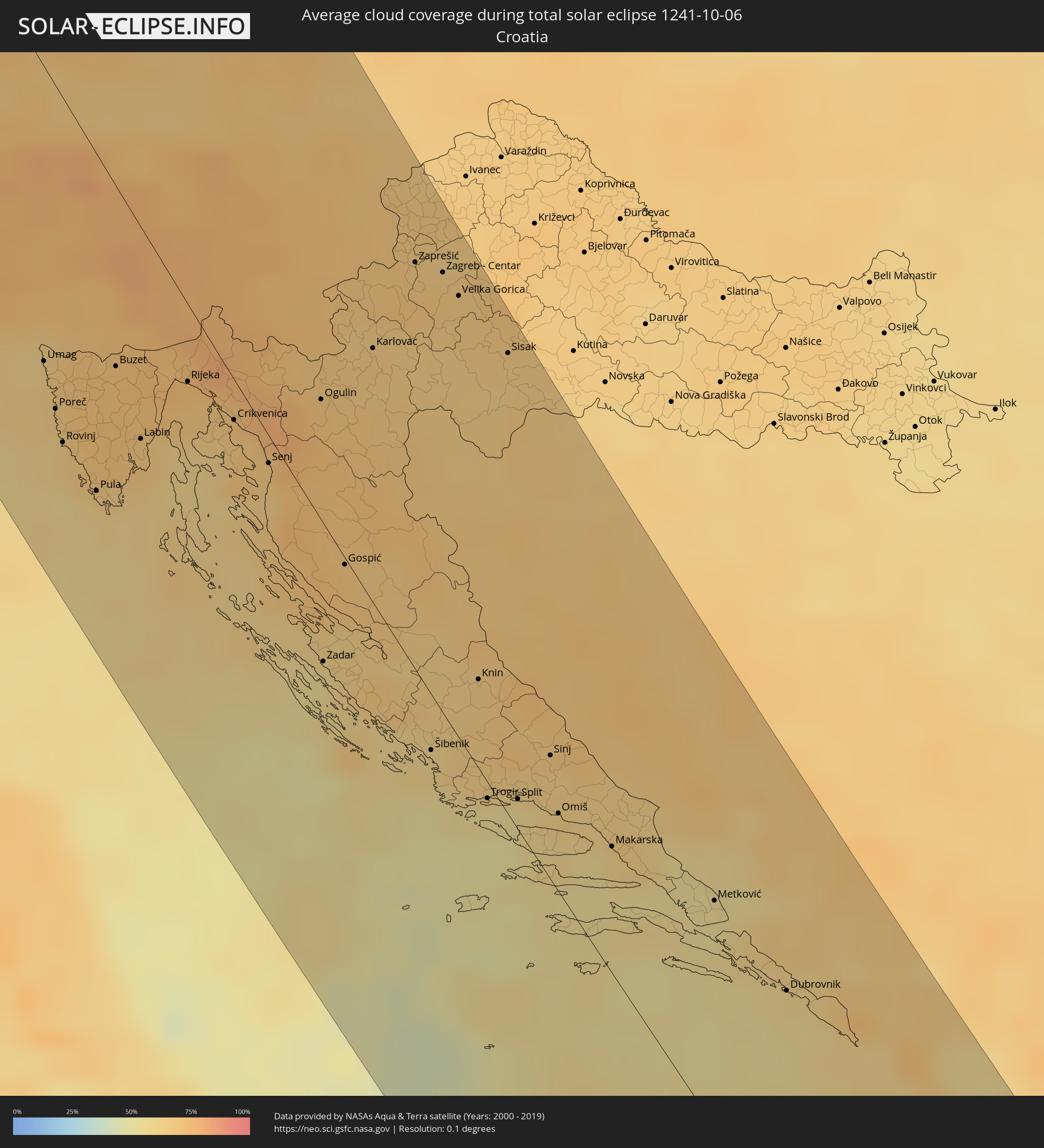 Croatia
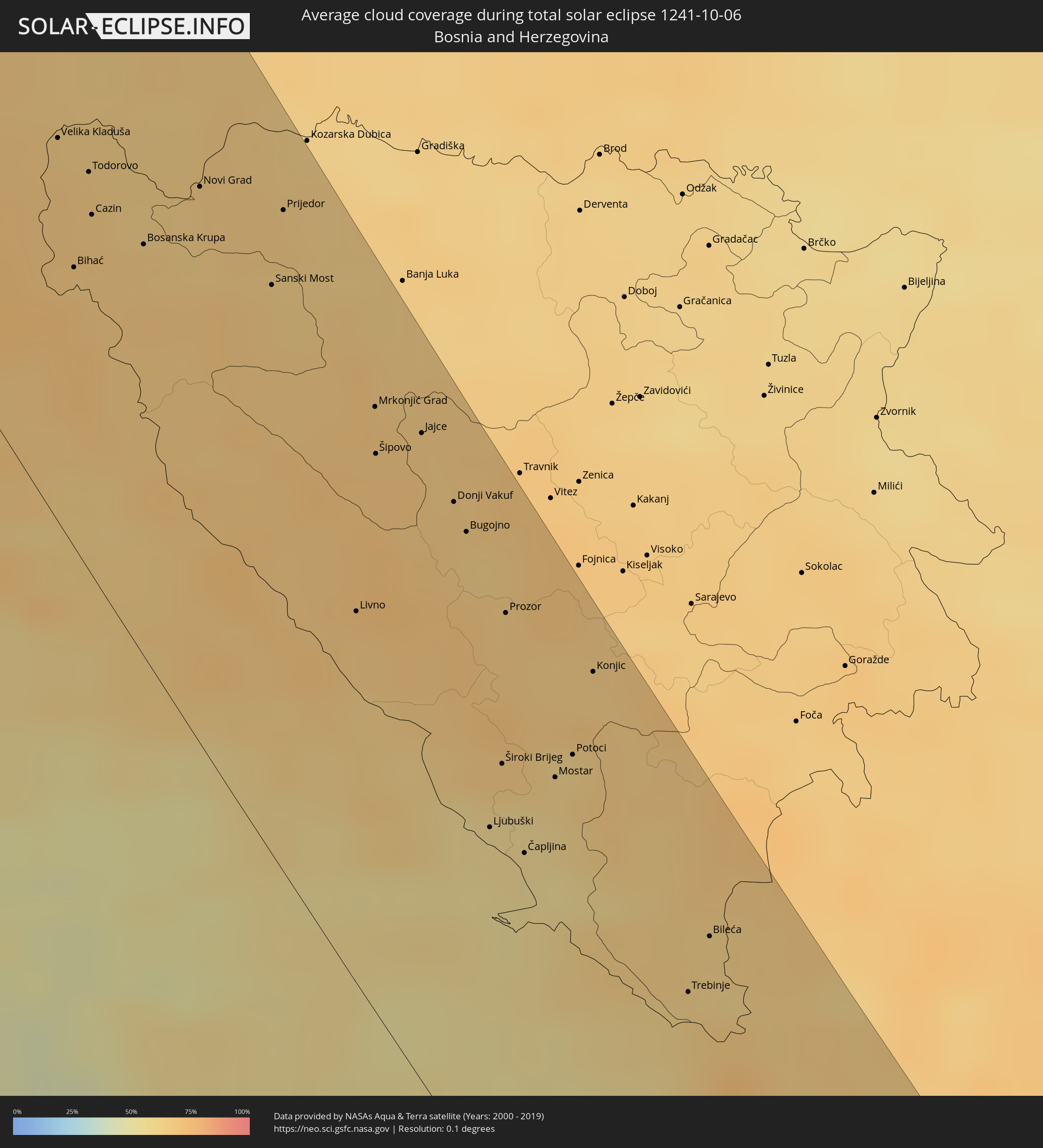 Bosnia and Herzegovina
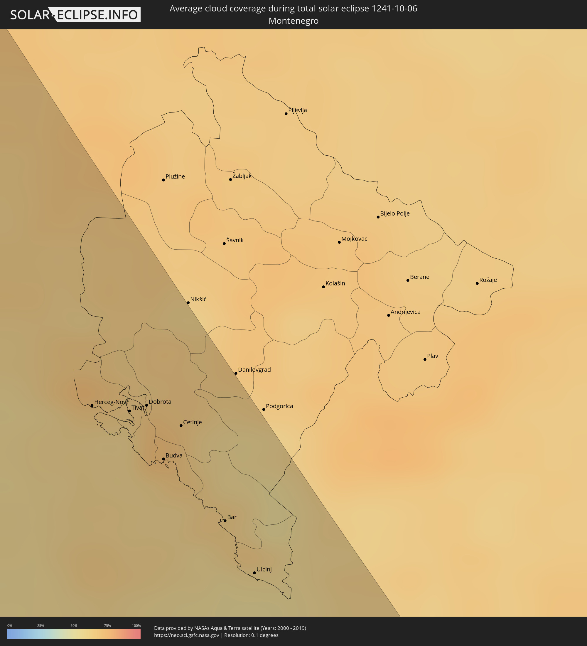 Montenegro
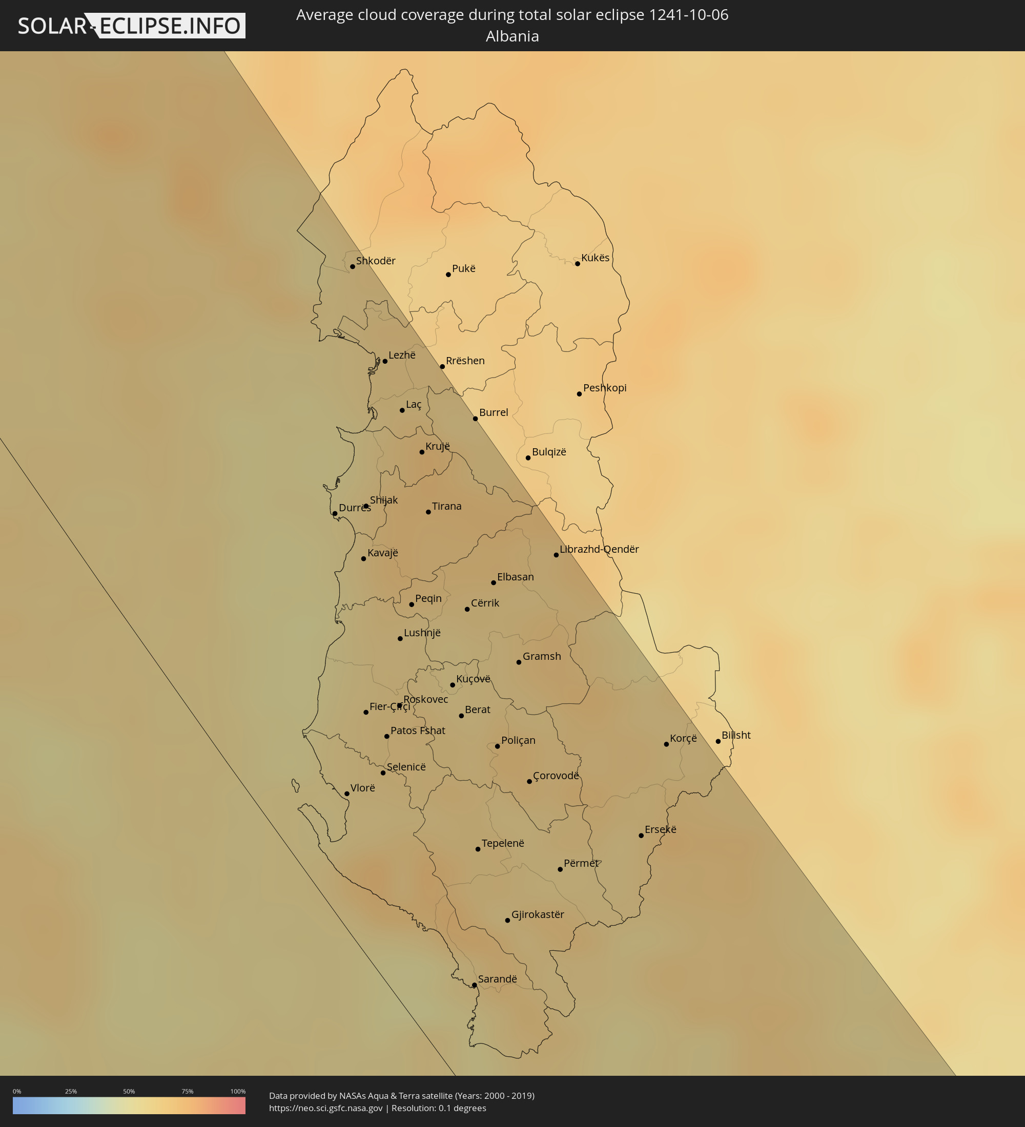 Albania
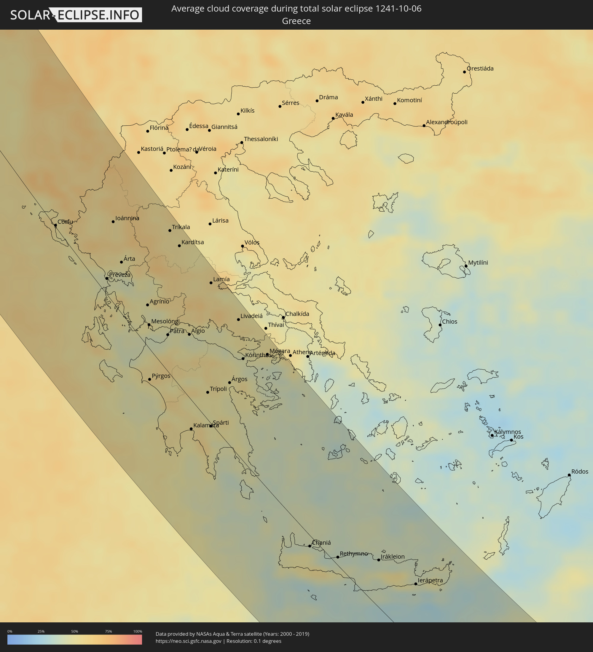 Greece
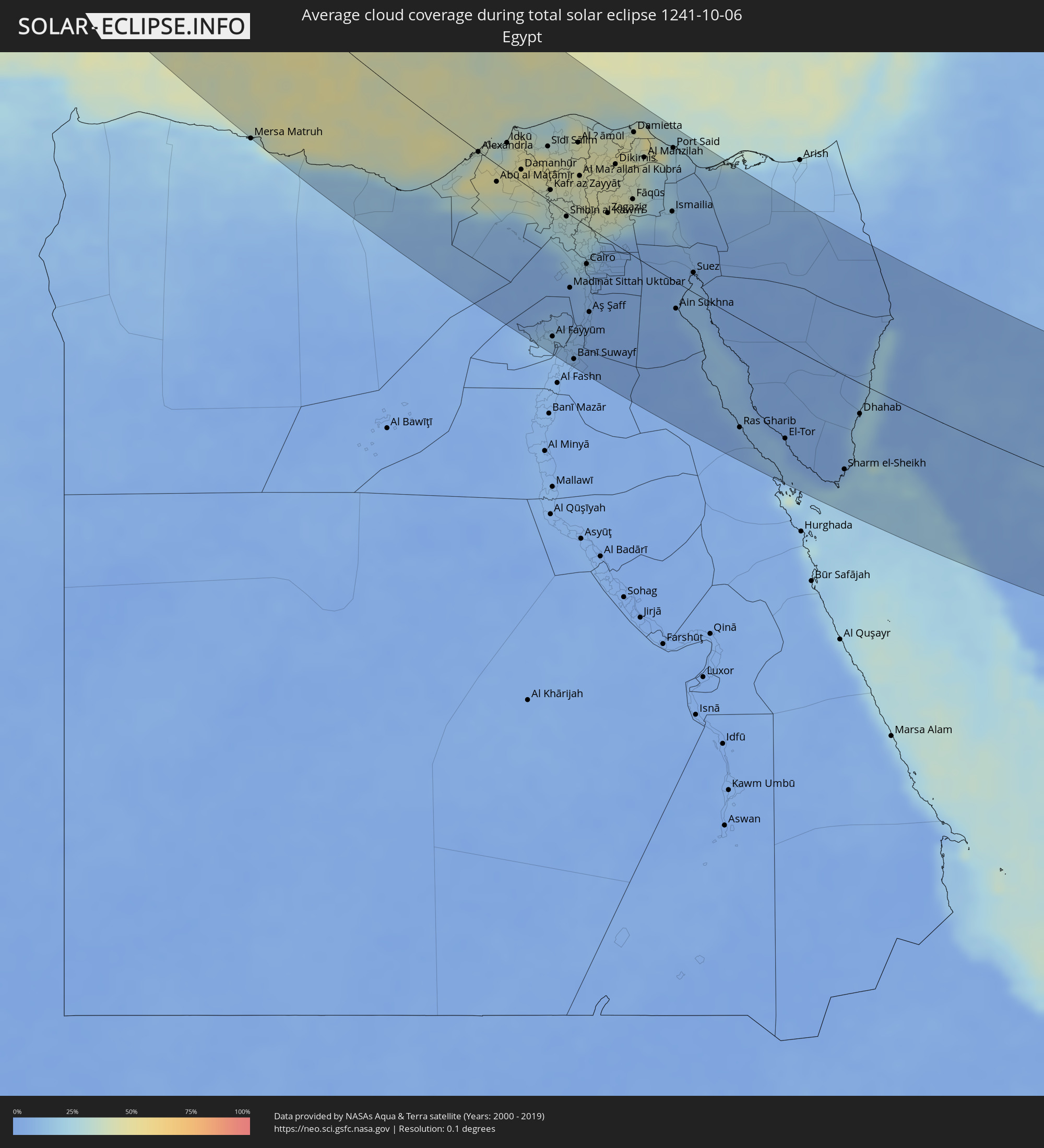 Egypt
Egypt
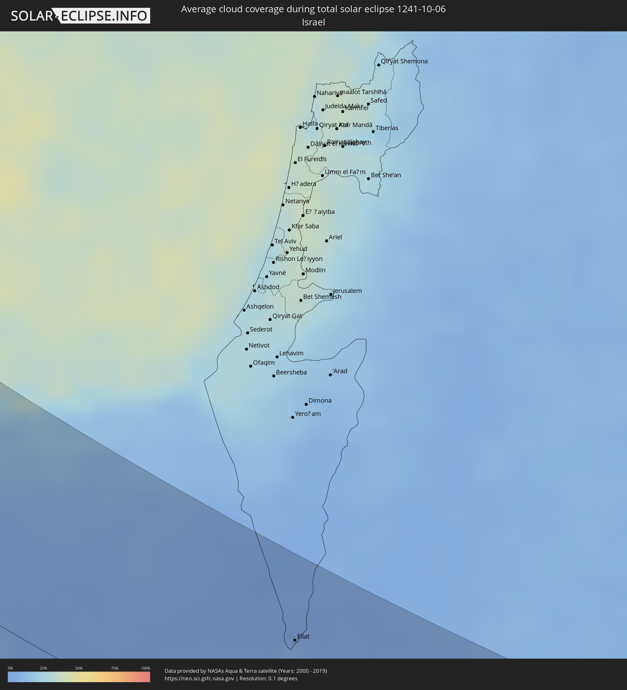 Israel
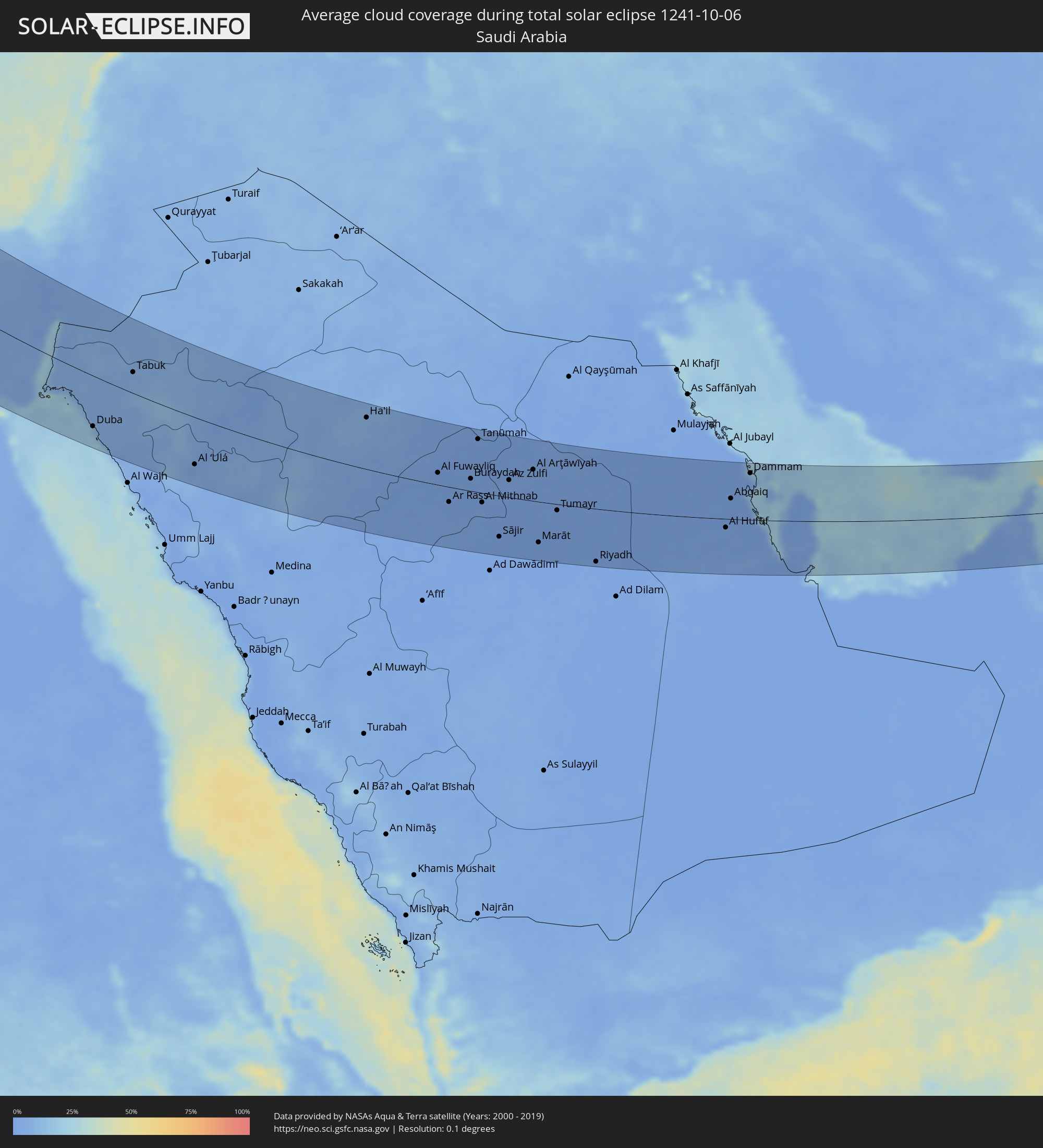 Saudi Arabia
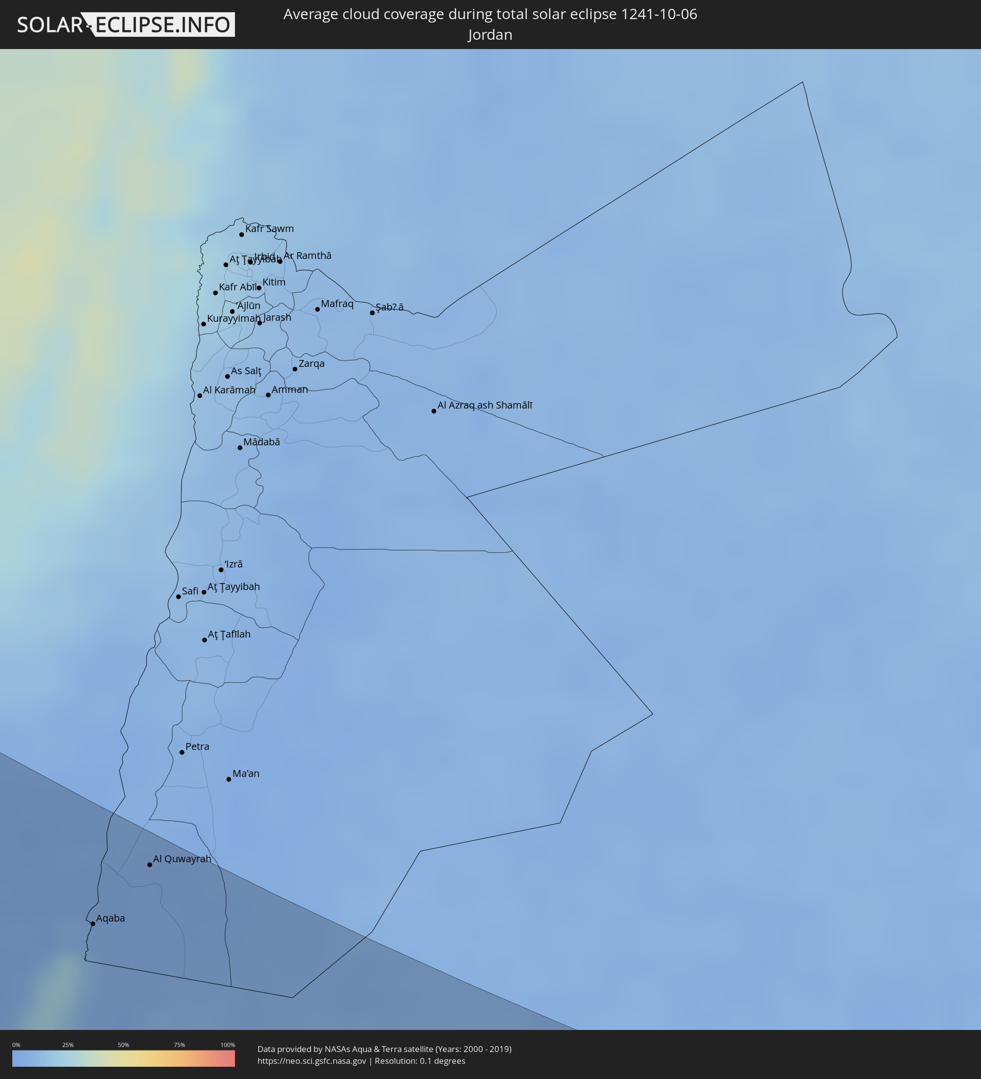 Jordan
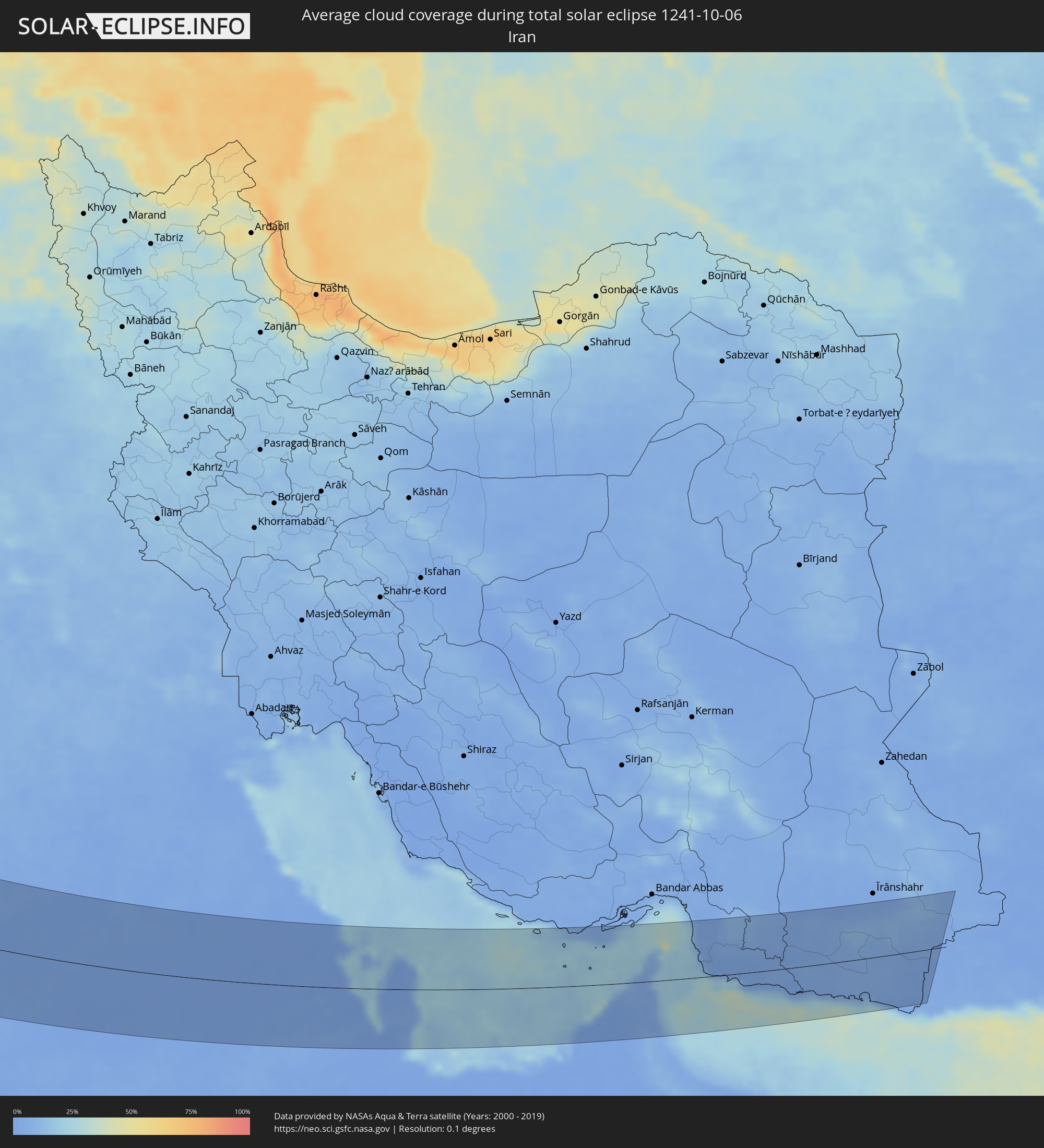 Iran
Iran
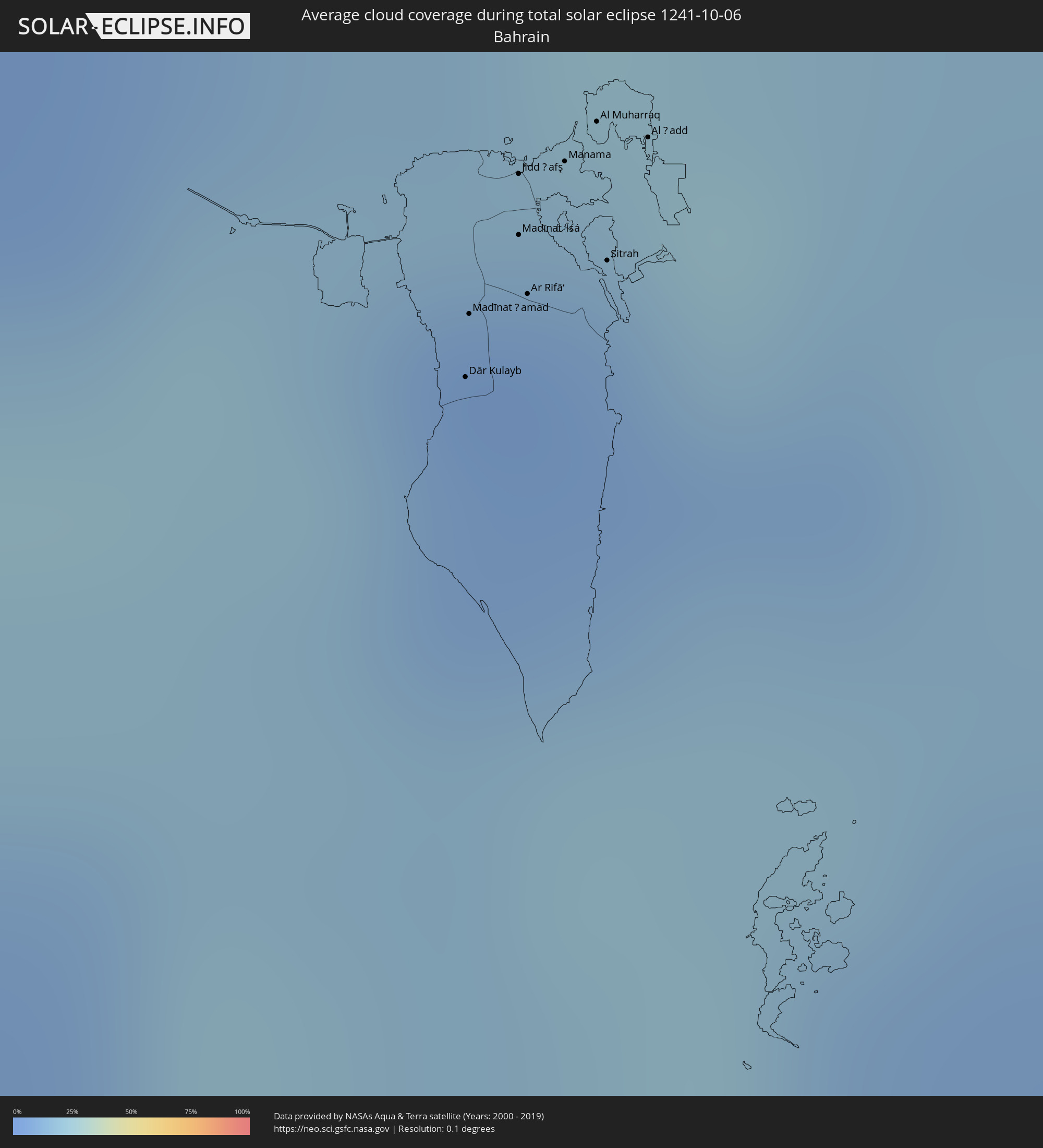 Bahrain
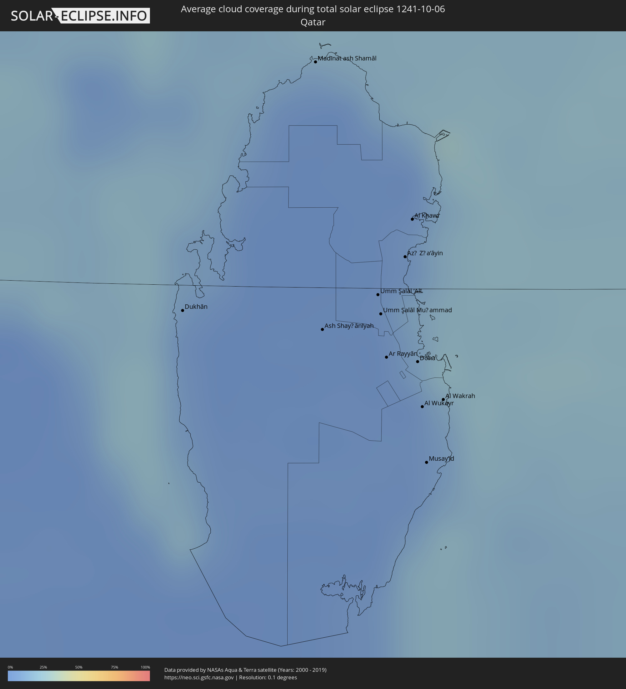 Qatar
Qatar
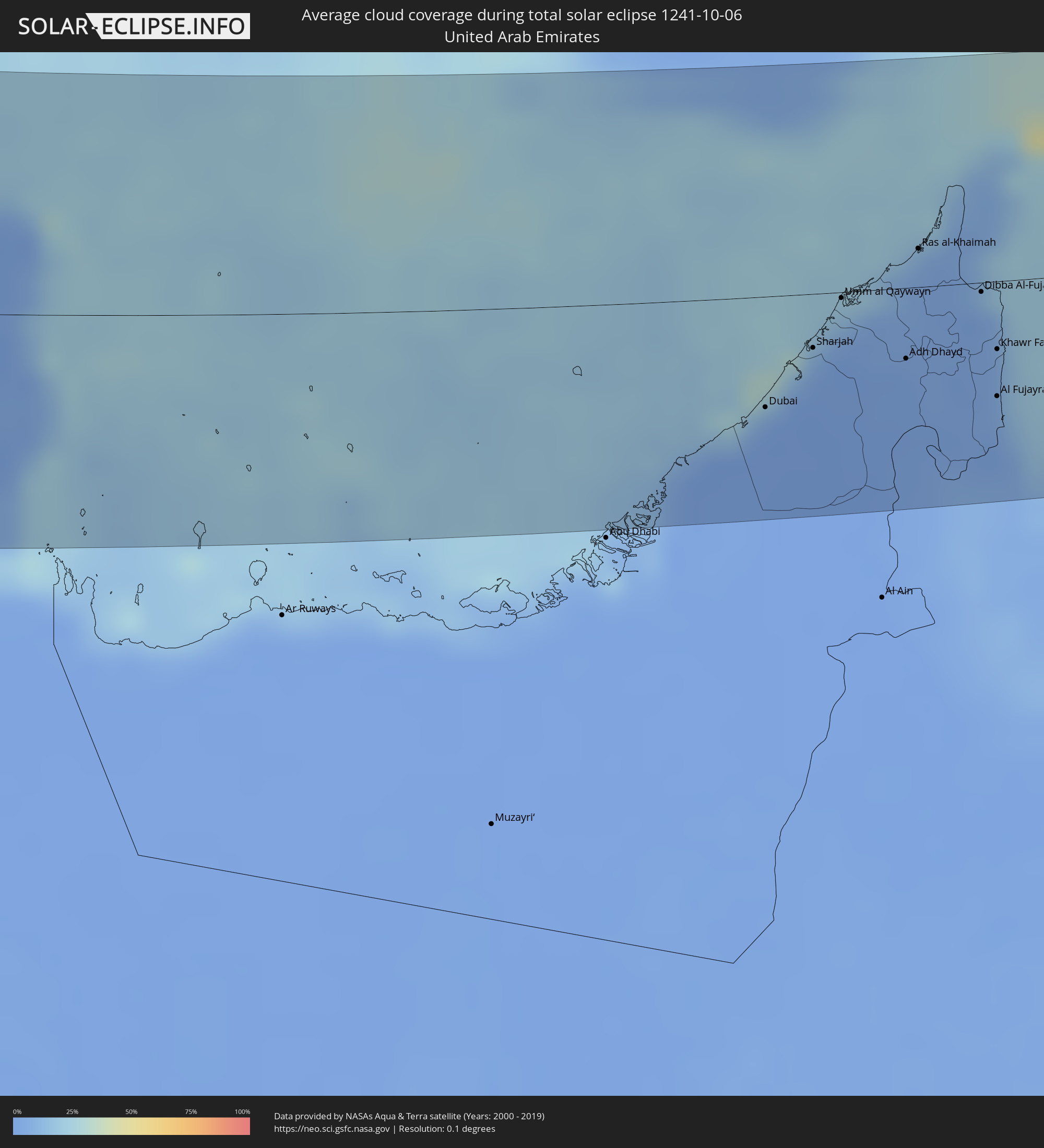 United Arab Emirates
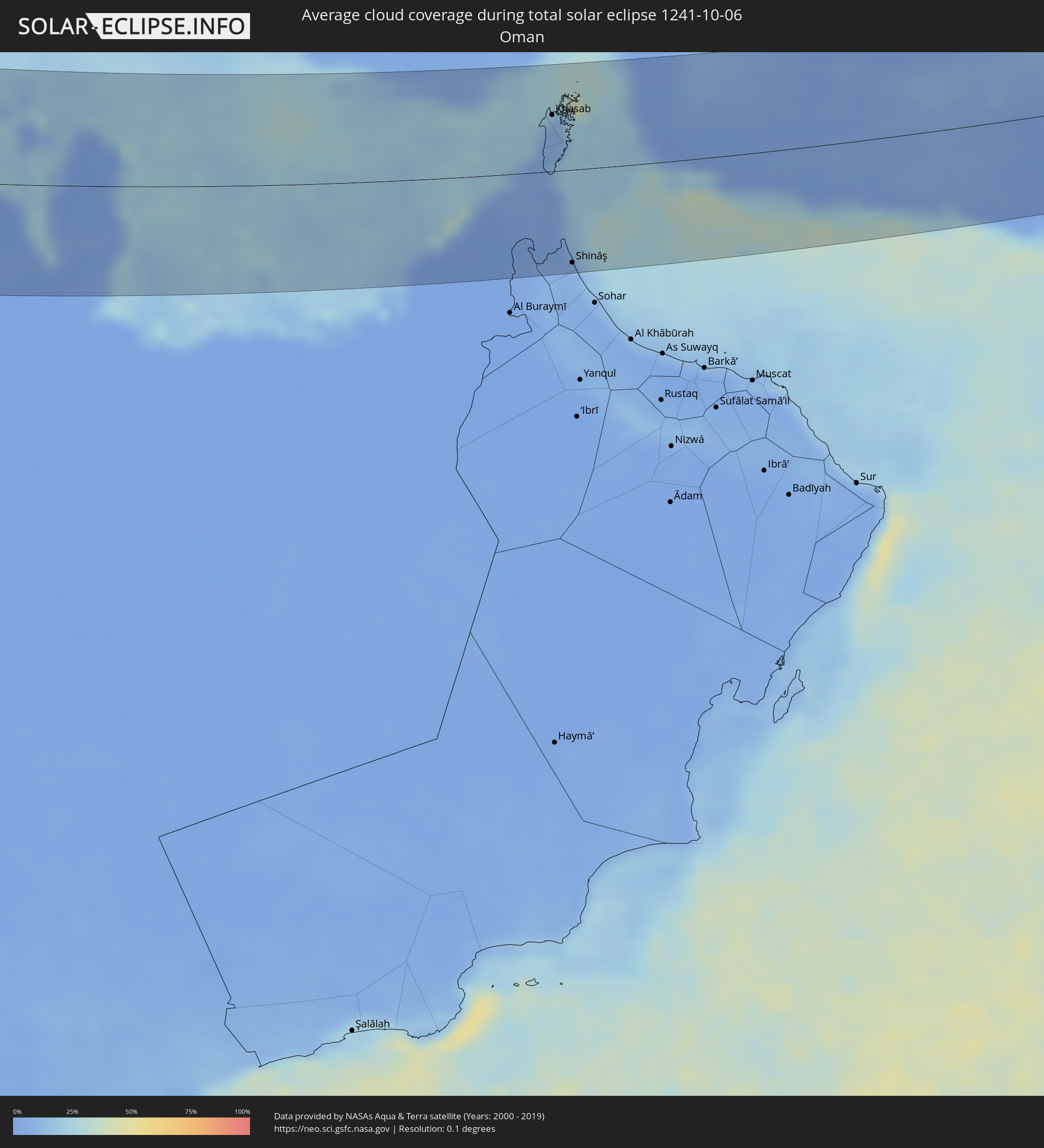 Oman
Oman
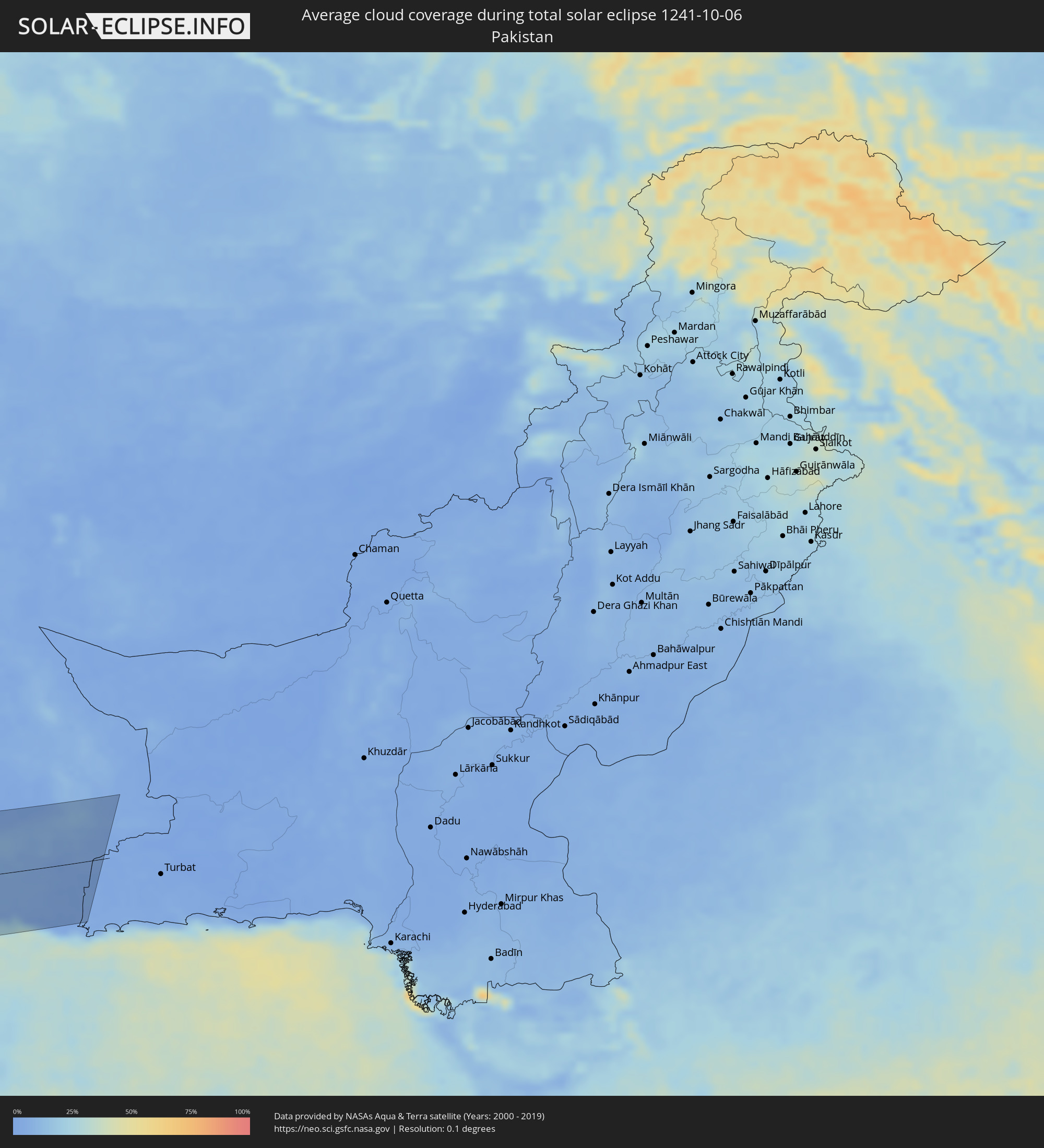 Pakistan
Cities inside the path of the eclipse
The following table shows all locations with a population of more than 5,000 inside the eclipse path. Cities which have more than 100,000 inhabitants are marked bold. A click at the locations opens a detailed map.
| City | Type | Eclipse duration | Local time of max. eclipse | Distance to central line | Ø Cloud coverage |
|
Lerwick, Scotland
|
total | - | 11:34:08 UTC+00:00 | 92 km | 82% |
|
Shetland, Scotland
|
total | - | 11:34:08 UTC+00:00 | 92 km | 82% |
|
Leeuwarden, Friesland
|
total | - | 12:04:50 UTC+00:19 | 112 km | 77% |
|
Drachten, Friesland
|
total | - | 12:05:14 UTC+00:19 | 100 km | 80% |
|
Meppel, Drenthe
|
total | - | 12:05:42 UTC+00:19 | 117 km | 78% |
|
Hoogeveen, Drenthe
|
total | - | 12:05:59 UTC+00:19 | 100 km | 79% |
|
Assen, Drenthe
|
total | - | 12:05:51 UTC+00:19 | 79 km | 80% |
|
Groningen, Groningen
|
total | - | 12:05:40 UTC+00:19 | 67 km | 79% |
|
Hardenberg, Overijssel
|
total | - | 12:06:17 UTC+00:19 | 99 km | 80% |
|
Almelo, Overijssel
|
total | - | 12:06:31 UTC+00:19 | 109 km | 81% |
|
Enschede, Overijssel
|
total | - | 12:06:55 UTC+00:19 | 103 km | 82% |
|
Emmen, Drenthe
|
total | - | 12:06:26 UTC+00:19 | 71 km | 81% |
|
Dortmund, North Rhine-Westphalia
|
total | - | 12:48:41 UTC+01:00 | 108 km | 82% |
|
Münster, North Rhine-Westphalia
|
total | - | 12:48:28 UTC+01:00 | 74 km | 82% |
|
Bielefeld, North Rhine-Westphalia
|
total | - | 12:49:27 UTC+01:00 | 16 km | 83% |
|
Frankfurt am Main, Hesse
|
total | - | 12:51:31 UTC+01:00 | 113 km | 82% |
|
Bremen, Bremen
|
total | - | 12:48:47 UTC+01:00 | 56 km | 83% |
|
Hannover, Lower Saxony
|
total | - | 12:50:31 UTC+01:00 | 74 km | 85% |
|
Braunschweig, Lower Saxony
|
total | - | 12:51:32 UTC+01:00 | 116 km | 82% |
|
Augsburg, Bavaria
|
total | - | 12:56:08 UTC+01:00 | 74 km | 79% |
|
Nürnberg, Bavaria
|
total | - | 12:55:09 UTC+01:00 | 2 km | 78% |
|
Innsbruck, Tyrol
|
total | - | 12:58:04 UTC+01:00 | 106 km | 65% |
|
Munich, Bavaria
|
total | - | 12:57:16 UTC+01:00 | 44 km | 77% |
|
Kufstein, Tyrol
|
total | - | 12:58:41 UTC+01:00 | 37 km | 64% |
|
Aš, Karlovarský
|
total | - | 12:55:39 UTC+01:00 | 110 km | 84% |
|
Františkovy Lázně, Karlovarský
|
total | - | 12:55:57 UTC+01:00 | 114 km | 83% |
|
Cheb, Karlovarský
|
total | - | 12:56:02 UTC+01:00 | 114 km | 83% |
|
Tachov, Plzeňský
|
total | - | 12:56:40 UTC+01:00 | 115 km | 82% |
|
Pordenone, Friuli Venezia Giulia
|
total | - | 13:01:20 UTC+01:00 | 99 km | 75% |
|
Saalfelden am Steinernen Meer, Salzburg
|
total | - | 12:59:44 UTC+01:00 | 2 km | 62% |
|
Domažlice, Plzeňský
|
total | - | 12:57:26 UTC+01:00 | 114 km | 80% |
|
Braunau am Inn, Upper Austria
|
total | - | 12:58:59 UTC+01:00 | 57 km | 74% |
|
Salzburg, Salzburg
|
total | - | 12:59:32 UTC+01:00 | 32 km | 67% |
|
Nýrsko, Plzeňský
|
total | - | 12:57:52 UTC+01:00 | 120 km | 79% |
|
Udine, Friuli Venezia Giulia
|
total | - | 13:01:57 UTC+01:00 | 55 km | 76% |
|
Spittal an der Drau, Carinthia
|
total | - | 13:01:22 UTC+01:00 | 5 km | 67% |
|
Nova Gorica, Nova Gorica
|
total | - | 13:02:38 UTC+01:00 | 34 km | 75% |
|
Koper, Koper-Capodistria
|
total | - | 13:03:17 UTC+01:00 | 53 km | 71% |
|
Trieste, Friuli Venezia Giulia
|
total | - | 13:03:14 UTC+01:00 | 43 km | 70% |
|
Pula, Istarska
|
total | - | 13:04:20 UTC+01:00 | 85 km | 61% |
|
Villach, Carinthia
|
total | - | 13:02:04 UTC+01:00 | 17 km | 63% |
|
Wels, Upper Austria
|
total | - | 13:00:20 UTC+01:00 | 116 km | 74% |
|
Jesenice, Jesenice
|
total | - | 13:02:34 UTC+01:00 | 21 km | 69% |
|
Klagenfurt am Wörthersee, Carinthia
|
total | - | 13:02:38 UTC+01:00 | 48 km | 63% |
|
Kranj, Kranj
|
total | - | 13:03:12 UTC+01:00 | 29 km | 74% |
|
Rijeka, Primorsko-Goranska
|
total | - | 13:04:27 UTC+01:00 | 19 km | 69% |
|
Ljubljana, Ljubljana
|
total | - | 13:03:38 UTC+01:00 | 28 km | 77% |
|
Kamnik, Kamnik
|
total | - | 13:03:33 UTC+01:00 | 45 km | 76% |
|
Wolfsberg, Carinthia
|
total | - | 13:03:03 UTC+01:00 | 95 km | 70% |
|
Trbovlje, Trbovlje
|
total | - | 13:04:13 UTC+01:00 | 70 km | 72% |
|
Velenje, Velenje
|
total | - | 13:04:01 UTC+01:00 | 86 km | 69% |
|
Novo Mesto, Novo Mesto
|
total | - | 13:04:50 UTC+01:00 | 58 km | 71% |
|
Zadar, Zadarska
|
total | - | 13:07:14 UTC+01:00 | 36 km | 56% |
|
Celje, Celje
|
total | - | 13:04:23 UTC+01:00 | 88 km | 70% |
|
Karlovac, Karlovačka
|
total | - | 13:05:46 UTC+01:00 | 65 km | 68% |
|
Samobor, Zagrebačka
|
total | - | 13:05:33 UTC+01:00 | 94 km | 70% |
|
Velika Kladuša, Federation of Bosnia and Herzegovina
|
total | - | 13:06:31 UTC+01:00 | 65 km | 67% |
|
Bihać, Federation of Bosnia and Herzegovina
|
total | - | 13:07:06 UTC+01:00 | 48 km | 68% |
|
Šibenik, Šibensko-Kniniska
|
total | - | 13:08:41 UTC+01:00 | 15 km | 61% |
|
Cazin, Federation of Bosnia and Herzegovina
|
total | - | 13:07:00 UTC+01:00 | 61 km | 67% |
|
Zagreb - Centar, City of Zagreb
|
total | - | 13:05:53 UTC+01:00 | 112 km | 67% |
|
Bosanska Krupa, Federation of Bosnia and Herzegovina
|
total | - | 13:07:23 UTC+01:00 | 70 km | 65% |
|
Sisak, Sisačko-Moslavačka
|
total | - | 13:06:53 UTC+01:00 | 119 km | 65% |
|
Split, Splitsko-Dalmatinska
|
total | - | 13:09:43 UTC+01:00 | 8 km | 56% |
|
Molfetta, Apulia
|
total | - | 13:13:21 UTC+01:00 | 124 km | 55% |
|
Prijedor, Republic of Srspka
|
total | - | 13:08:00 UTC+01:00 | 114 km | 66% |
|
Bari, Apulia
|
total | - | 13:13:51 UTC+01:00 | 112 km | 60% |
|
Mrkonjić Grad, Republic of Srspka
|
total | - | 13:09:17 UTC+01:00 | 106 km | 68% |
|
Taranto, Apulia
|
total | - | 13:15:28 UTC+01:00 | 130 km | 60% |
|
Monopoli, Apulia
|
total | - | 13:14:43 UTC+01:00 | 93 km | 63% |
|
Martina Franca, Apulia
|
total | - | 13:15:09 UTC+01:00 | 106 km | 63% |
|
Bugojno, Federation of Bosnia and Herzegovina
|
total | - | 13:10:18 UTC+01:00 | 110 km | 64% |
|
Mostar, Federation of Bosnia and Herzegovina
|
total | - | 13:11:49 UTC+01:00 | 91 km | 59% |
|
Brindisi, Apulia
|
total | - | 13:16:06 UTC+01:00 | 69 km | 65% |
|
Konjic, Federation of Bosnia and Herzegovina
|
total | - | 13:11:34 UTC+01:00 | 120 km | 65% |
|
Dubrovnik, Dubrovačko-Neretvanska
|
total | - | 13:13:14 UTC+01:00 | 69 km | 57% |
|
Lecce, Apulia
|
total | - | 13:16:52 UTC+01:00 | 71 km | 60% |
|
Trebinje, Republic of Srspka
|
total | - | 13:13:29 UTC+01:00 | 90 km | 63% |
|
Herceg-Novi, Herceg Novi
|
total | - | 13:14:08 UTC+01:00 | 87 km | 65% |
|
Tivat, Tivat
|
total | - | 13:14:23 UTC+01:00 | 97 km | 61% |
|
Kotor, Kotor
|
total | - | 13:14:30 UTC+01:00 | 101 km | 71% |
|
Dobrota
|
total | - | 13:14:27 UTC+01:00 | 103 km | 68% |
|
Budva, Budva
|
total | - | 13:14:48 UTC+01:00 | 98 km | 62% |
|
Cetinje, Cetinje
|
total | - | 13:14:45 UTC+01:00 | 109 km | 69% |
|
Bar, Bar
|
total | - | 13:15:27 UTC+01:00 | 103 km | 61% |
|
Ulcinj, Ulcinj
|
total | - | 13:15:53 UTC+01:00 | 102 km | 54% |
|
Durrës, Durrës
|
total | - | 13:36:27 UTC+01:19 | 79 km | 53% |
|
Vlorë, Vlorë
|
total | - | 13:37:52 UTC+01:19 | 27 km | 57% |
|
Shkodër, Shkodër
|
total | - | 13:35:23 UTC+01:19 | 130 km | 59% |
|
Kavajë, Tiranë
|
total | - | 13:36:49 UTC+01:19 | 78 km | 62% |
|
Fier-Çifçi, Fier
|
total | - | 13:37:35 UTC+01:19 | 49 km | 61% |
|
Lushnjë, Fier
|
total | - | 13:37:25 UTC+01:19 | 73 km | 61% |
|
Tirana, Tiranë
|
total | - | 13:36:58 UTC+01:19 | 105 km | 65% |
|
Berat, Berat
|
total | - | 13:38:08 UTC+01:19 | 74 km | 60% |
|
Elbasan, Elbasan
|
total | - | 13:37:40 UTC+01:19 | 109 km | 61% |
|
Korçë, Korçë
|
total | - | 13:39:25 UTC+01:19 | 126 km | 64% |
|
Ioánnina, Epirus
|
total | - | 13:56:35 UTC+01:34 | 68 km | 54% |
|
Agrínio, West Greece
|
total | - | 13:59:04 UTC+01:34 | 36 km | 47% |
|
Pátra, West Greece
|
total | - | 14:00:09 UTC+01:34 | 33 km | 46% |
|
Tríkala, Thessaly
|
total | - | 13:58:02 UTC+01:34 | 124 km | 53% |
|
Kardítsa, Thessaly
|
total | - | 13:58:34 UTC+01:34 | 122 km | 54% |
|
Kalamáta, Peloponnese
|
total | - | 14:02:43 UTC+01:34 | 27 km | 50% |
|
Lamía, Central Greece
|
total | - | 14:00:02 UTC+01:34 | 125 km | 54% |
|
Piraeus, Attica
|
total | - | 14:03:18 UTC+01:34 | 141 km | 41% |
|
Chaniá, Crete
|
total | - | 14:08:03 UTC+01:34 | 11 km | 49% |
|
Irákleion, Crete
|
total | - | 14:09:56 UTC+01:34 | 49 km | 45% |
|
Alexandria, Alexandria
|
total | - | 14:48:54 UTC+02:00 | 1 km | 45% |
|
Al Fayyūm, Faiyum
|
total | - | 14:53:29 UTC+02:00 | 129 km | 13% |
|
Tanda, Gharbia
|
total | - | 14:51:01 UTC+02:00 | 18 km | 38% |
|
Al Maḩallah al Kubrá, Gharbia
|
total | - | 14:50:54 UTC+02:00 | 43 km | 44% |
|
Cairo, Cairo
|
total | - | 14:52:38 UTC+02:00 | 37 km | 17% |
|
Al Manşūrah, Dakahlia
|
total | - | 14:51:03 UTC+02:00 | 61 km | 45% |
|
Zagazig, Sharqia
|
total | - | 14:52:00 UTC+02:00 | 25 km | 38% |
|
Ismailia, Ismailia
|
total | - | 14:52:56 UTC+02:00 | 67 km | 19% |
|
Port Said, Port Said
|
total | - | 14:51:46 UTC+02:00 | 129 km | 27% |
|
Suez, Suez
|
total | - | 14:54:23 UTC+02:00 | 20 km | 9% |
|
Eilat, Southern District
|
total | - | 15:18:41 UTC+02:20 | 92 km | 7% |
|
Aqaba, Aqaba
|
total | - | 15:21:52 UTC+02:23 | 92 km | 12% |
|
Al Quwayrah, Ma’an
|
total | - | 15:21:44 UTC+02:23 | 132 km | 4% |
|
Tabuk, Tabuk
|
total | - | 16:08:47 UTC+03:06 | 42 km | 7% |
|
Ha'il, Ḩāʼil
|
total | - | 16:15:28 UTC+03:06 | 109 km | 7% |
|
Ar Rass, Al-Qassim
|
total | - | 16:19:52 UTC+03:06 | 32 km | 1% |
|
Buraydah, Al-Qassim
|
total | - | 16:19:29 UTC+03:06 | 26 km | 1% |
|
Unaizah, Al-Qassim
|
total | - | 16:19:54 UTC+03:06 | 0 km | 1% |
|
Riyadh, Ar Riyāḑ
|
total | - | 16:24:18 UTC+03:06 | 116 km | 2% |
|
Al Hufūf, Eastern Province
|
total | - | 16:25:05 UTC+03:06 | 19 km | 2% |
|
Tārūt, Eastern Province
|
total | - | 16:23:25 UTC+03:06 | 117 km | 8% |
|
Dammam, Eastern Province
|
total | - | 16:23:41 UTC+03:06 | 102 km | 2% |
|
Khobar, Eastern Province
|
total | - | 16:24:00 UTC+03:06 | 85 km | 9% |
|
Dār Kulayb, Southern Governorate
|
total | - | 16:43:47 UTC+03:26 | 63 km | 8% |
|
Madīnat Ḩamad, Central Governorate
|
total | - | 16:43:42 UTC+03:26 | 68 km | 8% |
|
Madīnat ‘Īsá, Southern Governorate
|
total | - | 16:43:38 UTC+03:26 | 75 km | 6% |
|
Jidd Ḩafş, Manama
|
total | - | 16:43:34 UTC+03:26 | 80 km | 6% |
|
Ar Rifā‘, Southern Governorate
|
total | - | 16:43:43 UTC+03:26 | 70 km | 7% |
|
Manama, Manama
|
total | - | 16:43:34 UTC+03:26 | 81 km | 8% |
|
Al Muharraq, Muharraq
|
total | - | 16:43:32 UTC+03:26 | 84 km | 18% |
|
Sitrah, Manama
|
total | - | 16:43:43 UTC+03:26 | 73 km | 8% |
|
Al Ḩadd, Muharraq
|
total | - | 16:43:35 UTC+03:26 | 83 km | 19% |
|
Dukhān, Baladīyat ar Rayyān
|
total | - | 16:44:58 UTC+03:26 | 8 km | 7% |
|
Madīnat ash Shamāl, Madīnat ash Shamāl
|
total | - | 16:44:05 UTC+03:26 | 71 km | 2% |
|
Ash Shayḩānīyah, Baladīyat ar Rayyān
|
total | - | 16:45:18 UTC+03:26 | 13 km | 1% |
|
Umm Şalāl ‘Alī, Baladīyat Umm Şalāl
|
total | - | 16:45:15 UTC+03:26 | 2 km | 2% |
|
Umm Şalāl Muḩammad, Baladīyat Umm Şalāl
|
total | - | 16:45:20 UTC+03:26 | 8 km | 2% |
|
Al Khawr, Al Khawr
|
total | - | 16:44:58 UTC+03:26 | 22 km | 7% |
|
Doha, Baladīyat ad Dawḩah
|
total | - | 16:45:37 UTC+03:26 | 23 km | 3% |
|
Al Wukayr, Al Wakrah
|
total | - | 16:45:49 UTC+03:26 | 37 km | 4% |
|
Musay‘īd, Al Wakrah
|
total | - | 16:46:05 UTC+03:26 | 55 km | 14% |
|
Al Wakrah, Al Wakrah
|
total | - | 16:45:50 UTC+03:26 | 35 km | 11% |
|
Kīsh, Hormozgan
|
total | - | 16:44:28 UTC+03:25 | 115 km | 17% |
|
Bandar-e Lengeh, Hormozgan
|
total | - | 16:44:52 UTC+03:25 | 111 km | 6% |
|
Dubai, Dubai
|
total | - | 17:02:46 UTC+03:41 | 56 km | 4% |
|
Sharjah, Ash Shāriqah
|
total | - | 17:02:27 UTC+03:41 | 27 km | 3% |
|
Ajman, Ajman
|
total | - | 17:02:21 UTC+03:41 | 19 km | 10% |
|
Umm al Qaywayn, Umm al Qaywayn
|
total | - | 17:02:09 UTC+03:41 | 3 km | 12% |
|
Adh Dhayd, Ash Shāriqah
|
total | - | 17:02:43 UTC+03:41 | 36 km | 2% |
|
Ras al-Khaimah, Raʼs al Khaymah
|
total | - | 17:01:58 UTC+03:41 | 19 km | 11% |
|
Khasab, Musandam
|
total | - | 17:01:29 UTC+03:41 | 61 km | 9% |
|
Dibba Al-Fujairah, Al Fujayrah
|
total | - | 17:02:24 UTC+03:41 | 5 km | 7% |
|
Dibba Al-Hisn, Al Fujayrah
|
total | - | 17:02:22 UTC+03:41 | 2 km | 7% |
|
Al Fujayrah, Al Fujayrah
|
total | - | 17:03:09 UTC+03:41 | 58 km | 5% |
|
Khawr Fakkān, Ash Shāriqah
|
total | - | 17:02:49 UTC+03:41 | 34 km | 5% |
|
Shināş, Al Batinah North Governorate
|
total | - | 17:03:45 UTC+03:41 | 100 km | 7% |
|
Chabahar, Sistan and Baluchestan
|
total | - | 16:48:45 UTC+03:25 | 84 km | 25% |
|
Qaşr-e Qand, Sistan and Baluchestan
|
total | - | 16:47:22 UTC+03:25 | 20 km | 4% |