Annular solar eclipse of 10/29/1361
| Day of week: | Thursday |
| Maximum duration of eclipse: | 09m22s |
| Maximum width of eclipse path: | 310 km |
| Saros cycle: | 113 |
| Coverage: | 92.2% |
| Magnitude: | 0.9219 |
| Gamma: | -0.3101 |
Wo kann man die Sonnenfinsternis vom 10/29/1361 sehen?
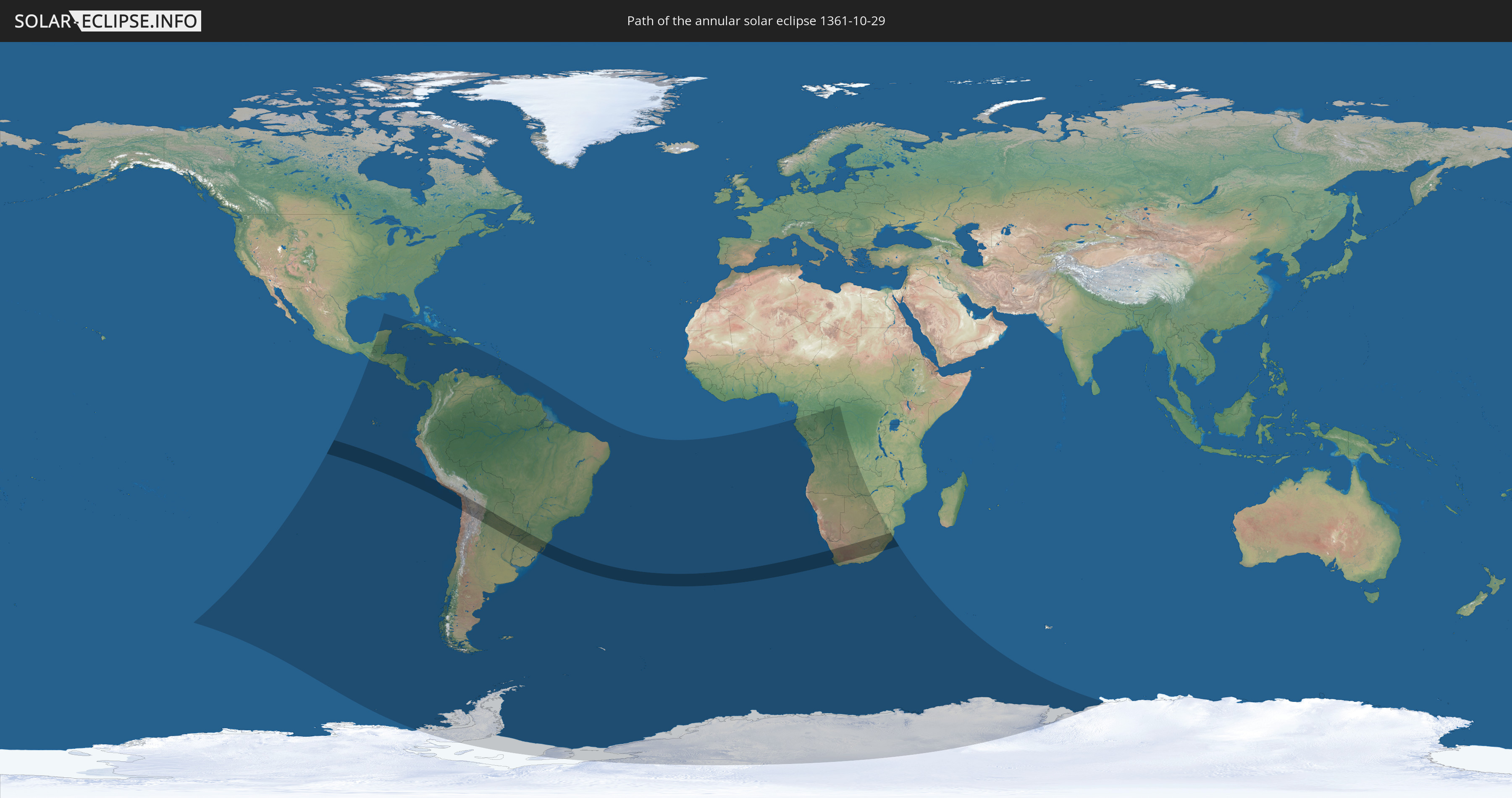
Die Sonnenfinsternis am 10/29/1361 kann man in 53 Ländern als partielle Sonnenfinsternis beobachten.
Der Finsternispfad verläuft durch 10 Länder. Nur in diesen Ländern ist sie als annular Sonnenfinsternis zu sehen.
In den folgenden Ländern ist die Sonnenfinsternis annular zu sehen
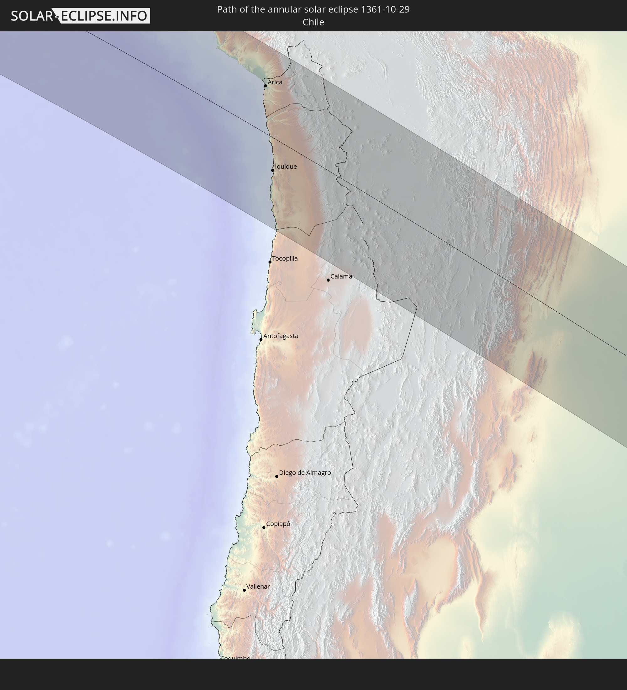 Chile
Chile
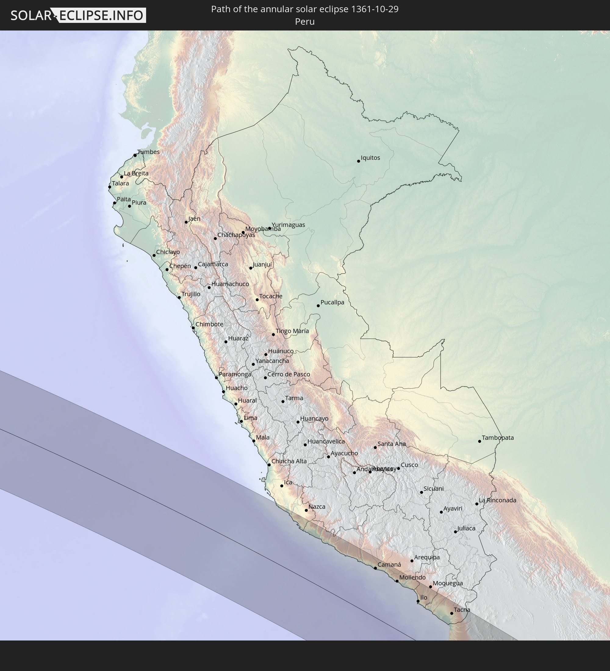 Peru
Peru
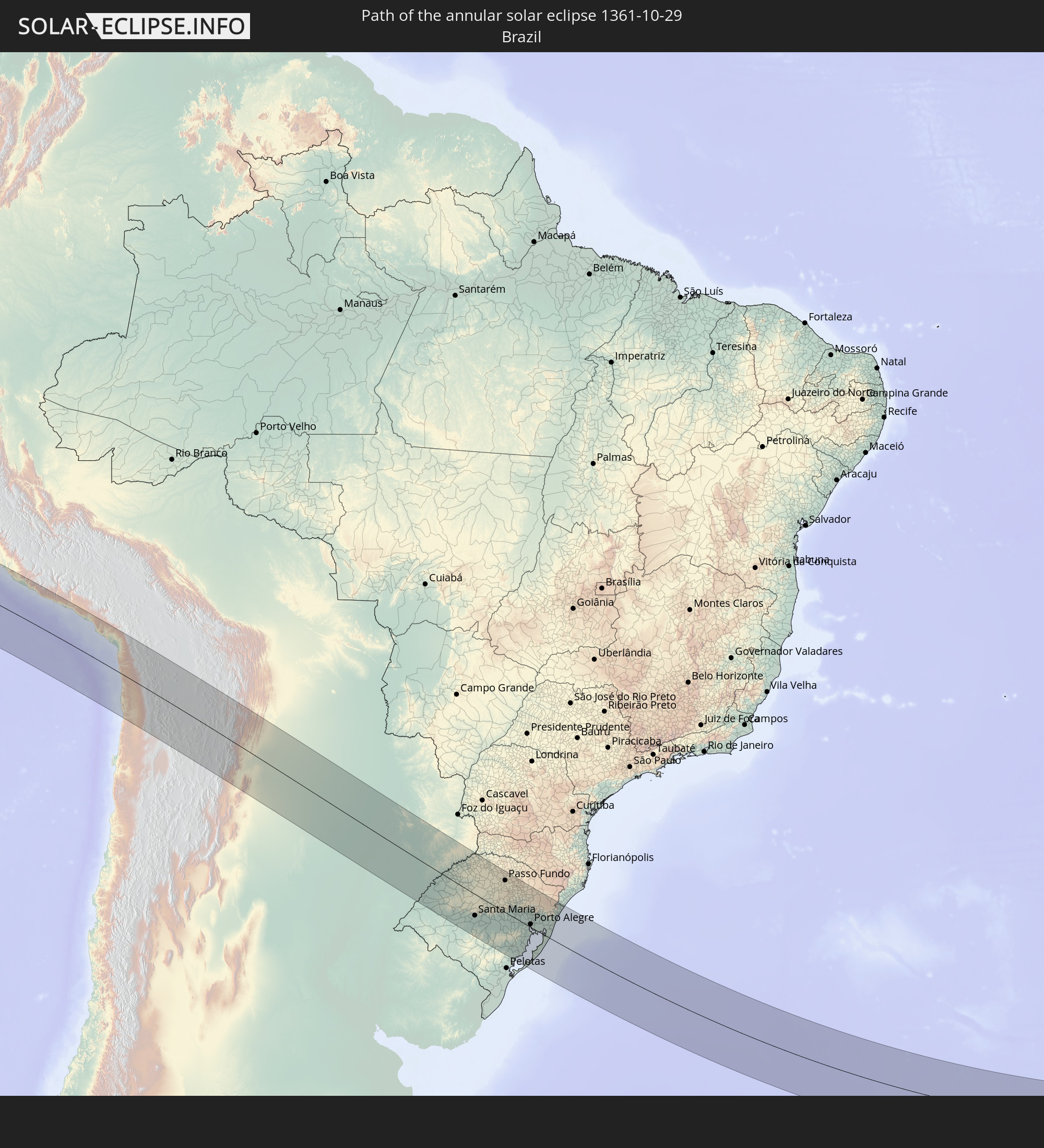 Brazil
 Argentina
 Bolivia
 Paraguay
 Saint Helena, Ascension and Tristan da Cunha
 South Africa
 Lesotho
 Swaziland
In den folgenden Ländern ist die Sonnenfinsternis partiell zu sehen
 Antarctica
 United States Minor Outlying Islands
 Mexico
 Chile
Chile
 Guatemala
 Ecuador
 El Salvador
 Honduras
 Belize
 Nicaragua
 Costa Rica
 Cuba
Cuba
 Panama
 Colombia
 Cayman Islands
 Peru
Peru
 Jamaica
 Haiti
Haiti
 Brazil
 Argentina
 Venezuela
 Dominican Republic
 Aruba
Aruba
 Bolivia
 Paraguay
 Trinidad and Tobago
 Grenada
 Saint Vincent and the Grenadines
 Falkland Islands
 Guyana
 Martinique
 Saint Lucia
 Barbados
 Uruguay
 Suriname
 French Guiana
 South Georgia and the South Sandwich Islands
 Saint Helena, Ascension and Tristan da Cunha
 Bouvet Island
 Equatorial Guinea
 Cameroon
 Gabon
Gabon
 Republic of the Congo
 Angola
 Namibia
 Democratic Republic of the Congo
 Central African Republic
 South Africa
 Botswana
 Zambia
 Zimbabwe
 Lesotho
 Swaziland
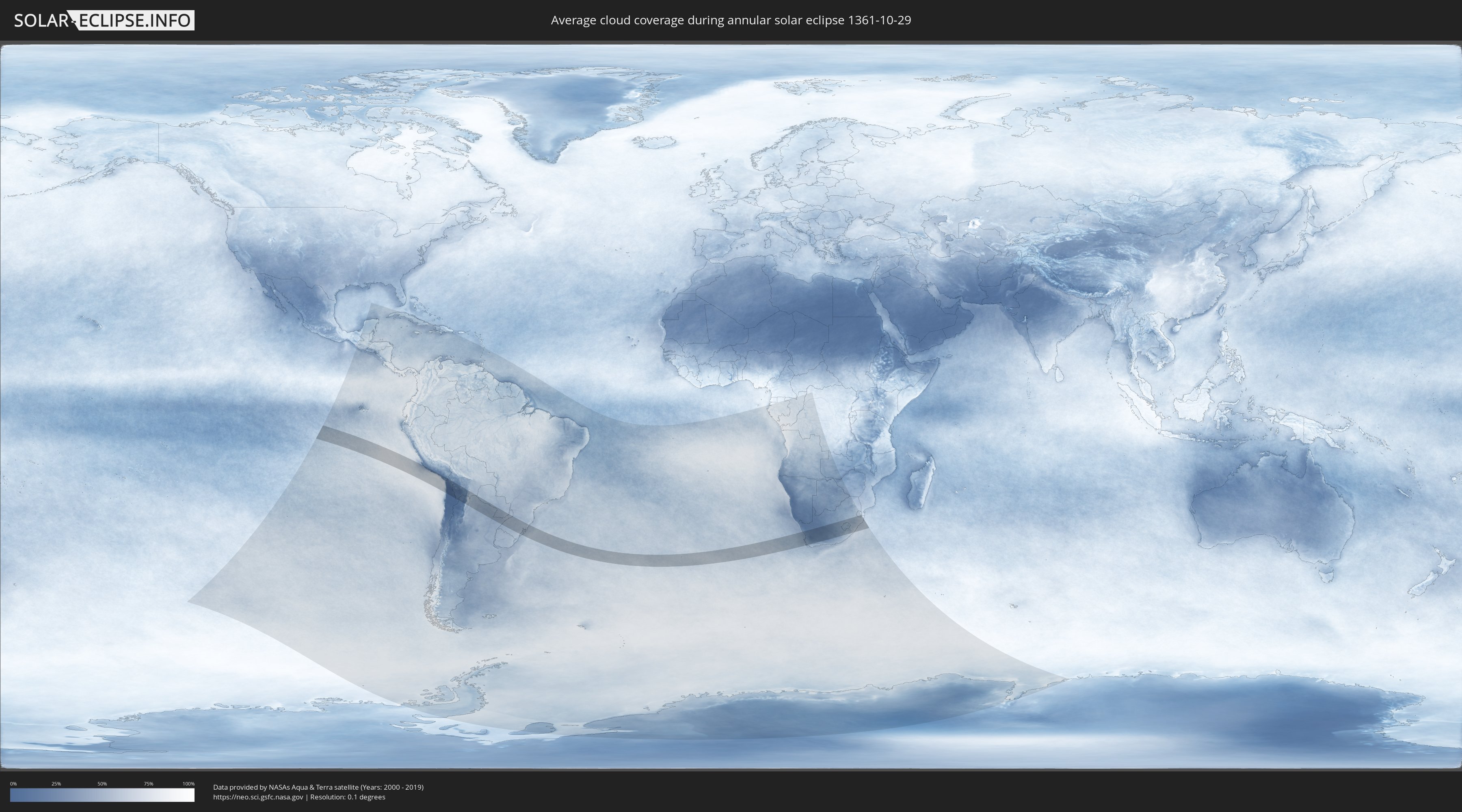
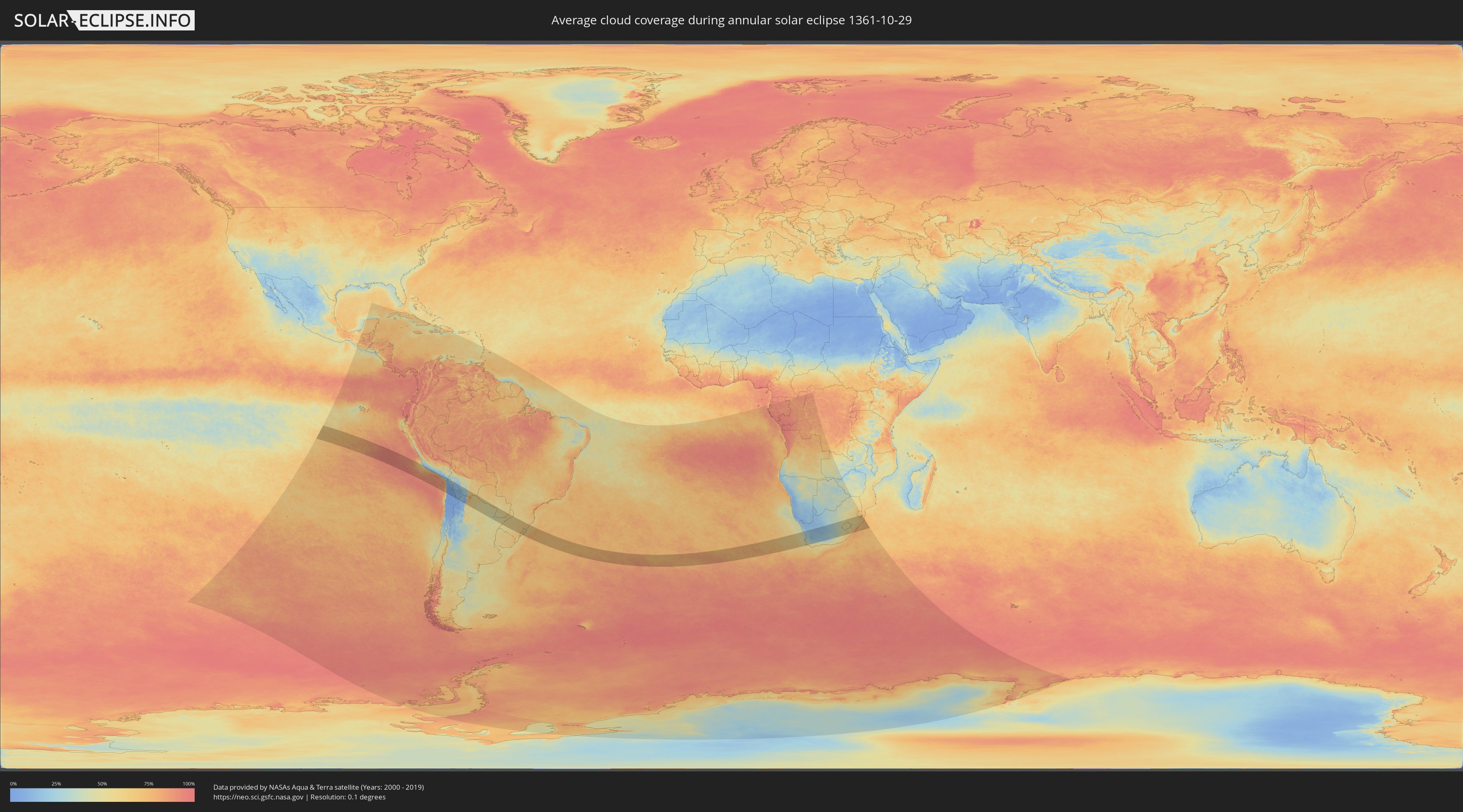
How will be the weather during the annular solar eclipse on 10/29/1361?
Where is the best place to see the annular solar eclipse of 10/29/1361?
The following maps show the average cloud coverage for the day of the annular solar eclipse.
With the help of these maps, it is possible to find the place along the eclipse path, which has the best
chance of a cloudless sky.
Nevertheless, you should consider local circumstances and inform about the weather of your chosen
observation site.
The data is provided by NASAs satellites
AQUA and TERRA.
The cloud maps are averaged over a period of 19 years (2000 - 2019).
Detailed country maps
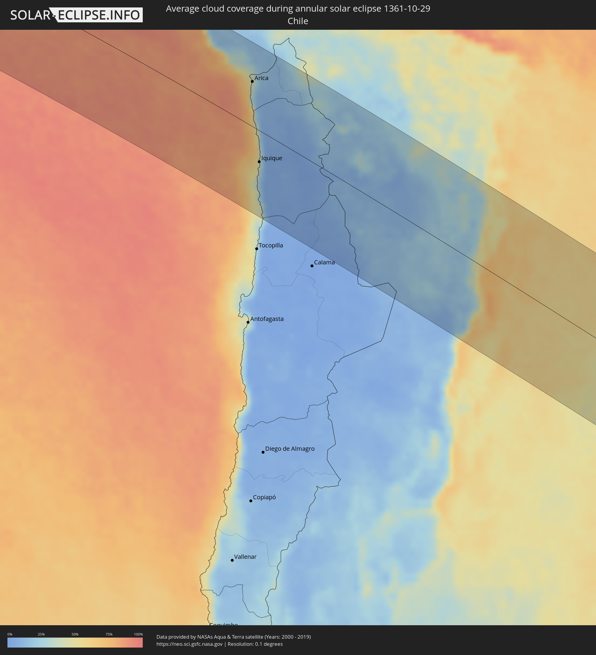 Chile
Chile
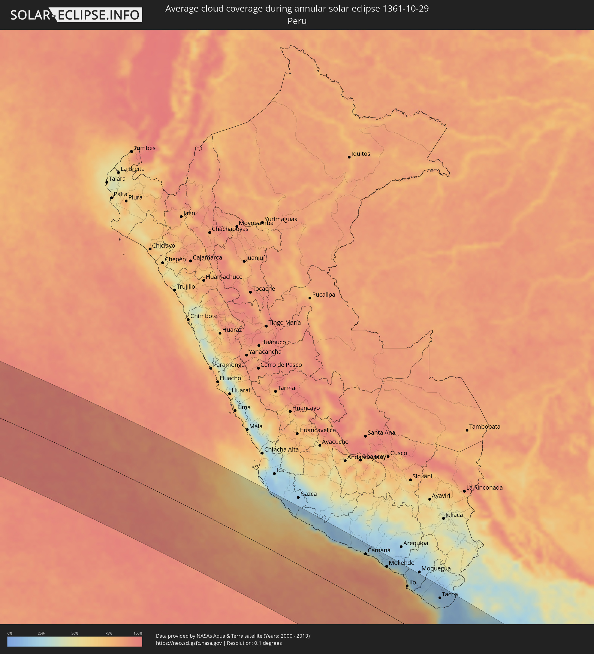 Peru
Peru
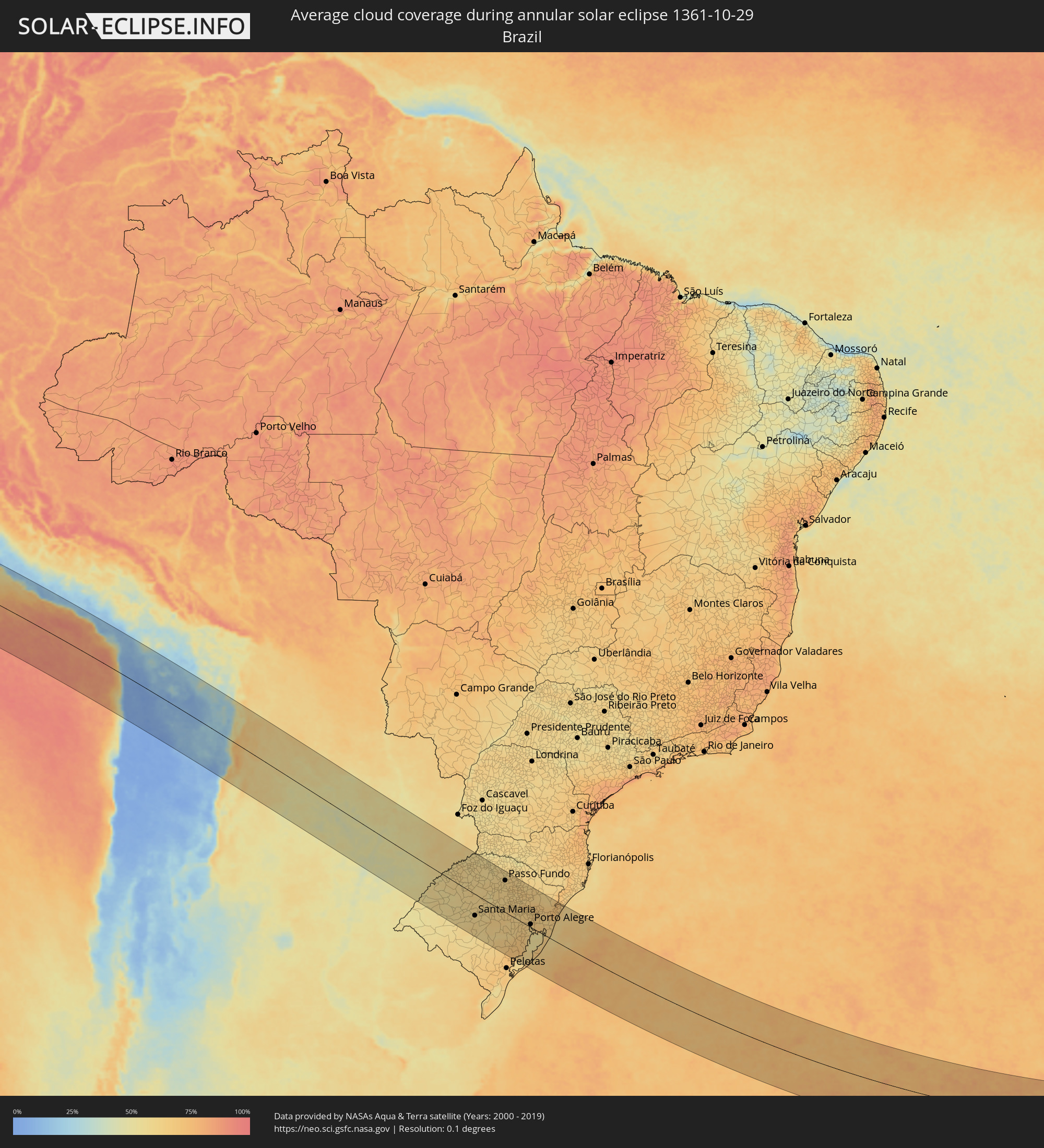 Brazil
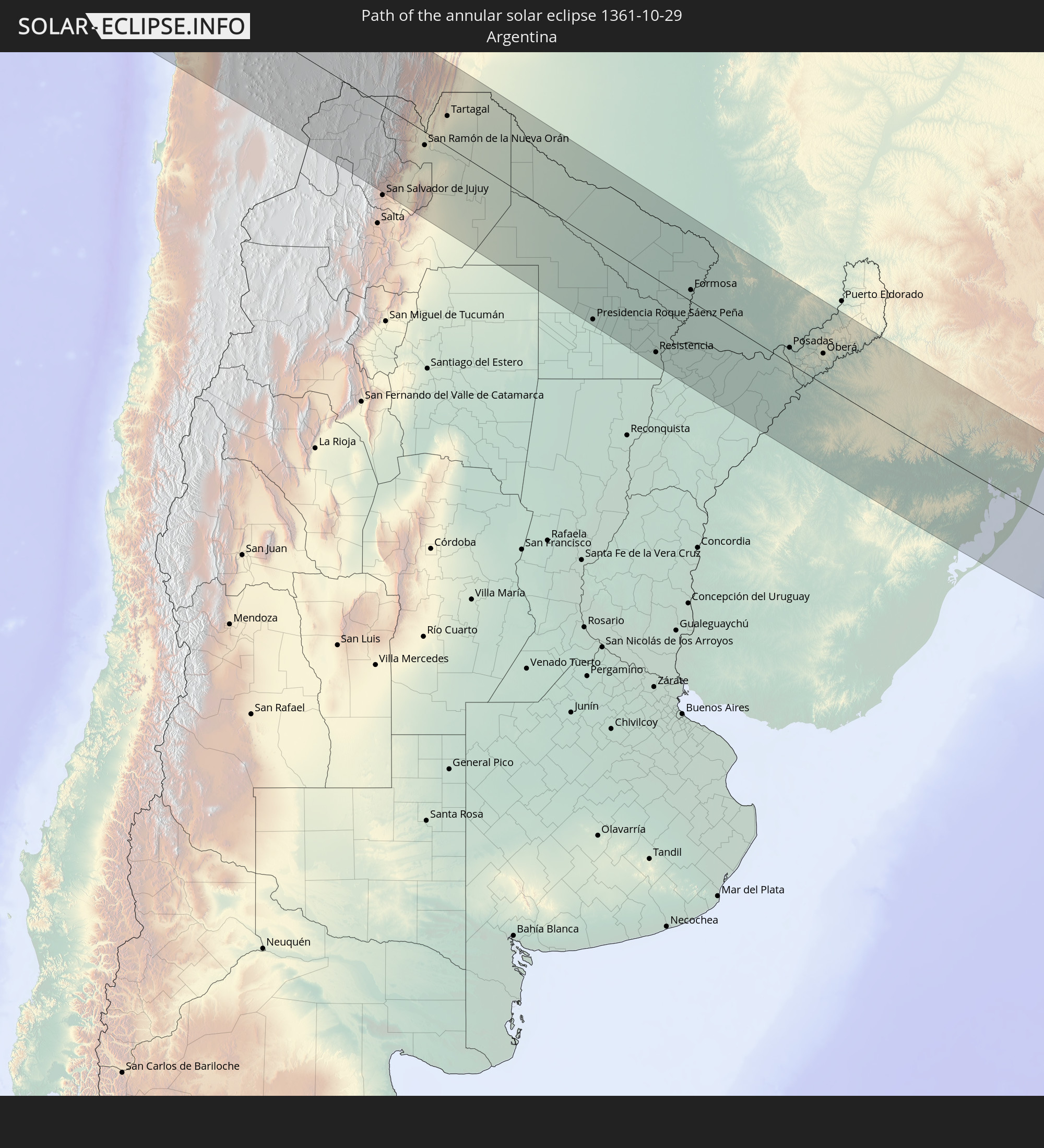
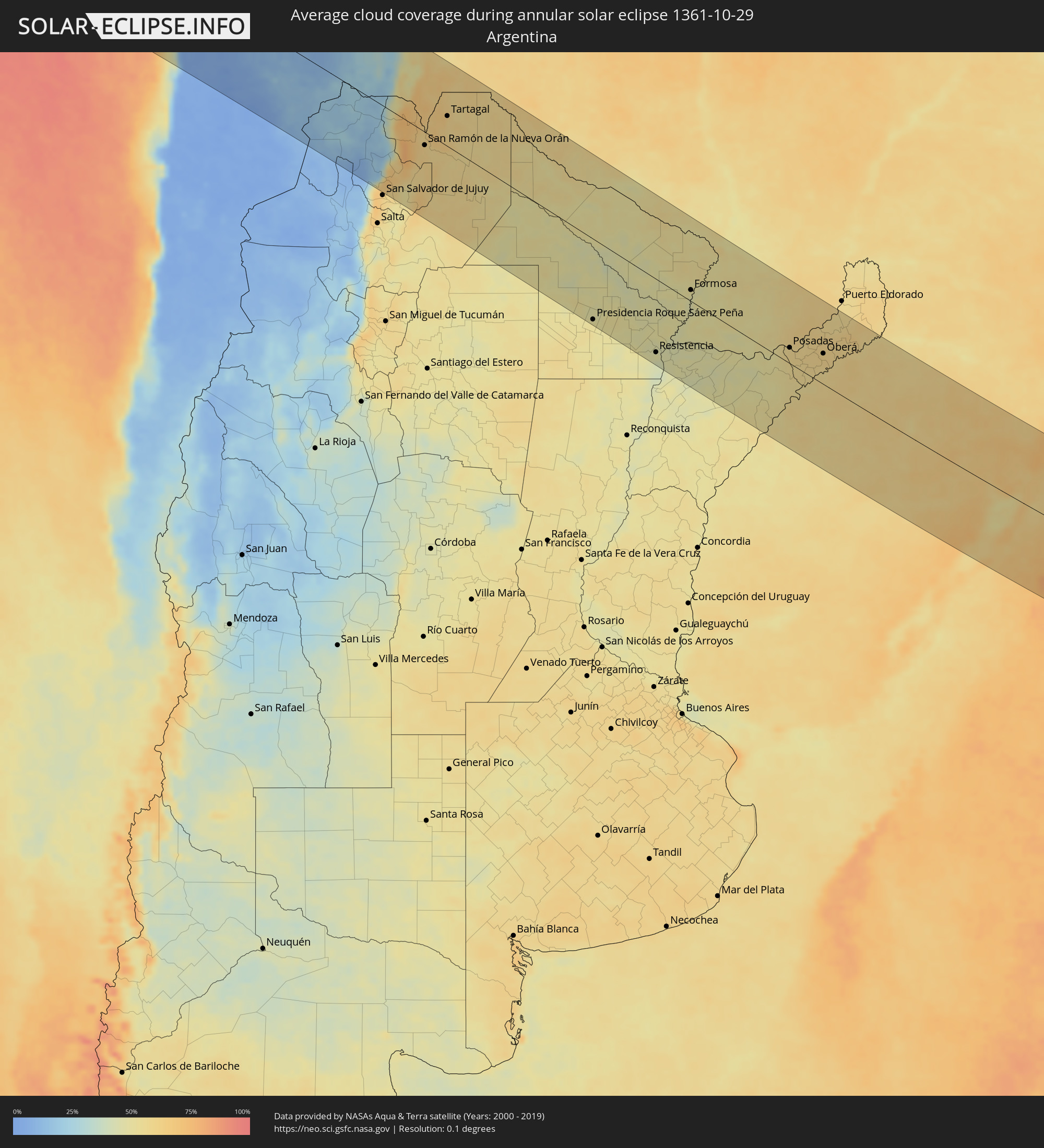 Argentina
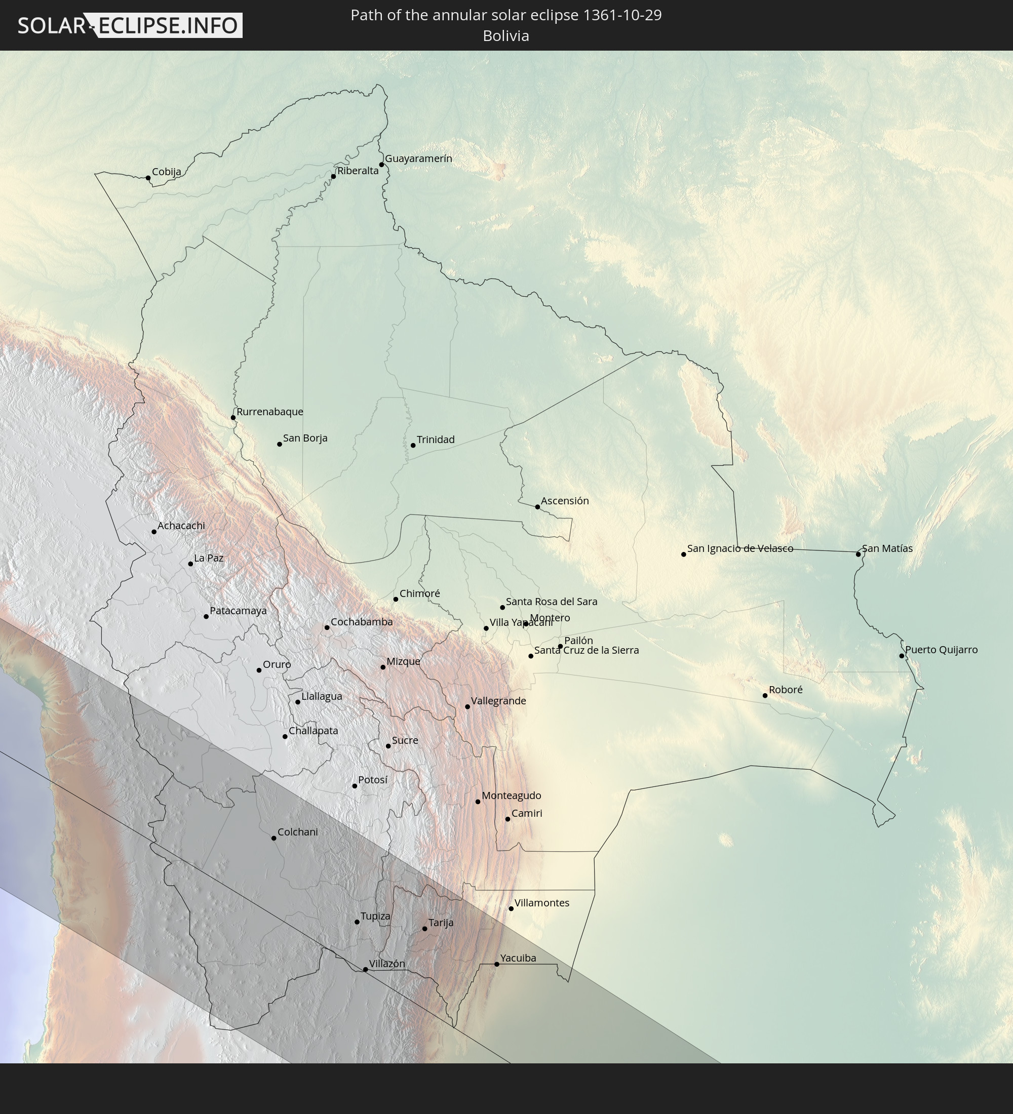
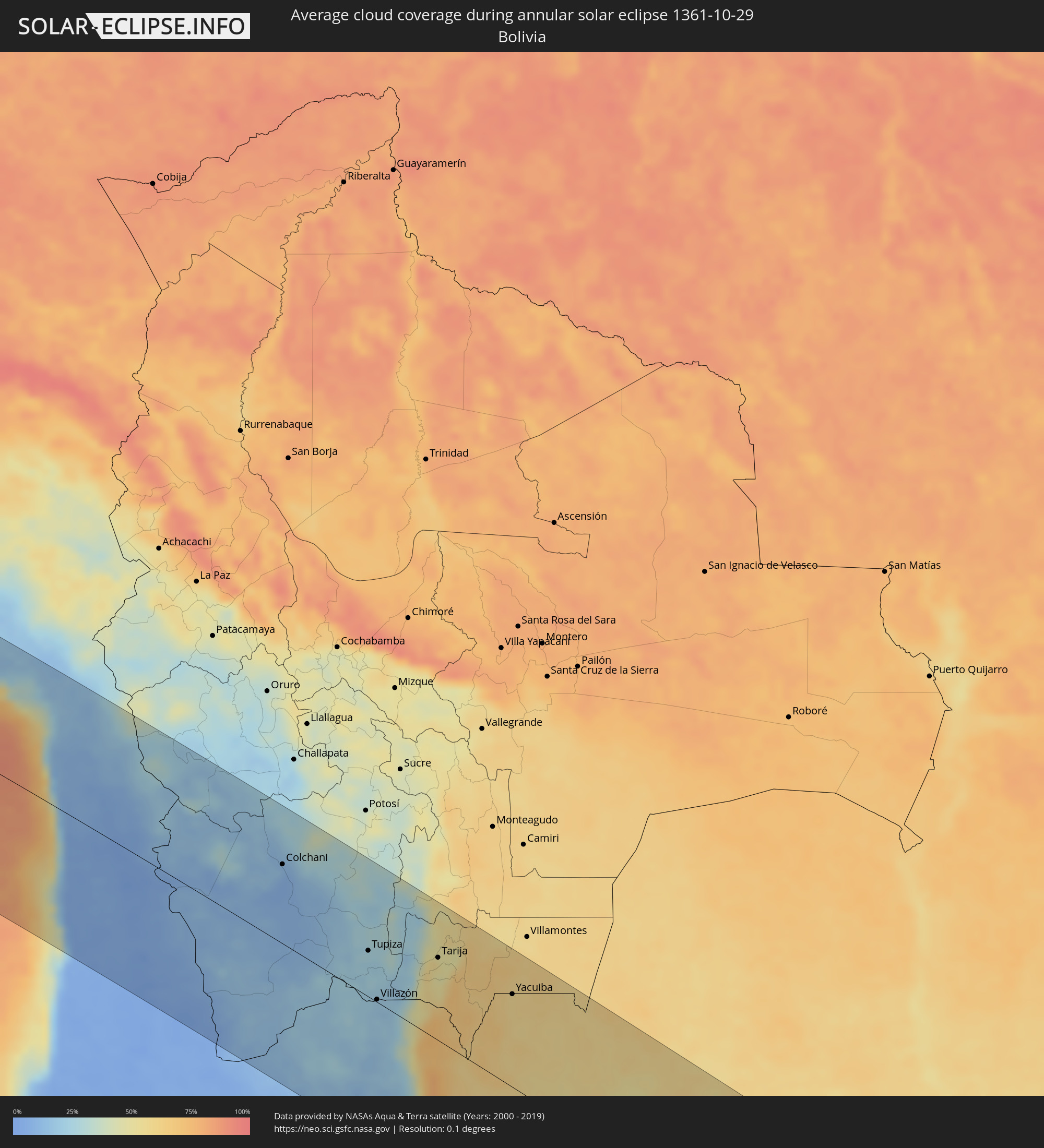 Bolivia
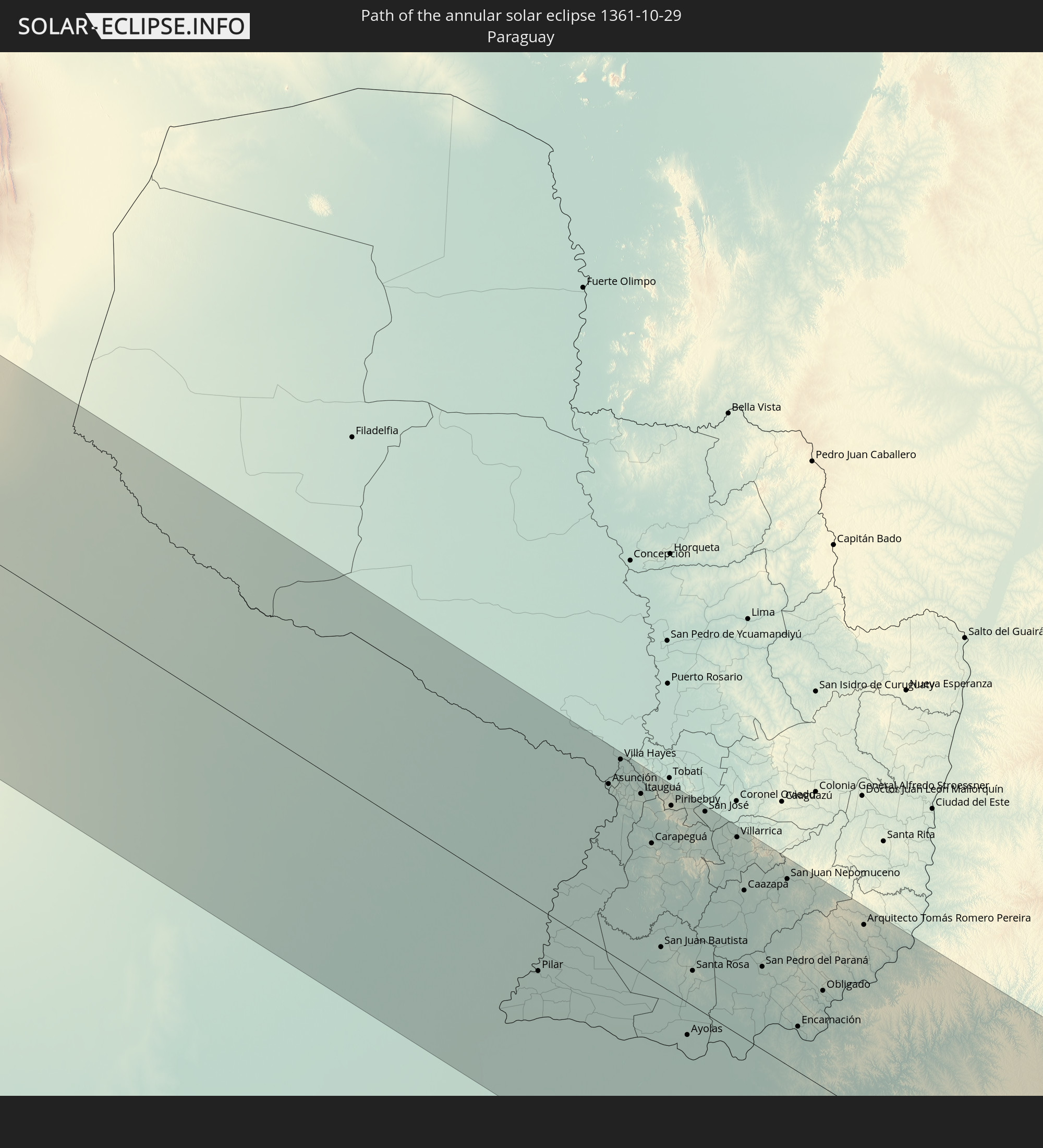
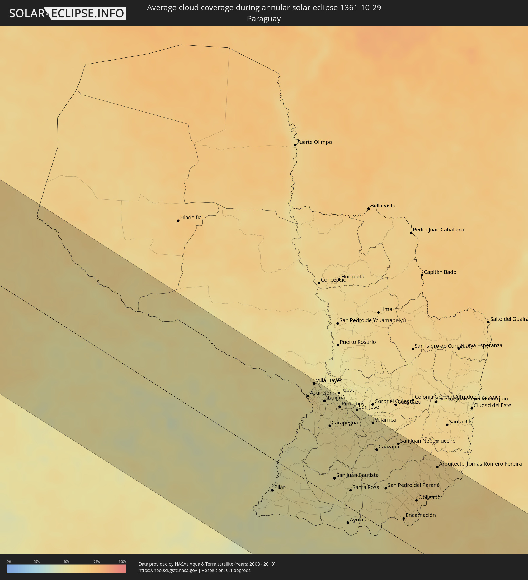 Paraguay
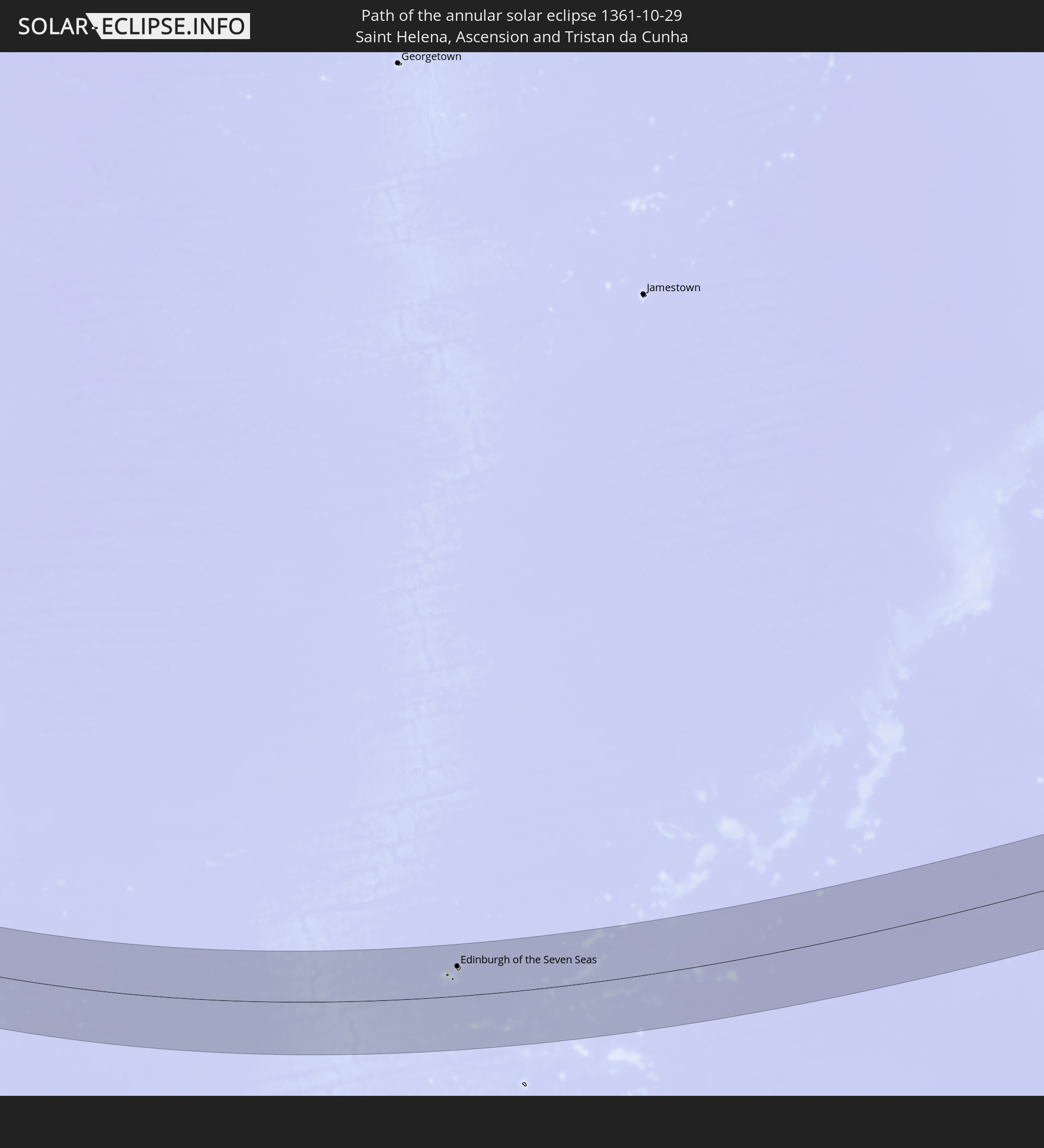
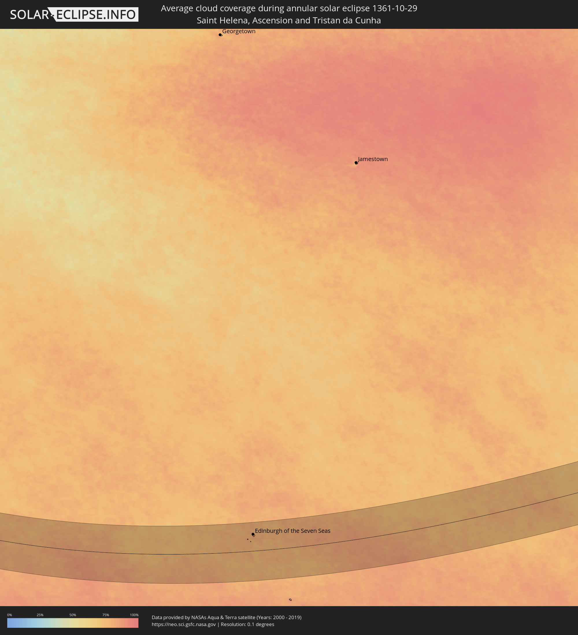 Saint Helena, Ascension and Tristan da Cunha
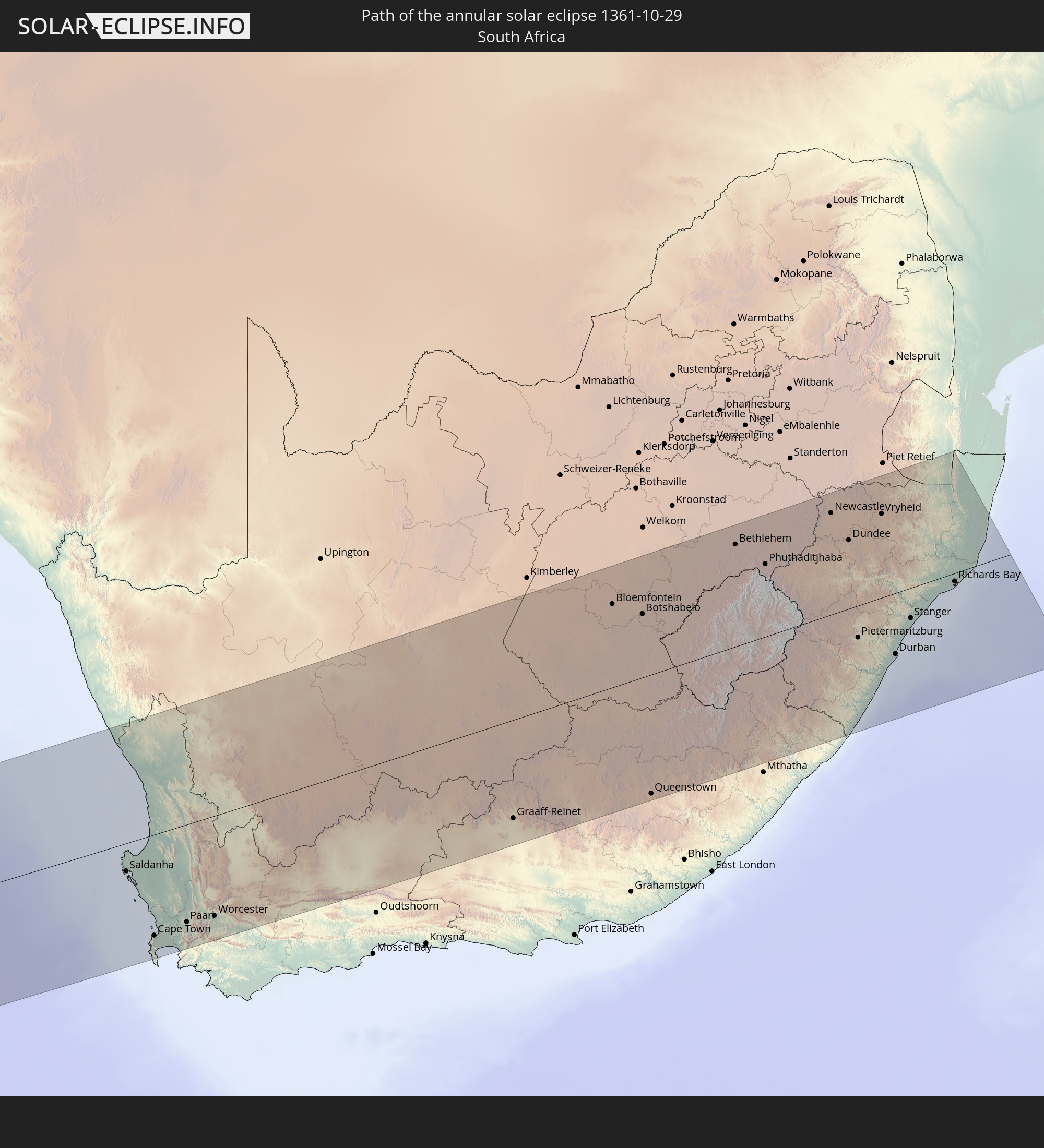
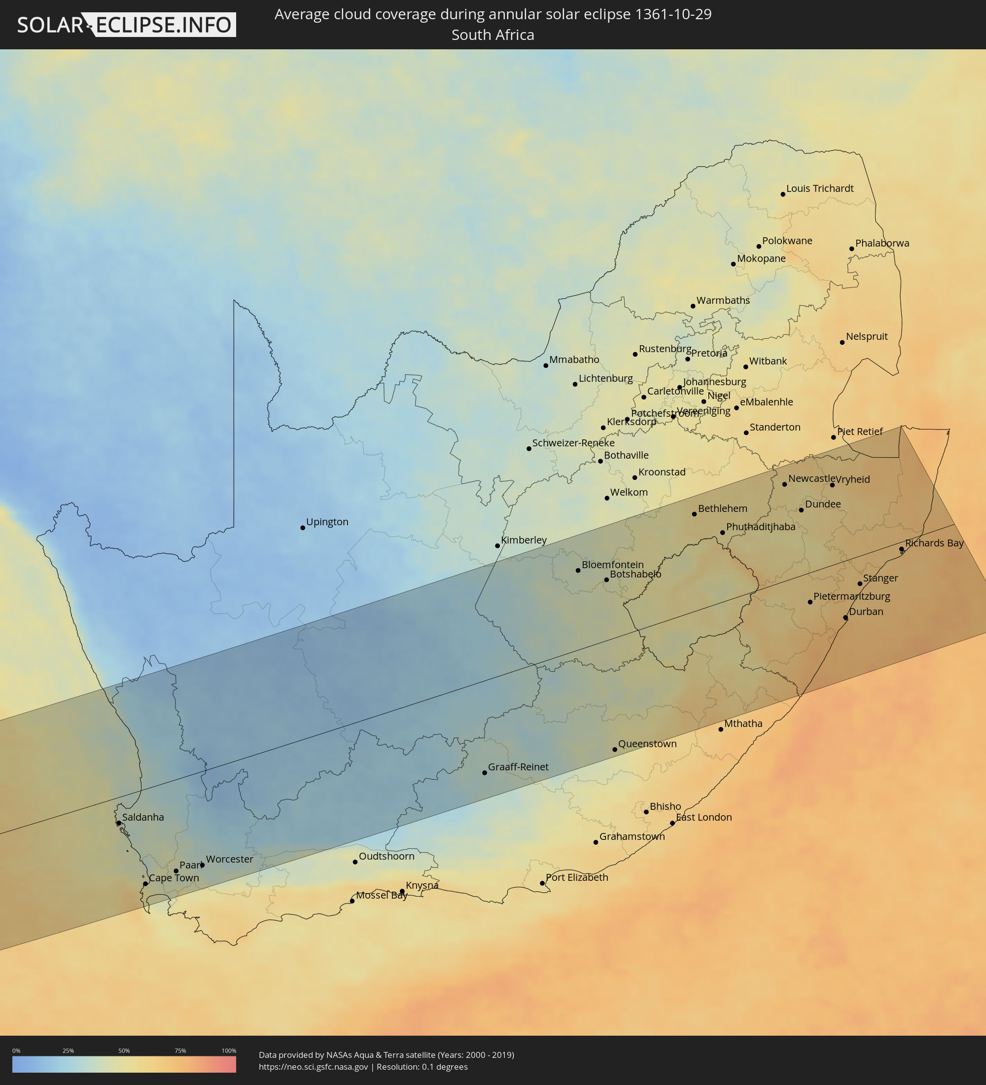 South Africa
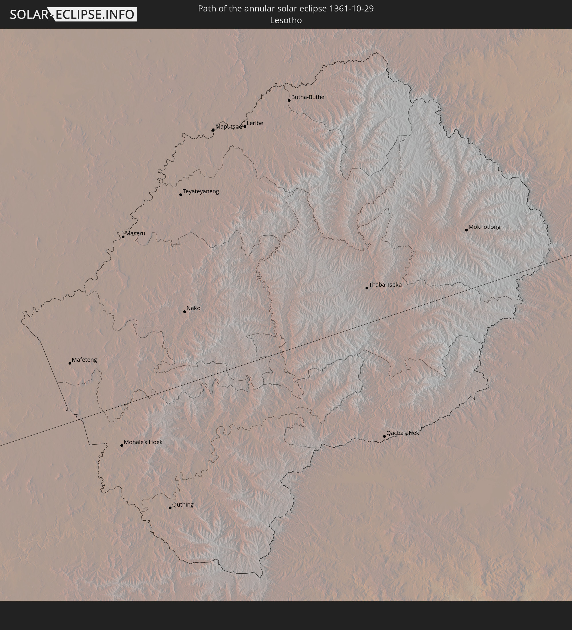
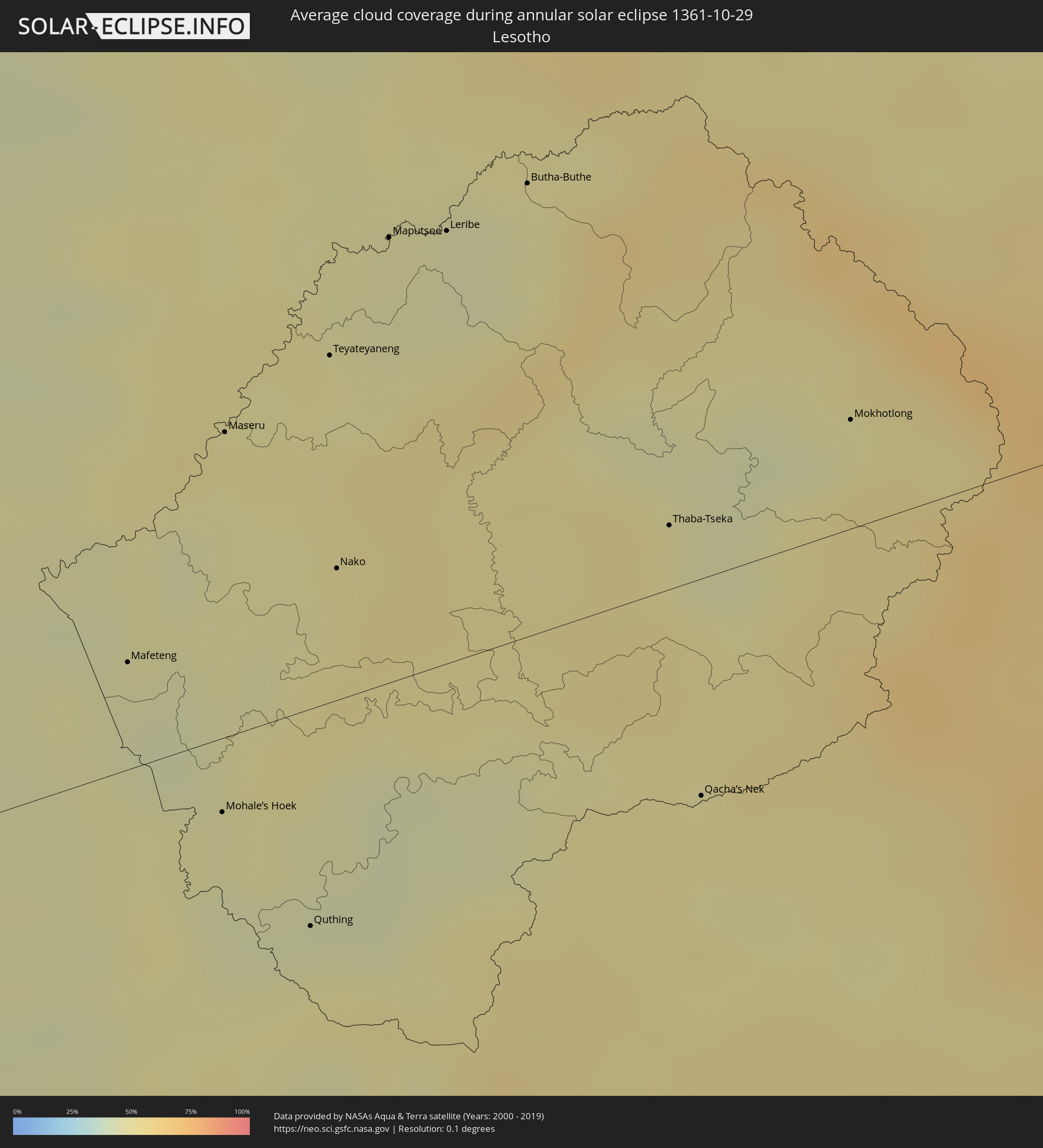 Lesotho
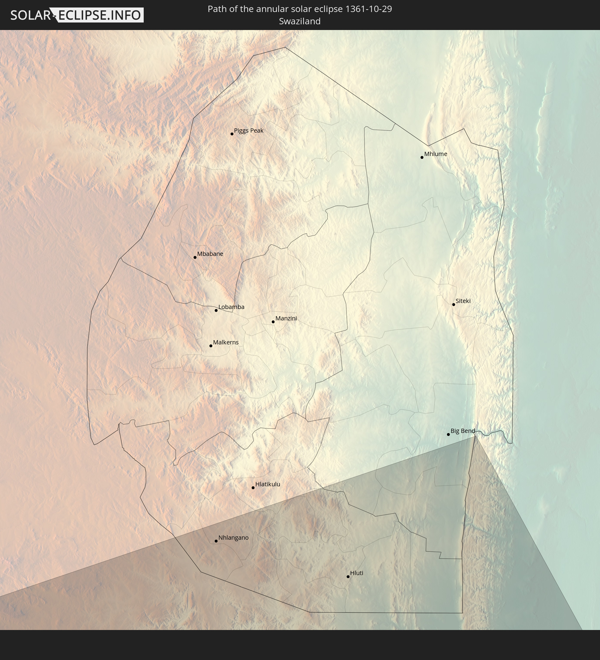
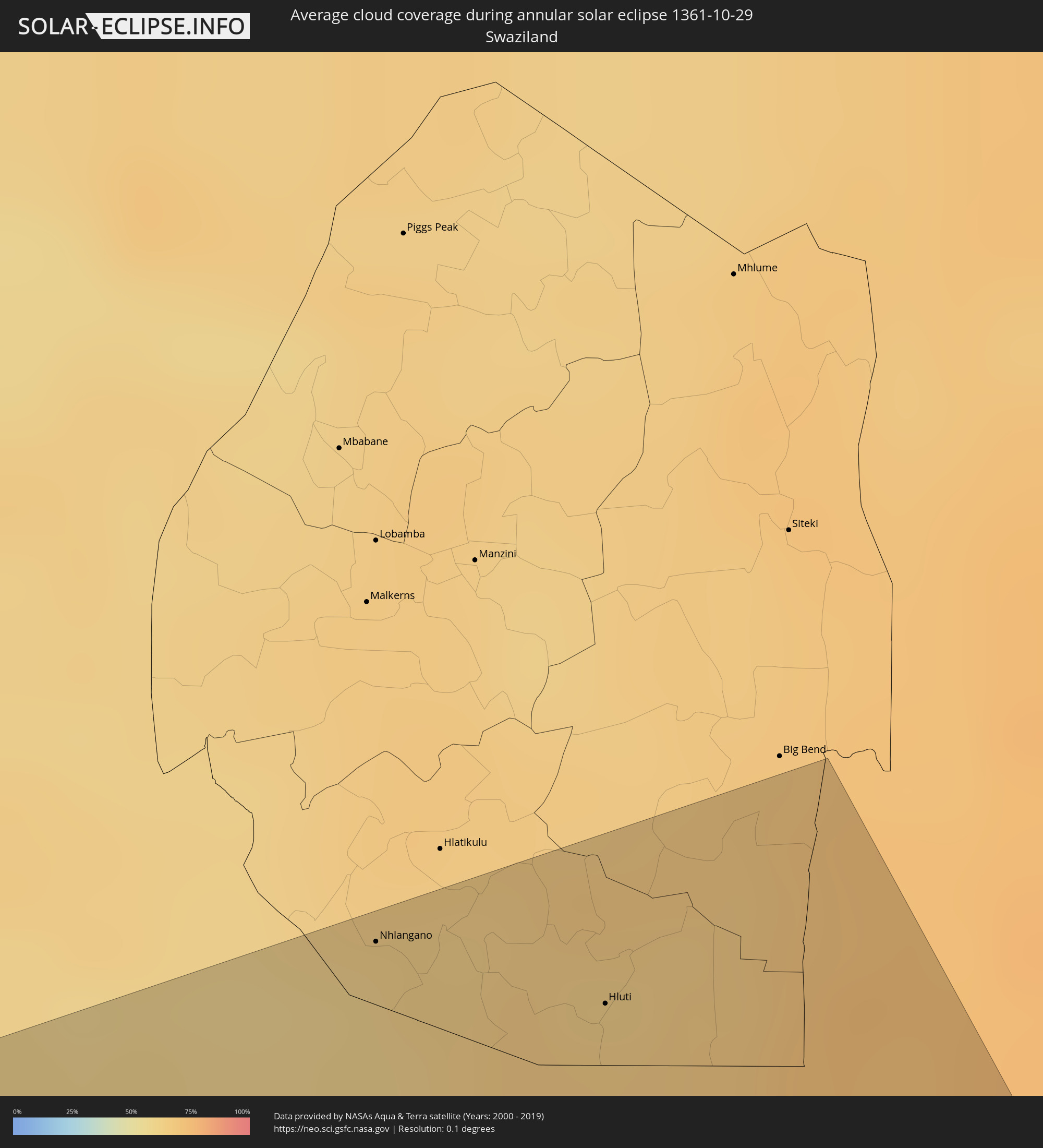 Swaziland
Cities inside the path of the eclipse
The following table shows all locations with a population of more than 5,000 inside the eclipse path. Cities which have more than 100,000 inhabitants are marked bold. A click at the locations opens a detailed map.
| City | Type | Eclipse duration | Local time of max. eclipse | Distance to central line | Ø Cloud coverage |
|
Minas de Marcona, Ica
|
annular | - | 07:30:19 UTC-05:08 | 162 km | 25% |
|
Camaná, Arequipa
|
annular | - | 07:34:43 UTC-05:08 | 147 km | 73% |
|
Mollendo, Arequipa
|
annular | - | 07:36:04 UTC-05:08 | 144 km | 76% |
|
Punta de Bombón, Arequipa
|
annular | - | 07:36:32 UTC-05:08 | 141 km | 79% |
|
Cocachacra, Arequipa
|
annular | - | 07:36:26 UTC-05:08 | 151 km | 72% |
|
Ilo, Moquegua
|
annular | - | 07:37:48 UTC-05:08 | 120 km | 55% |
|
Pacocha, Moquegua
|
annular | - | 07:37:42 UTC-05:08 | 125 km | 55% |
|
Arica, Arica y Parinacota
|
annular | - | 08:06:12 UTC-04:42 | 94 km | 35% |
|
Tacna, Tacna
|
annular | - | 07:39:38 UTC-05:08 | 141 km | 26% |
|
Iquique, Tarapacá
|
annular | - | 08:09:26 UTC-04:42 | 65 km | 29% |
|
Colchani, Potosí
|
annular | - | 08:23:49 UTC-04:32 | 100 km | 10% |
|
Uyuni, Potosí
|
annular | - | 08:24:15 UTC-04:32 | 90 km | 9% |
|
Tupiza, Potosí
|
annular | - | 08:27:38 UTC-04:32 | 57 km | 25% |
|
Villazón, Potosí
|
annular | - | 08:29:02 UTC-04:32 | 3 km | 19% |
|
San Pedro, Jujuy Province
|
annular | - | 08:50:01 UTC-04:16 | 159 km | 54% |
|
Libertador General San Martín, Jujuy Province
|
annular | - | 08:49:19 UTC-04:16 | 115 km | 57% |
|
Tarija, Tarija
|
annular | - | 08:29:17 UTC-04:32 | 103 km | 50% |
|
San Ramón de la Nueva Orán, Salta Province
|
annular | - | 08:48:45 UTC-04:16 | 26 km | 60% |
|
Embarcación, Salta Province
|
annular | - | 08:49:15 UTC-04:16 | 21 km | 58% |
|
Tartagal, Salta Province
|
annular | - | 08:48:23 UTC-04:16 | 61 km | 59% |
|
Yacuiba, Tarija
|
annular | - | 08:31:50 UTC-04:32 | 115 km | 58% |
|
Castelli, Chaco Province
|
annular | - | 09:00:31 UTC-04:16 | 88 km | 49% |
|
Presidencia Roque Sáenz Peña, Chaco Province
|
annular | - | 09:02:31 UTC-04:16 | 157 km | 51% |
|
Tres Isletas, Chaco Province
|
annular | - | 09:01:39 UTC-04:16 | 115 km | 48% |
|
Quitilipi, Chaco Province
|
annular | - | 09:03:05 UTC-04:16 | 153 km | 50% |
|
Machagai, Chaco Province
|
annular | - | 09:03:31 UTC-04:16 | 149 km | 50% |
|
General José de San Martín, Chaco Province
|
annular | - | 09:04:04 UTC-04:16 | 74 km | 49% |
|
Resistencia, Chaco Province
|
annular | - | 09:06:36 UTC-04:16 | 142 km | 44% |
|
Pilar, Ñeembucú
|
annular | - | 09:32:54 UTC-03:50 | 49 km | 49% |
|
Formosa, Formosa Province
|
annular | - | 09:05:37 UTC-04:16 | 22 km | 47% |
|
Asunción, Asunción
|
annular | - | 09:31:06 UTC-03:50 | 133 km | 56% |
|
Limpio, Central
|
annular | - | 09:31:08 UTC-03:50 | 154 km | 57% |
|
Guarambaré, Central
|
annular | - | 09:31:48 UTC-03:50 | 125 km | 52% |
|
Capiatá, Central
|
annular | - | 09:31:35 UTC-03:50 | 138 km | 54% |
|
Areguá, Central
|
annular | - | 09:31:38 UTC-03:50 | 146 km | 54% |
|
Itá, Central
|
annular | - | 09:32:02 UTC-03:50 | 129 km | 53% |
|
Yaguarón, Paraguarí
|
annular | - | 09:32:22 UTC-03:50 | 123 km | 51% |
|
Ypacarai, Central
|
annular | - | 09:32:01 UTC-03:50 | 142 km | 52% |
|
Paraguarí, Paraguarí
|
annular | - | 09:32:44 UTC-03:50 | 129 km | 52% |
|
San Juan Bautista, Misiones
|
annular | - | 09:34:49 UTC-03:50 | 30 km | 52% |
|
Caacupé, Cordillera
|
annular | - | 09:32:16 UTC-03:50 | 152 km | 54% |
|
Piribebuy, Cordillera
|
annular | - | 09:32:39 UTC-03:50 | 147 km | 53% |
|
Eusebio Ayala, Cordillera
|
annular | - | 09:32:40 UTC-03:50 | 160 km | 53% |
|
Ayolas, Misiones
|
annular | - | 09:36:46 UTC-03:50 | 25 km | 48% |
|
Santa Rosa, Misiones
|
annular | - | 09:35:49 UTC-03:50 | 27 km | 51% |
|
Villarrica, Guairá
|
annular | - | 09:34:28 UTC-03:50 | 155 km | 53% |
|
Caazapá, Caazapá
|
annular | - | 09:35:29 UTC-03:50 | 116 km | 52% |
|
Santo Tomé, Corrientes Province
|
annular | - | 09:14:42 UTC-04:16 | 89 km | 56% |
|
Gobernador Ingeniero Valentín Virasoro, Corrientes Province
|
annular | - | 09:13:44 UTC-04:16 | 41 km | 53% |
|
São Borja, Rio Grande do Sul
|
annular | - | 10:25:20 UTC-03:06 | 97 km | 56% |
|
San Juan Nepomuceno, Caazapá
|
annular | - | 09:36:09 UTC-03:50 | 146 km | 56% |
|
Posadas, Misiones Province
|
annular | - | 09:12:41 UTC-04:16 | 30 km | 58% |
|
Encarnación, Itapúa
|
annular | - | 09:38:48 UTC-03:50 | 35 km | 57% |
|
Jardín América, Misiones Province
|
annular | - | 09:13:29 UTC-04:16 | 96 km | 60% |
|
Oberá, Misiones Province
|
annular | - | 09:14:36 UTC-04:16 | 59 km | 60% |
|
Aristóbulo del Valle, Misiones Province
|
annular | - | 09:14:19 UTC-04:16 | 108 km | 60% |
|
Santa Rosa, Rio Grande do Sul
|
annular | - | 10:27:05 UTC-03:06 | 56 km | 62% |
|
Santo Ângelo, Rio Grande do Sul
|
annular | - | 10:28:25 UTC-03:06 | 26 km | 57% |
|
El Soberbio, Misiones Province
|
annular | - | 09:16:16 UTC-04:16 | 125 km | 55% |
|
Ijuí, Rio Grande do Sul
|
annular | - | 10:29:22 UTC-03:06 | 36 km | 59% |
|
Santa Maria, Rio Grande do Sul
|
annular | - | 10:32:07 UTC-03:06 | 82 km | 59% |
|
Cruz Alta, Rio Grande do Sul
|
annular | - | 10:30:33 UTC-03:06 | 27 km | 58% |
|
Cachoeira do Sul, Rio Grande do Sul
|
annular | - | 10:34:53 UTC-03:06 | 71 km | 63% |
|
Carazinho, Rio Grande do Sul
|
annular | - | 10:31:46 UTC-03:06 | 103 km | 60% |
|
Santa Cruz do Sul, Rio Grande do Sul
|
annular | - | 10:35:21 UTC-03:06 | 17 km | 64% |
|
Passo Fundo, Rio Grande do Sul
|
annular | - | 10:32:37 UTC-03:06 | 124 km | 61% |
|
Lajeado, Rio Grande do Sul
|
annular | - | 10:35:58 UTC-03:06 | 30 km | 62% |
|
Bento Gonçalves, Rio Grande do Sul
|
annular | - | 10:36:28 UTC-03:06 | 80 km | 67% |
|
Montenegro, Rio Grande do Sul
|
annular | - | 10:37:35 UTC-03:06 | 33 km | 65% |
|
Farroupilha, Rio Grande do Sul
|
annular | - | 10:36:59 UTC-03:06 | 83 km | 66% |
|
Porto Alegre, Rio Grande do Sul
|
annular | - | 10:38:47 UTC-03:06 | 11 km | 65% |
|
Caxias do Sul, Rio Grande do Sul
|
annular | - | 10:37:17 UTC-03:06 | 97 km | 67% |
|
Sapucaia, Rio Grande do Sul
|
annular | - | 10:38:36 UTC-03:06 | 34 km | 65% |
|
Novo Hamburgo, Rio Grande do Sul
|
annular | - | 10:38:21 UTC-03:06 | 50 km | 66% |
|
Viamão, Rio Grande do Sul
|
annular | - | 10:39:22 UTC-03:06 | 17 km | 66% |
|
Gravataí, Rio Grande do Sul
|
annular | - | 10:39:11 UTC-03:06 | 31 km | 66% |
|
Edinburgh of the Seven Seas, Tristan da Cunha
|
annular | - | 15:14:24 UTC-00:16 | 93 km | 83% |
|
Saldanha, Western Cape
|
annular | - | 17:34:24 UTC+01:30 | 42 km | 43% |
|
Cape Town, Western Cape
|
annular | - | 17:33:34 UTC+01:30 | 153 km | 47% |
|
Atlantis, Western Cape
|
annular | - | 17:33:58 UTC+01:30 | 116 km | 41% |
|
Stellenbosch, Western Cape
|
annular | - | 17:33:40 UTC+01:30 | 166 km | 43% |
|
Paarl, Western Cape
|
annular | - | 17:33:54 UTC+01:30 | 148 km | 39% |
|
Worcester, Western Cape
|
annular | - | 17:34:06 UTC+01:30 | 152 km | 35% |
|
Graaff-Reinet, Eastern Cape
|
annular | - | 17:36:11 UTC+01:30 | 151 km | 31% |
|
Bloemfontein, Orange Free State
|
annular | - | 17:39:06 UTC+01:30 | 130 km | 41% |
|
Botshabelo, Orange Free State
|
annular | - | 17:38:57 UTC+01:30 | 99 km | 43% |
|
Queenstown, Eastern Cape
|
annular | - | 17:36:31 UTC+01:30 | 183 km | 46% |
|
Mafeteng, Mafeteng
|
annular | - | 17:38:26 UTC+01:30 | 25 km | 47% |
|
Mohale’s Hoek, Mohaleʼs Hoek
|
annular | - | 17:38:07 UTC+01:30 | 17 km | 45% |
|
Maseru, Maseru
|
annular | - | 17:38:52 UTC+01:30 | 71 km | 50% |
|
Quthing, Quthing
|
annular | - | 17:37:52 UTC+01:30 | 50 km | 48% |
|
Teyateyaneng, Berea
|
annular | - | 17:38:59 UTC+01:30 | 81 km | 50% |
|
Nako, Maseru
|
annular | - | 17:38:34 UTC+01:30 | 31 km | 50% |
|
Maputsoe, Leribe
|
annular | - | 17:39:12 UTC+01:30 | 104 km | 47% |
|
Leribe, Leribe
|
annular | - | 17:39:12 UTC+01:30 | 101 km | 47% |
|
Butha-Buthe, Butha-Buthe
|
annular | - | 17:39:16 UTC+01:30 | 106 km | 47% |
|
Bethlehem, Orange Free State
|
annular | - | 17:39:43 UTC+01:30 | 161 km | 57% |
|
Thaba-Tseka, Thaba-Tseka
|
annular | - | 17:38:34 UTC+01:30 | 15 km | 51% |
|
Qacha’s Nek, Qachaʼs Nek
|
annular | - | 17:38:02 UTC+01:30 | 50 km | 50% |
|
Phuthaditjhaba, Orange Free State
|
annular | - | 17:39:25 UTC+01:30 | 114 km | 51% |
|
Mokhotlong, Mokhotlong
|
annular | - | 17:38:43 UTC+01:30 | 25 km | 51% |
|
Newcastle, KwaZulu-Natal
|
annular | - | 17:39:53 UTC+01:30 | 160 km | 56% |
|
Dundee, KwaZulu-Natal
|
annular | - | 17:39:30 UTC+01:30 | 108 km | 54% |
|
Pietermaritzburg, KwaZulu-Natal
|
annular | - | 17:38:15 UTC+01:30 | 50 km | 60% |
|
Mpumalanga, KwaZulu-Natal
|
annular | - | 17:38:03 UTC+01:30 | 78 km | 68% |
|
Vryheid, KwaZulu-Natal
|
annular | - | 17:39:44 UTC+01:30 | 133 km | 58% |
|
Durban, KwaZulu-Natal
|
annular | - | 17:37:56 UTC+01:30 | 95 km | 73% |
|
Nhlangano, Shiselweni
|
annular | - | 17:40:10 UTC+01:30 | 189 km | 61% |
|
Stanger, KwaZulu-Natal
|
annular | - | 17:38:21 UTC+01:30 | 47 km | 65% |
|
Hluti, Shiselweni
|
annular | - | 17:40:00 UTC+01:30 | 165 km | 66% |
|
Richards Bay, KwaZulu-Natal
|
annular | - | 17:38:39 UTC+01:30 | 13 km | 67% |