Annular solar eclipse of 07/17/1376
| Day of week: | Wednesday |
| Maximum duration of eclipse: | 05m30s |
| Maximum width of eclipse path: | 171 km |
| Saros cycle: | 116 |
| Coverage: | 95.3% |
| Magnitude: | 0.9533 |
| Gamma: | 0.0439 |
Wo kann man die Sonnenfinsternis vom 07/17/1376 sehen?
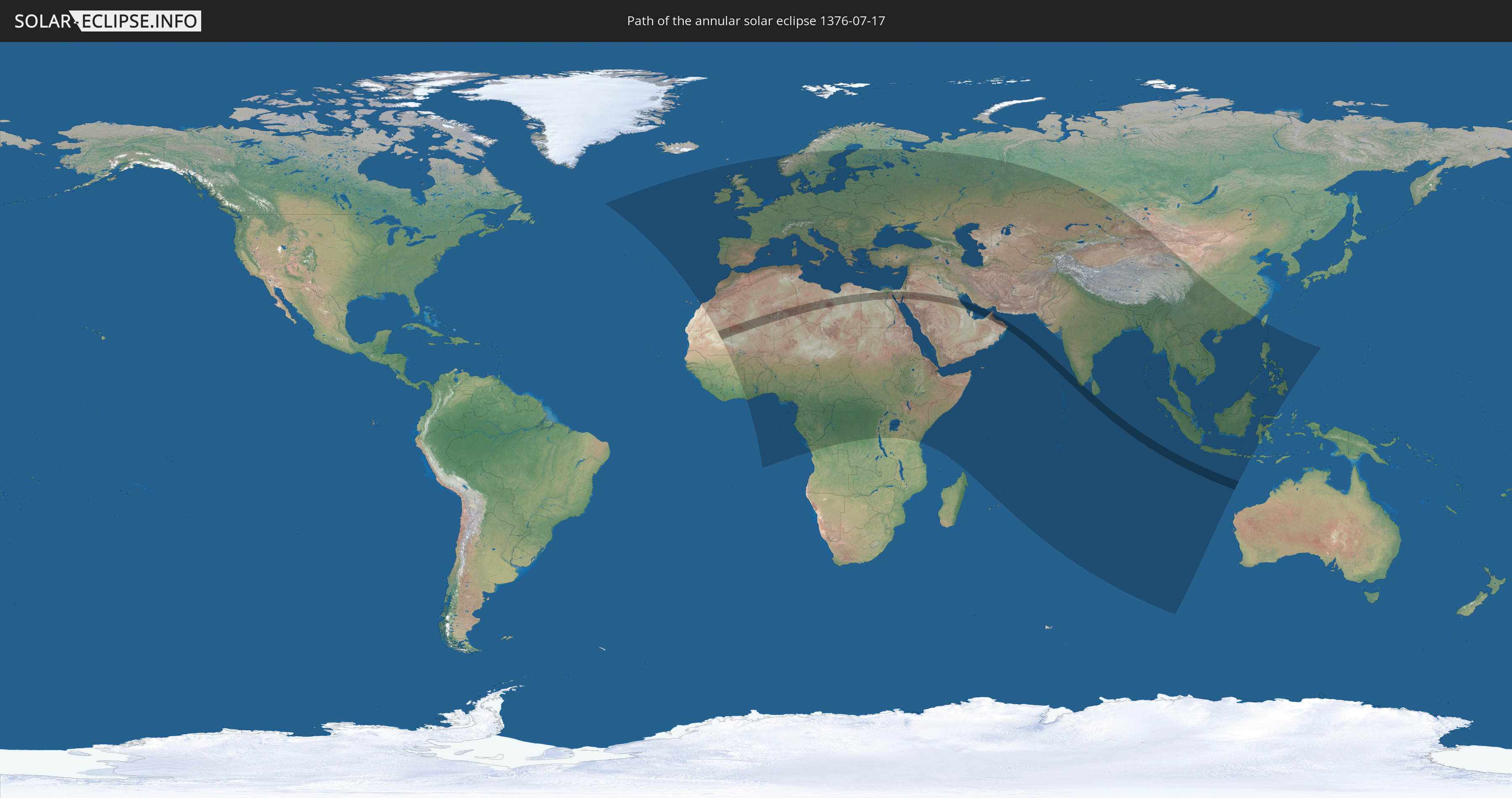
Die Sonnenfinsternis am 07/17/1376 kann man in 134 Ländern als partielle Sonnenfinsternis beobachten.
Der Finsternispfad verläuft durch 17 Länder. Nur in diesen Ländern ist sie als annular Sonnenfinsternis zu sehen.
In den folgenden Ländern ist die Sonnenfinsternis annular zu sehen
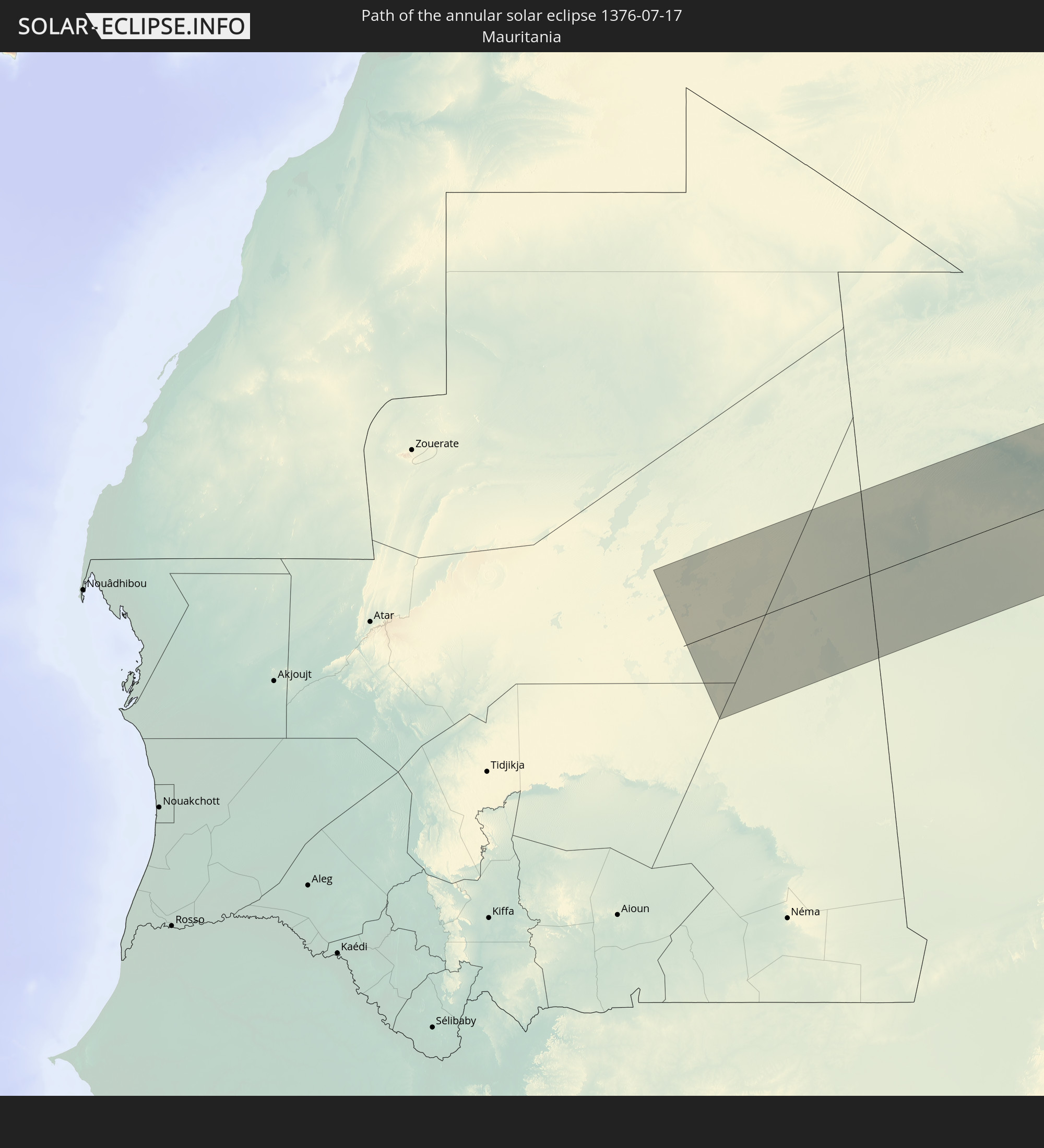 Mauritania
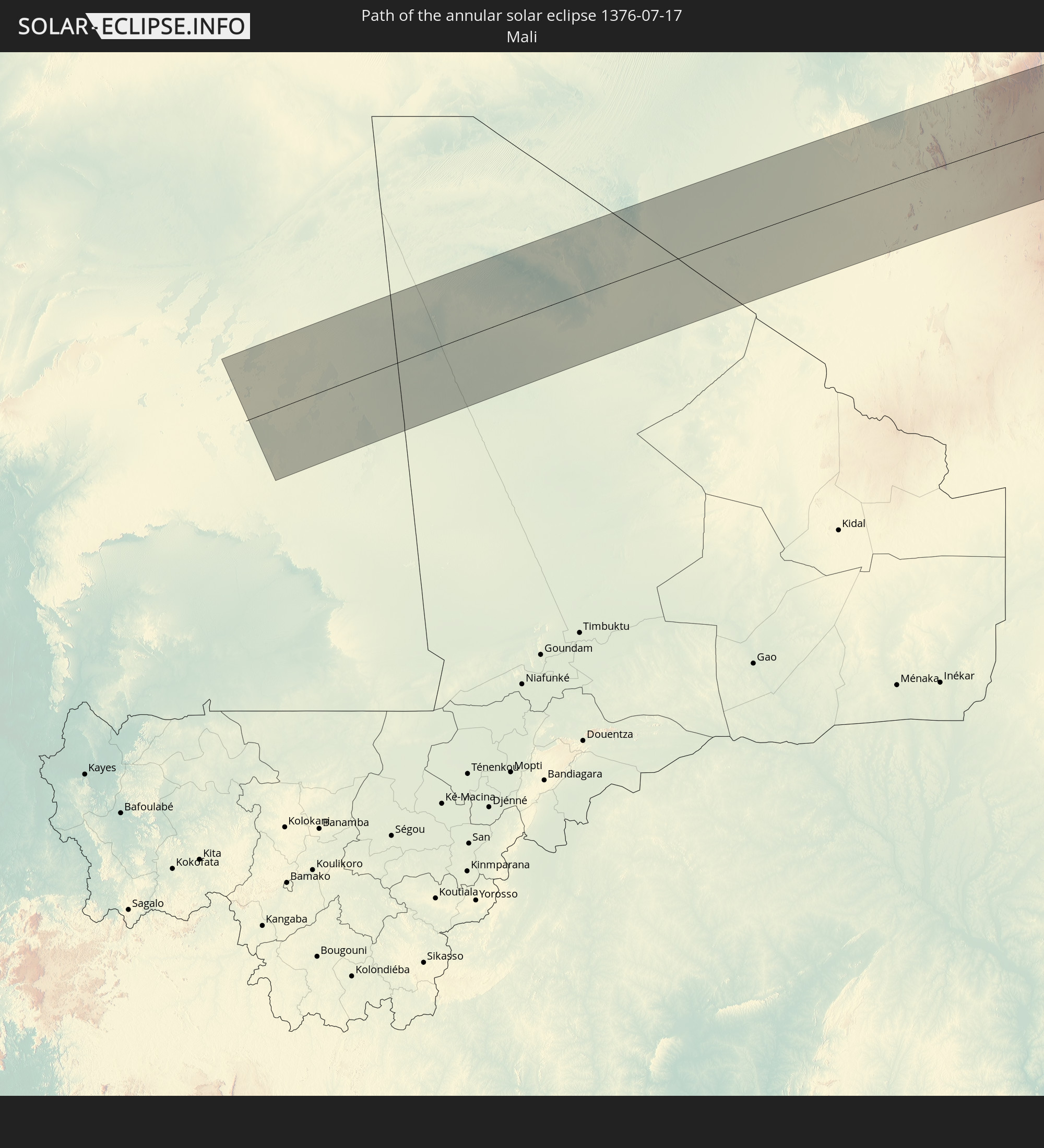 Mali
Mali
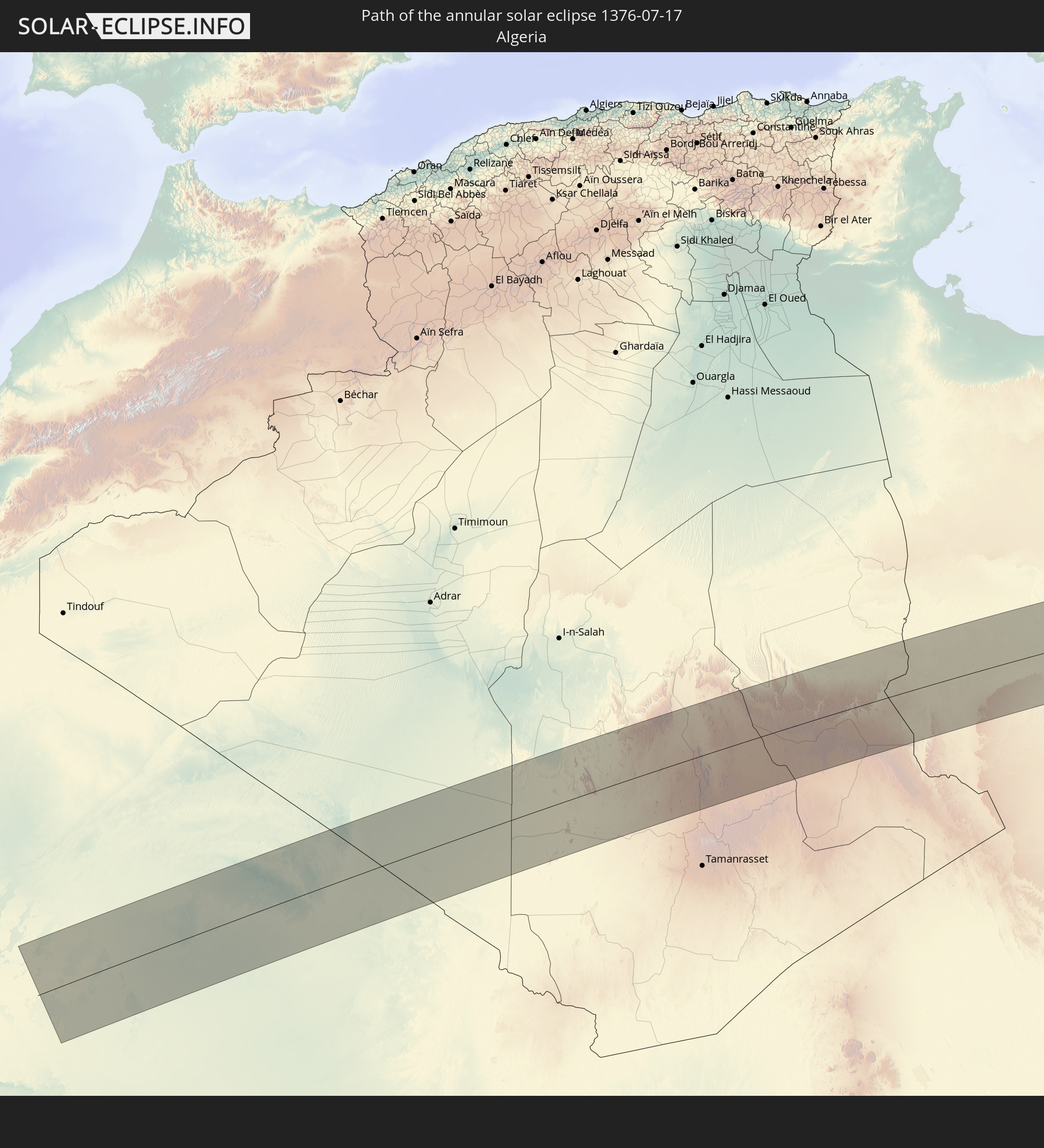 Algeria
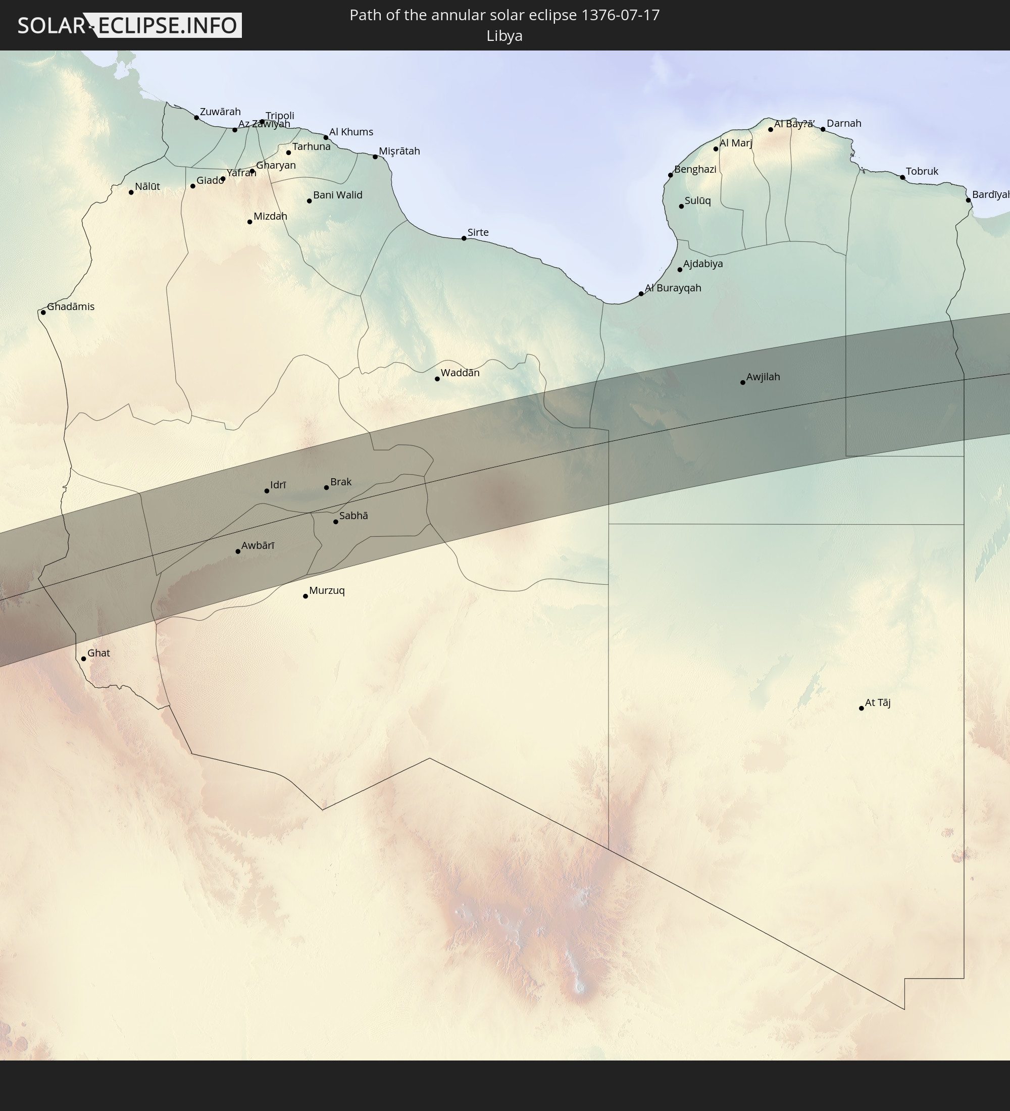 Libya
Libya
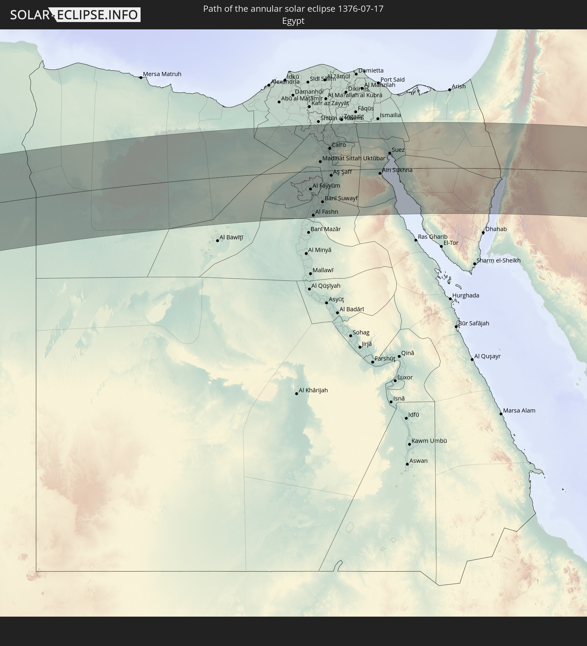 Egypt
Egypt
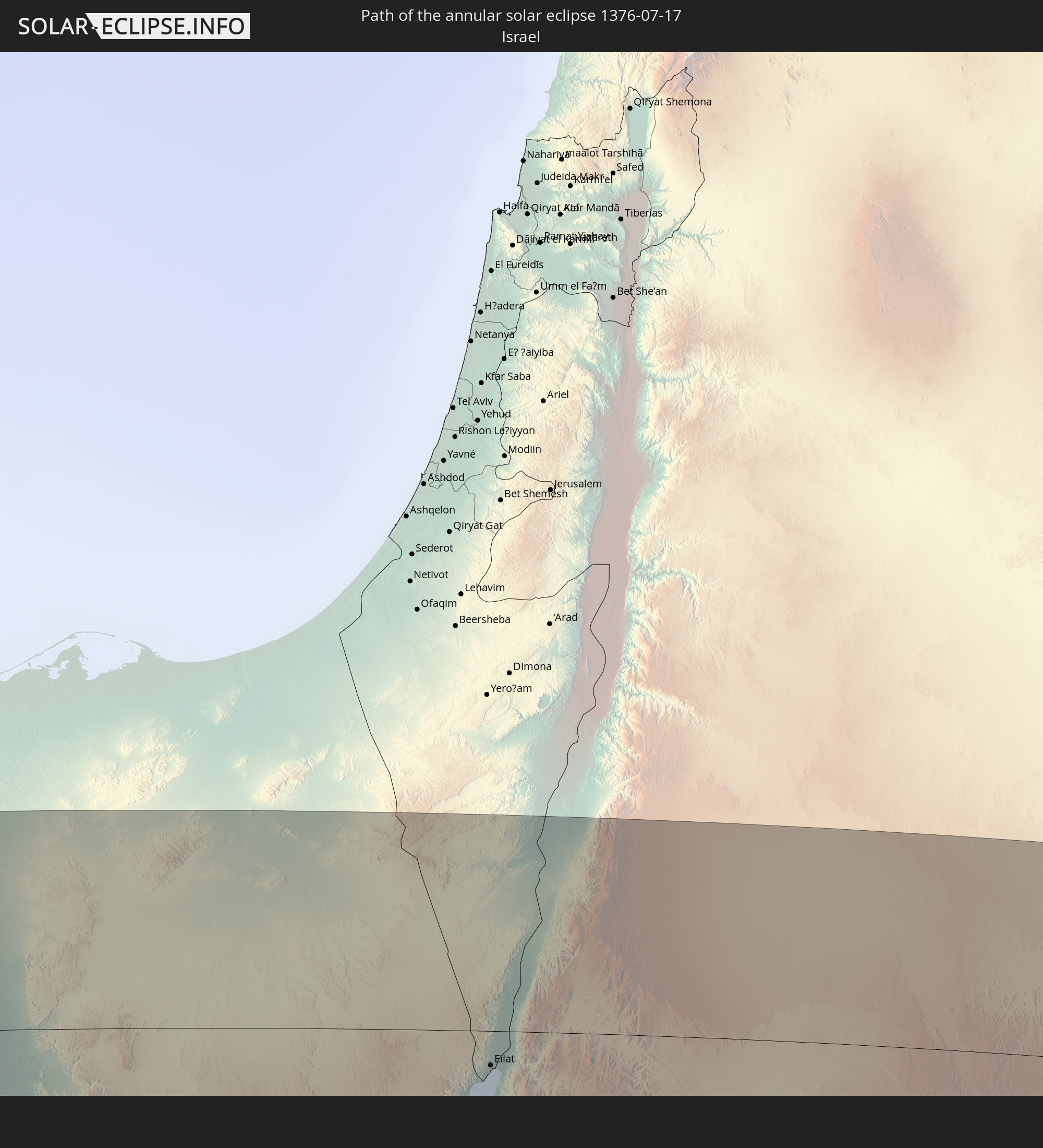 Israel
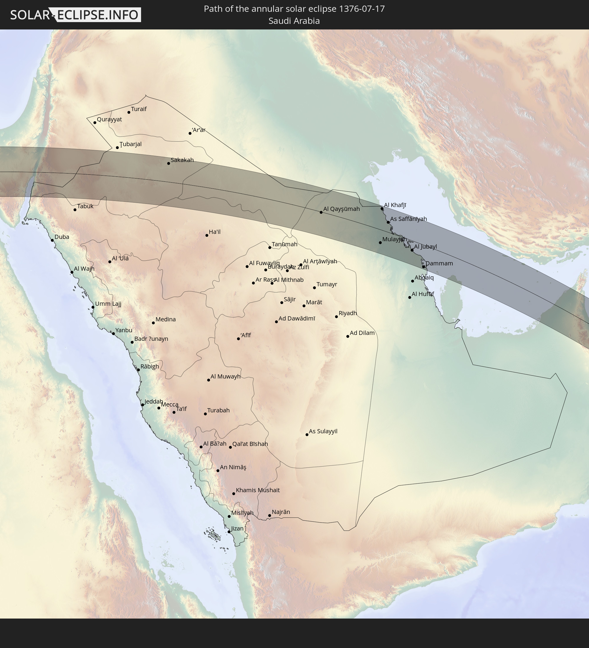 Saudi Arabia
 Jordan
 Iraq
Iraq
 Iran
Iran
 Kuwait
 Bahrain
 Qatar
Qatar
 United Arab Emirates
 Oman
Oman
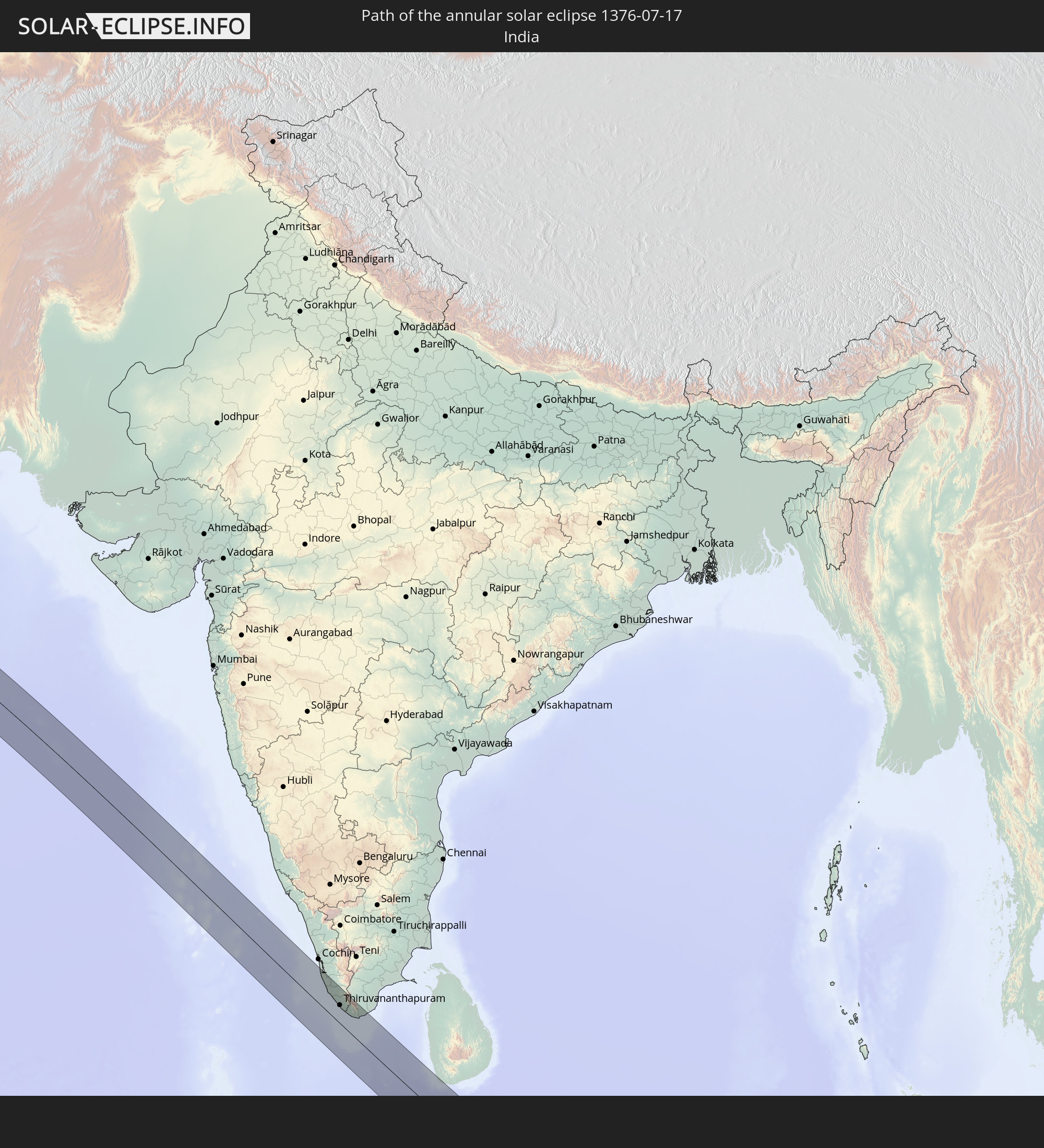 India
India
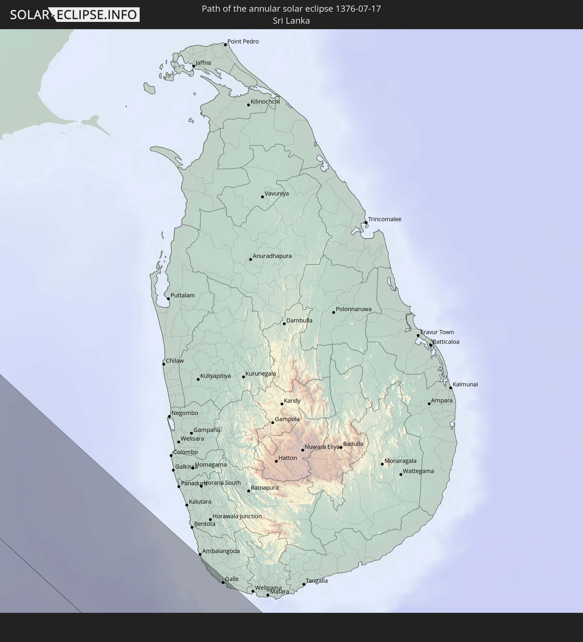 Sri Lanka
In den folgenden Ländern ist die Sonnenfinsternis partiell zu sehen
 Russia
 Portugal
 Spain
Spain
 Mauritania
 Morocco
 Mali
Mali
 Republic of Ireland
 Algeria
 United Kingdom
 Ivory Coast
 Burkina Faso
 Gibraltar
 France
 Isle of Man
 Ghana
Ghana
 Guernsey
 Jersey
 Togo
Togo
 Niger
Niger
 Benin
Benin
 Andorra
 Belgium
 Nigeria
 Netherlands
 Norway
 Equatorial Guinea
 Luxembourg
 Germany
 Switzerland
 São Tomé and Príncipe
 Italy
Italy
 Monaco
 Tunisia
 Denmark
 Cameroon
 Gabon
Gabon
 Libya
Libya
 Liechtenstein
 Austria
 Sweden
 Republic of the Congo
 Angola
 Czechia
 Democratic Republic of the Congo
 San Marino
 Vatican City
 Slovenia
 Chad
Chad
 Croatia
 Poland
 Malta
Malta
 Central African Republic
 Bosnia and Herzegovina
 Hungary
 Slovakia
 Montenegro
 Serbia
 Albania
 Åland Islands
 Greece
 Romania
 Republic of Macedonia
 Finland
 Lithuania
 Latvia
 Estonia
 Sudan
Sudan
 Ukraine
 Bulgaria
 Belarus
 Egypt
Egypt
 Turkey
 Moldova
 Rwanda
 Burundi
 Tanzania
 Uganda
 Cyprus
 Ethiopia
 Kenya
Kenya
 State of Palestine
 Israel
 Saudi Arabia
 Jordan
 Lebanon
 Syria
Syria
 Eritrea
 Iraq
Iraq
 Georgia
 French Southern and Antarctic Lands
 Somalia
 Djibouti
 Yemen
Yemen
 Armenia
 Iran
Iran
 Azerbaijan
 Seychelles
 Kazakhstan
 Kuwait
 Bahrain
 Qatar
Qatar
 United Arab Emirates
 Oman
Oman
 Turkmenistan
 Uzbekistan
 Mauritius
 Afghanistan
 Pakistan
 Tajikistan
 India
India
 Kyrgyzstan
 British Indian Ocean Territory
 Maldives
 China
China
 Sri Lanka
 Nepal
Nepal
 Mongolia
 Bangladesh
 Bhutan
 Myanmar
 Indonesia
 Cocos Islands
 Thailand
 Malaysia
 Laos
Laos
 Vietnam
 Cambodia
 Singapore
 Christmas Island
 Macau
Macau
 Hong Kong
 Brunei
 Taiwan
 Philippines
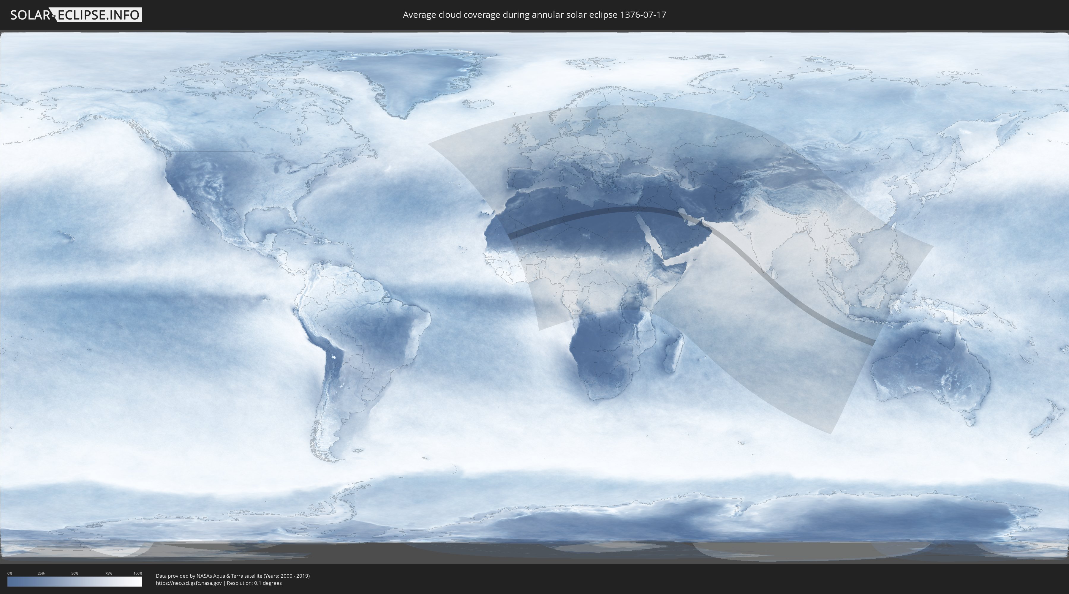
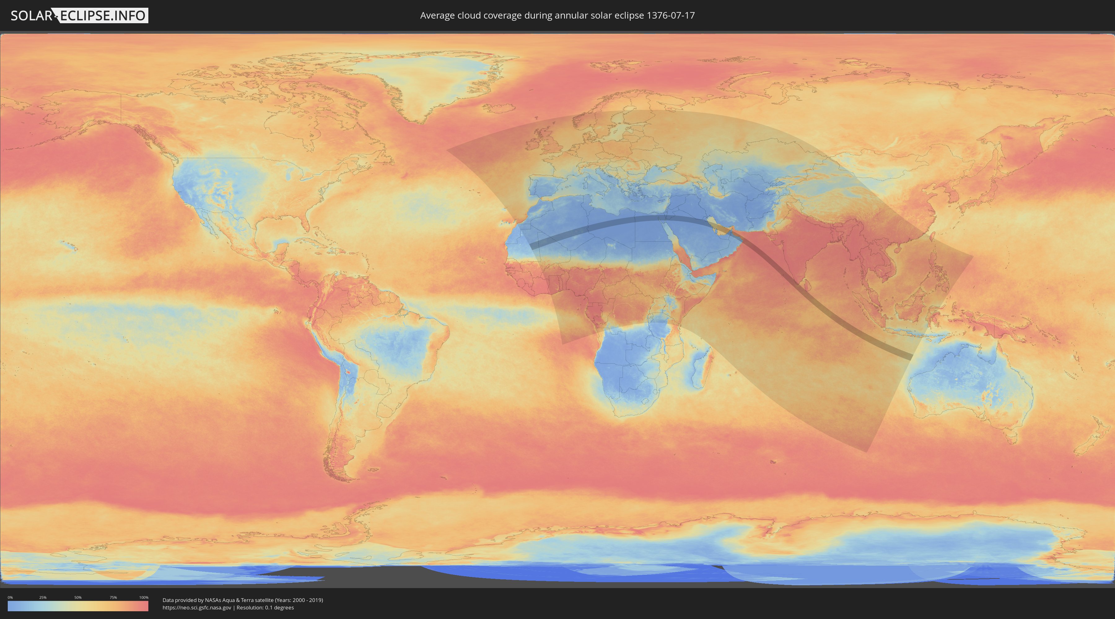
How will be the weather during the annular solar eclipse on 07/17/1376?
Where is the best place to see the annular solar eclipse of 07/17/1376?
The following maps show the average cloud coverage for the day of the annular solar eclipse.
With the help of these maps, it is possible to find the place along the eclipse path, which has the best
chance of a cloudless sky.
Nevertheless, you should consider local circumstances and inform about the weather of your chosen
observation site.
The data is provided by NASAs satellites
AQUA and TERRA.
The cloud maps are averaged over a period of 19 years (2000 - 2019).
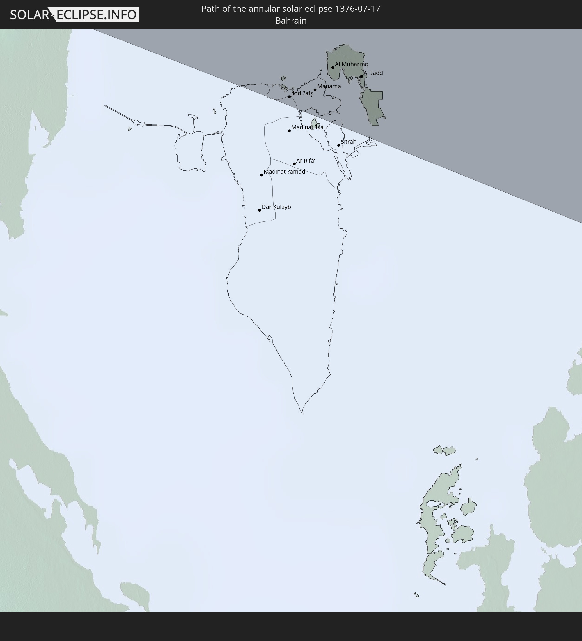
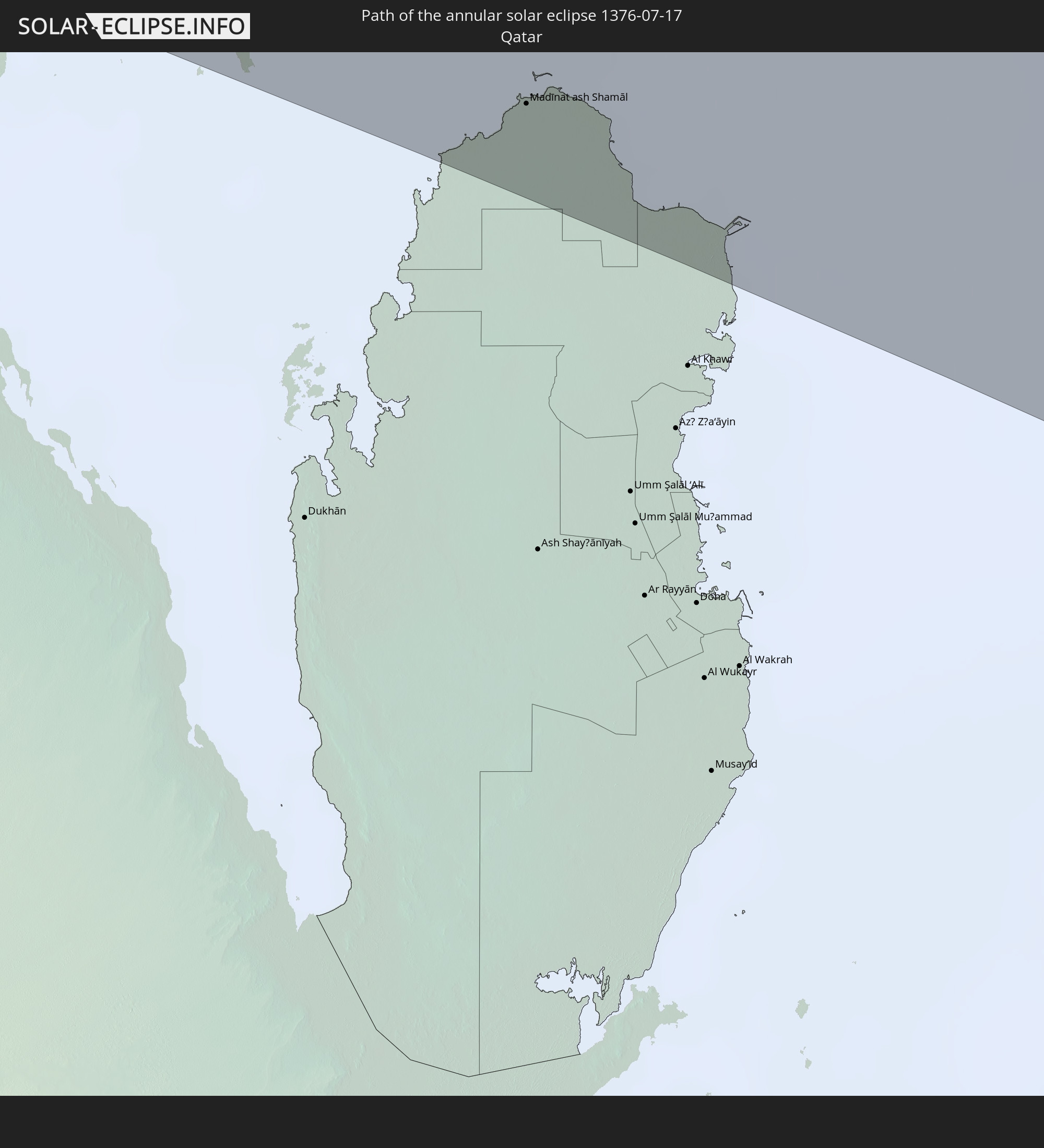
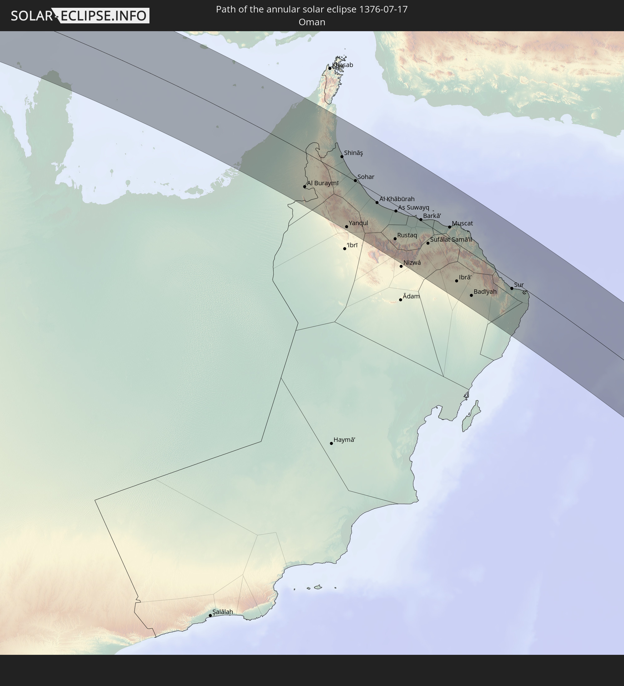
Detailed country maps
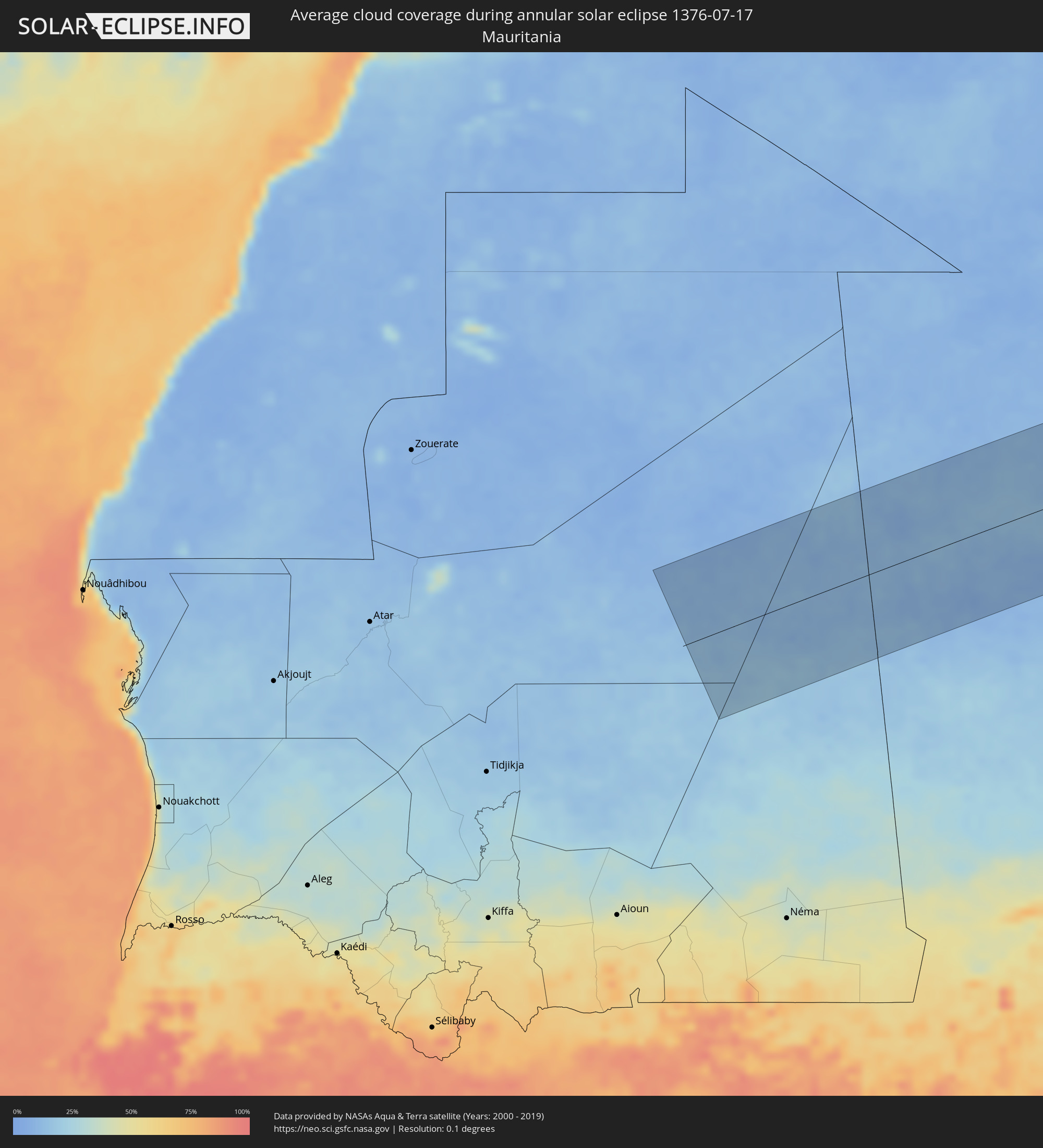 Mauritania
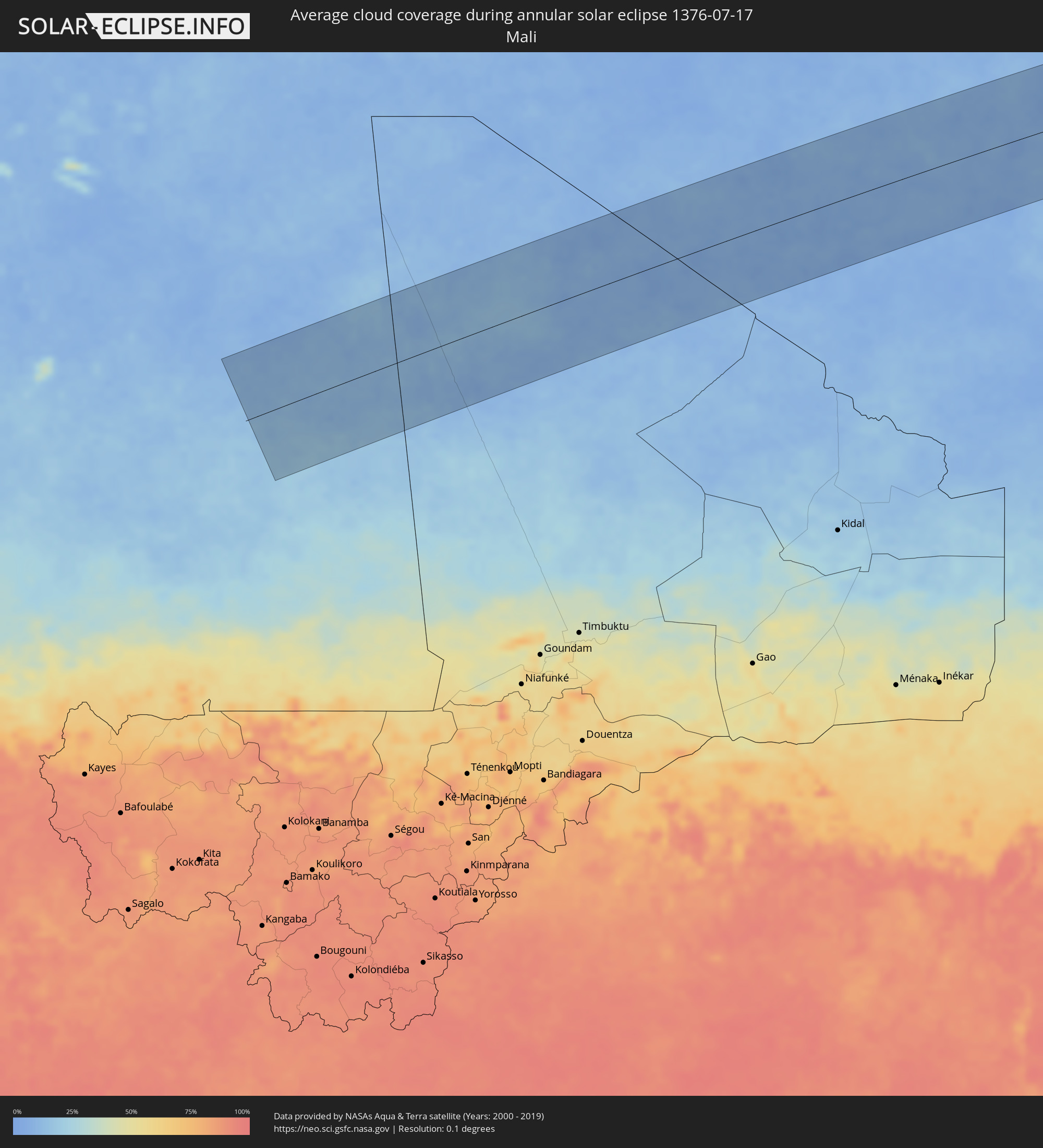 Mali
Mali
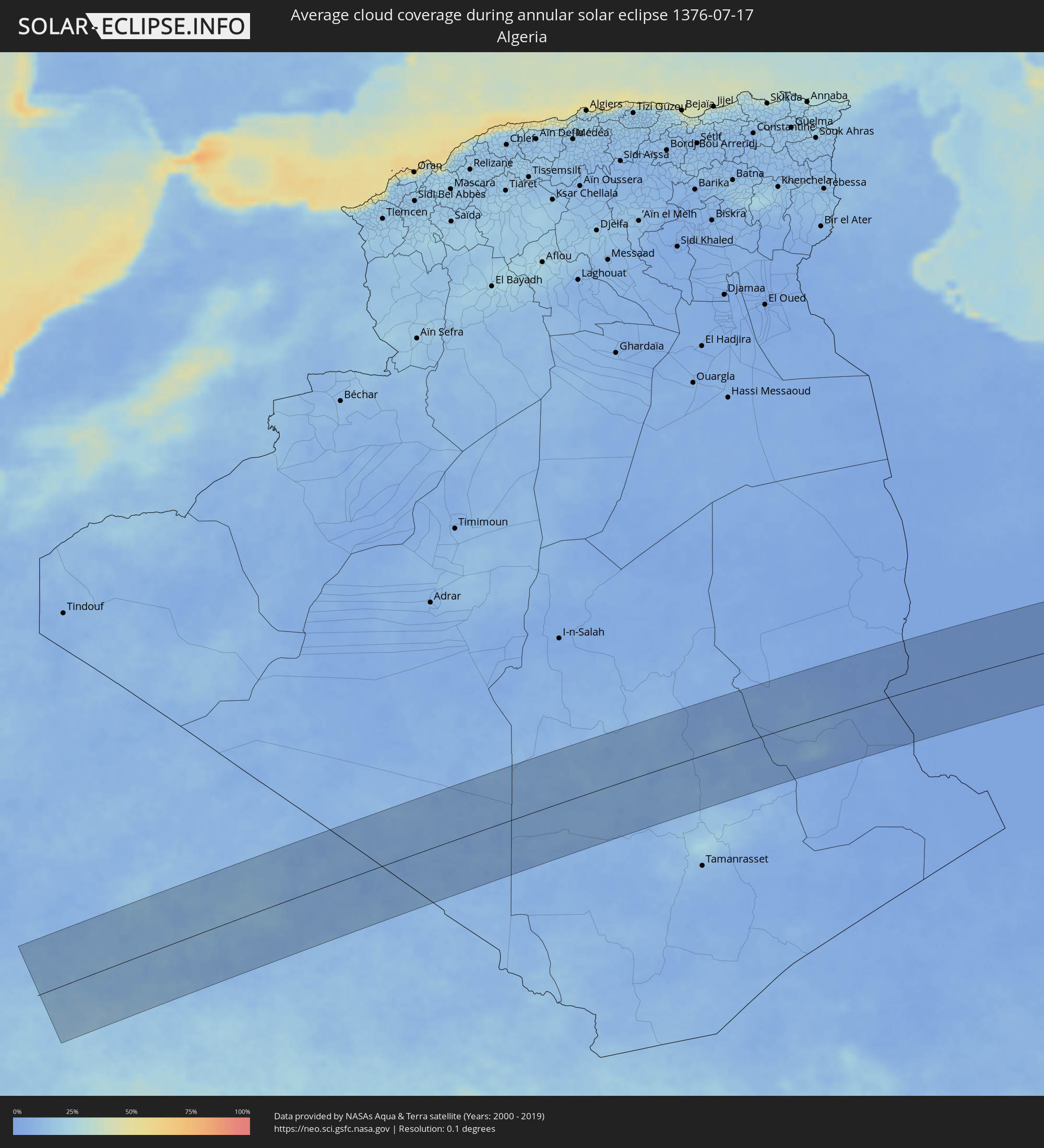 Algeria
 Libya
Libya
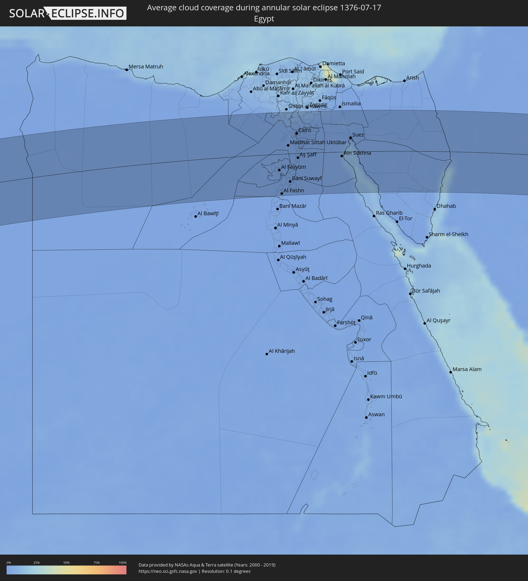 Egypt
Egypt
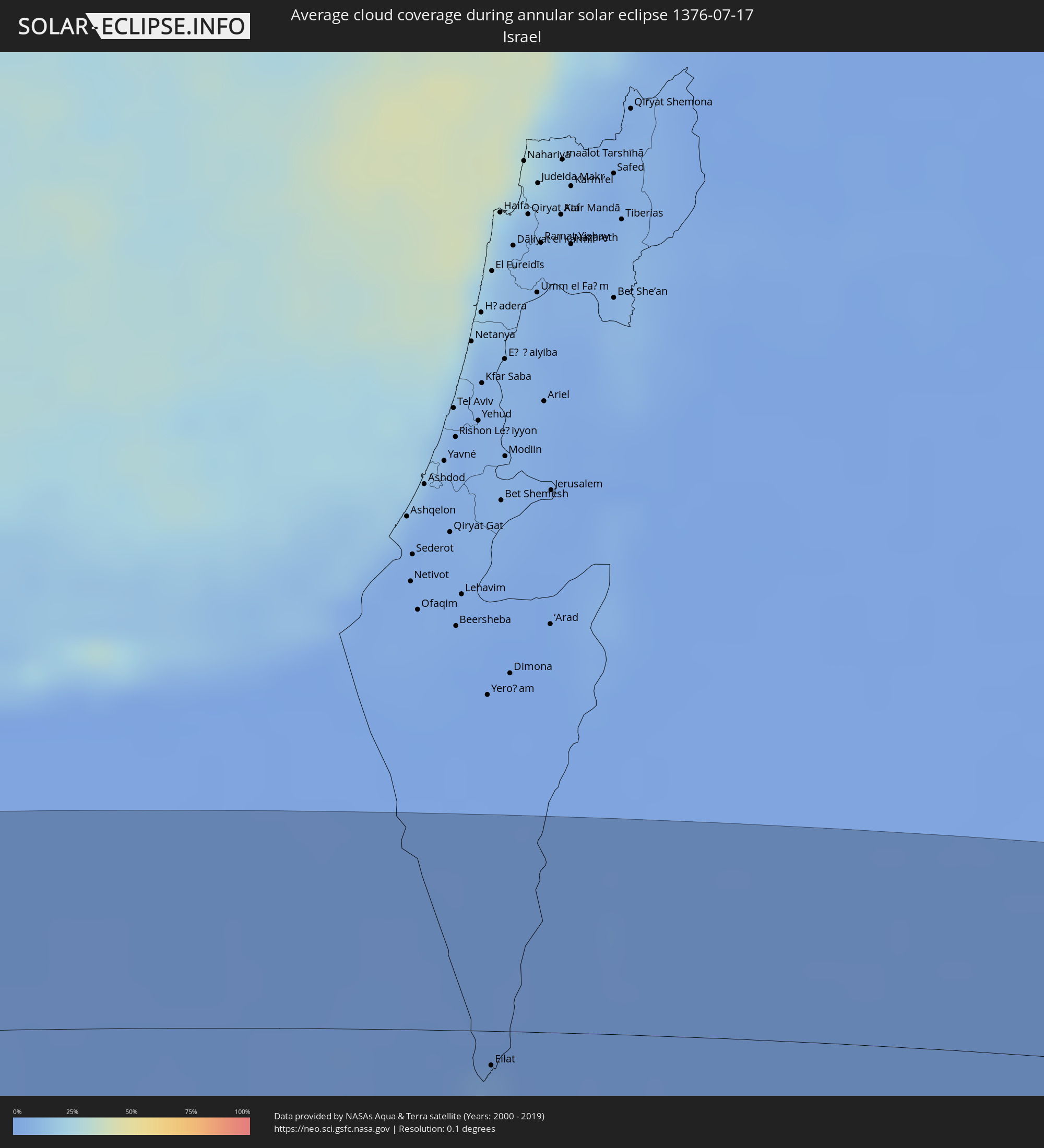 Israel
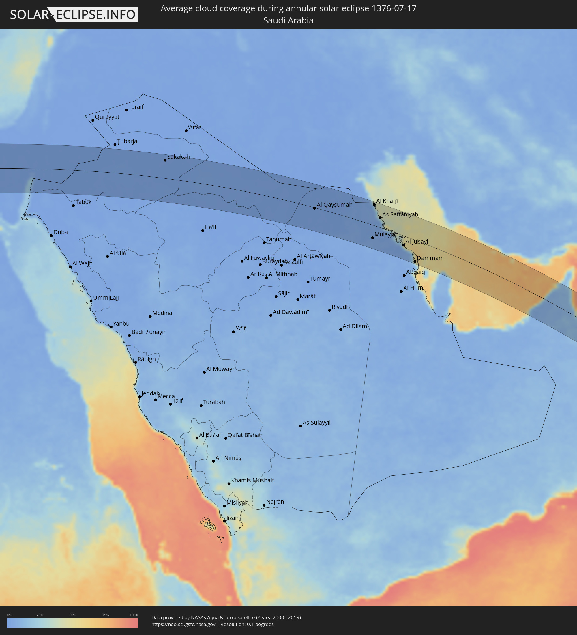 Saudi Arabia
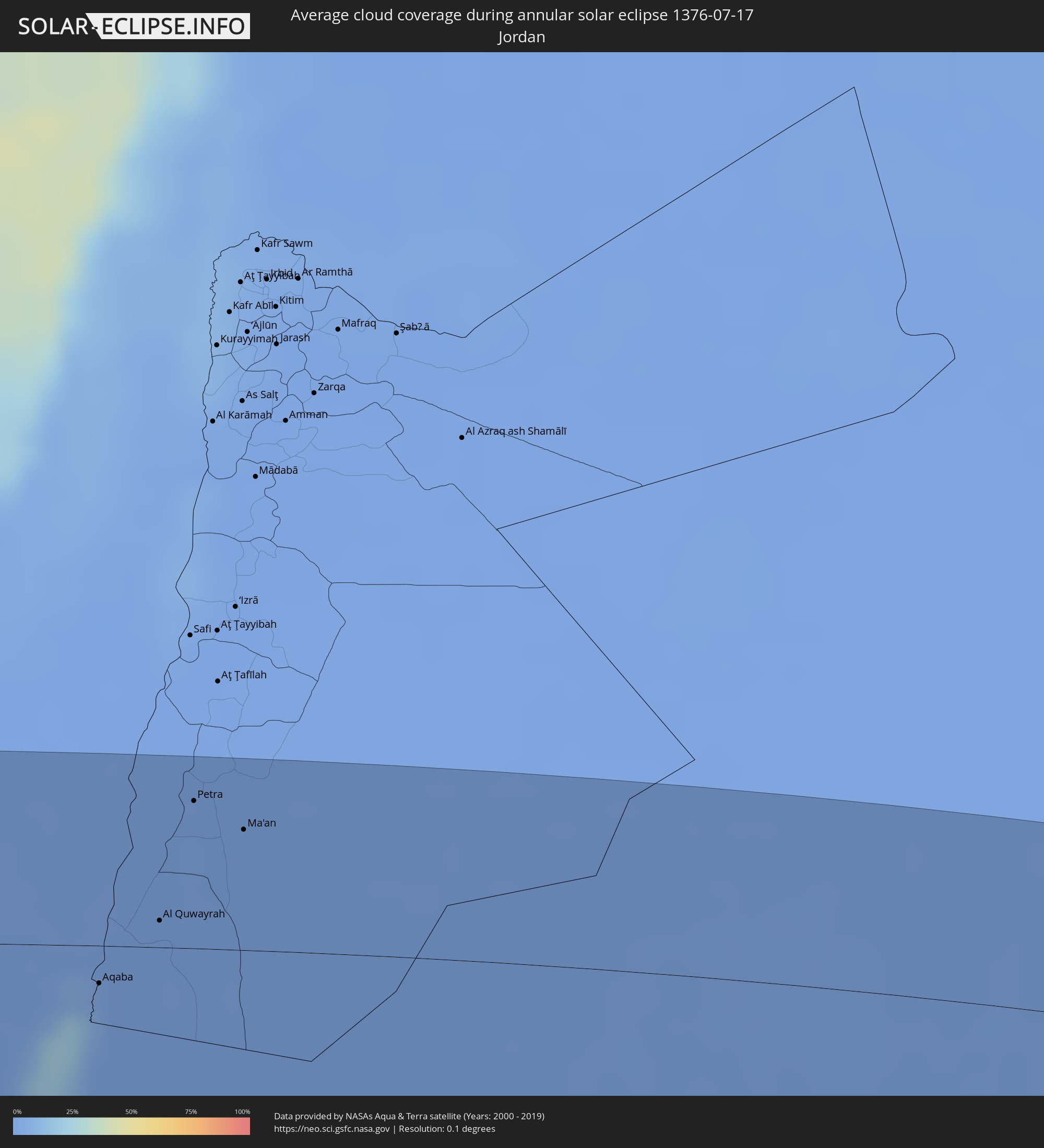 Jordan
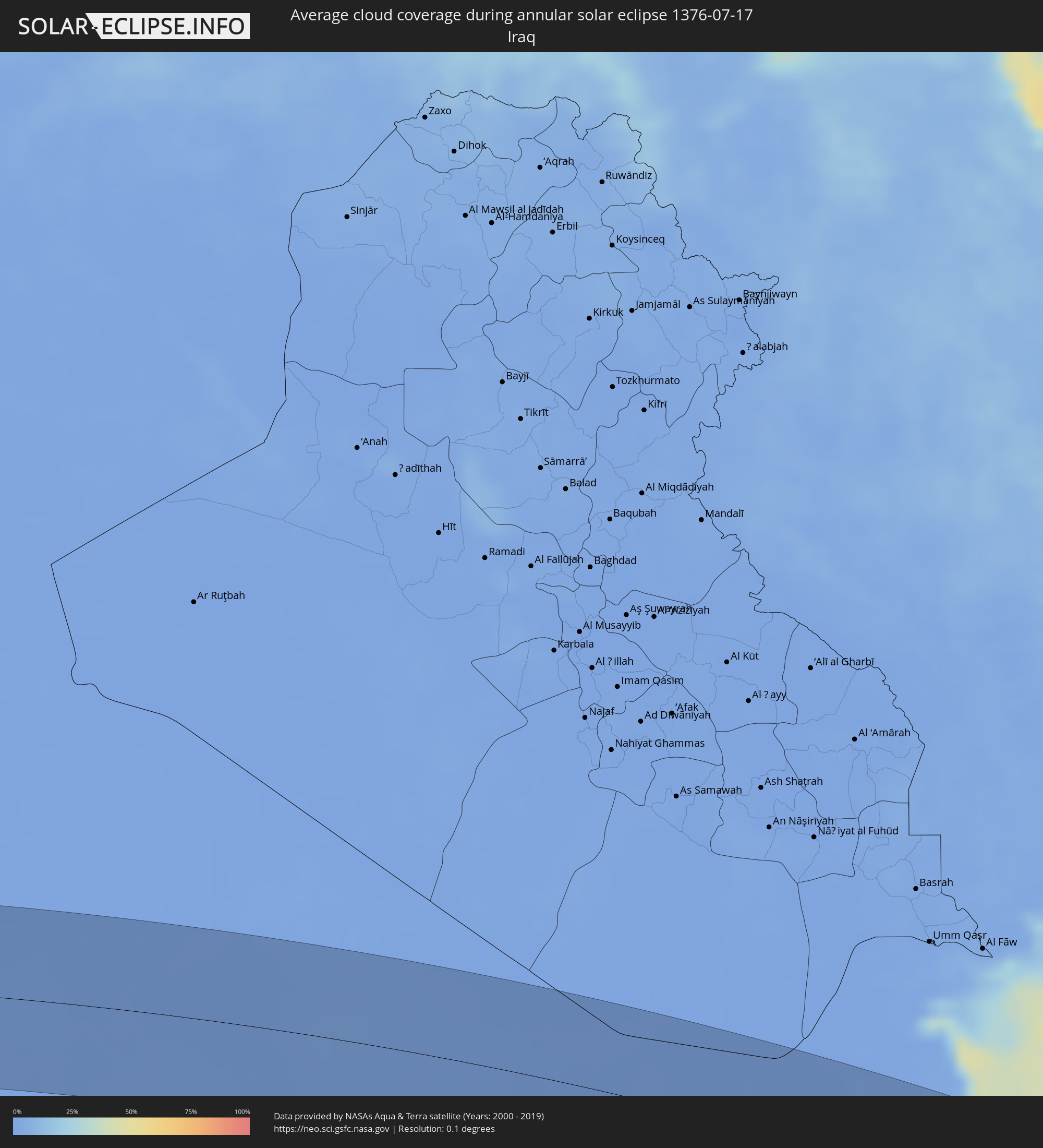 Iraq
Iraq
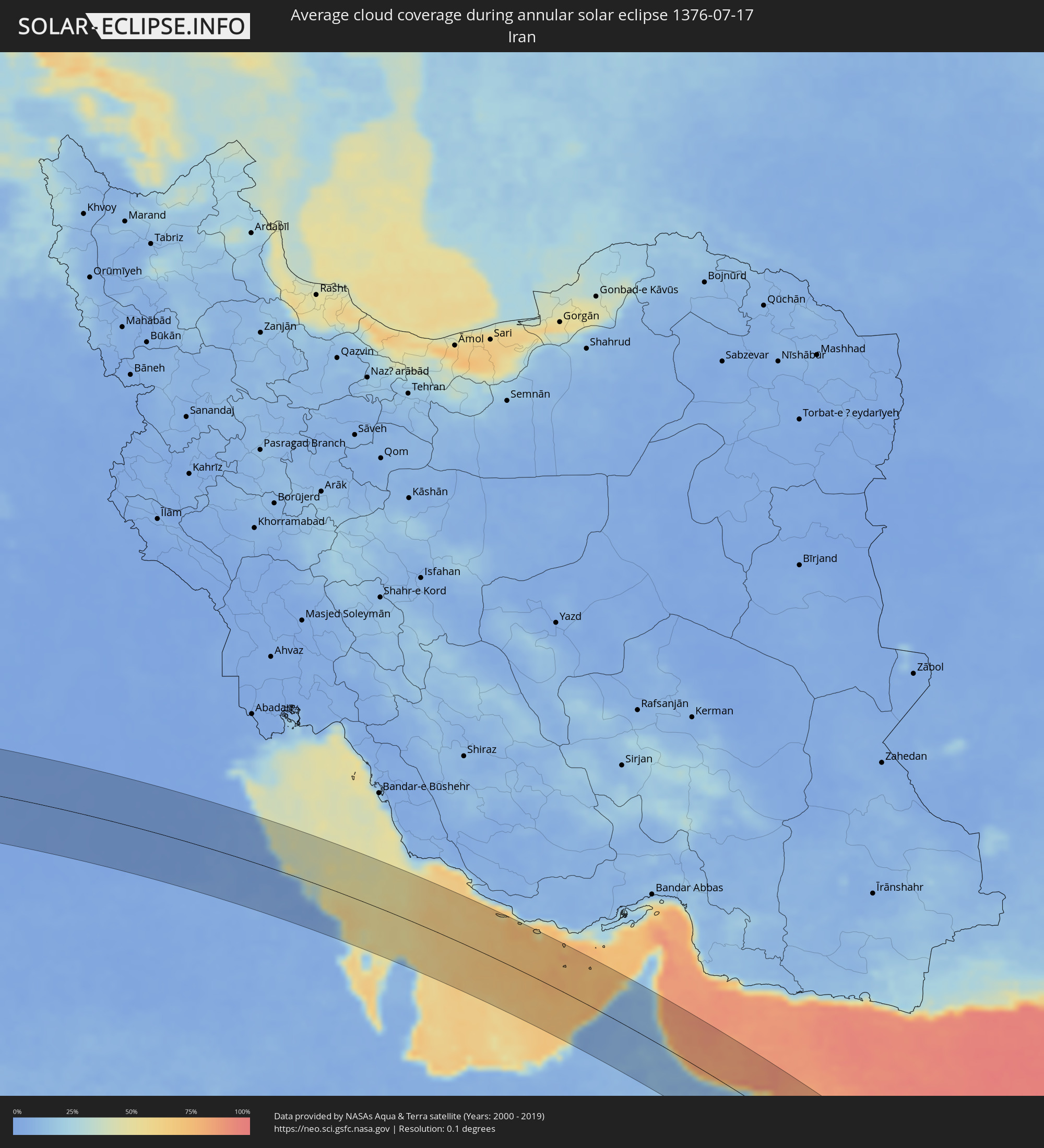 Iran
Iran
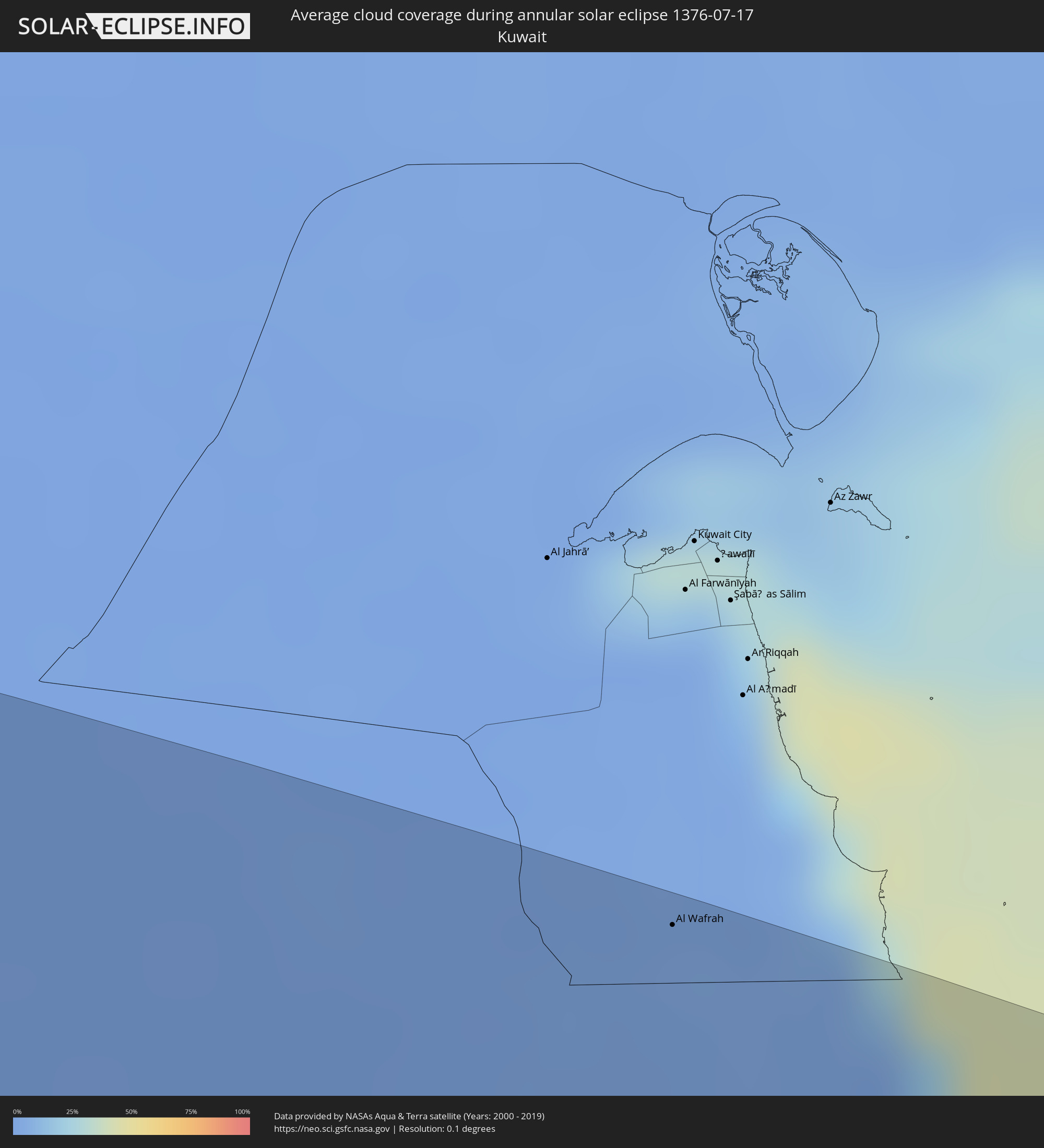 Kuwait
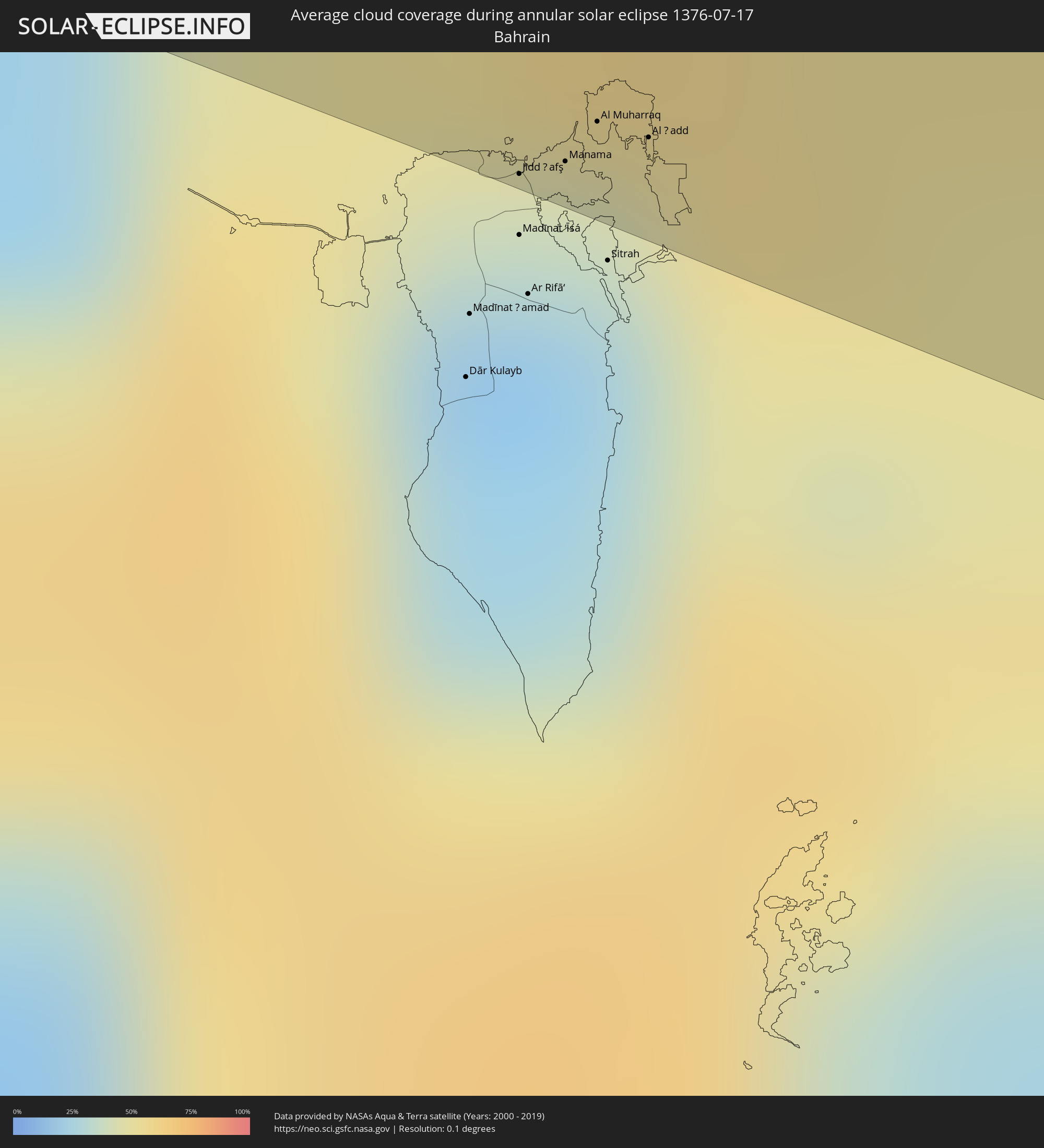 Bahrain
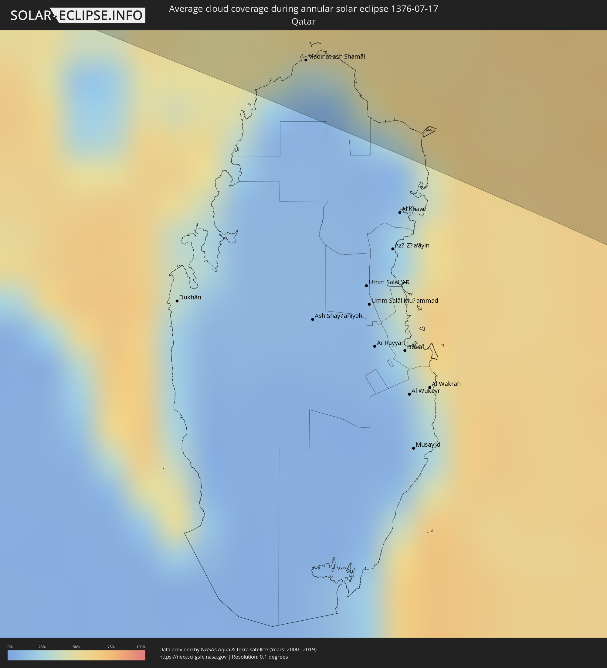 Qatar
Qatar
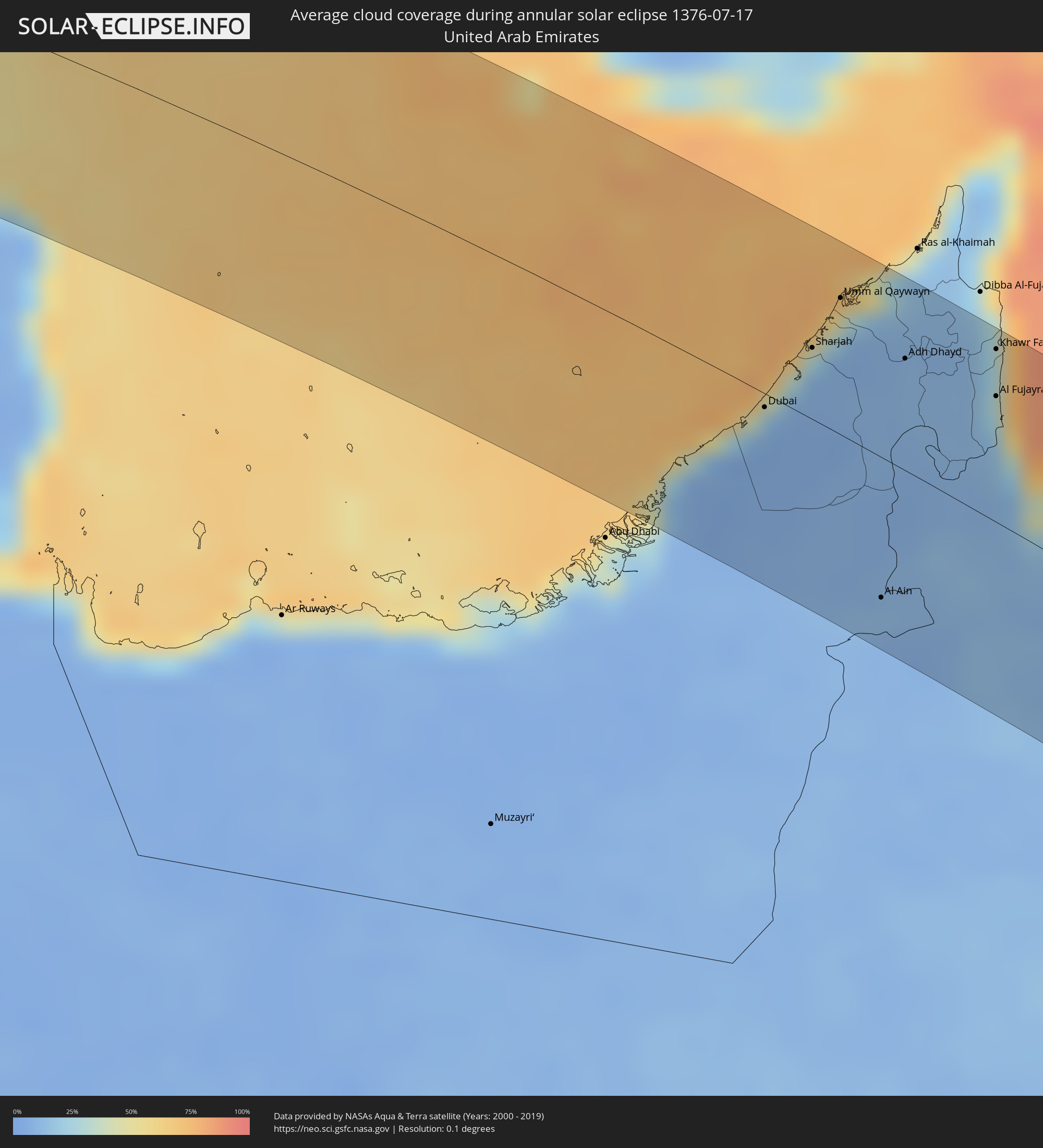 United Arab Emirates
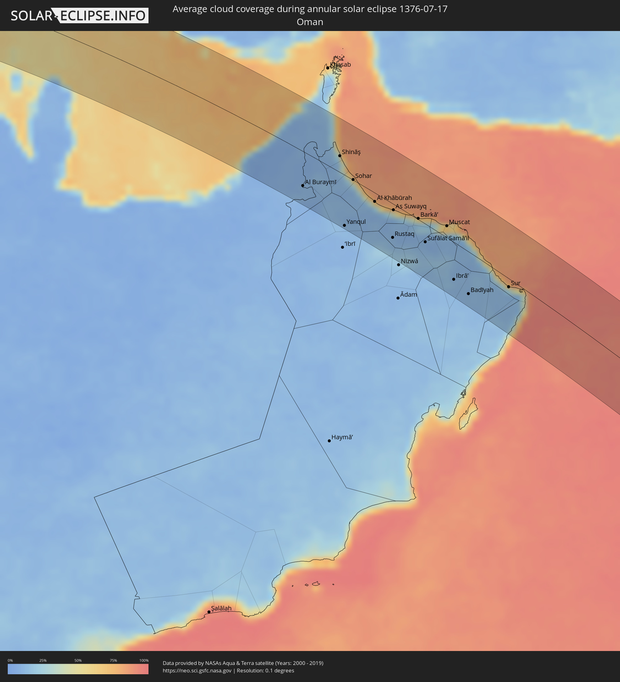 Oman
Oman
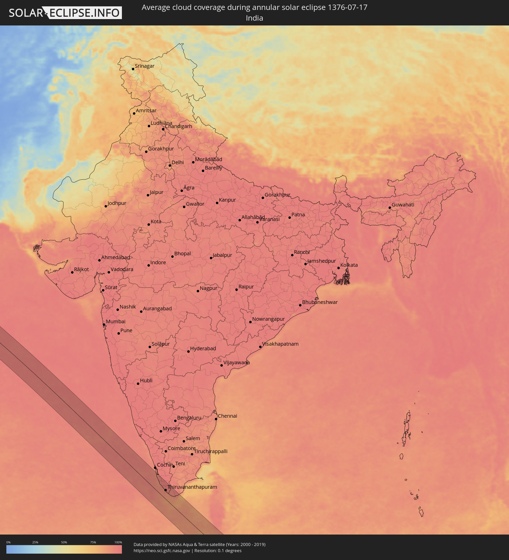 India
India
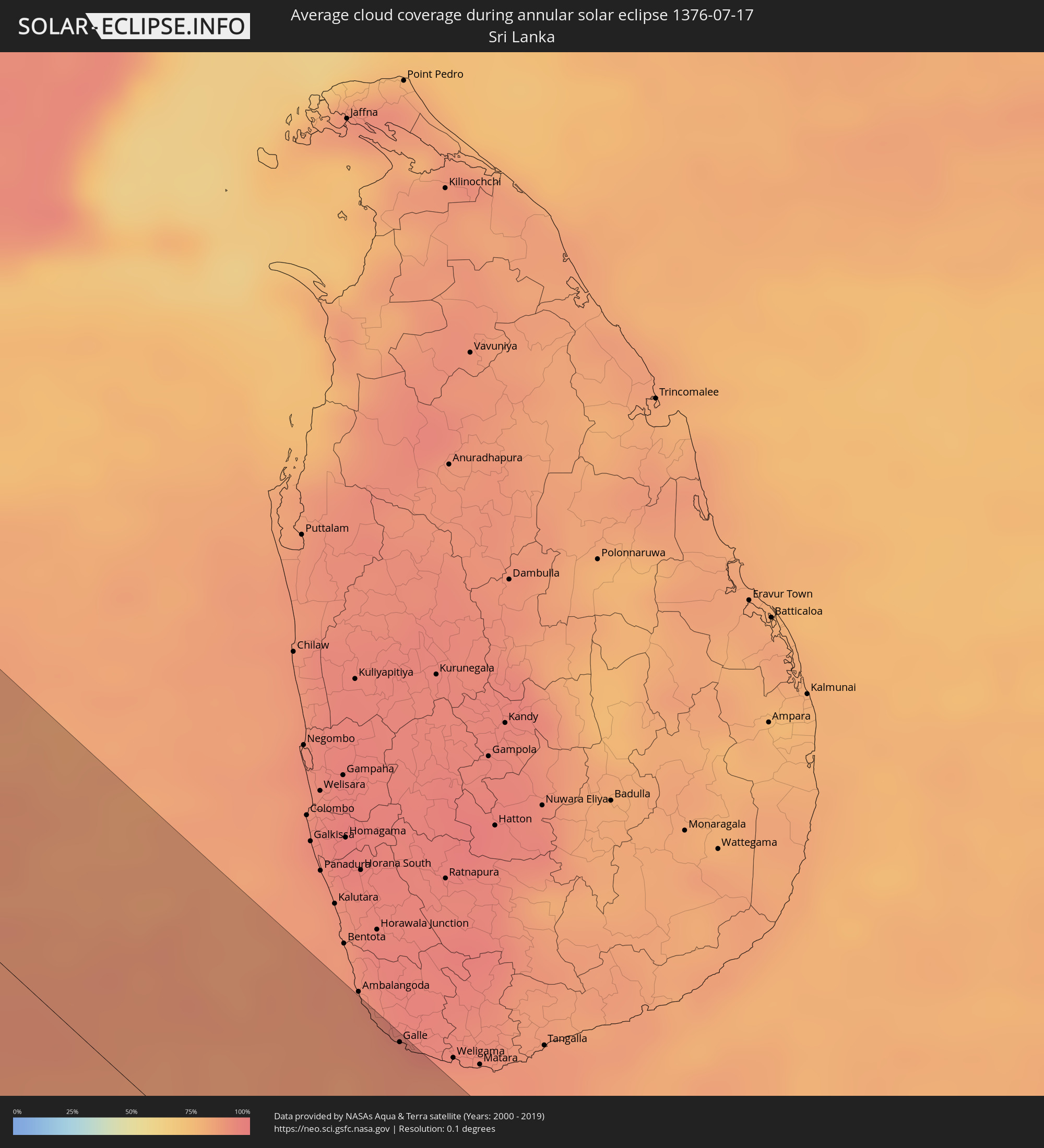 Sri Lanka
Cities inside the path of the eclipse
The following table shows all locations with a population of more than 5,000 inside the eclipse path. Cities which have more than 100,000 inhabitants are marked bold. A click at the locations opens a detailed map.
| City | Type | Eclipse duration | Local time of max. eclipse | Distance to central line | Ø Cloud coverage |
|
Illizi, Illizi
|
annular | - | 06:25:18 UTC+00:09 | 74 km | 1% |
|
Awbārī, Sha‘bīyat Wādī al Ḩayāt
|
annular | - | 07:11:30 UTC+00:52 | 34 km | 0% |
|
Idrī, Ash Shāţiʼ
|
annular | - | 07:12:24 UTC+00:52 | 51 km | 0% |
|
Brak, Ash Shāţiʼ
|
annular | - | 07:13:14 UTC+00:52 | 32 km | 1% |
|
Al Jadīd, Sabhā
|
annular | - | 07:13:03 UTC+00:52 | 25 km | 0% |
|
Sabhā, Sabhā
|
annular | - | 07:13:04 UTC+00:52 | 28 km | 0% |
|
Awjilah, Sha‘bīyat al Wāḩāt
|
annular | - | 07:21:12 UTC+00:52 | 51 km | 1% |
|
Ibshawāy, Faiyum
|
annular | - | 08:42:39 UTC+02:00 | 31 km | 1% |
|
Al Fayyūm, Faiyum
|
annular | - | 08:42:56 UTC+02:00 | 37 km | 1% |
|
Al Fashn, Beni Suweif
|
annular | - | 08:42:56 UTC+02:00 | 91 km | 0% |
|
Minūf, Monufia
|
annular | - | 08:43:22 UTC+02:00 | 91 km | 4% |
|
Ţāmiyah, Faiyum
|
annular | - | 08:43:11 UTC+02:00 | 19 km | 1% |
|
Ashmūn, Monufia
|
annular | - | 08:43:24 UTC+02:00 | 73 km | 2% |
|
Banī Suwayf, Beni Suweif
|
annular | - | 08:43:21 UTC+02:00 | 64 km | 0% |
|
Al Qanāţir al Khayrīyah, Qalyubia
|
annular | - | 08:43:40 UTC+02:00 | 60 km | 1% |
|
Banhā, Qalyubia
|
annular | - | 08:43:48 UTC+02:00 | 90 km | 6% |
|
Cairo, Cairo
|
annular | - | 08:43:50 UTC+02:00 | 45 km | 1% |
|
Ḩalwān, Cairo
|
annular | - | 08:43:53 UTC+02:00 | 20 km | 0% |
|
Shibīn al Qanāţir, Qalyubia
|
annular | - | 08:44:02 UTC+02:00 | 73 km | 2% |
|
Al Khānkah, Qalyubia
|
annular | - | 08:44:05 UTC+02:00 | 61 km | 0% |
|
Mashtūl as Sūq, Sharqia
|
annular | - | 08:44:08 UTC+02:00 | 78 km | 4% |
|
Bilbays, Sharqia
|
annular | - | 08:44:29 UTC+02:00 | 84 km | 2% |
|
Suez, Suez
|
annular | - | 08:46:11 UTC+02:00 | 31 km | 5% |
|
Eilat, Southern District
|
annular | - | 09:11:36 UTC+02:20 | 15 km | 5% |
|
Aqaba, Aqaba
|
annular | - | 09:14:47 UTC+02:23 | 18 km | 8% |
|
Al Quwayrah, Ma’an
|
annular | - | 09:15:25 UTC+02:23 | 13 km | 0% |
|
Petra, Ma’an
|
annular | - | 09:15:47 UTC+02:23 | 71 km | 0% |
|
Ma'an, Ma’an
|
annular | - | 09:16:18 UTC+02:23 | 58 km | 0% |
|
Sakakah, Al Jawf
|
annular | - | 10:09:19 UTC+03:06 | 68 km | 1% |
|
Şuwayr, Al Jawf
|
annular | - | 10:09:42 UTC+03:06 | 86 km | 1% |
|
Al Qayşūmah, Eastern Province
|
annular | - | 10:25:02 UTC+03:06 | 3 km | 0% |
|
Al Wafrah, Al Aḩmadī
|
annular | - | 10:29:33 UTC+03:06 | 82 km | 2% |
|
Mulayjah, Eastern Province
|
annular | - | 10:32:14 UTC+03:06 | 48 km | 4% |
|
Al Khafjī, Eastern Province
|
annular | - | 10:31:14 UTC+03:06 | 77 km | 15% |
|
As Saffānīyah, Eastern Province
|
annular | - | 10:32:21 UTC+03:06 | 35 km | 7% |
|
Al Jubayl, Eastern Province
|
annular | - | 10:35:58 UTC+03:06 | 35 km | 20% |
|
Umm as Sāhik, Eastern Province
|
annular | - | 10:37:07 UTC+03:06 | 64 km | 8% |
|
Al Awjām, Eastern Province
|
annular | - | 10:37:18 UTC+03:06 | 72 km | 8% |
|
Şafwá, Eastern Province
|
annular | - | 10:37:13 UTC+03:06 | 63 km | 18% |
|
At Tūbī, Eastern Province
|
annular | - | 10:37:27 UTC+03:06 | 71 km | 18% |
|
Al Qaţīf, Eastern Province
|
annular | - | 10:37:35 UTC+03:06 | 74 km | 9% |
|
Tārūt, Eastern Province
|
annular | - | 10:37:33 UTC+03:06 | 68 km | 18% |
|
Sayhāt, Eastern Province
|
annular | - | 10:37:40 UTC+03:06 | 77 km | 9% |
|
Raḩīmah, Eastern Province
|
annular | - | 10:37:28 UTC+03:06 | 53 km | 47% |
|
Dammam, Eastern Province
|
annular | - | 10:37:55 UTC+03:06 | 80 km | 8% |
|
Jidd Ḩafş, Manama
|
annular | - | 10:58:43 UTC+03:26 | 86 km | 19% |
|
Manama, Manama
|
annular | - | 10:58:49 UTC+03:26 | 84 km | 22% |
|
Al Muharraq, Muharraq
|
annular | - | 10:58:51 UTC+03:26 | 80 km | 39% |
|
Al Ḩadd, Muharraq
|
annular | - | 10:58:59 UTC+03:26 | 79 km | 46% |
|
Madīnat ash Shamāl, Madīnat ash Shamāl
|
annular | - | 11:00:42 UTC+03:26 | 71 km | 11% |
|
Dubai, Dubai
|
annular | - | 11:28:41 UTC+03:41 | 6 km | 15% |
|
Sharjah, Ash Shāriqah
|
annular | - | 11:28:55 UTC+03:41 | 32 km | 12% |
|
Ajman, Ajman
|
annular | - | 11:28:52 UTC+03:41 | 40 km | 30% |
|
Umm al Qaywayn, Umm al Qaywayn
|
annular | - | 11:28:57 UTC+03:41 | 61 km | 31% |
|
Al Ain, Abu Dhabi
|
annular | - | 11:31:51 UTC+03:41 | 63 km | 11% |
|
Al Buraymī, Al Buraimi
|
annular | - | 11:31:51 UTC+03:41 | 55 km | 11% |
|
Adh Dhayd, Ash Shāriqah
|
annular | - | 11:30:19 UTC+03:41 | 50 km | 10% |
|
Al Fujayrah, Al Fujayrah
|
annular | - | 11:31:54 UTC+03:41 | 56 km | 26% |
|
Khawr Fakkān, Ash Shāriqah
|
annular | - | 11:31:32 UTC+03:41 | 77 km | 26% |
|
Shināş, Al Batinah North Governorate
|
annular | - | 11:32:54 UTC+03:41 | 26 km | 39% |
|
Al Liwā’, Al Batinah North Governorate
|
annular | - | 11:33:32 UTC+03:41 | 11 km | 28% |
|
Sohar, Al Batinah North Governorate
|
annular | - | 11:34:16 UTC+03:41 | 1 km | 29% |
|
Şaḩam, Al Batinah North Governorate
|
annular | - | 11:35:06 UTC+03:41 | 7 km | 41% |
|
Al Khābūrah, Al Batinah North Governorate
|
annular | - | 11:36:01 UTC+03:41 | 14 km | 28% |
|
Rustaq, Al Batinah South Governorate
|
annular | - | 11:38:03 UTC+03:41 | 53 km | 12% |
|
As Suwayq, Al Batinah North Governorate
|
annular | - | 11:37:14 UTC+03:41 | 9 km | 12% |
|
Izkī, Muḩāfaz̧at ad Dākhilīyah
|
annular | - | 11:39:53 UTC+03:41 | 78 km | 11% |
|
Barkā’, Al Batinah South Governorate
|
annular | - | 11:38:46 UTC+03:41 | 1 km | 22% |
|
Sufālat Samā’il, Muḩāfaz̧at ad Dākhilīyah
|
annular | - | 11:39:51 UTC+03:41 | 28 km | 12% |
|
Bidbid, Muḩāfaz̧at ad Dākhilīyah
|
annular | - | 11:40:00 UTC+03:41 | 14 km | 8% |
|
Seeb, Muḩāfaz̧at Masqaţ
|
annular | - | 11:39:40 UTC+03:41 | 14 km | 34% |
|
Muscat, Muḩāfaz̧at Masqaţ
|
annular | - | 11:40:26 UTC+03:41 | 18 km | 20% |
|
Ibrā’, Ash Sharqiyah North Governorate
|
annular | - | 11:42:31 UTC+03:41 | 58 km | 13% |
|
Sur, Ash Sharqiyah South Governorate
|
annular | - | 11:45:32 UTC+03:41 | 13 km | 25% |
|
Alleppey, Kerala
|
annular | - | 14:32:19 UTC+05:21 | 81 km | 92% |
|
Kāyankulam, Kerala
|
annular | - | 14:33:15 UTC+05:21 | 68 km | 91% |
|
Panmana, Kerala
|
annular | - | 14:33:36 UTC+05:21 | 57 km | 89% |
|
Māvelikara, Kerala
|
annular | - | 14:33:10 UTC+05:21 | 80 km | 95% |
|
Tiruvalla, Kerala
|
annular | - | 14:32:57 UTC+05:21 | 91 km | 95% |
|
Kollam, Kerala
|
annular | - | 14:34:00 UTC+05:21 | 51 km | 92% |
|
Chengannūr, Kerala
|
annular | - | 14:33:09 UTC+05:21 | 89 km | 95% |
|
Varkala, Kerala
|
annular | - | 14:34:31 UTC+05:21 | 49 km | 91% |
|
Adūr, Kerala
|
annular | - | 14:33:39 UTC+05:21 | 85 km | 96% |
|
Kadakkavoor, Kerala
|
annular | - | 14:34:42 UTC+05:21 | 49 km | 91% |
|
Punalūr, Kerala
|
annular | - | 14:34:16 UTC+05:21 | 89 km | 96% |
|
Thiruvananthapuram, Kerala
|
annular | - | 14:35:23 UTC+05:21 | 47 km | 91% |
|
Neyyāttinkara, Kerala
|
annular | - | 14:35:47 UTC+05:21 | 50 km | 89% |
|
Colachel, Tamil Nadu
|
annular | - | 14:36:30 UTC+05:21 | 46 km | 86% |
|
Nāgercoil, Tamil Nadu
|
annular | - | 14:36:47 UTC+05:21 | 59 km | 90% |
|
Vadakku Valliyūr, Tamil Nadu
|
annular | - | 14:36:39 UTC+05:21 | 89 km | 94% |
|
Galle, Southern
|
annular | - | 14:43:24 UTC+05:19 | 93 km | 88% |