Annular solar eclipse of 08/29/1448
| Day of week: | Tuesday |
| Maximum duration of eclipse: | 06m37s |
| Maximum width of eclipse path: | 239 km |
| Saros cycle: | 116 |
| Coverage: | 93.9% |
| Magnitude: | 0.9389 |
| Gamma: | 0.338 |
Wo kann man die Sonnenfinsternis vom 08/29/1448 sehen?
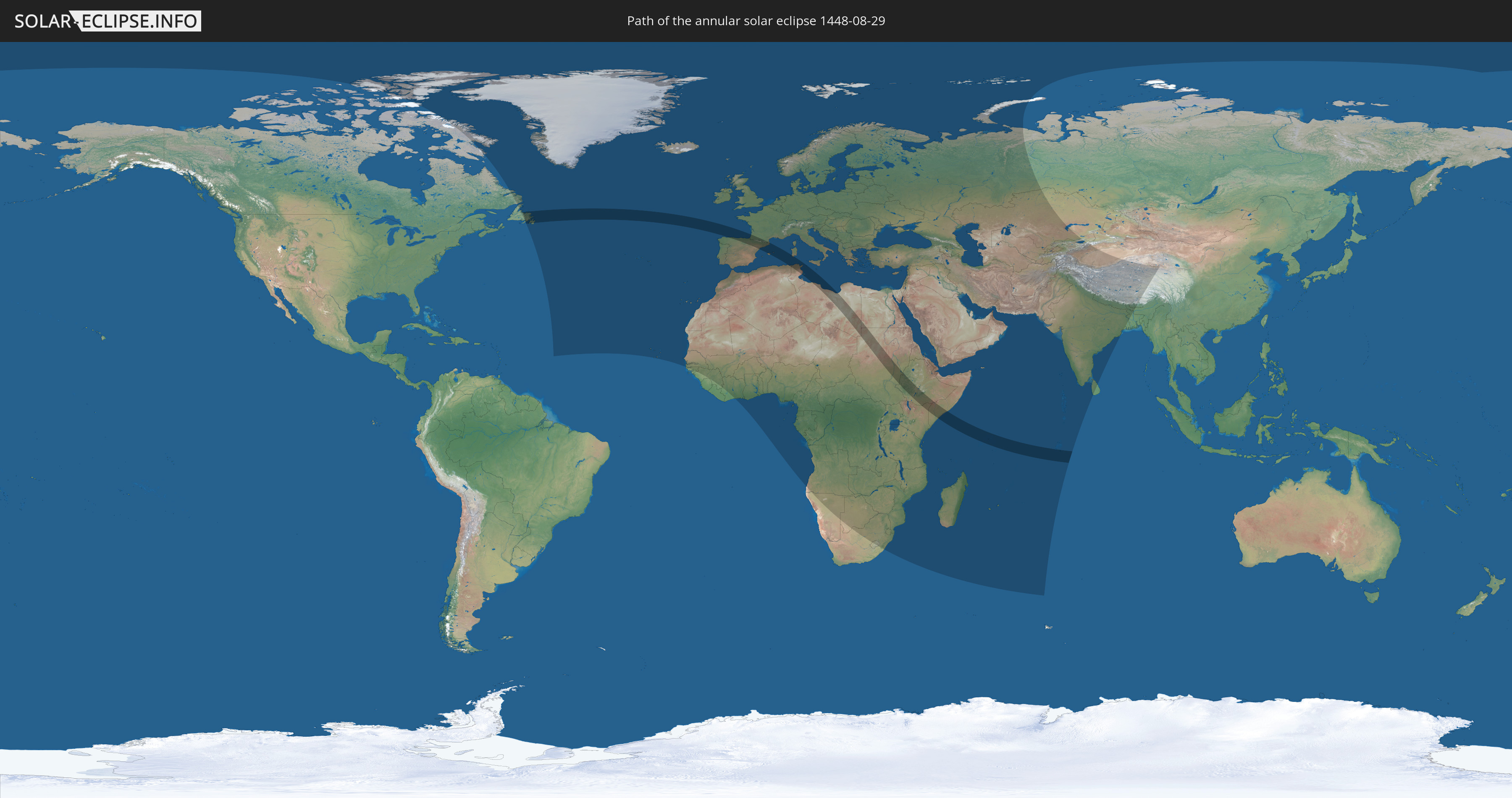
Die Sonnenfinsternis am 08/29/1448 kann man in 142 Ländern als partielle Sonnenfinsternis beobachten.
Der Finsternispfad verläuft durch 16 Länder. Nur in diesen Ländern ist sie als annular Sonnenfinsternis zu sehen.
In den folgenden Ländern ist die Sonnenfinsternis annular zu sehen
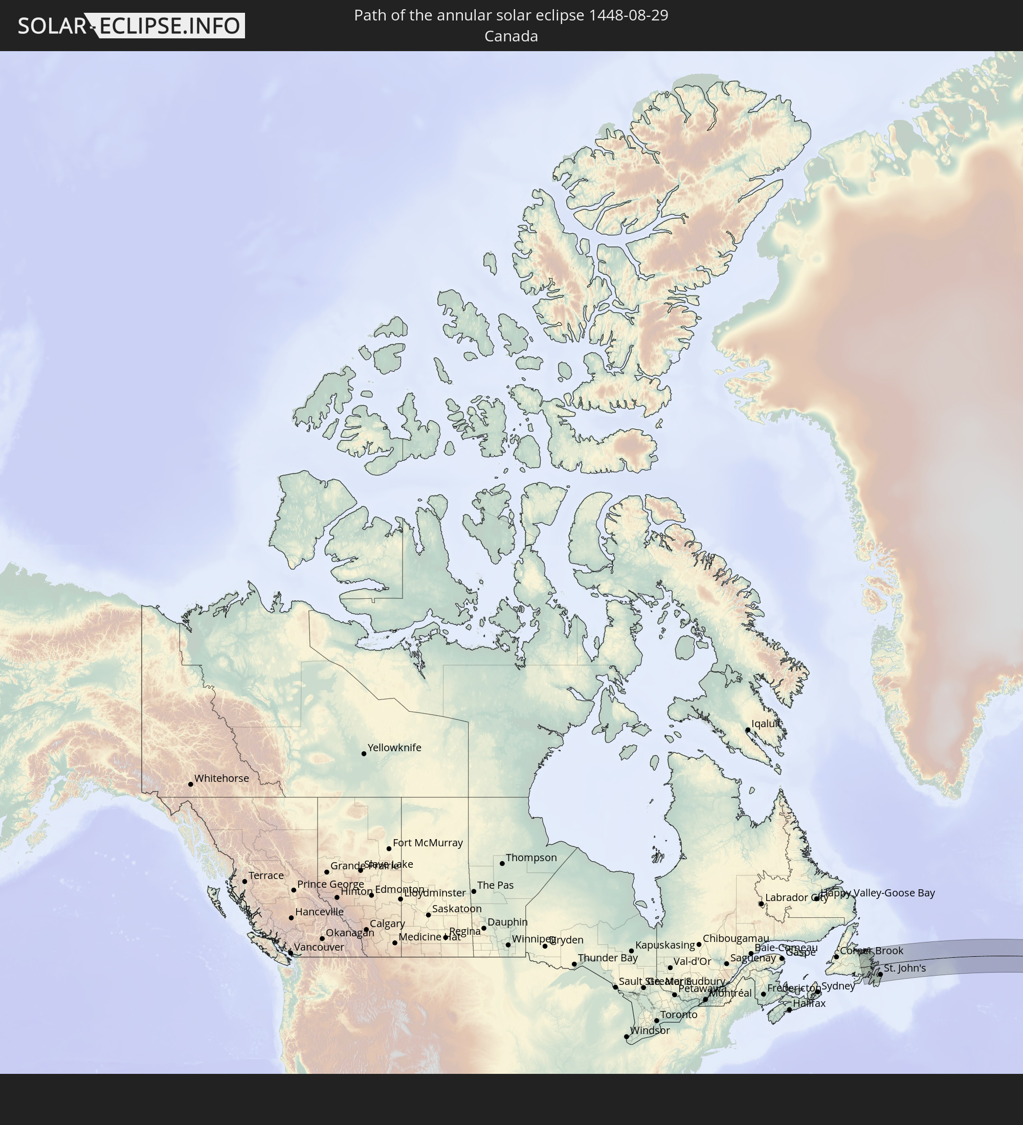 Canada
 Spain
Spain
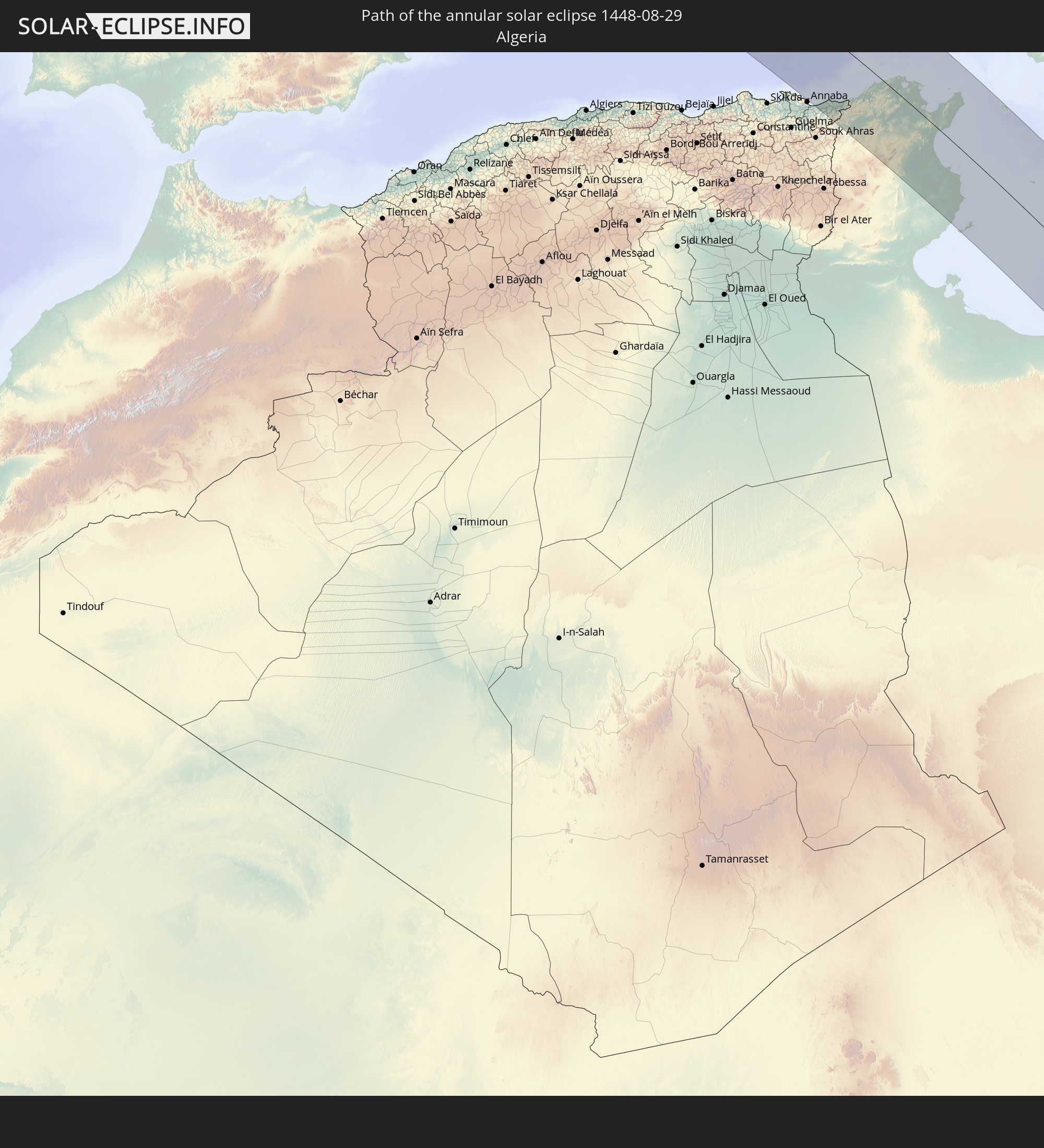 Algeria
 France
 Andorra
 Italy
Italy
 Tunisia
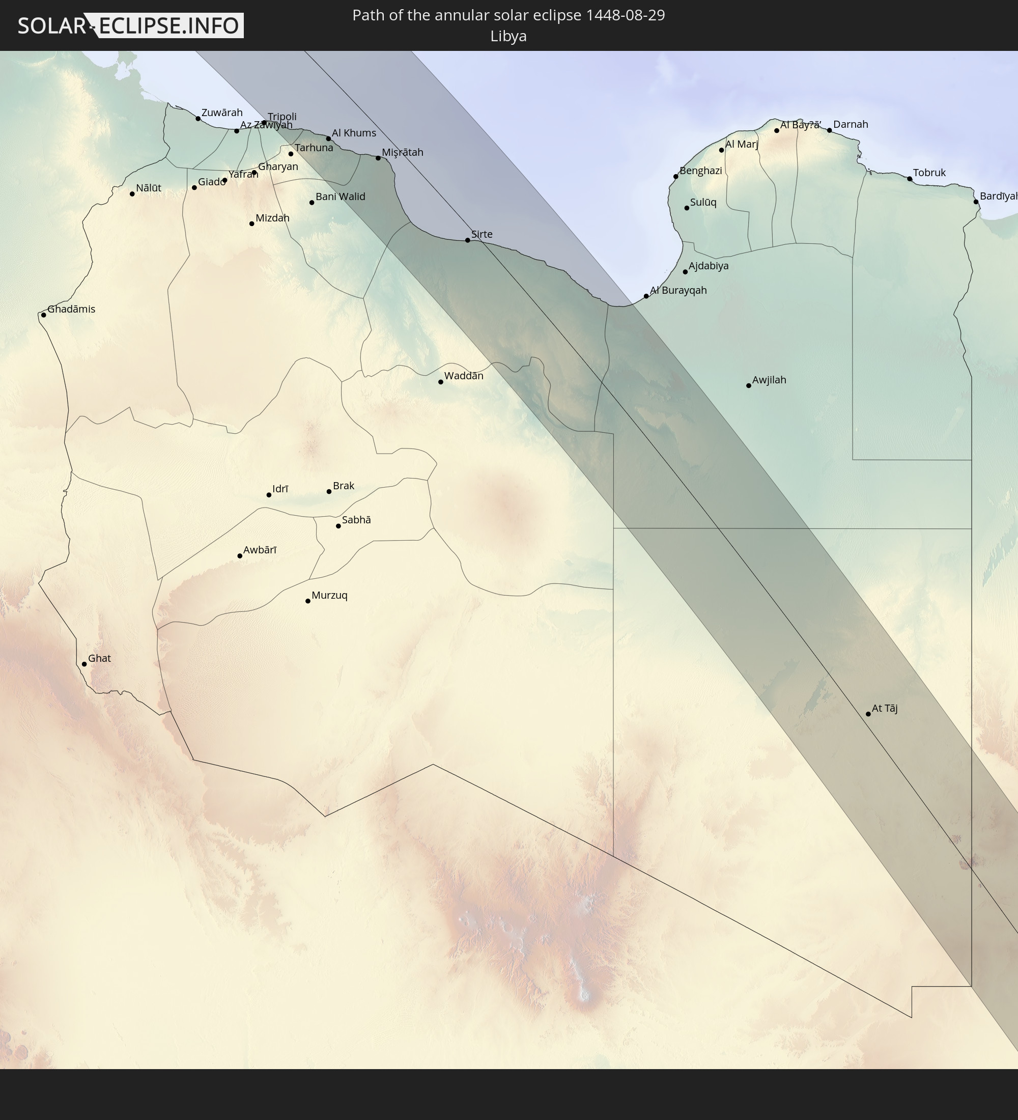 Libya
Libya
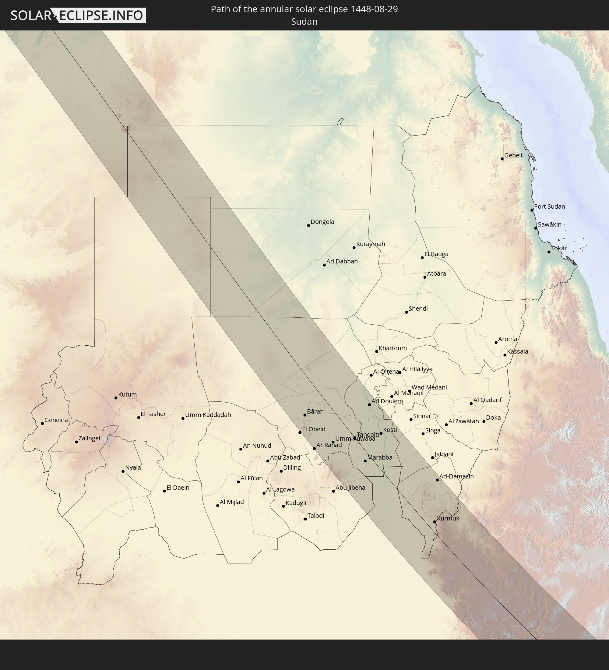 Sudan
Sudan
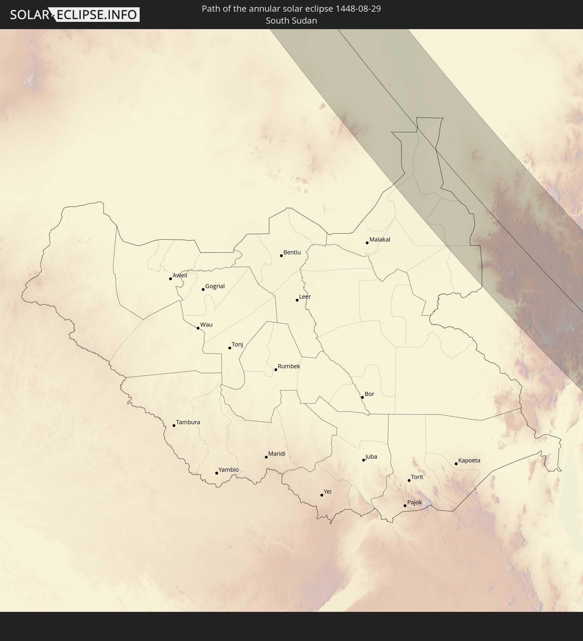 South Sudan
 Egypt
Egypt
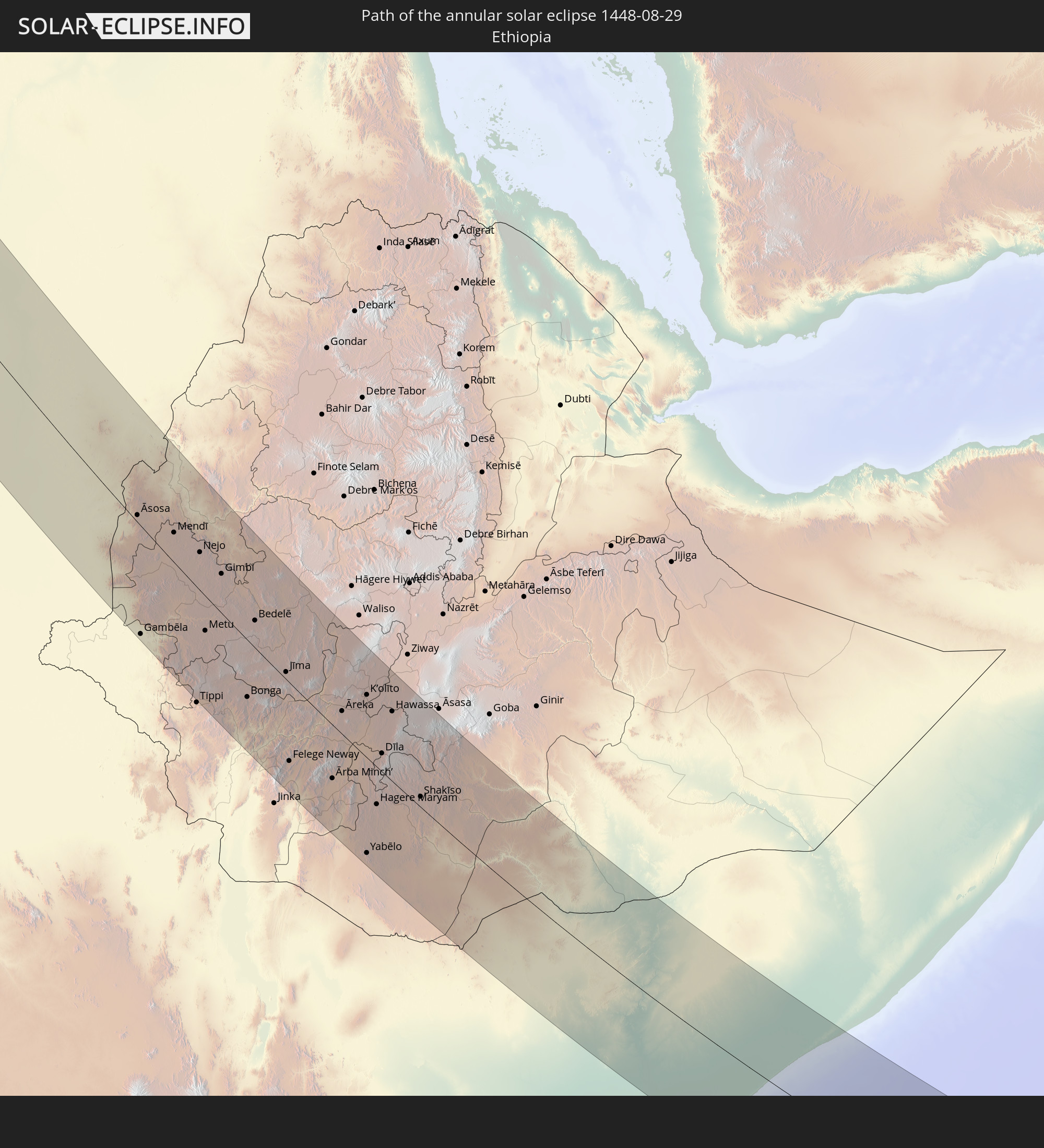 Ethiopia
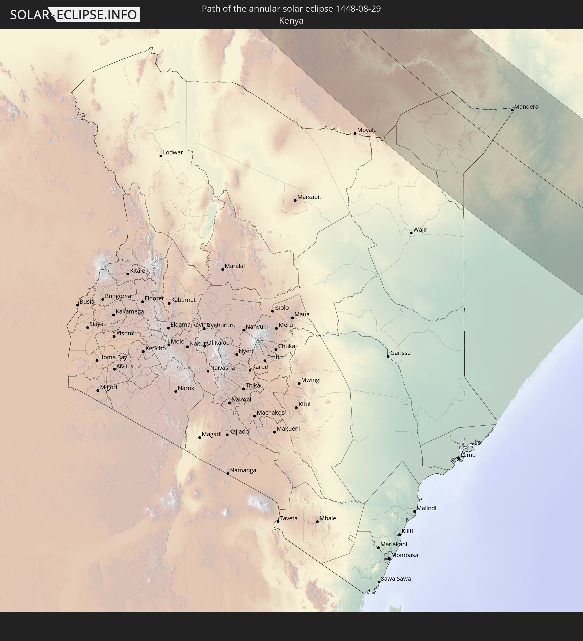 Kenya
Kenya
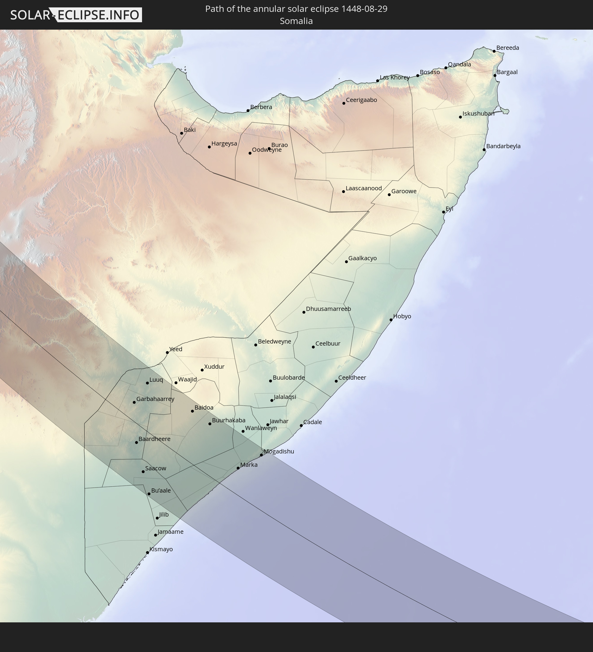 Somalia
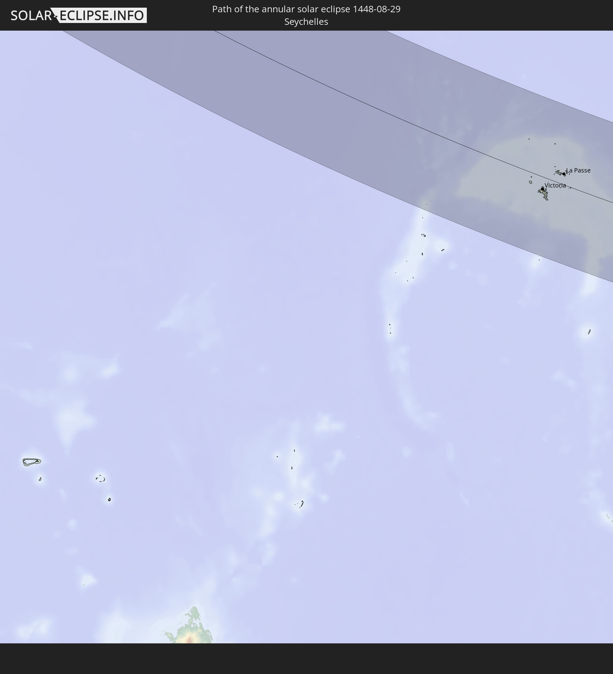 Seychelles
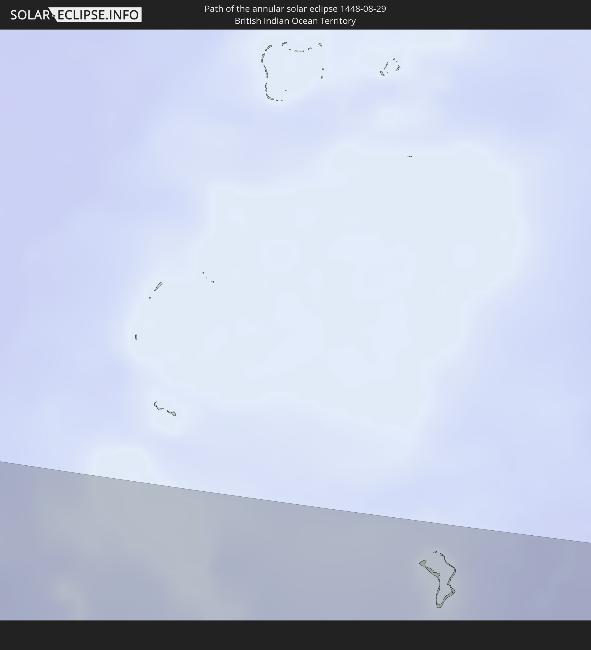 British Indian Ocean Territory
In den folgenden Ländern ist die Sonnenfinsternis partiell zu sehen
 Russia
 Canada
 Greenland
 Portugal
 Cabo Verde
 Iceland
 Spain
Spain
 Senegal
 Mauritania
 The Gambia
 Guinea-Bissau
 Guinea
 Sierra Leone
 Morocco
 Mali
Mali
 Republic of Ireland
 Svalbard and Jan Mayen
 Algeria
 United Kingdom
 Ivory Coast
 Faroe Islands
 Burkina Faso
 Gibraltar
 France
 Isle of Man
 Ghana
Ghana
 Guernsey
 Jersey
 Togo
Togo
 Niger
Niger
 Benin
Benin
 Andorra
 Belgium
 Nigeria
 Netherlands
 Norway
 Equatorial Guinea
 Luxembourg
 Germany
 Switzerland
 São Tomé and Príncipe
 Italy
Italy
 Monaco
 Tunisia
 Denmark
 Cameroon
 Gabon
Gabon
 Libya
Libya
 Liechtenstein
 Austria
 Sweden
 Republic of the Congo
 Angola
 Namibia
 Czechia
 Democratic Republic of the Congo
 San Marino
 Vatican City
 Slovenia
 Chad
Chad
 Croatia
 Poland
 Malta
Malta
 Central African Republic
 Bosnia and Herzegovina
 Hungary
 South Africa
 Slovakia
 Montenegro
 Serbia
 Albania
 Åland Islands
 Greece
 Botswana
 Romania
 Republic of Macedonia
 Finland
 Lithuania
 Latvia
 Estonia
 Sudan
Sudan
 Zambia
 Ukraine
 Bulgaria
 Belarus
 Egypt
Egypt
 Zimbabwe
 Turkey
 Moldova
 Lesotho
 Rwanda
 Burundi
 Tanzania
 Uganda
 Mozambique
 Swaziland
 Cyprus
 Malawi
 Ethiopia
 Kenya
Kenya
 State of Palestine
 Israel
 Saudi Arabia
 Jordan
 Lebanon
 Syria
Syria
 Eritrea
 Iraq
Iraq
 Georgia
 French Southern and Antarctic Lands
 Somalia
 Djibouti
 Yemen
Yemen
 Madagascar
 Comoros
 Armenia
 Iran
Iran
 Azerbaijan
 Mayotte
 Seychelles
 Kazakhstan
 Kuwait
 Bahrain
 Qatar
Qatar
 United Arab Emirates
 Oman
Oman
 Turkmenistan
 Réunion
 Uzbekistan
 Mauritius
 Afghanistan
 Pakistan
 Tajikistan
 India
India
 Kyrgyzstan
 British Indian Ocean Territory
 Maldives
 China
China
 Sri Lanka
 Nepal
Nepal
 Bangladesh
 Bhutan
How will be the weather during the annular solar eclipse on 08/29/1448?
Where is the best place to see the annular solar eclipse of 08/29/1448?
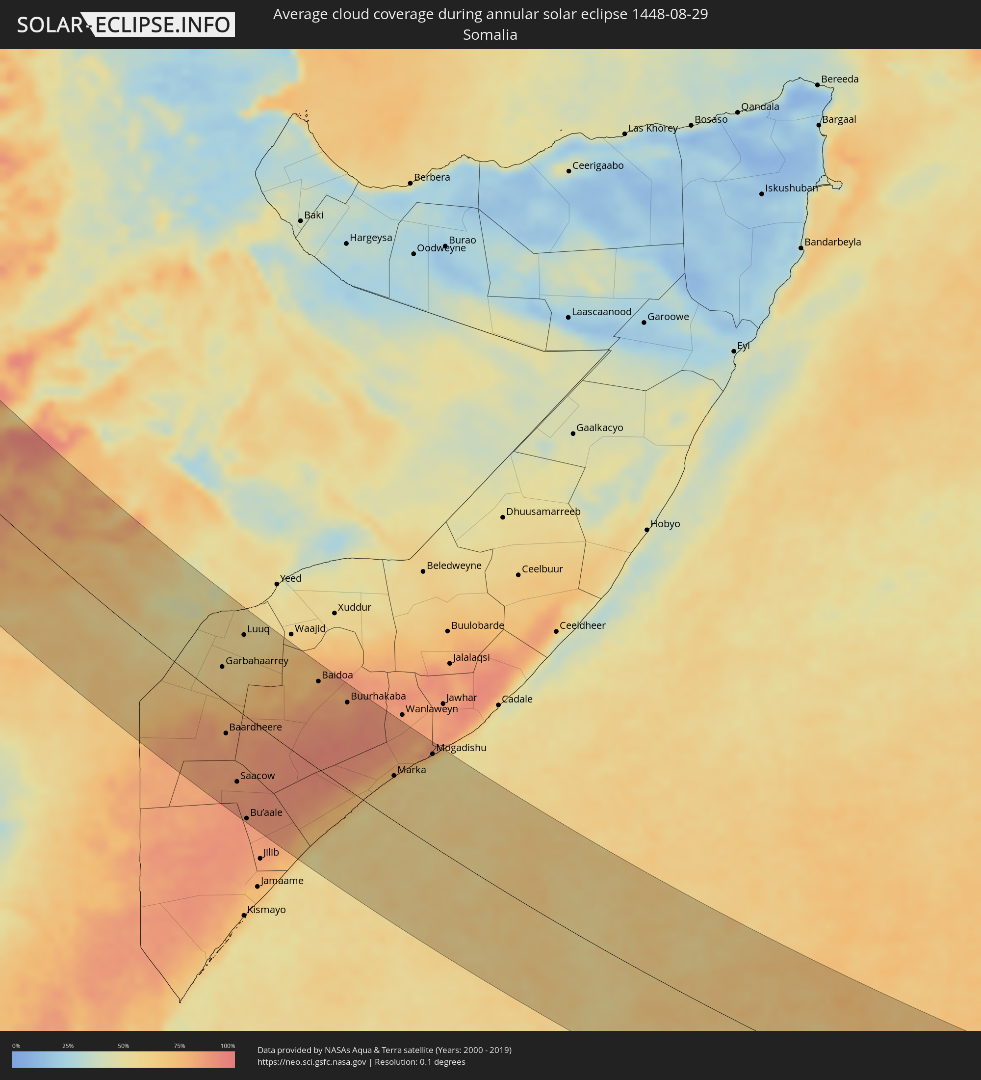
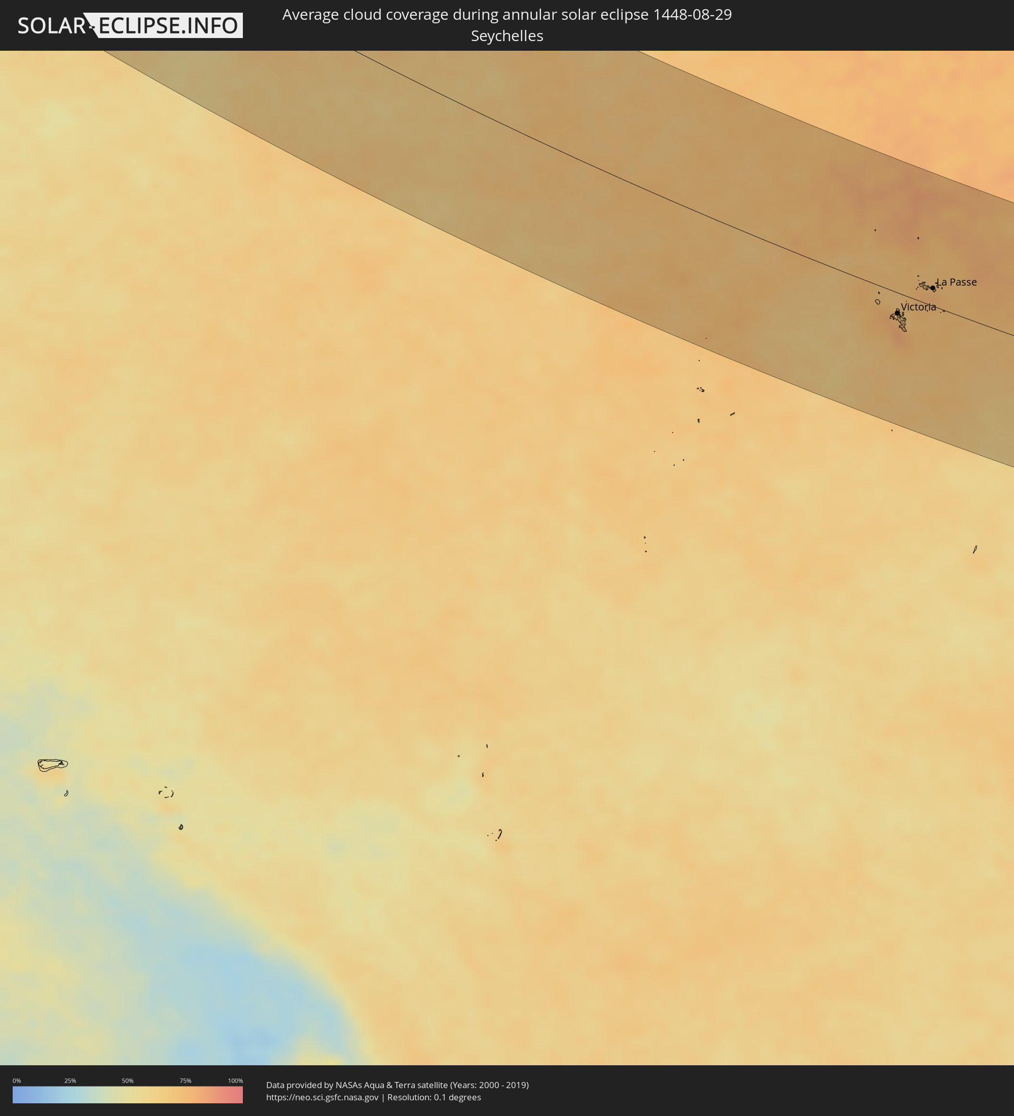
The following maps show the average cloud coverage for the day of the annular solar eclipse.
With the help of these maps, it is possible to find the place along the eclipse path, which has the best
chance of a cloudless sky.
Nevertheless, you should consider local circumstances and inform about the weather of your chosen
observation site.
The data is provided by NASAs satellites
AQUA and TERRA.
The cloud maps are averaged over a period of 19 years (2000 - 2019).
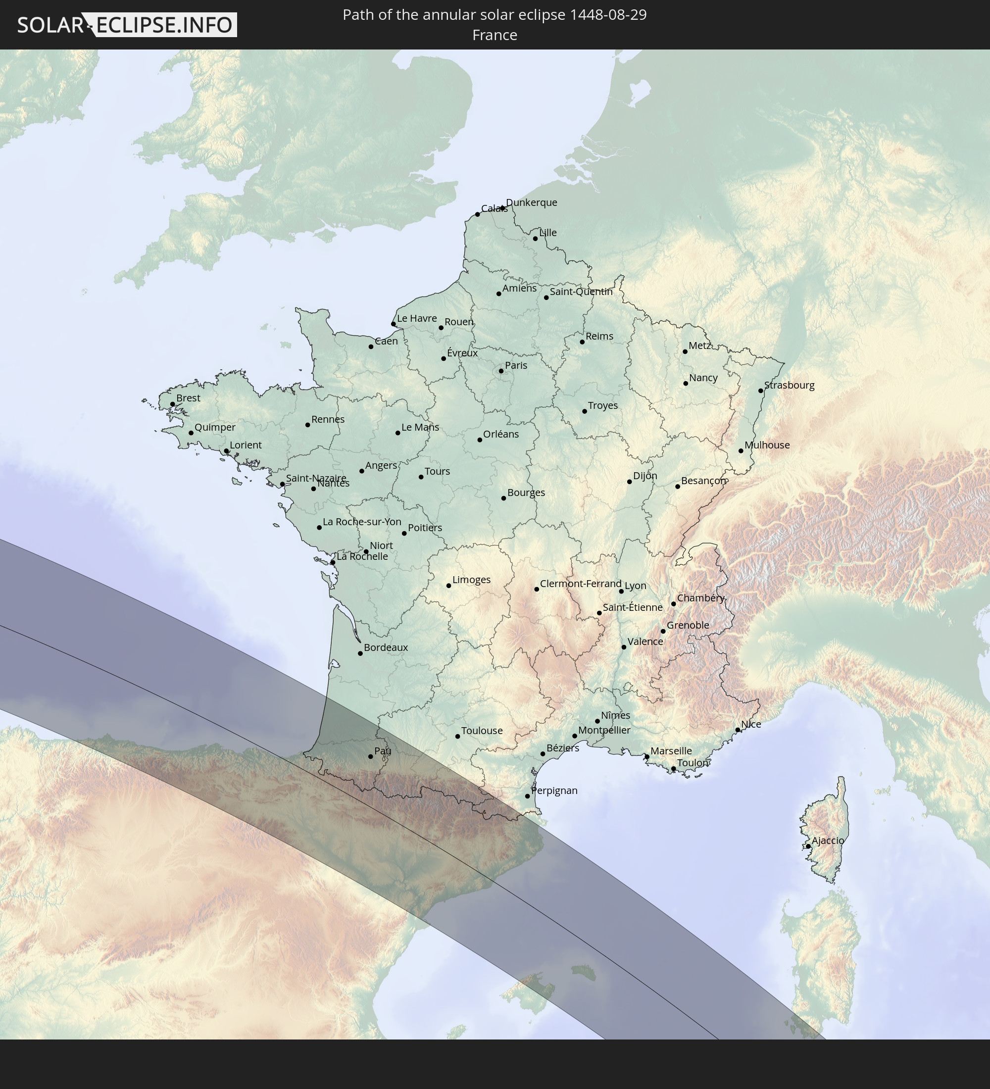
Detailed country maps
 Canada
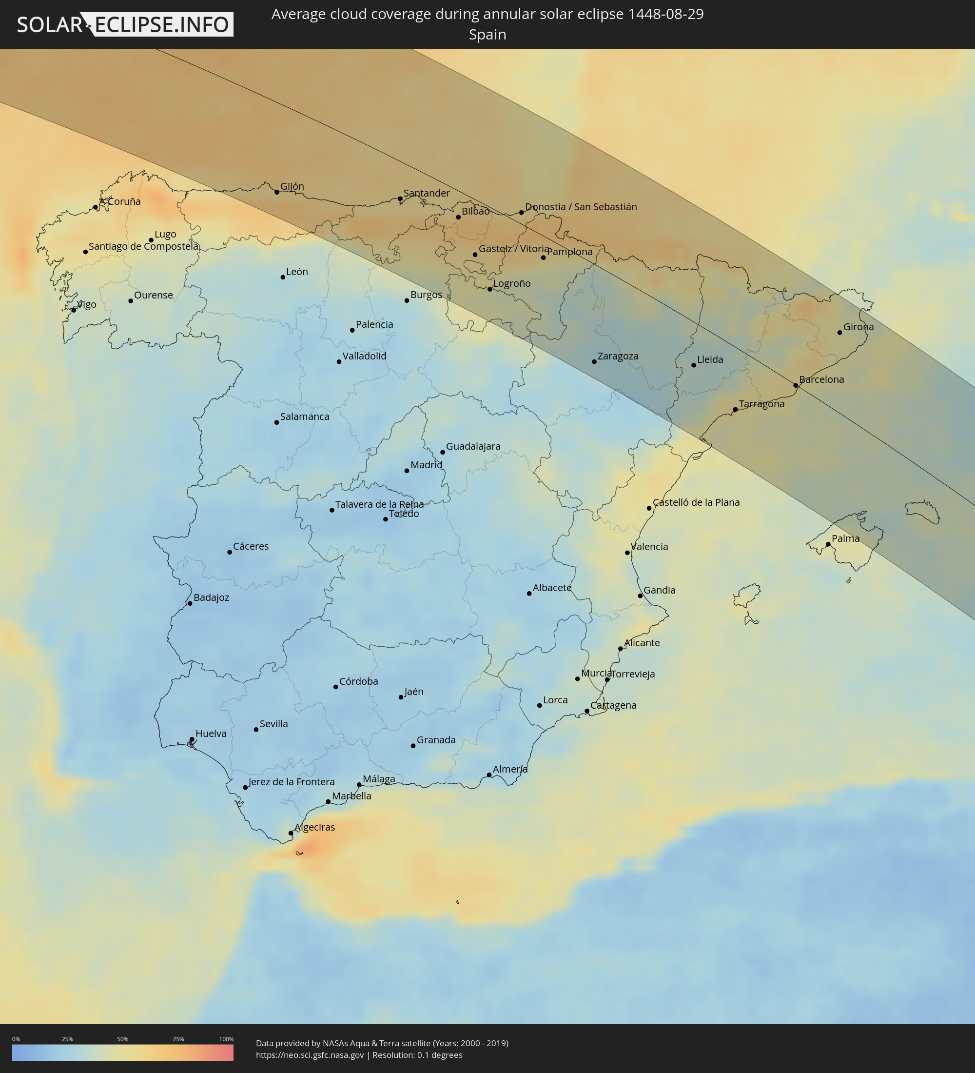 Spain
Spain
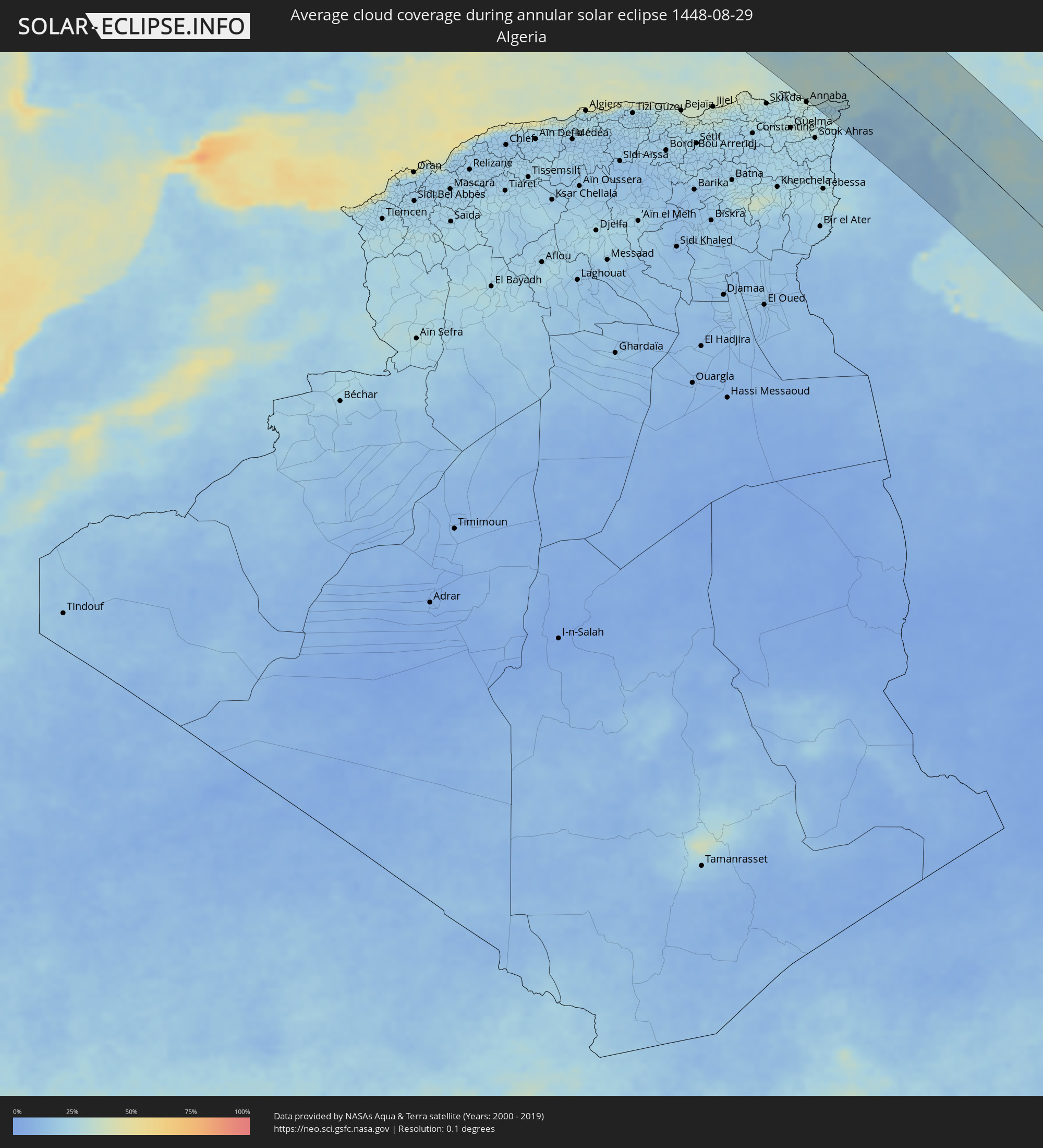 Algeria
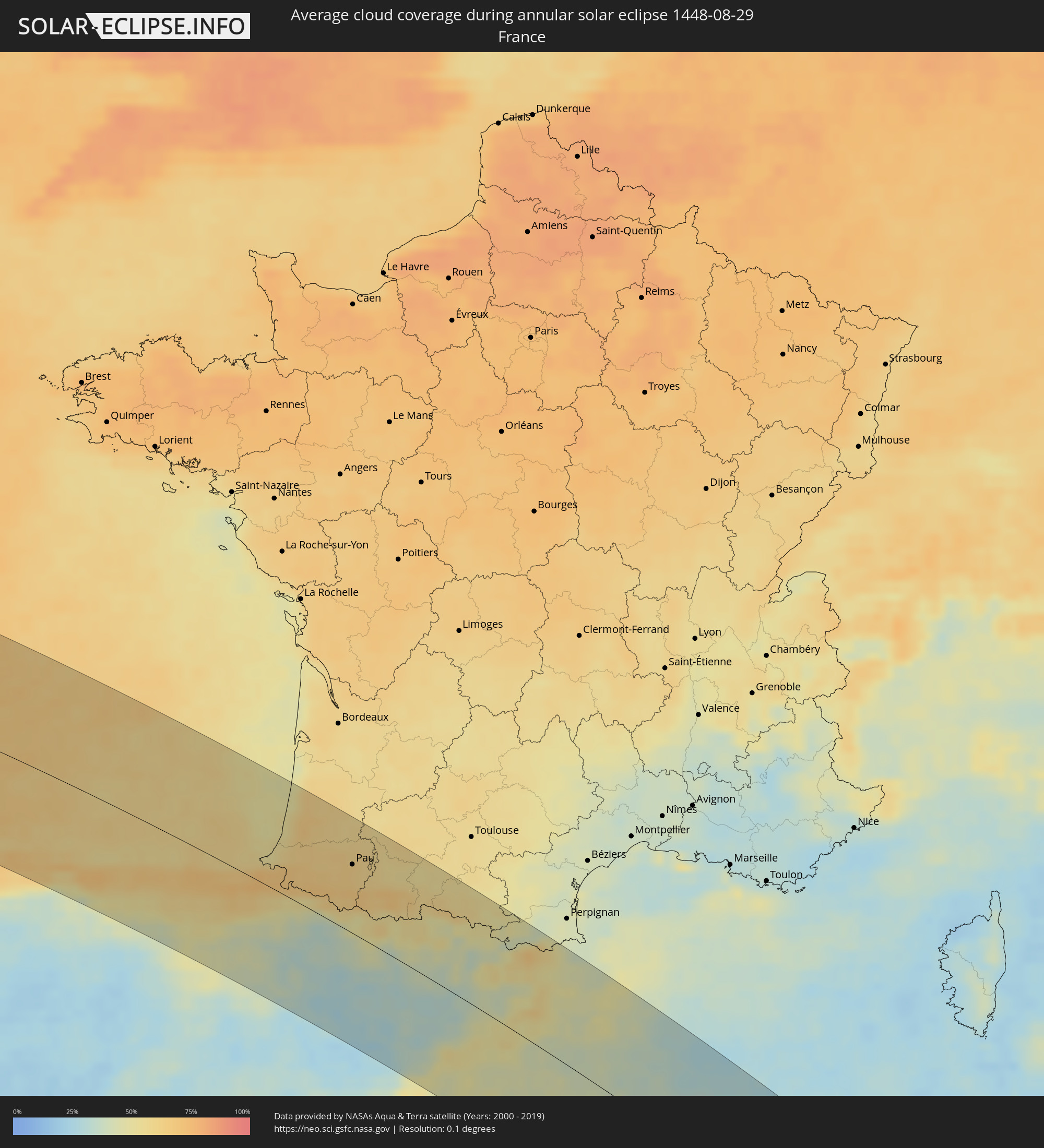 France
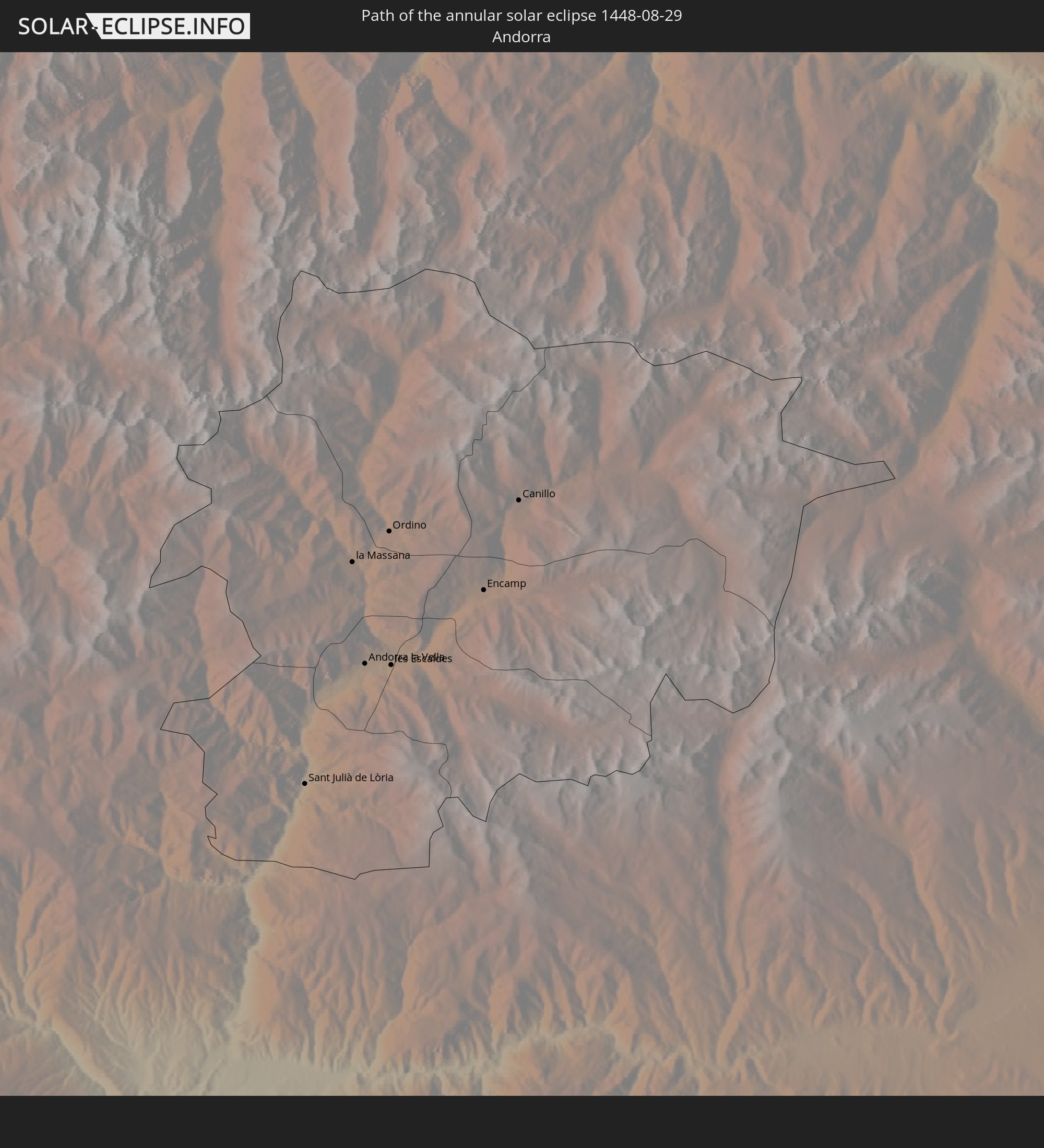
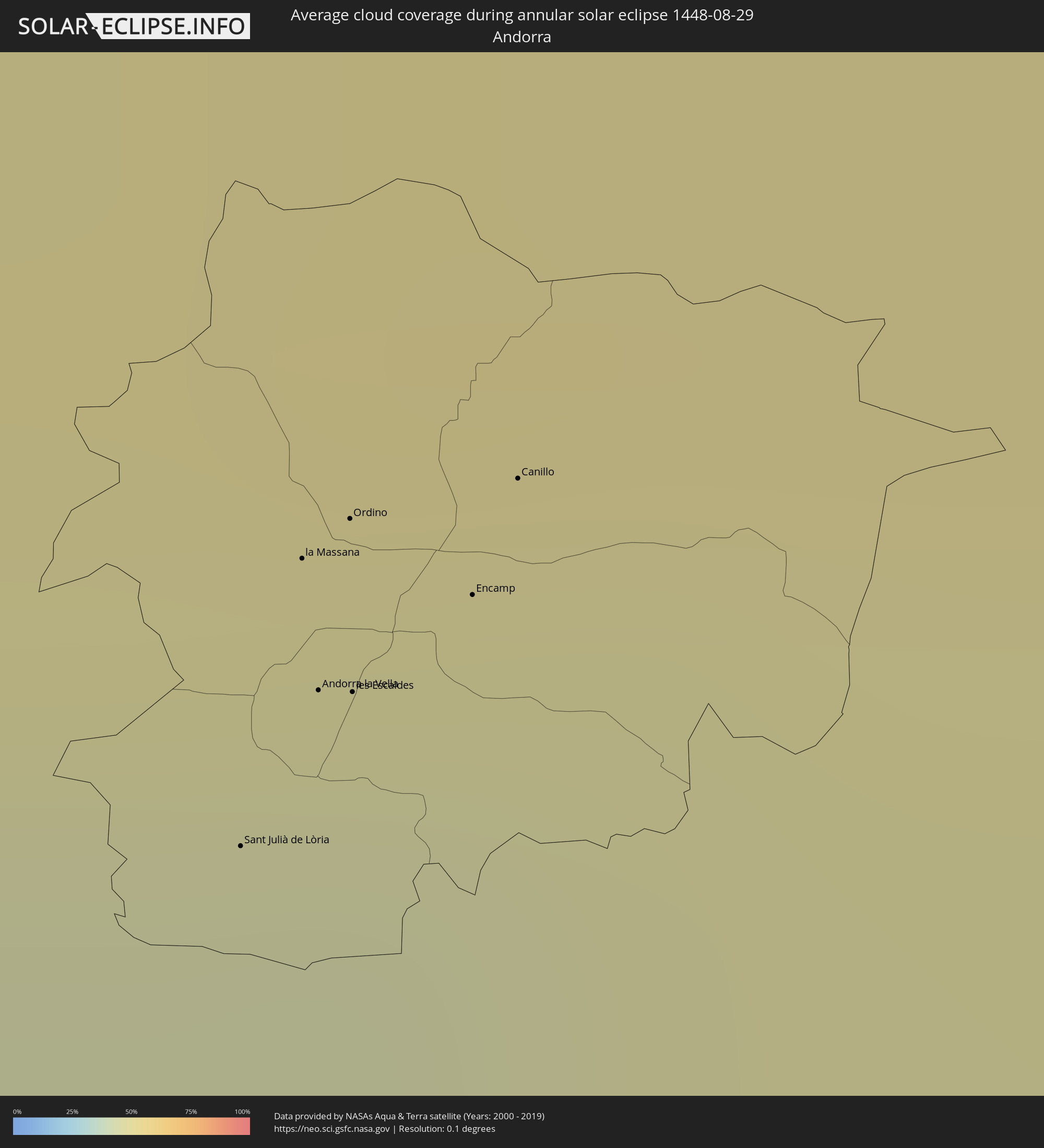 Andorra
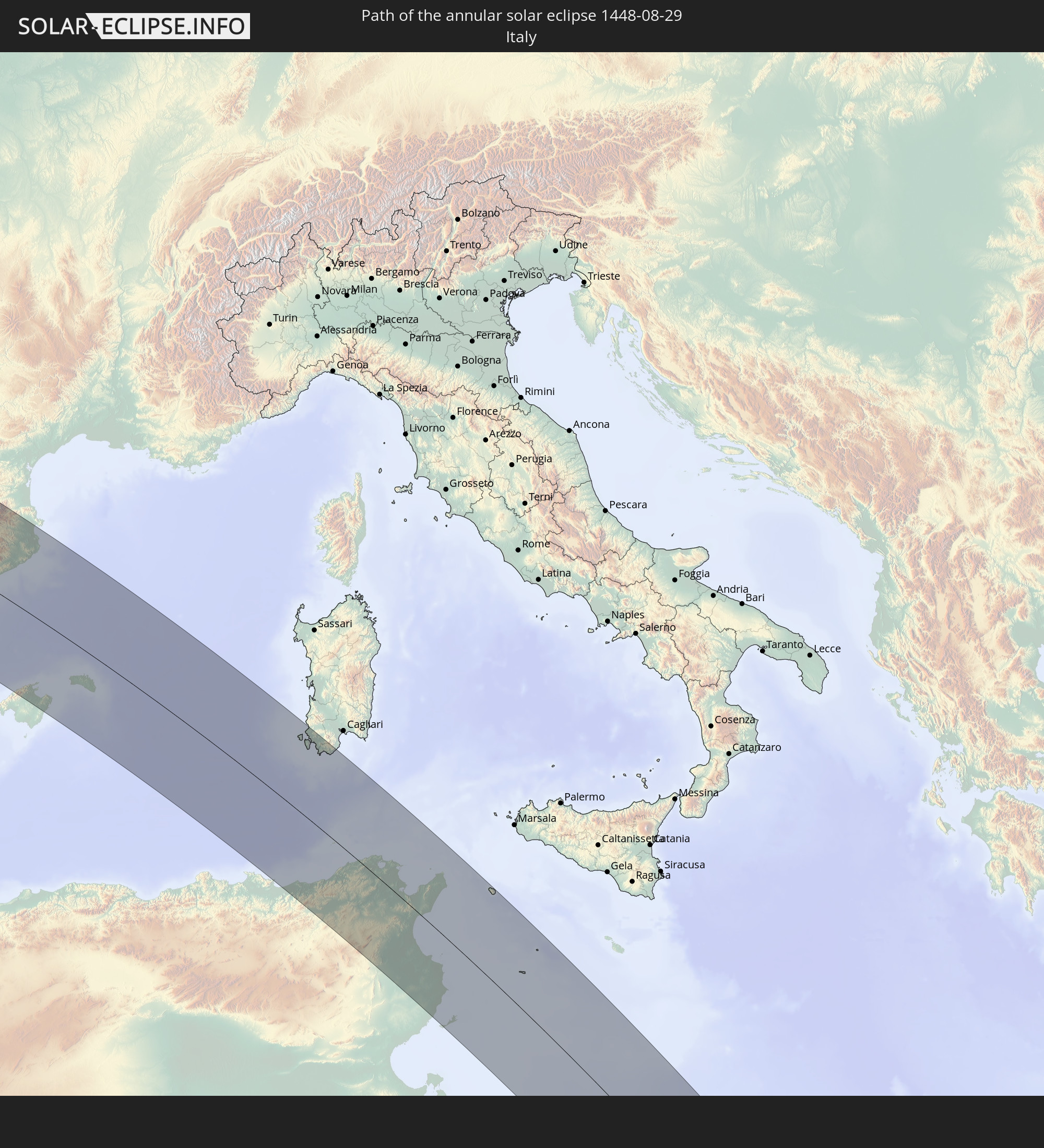
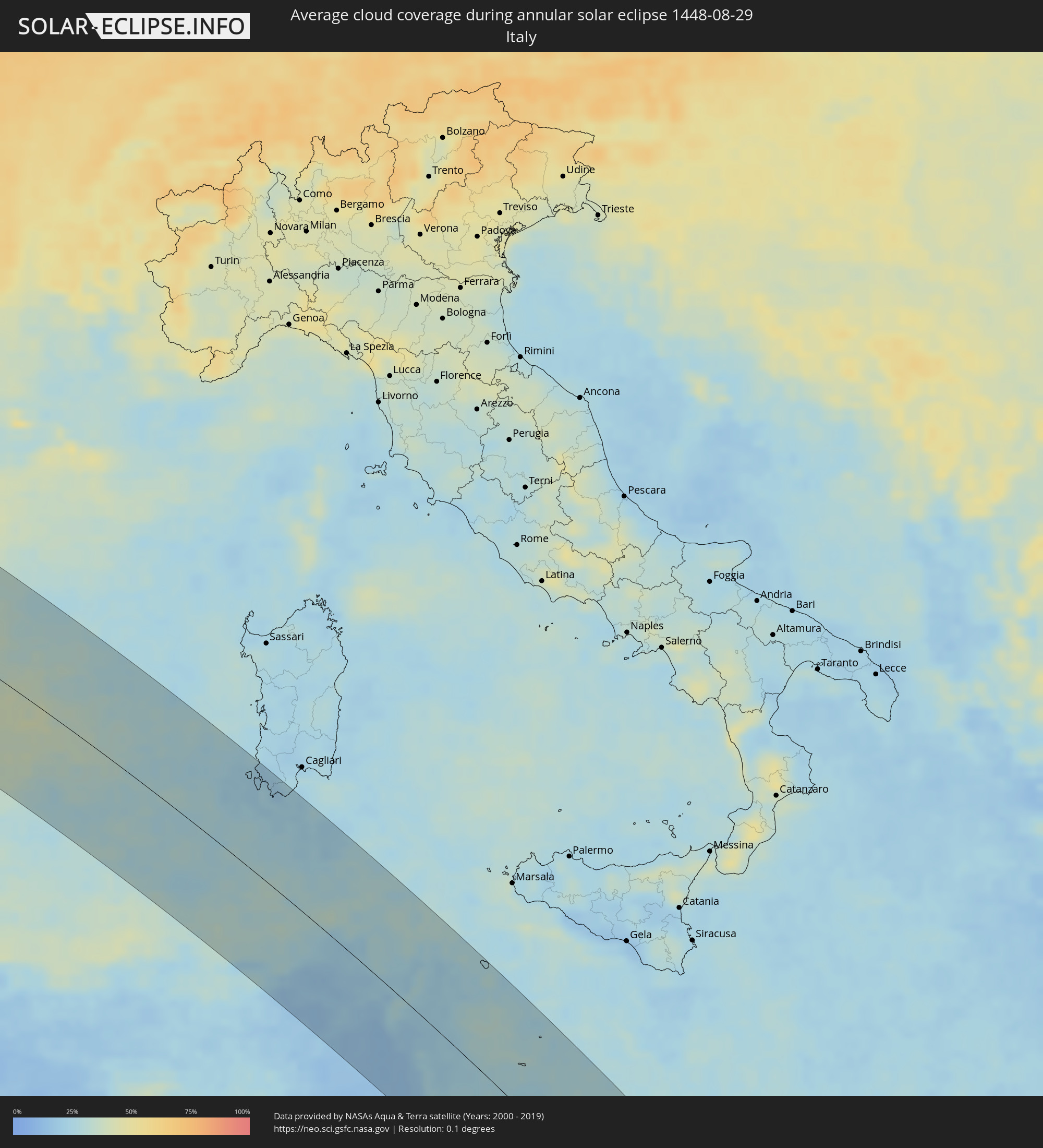 Italy
Italy
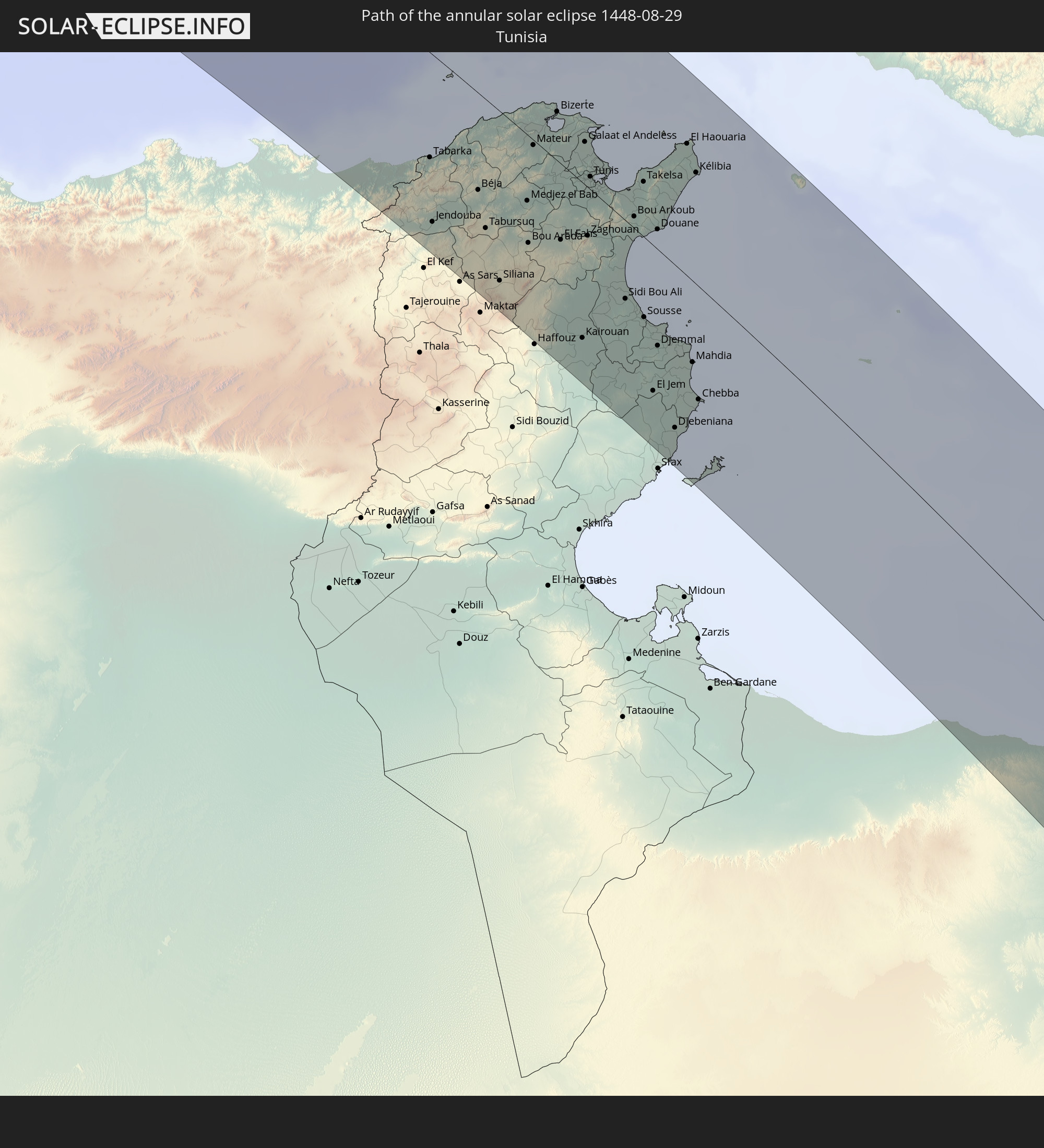
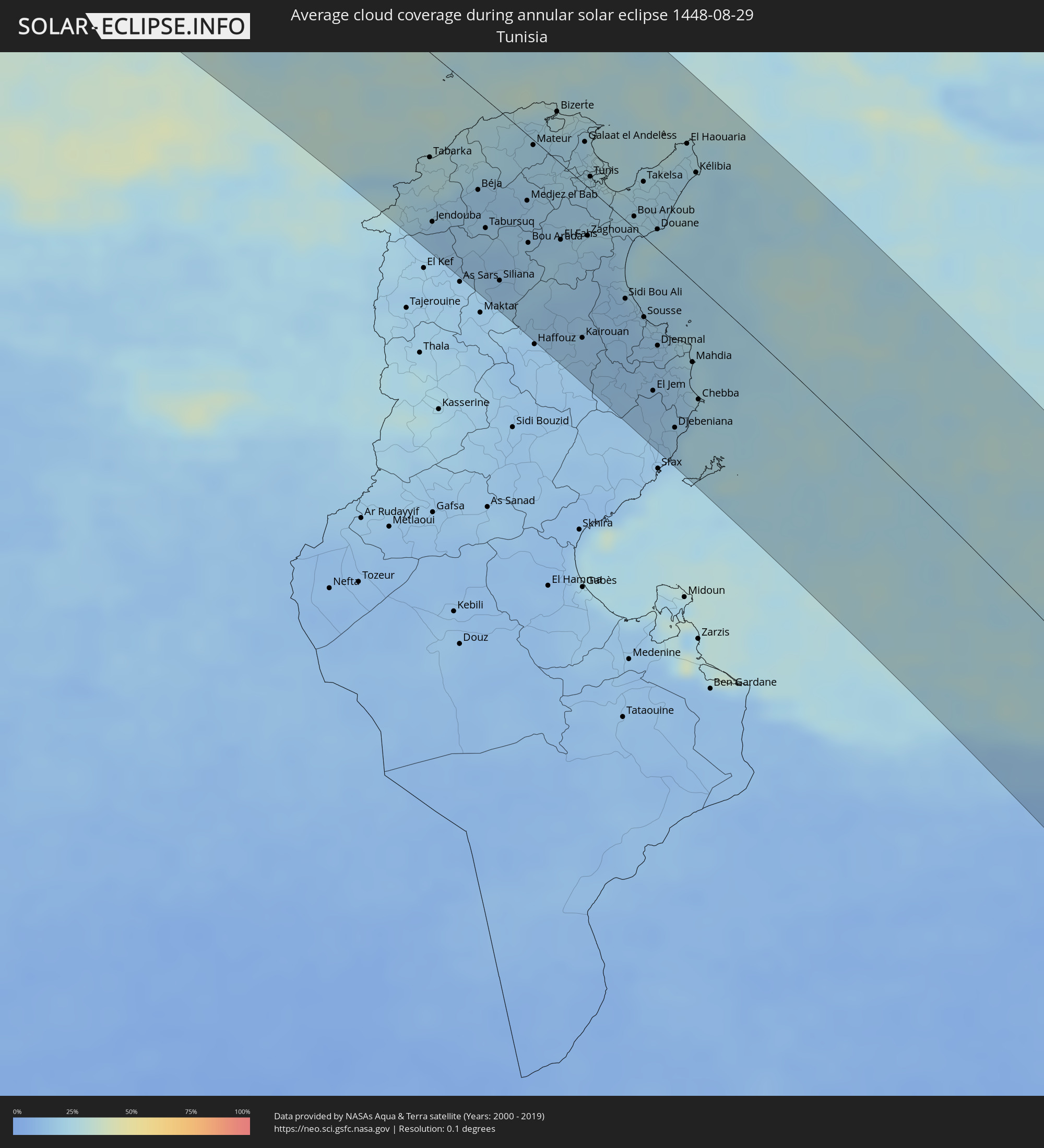 Tunisia
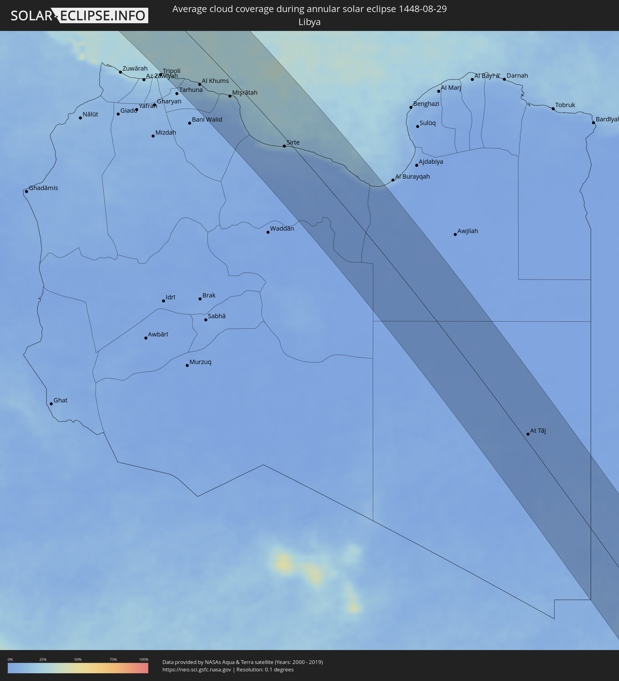 Libya
Libya
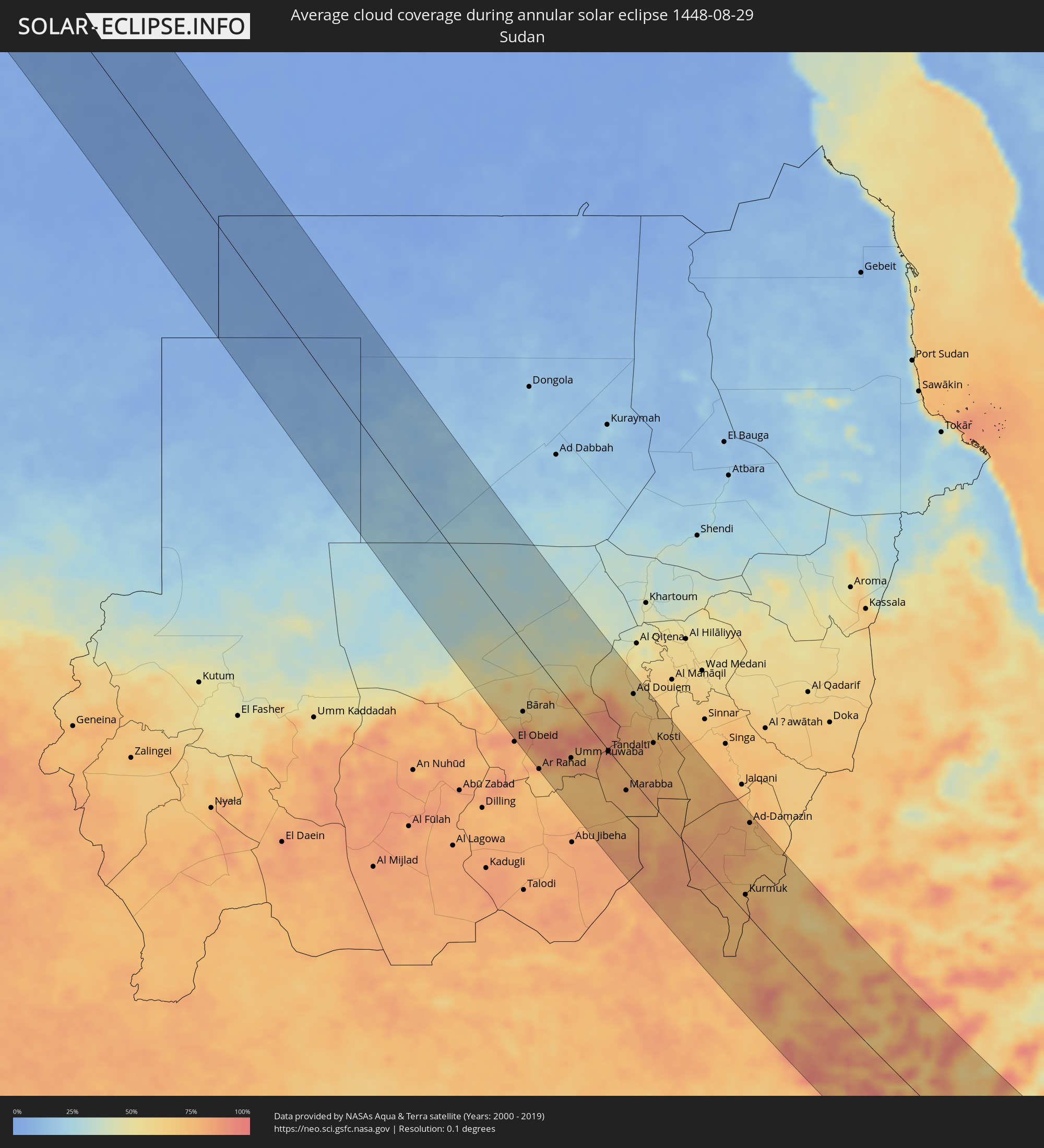 Sudan
Sudan
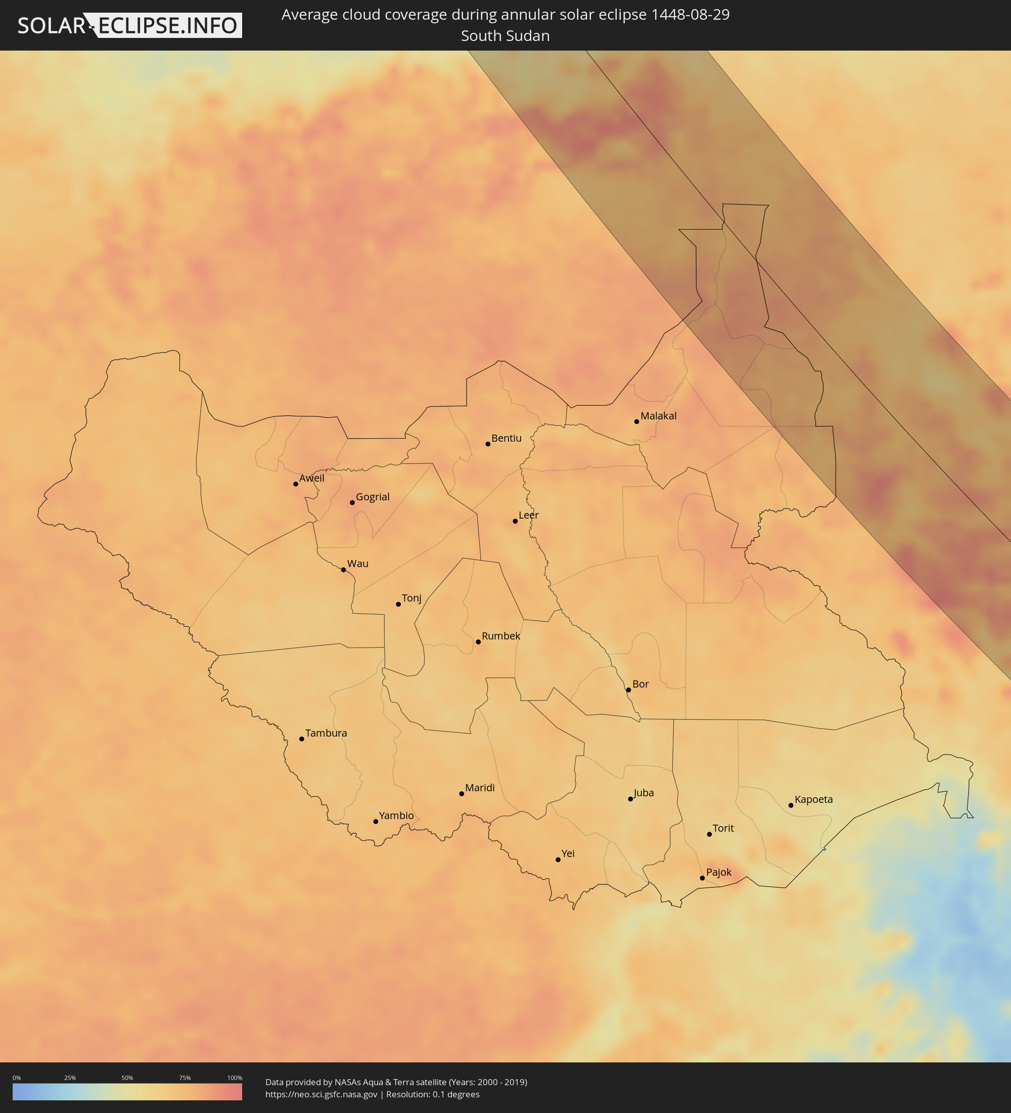 South Sudan
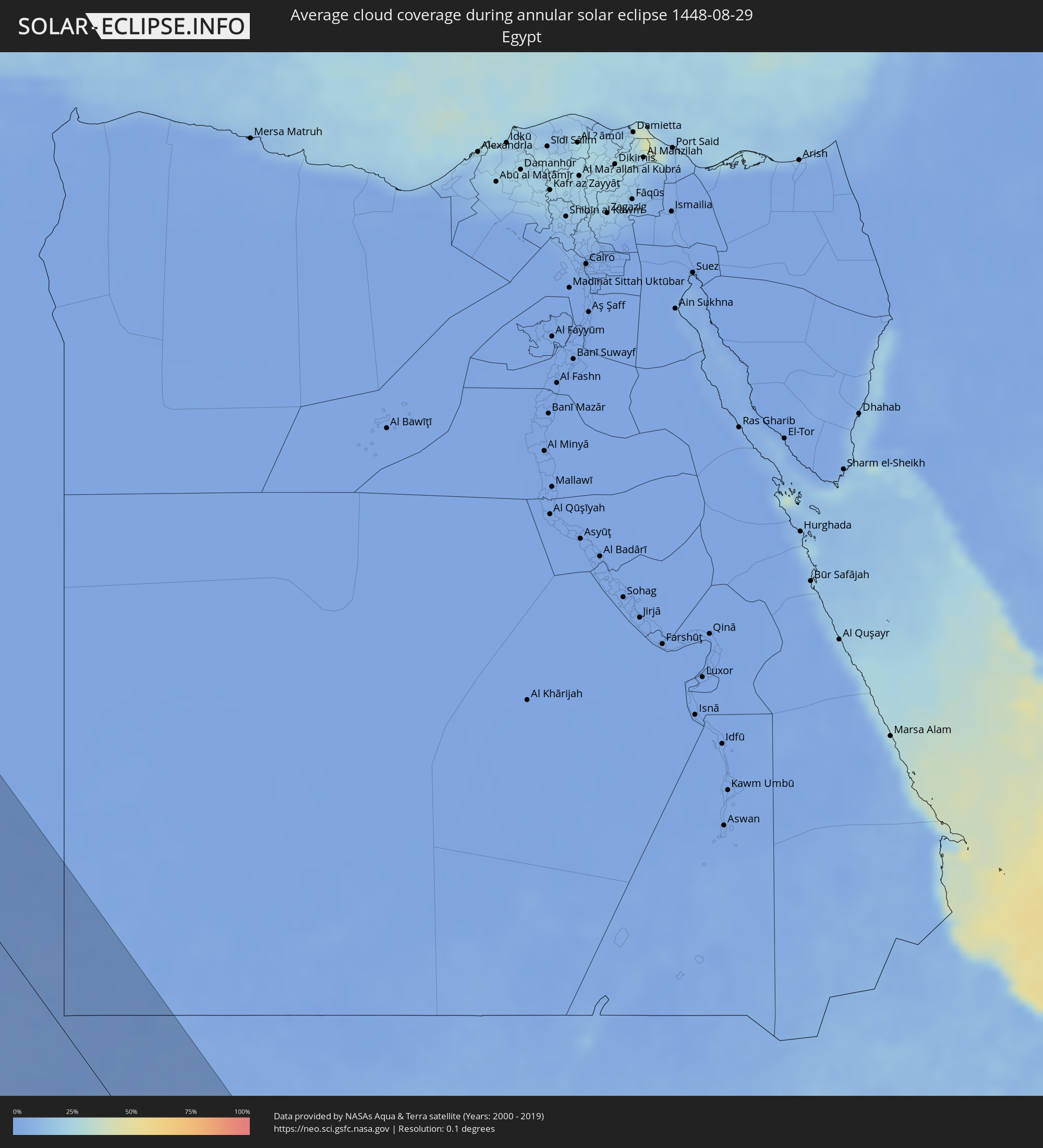 Egypt
Egypt
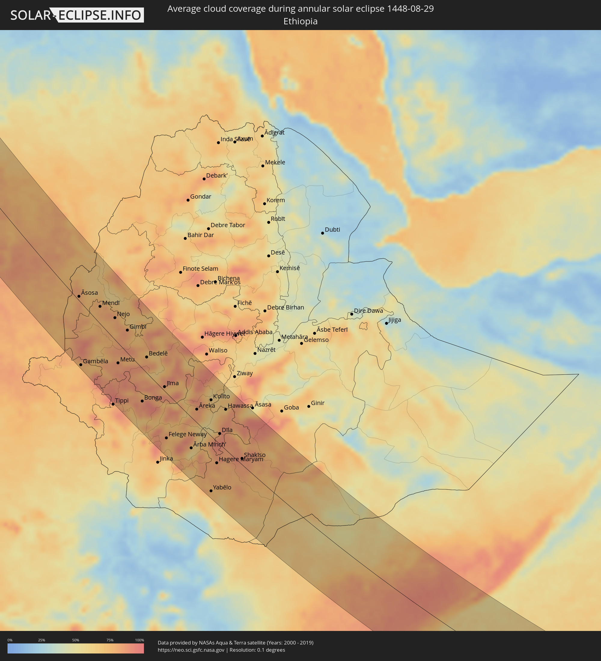 Ethiopia
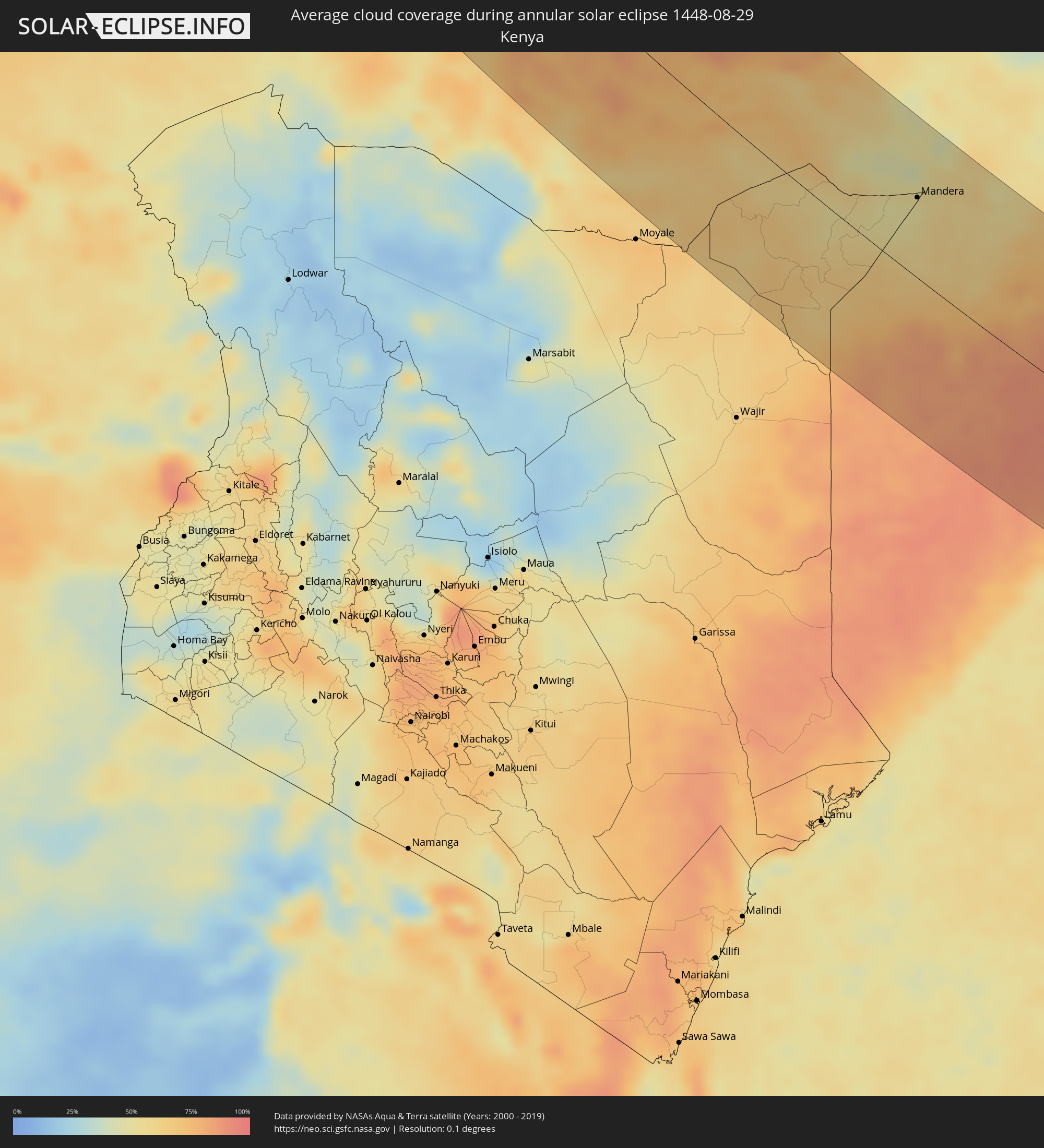 Kenya
Kenya
 Somalia
 Seychelles
 British Indian Ocean Territory
Cities inside the path of the eclipse
The following table shows all locations with a population of more than 5,000 inside the eclipse path. Cities which have more than 100,000 inhabitants are marked bold. A click at the locations opens a detailed map.
| City | Type | Eclipse duration | Local time of max. eclipse | Distance to central line | Ø Cloud coverage |
|
Bay Roberts, Newfoundland and Labrador
|
annular | - | 05:40:04 UTC-03:30 | 82 km | 73% |
|
Carbonear, Newfoundland and Labrador
|
annular | - | 05:40:10 UTC-03:30 | 68 km | 75% |
|
Conception Bay South, Newfoundland and Labrador
|
annular | - | 05:39:58 UTC-03:30 | 96 km | 72% |
|
Mount Pearl, Newfoundland and Labrador
|
annular | - | 05:39:59 UTC-03:30 | 96 km | 71% |
|
St. John's, Newfoundland and Labrador
|
annular | - | 05:40:01 UTC-03:30 | 91 km | 72% |
|
Avilés, Asturias
|
annular | - | 09:38:33 UTC+00:00 | 106 km | 60% |
|
Oviedo, Asturias
|
annular | - | 09:38:43 UTC+00:00 | 123 km | 68% |
|
Gijón, Asturias
|
annular | - | 09:38:54 UTC+00:00 | 99 km | 65% |
|
Santander, Cantabria
|
annular | - | 09:41:25 UTC+00:00 | 41 km | 56% |
|
Bilbao, Basque Country
|
annular | - | 09:42:42 UTC+00:00 | 29 km | 67% |
|
Gasteiz / Vitoria, Basque Country
|
annular | - | 09:43:15 UTC+00:00 | 60 km | 54% |
|
Logroño, La Rioja
|
annular | - | 09:43:46 UTC+00:00 | 89 km | 43% |
|
Donostia / San Sebastián, Basque Country
|
annular | - | 09:44:00 UTC+00:00 | 12 km | 65% |
|
Saint-Jean-de-Luz, Nouvelle-Aquitaine
|
annular | - | 09:53:45 UTC+00:09 | 31 km | 61% |
|
Pamplona, Navarre
|
annular | - | 09:44:43 UTC+00:00 | 24 km | 47% |
|
Bayonne, Nouvelle-Aquitaine
|
annular | - | 09:53:57 UTC+00:09 | 48 km | 55% |
|
Boucau, Nouvelle-Aquitaine
|
annular | - | 09:53:57 UTC+00:09 | 53 km | 55% |
|
Capbreton, Nouvelle-Aquitaine
|
annular | - | 09:53:57 UTC+00:09 | 65 km | 55% |
|
Dax, Nouvelle-Aquitaine
|
annular | - | 09:54:26 UTC+00:09 | 86 km | 62% |
|
Zaragoza, Aragon
|
annular | - | 09:46:32 UTC+00:00 | 106 km | 30% |
|
Orthez, Nouvelle-Aquitaine
|
annular | - | 09:54:56 UTC+00:09 | 76 km | 62% |
|
Oloron-Sainte-Marie, Nouvelle-Aquitaine
|
annular | - | 09:55:20 UTC+00:09 | 54 km | 64% |
|
Mourenx, Nouvelle-Aquitaine
|
annular | - | 09:55:15 UTC+00:09 | 73 km | 62% |
|
Saint-Pierre-du-Mont, Nouvelle-Aquitaine
|
annular | - | 09:55:05 UTC+00:09 | 124 km | 58% |
|
Jurançon, Nouvelle-Aquitaine
|
annular | - | 09:55:36 UTC+00:09 | 72 km | 62% |
|
Pau, Nouvelle-Aquitaine
|
annular | - | 09:55:37 UTC+00:09 | 74 km | 62% |
|
Lourdes, Occitania
|
annular | - | 09:56:11 UTC+00:09 | 67 km | 64% |
|
Tarbes, Occitania
|
annular | - | 09:56:18 UTC+00:09 | 86 km | 61% |
|
Bagnères-de-Bigorre, Occitania
|
annular | - | 09:56:30 UTC+00:09 | 72 km | 67% |
|
Lleida, Catalonia
|
annular | - | 09:48:48 UTC+00:00 | 47 km | 32% |
|
Saint-Gaudens, Occitania
|
annular | - | 09:57:18 UTC+00:09 | 101 km | 57% |
|
Tarragona, Catalonia
|
annular | - | 09:50:08 UTC+00:00 | 67 km | 48% |
|
Sant Julià de Lòria, Sant Julià de Loria
|
annular | - | 09:49:30 UTC+00:00 | 71 km | 44% |
|
la Massana, La Massana
|
annular | - | 09:49:28 UTC+00:00 | 80 km | 44% |
|
Andorra la Vella, Andorra la Vella
|
annular | - | 09:49:31 UTC+00:00 | 77 km | 44% |
|
Ordino, Ordino
|
annular | - | 09:49:30 UTC+00:00 | 82 km | 48% |
|
les Escaldes, Escaldes-Engordany
|
annular | - | 09:49:32 UTC+00:00 | 77 km | 44% |
|
Encamp, Encamp
|
annular | - | 09:49:35 UTC+00:00 | 82 km | 47% |
|
Canillo, Canillo
|
annular | - | 09:49:35 UTC+00:00 | 86 km | 48% |
|
Foix, Occitania
|
annular | - | 09:58:40 UTC+00:09 | 124 km | 53% |
|
Terrassa, Catalonia
|
annular | - | 09:50:57 UTC+00:00 | 9 km | 52% |
|
Barcelona, Catalonia
|
annular | - | 09:51:18 UTC+00:00 | 1 km | 47% |
|
Mataró, Catalonia
|
annular | - | 09:51:37 UTC+00:00 | 26 km | 48% |
|
Girona, Catalonia
|
annular | - | 09:51:51 UTC+00:00 | 85 km | 49% |
|
Carloforte, Sardinia
|
annular | - | 11:03:27 UTC+01:00 | 100 km | 22% |
|
El Tarf, El Tarf
|
annular | - | 10:15:53 UTC+00:09 | 104 km | 25% |
|
El Kala, El Tarf
|
annular | - | 10:15:56 UTC+00:09 | 86 km | 21% |
|
Sant'Antioco, Sardinia
|
annular | - | 11:03:47 UTC+01:00 | 102 km | 23% |
|
Carbonia, Sardinia
|
annular | - | 11:03:47 UTC+01:00 | 114 km | 19% |
|
Jendouba, Jundūbah
|
annular | - | 10:17:05 UTC+00:09 | 100 km | 16% |
|
Béja, Bājah
|
annular | - | 10:17:29 UTC+00:09 | 58 km | 17% |
|
Menzel Bourguiba, Banzart
|
annular | - | 10:17:56 UTC+00:09 | 14 km | 25% |
|
Bizerte, Banzart
|
annular | - | 10:17:55 UTC+00:09 | 29 km | 29% |
|
Kairouan, Al Qayrawān
|
annular | - | 10:20:39 UTC+00:09 | 92 km | 16% |
|
La Mohammedia, Tūnis
|
annular | - | 10:19:16 UTC+00:09 | 5 km | 20% |
|
Tunis, Tūnis
|
annular | - | 10:19:04 UTC+00:09 | 8 km | 23% |
|
Al Marsá, Tūnis
|
annular | - | 10:19:16 UTC+00:09 | 22 km | 28% |
|
Hammam-Lif, Tūnis
|
annular | - | 10:19:31 UTC+00:09 | 10 km | 22% |
|
Sousse, Sūsah
|
annular | - | 10:21:24 UTC+00:09 | 47 km | 16% |
|
Douane, Nābul
|
annular | - | 10:20:40 UTC+00:09 | 12 km | 26% |
|
Djemmal, Al Munastīr
|
annular | - | 10:21:56 UTC+00:09 | 56 km | 16% |
|
Monastir, Al Munastīr
|
annular | - | 10:21:48 UTC+00:09 | 39 km | 17% |
|
Korba, Nābul
|
annular | - | 10:20:39 UTC+00:09 | 29 km | 28% |
|
Mahdia, Al Mahdīyah
|
annular | - | 10:22:40 UTC+00:09 | 48 km | 25% |
|
Kélibia, Nābul
|
annular | - | 10:20:40 UTC+00:09 | 65 km | 25% |
|
Tagiura, Tripoli
|
annular | - | 11:14:44 UTC+00:52 | 112 km | 18% |
|
Masallātah, Al Marqab
|
annular | - | 11:16:26 UTC+00:52 | 89 km | 15% |
|
Al Khums, Al Marqab
|
annular | - | 11:16:52 UTC+00:52 | 68 km | 15% |
|
Zliten, Mişrātah
|
annular | - | 11:17:47 UTC+00:52 | 62 km | 16% |
|
Mişrātah, Mişrātah
|
annular | - | 11:18:56 UTC+00:52 | 33 km | 12% |
|
Sirte, Surt
|
annular | - | 11:24:02 UTC+00:52 | 15 km | 7% |
|
At Tāj, Al Kufrah
|
annular | - | 11:52:36 UTC+00:52 | 13 km | 1% |
|
Al Jawf, Al Kufrah
|
annular | - | 11:52:37 UTC+00:52 | 14 km | 1% |
|
Bārah, North Kordofan
|
annular | - | 13:49:35 UTC+02:10 | 81 km | 66% |
|
Ar Rahad, North Kordofan
|
annular | - | 13:52:34 UTC+02:10 | 125 km | 73% |
|
Umm Ruwaba, North Kordofan
|
annular | - | 13:53:01 UTC+02:10 | 64 km | 78% |
|
Tandaltī, White Nile
|
annular | - | 13:53:48 UTC+02:10 | 2 km | 87% |
|
Marabba, White Nile
|
annular | - | 13:55:59 UTC+02:10 | 22 km | 76% |
|
Wad az Zāki, White Nile
|
annular | - | 13:50:41 UTC+02:10 | 127 km | 62% |
|
Ad Douiem, White Nile
|
annular | - | 13:52:01 UTC+02:10 | 104 km | 63% |
|
Um Jar Al Gharbiyya, White Nile
|
annular | - | 13:52:41 UTC+02:10 | 99 km | 69% |
|
Al Kawa, White Nile
|
annular | - | 13:52:59 UTC+02:10 | 103 km | 70% |
|
Kosti, White Nile
|
annular | - | 13:54:43 UTC+02:10 | 76 km | 75% |
|
Rabak, White Nile
|
annular | - | 13:54:48 UTC+02:10 | 83 km | 75% |
|
Kurmuk, Blue Nile
|
annular | - | 14:03:46 UTC+02:10 | 23 km | 75% |
|
Ad-Damazin, Blue Nile
|
annular | - | 14:00:50 UTC+02:10 | 120 km | 72% |
|
Ar Ruseris, Blue Nile
|
annular | - | 14:00:42 UTC+02:10 | 128 km | 76% |
|
Āsosa, Bīnshangul Gumuz
|
annular | - | 14:22:27 UTC+02:27 | 8 km | 76% |
|
Gambēla, Gambela
|
annular | - | 14:26:54 UTC+02:27 | 124 km | 75% |
|
Metu, Oromiya
|
annular | - | 14:28:15 UTC+02:27 | 41 km | 83% |
|
Gimbi, Oromiya
|
annular | - | 14:26:34 UTC+02:27 | 46 km | 84% |
|
Āgaro, Oromiya
|
annular | - | 14:30:51 UTC+02:27 | 9 km | 76% |
|
Jīma, Oromiya
|
annular | - | 14:31:32 UTC+02:27 | 9 km | 77% |
|
Felege Neway, Southern Nations, Nationalities, and People's Region
|
annular | - | 14:34:44 UTC+02:27 | 96 km | 78% |
|
Ārba Minch’, Southern Nations, Nationalities, and People's Region
|
annular | - | 14:36:15 UTC+02:27 | 66 km | 57% |
|
Āreka, Southern Nations, Nationalities, and People's Region
|
annular | - | 14:34:08 UTC+02:27 | 28 km | 82% |
|
Bodītī, Southern Nations, Nationalities, and People's Region
|
annular | - | 14:34:36 UTC+02:27 | 33 km | 74% |
|
Dīla, Southern Nations, Nationalities, and People's Region
|
annular | - | 14:36:27 UTC+02:27 | 23 km | 84% |
|
Yirga ‘Alem, Southern Nations, Nationalities, and People's Region
|
annular | - | 14:35:50 UTC+02:27 | 58 km | 82% |
|
Hawassa, Southern Nations, Nationalities, and People's Region
|
annular | - | 14:35:13 UTC+02:27 | 87 km | 69% |
|
Shashemenē, Oromiya
|
annular | - | 14:35:05 UTC+02:27 | 108 km | 75% |
|
Shakīso, Oromiya
|
annular | - | 14:38:44 UTC+02:27 | 13 km | 88% |
|
Kibre Mengist, Oromiya
|
annular | - | 14:38:32 UTC+02:27 | 29 km | 85% |
|
Mandera, Mandera
|
annular | - | 14:46:19 UTC+02:27 | 70 km | 52% |
|
Garbahaarrey, Gedo
|
annular | - | 14:47:59 UTC+02:27 | 42 km | 59% |
|
Baardheere, Gedo
|
annular | - | 14:50:00 UTC+02:27 | 42 km | 80% |
|
Saacow, Middle Juba
|
annular | - | 14:51:36 UTC+02:27 | 95 km | 85% |
|
Luuq, Gedo
|
annular | - | 14:47:25 UTC+02:27 | 105 km | 57% |
|
Bu’aale, Middle Juba
|
annular | - | 14:52:48 UTC+02:27 | 135 km | 87% |
|
Baidoa, Bay
|
annular | - | 14:50:05 UTC+02:27 | 118 km | 76% |
|
Buurhakaba, Bay
|
annular | - | 14:51:10 UTC+02:27 | 117 km | 82% |
|
Qoryooley, Lower Shabeelle
|
annular | - | 14:53:36 UTC+02:27 | 53 km | 77% |
|
Marka, Lower Shabeelle
|
annular | - | 14:54:00 UTC+02:27 | 62 km | 58% |
|
Afgooye, Lower Shabeelle
|
annular | - | 14:53:35 UTC+02:27 | 123 km | 82% |
|
Mogadishu, Banaadir
|
annular | - | 14:54:01 UTC+02:27 | 127 km | 63% |
|
Port Glaud, Port Glaud
|
annular | - | 16:27:27 UTC+03:41 | 30 km | 78% |
|
Bel Ombre, Bel Ombre
|
annular | - | 16:27:23 UTC+03:41 | 25 km | 81% |
|
Beau Vallon, Beau Vallon
|
annular | - | 16:27:24 UTC+03:41 | 24 km | 81% |
|
Victoria, English River
|
annular | - | 16:27:25 UTC+03:41 | 23 km | 75% |
|
Anse Boileau, Anse Boileau
|
annular | - | 16:27:34 UTC+03:41 | 32 km | 77% |
|
Takamaka, Takamaka
|
annular | - | 16:27:38 UTC+03:41 | 37 km | 74% |
|
Cascade, Cascade
|
annular | - | 16:27:30 UTC+03:41 | 26 km | 77% |
|
Anse Royale, Anse Royale
|
annular | - | 16:27:36 UTC+03:41 | 33 km | 77% |
|
La Passe, Inner Islands
|
annular | - | 16:27:17 UTC+03:41 | 20 km | 75% |