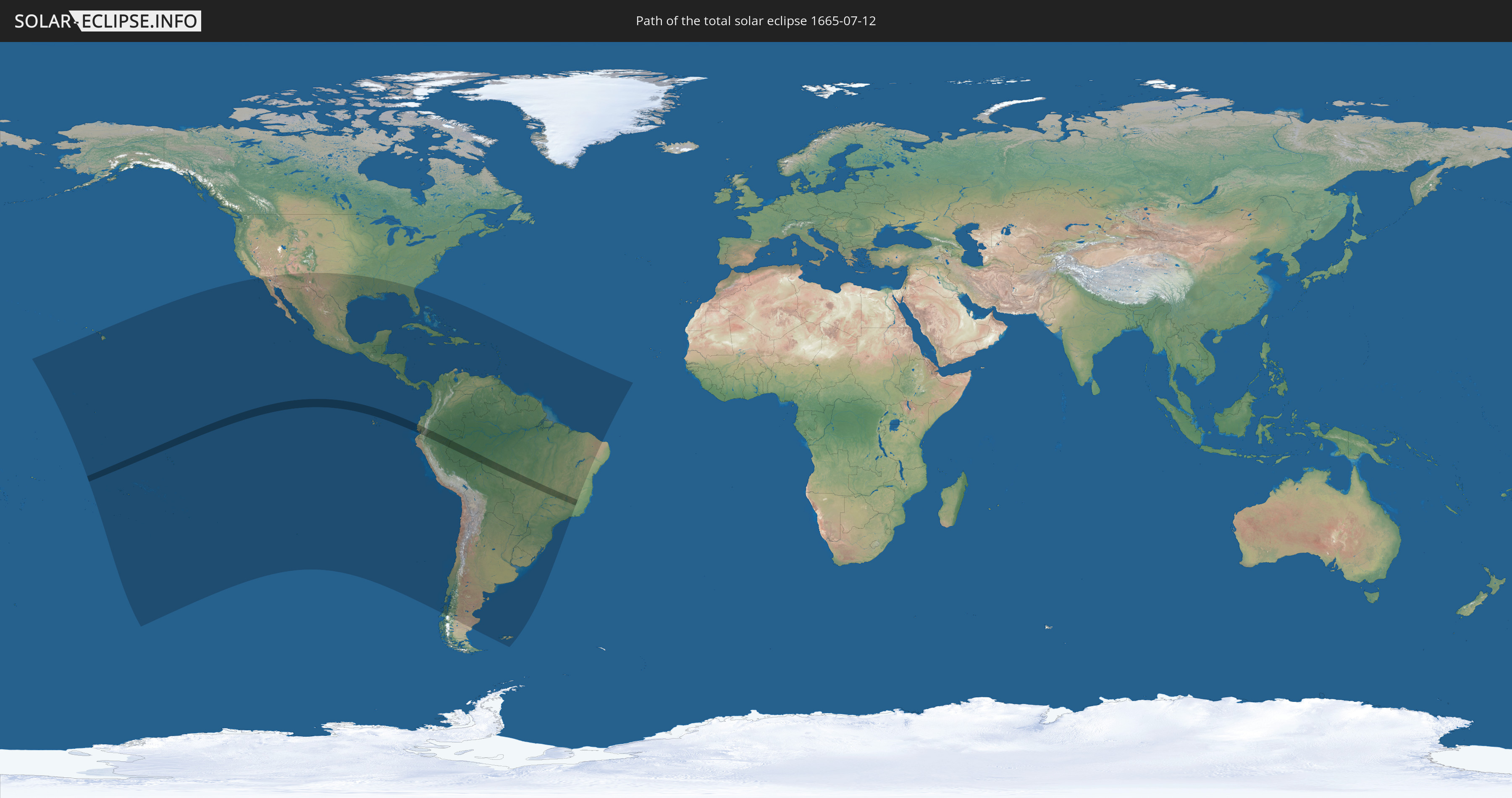
Total solar eclipse of 07/12/1665
| Day of week: | Sunday |
| Maximum duration of eclipse: | 06m02s |
| Maximum width of eclipse path: | 211 km |
| Saros cycle: | 121 |
| Coverage: | 100% |
| Magnitude: | 1.0611 |
| Gamma: | -0.3095 |
Wo kann man die Sonnenfinsternis vom 07/12/1665 sehen?
Die Sonnenfinsternis am 07/12/1665 kann man in 53 Ländern als partielle Sonnenfinsternis beobachten.
Der Finsternispfad verläuft durch 5 Länder. Nur in diesen Ländern ist sie als total Sonnenfinsternis zu sehen.
In den folgenden Ländern ist die Sonnenfinsternis total zu sehen
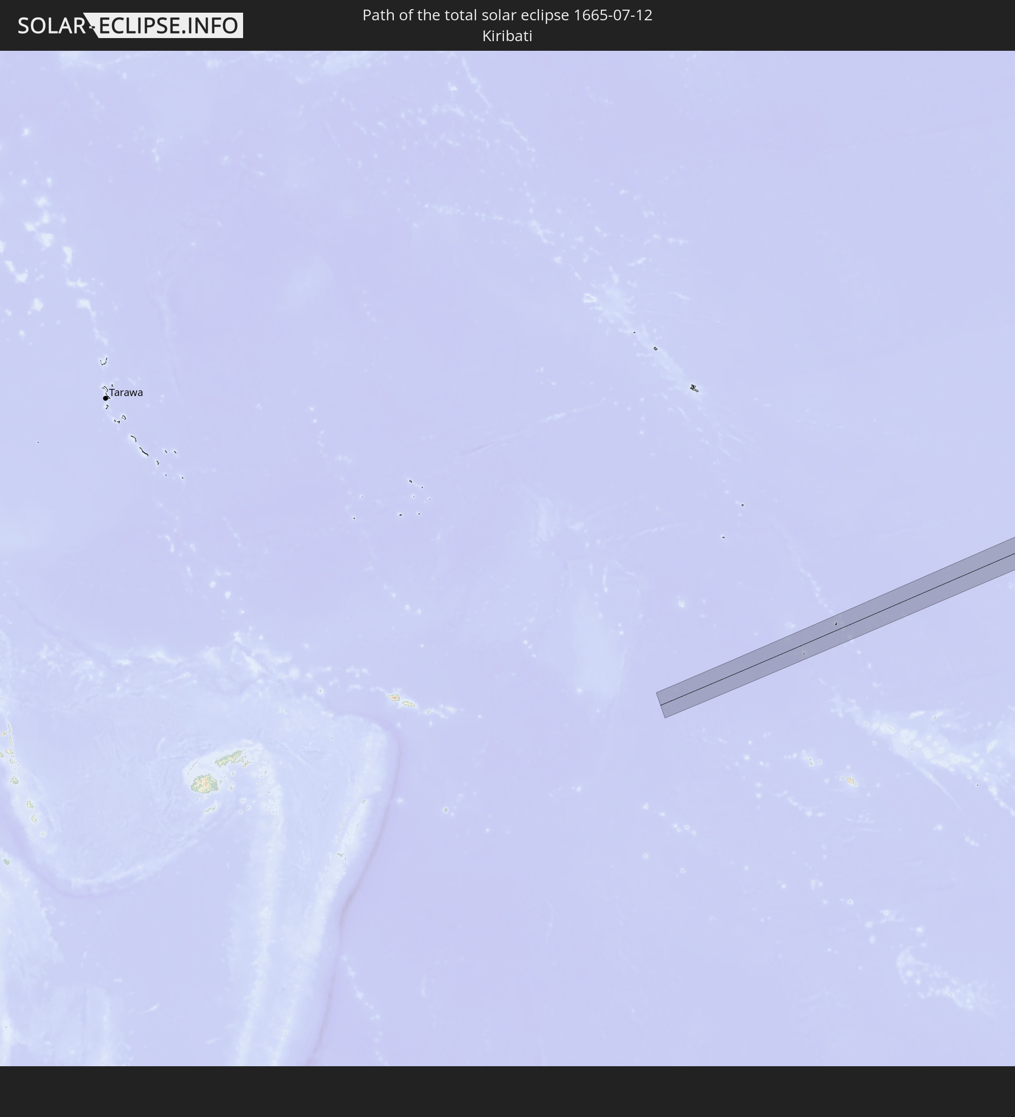 Kiribati
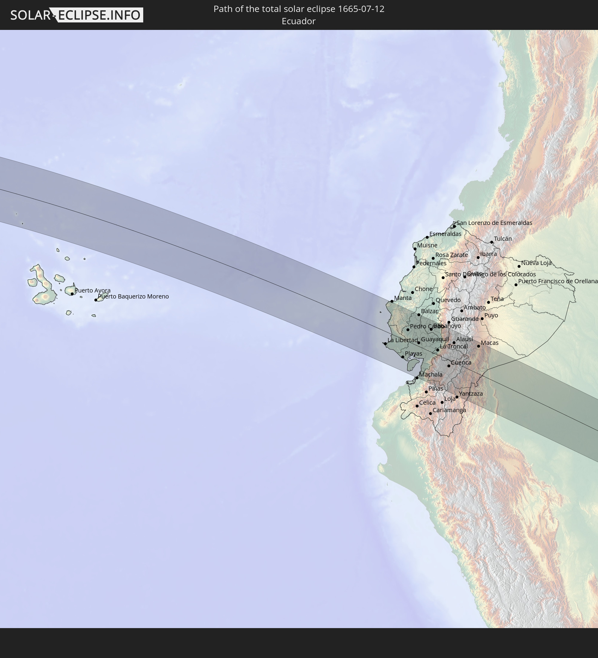 Ecuador
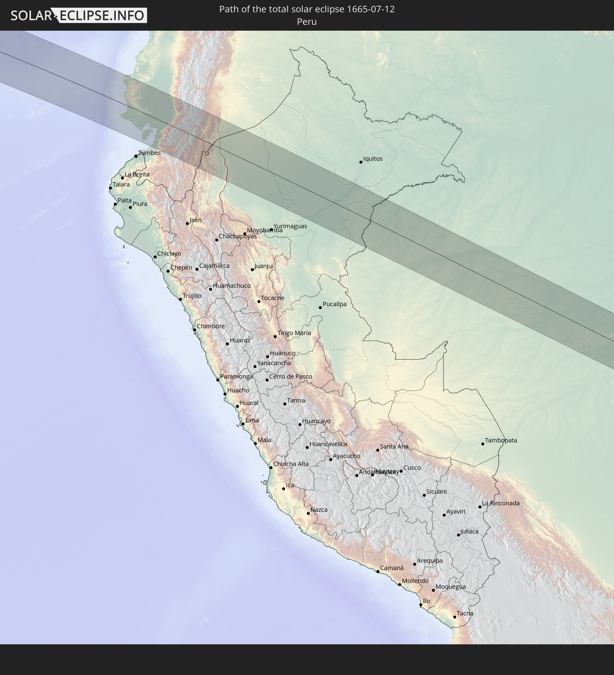 Peru
Peru
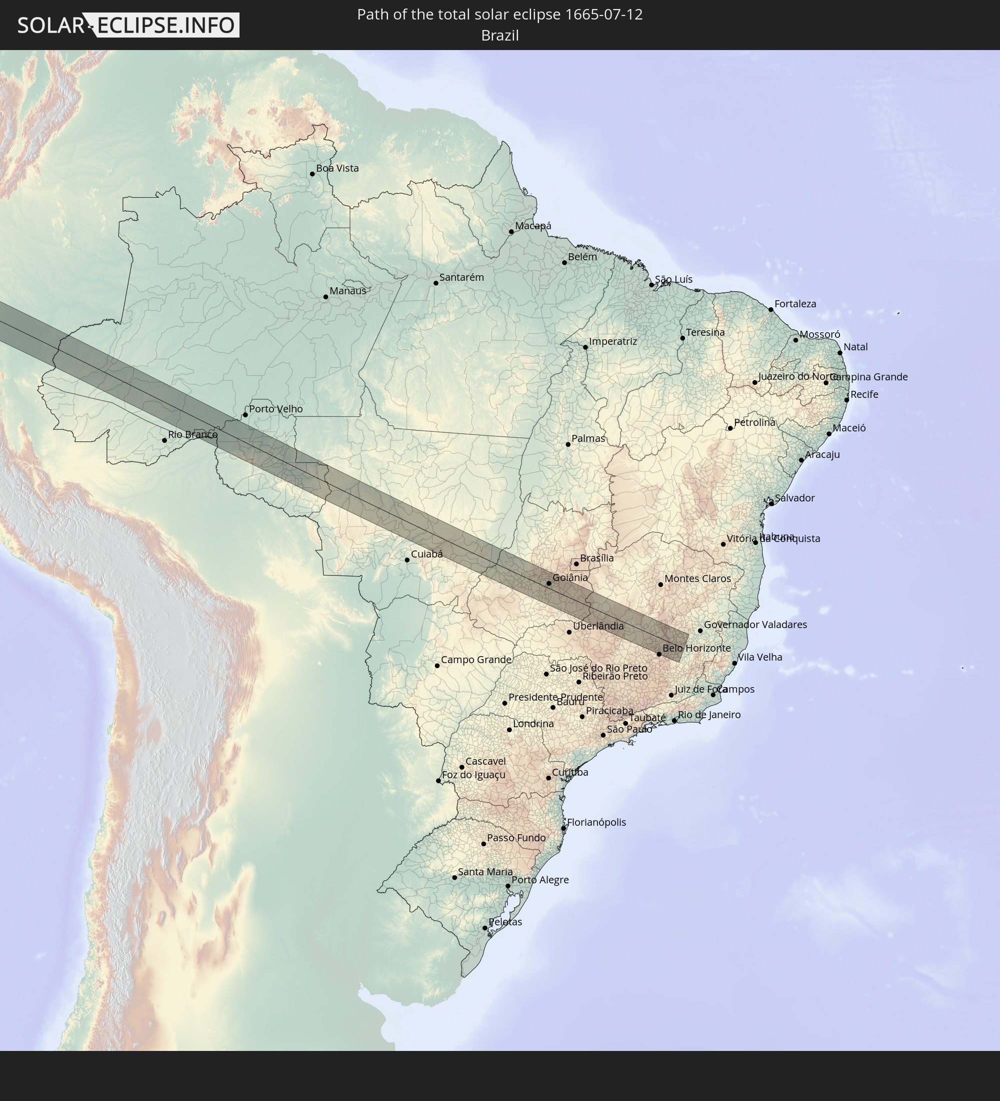 Brazil
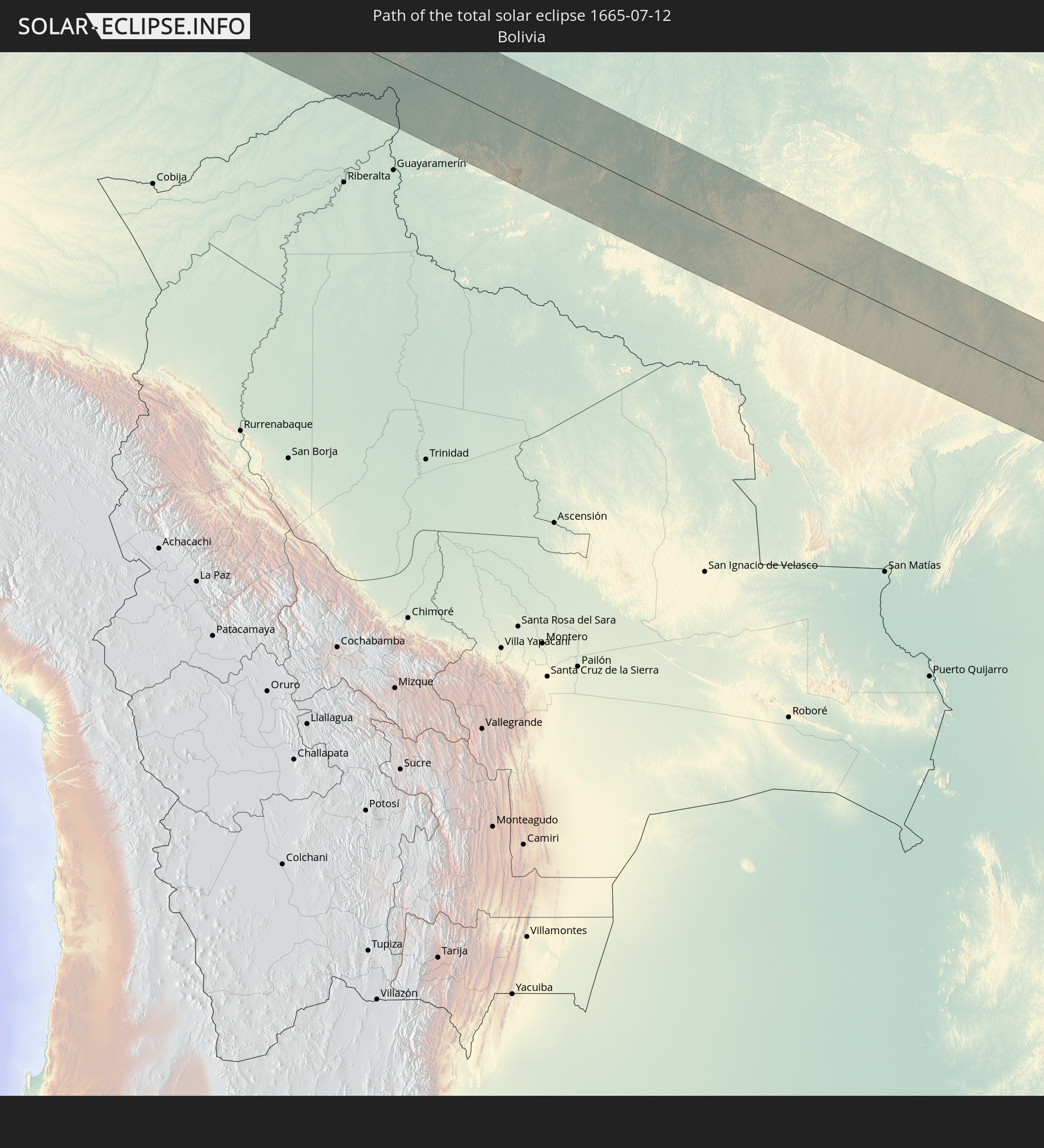 Bolivia
In den folgenden Ländern ist die Sonnenfinsternis partiell zu sehen
 United States
 United States Minor Outlying Islands
 Kiribati
 Cook Islands
 French Polynesia
 Pitcairn Islands
 Mexico
 Chile
Chile
 Guatemala
 Ecuador
 El Salvador
 Honduras
 Belize
 Nicaragua
 Costa Rica
 Cuba
Cuba
 Panama
 Colombia
 Cayman Islands
 Peru
Peru
 The Bahamas
 Jamaica
 Haiti
Haiti
 Brazil
 Argentina
 Venezuela
 Turks and Caicos Islands
 Dominican Republic
 Aruba
Aruba
 Bolivia
 Puerto Rico
 United States Virgin Islands
 British Virgin Islands
 Anguilla
 Collectivity of Saint Martin
 Saint Barthélemy
 Saint Kitts and Nevis
 Paraguay
 Antigua and Barbuda
 Montserrat
 Trinidad and Tobago
 Guadeloupe
 Grenada
 Dominica
 Saint Vincent and the Grenadines
 Falkland Islands
 Guyana
 Martinique
 Saint Lucia
 Barbados
 Uruguay
 Suriname
 French Guiana
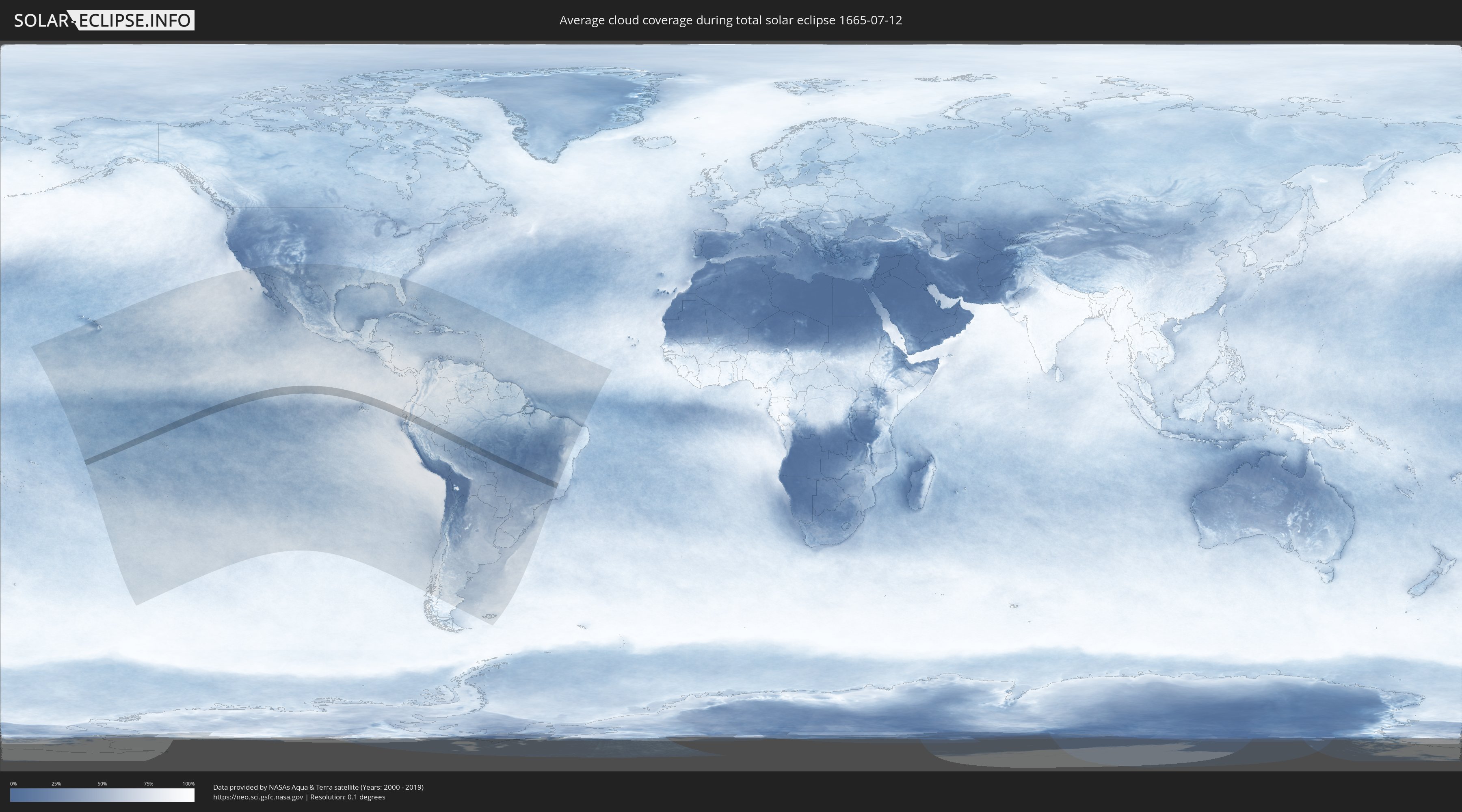
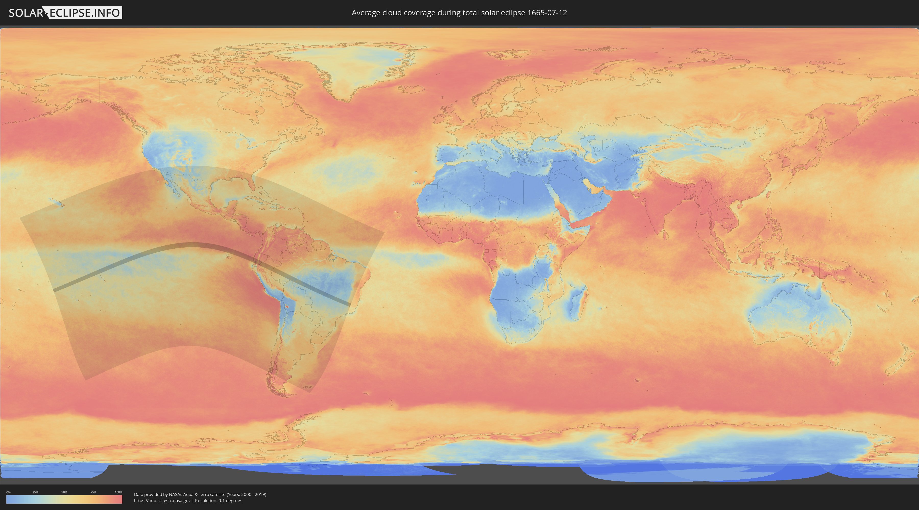
How will be the weather during the total solar eclipse on 07/12/1665?
Where is the best place to see the total solar eclipse of 07/12/1665?
The following maps show the average cloud coverage for the day of the total solar eclipse.
With the help of these maps, it is possible to find the place along the eclipse path, which has the best
chance of a cloudless sky.
Nevertheless, you should consider local circumstances and inform about the weather of your chosen
observation site.
The data is provided by NASAs satellites
AQUA and TERRA.
The cloud maps are averaged over a period of 19 years (2000 - 2019).
Detailed country maps
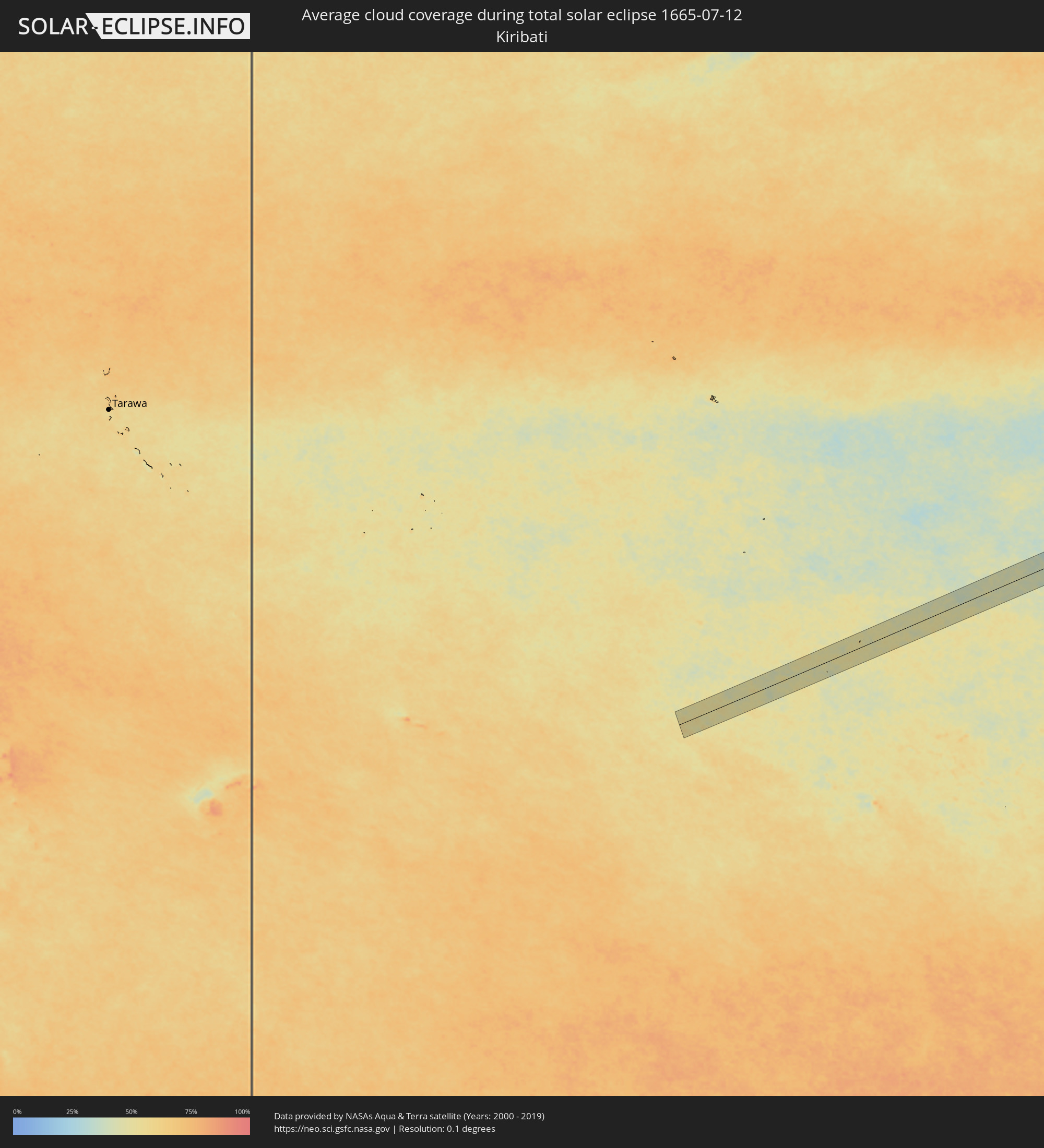 Kiribati
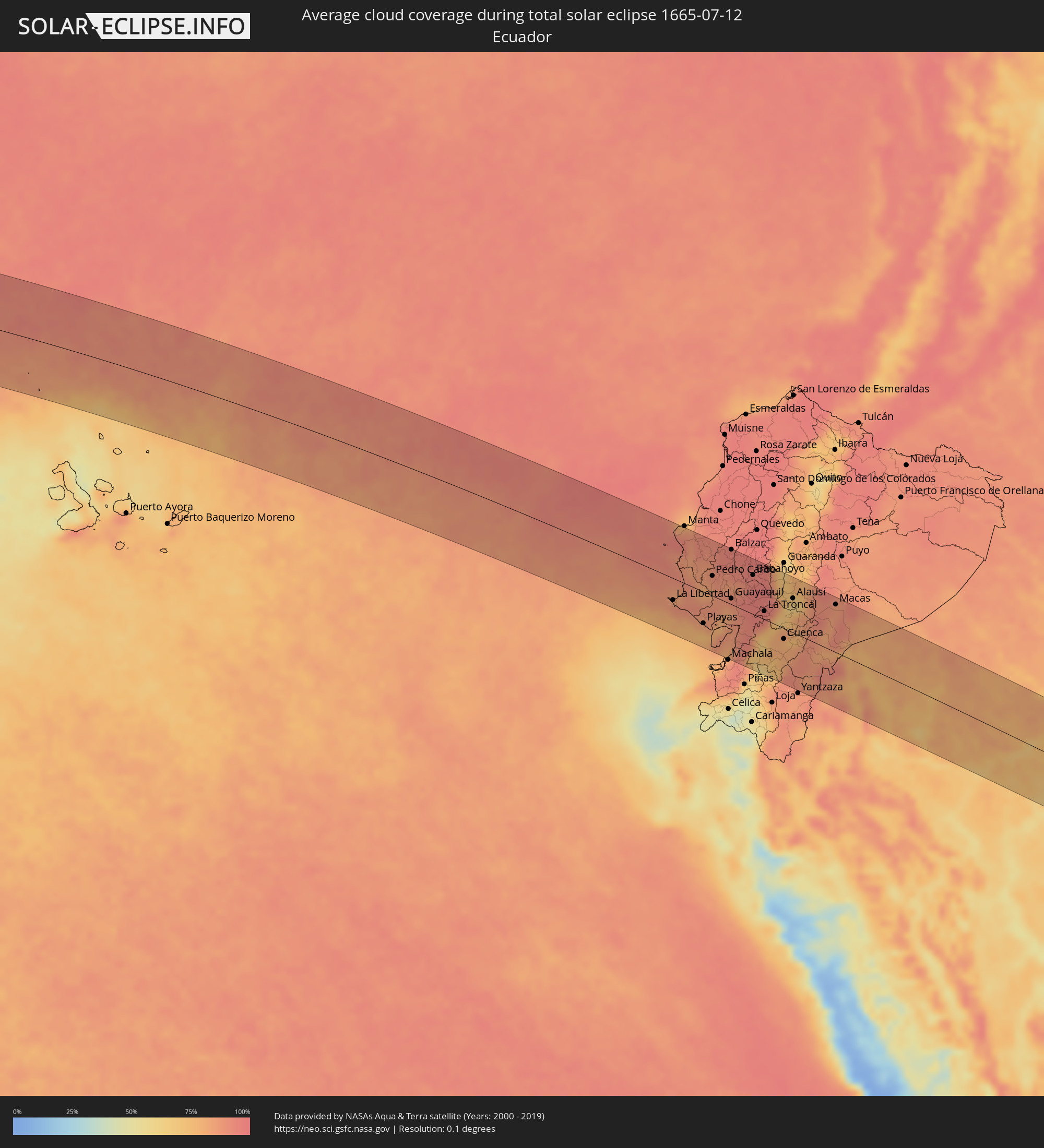 Ecuador
 Peru
Peru
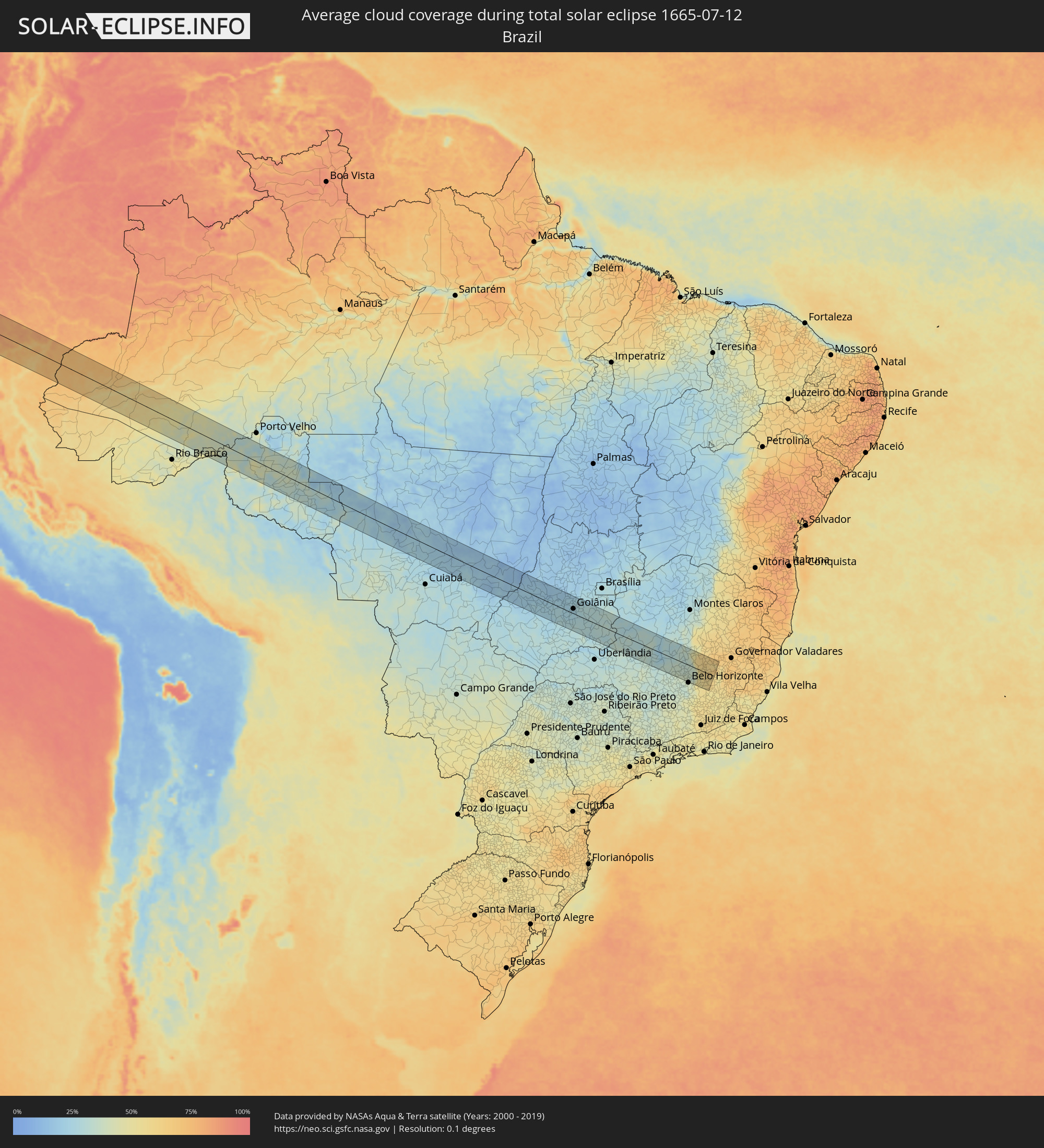 Brazil
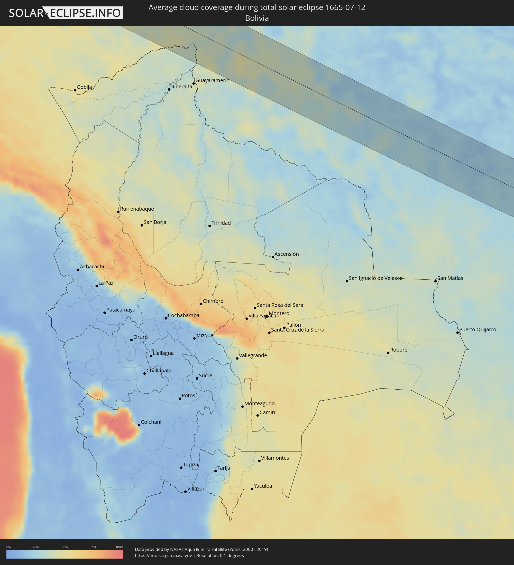 Bolivia
Cities inside the path of the eclipse
The following table shows all locations with a population of more than 5,000 inside the eclipse path. Cities which have more than 100,000 inhabitants are marked bold. A click at the locations opens a detailed map.
| City | Type | Eclipse duration | Local time of max. eclipse | Distance to central line | Ø Cloud coverage |
|
Salinas, Santa Elena
|
total | - | 14:29:38 UTC-05:14 | 38 km | 85% |
|
La Libertad, Guayas
|
total | - | 14:29:44 UTC-05:14 | 38 km | 88% |
|
Santa Elena, Santa Elena
|
total | - | 14:29:50 UTC-05:14 | 35 km | 88% |
|
Montecristi, Manabí
|
total | - | 14:29:36 UTC-05:14 | 94 km | 90% |
|
Jipijapa, Manabí
|
total | - | 14:29:57 UTC-05:14 | 67 km | 86% |
|
Paján, Manabí
|
total | - | 14:30:23 UTC-05:14 | 53 km | 85% |
|
Sucre, Manabí
|
total | - | 14:30:15 UTC-05:14 | 81 km | 91% |
|
Playas, Guayas
|
total | - | 14:31:04 UTC-05:14 | 55 km | 79% |
|
Santa Ana, Manabí
|
total | - | 14:30:19 UTC-05:14 | 91 km | 91% |
|
Pedro Carbo, Guayas
|
total | - | 14:30:57 UTC-05:14 | 35 km | 88% |
|
Lomas de Sargentillo, Guayas
|
total | - | 14:31:19 UTC-05:14 | 35 km | 89% |
|
Colimes, Guayas
|
total | - | 14:31:16 UTC-05:14 | 72 km | 92% |
|
Santa Lucía, Guayas
|
total | - | 14:31:39 UTC-05:14 | 8 km | 85% |
|
El Triunfo, Guayas
|
total | - | 14:31:35 UTC-05:14 | 35 km | 85% |
|
Guayaquil, Guayas
|
total | - | 14:31:52 UTC-05:14 | 10 km | 87% |
|
Balzar, Guayas
|
total | - | 14:31:24 UTC-05:14 | 96 km | 94% |
|
Eloy Alfaro, Guayas
|
total | - | 14:31:57 UTC-05:14 | 16 km | 87% |
|
Baláo, Guayas
|
total | - | 14:32:26 UTC-05:14 | 57 km | 90% |
|
Palenque, Los Ríos
|
total | - | 14:31:45 UTC-05:14 | 95 km | 94% |
|
Vinces, Los Ríos
|
total | - | 14:31:49 UTC-05:14 | 83 km | 92% |
|
Samborondón, Guayas
|
total | - | 14:32:07 UTC-05:14 | 43 km | 92% |
|
Palestina, Guayas
|
total | - | 14:32:07 UTC-05:14 | 46 km | 90% |
|
Yaguachi Nuevo, Guayas
|
total | - | 14:32:15 UTC-05:14 | 31 km | 94% |
|
Naranjal, Guayas
|
total | - | 14:32:43 UTC-05:14 | 24 km | 93% |
|
Milagro, Guayas
|
total | - | 14:32:29 UTC-05:14 | 32 km | 95% |
|
Babahoyo, Los Ríos
|
total | - | 14:32:25 UTC-05:14 | 68 km | 94% |
|
Alfredo Baquerizo Moreno, Guayas
|
total | - | 14:32:31 UTC-05:14 | 58 km | 96% |
|
Naranjito, Guayas
|
total | - | 14:32:46 UTC-05:14 | 35 km | 95% |
|
Catarama, Los Ríos
|
total | - | 14:32:26 UTC-05:14 | 95 km | 95% |
|
Coronel Marcelino Maridueña, Guayas
|
total | - | 14:32:51 UTC-05:14 | 32 km | 96% |
|
La Troncal, Cañar
|
total | - | 14:33:10 UTC-05:14 | 14 km | 93% |
|
Montalvo, Los Ríos
|
total | - | 14:32:55 UTC-05:14 | 81 km | 96% |
|
Cuenca, Azuay
|
total | - | 14:34:06 UTC-05:14 | 18 km | 79% |
|
Cañar, Cañar
|
total | - | 14:34:03 UTC-05:14 | 19 km | 81% |
|
Azogues, Cañar
|
total | - | 14:34:20 UTC-05:14 | 5 km | 78% |
|
Alausí, Chimborazo
|
total | - | 14:34:02 UTC-05:14 | 59 km | 63% |
|
Gualaceo, Azuay
|
total | - | 14:34:33 UTC-05:14 | 7 km | 82% |
|
Sucúa, Morona-Santiago
|
total | - | 14:35:31 UTC-05:14 | 65 km | 84% |
|
Macas, Morona-Santiago
|
total | - | 14:35:34 UTC-05:14 | 83 km | 87% |
|
Envira, Amazonas
|
total | - | 16:02:11 UTC-04:02 | 35 km | 60% |
|
Eirunepé, Amazonas
|
total | - | 16:02:26 UTC-04:02 | 45 km | 54% |
|
Boca do Acre, Amazonas
|
total | - | 16:06:13 UTC-04:02 | 41 km | 43% |
|
Pauini, Amazonas
|
total | - | 16:06:26 UTC-04:02 | 83 km | 44% |
|
Ariquemes, Rondônia
|
total | - | 16:11:06 UTC-04:02 | 56 km | 39% |
|
Jaru, Rondônia
|
total | - | 16:11:44 UTC-04:02 | 32 km | 38% |
|
Ouro Preto do Oeste, Rondônia
|
total | - | 16:12:00 UTC-04:02 | 13 km | 36% |
|
Ji Paraná, Rondônia
|
total | - | 16:12:15 UTC-04:02 | 12 km | 35% |
|
Presidente Médici, Rondônia
|
total | - | 16:12:20 UTC-04:02 | 15 km | 32% |
|
Cacoal, Rondônia
|
total | - | 16:12:46 UTC-04:02 | 19 km | 33% |
|
Pimenta Bueno, Rondônia
|
total | - | 16:13:00 UTC-04:02 | 30 km | 26% |
|
Diamantino, Mato Grosso
|
total | - | 16:40:43 UTC-03:38 | 78 km | 26% |
|
Barra do Garças, Mato Grosso
|
total | - | 16:42:48 UTC-03:38 | 34 km | 19% |
|
Aragarças, Goiás
|
total | - | 16:42:48 UTC-03:38 | 34 km | 19% |
|
Piranhas, Goiás
|
total | - | 17:14:55 UTC-03:06 | 68 km | 20% |
|
Iporá, Goiás
|
total | - | 17:15:12 UTC-03:06 | 38 km | 26% |
|
Itapirapuã, Goiás
|
total | - | 17:15:28 UTC-03:06 | 47 km | 21% |
|
Paraúna, Goiás
|
total | - | 17:15:23 UTC-03:06 | 59 km | 25% |
|
São Luís de Montes Belos, Goiás
|
total | - | 17:15:28 UTC-03:06 | 13 km | 24% |
|
Firminópolis, Goiás
|
total | - | 17:15:29 UTC-03:06 | 16 km | 26% |
|
Goiás, Goiás
|
total | - | 17:15:38 UTC-03:06 | 57 km | 20% |
|
Anicuns, Goiás
|
total | - | 17:15:38 UTC-03:06 | 12 km | 26% |
|
Edéia, Goiás
|
total | - | 17:15:31 UTC-03:06 | 76 km | 28% |
|
Palmeiras de Goiás, Goiás
|
total | - | 17:15:36 UTC-03:06 | 21 km | 27% |
|
Itaberaí, Goiás
|
total | - | 17:15:44 UTC-03:06 | 63 km | 18% |
|
Guapó, Goiás
|
total | - | 17:15:43 UTC-03:06 | 7 km | 25% |
|
Inhumas, Goiás
|
total | - | 17:15:48 UTC-03:06 | 43 km | 23% |
|
Trindade, Goiás
|
total | - | 17:15:46 UTC-03:06 | 14 km | 24% |
|
Pontalina, Goiás
|
total | - | 17:15:39 UTC-03:06 | 73 km | 29% |
|
Goianira, Goiás
|
total | - | 17:15:48 UTC-03:06 | 32 km | 24% |
|
Petrolina de Goiás, Goiás
|
total | - | 17:15:53 UTC-03:06 | 77 km | 23% |
|
Goiânia, Goiás
|
total | - | 17:15:50 UTC-03:06 | 21 km | 23% |
|
Aparecida de Goiânia, Goiás
|
total | - | 17:15:49 UTC-03:06 | 7 km | 25% |
|
Hidrolândia, Goiás
|
total | - | 17:15:48 UTC-03:06 | 6 km | 25% |
|
Nerópolis, Goiás
|
total | - | 17:15:53 UTC-03:06 | 50 km | 28% |
|
Senador Canedo, Goiás
|
total | - | 17:15:53 UTC-03:06 | 25 km | 27% |
|
Goianápolis, Goiás
|
total | - | 17:15:56 UTC-03:06 | 48 km | 29% |
|
Piracanjuba, Goiás
|
total | - | 17:15:49 UTC-03:06 | 32 km | 29% |
|
Bela Vista de Goiás, Goiás
|
total | - | 17:15:53 UTC-03:06 | 5 km | 28% |
|
Anápolis, Goiás
|
total | - | 17:15:59 UTC-03:06 | 70 km | 26% |
|
Caldas Novas, Goiás
|
total | - | 17:15:52 UTC-03:06 | 59 km | 28% |
|
Silvânia, Goiás
|
total | - | 17:16:02 UTC-03:06 | 52 km | 29% |
|
Vianópolis, Goiás
|
total | - | 17:16:03 UTC-03:06 | 47 km | 29% |
|
Orizona, Goiás
|
total | - | 17:16:04 UTC-03:06 | 28 km | 29% |
|
Pires do Rio, Goiás
|
total | - | 17:16:02 UTC-03:06 | 1 km | 30% |
|
Ipameri, Goiás
|
total | - | 17:16:00 UTC-03:06 | 36 km | 29% |
|
Catalão, Goiás
|
total | - | 17:15:58 UTC-03:06 | 72 km | 29% |
|
Coromandel, Minas Gerais
|
total | - | 17:16:06 UTC-03:06 | 71 km | 32% |
|
Vazante, Minas Gerais
|
total | - | 17:16:16 UTC-03:06 | 9 km | 30% |
|
Paracatu, Minas Gerais
|
total | - | 17:16:25 UTC-03:06 | 71 km | 30% |
|
Patos de Minas, Minas Gerais
|
total | - | 17:16:15 UTC-03:06 | 52 km | 31% |
|
Presidente Olegário, Minas Gerais
|
total | - | 17:16:18 UTC-03:06 | 31 km | 33% |
|
Lagoa Formosa, Minas Gerais
|
total | - | 17:16:13 UTC-03:06 | 67 km | 31% |
|
João Pinheiro, Minas Gerais
|
total | - | 17:16:29 UTC-03:06 | 48 km | 32% |
|
Abaeté, Minas Gerais
|
total | - | 17:16:20 UTC-03:06 | 65 km | 30% |
|
Martinho Campos, Minas Gerais
|
total | - | 17:16:20 UTC-03:06 | 73 km | 33% |
|
Pompéu, Minas Gerais
|
total | - | 17:16:24 UTC-03:06 | 50 km | 34% |
|
Papagaios, Minas Gerais
|
total | - | 17:16:23 UTC-03:06 | 65 km | 36% |
|
Corinto, Minas Gerais
|
total | - | 17:16:41 UTC-03:06 | 57 km | 32% |
|
Curvelo, Minas Gerais
|
total | - | 17:16:36 UTC-03:06 | 19 km | 35% |
|
Sete Lagoas, Minas Gerais
|
total | - | 17:16:28 UTC-03:06 | 45 km | 37% |
|
Ribeirão das Neves, Minas Gerais
|
total | - | 17:16:24 UTC-03:06 | 69 km | 38% |
|
Matozinhos, Minas Gerais
|
total | - | 17:16:28 UTC-03:06 | 47 km | 38% |
|
Pedro Leopoldo, Minas Gerais
|
total | - | 17:16:27 UTC-03:06 | 52 km | 38% |
|
Vespasiano, Minas Gerais
|
total | - | 17:16:27 UTC-03:06 | 54 km | 39% |
|
Lagoa Santa, Minas Gerais
|
total | - | 17:16:28 UTC-03:06 | 47 km | 36% |
|
Santa Luzia, Minas Gerais
|
total | - | 17:16:26 UTC-03:06 | 59 km | 40% |
|
Caeté, Minas Gerais
|
total | - | 17:16:26 UTC-03:06 | 63 km | 45% |
|
Barão de Cocais, Minas Gerais
|
total | - | 17:16:26 UTC-03:06 | 62 km | 53% |
|
Conceição do Mato Dentro, Minas Gerais
|
total | - | 17:16:41 UTC-03:06 | 33 km | 59% |
|
Itabira, Minas Gerais
|
total | - | 17:16:33 UTC-03:06 | 18 km | 56% |
|
Rio Piracicaba, Minas Gerais
|
total | - | 17:16:29 UTC-03:06 | 47 km | 56% |
|
João Monlevade, Minas Gerais
|
total | - | 17:16:31 UTC-03:06 | 35 km | 56% |
|
Alvinópolis, Minas Gerais
|
total | - | 17:16:27 UTC-03:06 | 60 km | 55% |
|
Nova Era, Minas Gerais
|
total | - | 17:16:33 UTC-03:06 | 23 km | 58% |
|
São Domingos do Prata, Minas Gerais
|
total | - | 17:16:31 UTC-03:06 | 32 km | 59% |