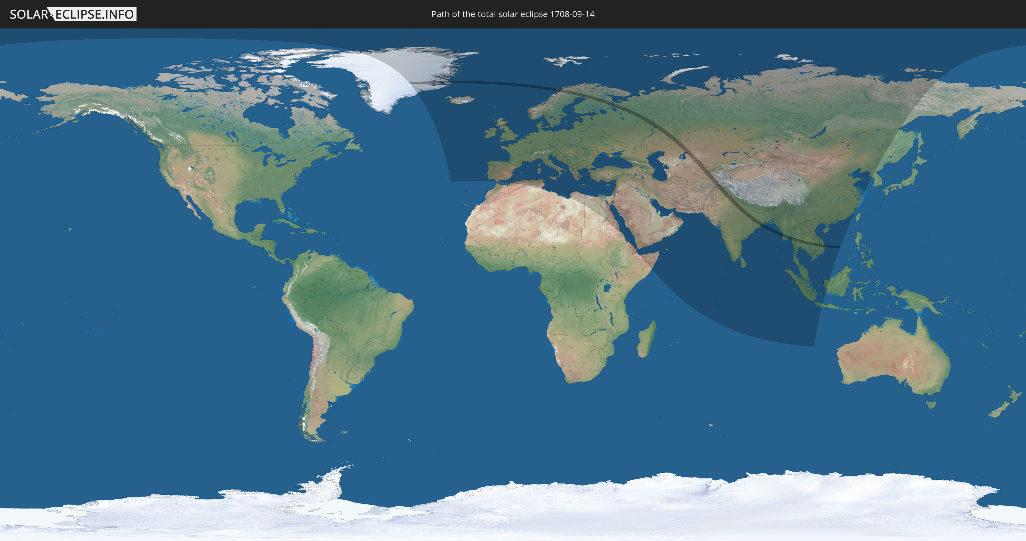
Total solar eclipse of 09/14/1708
| Day of week: | Friday |
| Maximum duration of eclipse: | 02m10s |
| Maximum width of eclipse path: | 126 km |
| Saros cycle: | 120 |
| Coverage: | 100% |
| Magnitude: | 1.0281 |
| Gamma: | 0.6685 |
Wo kann man die Sonnenfinsternis vom 09/14/1708 sehen?
Die Sonnenfinsternis am 09/14/1708 kann man in 109 Ländern als partielle Sonnenfinsternis beobachten.
Der Finsternispfad verläuft durch 17 Länder. Nur in diesen Ländern ist sie als total Sonnenfinsternis zu sehen.
In den folgenden Ländern ist die Sonnenfinsternis total zu sehen
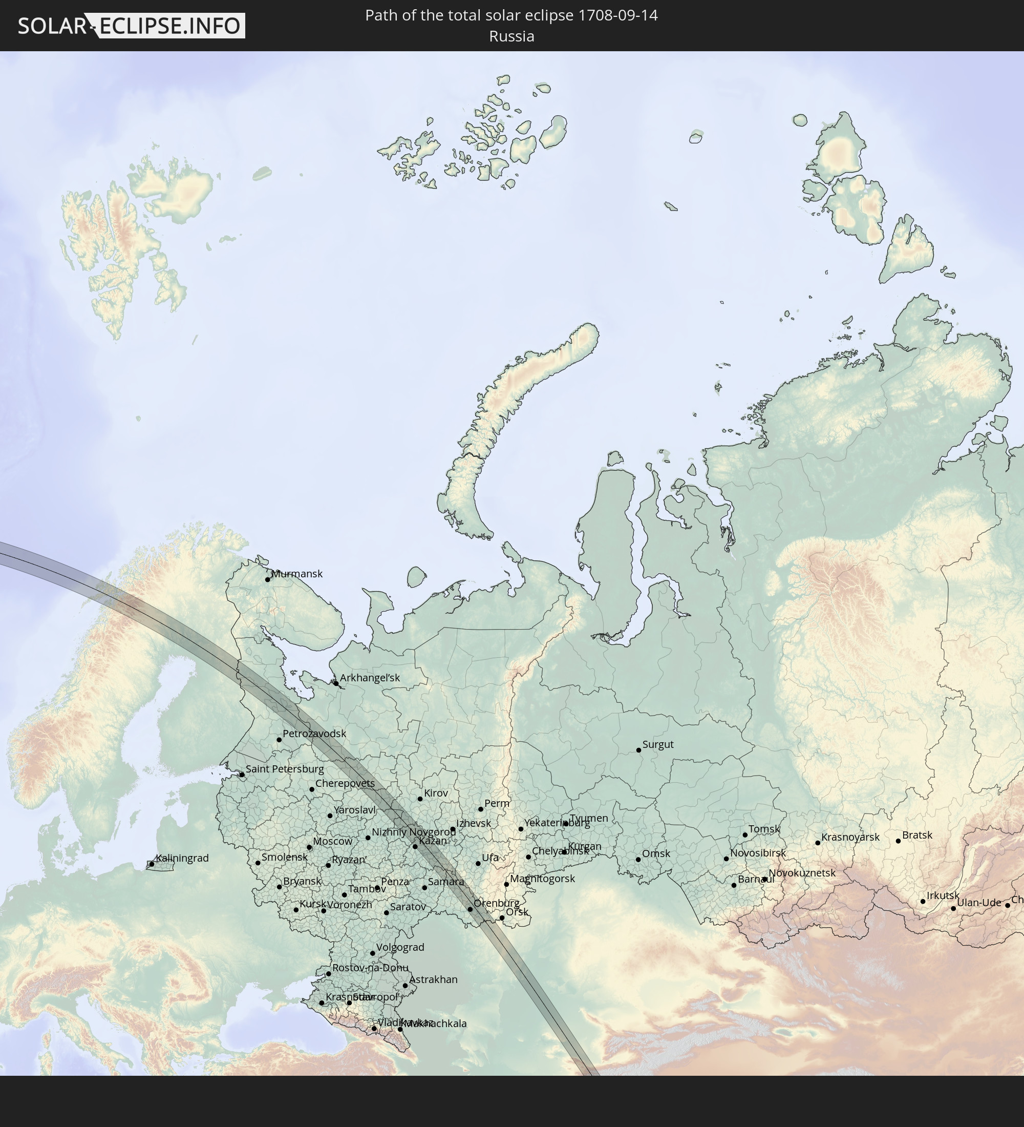 Russia
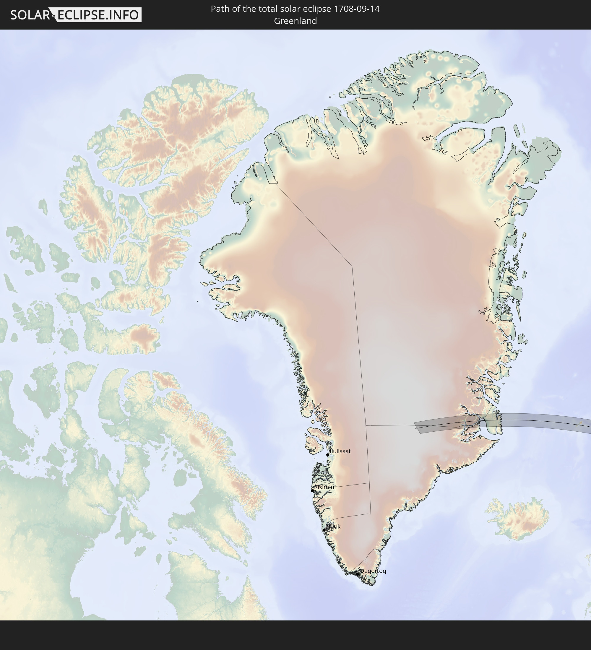 Greenland
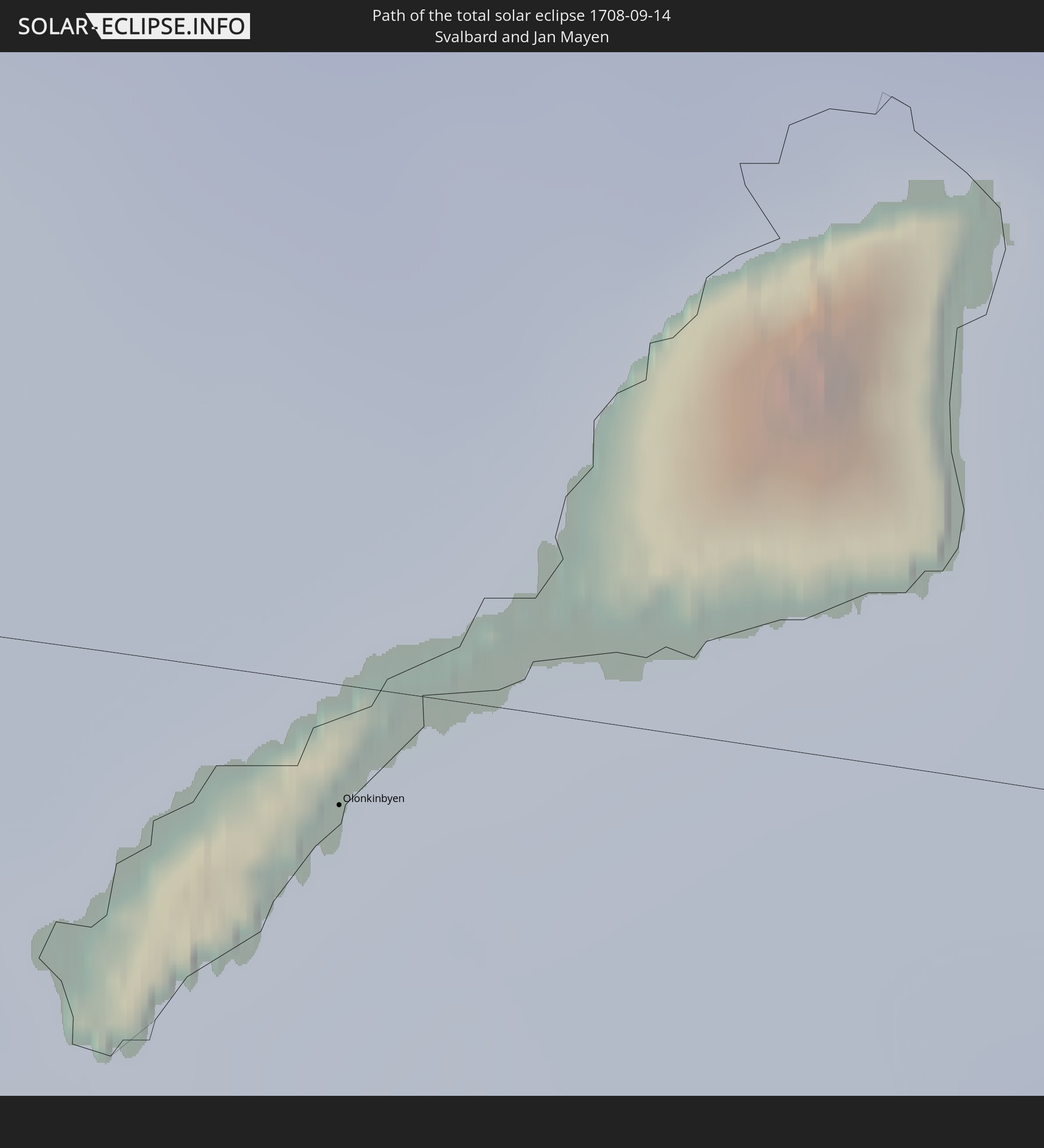 Svalbard and Jan Mayen
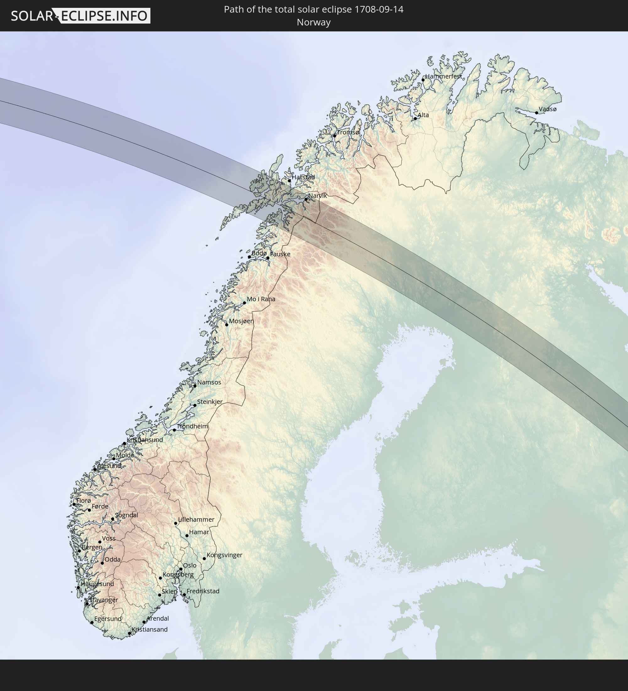 Norway
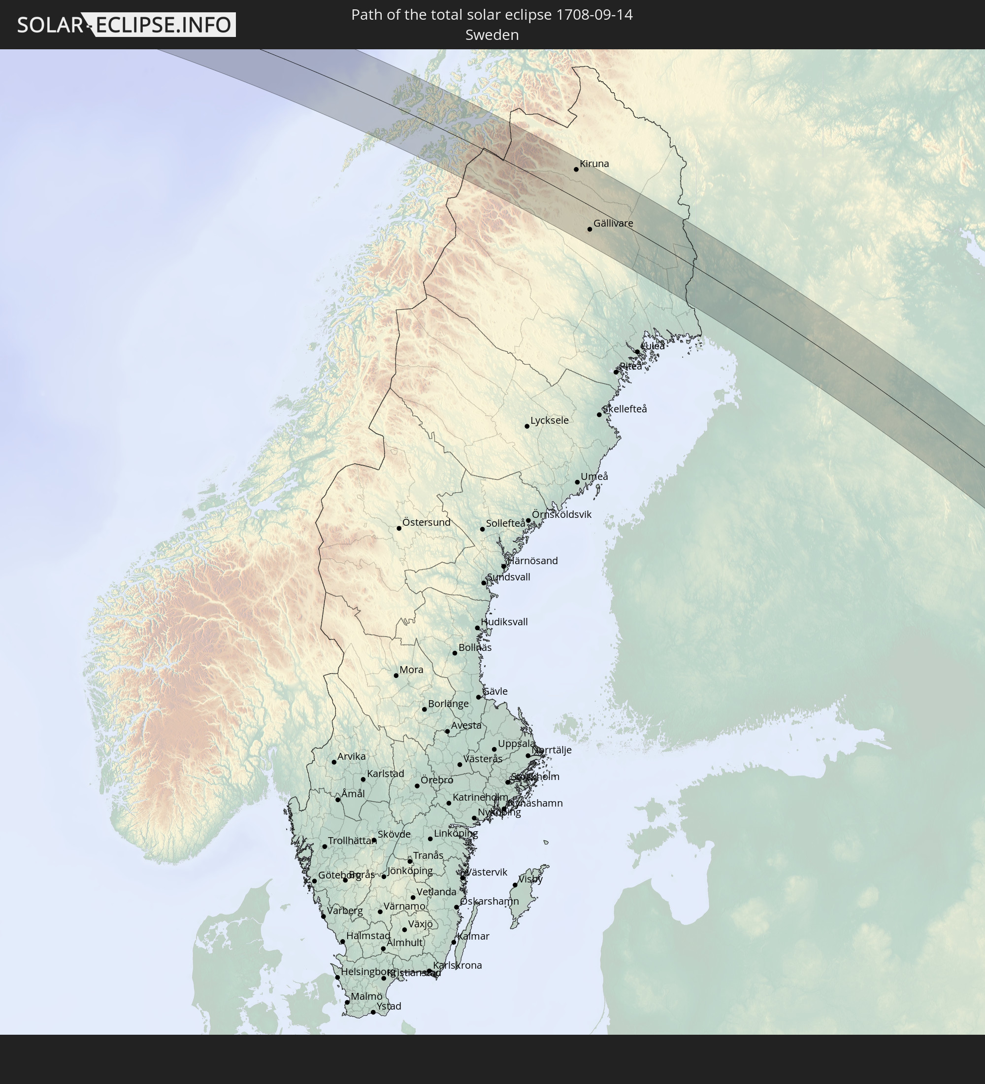 Sweden
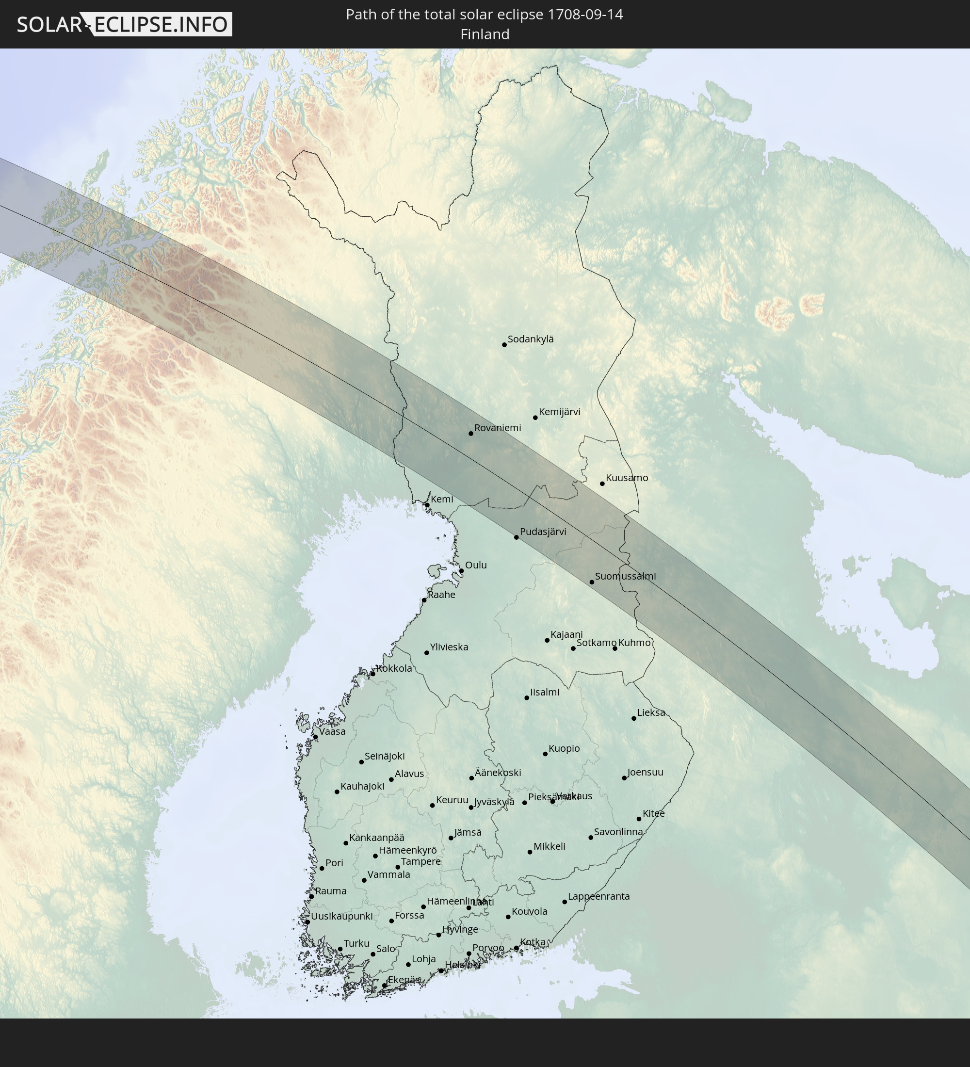 Finland
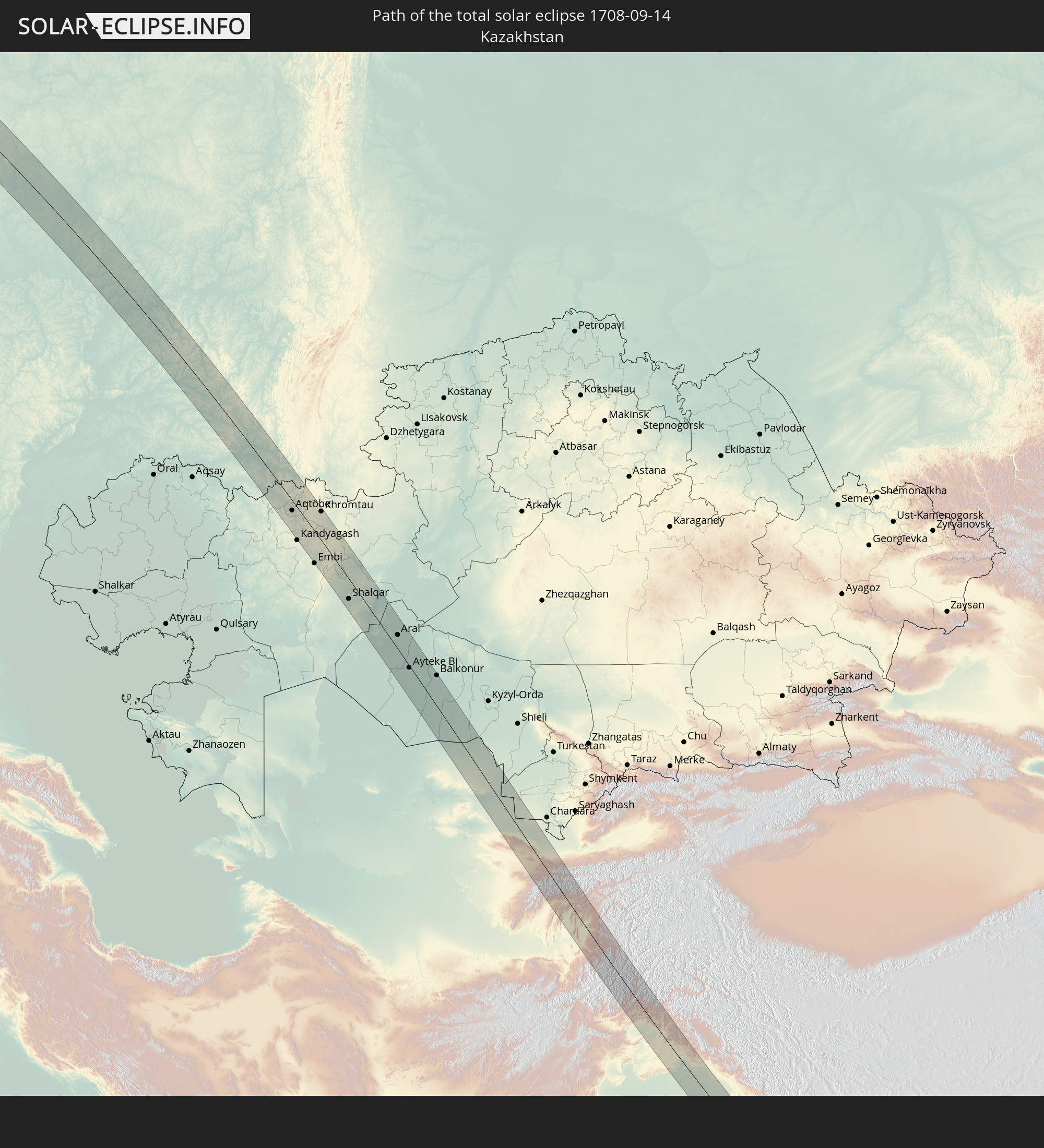 Kazakhstan
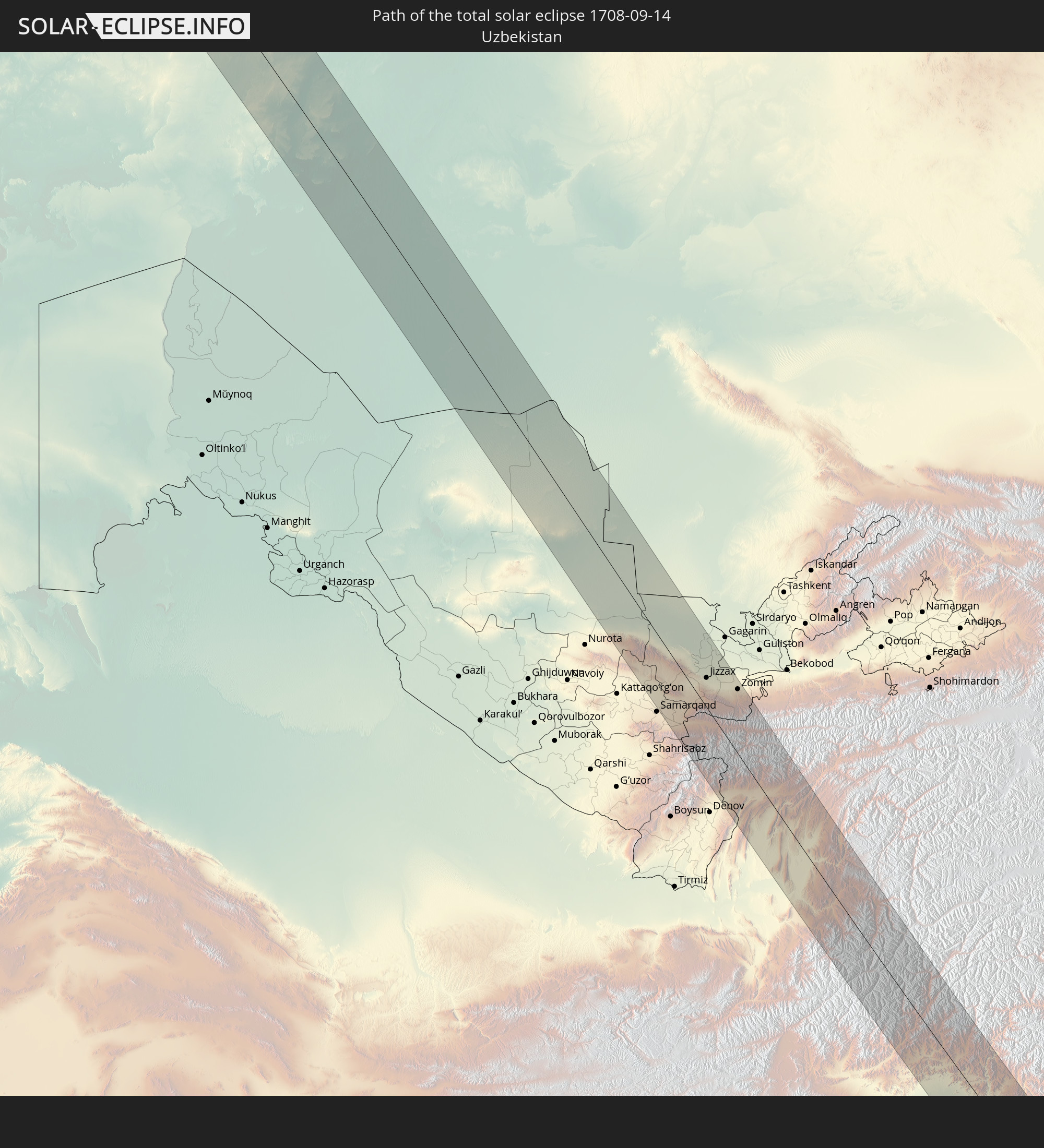 Uzbekistan
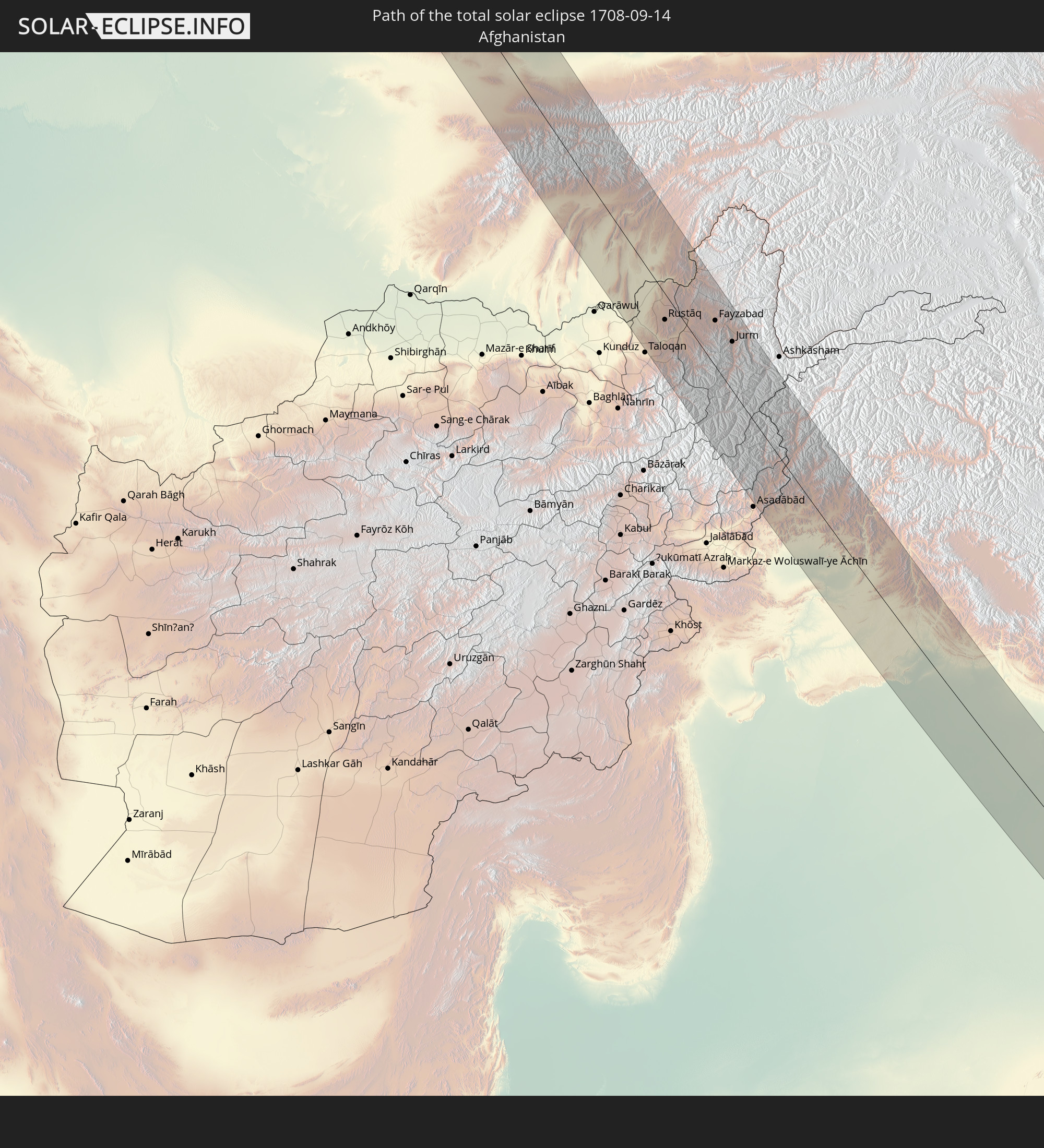 Afghanistan
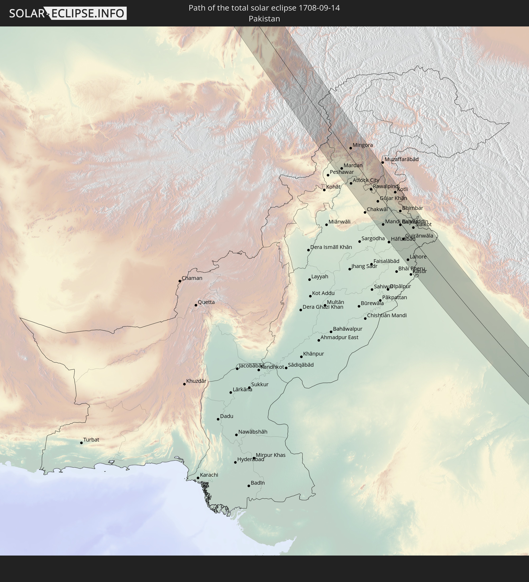 Pakistan
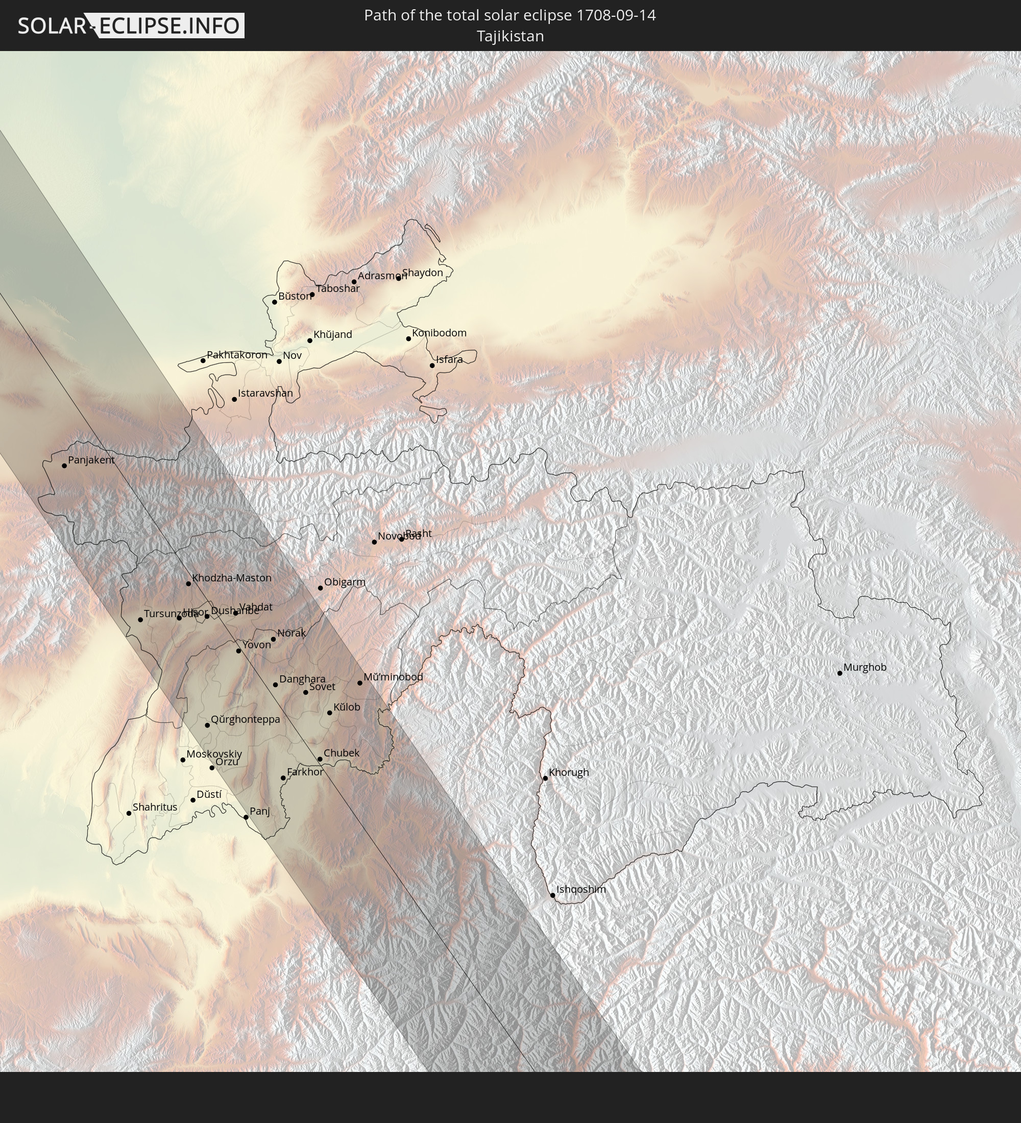 Tajikistan
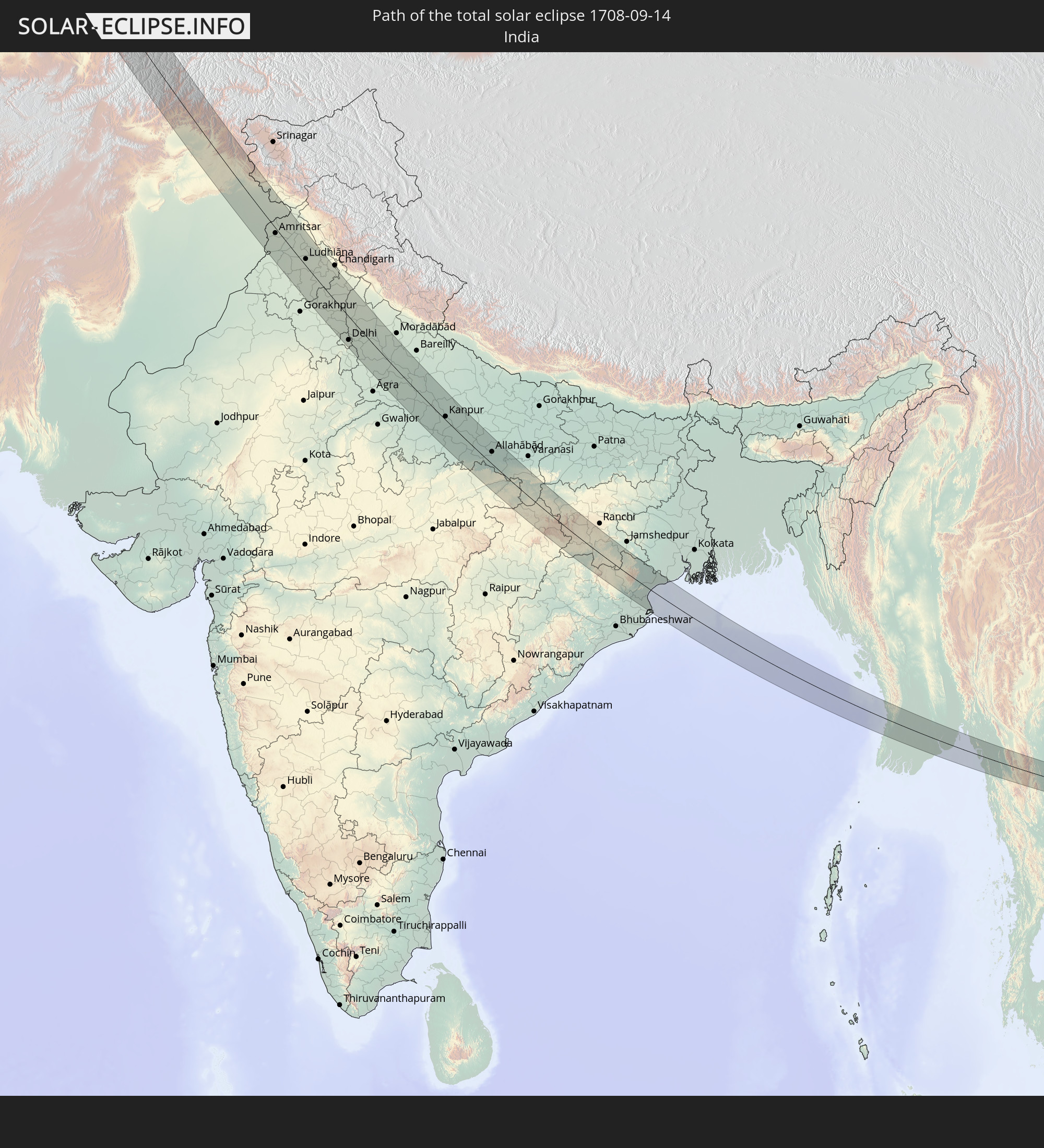 India
India
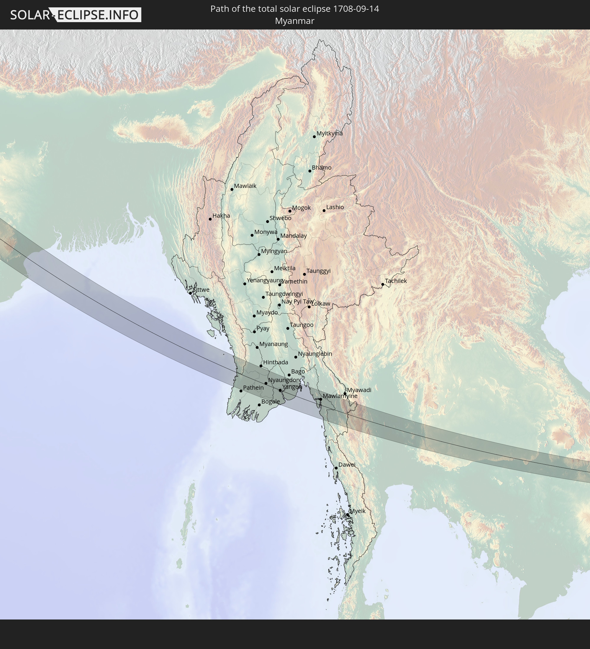 Myanmar
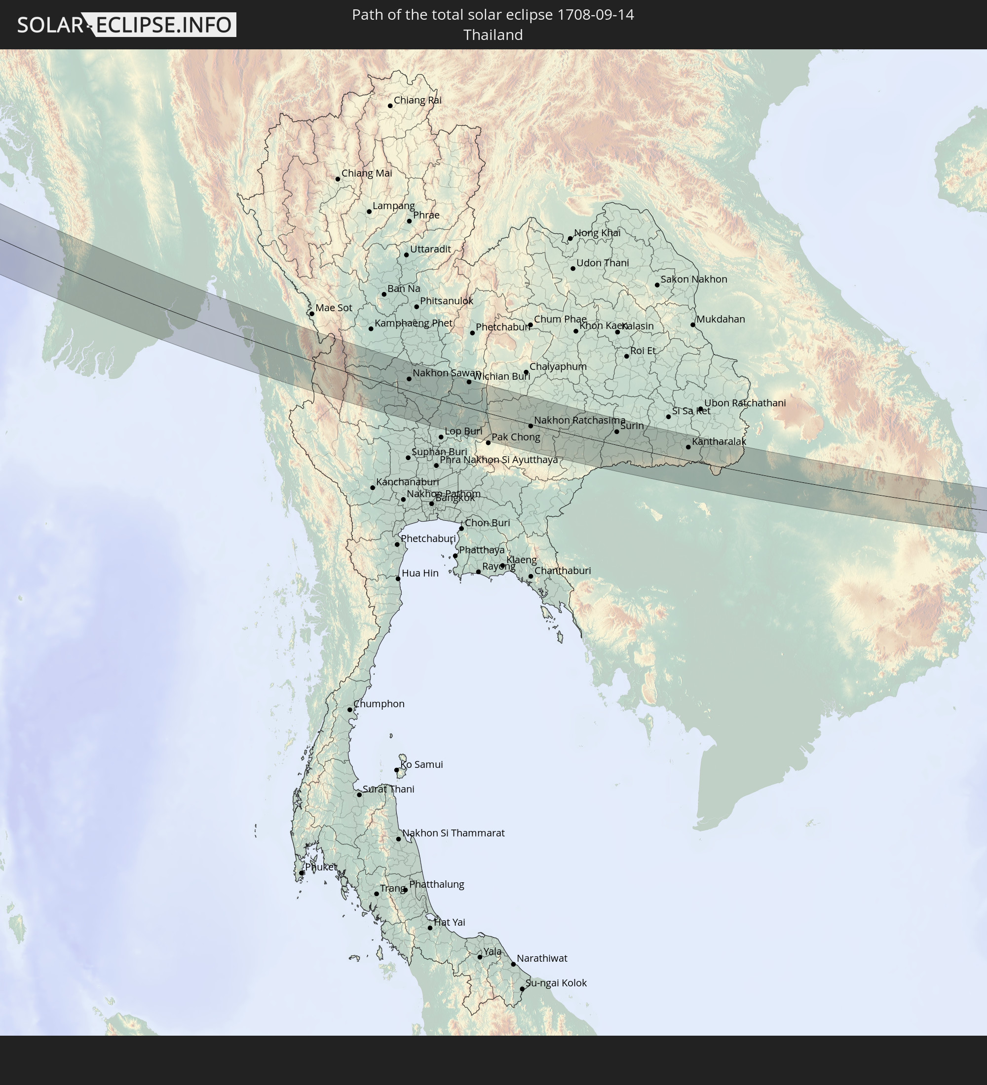 Thailand
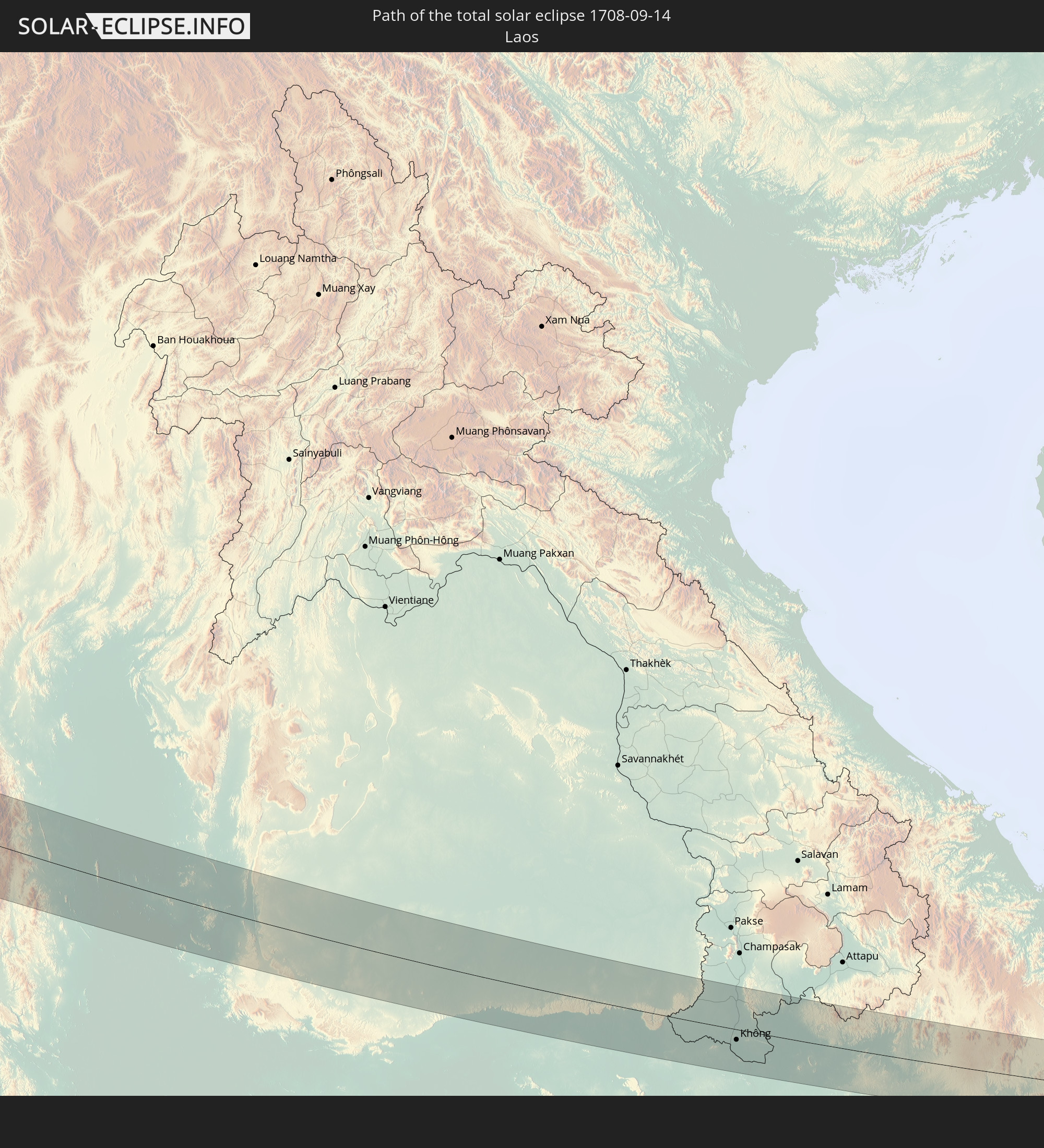 Laos
Laos
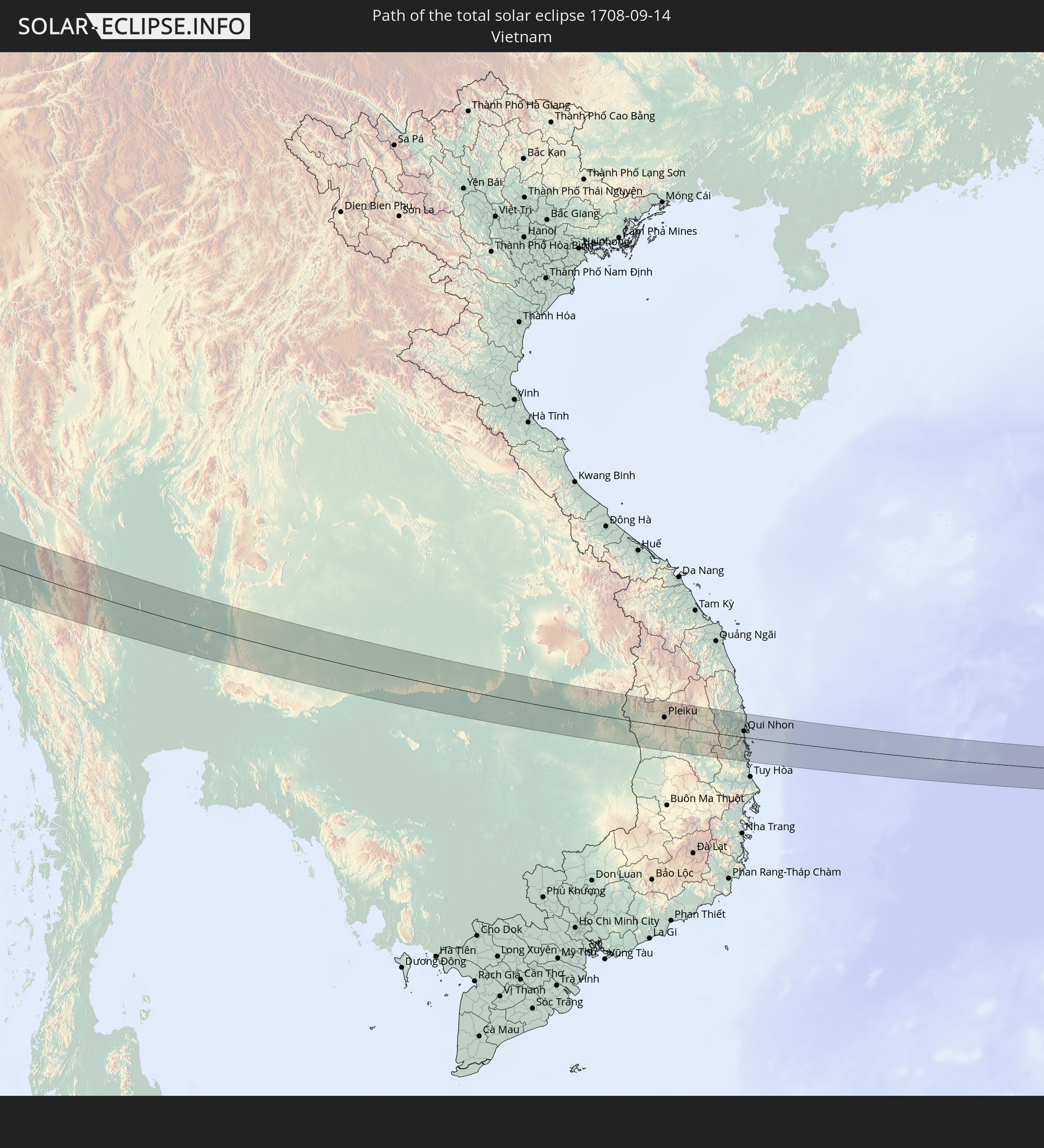 Vietnam
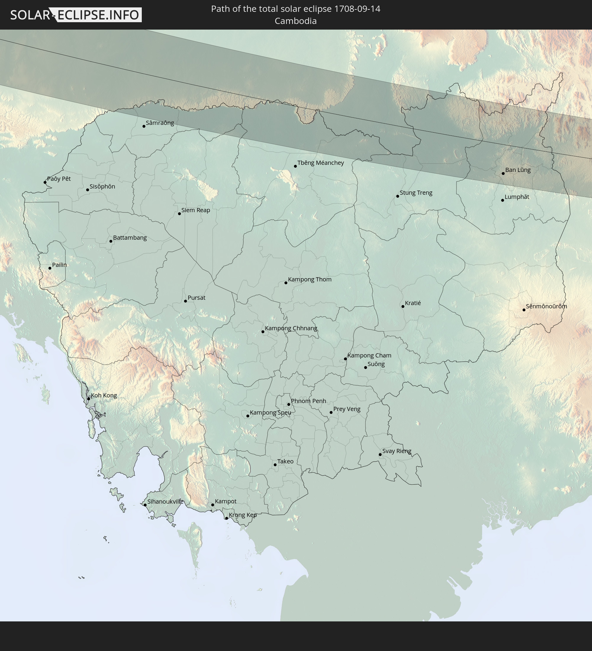 Cambodia
In den folgenden Ländern ist die Sonnenfinsternis partiell zu sehen
 Russia
 Greenland
 Portugal
 Iceland
 Spain
Spain
 Republic of Ireland
 Svalbard and Jan Mayen
 Algeria
 United Kingdom
 Faroe Islands
 France
 Isle of Man
 Guernsey
 Jersey
 Andorra
 Belgium
 Netherlands
 Norway
 Luxembourg
 Germany
 Switzerland
 Italy
Italy
 Monaco
 Tunisia
 Denmark
 Libya
Libya
 Liechtenstein
 Austria
 Sweden
 Czechia
 San Marino
 Vatican City
 Slovenia
 Croatia
 Poland
 Malta
Malta
 Bosnia and Herzegovina
 Hungary
 Slovakia
 Montenegro
 Serbia
 Albania
 Åland Islands
 Greece
 Romania
 Republic of Macedonia
 Finland
 Lithuania
 Latvia
 Estonia
 Sudan
Sudan
 Ukraine
 Bulgaria
 Belarus
 Egypt
Egypt
 Turkey
 Moldova
 Cyprus
 Ethiopia
 State of Palestine
 Israel
 Saudi Arabia
 Jordan
 Lebanon
 Syria
Syria
 Eritrea
 Iraq
Iraq
 Georgia
 Somalia
 Djibouti
 Yemen
Yemen
 Armenia
 Iran
Iran
 Azerbaijan
 Kazakhstan
 Kuwait
 Bahrain
 Qatar
Qatar
 United Arab Emirates
 Oman
Oman
 Turkmenistan
 Uzbekistan
 Afghanistan
 Pakistan
 Tajikistan
 India
India
 Kyrgyzstan
 British Indian Ocean Territory
 Maldives
 China
China
 Sri Lanka
 Nepal
Nepal
 Mongolia
 Bangladesh
 Bhutan
 Myanmar
 Indonesia
 Cocos Islands
 Thailand
 Malaysia
 Laos
Laos
 Vietnam
 Cambodia
 Singapore
 Christmas Island
 Macau
Macau
 Hong Kong
 Taiwan
 North Korea
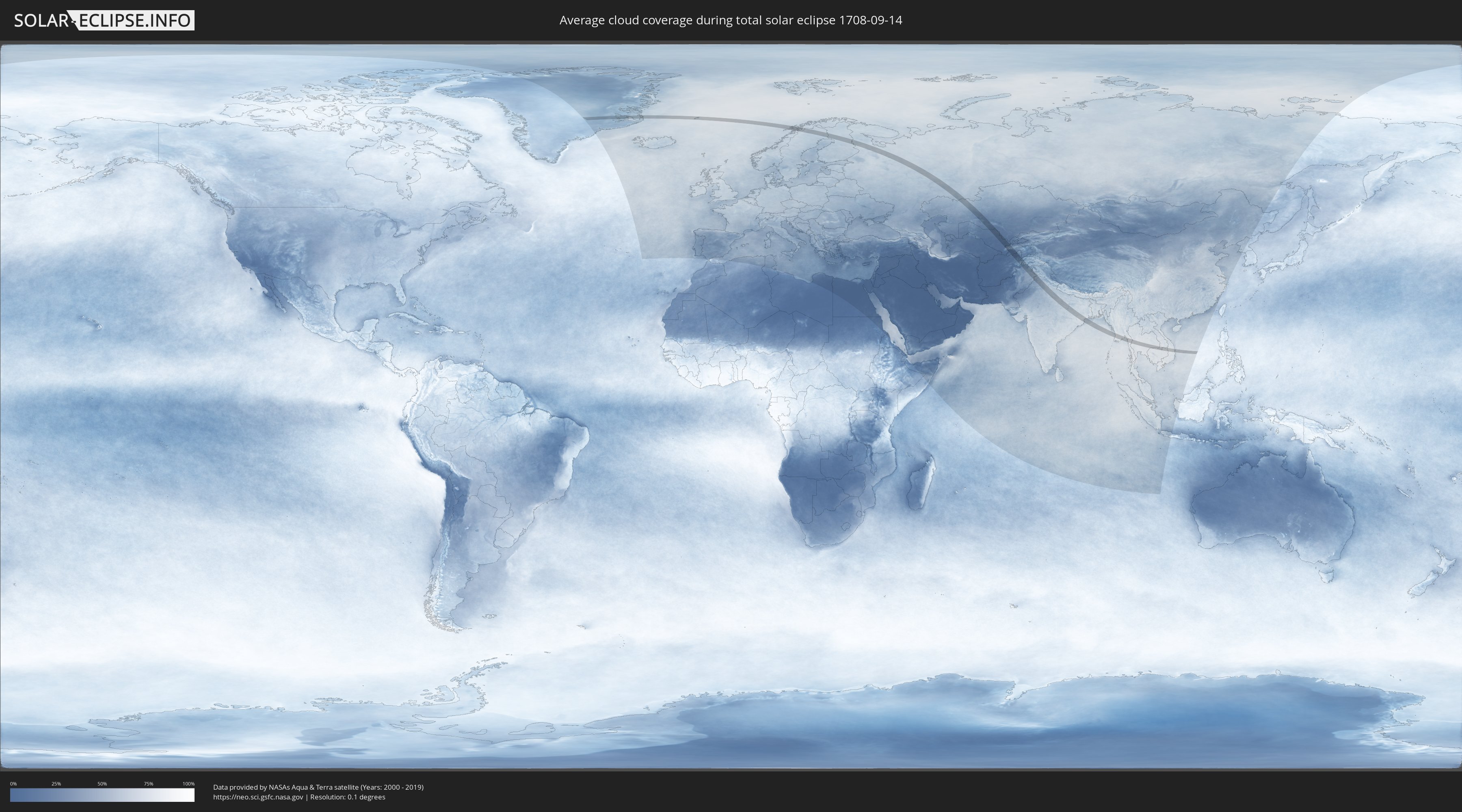
How will be the weather during the total solar eclipse on 09/14/1708?
Where is the best place to see the total solar eclipse of 09/14/1708?
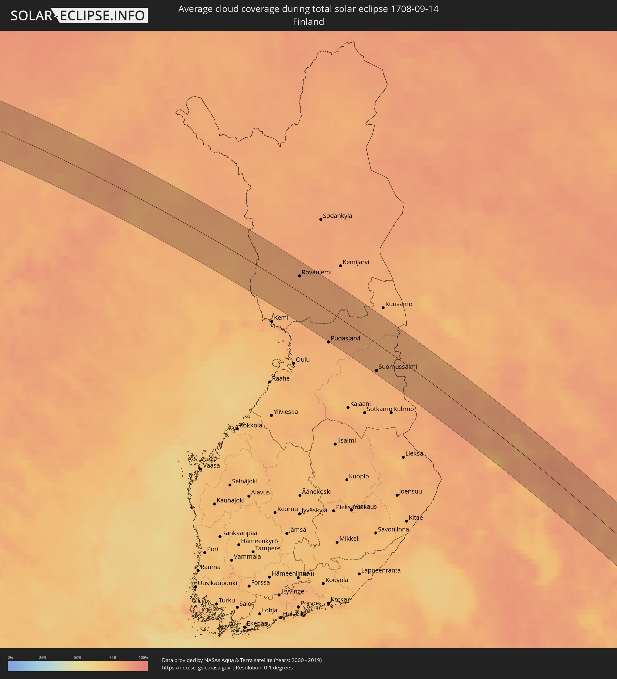
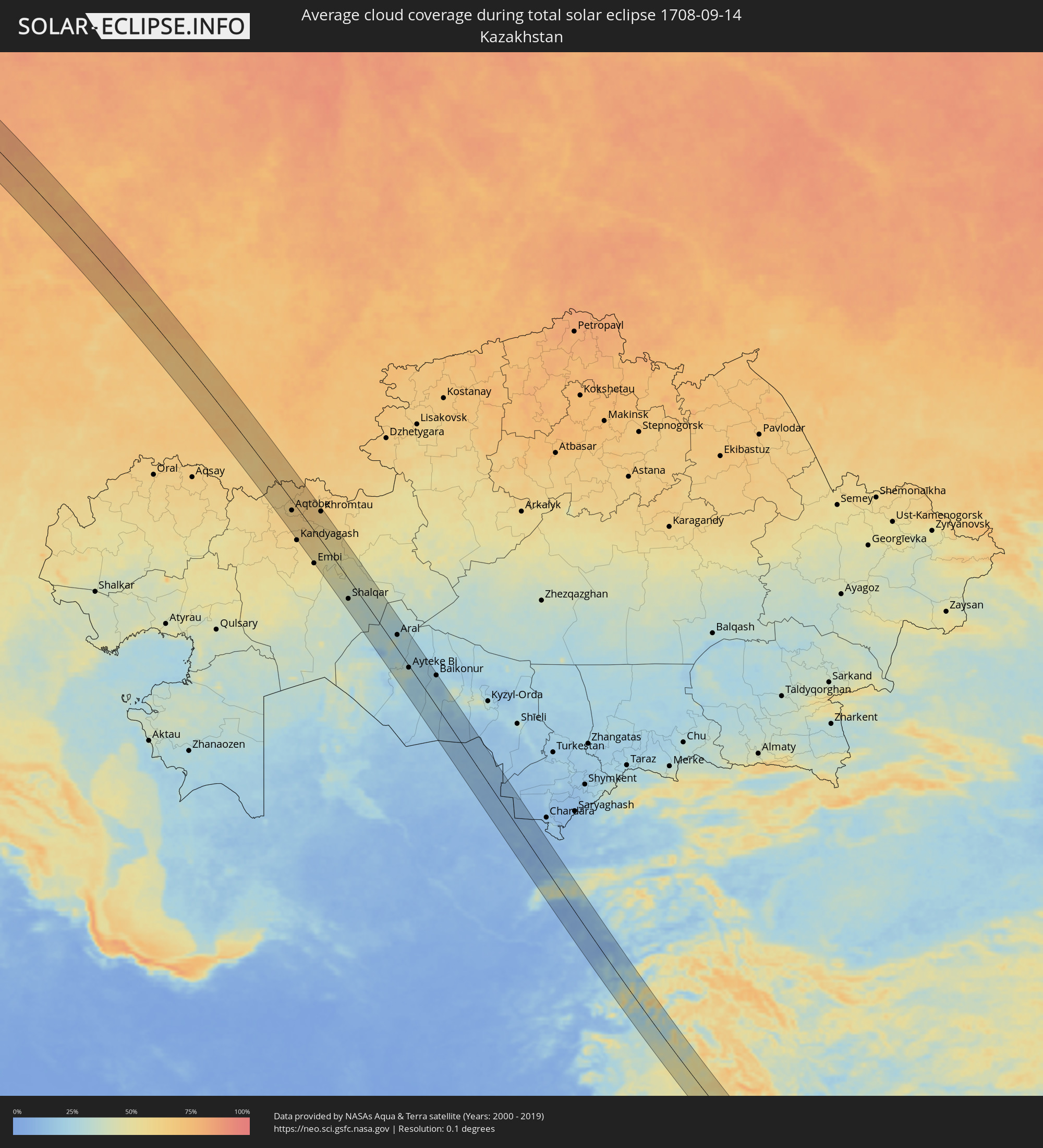
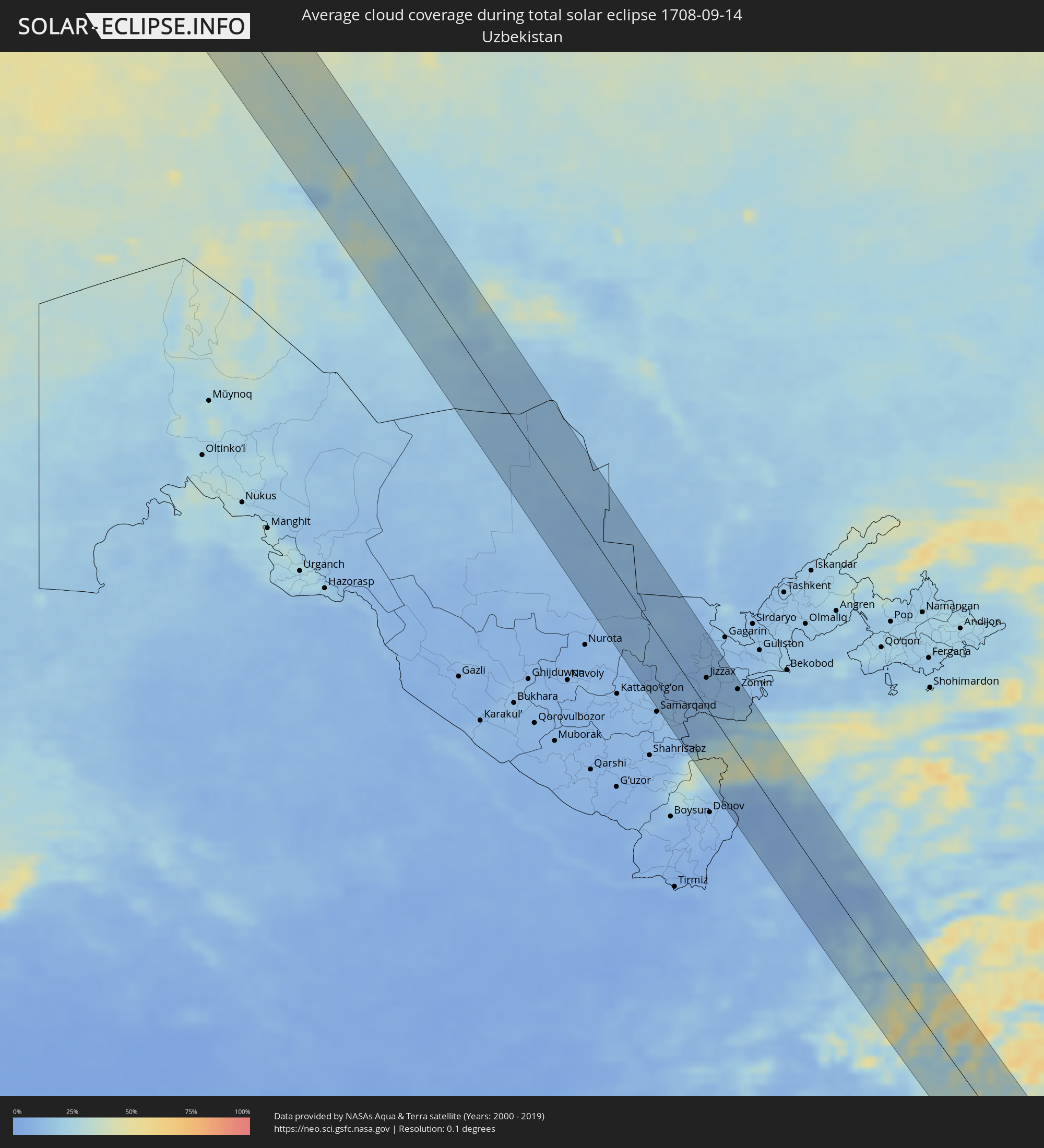
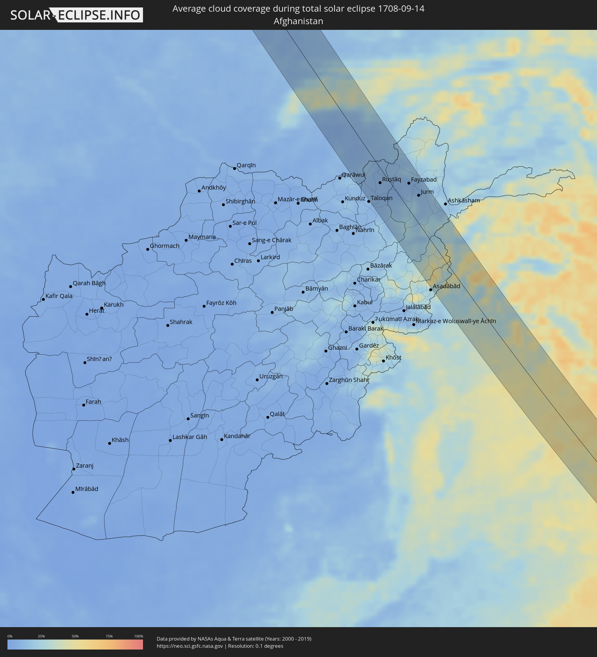
The following maps show the average cloud coverage for the day of the total solar eclipse.
With the help of these maps, it is possible to find the place along the eclipse path, which has the best
chance of a cloudless sky.
Nevertheless, you should consider local circumstances and inform about the weather of your chosen
observation site.
The data is provided by NASAs satellites
AQUA and TERRA.
The cloud maps are averaged over a period of 19 years (2000 - 2019).

Detailed country maps
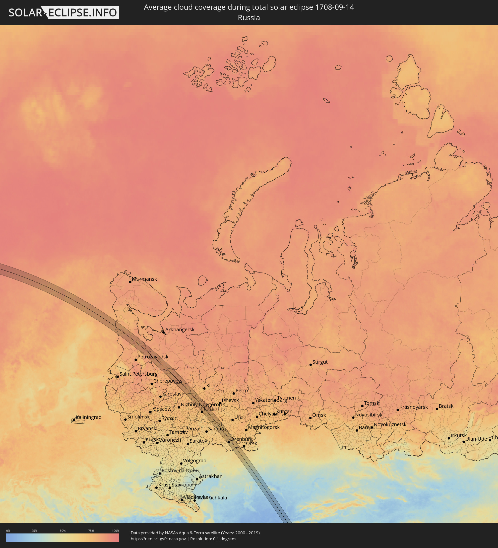 Russia
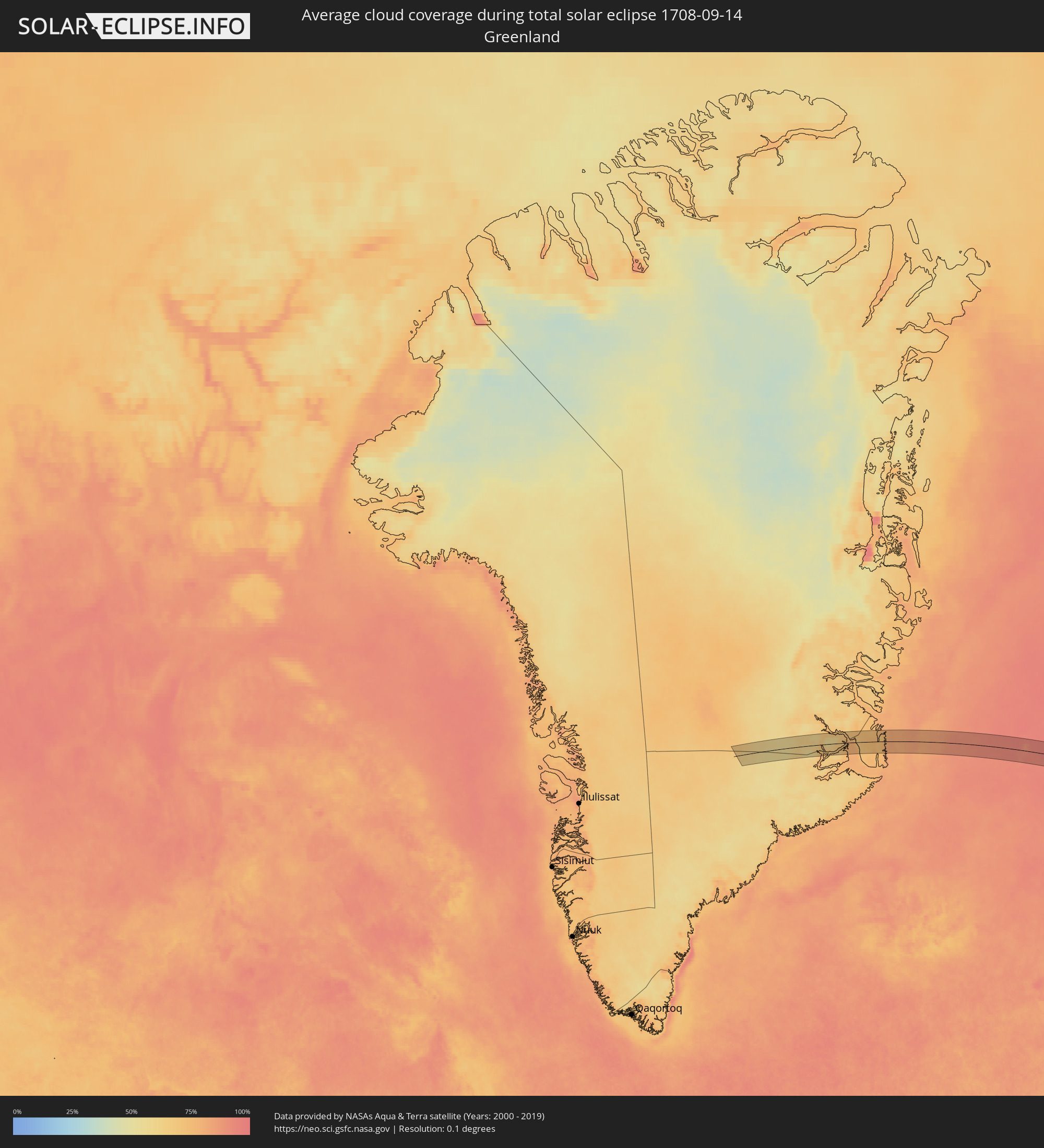 Greenland
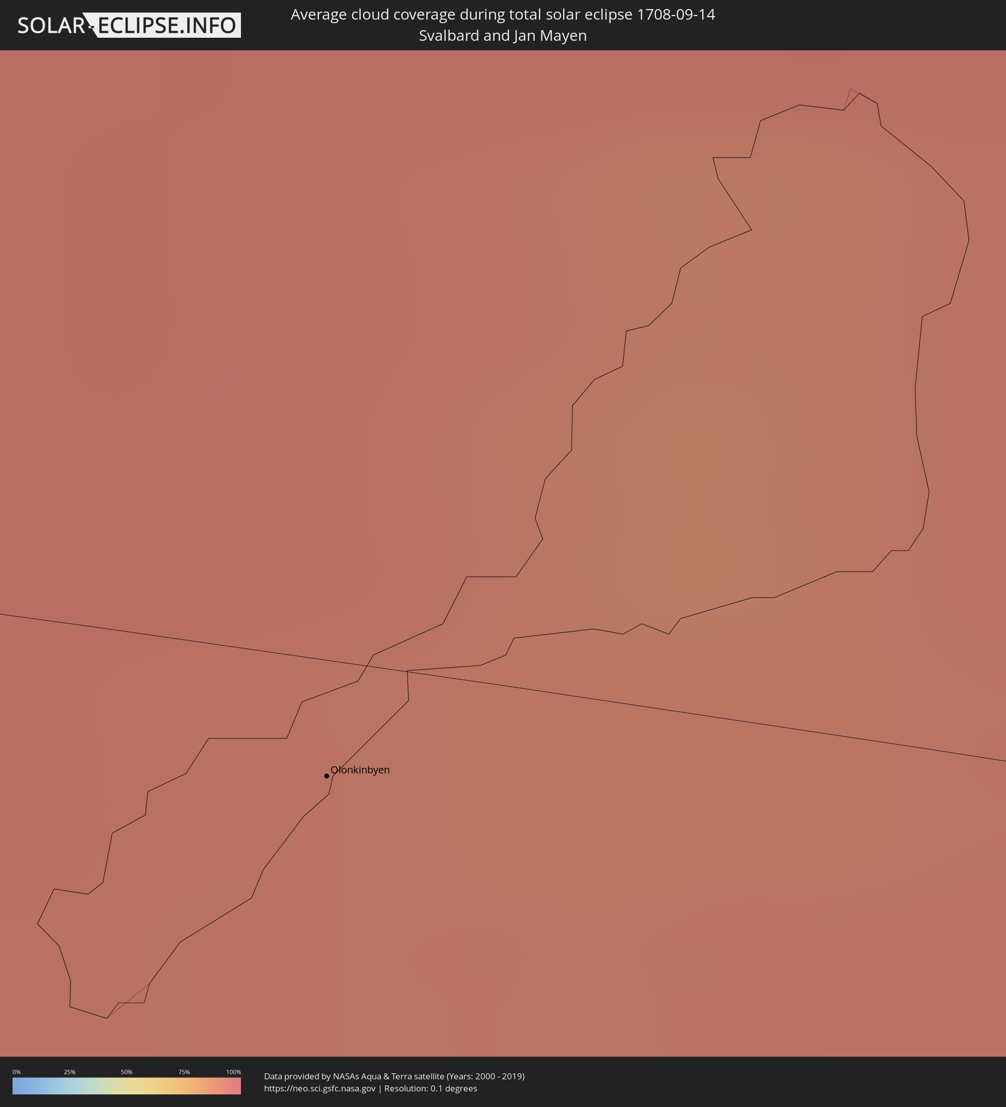 Svalbard and Jan Mayen
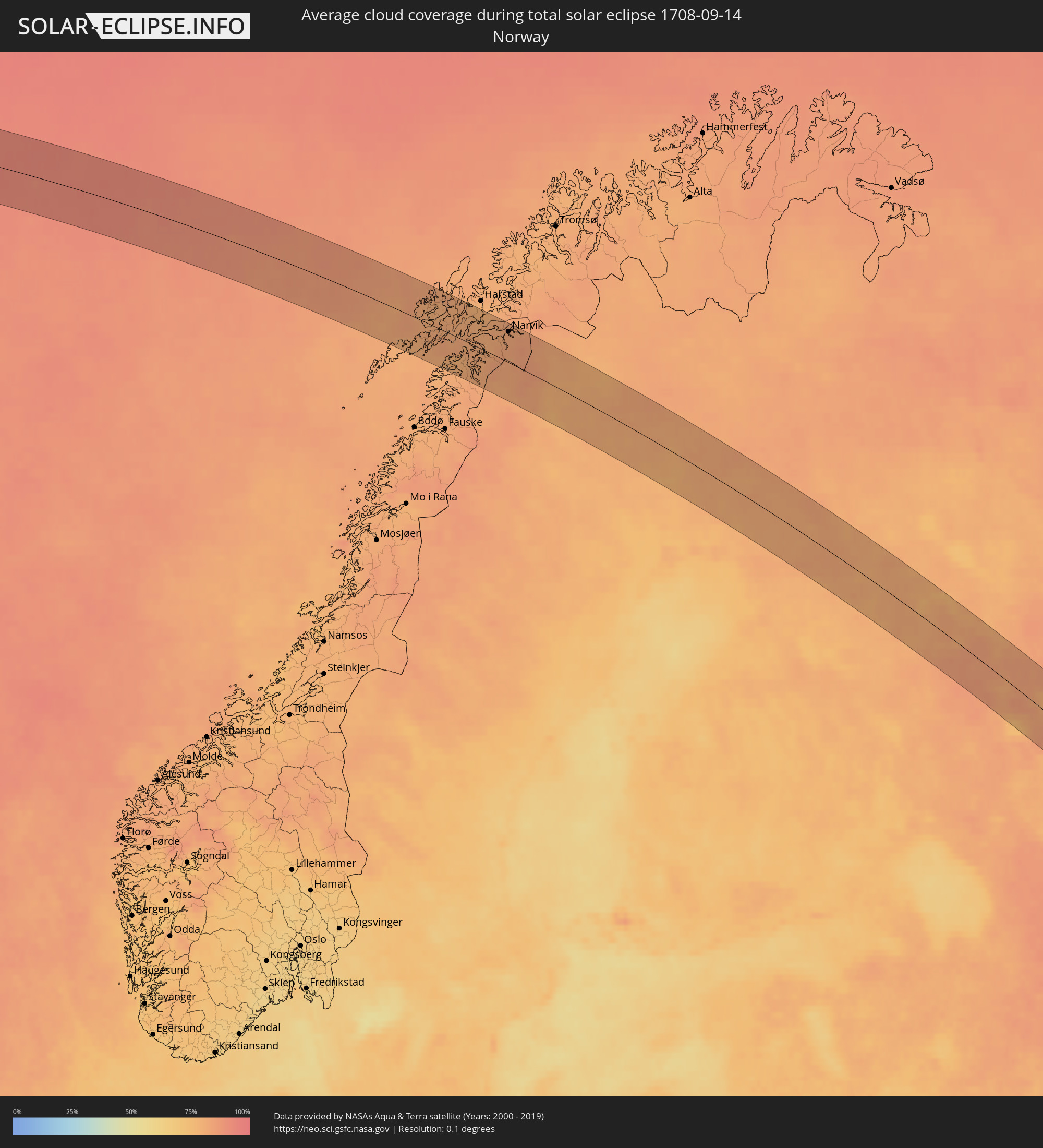 Norway
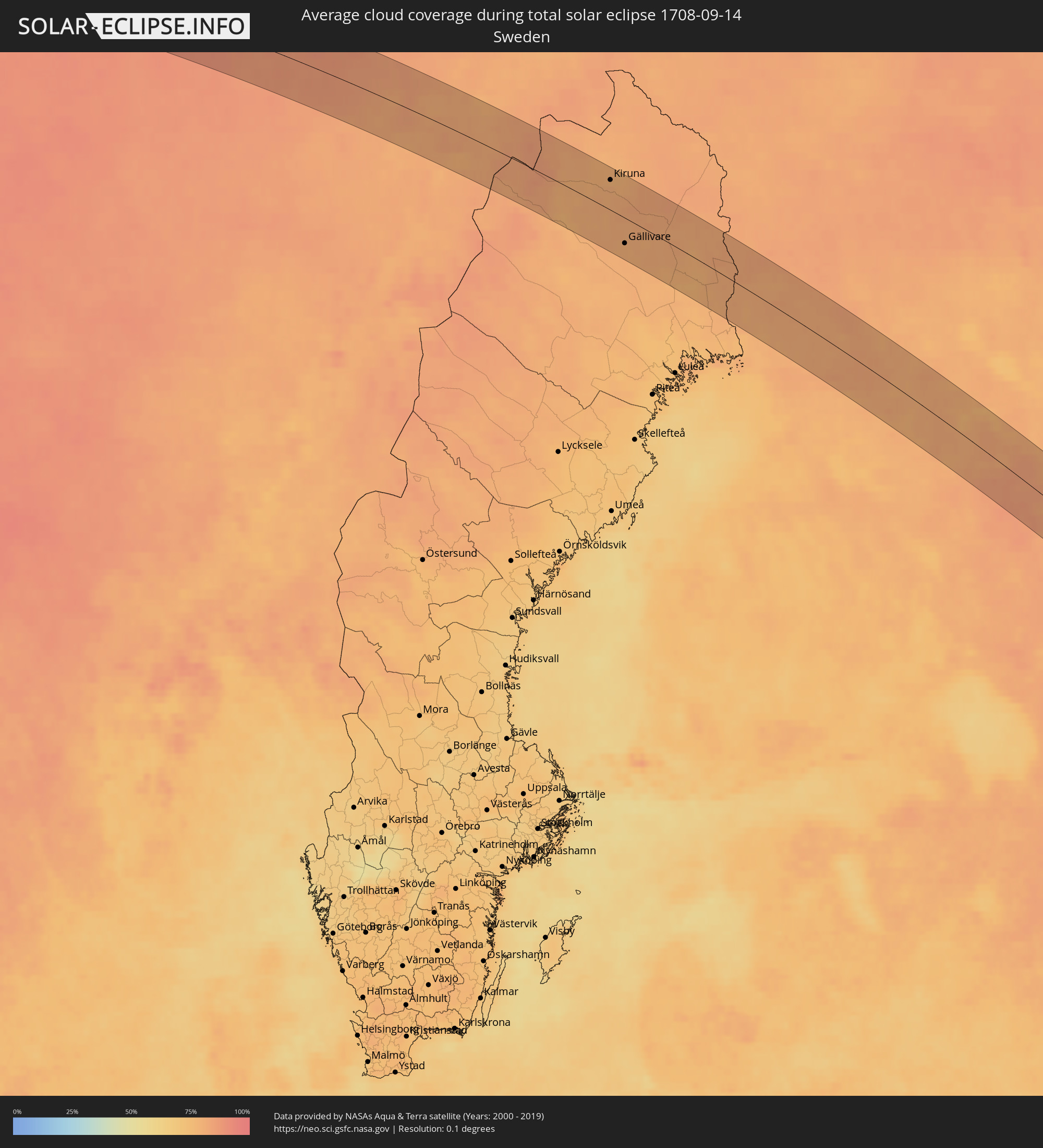 Sweden
 Finland
 Kazakhstan
 Uzbekistan
 Afghanistan
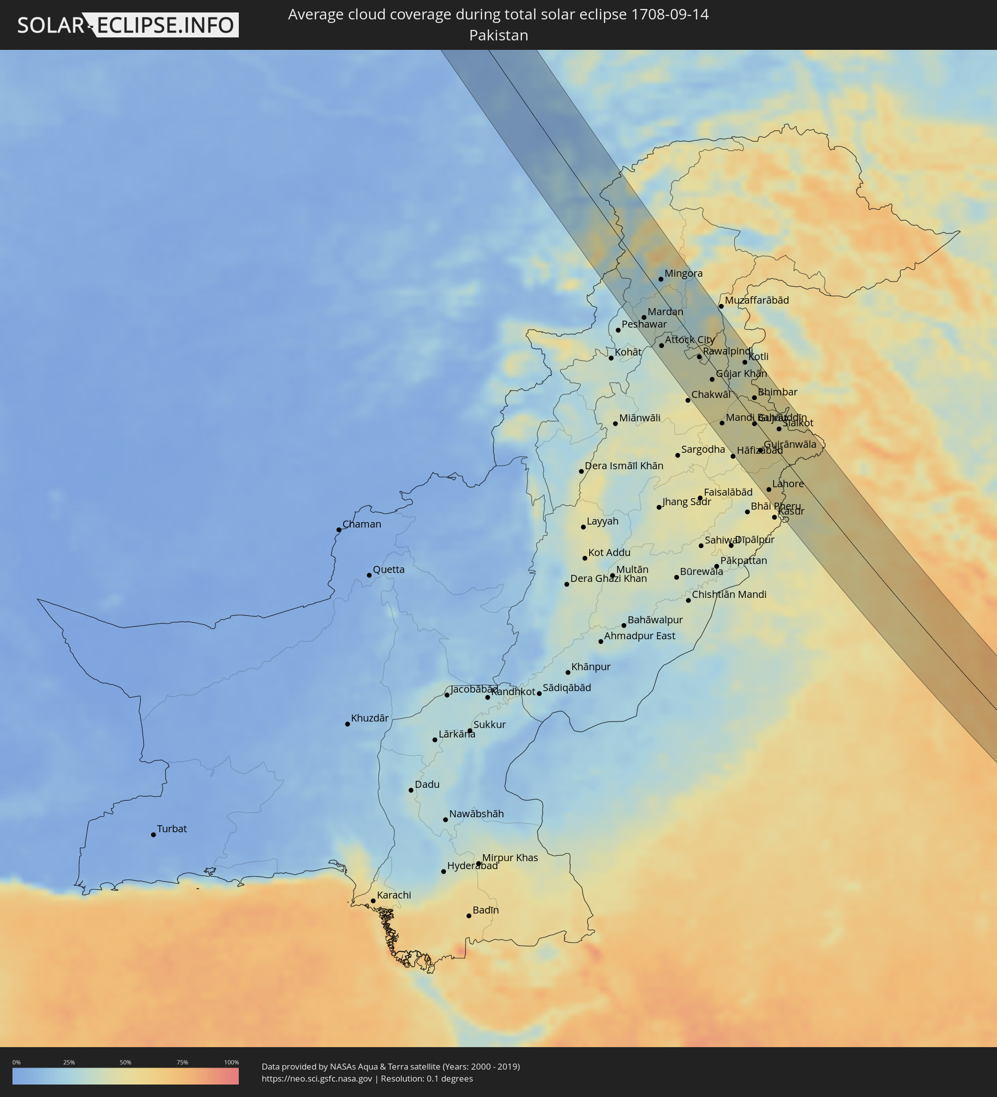 Pakistan
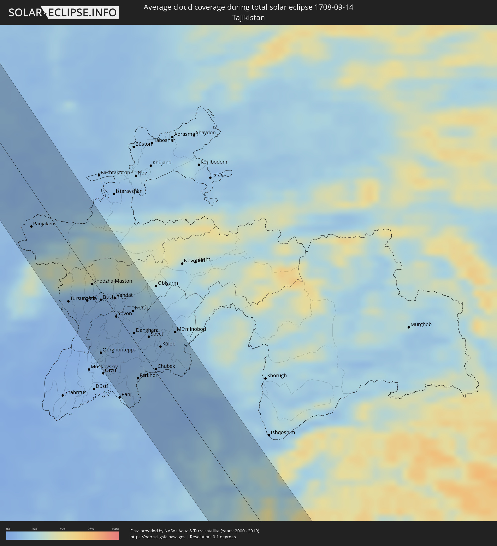 Tajikistan
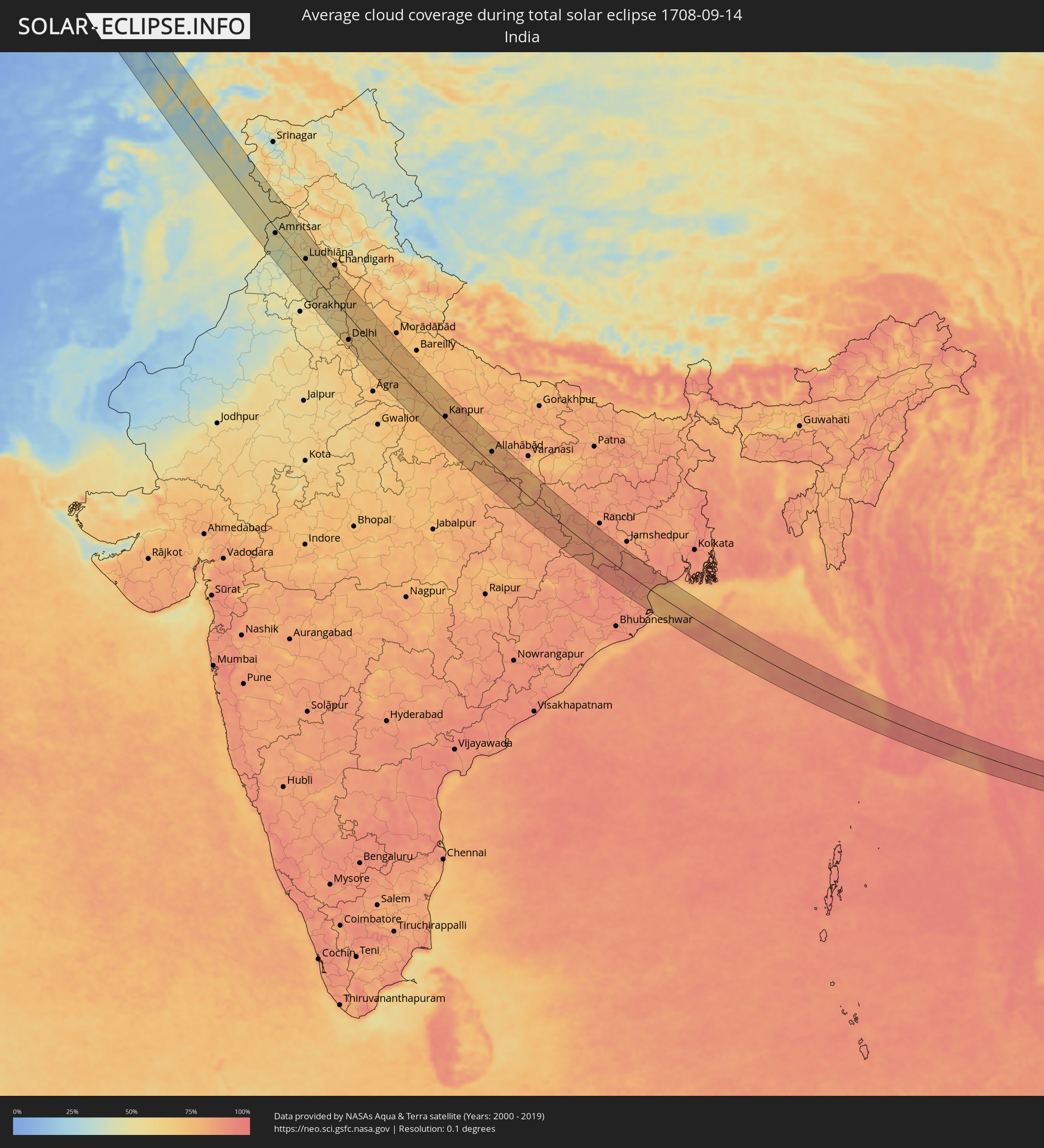 India
India
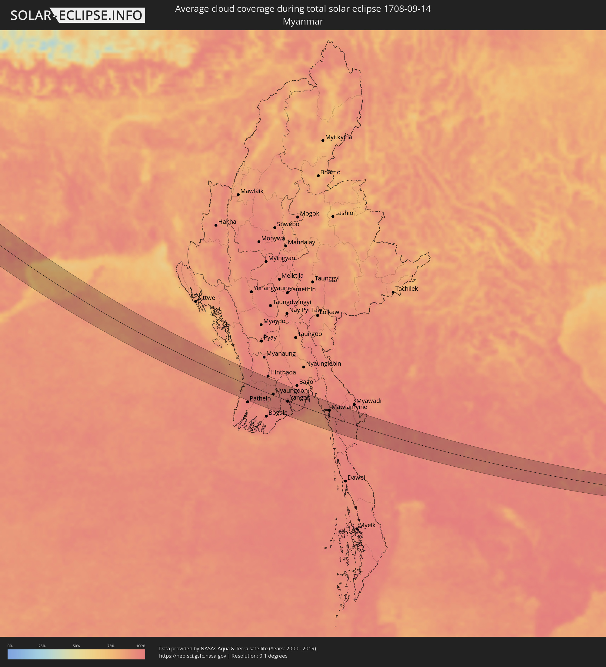 Myanmar
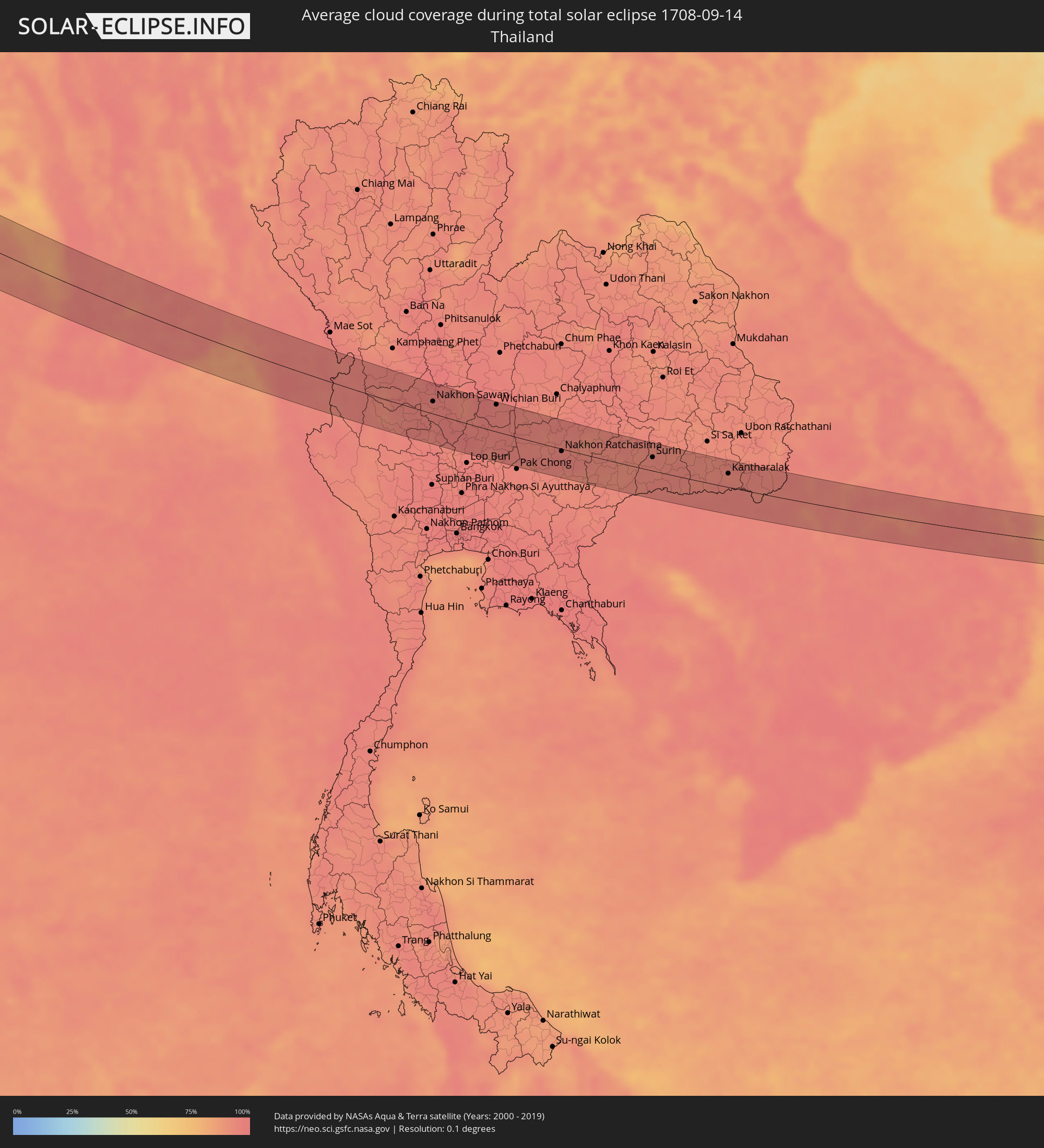 Thailand
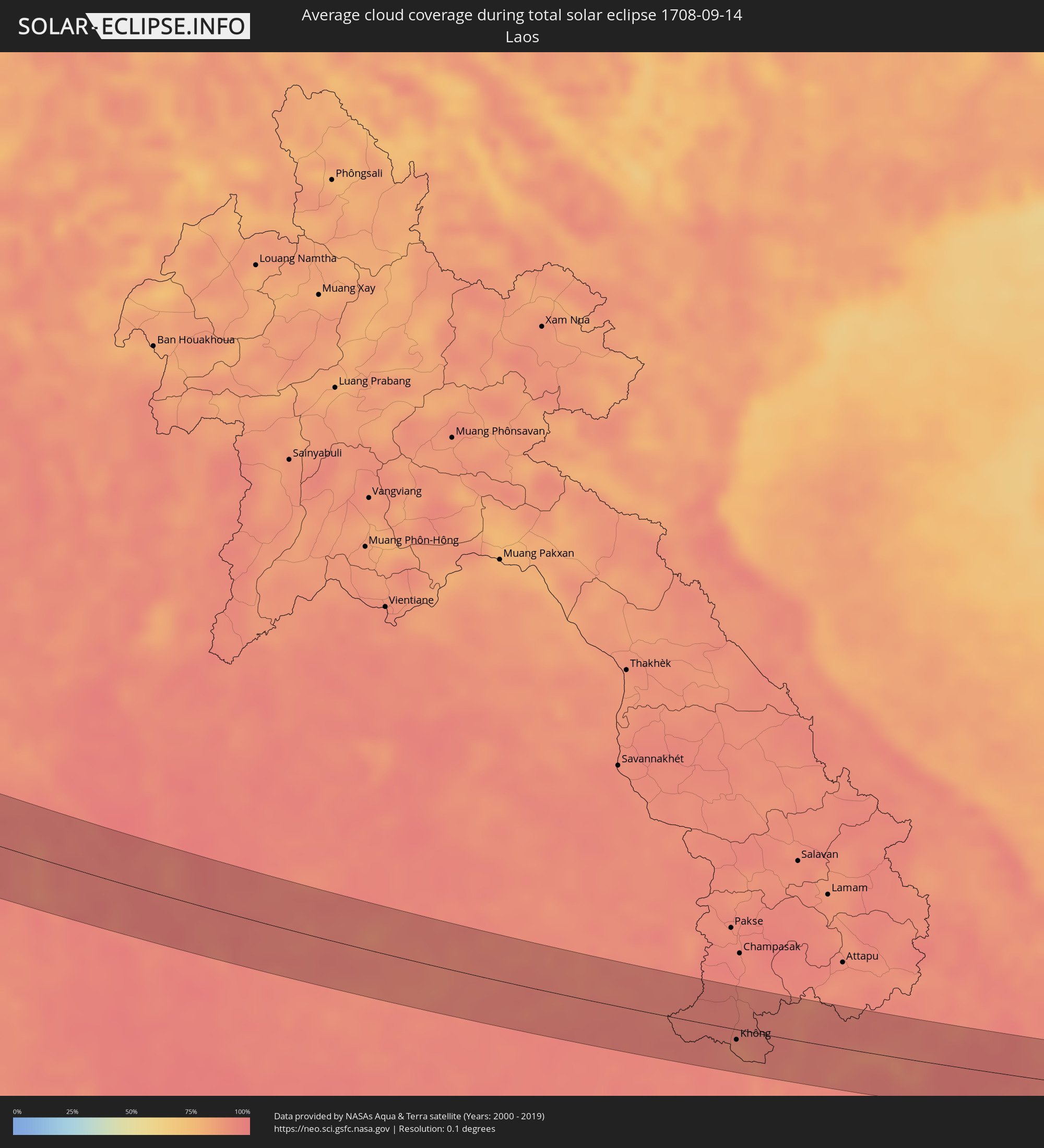 Laos
Laos
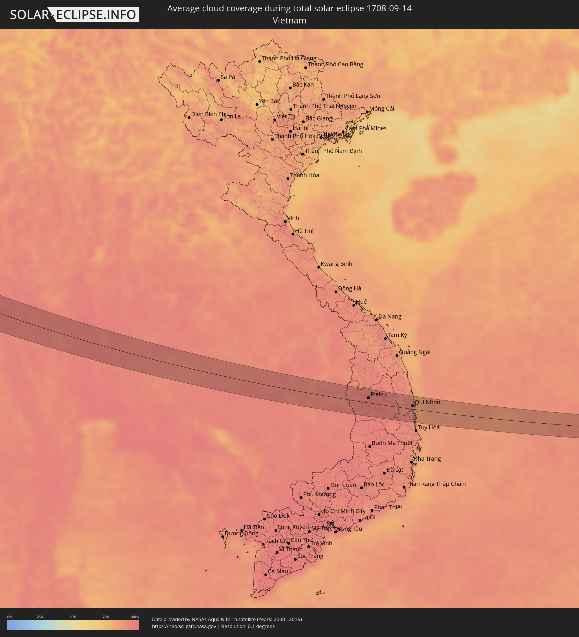 Vietnam
 Cambodia
Cities inside the path of the eclipse
The following table shows all locations with a population of more than 5,000 inside the eclipse path. Cities which have more than 100,000 inhabitants are marked bold. A click at the locations opens a detailed map.
| City | Type | Eclipse duration | Local time of max. eclipse | Distance to central line | Ø Cloud coverage |
|
Olonkinbyen, Jan Mayen
|
total | - | 08:43:06 UTC+01:00 | 5 km | 91% |
|
Narvik, Nordland
|
total | - | 08:49:30 UTC+01:00 | 36 km | 82% |
|
Kiruna, Norrbotten
|
total | - | 08:50:32 UTC+01:00 | 33 km | 78% |
|
Gällivare, Norrbotten
|
total | - | 08:50:20 UTC+01:00 | 28 km | 79% |
|
Malmberget, Norrbotten
|
total | - | 08:50:21 UTC+01:00 | 24 km | 79% |
|
Ylitornio, Lapland
|
total | - | 09:31:26 UTC+01:39 | 41 km | 80% |
|
Rovaniemi, Lapland
|
total | - | 09:32:44 UTC+01:39 | 25 km | 81% |
|
Suomussalmi, Kainuu
|
total | - | 09:34:13 UTC+01:39 | 43 km | 80% |
|
Kostomuksha, Republic of Karelia
|
total | - | 10:25:45 UTC+02:30 | 26 km | 79% |
|
Segezha, Republic of Karelia
|
total | - | 10:28:20 UTC+02:30 | 11 km | 82% |
|
Shar’ya, Kostroma
|
total | - | 10:39:07 UTC+02:30 | 21 km | 80% |
|
Yoshkar-Ola, Mariy-El
|
total | - | 10:42:29 UTC+02:30 | 48 km | 78% |
|
Kazan, Tatarstan
|
total | - | 10:44:22 UTC+02:30 | 54 km | 70% |
|
Chistopol’, Tatarstan
|
total | - | 10:46:18 UTC+02:30 | 13 km | 71% |
|
Zainsk, Tatarstan
|
total | - | 10:47:52 UTC+02:30 | 53 km | 75% |
|
Al’met’yevsk, Tatarstan
|
total | - | 10:48:30 UTC+02:30 | 36 km | 74% |
|
Buguruslan, Orenburg
|
total | - | 12:22:01 UTC+04:02 | 45 km | 66% |
|
Leninogorsk, Tatarstan
|
total | - | 10:48:55 UTC+02:30 | 22 km | 71% |
|
Bugul’ma, Tatarstan
|
total | - | 10:49:21 UTC+02:30 | 35 km | 71% |
|
Bavly, Tatarstan
|
total | - | 10:49:59 UTC+02:30 | 48 km | 72% |
|
Orenburg, Orenburg
|
total | - | 12:26:59 UTC+04:02 | 35 km | 64% |
|
Martuk, Aqtöbe
|
total | - | 11:52:39 UTC+03:25 | 26 km | 59% |
|
Aqtöbe, Aqtöbe
|
total | - | 11:54:03 UTC+03:25 | 18 km | 62% |
|
Embi, Aqtöbe
|
total | - | 11:57:02 UTC+03:25 | 58 km | 53% |
|
Khromtau, Aqtöbe
|
total | - | 11:55:34 UTC+03:25 | 52 km | 63% |
|
Shalqar, Aqtöbe
|
total | - | 12:00:10 UTC+03:25 | 36 km | 36% |
|
Sekseūil, Qyzylorda
|
total | - | 12:59:38 UTC+04:21 | 12 km | 28% |
|
Aral, Qyzylorda
|
total | - | 13:00:42 UTC+04:21 | 26 km | 29% |
|
Qazaly, Qyzylorda
|
total | - | 13:02:49 UTC+04:21 | 11 km | 35% |
|
Ayteke Bi, Qyzylorda
|
total | - | 13:02:45 UTC+04:21 | 3 km | 35% |
|
Tyuratam, Baikonur
|
total | - | 13:04:31 UTC+04:21 | 59 km | 23% |
|
Baikonur, Baikonur
|
total | - | 13:04:34 UTC+04:21 | 57 km | 23% |
|
Chelak, Samarqand
|
total | - | 13:24:48 UTC+04:27 | 56 km | 11% |
|
Jomboy, Samarqand
|
total | - | 13:25:31 UTC+04:27 | 54 km | 12% |
|
Urgut, Samarqand
|
total | - | 13:26:15 UTC+04:27 | 62 km | 11% |
|
Bulung’ur, Samarqand
|
total | - | 13:25:37 UTC+04:27 | 37 km | 11% |
|
Panjakent, Viloyati Sughd
|
total | - | 13:33:52 UTC+04:35 | 30 km | 9% |
|
Jizzax, Jizzax
|
total | - | 13:25:43 UTC+04:27 | 25 km | 10% |
|
Paxtakor, Jizzax
|
total | - | 13:25:30 UTC+04:27 | 45 km | 10% |
|
Tursunzoda, Republican Subordination
|
total | - | 13:36:30 UTC+04:35 | 47 km | 9% |
|
Zomin, Jizzax
|
total | - | 13:26:43 UTC+04:27 | 55 km | 11% |
|
Hisor, Republican Subordination
|
total | - | 13:36:54 UTC+04:35 | 24 km | 9% |
|
Dushanbe, Dushanbe
|
total | - | 13:37:11 UTC+04:35 | 7 km | 8% |
|
Qŭrghonteppa, Khatlon
|
total | - | 13:38:30 UTC+04:35 | 51 km | 11% |
|
Vahdat, Republican Subordination
|
total | - | 13:37:26 UTC+04:35 | 12 km | 12% |
|
Yovon, Khatlon
|
total | - | 13:37:56 UTC+04:35 | 2 km | 9% |
|
Norak, Khatlon
|
total | - | 13:38:09 UTC+04:35 | 23 km | 11% |
|
Danghara, Khatlon
|
total | - | 13:38:44 UTC+04:35 | 6 km | 10% |
|
Farkhor, Khatlon
|
total | - | 13:39:58 UTC+04:35 | 27 km | 14% |
|
Ārt Khwājah, Takhar
|
total | - | 13:05:38 UTC+04:00 | 48 km | 9% |
|
Yangī Qal‘ah, Takhar
|
total | - | 13:05:05 UTC+04:00 | 14 km | 12% |
|
Vose’, Khatlon
|
total | - | 13:39:41 UTC+04:35 | 10 km | 10% |
|
Chubek, Khatlon
|
total | - | 13:40:07 UTC+04:35 | 2 km | 10% |
|
Kŭlob, Khatlon
|
total | - | 13:39:39 UTC+04:35 | 27 km | 11% |
|
Rustāq, Takhar
|
total | - | 13:06:01 UTC+04:00 | 19 km | 9% |
|
Farkhār, Takhar
|
total | - | 13:07:07 UTC+04:00 | 53 km | 11% |
|
Fayzabad, Badakhshan
|
total | - | 13:07:00 UTC+04:00 | 35 km | 10% |
|
Jurm, Badakhshan
|
total | - | 13:07:48 UTC+04:00 | 37 km | 13% |
|
Pārūn, Nuristan
|
total | - | 13:10:44 UTC+04:00 | 49 km | 37% |
|
Āsmār, Kunar
|
total | - | 13:12:03 UTC+04:00 | 42 km | 35% |
|
Mardan, Khyber Pakhtunkhwa
|
total | - | 13:42:47 UTC+04:28 | 45 km | 35% |
|
Mingora, Khyber Pakhtunkhwa
|
total | - | 13:42:02 UTC+04:28 | 16 km | 31% |
|
Rawalpindi, Punjab
|
total | - | 13:45:16 UTC+04:28 | 10 km | 43% |
|
Mandi Bahāuddīn, Punjab
|
total | - | 13:47:50 UTC+04:28 | 47 km | 46% |
|
Jhelum, Punjab
|
total | - | 13:47:25 UTC+04:28 | 5 km | 46% |
|
Kotli, Azad Kashmir
|
total | - | 13:46:28 UTC+04:28 | 47 km | 38% |
|
Bhimbar, Azad Kashmir
|
total | - | 13:47:47 UTC+04:28 | 24 km | 49% |
|
Gujrāt, Punjab
|
total | - | 13:48:35 UTC+04:28 | 4 km | 47% |
|
Gujrānwāla, Punjab
|
total | - | 13:49:33 UTC+04:28 | 23 km | 52% |
|
Kamoke, Punjab
|
total | - | 13:49:58 UTC+04:28 | 34 km | 52% |
|
Murīdke, Punjab
|
total | - | 13:50:22 UTC+04:28 | 43 km | 51% |
|
Lahore, Punjab
|
total | - | 13:50:59 UTC+04:28 | 54 km | 54% |
|
Sialkot, Punjab
|
total | - | 13:49:18 UTC+04:28 | 25 km | 53% |
|
Amritsar, Punjab
|
total | - | 14:44:27 UTC+05:21 | 9 km | 52% |
|
Jalandhar, Punjab
|
total | - | 14:45:54 UTC+05:21 | 22 km | 58% |
|
Ludhiāna, Punjab
|
total | - | 14:47:04 UTC+05:21 | 14 km | 63% |
|
Patiāla, Punjab
|
total | - | 14:48:53 UTC+05:21 | 12 km | 62% |
|
Delhi, NCT
|
total | - | 14:53:17 UTC+05:21 | 48 km | 67% |
|
Farīdābād, Haryana
|
total | - | 14:53:52 UTC+05:21 | 60 km | 69% |
|
Ghāziābād, Uttar Pradesh
|
total | - | 14:53:30 UTC+05:21 | 32 km | 69% |
|
Greater Noida, Uttar Pradesh
|
total | - | 14:53:57 UTC+05:21 | 38 km | 69% |
|
Muzaffarnagar, Uttar Pradesh
|
total | - | 14:52:10 UTC+05:21 | 46 km | 72% |
|
Meerut, Uttar Pradesh
|
total | - | 14:53:10 UTC+05:21 | 11 km | 69% |
|
Alīgarh, Uttar Pradesh
|
total | - | 14:55:49 UTC+05:21 | 45 km | 71% |
|
Kanpur, Uttar Pradesh
|
total | - | 15:01:11 UTC+05:21 | 8 km | 77% |
|
Allahābād, Uttar Pradesh
|
total | - | 15:04:47 UTC+05:21 | 29 km | 78% |
|
Nyaungdon, Ayeyarwady
|
total | - | 16:34:35 UTC+06:24 | 4 km | 95% |
|
Maubin, Ayeyarwady
|
total | - | 16:35:07 UTC+06:24 | 28 km | 95% |
|
Twante, Yangon
|
total | - | 16:35:17 UTC+06:24 | 20 km | 95% |
|
Kanbe, Yangon
|
total | - | 16:35:20 UTC+06:24 | 17 km | 95% |
|
Yangon, Yangon
|
total | - | 16:35:15 UTC+06:24 | 1 km | 95% |
|
Syriam, Yangon
|
total | - | 16:35:21 UTC+06:24 | 2 km | 95% |
|
Thanatpin, Bago
|
total | - | 16:34:39 UTC+06:24 | 47 km | 96% |
|
Thongwa, Yangon
|
total | - | 16:35:30 UTC+06:24 | 8 km | 95% |
|
Kayan, Yangon
|
total | - | 16:35:17 UTC+06:24 | 25 km | 95% |
|
Kyaikkami, Mon
|
total | - | 16:37:05 UTC+06:24 | 26 km | 91% |
|
Martaban, Mon
|
total | - | 16:36:23 UTC+06:24 | 24 km | 94% |
|
Mawlamyine, Mon
|
total | - | 16:36:27 UTC+06:24 | 20 km | 94% |
|
Mudon, Mon
|
total | - | 16:36:52 UTC+06:24 | 1 km | 95% |
|
Lat Yao, Nakhon Sawan
|
total | - | 16:55:48 UTC+06:42 | 14 km | 96% |
|
Uthai Thani, Uthai Thani
|
total | - | 16:56:27 UTC+06:42 | 19 km | 96% |
|
Nakhon Sawan, Nakhon Sawan
|
total | - | 16:56:00 UTC+06:42 | 19 km | 95% |
|
Wichian Buri, Phetchabun
|
total | - | 16:56:24 UTC+06:42 | 43 km | 95% |
|
Chai Badan, Lop Buri
|
total | - | 16:57:06 UTC+06:42 | 6 km | 96% |
|
Amphoe Sikhiu, Nakhon Ratchasima
|
total | - | 16:57:44 UTC+06:42 | 22 km | 94% |
|
Nakhon Ratchasima, Nakhon Ratchasima
|
total | - | 16:57:45 UTC+06:42 | 4 km | 96% |
|
Chok Chai, Nakhon Ratchasima
|
total | - | 16:58:08 UTC+06:42 | 28 km | 92% |
|
Non Sung, Nakhon Ratchasima
|
total | - | 16:57:29 UTC+06:42 | 23 km | 93% |
|
Nang Rong, Buriram
|
total | - | 16:58:26 UTC+06:42 | 22 km | 92% |
|
Buriram, Buriram
|
total | - | 16:58:00 UTC+06:42 | 24 km | 94% |
|
Surin, Surin
|
total | - | 16:58:16 UTC+06:42 | 22 km | 93% |
|
Kantharalak, Sisaket
|
total | - | 16:58:54 UTC+06:42 | 22 km | 95% |
|
Không, Champasak
|
total | - | 16:59:52 UTC+06:42 | 10 km | 91% |
|
Ban Lŭng, Ratanakiri
|
total | - | 17:00:34 UTC+06:42 | 30 km | 94% |
|
Pleiku, Gia Lai
|
total | - | 17:24:58 UTC+07:06 | 14 km | 97% |
|
Sông Cầu, Phú Yên
|
total | - | 17:25:48 UTC+07:06 | 26 km | 93% |
|
Qui Nhon, Bình Định
|
total | - | 17:25:22 UTC+07:06 | 10 km | 91% |