Annular solar eclipse of 05/05/1818
| Day of week: | Tuesday |
| Maximum duration of eclipse: | 05m05s |
| Maximum width of eclipse path: | 233 km |
| Saros cycle: | 135 |
| Coverage: | 94.6% |
| Magnitude: | 0.9464 |
| Gamma: | 0.544 |
Wo kann man die Sonnenfinsternis vom 05/05/1818 sehen?
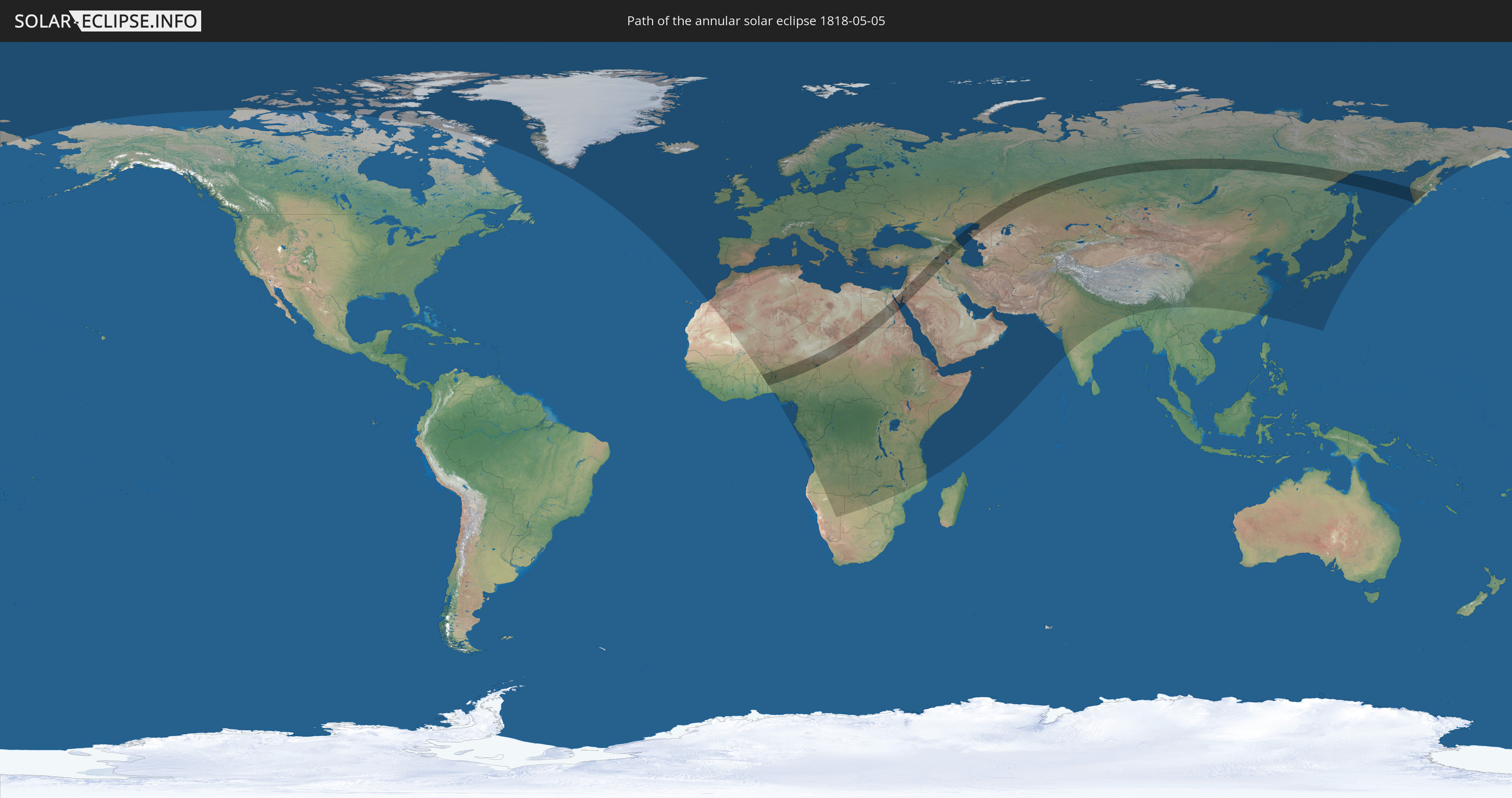
Die Sonnenfinsternis am 05/05/1818 kann man in 129 Ländern als partielle Sonnenfinsternis beobachten.
Der Finsternispfad verläuft durch 20 Länder. Nur in diesen Ländern ist sie als annular Sonnenfinsternis zu sehen.
In den folgenden Ländern ist die Sonnenfinsternis annular zu sehen
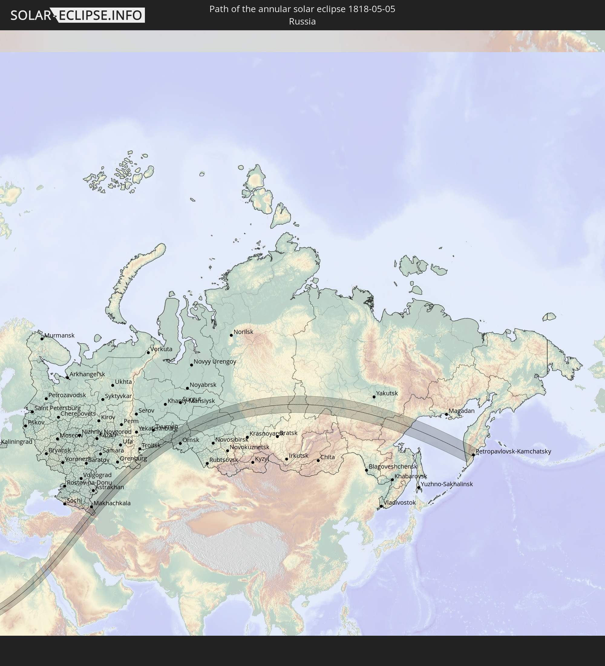 Russia
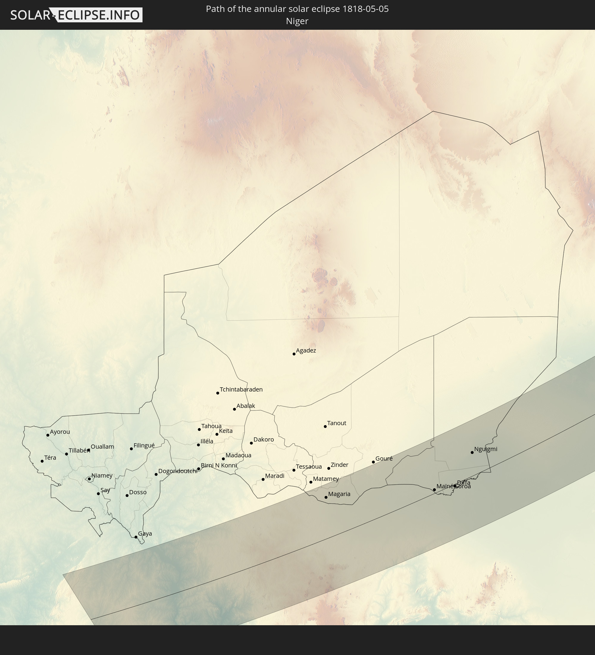 Niger
Niger
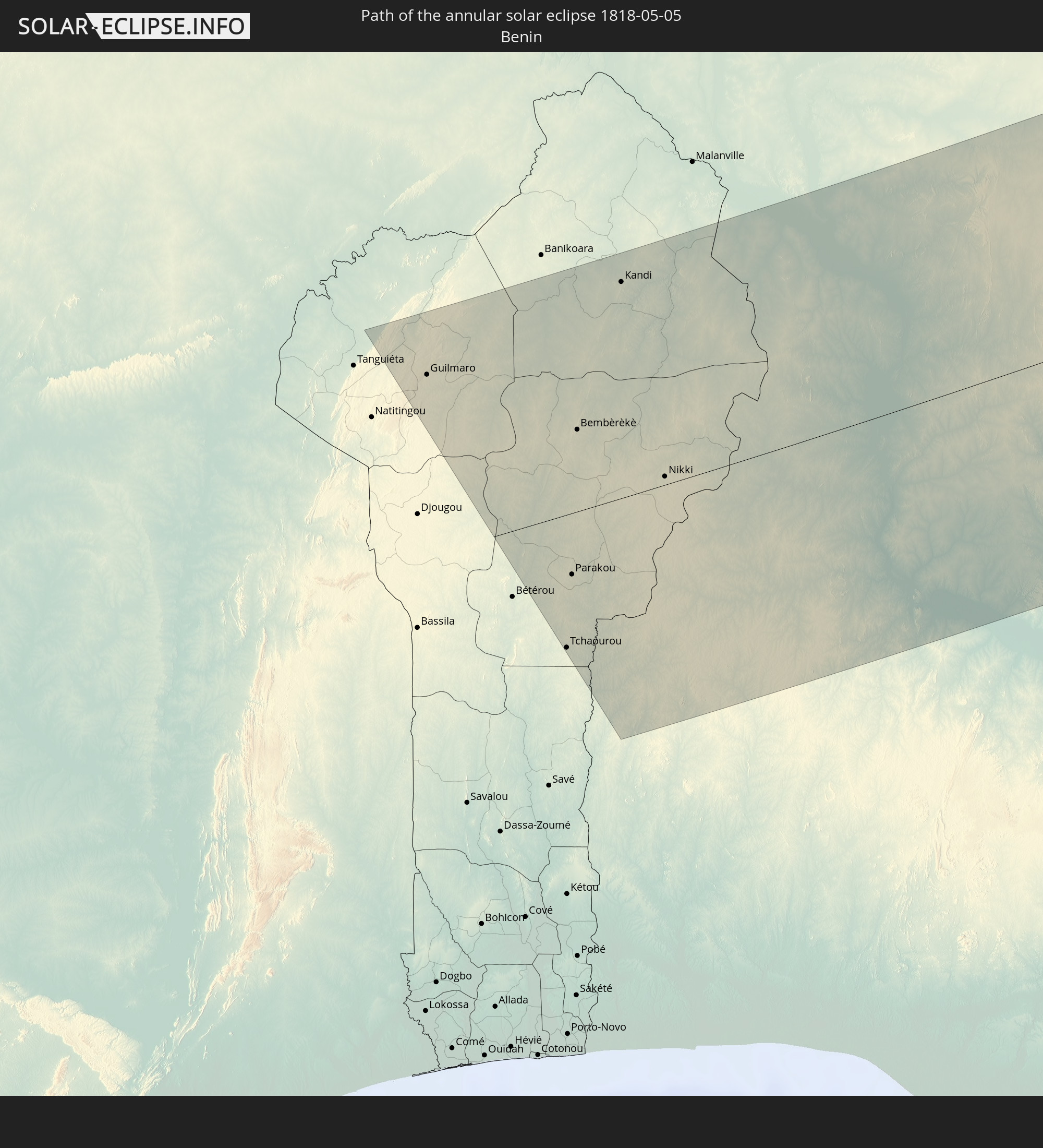 Benin
Benin
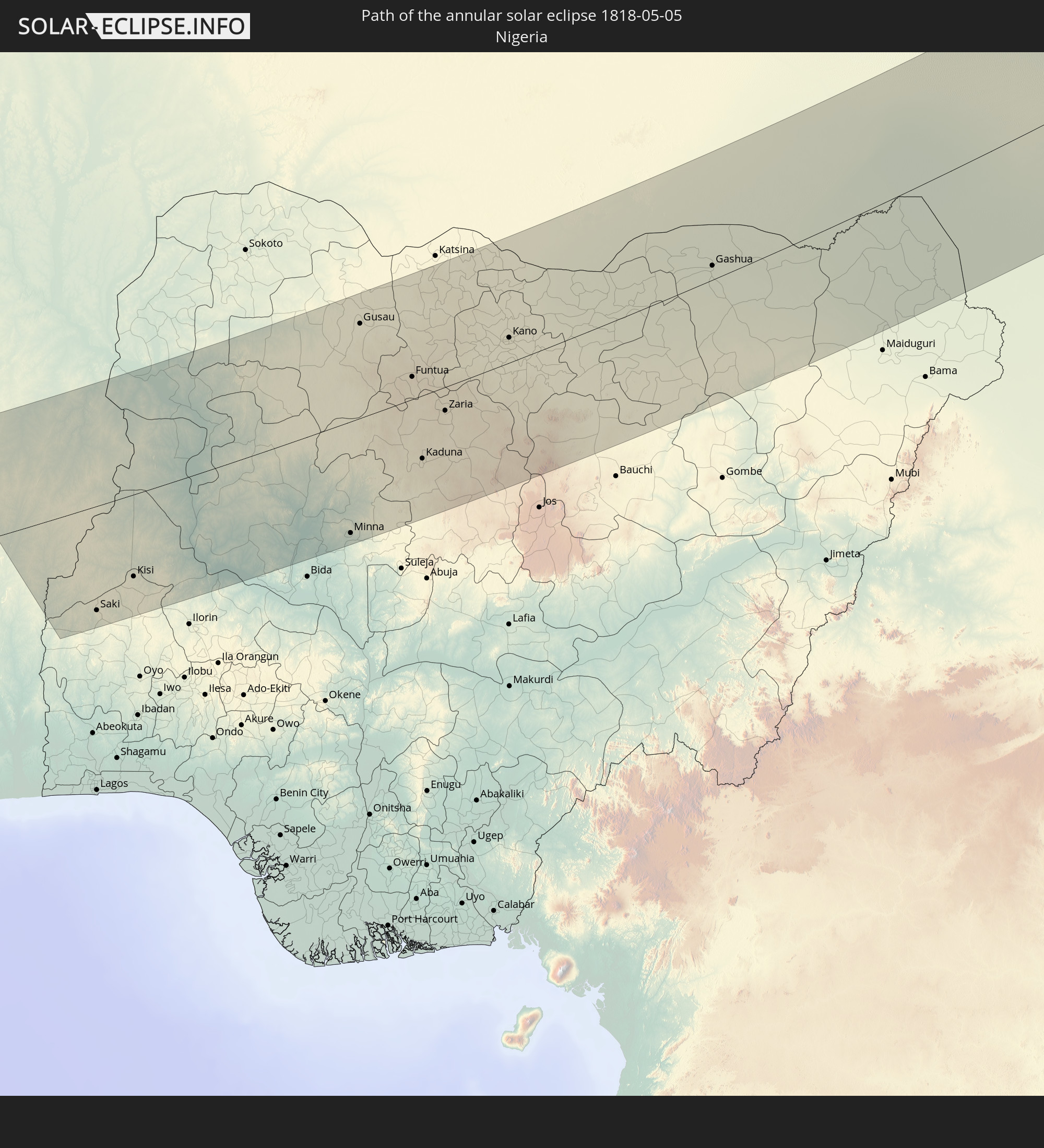 Nigeria
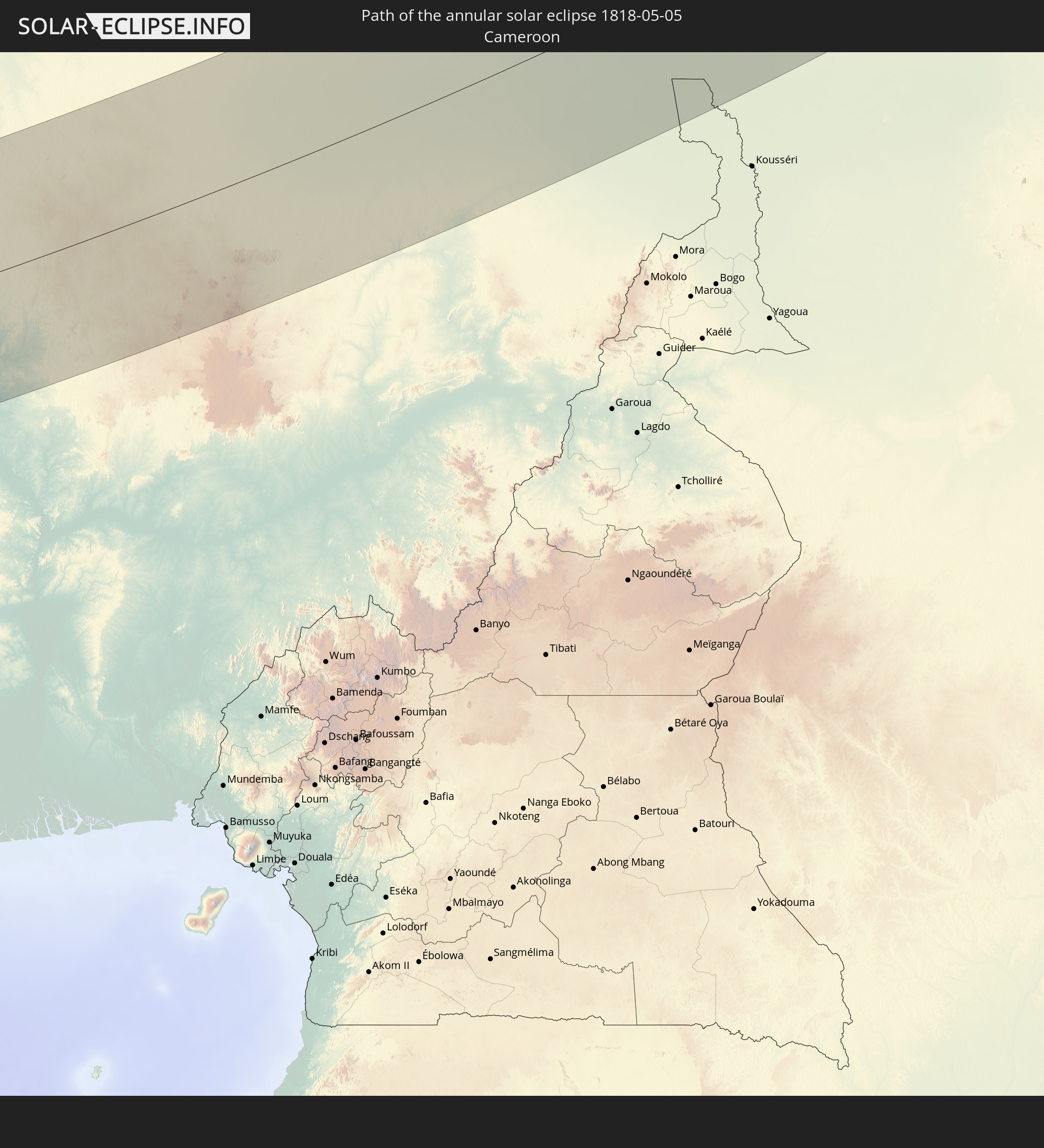 Cameroon
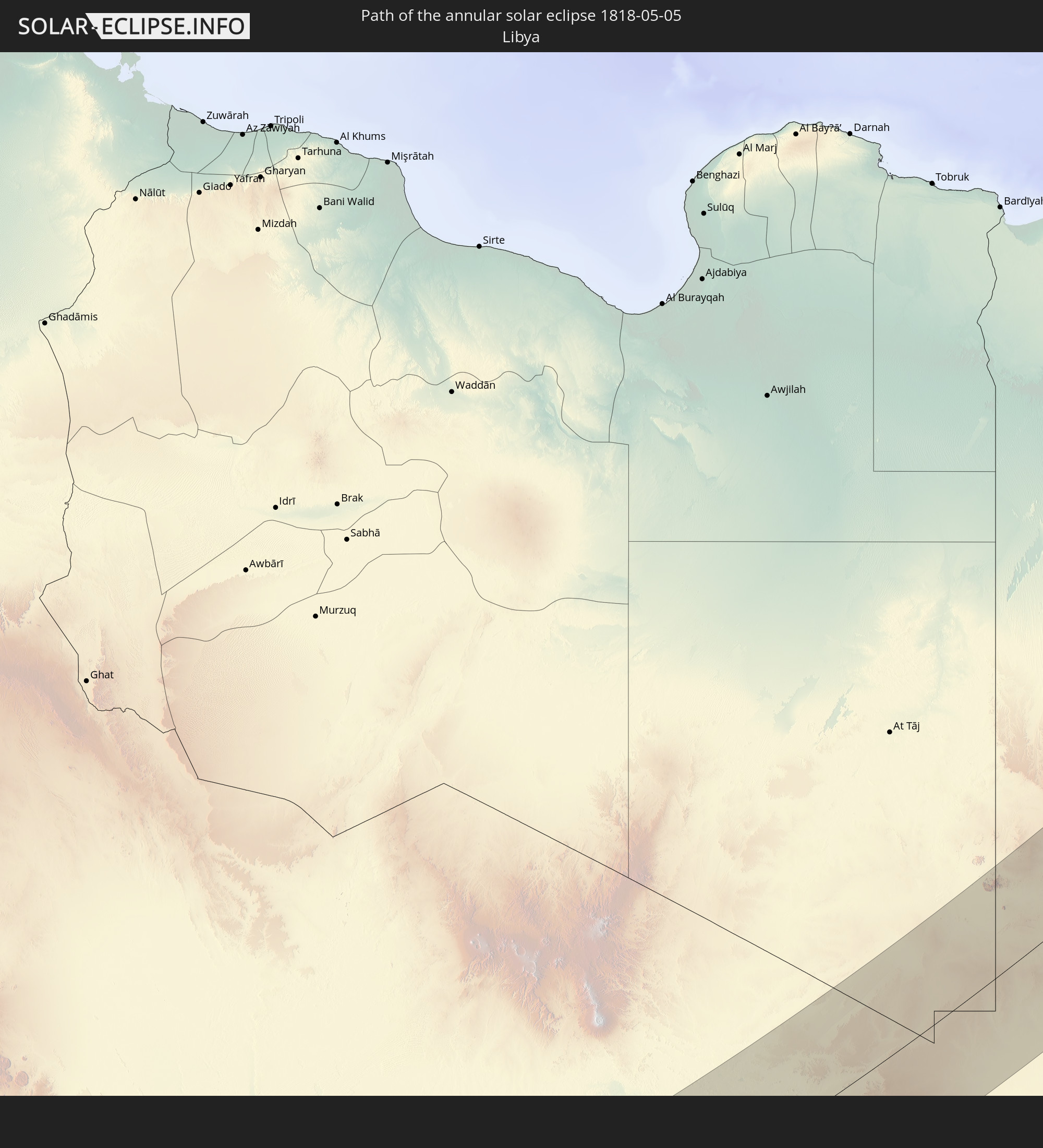 Libya
Libya
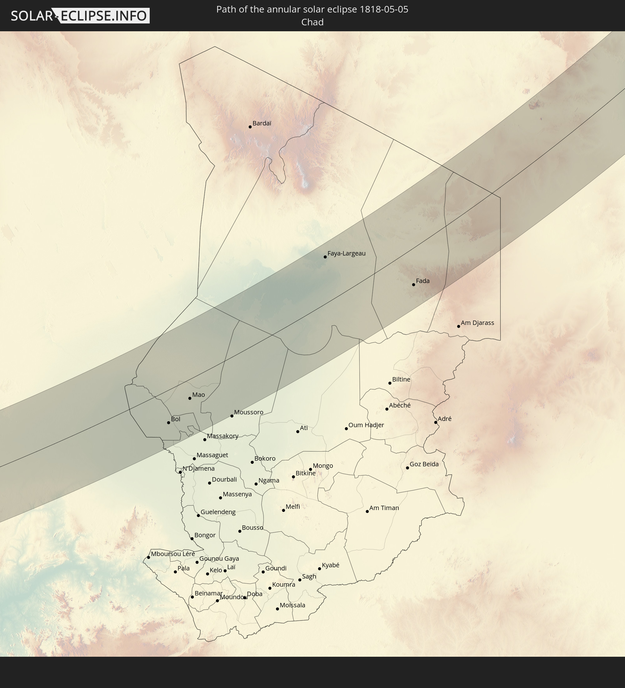 Chad
Chad
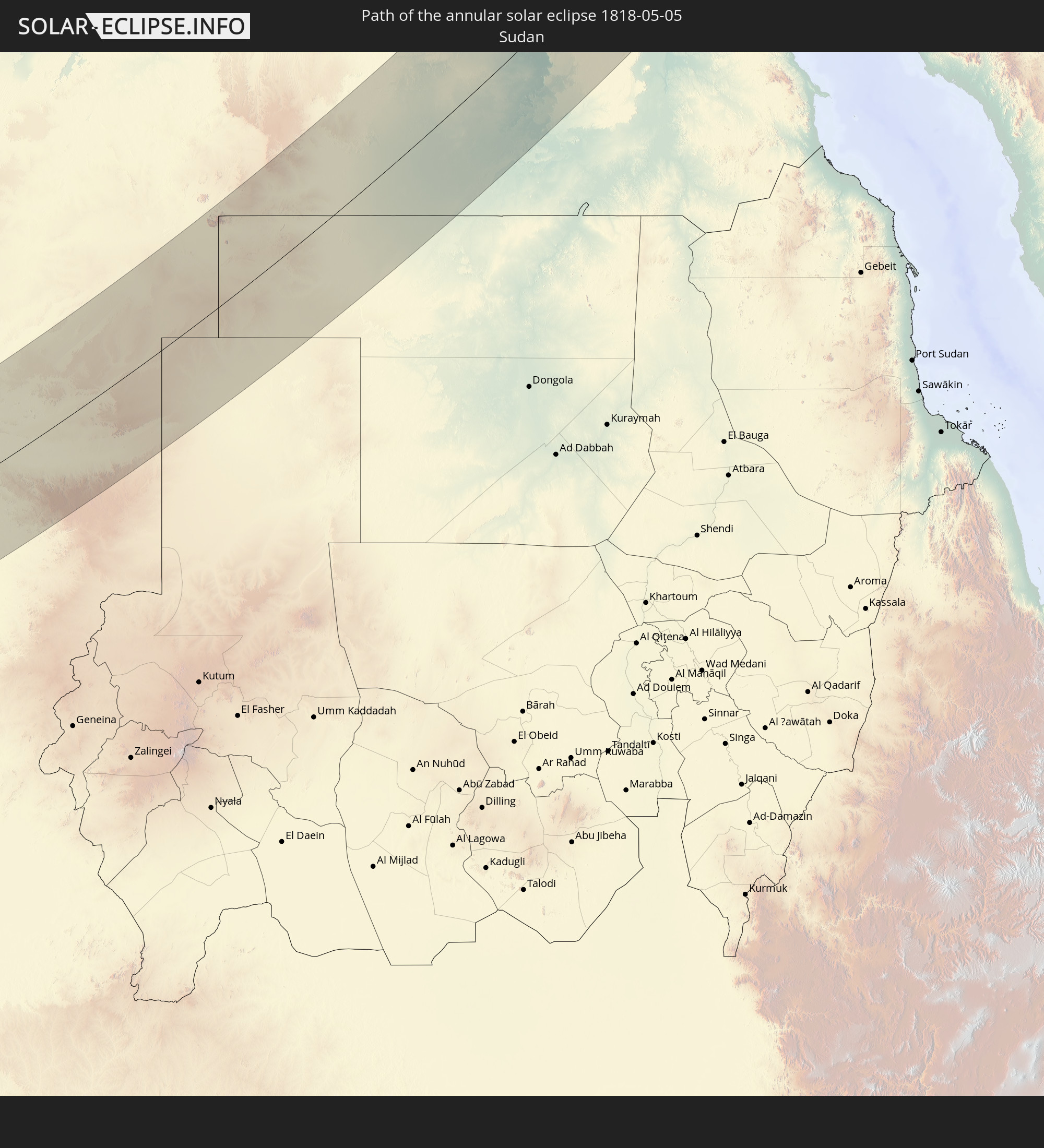 Sudan
Sudan
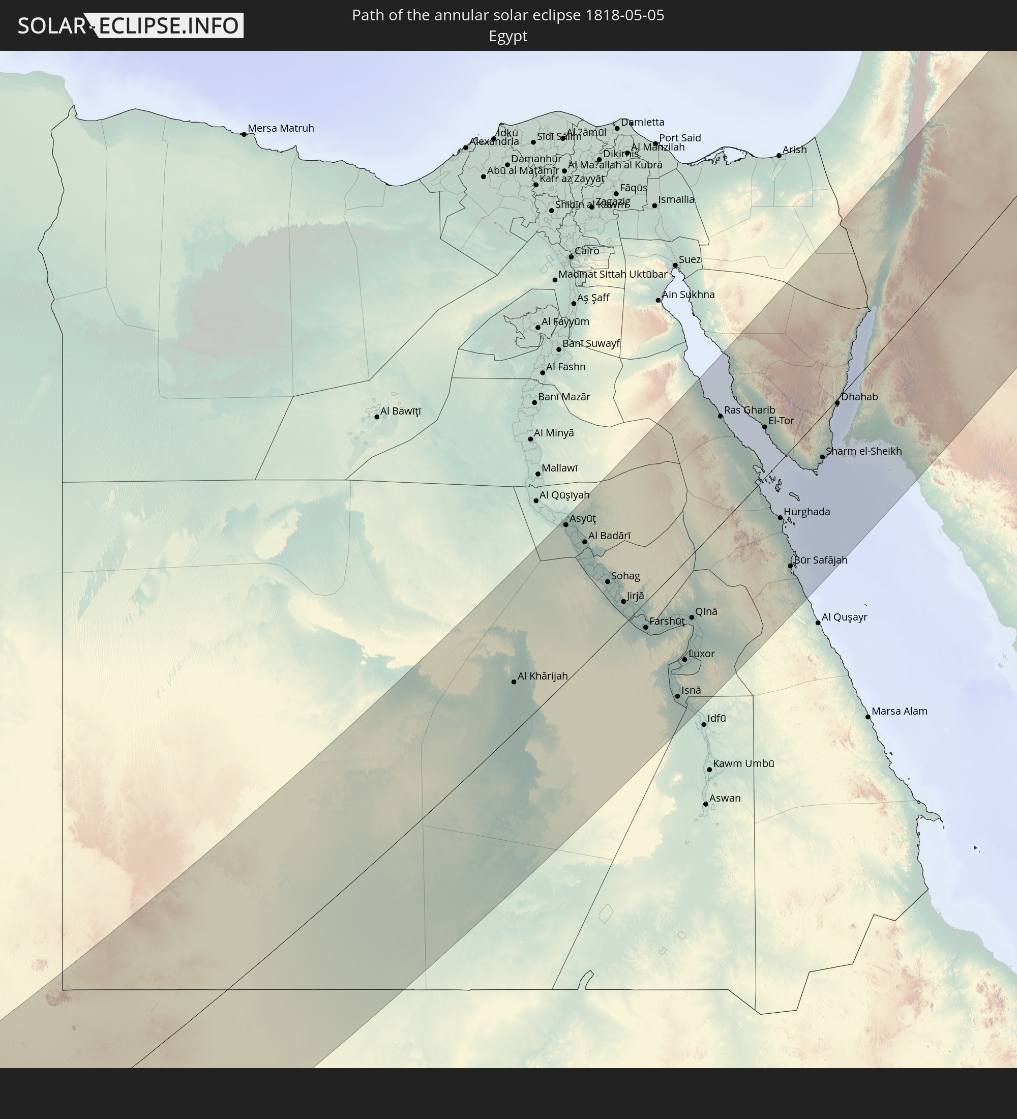 Egypt
Egypt
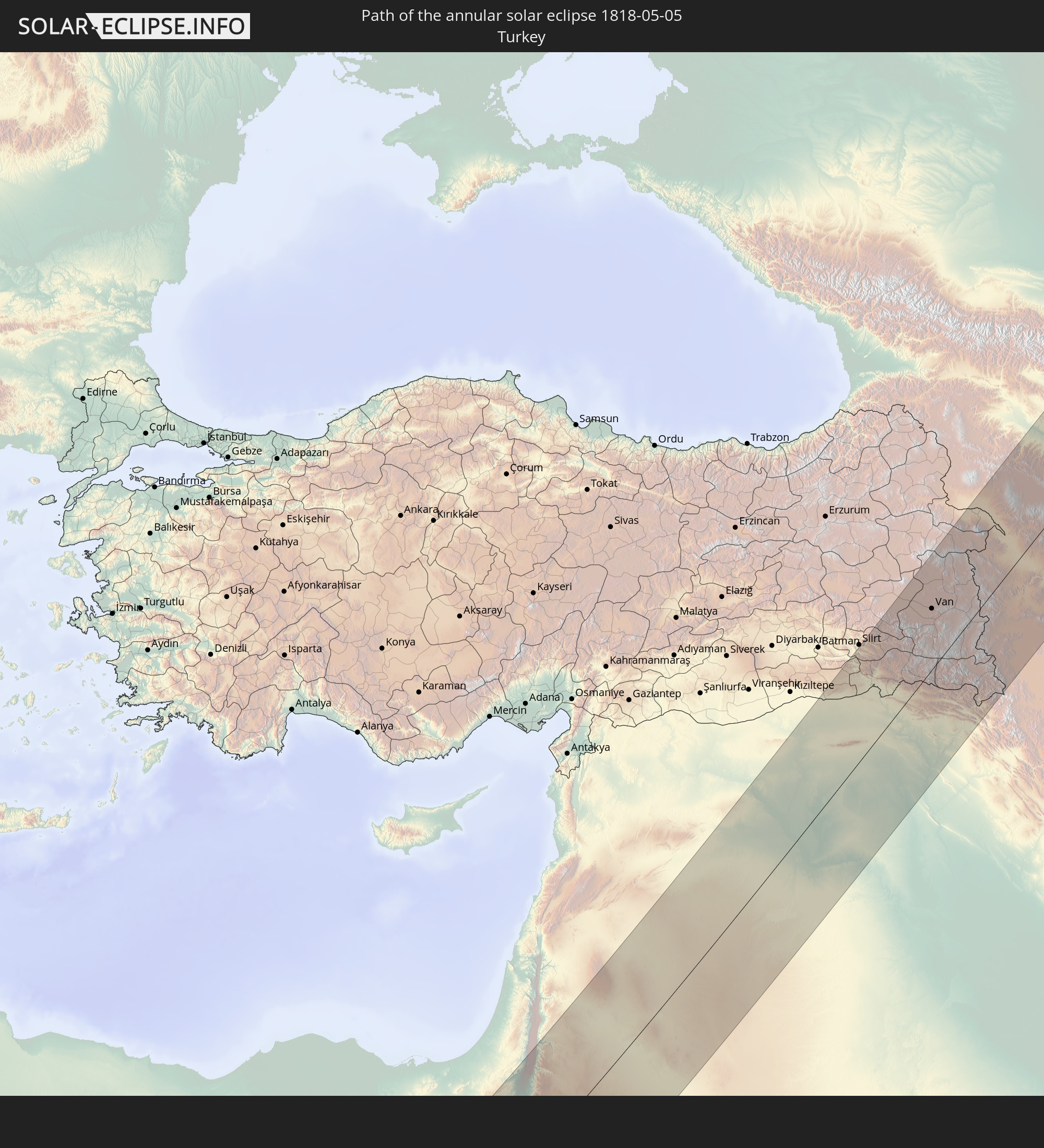 Turkey
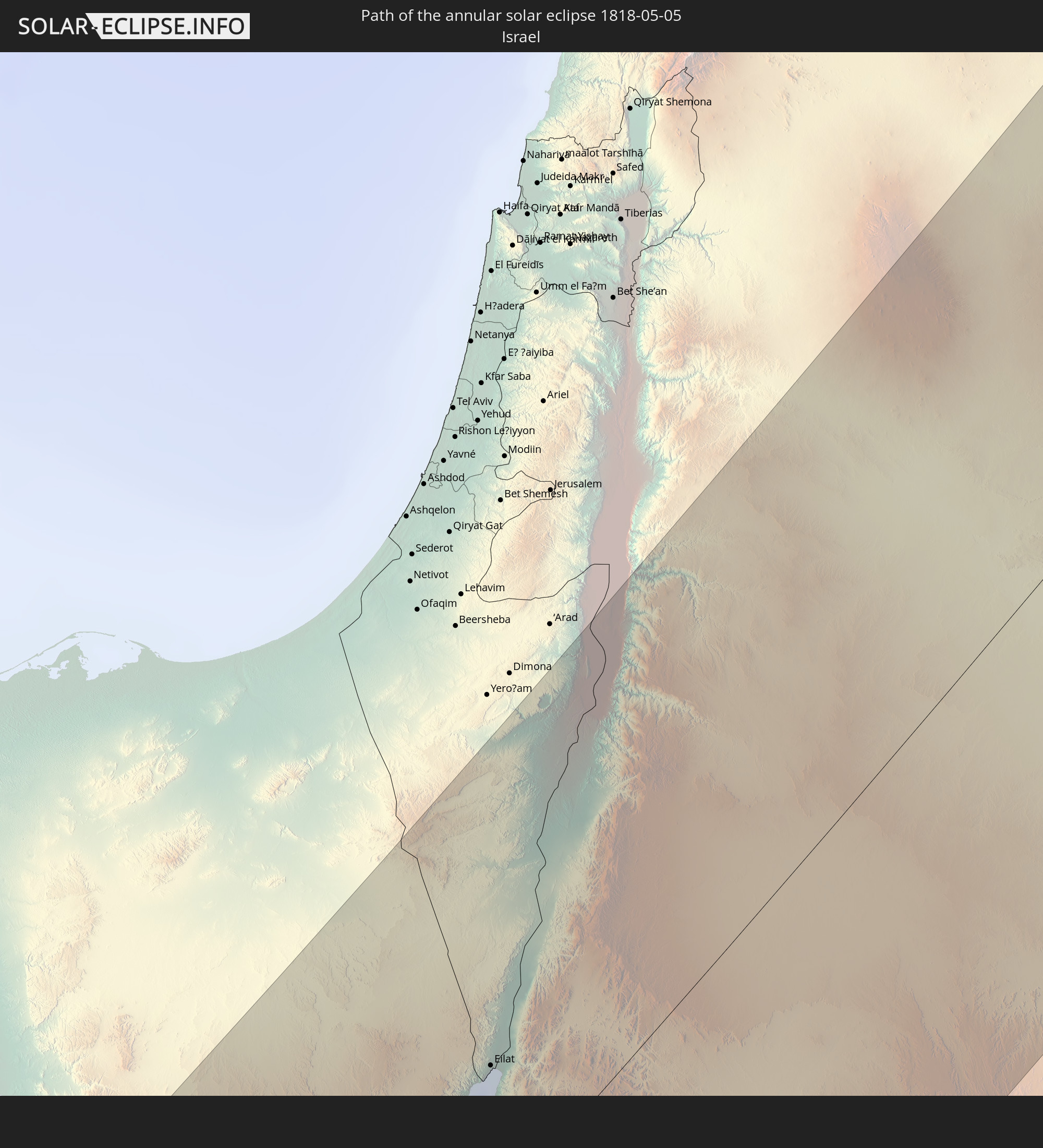 Israel
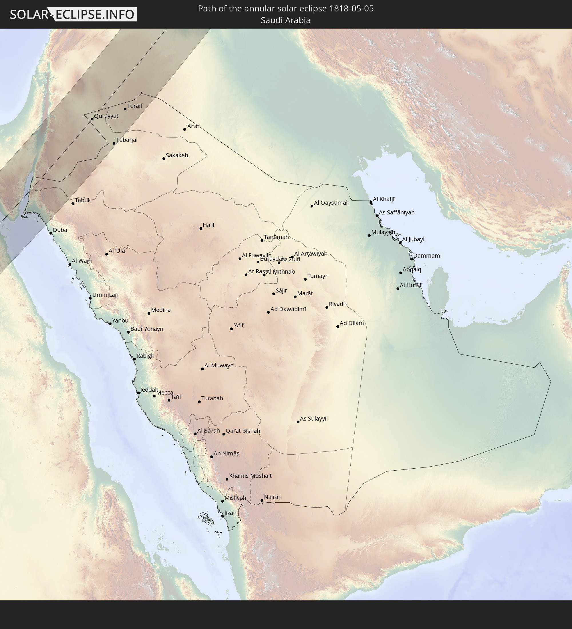 Saudi Arabia
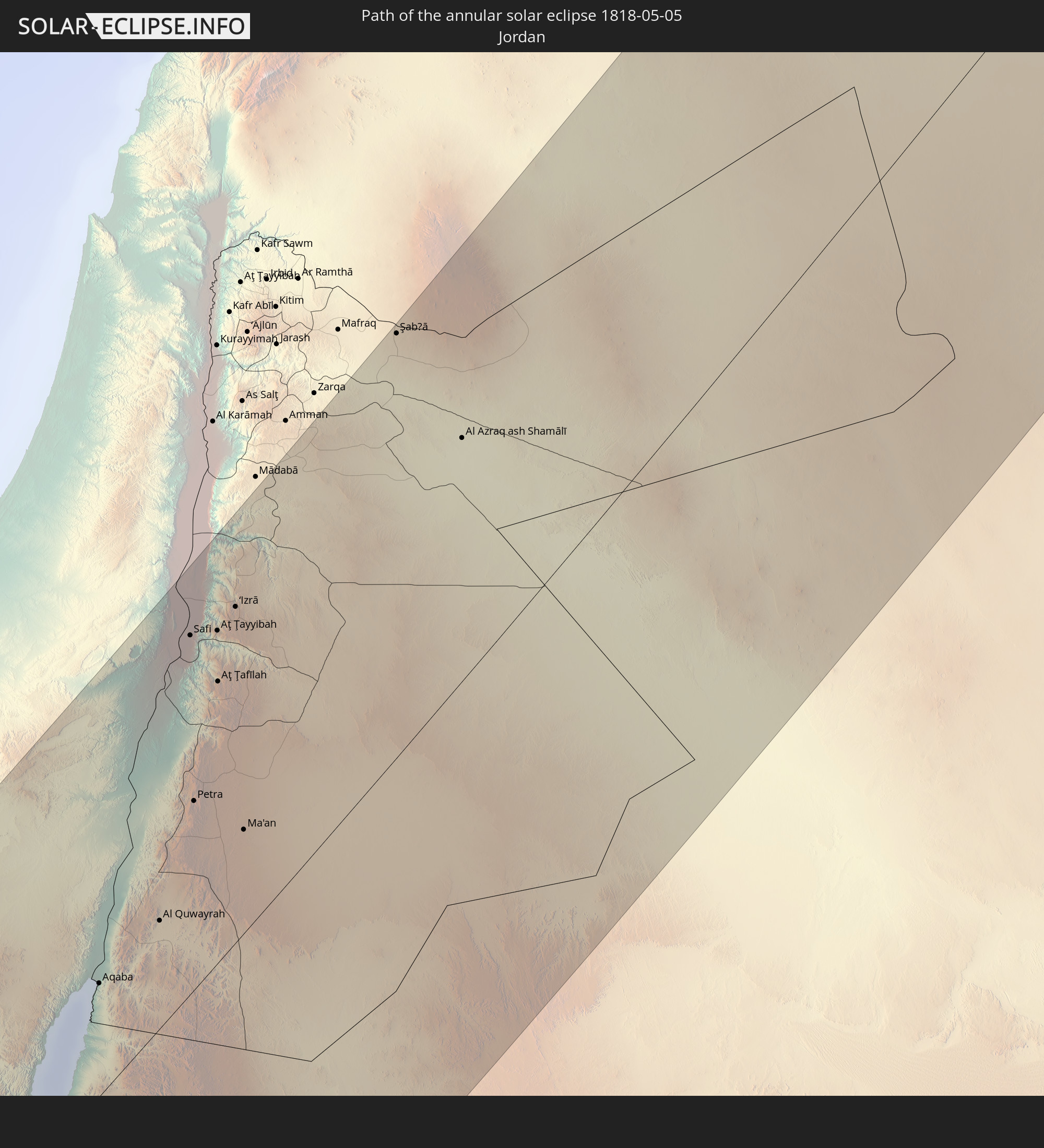 Jordan
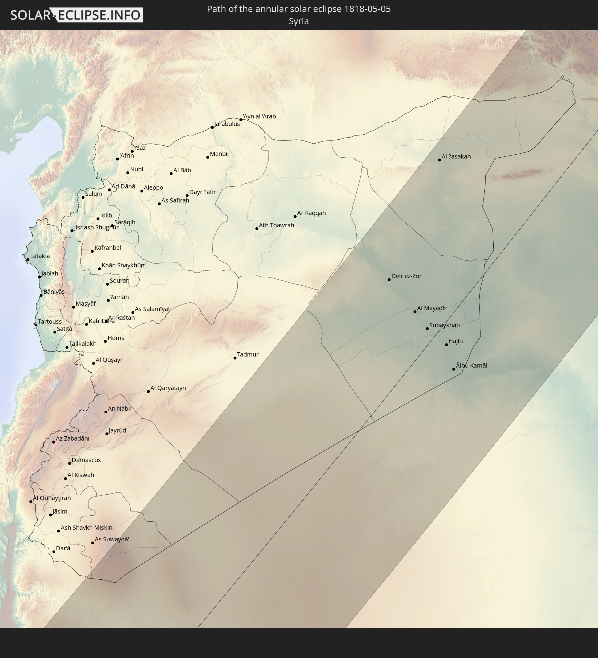 Syria
Syria
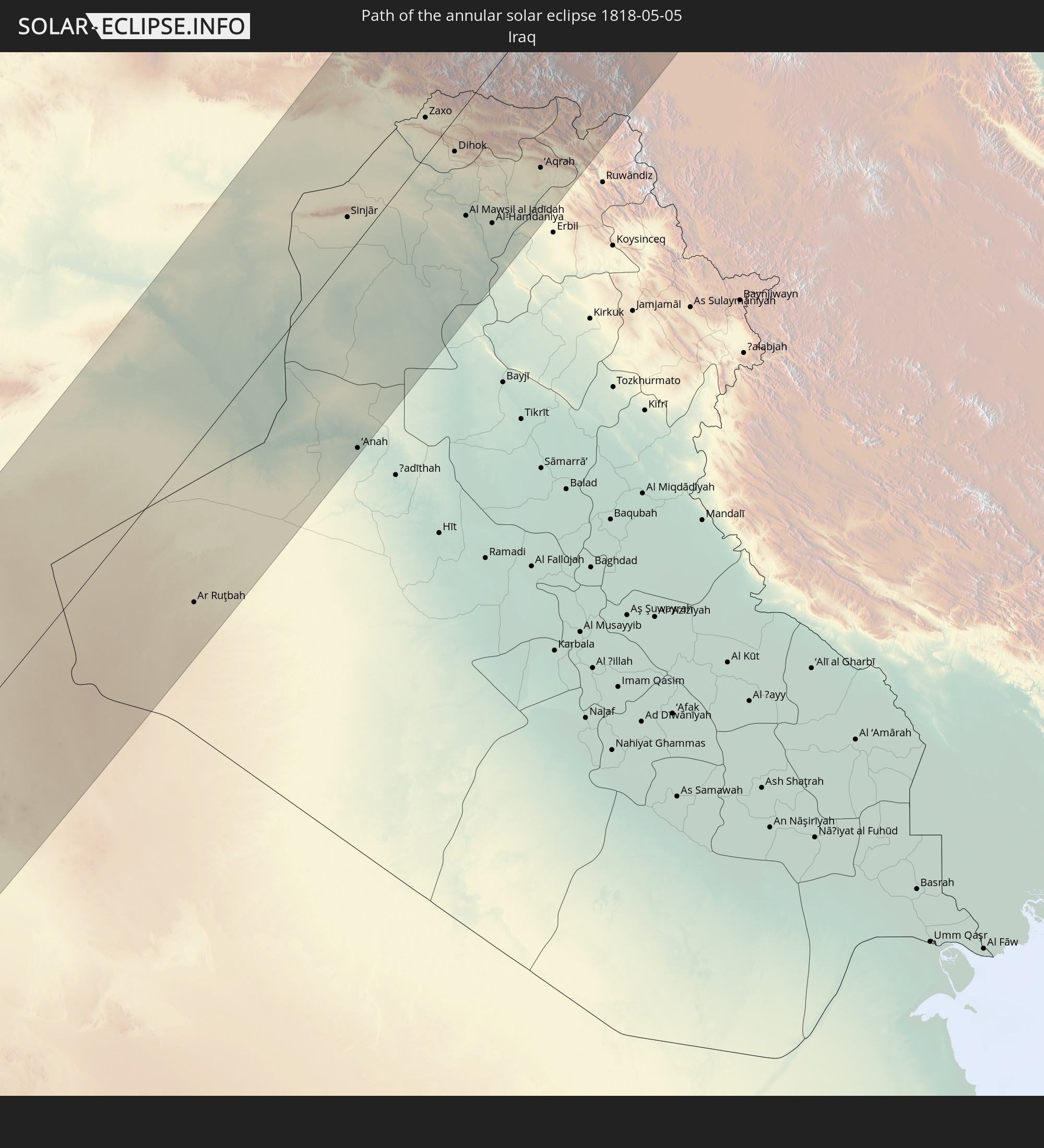 Iraq
Iraq
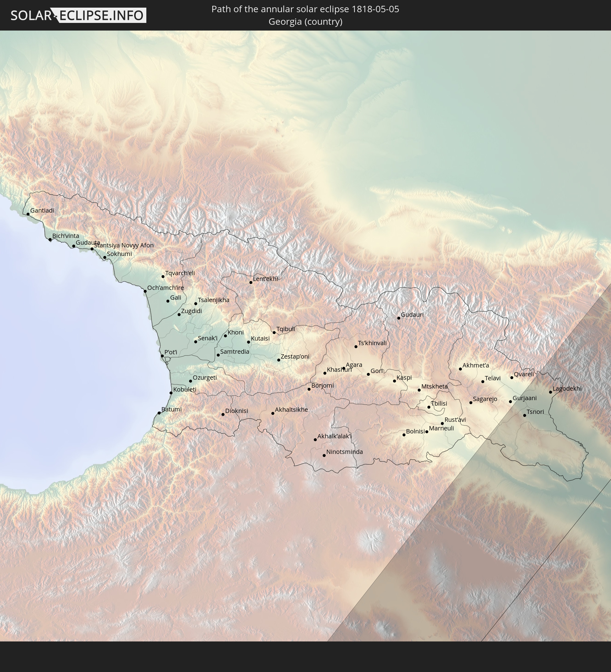 Georgia
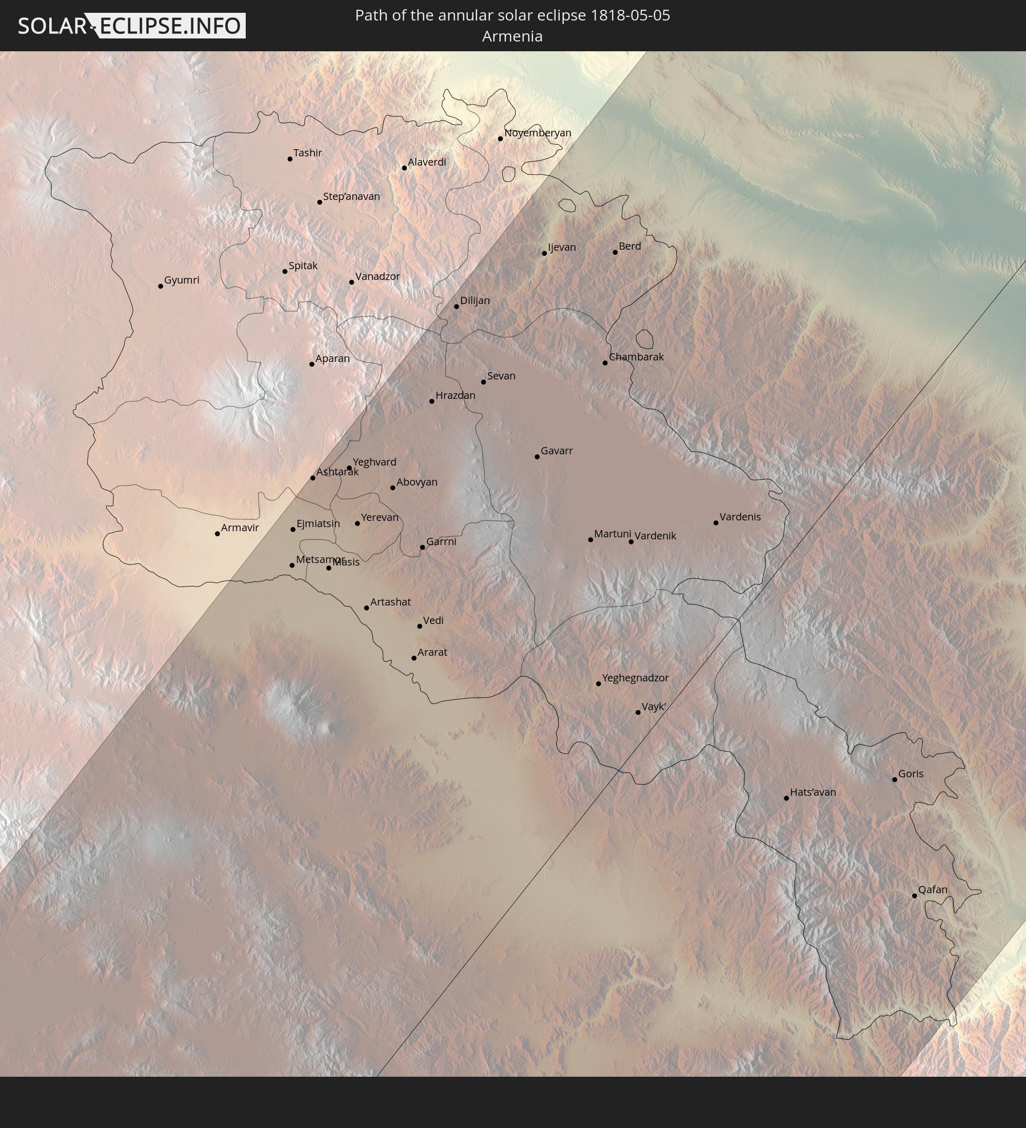 Armenia
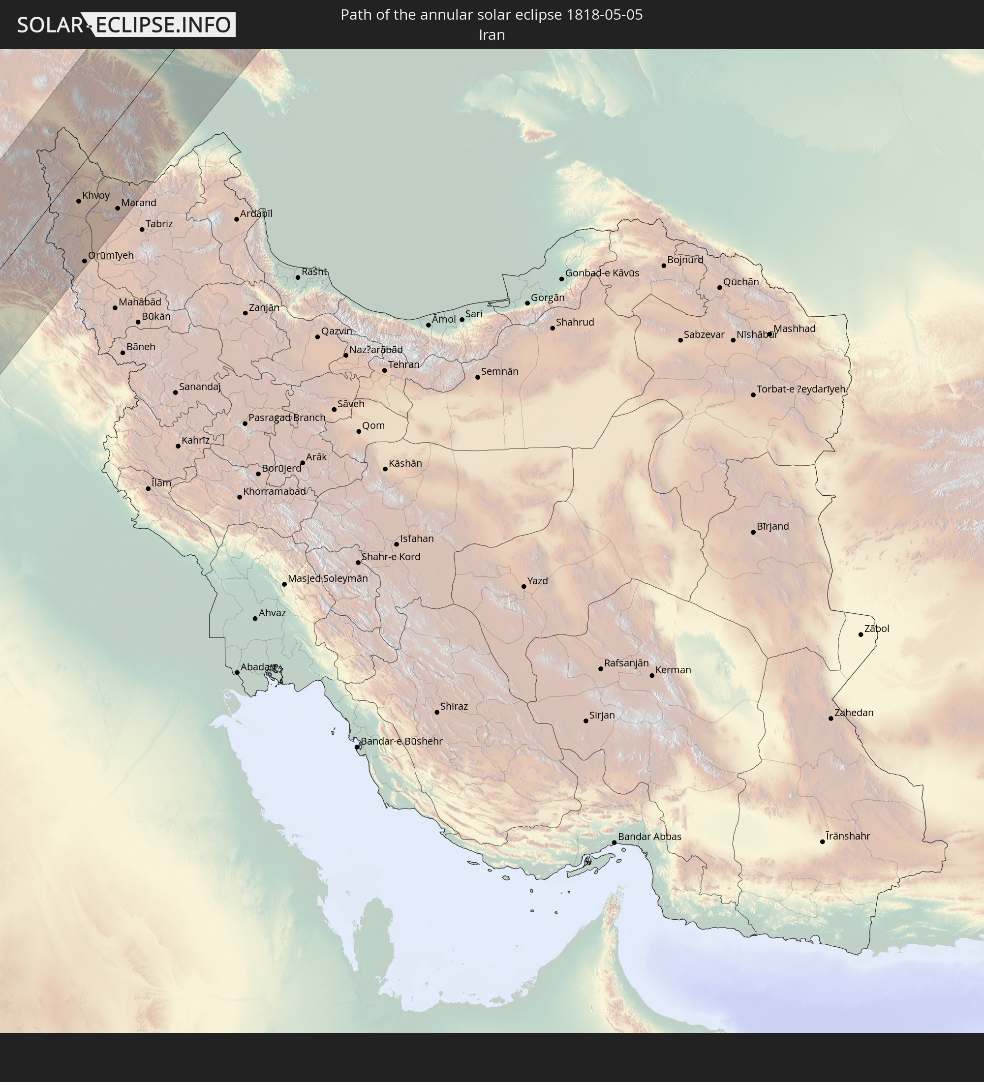 Iran
Iran
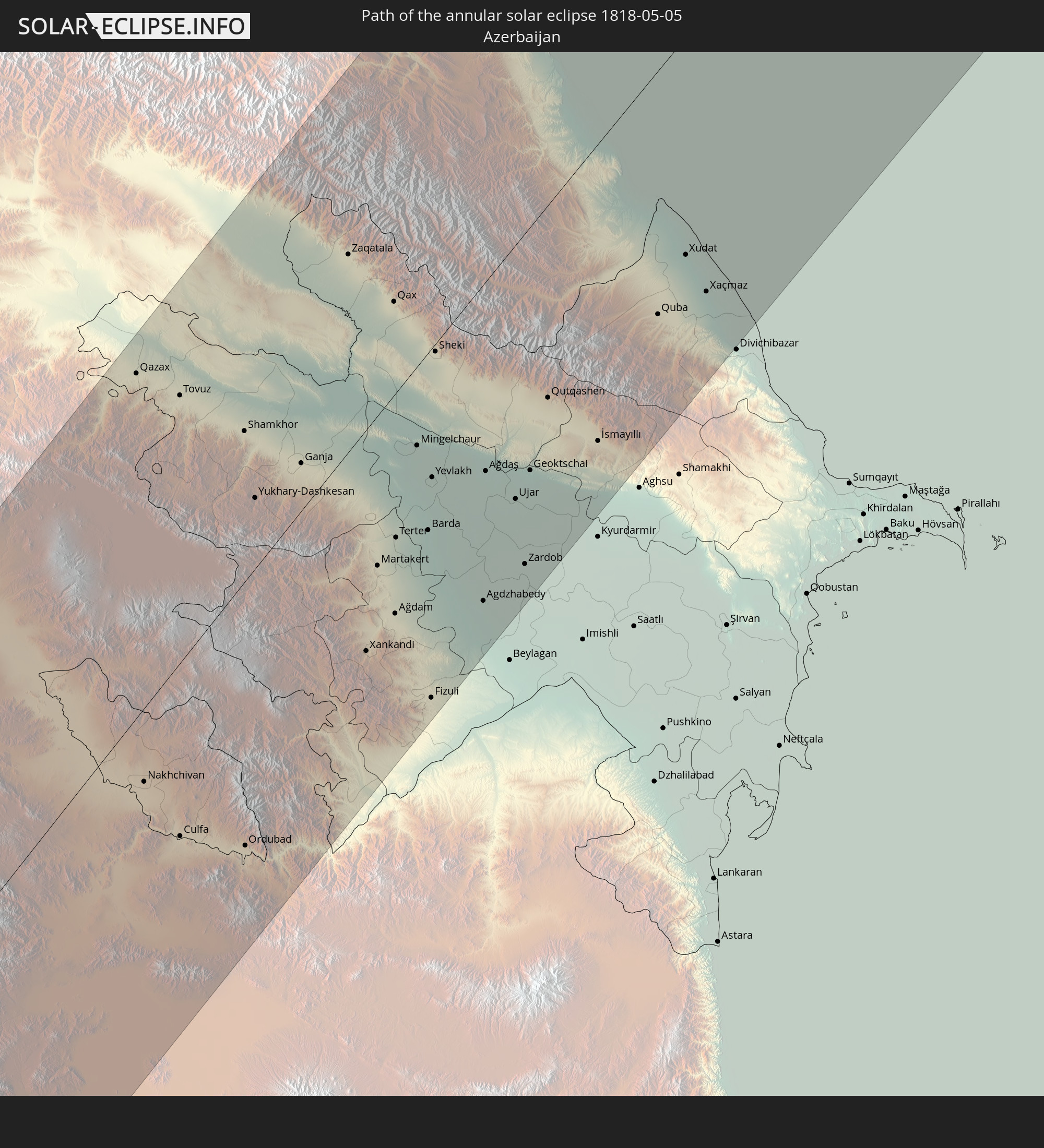 Azerbaijan
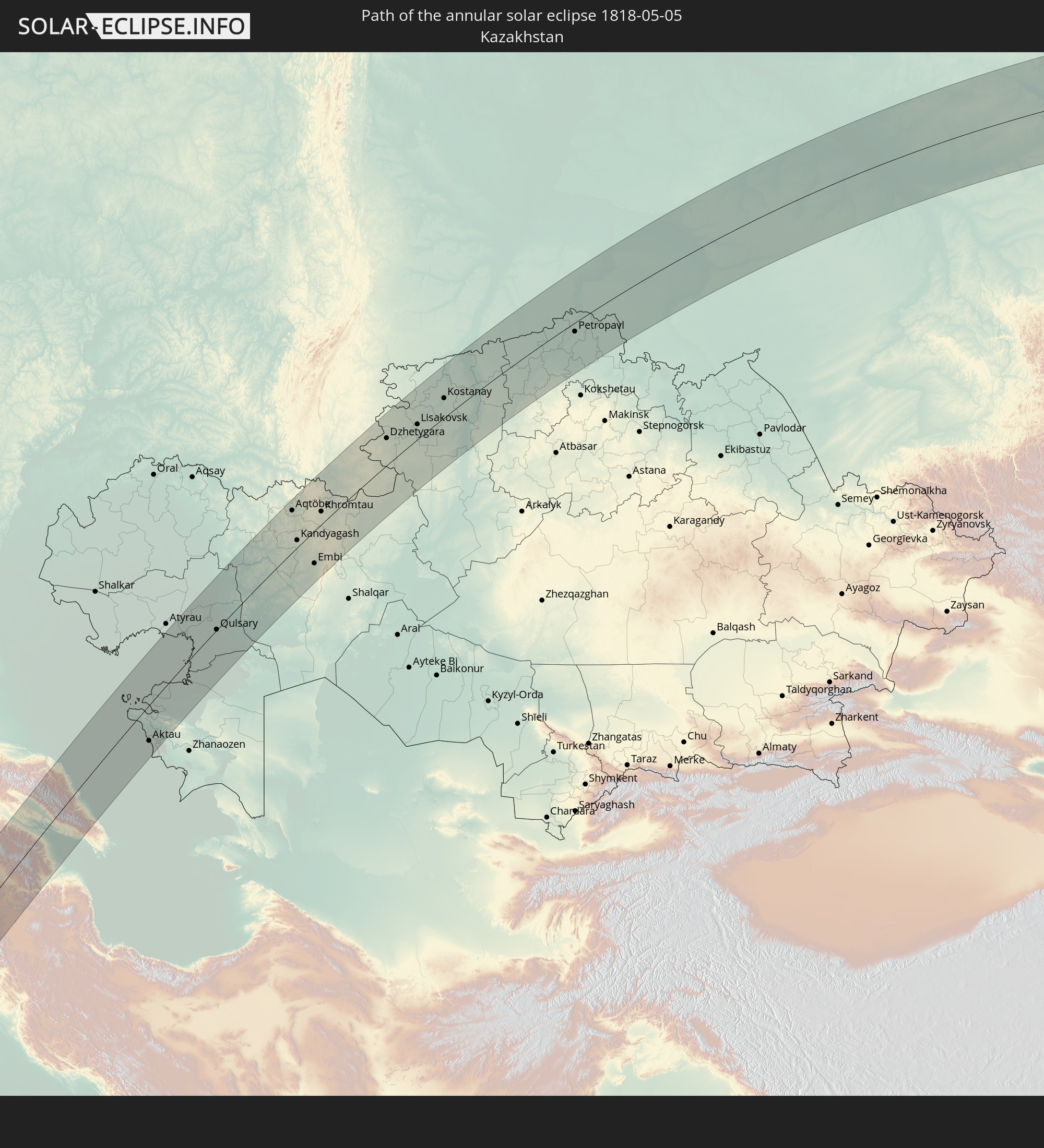 Kazakhstan
In den folgenden Ländern ist die Sonnenfinsternis partiell zu sehen
 Russia
 United States
 Canada
 Greenland
 Portugal
 Iceland
 Spain
Spain
 Mauritania
 Morocco
 Mali
Mali
 Republic of Ireland
 Svalbard and Jan Mayen
 Algeria
 United Kingdom
 Faroe Islands
 Burkina Faso
 Gibraltar
 France
 Isle of Man
 Guernsey
 Jersey
 Niger
Niger
 Benin
Benin
 Andorra
 Belgium
 Nigeria
 Netherlands
 Norway
 Equatorial Guinea
 Luxembourg
 Germany
 Switzerland
 São Tomé and Príncipe
 Italy
Italy
 Monaco
 Tunisia
 Denmark
 Cameroon
 Gabon
Gabon
 Libya
Libya
 Liechtenstein
 Austria
 Sweden
 Republic of the Congo
 Angola
 Namibia
 Czechia
 Democratic Republic of the Congo
 San Marino
 Vatican City
 Slovenia
 Chad
Chad
 Croatia
 Poland
 Malta
Malta
 Central African Republic
 Bosnia and Herzegovina
 Hungary
 Slovakia
 Montenegro
 Serbia
 Albania
 Åland Islands
 Greece
 Botswana
 Romania
 Republic of Macedonia
 Finland
 Lithuania
 Latvia
 Estonia
 Sudan
Sudan
 Zambia
 Ukraine
 Bulgaria
 Belarus
 Egypt
Egypt
 Zimbabwe
 Turkey
 Moldova
 Rwanda
 Burundi
 Tanzania
 Uganda
 Mozambique
 Cyprus
 Malawi
 Ethiopia
 Kenya
Kenya
 State of Palestine
 Israel
 Saudi Arabia
 Jordan
 Lebanon
 Syria
Syria
 Eritrea
 Iraq
Iraq
 Georgia
 Somalia
 Djibouti
 Yemen
Yemen
 Comoros
 Armenia
 Iran
Iran
 Azerbaijan
 Seychelles
 Kazakhstan
 Kuwait
 Bahrain
 Qatar
Qatar
 United Arab Emirates
 Oman
Oman
 Turkmenistan
 Uzbekistan
 Afghanistan
 Pakistan
 Tajikistan
 India
India
 Kyrgyzstan
 China
China
 Nepal
Nepal
 Mongolia
 Bangladesh
 Bhutan
 Myanmar
 Taiwan
 Japan
Japan
 North Korea
 South Korea
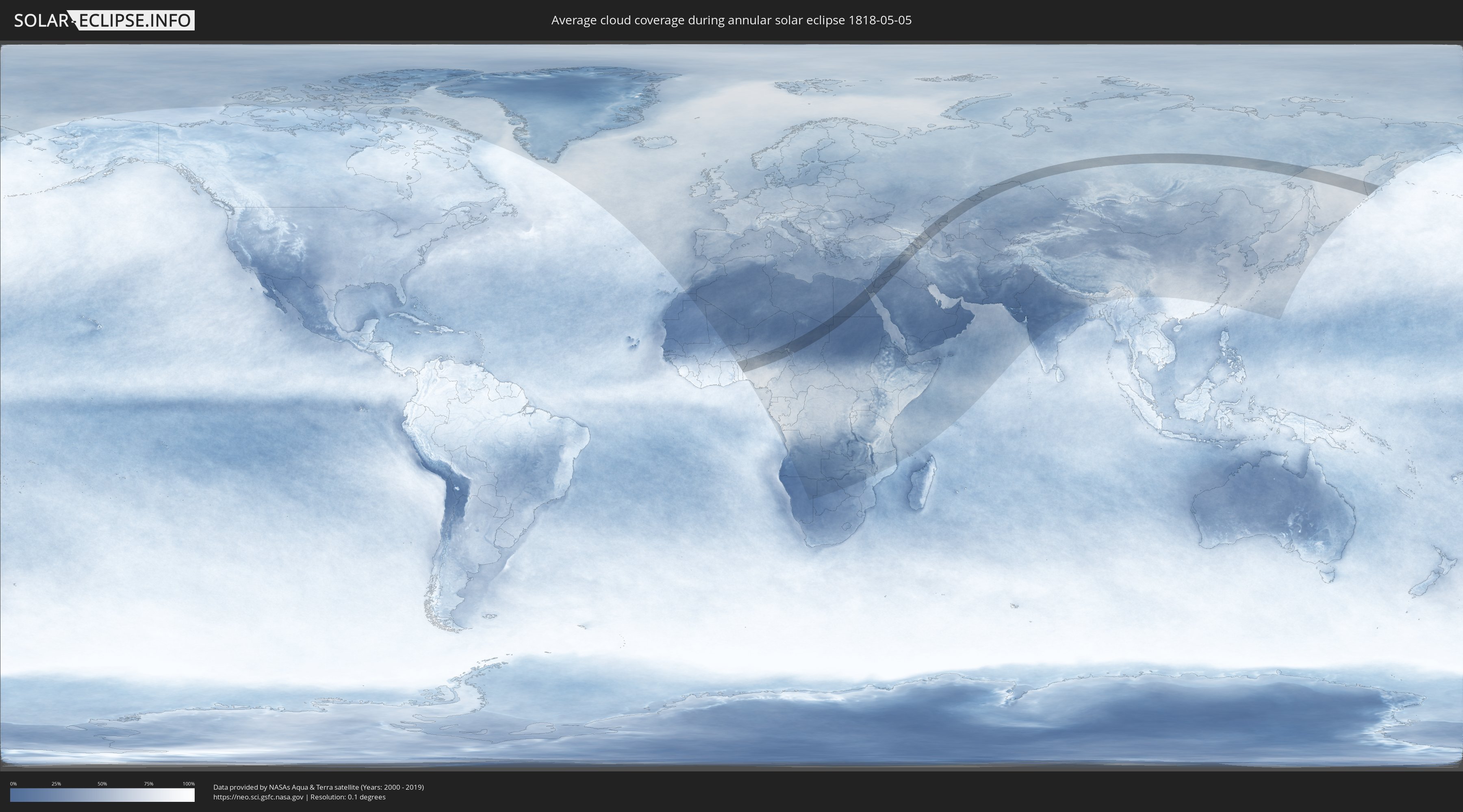
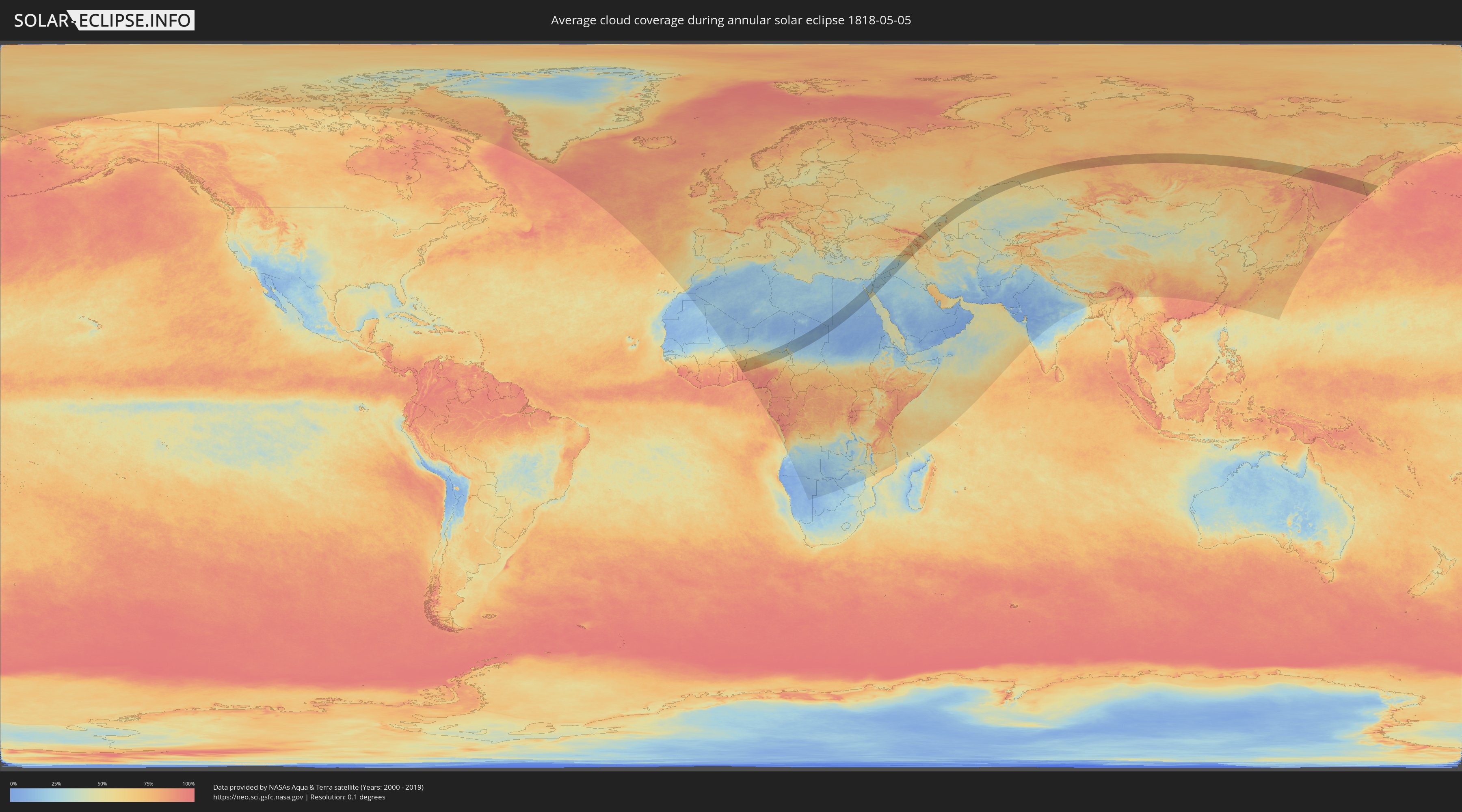
How will be the weather during the annular solar eclipse on 05/05/1818?
Where is the best place to see the annular solar eclipse of 05/05/1818?
The following maps show the average cloud coverage for the day of the annular solar eclipse.
With the help of these maps, it is possible to find the place along the eclipse path, which has the best
chance of a cloudless sky.
Nevertheless, you should consider local circumstances and inform about the weather of your chosen
observation site.
The data is provided by NASAs satellites
AQUA and TERRA.
The cloud maps are averaged over a period of 19 years (2000 - 2019).
Detailed country maps
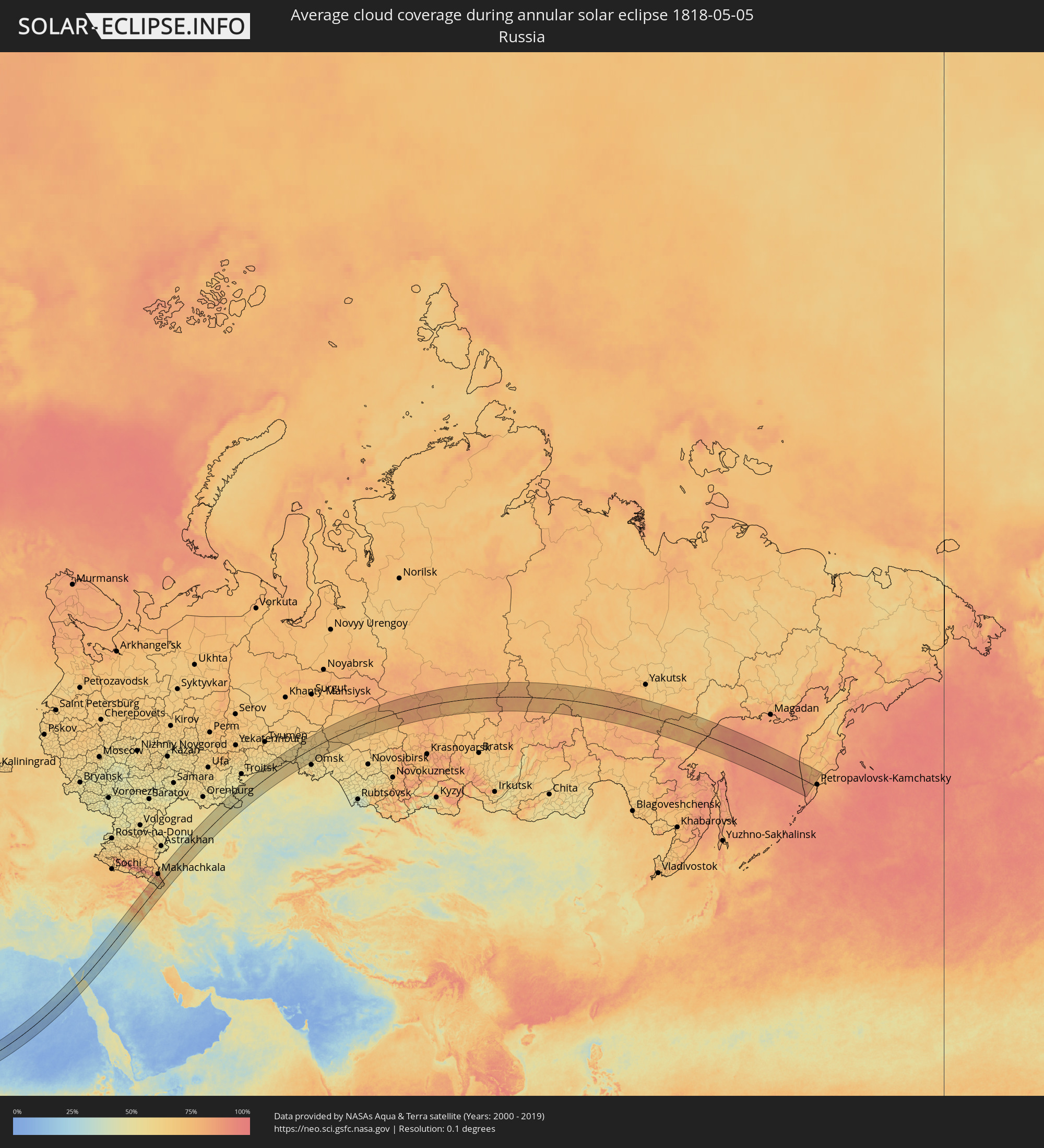 Russia
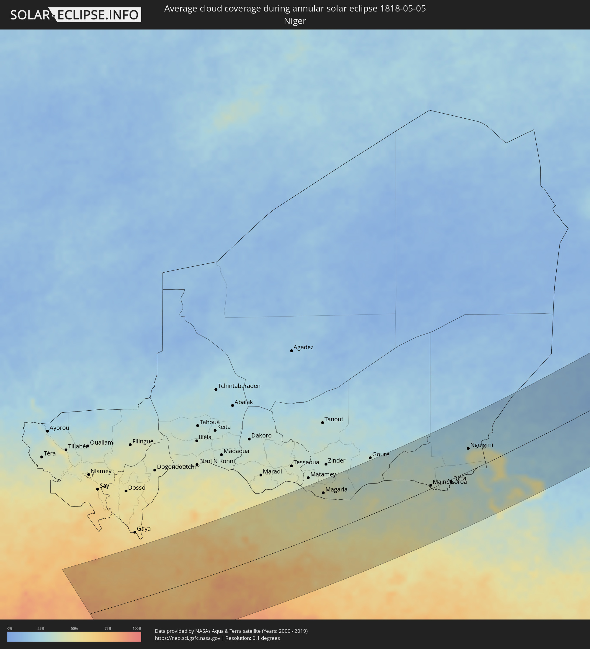 Niger
Niger
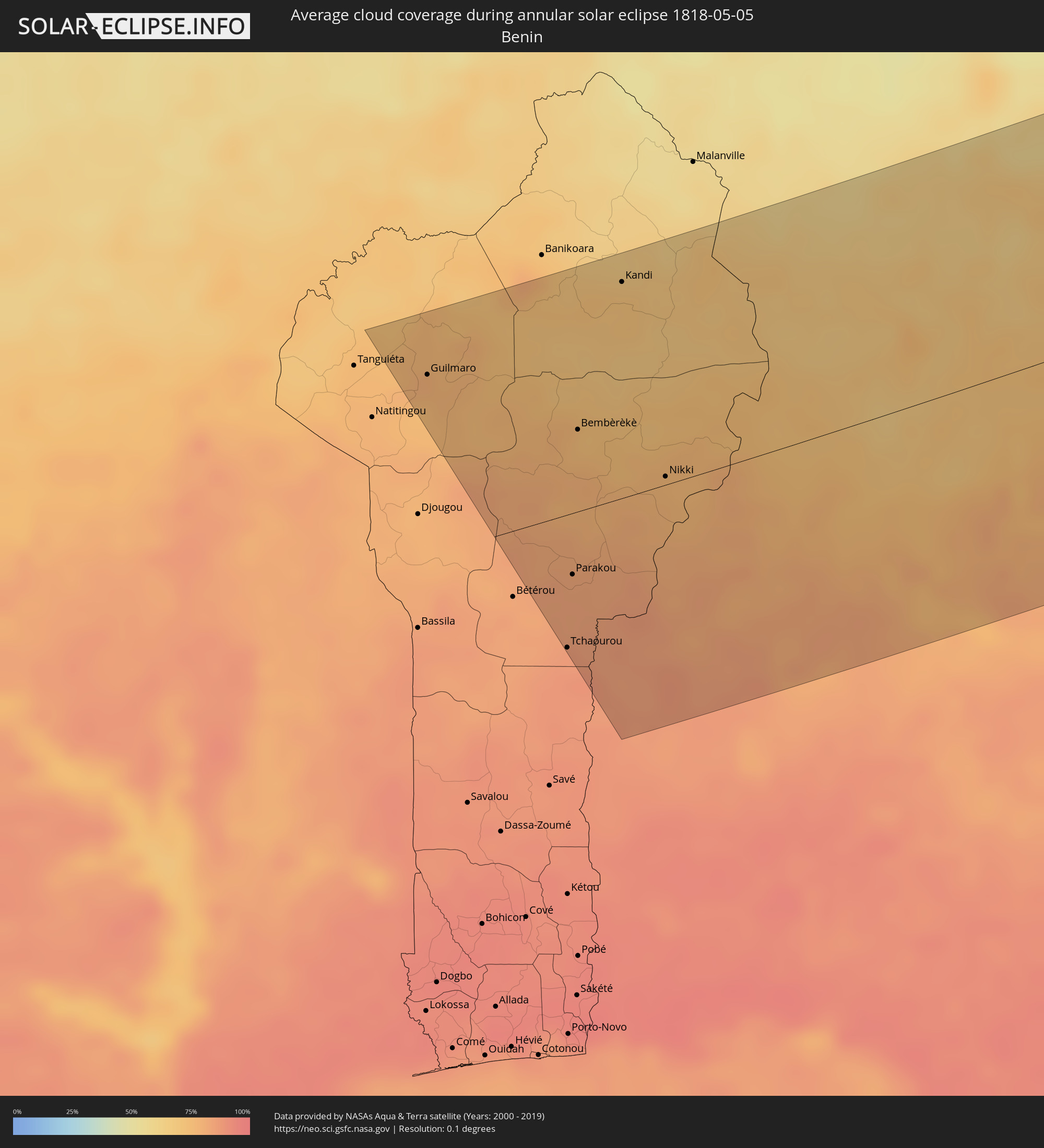 Benin
Benin
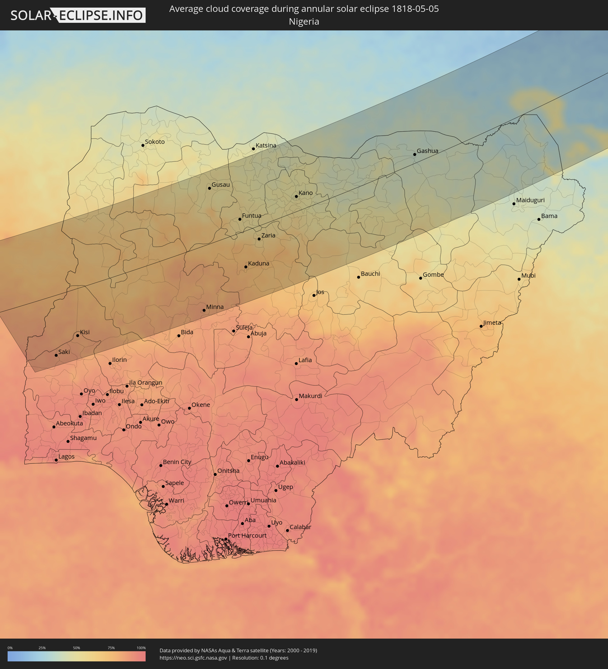 Nigeria
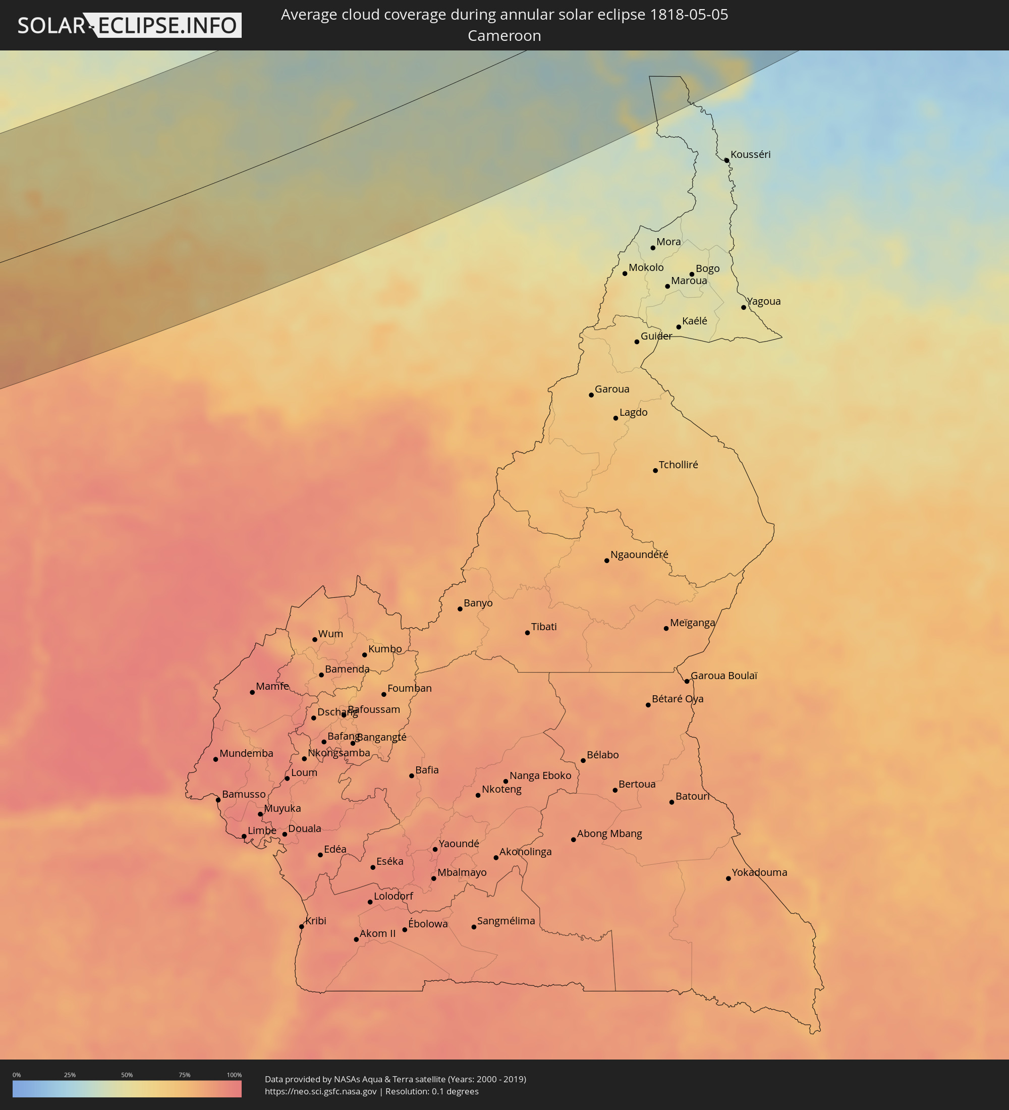 Cameroon
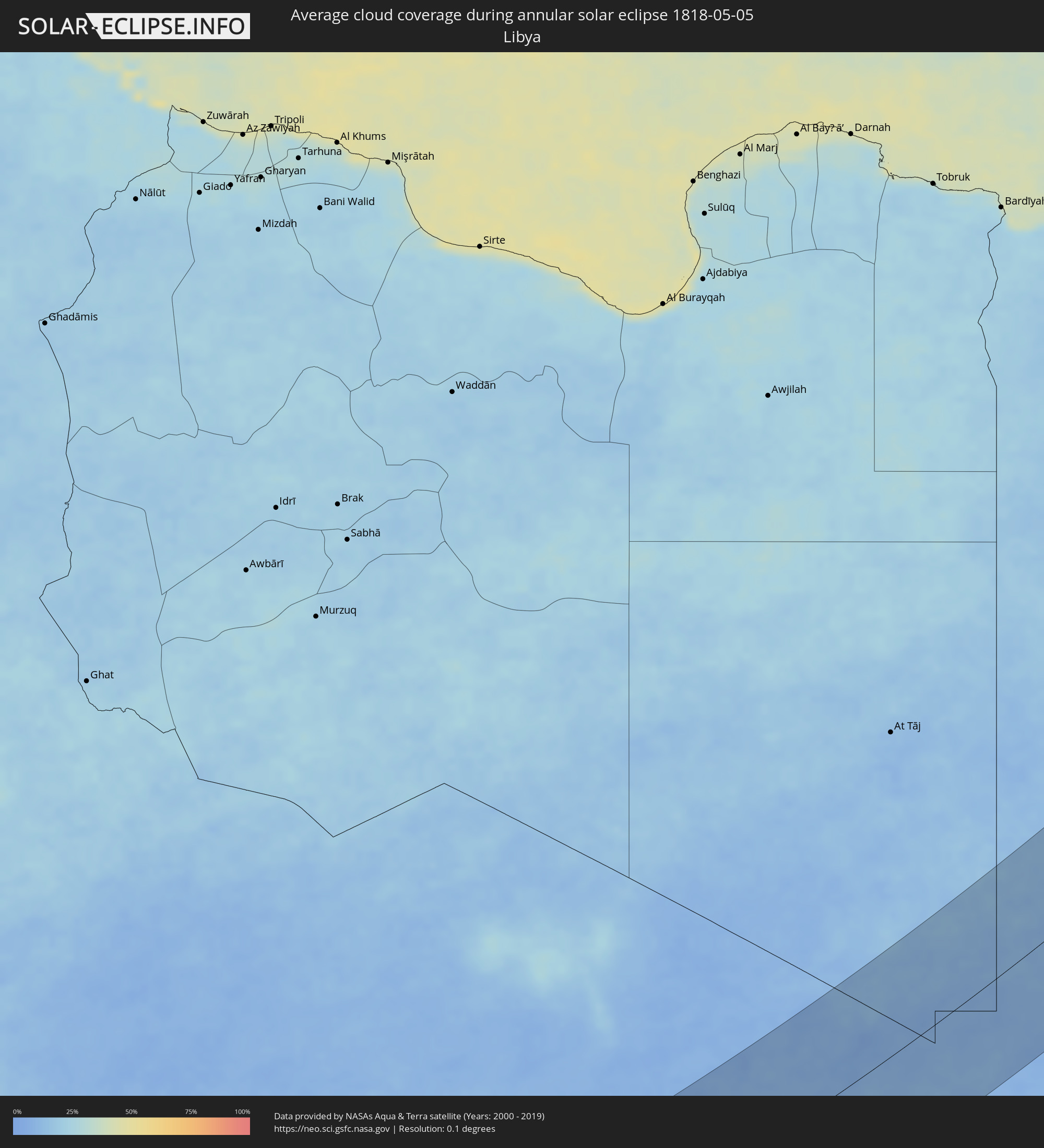 Libya
Libya
 Chad
Chad
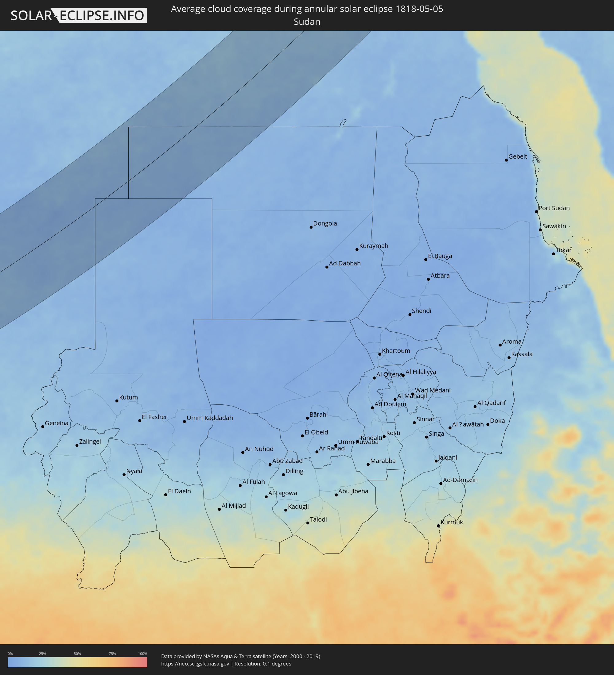 Sudan
Sudan
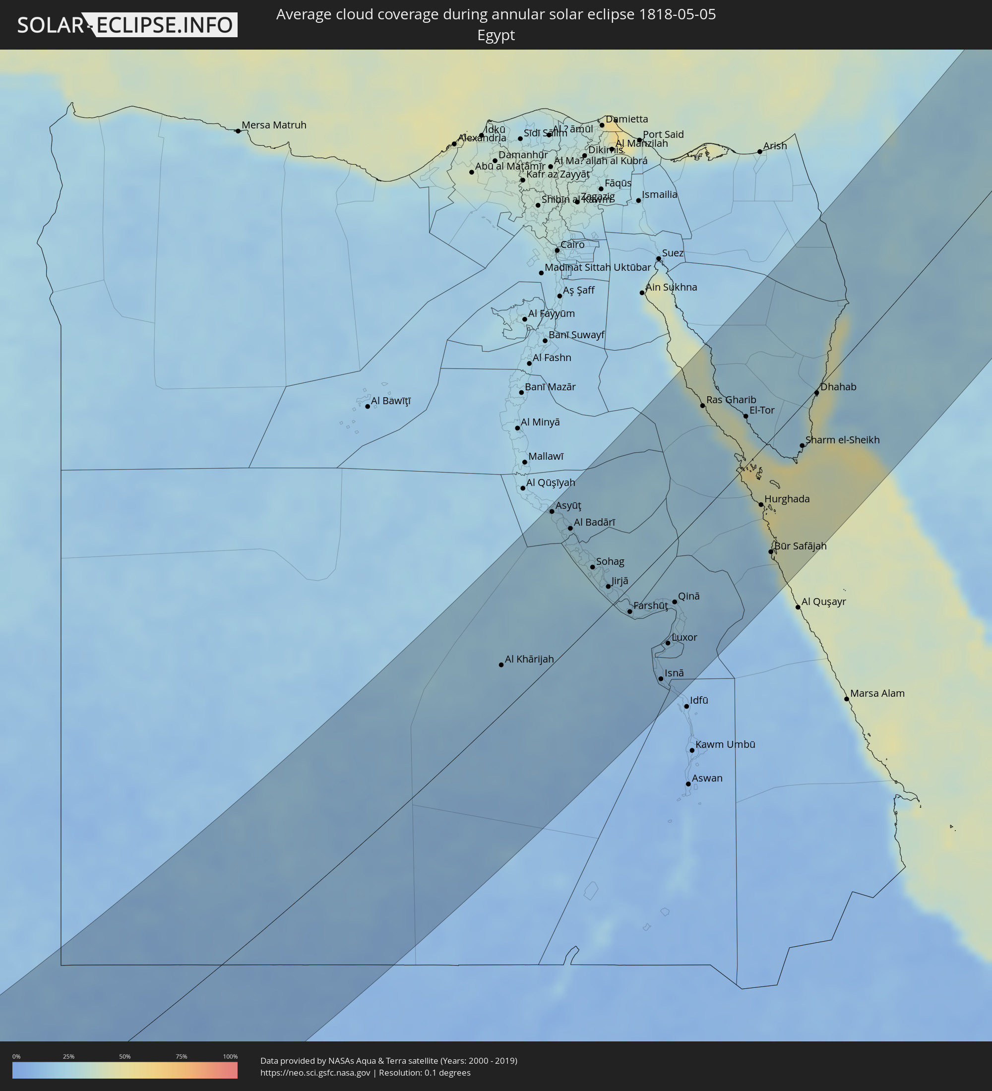 Egypt
Egypt
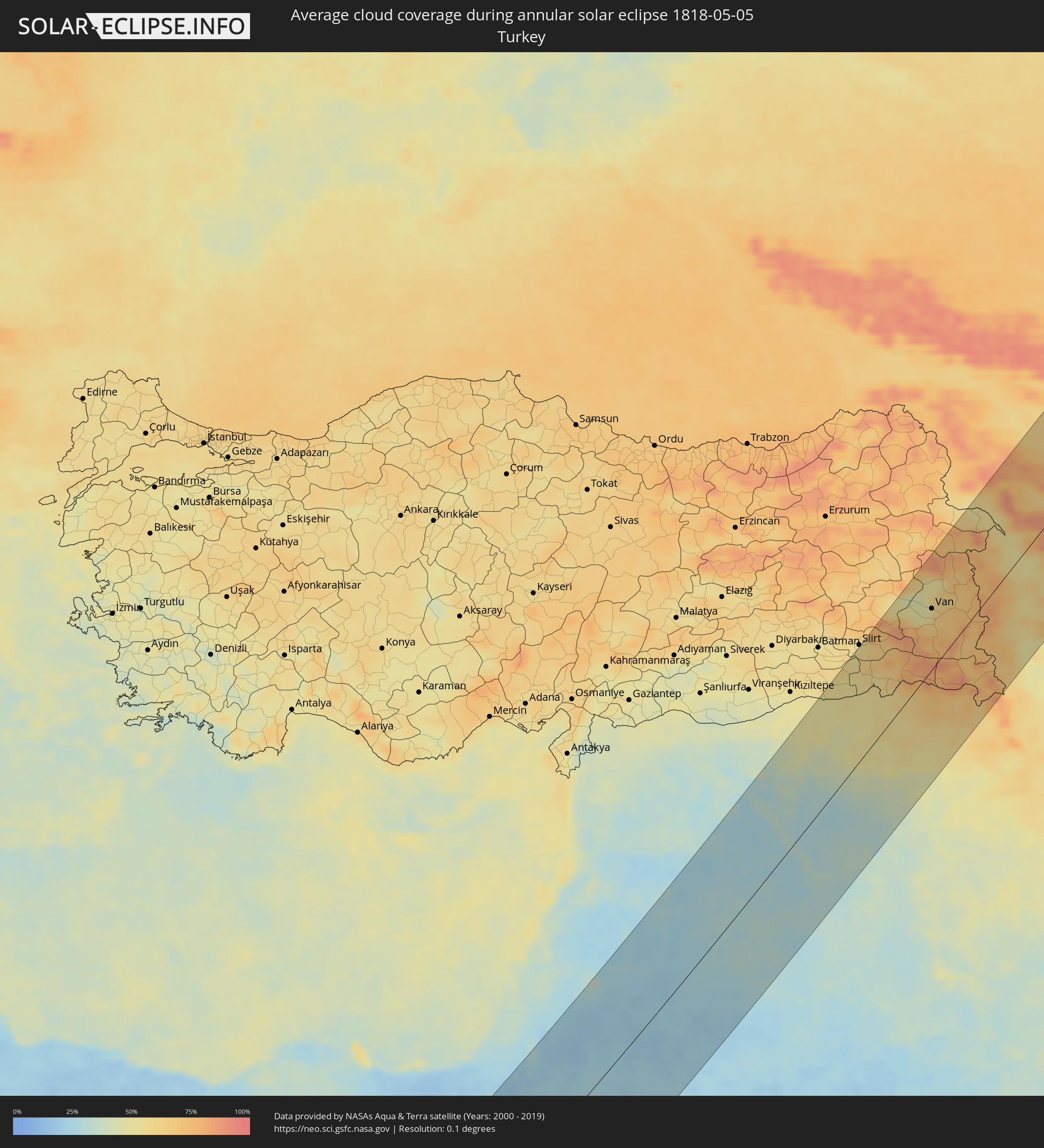 Turkey
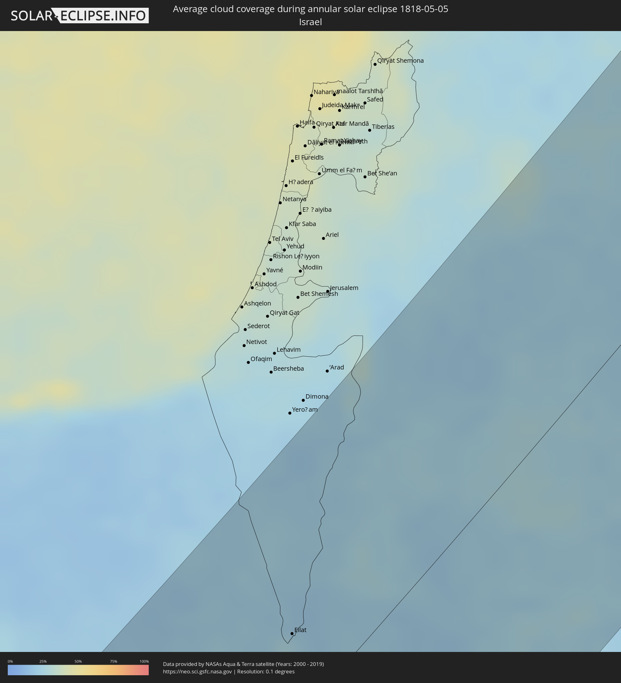 Israel
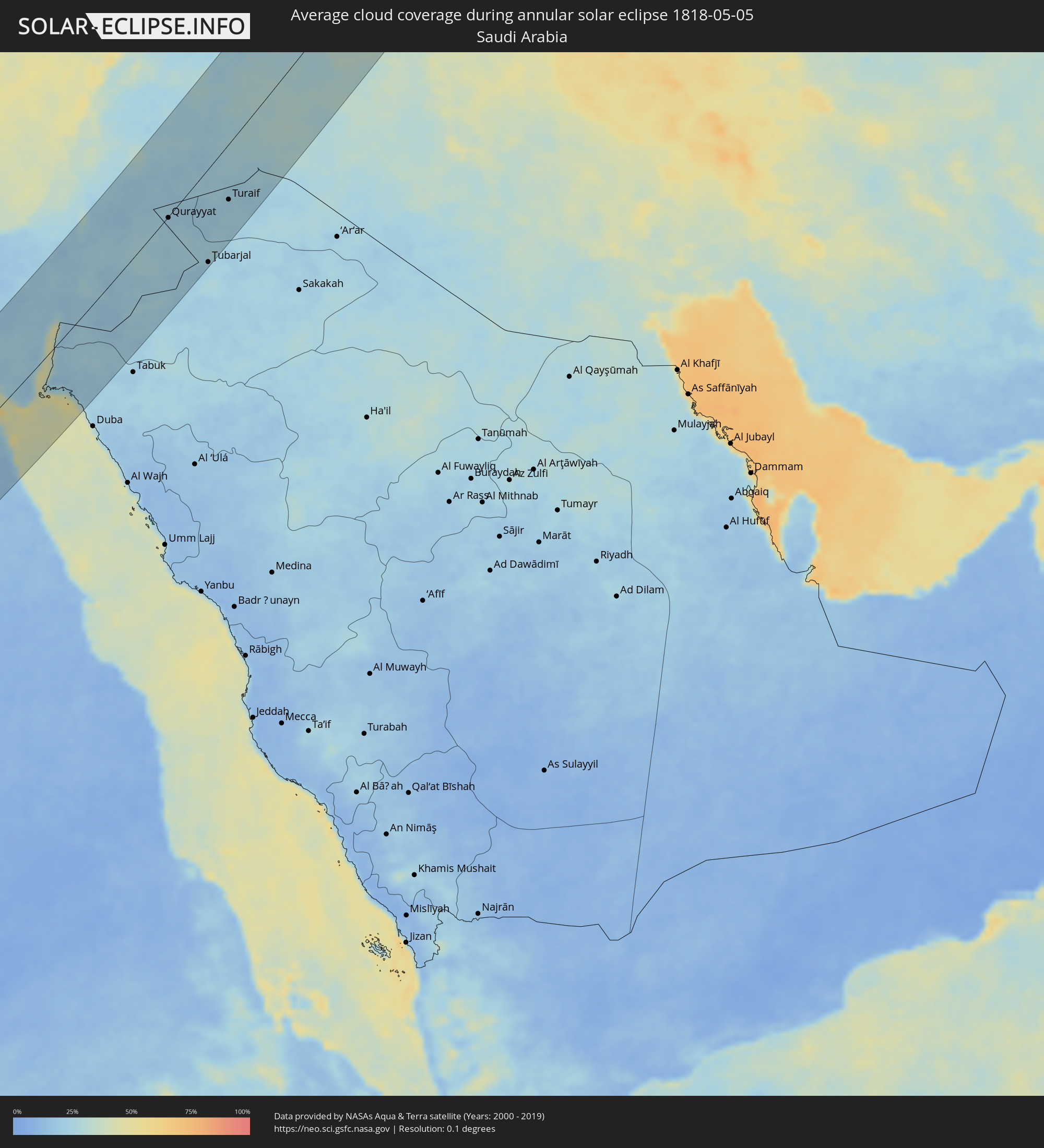 Saudi Arabia
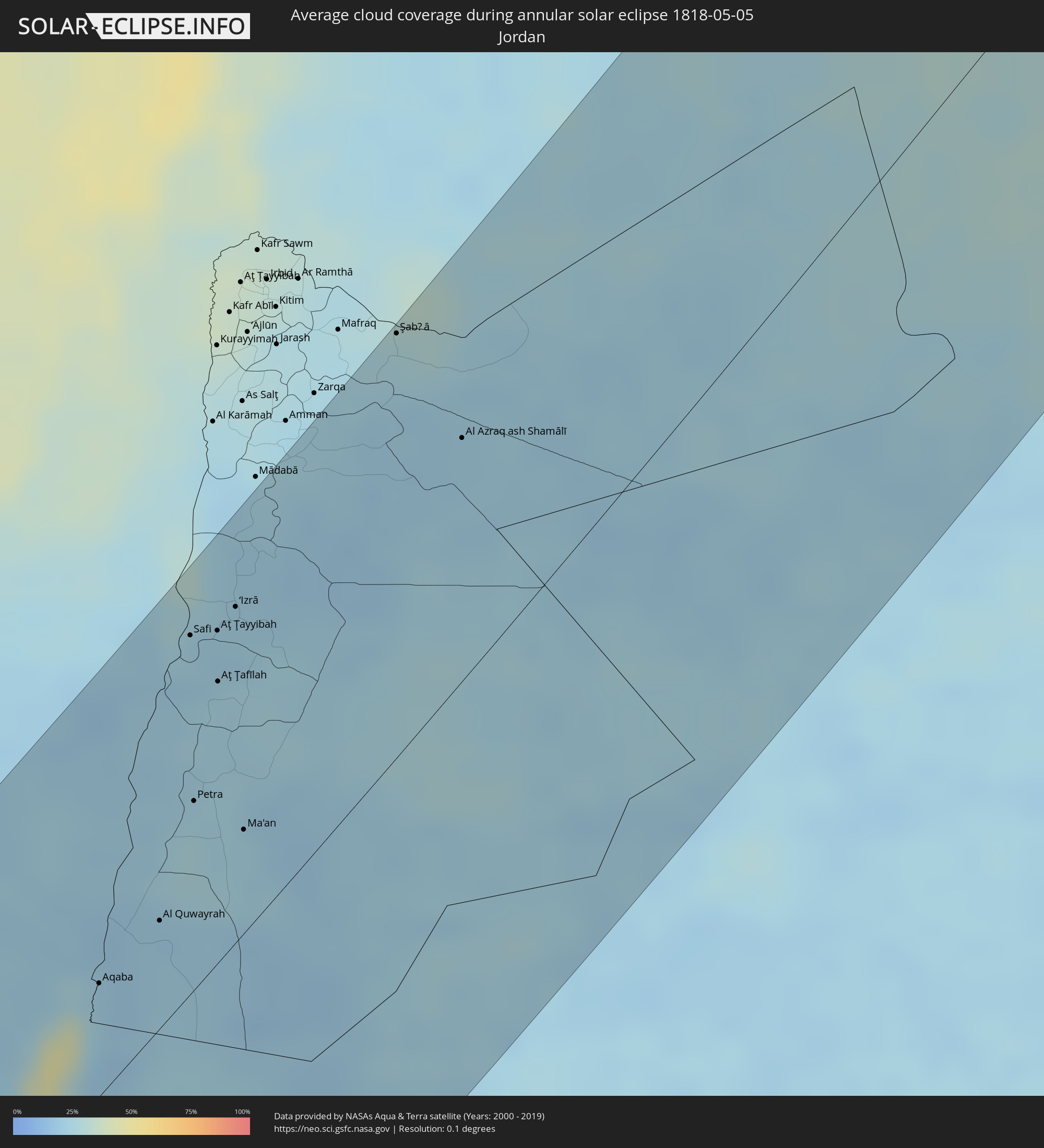 Jordan
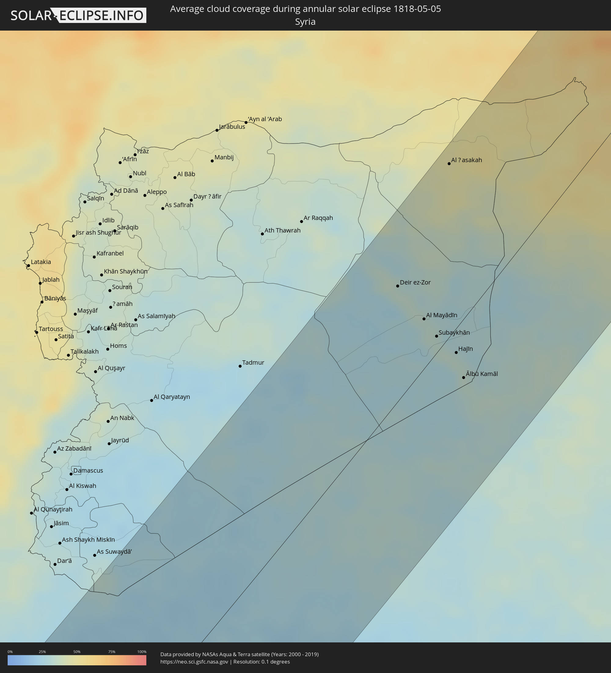 Syria
Syria
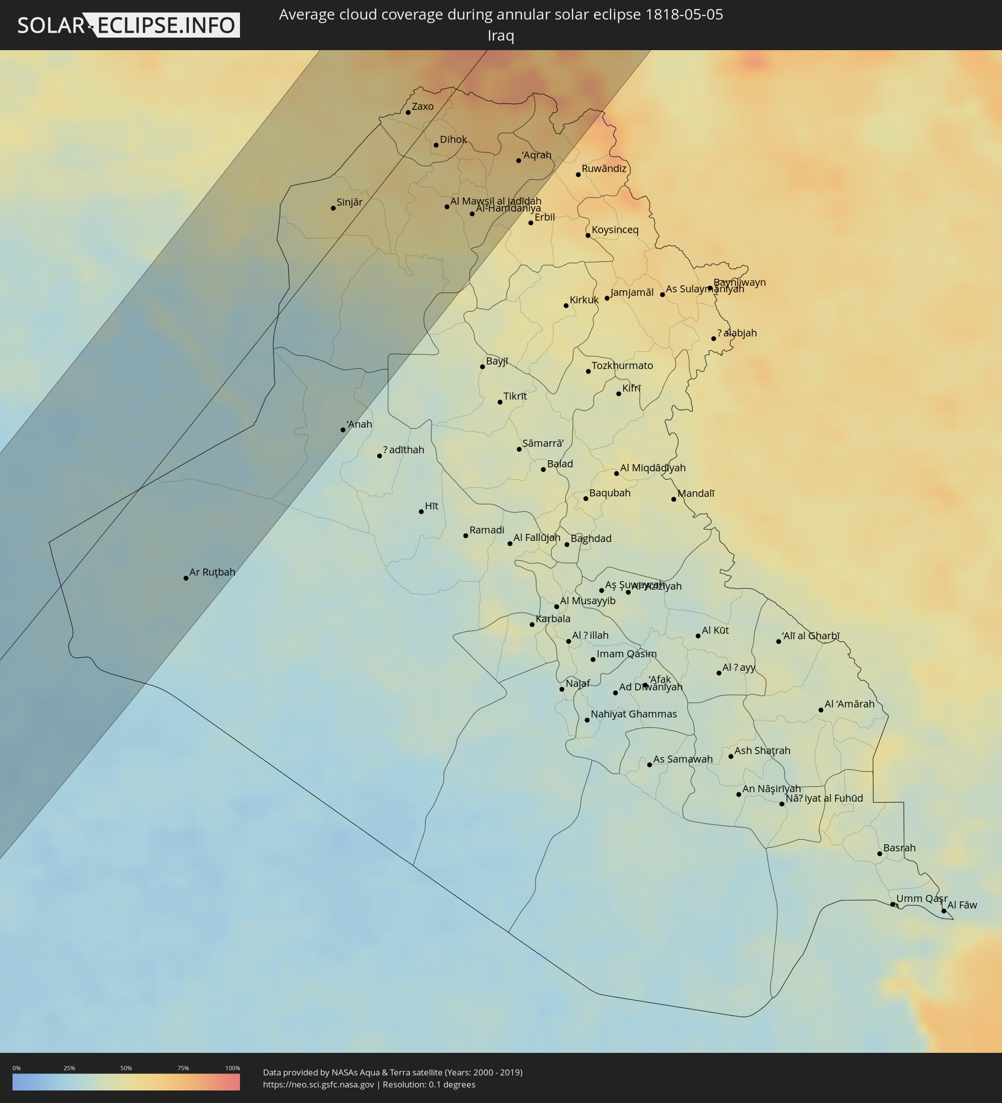 Iraq
Iraq
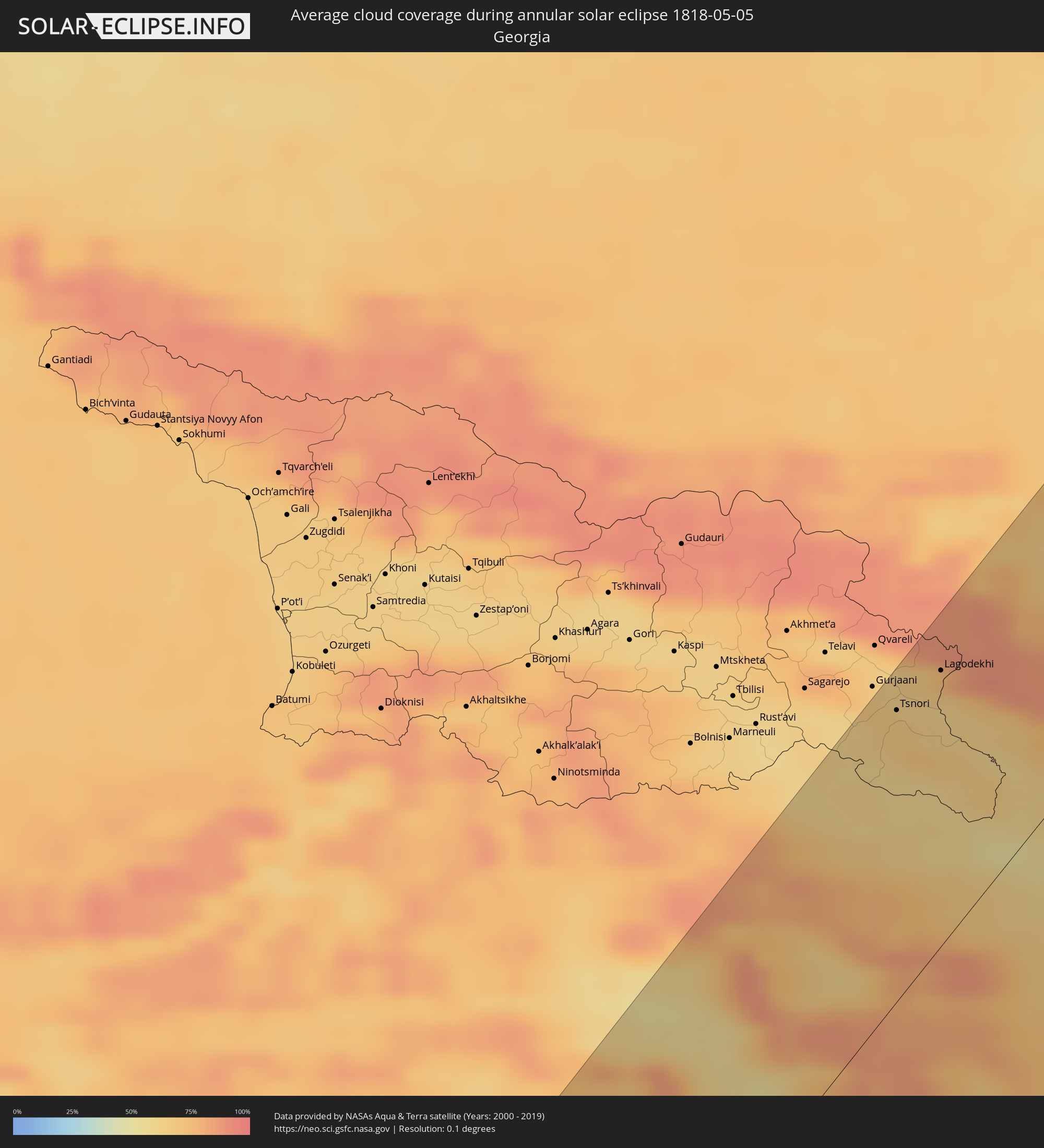 Georgia
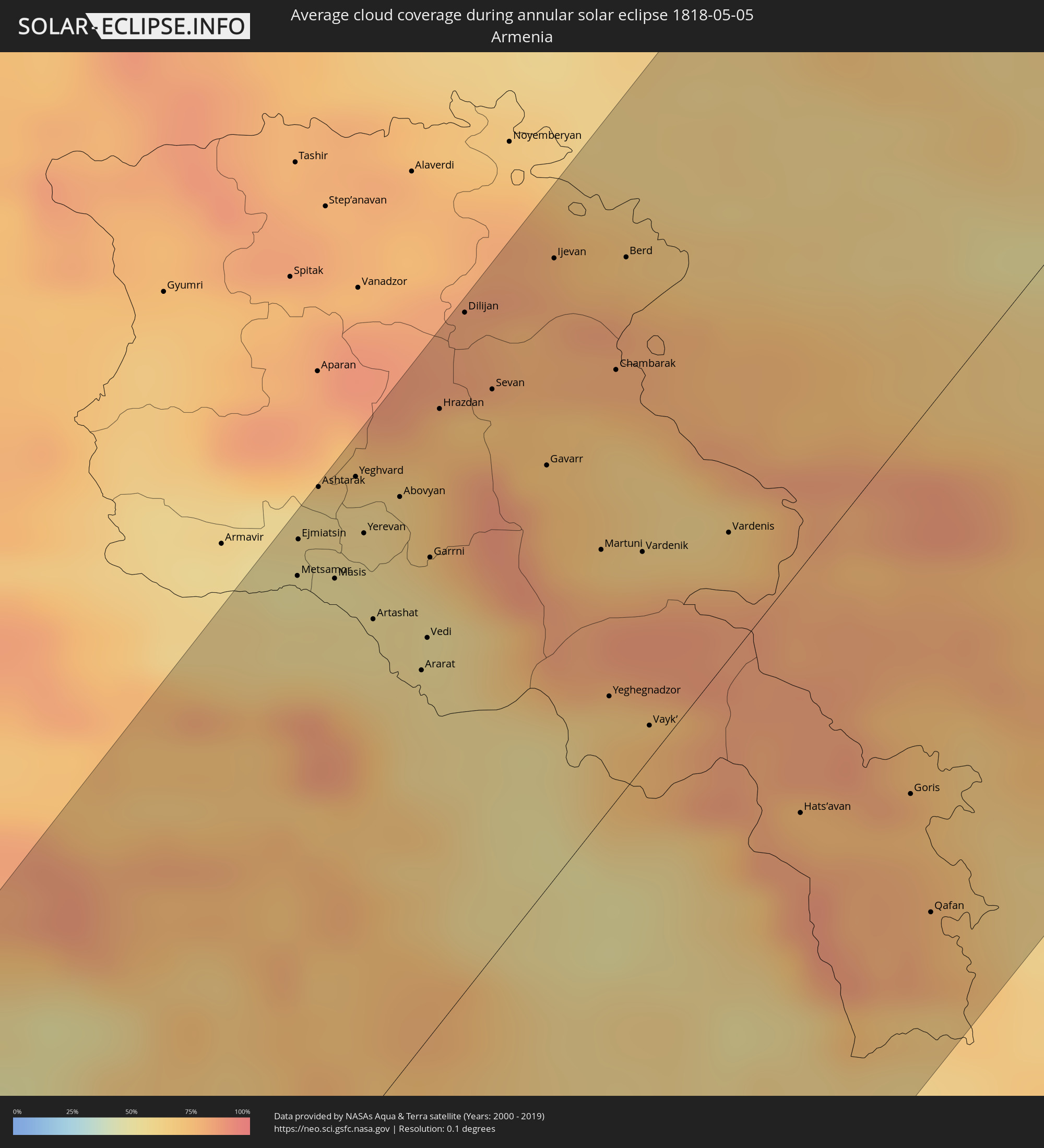 Armenia
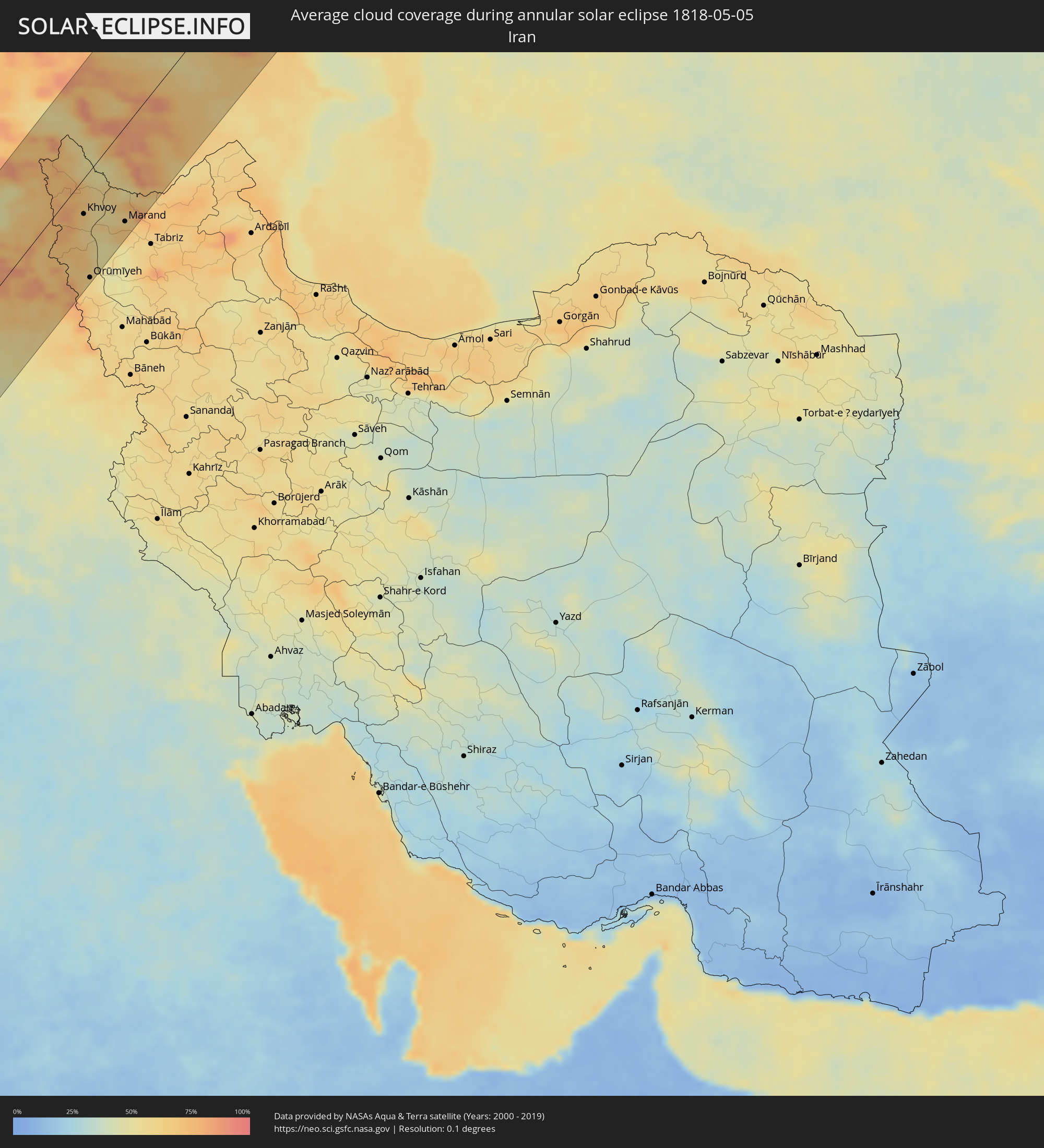 Iran
Iran
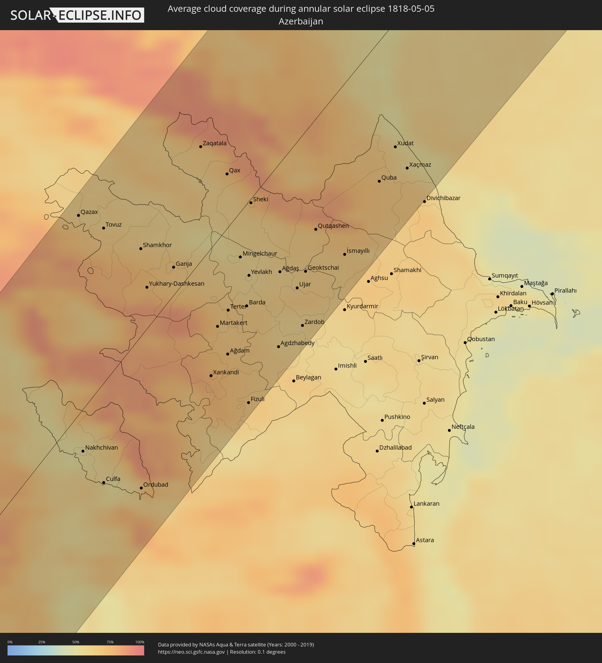 Azerbaijan
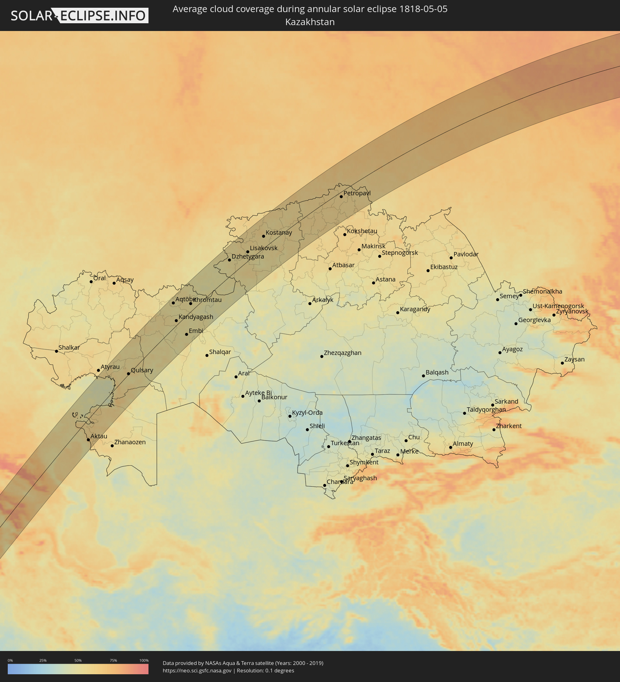 Kazakhstan
Cities inside the path of the eclipse
The following table shows all locations with a population of more than 5,000 inside the eclipse path. Cities which have more than 100,000 inhabitants are marked bold. A click at the locations opens a detailed map.
| City | Type | Eclipse duration | Local time of max. eclipse | Distance to central line | Ø Cloud coverage |
|
Guilmaro, Atakora
|
annular | - | 05:51:41 UTC+00:13 | 120 km | 77% |
|
Tchaourou, Borgou
|
annular | - | 05:49:28 UTC+00:13 | 87 km | 86% |
|
Parakou, Borgou
|
annular | - | 05:49:58 UTC+00:13 | 40 km | 83% |
|
Bembèrèkè, Borgou
|
annular | - | 05:51:00 UTC+00:13 | 54 km | 75% |
|
Kandi, Alibori
|
annular | - | 05:51:59 UTC+00:13 | 141 km | 71% |
|
Nikki, Borgou
|
annular | - | 05:50:29 UTC+00:13 | 5 km | 77% |
|
Saki, Oyo
|
annular | - | 05:48:58 UTC+00:13 | 136 km | 85% |
|
Igboho, Oyo
|
annular | - | 05:49:02 UTC+00:13 | 130 km | 86% |
|
Kisi, Oyo
|
annular | - | 05:49:18 UTC+00:13 | 107 km | 81% |
|
Minna, Niger
|
annular | - | 05:49:11 UTC+00:13 | 143 km | 84% |
|
Gusau, Zamfara
|
annular | - | 05:52:21 UTC+00:13 | 121 km | 52% |
|
Funtua, Katsina
|
annular | - | 05:51:24 UTC+00:13 | 29 km | 56% |
|
Kaduna, Kaduna
|
annular | - | 05:50:07 UTC+00:13 | 80 km | 75% |
|
Zaria, Kaduna
|
annular | - | 05:50:47 UTC+00:13 | 30 km | 64% |
|
Kano, Kano
|
annular | - | 05:51:48 UTC+00:13 | 32 km | 52% |
|
Magaria, Zinder
|
annular | - | 05:53:04 UTC+00:13 | 119 km | 41% |
|
Hadejia, Jigawa
|
annular | - | 05:52:11 UTC+00:13 | 17 km | 42% |
|
Nguru, Yobe
|
annular | - | 05:52:43 UTC+00:13 | 43 km | 45% |
|
Gashua, Yobe
|
annular | - | 05:52:40 UTC+00:13 | 18 km | 36% |
|
Maïné Soroa, Diffa
|
annular | - | 05:53:03 UTC+00:13 | 9 km | 39% |
|
Diffa, Diffa
|
annular | - | 05:53:10 UTC+00:13 | 7 km | 33% |
|
Nguigmi, Diffa
|
annular | - | 05:54:30 UTC+00:13 | 65 km | 39% |
|
Bol, Lac
|
annular | - | 06:39:58 UTC+01:00 | 90 km | 42% |
|
Mao, Kanem
|
annular | - | 06:40:57 UTC+01:00 | 53 km | 23% |
|
Faya-Largeau, Borkou
|
annular | - | 06:47:24 UTC+01:00 | 118 km | 11% |
|
Fada, Ennedi-Ouest
|
annular | - | 06:46:43 UTC+01:00 | 93 km | 11% |
|
Al Khārijah, New Valley
|
annular | - | 08:06:16 UTC+02:00 | 44 km | 19% |
|
Asyūţ, Asyut
|
annular | - | 08:10:20 UTC+02:00 | 135 km | 24% |
|
Abū Tīj, Asyut
|
annular | - | 08:10:09 UTC+02:00 | 115 km | 22% |
|
Ţahţā, Sohag
|
annular | - | 08:09:41 UTC+02:00 | 80 km | 26% |
|
Sohag, Sohag
|
annular | - | 08:09:23 UTC+02:00 | 50 km | 26% |
|
Jirjā, Sohag
|
annular | - | 08:09:03 UTC+02:00 | 19 km | 23% |
|
Dishnā, Qena
|
annular | - | 08:09:02 UTC+02:00 | 39 km | 19% |
|
Isnā, Qena
|
annular | - | 08:07:19 UTC+02:00 | 110 km | 16% |
|
Luxor, Luxor
|
annular | - | 08:08:15 UTC+02:00 | 84 km | 18% |
|
Qinā, Qena
|
annular | - | 08:09:18 UTC+02:00 | 54 km | 21% |
|
Kousa, Qena
|
annular | - | 08:08:48 UTC+02:00 | 76 km | 19% |
|
Hurghada, Red Sea
|
annular | - | 08:12:29 UTC+02:00 | 47 km | 33% |
|
Eilat, Southern District
|
annular | - | 08:39:08 UTC+02:20 | 43 km | 26% |
|
Aqaba, Aqaba
|
annular | - | 08:42:11 UTC+02:23 | 37 km | 26% |
|
Al Quwayrah, Ma’an
|
annular | - | 08:43:03 UTC+02:23 | 35 km | 21% |
|
Safi, Karak
|
annular | - | 08:45:57 UTC+02:23 | 113 km | 23% |
|
Petra, Ma’an
|
annular | - | 08:44:22 UTC+02:23 | 60 km | 25% |
|
Aţ Ţafīlah, Tafielah
|
annular | - | 08:45:38 UTC+02:23 | 89 km | 24% |
|
‘Izrā, Karak
|
annular | - | 08:46:26 UTC+02:23 | 106 km | 22% |
|
Al Mazār al Janūbī, Karak
|
annular | - | 08:46:14 UTC+02:23 | 99 km | 22% |
|
Qīr Moāv, Ma’an
|
annular | - | 08:46:30 UTC+02:23 | 107 km | 22% |
|
Ma'an, Ma’an
|
annular | - | 08:44:19 UTC+02:23 | 33 km | 24% |
|
Karak City, Karak
|
annular | - | 08:46:30 UTC+02:23 | 101 km | 22% |
|
Saḩāb, Amman
|
annular | - | 08:48:19 UTC+02:23 | 134 km | 25% |
|
Al Azraq ash Shamālī, Zarqa
|
annular | - | 08:49:08 UTC+02:23 | 75 km | 21% |
|
Qurayyat, Al Jawf
|
annular | - | 09:31:30 UTC+03:06 | 2 km | 22% |
|
Ţubarjal, Al Jawf
|
annular | - | 09:30:29 UTC+03:06 | 125 km | 22% |
|
Turaif, Northern Borders
|
annular | - | 09:33:36 UTC+03:06 | 73 km | 22% |
|
Deir ez-Zor, Deir ez-Zor
|
annular | - | 09:01:53 UTC+02:25 | 77 km | 27% |
|
Ar Ruţbah, Anbar
|
annular | - | 09:29:10 UTC+02:57 | 94 km | 30% |
|
Al Mayādīn, Deir ez-Zor
|
annular | - | 09:01:30 UTC+02:25 | 33 km | 33% |
|
Subaykhān, Deir ez-Zor
|
annular | - | 09:01:17 UTC+02:25 | 11 km | 33% |
|
Al Ḩasakah, Al-Hasakah
|
annular | - | 09:05:14 UTC+02:25 | 114 km | 45% |
|
Hajīn, Deir ez-Zor
|
annular | - | 09:01:11 UTC+02:25 | 17 km | 33% |
|
Ālbū Kamāl, Deir ez-Zor
|
annular | - | 09:00:43 UTC+02:25 | 40 km | 32% |
|
Nusaybin, Mardin
|
annular | - | 08:38:48 UTC+01:56 | 119 km | 49% |
|
Dargeçit, Mardin
|
annular | - | 08:40:28 UTC+01:56 | 117 km | 54% |
|
Sinjār, Nīnawá
|
annular | - | 09:38:31 UTC+02:57 | 22 km | 52% |
|
İdil, Şırnak
|
annular | - | 08:40:11 UTC+01:56 | 90 km | 53% |
|
Rāwah, Anbar
|
annular | - | 09:34:20 UTC+02:57 | 109 km | 32% |
|
‘Anat al Qadīmah, Anbar
|
annular | - | 09:34:19 UTC+02:57 | 112 km | 32% |
|
‘Anah, Anbar
|
annular | - | 09:34:08 UTC+02:57 | 122 km | 35% |
|
Cizre, Şırnak
|
annular | - | 08:40:31 UTC+01:56 | 69 km | 54% |
|
Şırnak, Şırnak
|
annular | - | 08:41:15 UTC+01:56 | 63 km | 61% |
|
Silopi, Şırnak
|
annular | - | 08:40:39 UTC+01:56 | 44 km | 52% |
|
Zaxo, Dahūk
|
annular | - | 09:41:22 UTC+02:57 | 22 km | 58% |
|
Dihok, Dahūk
|
annular | - | 09:41:05 UTC+02:57 | 19 km | 58% |
|
Sīnah, Dahūk
|
annular | - | 09:41:00 UTC+02:57 | 26 km | 55% |
|
Al Mawşil al Jadīdah, Nīnawá
|
annular | - | 09:40:00 UTC+02:57 | 64 km | 50% |
|
Tallkayf, Nīnawá
|
annular | - | 09:40:23 UTC+02:57 | 54 km | 56% |
|
Erciş, Van
|
annular | - | 08:45:47 UTC+01:56 | 103 km | 50% |
|
Al-Hamdaniya, Nīnawá
|
annular | - | 09:40:11 UTC+02:57 | 87 km | 52% |
|
Van, Van
|
annular | - | 08:44:37 UTC+01:56 | 65 km | 55% |
|
Hakkari, Hakkâri
|
annular | - | 08:42:57 UTC+01:56 | 22 km | 77% |
|
‘Aqrah, Nīnawá
|
annular | - | 09:41:52 UTC+02:57 | 90 km | 60% |
|
Iğdır, Iğdır
|
annular | - | 08:48:39 UTC+01:56 | 118 km | 67% |
|
Doğubayazıt, Ağrı
|
annular | - | 08:47:51 UTC+01:56 | 89 km | 75% |
|
Yüksekova, Hakkâri
|
annular | - | 08:43:38 UTC+01:56 | 60 km | 67% |
|
Ejmiatsin, Armavir Province
|
annular | - | 09:50:34 UTC+02:58 | 117 km | 54% |
|
Ashtarak, Aragatsotn Province
|
annular | - | 09:50:57 UTC+02:58 | 122 km | 59% |
|
Masis, Ararat Province
|
annular | - | 09:50:30 UTC+02:58 | 102 km | 52% |
|
Yerevan, Yerevan
|
annular | - | 09:50:53 UTC+02:58 | 104 km | 56% |
|
Artashat, Ararat Province
|
annular | - | 09:50:26 UTC+02:58 | 87 km | 55% |
|
Ararat, Ararat Province
|
annular | - | 09:50:20 UTC+02:58 | 67 km | 57% |
|
Salmās, Āz̄ārbāyjān-e Gharbī
|
annular | - | 10:14:27 UTC+03:25 | 50 km | 68% |
|
Hrazdan, Kotayk Province
|
annular | - | 09:51:54 UTC+02:58 | 108 km | 75% |
|
Sevan, Gegharkunik Province
|
annular | - | 09:52:14 UTC+02:58 | 100 km | 76% |
|
Khvoy, Āz̄ārbāyjān-e Gharbī
|
annular | - | 10:15:30 UTC+03:25 | 38 km | 63% |
|
Qarah Ẕīā’ od Dīn, Āz̄ārbāyjān-e Gharbī
|
annular | - | 10:16:22 UTC+03:25 | 20 km | 64% |
|
Orūmīyeh, Āz̄ārbāyjān-e Gharbī
|
annular | - | 10:13:23 UTC+03:25 | 116 km | 61% |
|
Gavarr, Gegharkunik Province
|
annular | - | 09:52:02 UTC+02:58 | 75 km | 72% |
|
Nakhchivan, Nakhichevan
|
annular | - | 10:11:15 UTC+03:19 | 24 km | 53% |
|
Marand, East Azerbaijan
|
annular | - | 10:16:17 UTC+03:25 | 102 km | 68% |
|
Tsnori
|
annular | - | 09:57:07 UTC+02:59 | 106 km | 68% |
|
Hats’avan, Syunik Province
|
annular | - | 09:51:09 UTC+02:58 | 44 km | 76% |
|
Shamkhor, Şǝmkir
|
annular | - | 10:15:39 UTC+03:19 | 48 km | 71% |
|
Lagodekhi, Kakheti
|
annular | - | 09:57:58 UTC+02:59 | 100 km | 66% |
|
Goris, Syunik Province
|
annular | - | 09:51:44 UTC+02:58 | 65 km | 75% |
|
Ganja, Gǝncǝ
|
annular | - | 10:15:47 UTC+03:19 | 15 km | 67% |
|
Qafan, Syunik Province
|
annular | - | 09:51:08 UTC+02:58 | 91 km | 76% |
|
Xankandi, Xankǝndi
|
annular | - | 10:14:22 UTC+03:19 | 71 km | 77% |
|
Ağdam, Ağdam
|
annular | - | 10:14:59 UTC+03:19 | 71 km | 71% |
|
Mingelchaur, Mingǝcevir
|
annular | - | 10:16:53 UTC+03:19 | 25 km | 58% |
|
Buynaksk, Dagestan
|
annular | - | 09:32:20 UTC+02:30 | 114 km | 74% |
|
Barda, Bǝrdǝ
|
annular | - | 10:16:07 UTC+03:19 | 57 km | 65% |
|
Yevlakh, Yevlax City
|
annular | - | 10:16:41 UTC+03:19 | 41 km | 60% |
|
Sheki, Shaki City
|
annular | - | 10:17:59 UTC+03:19 | 3 km | 65% |
|
Agdzhabedy, Ağcabǝdi
|
annular | - | 10:15:50 UTC+03:19 | 102 km | 60% |
|
Makhachkala, Dagestan
|
annular | - | 09:33:11 UTC+02:30 | 101 km | 65% |
|
Kaspiysk, Dagestan
|
annular | - | 09:33:10 UTC+02:30 | 85 km | 66% |
|
Geoktschai, Göyçay
|
annular | - | 10:17:33 UTC+03:19 | 78 km | 63% |
|
Izberbash, Dagestan
|
annular | - | 09:32:48 UTC+02:30 | 49 km | 62% |
|
Derbent, Dagestan
|
annular | - | 09:32:17 UTC+02:30 | 13 km | 59% |
|
Xaçmaz, Xaçmaz
|
annular | - | 10:20:48 UTC+03:19 | 89 km | 62% |
|
Aktau, Mangghystaū
|
annular | - | 10:34:48 UTC+03:25 | 79 km | 61% |
|
Maqat, Atyraū
|
annular | - | 10:45:45 UTC+03:25 | 92 km | 53% |
|
Qulsary, Atyraū
|
annular | - | 10:45:29 UTC+03:25 | 1 km | 53% |
|
Aqtöbe, Aqtöbe
|
annular | - | 10:55:54 UTC+03:25 | 91 km | 53% |
|
Kandyagash, Aqtöbe
|
annular | - | 10:54:53 UTC+03:25 | 16 km | 56% |
|
Embi, Aqtöbe
|
annular | - | 10:54:55 UTC+03:25 | 72 km | 52% |
|
Novotroitsk, Orenburg
|
annular | - | 11:36:05 UTC+04:02 | 111 km | 52% |
|
Khromtau, Aqtöbe
|
annular | - | 10:57:38 UTC+03:25 | 28 km | 52% |
|
Orsk, Orenburg
|
annular | - | 11:36:26 UTC+04:02 | 100 km | 52% |
|
Yasnyy, Orenburg
|
annular | - | 11:38:04 UTC+04:02 | 24 km | 49% |
|
Dzhetygara, Qostanay
|
annular | - | 12:00:57 UTC+04:21 | 60 km | 53% |
|
Lisakovsk, Qostanay
|
annular | - | 12:03:18 UTC+04:21 | 33 km | 53% |
|
Rudnyy, Qostanay
|
annular | - | 12:04:43 UTC+04:21 | 43 km | 56% |
|
Kostanay, Qostanay
|
annular | - | 12:05:44 UTC+04:21 | 43 km | 56% |
|
Petropavl, Soltüstik Qazaqstan
|
annular | - | 12:15:17 UTC+04:21 | 20 km | 59% |
|
Ishim, Tyumenskaya
|
annular | - | 11:57:26 UTC+04:02 | 84 km | 63% |
|
Tara, Omsk
|
annular | - | 12:55:22 UTC+04:53 | 6 km | 64% |
|
Kolpashevo, Tomsk
|
annular | - | 14:24:23 UTC+06:11 | 61 km | 77% |
|
Lensk, Sakha
|
annular | - | 17:18:54 UTC+08:38 | 16 km | 76% |