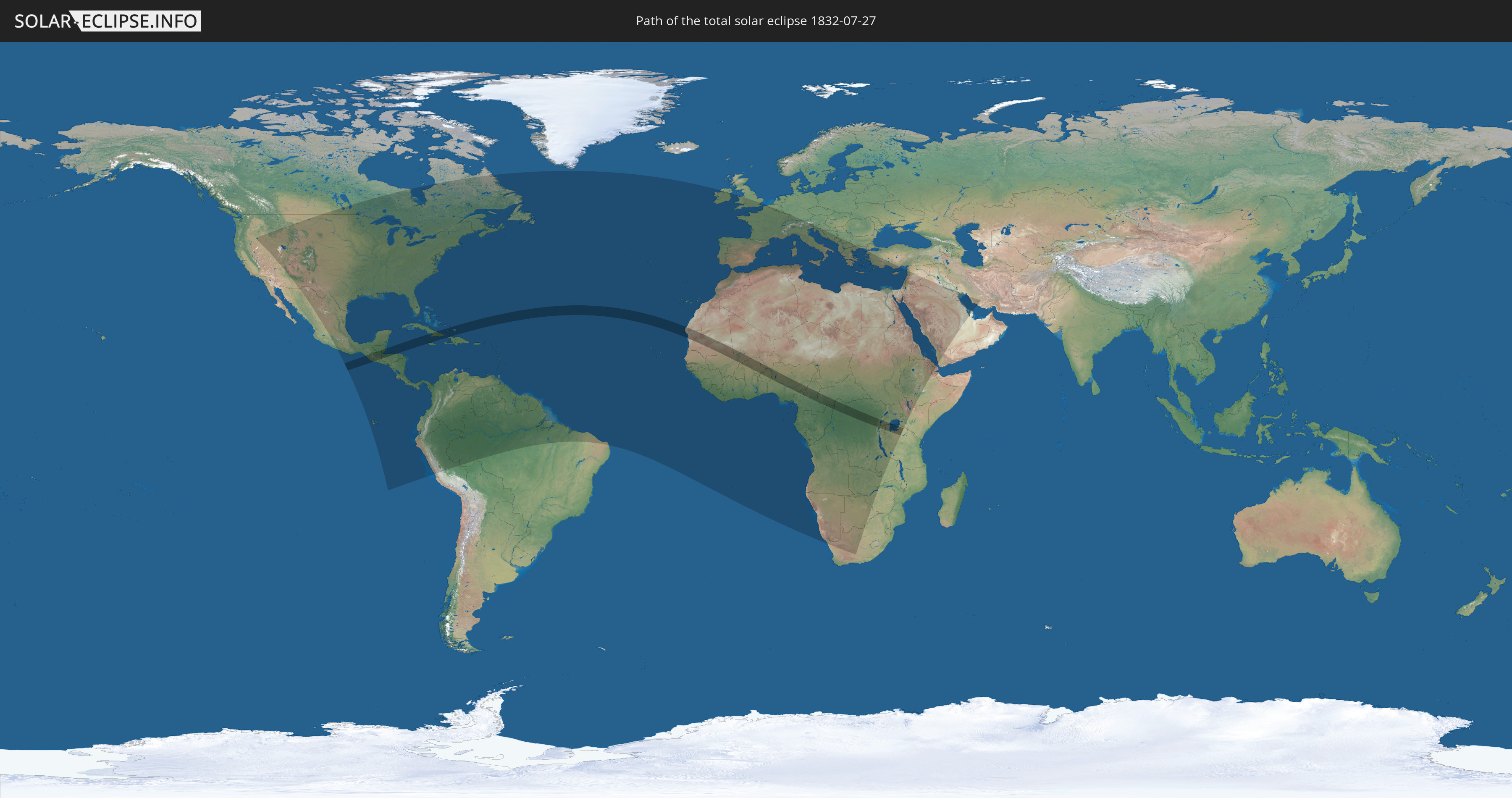
Total solar eclipse of 07/27/1832
| Day of week: | Friday |
| Maximum duration of eclipse: | 06m46s |
| Maximum width of eclipse path: | 252 km |
| Saros cycle: | 133 |
| Coverage: | 100% |
| Magnitude: | 1.0776 |
| Gamma: | 0.0919 |
Wo kann man die Sonnenfinsternis vom 07/27/1832 sehen?
Die Sonnenfinsternis am 07/27/1832 kann man in 134 Ländern als partielle Sonnenfinsternis beobachten.
Der Finsternispfad verläuft durch 23 Länder. Nur in diesen Ländern ist sie als total Sonnenfinsternis zu sehen.
In den folgenden Ländern ist die Sonnenfinsternis total zu sehen
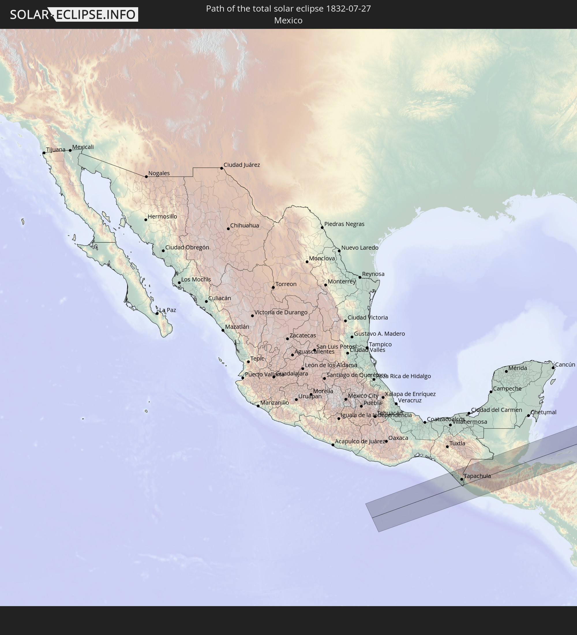 Mexico
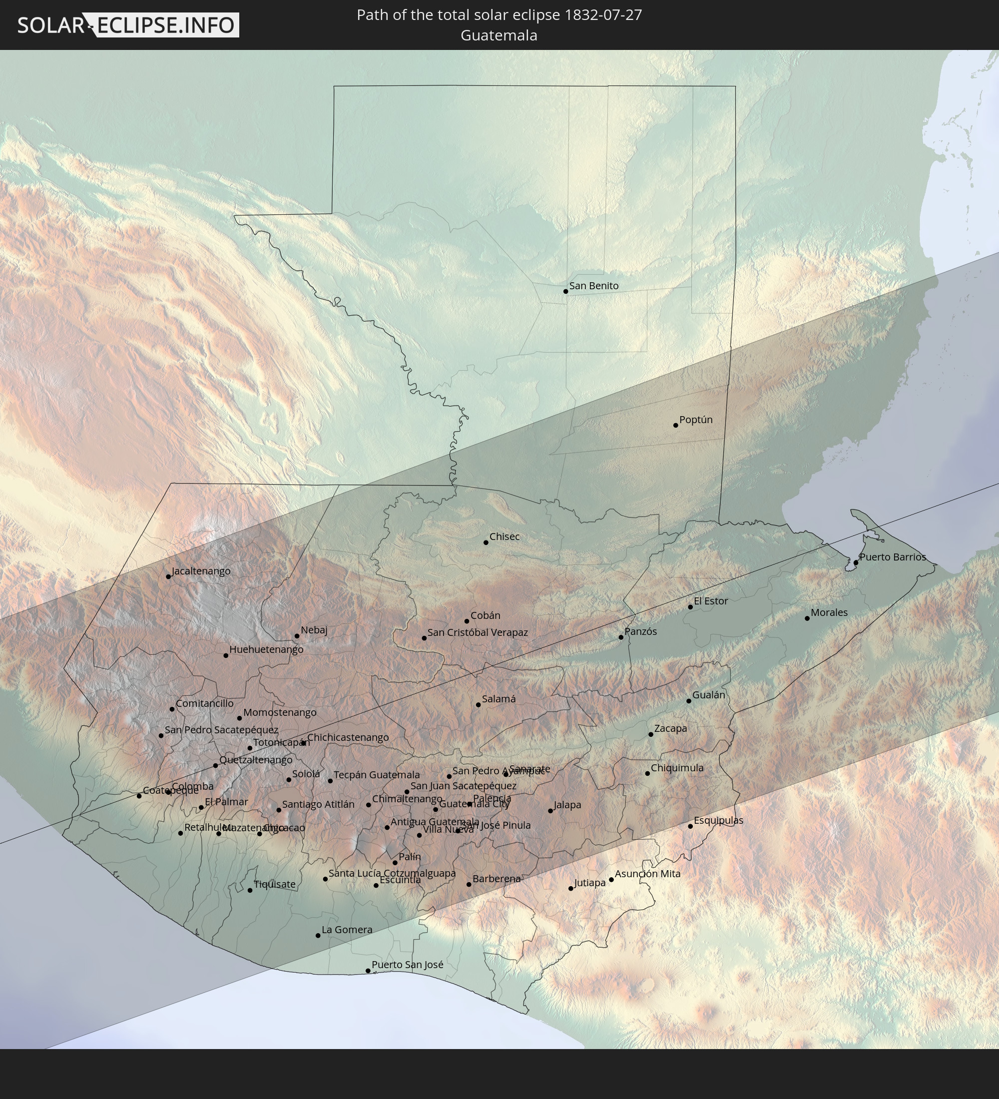 Guatemala
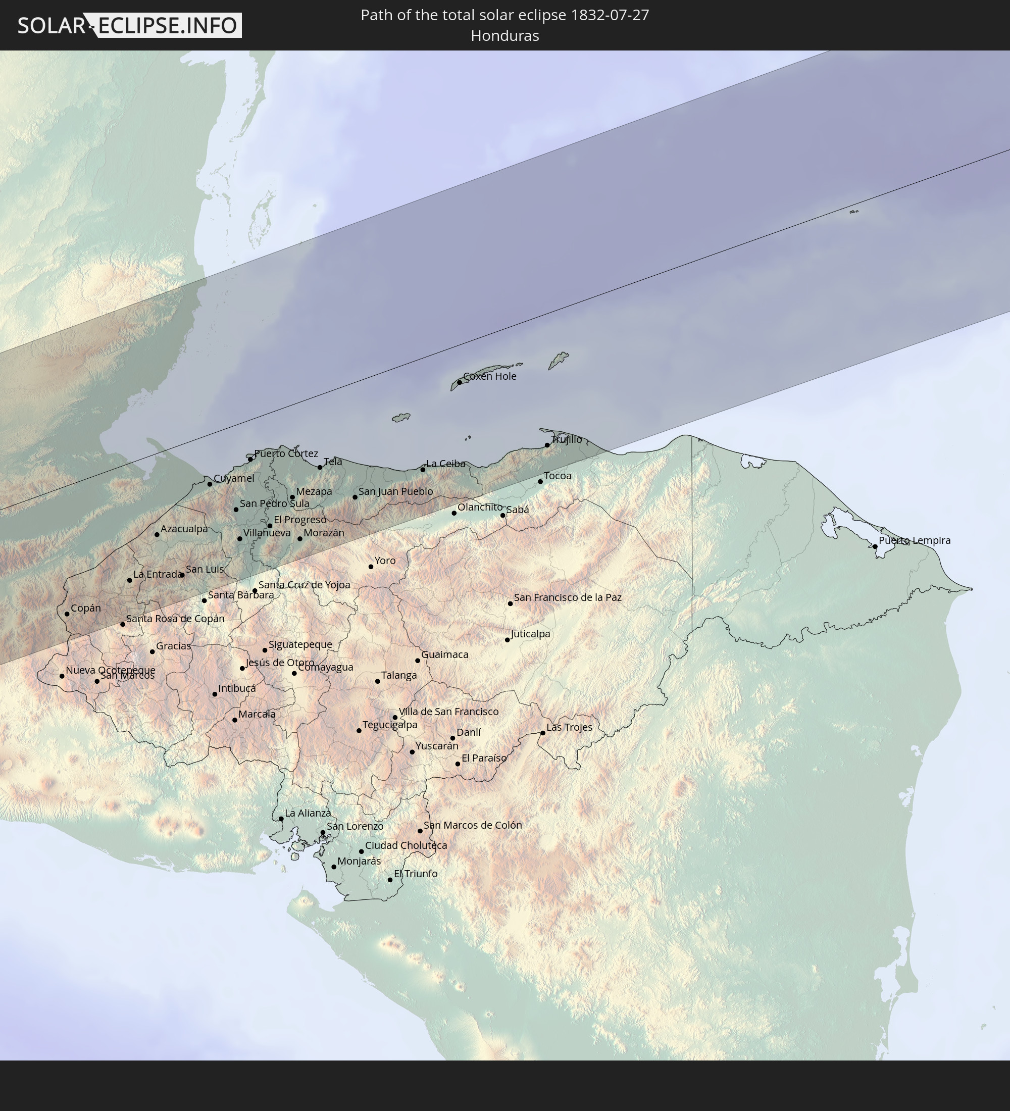 Honduras
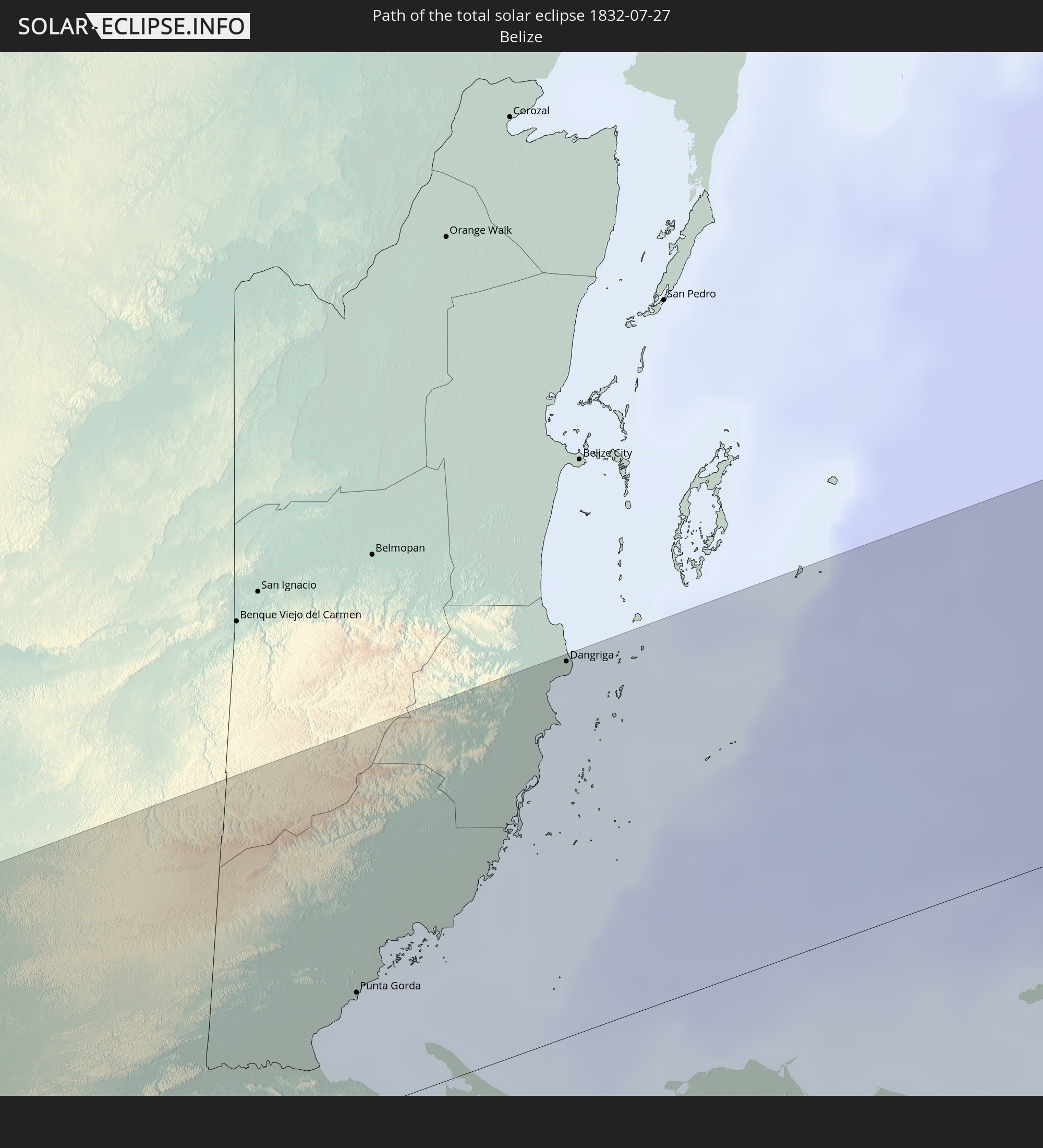 Belize
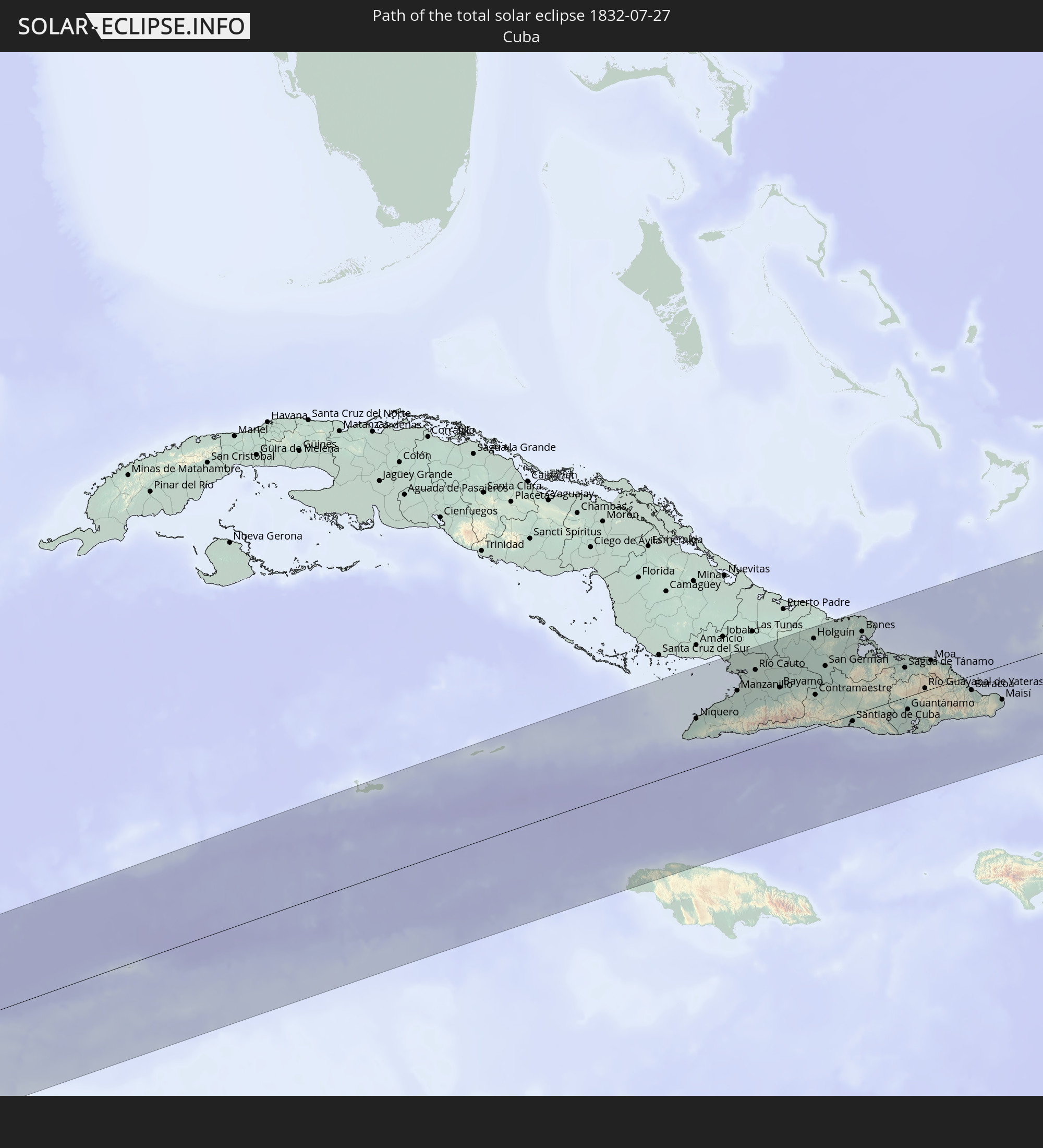 Cuba
Cuba
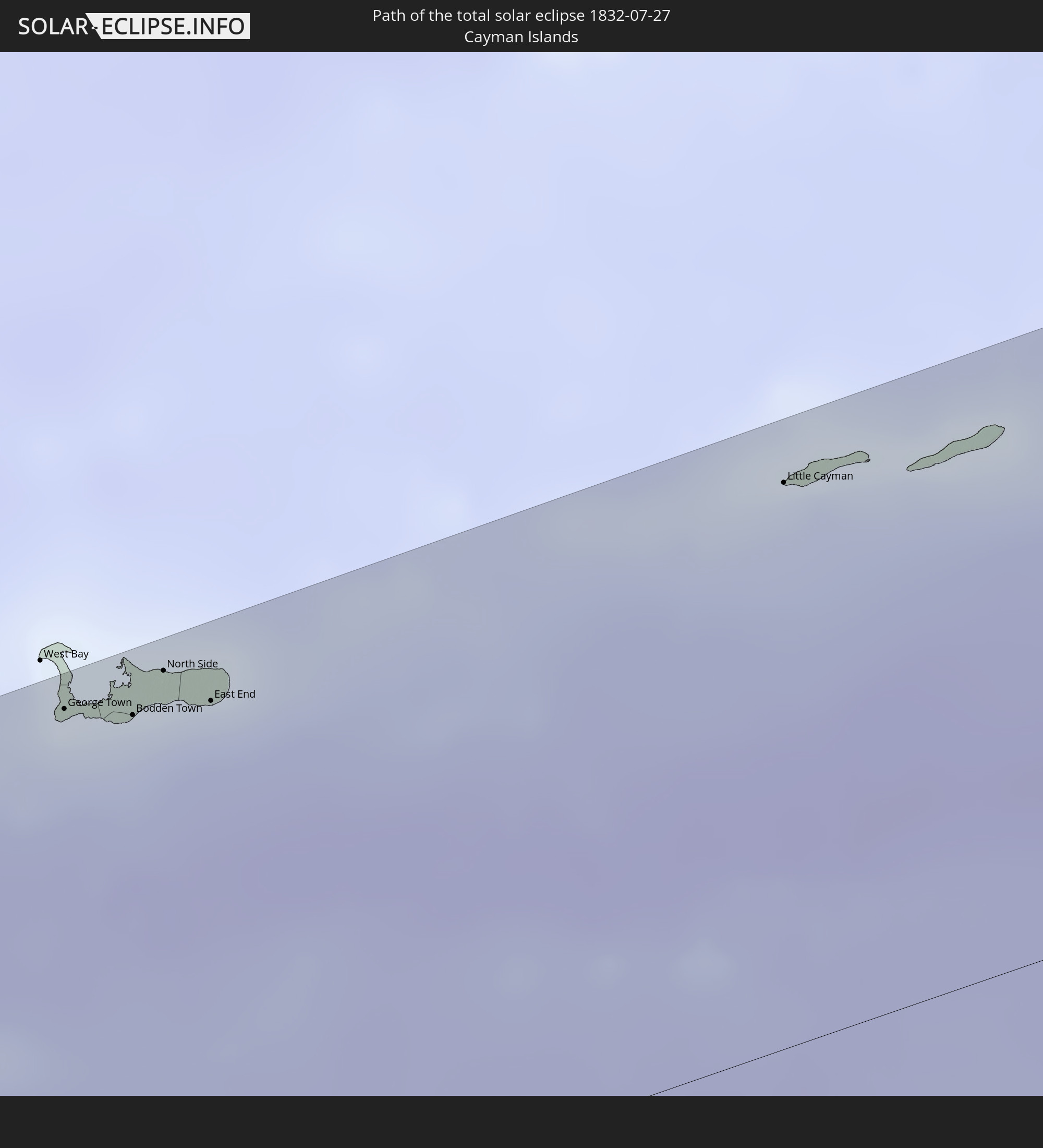 Cayman Islands
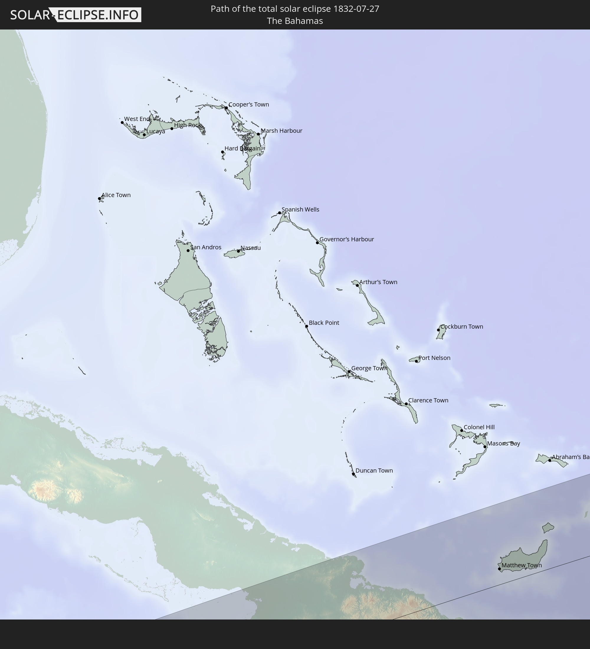 The Bahamas
 Jamaica
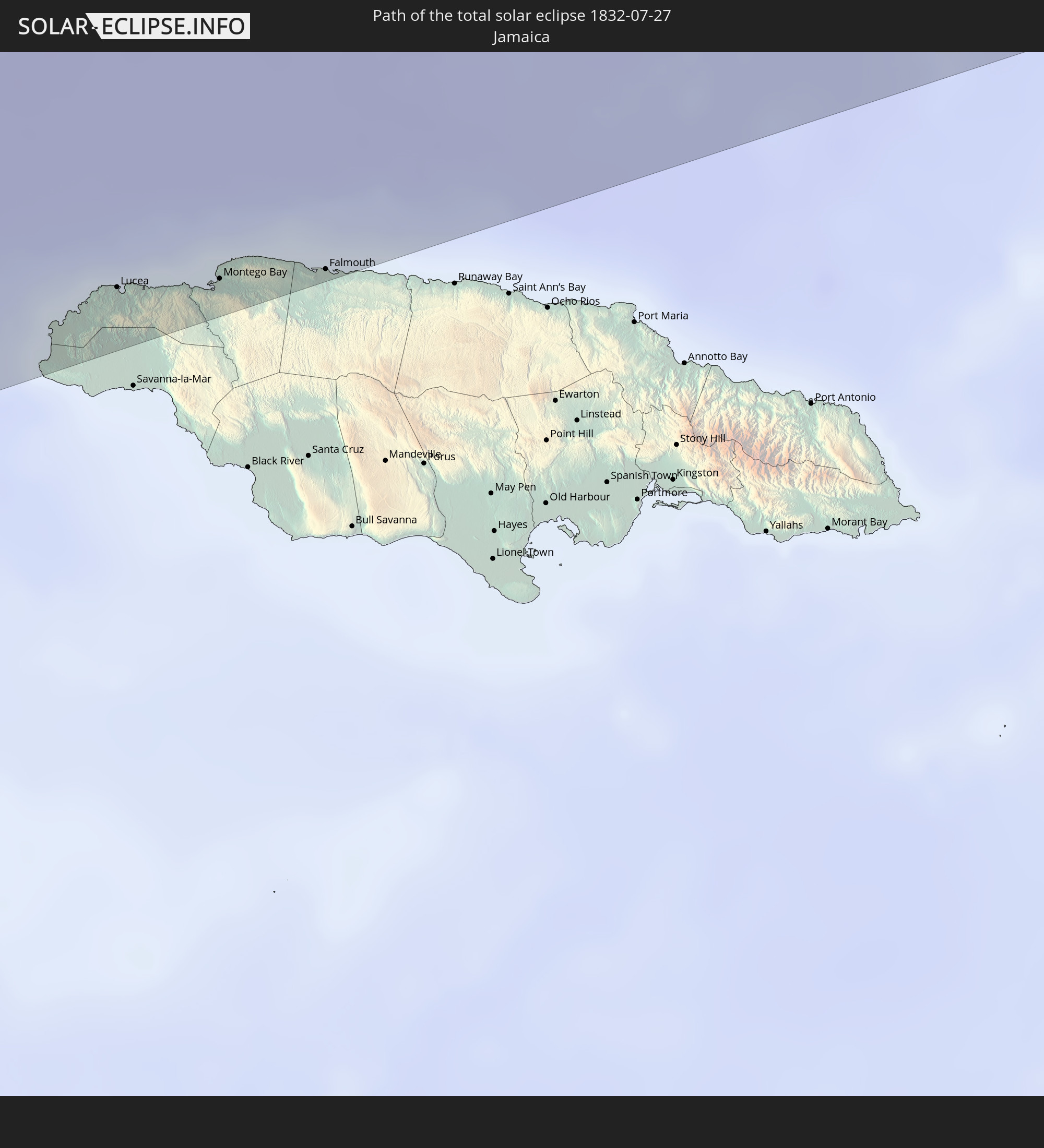
 Haiti
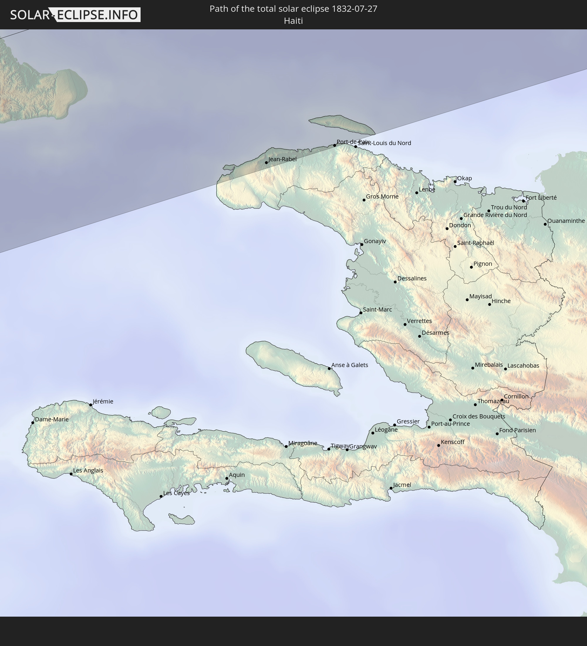
Haiti
 Turks and Caicos Islands
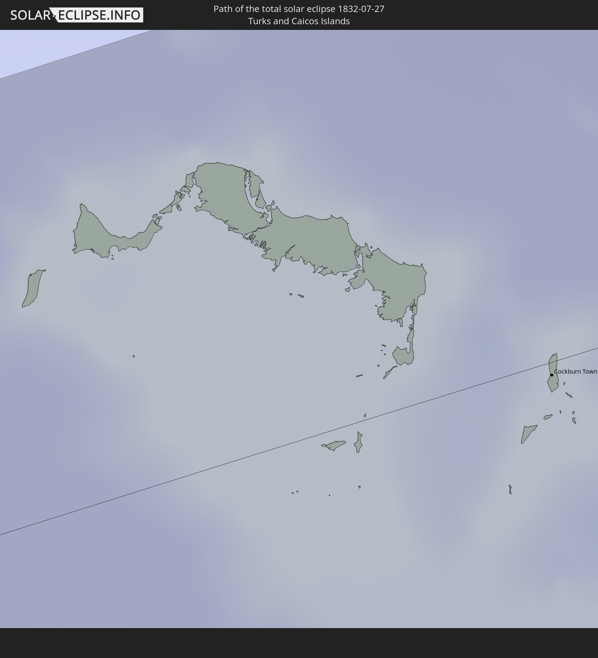
 Mauritania
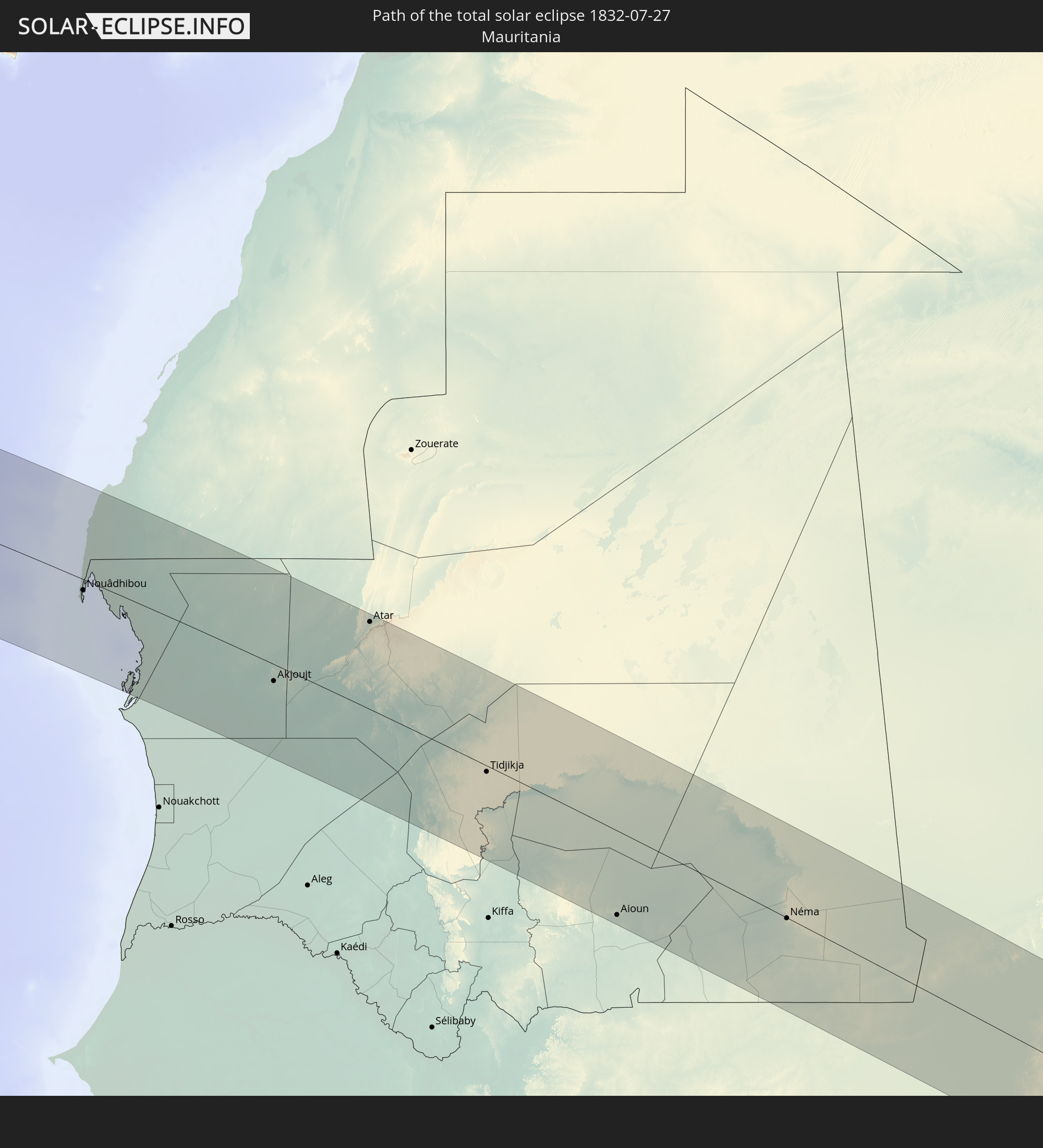
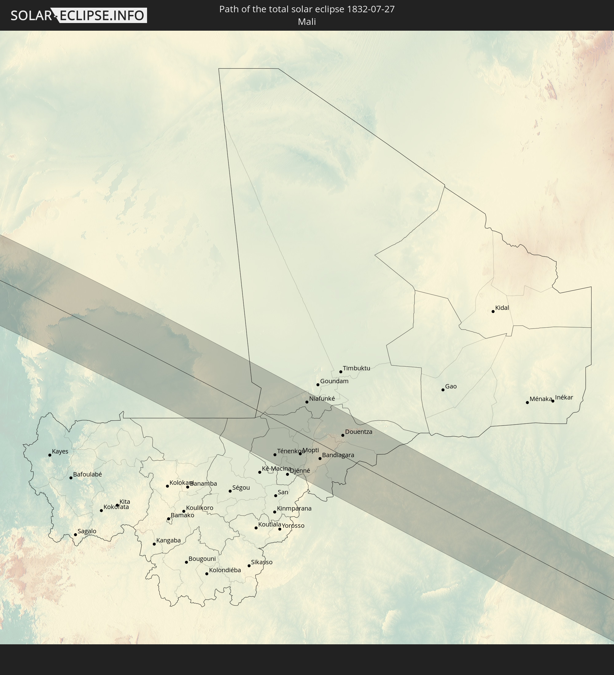 Mali
Mali
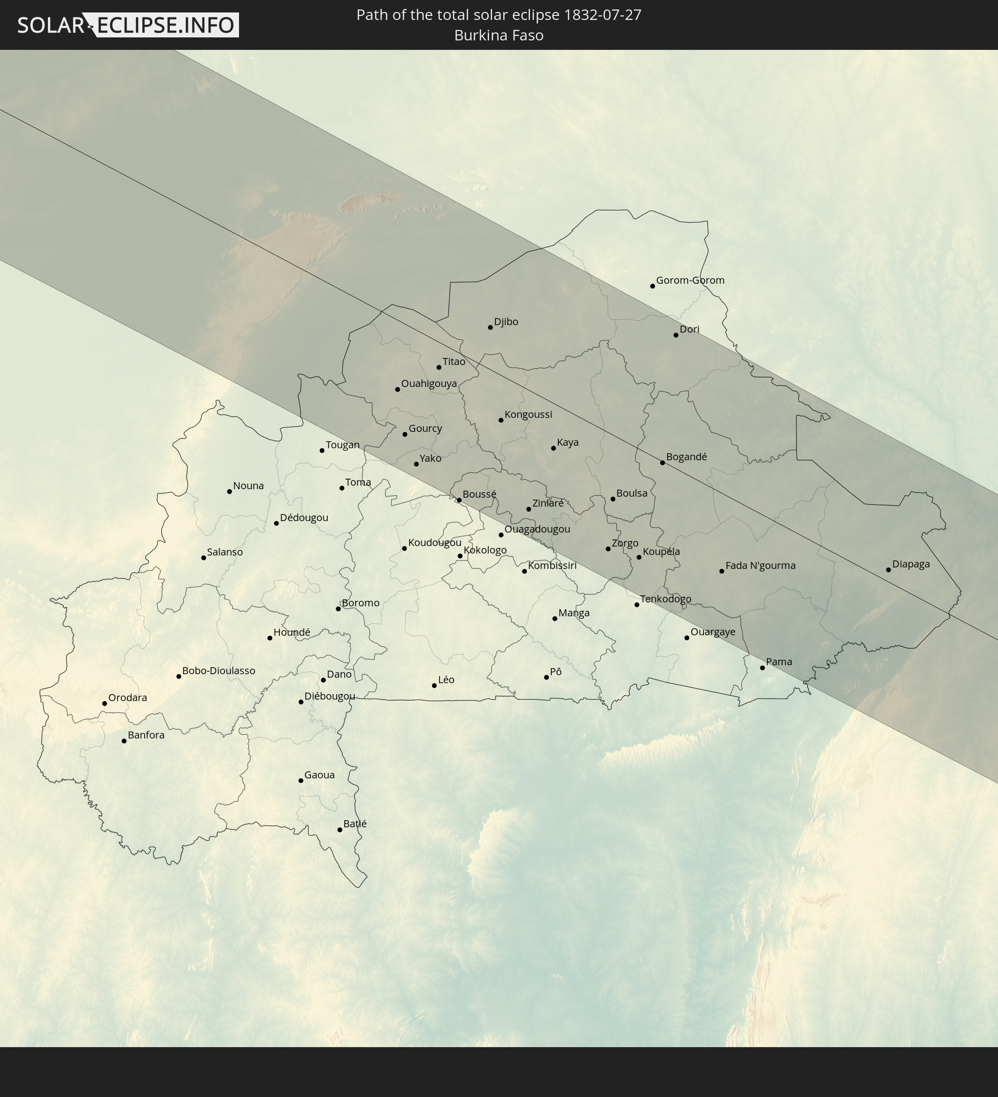 Burkina Faso
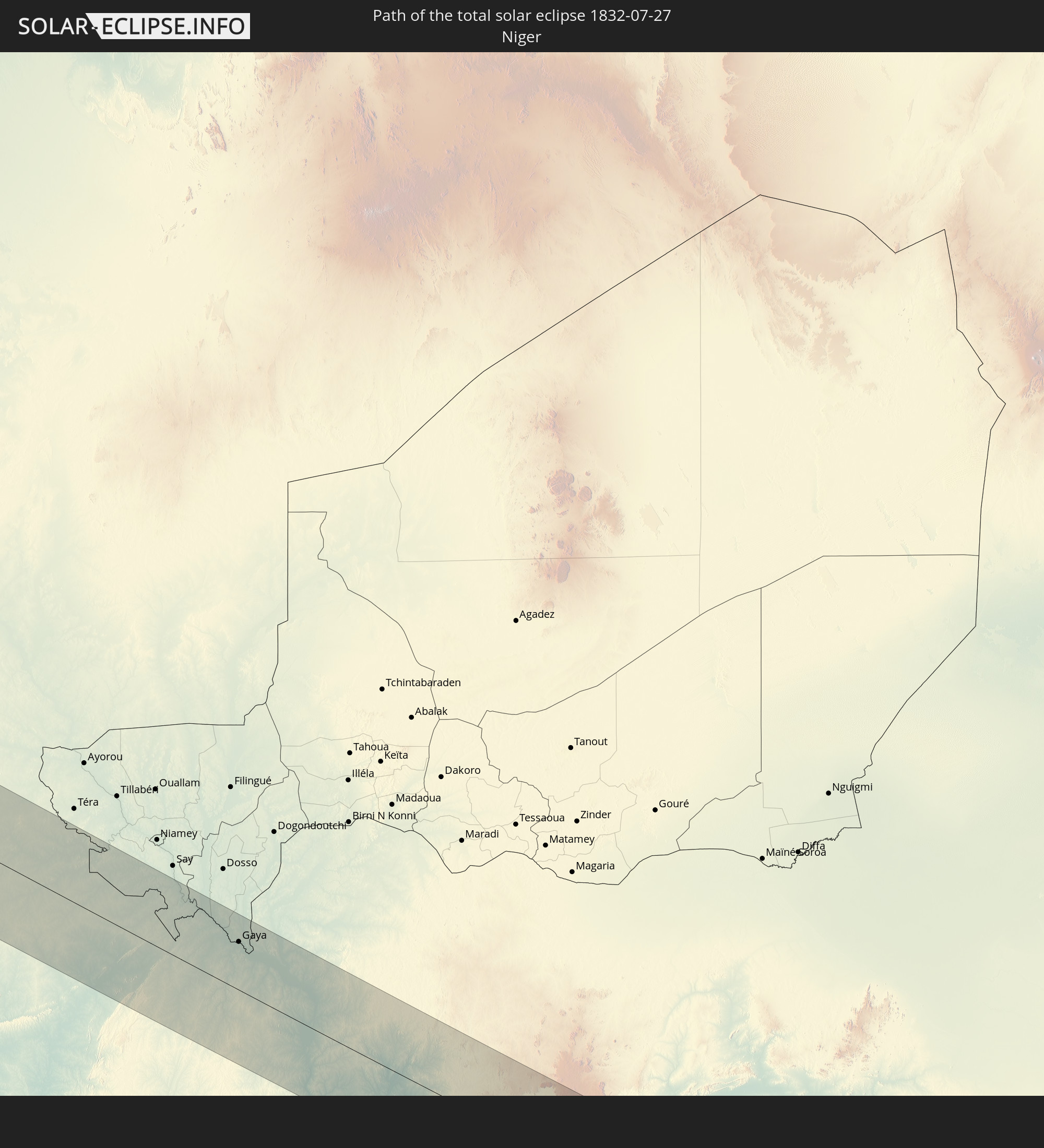 Niger
Niger
 Benin
Benin
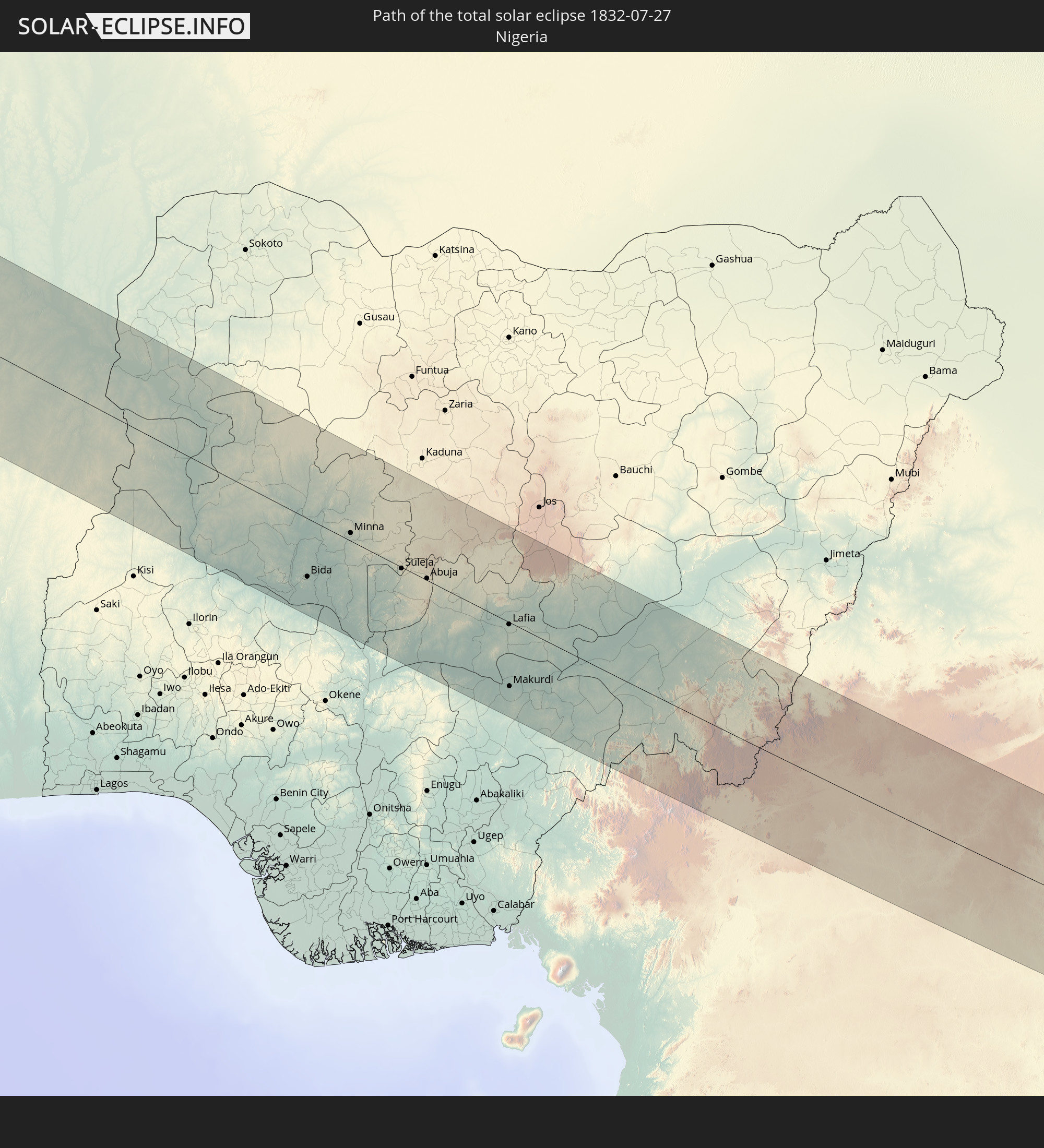 Nigeria
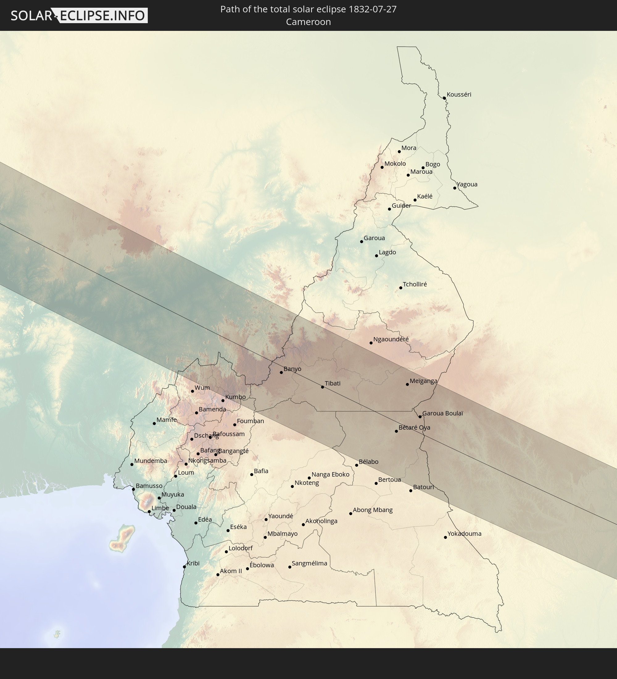 Cameroon
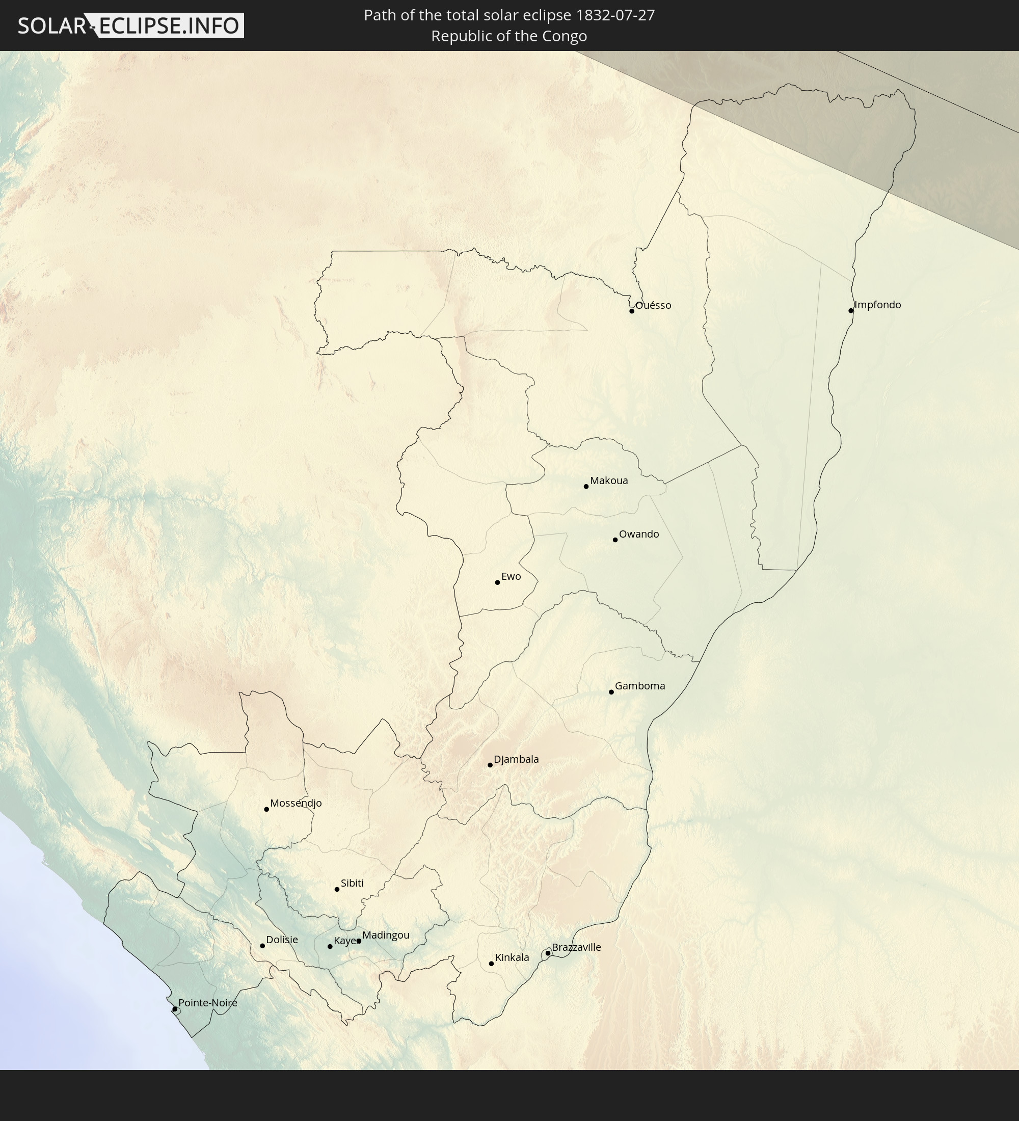 Republic of the Congo
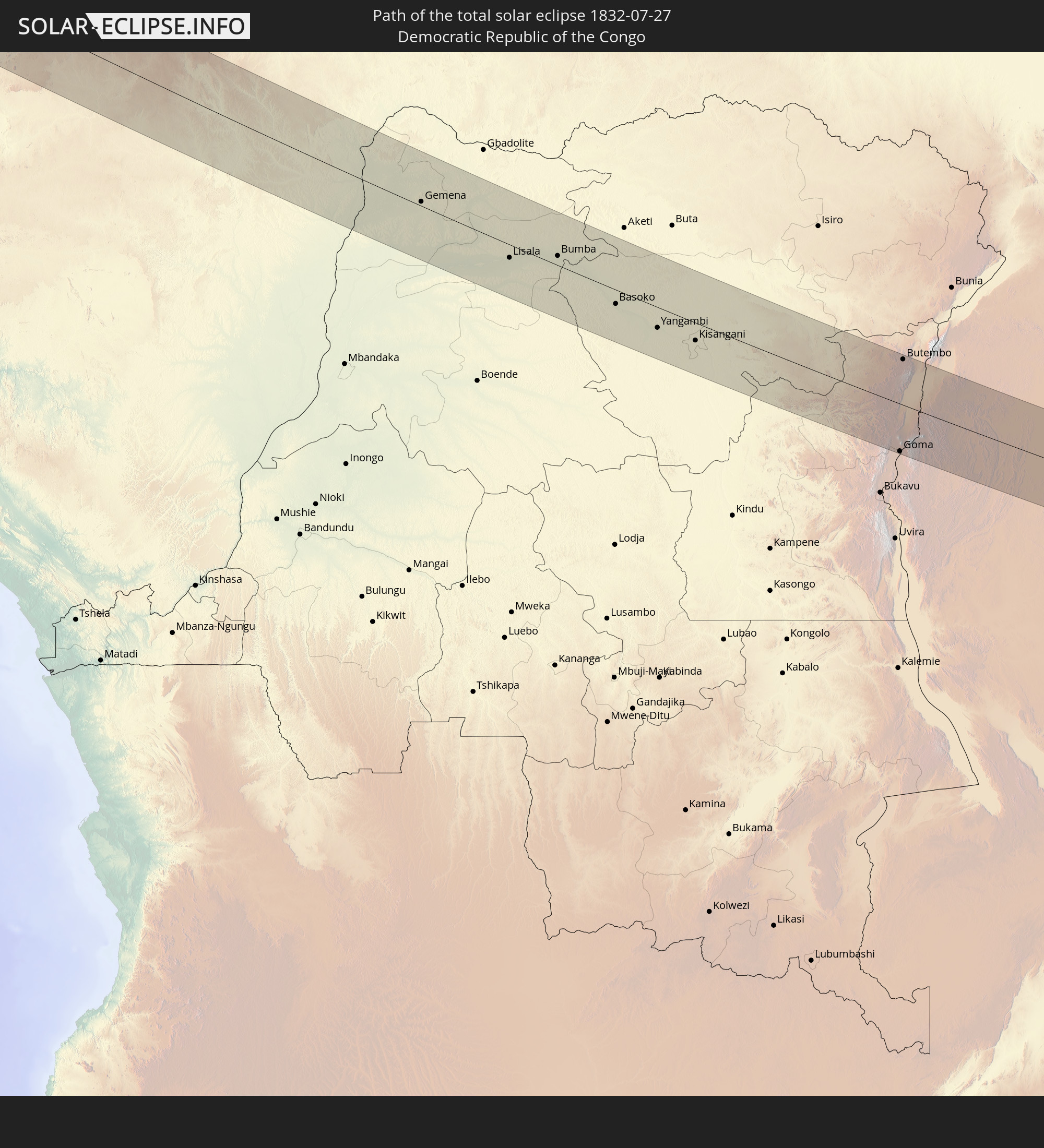 Democratic Republic of the Congo
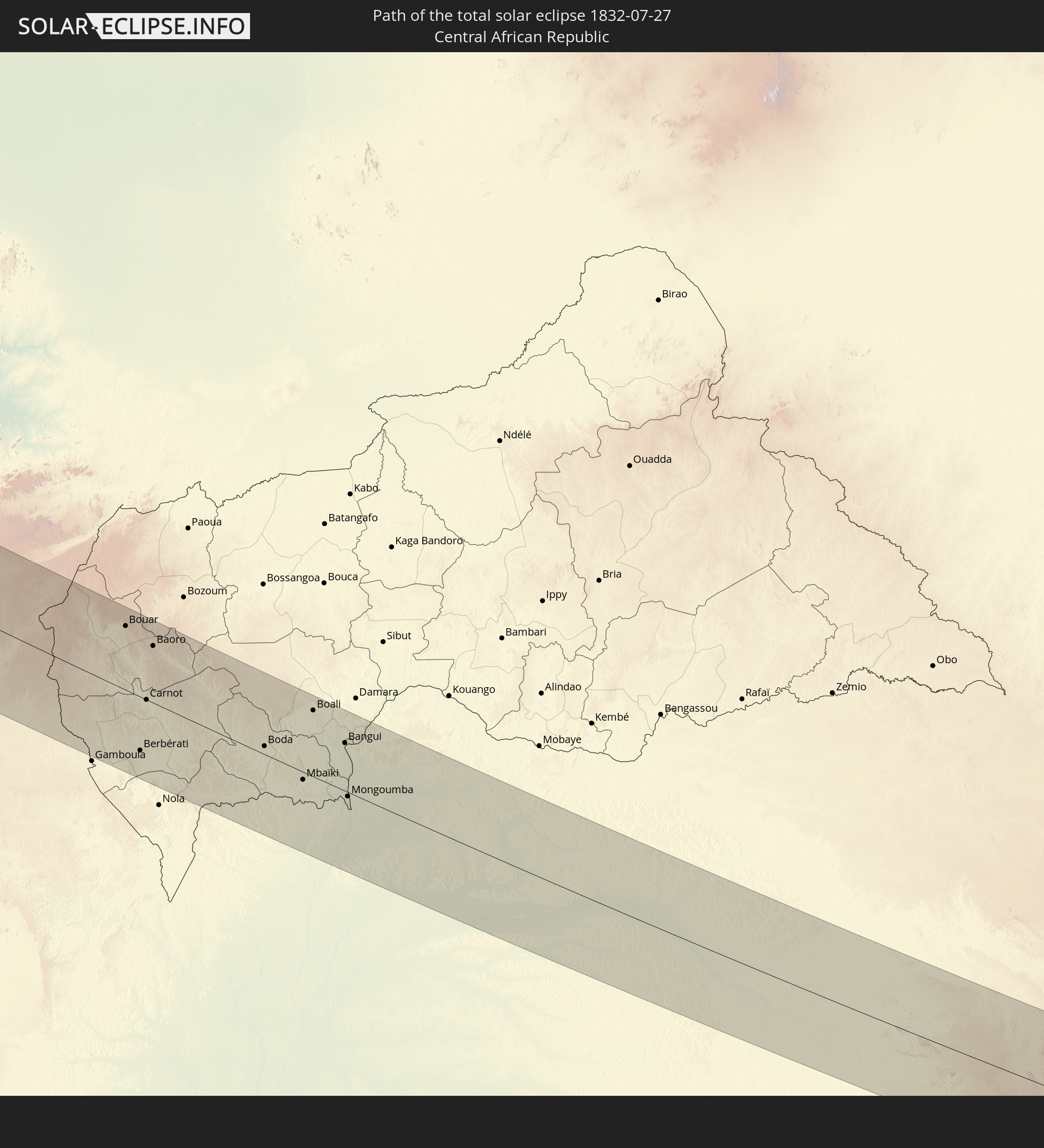 Central African Republic
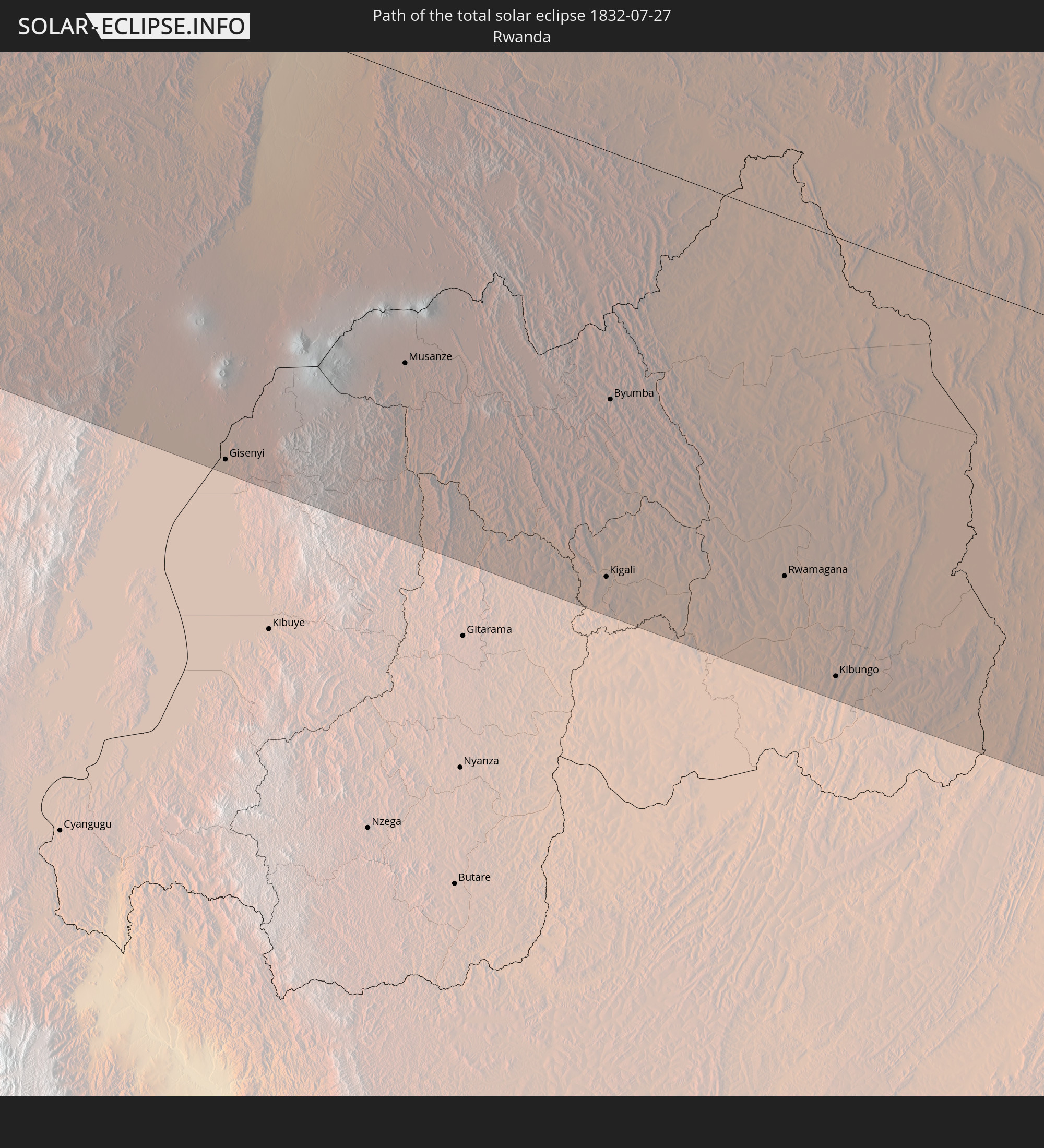 Rwanda
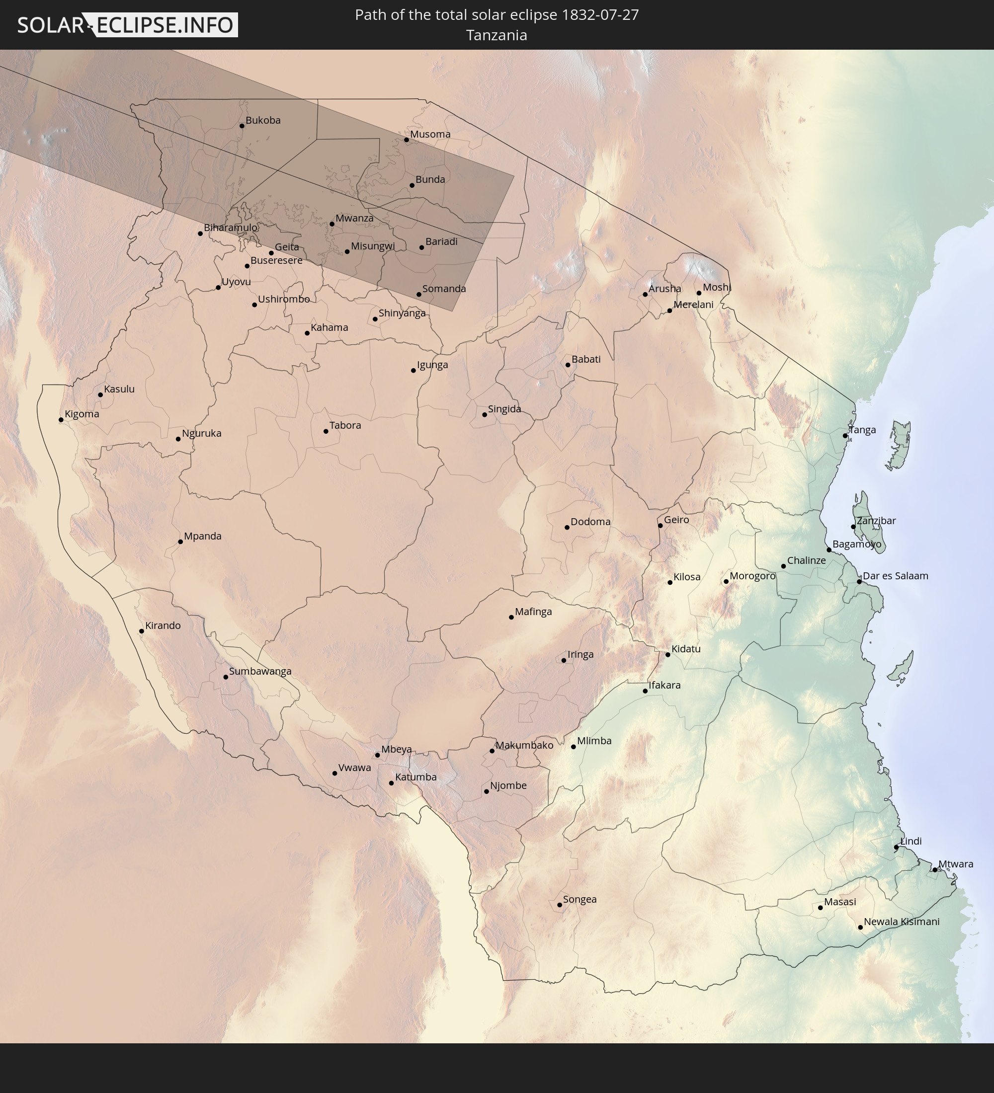 Tanzania
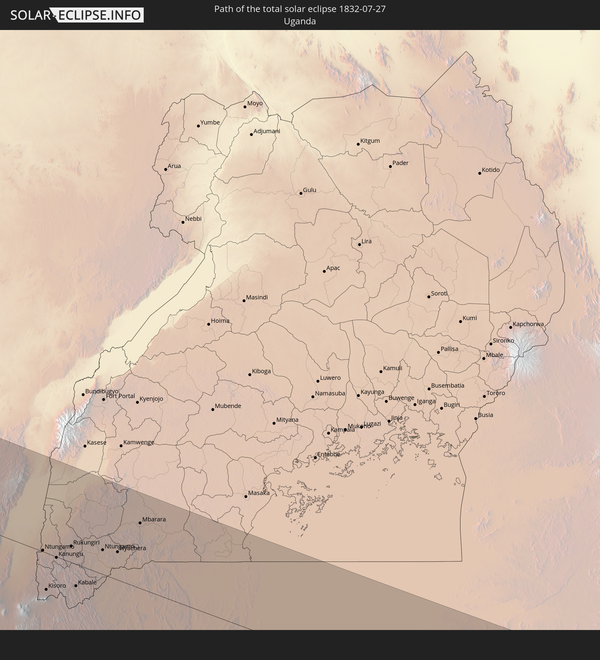 Uganda
In den folgenden Ländern ist die Sonnenfinsternis partiell zu sehen
 United States
 United States Minor Outlying Islands
 Canada
 Mexico
 Guatemala
 Ecuador
 El Salvador
 Honduras
 Belize
 Nicaragua
 Costa Rica
 Cuba
Cuba
 Panama
 Colombia
 Cayman Islands
 Peru
Peru
 The Bahamas
 Jamaica
 Haiti
Haiti
 Brazil
 Venezuela
 Turks and Caicos Islands
 Dominican Republic
 Aruba
Aruba
 Puerto Rico
 United States Virgin Islands
 Bermuda
 British Virgin Islands
 Anguilla
 Collectivity of Saint Martin
 Saint Barthélemy
 Saint Kitts and Nevis
 Antigua and Barbuda
 Montserrat
 Trinidad and Tobago
 Guadeloupe
 Grenada
 Dominica
 Saint Vincent and the Grenadines
 Guyana
 Martinique
 Saint Lucia
 Barbados
 Suriname
 Saint Pierre and Miquelon
 French Guiana
 Portugal
 Cabo Verde
 Spain
Spain
 Senegal
 Mauritania
 The Gambia
 Guinea-Bissau
 Guinea
 Saint Helena, Ascension and Tristan da Cunha
 Sierra Leone
 Morocco
 Mali
Mali
 Liberia
 Republic of Ireland
 Algeria
 United Kingdom
 Ivory Coast
 Burkina Faso
 Gibraltar
 France
 Ghana
Ghana
 Guernsey
 Jersey
 Togo
Togo
 Niger
Niger
 Benin
Benin
 Andorra
 Belgium
 Nigeria
 Equatorial Guinea
 Luxembourg
 Germany
 Switzerland
 São Tomé and Príncipe
 Italy
Italy
 Monaco
 Tunisia
 Cameroon
 Gabon
Gabon
 Libya
Libya
 Liechtenstein
 Austria
 Republic of the Congo
 Angola
 Namibia
 Democratic Republic of the Congo
 San Marino
 Vatican City
 Slovenia
 Chad
Chad
 Croatia
 Malta
Malta
 Central African Republic
 Bosnia and Herzegovina
 South Africa
 Montenegro
 Serbia
 Albania
 Greece
 Botswana
 Republic of Macedonia
 Sudan
Sudan
 Zambia
 Bulgaria
 Egypt
Egypt
 Zimbabwe
 Turkey
 Rwanda
 Burundi
 Tanzania
 Uganda
 Cyprus
 Ethiopia
 Kenya
Kenya
 State of Palestine
 Israel
 Saudi Arabia
 Jordan
 Lebanon
 Syria
Syria
 Eritrea
 Iraq
Iraq
 Djibouti
 Yemen
Yemen
 Iran
Iran
 Kuwait
 Bahrain
 Qatar
Qatar
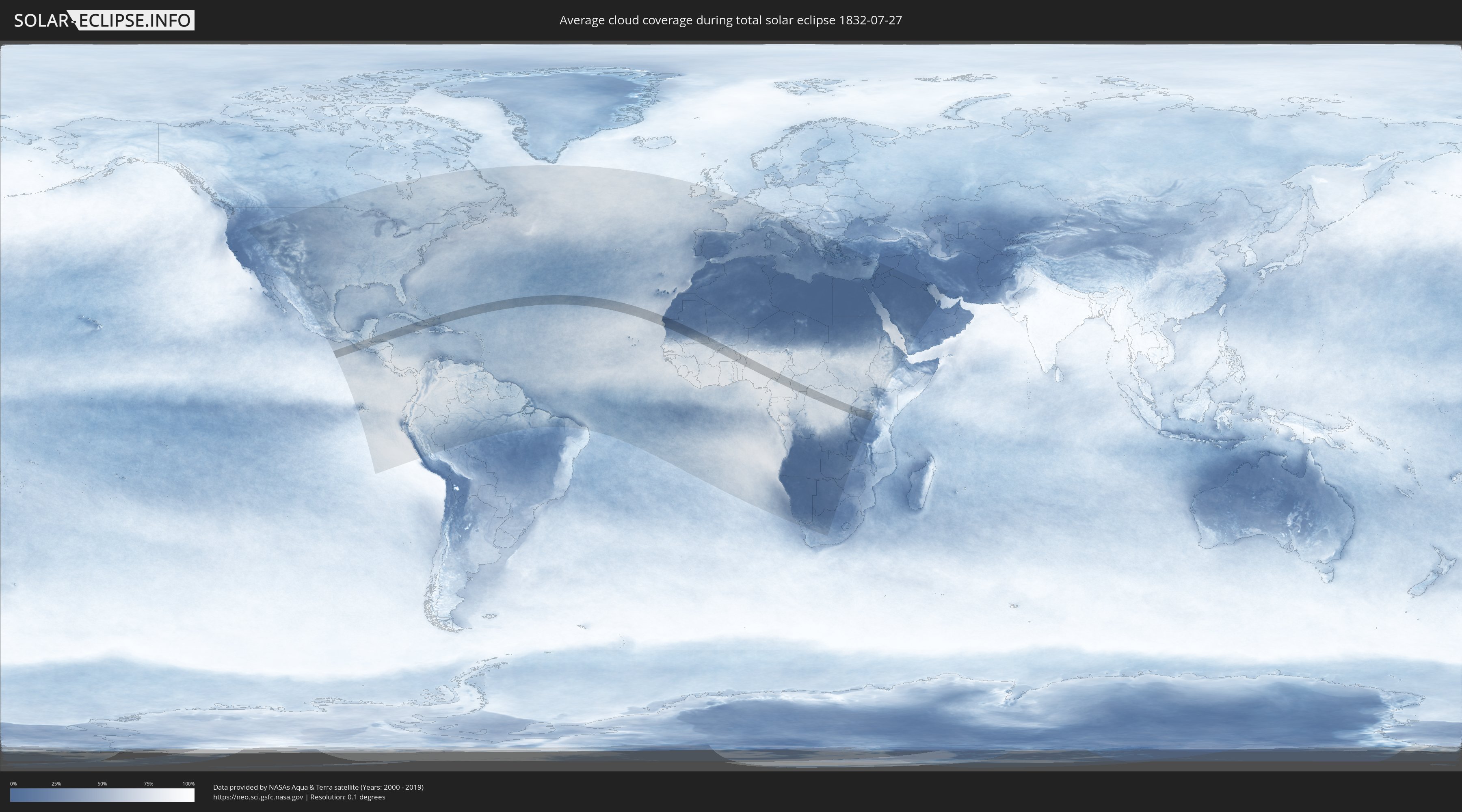
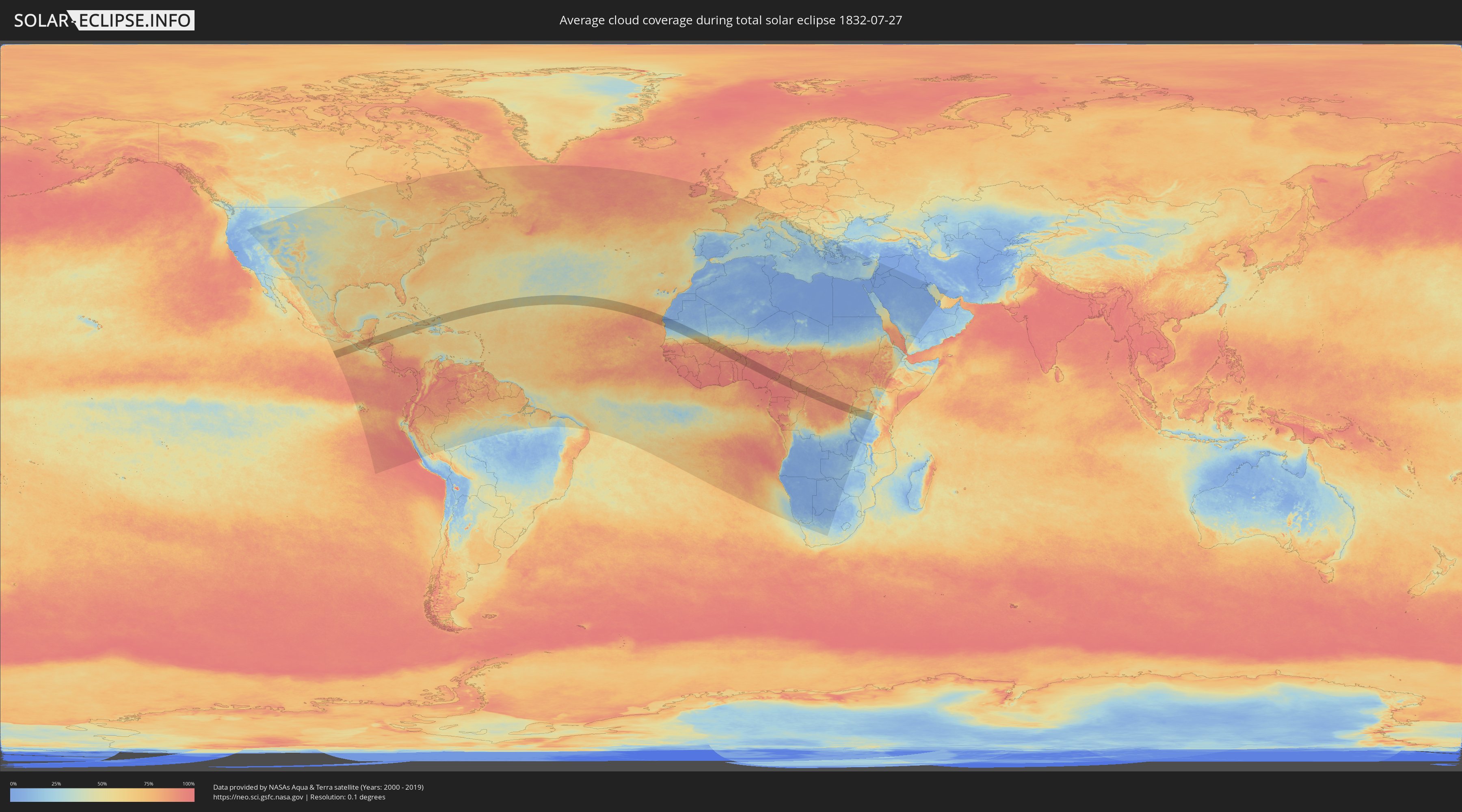
How will be the weather during the total solar eclipse on 07/27/1832?
Where is the best place to see the total solar eclipse of 07/27/1832?
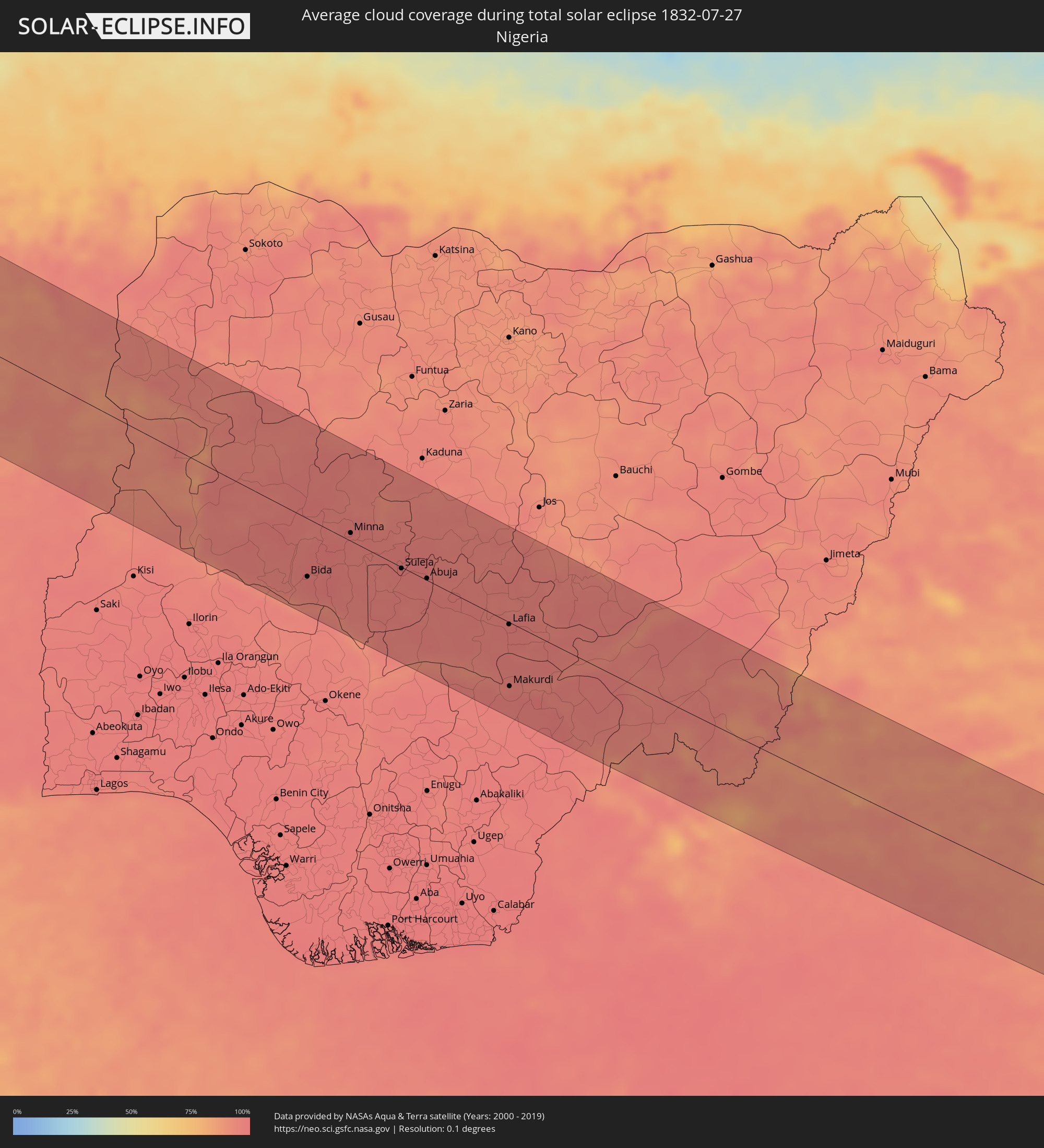
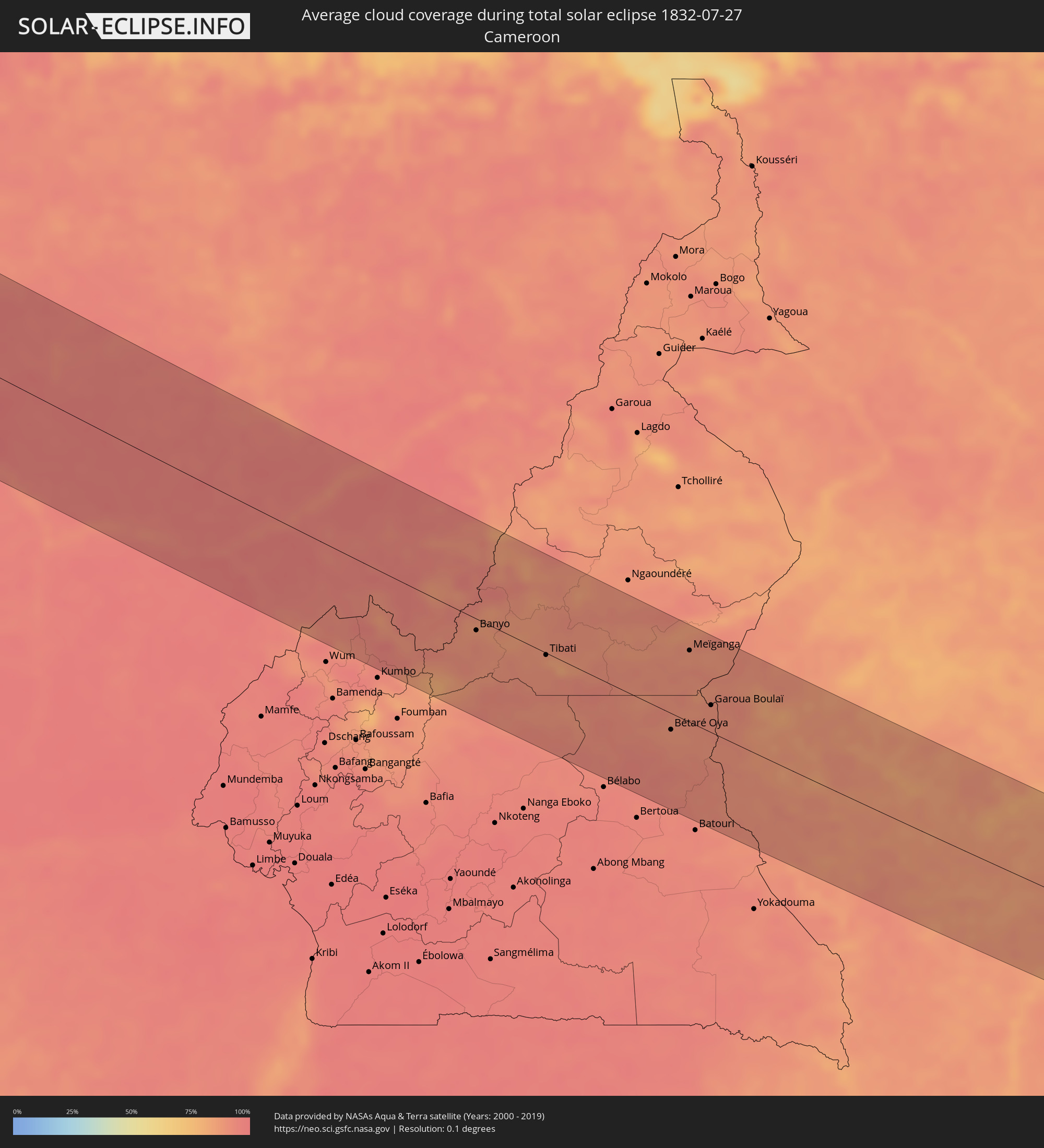
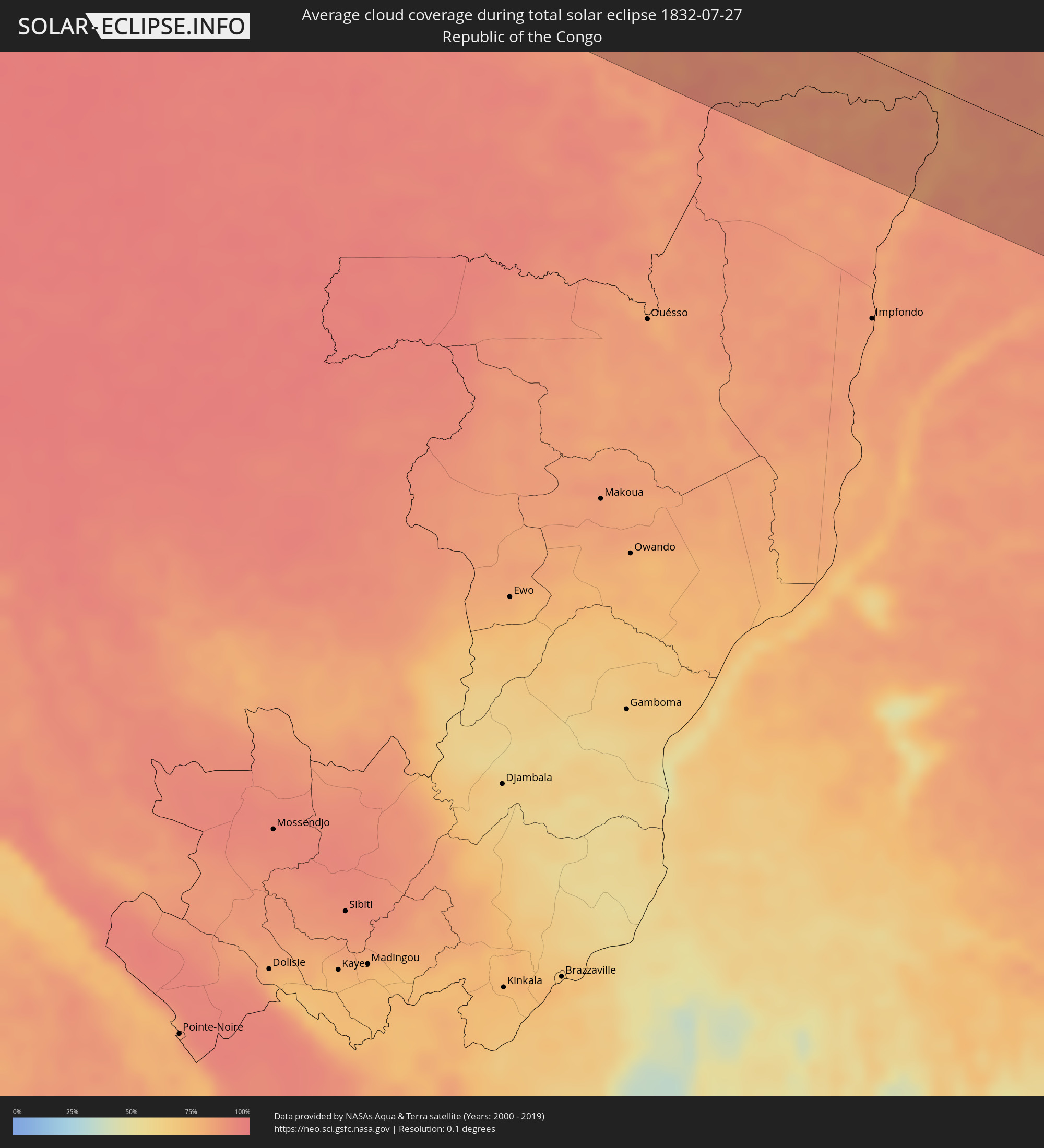
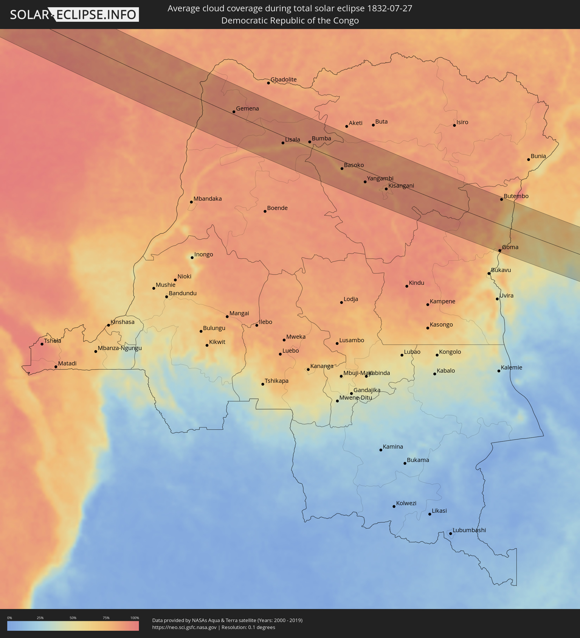
The following maps show the average cloud coverage for the day of the total solar eclipse.
With the help of these maps, it is possible to find the place along the eclipse path, which has the best
chance of a cloudless sky.
Nevertheless, you should consider local circumstances and inform about the weather of your chosen
observation site.
The data is provided by NASAs satellites
AQUA and TERRA.
The cloud maps are averaged over a period of 19 years (2000 - 2019).
Detailed country maps
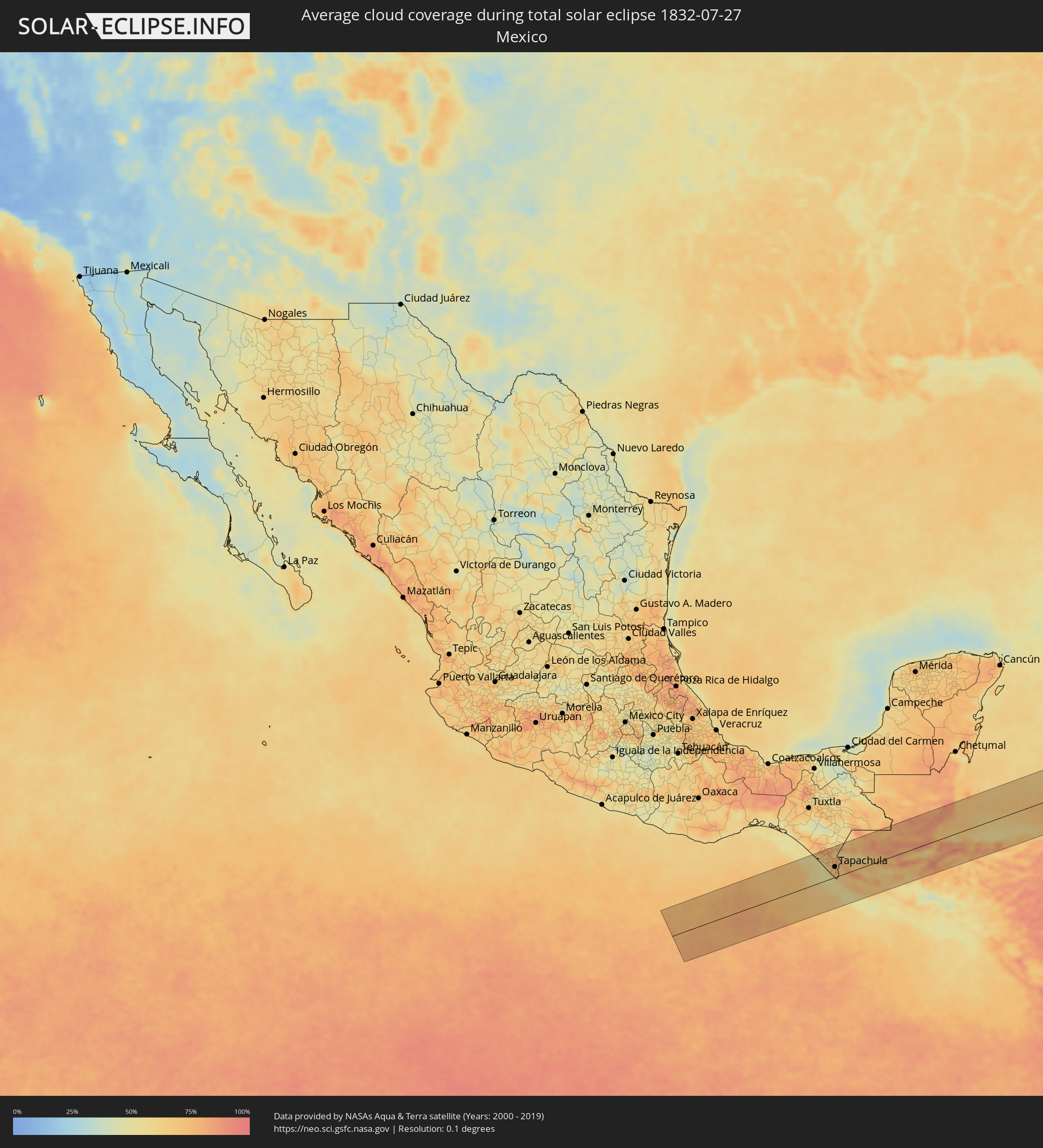 Mexico
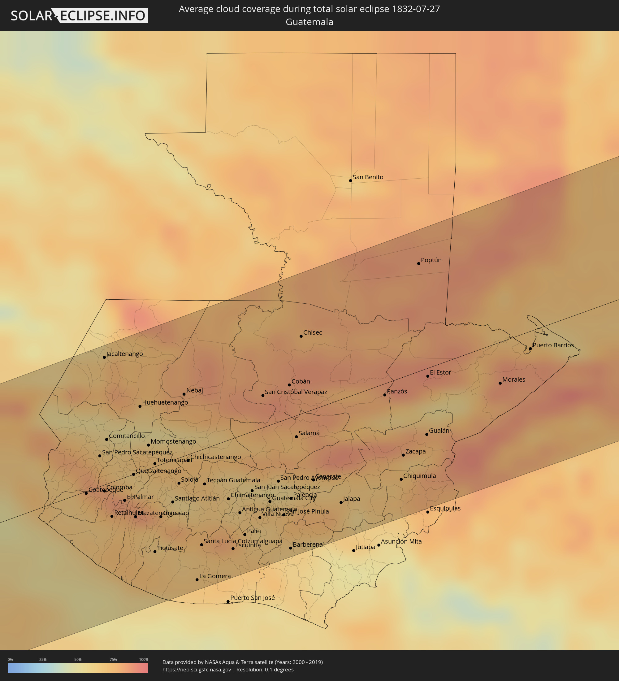 Guatemala
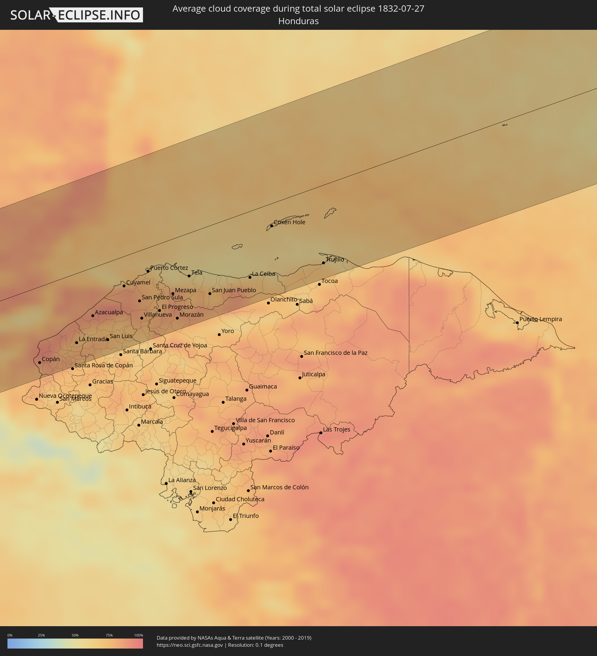 Honduras
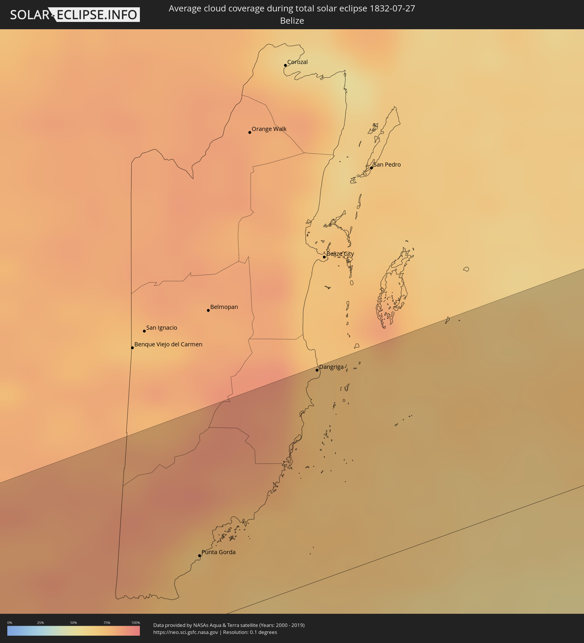 Belize
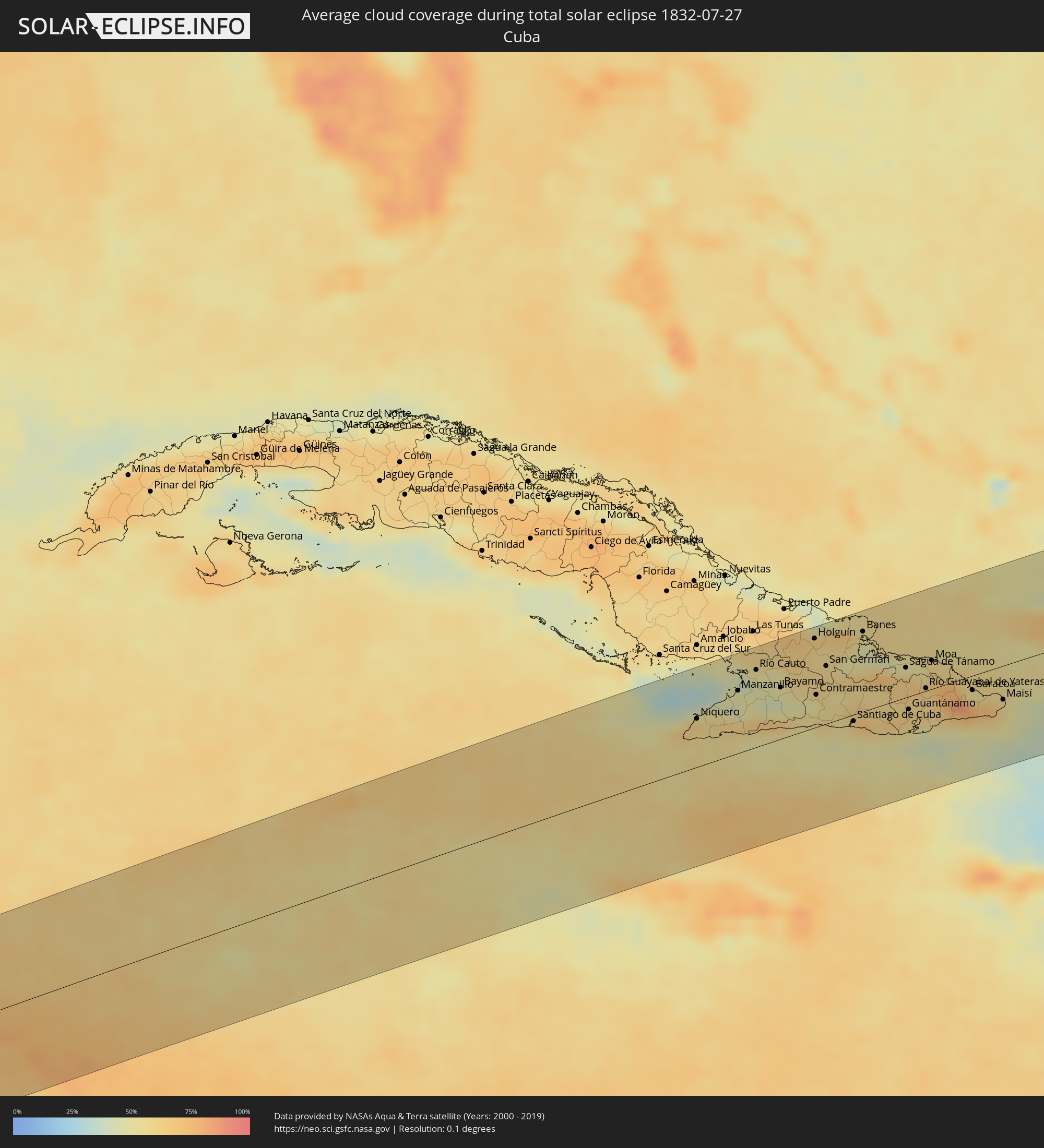 Cuba
Cuba
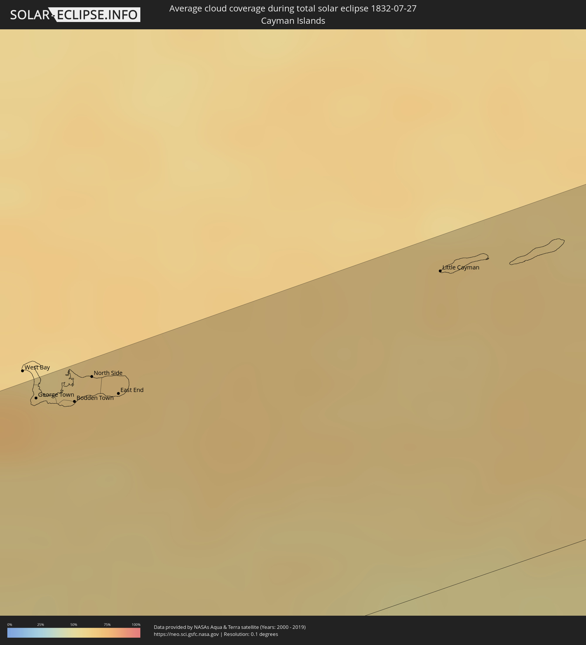 Cayman Islands
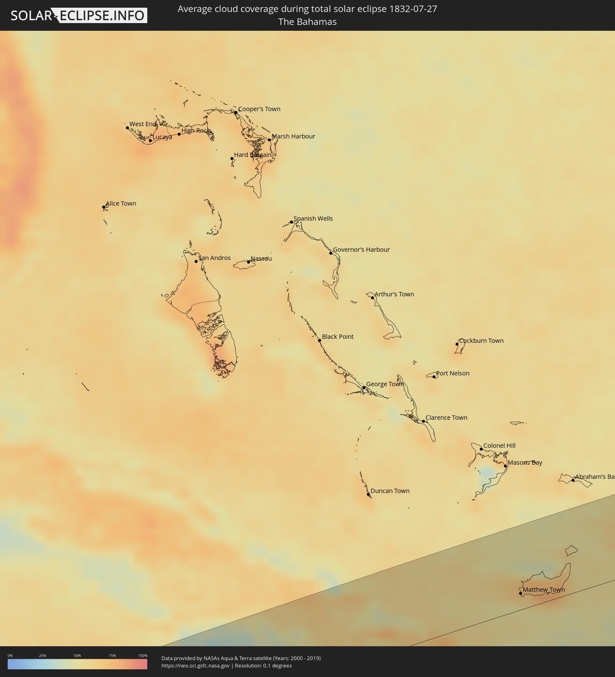 The Bahamas
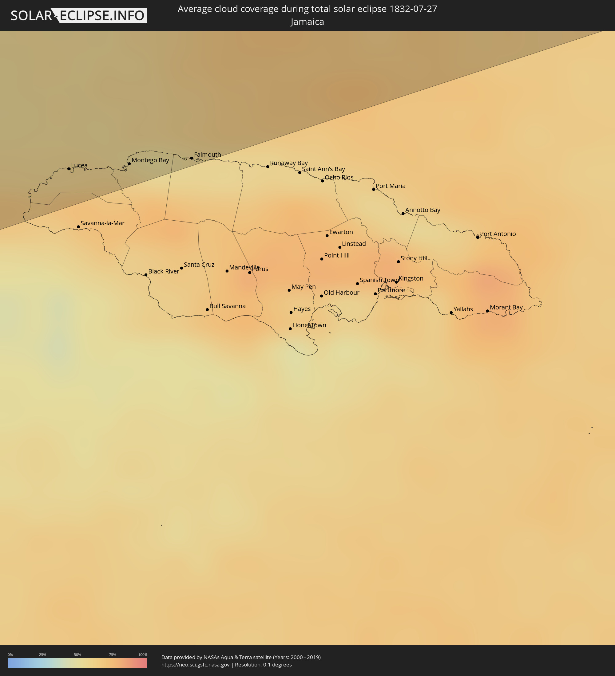 Jamaica
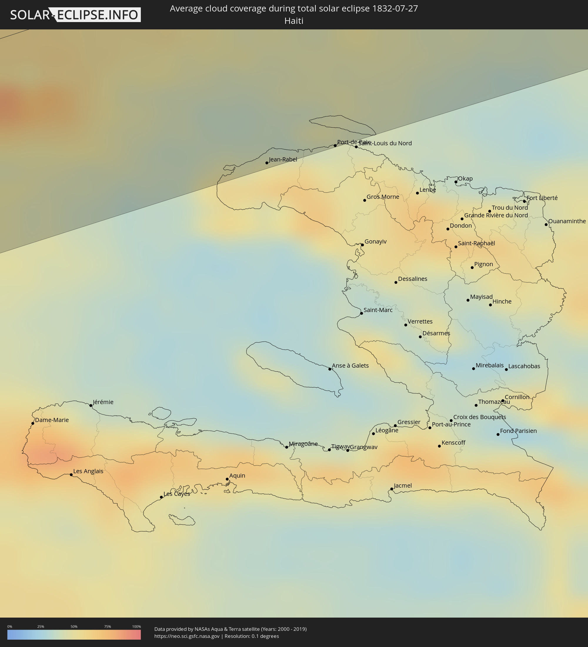 Haiti
Haiti
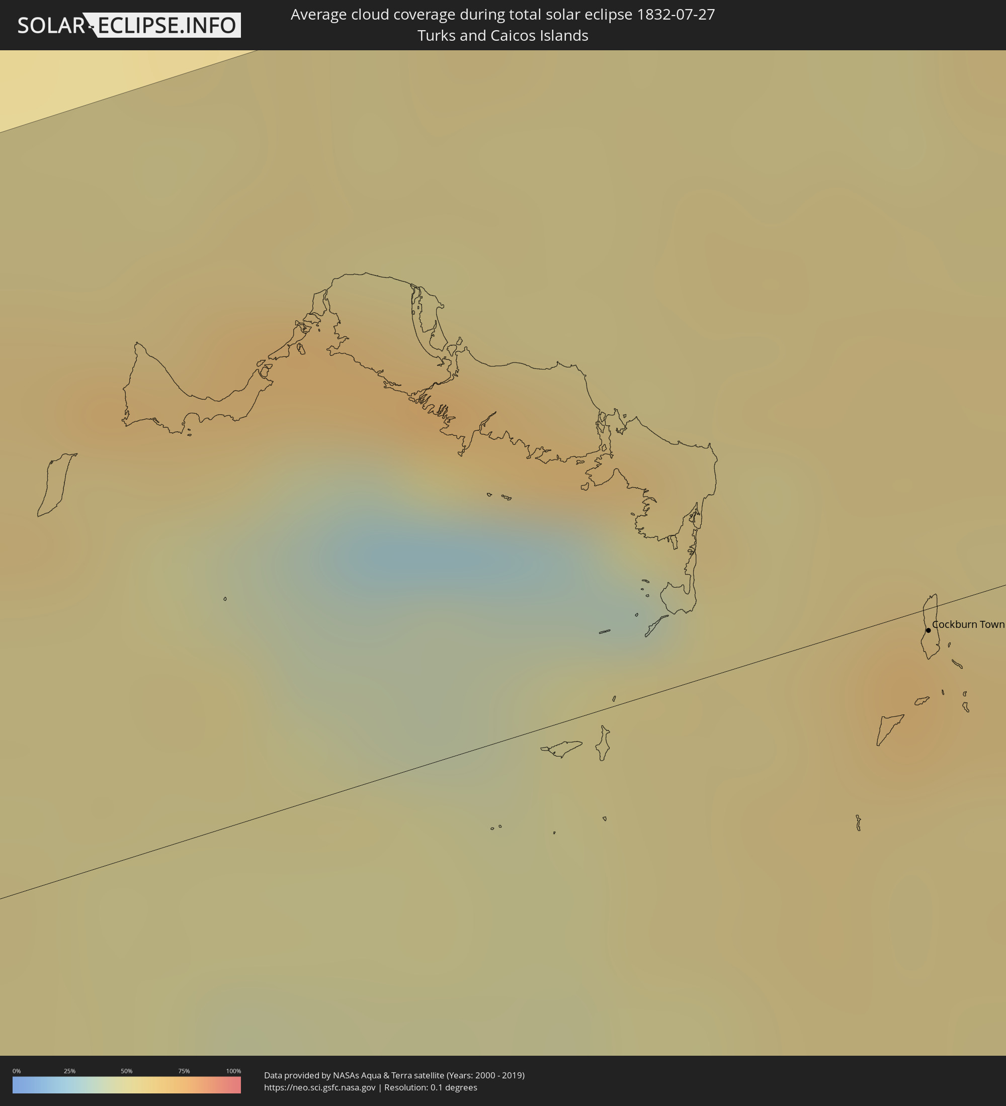 Turks and Caicos Islands
 Mauritania
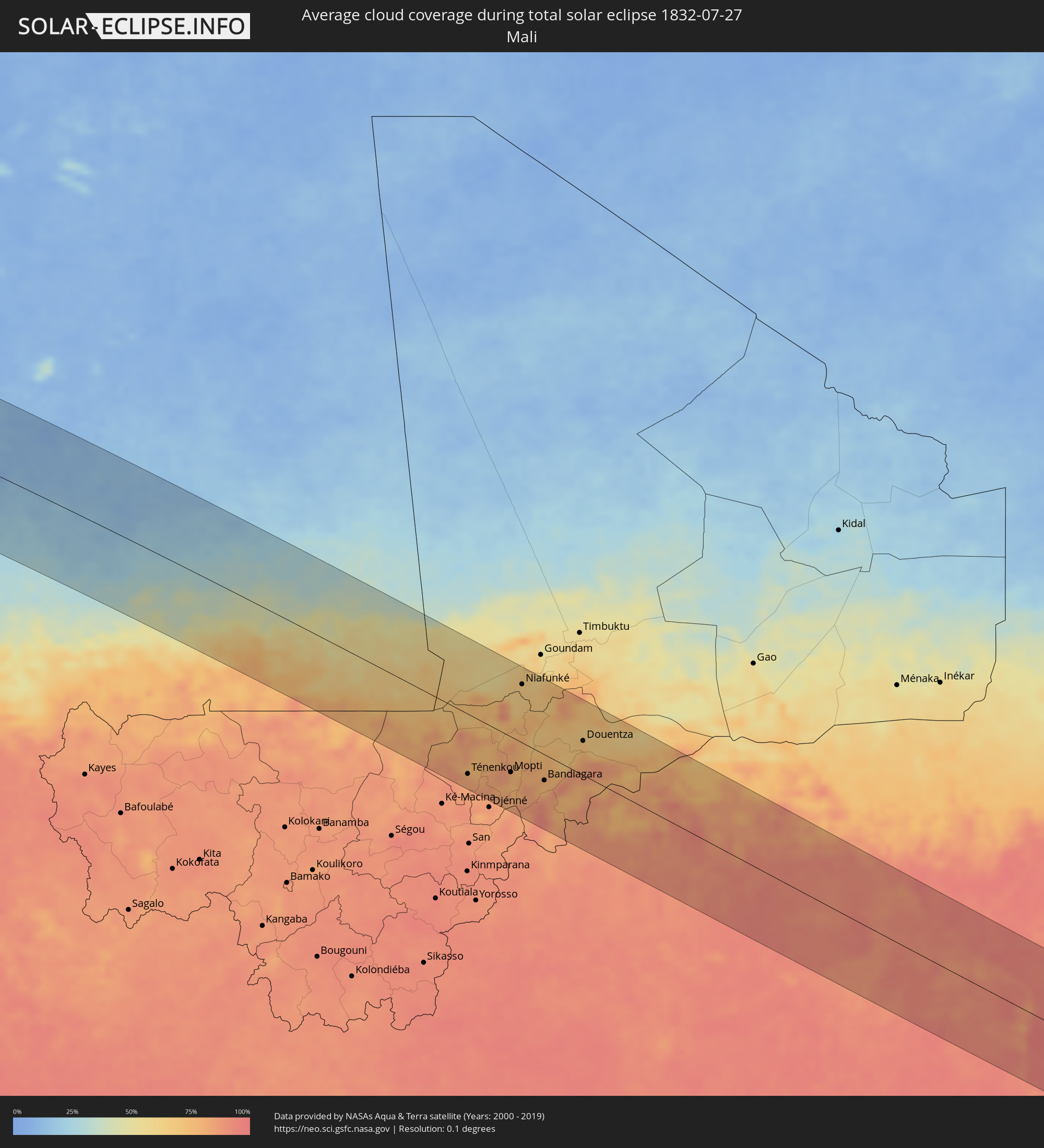 Mali
Mali
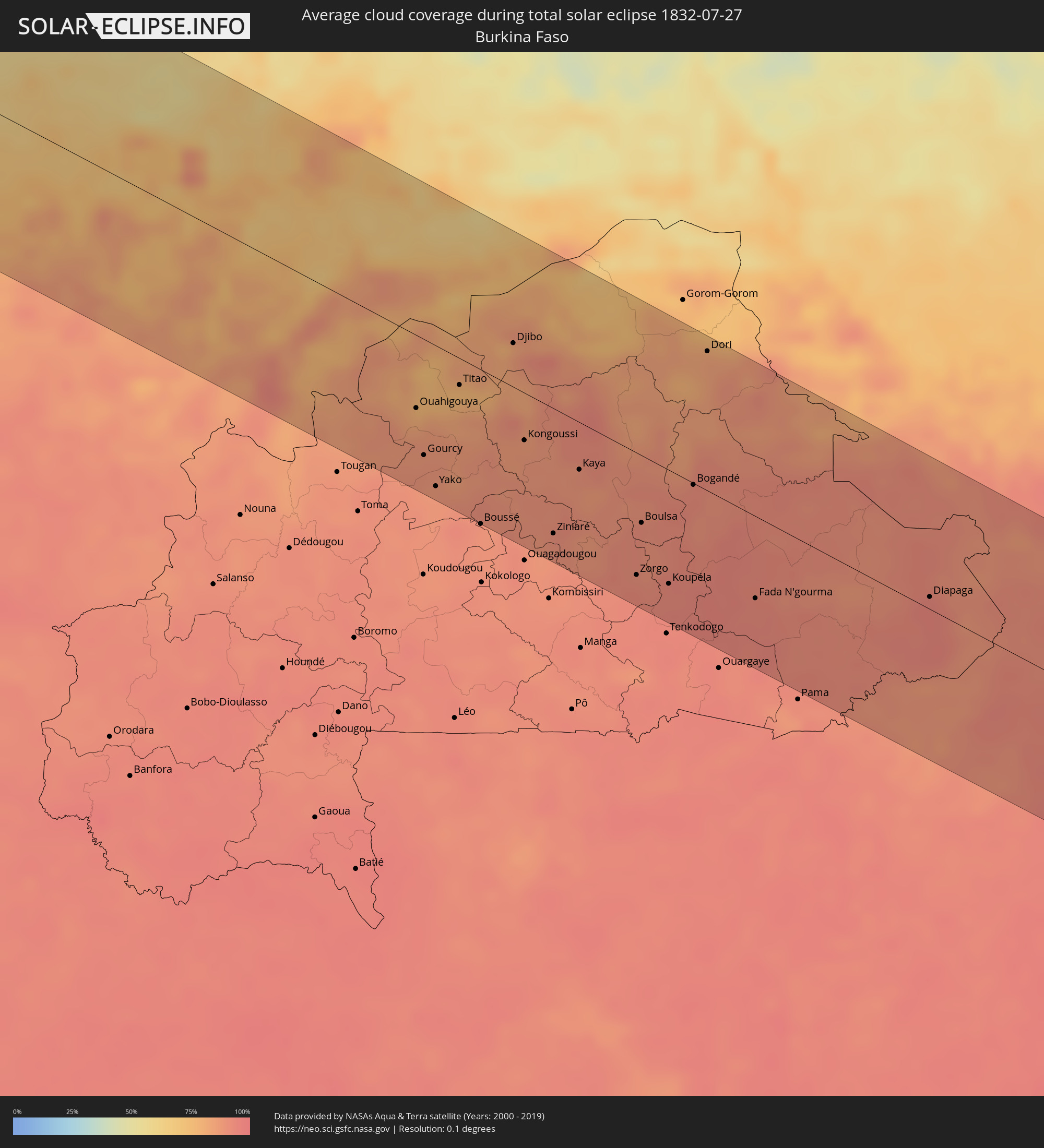 Burkina Faso
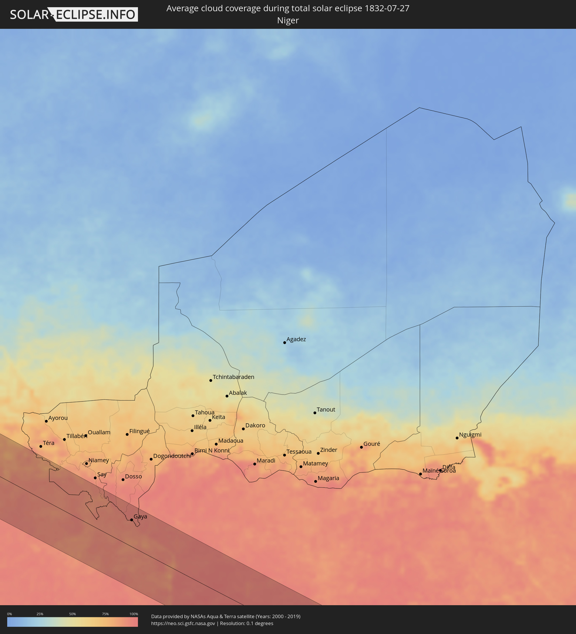 Niger
Niger
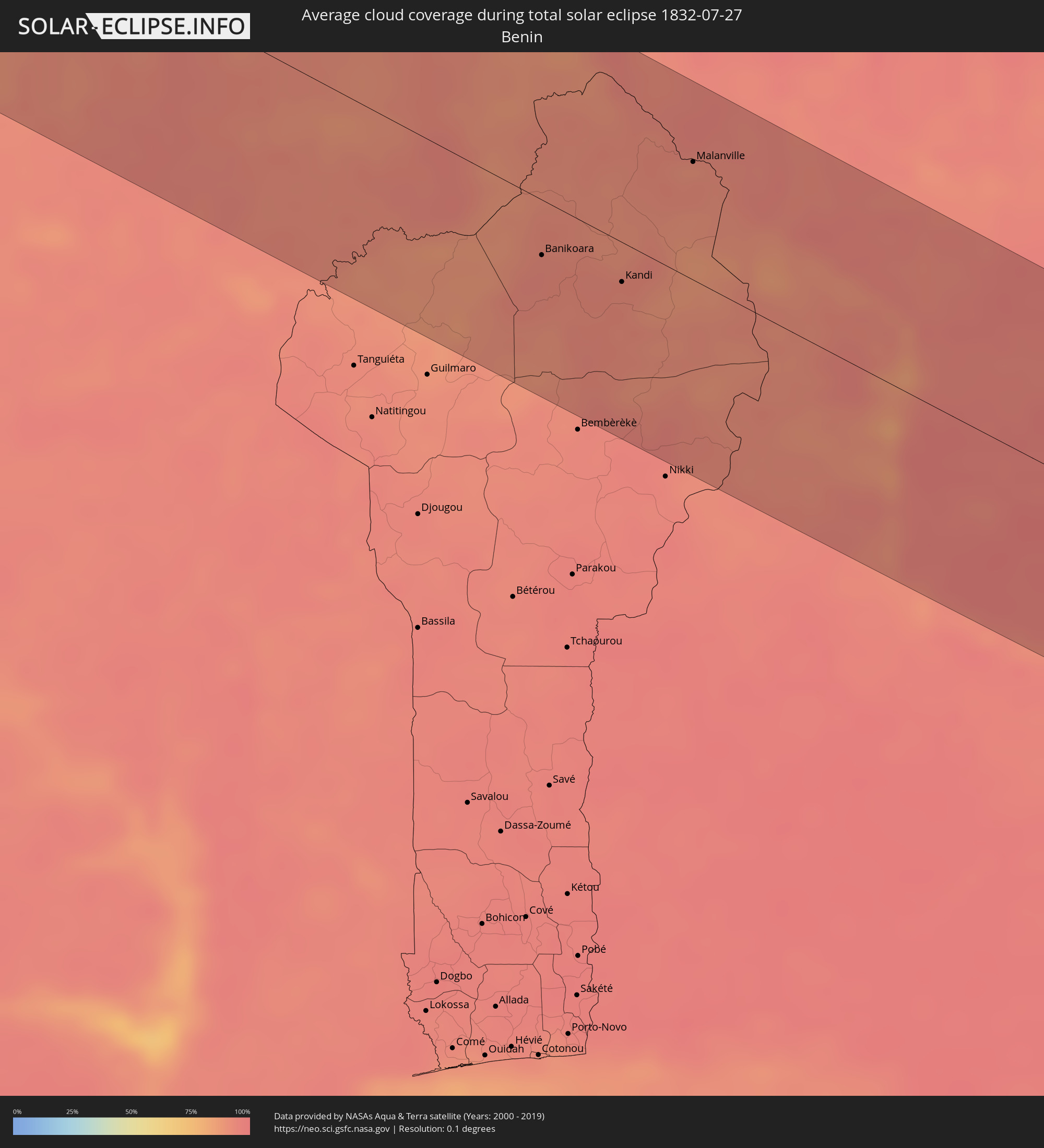 Benin
Benin
 Nigeria
 Cameroon
 Republic of the Congo
 Democratic Republic of the Congo
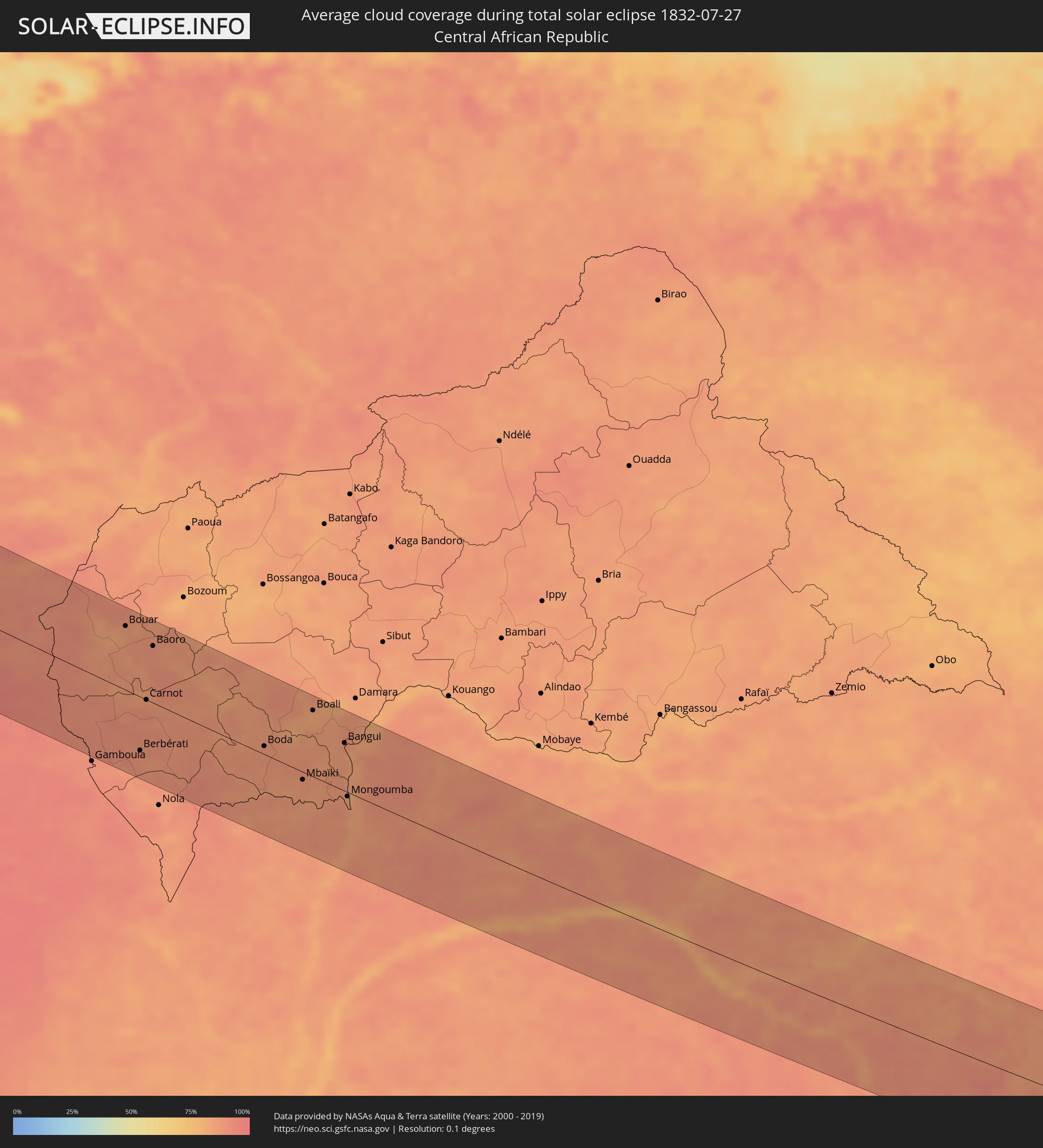 Central African Republic
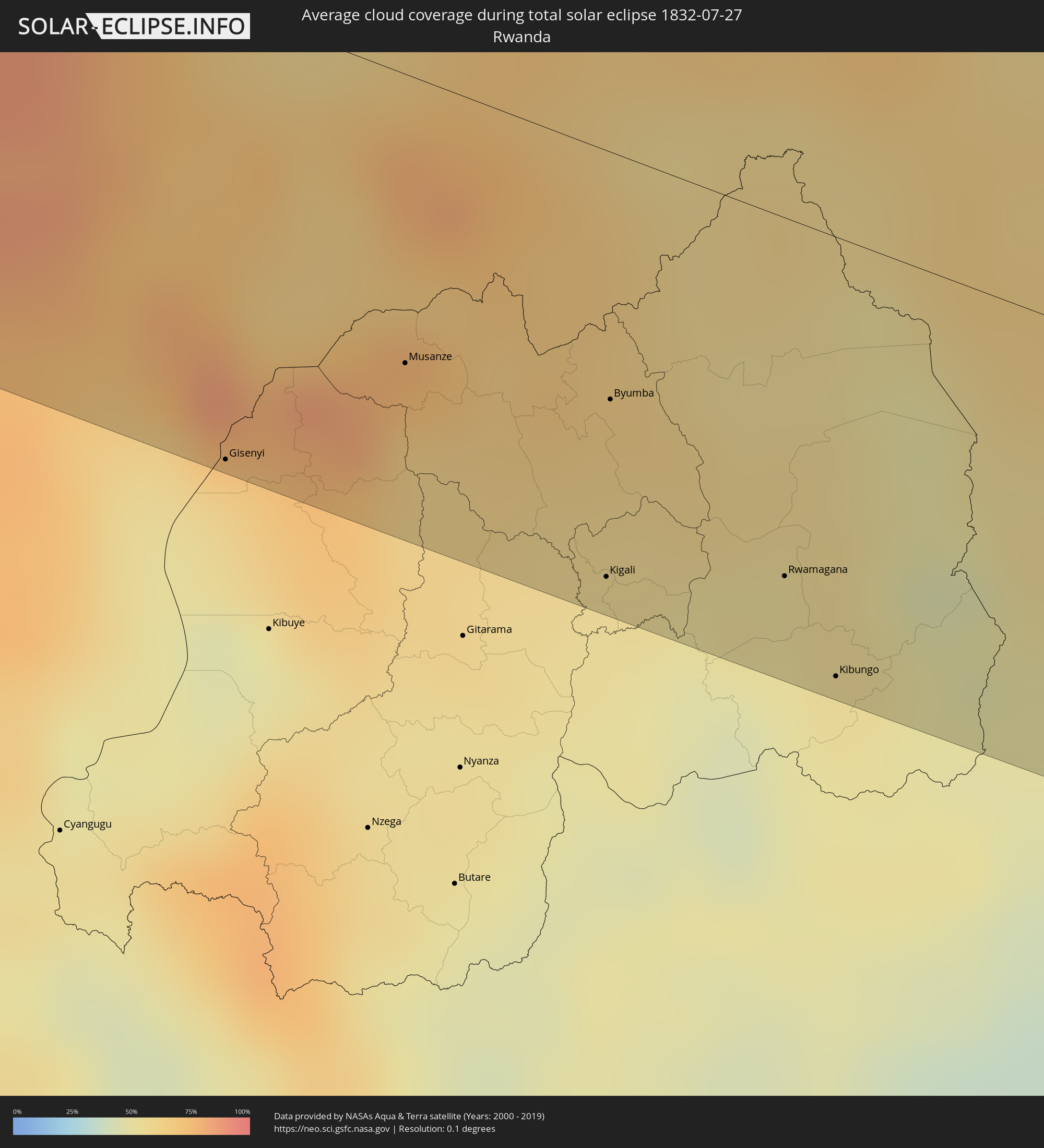 Rwanda
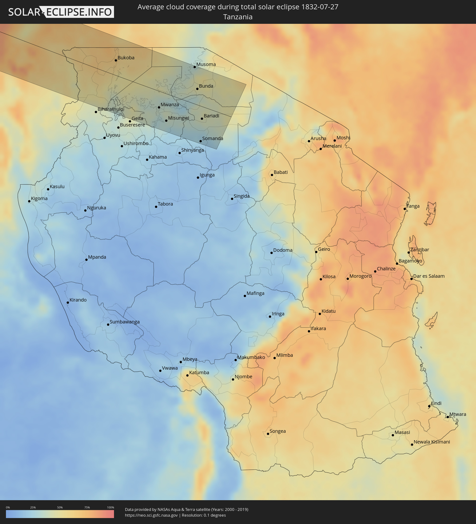 Tanzania
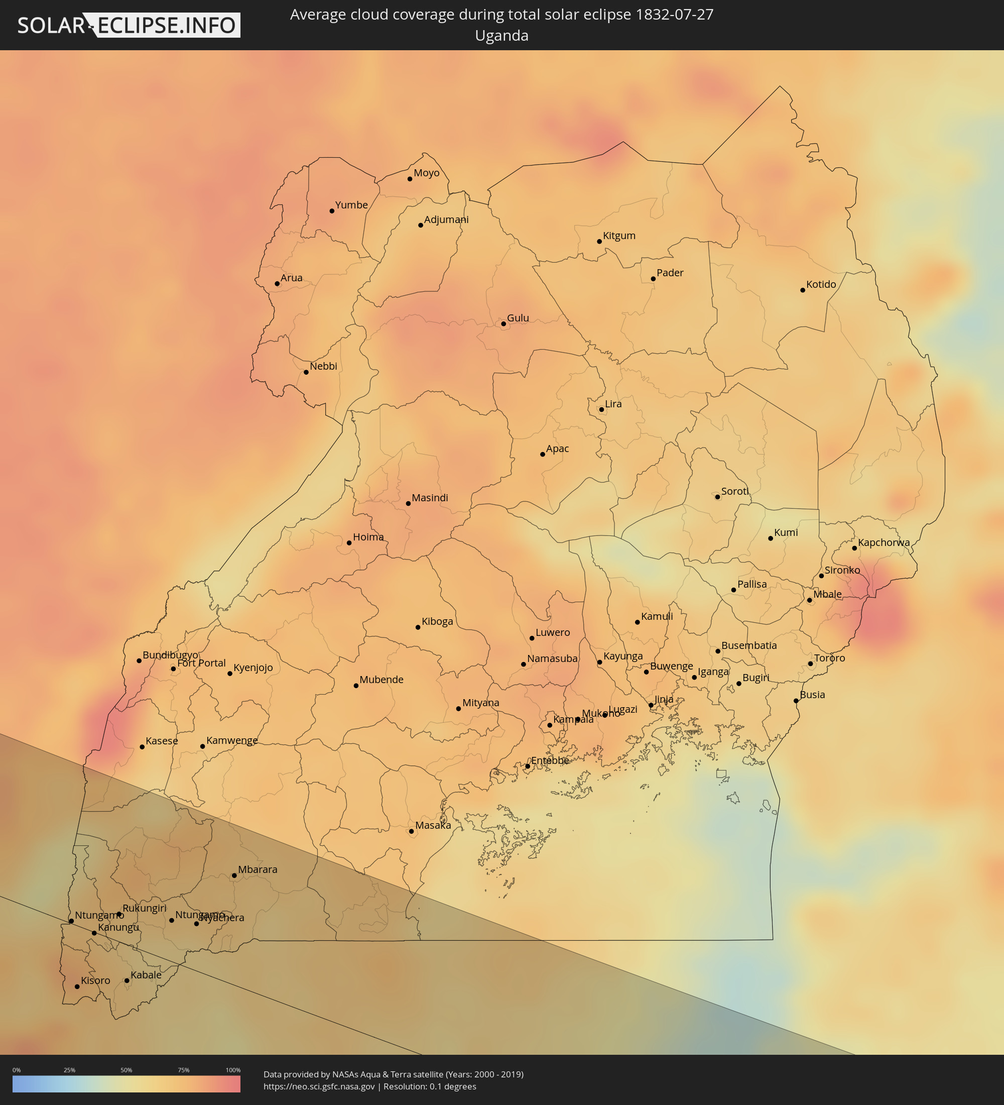 Uganda
Cities inside the path of the eclipse
The following table shows all locations with a population of more than 5,000 inside the eclipse path. Cities which have more than 100,000 inhabitants are marked bold. A click at the locations opens a detailed map.
| City | Type | Eclipse duration | Local time of max. eclipse | Distance to central line | Ø Cloud coverage |
|
Escuintla, Chiapas
|
total | - | 05:42:47 UTC-06:36 | 92 km | 65% |
|
Villa Comaltitlán, Chiapas
|
total | - | 05:42:44 UTC-06:36 | 78 km | 65% |
|
Huixtla, Chiapas
|
total | - | 05:42:42 UTC-06:36 | 66 km | 66% |
|
Puerto Madero, Chiapas
|
total | - | 05:42:30 UTC-06:36 | 21 km | 55% |
|
Huehuetán, Chiapas
|
total | - | 05:42:38 UTC-06:36 | 51 km | 68% |
|
Vida Mejor I, Chiapas
|
total | - | 05:42:34 UTC-06:36 | 32 km | 72% |
|
Tapachula, Chiapas
|
total | - | 05:42:35 UTC-06:36 | 34 km | 72% |
|
Motozintla, Chiapas
|
total | - | 05:42:49 UTC-06:36 | 82 km | 58% |
|
Brisas Barra de Suchiate, Chiapas
|
total | - | 06:16:57 UTC-06:02 | 6 km | 53% |
|
Tuxtla Chico, Chiapas
|
total | - | 05:42:36 UTC-06:36 | 34 km | 67% |
|
Quetzaltenango, Quetzaltenango
|
total | - | 06:17:07 UTC-06:02 | 0 km | 79% |
|
Huehuetenango, Huehuetenango
|
total | - | 06:17:21 UTC-06:02 | 49 km | 54% |
|
Totonicapán, Totonicapán
|
total | - | 06:17:10 UTC-06:02 | 2 km | 65% |
|
Chichicastenango, Quiché
|
total | - | 06:17:11 UTC-06:02 | 5 km | 71% |
|
Santa Lucía Cotzumalguapa, Escuintla
|
total | - | 06:16:55 UTC-06:02 | 71 km | 69% |
|
Chimaltenango, Chimaltenango
|
total | - | 06:17:05 UTC-06:02 | 44 km | 64% |
|
Escuintla, Escuintla
|
total | - | 06:16:55 UTC-06:02 | 83 km | 68% |
|
San Juan Sacatepéquez, Guatemala
|
total | - | 06:17:07 UTC-06:02 | 44 km | 69% |
|
Petapa, Guatemala
|
total | - | 06:17:02 UTC-06:02 | 70 km | 66% |
|
Guatemala City, Guatemala
|
total | - | 06:17:06 UTC-06:02 | 57 km | 66% |
|
Punta Gorda, Toledo
|
total | - | 06:27:17 UTC-05:52 | 33 km | 71% |
|
La Entrada, Copán
|
total | - | 06:30:42 UTC-05:48 | 79 km | 80% |
|
Dangriga, Stann Creek
|
total | - | 06:27:50 UTC-05:52 | 104 km | 70% |
|
Cofradía, Cortés
|
total | - | 06:30:58 UTC-05:48 | 64 km | 69% |
|
San Pedro Sula, Cortés
|
total | - | 06:31:02 UTC-05:48 | 57 km | 82% |
|
Villanueva, Cortés
|
total | - | 06:30:57 UTC-05:48 | 78 km | 71% |
|
Puerto Cortez, Cortés
|
total | - | 06:31:13 UTC-05:48 | 27 km | 74% |
|
El Progreso, Yoro
|
total | - | 06:31:01 UTC-05:48 | 76 km | 80% |
|
Morazán, Yoro
|
total | - | 06:31:01 UTC-05:48 | 92 km | 77% |
|
Tela, Atlántida
|
total | - | 06:31:16 UTC-05:48 | 49 km | 63% |
|
La Ceiba, Atlántida
|
total | - | 06:31:24 UTC-05:48 | 76 km | 68% |
|
Trujillo, Colón
|
total | - | 06:31:41 UTC-05:48 | 89 km | 72% |
|
George Town, George Town
|
total | - | 07:04:26 UTC-05:19 | 103 km | 70% |
|
Bodden Town, Bodden Town
|
total | - | 07:04:29 UTC-05:19 | 98 km | 65% |
|
North Side, North Side
|
total | - | 07:04:33 UTC-05:19 | 104 km | 65% |
|
East End, East End
|
total | - | 07:04:34 UTC-05:19 | 96 km | 63% |
|
Little Cayman, Sister Island
|
total | - | 07:05:15 UTC-05:19 | 99 km | 64% |
|
Lucea, Hanover
|
total | - | 07:17:57 UTC-05:07 | 95 km | 60% |
|
Montego Bay, St. James
|
total | - | 07:18:06 UTC-05:07 | 101 km | 61% |
|
Falmouth, Trelawny
|
total | - | 07:18:16 UTC-05:07 | 108 km | 57% |
|
Manzanillo, Granma
|
total | - | 06:57:20 UTC-05:29 | 70 km | 43% |
|
Bayamo, Granma
|
total | - | 06:57:40 UTC-05:29 | 57 km | 48% |
|
Holguín, Holguín
|
total | - | 06:58:15 UTC-05:29 | 99 km | 62% |
|
Contramaestre, Santiago de Cuba
|
total | - | 06:57:52 UTC-05:29 | 36 km | 50% |
|
Palma Soriano, Santiago de Cuba
|
total | - | 06:57:58 UTC-05:29 | 18 km | 56% |
|
San Luis, Santiago de Cuba
|
total | - | 06:58:03 UTC-05:29 | 11 km | 59% |
|
Santiago de Cuba, Santiago de Cuba
|
total | - | 06:57:58 UTC-05:29 | 7 km | 56% |
|
Banes, Holguín
|
total | - | 06:58:40 UTC-05:29 | 89 km | 51% |
|
Guantánamo, Guantánamo
|
total | - | 06:58:28 UTC-05:29 | 14 km | 61% |
|
Moa, Holguín
|
total | - | 06:58:59 UTC-05:29 | 32 km | 52% |
|
Matthew Town, Inagua
|
total | - | 07:20:14 UTC-05:09 | 21 km | 51% |
|
Jean-Rabel, Nord-Ouest
|
total | - | 07:40:23 UTC-04:49 | 110 km | 49% |
|
Port-de-Paix, Nord-Ouest
|
total | - | 07:40:44 UTC-04:49 | 112 km | 46% |
|
Cockburn Town
|
total | - | 07:25:02 UTC-05:07 | 3 km | 61% |
|
Nouâdhibou, Dakhlet Nouadhibou
|
total | - | 14:15:53 UTC-00:16 | 14 km | 66% |
|
Akjoujt, Inchiri
|
total | - | 14:23:20 UTC-00:16 | 22 km | 15% |
|
Atar, Adrar
|
total | - | 14:25:16 UTC-00:16 | 115 km | 15% |
|
Tidjikja, Tagant
|
total | - | 14:31:06 UTC-00:16 | 8 km | 20% |
|
Aioun, Hodh El Gharbi
|
total | - | 14:37:06 UTC-00:16 | 111 km | 53% |
|
Néma, Hodh ech Chargui
|
total | - | 14:41:33 UTC-00:16 | 1 km | 54% |
|
Ténenkou, Mopti
|
total | - | 14:48:15 UTC-00:16 | 97 km | 82% |
|
Mopti, Mopti
|
total | - | 14:49:25 UTC-00:16 | 58 km | 82% |
|
Niafunké, Tombouctou
|
total | - | 14:47:55 UTC-00:16 | 94 km | 67% |
|
Bandiagara, Mopti
|
total | - | 14:50:29 UTC-00:16 | 42 km | 77% |
|
Douentza, Mopti
|
total | - | 14:50:42 UTC-00:16 | 56 km | 76% |
|
Ouahigouya, Nord
|
total | - | 14:53:13 UTC-00:16 | 57 km | 79% |
|
Yako, Nord
|
total | - | 14:54:12 UTC-00:16 | 110 km | 87% |
|
Djibo, Sahel
|
total | - | 14:53:46 UTC-00:16 | 34 km | 86% |
|
Kongoussi, Centre-Nord
|
total | - | 14:54:49 UTC-00:16 | 37 km | 87% |
|
Kaya, Centre-Nord
|
total | - | 14:55:44 UTC-00:16 | 37 km | 89% |
|
Zorgo, Plateau-Central
|
total | - | 14:57:23 UTC-00:16 | 96 km | 93% |
|
Koupéla, Centre-Est
|
total | - | 14:57:49 UTC-00:16 | 89 km | 93% |
|
Dori, Sahel
|
total | - | 14:56:04 UTC-00:16 | 109 km | 84% |
|
Fada N'gourma, Est
|
total | - | 14:58:54 UTC-00:16 | 65 km | 93% |
|
Diapaga, Est
|
total | - | 15:00:43 UTC-00:16 | 10 km | 94% |
|
Banikoara, Alibori
|
total | - | 15:32:06 UTC+00:13 | 33 km | 94% |
|
Kandi, Alibori
|
total | - | 15:32:52 UTC+00:13 | 24 km | 93% |
|
Malanville, Atakora
|
total | - | 15:32:35 UTC+00:13 | 71 km | 92% |
|
Gaya, Dosso
|
total | - | 15:32:38 UTC+00:13 | 76 km | 92% |
|
Kontagora, Niger
|
total | - | 15:36:27 UTC+00:13 | 33 km | 96% |
|
Bida, Niger
|
total | - | 15:38:22 UTC+00:13 | 70 km | 98% |
|
Minna, Niger
|
total | - | 15:38:21 UTC+00:13 | 10 km | 97% |
|
Suleja, Niger
|
total | - | 15:39:24 UTC+00:13 | 2 km | 97% |
|
Kuje, Abuja Federal Capital Territory
|
total | - | 15:39:44 UTC+00:13 | 29 km | 97% |
|
Abuja, Abuja Federal Capital Territory
|
total | - | 15:39:49 UTC+00:13 | 2 km | 97% |
|
Keffi, Nassarawa
|
total | - | 15:40:22 UTC+00:13 | 0 km | 97% |
|
Lafia, Nassarawa
|
total | - | 15:41:17 UTC+00:13 | 3 km | 97% |
|
Makurdi, Benue
|
total | - | 15:42:00 UTC+00:13 | 78 km | 97% |
|
Wukari, Taraba
|
total | - | 15:42:55 UTC+00:13 | 2 km | 96% |
|
Bankim, Adamaoua
|
total | - | 15:45:50 UTC+00:13 | 96 km | 86% |
|
Banyo, Adamaoua
|
total | - | 15:45:29 UTC+00:13 | 13 km | 89% |
|
Yoko, Centre
|
total | - | 15:46:52 UTC+00:13 | 111 km | 94% |
|
Tibati, Adamaoua
|
total | - | 15:46:17 UTC+00:13 | 2 km | 87% |
|
Bétaré Oya, East
|
total | - | 15:47:56 UTC+00:13 | 19 km | 88% |
|
Meïganga, Adamaoua
|
total | - | 15:47:18 UTC+00:13 | 83 km | 88% |
|
Garoua Boulaï, East
|
total | - | 15:47:58 UTC+00:13 | 32 km | 90% |
|
Bouar, Nana-Mambéré
|
total | - | 15:48:31 UTC+00:13 | 86 km | 86% |
|
Berbérati, Mambéré-Kadéï
|
total | - | 15:49:56 UTC+00:13 | 73 km | 88% |
|
Carnot, Mambéré-Kadéï
|
total | - | 15:49:27 UTC+00:13 | 0 km | 88% |
|
Baoro, Nana-Mambéré
|
total | - | 15:48:56 UTC+00:13 | 77 km | 86% |
|
Boda, Lobaye
|
total | - | 15:50:42 UTC+00:13 | 11 km | 87% |
|
Mbaïki, Lobaye
|
total | - | 15:51:16 UTC+00:13 | 11 km | 87% |
|
Boali, Ombella-M'Poko
|
total | - | 15:50:38 UTC+00:13 | 90 km | 80% |
|
Bimbo, Ombella-M'Poko
|
total | - | 15:51:10 UTC+00:13 | 48 km | 85% |
|
Bangui, Bangui
|
total | - | 15:51:08 UTC+00:13 | 65 km | 84% |
|
Mongoumba, Lobaye
|
total | - | 15:51:41 UTC+00:13 | 6 km | 81% |
|
Libenge, Équateur
|
total | - | 15:51:41 UTC+00:13 | 3 km | 80% |
|
Gemena, Équateur
|
total | - | 15:52:24 UTC+00:13 | 8 km | 91% |
|
Businga, Équateur
|
total | - | 15:52:43 UTC+00:13 | 67 km | 90% |
|
Lisala, Équateur
|
total | - | 15:53:41 UTC+00:13 | 26 km | 81% |
|
Bumba, Équateur
|
total | - | 15:53:56 UTC+00:13 | 19 km | 79% |
|
Basoko, Orientale
|
total | - | 17:51:31 UTC+02:10 | 29 km | 78% |
|
Yangambi, Orientale
|
total | - | 17:51:57 UTC+02:10 | 42 km | 83% |
|
Kisangani, Orientale
|
total | - | 17:52:13 UTC+02:10 | 36 km | 88% |
|
Goma, Nord Kivu
|
total | - | 17:53:40 UTC+02:10 | 98 km | 55% |
|
Gisenyi, Western Province
|
total | - | 17:53:41 UTC+02:10 | 100 km | 63% |
|
Butembo, Nord Kivu
|
total | - | 17:52:48 UTC+02:10 | 94 km | 80% |
|
Musanze, Northern Province
|
total | - | 17:53:36 UTC+02:10 | 63 km | 66% |
|
Ntungamo, Western Region
|
total | - | 18:10:14 UTC+02:27 | 1 km | 76% |
|
Kisoro, Western Region
|
total | - | 18:10:26 UTC+02:27 | 39 km | 71% |
|
Kanungu, Western Region
|
total | - | 18:10:17 UTC+02:27 | 1 km | 74% |
|
Rukungiri, Western Region
|
total | - | 18:10:13 UTC+02:27 | 17 km | 65% |
|
Kabale, Western Region
|
total | - | 18:10:25 UTC+02:27 | 23 km | 66% |
|
Kigali, Kigali
|
total | - | 17:53:48 UTC+02:10 | 94 km | 53% |
|
Byumba, Northern Province
|
total | - | 17:53:38 UTC+02:10 | 54 km | 60% |
|
Ntungamo, Western Region
|
total | - | 18:10:14 UTC+02:27 | 26 km | 58% |
|
Nyachera, Western Region
|
total | - | 18:10:15 UTC+02:27 | 30 km | 58% |
|
Rwamagana, Eastern Province
|
total | - | 17:53:47 UTC+02:10 | 79 km | 53% |
|
Kibungo, Eastern Province
|
total | - | 17:53:53 UTC+02:10 | 97 km | 50% |
|
Bwizibwera, Western Region
|
total | - | 18:10:06 UTC+02:27 | 70 km | 69% |
|
Mbarara, Western Region
|
total | - | 18:10:06 UTC+02:27 | 70 km | 69% |
|
Byakabanda, Central Region
|
total | - | 18:10:09 UTC+02:27 | 85 km | 68% |
|
Chato, Geita
|
total | - | 18:10:58 UTC+02:27 | 99 km | 31% |
|
Bukoba, Kagera
|
total | - | 18:10:24 UTC+02:27 | 39 km | 60% |
|
Kasamwa, Geita
|
total | - | 18:11:00 UTC+02:27 | 96 km | 33% |
|
Mwanza, Mwanza
|
total | - | 18:10:50 UTC+02:27 | 44 km | 35% |
|
Misungwi, Mwanza
|
total | - | 18:10:57 UTC+02:27 | 72 km | 27% |
|
Musoma, Mara
|
total | - | 18:10:19 UTC+02:27 | 97 km | 39% |
|
Bunda, Mara
|
total | - | 18:10:33 UTC+02:27 | 42 km | 37% |
|
Somanda, Simiyu
|
total | - | 18:11:03 UTC+02:27 | 93 km | 18% |
|
Bariadi, Simiyu
|
total | - | 18:10:50 UTC+02:27 | 33 km | 39% |
|
Kisesa, Simiyu
|
total | - | 18:10:55 UTC+02:27 | 56 km | 31% |