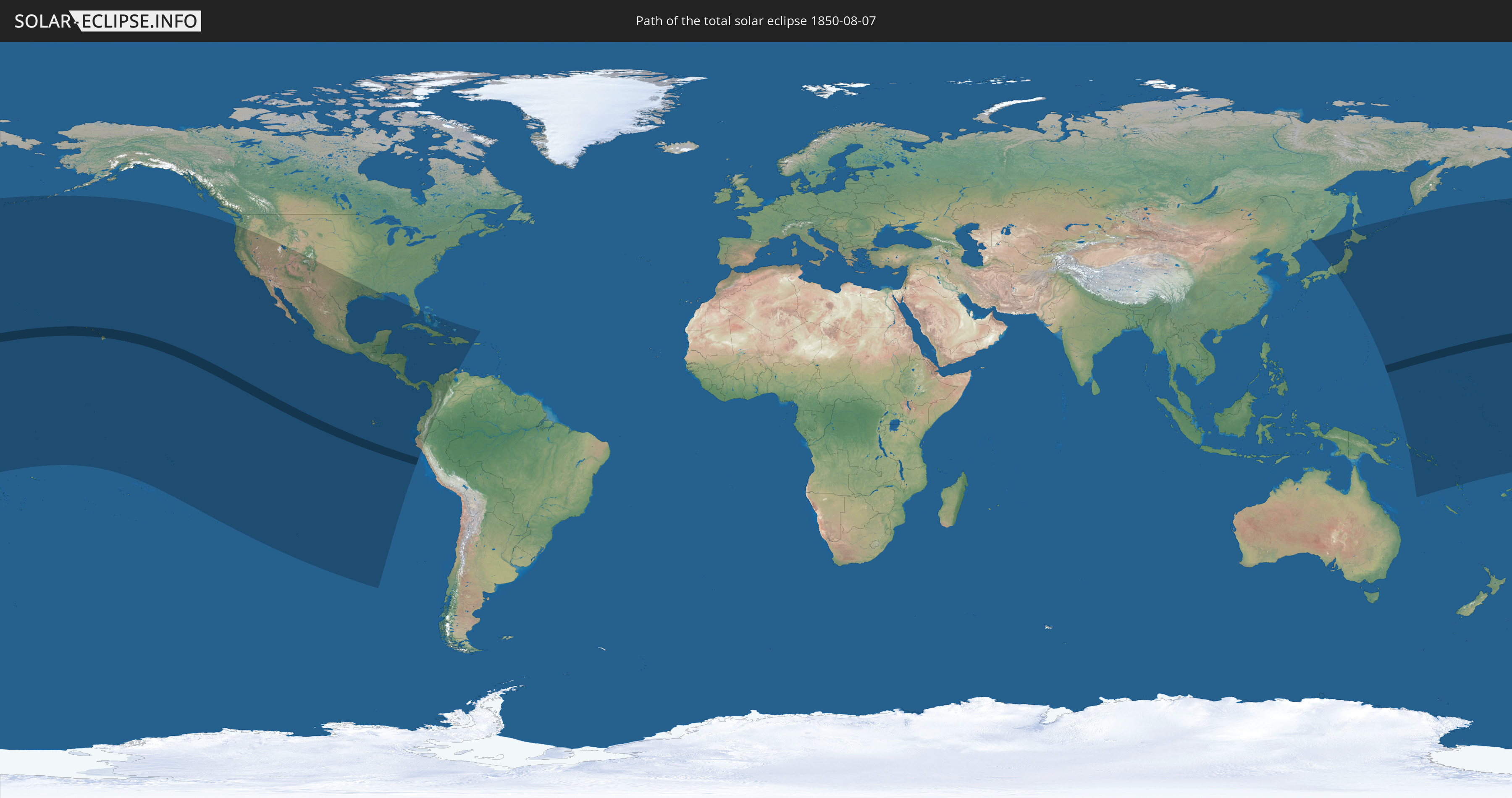
Total solar eclipse of 08/07/1850
| Day of week: | Wednesday |
| Maximum duration of eclipse: | 06m50s |
| Maximum width of eclipse path: | 249 km |
| Saros cycle: | 133 |
| Coverage: | 100% |
| Magnitude: | 1.0769 |
| Gamma: | 0.0215 |
Wo kann man die Sonnenfinsternis vom 08/07/1850 sehen?
Die Sonnenfinsternis am 08/07/1850 kann man in 38 Ländern als partielle Sonnenfinsternis beobachten.
Der Finsternispfad verläuft durch ein Land. Nur in diesem Land ist sie als total Sonnenfinsternis zu sehen.
In den folgenden Ländern ist die Sonnenfinsternis total zu sehen
 United States
In den folgenden Ländern ist die Sonnenfinsternis partiell zu sehen
 Russia
 Fiji
Fiji
 United States
 United States Minor Outlying Islands
 Kiribati
 Tokelau
 Cook Islands
 French Polynesia
 Pitcairn Islands
 Mexico
 Chile
Chile
 Guatemala
 Ecuador
 El Salvador
 Honduras
 Belize
 Nicaragua
 Costa Rica
 Cuba
Cuba
 Panama
 Colombia
 Cayman Islands
 Peru
Peru
 The Bahamas
 Jamaica
 Haiti
Haiti
 Venezuela
 Turks and Caicos Islands
 Dominican Republic
 Puerto Rico
 Japan
Japan
 Federated States of Micronesia
 Papua New Guinea
 Solomon Islands
 Marshall Islands
 Vanuatu
 Nauru
Nauru
 Tuvalu
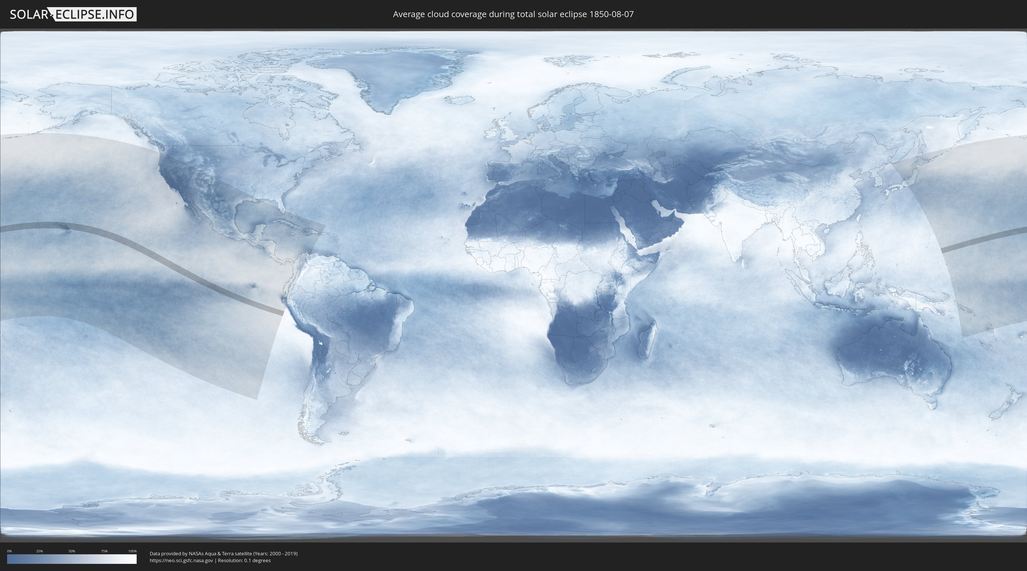
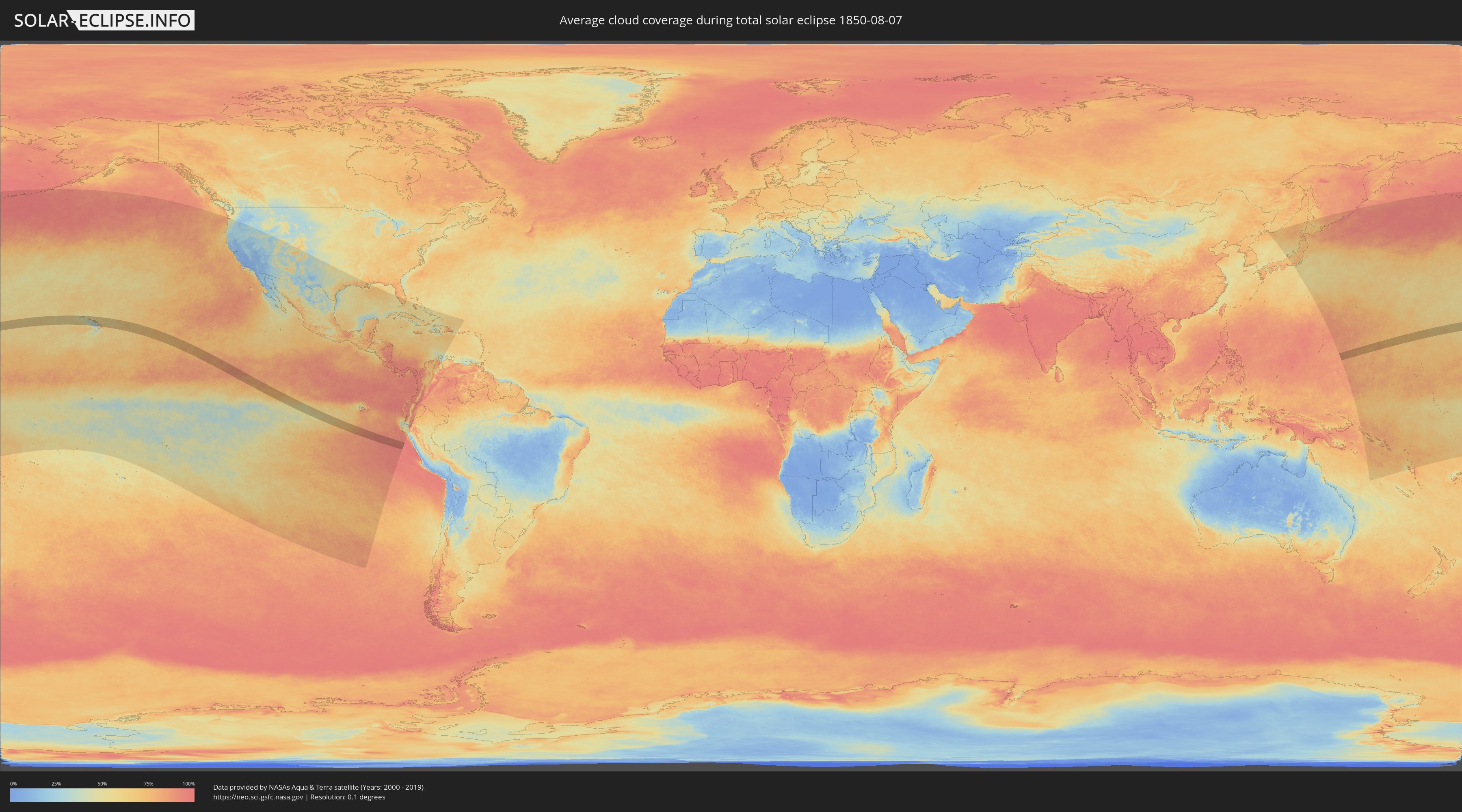
How will be the weather during the total solar eclipse on 08/07/1850?
Where is the best place to see the total solar eclipse of 08/07/1850?
The following maps show the average cloud coverage for the day of the total solar eclipse.
With the help of these maps, it is possible to find the place along the eclipse path, which has the best
chance of a cloudless sky.
Nevertheless, you should consider local circumstances and inform about the weather of your chosen
observation site.
The data is provided by NASAs satellites
AQUA and TERRA.
The cloud maps are averaged over a period of 19 years (2000 - 2019).
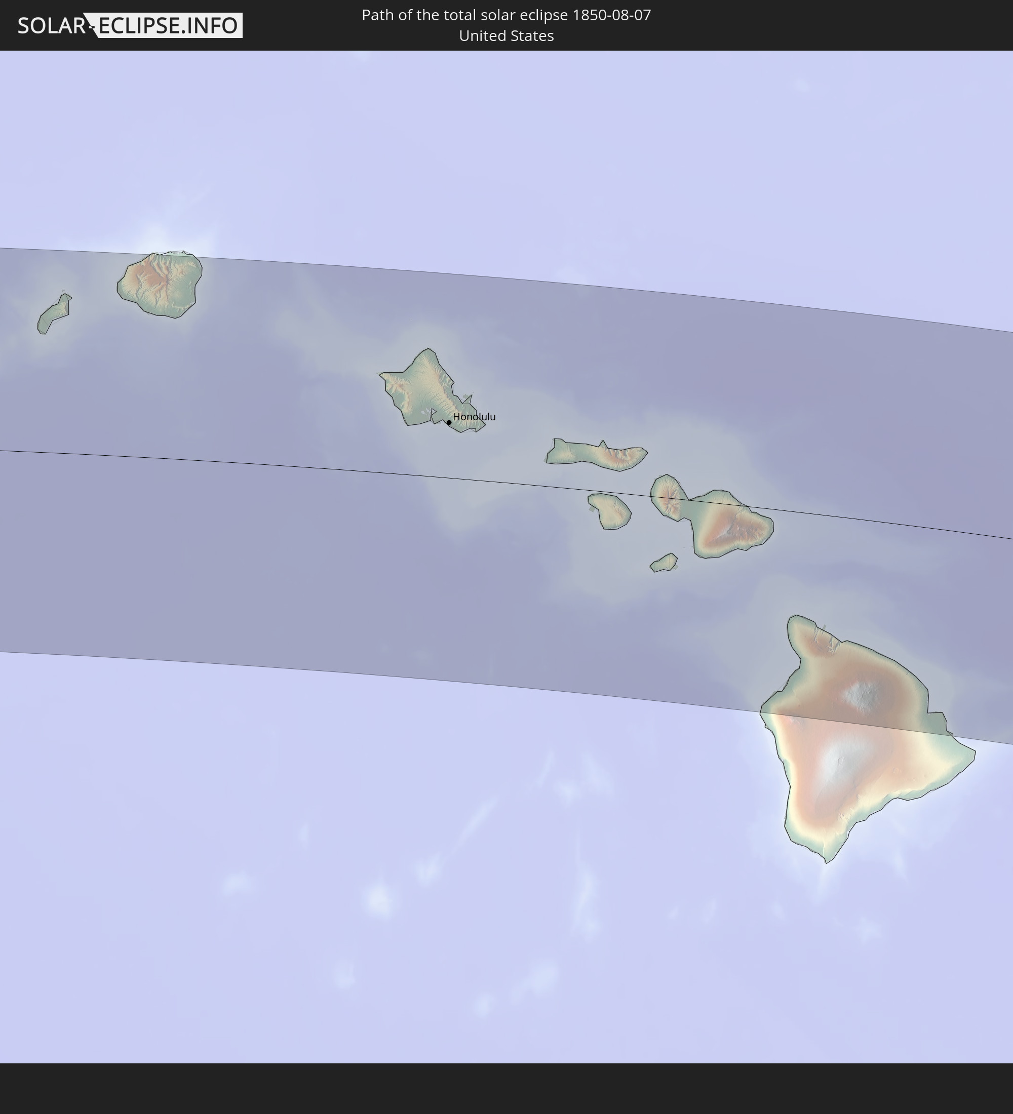
Detailed country maps
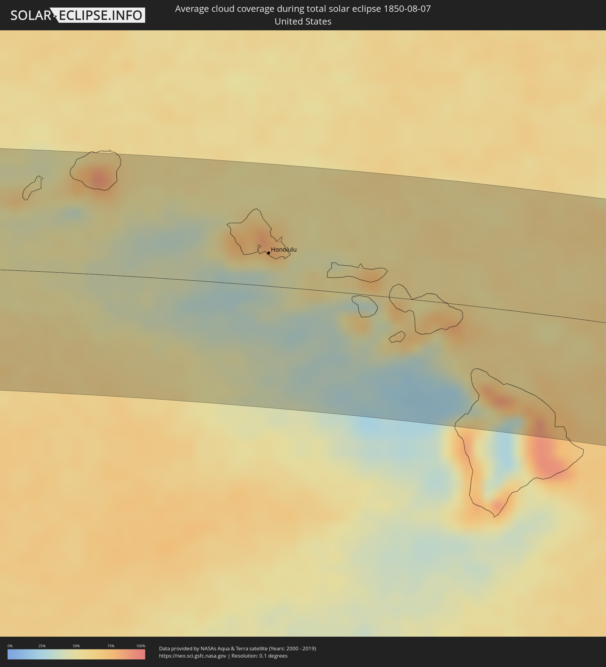 United States
Cities inside the path of the eclipse
The following table shows all locations with a population of more than 5,000 inside the eclipse path. Cities which have more than 100,000 inhabitants are marked bold. A click at the locations opens a detailed map.
| City | Type | Eclipse duration | Local time of max. eclipse | Distance to central line | Ø Cloud coverage |
|
Wailua Homesteads, Hawaii
|
total | - | 10:15:07 UTC-10:30 | 107 km | 82% |
|
Lihue, Hawaii
|
total | - | 10:15:08 UTC-10:30 | 97 km | 75% |
|
Kapa‘a, Hawaii
|
total | - | 10:15:15 UTC-10:30 | 108 km | 65% |
|
Mākaha, Hawaii
|
total | - | 10:17:55 UTC-10:30 | 48 km | 74% |
|
Waianae, Hawaii
|
total | - | 10:17:59 UTC-10:30 | 45 km | 65% |
|
Mā‘ili, Hawaii
|
total | - | 10:18:01 UTC-10:30 | 42 km | 65% |
|
Nānākuli, Hawaii
|
total | - | 10:18:04 UTC-10:30 | 40 km | 65% |
|
Makakilo, Hawaii
|
total | - | 10:18:14 UTC-10:30 | 36 km | 69% |
|
Makakilo City, Hawaii
|
total | - | 10:18:14 UTC-10:30 | 35 km | 52% |
|
Schofield Barracks, Hawaii
|
total | - | 10:18:16 UTC-10:30 | 52 km | 76% |
|
‘Ewa Villages, Hawaii
|
total | - | 10:18:21 UTC-10:30 | 35 km | 51% |
|
‘Ewa Gentry, Hawaii
|
total | - | 10:18:22 UTC-10:30 | 35 km | 51% |
|
Village Park, Hawaii
|
total | - | 10:18:22 UTC-10:30 | 42 km | 65% |
|
Royal Kunia, Hawaii
|
total | - | 10:18:22 UTC-10:30 | 41 km | 65% |
|
Wahiawā, Hawaii
|
total | - | 10:18:21 UTC-10:30 | 53 km | 71% |
|
Waipi‘o Acres, Hawaii
|
total | - | 10:18:23 UTC-10:30 | 49 km | 71% |
|
Waipahu, Hawaii
|
total | - | 10:18:25 UTC-10:30 | 40 km | 65% |
|
‘Ewa Beach, Hawaii
|
total | - | 10:18:26 UTC-10:30 | 33 km | 51% |
|
Mililani Town, Hawaii
|
total | - | 10:18:25 UTC-10:30 | 48 km | 71% |
|
Waipio, Hawaii
|
total | - | 10:18:26 UTC-10:30 | 44 km | 65% |
|
Pearl City, Hawaii
|
total | - | 10:18:30 UTC-10:30 | 42 km | 65% |
|
Hickam Field, Hawaii
|
total | - | 10:18:32 UTC-10:30 | 36 km | 51% |
|
Waimalu, Hawaii
|
total | - | 10:18:34 UTC-10:30 | 43 km | 69% |
|
‘Aiea, Hawaii
|
total | - | 10:18:36 UTC-10:30 | 41 km | 69% |
|
Lā‘ie, Hawaii
|
total | - | 10:18:35 UTC-10:30 | 70 km | 80% |
|
Hālawa, Hawaii
|
total | - | 10:18:38 UTC-10:30 | 40 km | 69% |
|
Hālawa Heights, Hawaii
|
total | - | 10:18:39 UTC-10:30 | 40 km | 69% |
|
Honolulu, Hawaii
|
total | - | 10:18:47 UTC-10:30 | 33 km | 51% |
|
‘Āhuimanu, Hawaii
|
total | - | 10:18:49 UTC-10:30 | 48 km | 77% |
|
Kaneohe, Hawaii
|
total | - | 10:18:55 UTC-10:30 | 44 km | 77% |
|
Marine Corps Base Hawaii - MCBH, Hawaii
|
total | - | 10:19:01 UTC-10:30 | 49 km | 69% |
|
Kailua, Hawaii
|
total | - | 10:19:03 UTC-10:30 | 44 km | 69% |
|
Waimanalo, Hawaii
|
total | - | 10:19:06 UTC-10:30 | 38 km | 57% |
|
Napili-Honokowai, Hawaii
|
total | - | 10:21:44 UTC-10:30 | 7 km | 56% |
|
Lahaina, Hawaii
|
total | - | 10:21:45 UTC-10:30 | 4 km | 49% |
|
Wailuku, Hawaii
|
total | - | 10:22:10 UTC-10:30 | 1 km | 63% |
|
Waihee-Waiehu, Hawaii
|
total | - | 10:22:10 UTC-10:30 | 4 km | 63% |
|
Kahului, Hawaii
|
total | - | 10:22:15 UTC-10:30 | 0 km | 63% |
|
Kīhei, Hawaii
|
total | - | 10:22:21 UTC-10:30 | 14 km | 63% |
|
Pukalani, Hawaii
|
total | - | 10:22:36 UTC-10:30 | 4 km | 69% |
|
Makawao, Hawaii
|
total | - | 10:22:40 UTC-10:30 | 2 km | 66% |
|
Haiku-Pauwela, Hawaii
|
total | - | 10:22:40 UTC-10:30 | 5 km | 66% |
|
Waikoloa Village, Hawaii
|
total | - | 10:24:09 UTC-10:30 | 99 km | 57% |
|
Waimea, Hawaii
|
total | - | 10:24:31 UTC-10:30 | 87 km | 48% |
|
Hilo, Hawaii
|
total | - | 10:26:07 UTC-10:30 | 112 km | 86% |