Totale Sonnenfinsternis vom 07.08.1850
| Wochentag: | Mittwoch |
| Maximale Dauer der Verfinsterung: | 06m50s |
| Maximale Breite des Finsternispfades: | 249 km |
| Saroszyklus: | 133 |
| Bedeckungsgrad: | 100% |
| Magnitude: | 1.0769 |
| Gamma: | 0.0215 |
Wo kann man die Sonnenfinsternis vom 07.08.1850 sehen?
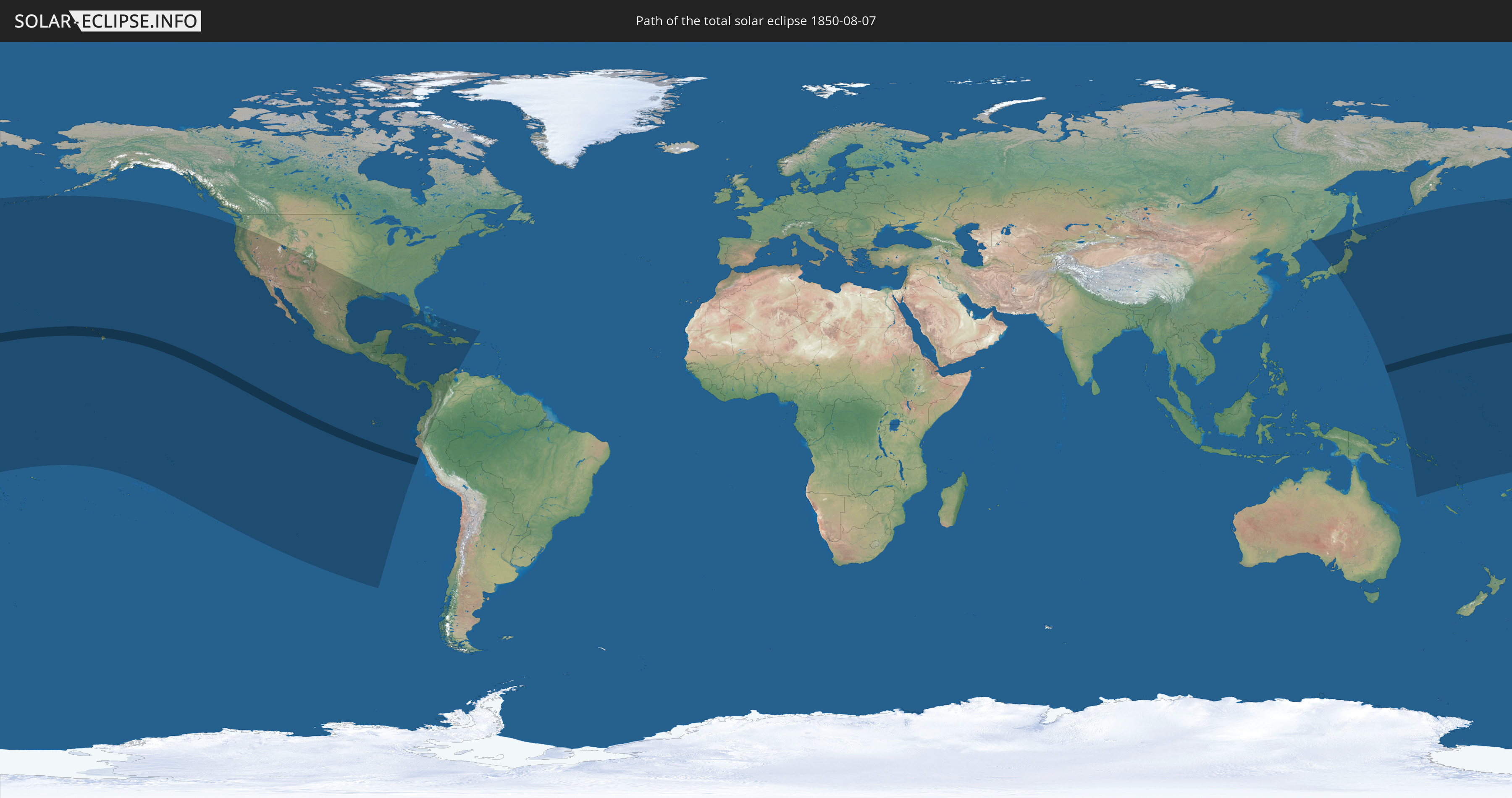
Die Sonnenfinsternis am 07.08.1850 kann man in 38 Ländern als partielle Sonnenfinsternis beobachten.
Der Finsternispfad verläuft durch ein Land. Nur in diesem Land ist sie als totale Sonnenfinsternis zu sehen.
In den folgenden Ländern ist die Sonnenfinsternis total zu sehen
 Vereinigte Staaten
In den folgenden Ländern ist die Sonnenfinsternis partiell zu sehen
 Fidschi
 Russland
 Vereinigte Staaten
 United States Minor Outlying Islands
 Kiribati
 Tokelau
 Cookinseln
 Französisch-Polynesien
 Pitcairninseln
 Mexiko
 Chile
Chile
 Guatemala
 Ecuador
 El Salvador
 Honduras
 Belize
 Nicaragua
 Costa Rica
 Kuba
Kuba
 Panama
 Kolumbien
 Kaimaninseln
 Peru
Peru
 Bahamas
 Jamaika
 Haiti
Haiti
 Venezuela
 Turks- und Caicosinseln
 Dominikanische Republik
 Puerto Rico
 Japan
Japan
 Föderierte Staaten von Mikronesien
 Papua-Neuguinea
 Salomonen
 Marshallinseln
 Vanuatu
 Nauru
Nauru
 Tuvalu
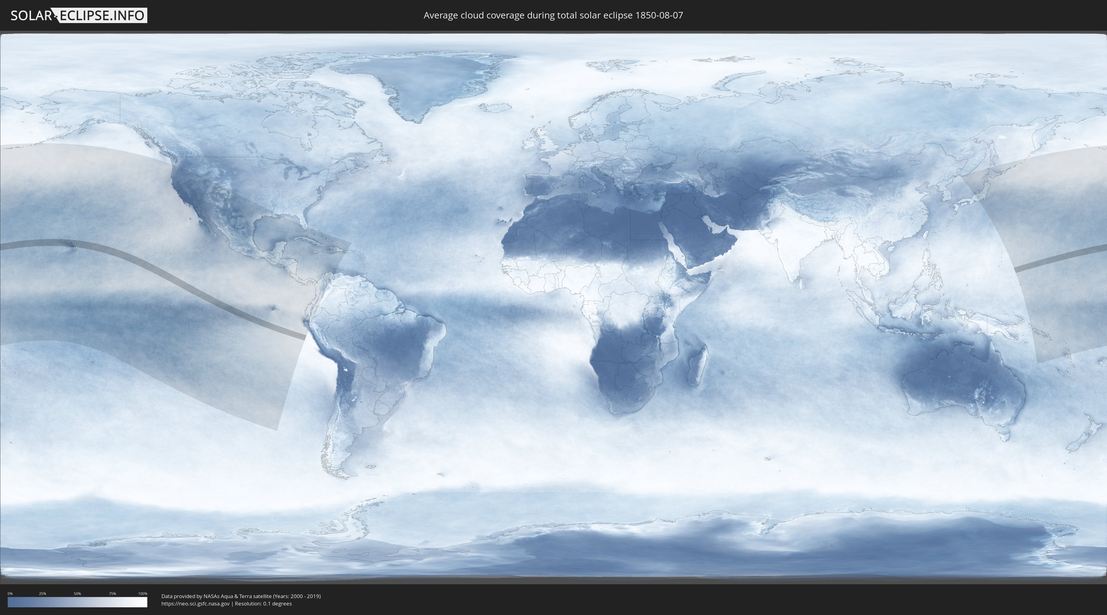
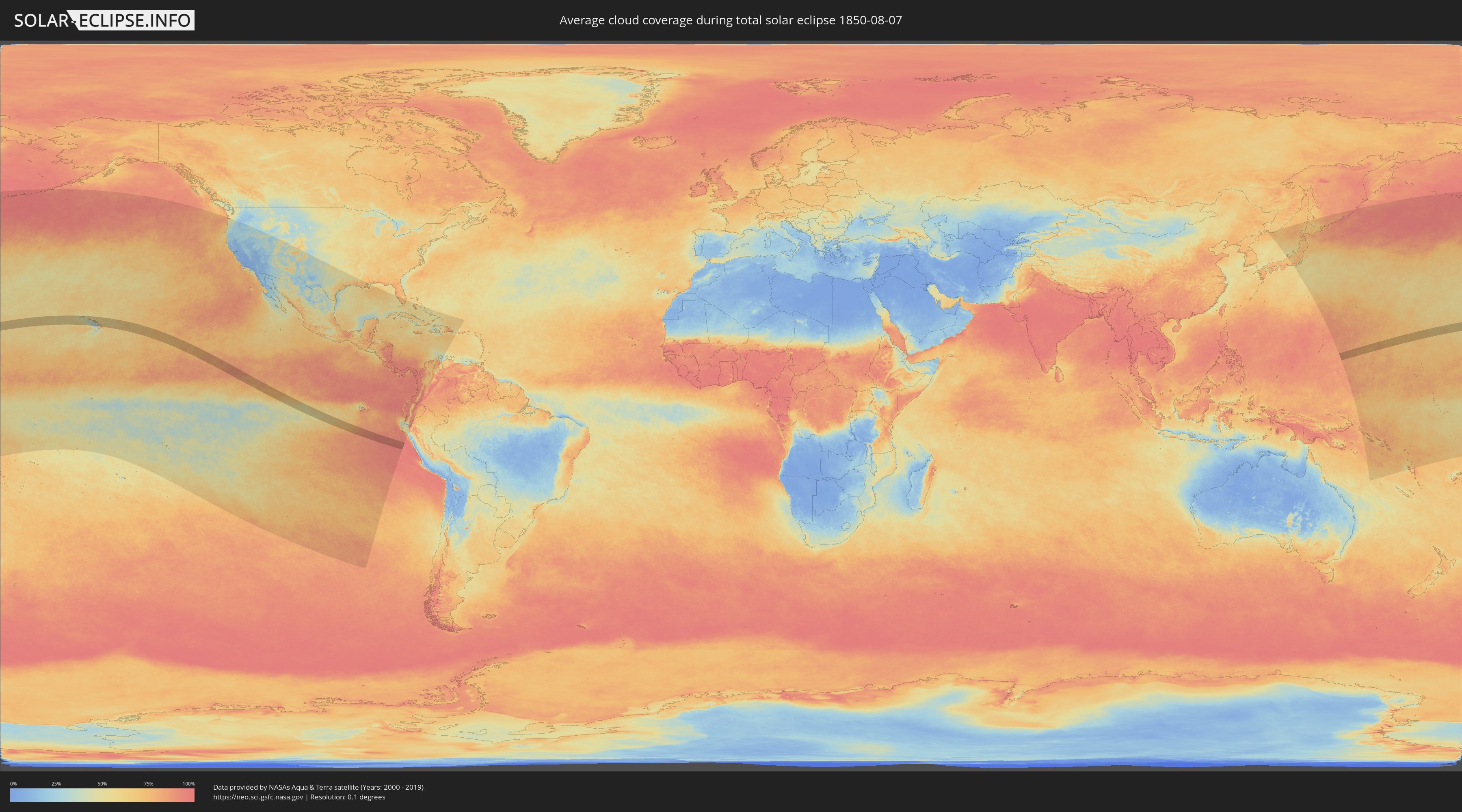
Wie wird das Wetter während der totalen Sonnenfinsternis am 07.08.1850?
Wo ist der beste Ort, um die totale Sonnenfinsternis vom 07.08.1850 zu beobachten?
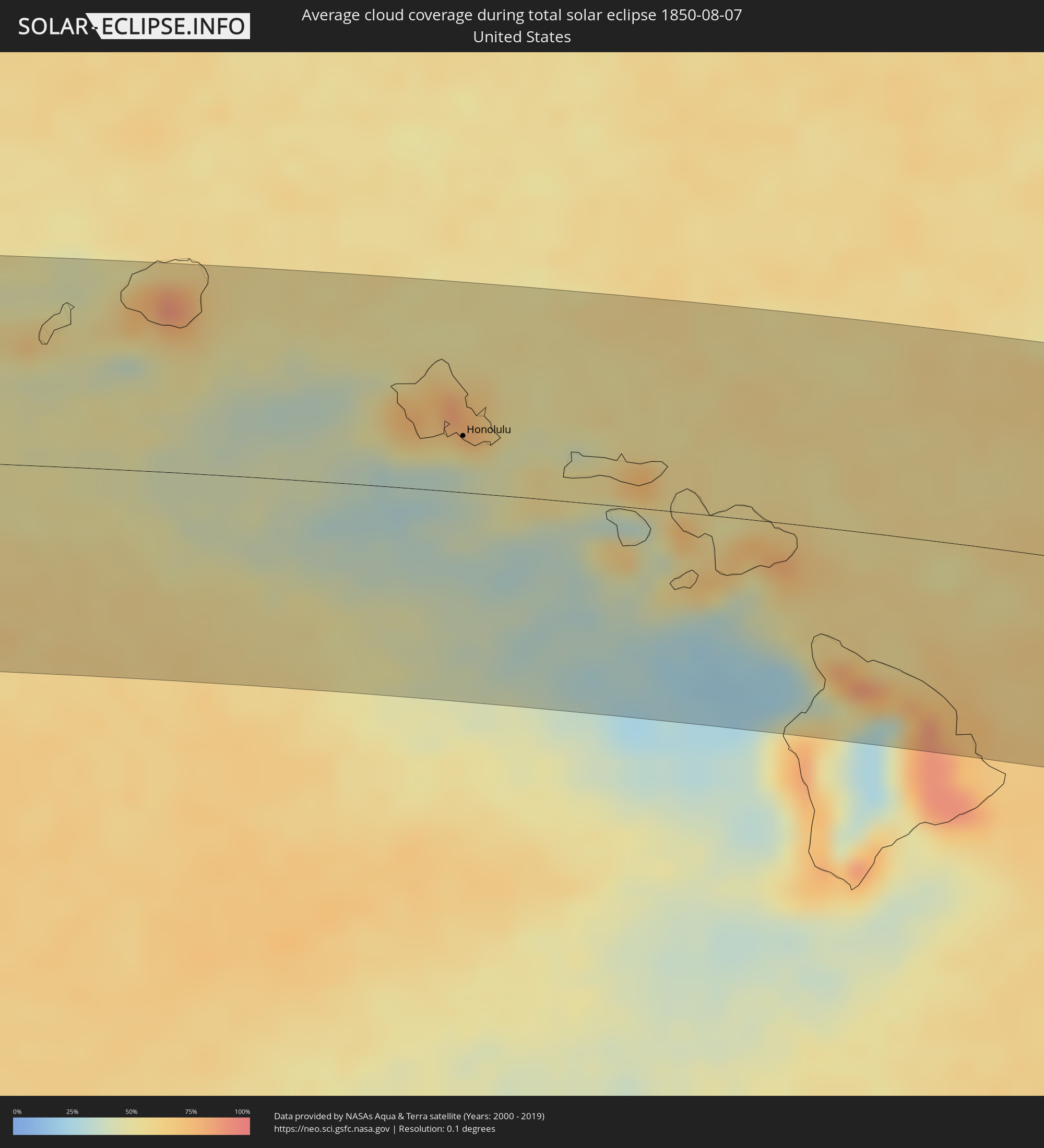
Die folgenden Karten zeigen die durchschnittliche Bewölkung für den Tag, an dem die totale Sonnenfinsternis
stattfindet. Mit Hilfe der Karten lässt sich der Ort entlang des Finsternispfades eingrenzen,
der die besten Aussichen auf einen klaren wolkenfreien Himmel bietet.
Trotzdem muss man immer lokale Gegenenheiten beachten und sollte sich genau über das Wetter an seinem
gewählten Beobachtungsort informieren.
Die Daten stammen von den beiden NASA-Satelliten
AQUA und TERRA
und wurden über einen Zeitraum von 19 Jahren (2000 - 2019) gemittelt.
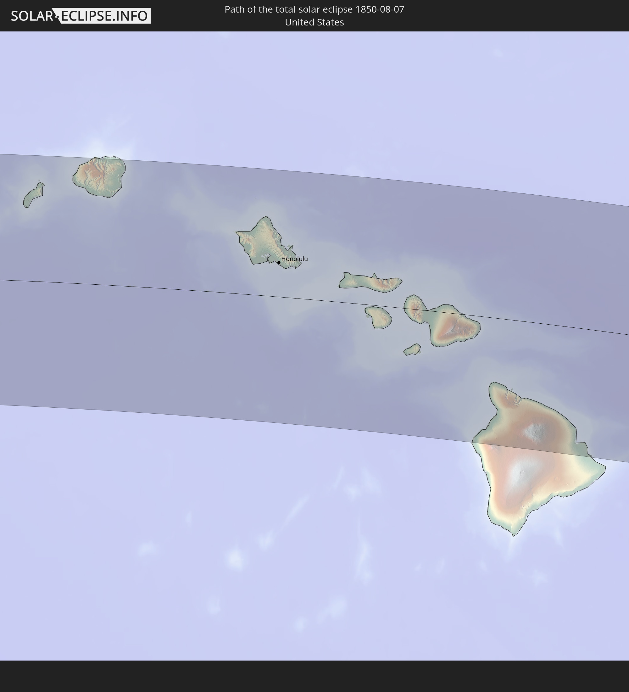
Detaillierte Länderkarten
 Vereinigte Staaten
Orte im Finsternispfad
Die nachfolgene Tabelle zeigt Städte und Orte mit mehr als 5.000 Einwohnern, die sich im Finsternispfad befinden. Städte mit mehr als 100.000 Einwohnern sind dick gekennzeichnet. Mit einem Klick auf den Ort öffnet sich eine Detailkarte die die Lage des jeweiligen Ortes zusammen mit dem Verlauf der zentralen Finsternis präsentiert.
| Ort | Typ | Dauer der Verfinsterung | Ortszeit bei maximaler Verfinsterung | Entfernung zur Zentrallinie | Ø Bewölkung |
|
Wailua Homesteads, Hawaii
|
total | - | 10:15:07 UTC-10:30 | 107 km | 82% |
|
Lihue, Hawaii
|
total | - | 10:15:08 UTC-10:30 | 97 km | 75% |
|
Kapa‘a, Hawaii
|
total | - | 10:15:15 UTC-10:30 | 108 km | 65% |
|
Mākaha, Hawaii
|
total | - | 10:17:55 UTC-10:30 | 48 km | 74% |
|
Waianae, Hawaii
|
total | - | 10:17:59 UTC-10:30 | 45 km | 65% |
|
Mā‘ili, Hawaii
|
total | - | 10:18:01 UTC-10:30 | 42 km | 65% |
|
Nānākuli, Hawaii
|
total | - | 10:18:04 UTC-10:30 | 40 km | 65% |
|
Makakilo, Hawaii
|
total | - | 10:18:14 UTC-10:30 | 36 km | 69% |
|
Makakilo City, Hawaii
|
total | - | 10:18:14 UTC-10:30 | 35 km | 52% |
|
Schofield Barracks, Hawaii
|
total | - | 10:18:16 UTC-10:30 | 52 km | 76% |
|
‘Ewa Villages, Hawaii
|
total | - | 10:18:21 UTC-10:30 | 35 km | 51% |
|
‘Ewa Gentry, Hawaii
|
total | - | 10:18:22 UTC-10:30 | 35 km | 51% |
|
Village Park, Hawaii
|
total | - | 10:18:22 UTC-10:30 | 42 km | 65% |
|
Royal Kunia, Hawaii
|
total | - | 10:18:22 UTC-10:30 | 41 km | 65% |
|
Wahiawā, Hawaii
|
total | - | 10:18:21 UTC-10:30 | 53 km | 71% |
|
Waipi‘o Acres, Hawaii
|
total | - | 10:18:23 UTC-10:30 | 49 km | 71% |
|
Waipahu, Hawaii
|
total | - | 10:18:25 UTC-10:30 | 40 km | 65% |
|
‘Ewa Beach, Hawaii
|
total | - | 10:18:26 UTC-10:30 | 33 km | 51% |
|
Mililani Town, Hawaii
|
total | - | 10:18:25 UTC-10:30 | 48 km | 71% |
|
Waipio, Hawaii
|
total | - | 10:18:26 UTC-10:30 | 44 km | 65% |
|
Pearl City, Hawaii
|
total | - | 10:18:30 UTC-10:30 | 42 km | 65% |
|
Hickam Field, Hawaii
|
total | - | 10:18:32 UTC-10:30 | 36 km | 51% |
|
Waimalu, Hawaii
|
total | - | 10:18:34 UTC-10:30 | 43 km | 69% |
|
‘Aiea, Hawaii
|
total | - | 10:18:36 UTC-10:30 | 41 km | 69% |
|
Lā‘ie, Hawaii
|
total | - | 10:18:35 UTC-10:30 | 70 km | 80% |
|
Hālawa, Hawaii
|
total | - | 10:18:38 UTC-10:30 | 40 km | 69% |
|
Hālawa Heights, Hawaii
|
total | - | 10:18:39 UTC-10:30 | 40 km | 69% |
|
Honolulu, Hawaii
|
total | - | 10:18:47 UTC-10:30 | 33 km | 51% |
|
‘Āhuimanu, Hawaii
|
total | - | 10:18:49 UTC-10:30 | 48 km | 77% |
|
Kaneohe, Hawaii
|
total | - | 10:18:55 UTC-10:30 | 44 km | 77% |
|
Marine Corps Base Hawaii - MCBH, Hawaii
|
total | - | 10:19:01 UTC-10:30 | 49 km | 69% |
|
Kailua, Hawaii
|
total | - | 10:19:03 UTC-10:30 | 44 km | 69% |
|
Waimanalo, Hawaii
|
total | - | 10:19:06 UTC-10:30 | 38 km | 57% |
|
Napili-Honokowai, Hawaii
|
total | - | 10:21:44 UTC-10:30 | 7 km | 56% |
|
Lahaina, Hawaii
|
total | - | 10:21:45 UTC-10:30 | 4 km | 49% |
|
Wailuku, Hawaii
|
total | - | 10:22:10 UTC-10:30 | 1 km | 63% |
|
Waihee-Waiehu, Hawaii
|
total | - | 10:22:10 UTC-10:30 | 4 km | 63% |
|
Kahului, Hawaii
|
total | - | 10:22:15 UTC-10:30 | 0 km | 63% |
|
Kīhei, Hawaii
|
total | - | 10:22:21 UTC-10:30 | 14 km | 63% |
|
Pukalani, Hawaii
|
total | - | 10:22:36 UTC-10:30 | 4 km | 69% |
|
Makawao, Hawaii
|
total | - | 10:22:40 UTC-10:30 | 2 km | 66% |
|
Haiku-Pauwela, Hawaii
|
total | - | 10:22:40 UTC-10:30 | 5 km | 66% |
|
Waikoloa Village, Hawaii
|
total | - | 10:24:09 UTC-10:30 | 99 km | 57% |
|
Waimea, Hawaii
|
total | - | 10:24:31 UTC-10:30 | 87 km | 48% |
|
Hilo, Hawaii
|
total | - | 10:26:07 UTC-10:30 | 112 km | 86% |