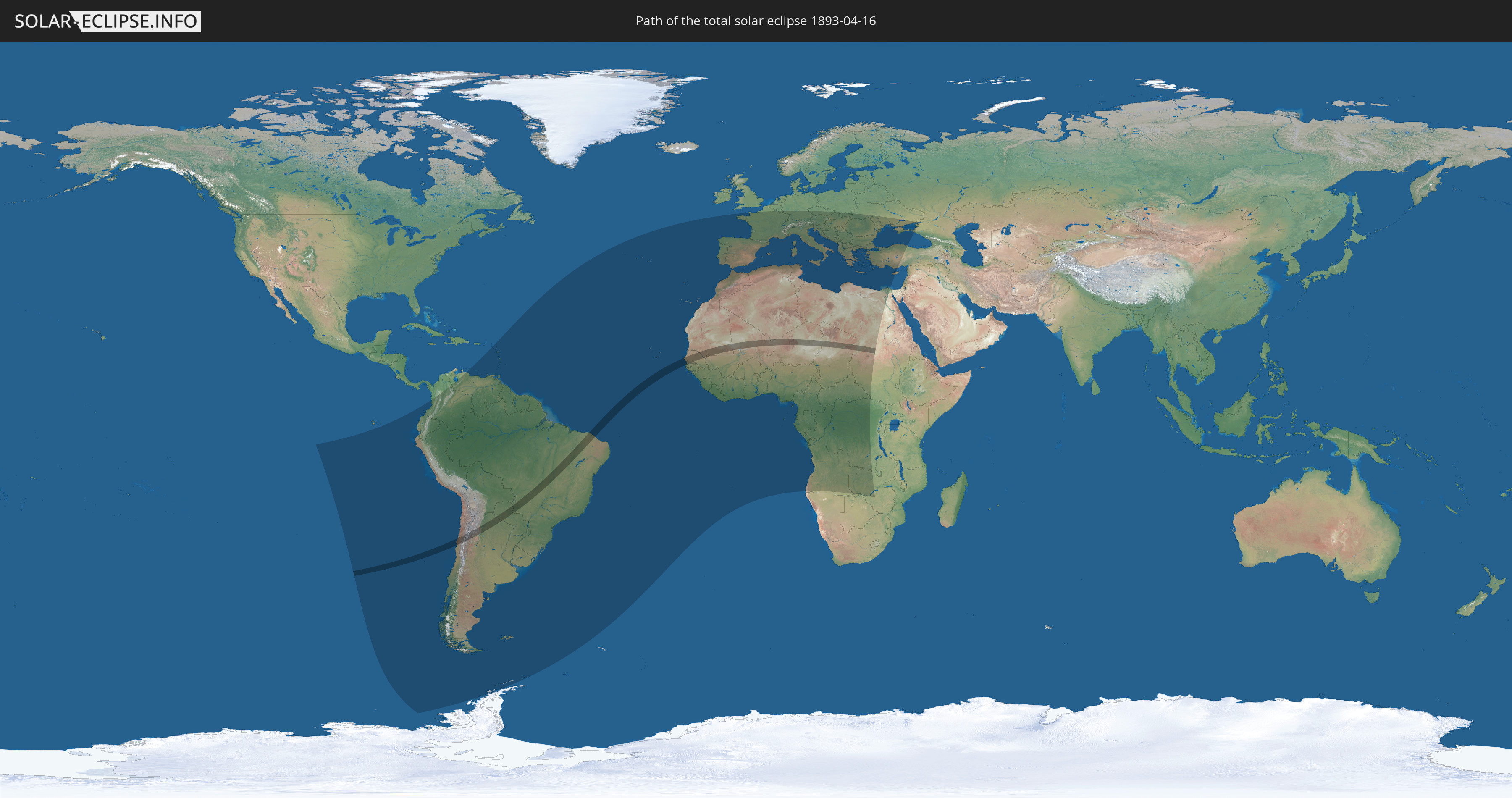
Total solar eclipse of 04/16/1893
| Day of week: | Sunday |
| Maximum duration of eclipse: | 04m47s |
| Maximum width of eclipse path: | 186 km |
| Saros cycle: | 127 |
| Coverage: | 100% |
| Magnitude: | 1.0556 |
| Gamma: | -0.1764 |
Wo kann man die Sonnenfinsternis vom 04/16/1893 sehen?
Die Sonnenfinsternis am 04/16/1893 kann man in 99 Ländern als partielle Sonnenfinsternis beobachten.
Der Finsternispfad verläuft durch 12 Länder. Nur in diesen Ländern ist sie als total Sonnenfinsternis zu sehen.
In den folgenden Ländern ist die Sonnenfinsternis total zu sehen
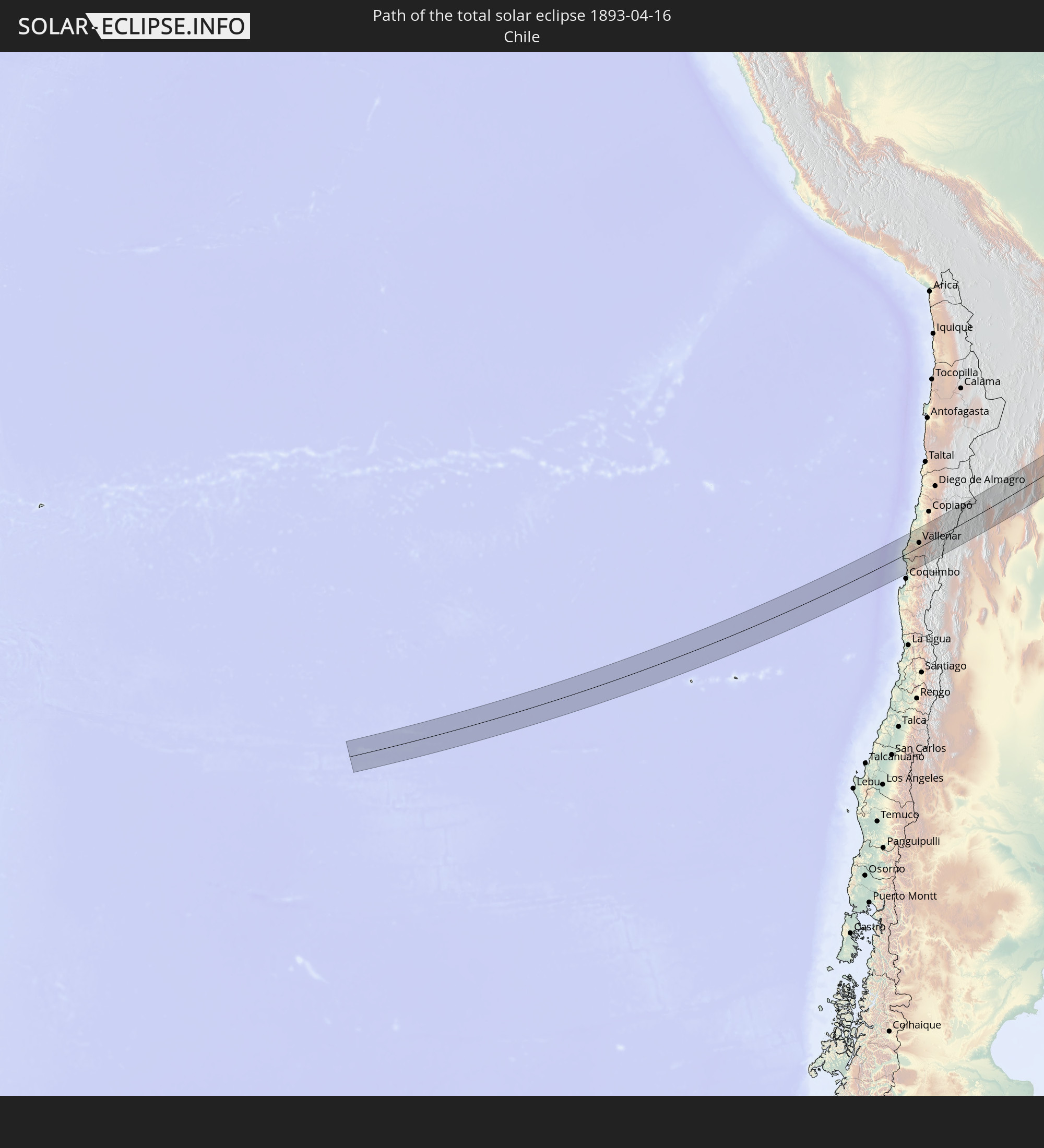 Chile
Chile
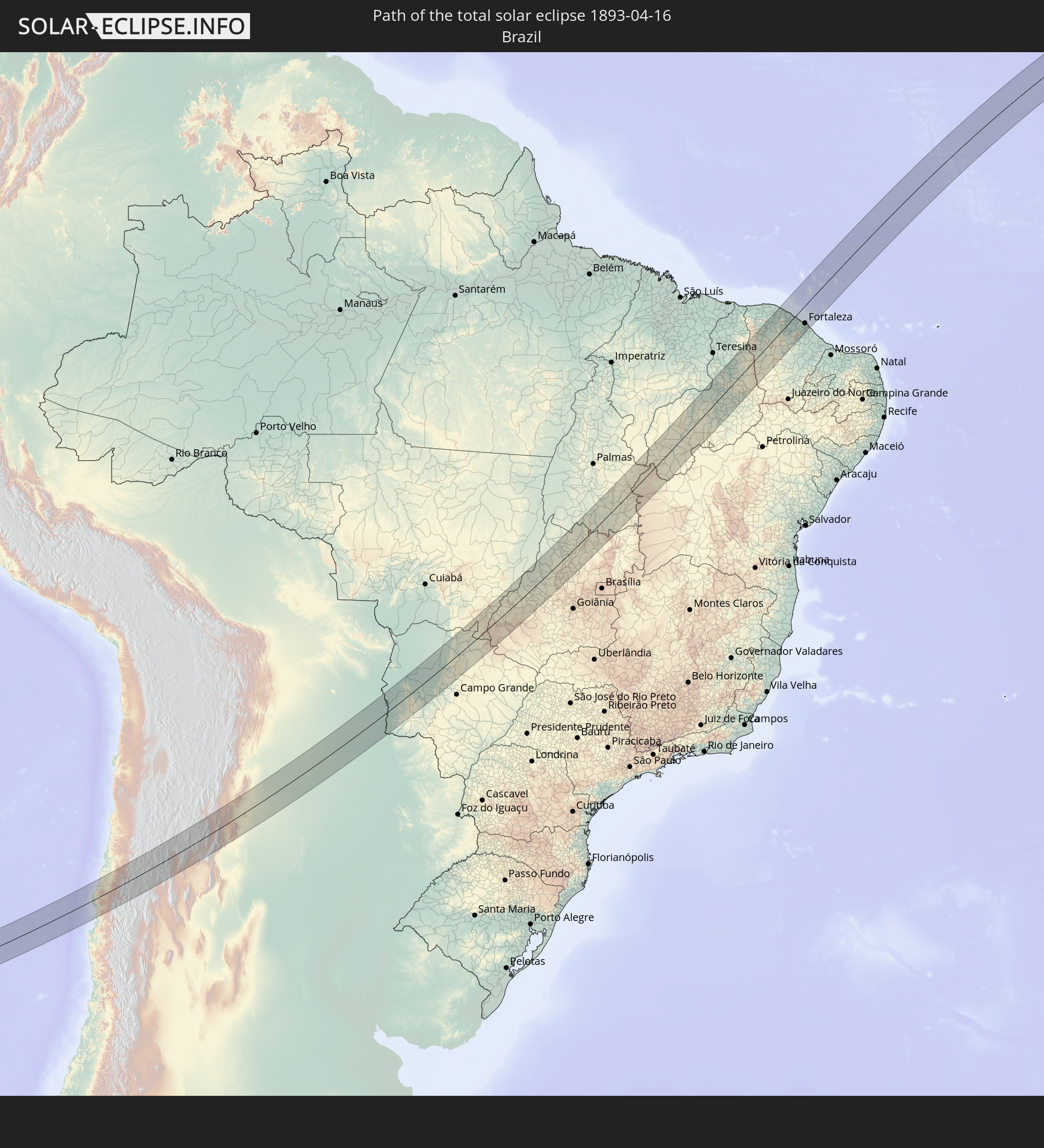 Brazil
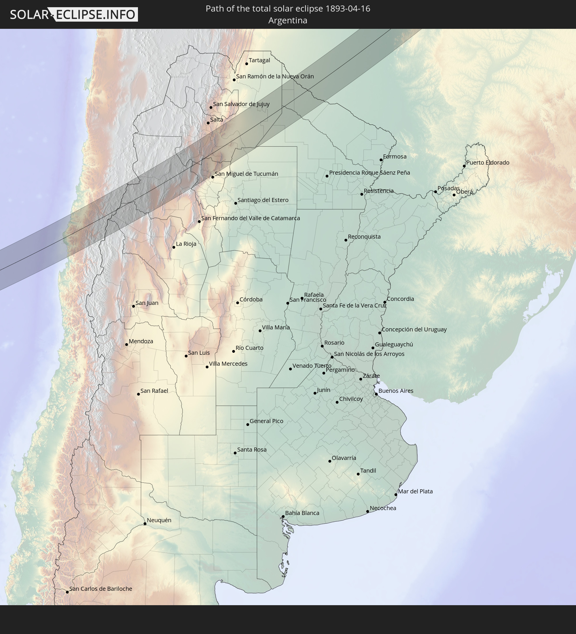 Argentina
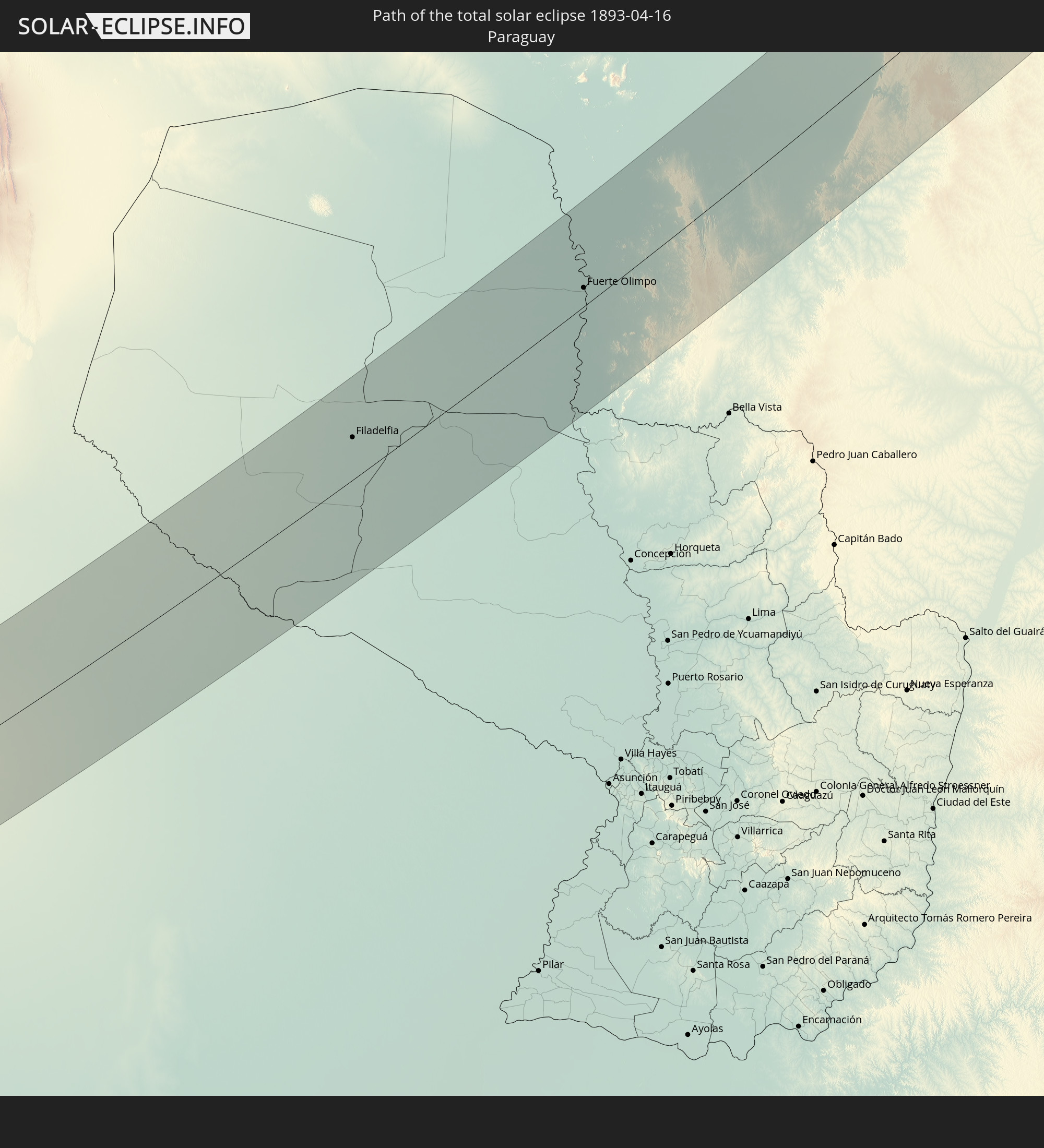 Paraguay
 Senegal
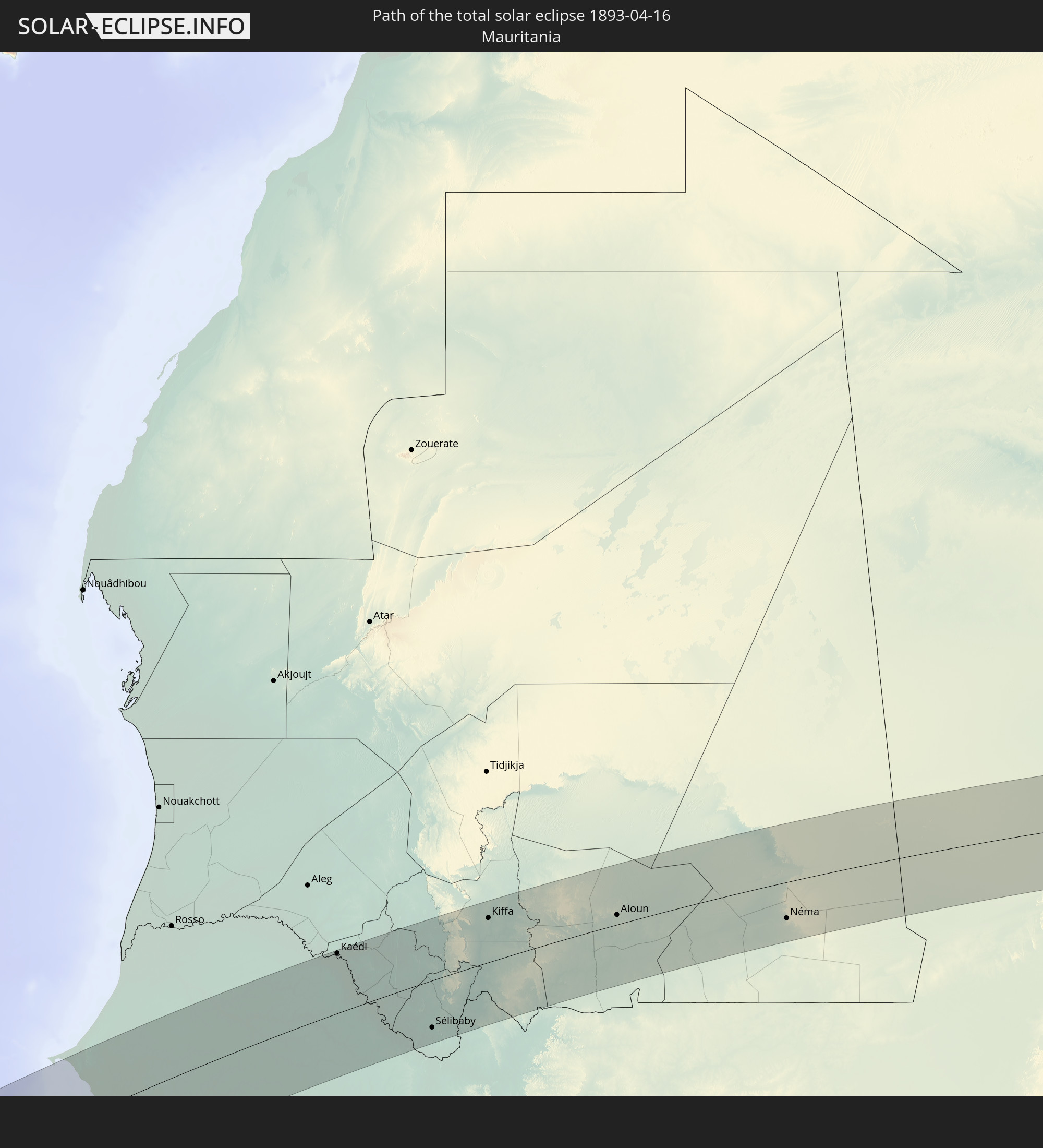 Mauritania
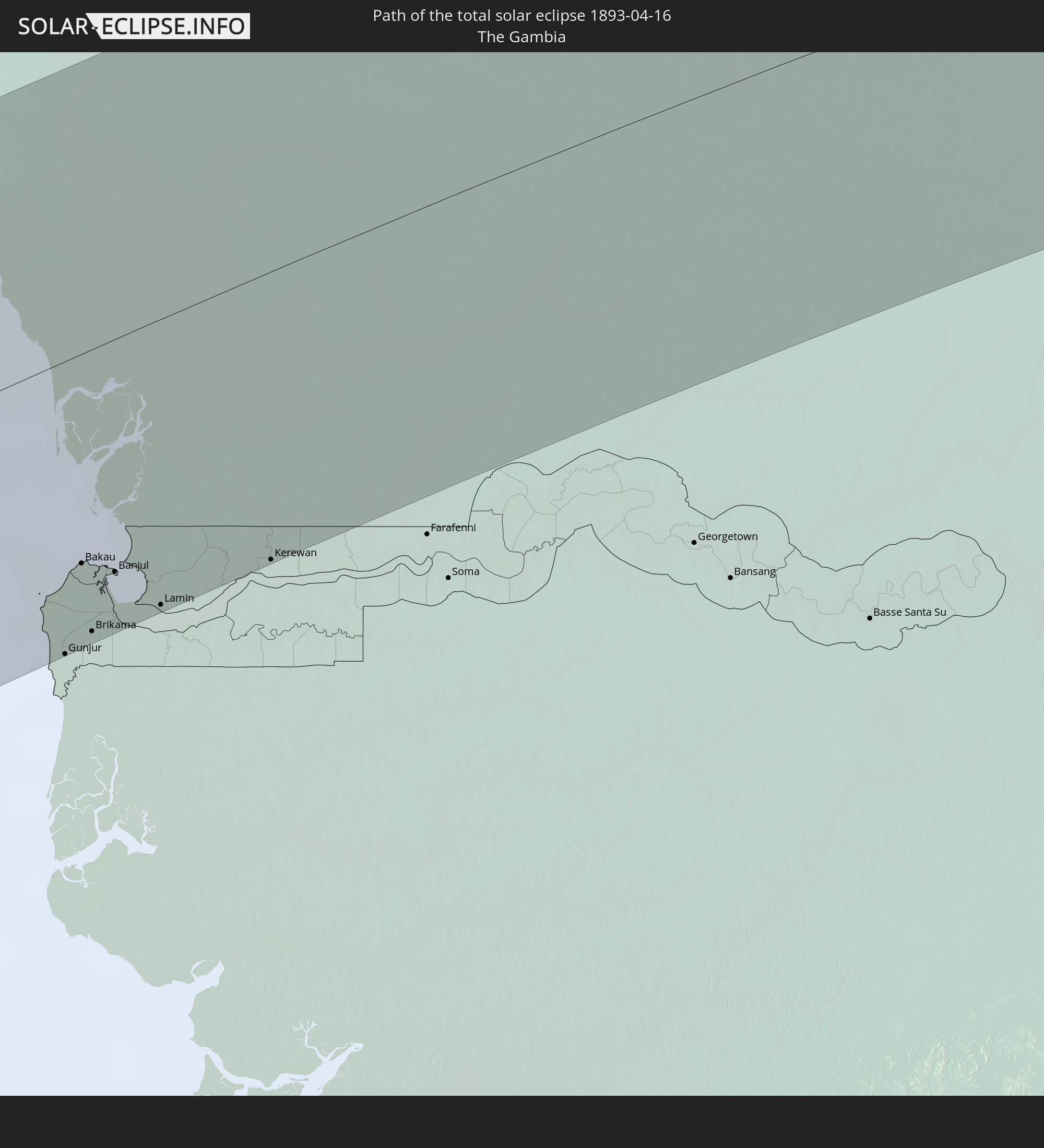 The Gambia
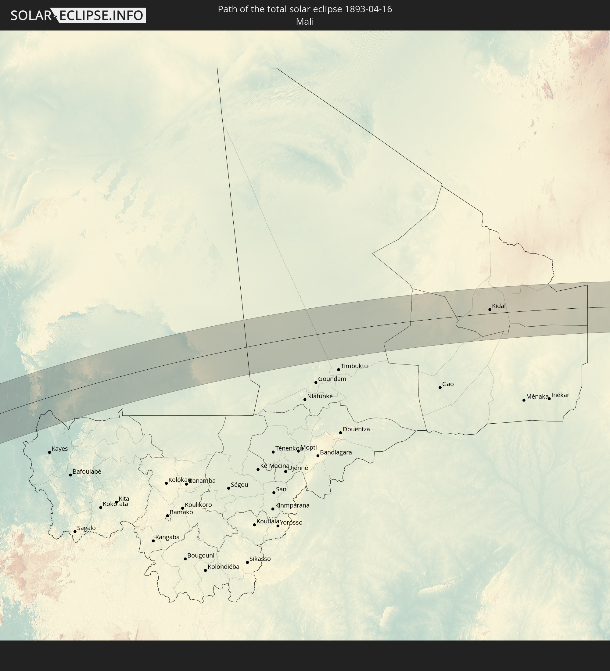 Mali
Mali
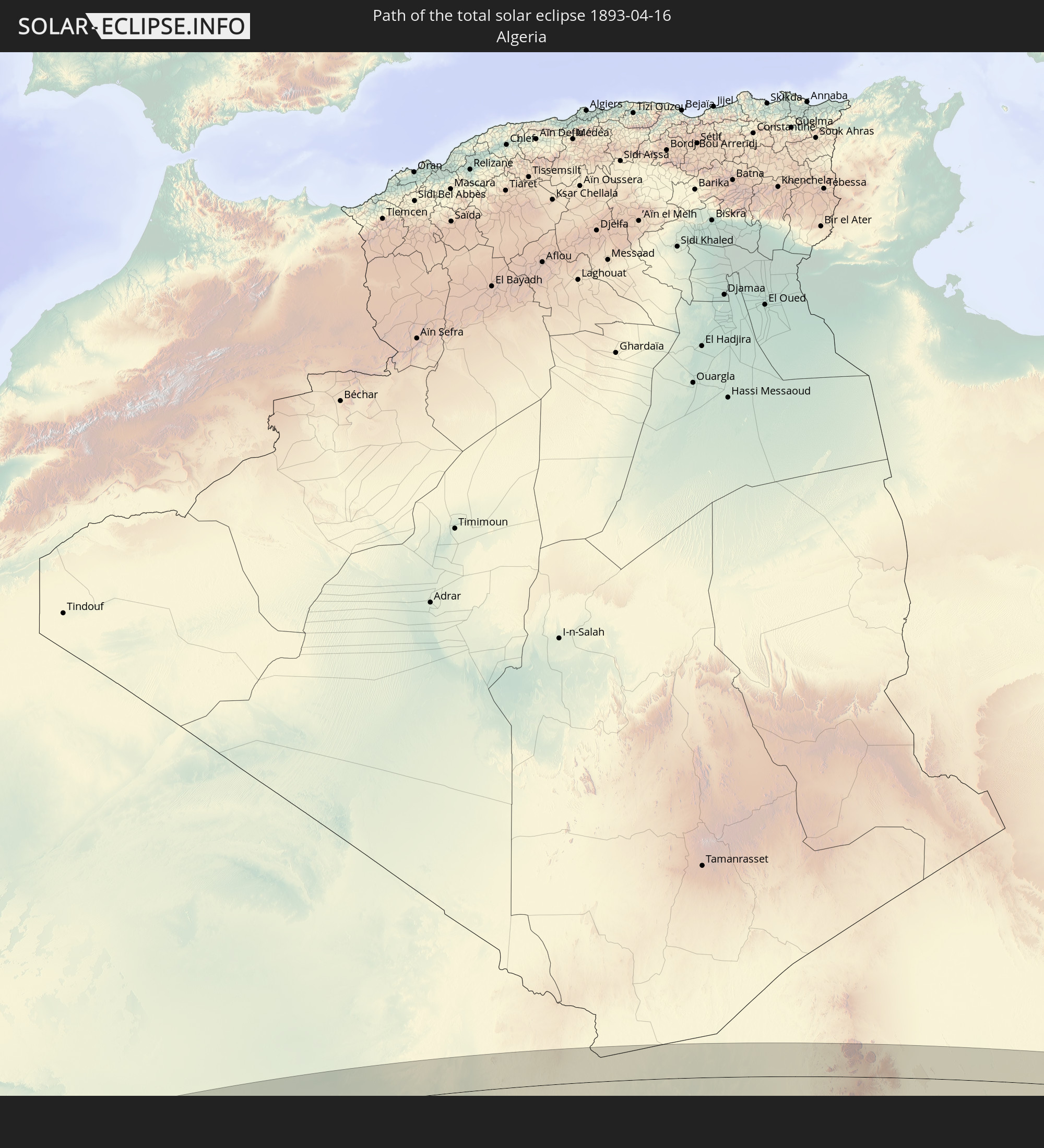 Algeria
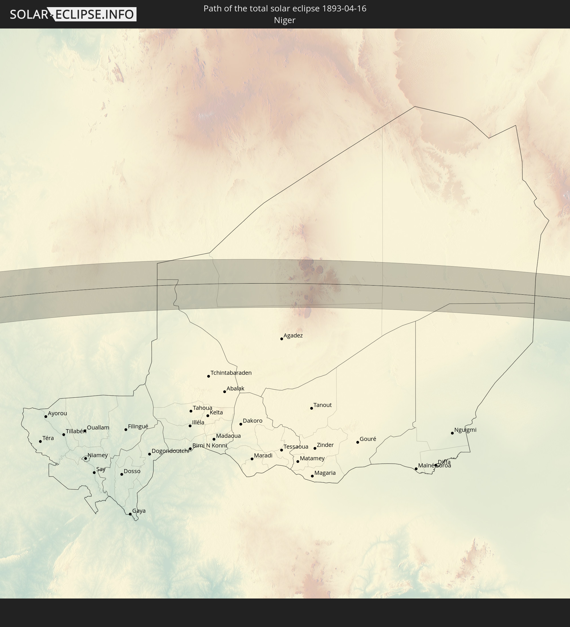 Niger
Niger
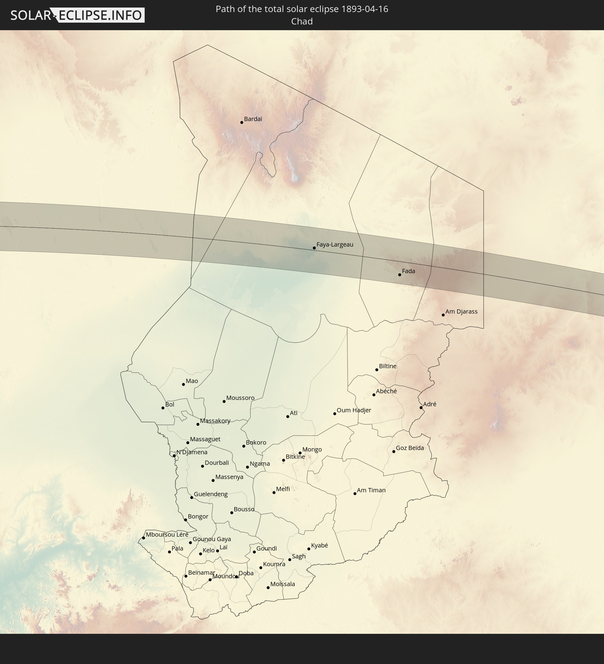 Chad
Chad
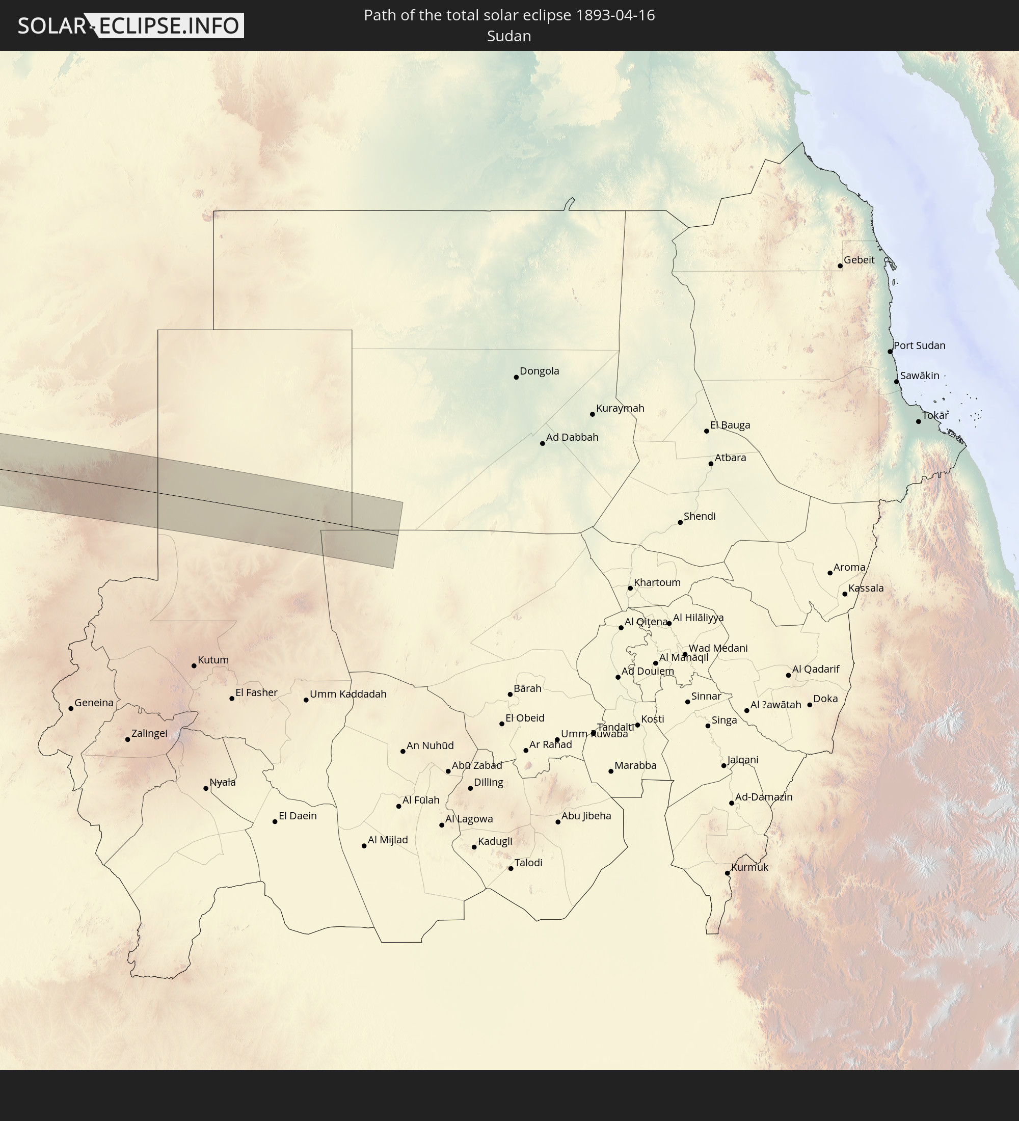 Sudan
Sudan
In den folgenden Ländern ist die Sonnenfinsternis partiell zu sehen
 Antarctica
 Russia
 Chile
Chile
 Ecuador
 Colombia
 Peru
Peru
 Brazil
 Argentina
 Venezuela
 Bolivia
 Saint Kitts and Nevis
 Paraguay
 Antigua and Barbuda
 Montserrat
 Trinidad and Tobago
 Guadeloupe
 Grenada
 Dominica
 Saint Vincent and the Grenadines
 Falkland Islands
 Guyana
 Martinique
 Saint Lucia
 Barbados
 Uruguay
 Suriname
 French Guiana
 South Georgia and the South Sandwich Islands
 Portugal
 Cabo Verde
 Spain
Spain
 Senegal
 Mauritania
 The Gambia
 Guinea-Bissau
 Guinea
 Saint Helena, Ascension and Tristan da Cunha
 Sierra Leone
 Morocco
 Mali
Mali
 Liberia
 Algeria
 Ivory Coast
 Burkina Faso
 Gibraltar
 France
 Ghana
Ghana
 Jersey
 Togo
Togo
 Niger
Niger
 Benin
Benin
 Andorra
 Belgium
 Nigeria
 Equatorial Guinea
 Luxembourg
 Germany
 Switzerland
 São Tomé and Príncipe
 Italy
Italy
 Monaco
 Tunisia
 Cameroon
 Gabon
Gabon
 Libya
Libya
 Liechtenstein
 Austria
 Republic of the Congo
 Angola
 Namibia
 Czechia
 Democratic Republic of the Congo
 San Marino
 Vatican City
 Slovenia
 Chad
Chad
 Croatia
 Poland
 Malta
Malta
 Central African Republic
 Bosnia and Herzegovina
 Hungary
 Slovakia
 Montenegro
 Serbia
 Albania
 Greece
 Botswana
 Romania
 Republic of Macedonia
 Sudan
Sudan
 Zambia
 Ukraine
 Bulgaria
 Egypt
Egypt
 Zimbabwe
 Turkey
 Moldova
 Cyprus
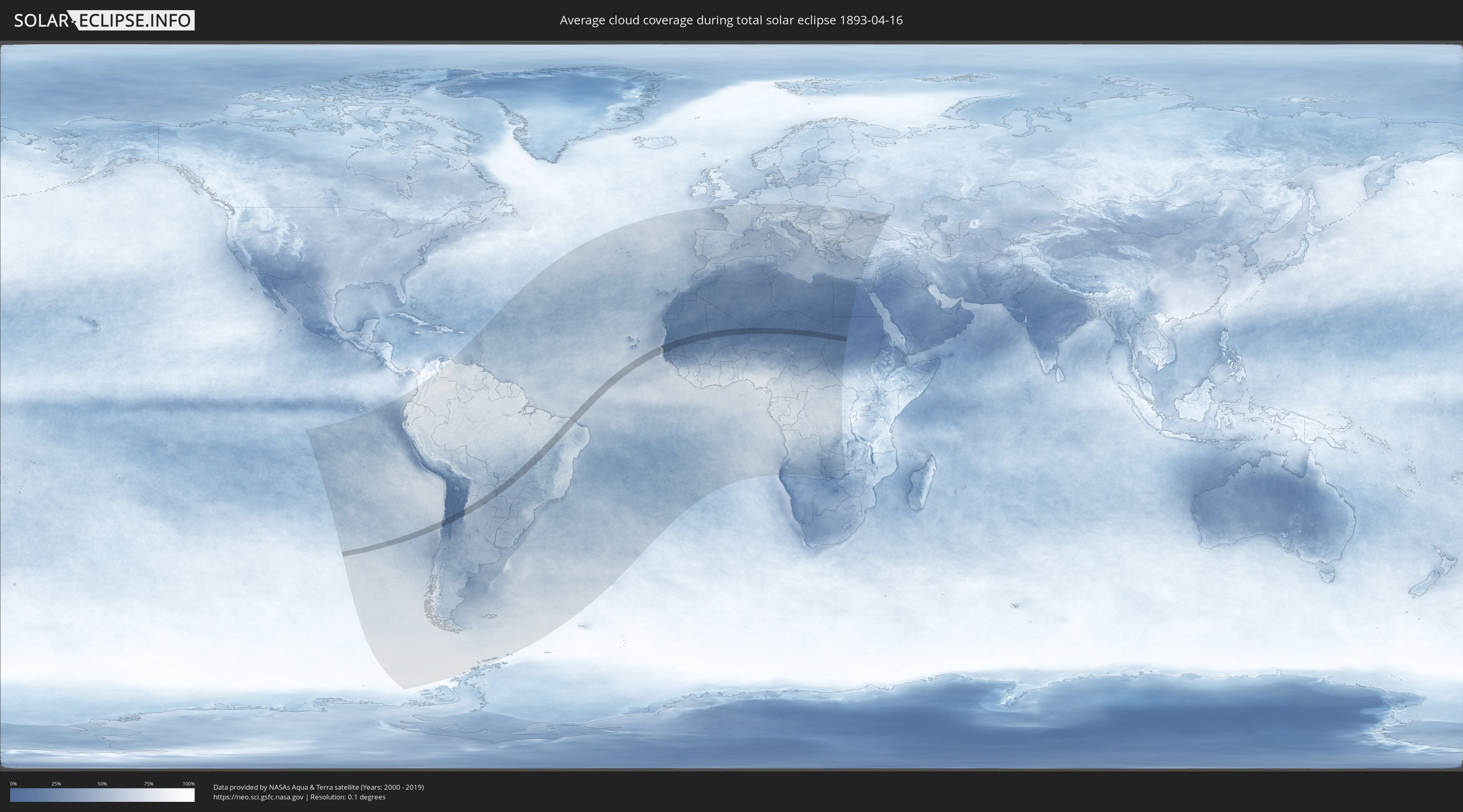
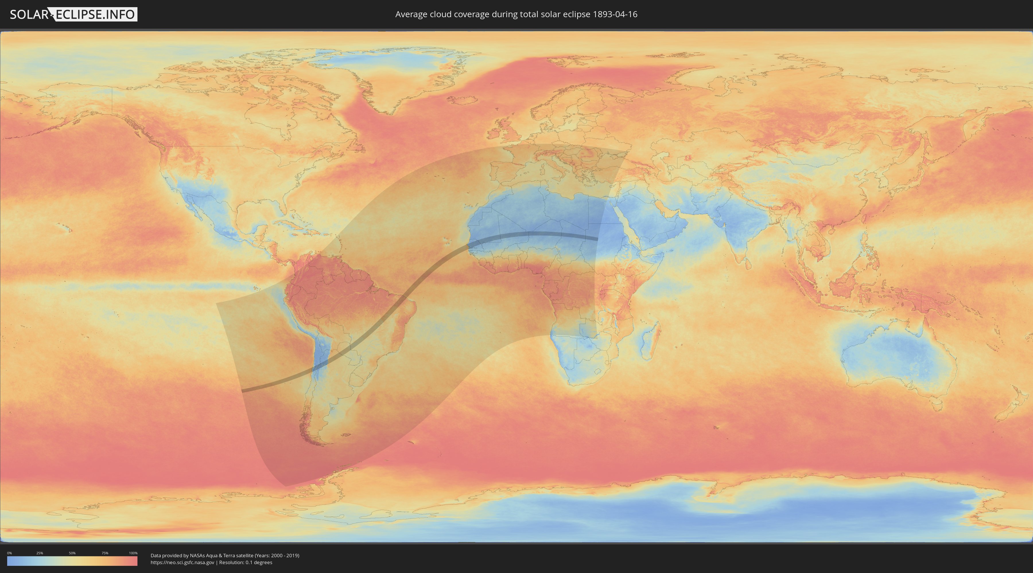
How will be the weather during the total solar eclipse on 04/16/1893?
Where is the best place to see the total solar eclipse of 04/16/1893?
The following maps show the average cloud coverage for the day of the total solar eclipse.
With the help of these maps, it is possible to find the place along the eclipse path, which has the best
chance of a cloudless sky.
Nevertheless, you should consider local circumstances and inform about the weather of your chosen
observation site.
The data is provided by NASAs satellites
AQUA and TERRA.
The cloud maps are averaged over a period of 19 years (2000 - 2019).
Detailed country maps
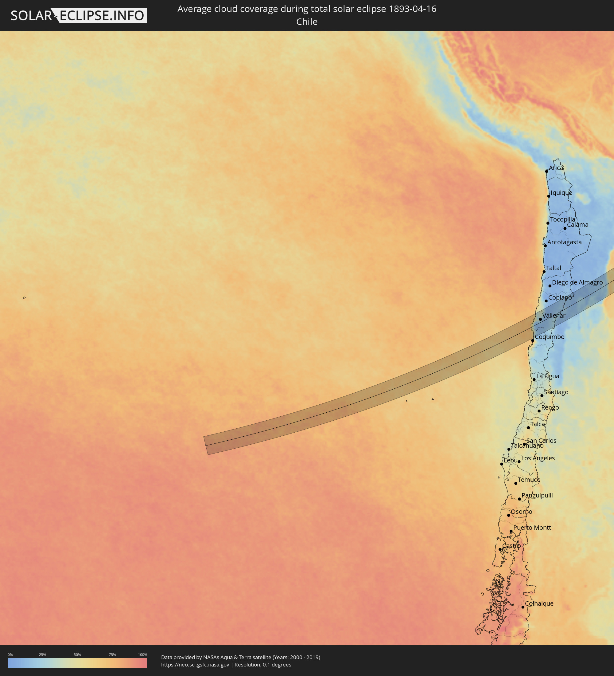 Chile
Chile
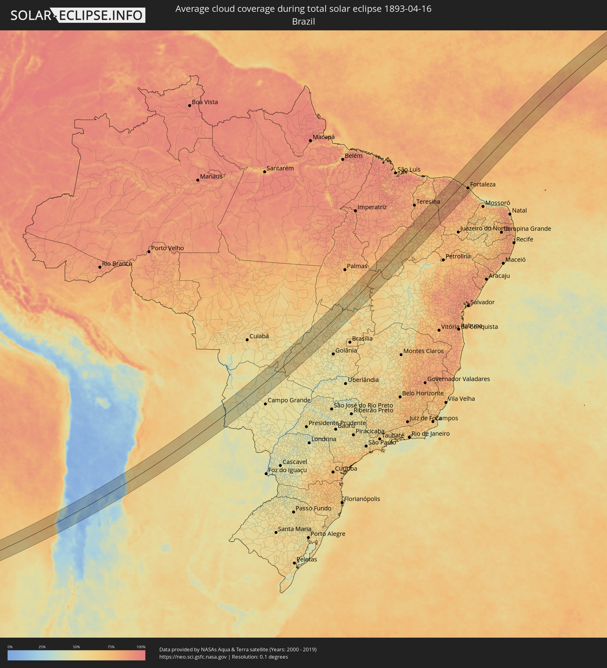 Brazil
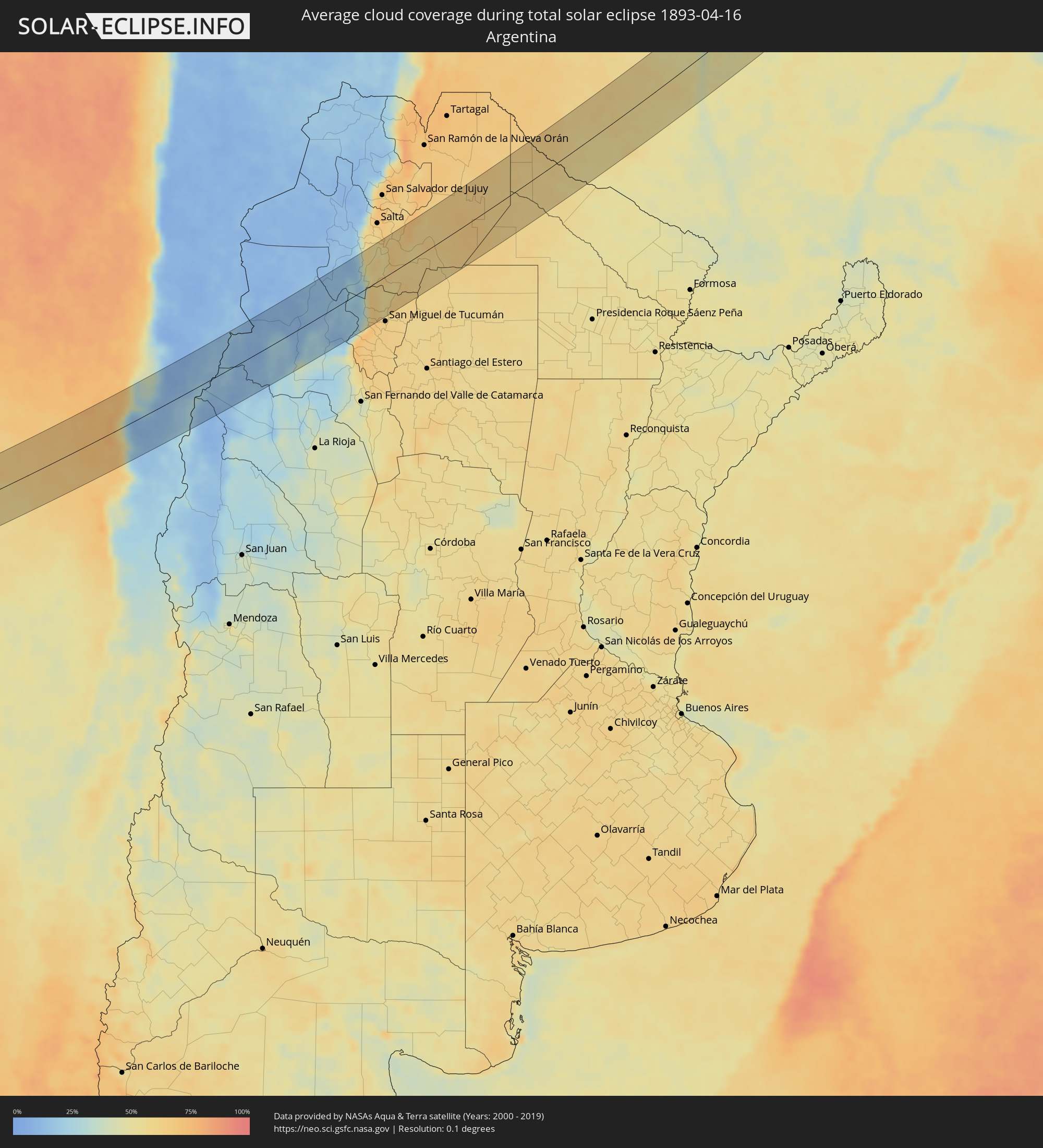 Argentina
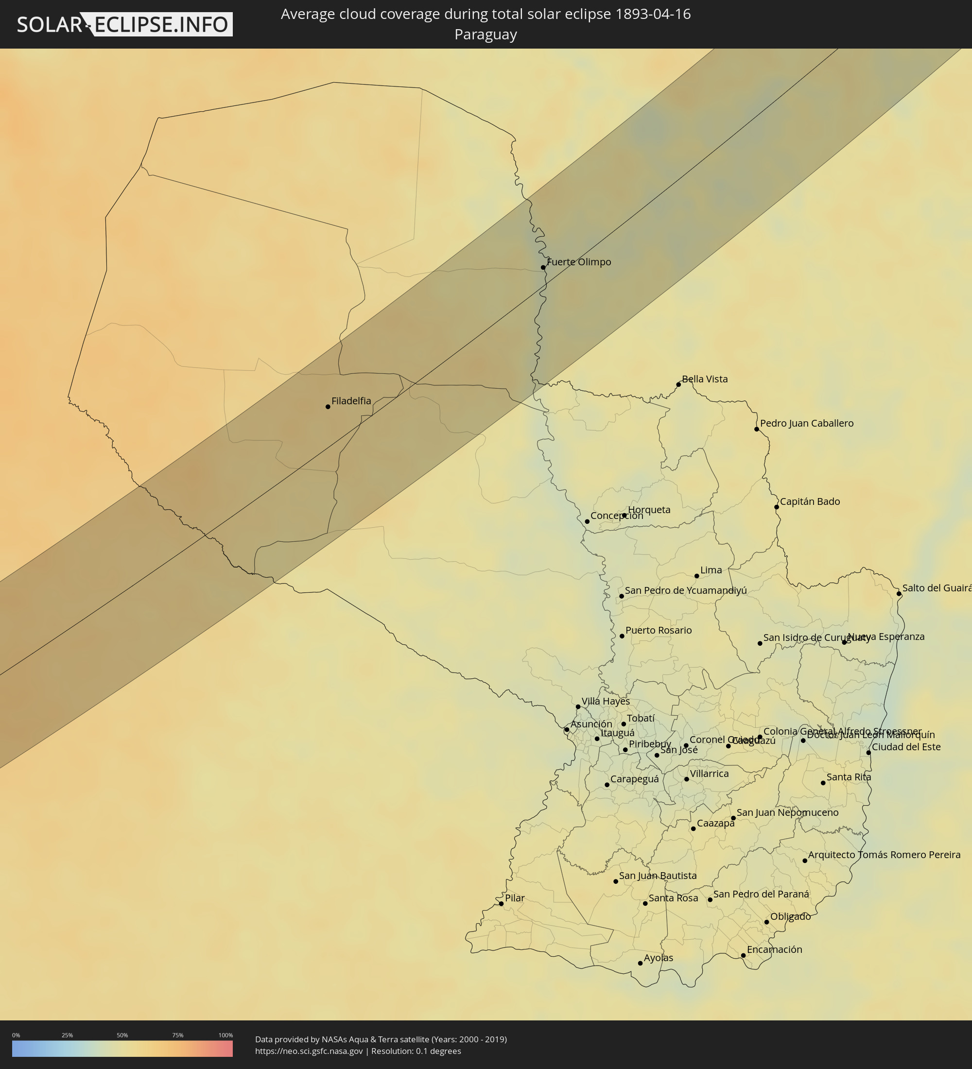 Paraguay
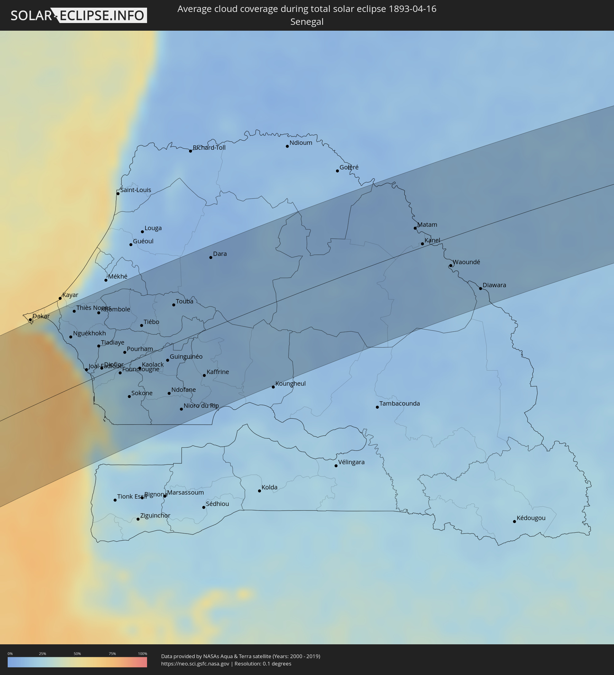 Senegal
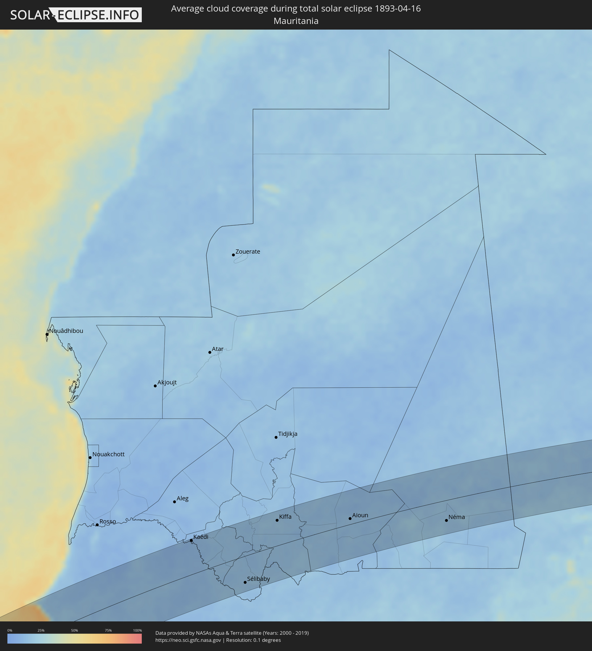 Mauritania
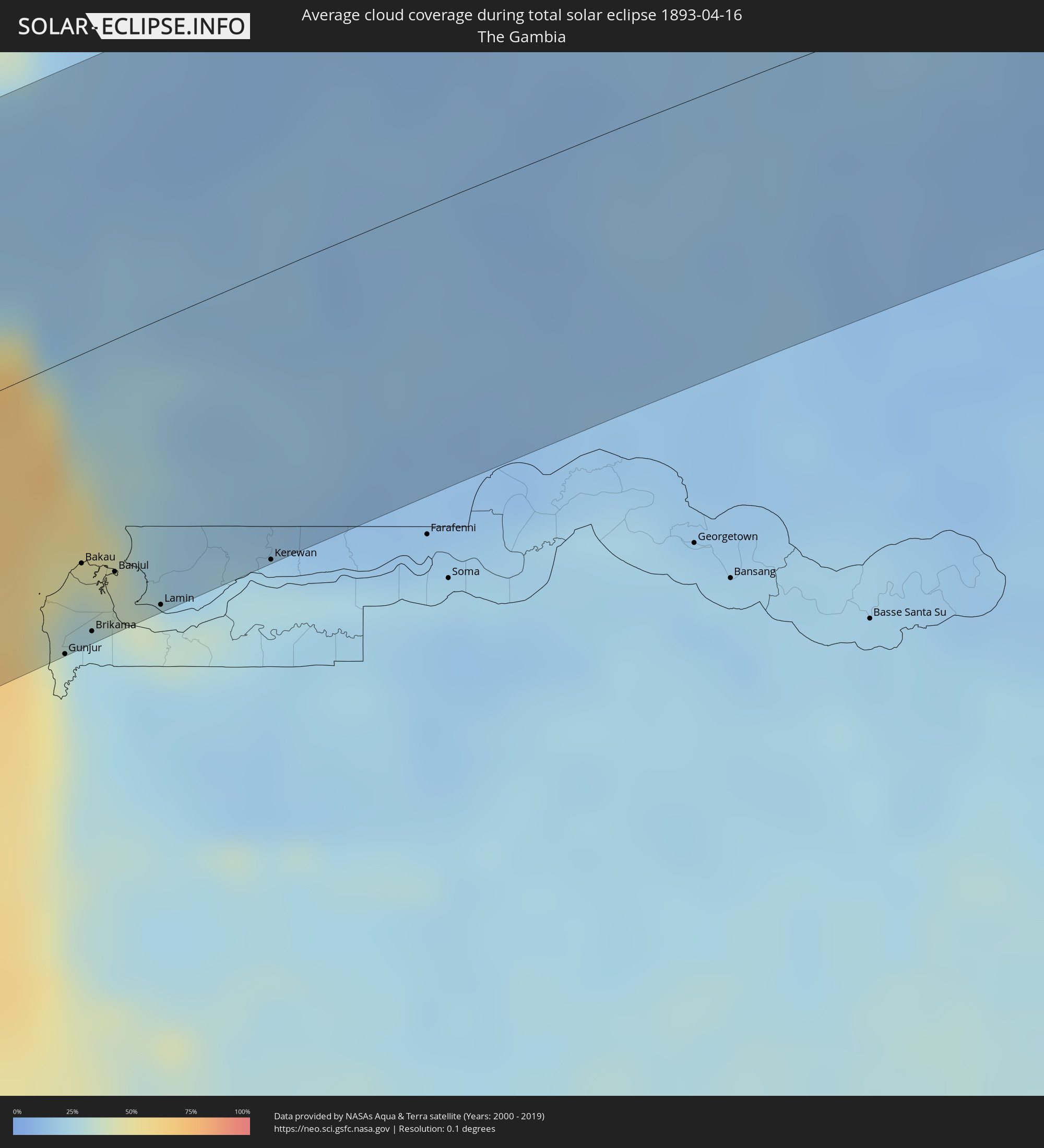 The Gambia
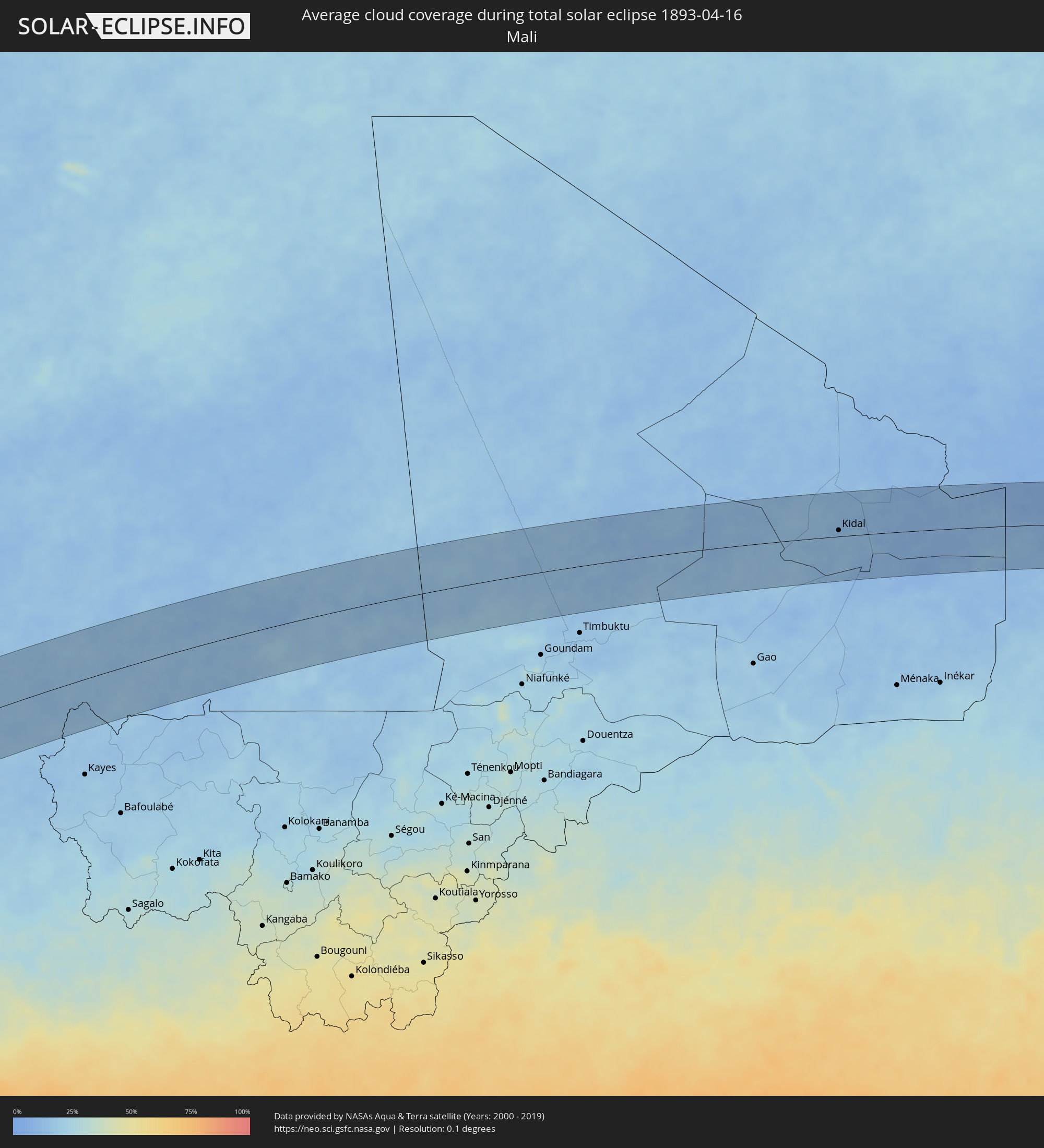 Mali
Mali
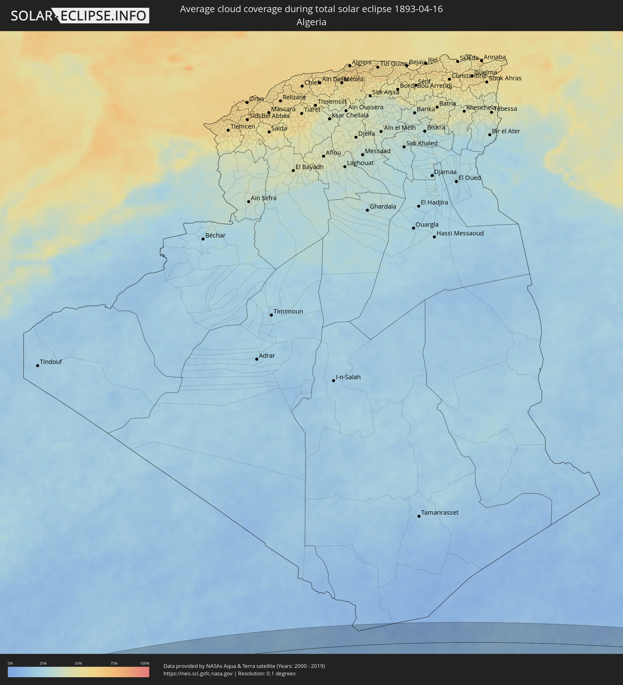 Algeria
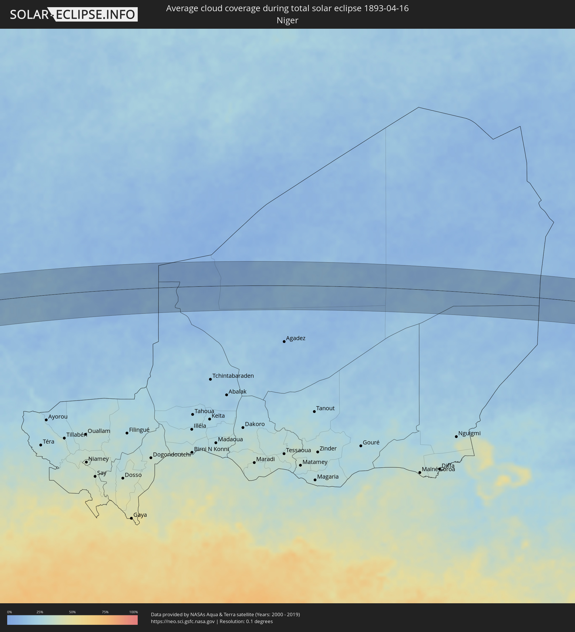 Niger
Niger
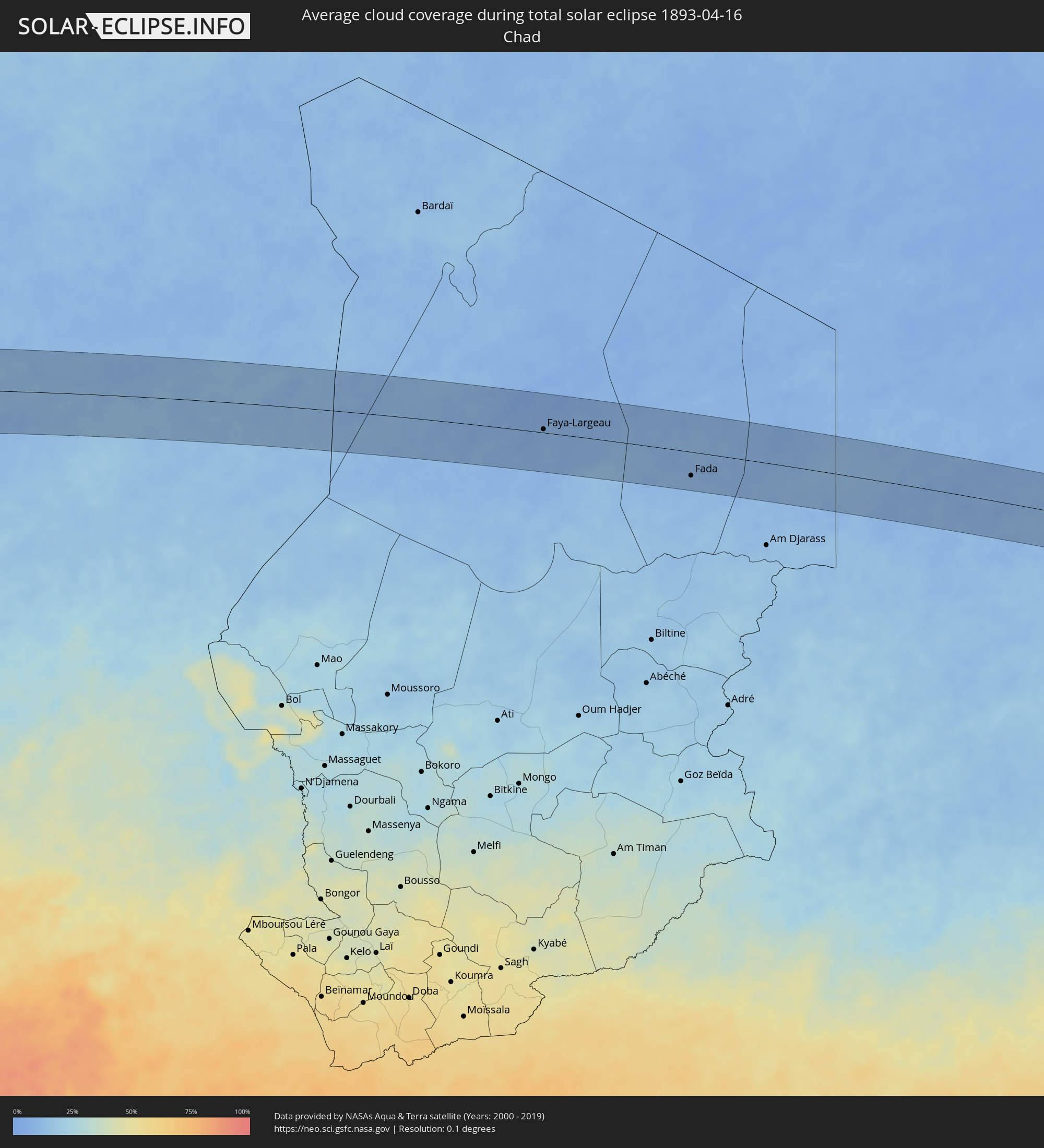 Chad
Chad
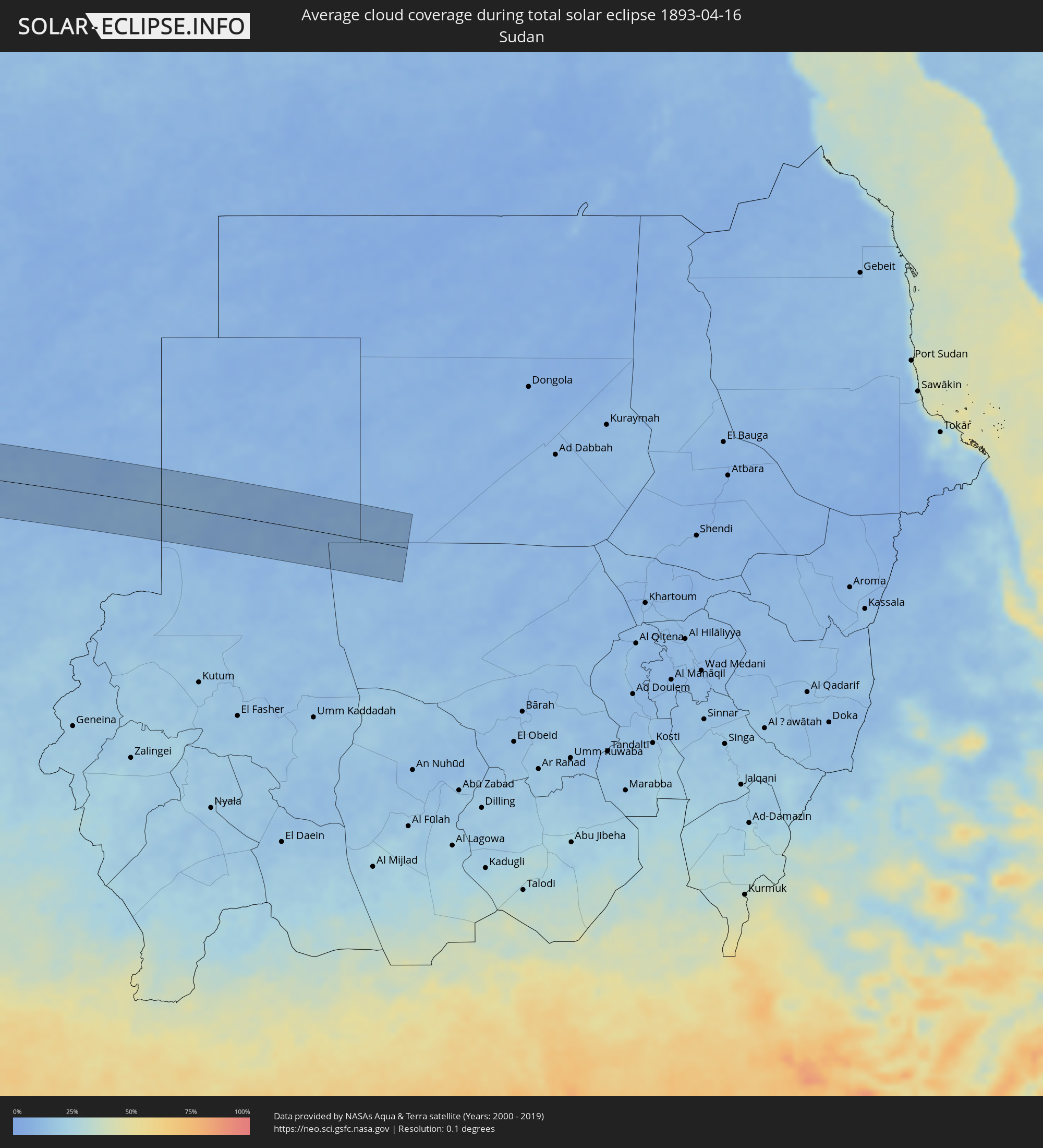 Sudan
Sudan
Cities inside the path of the eclipse
The following table shows all locations with a population of more than 5,000 inside the eclipse path. Cities which have more than 100,000 inhabitants are marked bold. A click at the locations opens a detailed map.
| City | Type | Eclipse duration | Local time of max. eclipse | Distance to central line | Ø Cloud coverage |
|
Vallenar, Atacama
|
total | - | 08:20:20 UTC-04:42 | 16 km | 24% |
|
Fiambalá, Catamarca Province
|
total | - | 08:49:03 UTC-04:16 | 48 km | 17% |
|
Cafayate, Salta Province
|
total | - | 08:51:18 UTC-04:16 | 23 km | 28% |
|
Trancas, Tucumán Province
|
total | - | 08:51:50 UTC-04:16 | 27 km | 54% |
|
Tafí Viejo, Tucumán Province
|
total | - | 08:51:32 UTC-04:16 | 77 km | 63% |
|
El Galpón, Salta Province
|
total | - | 08:52:55 UTC-04:16 | 18 km | 57% |
|
Las Lajitas, Salta Province
|
total | - | 08:53:46 UTC-04:16 | 62 km | 60% |
|
Joaquín V. González, Salta Province
|
total | - | 08:53:33 UTC-04:16 | 21 km | 63% |
|
El Quebrachal, Salta Province
|
total | - | 08:53:32 UTC-04:16 | 4 km | 61% |
|
Apolinario Saravia, Salta Province
|
total | - | 08:54:11 UTC-04:16 | 71 km | 63% |
|
Taco Pozo, Chaco Province
|
total | - | 08:54:02 UTC-04:16 | 79 km | 62% |
|
Ingeniero Guillermo N. Juárez, Formosa Province
|
total | - | 08:56:42 UTC-04:16 | 1 km | 60% |
|
Filadelfia, Boquerón
|
total | - | 09:26:04 UTC-03:50 | 33 km | 59% |
|
Colonia Menno, Boquerón
|
total | - | 09:26:16 UTC-03:50 | 17 km | 57% |
|
Fuerte Olimpo, Alto Paraguay
|
total | - | 09:29:44 UTC-03:50 | 14 km | 43% |
|
Aquidauana, Mato Grosso do Sul
|
total | - | 09:45:03 UTC-03:38 | 71 km | 51% |
|
Coxim, Mato Grosso do Sul
|
total | - | 09:48:35 UTC-03:38 | 28 km | 50% |
|
Mineiros, Goiás
|
total | - | 10:24:43 UTC-03:06 | 46 km | 53% |
|
Barra do Garças, Mato Grosso
|
total | - | 09:55:21 UTC-03:38 | 72 km | 52% |
|
Iporá, Goiás
|
total | - | 10:28:13 UTC-03:06 | 56 km | 54% |
|
Porangatu, Goiás
|
total | - | 10:35:31 UTC-03:06 | 40 km | 59% |
|
Uruaçu, Goiás
|
total | - | 10:33:53 UTC-03:06 | 47 km | 51% |
|
Floriano, Piauí
|
total | - | 11:29:41 UTC-02:34 | 73 km | 75% |
|
Picos, Piauí
|
total | - | 11:31:57 UTC-02:34 | 77 km | 78% |
|
Ipu, Ceará
|
total | - | 11:38:38 UTC-02:34 | 69 km | 82% |
|
Crateús, Ceará
|
total | - | 11:37:02 UTC-02:34 | 2 km | 80% |
|
Sobral, Ceará
|
partial | - | 11:40:34 UTC-02:34 | 88 km | 80% |
|
Santa Quitéria, Ceará
|
total | - | 11:39:40 UTC-02:34 | 23 km | 81% |
|
Boa Viagem, Ceará
|
total | - | 11:38:56 UTC-02:34 | 72 km | 84% |
|
Itapagé, Ceará
|
total | - | 11:42:02 UTC-02:34 | 25 km | 87% |
|
Itapipoca, Ceará
|
total | - | 11:42:26 UTC-02:34 | 39 km | 82% |
|
Canindé, Ceará
|
total | - | 11:41:14 UTC-02:34 | 48 km | 80% |
|
Trairi, Ceará
|
total | - | 11:43:27 UTC-02:34 | 30 km | 83% |
|
São Gonçalo do Amarante, Ceará
|
total | - | 11:43:23 UTC-02:34 | 19 km | 83% |
|
Baturité, Ceará
|
total | - | 11:42:07 UTC-02:34 | 81 km | 89% |
|
Maracanaú, Ceará
|
total | - | 11:43:31 UTC-02:34 | 68 km | 82% |
|
Fortaleza, Ceará
|
total | - | 11:44:00 UTC-02:34 | 62 km | 78% |
|
Aquiraz, Ceará
|
total | - | 11:43:56 UTC-02:34 | 89 km | 78% |
|
Pout, Thiès
|
total | - | 15:19:15 UTC-00:16 | 83 km | 18% |
|
Nguékhokh, Thiès
|
total | - | 15:19:02 UTC-00:16 | 55 km | 34% |
|
Thiès Nones, Thiès
|
total | - | 15:19:26 UTC-00:16 | 80 km | 15% |
|
Joal-Fadiout, Thiès
|
total | - | 15:18:54 UTC-00:16 | 12 km | 35% |
|
Gunjur, Western
|
total | - | 15:17:51 UTC-00:16 | 91 km | 28% |
|
Sukuta, Western
|
total | - | 15:18:10 UTC-00:16 | 71 km | 27% |
|
Tiadiaye, Thiès
|
total | - | 15:19:28 UTC-00:16 | 31 km | 16% |
|
Khombole, Thiès
|
total | - | 15:19:54 UTC-00:16 | 67 km | 13% |
|
Bakau, Banjul
|
total | - | 15:18:18 UTC-00:16 | 65 km | 35% |
|
Diofior, Fatick
|
total | - | 15:19:14 UTC-00:16 | 6 km | 21% |
|
Abuko, Western
|
total | - | 15:18:15 UTC-00:16 | 73 km | 27% |
|
Brikama, Western
|
total | - | 15:18:06 UTC-00:16 | 87 km | 26% |
|
Banjul, Banjul
|
total | - | 15:18:28 UTC-00:16 | 72 km | 39% |
|
Barra, North Bank
|
total | - | 15:18:34 UTC-00:16 | 70 km | 32% |
|
Essau, North Bank
|
total | - | 15:18:35 UTC-00:16 | 71 km | 32% |
|
Lamin, North Bank
|
total | - | 15:18:36 UTC-00:16 | 89 km | 31% |
|
Pourham, Fatick
|
total | - | 15:19:54 UTC-00:16 | 12 km | 15% |
|
Sokone, Fatick
|
total | - | 15:19:24 UTC-00:16 | 37 km | 22% |
|
Gandiaye, Kaolack
|
total | - | 15:20:02 UTC-00:16 | 6 km | 20% |
|
Kaolack, Kaolack
|
total | - | 15:19:59 UTC-00:16 | 12 km | 20% |
|
Tiébo, Diourbel
|
total | - | 15:20:35 UTC-00:16 | 34 km | 14% |
|
Kerewan, North Bank
|
total | - | 15:19:25 UTC-00:16 | 90 km | 27% |
|
Guinguinéo, Fatick
|
total | - | 15:20:39 UTC-00:16 | 16 km | 14% |
|
Ndofane, Kaolack
|
total | - | 15:20:14 UTC-00:16 | 53 km | 16% |
|
Touba, Diourbel
|
total | - | 15:21:28 UTC-00:16 | 41 km | 14% |
|
Nioro du Rip, Kaolack
|
total | - | 15:20:17 UTC-00:16 | 75 km | 12% |
|
Kaffrine, Kaffrine
|
total | - | 15:21:10 UTC-00:16 | 49 km | 14% |
|
Dara, Louga
|
total | - | 15:22:47 UTC-00:16 | 76 km | 10% |
|
Ndibène Dahra, Louga
|
total | - | 15:22:46 UTC-00:16 | 74 km | 10% |
|
Kaédi, Gorgol
|
total | - | 15:27:04 UTC-00:16 | 84 km | 11% |
|
Ouro Sogui, Matam
|
total | - | 15:26:48 UTC-00:16 | 20 km | 12% |
|
Matam, Matam
|
total | - | 15:26:58 UTC-00:16 | 23 km | 12% |
|
Kanel, Matam
|
total | - | 15:26:55 UTC-00:16 | 3 km | 12% |
|
Waoundé, Matam
|
total | - | 15:27:12 UTC-00:16 | 32 km | 15% |
|
Sélibaby, Guidimaka
|
total | - | 15:28:14 UTC-00:16 | 67 km | 15% |
|
Kiffa, Assaba
|
total | - | 15:30:59 UTC-00:16 | 63 km | 17% |
|
Aioun, Hodh El Gharbi
|
total | - | 15:33:49 UTC-00:16 | 14 km | 16% |
|
Néma, Hodh ech Chargui
|
total | - | 15:37:18 UTC-00:16 | 52 km | 16% |
|
Kidal, Kidal
|
total | - | 15:49:14 UTC-00:16 | 11 km | 14% |
|
Faya-Largeau, Borkou
|
total | - | 17:17:19 UTC+01:00 | 6 km | 8% |
|
Fada, Ennedi-Ouest
|
total | - | 17:17:53 UTC+01:00 | 42 km | 10% |