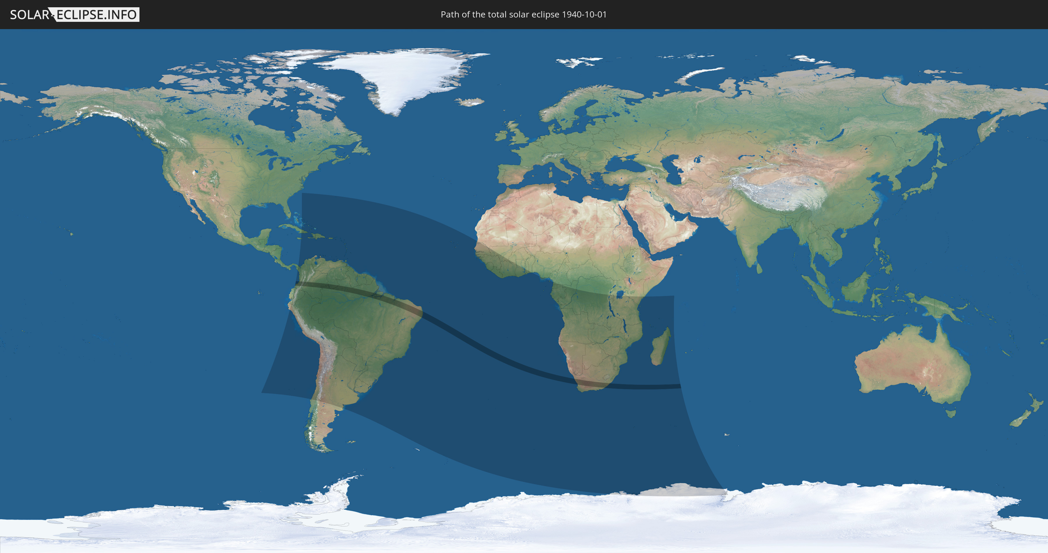
Total solar eclipse of 10/01/1940
| Day of week: | Tuesday |
| Maximum duration of eclipse: | 05m35s |
| Maximum width of eclipse path: | 218 km |
| Saros cycle: | 133 |
| Coverage: | 100% |
| Magnitude: | 1.0645 |
| Gamma: | -0.2573 |
Wo kann man die Sonnenfinsternis vom 10/01/1940 sehen?
Die Sonnenfinsternis am 10/01/1940 kann man in 85 Ländern als partielle Sonnenfinsternis beobachten.
Der Finsternispfad verläuft durch 4 Länder. Nur in diesen Ländern ist sie als total Sonnenfinsternis zu sehen.
In den folgenden Ländern ist die Sonnenfinsternis total zu sehen
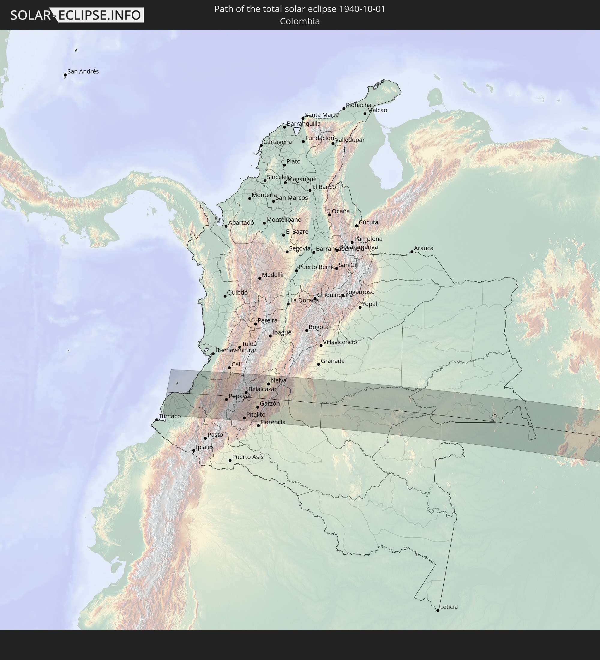 Colombia
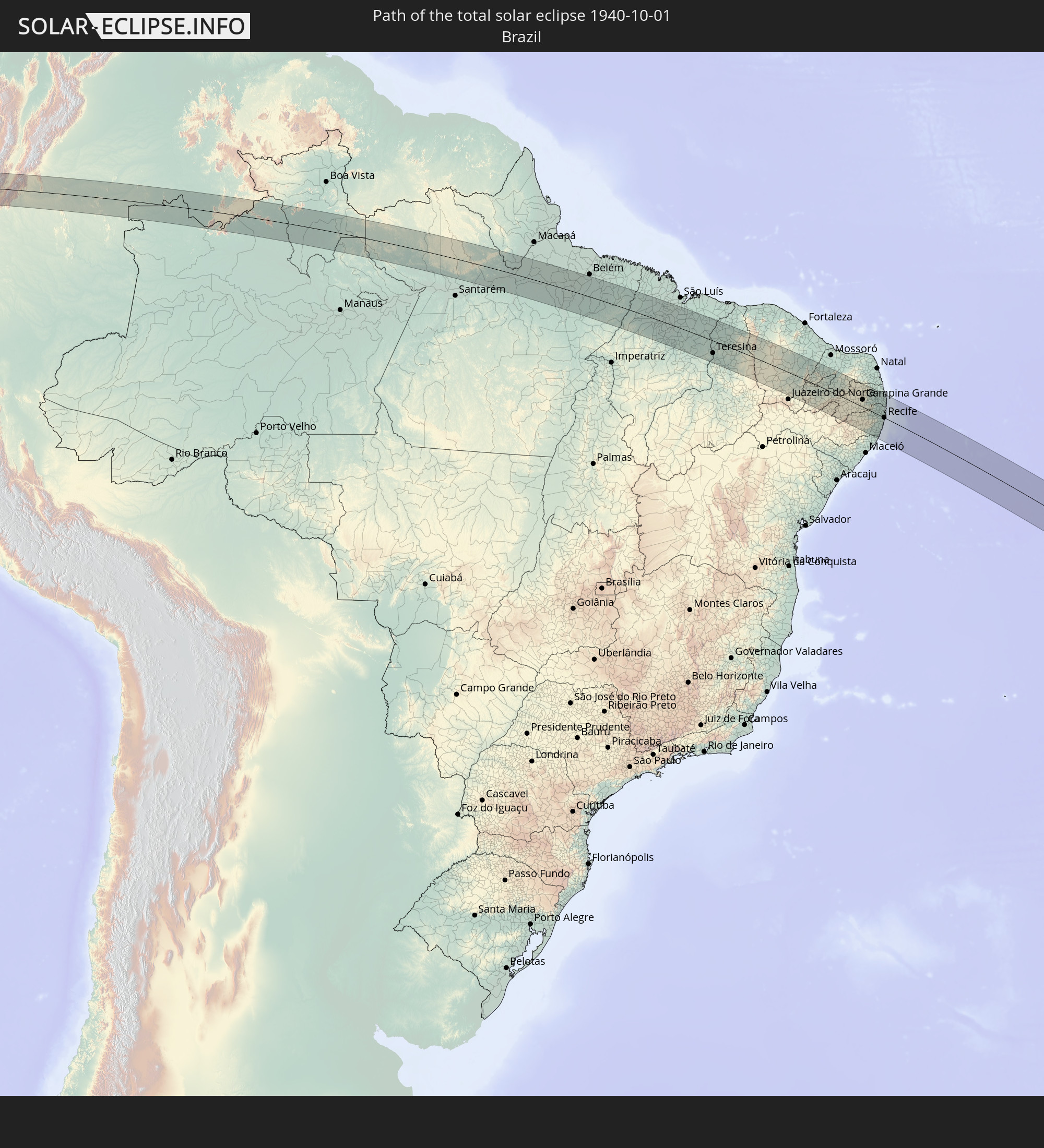 Brazil
 Venezuela
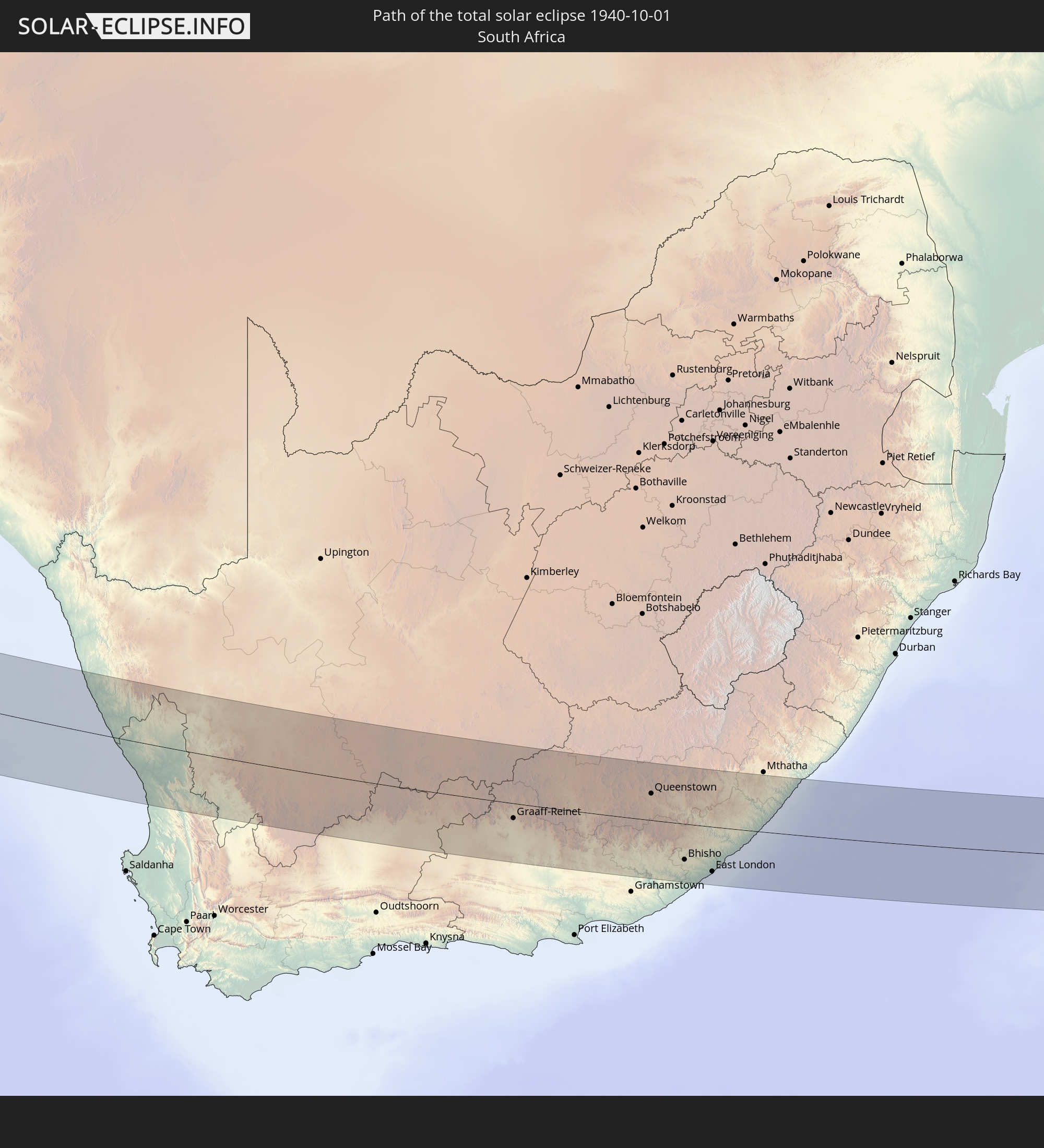 South Africa
In den folgenden Ländern ist die Sonnenfinsternis partiell zu sehen
 Antarctica
 United States Minor Outlying Islands
 Chile
Chile
 Ecuador
 Cuba
Cuba
 Panama
 Colombia
 Peru
Peru
 The Bahamas
 Jamaica
 Haiti
Haiti
 Brazil
 Argentina
 Venezuela
 Turks and Caicos Islands
 Dominican Republic
 Aruba
Aruba
 Bolivia
 Puerto Rico
 United States Virgin Islands
 Bermuda
 British Virgin Islands
 Anguilla
 Collectivity of Saint Martin
 Saint Barthélemy
 Saint Kitts and Nevis
 Paraguay
 Antigua and Barbuda
 Montserrat
 Trinidad and Tobago
 Guadeloupe
 Grenada
 Dominica
 Saint Vincent and the Grenadines
 Guyana
 Martinique
 Saint Lucia
 Barbados
 Uruguay
 Suriname
 French Guiana
 South Georgia and the South Sandwich Islands
 Cabo Verde
 Senegal
 Mauritania
 The Gambia
 Guinea-Bissau
 Guinea
 Saint Helena, Ascension and Tristan da Cunha
 Sierra Leone
 Mali
Mali
 Liberia
 Ivory Coast
 Burkina Faso
 Ghana
Ghana
 Togo
Togo
 Benin
Benin
 Nigeria
 Bouvet Island
 Equatorial Guinea
 São Tomé and Príncipe
 Cameroon
 Gabon
Gabon
 Republic of the Congo
 Angola
 Namibia
 Democratic Republic of the Congo
 South Africa
 Botswana
 Zambia
 Zimbabwe
 Lesotho
 Rwanda
 Burundi
 Tanzania
 Uganda
 Mozambique
 Swaziland
 Malawi
 Kenya
Kenya
 French Southern and Antarctic Lands
 Madagascar
 Comoros
 Mayotte
 Seychelles
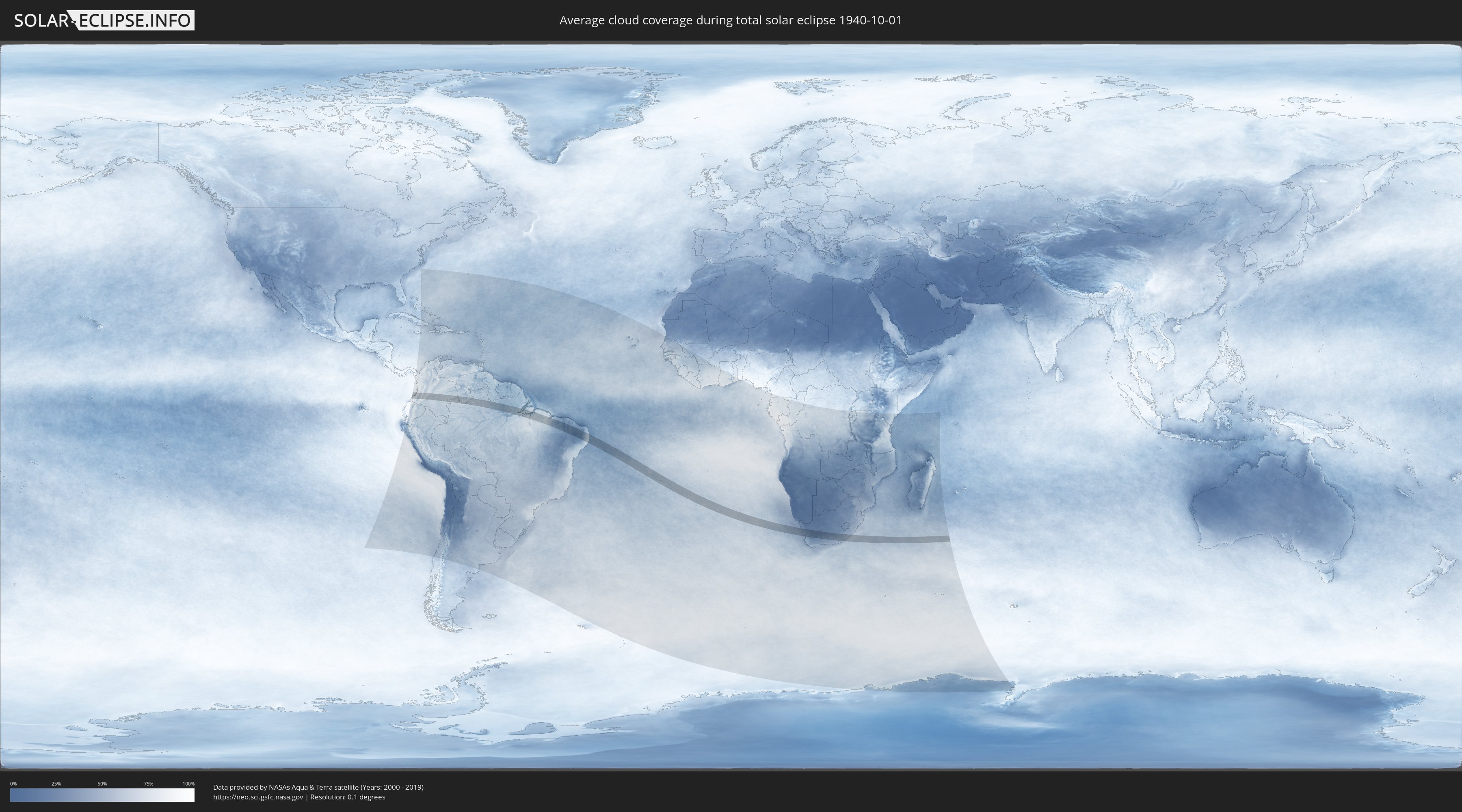
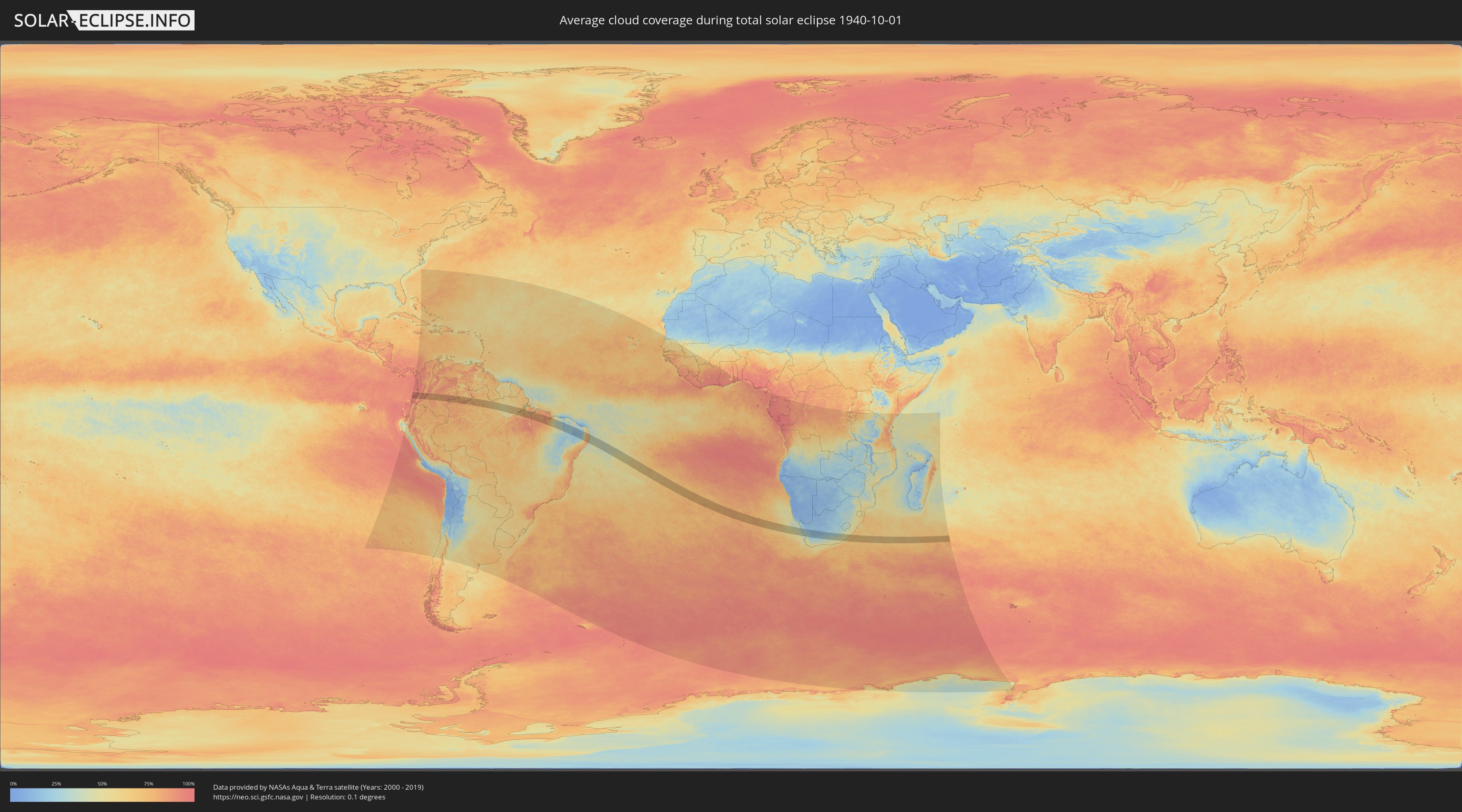
How will be the weather during the total solar eclipse on 10/01/1940?
Where is the best place to see the total solar eclipse of 10/01/1940?
The following maps show the average cloud coverage for the day of the total solar eclipse.
With the help of these maps, it is possible to find the place along the eclipse path, which has the best
chance of a cloudless sky.
Nevertheless, you should consider local circumstances and inform about the weather of your chosen
observation site.
The data is provided by NASAs satellites
AQUA and TERRA.
The cloud maps are averaged over a period of 19 years (2000 - 2019).
Detailed country maps
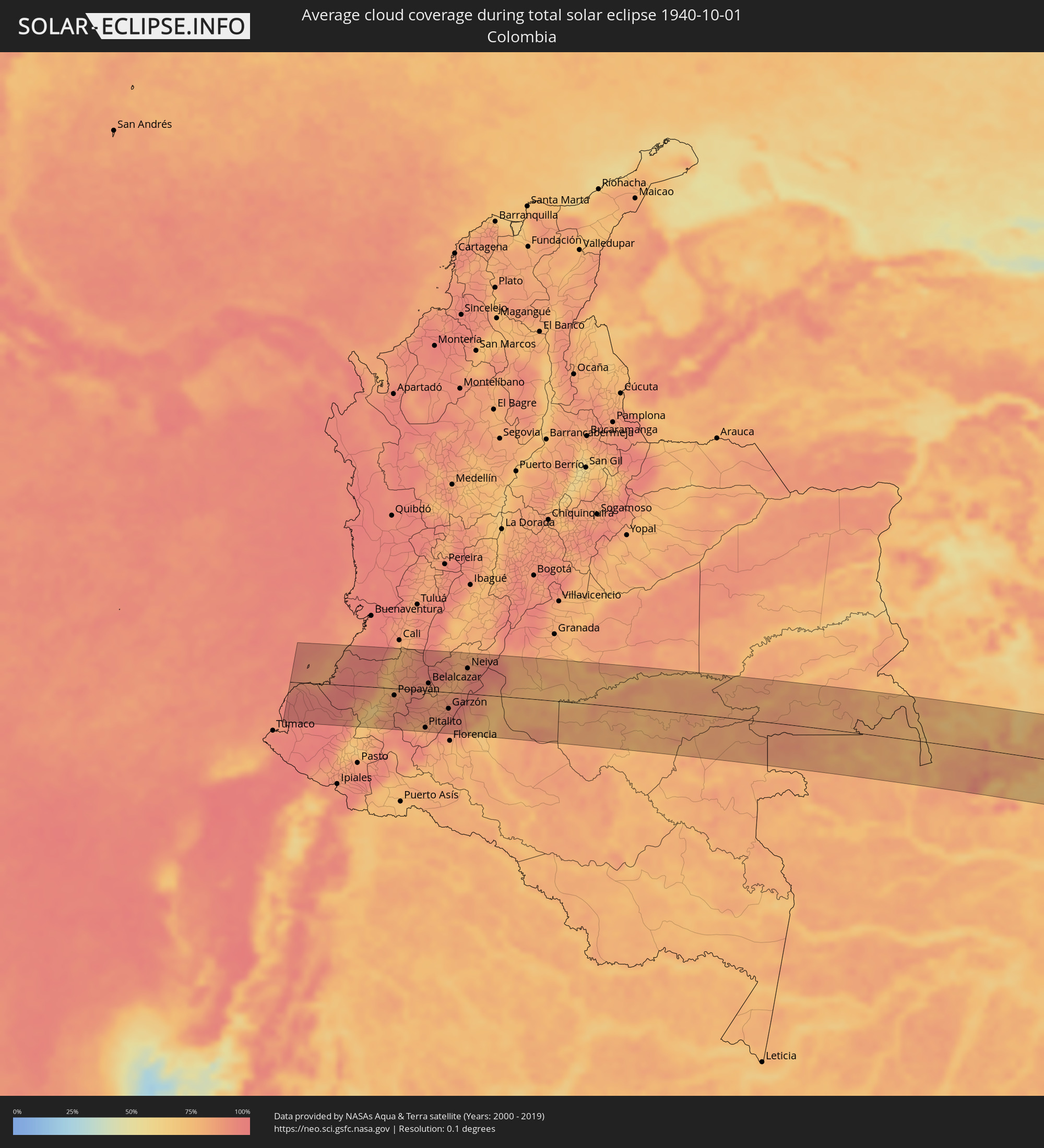 Colombia
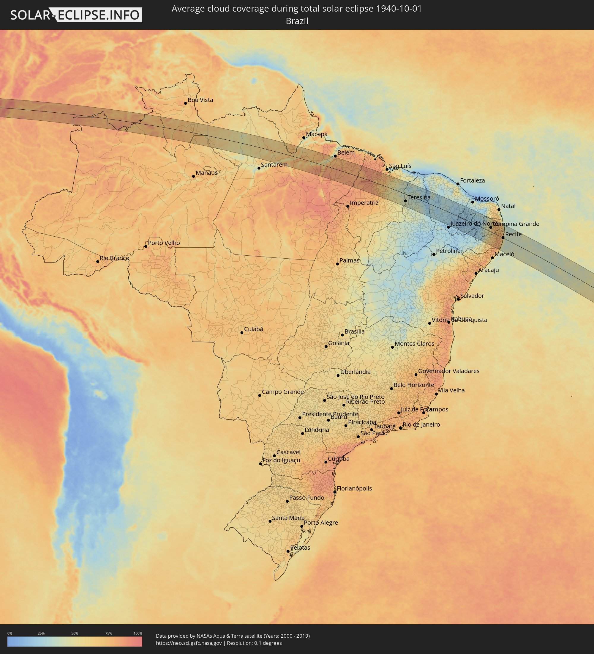 Brazil
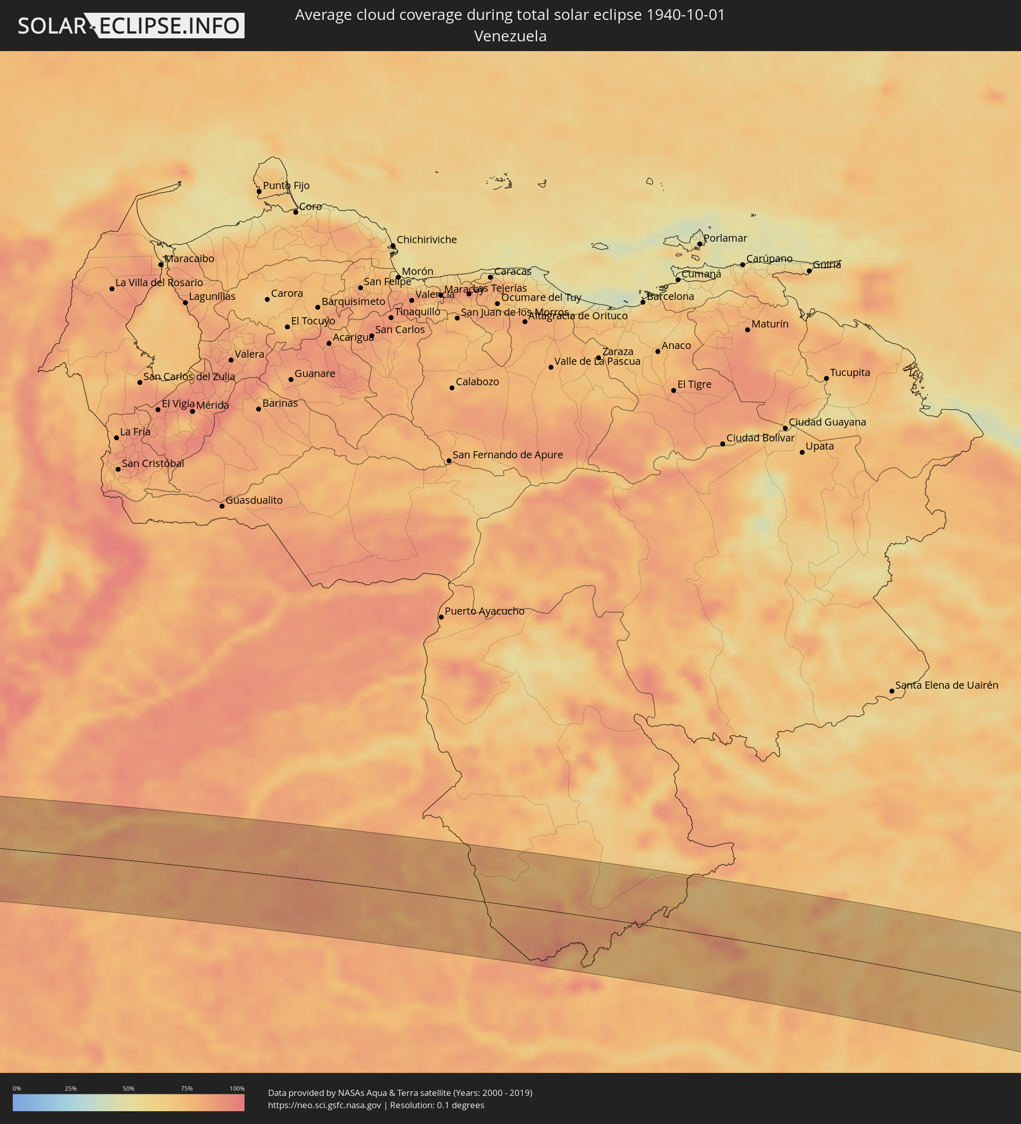 Venezuela
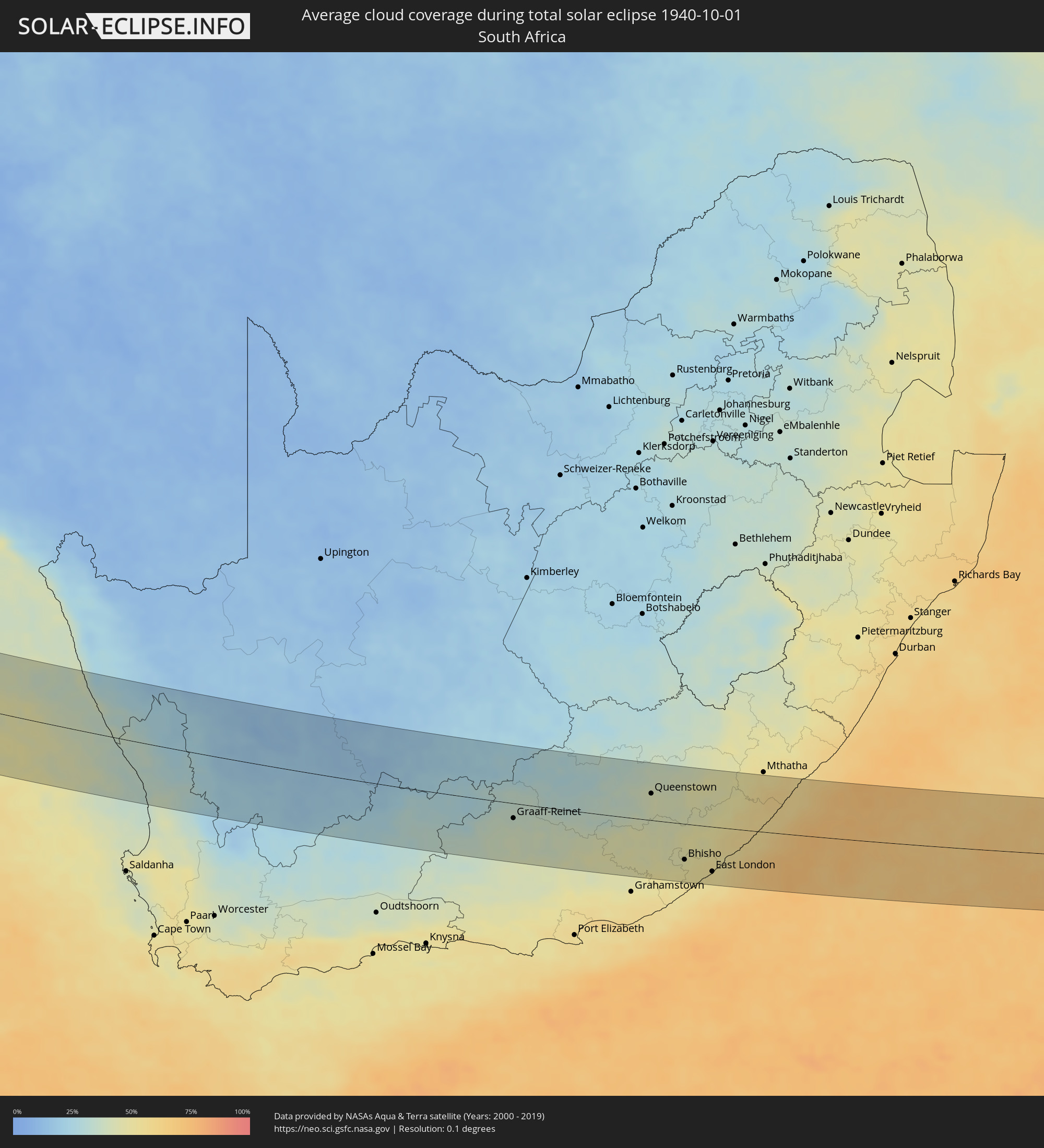 South Africa
Cities inside the path of the eclipse
The following table shows all locations with a population of more than 5,000 inside the eclipse path. Cities which have more than 100,000 inhabitants are marked bold. A click at the locations opens a detailed map.
| City | Type | Eclipse duration | Local time of max. eclipse | Distance to central line | Ø Cloud coverage |
|
El Charco, Nariño
|
total | - | 06:04:26 UTC-05:00 | 20 km | 94% |
|
Guapi, Cauca
|
total | - | 06:04:23 UTC-05:00 | 8 km | 90% |
|
Timbiquí, Cauca
|
total | - | 06:04:17 UTC-05:00 | 15 km | 92% |
|
Balboa, Cauca
|
total | - | 06:04:39 UTC-05:00 | 63 km | 68% |
|
Patía, Cauca
|
total | - | 06:04:39 UTC-05:00 | 58 km | 69% |
|
El Bordo, Cauca
|
total | - | 06:04:37 UTC-05:00 | 52 km | 74% |
|
Villa Rica, Cauca
|
total | - | 06:04:25 UTC-05:00 | 7 km | 76% |
|
El Tambo, Cauca
|
total | - | 06:04:27 UTC-05:00 | 14 km | 76% |
|
Suárez, Cauca
|
total | - | 06:04:12 UTC-05:00 | 43 km | 76% |
|
Morales, Cauca
|
total | - | 06:04:18 UTC-05:00 | 21 km | 82% |
|
Popayán, Cauca
|
total | - | 06:04:28 UTC-05:00 | 14 km | 88% |
|
Jamundí, Valle del Cauca
|
total | - | 06:04:03 UTC-05:00 | 78 km | 77% |
|
Santander de Quilichao, Cauca
|
total | - | 06:04:10 UTC-05:00 | 50 km | 83% |
|
Puerto Tejada, Cauca
|
total | - | 06:04:04 UTC-05:00 | 76 km | 82% |
|
Caloto, Cauca
|
total | - | 06:04:10 UTC-05:00 | 54 km | 86% |
|
Silvia, Cauca
|
total | - | 06:04:23 UTC-05:00 | 8 km | 86% |
|
San Agustín, Huila
|
total | - | 06:04:46 UTC-05:00 | 73 km | 81% |
|
Corinto, Cauca
|
total | - | 06:04:06 UTC-05:00 | 70 km | 84% |
|
Isnos, Huila
|
total | - | 06:04:44 UTC-05:00 | 67 km | 79% |
|
Miranda, Cauca
|
total | - | 06:04:04 UTC-05:00 | 79 km | 90% |
|
Pitalito, Huila
|
total | - | 06:04:48 UTC-05:00 | 75 km | 81% |
|
Belalcazar, Cauca
|
total | - | 06:04:22 UTC-05:00 | 15 km | 86% |
|
Timaná, Huila
|
total | - | 06:04:44 UTC-05:00 | 60 km | 84% |
|
La Plata, Huila
|
total | - | 06:04:31 UTC-05:00 | 13 km | 85% |
|
Planadas, Tolima
|
total | - | 06:04:07 UTC-05:00 | 78 km | 87% |
|
Garzón, Huila
|
total | - | 06:04:38 UTC-05:00 | 33 km | 92% |
|
Gigante, Huila
|
total | - | 06:04:32 UTC-05:00 | 11 km | 93% |
|
Yaguará, Huila
|
total | - | 06:04:24 UTC-05:00 | 20 km | 81% |
|
Palermo, Huila
|
total | - | 06:04:17 UTC-05:00 | 46 km | 82% |
|
Campoalegre, Huila
|
total | - | 06:04:24 UTC-05:00 | 24 km | 89% |
|
Algeciras, Huila
|
total | - | 06:04:29 UTC-05:00 | 6 km | 91% |
|
Neiva, Huila
|
total | - | 06:04:16 UTC-05:00 | 51 km | 86% |
|
Rivera, Huila
|
total | - | 06:04:21 UTC-05:00 | 35 km | 89% |
|
Puerto Rico, Caquetá
|
total | - | 06:04:49 UTC-05:00 | 60 km | 71% |
|
Puerto Lleras, Meta
|
total | - | 06:04:24 UTC-05:00 | 79 km | 80% |
|
Puerto Yuca, Meta
|
total | - | 06:04:28 UTC-05:00 | 71 km | 76% |
|
San José del Guaviare, Guaviare
|
total | - | 06:04:44 UTC-05:00 | 37 km | 77% |
|
Mitú, Vaupés
|
total | - | 06:05:59 UTC-05:00 | 82 km | 79% |
|
Breves, Pará
|
total | - | 08:20:49 UTC-03:00 | 21 km | 63% |
|
Cametá, Pará
|
total | - | 08:22:27 UTC-03:00 | 7 km | 65% |
|
Igarapé Miri, Pará
|
total | - | 08:22:47 UTC-03:00 | 39 km | 77% |
|
Abaetetuba, Pará
|
total | - | 08:22:37 UTC-03:00 | 69 km | 71% |
|
Barcarena, Pará
|
total | - | 08:22:41 UTC-03:00 | 100 km | 73% |
|
Tomé Açu, Pará
|
total | - | 08:24:11 UTC-03:00 | 19 km | 86% |
|
Paragominas, Pará
|
total | - | 08:25:35 UTC-03:00 | 16 km | 84% |
|
Santa Inês, Maranhão
|
total | - | 08:29:04 UTC-03:00 | 13 km | 82% |
|
Lago da Pedra, Maranhão
|
total | - | 08:29:58 UTC-03:00 | 72 km | 80% |
|
Viana, Maranhão
|
total | - | 08:29:03 UTC-03:00 | 48 km | 81% |
|
Bacabal, Maranhão
|
total | - | 08:30:35 UTC-03:00 | 55 km | 69% |
|
São Mateus do Maranhão, Maranhão
|
total | - | 08:30:44 UTC-03:00 | 17 km | 67% |
|
Itapecuru Mirim, Maranhão
|
total | - | 08:30:08 UTC-03:00 | 55 km | 69% |
|
Coroatá, Maranhão
|
total | - | 08:31:19 UTC-03:00 | 13 km | 52% |
|
Codó, Maranhão
|
total | - | 08:32:03 UTC-03:00 | 37 km | 50% |
|
Chapadinha, Maranhão
|
total | - | 08:31:57 UTC-03:00 | 58 km | 45% |
|
Caxias, Maranhão
|
total | - | 08:33:18 UTC-03:00 | 58 km | 50% |
|
Coelho Neto, Maranhão
|
total | - | 08:33:04 UTC-03:00 | 18 km | 38% |
|
Teresina, Piauí
|
total | - | 08:34:24 UTC-03:00 | 59 km | 41% |
|
Altos, Piauí
|
total | - | 08:34:51 UTC-03:00 | 40 km | 37% |
|
Campo Maior, Piauí
|
total | - | 08:35:01 UTC-03:00 | 6 km | 34% |
|
Piripiri, Piauí
|
total | - | 08:34:56 UTC-03:00 | 67 km | 38% |
|
Pedro II, Piauí
|
total | - | 08:35:36 UTC-03:00 | 65 km | 26% |
|
Crateús, Ceará
|
total | - | 08:37:46 UTC-03:00 | 21 km | 26% |
|
Nova Russas, Ceará
|
total | - | 08:37:21 UTC-03:00 | 74 km | 32% |
|
Várzea Alegre, Ceará
|
total | - | 08:38:28 UTC-03:00 | 16 km | 24% |
|
São João dos Inhamuns, Ceará
|
total | - | 08:39:28 UTC-03:00 | 46 km | 27% |
|
Boa Viagem, Ceará
|
total | - | 08:39:14 UTC-03:00 | 67 km | 29% |
|
Acopiara, Ceará
|
total | - | 08:40:57 UTC-03:00 | 19 km | 25% |
|
Iguatu, Ceará
|
total | - | 08:41:34 UTC-03:00 | 39 km | 25% |
|
Quixeramobim, Ceará
|
total | - | 08:40:02 UTC-03:00 | 80 km | 30% |
|
Icó, Ceará
|
total | - | 08:42:21 UTC-03:00 | 23 km | 19% |
|
Jaguaribe, Ceará
|
total | - | 08:42:04 UTC-03:00 | 40 km | 20% |
|
Cajazeiras, Paraíba
|
total | - | 08:43:32 UTC-03:00 | 59 km | 15% |
|
Sousa, Paraíba
|
total | - | 08:43:55 UTC-03:00 | 30 km | 14% |
|
Pombal, Paraíba
|
total | - | 08:44:41 UTC-03:00 | 12 km | 19% |
|
São Bento, Paraíba
|
total | - | 08:44:06 UTC-03:00 | 40 km | 21% |
|
Afogados da Ingazeira, Pernambuco
|
total | - | 08:46:19 UTC-03:00 | 103 km | 27% |
|
Patos, Paraíba
|
total | - | 08:45:57 UTC-03:00 | 13 km | 14% |
|
Caicó, Rio Grande do Norte
|
total | - | 08:45:29 UTC-03:00 | 53 km | 22% |
|
Currais Novos, Rio Grande do Norte
|
total | - | 08:46:15 UTC-03:00 | 100 km | 31% |
|
Belo Jardim, Pernambuco
|
total | - | 08:49:20 UTC-03:00 | 103 km | 54% |
|
Brejo da Madre de Deus, Pernambuco
|
total | - | 08:49:10 UTC-03:00 | 82 km | 45% |
|
Santa Cruz do Capibaribe, Pernambuco
|
total | - | 08:49:12 UTC-03:00 | 55 km | 51% |
|
Toritama, Pernambuco
|
total | - | 08:49:33 UTC-03:00 | 53 km | 56% |
|
Caruaru, Pernambuco
|
total | - | 08:50:05 UTC-03:00 | 76 km | 66% |
|
Campina Grande, Paraíba
|
total | - | 08:48:46 UTC-03:00 | 33 km | 58% |
|
Bezerros, Pernambuco
|
total | - | 08:50:21 UTC-03:00 | 63 km | 69% |
|
Surubim, Pernambuco
|
total | - | 08:49:51 UTC-03:00 | 21 km | 64% |
|
Palmares, Pernambuco
|
total | - | 08:51:23 UTC-03:00 | 97 km | 78% |
|
Gravatá, Pernambuco
|
total | - | 08:50:44 UTC-03:00 | 48 km | 67% |
|
Guarabira, Paraíba
|
total | - | 08:48:57 UTC-03:00 | 90 km | 75% |
|
Limoeiro, Pernambuco
|
total | - | 08:50:29 UTC-03:00 | 10 km | 78% |
|
Ribeirão, Pernambuco
|
total | - | 08:51:33 UTC-03:00 | 70 km | 78% |
|
Timbaúba, Pernambuco
|
total | - | 08:50:12 UTC-03:00 | 33 km | 78% |
|
Vitória de Santo Antão, Pernambuco
|
total | - | 08:51:08 UTC-03:00 | 26 km | 80% |
|
Carpina, Pernambuco
|
total | - | 08:50:49 UTC-03:00 | 2 km | 76% |
|
Escada, Pernambuco
|
total | - | 08:51:36 UTC-03:00 | 47 km | 81% |
|
Barreiros, Pernambuco
|
total | - | 08:52:21 UTC-03:00 | 91 km | 61% |
|
Sirinhaém, Pernambuco
|
total | - | 08:52:09 UTC-03:00 | 65 km | 55% |
|
Ipojuca, Pernambuco
|
total | - | 08:51:58 UTC-03:00 | 43 km | 74% |
|
São Lourenço da Mata, Pernambuco
|
total | - | 08:51:29 UTC-03:00 | 1 km | 74% |
|
Goiana, Pernambuco
|
total | - | 08:50:52 UTC-03:00 | 43 km | 71% |
|
Jaboatão, Pernambuco
|
total | - | 08:51:46 UTC-03:00 | 18 km | 63% |
|
Igarassu, Pernambuco
|
total | - | 08:51:27 UTC-03:00 | 21 km | 63% |
|
Recife, Pernambuco
|
total | - | 08:51:49 UTC-03:00 | 1 km | 54% |
|
João Pessoa, Paraíba
|
total | - | 08:50:30 UTC-03:00 | 95 km | 60% |
|
Vredendal, Western Cape
|
total | - | 16:05:07 UTC+02:00 | 50 km | 34% |
|
Calvinia, Northern Cape
|
total | - | 16:06:35 UTC+02:00 | 7 km | 19% |
|
Carnarvon, Northern Cape
|
total | - | 16:09:11 UTC+02:00 | 85 km | 20% |
|
Beaufort West, Western Cape
|
total | - | 16:09:19 UTC+02:00 | 61 km | 31% |
|
Graaff-Reinet, Eastern Cape
|
total | - | 16:11:11 UTC+02:00 | 24 km | 37% |
|
Middelburg, Eastern Cape
|
total | - | 16:11:50 UTC+02:00 | 66 km | 27% |
|
Somerset East, Eastern Cape
|
total | - | 16:11:58 UTC+02:00 | 63 km | 43% |
|
Cradock, Eastern Cape
|
total | - | 16:12:10 UTC+02:00 | 1 km | 36% |
|
Adelaide, Eastern Cape
|
total | - | 16:12:34 UTC+02:00 | 53 km | 46% |
|
Fort Beaufort, Eastern Cape
|
total | - | 16:12:50 UTC+02:00 | 57 km | 46% |
|
Whittlesea, Eastern Cape
|
total | - | 16:13:11 UTC+02:00 | 11 km | 41% |
|
Alice, Eastern Cape
|
total | - | 16:12:59 UTC+02:00 | 56 km | 44% |
|
Queenstown, Eastern Cape
|
total | - | 16:13:19 UTC+02:00 | 42 km | 43% |
|
Queensdale, Eastern Cape
|
total | - | 16:13:25 UTC+02:00 | 47 km | 43% |
|
Ilinge, Eastern Cape
|
total | - | 16:13:26 UTC+02:00 | 36 km | 42% |
|
Lady Frere, Eastern Cape
|
total | - | 16:13:41 UTC+02:00 | 68 km | 40% |
|
Stutterheim, Eastern Cape
|
total | - | 16:13:32 UTC+02:00 | 26 km | 47% |
|
Bhisho, Eastern Cape
|
total | - | 16:13:27 UTC+02:00 | 57 km | 46% |
|
East London, Eastern Cape
|
total | - | 16:13:46 UTC+02:00 | 71 km | 53% |
|
Butterworth, Eastern Cape
|
total | - | 16:14:12 UTC+02:00 | 7 km | 52% |