Total solar eclipse of 07/09/1945
| Day of week: | Monday |
| Maximum duration of eclipse: | 01m15s |
| Maximum width of eclipse path: | 92 km |
| Saros cycle: | 145 |
| Coverage: | 100% |
| Magnitude: | 1.018 |
| Gamma: | 0.7356 |
Wo kann man die Sonnenfinsternis vom 07/09/1945 sehen?
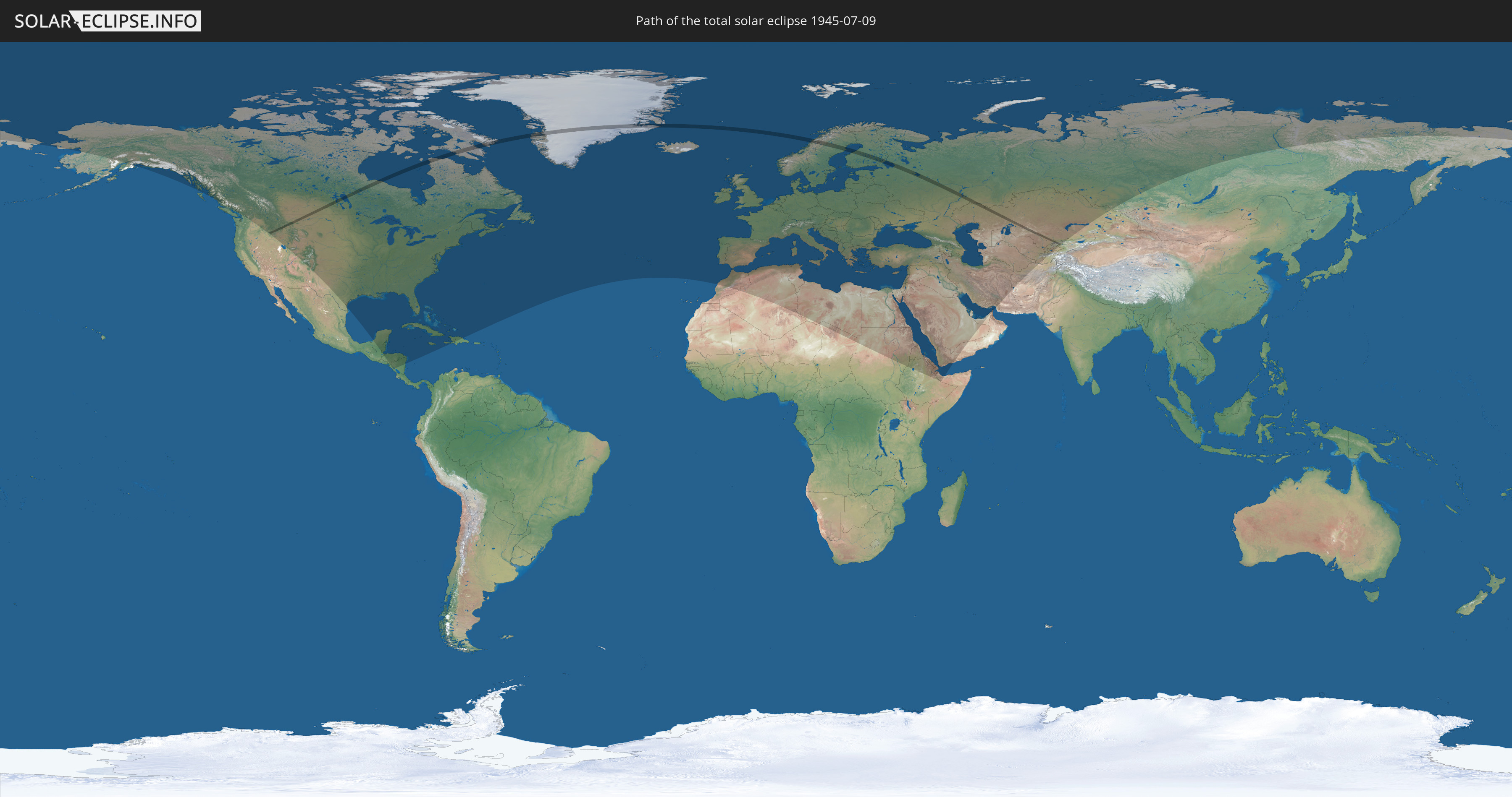
Die Sonnenfinsternis am 07/09/1945 kann man in 106 Ländern als partielle Sonnenfinsternis beobachten.
Der Finsternispfad verläuft durch 10 Länder. Nur in diesen Ländern ist sie als total Sonnenfinsternis zu sehen.
In den folgenden Ländern ist die Sonnenfinsternis total zu sehen
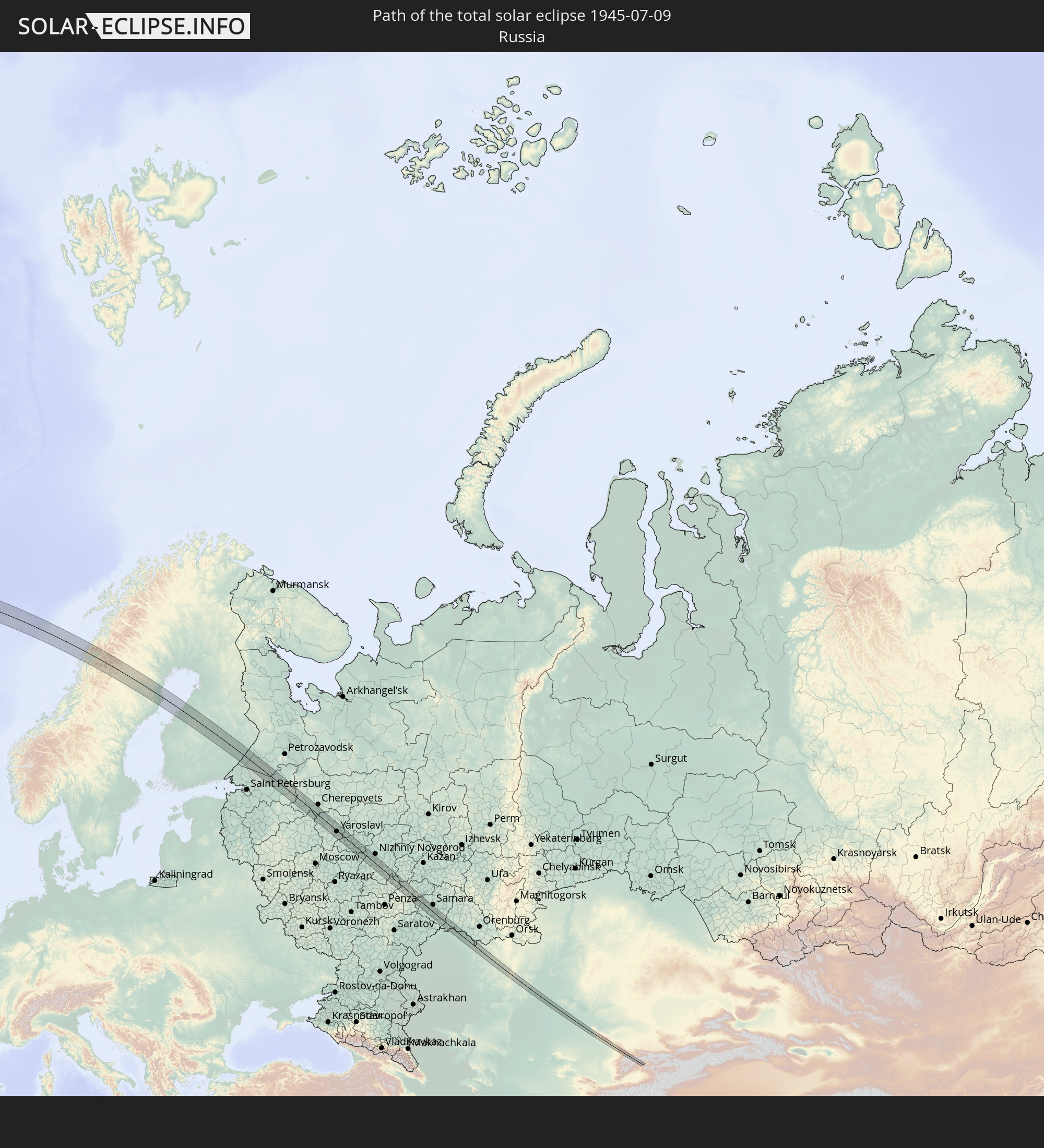 Russia
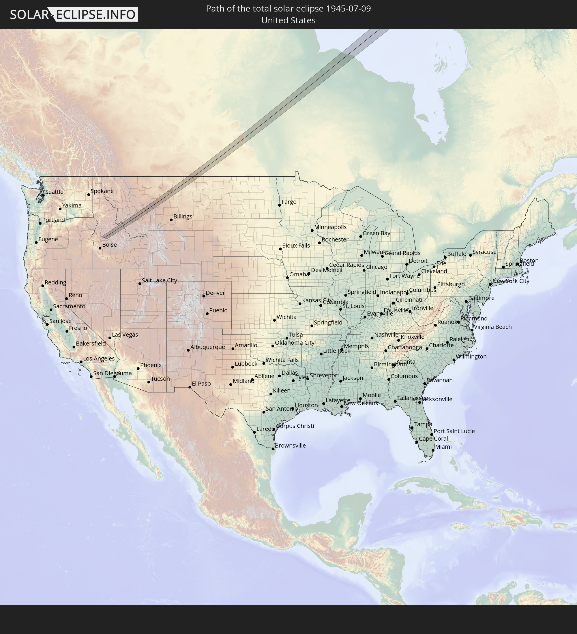 United States
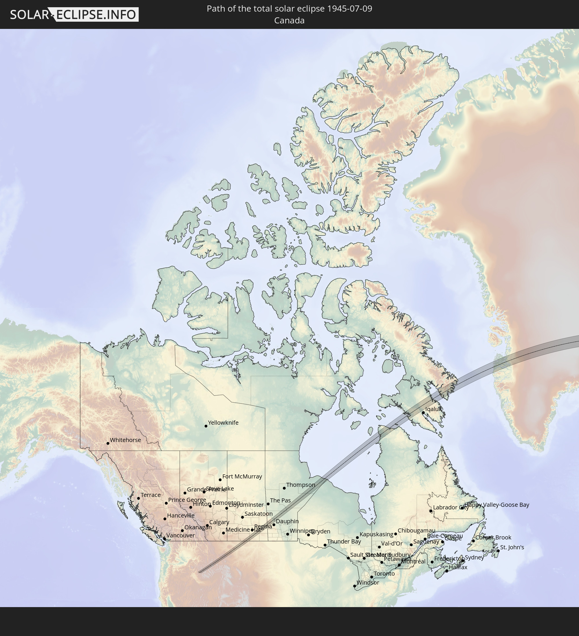 Canada
 Greenland
 Norway
 Sweden
 Finland
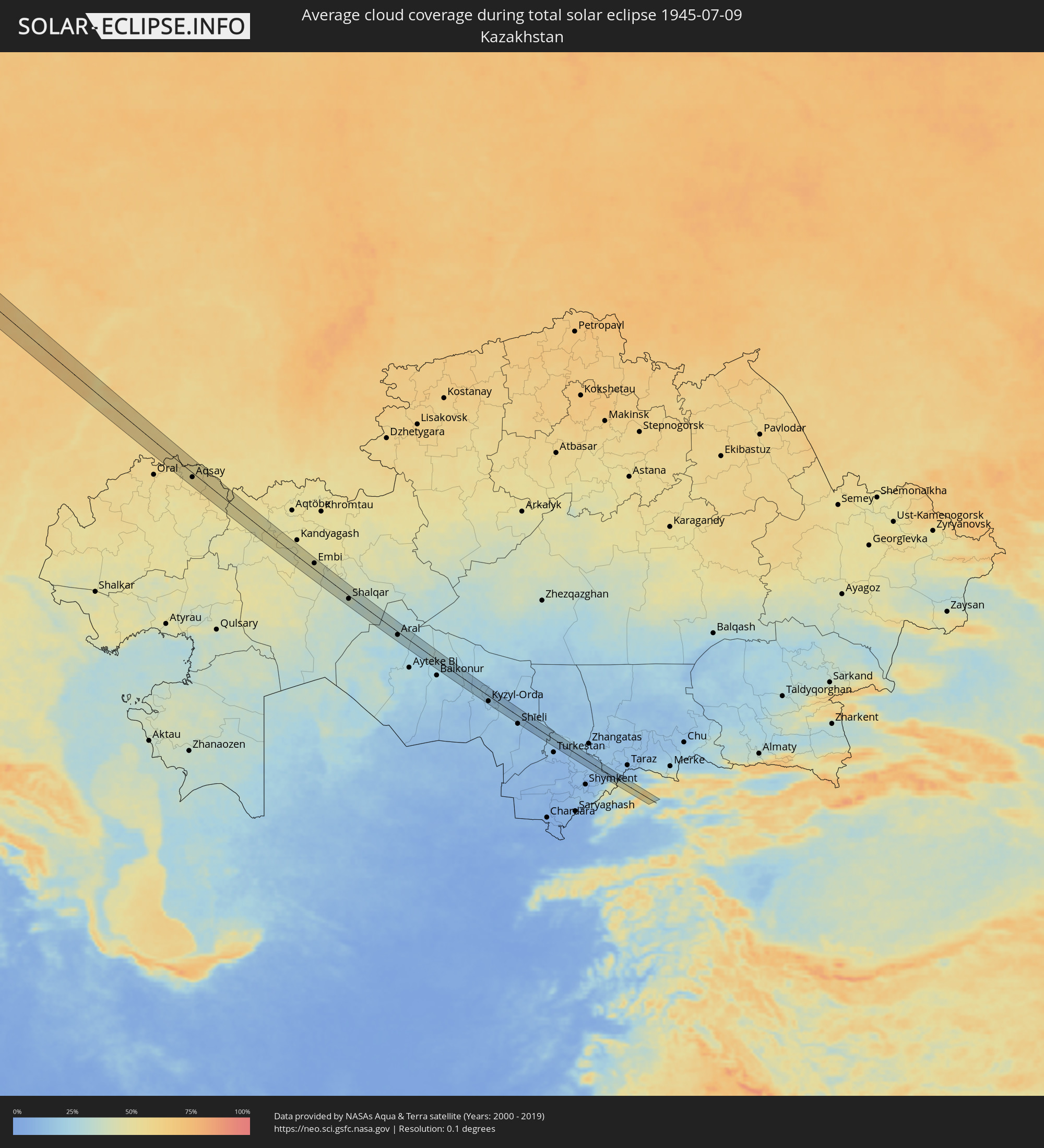
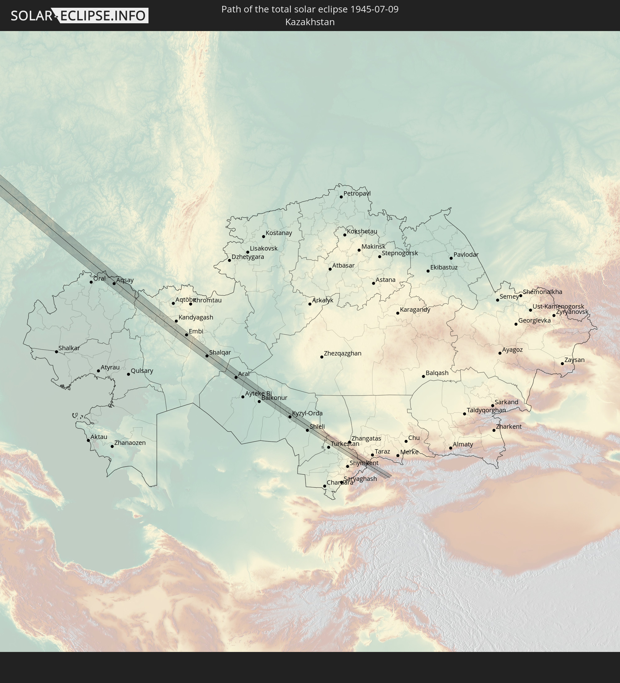 Kazakhstan
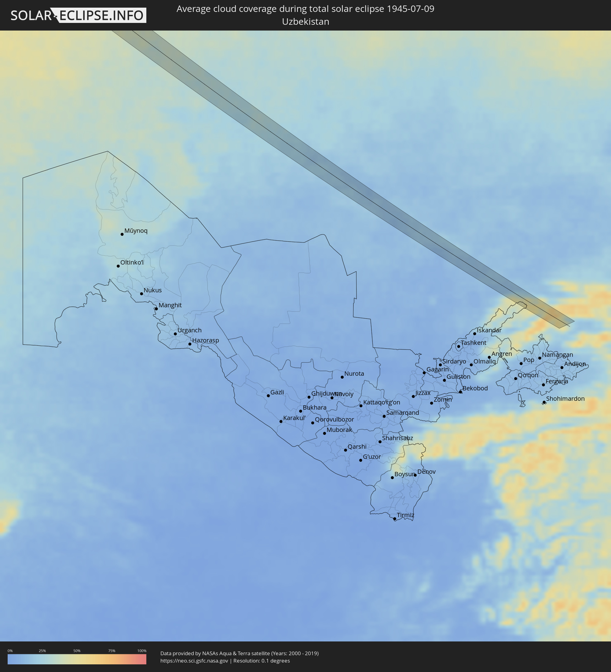
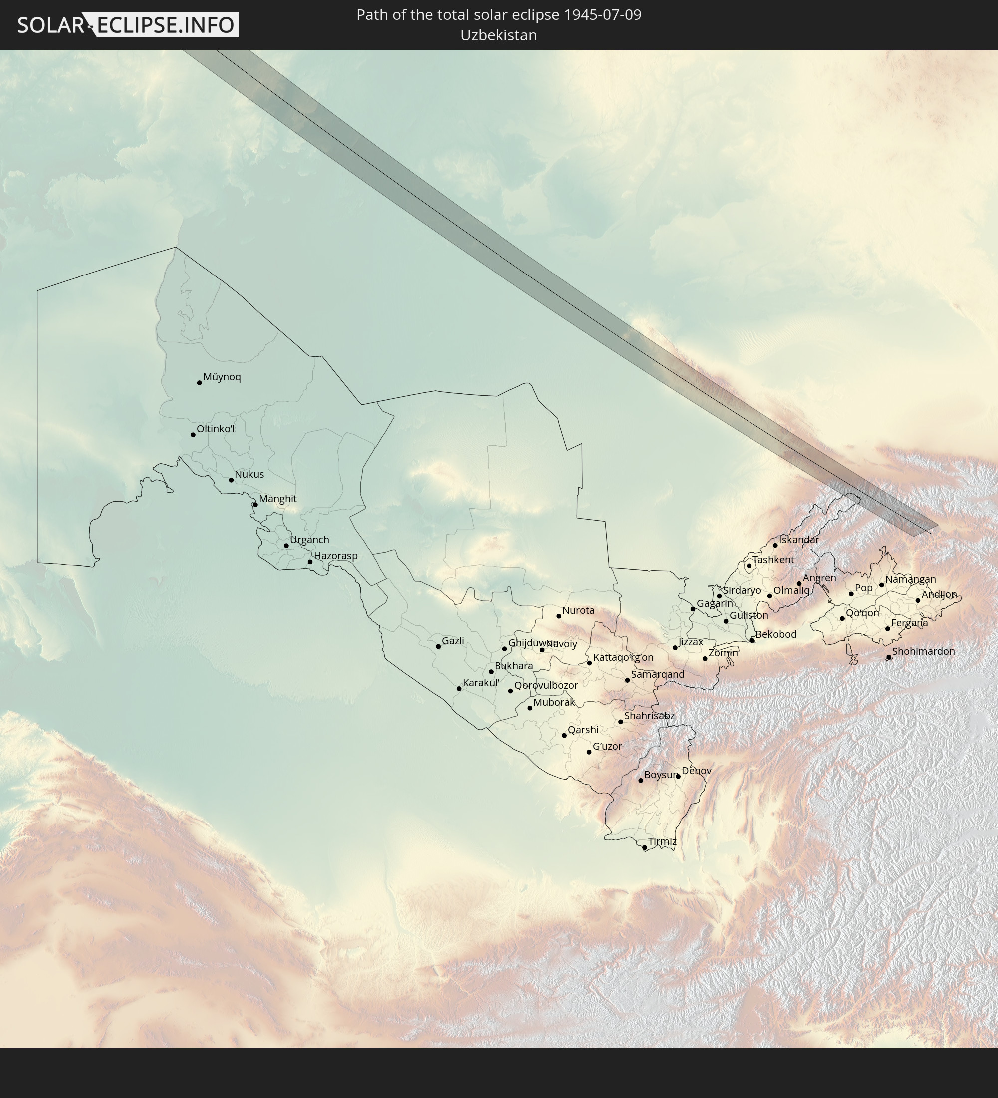 Uzbekistan
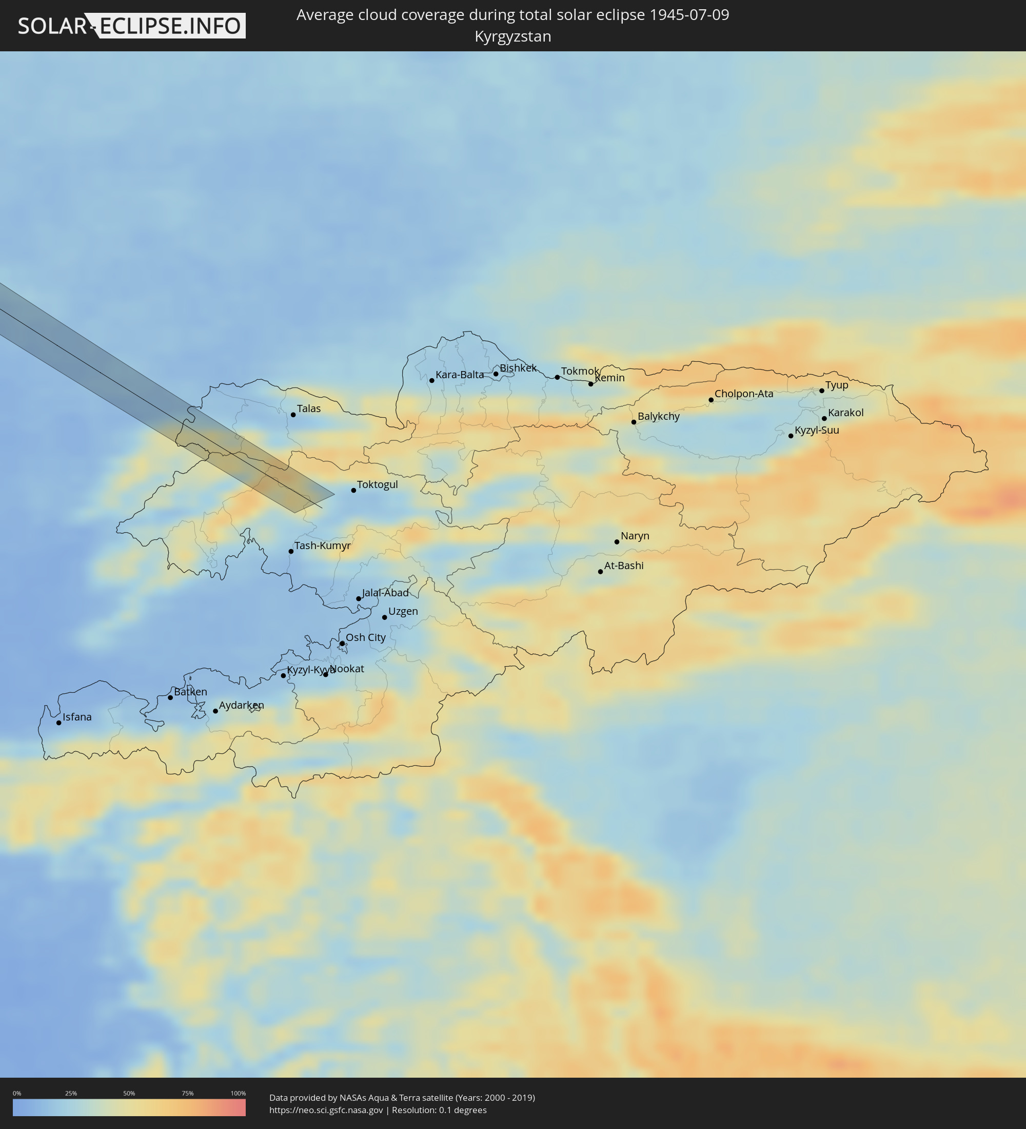
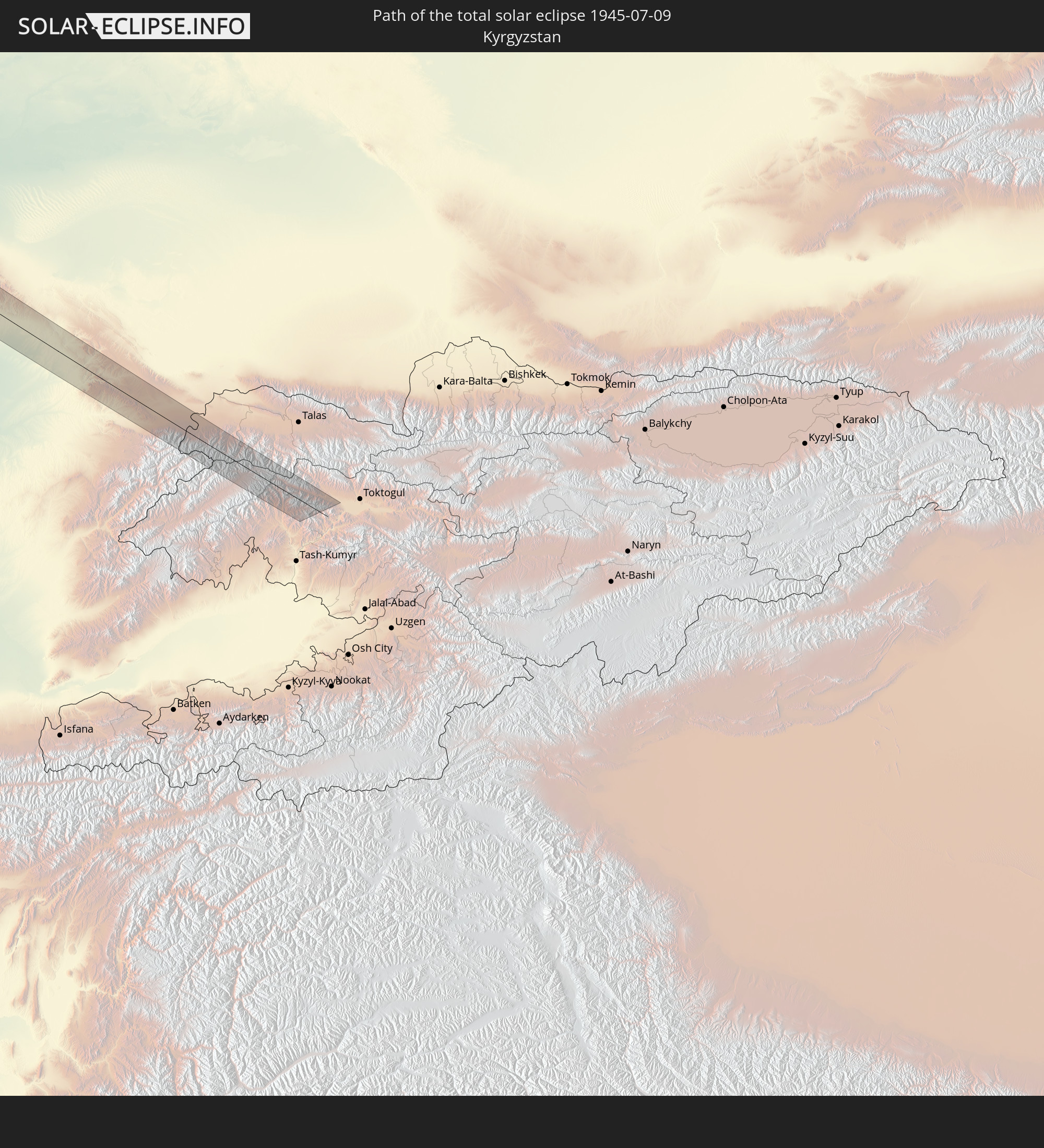 Kyrgyzstan
In den folgenden Ländern ist die Sonnenfinsternis partiell zu sehen
 Russia
 United States
 United States Minor Outlying Islands
 Canada
 Mexico
 Greenland
 Guatemala
 Honduras
 Belize
 Nicaragua
 Cuba
Cuba
 Cayman Islands
 The Bahamas
 Jamaica
 Haiti
Haiti
 Turks and Caicos Islands
 Dominican Republic
 Bermuda
 Saint Pierre and Miquelon
 Portugal
 Iceland
 Spain
Spain
 Morocco
 Republic of Ireland
 Svalbard and Jan Mayen
 Algeria
 United Kingdom
 Faroe Islands
 Gibraltar
 France
 Isle of Man
 Guernsey
 Jersey
 Niger
Niger
 Andorra
 Belgium
 Netherlands
 Norway
 Luxembourg
 Germany
 Switzerland
 Italy
Italy
 Monaco
 Tunisia
 Denmark
 Libya
Libya
 Liechtenstein
 Austria
 Sweden
 Czechia
 San Marino
 Vatican City
 Slovenia
 Chad
Chad
 Croatia
 Poland
 Malta
Malta
 Bosnia and Herzegovina
 Hungary
 Slovakia
 Montenegro
 Serbia
 Albania
 Åland Islands
 Greece
 Romania
 Republic of Macedonia
 Finland
 Lithuania
 Latvia
 Estonia
 Sudan
Sudan
 Ukraine
 Bulgaria
 Belarus
 Egypt
Egypt
 Turkey
 Moldova
 Cyprus
 Ethiopia
 State of Palestine
 Israel
 Saudi Arabia
 Jordan
 Lebanon
 Syria
Syria
 Eritrea
 Iraq
Iraq
 Georgia
 Somalia
 Djibouti
 Yemen
Yemen
 Armenia
 Iran
Iran
 Azerbaijan
 Kazakhstan
 Kuwait
 Bahrain
 Qatar
Qatar
 United Arab Emirates
 Oman
Oman
 Turkmenistan
 Uzbekistan
 Afghanistan
 Tajikistan
 Kyrgyzstan
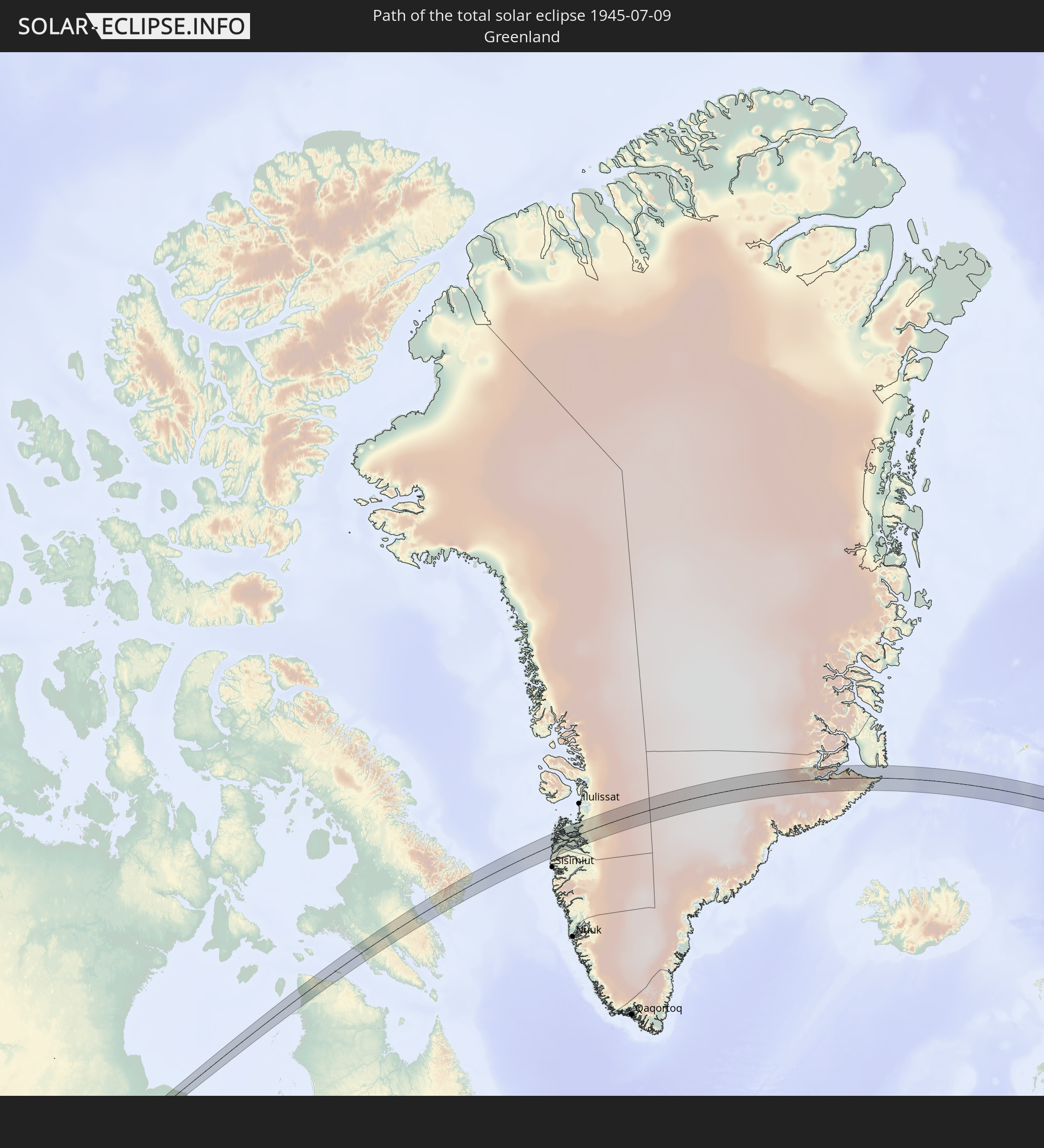
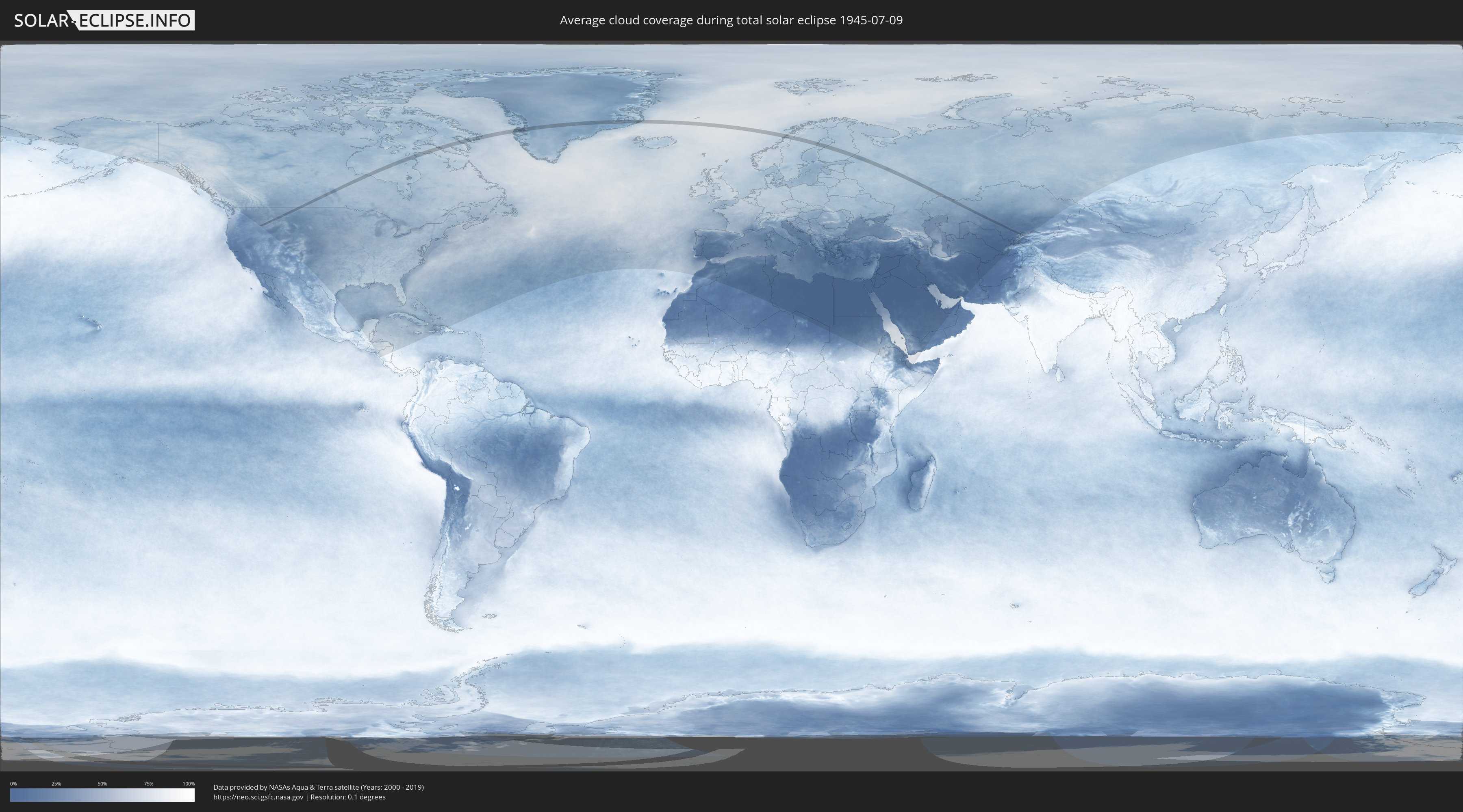
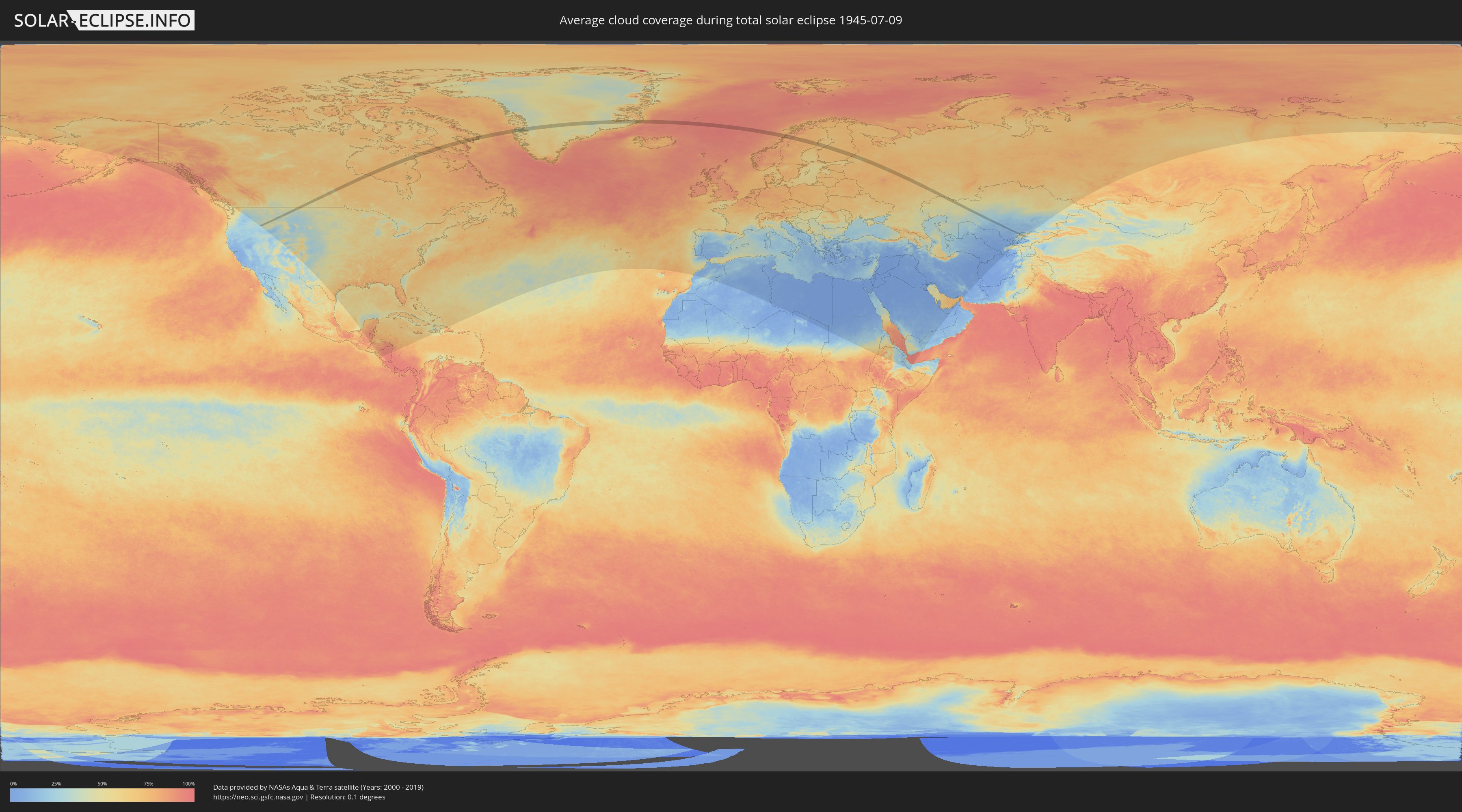
How will be the weather during the total solar eclipse on 07/09/1945?
Where is the best place to see the total solar eclipse of 07/09/1945?
The following maps show the average cloud coverage for the day of the total solar eclipse.
With the help of these maps, it is possible to find the place along the eclipse path, which has the best
chance of a cloudless sky.
Nevertheless, you should consider local circumstances and inform about the weather of your chosen
observation site.
The data is provided by NASAs satellites
AQUA and TERRA.
The cloud maps are averaged over a period of 19 years (2000 - 2019).
Detailed country maps
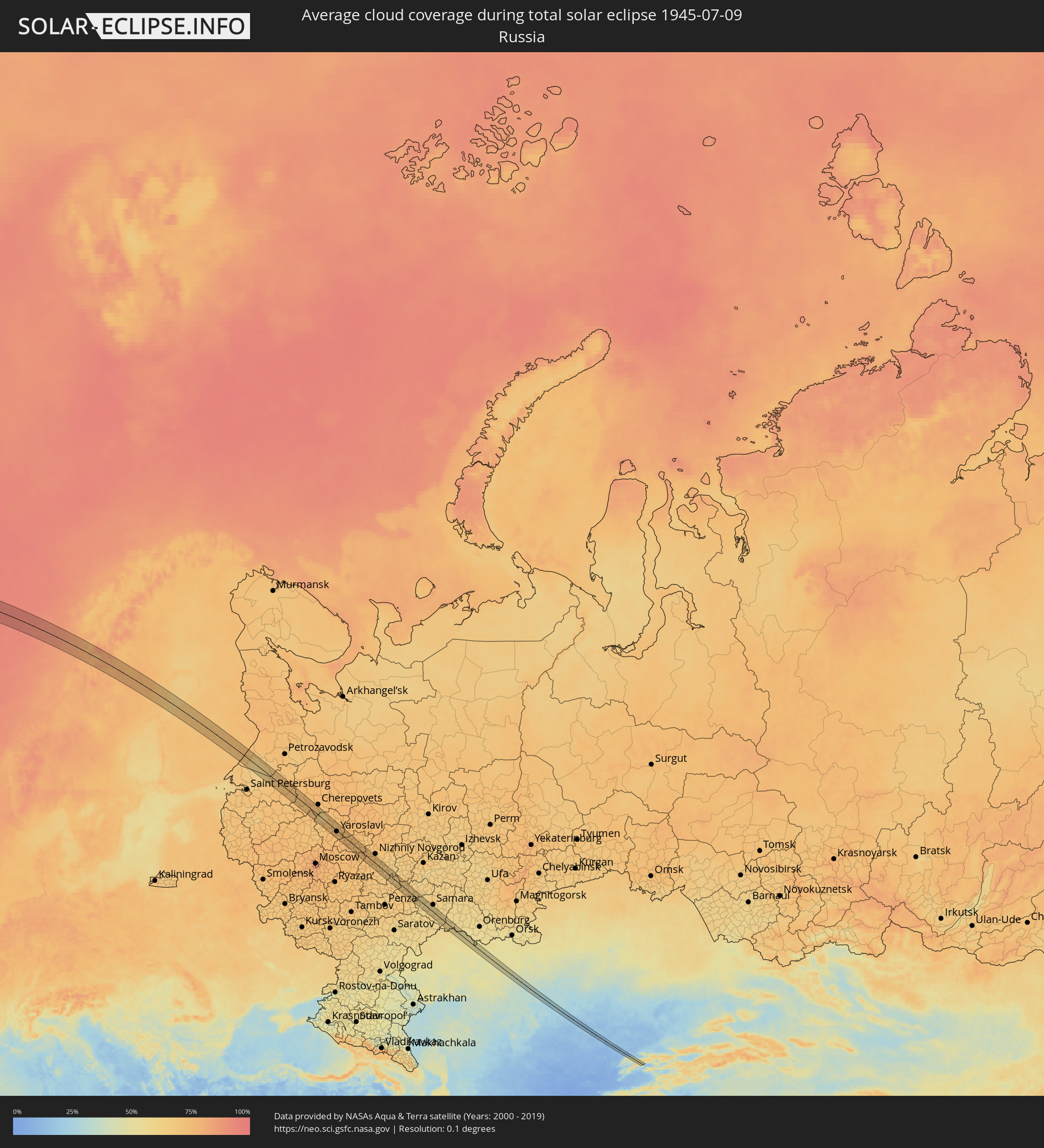 Russia
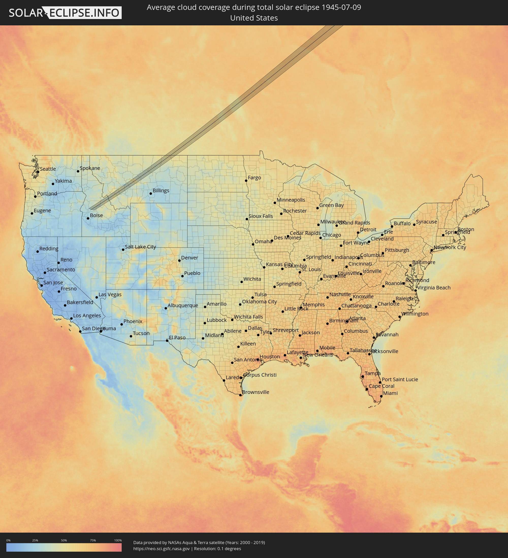 United States
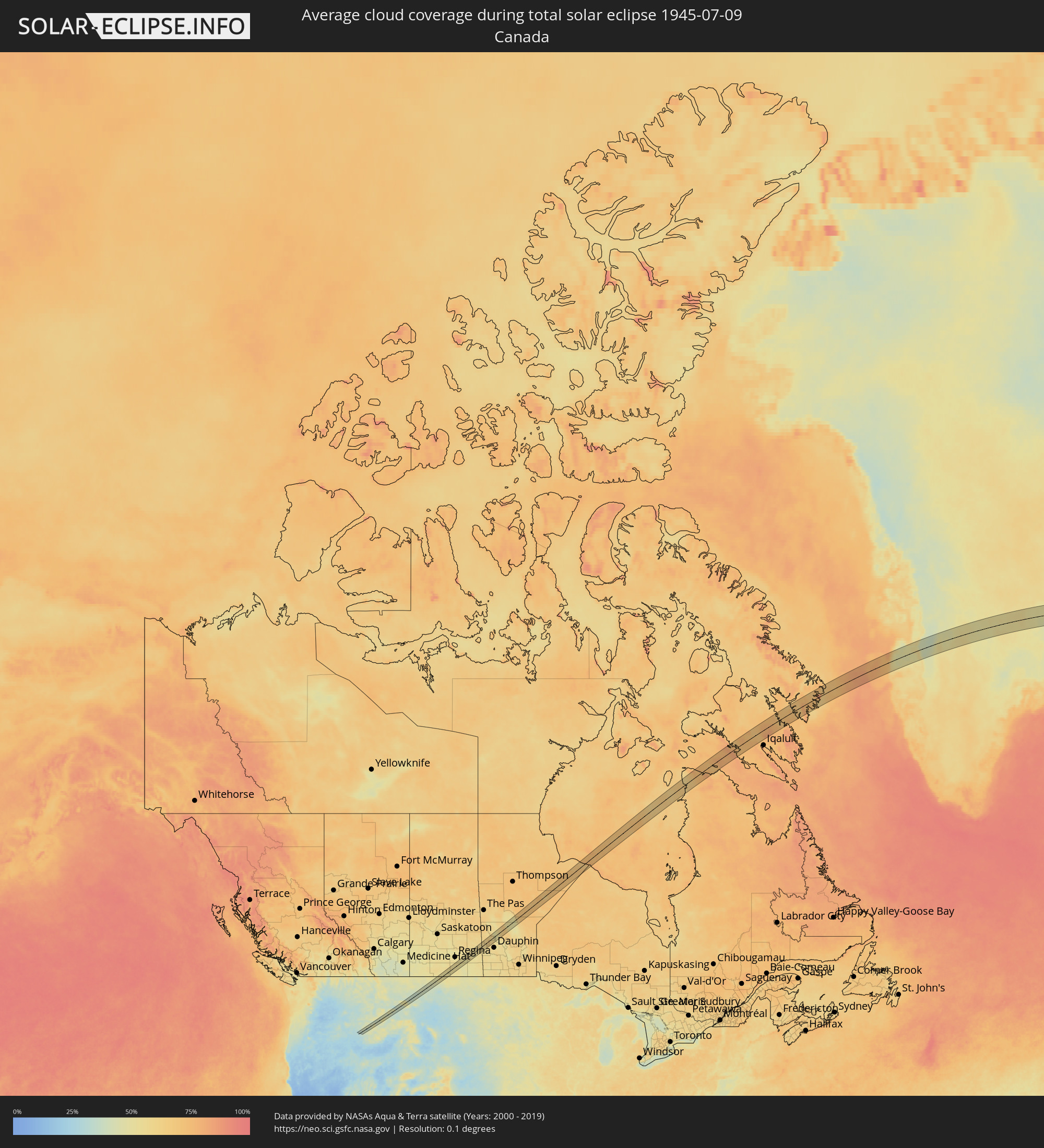 Canada
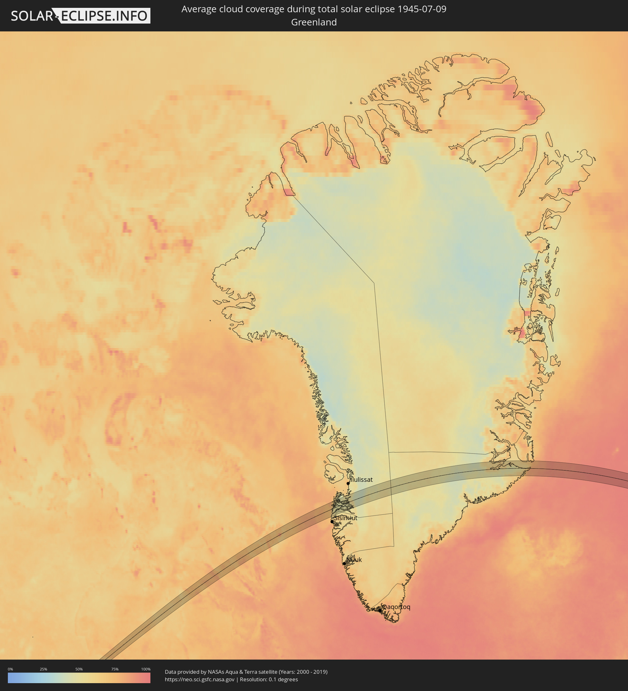 Greenland
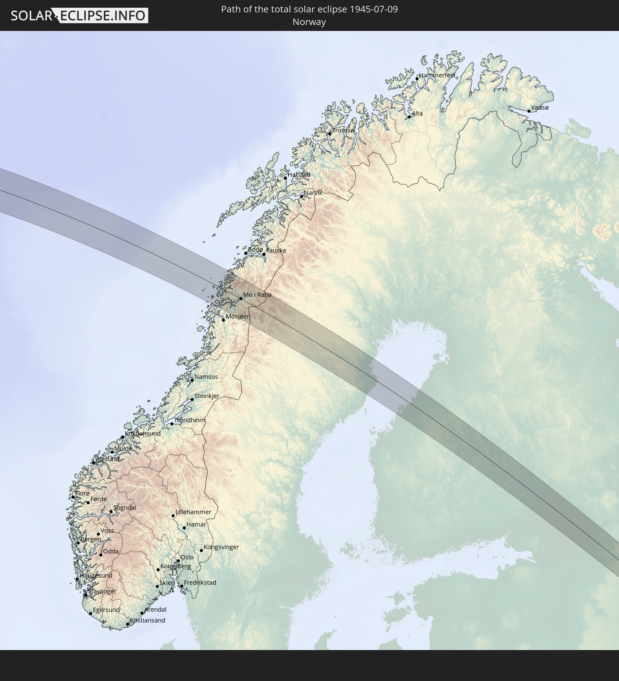
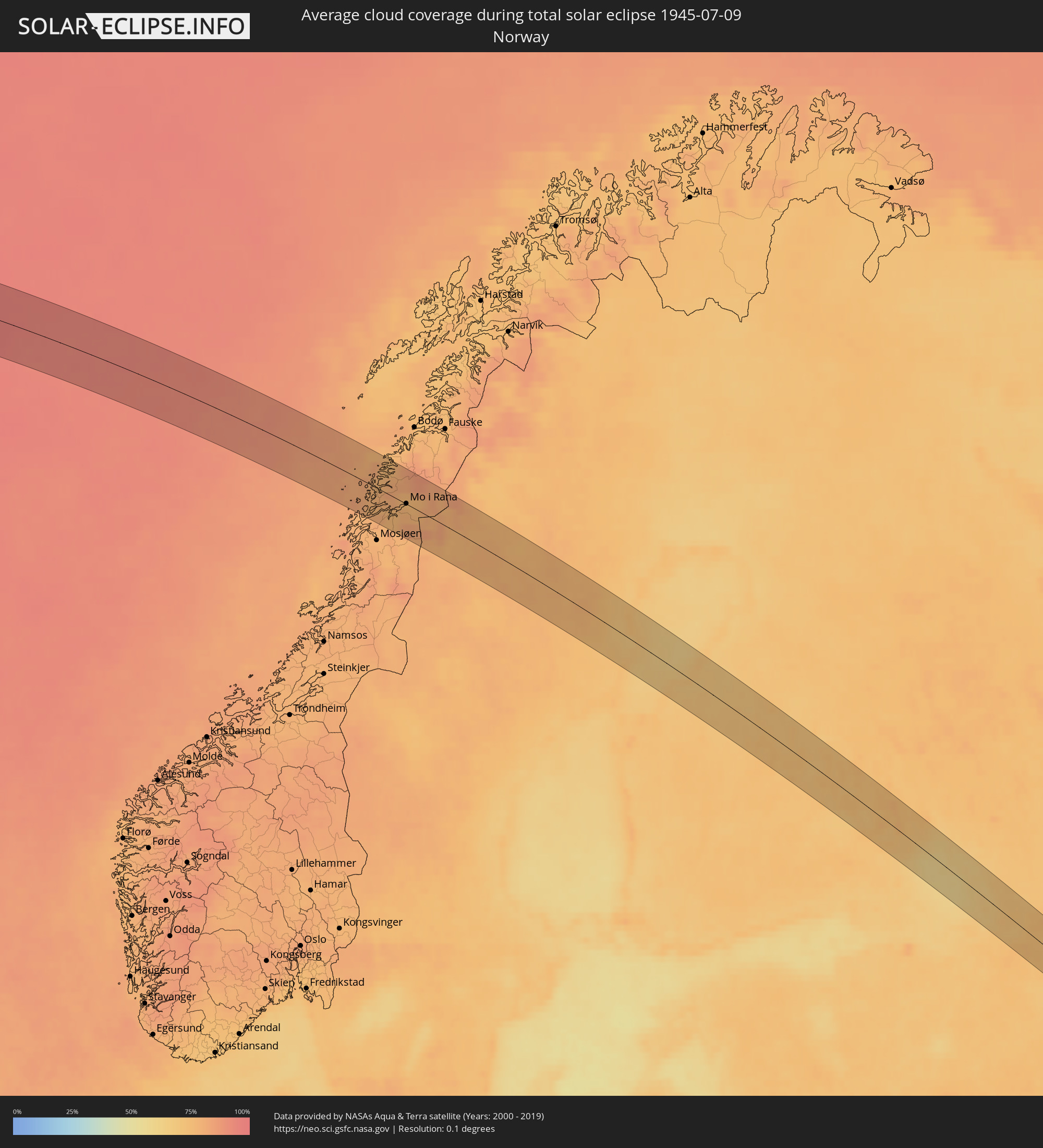 Norway
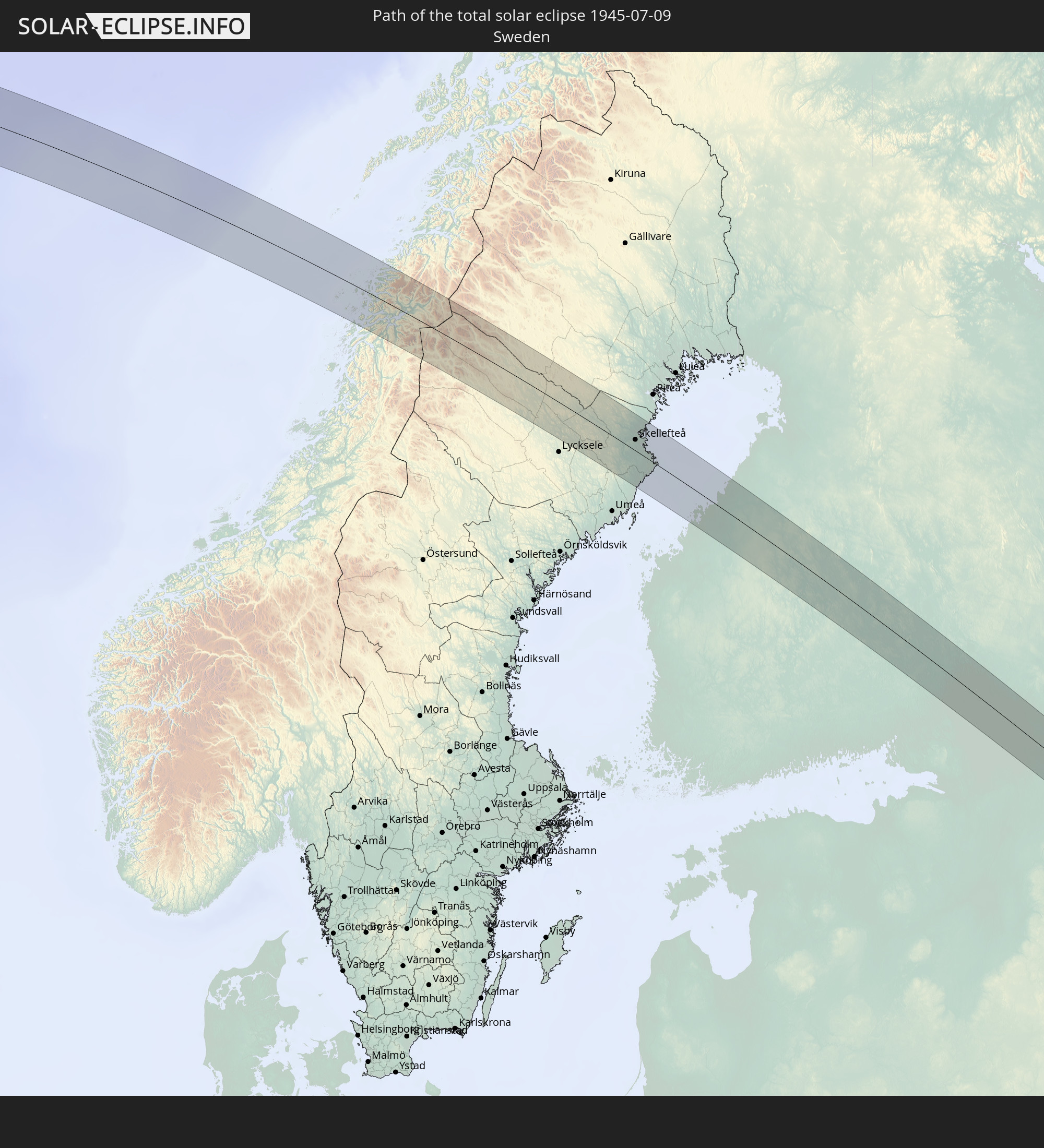
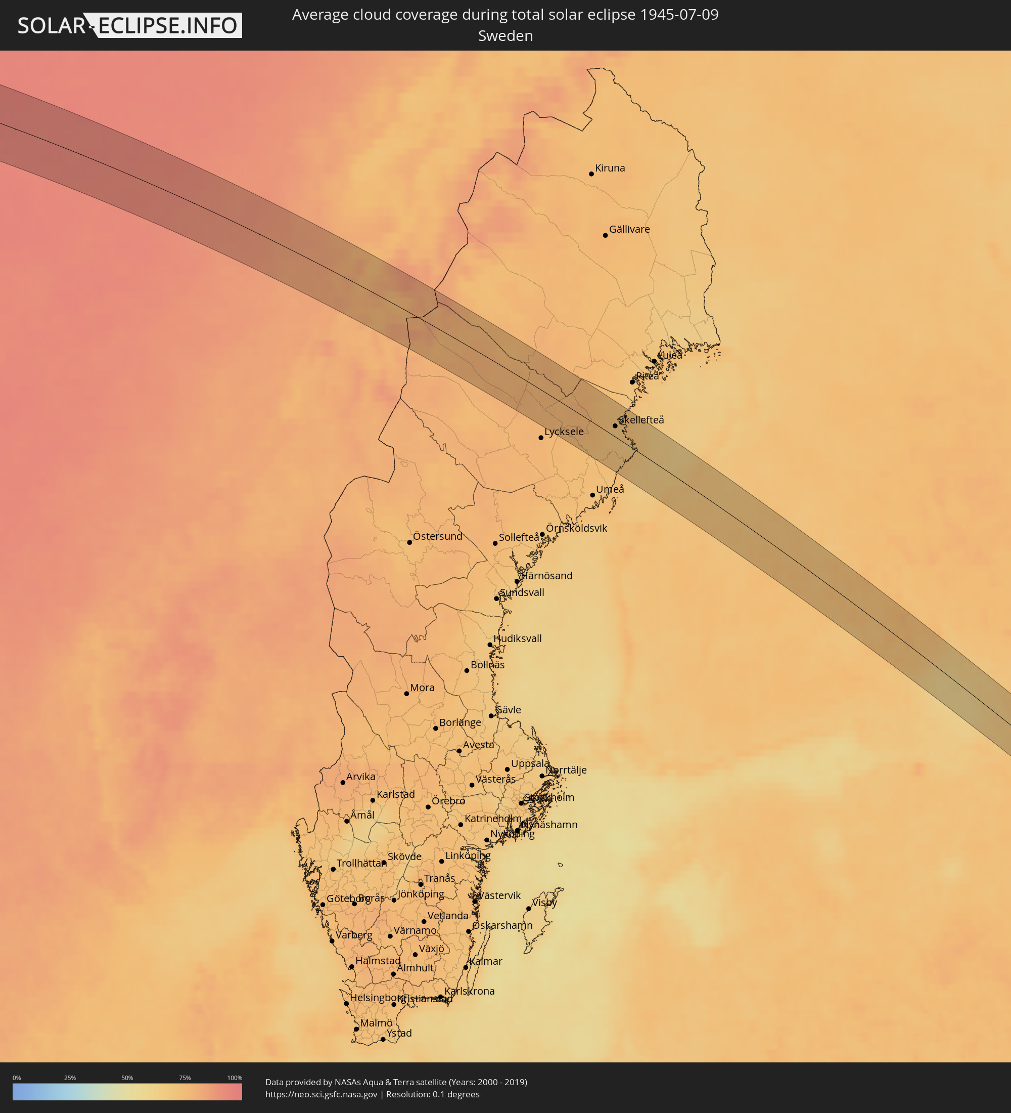 Sweden
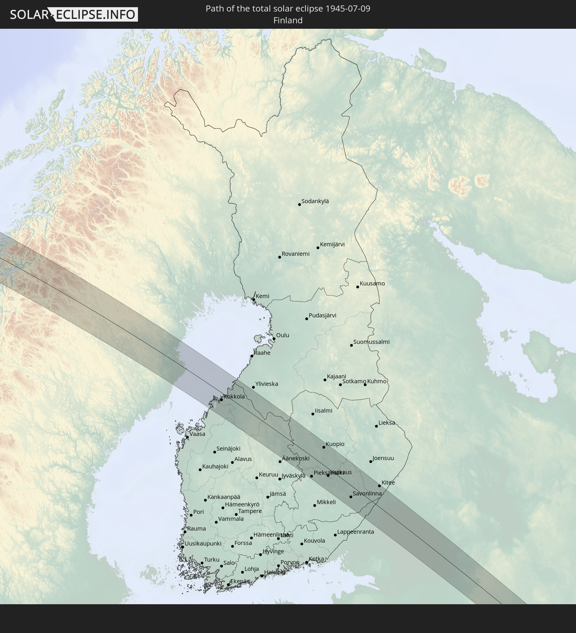
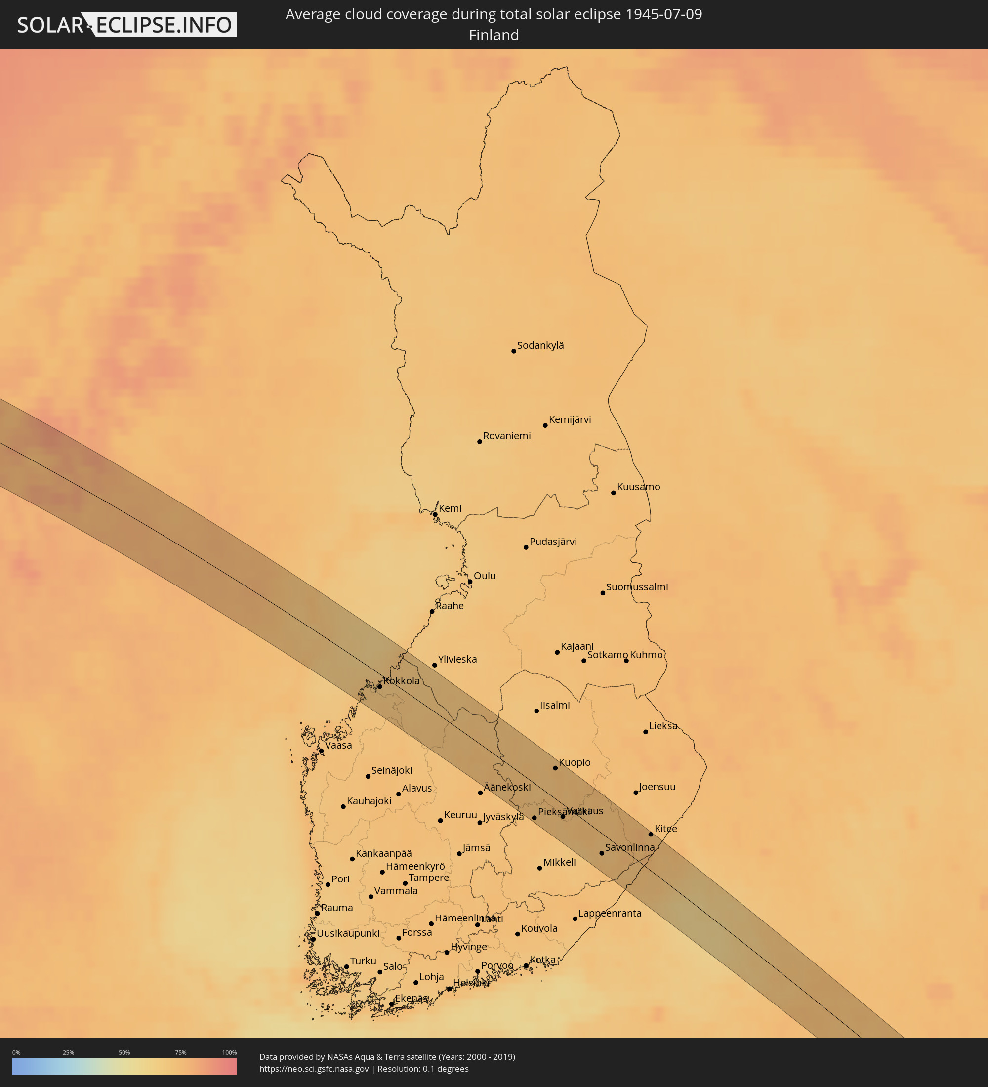 Finland
 Kazakhstan
 Uzbekistan
 Kyrgyzstan
Cities inside the path of the eclipse
The following table shows all locations with a population of more than 5,000 inside the eclipse path. Cities which have more than 100,000 inhabitants are marked bold. A click at the locations opens a detailed map.
| City | Type | Eclipse duration | Local time of max. eclipse | Distance to central line | Ø Cloud coverage |
|
Butte-Silver Bow (Balance), Montana
|
total | - | 06:13:59 UTC-06:00 | 14 km | 43% |
|
Butte, Montana
|
total | - | 06:14:03 UTC-06:00 | 4 km | 39% |
|
Mo i Rana, Nordland
|
total | - | 15:54:09 UTC+02:00 | 7 km | 77% |
|
Skellefteå, Västerbotten
|
total | - | 15:00:44 UTC+01:00 | 17 km | 68% |
|
Jakobstad, Ostrobothnia
|
total | - | 16:03:30 UTC+02:00 | 41 km | 68% |
|
Kronoby, Ostrobothnia
|
total | - | 16:03:35 UTC+02:00 | 28 km | 69% |
|
Kokkola, Central Ostrobothnia
|
total | - | 16:03:28 UTC+02:00 | 19 km | 68% |
|
Kannus, Central Ostrobothnia
|
total | - | 16:03:46 UTC+02:00 | 20 km | 69% |
|
Sievi, Northern Ostrobothnia
|
total | - | 16:04:05 UTC+02:00 | 32 km | 68% |
|
Haapajärvi, Northern Ostrobothnia
|
total | - | 16:04:46 UTC+02:00 | 41 km | 69% |
|
Viitasaari, Central Finland
|
total | - | 16:06:13 UTC+02:00 | 7 km | 73% |
|
Pielavesi, Northern Savo
|
total | - | 16:06:22 UTC+02:00 | 37 km | 70% |
|
Suonenjoki, Northern Savo
|
total | - | 16:07:38 UTC+02:00 | 17 km | 70% |
|
Pieksämäki, Southern Savonia
|
total | - | 16:08:11 UTC+02:00 | 37 km | 72% |
|
Kuopio, Northern Savo
|
total | - | 16:07:24 UTC+02:00 | 32 km | 74% |
|
Leppävirta, Northern Savo
|
total | - | 16:08:10 UTC+02:00 | 0 km | 73% |
|
Joroinen, Southern Savonia
|
total | - | 16:08:44 UTC+02:00 | 27 km | 69% |
|
Varkaus, Northern Savo
|
total | - | 16:08:31 UTC+02:00 | 13 km | 72% |
|
Savonlinna, Southern Savonia
|
total | - | 16:09:46 UTC+02:00 | 22 km | 71% |
|
Kerimäki, Southern Savonia
|
total | - | 16:09:53 UTC+02:00 | 5 km | 74% |
|
Kitee, North Karelia
|
total | - | 16:09:56 UTC+02:00 | 39 km | 73% |
|
Sortavala, Republic of Karelia
|
total | - | 17:10:51 UTC+03:00 | 23 km | 71% |
|
Pitkyaranta, Republic of Karelia
|
total | - | 17:11:25 UTC+03:00 | 36 km | 64% |
|
Olonets, Republic of Karelia
|
total | - | 17:13:04 UTC+03:00 | 34 km | 69% |
|
Lodeynoye Pole, Leningradskaya Oblast'
|
total | - | 17:13:45 UTC+03:00 | 34 km | 71% |
|
Babayevo, Vologda
|
total | - | 17:17:00 UTC+03:00 | 5 km | 72% |
|
Ustyuzhna, Vologda
|
total | - | 17:18:09 UTC+03:00 | 35 km | 69% |
|
Kaduy, Vologda
|
total | - | 17:17:44 UTC+03:00 | 30 km | 73% |
|
Rybinsk, Jaroslavl
|
total | - | 17:20:17 UTC+03:00 | 10 km | 73% |
|
Tutayev, Jaroslavl
|
total | - | 17:20:45 UTC+03:00 | 4 km | 72% |
|
Gavrilov-Yam, Jaroslavl
|
total | - | 17:21:53 UTC+03:00 | 37 km | 74% |
|
Yaroslavl, Jaroslavl
|
total | - | 17:21:18 UTC+03:00 | 8 km | 77% |
|
Komsomol’sk, Ivanovo
|
total | - | 17:22:29 UTC+03:00 | 41 km | 76% |
|
Nerekhta, Kostroma
|
total | - | 17:21:46 UTC+03:00 | 8 km | 73% |
|
Ivanovo, Ivanovo
|
total | - | 17:22:41 UTC+03:00 | 20 km | 78% |
|
Furmanov, Ivanovo
|
total | - | 17:22:15 UTC+03:00 | 11 km | 73% |
|
Privolzhsk, Ivanovo
|
total | - | 17:22:03 UTC+03:00 | 29 km | 73% |
|
Shuya, Ivanovo
|
total | - | 17:23:02 UTC+03:00 | 12 km | 74% |
|
Rodniki, Ivanovo
|
total | - | 17:22:39 UTC+03:00 | 23 km | 74% |
|
Yuzha, Ivanovo
|
total | - | 17:23:38 UTC+03:00 | 14 km | 72% |
|
Vyazniki, Vladimir
|
total | - | 17:24:16 UTC+03:00 | 34 km | 73% |
|
Gorokhovets, Vladimir
|
total | - | 17:24:26 UTC+03:00 | 19 km | 74% |
|
Mulino, Nizjnij Novgorod
|
total | - | 17:24:20 UTC+03:00 | 7 km | 74% |
|
Pavlovo, Nizjnij Novgorod
|
total | - | 17:24:55 UTC+03:00 | 26 km | 71% |
|
Volodarsk, Nizjnij Novgorod
|
total | - | 17:24:29 UTC+03:00 | 12 km | 71% |
|
Dzerzhinsk, Nizjnij Novgorod
|
total | - | 17:24:30 UTC+03:00 | 27 km | 72% |
|
Bogorodsk, Nizjnij Novgorod
|
total | - | 17:24:45 UTC+03:00 | 11 km | 72% |
|
Perevoz, Nizjnij Novgorod
|
total | - | 17:25:48 UTC+03:00 | 8 km | 68% |
|
Ardatov, Mordoviya
|
total | - | 17:27:18 UTC+03:00 | 16 km | 62% |
|
Alatyr’, Chuvashia
|
total | - | 17:27:21 UTC+03:00 | 33 km | 61% |
|
Tol’yatti, Samara
|
total | - | 18:29:45 UTC+04:00 | 34 km | 60% |
|
Bezenchuk, Samara
|
total | - | 18:30:40 UTC+04:00 | 10 km | 63% |
|
Zhigulevsk, Samara
|
total | - | 18:29:59 UTC+04:00 | 34 km | 61% |
|
Chapayevsk, Samara
|
total | - | 18:30:41 UTC+04:00 | 17 km | 62% |
|
Novokuybyshevsk, Samara
|
total | - | 18:30:30 UTC+04:00 | 30 km | 60% |
|
Aqsay, Batys Qazaqstan
|
total | - | 19:33:34 UTC+05:00 | 10 km | 55% |
|
Embi, Aqtöbe
|
total | - | 19:36:32 UTC+05:00 | 15 km | 46% |
|
Shalqar, Aqtöbe
|
total | - | 19:37:42 UTC+05:00 | 18 km | 36% |
|
Sekseūil, Qyzylorda
|
total | - | 19:38:24 UTC+05:00 | 19 km | 29% |
|
Aral, Qyzylorda
|
total | - | 19:38:40 UTC+05:00 | 23 km | 28% |
|
Zhosaly, Qyzylorda
|
total | - | 19:39:45 UTC+05:00 | 28 km | 22% |
|
Terenozek, Qyzylorda
|
total | - | 19:40:01 UTC+05:00 | 22 km | 17% |
|
Kyzyl-Orda, Qyzylorda
|
total | - | 19:40:06 UTC+05:00 | 15 km | 17% |
|
Kyzylorda, Qyzylorda
|
total | - | 19:40:05 UTC+05:00 | 14 km | 16% |
|
Tasböget, Qyzylorda
|
total | - | 19:40:11 UTC+05:00 | 19 km | 17% |
|
Kentau, Ongtüstik Qazaqstan
|
total | - | 19:40:37 UTC+05:00 | 7 km | 11% |
|
Kantagi, Ongtüstik Qazaqstan
|
total | - | 19:40:34 UTC+05:00 | 9 km | 11% |
|
Ashchysay, Ongtüstik Qazaqstan
|
total | - | 19:40:24 UTC+05:00 | 15 km | 19% |
|
Chayan, Ongtüstik Qazaqstan
|
total | - | 19:40:49 UTC+05:00 | 14 km | 12% |
|
Vannovka, Ongtüstik Qazaqstan
|
total | - | 19:40:59 UTC+05:00 | 19 km | 14% |