Total solar eclipse of 09/03/2081
| Day of week: | Wednesday |
| Maximum duration of eclipse: | 05m33s |
| Maximum width of eclipse path: | 247 km |
| Saros cycle: | 136 |
| Coverage: | 100% |
| Magnitude: | 1.072 |
| Gamma: | 0.3378 |
Wo kann man die Sonnenfinsternis vom 09/03/2081 sehen?
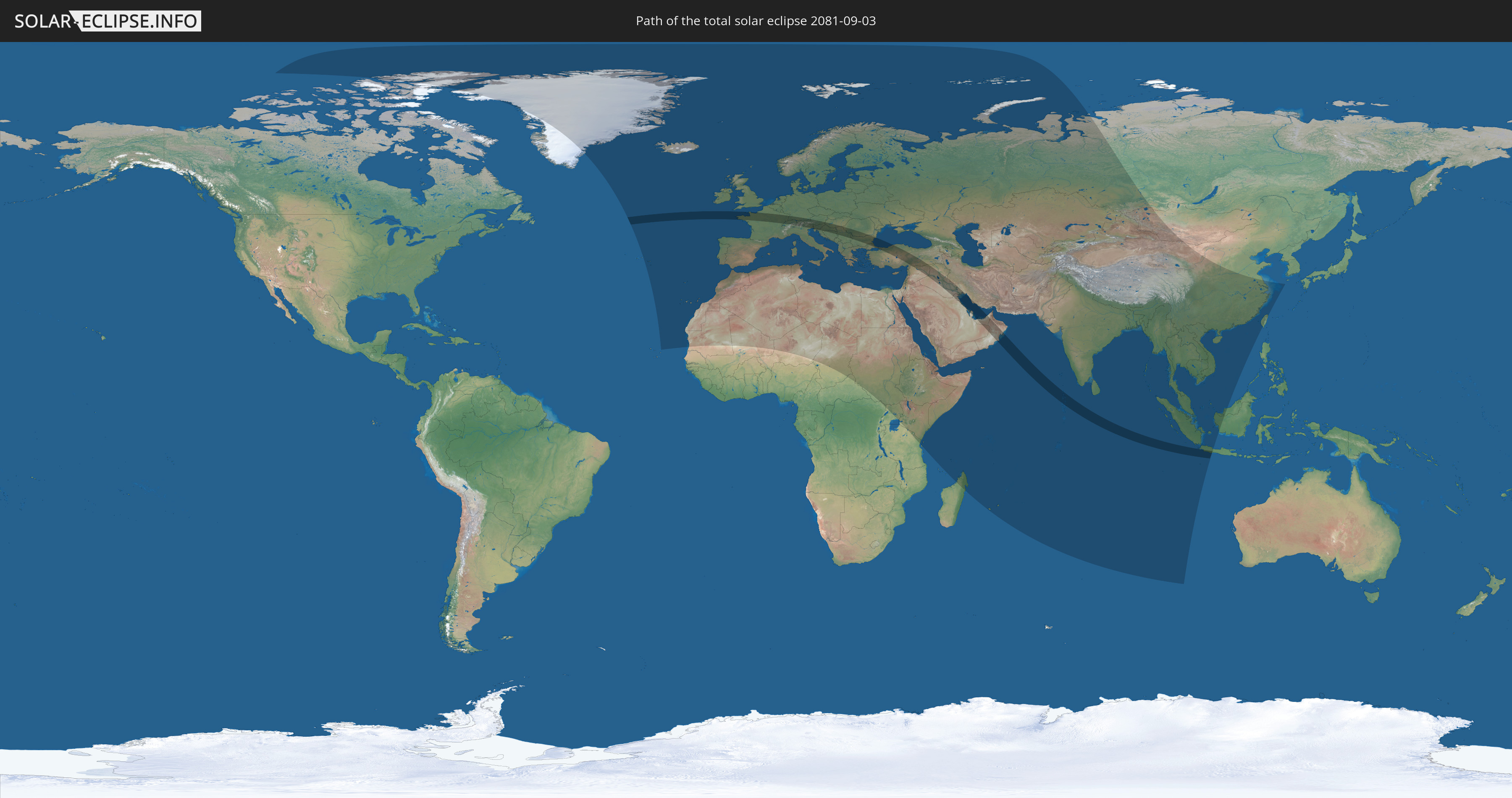
Die Sonnenfinsternis am 09/03/2081 kann man in 125 Ländern als partielle Sonnenfinsternis beobachten.
Der Finsternispfad verläuft durch 27 Länder. Nur in diesen Ländern ist sie als total Sonnenfinsternis zu sehen.
In den folgenden Ländern ist die Sonnenfinsternis total zu sehen
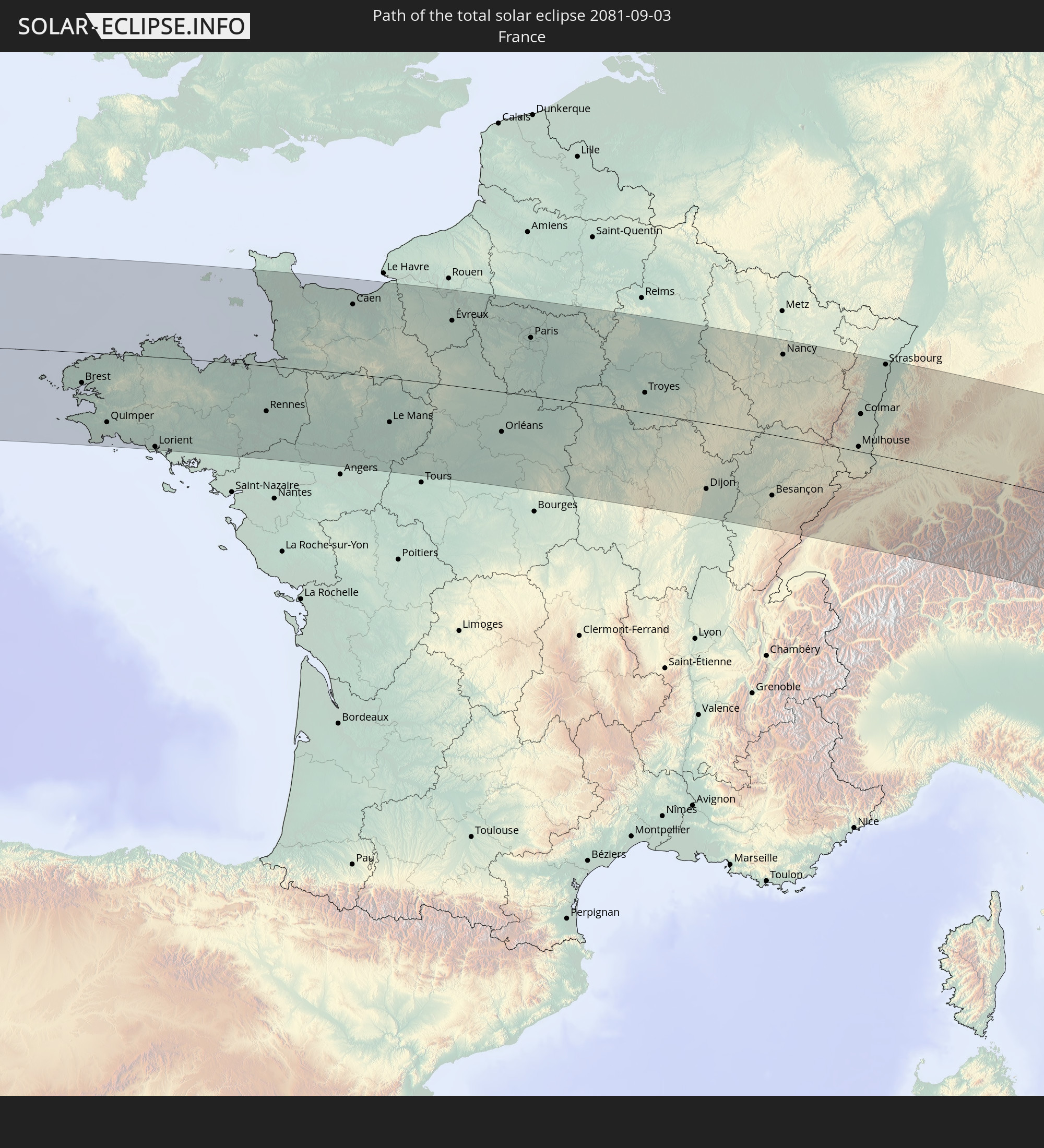 France
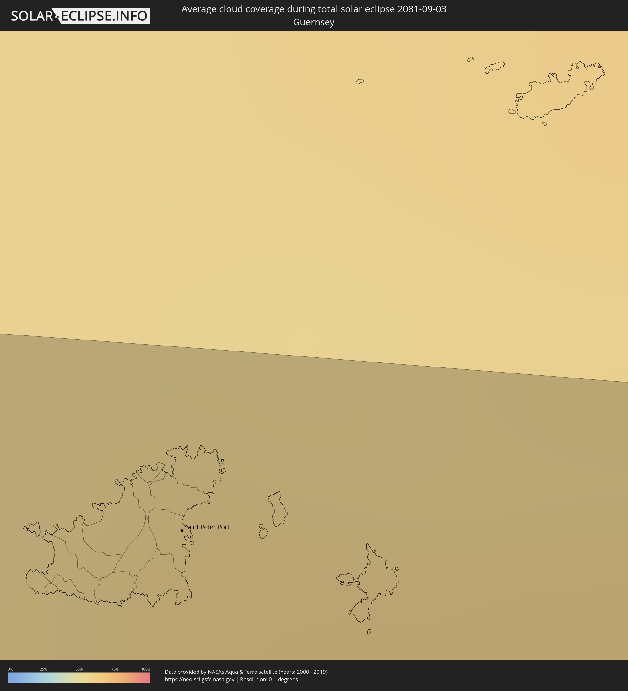
 Guernsey
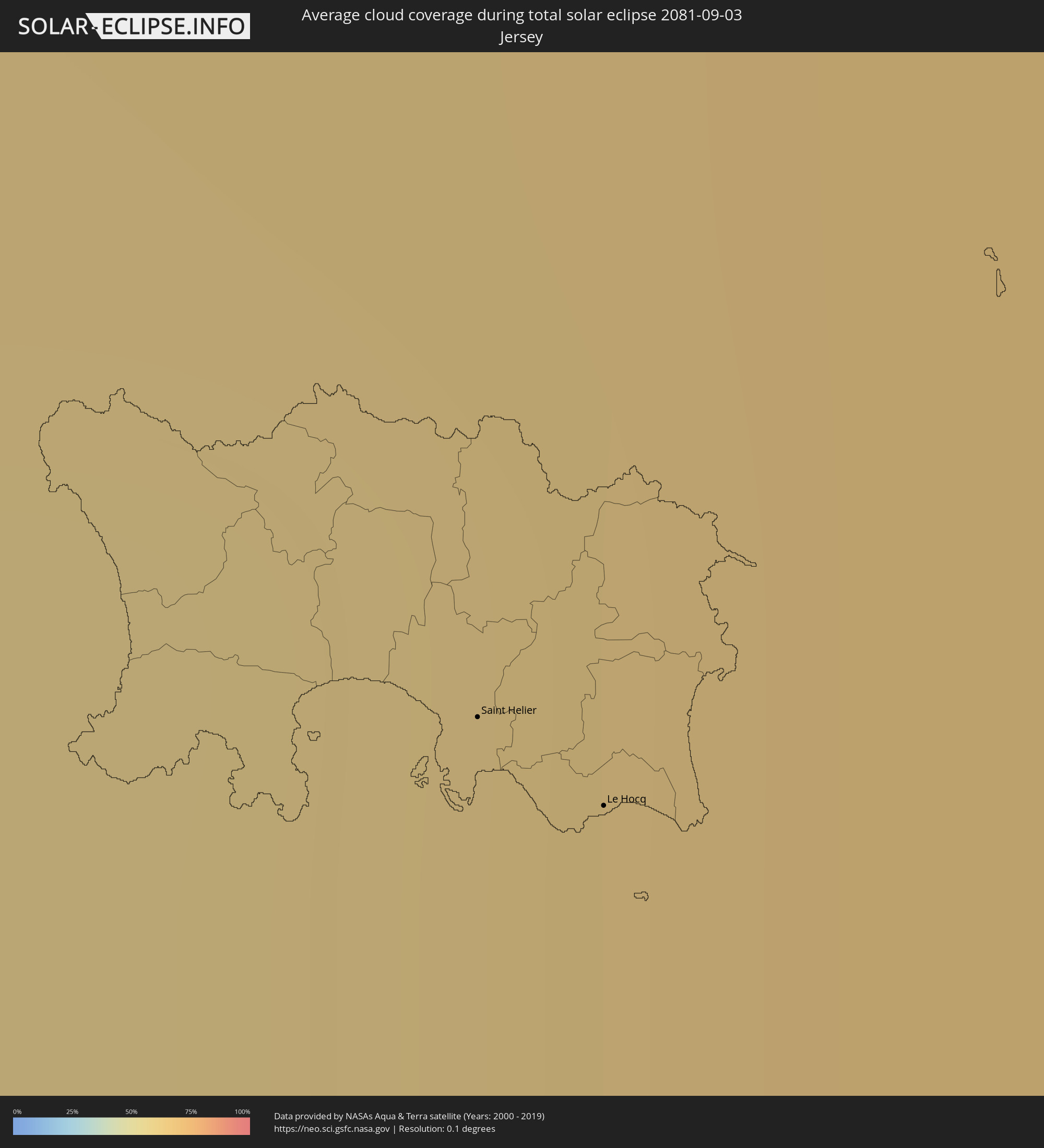
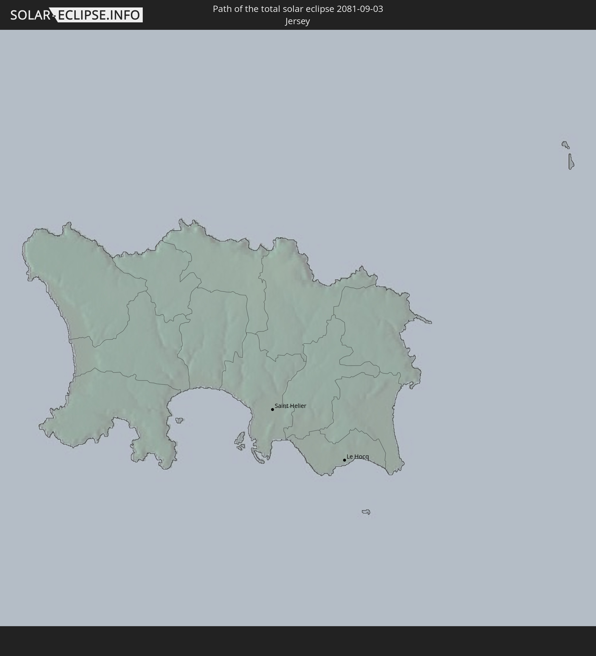 Jersey
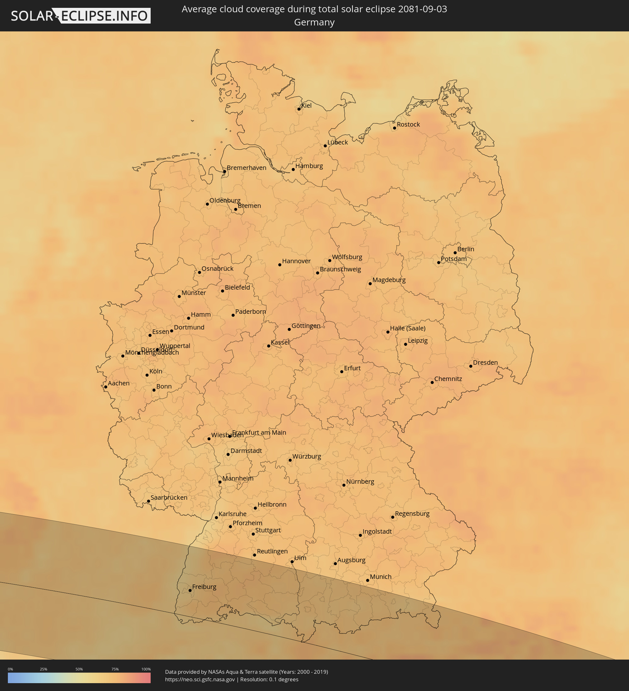
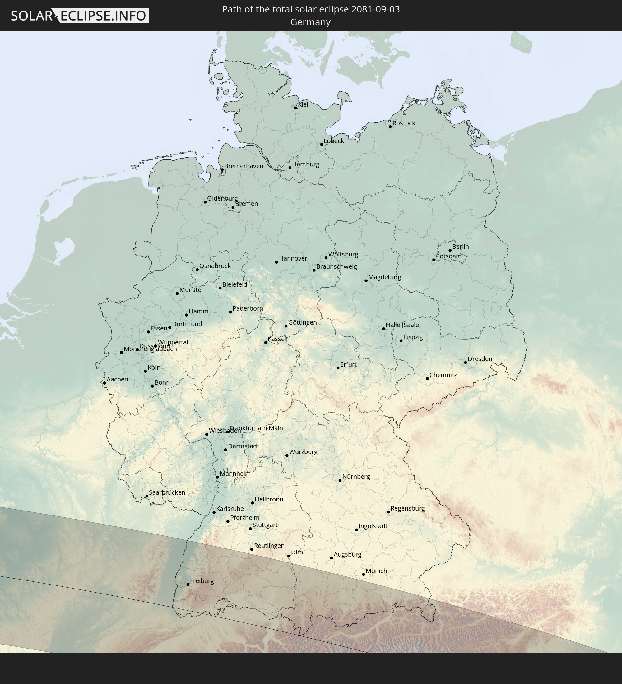 Germany
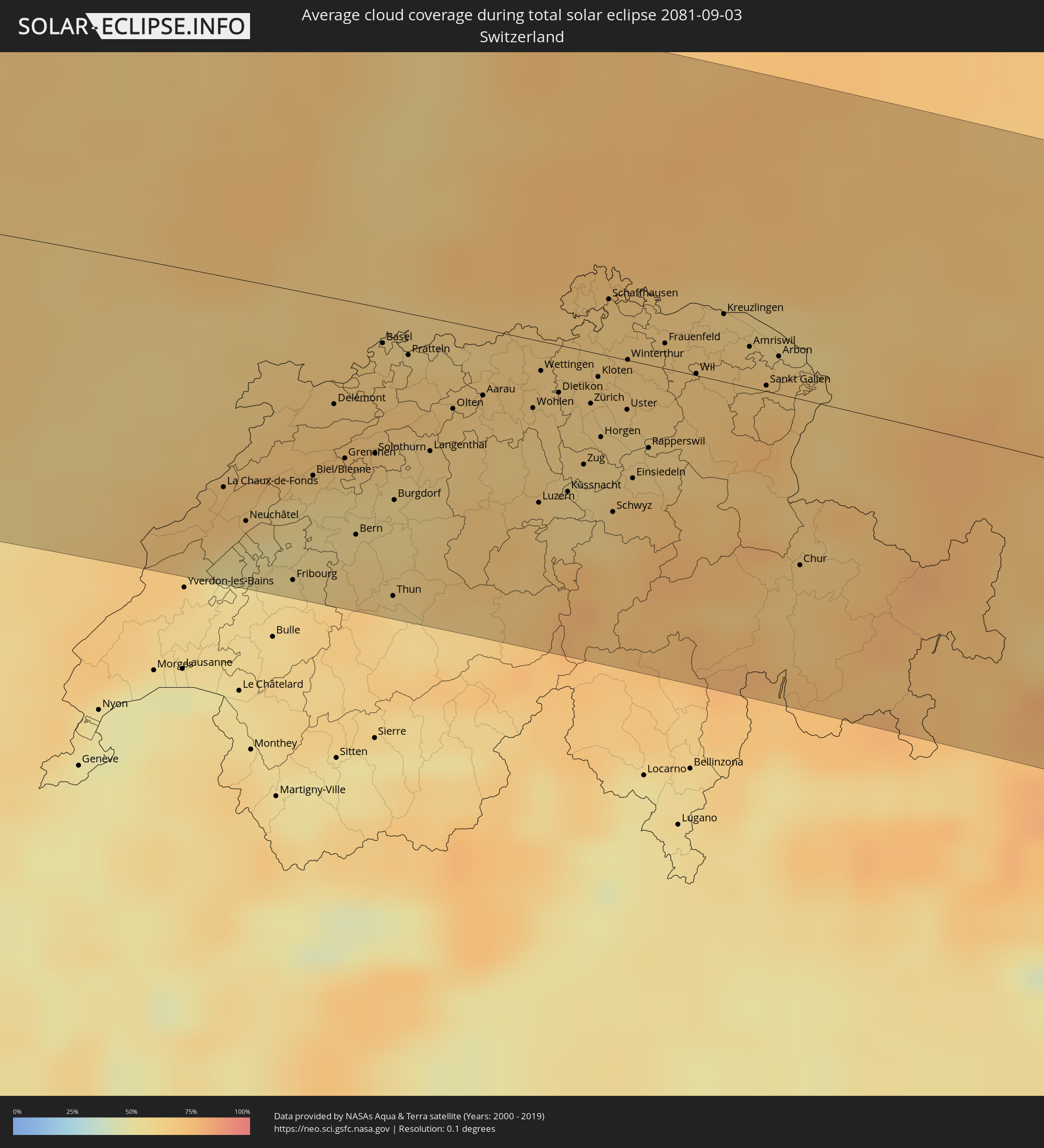
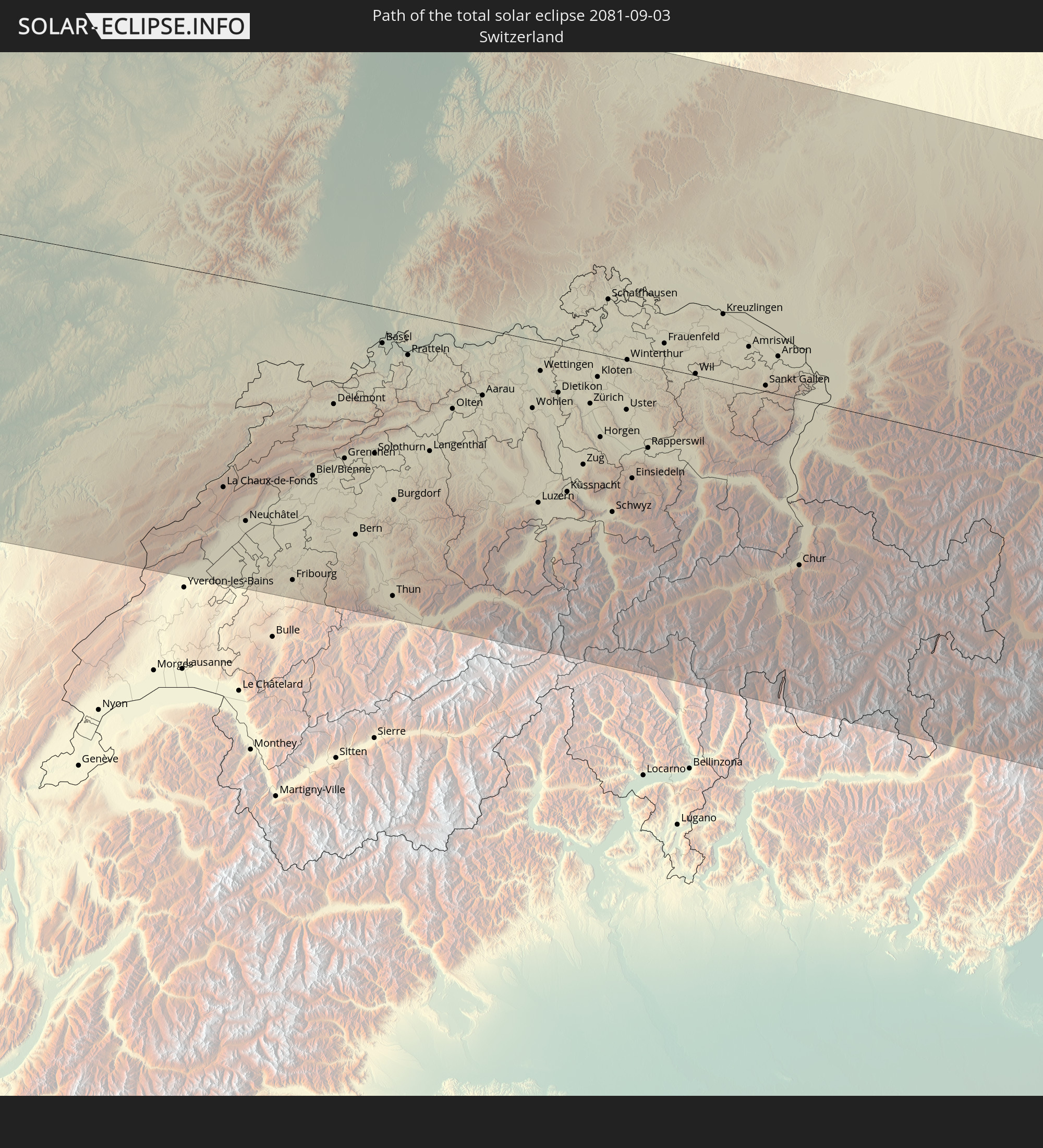 Switzerland
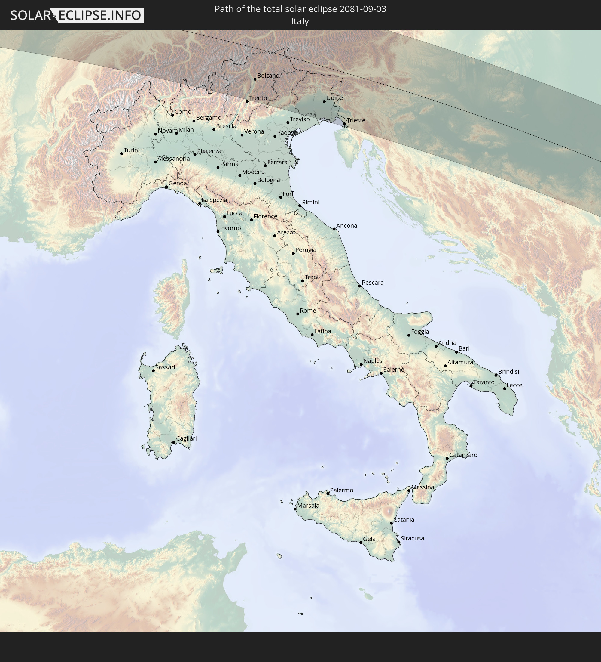 Italy
Italy
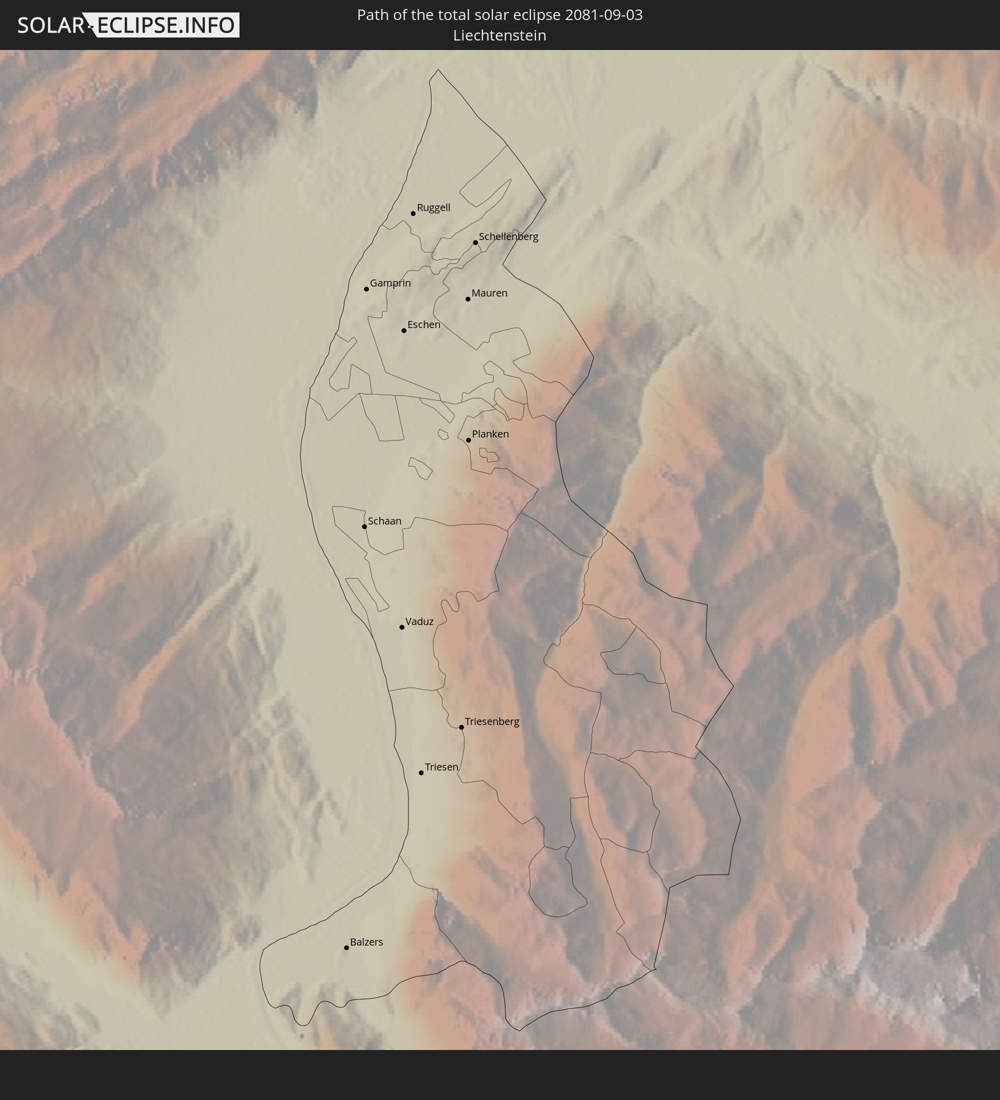 Liechtenstein
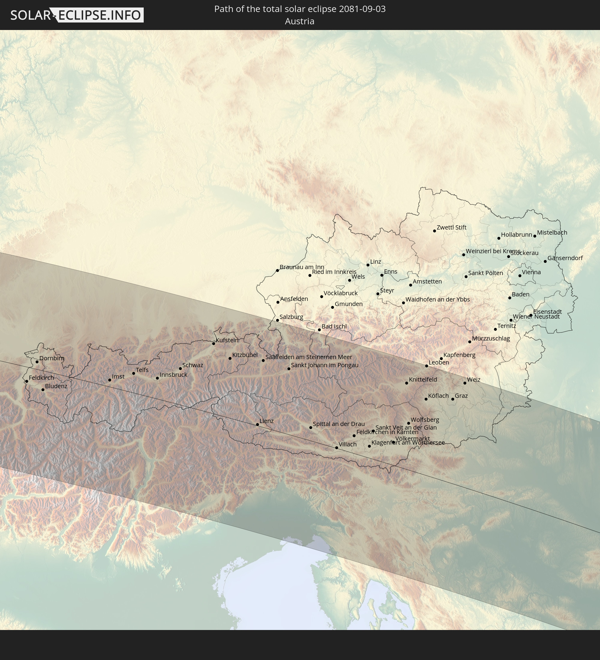 Austria
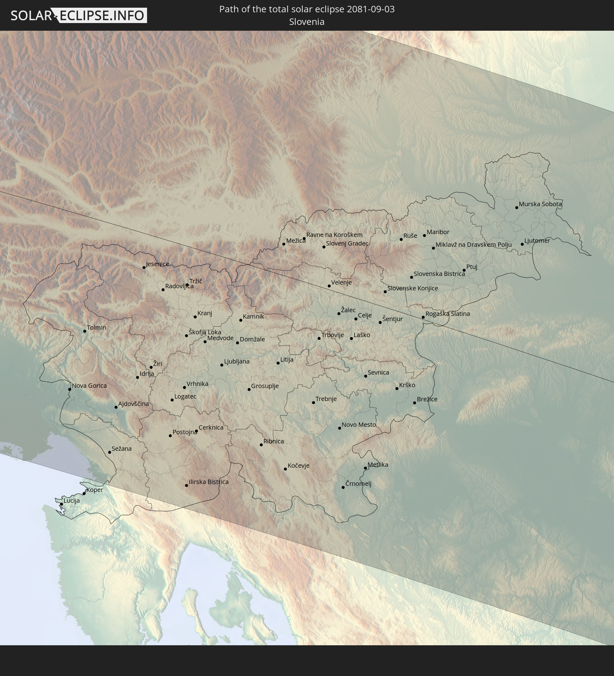 Slovenia
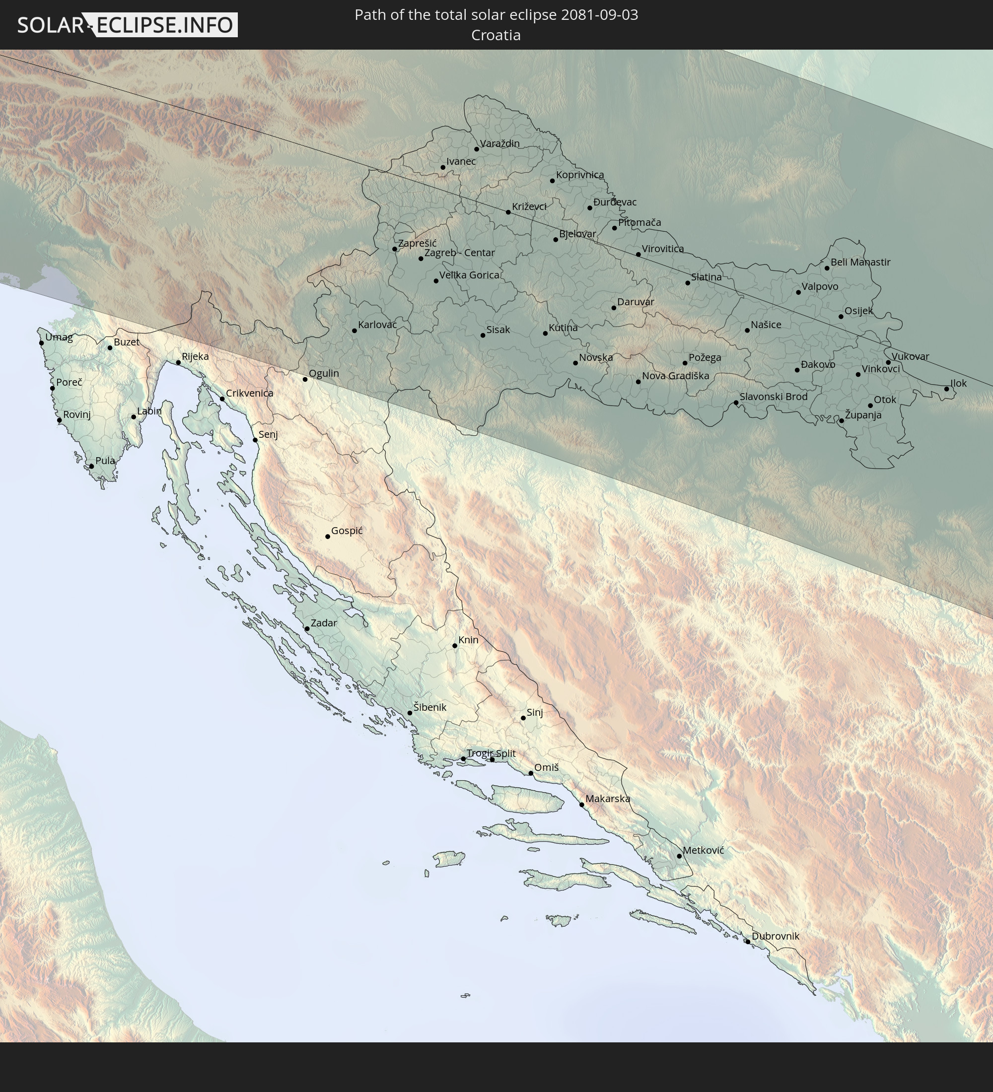 Croatia
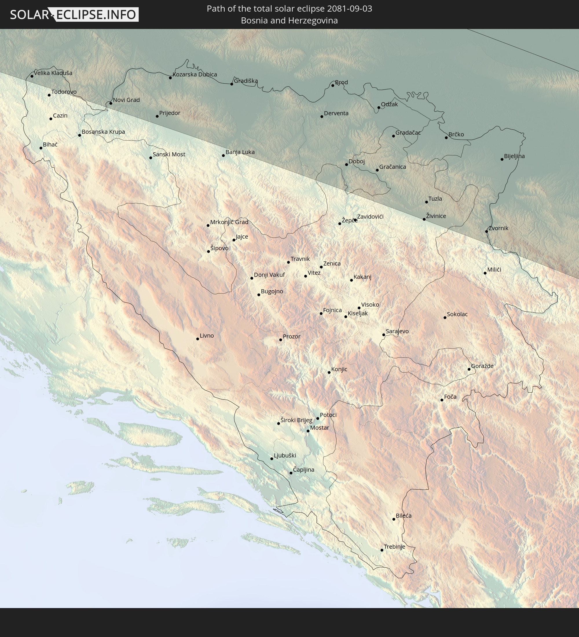 Bosnia and Herzegovina
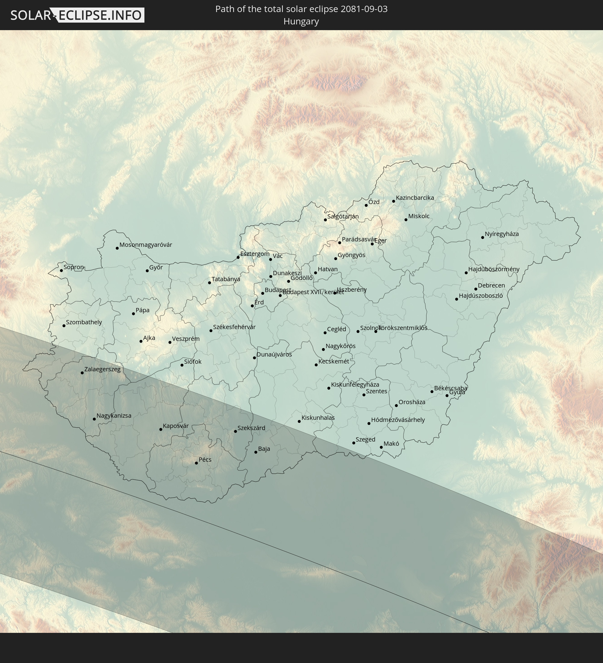 Hungary
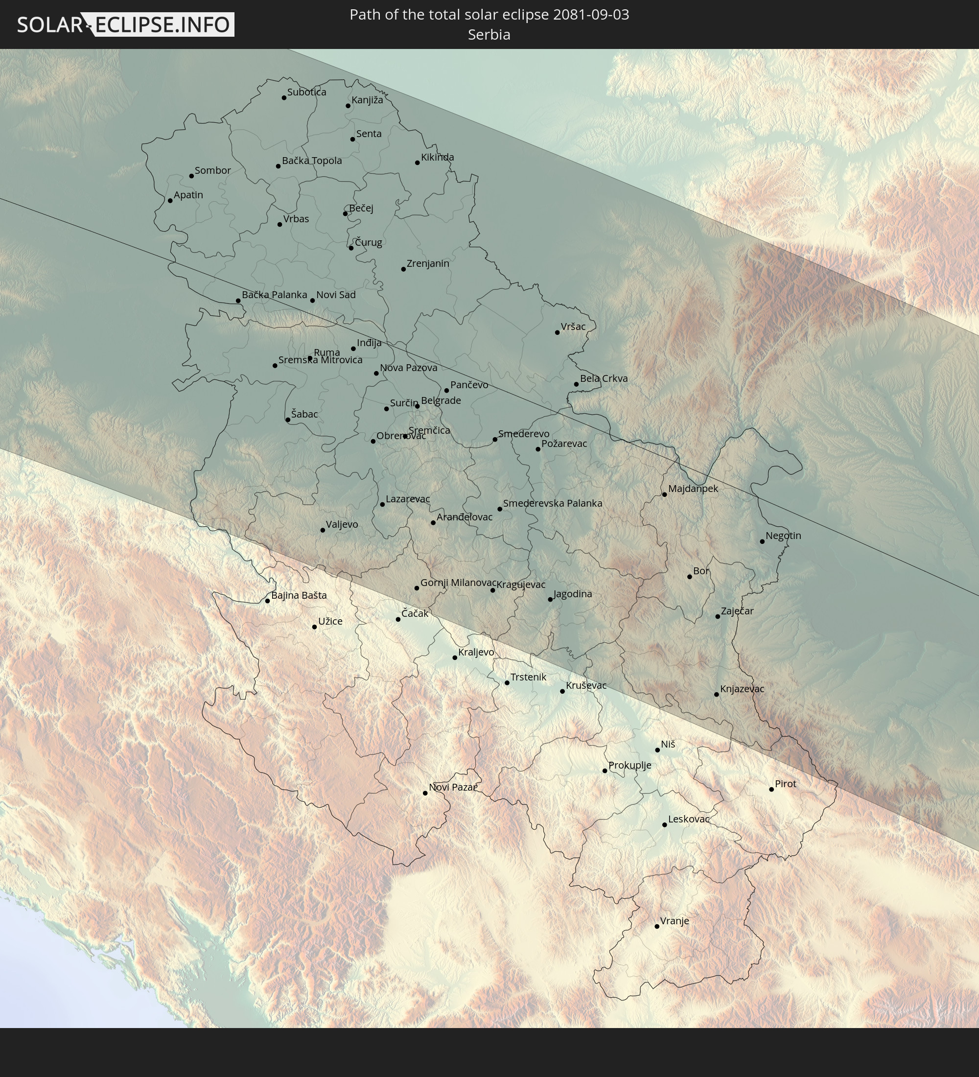 Serbia
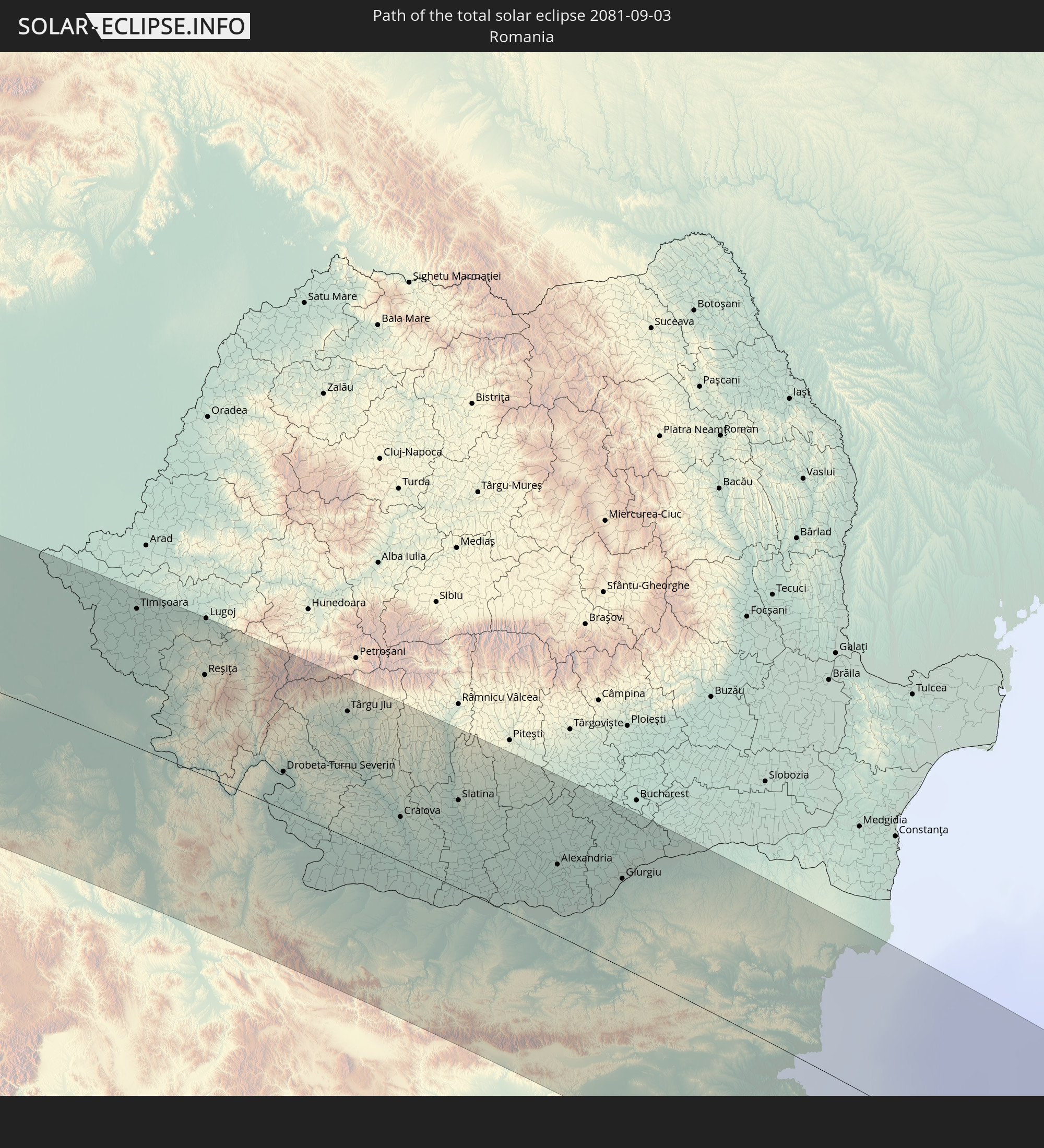 Romania
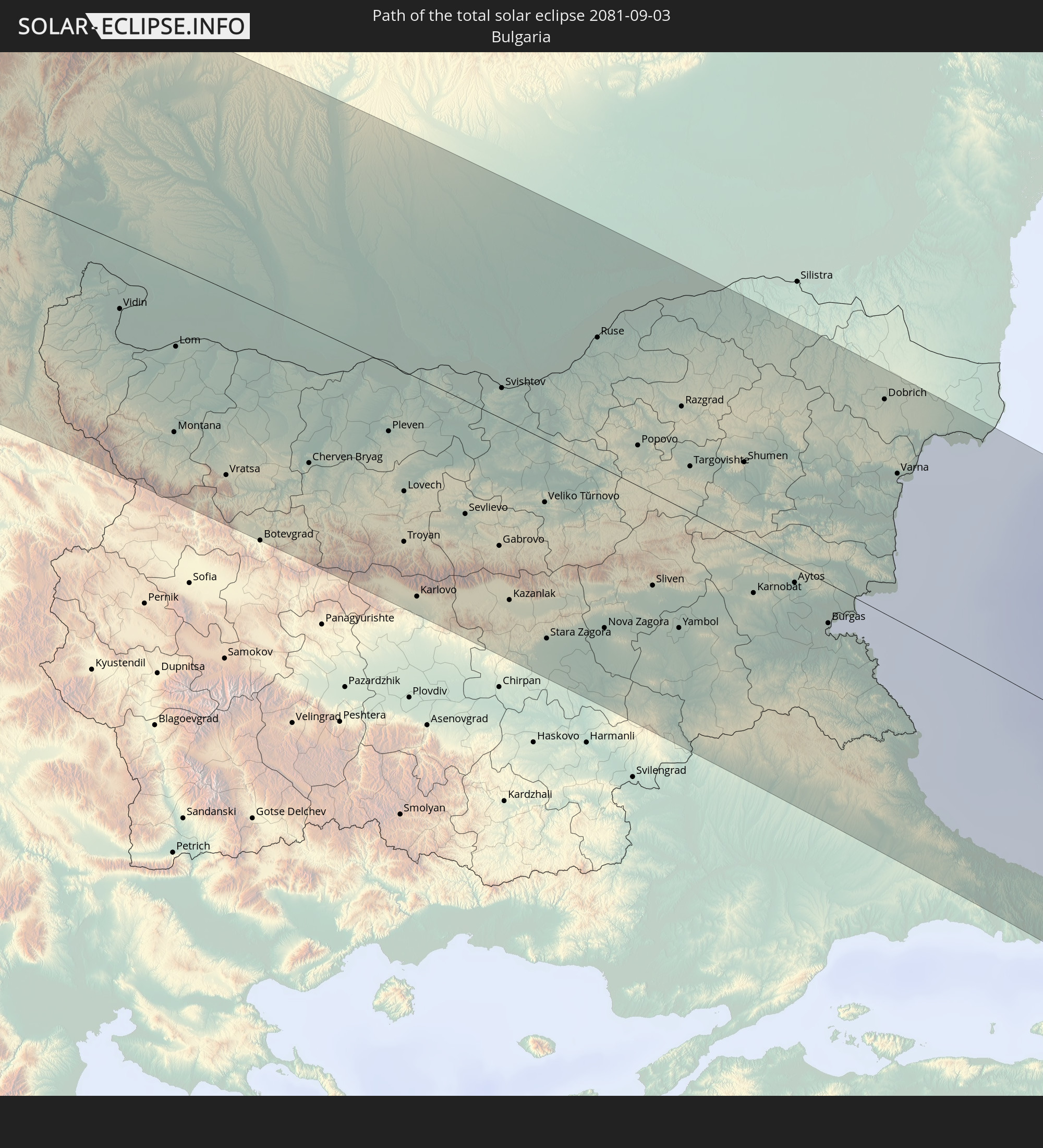 Bulgaria
 Turkey
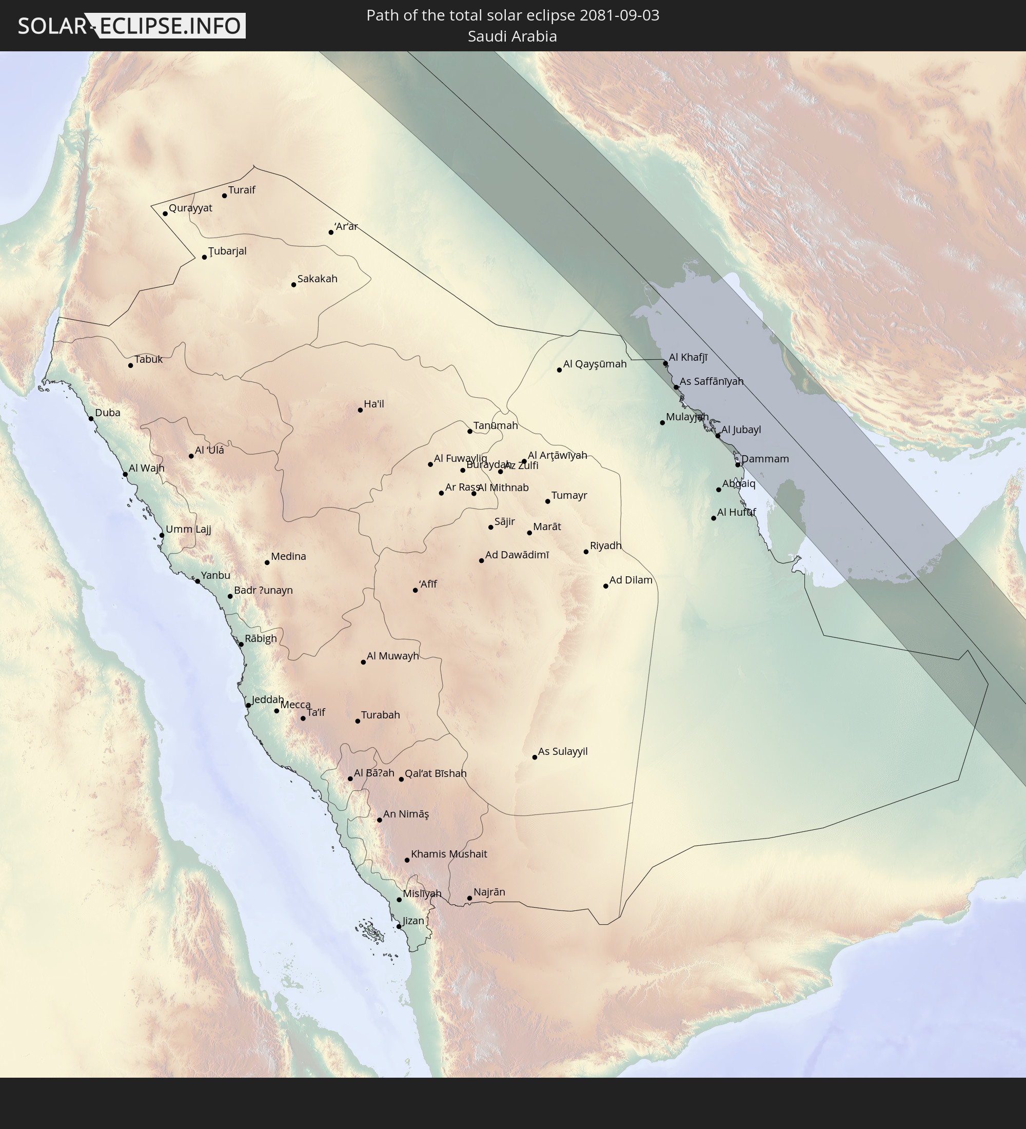 Saudi Arabia
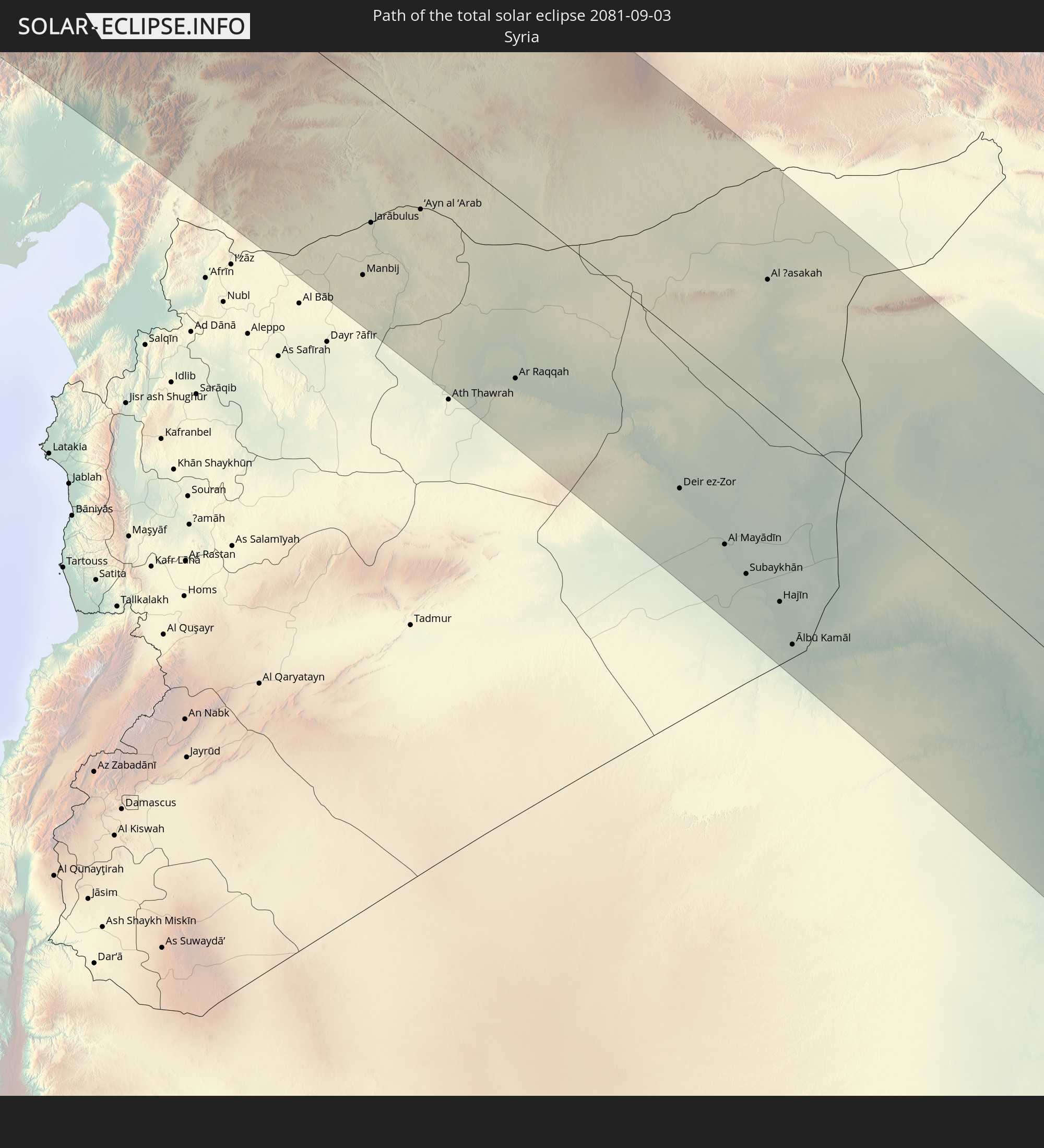 Syria
Syria
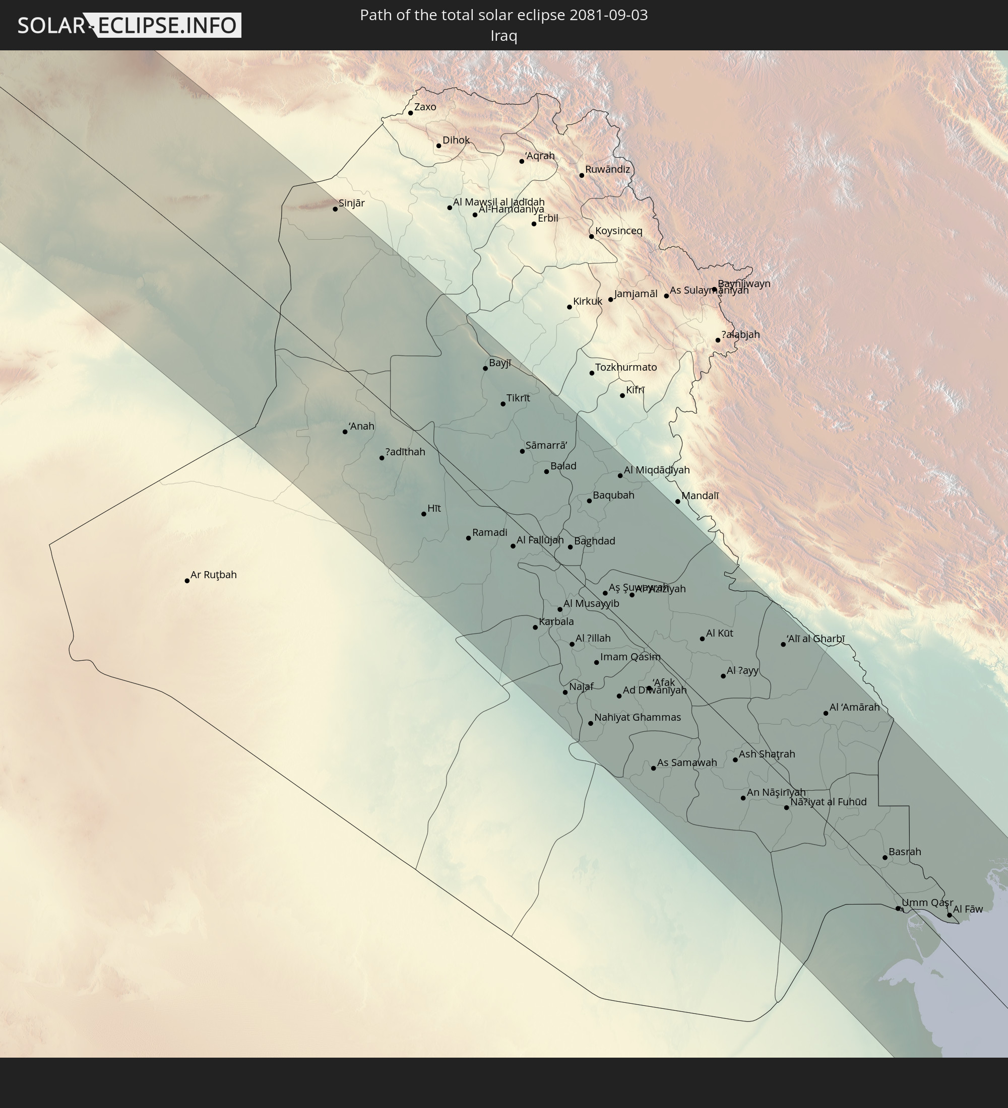 Iraq
Iraq
 Iran
Iran
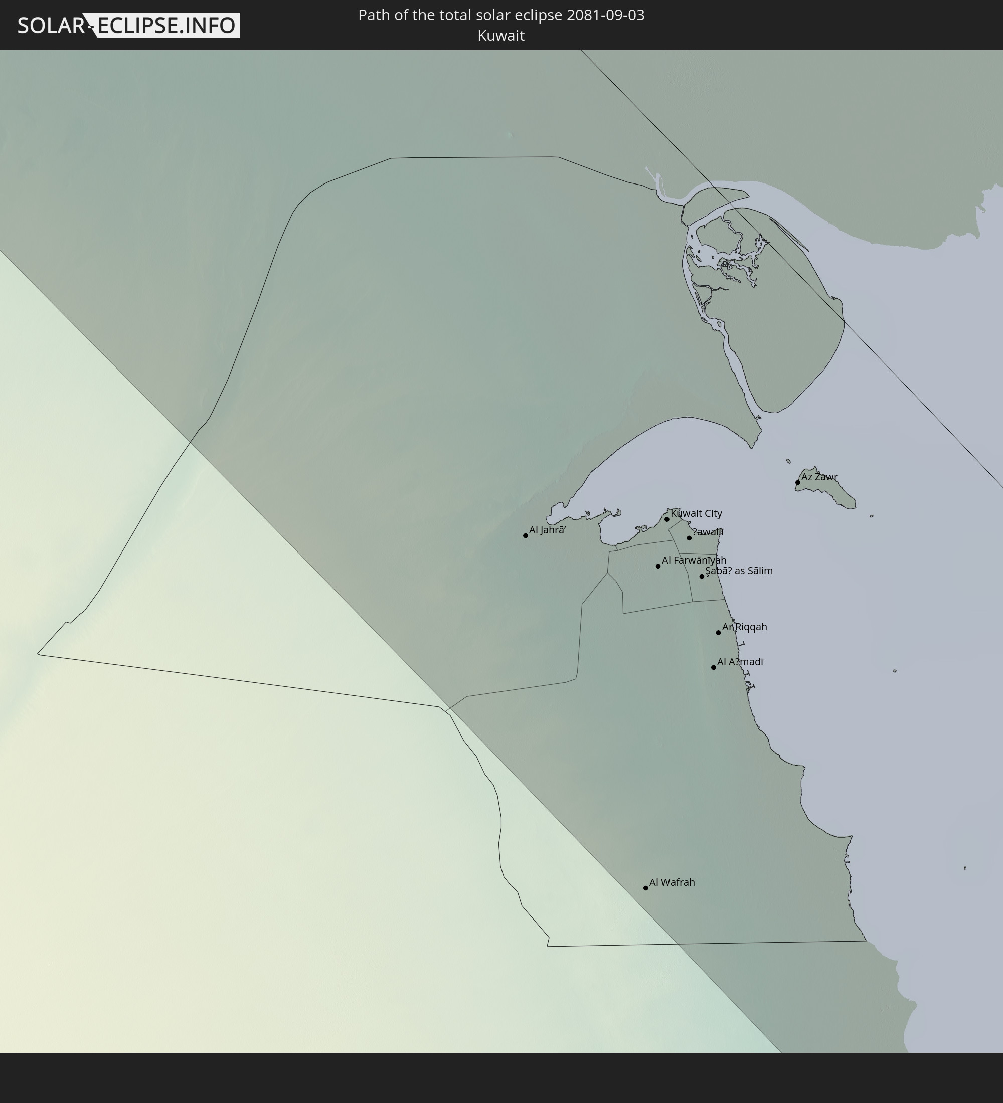 Kuwait
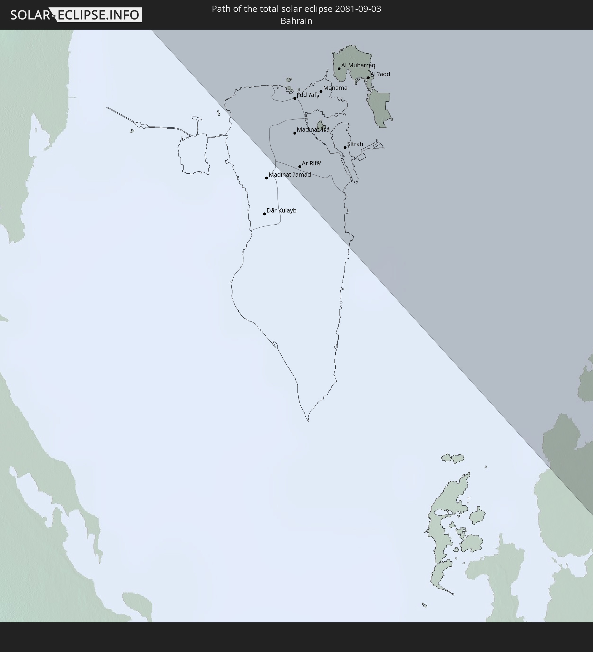 Bahrain
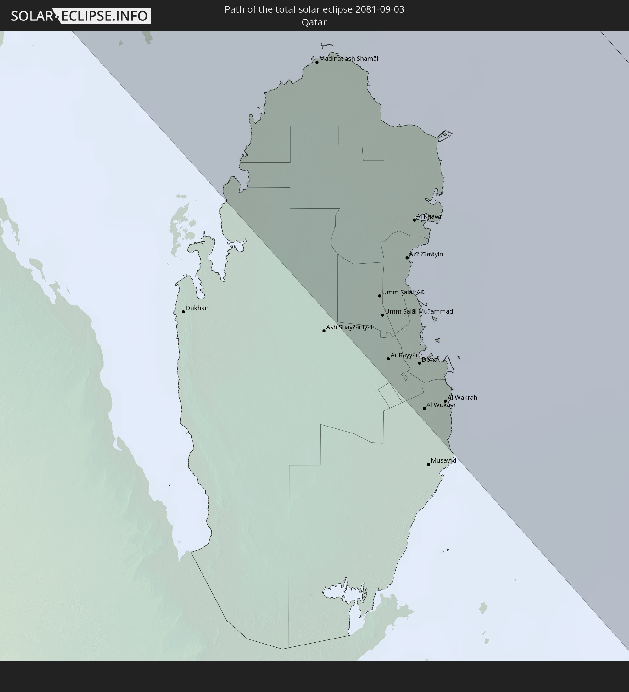 Qatar
Qatar
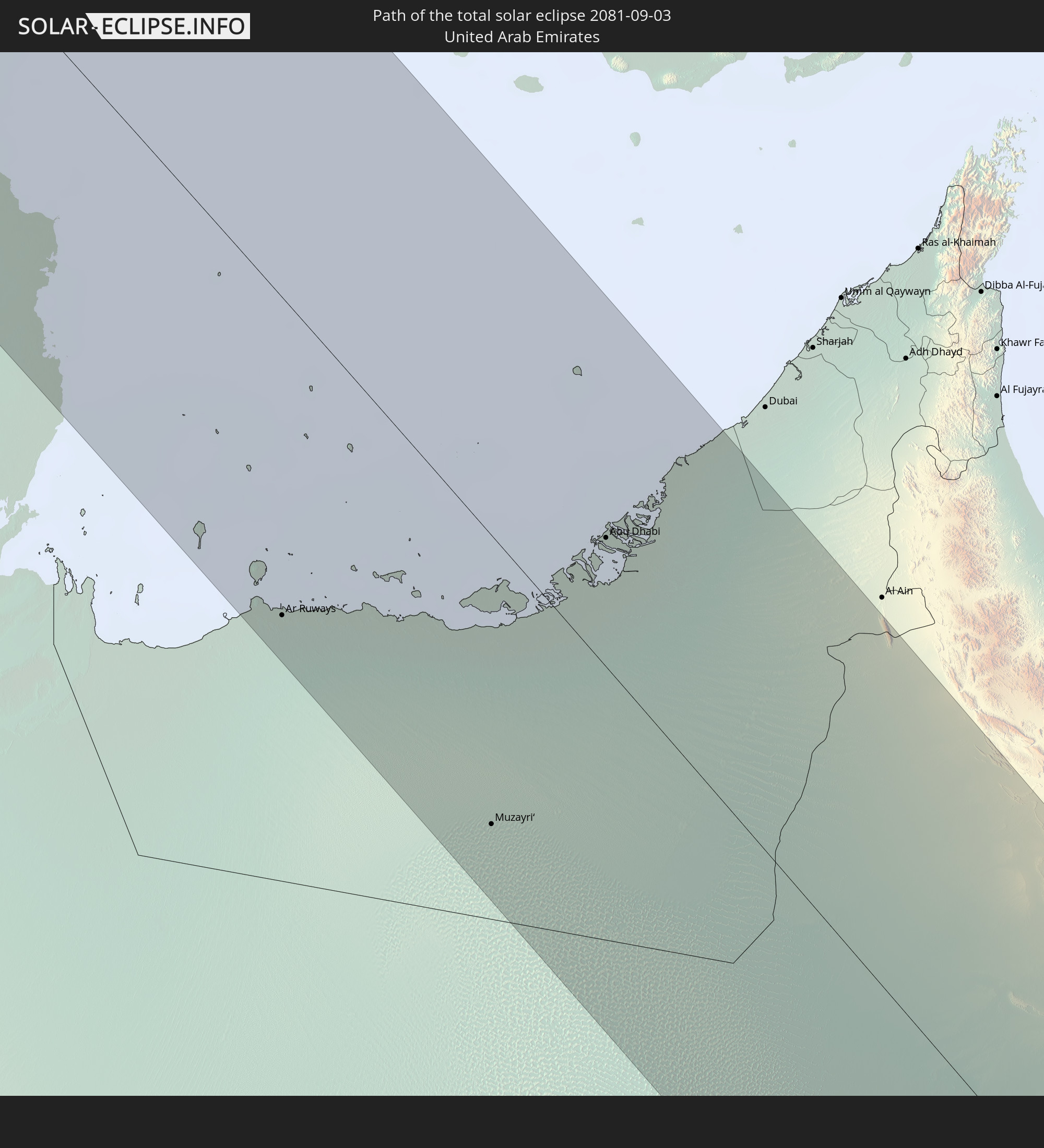 United Arab Emirates
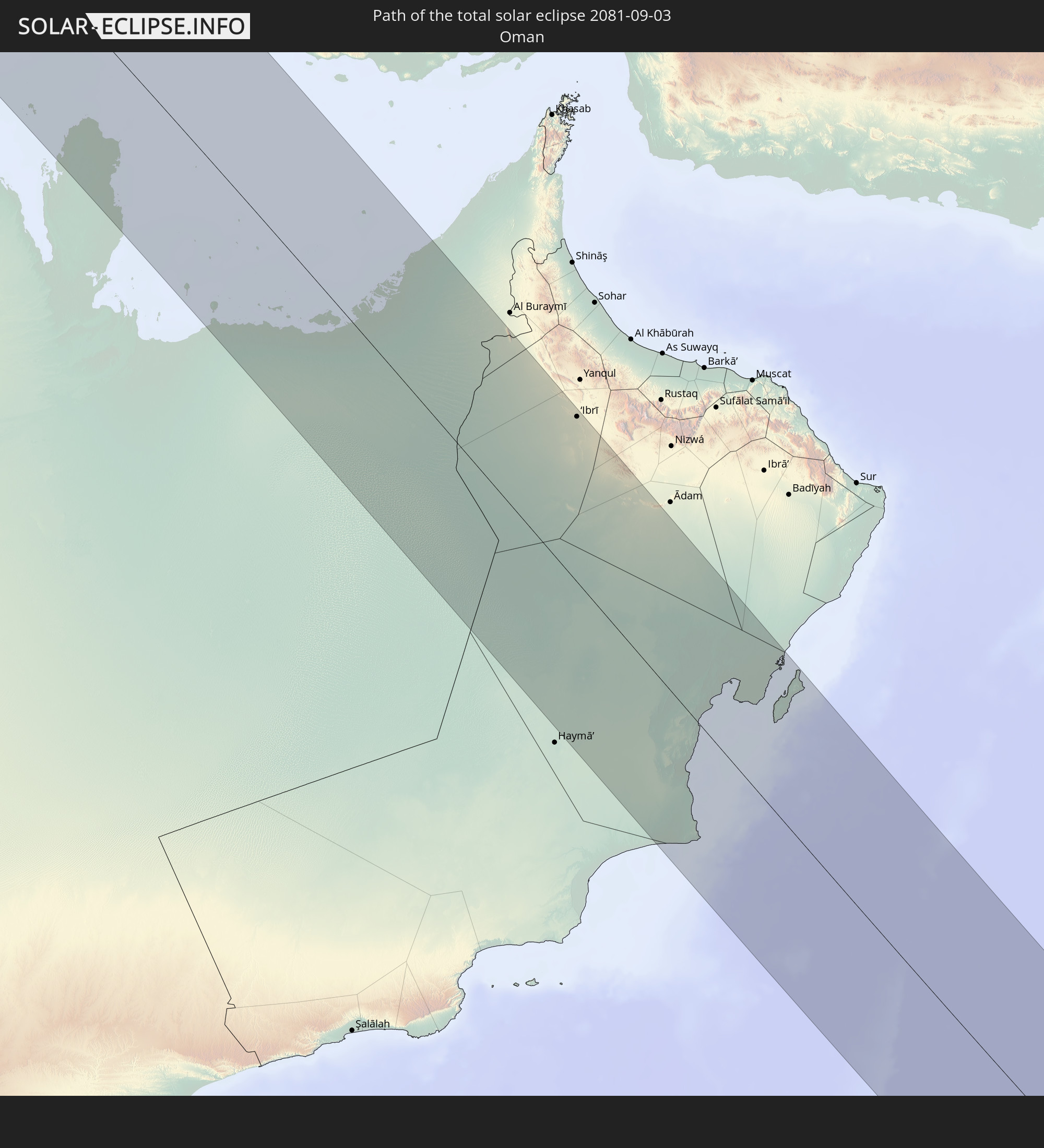 Oman
Oman
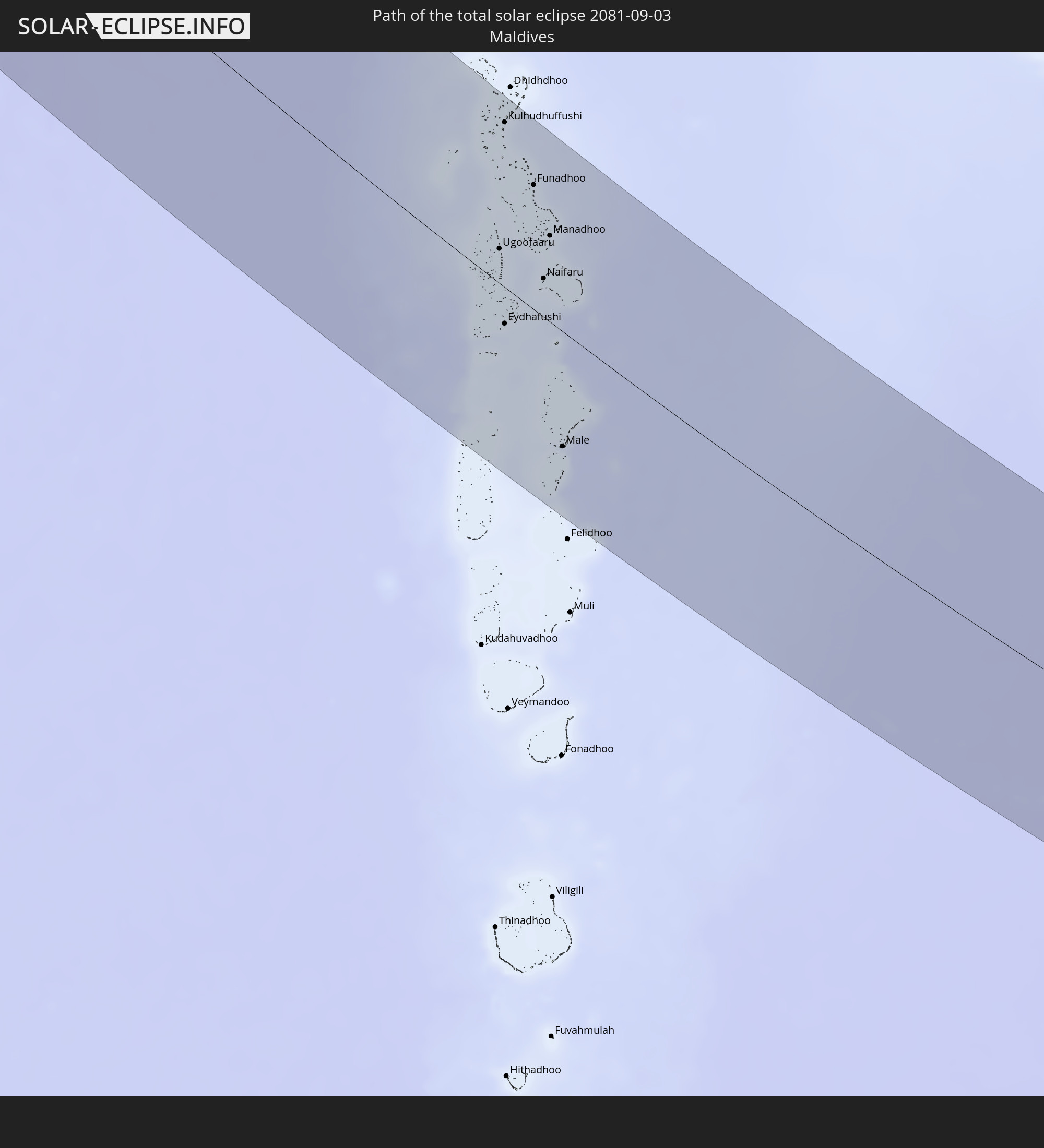 Maldives
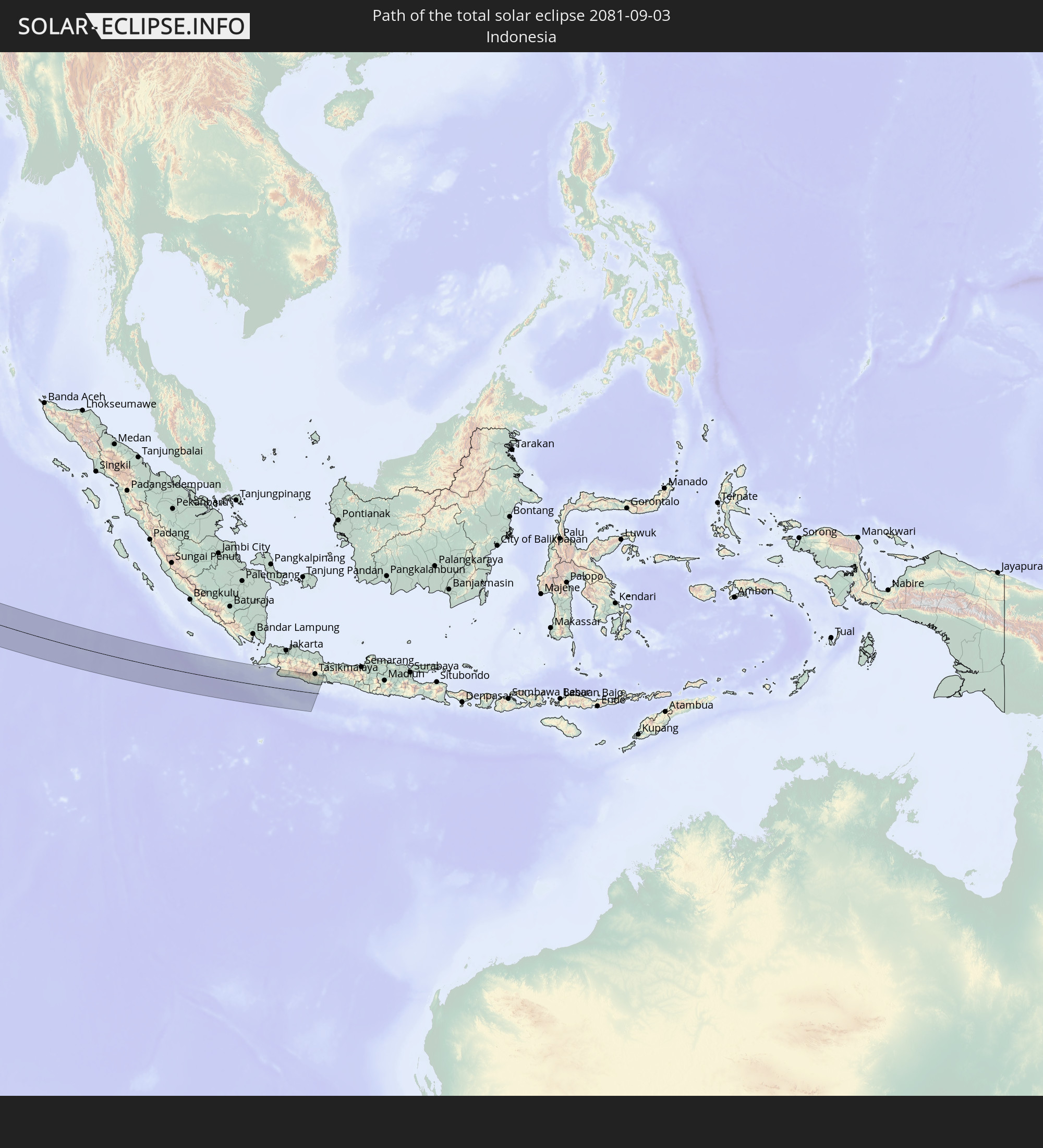 Indonesia
In den folgenden Ländern ist die Sonnenfinsternis partiell zu sehen
 Russia
 Canada
 Greenland
 Portugal
 Iceland
 Spain
Spain
 Mauritania
 Morocco
 Mali
Mali
 Republic of Ireland
 Svalbard and Jan Mayen
 Algeria
 United Kingdom
 Faroe Islands
 Gibraltar
 France
 Isle of Man
 Guernsey
 Jersey
 Niger
Niger
 Andorra
 Belgium
 Netherlands
 Norway
 Luxembourg
 Germany
 Switzerland
 Italy
Italy
 Monaco
 Tunisia
 Denmark
 Libya
Libya
 Liechtenstein
 Austria
 Sweden
 Czechia
 Democratic Republic of the Congo
 San Marino
 Vatican City
 Slovenia
 Chad
Chad
 Croatia
 Poland
 Malta
Malta
 Central African Republic
 Bosnia and Herzegovina
 Hungary
 Slovakia
 Montenegro
 Serbia
 Albania
 Åland Islands
 Greece
 Romania
 Republic of Macedonia
 Finland
 Lithuania
 Latvia
 Estonia
 Sudan
Sudan
 Ukraine
 Bulgaria
 Belarus
 Egypt
Egypt
 Turkey
 Moldova
 Tanzania
 Uganda
 Cyprus
 Ethiopia
 Kenya
Kenya
 State of Palestine
 Israel
 Saudi Arabia
 Jordan
 Lebanon
 Syria
Syria
 Eritrea
 Iraq
Iraq
 Georgia
 French Southern and Antarctic Lands
 Somalia
 Djibouti
 Yemen
Yemen
 Madagascar
 Armenia
 Iran
Iran
 Azerbaijan
 Seychelles
 Kazakhstan
 Kuwait
 Bahrain
 Qatar
Qatar
 United Arab Emirates
 Oman
Oman
 Turkmenistan
 Réunion
 Uzbekistan
 Mauritius
 Afghanistan
 Pakistan
 Tajikistan
 India
India
 Kyrgyzstan
 British Indian Ocean Territory
 Maldives
 China
China
 Sri Lanka
 Nepal
Nepal
 Mongolia
 Bangladesh
 Bhutan
 Myanmar
 Indonesia
 Cocos Islands
 Thailand
 Malaysia
 Laos
Laos
 Vietnam
 Cambodia
 Singapore
 Christmas Island
 Macau
Macau
 Hong Kong
 Taiwan
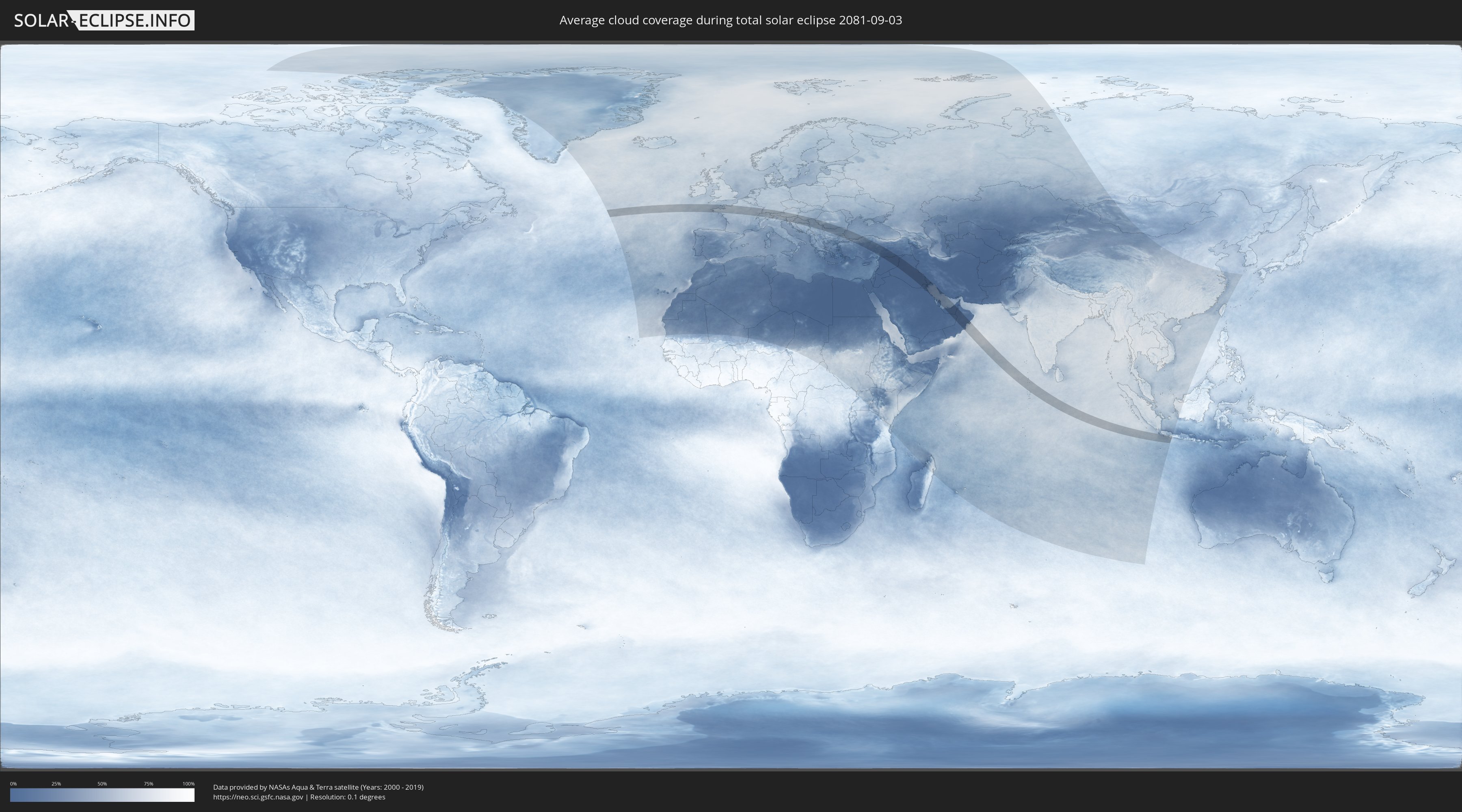
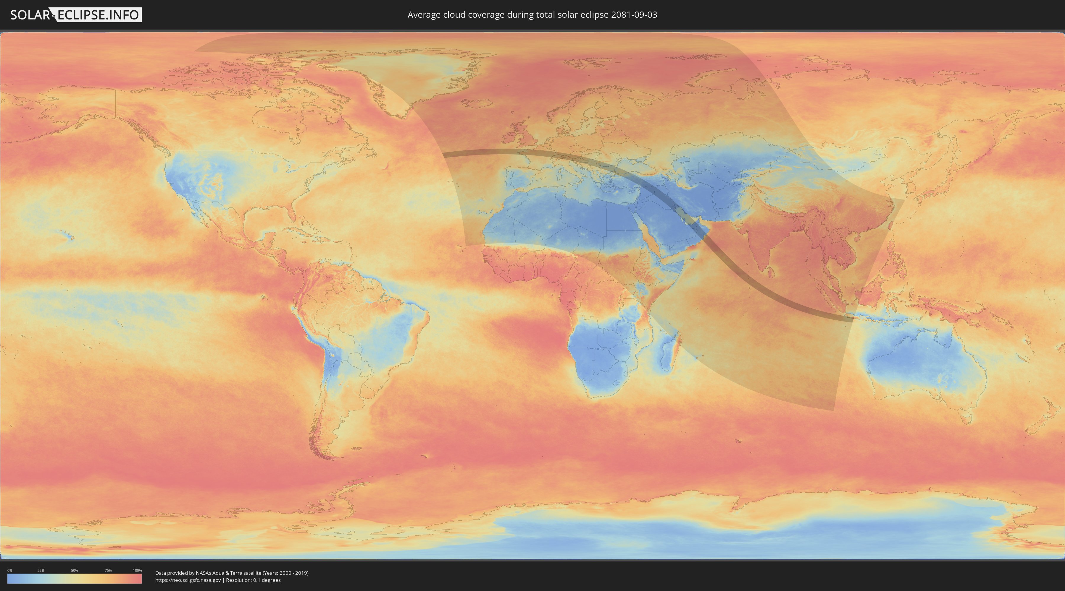
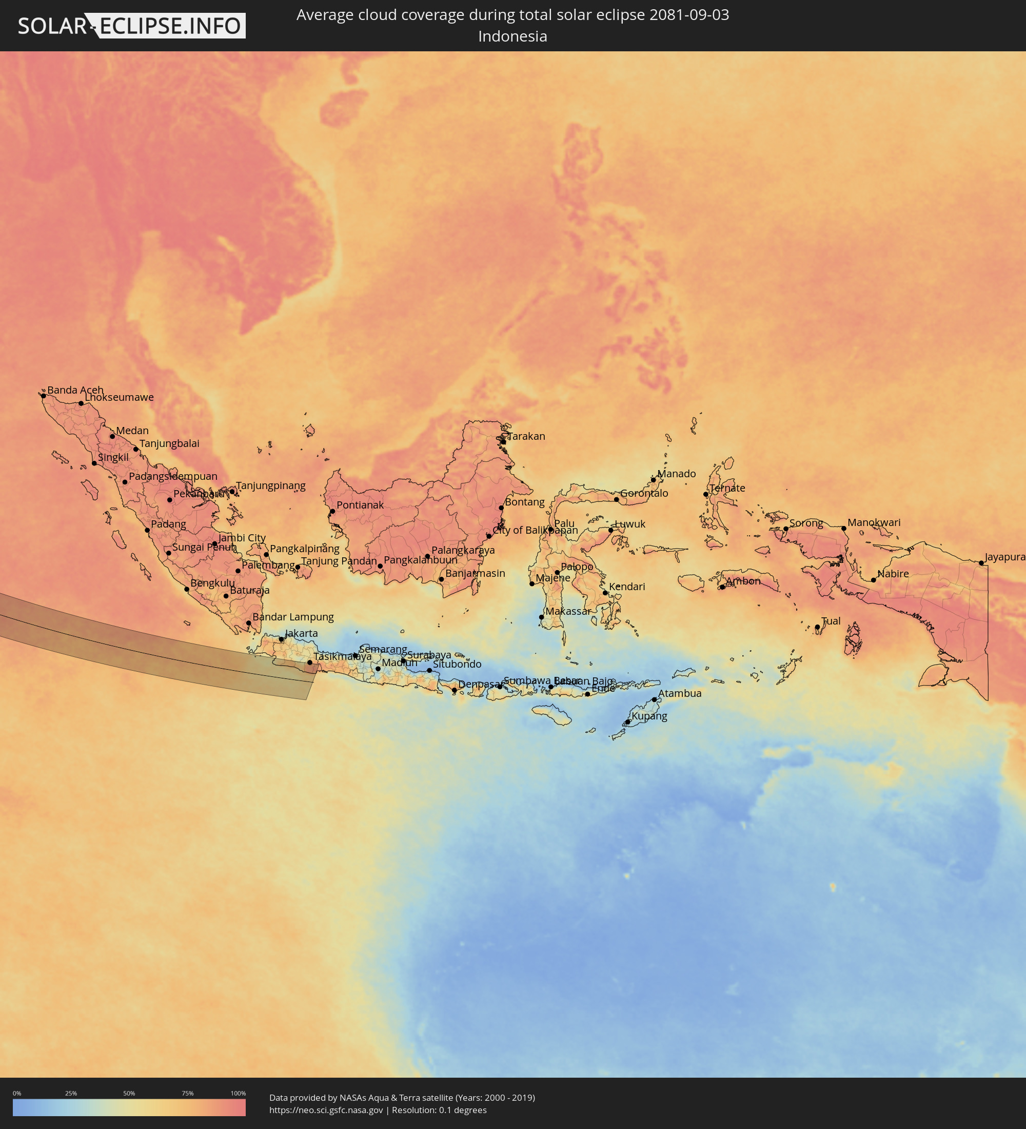
How will be the weather during the total solar eclipse on 09/03/2081?
Where is the best place to see the total solar eclipse of 09/03/2081?
The following maps show the average cloud coverage for the day of the total solar eclipse.
With the help of these maps, it is possible to find the place along the eclipse path, which has the best
chance of a cloudless sky.
Nevertheless, you should consider local circumstances and inform about the weather of your chosen
observation site.
The data is provided by NASAs satellites
AQUA and TERRA.
The cloud maps are averaged over a period of 19 years (2000 - 2019).
Detailed country maps
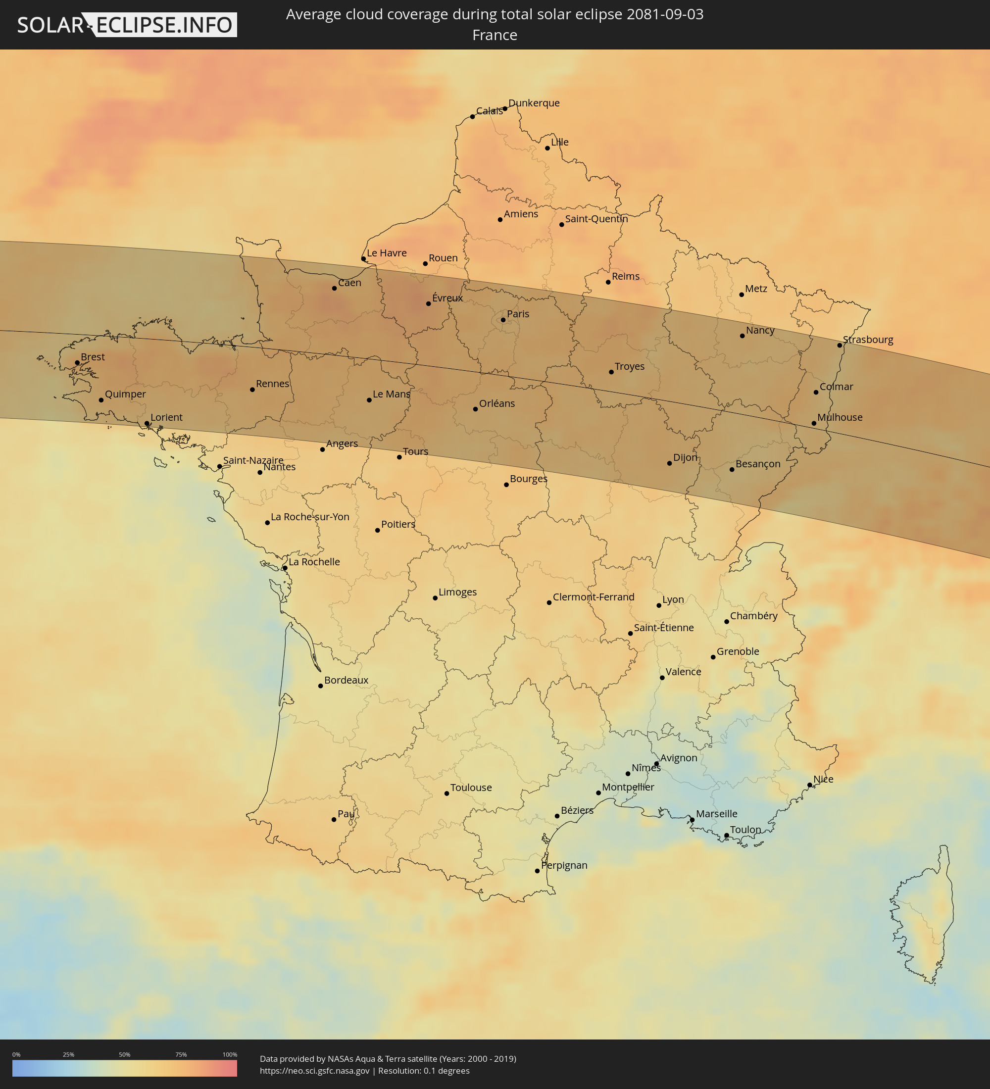 France
 Guernsey
 Jersey
 Germany
 Switzerland
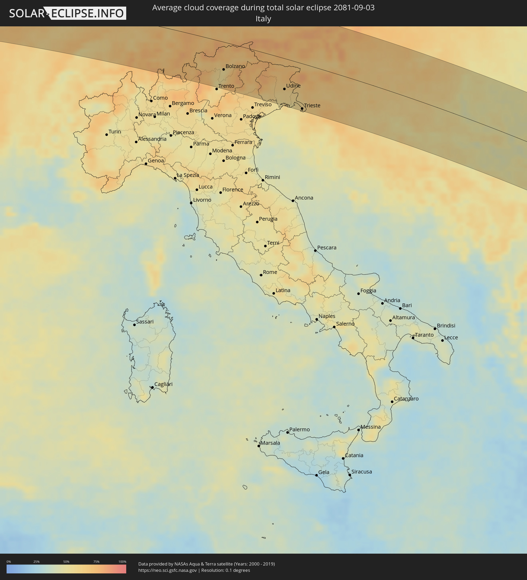 Italy
Italy
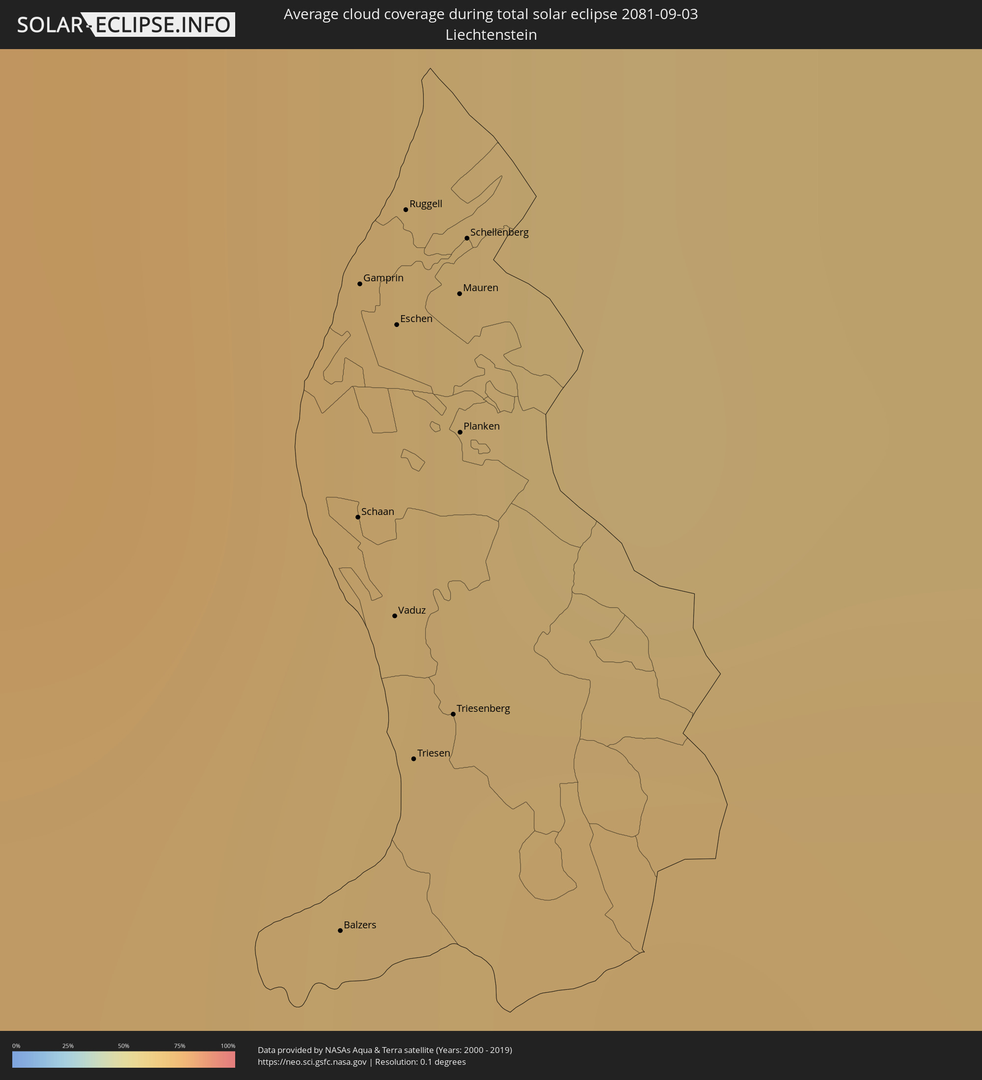 Liechtenstein
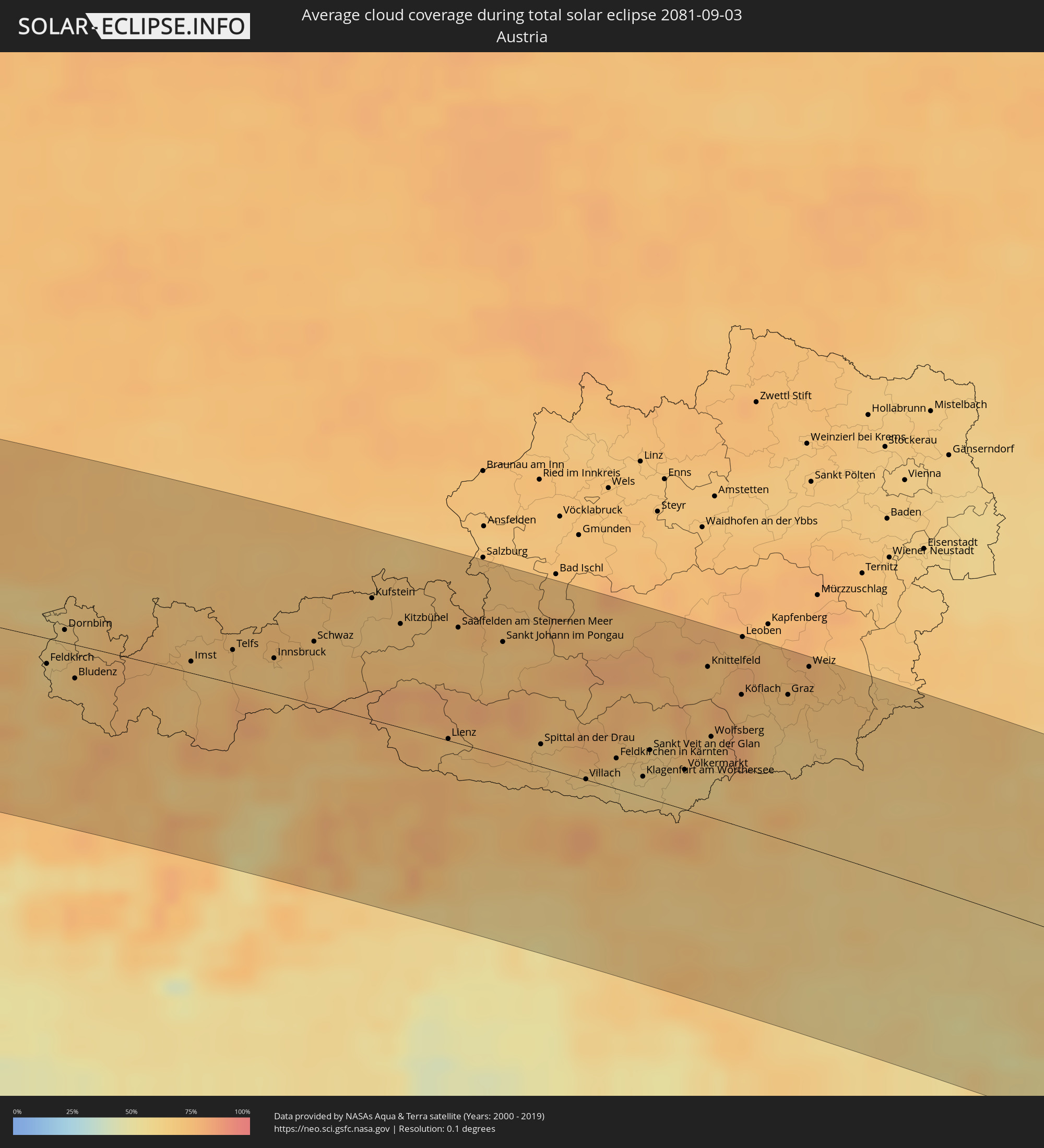 Austria
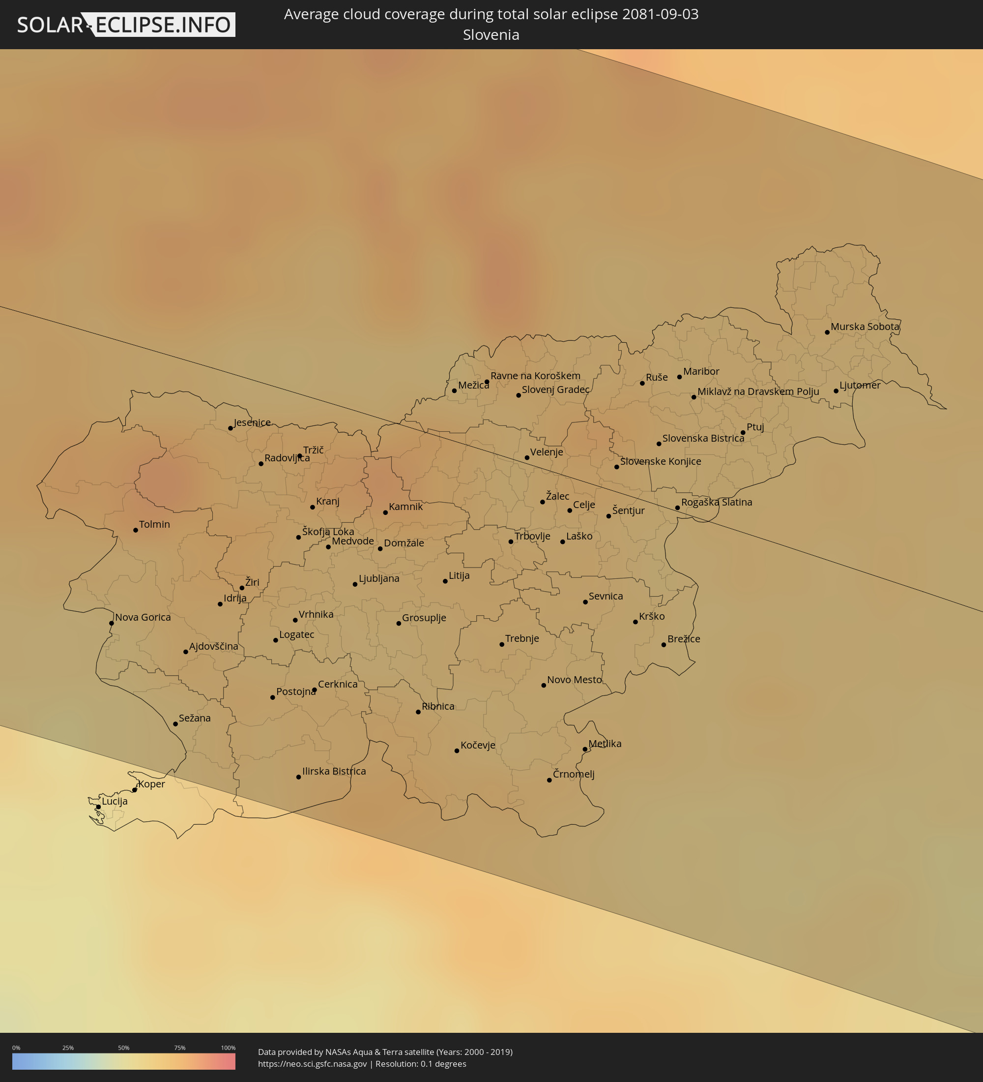 Slovenia
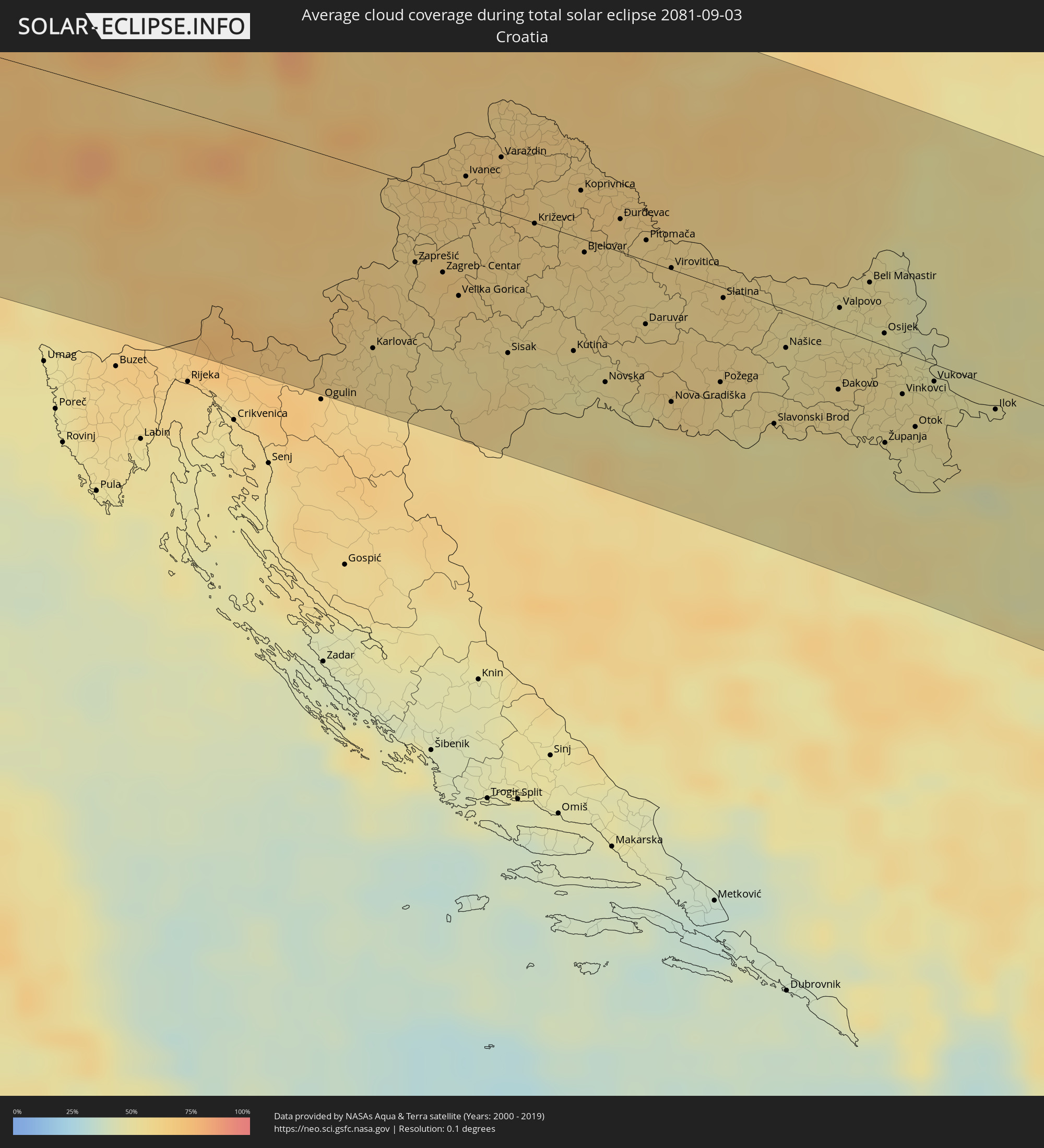 Croatia
 Bosnia and Herzegovina
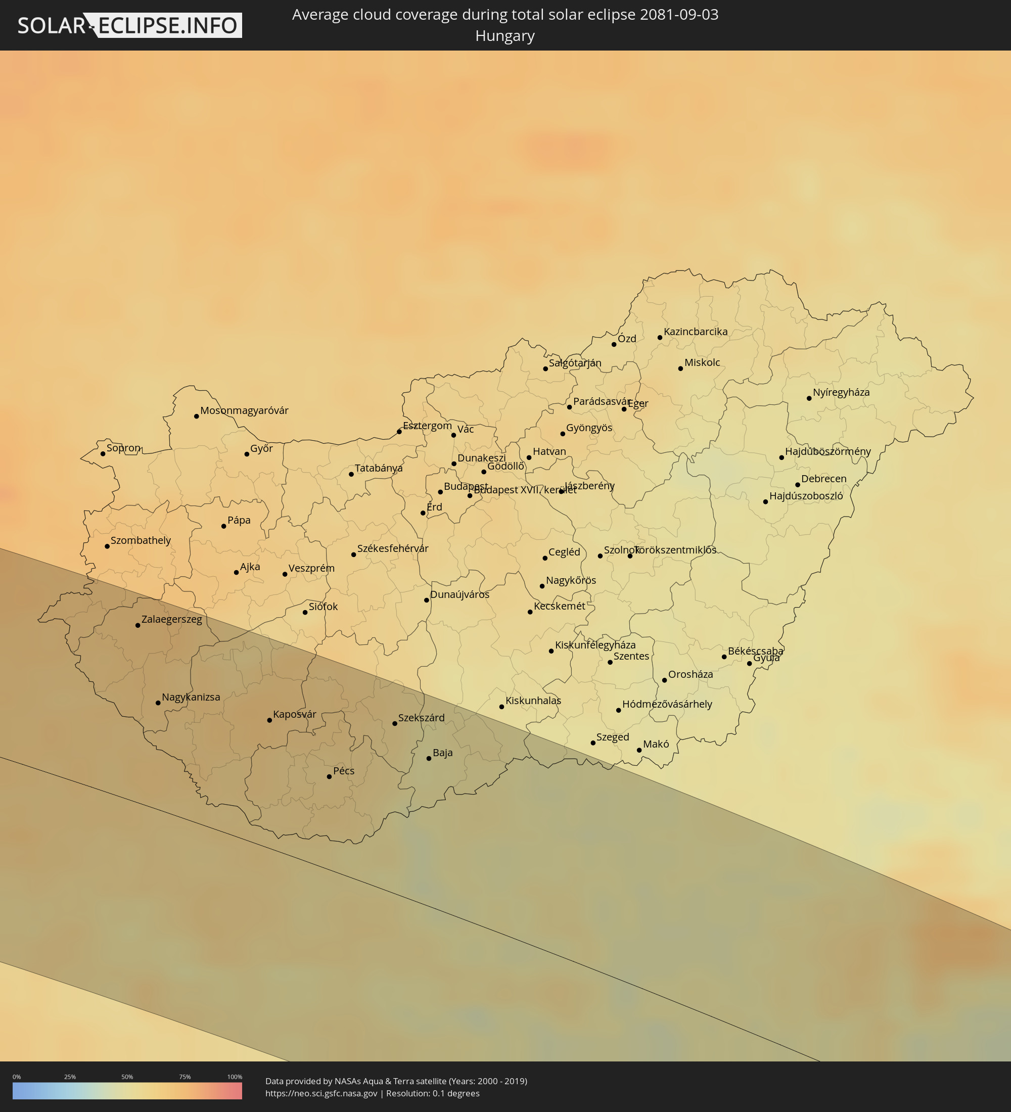 Hungary
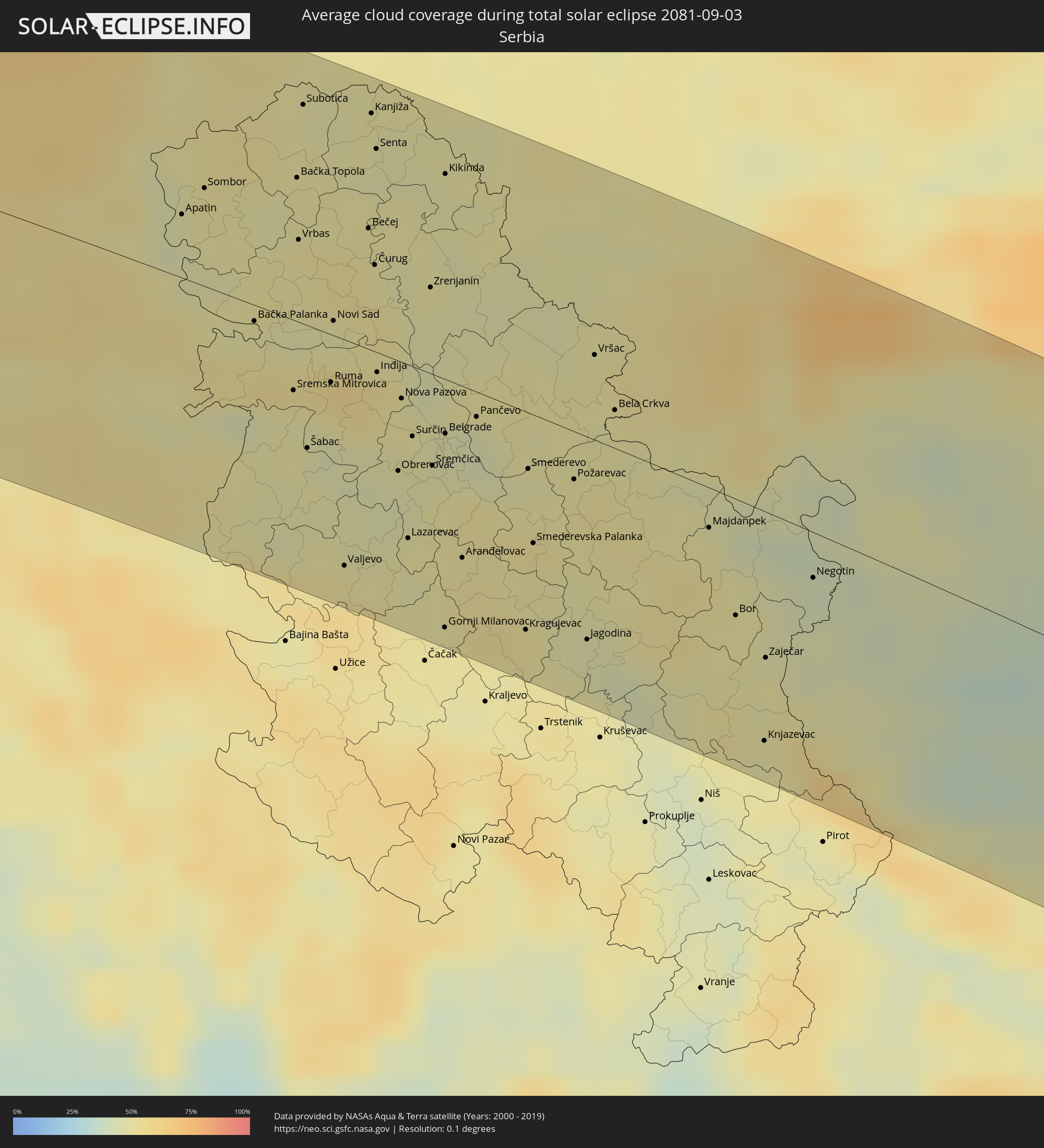 Serbia
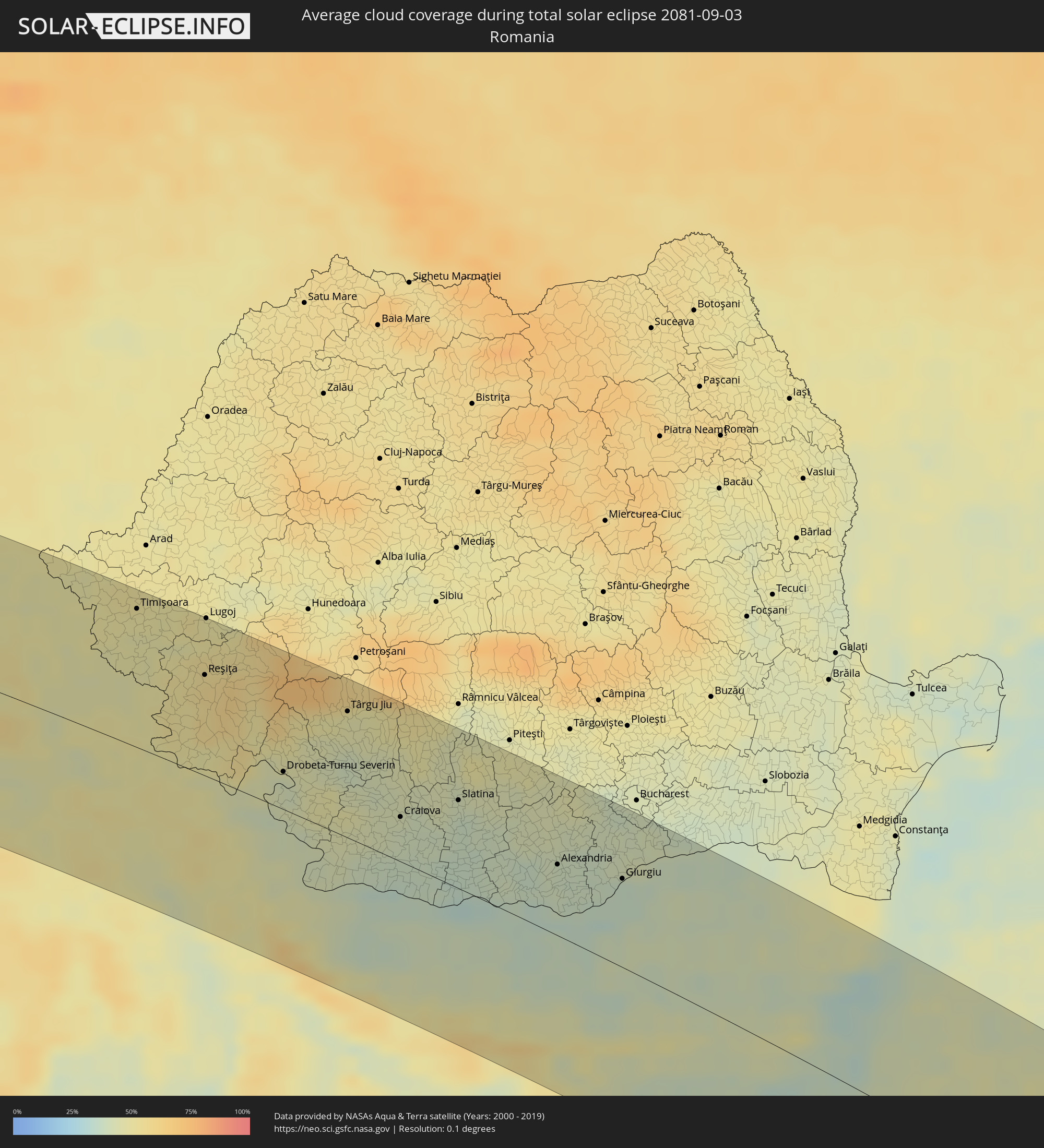 Romania
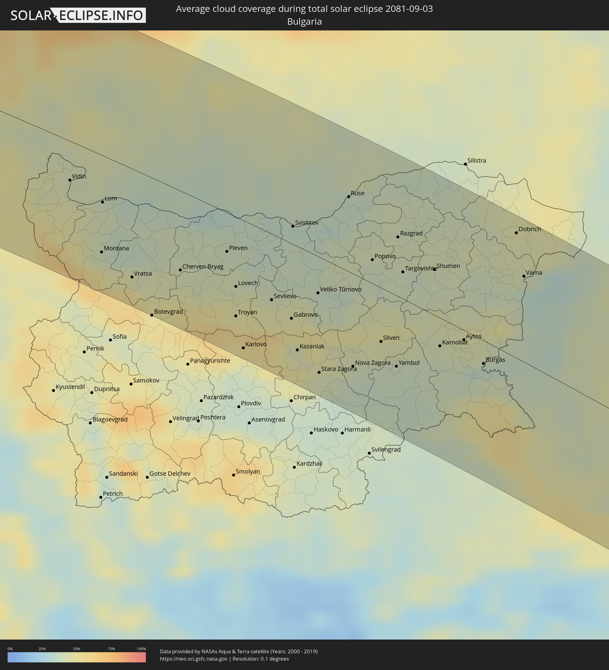 Bulgaria
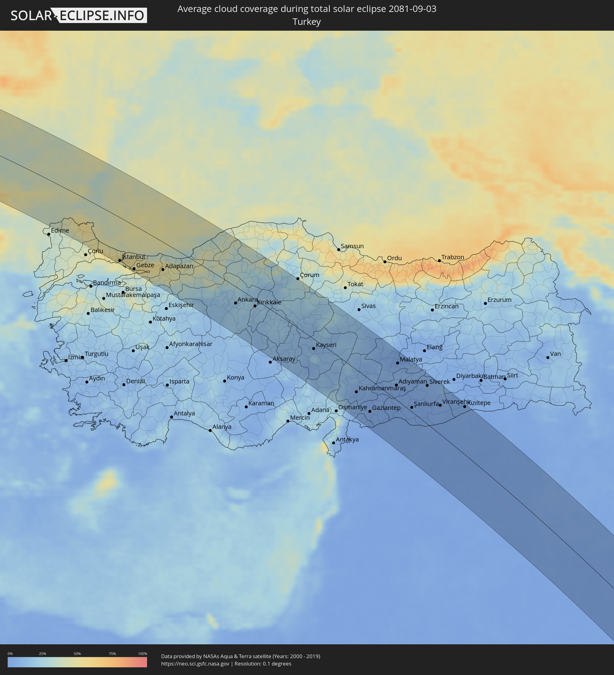 Turkey
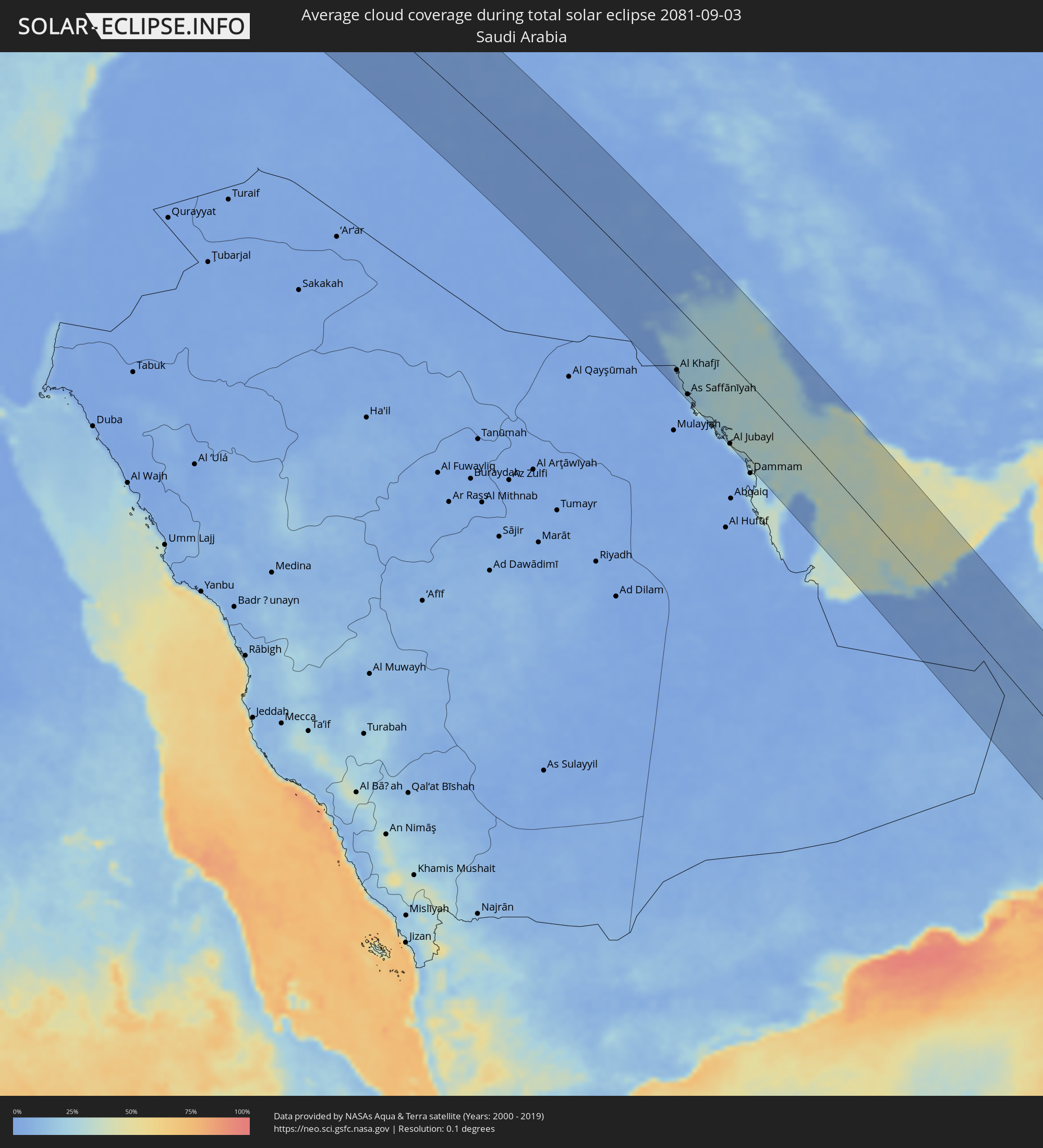 Saudi Arabia
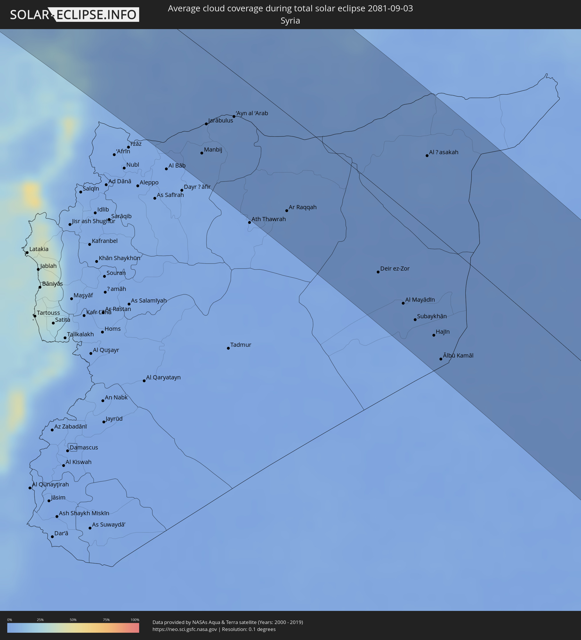 Syria
Syria
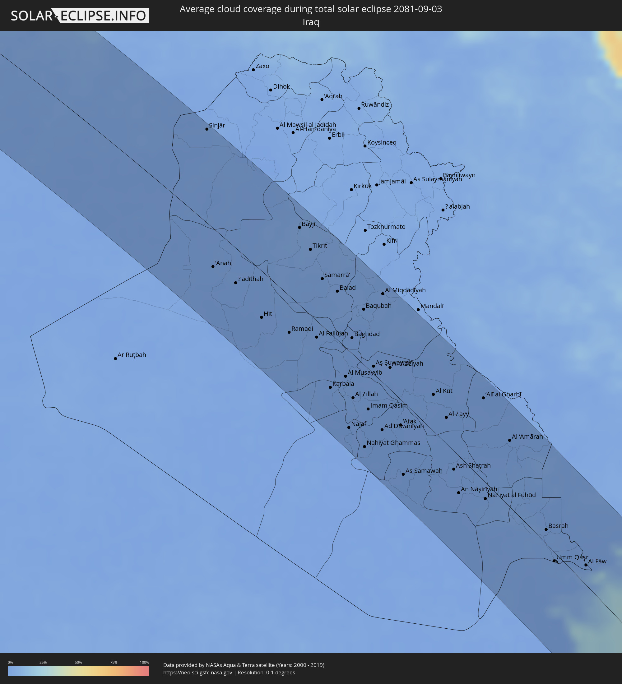 Iraq
Iraq
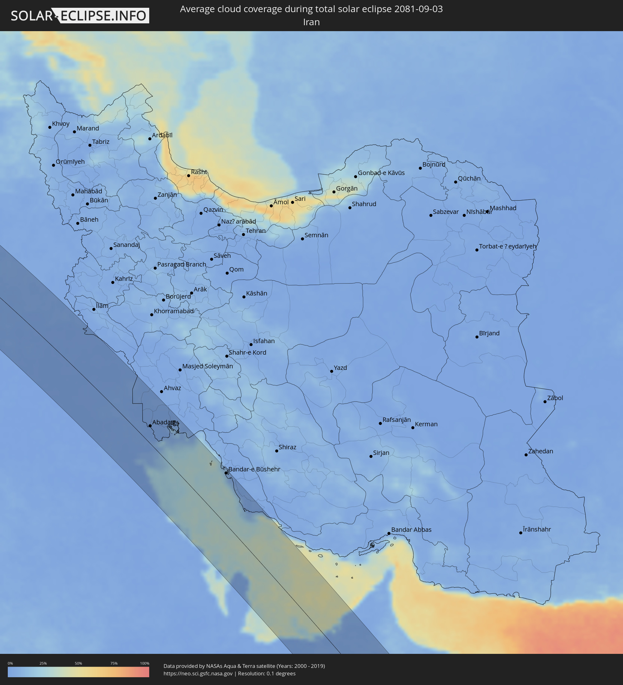 Iran
Iran
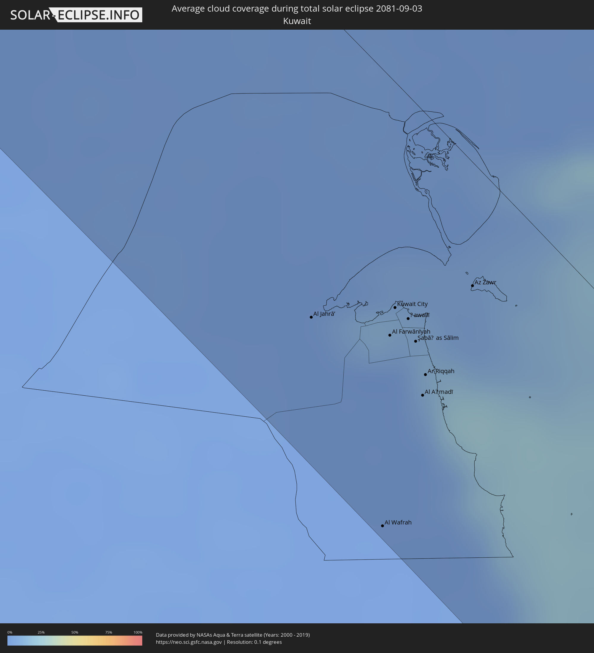 Kuwait
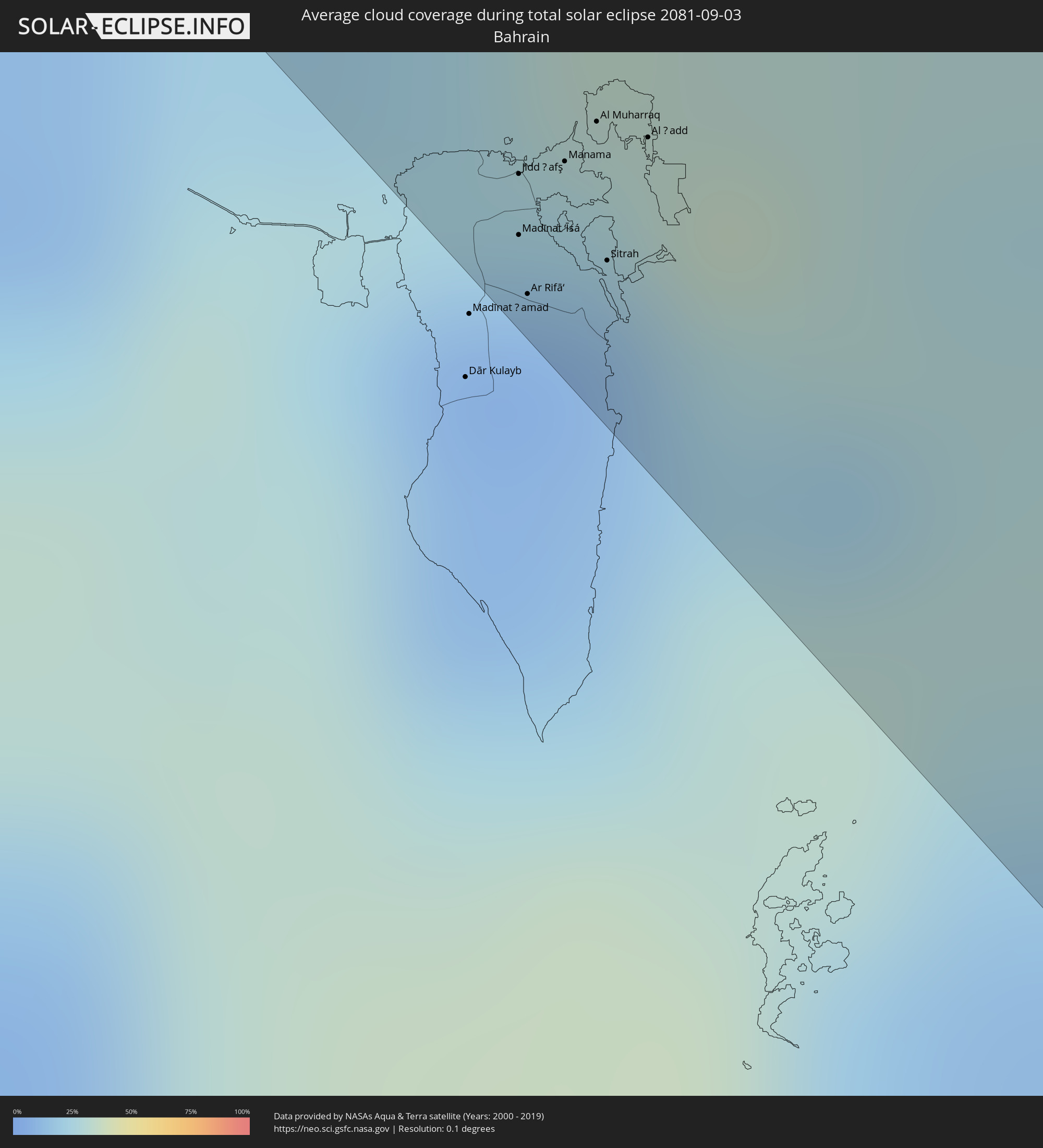 Bahrain
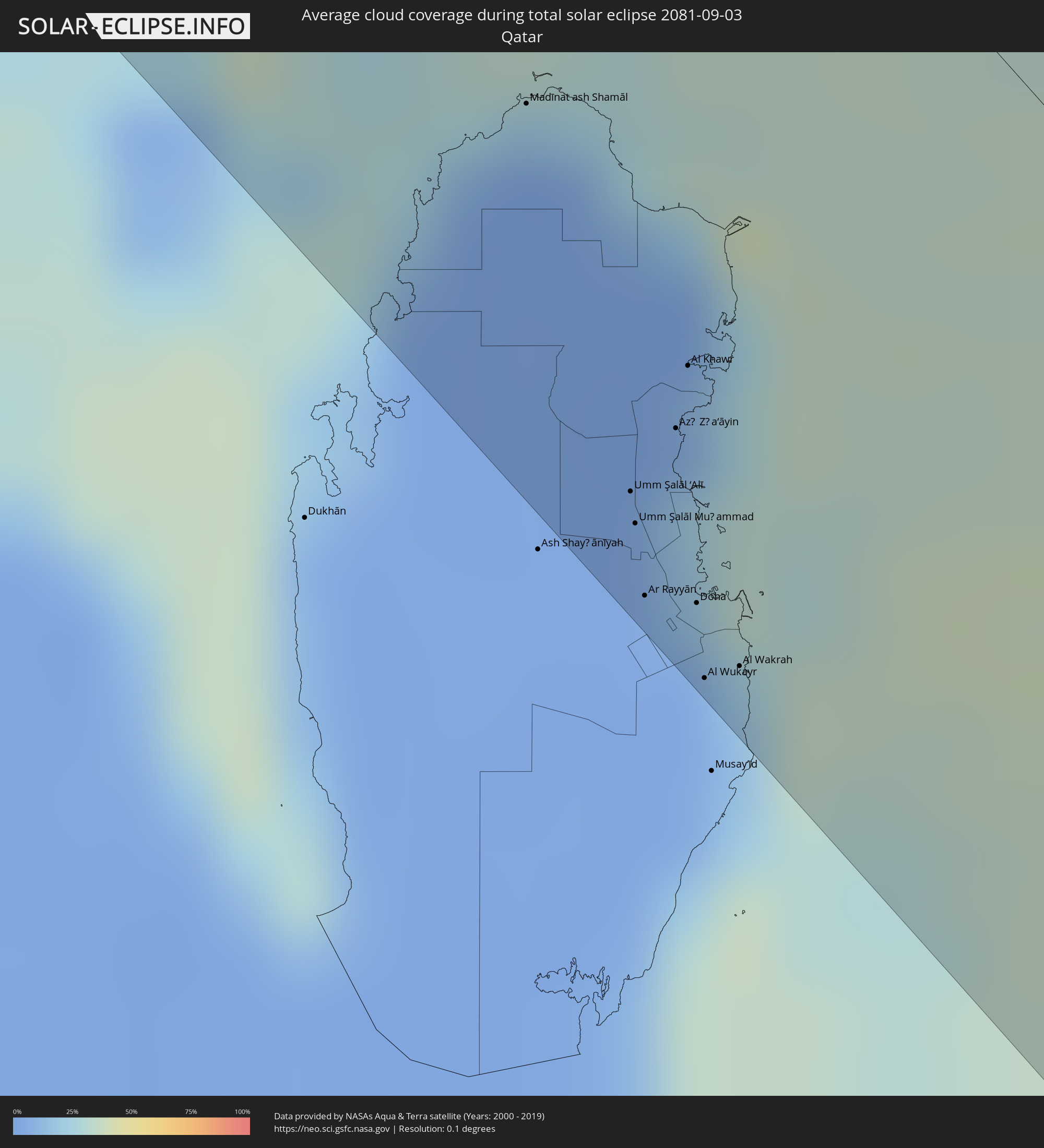 Qatar
Qatar
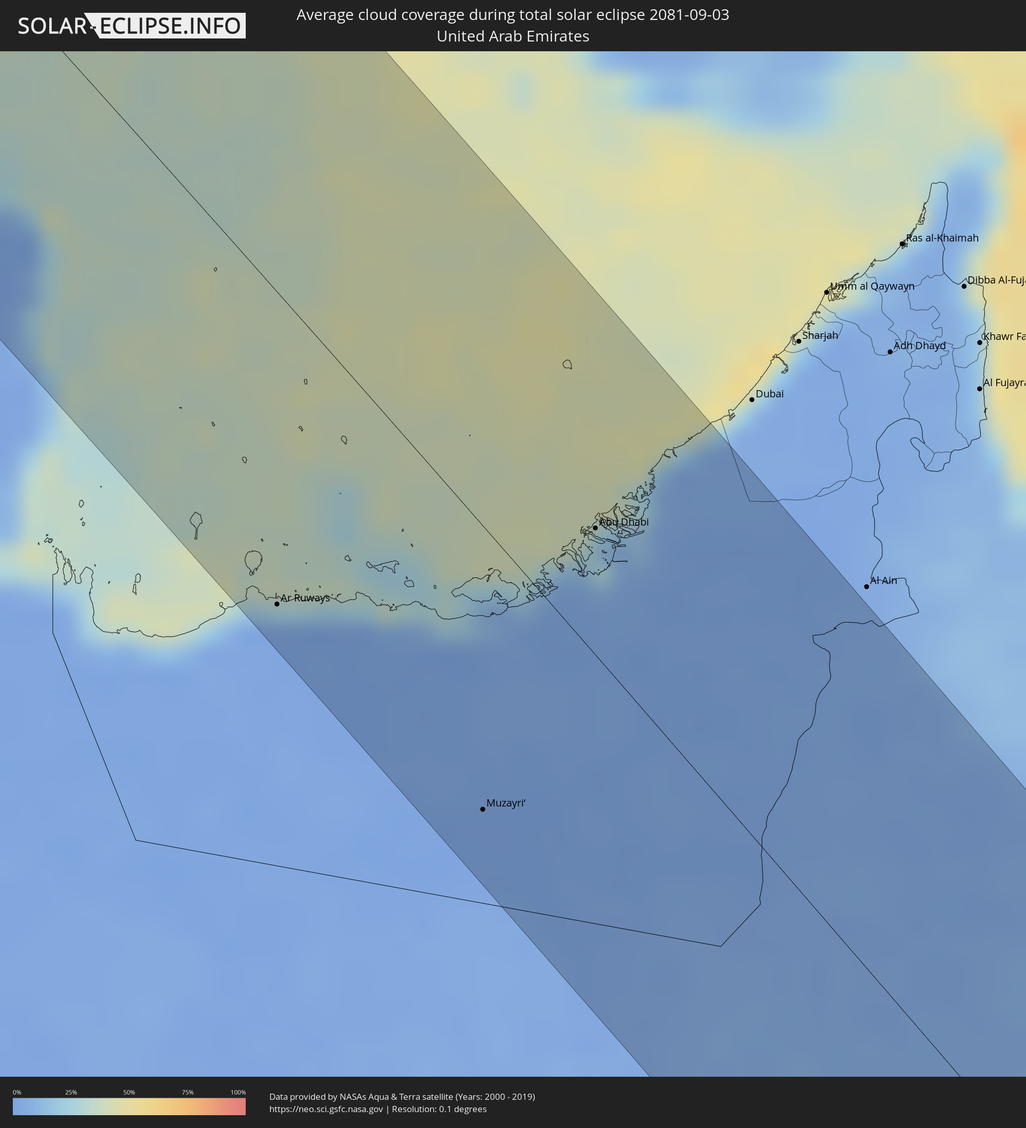 United Arab Emirates
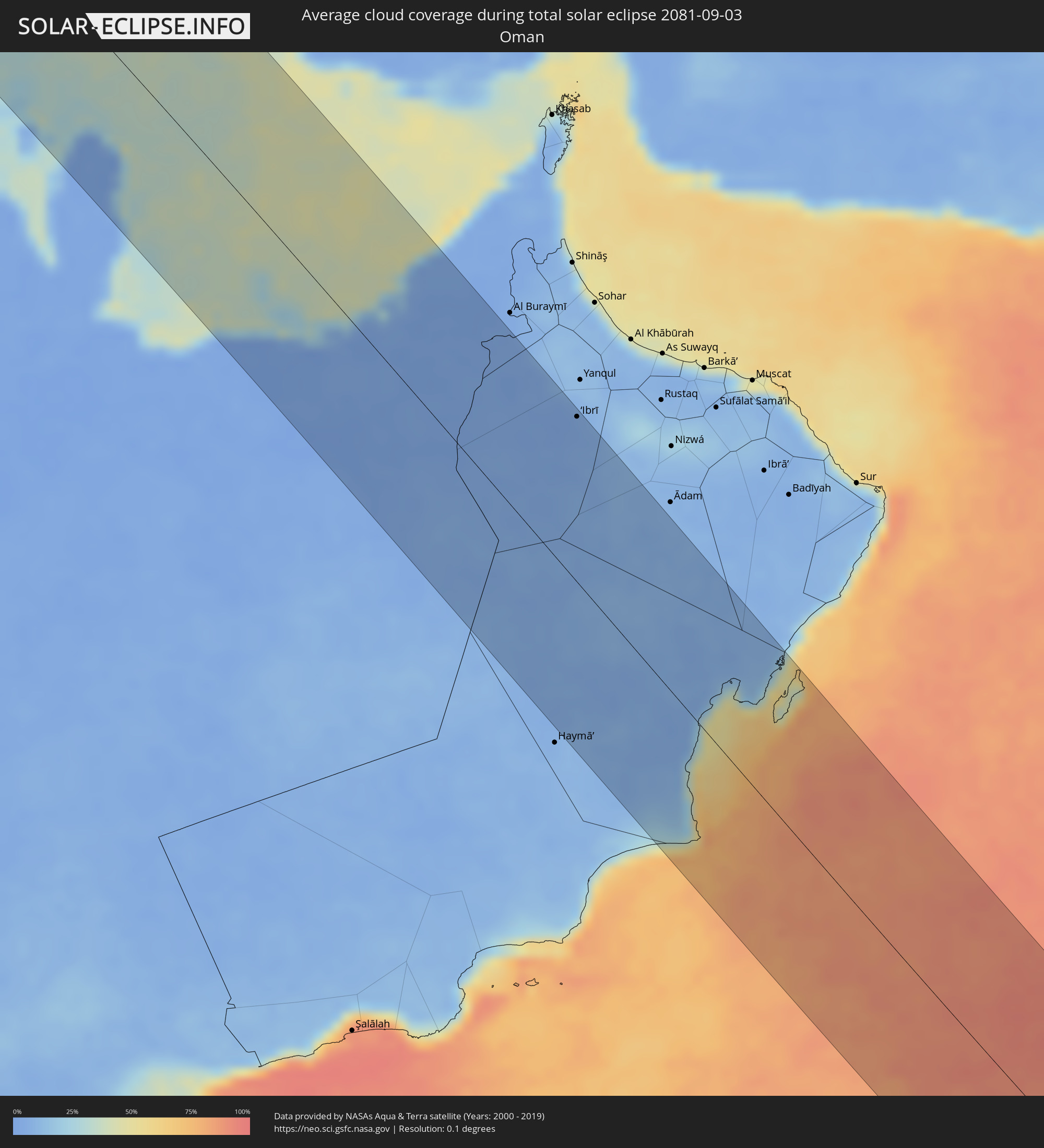 Oman
Oman
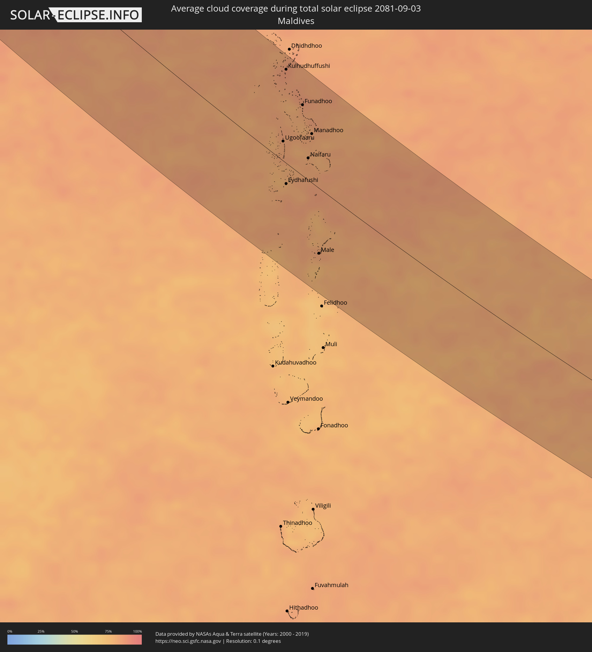 Maldives
 Indonesia
Cities inside the path of the eclipse
The following table shows all locations with a population of more than 5,000 inside the eclipse path. Cities which have more than 100,000 inhabitants are marked bold. A click at the locations opens a detailed map.
| City | Type | Eclipse duration | Local time of max. eclipse | Distance to central line | Ø Cloud coverage |
|
Brest, Brittany
|
total | - | 08:33:31 UTC+01:00 | 34 km | 69% |
|
Saint Peter Port, St Peter Port
|
total | - | 07:35:03 UTC+00:00 | 93 km | 60% |
|
Saint Helier, St Helier
|
total | - | 07:35:06 UTC+00:00 | 66 km | 63% |
|
Le Hocq, St Clement
|
total | - | 07:35:07 UTC+00:00 | 64 km | 63% |
|
Rennes, Brittany
|
total | - | 08:34:45 UTC+01:00 | 51 km | 69% |
|
Le Mans, Pays de la Loire
|
total | - | 08:35:43 UTC+01:00 | 49 km | 69% |
|
Saint-Quentin-en-Yvelines, Île-de-France
|
total | - | 08:37:10 UTC+01:00 | 52 km | 70% |
|
Cergy-Pontoise, Île-de-France
|
total | - | 08:37:19 UTC+01:00 | 82 km | 69% |
|
Paris, Île-de-France
|
total | - | 08:37:24 UTC+01:00 | 65 km | 67% |
|
Dijon, Bourgogne-Franche-Comté
|
total | - | 08:38:28 UTC+01:00 | 74 km | 69% |
|
Biel/Bienne, Bern
|
total | - | 08:40:01 UTC+01:00 | 63 km | 58% |
|
Bern, Bern
|
total | - | 08:40:07 UTC+01:00 | 81 km | 63% |
|
Basel, Basel-City
|
total | - | 08:40:24 UTC+01:00 | 12 km | 62% |
|
Thun, Bern
|
total | - | 08:40:11 UTC+01:00 | 99 km | 61% |
|
Strasbourg, Grand-Est
|
total | - | 08:40:53 UTC+01:00 | 102 km | 63% |
|
Freiburg, Baden-Württemberg
|
total | - | 08:40:46 UTC+01:00 | 40 km | 67% |
|
Offenburg, Baden-Württemberg
|
total | - | 08:41:00 UTC+01:00 | 93 km | 63% |
|
Luzern, Lucerne
|
total | - | 08:40:48 UTC+01:00 | 56 km | 64% |
|
Villingen-Schwenningen, Baden-Württemberg
|
total | - | 08:41:16 UTC+01:00 | 57 km | 75% |
|
Zürich, Zurich
|
total | - | 08:41:05 UTC+01:00 | 18 km | 62% |
|
Winterthur, Zurich
|
total | - | 08:41:16 UTC+01:00 | 0 km | 66% |
|
Konstanz, Baden-Württemberg
|
total | - | 08:41:40 UTC+01:00 | 24 km | 63% |
|
Sankt Gallen, Saint Gallen
|
total | - | 08:41:45 UTC+01:00 | 2 km | 72% |
|
Friedrichshafen, Baden-Württemberg
|
total | - | 08:41:54 UTC+01:00 | 29 km | 62% |
|
Schaan, Schaan
|
total | - | 08:41:47 UTC+01:00 | 24 km | 66% |
|
Gamprin, Gamprin
|
total | - | 08:41:48 UTC+01:00 | 18 km | 66% |
|
Eschen, Eschen
|
total | - | 08:41:49 UTC+01:00 | 19 km | 66% |
|
Ruggell, Ruggell
|
total | - | 08:41:49 UTC+01:00 | 16 km | 66% |
|
Triesenberg, Triesenberg
|
total | - | 08:41:48 UTC+01:00 | 28 km | 66% |
|
Mauren, Mauren
|
total | - | 08:41:50 UTC+01:00 | 17 km | 66% |
|
Planken, Planken
|
total | - | 08:41:49 UTC+01:00 | 21 km | 66% |
|
Schellenberg, Schellenberg
|
total | - | 08:41:50 UTC+01:00 | 16 km | 66% |
|
Feldkirch, Vorarlberg
|
total | - | 08:41:53 UTC+01:00 | 15 km | 67% |
|
Ravensburg, Baden-Württemberg
|
total | - | 08:42:02 UTC+01:00 | 45 km | 70% |
|
Dornbirn, Vorarlberg
|
total | - | 08:42:02 UTC+01:00 | 7 km | 65% |
|
Kempten (Allgäu), Bavaria
|
total | - | 08:42:35 UTC+01:00 | 51 km | 67% |
|
Merano, Trentino-Alto Adige
|
total | - | 08:43:01 UTC+01:00 | 48 km | 64% |
|
Bolzano, Trentino-Alto Adige
|
total | - | 08:43:08 UTC+01:00 | 64 km | 54% |
|
Innsbruck, Tyrol
|
total | - | 08:43:21 UTC+01:00 | 21 km | 66% |
|
Rosenheim, Bavaria
|
total | - | 08:44:06 UTC+01:00 | 98 km | 67% |
|
Belluno, Veneto
|
total | - | 08:43:50 UTC+01:00 | 84 km | 64% |
|
Pordenone, Friuli Venezia Giulia
|
total | - | 08:44:12 UTC+01:00 | 95 km | 59% |
|
Udine, Friuli Venezia Giulia
|
total | - | 08:44:45 UTC+01:00 | 71 km | 61% |
|
Monfalcone, Friuli Venezia Giulia
|
total | - | 08:44:59 UTC+01:00 | 93 km | 52% |
|
Gorizia, Friuli Venezia Giulia
|
total | - | 08:45:05 UTC+01:00 | 76 km | 57% |
|
Trieste, Friuli Venezia Giulia
|
total | - | 08:45:12 UTC+01:00 | 104 km | 58% |
|
Villach, Carinthia
|
total | - | 08:45:23 UTC+01:00 | 0 km | 67% |
|
Klagenfurt am Wörthersee, Carinthia
|
total | - | 08:45:48 UTC+01:00 | 12 km | 64% |
|
Kranj, Kranj
|
total | - | 08:45:47 UTC+01:00 | 28 km | 65% |
|
Ljubljana, Ljubljana
|
total | - | 08:45:55 UTC+01:00 | 45 km | 63% |
|
Wolfsberg, Carinthia
|
total | - | 08:46:19 UTC+01:00 | 47 km | 66% |
|
Trbovlje, Trbovlje
|
total | - | 08:46:26 UTC+01:00 | 22 km | 67% |
|
Leoben, Styria
|
total | - | 08:46:37 UTC+01:00 | 109 km | 73% |
|
Velenje, Velenje
|
total | - | 08:46:30 UTC+01:00 | 1 km | 64% |
|
Novo Mesto, Novo Mesto
|
total | - | 08:46:31 UTC+01:00 | 56 km | 64% |
|
Celje, Celje
|
total | - | 08:46:38 UTC+01:00 | 9 km | 67% |
|
Graz, Styria
|
total | - | 08:46:54 UTC+01:00 | 84 km | 72% |
|
Karlovac, Karlovačka
|
total | - | 08:46:52 UTC+01:00 | 81 km | 58% |
|
Maribor, Maribor
|
total | - | 08:47:02 UTC+01:00 | 35 km | 68% |
|
Velika Kladuša, Federation of Bosnia and Herzegovina
|
total | - | 08:47:06 UTC+01:00 | 107 km | 61% |
|
Ptuj, Ptuj
|
total | - | 08:47:14 UTC+01:00 | 26 km | 64% |
|
Zagreb - Centar, City of Zagreb
|
total | - | 08:47:18 UTC+01:00 | 36 km | 62% |
|
Varaždin, Varaždinska
|
total | - | 08:47:40 UTC+01:00 | 25 km | 64% |
|
Sisak, Sisačko-Moslavačka
|
total | - | 08:47:40 UTC+01:00 | 63 km | 56% |
|
Prijedor, Republic of Srspka
|
total | - | 08:48:00 UTC+01:00 | 106 km | 55% |
|
Zalaegerszeg, Zala
|
total | - | 08:48:12 UTC+01:00 | 93 km | 67% |
|
Nagykanizsa, Zala
|
total | - | 08:48:19 UTC+01:00 | 56 km | 64% |
|
Keszthely, Zala
|
total | - | 08:48:34 UTC+01:00 | 96 km | 65% |
|
Kaposvár, Somogy
|
total | - | 08:49:06 UTC+01:00 | 67 km | 66% |
|
Slavonski Brod, Slavonski Brod-Posavina
|
total | - | 08:49:20 UTC+01:00 | 53 km | 50% |
|
Doboj, Republic of Srspka
|
total | - | 08:49:25 UTC+01:00 | 96 km | 53% |
|
Dombóvár, Tolna
|
total | - | 08:49:26 UTC+01:00 | 77 km | 63% |
|
Pécs, Baranya
|
total | - | 08:49:32 UTC+01:00 | 49 km | 60% |
|
Gračanica, Federation of Bosnia and Herzegovina
|
total | - | 08:49:39 UTC+01:00 | 93 km | 54% |
|
Gradačac, Federation of Bosnia and Herzegovina
|
total | - | 08:49:46 UTC+01:00 | 72 km | 56% |
|
Tuzla, Federation of Bosnia and Herzegovina
|
total | - | 08:50:03 UTC+01:00 | 101 km | 50% |
|
Osijek, Osječko-Baranjska
|
total | - | 08:50:01 UTC+01:00 | 6 km | 49% |
|
Szekszárd, Tolna
|
total | - | 08:50:01 UTC+01:00 | 89 km | 58% |
|
Vinkovci, Vukovar-Sirmium
|
total | - | 08:50:09 UTC+01:00 | 19 km | 54% |
|
Brčko, Brčko
|
total | - | 08:50:10 UTC+01:00 | 62 km | 48% |
|
Baja, Bács-Kiskun
|
total | - | 08:50:16 UTC+01:00 | 78 km | 50% |
|
Vukovar, Vukovar-Sirmium
|
total | - | 08:50:21 UTC+01:00 | 8 km | 52% |
|
Bijeljina, Republic of Srspka
|
total | - | 08:50:37 UTC+01:00 | 63 km | 51% |
|
Subotica, Vojvodina
|
total | - | 08:51:00 UTC+01:00 | 89 km | 48% |
|
Novi Sad, Vojvodina
|
total | - | 08:51:14 UTC+01:00 | 6 km | 48% |
|
Valjevo, Central Serbia
|
total | - | 08:51:24 UTC+01:00 | 94 km | 51% |
|
Zrenjanin, Vojvodina
|
total | - | 08:51:48 UTC+01:00 | 35 km | 48% |
|
Belgrade, Central Serbia
|
total | - | 08:51:57 UTC+01:00 | 22 km | 45% |
|
Pančevo, Vojvodina
|
total | - | 08:52:08 UTC+01:00 | 10 km | 43% |
|
Kragujevac, Central Serbia
|
total | - | 08:52:34 UTC+01:00 | 90 km | 51% |
|
Smederevo, Central Serbia
|
total | - | 08:52:29 UTC+01:00 | 23 km | 47% |
|
Timişoara, Timiş
|
total | - | 09:52:40 UTC+02:00 | 98 km | 49% |
|
Reşiţa, Caraş-Severin
|
total | - | 09:53:26 UTC+02:00 | 71 km | 57% |
|
Drobeta-Turnu Severin, Mehedinţi
|
total | - | 09:54:25 UTC+02:00 | 27 km | 41% |
|
Târgu Jiu, Gorj
|
total | - | 09:55:02 UTC+02:00 | 89 km | 46% |
|
Craiova, Dolj
|
total | - | 09:55:47 UTC+02:00 | 32 km | 40% |
|
Slatina, Olt County
|
total | - | 09:56:25 UTC+02:00 | 62 km | 37% |
|
Pleven, Pleven
|
total | - | 09:57:01 UTC+02:00 | 32 km | 40% |
|
Alexandria, Teleorman
|
total | - | 09:57:41 UTC+02:00 | 50 km | 38% |
|
Stara Zagora, Stara Zagora
|
total | - | 09:58:37 UTC+02:00 | 94 km | 43% |
|
Giurgiu, Giurgiu
|
total | - | 09:58:29 UTC+02:00 | 63 km | 36% |
|
Ruse, Ruse
|
total | - | 09:58:30 UTC+02:00 | 60 km | 36% |
|
Sliven, Sliven
|
total | - | 09:59:22 UTC+02:00 | 44 km | 44% |
|
Shumen, Shumen
|
total | - | 09:59:52 UTC+02:00 | 36 km | 40% |
|
Burgas, Burgas
|
total | - | 10:00:53 UTC+02:00 | 19 km | 35% |
|
Dobrich, Dobrich
|
total | - | 10:00:53 UTC+02:00 | 100 km | 46% |
|
Varna, Varna
|
total | - | 10:01:08 UTC+02:00 | 68 km | 35% |
|
İstanbul, Istanbul
|
total | - | 11:03:36 UTC+03:00 | 106 km | 44% |
|
Maltepe, Istanbul
|
total | - | 11:03:55 UTC+03:00 | 105 km | 48% |
|
Ankara, Ankara
|
total | - | 11:09:43 UTC+03:00 | 40 km | 19% |
|
Kayseri, Kayseri
|
total | - | 11:14:31 UTC+03:00 | 23 km | 13% |
|
Kahramanmaraş, Kahramanmaraş
|
total | - | 11:17:46 UTC+03:00 | 53 km | 3% |
|
Gaziantep, Gaziantep
|
total | - | 11:19:00 UTC+03:00 | 76 km | 3% |
|
Manbij, Aleppo
|
total | - | 10:20:28 UTC+02:00 | 92 km | 2% |
|
Malatya, Malatya
|
total | - | 11:19:05 UTC+03:00 | 88 km | 3% |
|
‘Ayn al ‘Arab, Aleppo
|
total | - | 10:20:41 UTC+02:00 | 38 km | 1% |
|
Şanlıurfa, Şanlıurfa
|
total | - | 11:21:03 UTC+03:00 | 10 km | 2% |
|
Ar Raqqah, Ar-Raqqah
|
total | - | 10:22:45 UTC+02:00 | 84 km | 2% |
|
Deir ez-Zor, Deir ez-Zor
|
total | - | 10:25:17 UTC+02:00 | 73 km | 0% |
|
Al Mayādīn, Deir ez-Zor
|
total | - | 10:26:10 UTC+02:00 | 82 km | 1% |
|
Al Ḩasakah, Al-Hasakah
|
total | - | 10:24:49 UTC+02:00 | 62 km | 1% |
|
Hajīn, Deir ez-Zor
|
total | - | 10:27:11 UTC+02:00 | 88 km | 1% |
|
Ālbū Kamāl, Deir ez-Zor
|
total | - | 10:27:38 UTC+02:00 | 103 km | 1% |
|
Karbala, Karbalāʼ
|
total | - | 11:35:13 UTC+03:00 | 65 km | 1% |
|
Abū Ghurayb, Mayorality of Baghdad
|
total | - | 11:34:28 UTC+03:00 | 2 km | 2% |
|
Najaf, An Najaf
|
total | - | 11:36:37 UTC+03:00 | 92 km | 0% |
|
Baghdad, Mayorality of Baghdad
|
total | - | 11:34:46 UTC+03:00 | 19 km | 1% |
|
Ad Dīwānīyah, Al Qādisīyah
|
total | - | 11:37:37 UTC+03:00 | 57 km | 0% |
|
Mehrān, Īlām
|
total | - | 12:07:56 UTC+03:30 | 114 km | 1% |
|
An Nāşirīyah, Dhi Qar
|
total | - | 11:41:16 UTC+03:00 | 44 km | 1% |
|
Al ‘Amārah, Maysan
|
total | - | 11:41:30 UTC+03:00 | 77 km | 0% |
|
Al Jahrā’, Al Jahrāʼ
|
total | - | 11:46:24 UTC+03:00 | 83 km | 0% |
|
Basrah, Basra Governorate
|
total | - | 11:44:39 UTC+03:00 | 17 km | 2% |
|
Al Wafrah, Al Aḩmadī
|
total | - | 11:48:02 UTC+03:00 | 118 km | 0% |
|
Ash Shāmīyah, Al Asimah
|
total | - | 11:46:53 UTC+03:00 | 61 km | 2% |
|
Janūb as Surrah, Al Farwaniyah
|
total | - | 11:47:03 UTC+03:00 | 66 km | 2% |
|
Ad Dasmah, Al Asimah
|
total | - | 11:46:55 UTC+03:00 | 57 km | 7% |
|
Ḩawallī, Hawalli
|
total | - | 11:47:01 UTC+03:00 | 57 km | 2% |
|
Al Aḩmadī, Al Aḩmadī
|
total | - | 11:47:33 UTC+03:00 | 73 km | 6% |
|
Al Mahbūlah, Al Aḩmadī
|
total | - | 11:47:30 UTC+03:00 | 65 km | 6% |
|
Khorramshahr, Khuzestan
|
total | - | 12:15:26 UTC+03:30 | 39 km | 1% |
|
Abadan, Khuzestan
|
total | - | 12:15:48 UTC+03:30 | 40 km | 1% |
|
Al Khafjī, Eastern Province
|
total | - | 11:49:19 UTC+03:00 | 94 km | 11% |
|
Shādegān, Khuzestan
|
total | - | 12:15:53 UTC+03:30 | 88 km | 2% |
|
As Saffānīyah, Eastern Province
|
total | - | 11:50:32 UTC+03:00 | 113 km | 5% |
|
Al Jubayl, Eastern Province
|
total | - | 11:53:47 UTC+03:00 | 119 km | 16% |
|
Raḩīmah, Eastern Province
|
total | - | 11:55:01 UTC+03:00 | 113 km | 28% |
|
Khārk, Bushehr
|
total | - | 12:20:57 UTC+03:30 | 100 km | 32% |
|
Jidd Ḩafş, Manama
|
total | - | 11:56:43 UTC+03:00 | 114 km | 8% |
|
Madīnat ‘Īsá, Southern Governorate
|
total | - | 11:56:48 UTC+03:00 | 117 km | 8% |
|
Ar Rifā‘, Southern Governorate
|
total | - | 11:56:54 UTC+03:00 | 120 km | 11% |
|
Manama, Manama
|
total | - | 11:56:46 UTC+03:00 | 111 km | 10% |
|
Al Muharraq, Muharraq
|
total | - | 11:56:45 UTC+03:00 | 106 km | 25% |
|
Sitrah, Manama
|
total | - | 11:56:57 UTC+03:00 | 113 km | 10% |
|
Al Ḩadd, Muharraq
|
total | - | 11:56:51 UTC+03:00 | 104 km | 27% |
|
Bandar-e Būshehr, Bushehr
|
total | - | 12:22:17 UTC+03:30 | 114 km | 10% |
|
Madīnat ash Shamāl, Madīnat ash Shamāl
|
total | - | 11:57:58 UTC+03:00 | 72 km | 3% |
|
Umm Şalāl ‘Alī, Baladīyat Umm Şalāl
|
total | - | 11:59:31 UTC+03:00 | 107 km | 4% |
|
Umm Şalāl Muḩammad, Baladīyat Umm Şalāl
|
total | - | 11:59:38 UTC+03:00 | 110 km | 3% |
|
Az̧ Z̧a‘āyin, Baladīyat az̧ Z̧a‘āyin
|
total | - | 11:59:28 UTC+03:00 | 93 km | 19% |
|
Al Khawr, Al Khawr
|
total | - | 11:59:18 UTC+03:00 | 83 km | 9% |
|
Doha, Baladīyat ad Dawḩah
|
total | - | 12:00:05 UTC+03:00 | 112 km | 4% |
|
Al Wukayr, Al Wakrah
|
total | - | 12:00:21 UTC+03:00 | 120 km | 2% |
|
Al Wakrah, Al Wakrah
|
total | - | 12:00:25 UTC+03:00 | 114 km | 16% |
|
Ar Ruways, Abu Dhabi
|
total | - | 13:04:18 UTC+04:00 | 108 km | 2% |
|
Muzayri‘, Abu Dhabi
|
total | - | 13:07:55 UTC+04:00 | 98 km | 1% |
|
Abu Dhabi, Abu Dhabi
|
total | - | 13:06:19 UTC+04:00 | 43 km | 15% |
|
‘Ibrī, Az̧ Z̧āhirah
|
total | - | 13:12:11 UTC+04:00 | 119 km | 3% |
|
Ugoofaaru, Raa Atoll
|
total | - | 15:08:31 UTC+05:00 | 23 km | 81% |
|
Kulhudhuffushi, Haa Dhaalu Atholhu
|
total | - | 15:06:58 UTC+05:00 | 109 km | 85% |
|
Eydhafushi, Baa Atholhu
|
total | - | 15:09:30 UTC+05:00 | 24 km | 80% |
|
Funadhoo, Shaviyani Atholhu
|
total | - | 15:08:00 UTC+05:00 | 83 km | 84% |
|
Naifaru, Lhaviyani Atholhu
|
total | - | 15:09:15 UTC+05:00 | 26 km | 82% |
|
Manadhoo, Noonu Atoll
|
total | - | 15:08:46 UTC+05:00 | 58 km | 83% |
|
Male, Kaafu Atoll
|
total | - | 15:11:29 UTC+05:00 | 77 km | 82% |
|
Singaparna, West Java
|
total | - | 17:40:57 UTC+07:00 | 95 km | 84% |
|
Kawalu, West Java
|
total | - | 17:40:58 UTC+07:00 | 93 km | 84% |