Annular solar eclipse of 02/07/2092
| Day of week: | Thursday |
| Maximum duration of eclipse: | 01m48s |
| Maximum width of eclipse path: | 62 km |
| Saros cycle: | 132 |
| Coverage: | 98.4% |
| Magnitude: | 0.984 |
| Gamma: | 0.4322 |
Wo kann man die Sonnenfinsternis vom 02/07/2092 sehen?
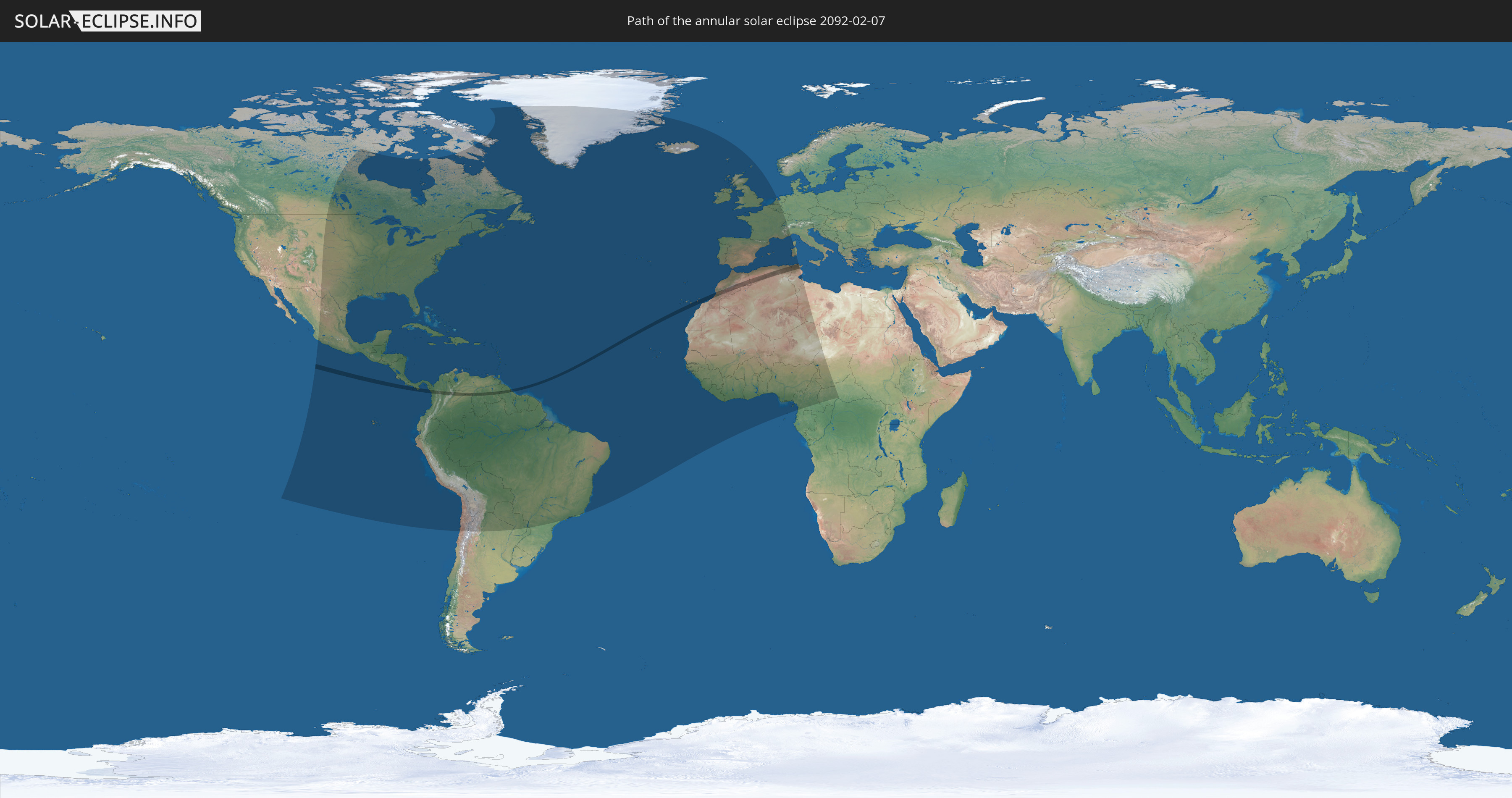
Die Sonnenfinsternis am 02/07/2092 kann man in 96 Ländern als partielle Sonnenfinsternis beobachten.
Der Finsternispfad verläuft durch 9 Länder. Nur in diesen Ländern ist sie als annular Sonnenfinsternis zu sehen.
In den folgenden Ländern ist die Sonnenfinsternis annular zu sehen
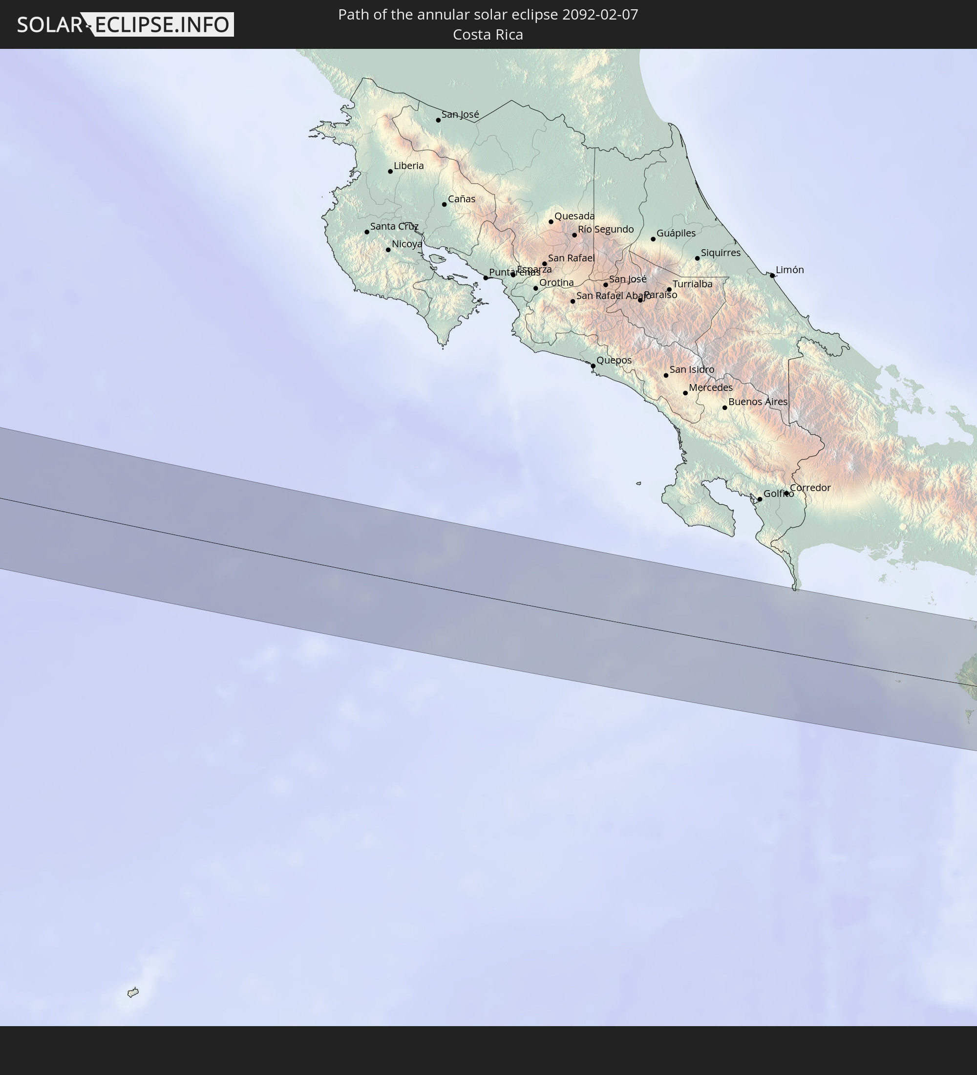 Costa Rica
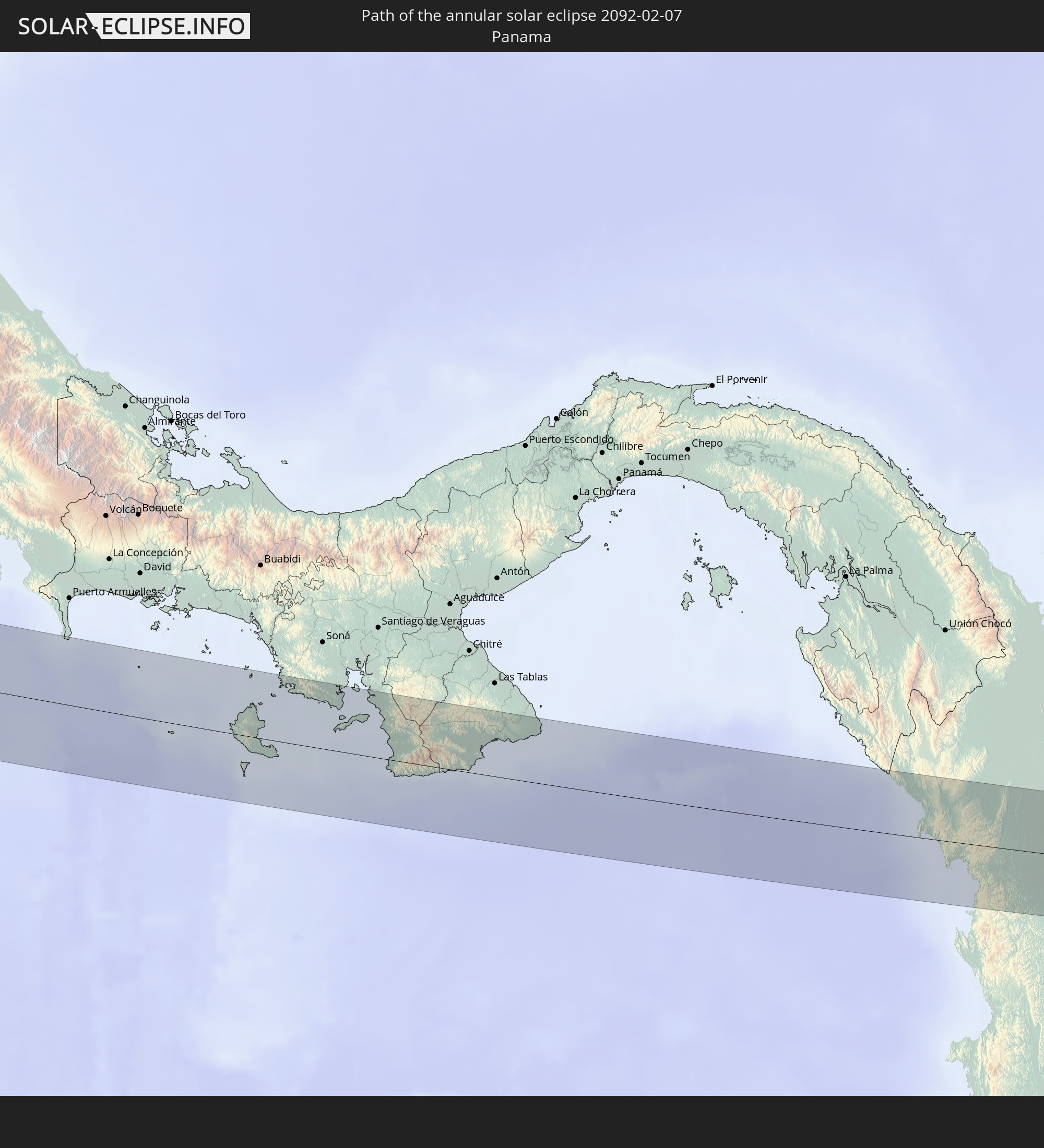 Panama
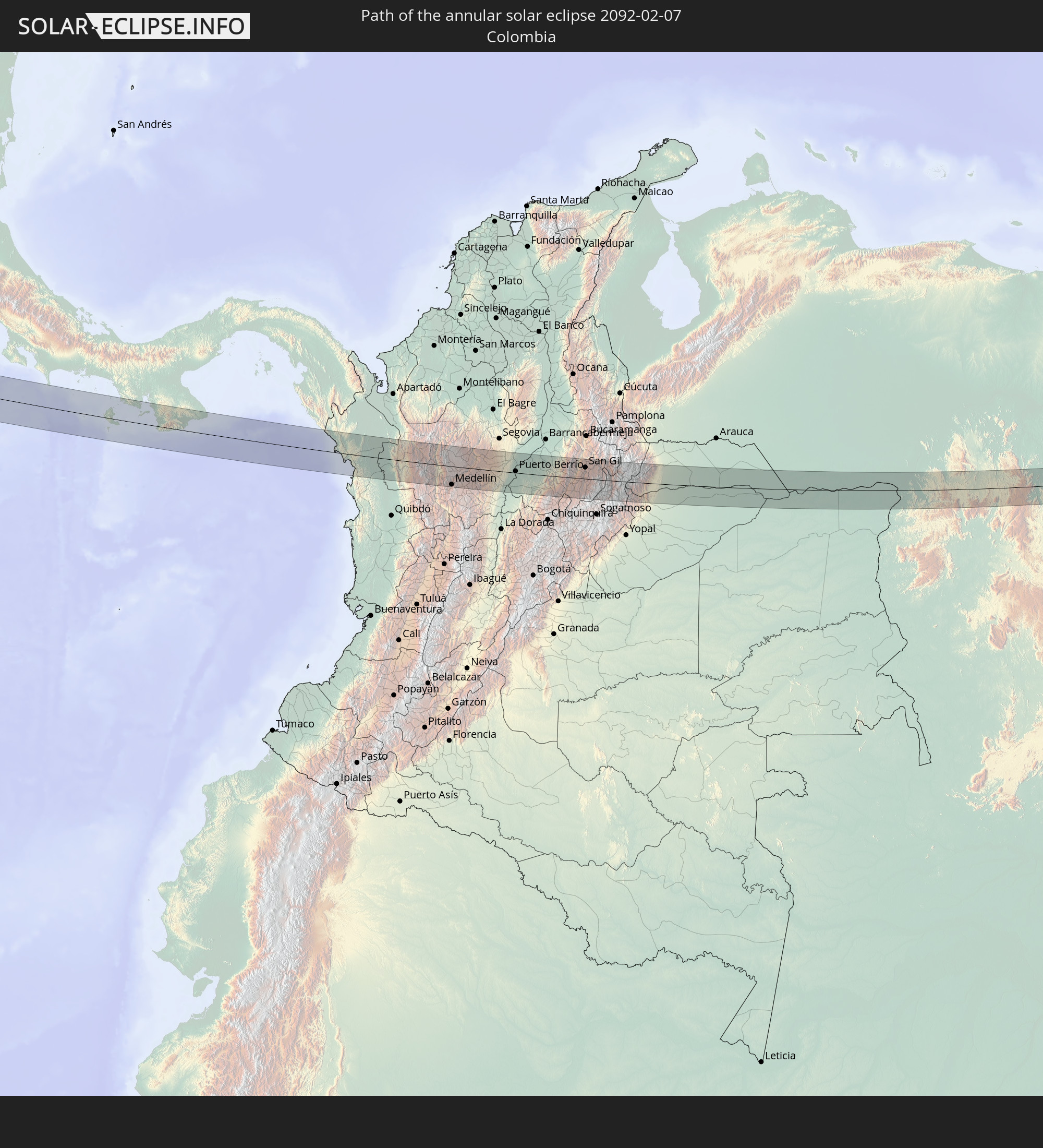 Colombia
 Venezuela
 Guyana
 Spain
Spain
 Morocco
 Algeria
 Tunisia
In den folgenden Ländern ist die Sonnenfinsternis partiell zu sehen
 United States
 United States Minor Outlying Islands
 Canada
 Mexico
 Chile
Chile
 Greenland
 Guatemala
 Ecuador
 El Salvador
 Honduras
 Belize
 Nicaragua
 Costa Rica
 Cuba
Cuba
 Panama
 Colombia
 Cayman Islands
 Peru
Peru
 The Bahamas
 Jamaica
 Haiti
Haiti
 Brazil
 Argentina
 Venezuela
 Turks and Caicos Islands
 Dominican Republic
 Aruba
Aruba
 Bolivia
 Puerto Rico
 United States Virgin Islands
 Bermuda
 British Virgin Islands
 Anguilla
 Collectivity of Saint Martin
 Saint Barthélemy
 Saint Kitts and Nevis
 Paraguay
 Antigua and Barbuda
 Montserrat
 Trinidad and Tobago
 Guadeloupe
 Grenada
 Dominica
 Saint Vincent and the Grenadines
 Guyana
 Martinique
 Saint Lucia
 Barbados
 Suriname
 Saint Pierre and Miquelon
 French Guiana
 Portugal
 Cabo Verde
 Iceland
 Spain
Spain
 Senegal
 Mauritania
 The Gambia
 Guinea-Bissau
 Guinea
 Saint Helena, Ascension and Tristan da Cunha
 Sierra Leone
 Morocco
 Mali
Mali
 Liberia
 Republic of Ireland
 Algeria
 United Kingdom
 Ivory Coast
 Faroe Islands
 Burkina Faso
 Gibraltar
 France
 Isle of Man
 Ghana
Ghana
 Guernsey
 Jersey
 Togo
Togo
 Niger
Niger
 Benin
Benin
 Andorra
 Belgium
 Nigeria
 Netherlands
 Equatorial Guinea
 Luxembourg
 Germany
 Switzerland
 São Tomé and Príncipe
 Italy
Italy
 Monaco
 Tunisia
 Cameroon
 Libya
Libya
 Chad
Chad
 Central African Republic
How will be the weather during the annular solar eclipse on 02/07/2092?
Where is the best place to see the annular solar eclipse of 02/07/2092?
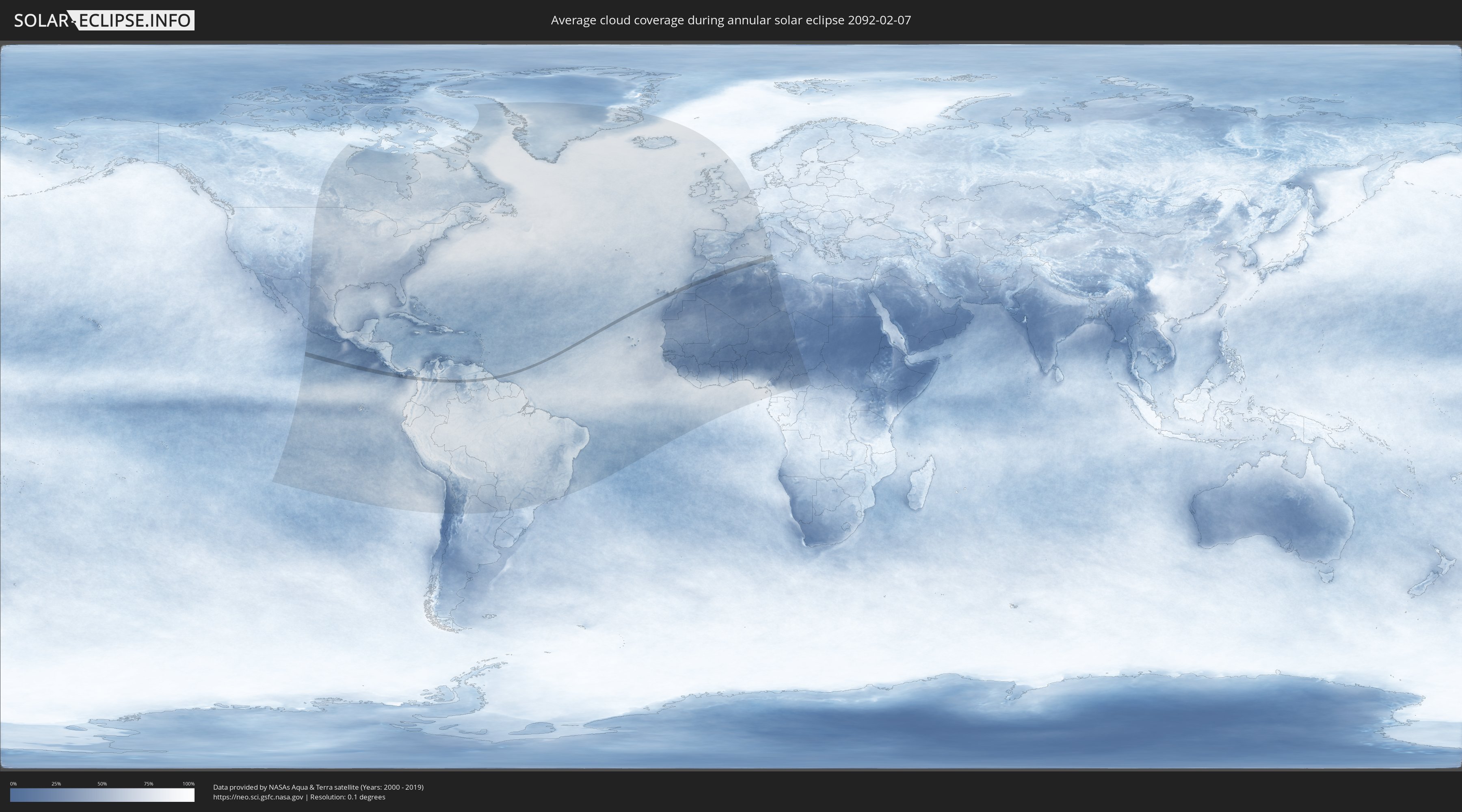
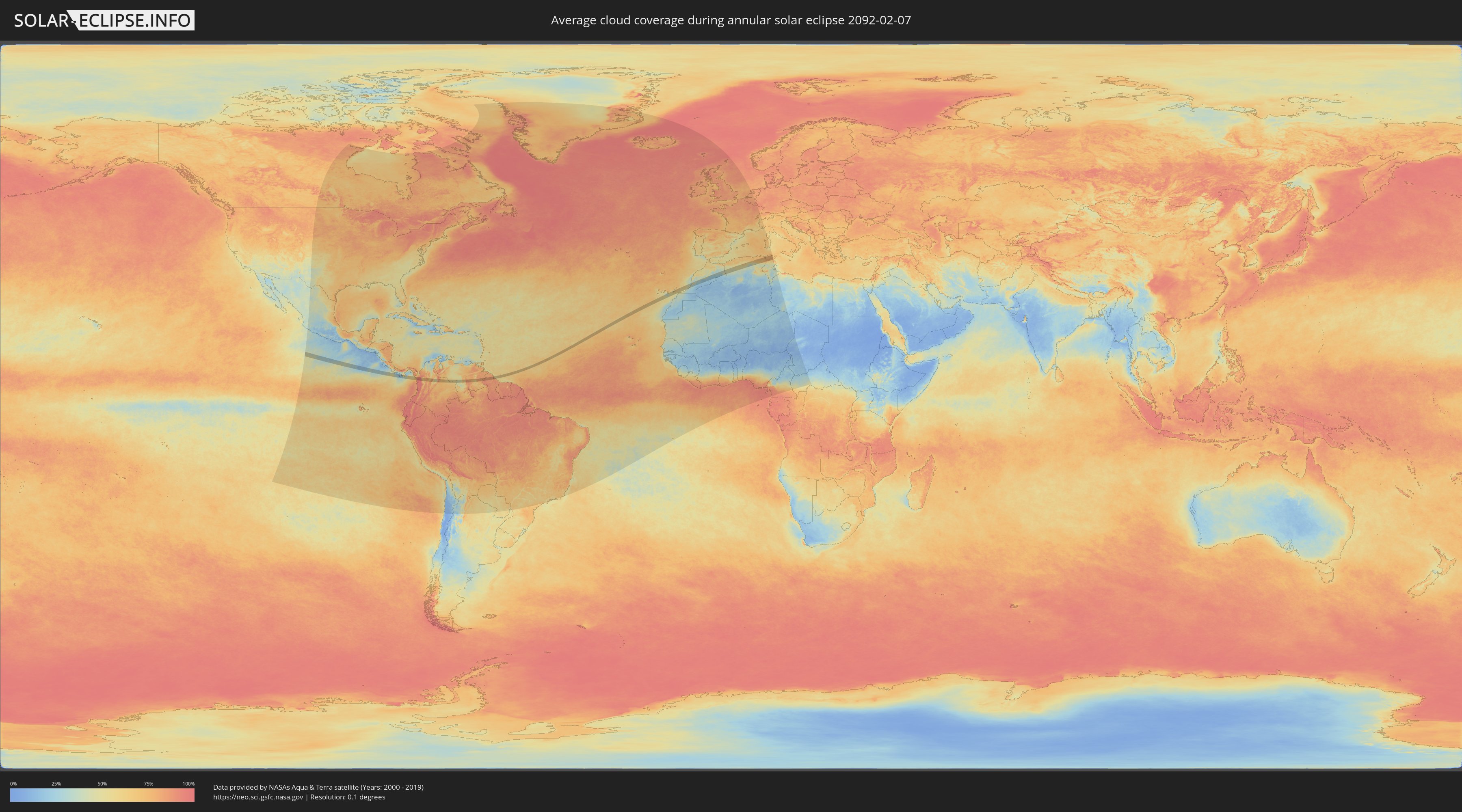
The following maps show the average cloud coverage for the day of the annular solar eclipse.
With the help of these maps, it is possible to find the place along the eclipse path, which has the best
chance of a cloudless sky.
Nevertheless, you should consider local circumstances and inform about the weather of your chosen
observation site.
The data is provided by NASAs satellites
AQUA and TERRA.
The cloud maps are averaged over a period of 19 years (2000 - 2019).
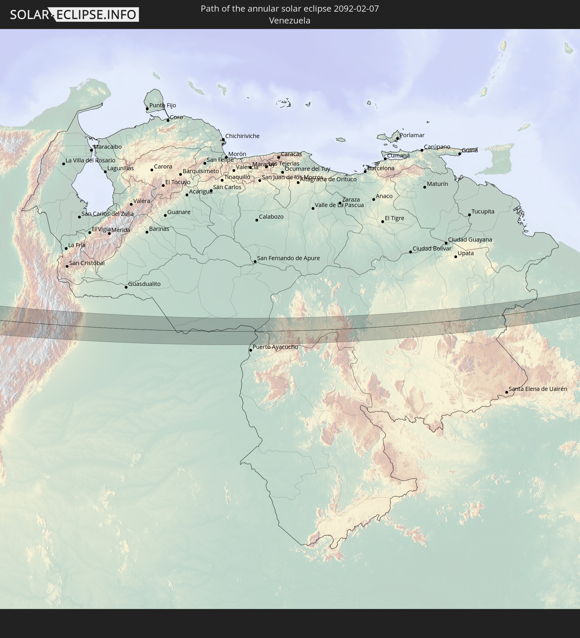
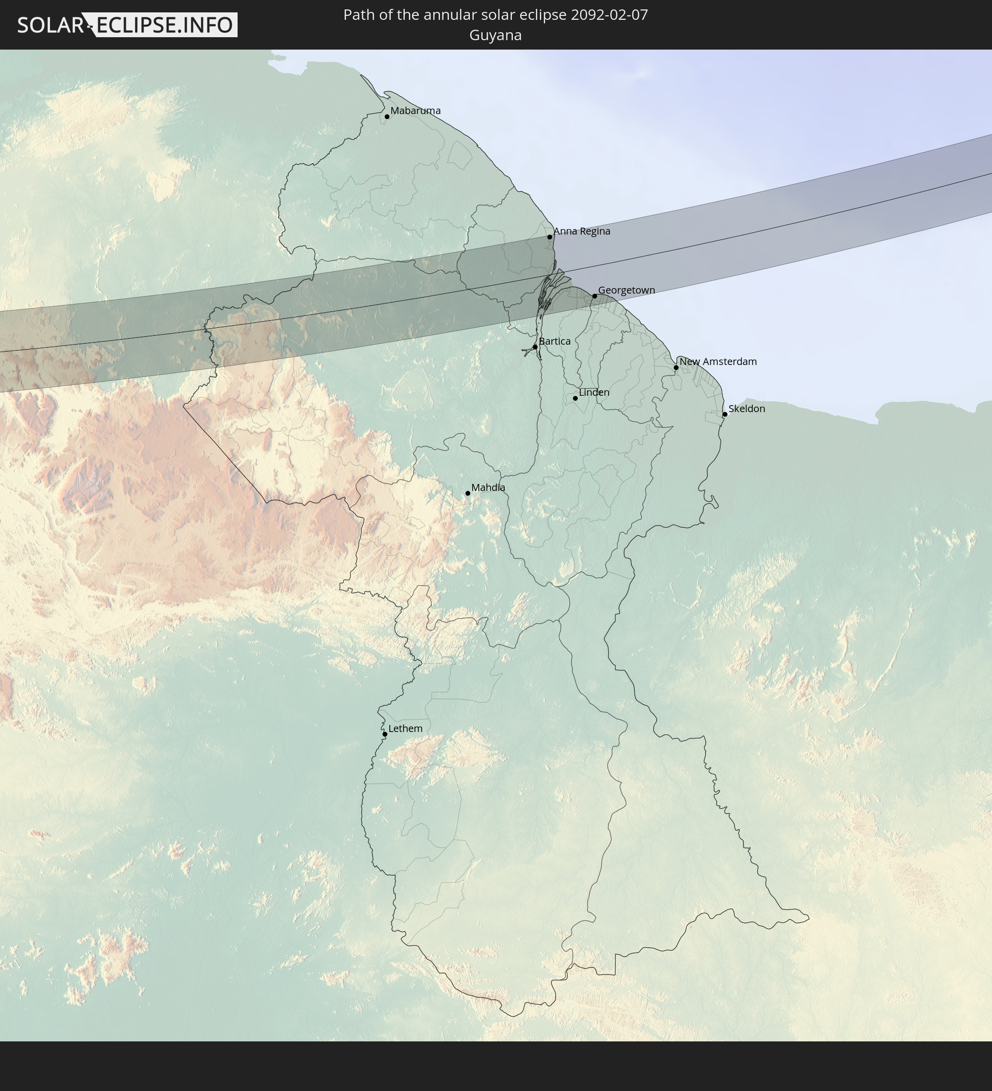
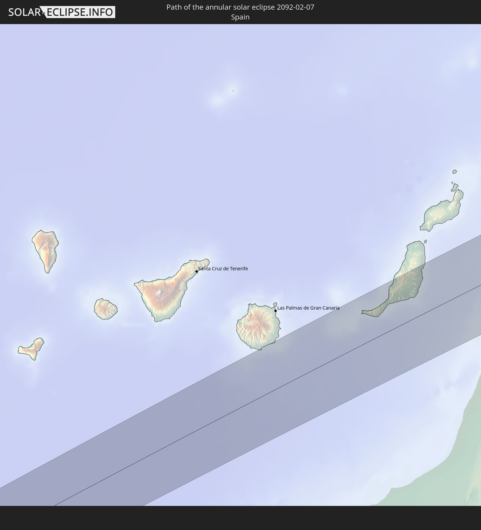
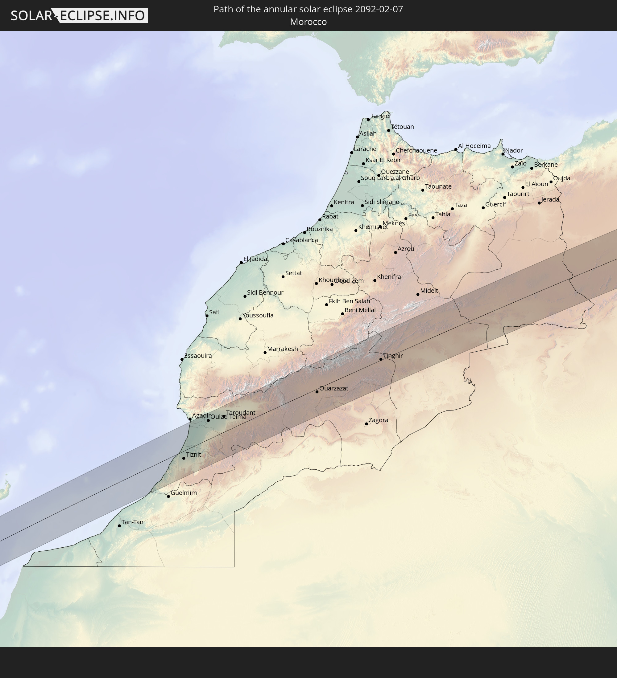
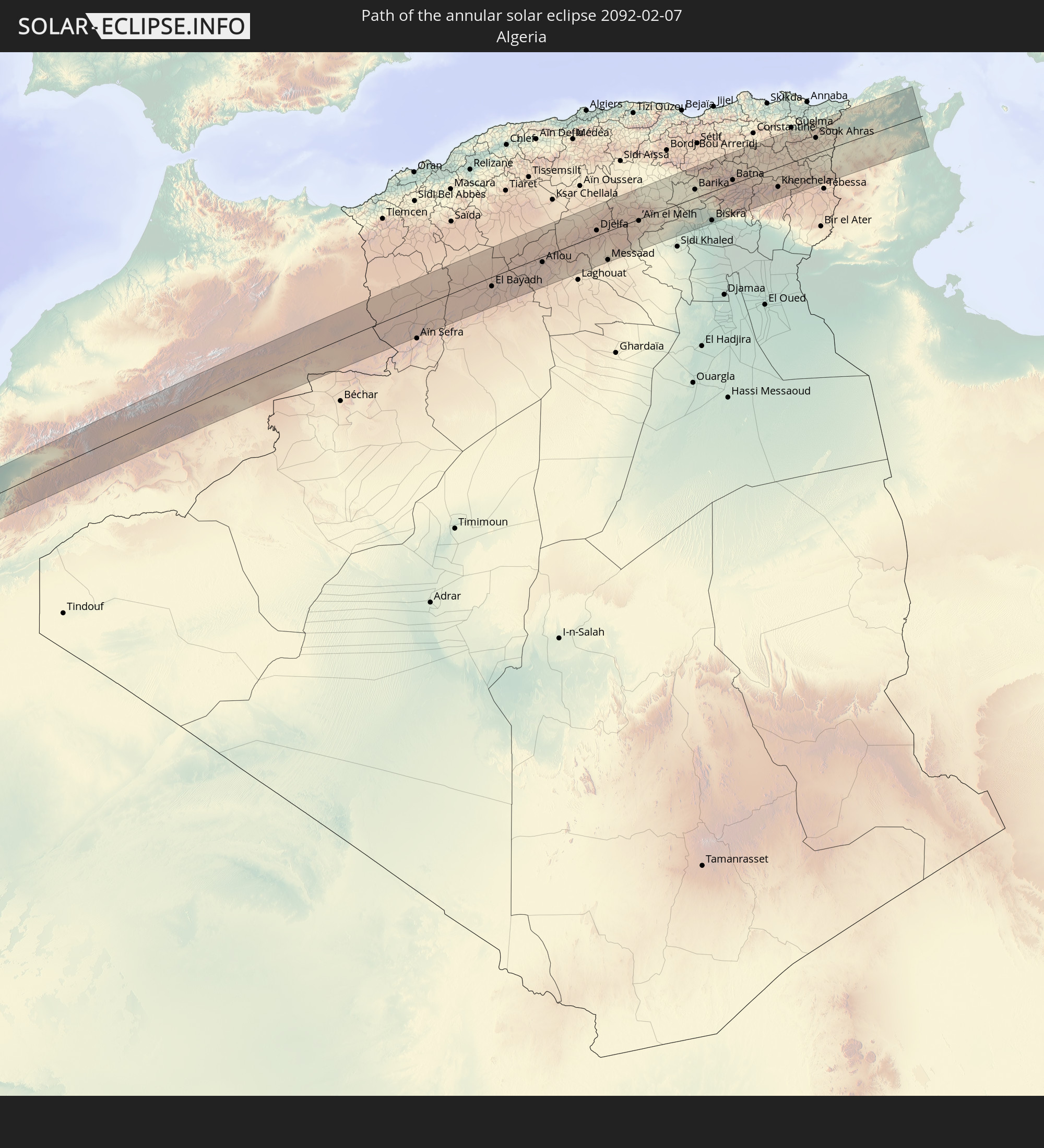
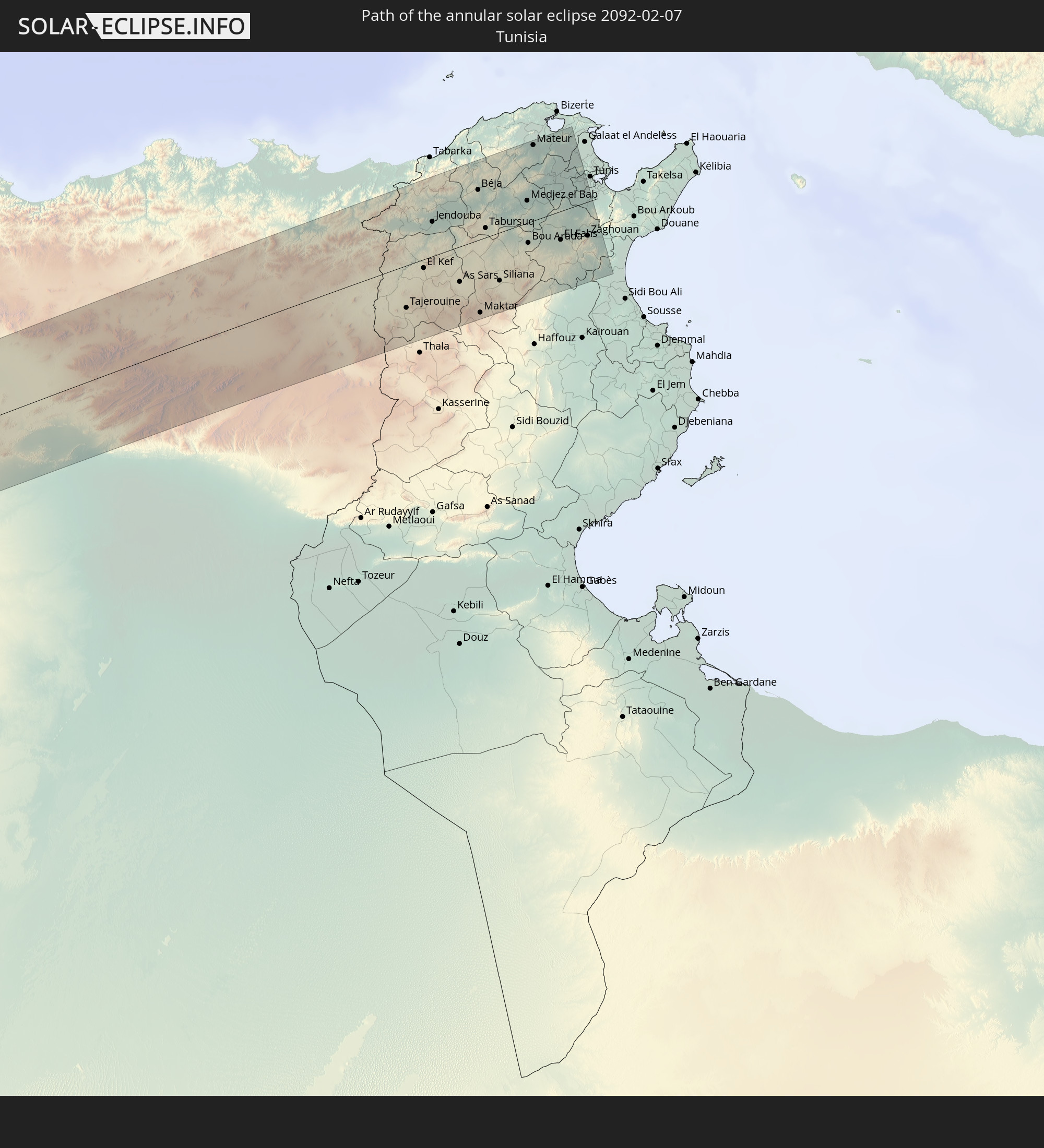
Detailed country maps
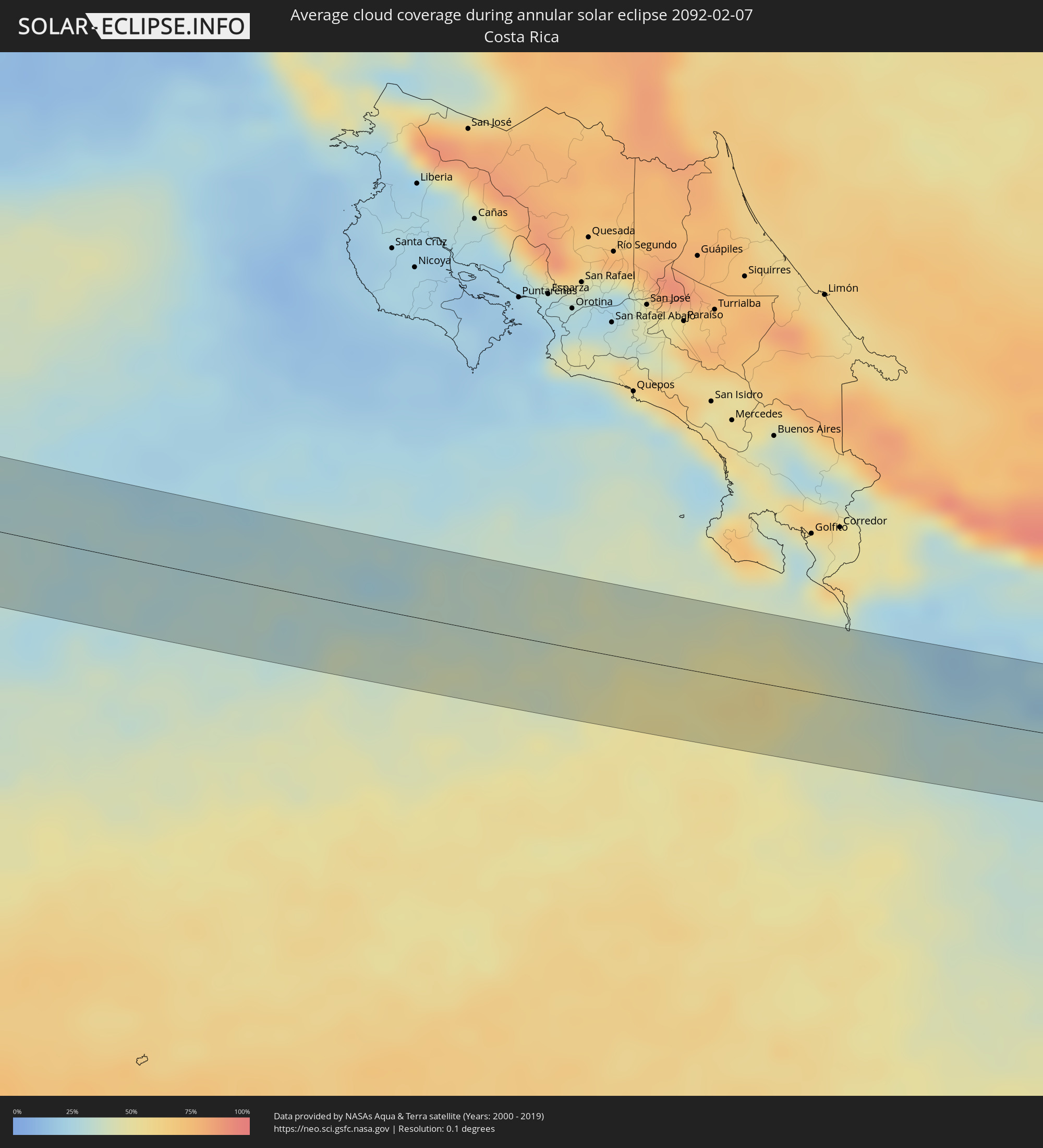 Costa Rica
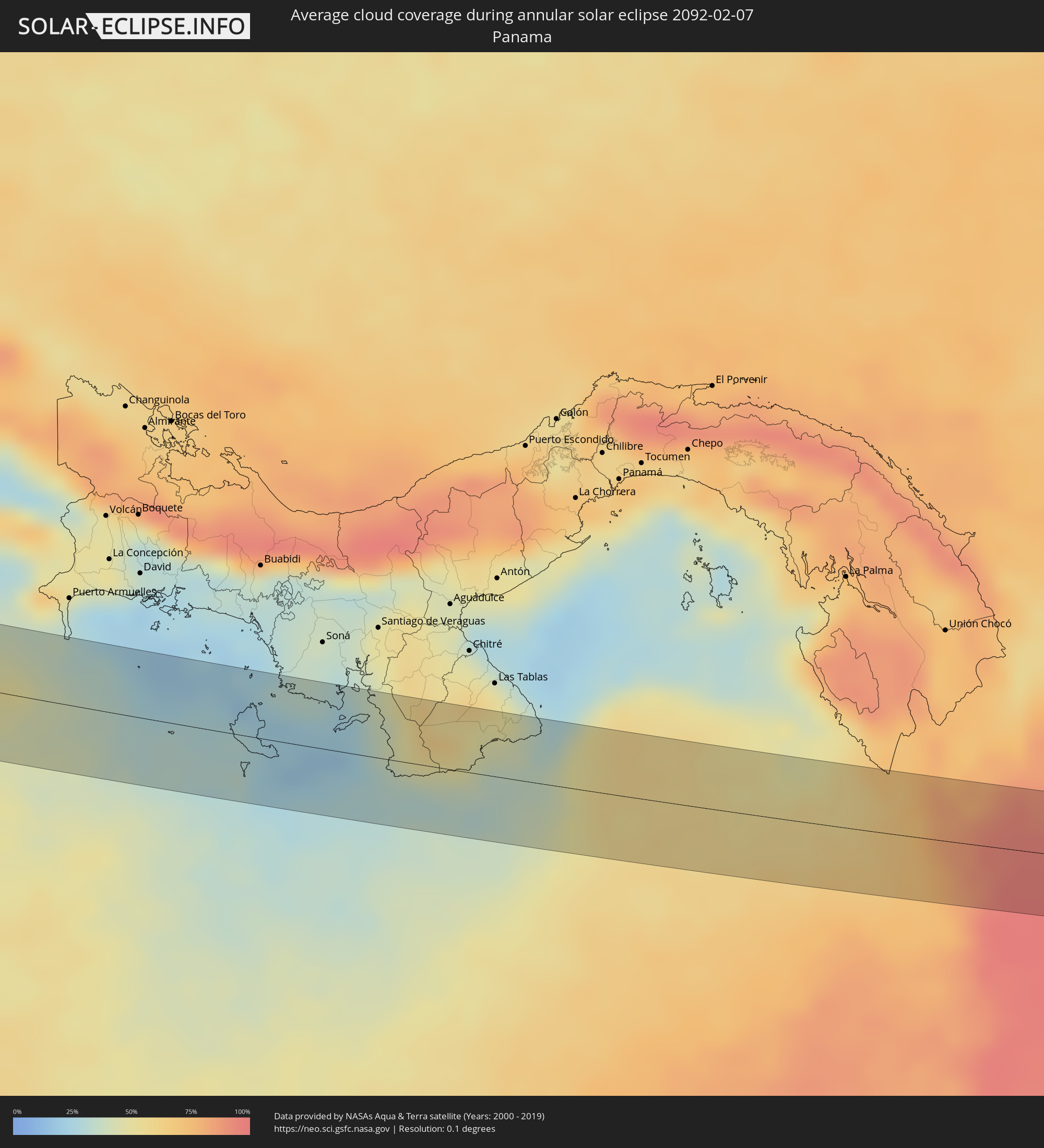 Panama
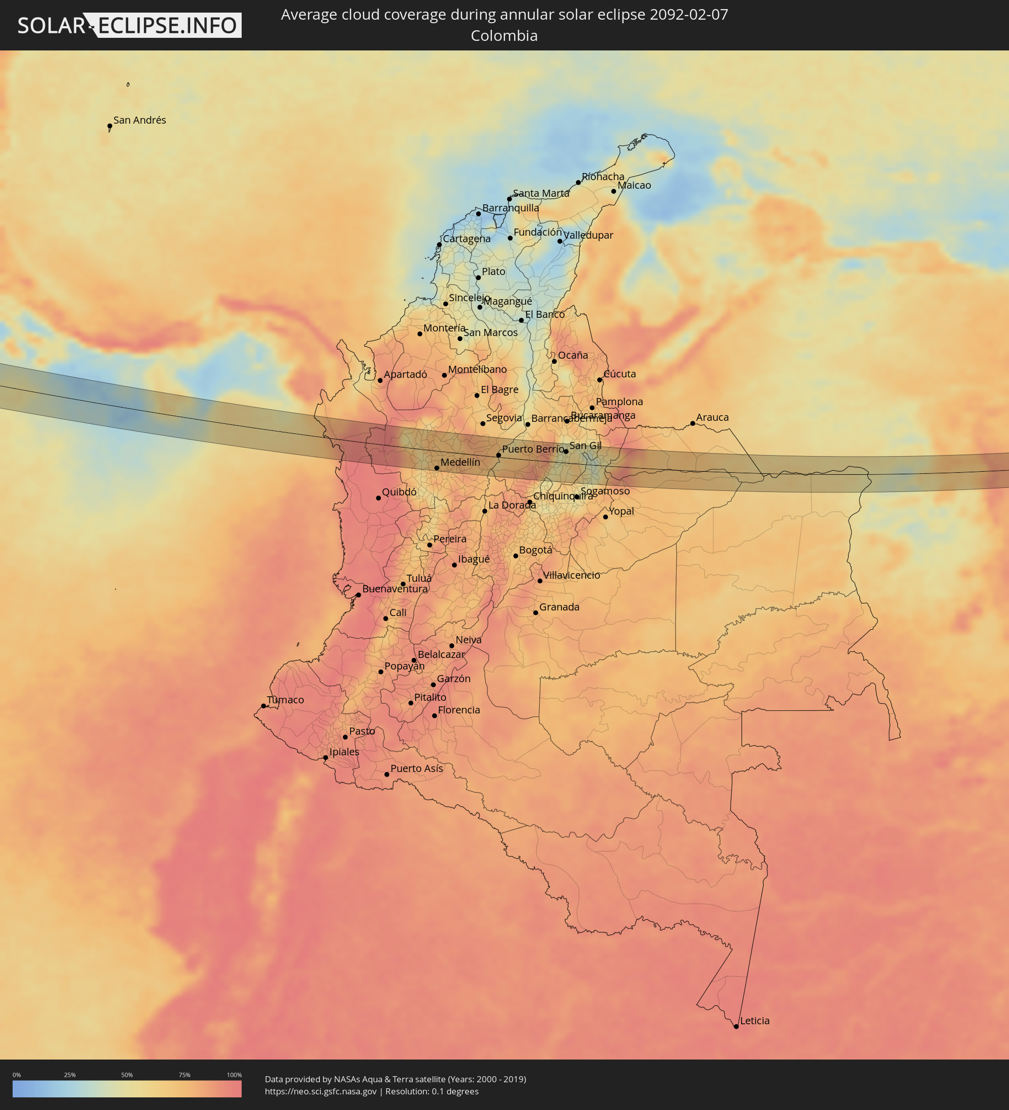 Colombia
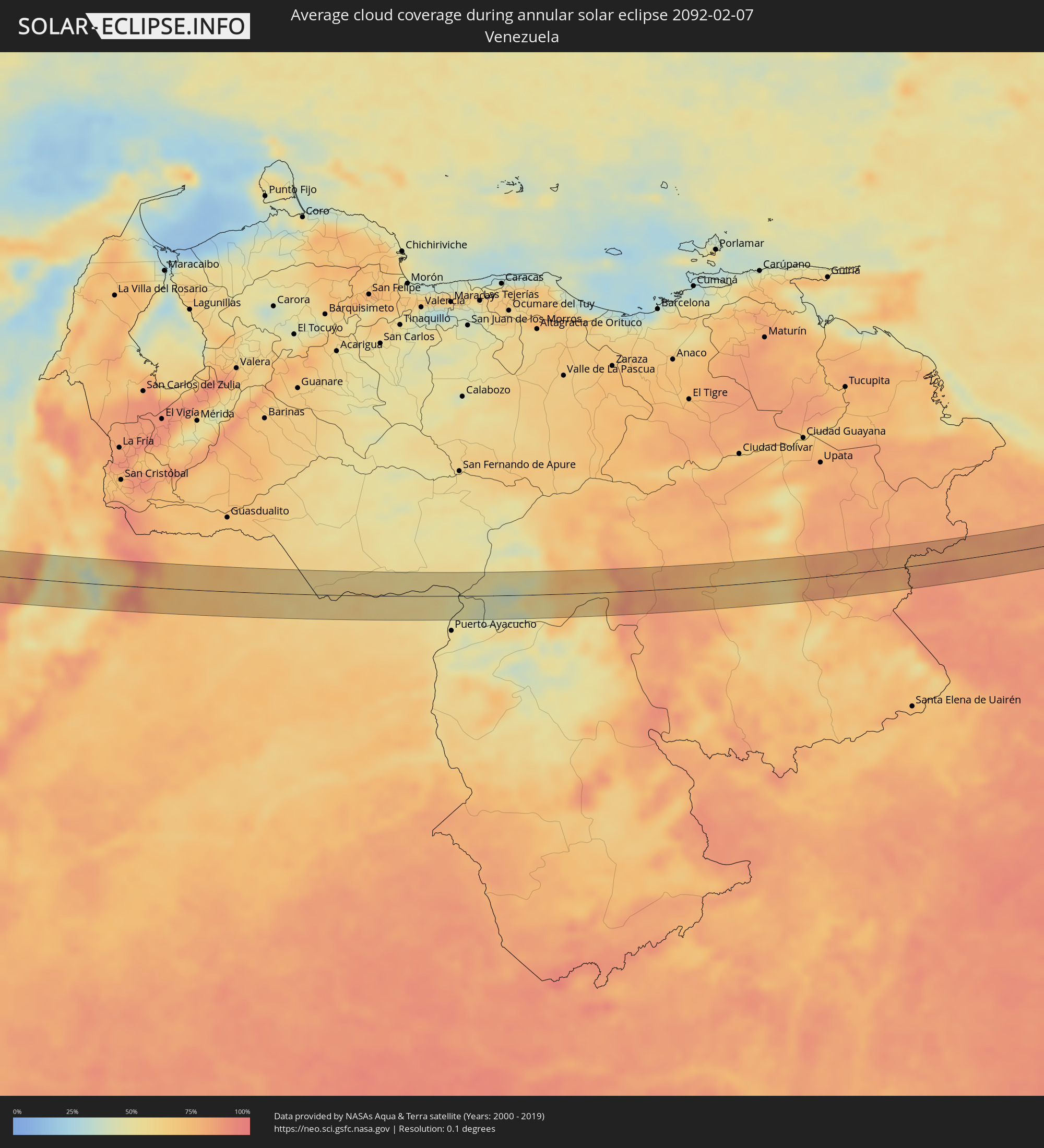 Venezuela
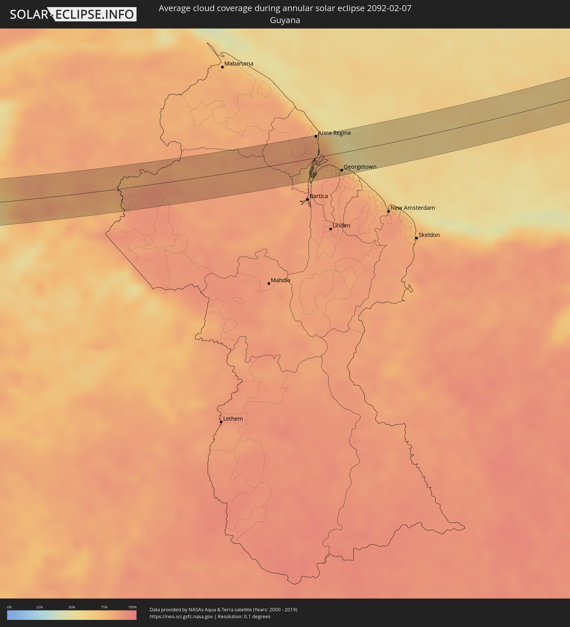 Guyana
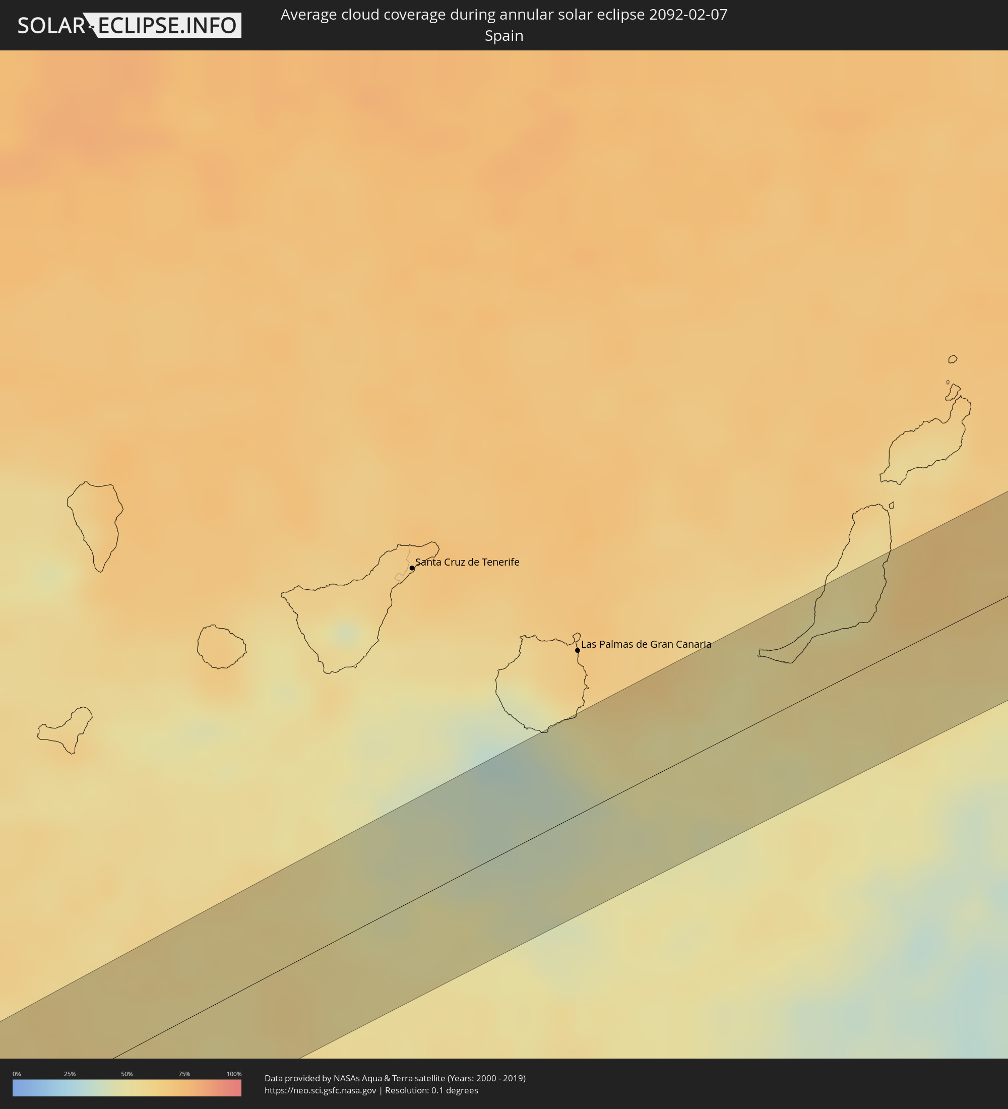 Spain
Spain
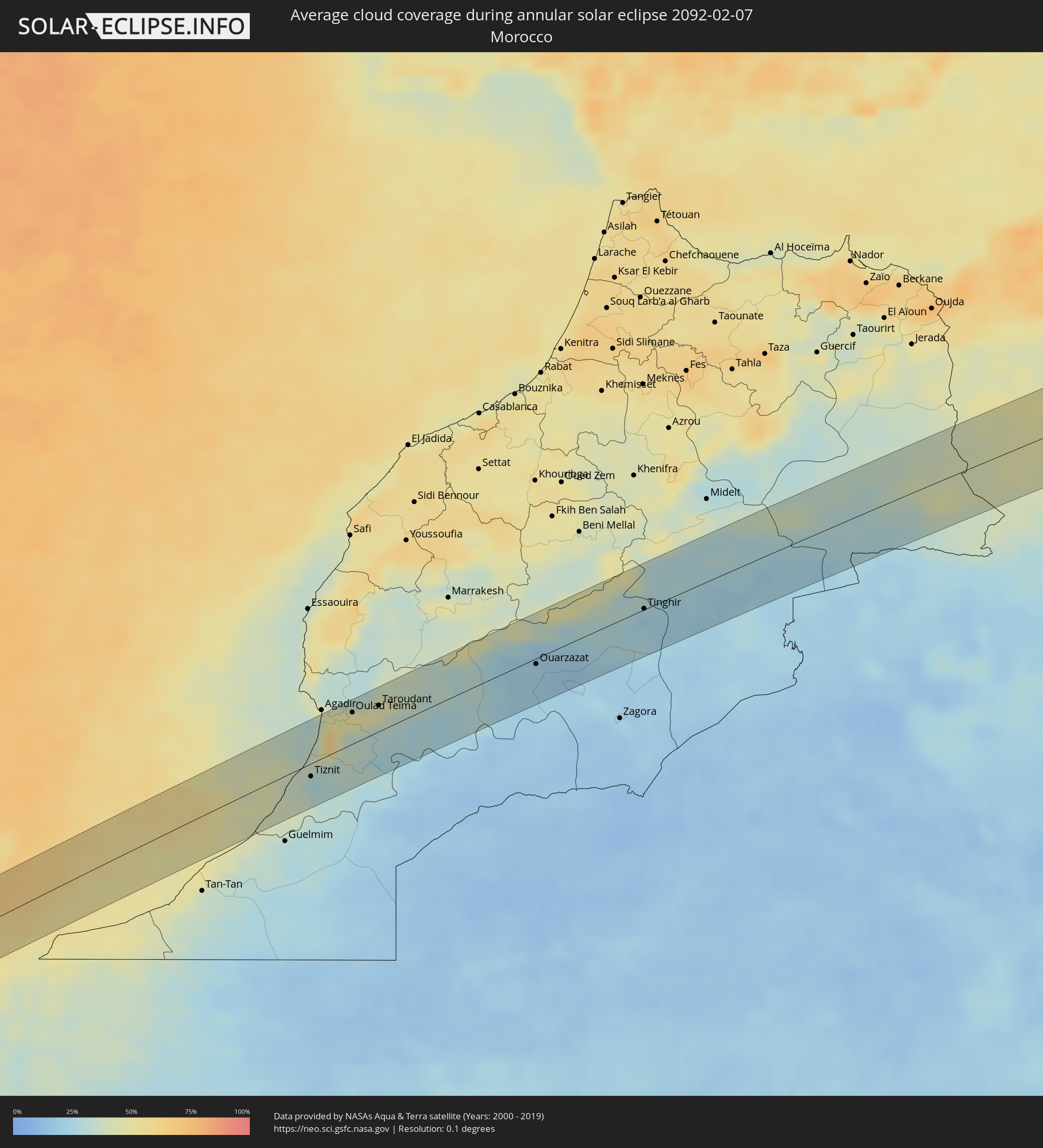 Morocco
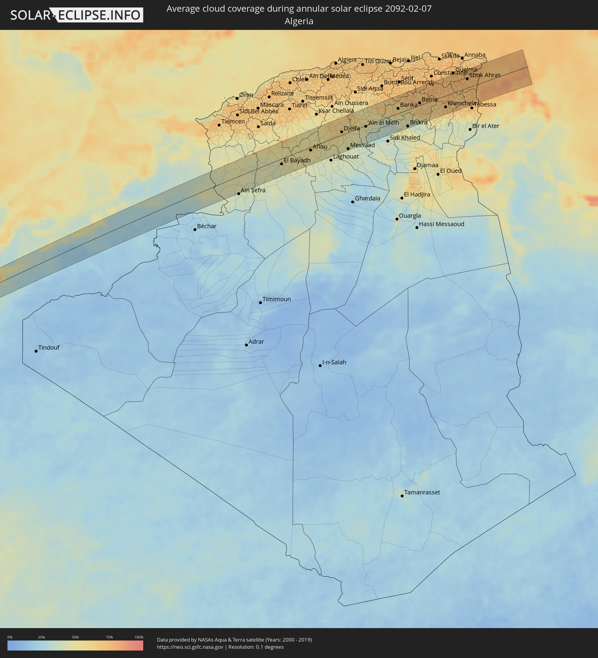 Algeria
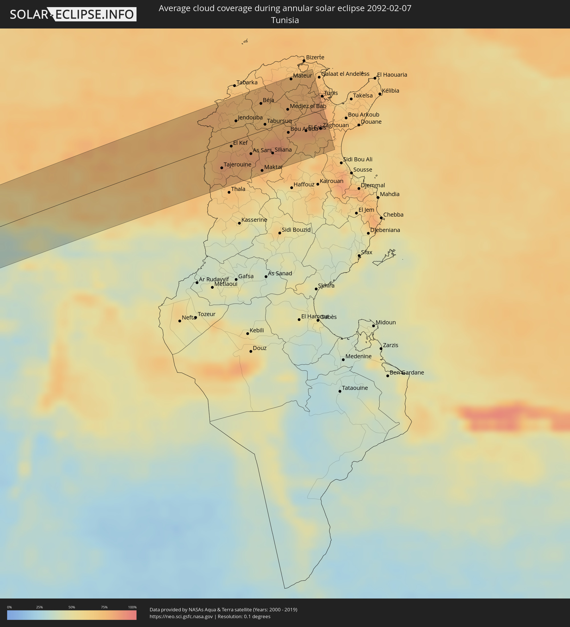 Tunisia
Cities inside the path of the eclipse
The following table shows all locations with a population of more than 5,000 inside the eclipse path. Cities which have more than 100,000 inhabitants are marked bold. A click at the locations opens a detailed map.
| City | Type | Eclipse duration | Local time of max. eclipse | Distance to central line | Ø Cloud coverage |
|
Dabeiba, Antioquia
|
annular | - | 08:48:54 UTC-05:00 | 38 km | 84% |
|
Urrao, Antioquia
|
annular | - | 08:48:40 UTC-05:00 | 36 km | 74% |
|
Frontino, Antioquia
|
annular | - | 08:48:58 UTC-05:00 | 14 km | 59% |
|
Cañasgordas, Antioquia
|
annular | - | 08:49:09 UTC-05:00 | 13 km | 69% |
|
Antioquia, Antioquia
|
annular | - | 08:49:22 UTC-05:00 | 6 km | 57% |
|
Medellín, Antioquia
|
annular | - | 08:49:38 UTC-05:00 | 36 km | 67% |
|
San Pedro, Antioquia
|
annular | - | 08:49:47 UTC-05:00 | 13 km | 72% |
|
Bello, Antioquia
|
annular | - | 08:49:42 UTC-05:00 | 27 km | 67% |
|
Municipio de Copacabana, Antioquia
|
annular | - | 08:49:47 UTC-05:00 | 25 km | 75% |
|
Santa Rosa de Osos, Antioquia
|
annular | - | 08:50:05 UTC-05:00 | 9 km | 69% |
|
Guarne, Antioquia
|
annular | - | 08:49:52 UTC-05:00 | 32 km | 76% |
|
Don Matías, Antioquia
|
annular | - | 08:50:05 UTC-05:00 | 9 km | 70% |
|
San Vicente, Antioquia
|
annular | - | 08:50:02 UTC-05:00 | 36 km | 72% |
|
Barbosa, Antioquia
|
annular | - | 08:50:10 UTC-05:00 | 13 km | 76% |
|
Guatapé, Antioquia
|
annular | - | 08:50:20 UTC-05:00 | 34 km | 78% |
|
Cisneros, Antioquia
|
annular | - | 08:50:41 UTC-05:00 | 1 km | 79% |
|
San Rafael, Antioquia
|
annular | - | 08:50:38 UTC-05:00 | 26 km | 77% |
|
San Roque, Antioquia
|
annular | - | 08:50:46 UTC-05:00 | 4 km | 76% |
|
Yolombó, Antioquia
|
annular | - | 08:50:52 UTC-05:00 | 8 km | 75% |
|
San Carlos, Antioquia
|
annular | - | 08:50:37 UTC-05:00 | 37 km | 84% |
|
Vegachí, Antioquia
|
annular | - | 08:51:23 UTC-05:00 | 29 km | 81% |
|
Puerto Berrío, Antioquia
|
annular | - | 08:51:55 UTC-05:00 | 3 km | 61% |
|
Cimitarra, Santander
|
annular | - | 08:52:40 UTC-05:00 | 12 km | 83% |
|
Socorro, Santander
|
annular | - | 08:54:07 UTC-05:00 | 11 km | 46% |
|
San Gil, Santander
|
annular | - | 08:54:25 UTC-05:00 | 22 km | 53% |
|
Belén, Boyacá
|
annular | - | 08:54:28 UTC-05:00 | 39 km | 56% |
|
Soatá, Boyacá
|
annular | - | 08:55:10 UTC-05:00 | 1 km | 47% |
|
Tame, Arauca
|
annular | - | 08:57:13 UTC-05:00 | 22 km | 79% |
|
Puerto Carreño, Vichada
|
annular | - | 09:06:38 UTC-05:00 | 5 km | 48% |
|
Anna Regina, Pomeroon-Supenaam
|
annular | - | 10:32:35 UTC-04:00 | 31 km | 78% |
|
Vreed-en-Hoop, Essequibo Islands-West Demerara
|
annular | - | 10:33:03 UTC-04:00 | 25 km | 82% |
|
Georgetown, Demerara-Mahaica
|
annular | - | 10:33:10 UTC-04:00 | 26 km | 82% |
|
Pájara, Canary Islands
|
annular | - | 16:35:36 UTC+00:00 | 39 km | 51% |
|
Tuineje, Canary Islands
|
annular | - | 16:35:40 UTC+00:00 | 34 km | 53% |
|
Antigua, Canary Islands
|
annular | - | 16:35:41 UTC+00:00 | 42 km | 53% |
|
Puerto del Rosario, Canary Islands
|
annular | - | 16:35:50 UTC+00:00 | 43 km | 57% |
|
Sidi Ifni, Souss-Massa-Drâa
|
annular | - | 17:39:21 UTC+01:00 | 28 km | 40% |
|
Tiznit, Souss-Massa-Drâa
|
annular | - | 17:39:40 UTC+01:00 | 14 km | 28% |
|
Oulad Teïma, Souss-Massa-Drâa
|
annular | - | 17:39:58 UTC+01:00 | 34 km | 51% |
|
Taroudant, Souss-Massa-Drâa
|
annular | - | 17:40:13 UTC+01:00 | 28 km | 45% |
|
Ouarzazat, Souss-Massa-Drâa
|
annular | - | 17:41:41 UTC+01:00 | 6 km | 22% |
|
Tinghir, Souss-Massa-Drâa
|
annular | - | 17:42:29 UTC+01:00 | 1 km | 22% |
|
Naama, Naama
|
annular | - | 17:44:54 UTC+01:00 | 13 km | 47% |
|
El Bayadh, El Bayadh
|
annular | - | 17:45:21 UTC+01:00 | 17 km | 48% |
|
Aflou, Laghouat
|
annular | - | 17:45:37 UTC+01:00 | 10 km | 52% |
|
El Idrissia, Djelfa
|
annular | - | 17:45:37 UTC+01:00 | 10 km | 50% |
|
Charef, Djelfa
|
annular | - | 17:45:38 UTC+01:00 | 19 km | 58% |
|
’Aïn el Bell, Djelfa
|
annular | - | 17:45:57 UTC+01:00 | 24 km | 47% |
|
Djelfa, Djelfa
|
annular | - | 17:45:47 UTC+01:00 | 9 km | 54% |
|
Dar Chioukh, Djelfa
|
annular | - | 17:45:45 UTC+01:00 | 25 km | 53% |
|
Messaad, Djelfa
|
annular | - | 17:46:09 UTC+01:00 | 53 km | 43% |
|
’Aïn el Melh, M'Sila
|
annular | - | 17:46:02 UTC+01:00 | 3 km | 41% |
|
Barika, Batna
|
annular | - | 17:46:08 UTC+01:00 | 15 km | 59% |
|
Tolga, Biskra
|
annular | - | 17:46:30 UTC+01:00 | 55 km | 56% |
|
Boumagueur, Batna
|
annular | - | 17:46:07 UTC+01:00 | 21 km | 62% |
|
Râs el Aïoun, Batna
|
annular | - | 17:46:03 UTC+01:00 | 36 km | 65% |
|
Biskra, Biskra
|
annular | - | 17:46:32 UTC+01:00 | 53 km | 45% |
|
Aïn Touta, Batna
|
annular | - | 17:46:18 UTC+01:00 | 3 km | 56% |
|
Merouana, Batna
|
annular | - | 17:46:09 UTC+01:00 | 23 km | 67% |
|
Batna, Batna
|
annular | - | 17:46:16 UTC+01:00 | 7 km | 64% |
|
Tazoult-Lambese, Batna
|
annular | - | 17:46:20 UTC+01:00 | 4 km | 64% |
|
Arris, Batna
|
annular | - | 17:46:29 UTC+01:00 | 30 km | 59% |
|
Aïn Kercha, Oum el Bouaghi
|
annular | - | 17:46:12 UTC+01:00 | 29 km | 73% |
|
Aïn Fakroun, Oum el Bouaghi
|
annular | - | 17:46:14 UTC+01:00 | 28 km | 72% |
|
’Aïn Abid, Constantine
|
annular | - | 17:46:06 UTC+01:00 | 53 km | 72% |
|
Oum el Bouaghi, Oum el Bouaghi
|
annular | - | 17:46:21 UTC+01:00 | 11 km | 72% |
|
Khenchela, Khenchela
|
annular | - | 17:46:36 UTC+01:00 | 36 km | 64% |
|
Aïn Beïda, Oum el Bouaghi
|
annular | - | 17:46:28 UTC+01:00 | 6 km | 72% |
|
Sedrata, Souk Ahras
|
annular | - | 17:46:18 UTC+01:00 | 24 km | 71% |
|
Meskiana, Oum el Bouaghi
|
annular | - | 17:46:38 UTC+01:00 | 32 km | 70% |
|
El Aouinet, Oum el Bouaghi
|
annular | - | 17:46:33 UTC+01:00 | 14 km | 71% |
|
Souk Ahras, Souk Ahras
|
annular | - | 17:46:19 UTC+01:00 | 28 km | 74% |
|
Sakiet Sidi Youssef, Kef
|
annular | - | 17:46:27 UTC+01:00 | 9 km | 74% |
|
Tajerouine, Kef
|
annular | - | 17:46:41 UTC+01:00 | 32 km | 79% |
|
El Kef, Kef
|
annular | - | 17:46:33 UTC+01:00 | 6 km | 80% |
|
Jendouba, Jundūbah
|
annular | - | 17:46:22 UTC+01:00 | 26 km | 73% |
|
El Ksour, Kef
|
annular | - | 17:46:45 UTC+01:00 | 41 km | 75% |
|
As Sars, Kef
|
annular | - | 17:46:40 UTC+01:00 | 26 km | 80% |
|
Le Krib, Silyānah
|
annular | - | 17:46:33 UTC+01:00 | 3 km | 74% |
|
Béja, Bājah
|
annular | - | 17:46:19 UTC+01:00 | 37 km | 72% |
|
Maktar, Silyānah
|
annular | - | 17:46:50 UTC+01:00 | 55 km | 76% |
|
Tabursuq, Bājah
|
annular | - | 17:46:29 UTC+01:00 | 7 km | 75% |
|
Gafour, Silyānah
|
annular | - | 17:46:35 UTC+01:00 | 10 km | 84% |
|
Siliana, Silyānah
|
annular | - | 17:46:44 UTC+01:00 | 36 km | 81% |
|
Testour, Bājah
|
annular | - | 17:46:28 UTC+01:00 | 11 km | 72% |
|
Medjez el Bab, Bājah
|
annular | - | 17:46:26 UTC+01:00 | 16 km | 75% |
|
Bou Arada, Silyānah
|
annular | - | 17:46:37 UTC+01:00 | 15 km | 78% |
|
Mateur, Banzart
|
annular | - | 17:46:12 UTC+01:00 | 57 km | 75% |
|
El Battan, Manouba
|
annular | - | 17:46:23 UTC+01:00 | 26 km | 73% |
|
El Fahs, Zaghwān
|
annular | - | 17:46:40 UTC+01:00 | 21 km | 81% |
|
Oued Lill, Tūnis
|
annular | - | 17:46:24 UTC+01:00 | 23 km | 78% |
|
Manouba, Manouba
|
annular | - | 17:46:26 UTC+01:00 | 19 km | 80% |
|
Zaghouan, Zaghwān
|
annular | - | 17:46:41 UTC+01:00 | 25 km | 75% |
|
La Mohammedia, Tūnis
|
annular | - | 17:46:31 UTC+01:00 | 3 km | 80% |