Total solar eclipse of 06/13/2132
| Day of week: | Friday |
| Maximum duration of eclipse: | 06m55s |
| Maximum width of eclipse path: | 255 km |
| Saros cycle: | 139 |
| Coverage: | 100% |
| Magnitude: | 1.0788 |
| Gamma: | -0.0186 |
Wo kann man die Sonnenfinsternis vom 06/13/2132 sehen?
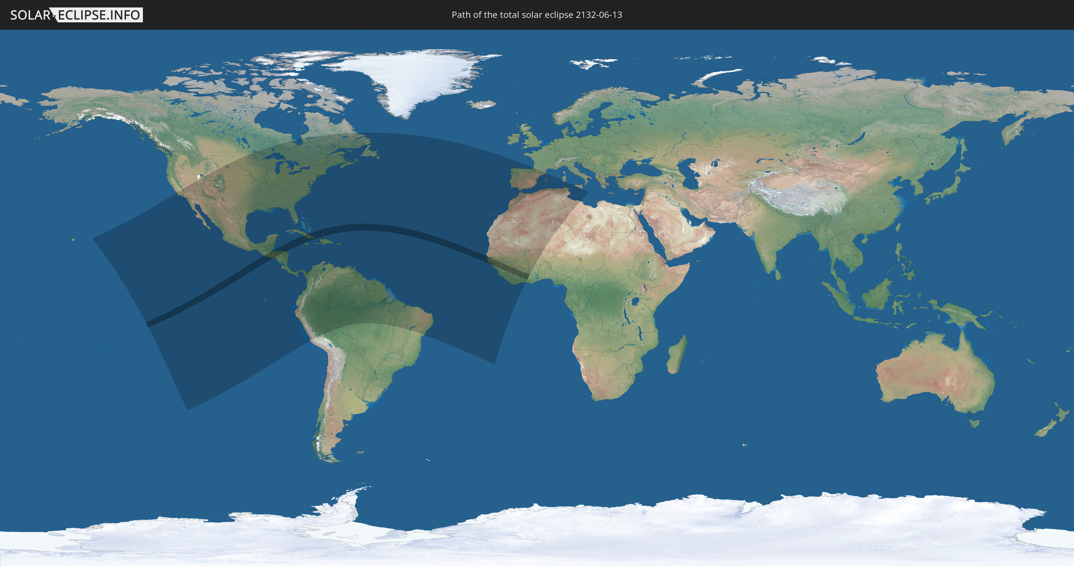
Die Sonnenfinsternis am 06/13/2132 kann man in 73 Ländern als partielle Sonnenfinsternis beobachten.
Der Finsternispfad verläuft durch 15 Länder. Nur in diesen Ländern ist sie als total Sonnenfinsternis zu sehen.
In den folgenden Ländern ist die Sonnenfinsternis total zu sehen
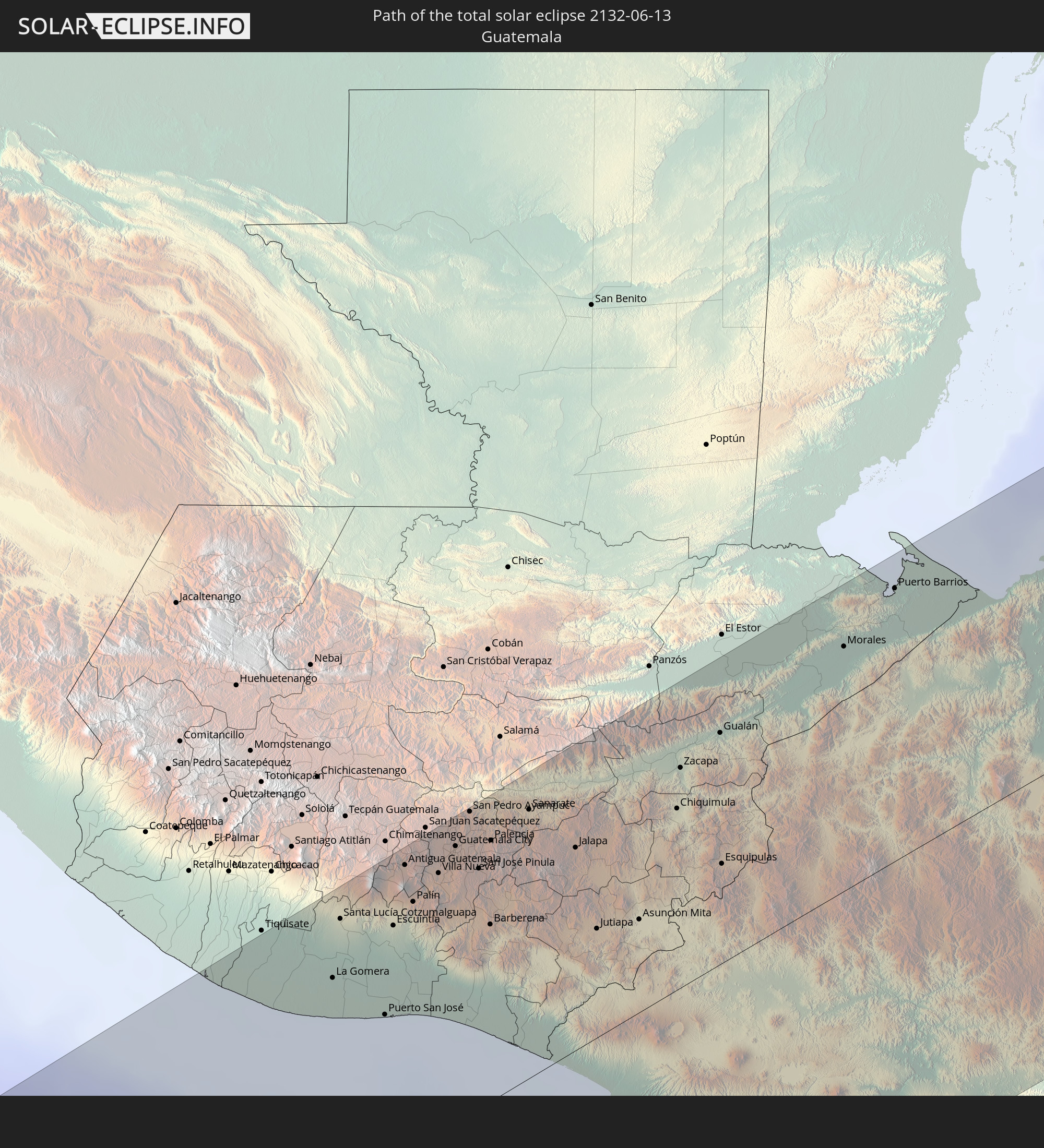 Guatemala
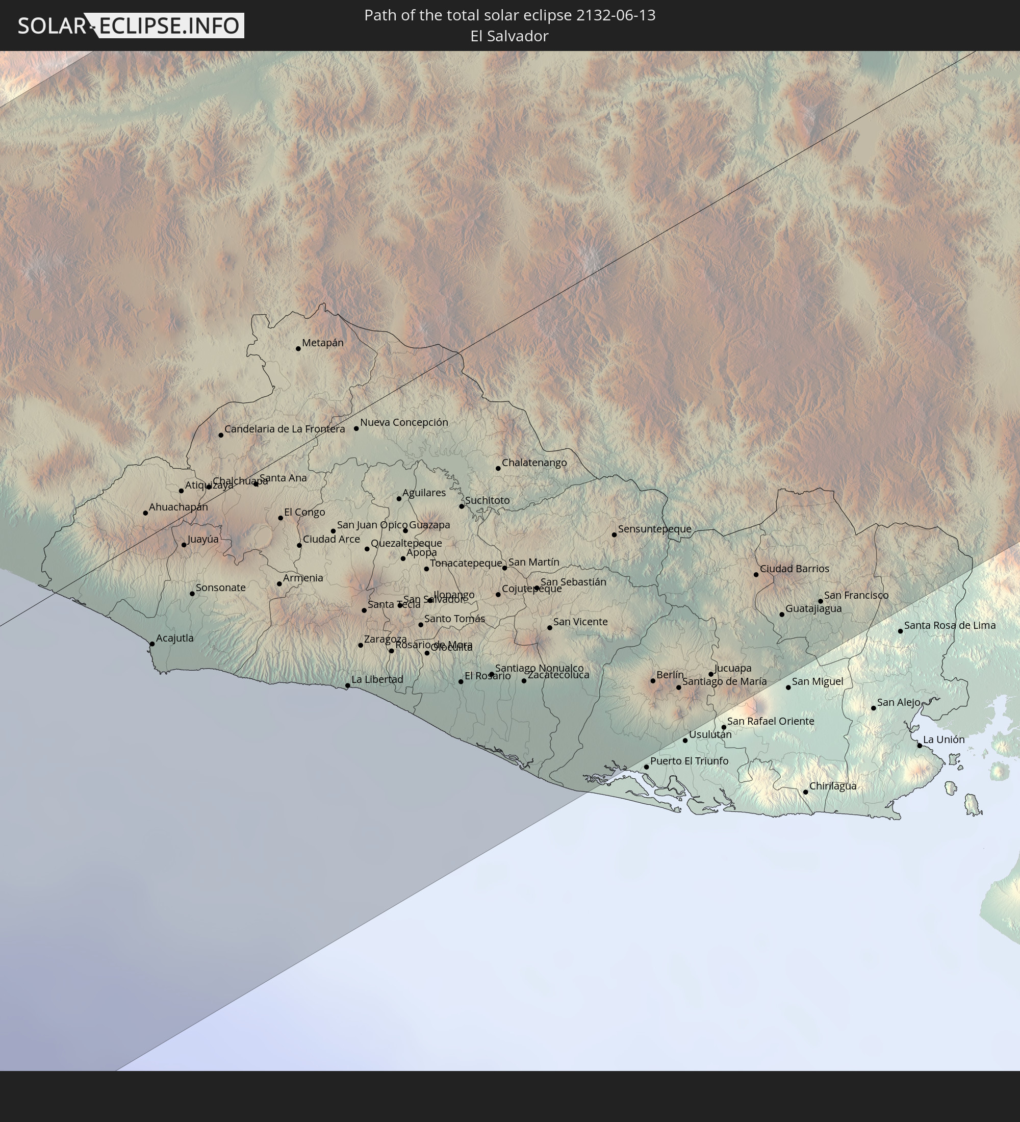 El Salvador
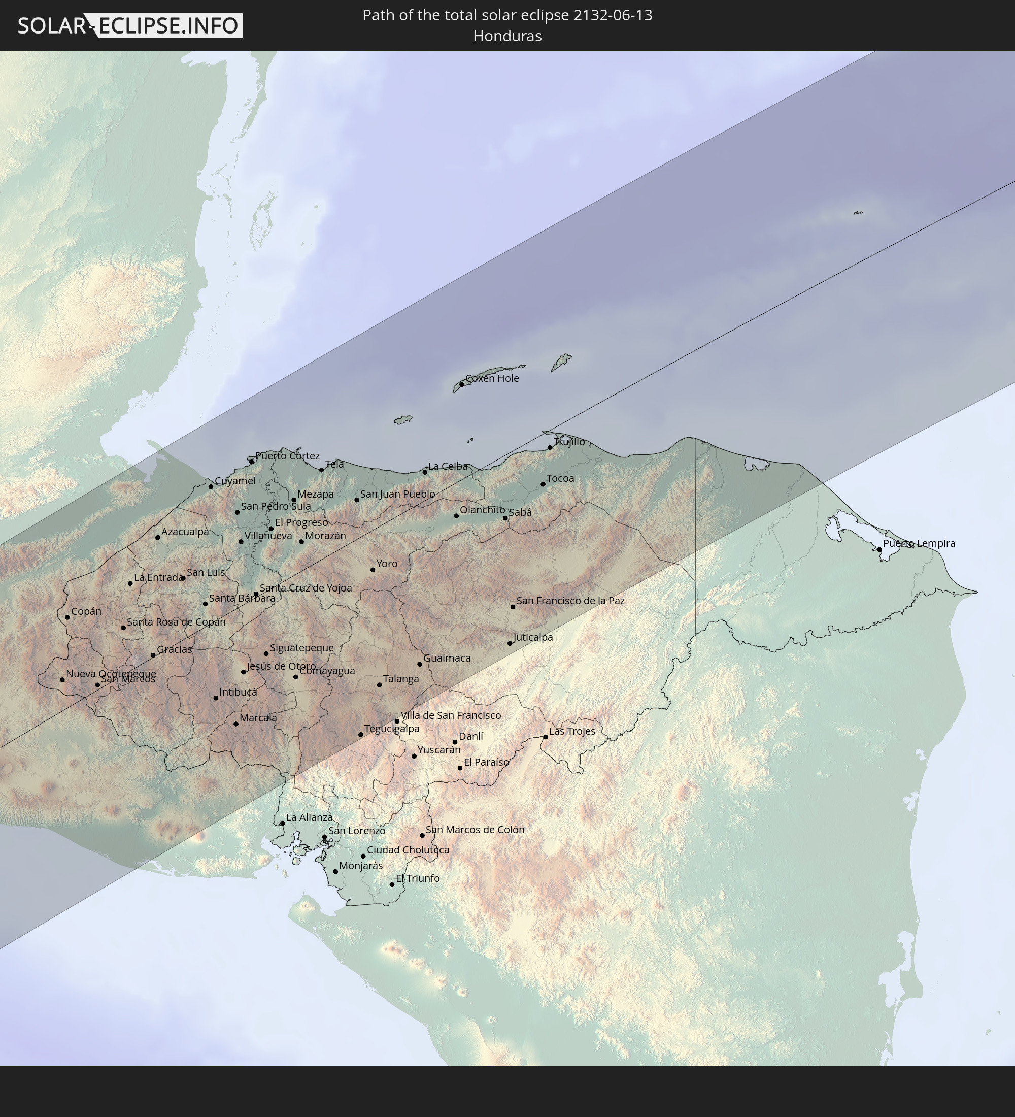 Honduras
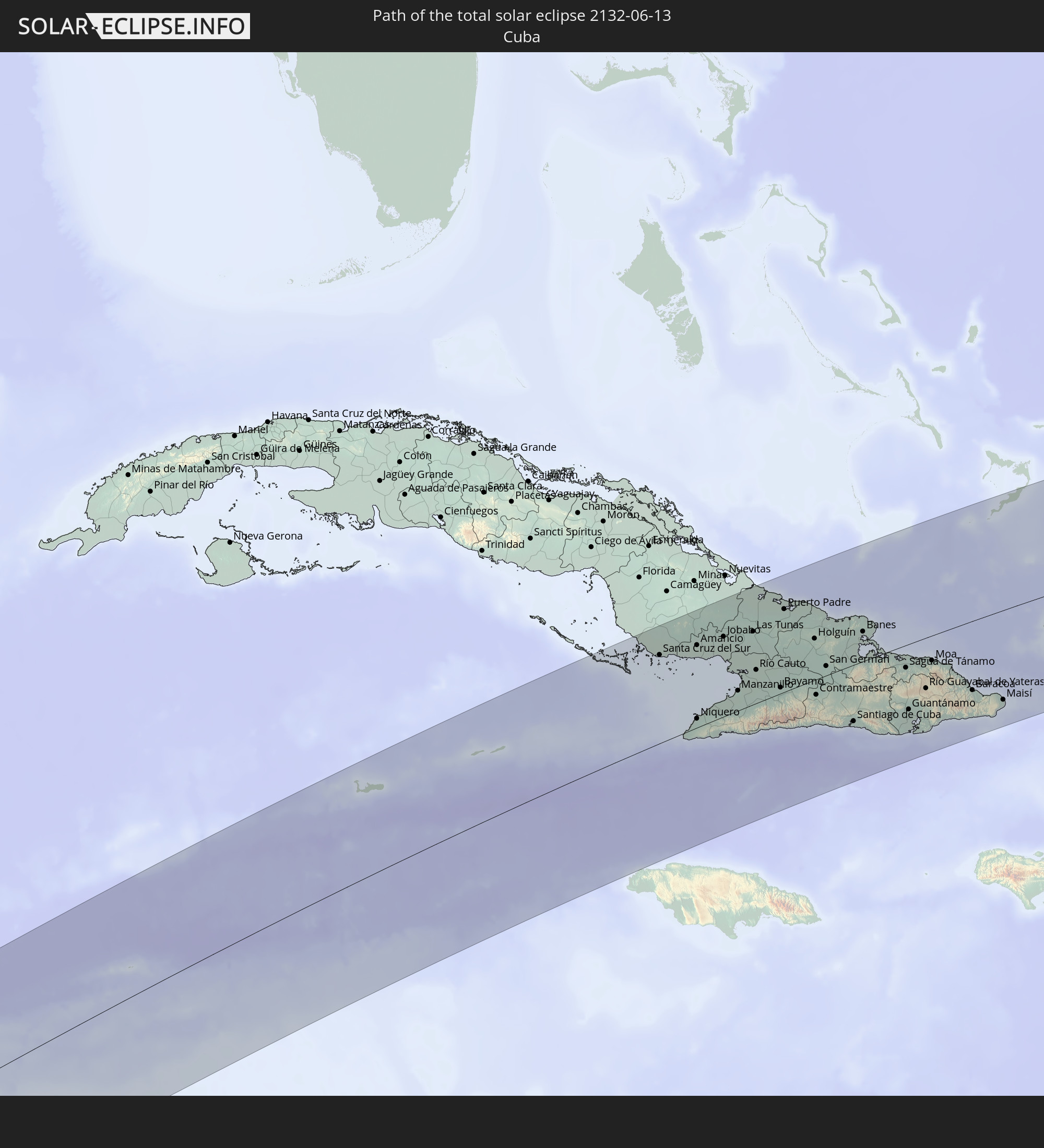 Cuba
Cuba
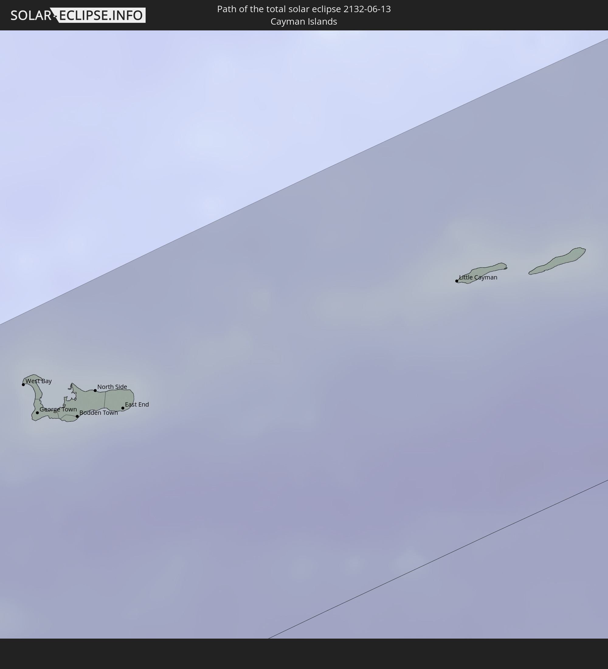 Cayman Islands
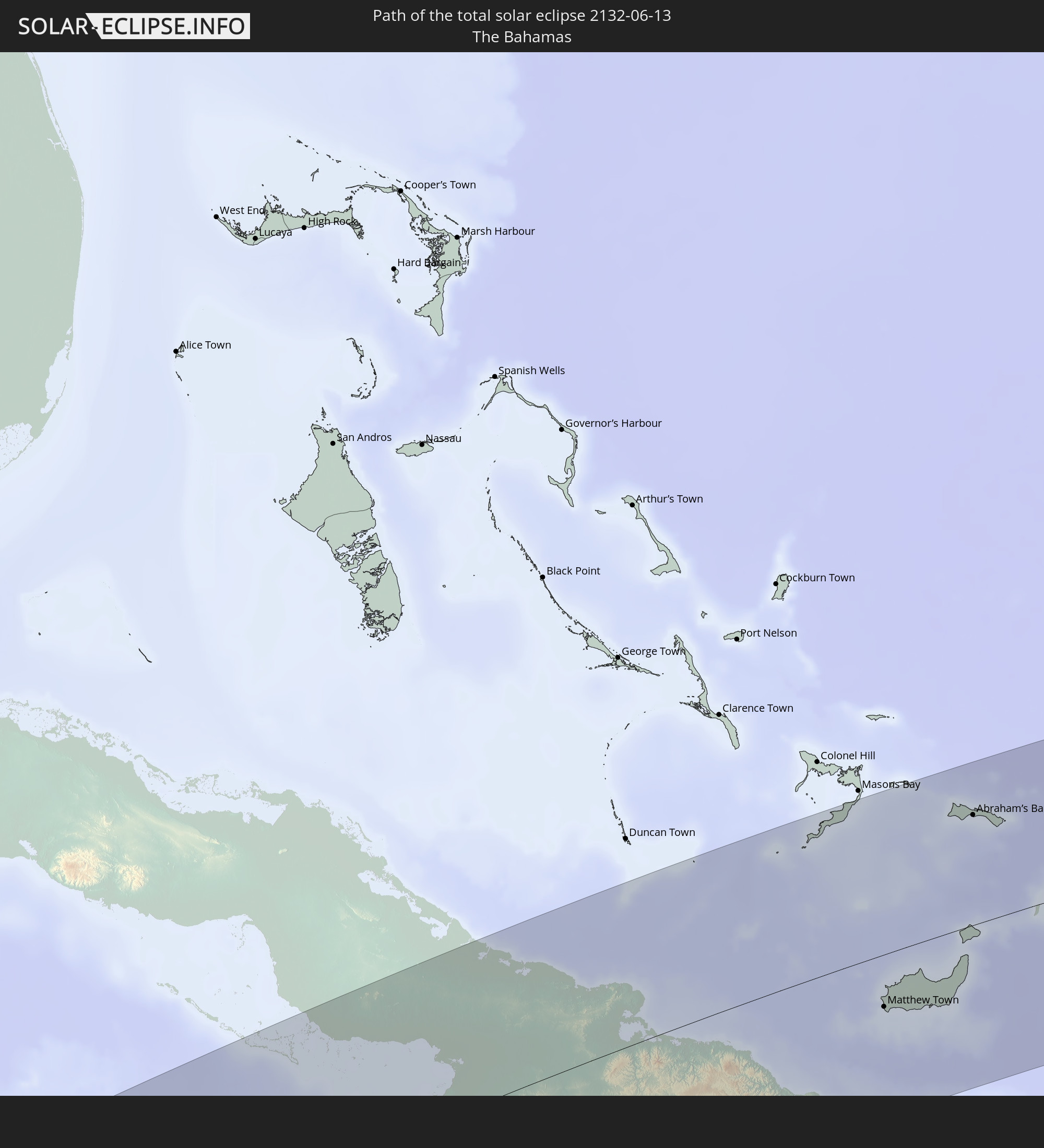 The Bahamas
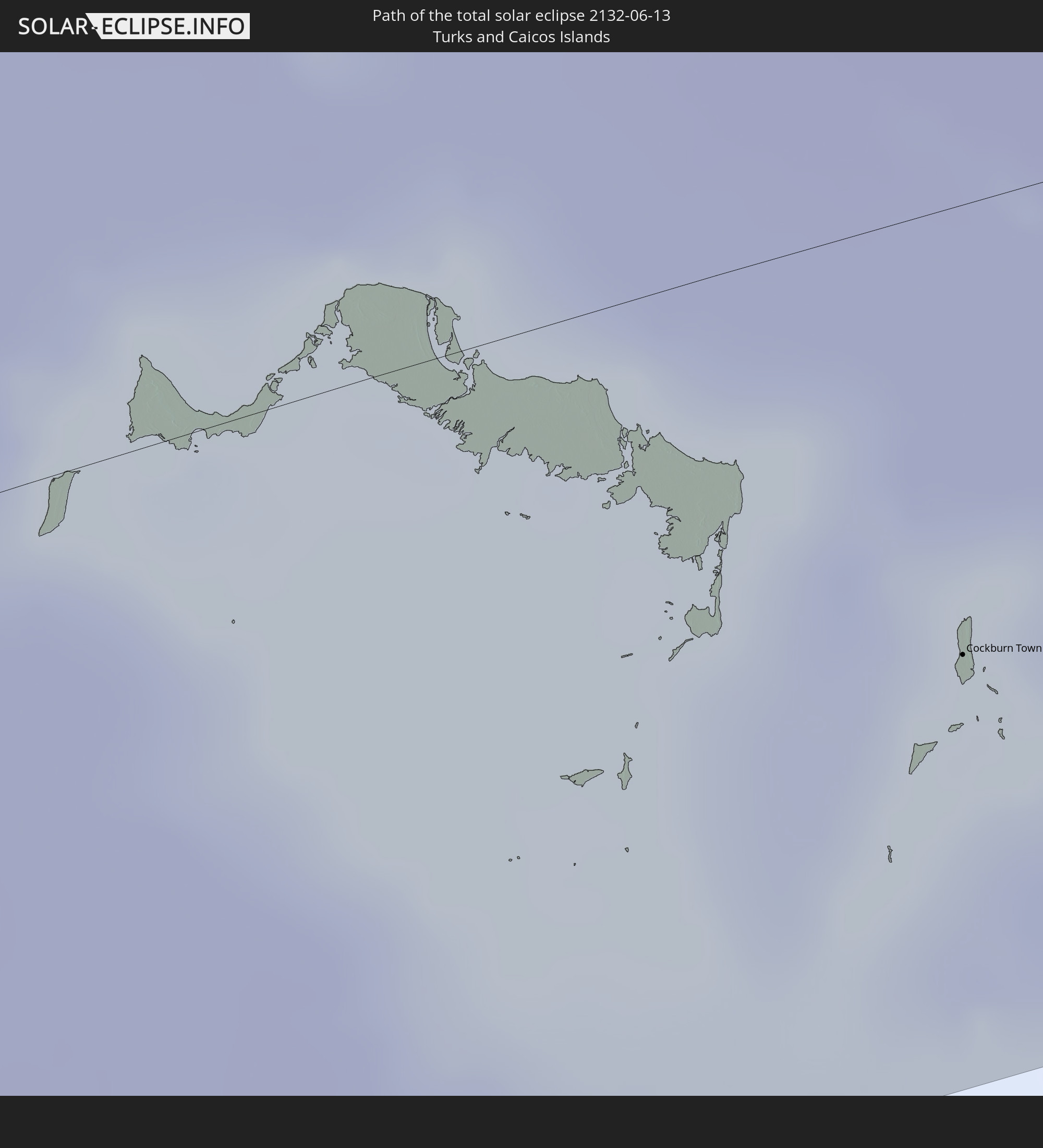 Turks and Caicos Islands
 Cabo Verde
 Senegal
 The Gambia
 Guinea-Bissau
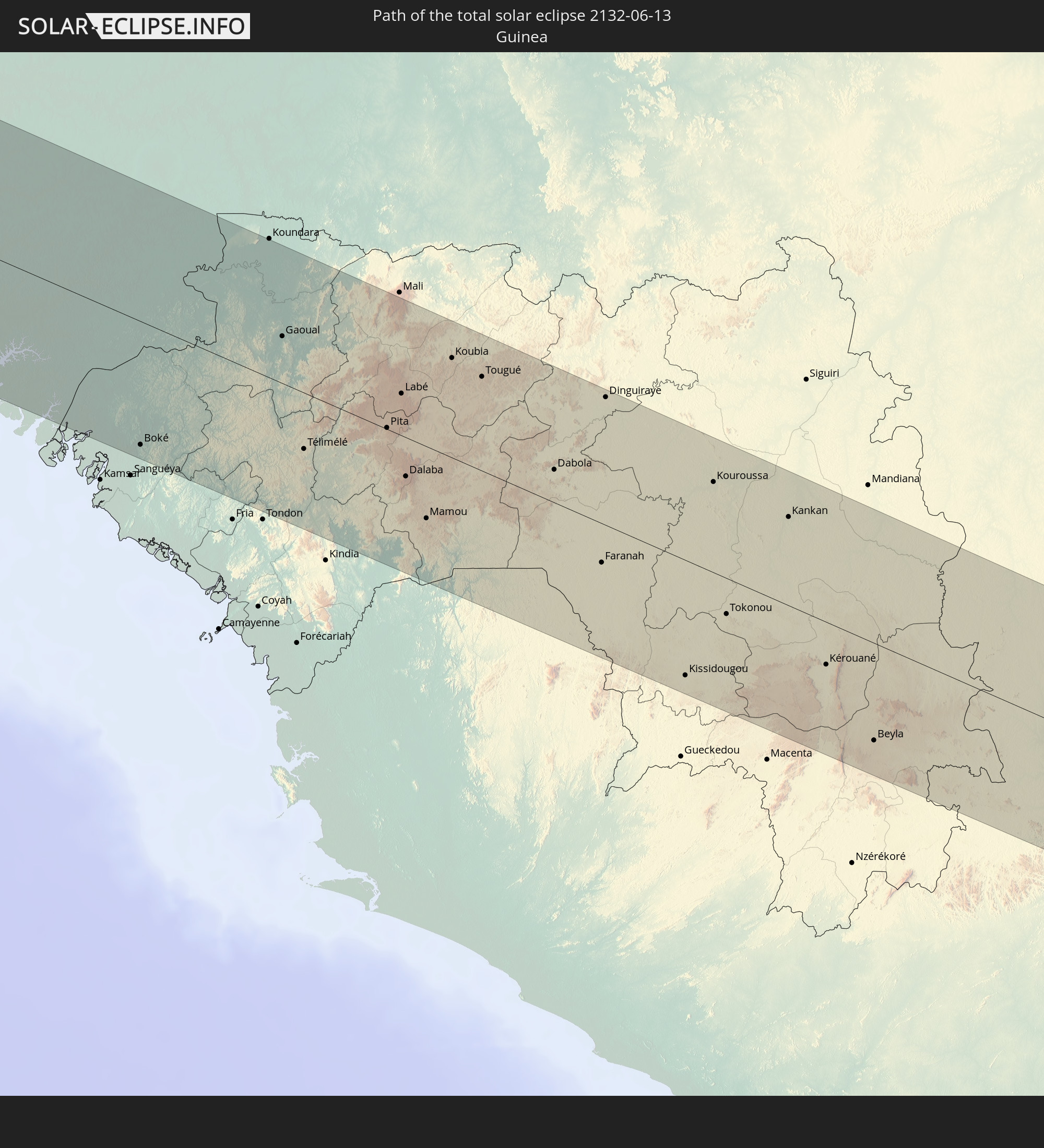 Guinea
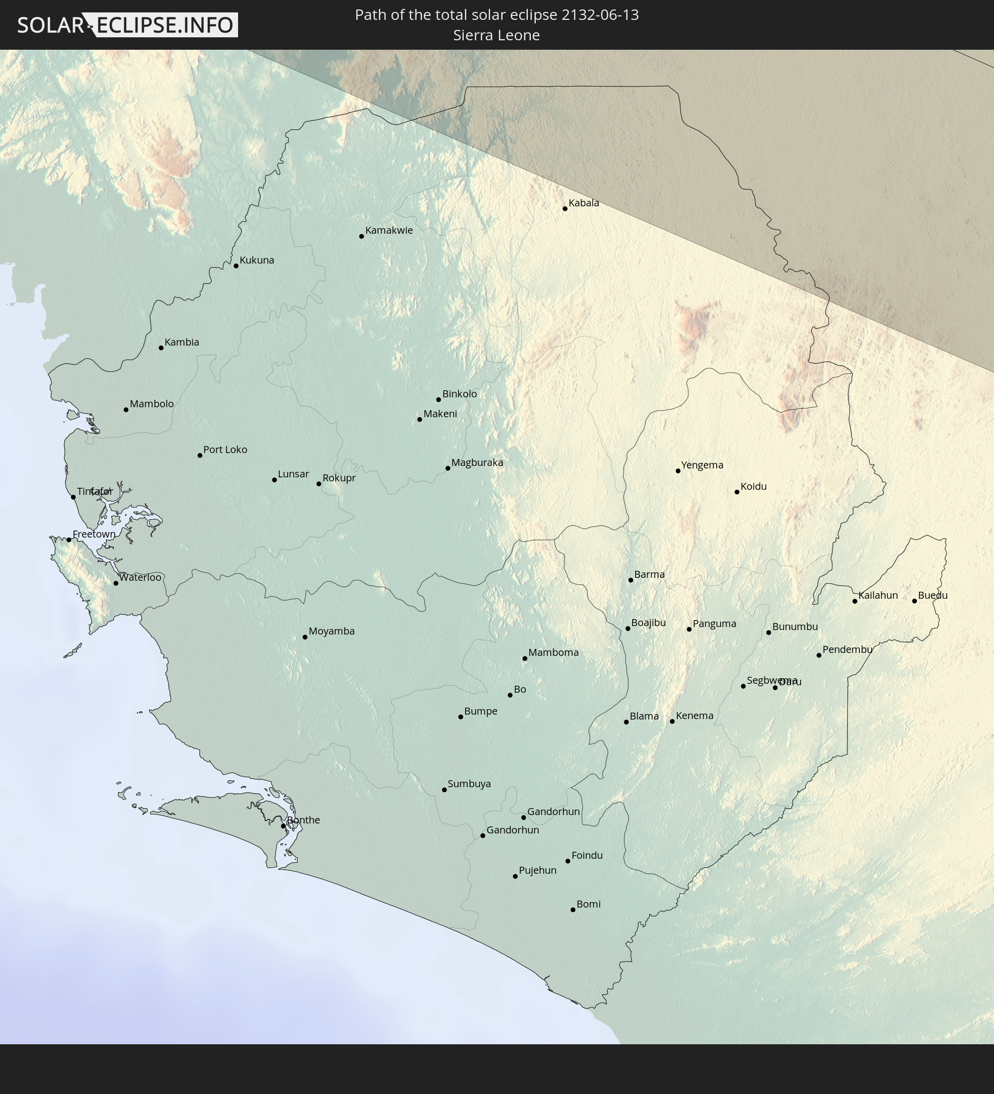 Sierra Leone
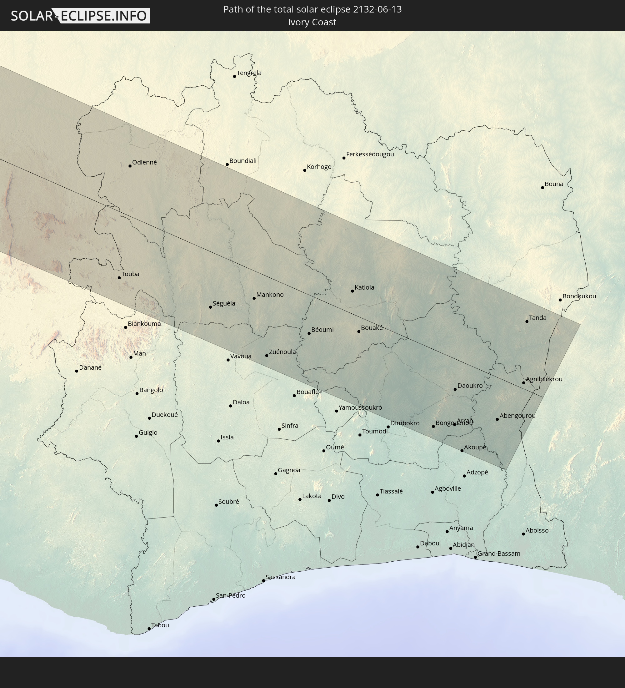 Ivory Coast
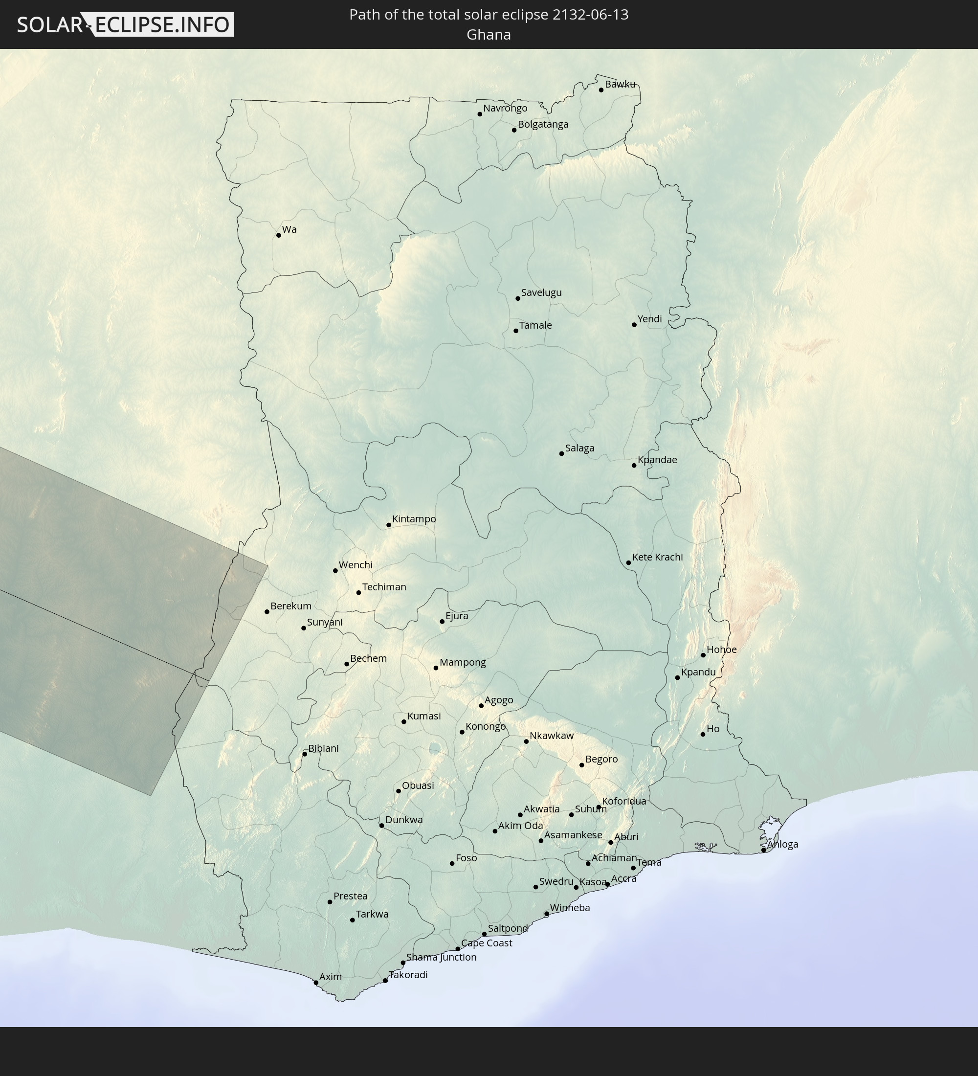 Ghana
Ghana
In den folgenden Ländern ist die Sonnenfinsternis partiell zu sehen
 United States
 United States Minor Outlying Islands
 Canada
 Mexico
 Chile
Chile
 Guatemala
 Ecuador
 El Salvador
 Honduras
 Belize
 Nicaragua
 Costa Rica
 Cuba
Cuba
 Panama
 Colombia
 Cayman Islands
 Peru
Peru
 The Bahamas
 Jamaica
 Haiti
Haiti
 Brazil
 Venezuela
 Turks and Caicos Islands
 Dominican Republic
 Aruba
Aruba
 Bolivia
 Puerto Rico
 United States Virgin Islands
 Bermuda
 British Virgin Islands
 Anguilla
 Collectivity of Saint Martin
 Saint Barthélemy
 Saint Kitts and Nevis
 Antigua and Barbuda
 Montserrat
 Trinidad and Tobago
 Guadeloupe
 Grenada
 Dominica
 Saint Vincent and the Grenadines
 Guyana
 Martinique
 Saint Lucia
 Barbados
 Suriname
 Saint Pierre and Miquelon
 French Guiana
 Portugal
 Cabo Verde
 Spain
Spain
 Senegal
 Mauritania
 The Gambia
 Guinea-Bissau
 Guinea
 Saint Helena, Ascension and Tristan da Cunha
 Sierra Leone
 Morocco
 Mali
Mali
 Liberia
 Algeria
 Ivory Coast
 Burkina Faso
 Gibraltar
 France
 Ghana
Ghana
 Niger
Niger
 Andorra
 Italy
Italy
 Tunisia
 Libya
Libya
 Malta
Malta
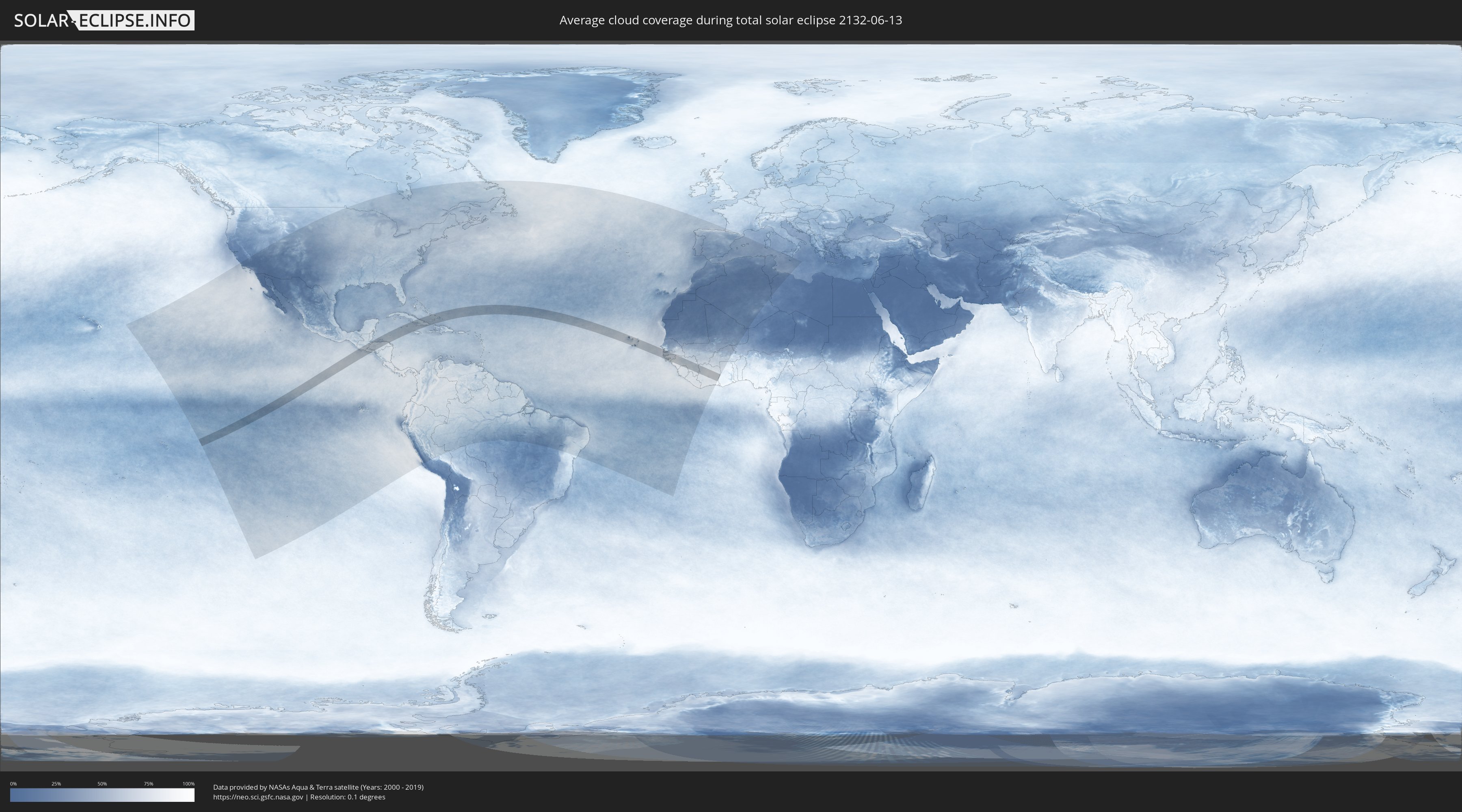
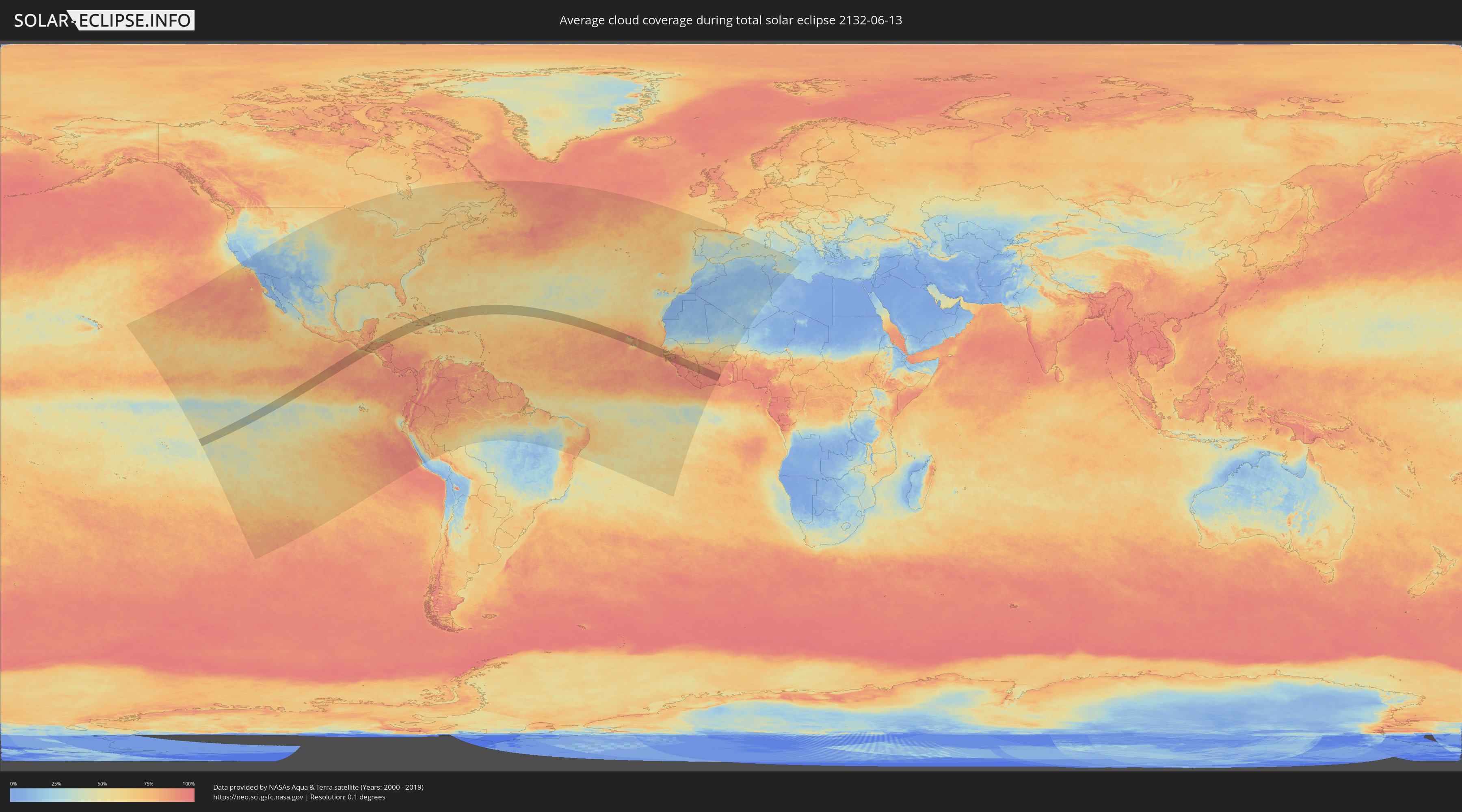
How will be the weather during the total solar eclipse on 06/13/2132?
Where is the best place to see the total solar eclipse of 06/13/2132?
The following maps show the average cloud coverage for the day of the total solar eclipse.
With the help of these maps, it is possible to find the place along the eclipse path, which has the best
chance of a cloudless sky.
Nevertheless, you should consider local circumstances and inform about the weather of your chosen
observation site.
The data is provided by NASAs satellites
AQUA and TERRA.
The cloud maps are averaged over a period of 19 years (2000 - 2019).
Detailed country maps
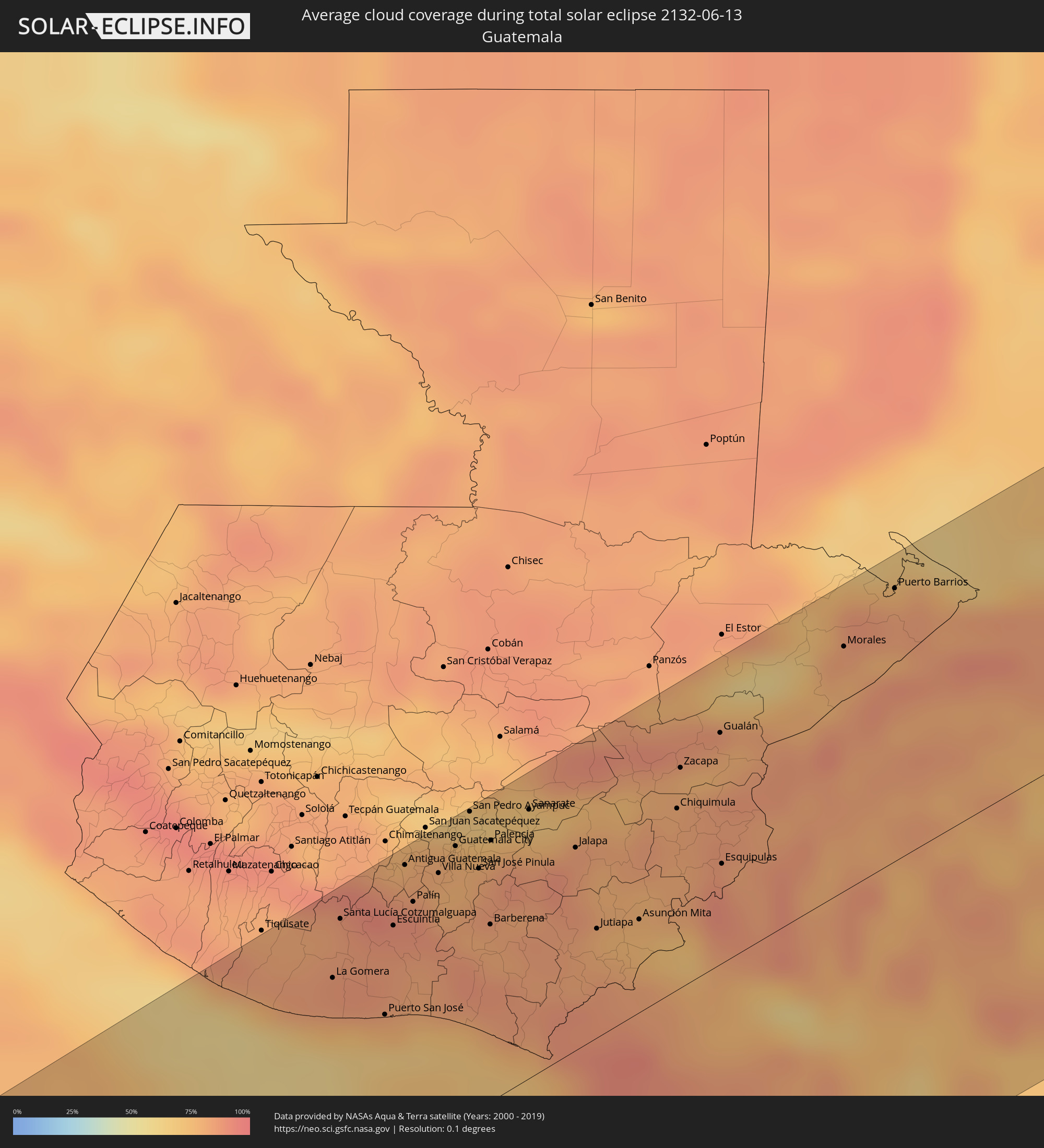 Guatemala
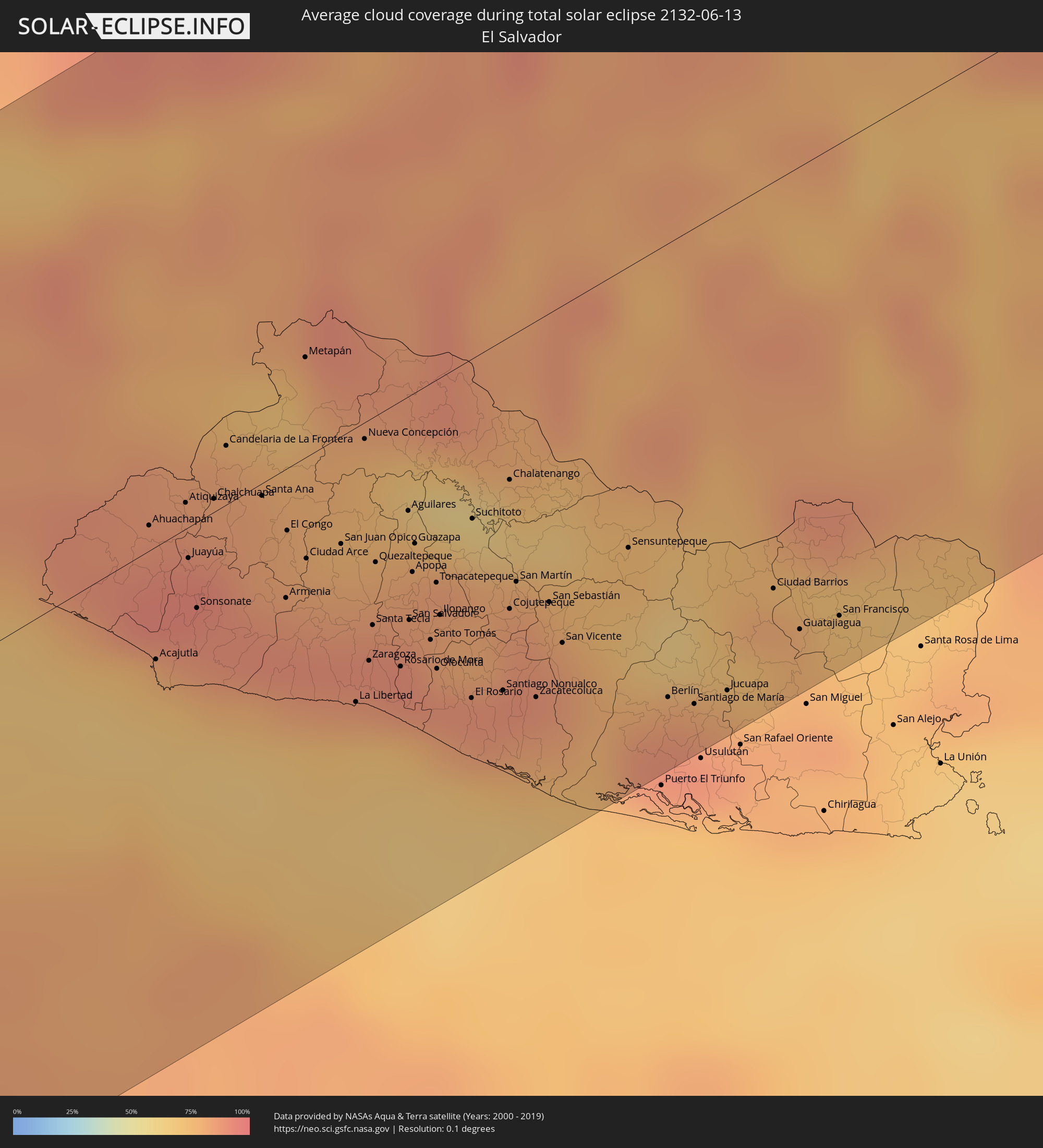 El Salvador
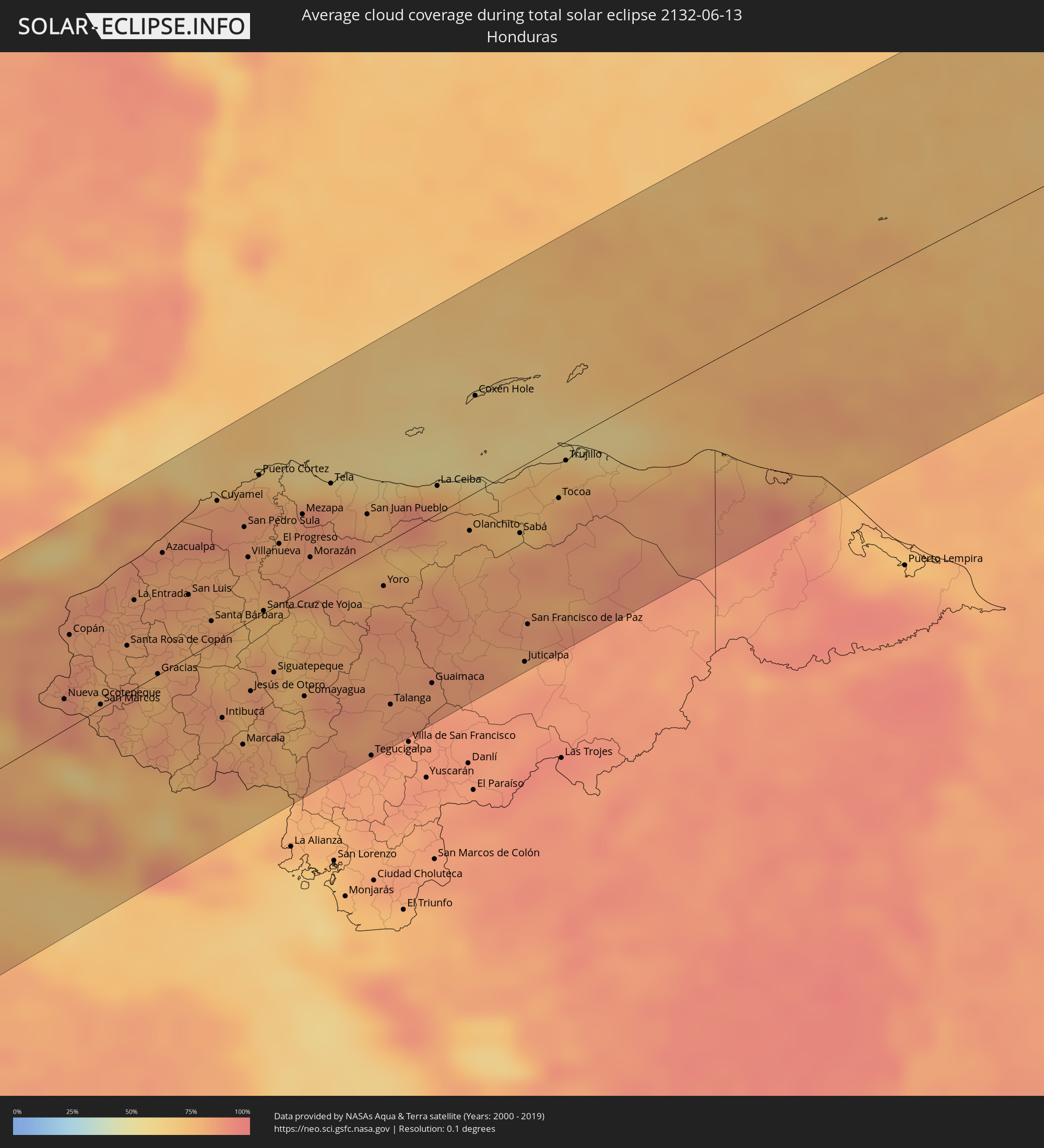 Honduras
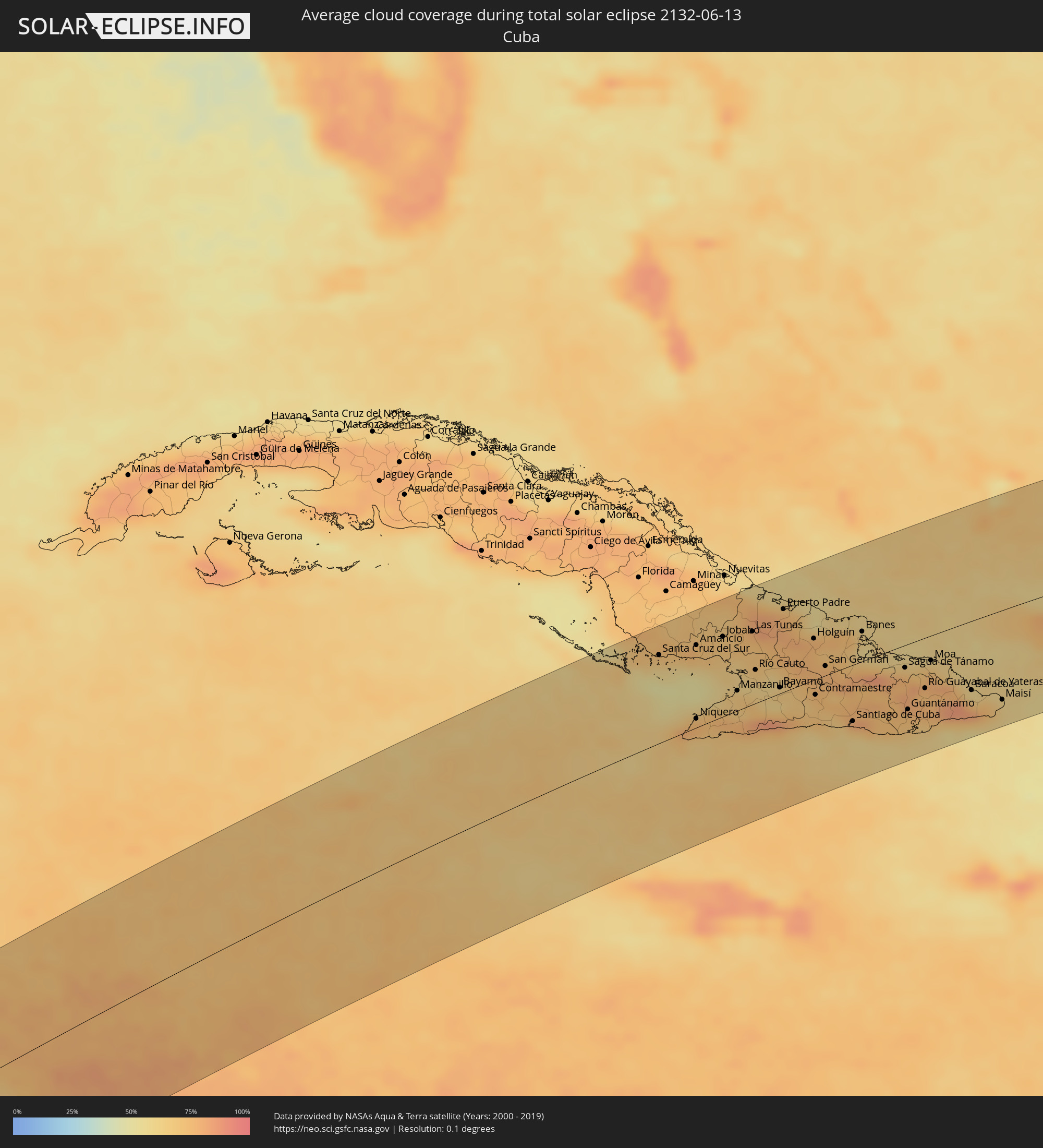 Cuba
Cuba
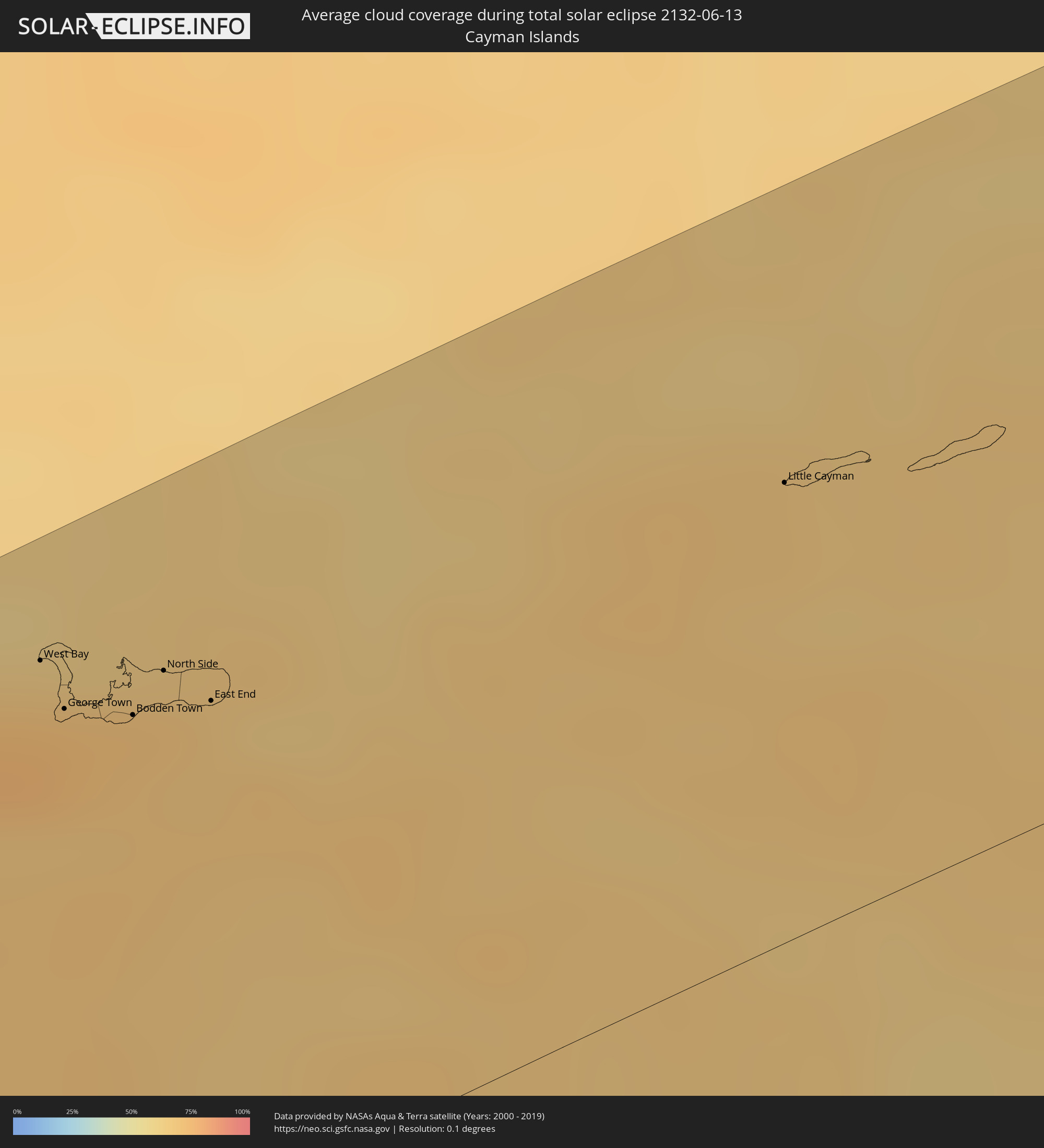 Cayman Islands
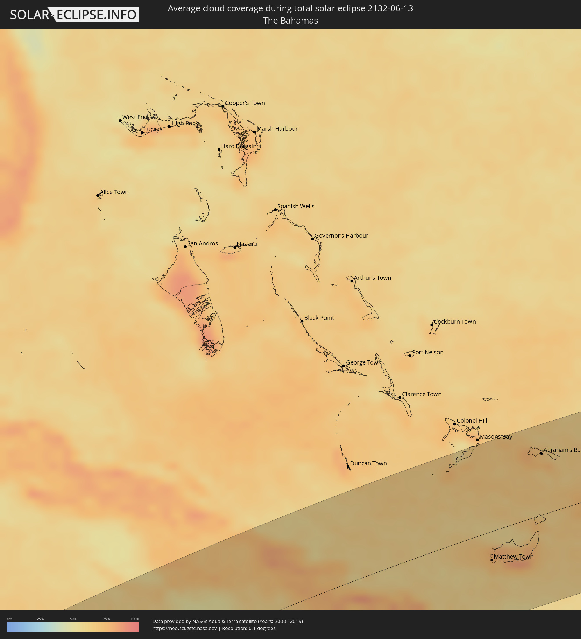 The Bahamas
 Turks and Caicos Islands
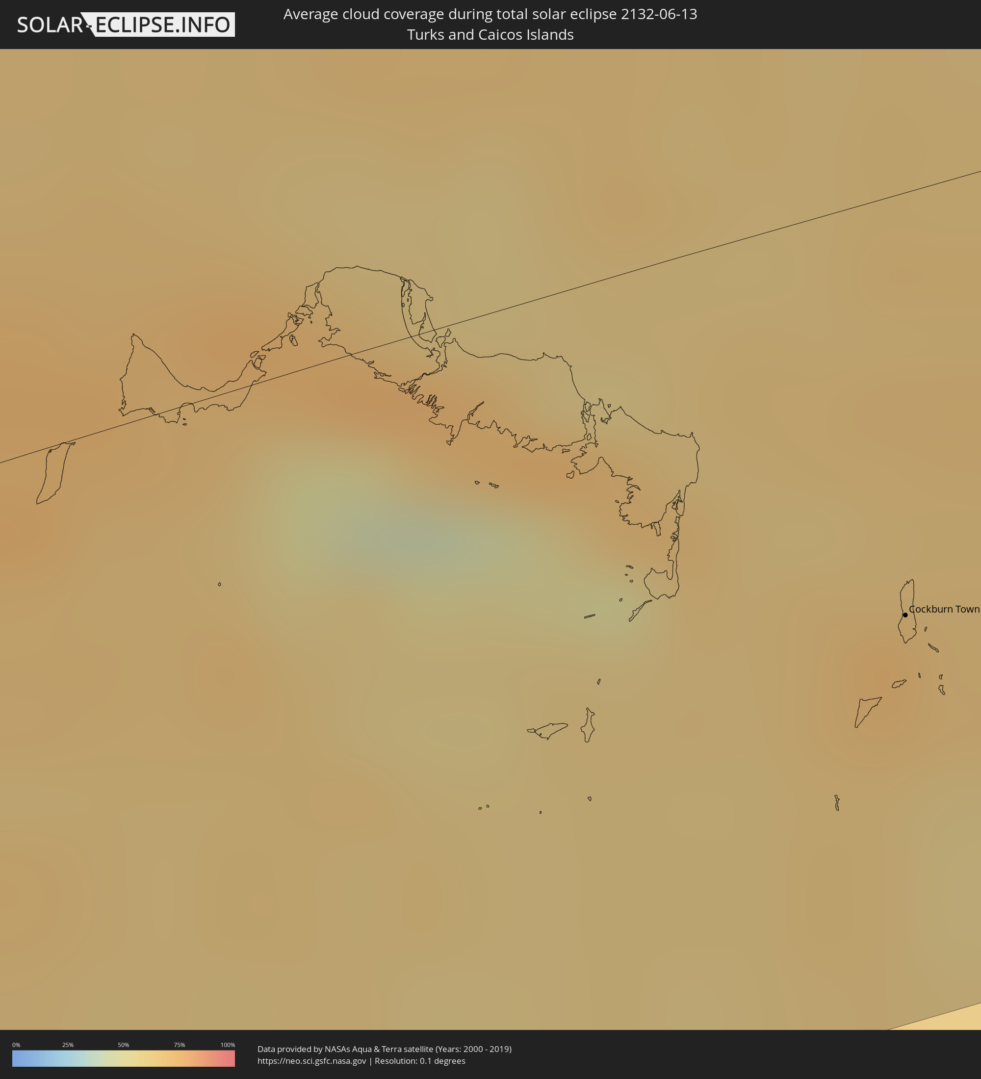
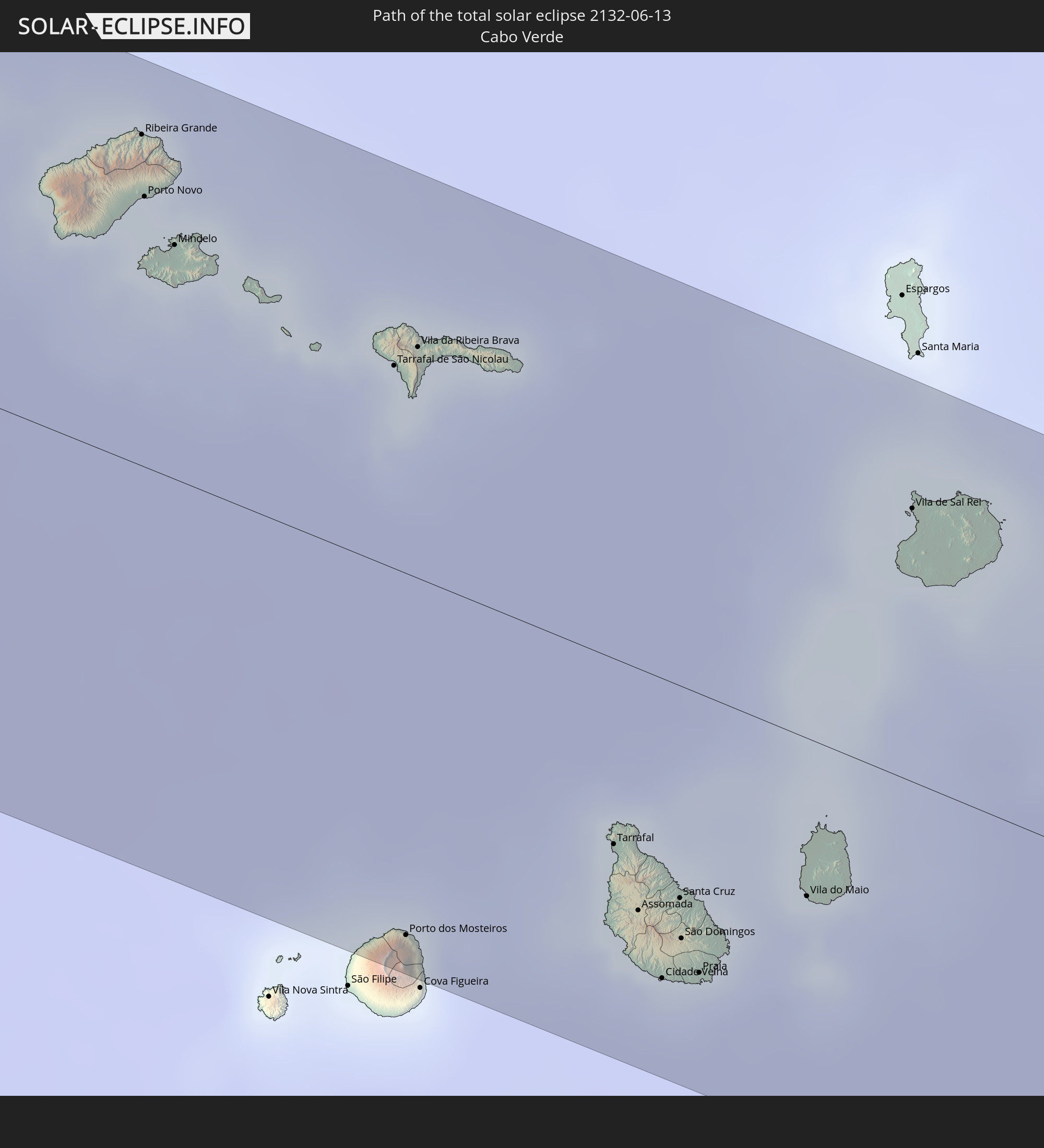
 Cabo Verde
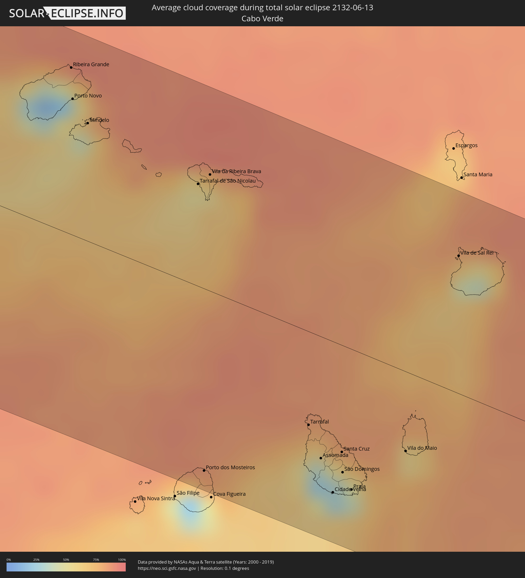
 Senegal
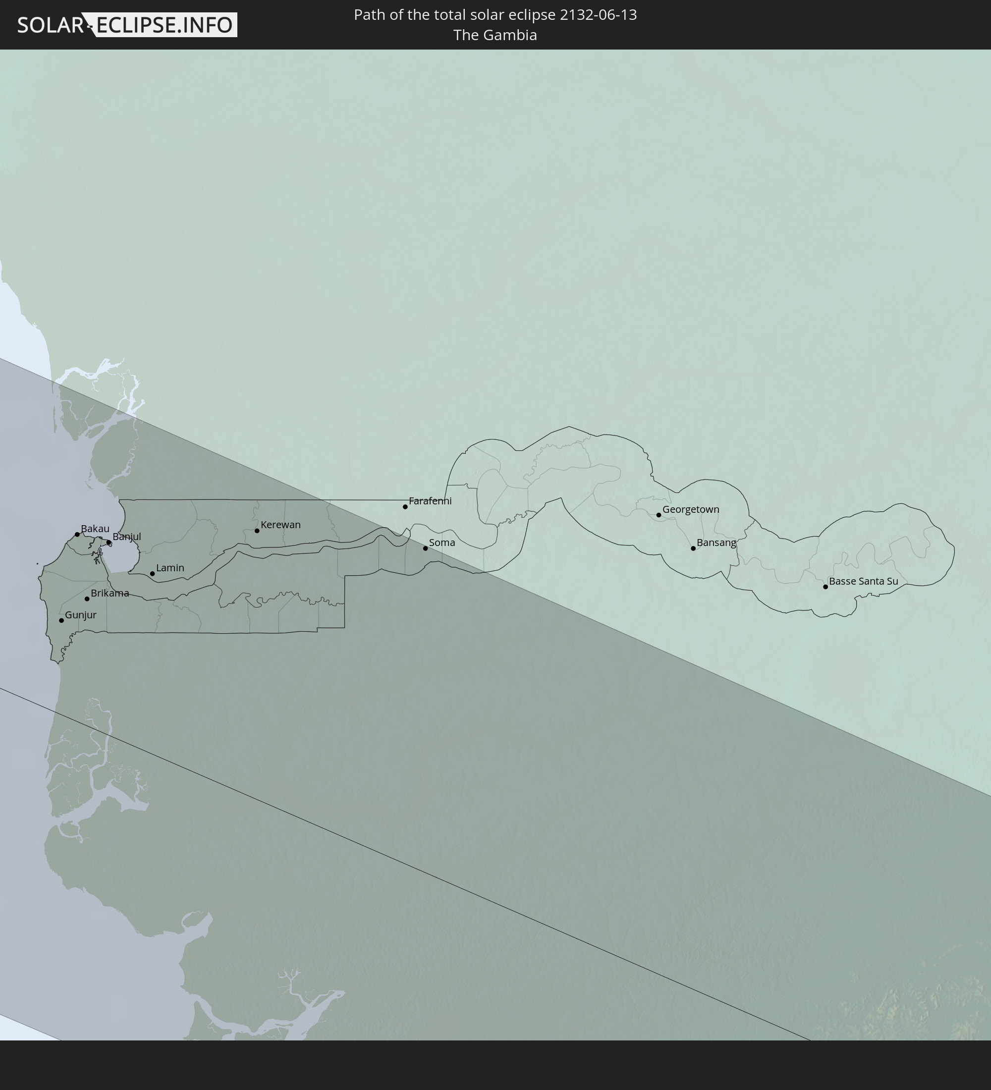
 The Gambia
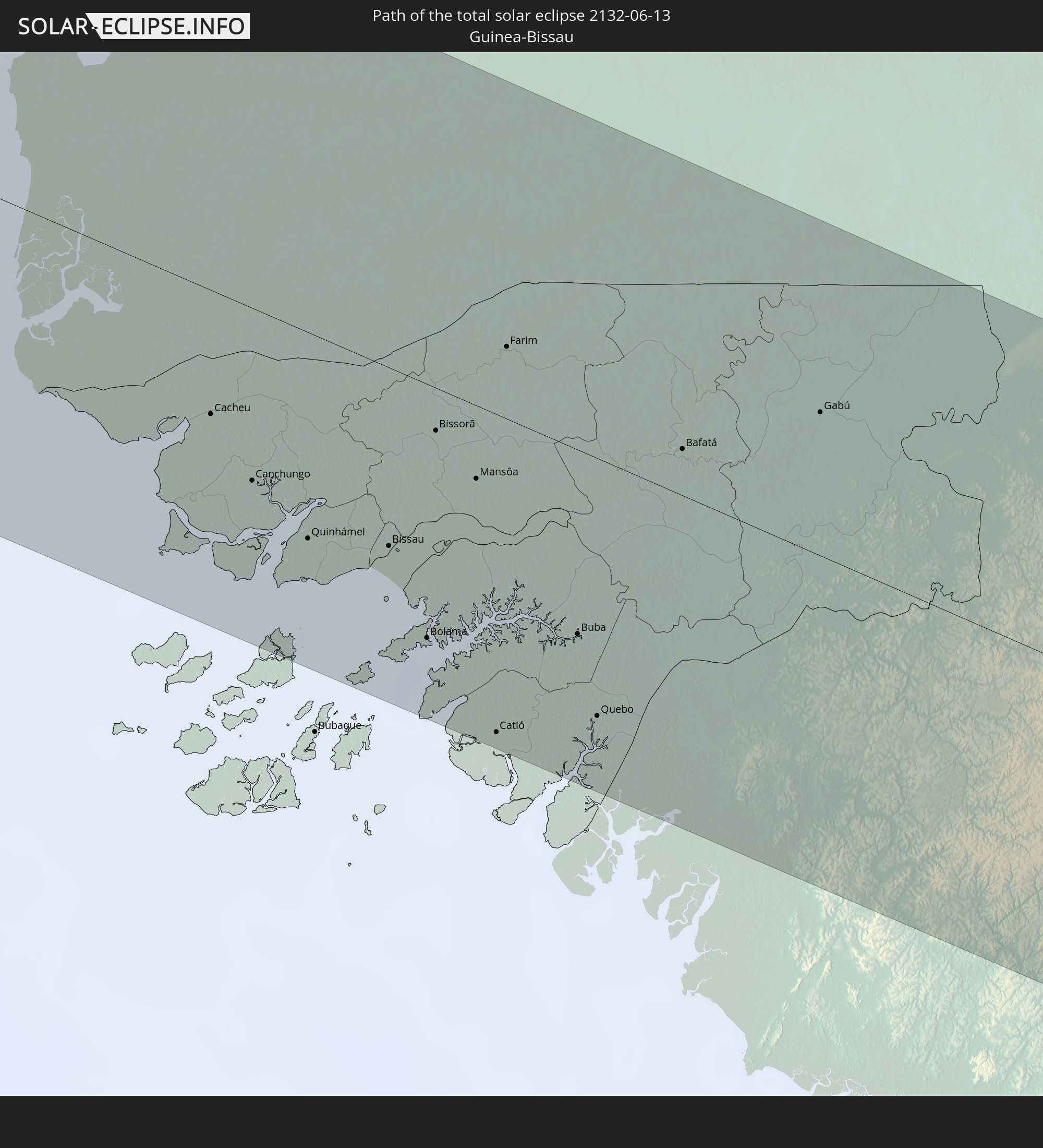
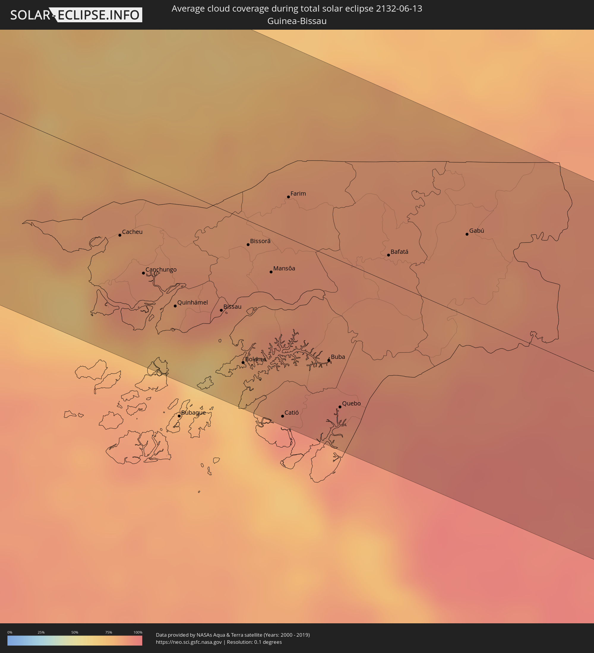 Guinea-Bissau
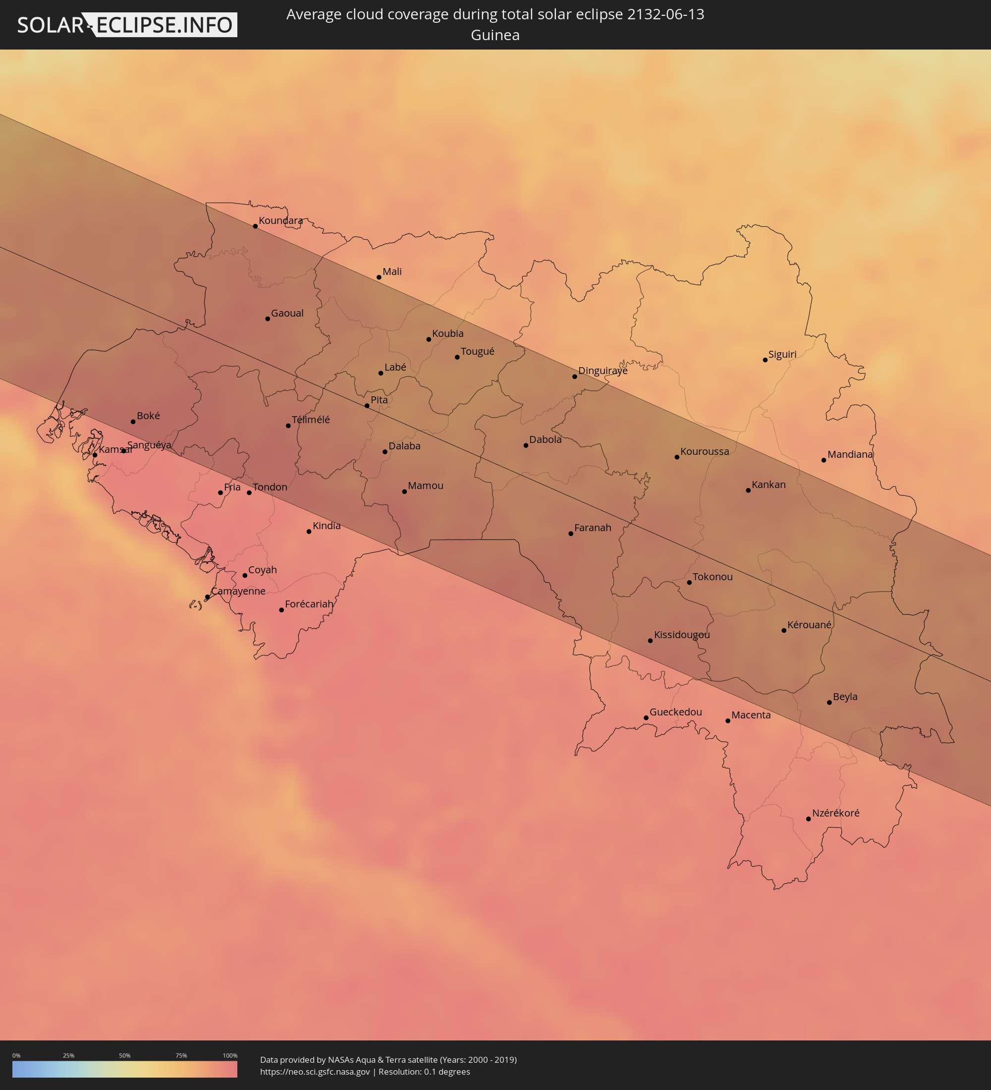 Guinea
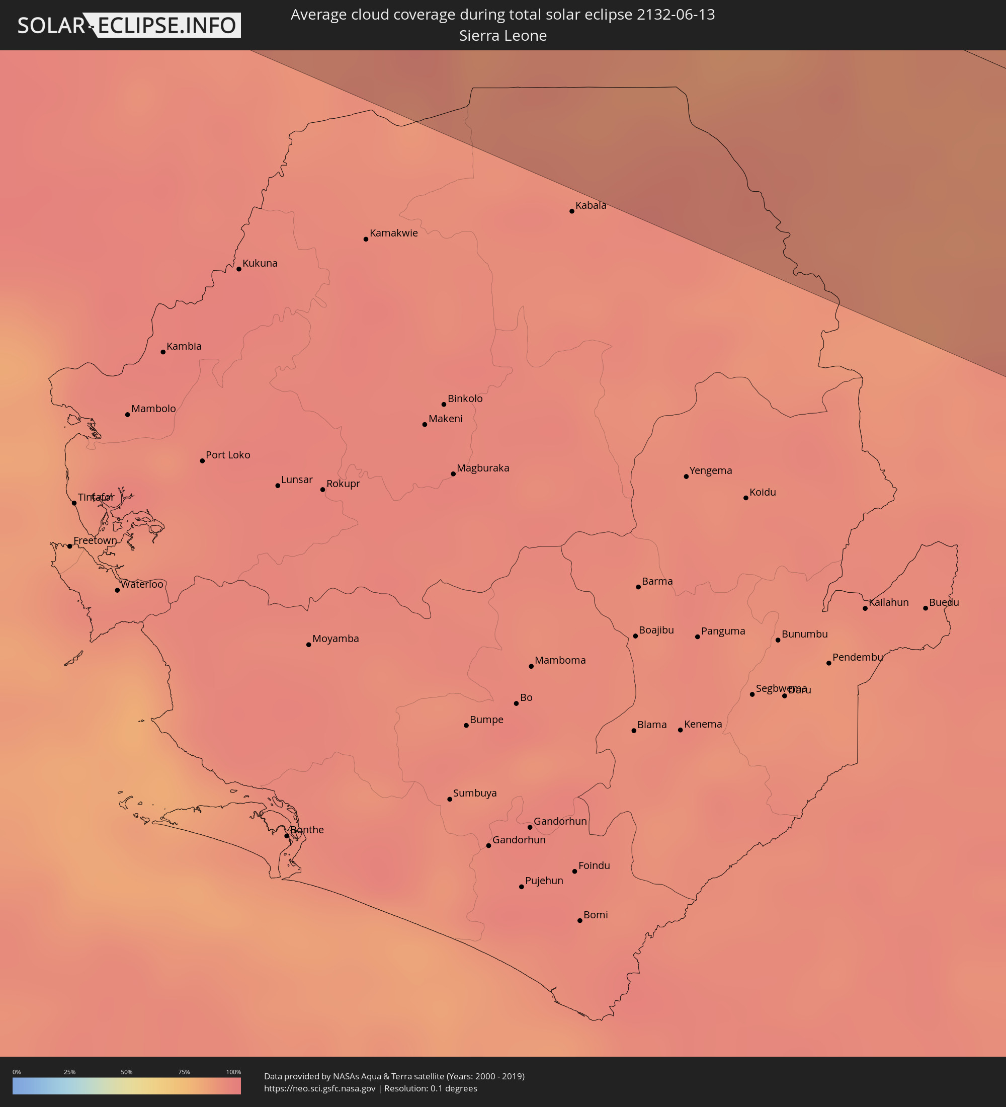 Sierra Leone
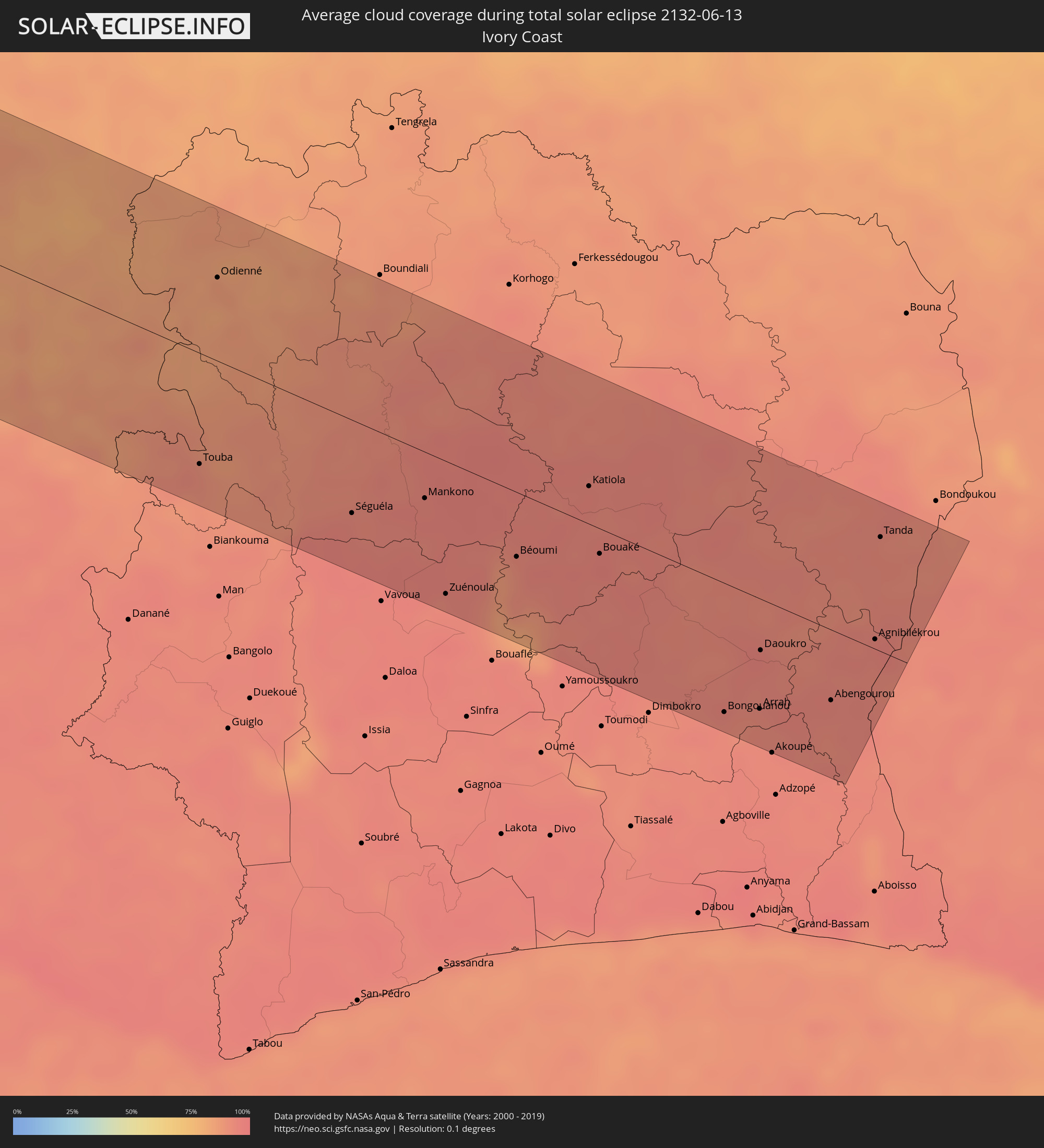 Ivory Coast
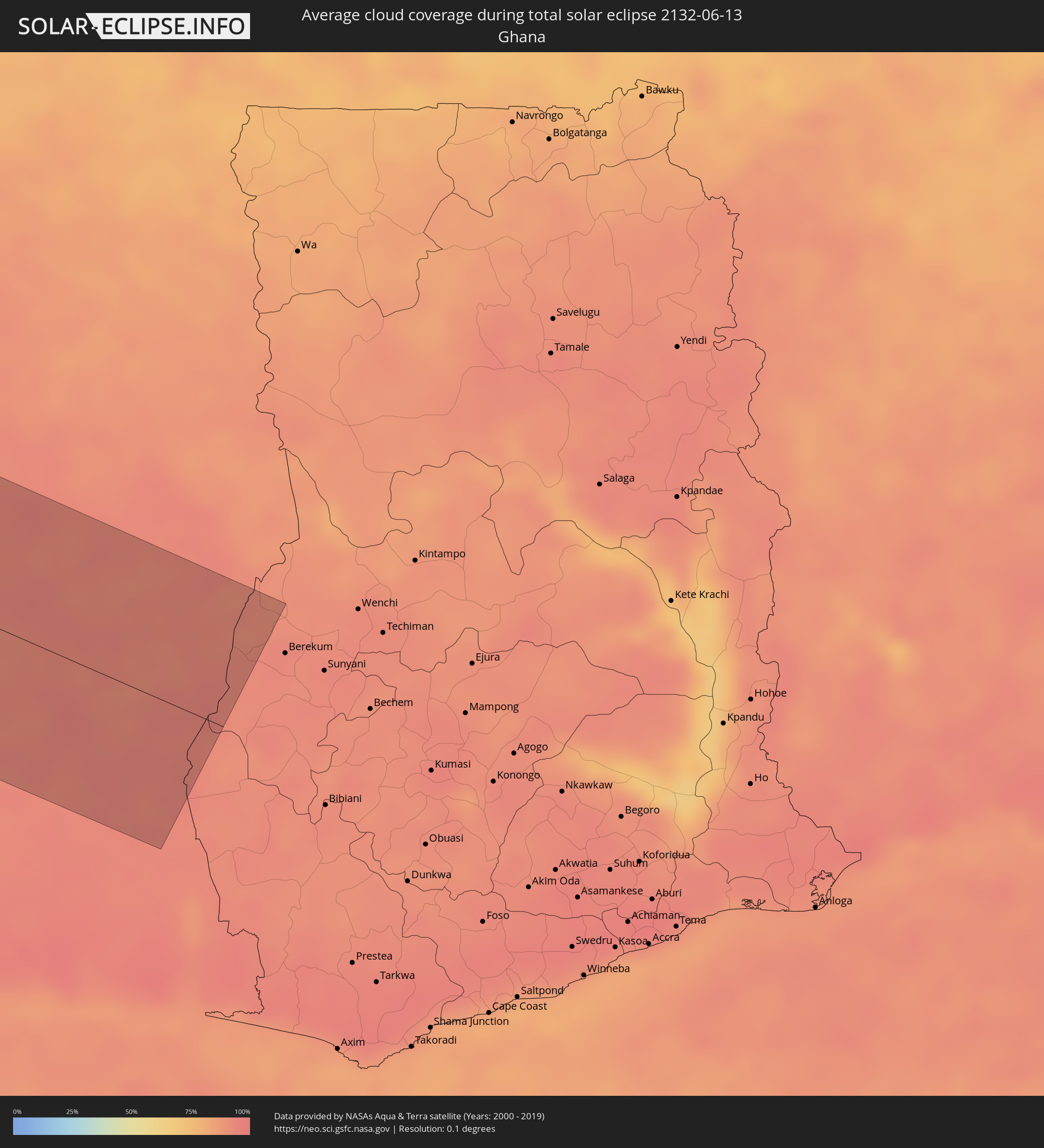 Ghana
Ghana
Cities inside the path of the eclipse
The following table shows all locations with a population of more than 5,000 inside the eclipse path. Cities which have more than 100,000 inhabitants are marked bold. A click at the locations opens a detailed map.
| City | Type | Eclipse duration | Local time of max. eclipse | Distance to central line | Ø Cloud coverage |
|
La Gomera, Escuintla
|
total | - | 09:43:44 UTC-06:00 | 89 km | 84% |
|
Santa Lucía Cotzumalguapa, Escuintla
|
total | - | 09:44:07 UTC-06:00 | 110 km | 85% |
|
Escuintla, Escuintla
|
total | - | 09:44:29 UTC-06:00 | 95 km | 85% |
|
Antigua Guatemala, Sacatepéquez
|
total | - | 09:44:54 UTC-06:00 | 116 km | 82% |
|
Petapa, Guatemala
|
total | - | 09:45:09 UTC-06:00 | 101 km | 80% |
|
Guatemala City, Guatemala
|
total | - | 09:45:23 UTC-06:00 | 112 km | 78% |
|
San Pedro Ayampuc, Guatemala
|
total | - | 09:45:41 UTC-06:00 | 122 km | 75% |
|
San José Pinula, Guatemala
|
total | - | 09:45:27 UTC-06:00 | 97 km | 85% |
|
Barberena, Santa Rosa
|
total | - | 09:45:14 UTC-06:00 | 72 km | 82% |
|
Jalapa, Jalapa
|
total | - | 09:46:19 UTC-06:00 | 82 km | 83% |
|
Jutiapa, Jutiapa
|
total | - | 09:46:02 UTC-06:00 | 44 km | 80% |
|
Ahuachapán, Ahuachapán
|
total | - | 09:45:40 UTC-06:00 | 6 km | 93% |
|
Acajutla, Sonsonate
|
total | - | 09:45:17 UTC-06:00 | 26 km | 72% |
|
Sonsonate, Sonsonate
|
total | - | 09:45:37 UTC-06:00 | 20 km | 87% |
|
Santa Ana, Santa Ana
|
total | - | 09:46:16 UTC-06:00 | 3 km | 83% |
|
Chiquimula, Chiquimula
|
total | - | 09:47:20 UTC-06:00 | 73 km | 82% |
|
Zacapa, Zacapa
|
total | - | 09:47:34 UTC-06:00 | 89 km | 81% |
|
Metapán, Santa Ana
|
total | - | 09:46:54 UTC-06:00 | 24 km | 70% |
|
Gualán, Zacapa
|
total | - | 09:48:05 UTC-06:00 | 94 km | 78% |
|
Esquipulas, Chiquimula
|
total | - | 09:47:23 UTC-06:00 | 40 km | 90% |
|
La Libertad, La Libertad
|
total | - | 09:46:04 UTC-06:00 | 64 km | 72% |
|
Quezaltepeque, La Libertad
|
total | - | 09:46:35 UTC-06:00 | 34 km | 85% |
|
Aguilares, San Salvador
|
total | - | 09:46:54 UTC-06:00 | 27 km | 76% |
|
San Salvador, San Salvador
|
total | - | 09:46:34 UTC-06:00 | 53 km | 90% |
|
Cojutepeque, Cuscatlán
|
total | - | 09:47:04 UTC-06:00 | 64 km | 87% |
|
Chalatenango, Chalatenango
|
total | - | 09:47:29 UTC-06:00 | 34 km | 67% |
|
Zacatecoluca, La Paz
|
total | - | 09:46:55 UTC-06:00 | 88 km | 83% |
|
San Vicente, San Vicente
|
total | - | 09:47:13 UTC-06:00 | 79 km | 85% |
|
Santa Rosa de Copán, Copán
|
total | - | 09:48:42 UTC-06:00 | 28 km | 80% |
|
Sensuntepeque, Cabañas
|
total | - | 09:47:50 UTC-06:00 | 66 km | 75% |
|
Puerto Barrios, Izabal
|
total | - | 09:50:17 UTC-06:00 | 111 km | 83% |
|
Santiago de María, Usulután
|
total | - | 09:47:39 UTC-06:00 | 112 km | 88% |
|
Cofradía, Cortés
|
total | - | 09:50:42 UTC-06:00 | 55 km | 80% |
|
San Francisco, Morazán
|
total | - | 09:48:38 UTC-06:00 | 111 km | 75% |
|
San Pedro Sula, Cortés
|
total | - | 09:51:05 UTC-06:00 | 58 km | 84% |
|
Villanueva, Cortés
|
total | - | 09:50:53 UTC-06:00 | 39 km | 77% |
|
Puerto Cortez, Cortés
|
total | - | 09:51:40 UTC-06:00 | 84 km | 79% |
|
Siguatepeque, Comayagua
|
total | - | 09:50:17 UTC-06:00 | 39 km | 77% |
|
El Progreso, Yoro
|
total | - | 09:51:23 UTC-06:00 | 36 km | 82% |
|
La Paz, La Paz
|
total | - | 09:50:14 UTC-06:00 | 74 km | 73% |
|
Comayagua, Comayagua
|
total | - | 09:50:29 UTC-06:00 | 64 km | 78% |
|
Tela, Atlántida
|
total | - | 09:52:30 UTC-06:00 | 55 km | 72% |
|
Tegucigalpa, Francisco Morazán
|
total | - | 09:50:51 UTC-06:00 | 123 km | 84% |
|
Yoro, Yoro
|
total | - | 09:52:21 UTC-06:00 | 25 km | 87% |
|
La Ceiba, Atlántida
|
total | - | 09:53:50 UTC-06:00 | 17 km | 76% |
|
Olanchito, Yoro
|
total | - | 09:53:54 UTC-06:00 | 21 km | 75% |
|
Juticalpa, Olancho
|
total | - | 09:53:35 UTC-06:00 | 119 km | 84% |
|
Tocoa, Colón
|
total | - | 09:55:20 UTC-06:00 | 32 km | 77% |
|
West Bay, West Bay
|
total | - | 11:09:58 UTC-05:00 | 106 km | 73% |
|
George Town, George Town
|
total | - | 11:09:58 UTC-05:00 | 96 km | 75% |
|
Bodden Town, Bodden Town
|
total | - | 11:10:14 UTC-05:00 | 90 km | 72% |
|
North Side, North Side
|
total | - | 11:10:26 UTC-05:00 | 95 km | 71% |
|
East End, East End
|
total | - | 11:10:34 UTC-05:00 | 86 km | 68% |
|
Little Cayman, Sister Island
|
total | - | 11:13:22 UTC-05:00 | 77 km | 68% |
|
Jobabo, Las Tunas
|
total | - | 11:21:40 UTC-05:00 | 86 km | 69% |
|
Manzanillo, Granma
|
total | - | 11:21:27 UTC-05:00 | 22 km | 66% |
|
Las Tunas, Las Tunas
|
total | - | 11:22:33 UTC-05:00 | 79 km | 74% |
|
Bartolomé Masó, Granma
|
total | - | 11:21:43 UTC-05:00 | 3 km | 72% |
|
Bayamo, Granma
|
total | - | 11:22:42 UTC-05:00 | 6 km | 66% |
|
Puerto Padre, Las Tunas
|
total | - | 11:23:40 UTC-05:00 | 90 km | 77% |
|
Holguín, Holguín
|
total | - | 11:24:12 UTC-05:00 | 45 km | 76% |
|
Contramaestre, Santiago de Cuba
|
total | - | 11:23:38 UTC-05:00 | 17 km | 71% |
|
San Germán, Holguín
|
total | - | 11:24:14 UTC-05:00 | 10 km | 77% |
|
Palma Soriano, Santiago de Cuba
|
total | - | 11:24:11 UTC-05:00 | 35 km | 70% |
|
San Luis, Santiago de Cuba
|
total | - | 11:24:32 UTC-05:00 | 43 km | 75% |
|
Santiago de Cuba, Santiago de Cuba
|
total | - | 11:24:25 UTC-05:00 | 61 km | 67% |
|
Banes, Holguín
|
total | - | 11:25:40 UTC-05:00 | 32 km | 62% |
|
Guantánamo, Guantánamo
|
total | - | 11:26:09 UTC-05:00 | 71 km | 71% |
|
Moa, Holguín
|
total | - | 11:27:21 UTC-05:00 | 27 km | 69% |
|
Baracoa, Guantánamo
|
total | - | 11:28:14 UTC-05:00 | 76 km | 78% |
|
Matthew Town, Inagua
|
total | - | 11:31:01 UTC-05:00 | 41 km | 63% |
|
Abraham’s Bay, Mayaguana
|
total | - | 11:34:11 UTC-05:00 | 86 km | 73% |
|
Cockburn Town
|
total | - | 11:38:17 UTC-05:00 | 65 km | 66% |
|
Ribeira Grande, Ribeira Grande
|
total | - | 17:13:40 UTC-01:00 | 92 km | 47% |
|
Porto Novo, Porto Novo
|
total | - | 17:13:46 UTC-01:00 | 75 km | 49% |
|
Pombas, Paul
|
total | - | 17:13:44 UTC-01:00 | 90 km | 71% |
|
Mindelo, São Vicente
|
total | - | 17:13:55 UTC-01:00 | 65 km | 43% |
|
Tarrafal de São Nicolau, Tarrafal de São Nicolau
|
total | - | 17:14:34 UTC-01:00 | 56 km | 53% |
|
Vila da Ribeira Brava, Ribeira Brava
|
total | - | 17:14:35 UTC-01:00 | 64 km | 56% |
|
Tarrafal, Tarrafal
|
total | - | 17:15:44 UTC-01:00 | 52 km | 71% |
|
Assomada, Santa Catarina
|
total | - | 17:15:52 UTC-01:00 | 67 km | 28% |
|
Picos, São Salvador do Mundo
|
total | - | 17:15:55 UTC-01:00 | 67 km | 32% |
|
Cidade Velha, Ribeira Grande de Santiago
|
total | - | 17:16:01 UTC-01:00 | 83 km | 60% |
|
Calheta, São Miguel
|
total | - | 17:15:53 UTC-01:00 | 55 km | 54% |
|
Santa Cruz, Santa Cruz
|
total | - | 17:15:56 UTC-01:00 | 59 km | 32% |
|
São Domingos, São Domingos
|
total | - | 17:16:00 UTC-01:00 | 70 km | 32% |
|
Praia, Praia
|
total | - | 17:16:05 UTC-01:00 | 78 km | 64% |
|
Vila do Maio, Maio
|
total | - | 17:16:10 UTC-01:00 | 44 km | 75% |
|
Vila de Sal Rei, Boa Vista
|
total | - | 17:15:47 UTC-01:00 | 76 km | 64% |
|
Gunjur, Western
|
total | - | 18:20:32 UTC+00:00 | 31 km | 76% |
|
Sukuta, Western
|
total | - | 18:20:26 UTC+00:00 | 53 km | 75% |
|
Bakau, Banjul
|
total | - | 18:20:25 UTC+00:00 | 61 km | 70% |
|
Abuko, Western
|
total | - | 18:20:28 UTC+00:00 | 55 km | 75% |
|
Brikama, Western
|
total | - | 18:20:32 UTC+00:00 | 42 km | 71% |
|
Banjul, Banjul
|
total | - | 18:20:28 UTC+00:00 | 63 km | 67% |
|
Barra, North Bank
|
total | - | 18:20:28 UTC+00:00 | 68 km | 69% |
|
Essau, North Bank
|
total | - | 18:20:28 UTC+00:00 | 68 km | 69% |
|
Tionk Essil, Ziguinchor
|
total | - | 18:20:48 UTC+00:00 | 3 km | 75% |
|
Lamin, North Bank
|
total | - | 18:20:34 UTC+00:00 | 59 km | 68% |
|
Ziguinchor, Ziguinchor
|
total | - | 18:20:59 UTC+00:00 | 12 km | 78% |
|
Bignona, Ziguinchor
|
total | - | 18:20:54 UTC+00:00 | 13 km | 77% |
|
Cacheu, Cacheu
|
total | - | 18:21:10 UTC+00:00 | 39 km | 80% |
|
Kerewan, North Bank
|
total | - | 18:20:37 UTC+00:00 | 88 km | 64% |
|
Canchungo, Cacheu
|
total | - | 18:21:18 UTC+00:00 | 55 km | 85% |
|
Marsassoum, Kolda
|
total | - | 18:20:59 UTC+00:00 | 25 km | 74% |
|
Quinhámel, Biombo
|
total | - | 18:21:27 UTC+00:00 | 66 km | 82% |
|
Bissau, Bissau
|
total | - | 18:21:33 UTC+00:00 | 57 km | 82% |
|
Sédhiou, Sédhiou
|
total | - | 18:21:11 UTC+00:00 | 31 km | 78% |
|
Soma, Lower River
|
total | - | 18:20:50 UTC+00:00 | 106 km | 68% |
|
Bolama, Bolama and Bijagos
|
total | - | 18:21:43 UTC+00:00 | 81 km | 77% |
|
Bissorã, Oio
|
total | - | 18:21:26 UTC+00:00 | 14 km | 87% |
|
Mansôa, Oio
|
total | - | 18:21:33 UTC+00:00 | 23 km | 88% |
|
Catió, Tombali
|
total | - | 18:21:54 UTC+00:00 | 101 km | 91% |
|
Farim, Oio
|
total | - | 18:21:23 UTC+00:00 | 23 km | 86% |
|
Buba, Quinara
|
total | - | 18:21:51 UTC+00:00 | 59 km | 89% |
|
Kolda, Kolda
|
total | - | 18:21:17 UTC+00:00 | 75 km | 81% |
|
Quebo, Tombali
|
total | - | 18:21:59 UTC+00:00 | 82 km | 87% |
|
Bafatá, Bafatá
|
total | - | 18:21:42 UTC+00:00 | 15 km | 87% |
|
Boké, Boke
|
total | - | 18:22:20 UTC+00:00 | 95 km | 95% |
|
Gabú, Gabú
|
total | - | 18:21:47 UTC+00:00 | 46 km | 86% |
|
Gaoual, Boke
|
total | - | 18:22:16 UTC+00:00 | 36 km | 89% |
|
Télimélé, Kindia
|
total | - | 18:22:40 UTC+00:00 | 43 km | 93% |
|
Pita, Mamou
|
total | - | 18:22:44 UTC+00:00 | 1 km | 85% |
|
Labé, Labe
|
total | - | 18:22:39 UTC+00:00 | 32 km | 81% |
|
Dalaba, Mamou
|
total | - | 18:22:55 UTC+00:00 | 30 km | 88% |
|
Mamou, Mamou
|
total | - | 18:23:04 UTC+00:00 | 55 km | 93% |
|
Koubia, Labe
|
total | - | 18:22:37 UTC+00:00 | 77 km | 81% |
|
Tougué, Labe
|
total | - | 18:22:43 UTC+00:00 | 72 km | 80% |
|
Dabola, Faranah
|
total | - | 18:23:06 UTC+00:00 | 25 km | 84% |
|
Faranah, Faranah
|
total | - | 18:23:25 UTC+00:00 | 30 km | 90% |
|
Kissidougou, Faranah
|
total | - | 18:23:48 UTC+00:00 | 89 km | 92% |
|
Kouroussa, Kankan
|
total | - | 18:23:18 UTC+00:00 | 70 km | 83% |
|
Kankan, Kankan
|
total | - | 18:23:28 UTC+00:00 | 68 km | 87% |
|
Kérouané, Kankan
|
total | - | 18:23:53 UTC+00:00 | 33 km | 85% |
|
Beyla, Nzerekore
|
total | - | 18:24:06 UTC+00:00 | 75 km | 86% |
|
Touba, Woroba
|
total | - | 18:24:17 UTC+00:00 | 74 km | 91% |
|
Odienné, Denguélé
|
total | - | 18:23:53 UTC+00:00 | 56 km | 85% |
|
Séguéla, Woroba
|
total | - | 18:24:24 UTC+00:00 | 62 km | 94% |
|
Mankono, Woroba
|
total | - | 18:24:22 UTC+00:00 | 31 km | 94% |
|
Zuénoula, Sassandra-Marahoué
|
total | - | 18:24:33 UTC+00:00 | 89 km | 94% |
|
Béoumi, Vallée du Bandama
|
total | - | 18:24:28 UTC+00:00 | 43 km | 91% |
|
Sakassou, Vallée du Bandama
|
total | - | 18:24:31 UTC+00:00 | 53 km | 94% |
|
Katiola, Vallée du Bandama
|
total | - | 18:24:19 UTC+00:00 | 25 km | 94% |
|
Bouaké, Vallée du Bandama
|
total | - | 18:24:26 UTC+00:00 | 17 km | 96% |
|
Bongouanou, Lacs
|
total | - | 18:24:40 UTC+00:00 | 87 km | 93% |
|
Arrah, Lacs
|
total | - | 18:24:38 UTC+00:00 | 74 km | 92% |
|
Daoukro, Lacs
|
total | - | 18:24:32 UTC+00:00 | 34 km | 95% |
|
Akoupé, Lagunes
|
total | - | 18:24:42 UTC+00:00 | 100 km | 93% |
|
Abengourou, Comoé
|
total | - | 18:24:35 UTC+00:00 | 47 km | 93% |
|
Agnibilékrou, Comoé
|
total | - | 18:24:27 UTC+00:00 | 28 km | 94% |
|
Tanda, Zanzan
|
total | - | 18:24:16 UTC+00:00 | 77 km | 93% |