Total solar eclipse of 10/07/2135
| Day of week: | Friday |
| Maximum duration of eclipse: | 04m50s |
| Maximum width of eclipse path: | 224 km |
| Saros cycle: | 136 |
| Coverage: | 100% |
| Magnitude: | 1.0603 |
| Gamma: | 0.4884 |
Wo kann man die Sonnenfinsternis vom 10/07/2135 sehen?
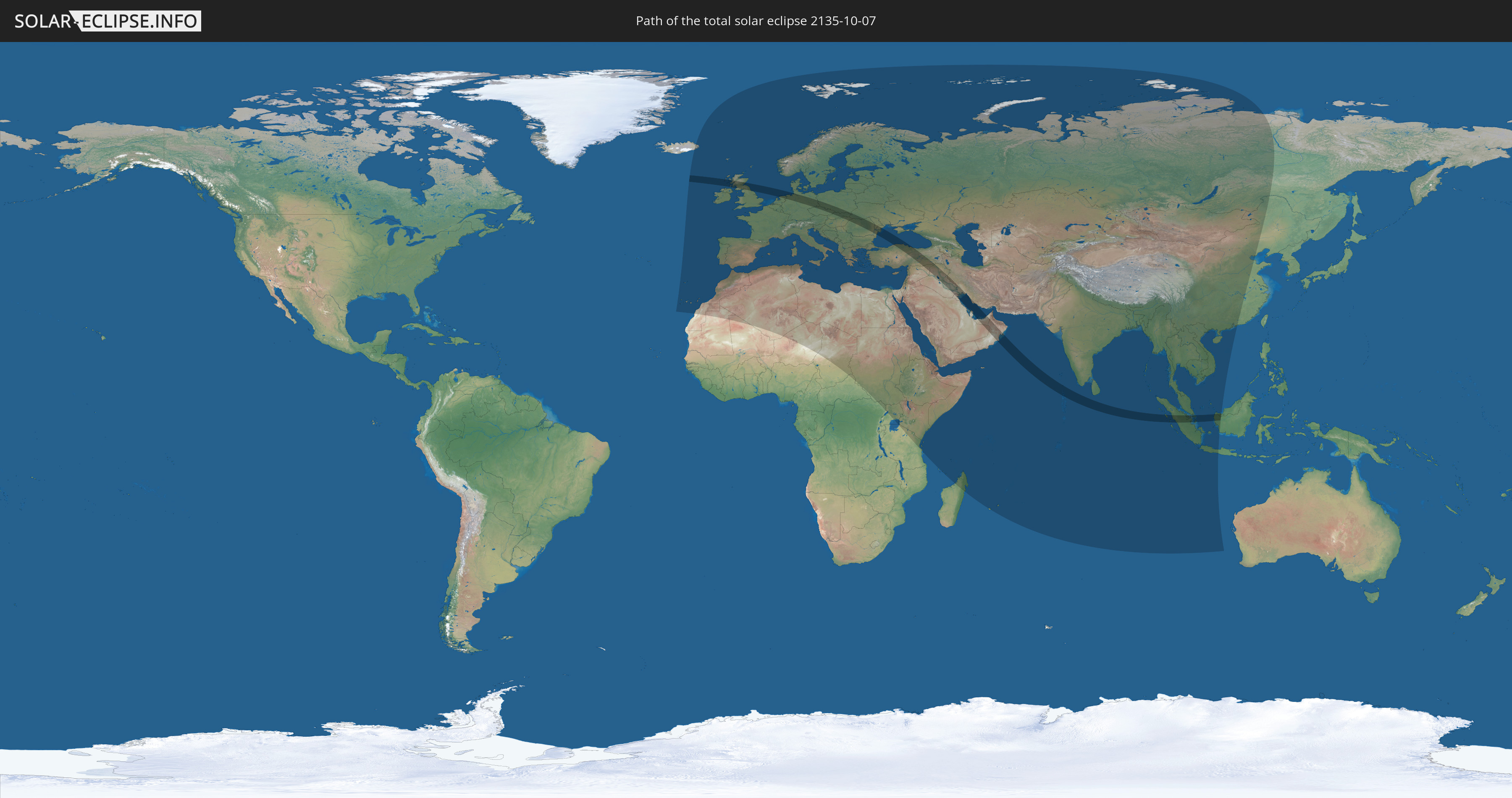
Die Sonnenfinsternis am 10/07/2135 kann man in 124 Ländern als partielle Sonnenfinsternis beobachten.
Der Finsternispfad verläuft durch 22 Länder. Nur in diesen Ländern ist sie als total Sonnenfinsternis zu sehen.
In den folgenden Ländern ist die Sonnenfinsternis total zu sehen
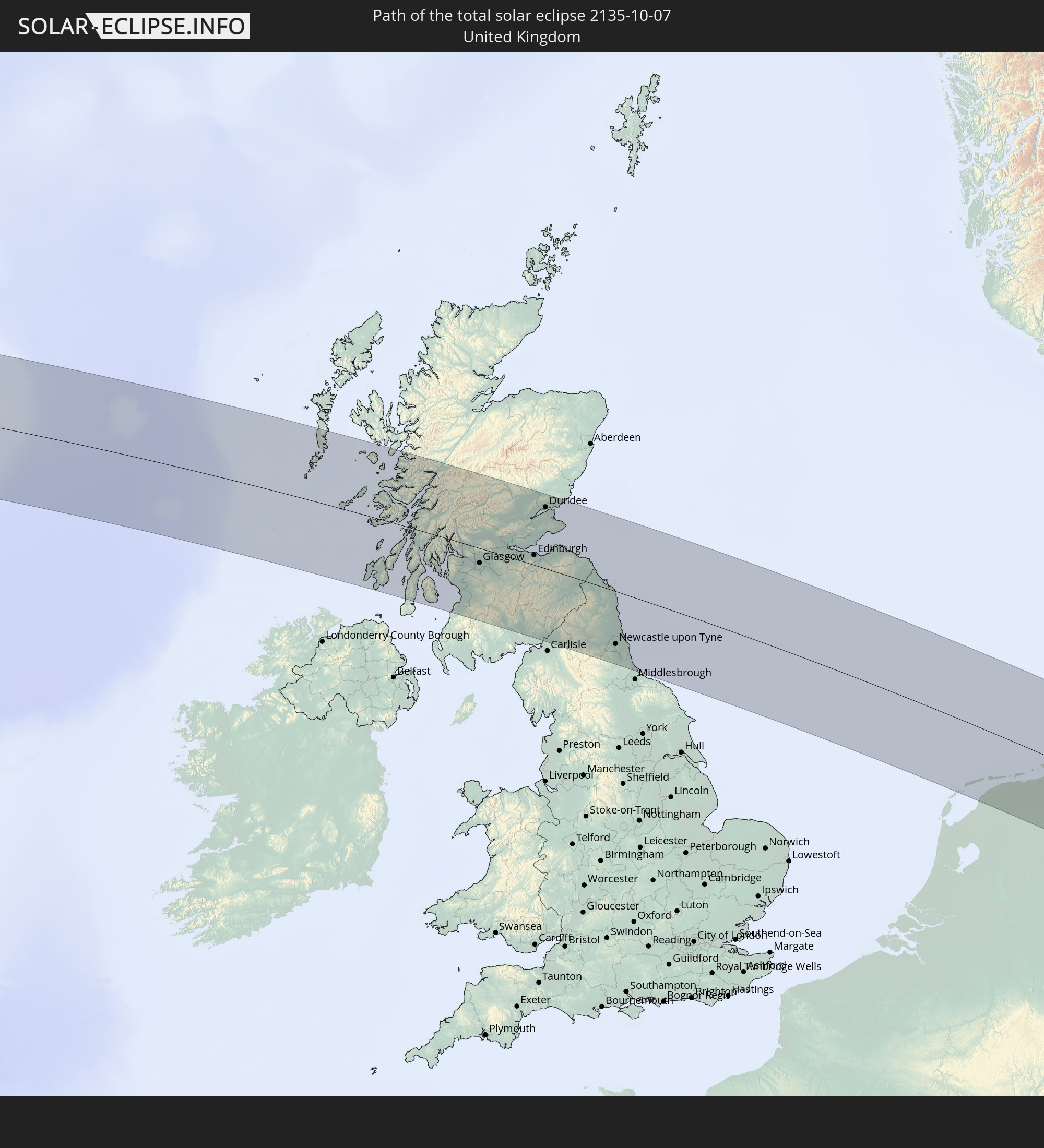 United Kingdom
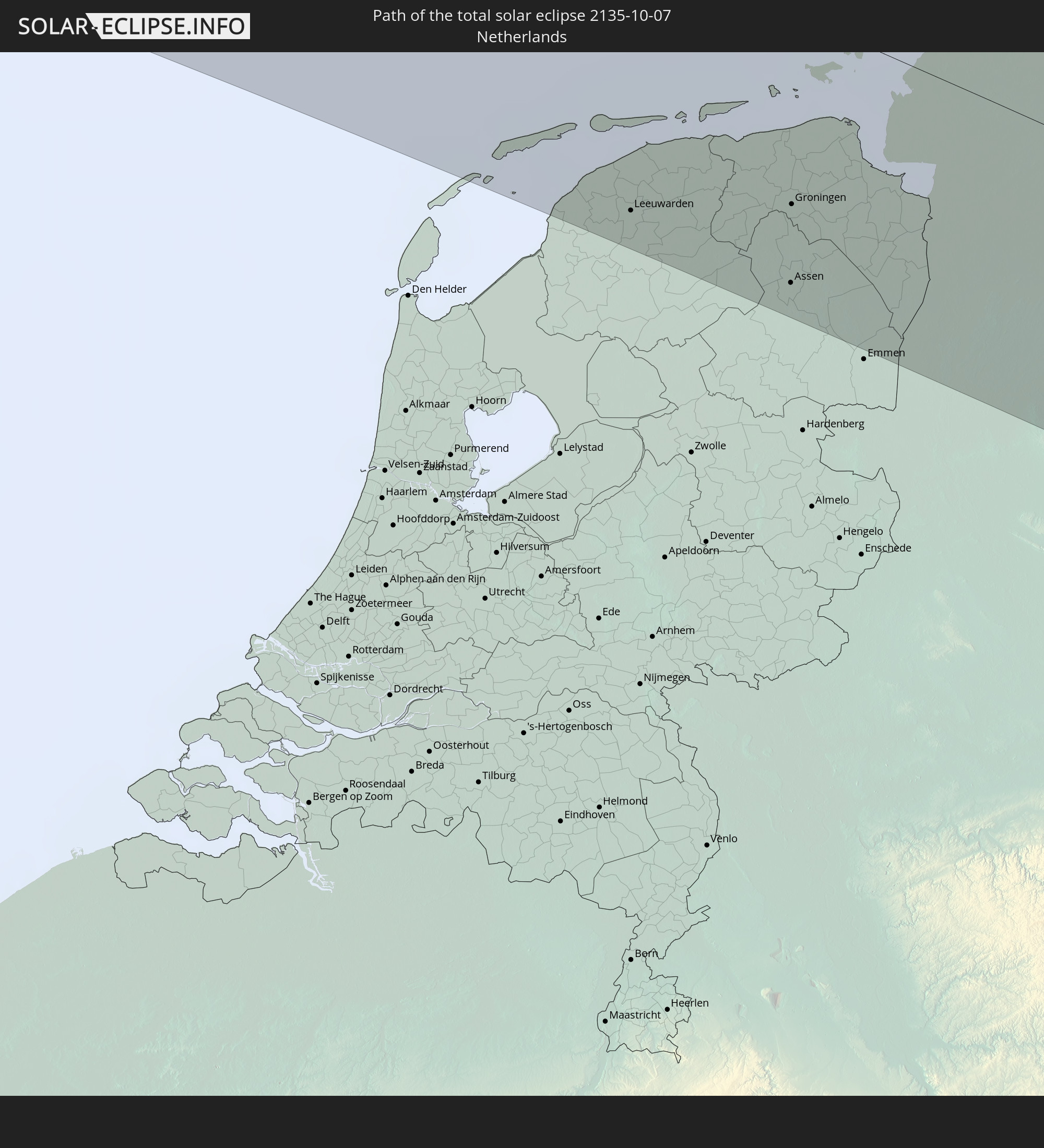 Netherlands
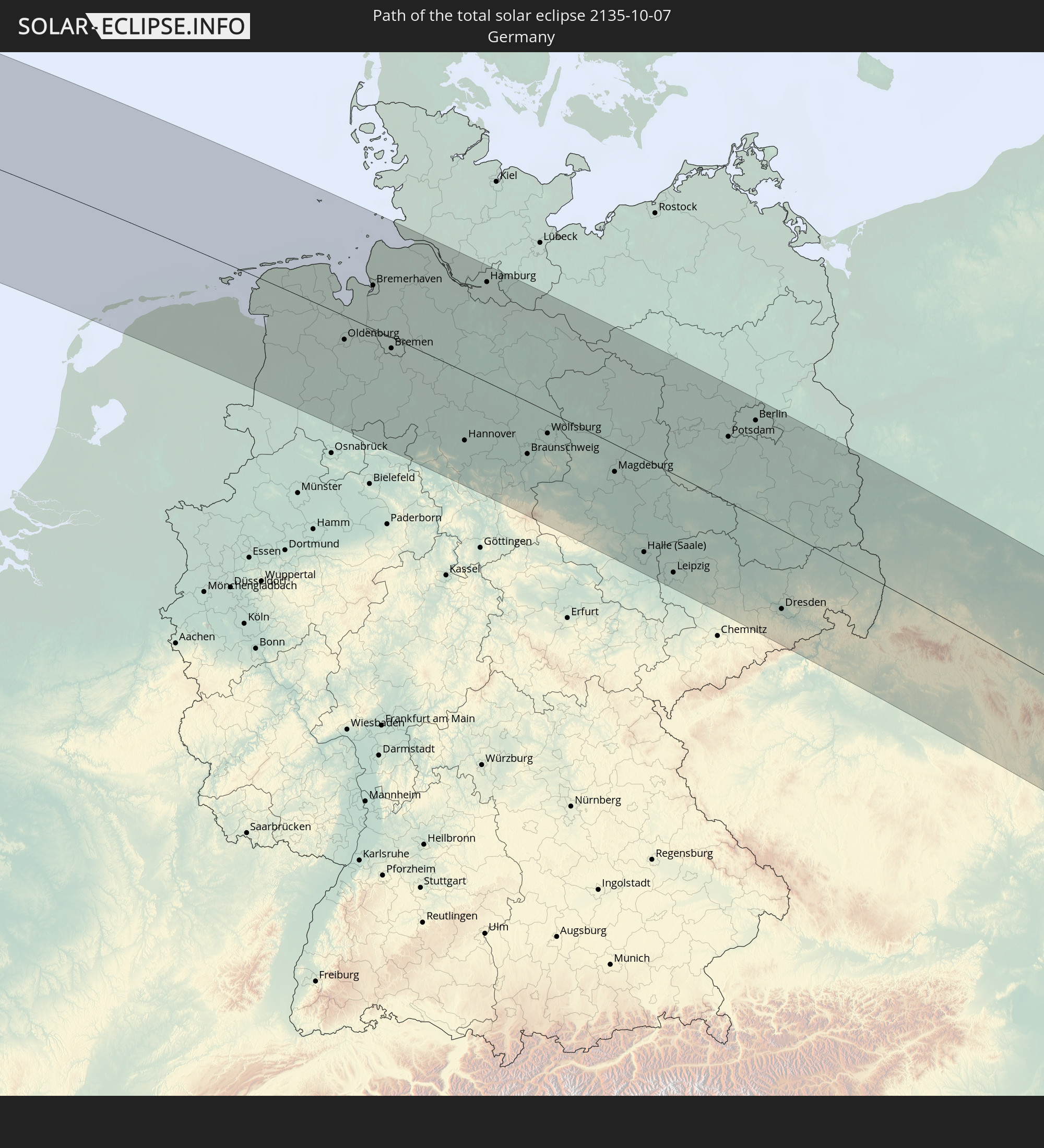 Germany
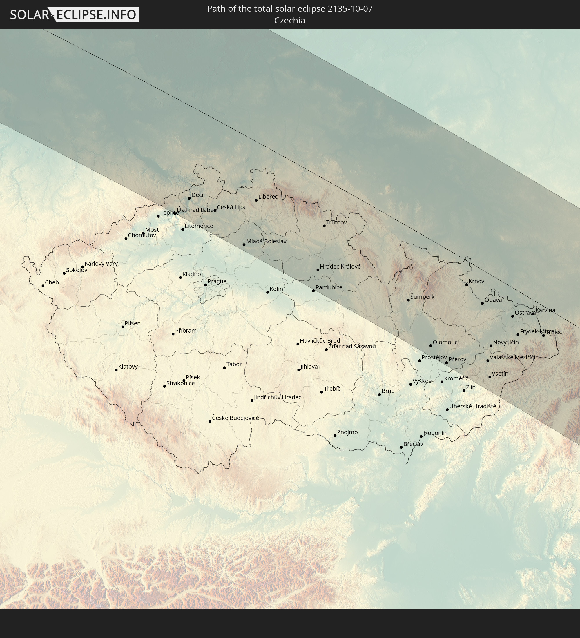 Czechia
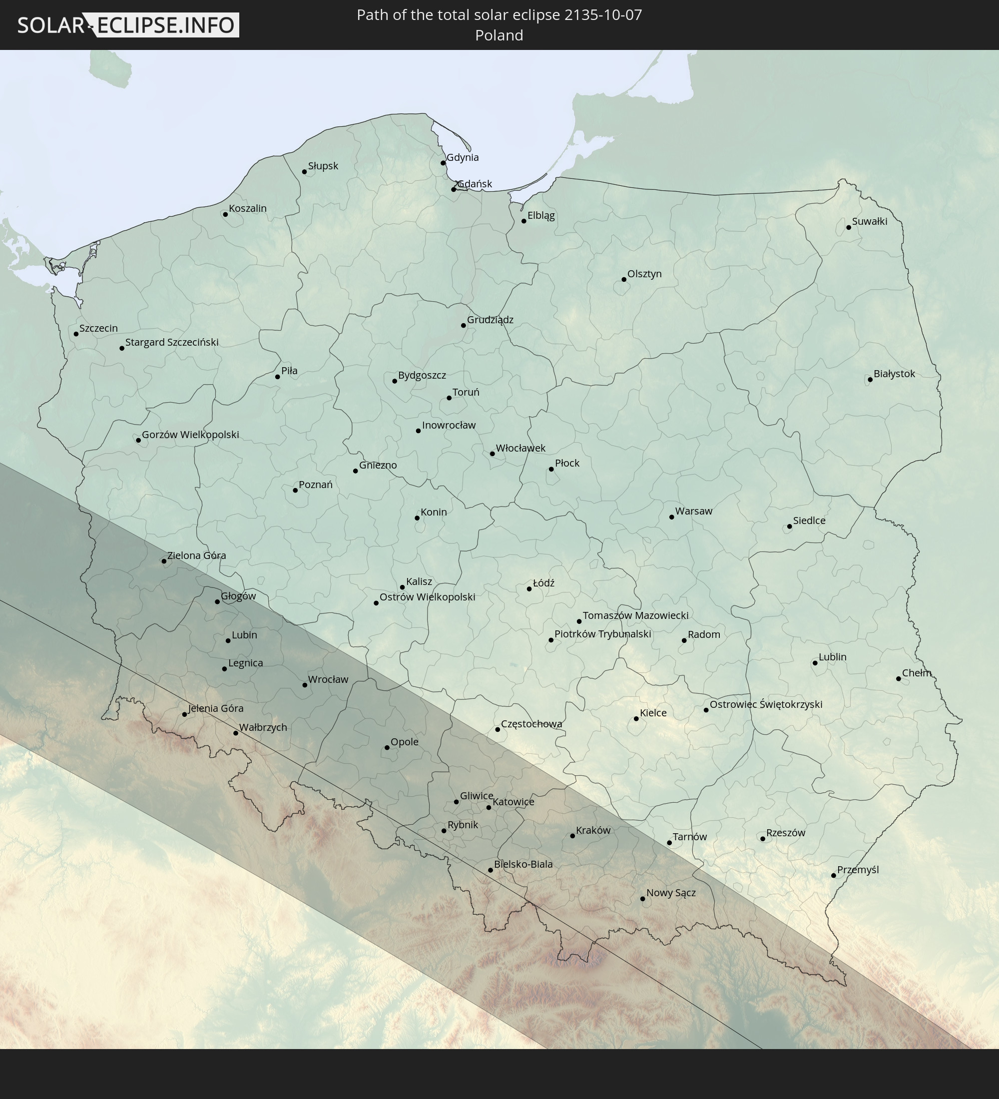 Poland
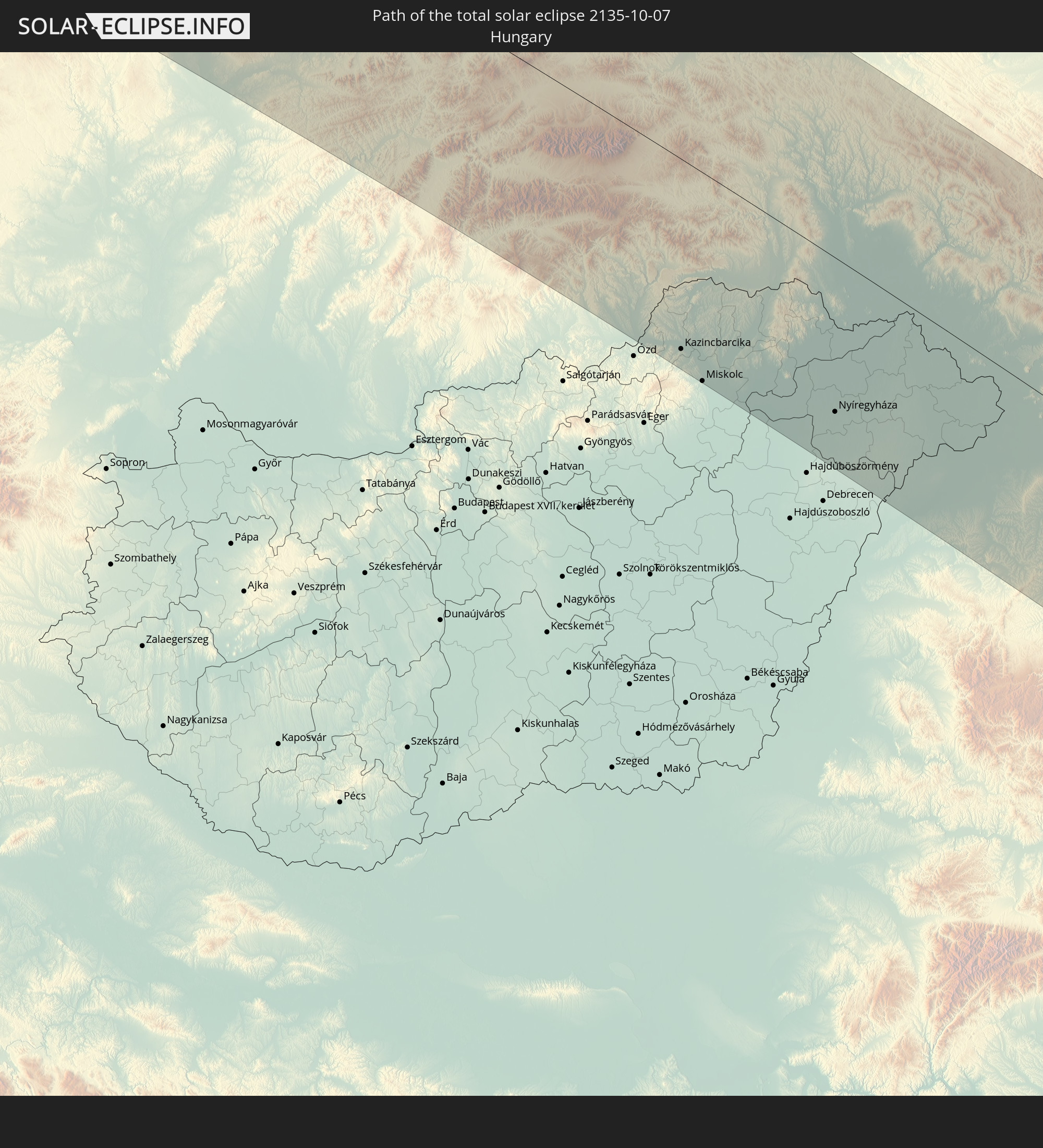 Hungary
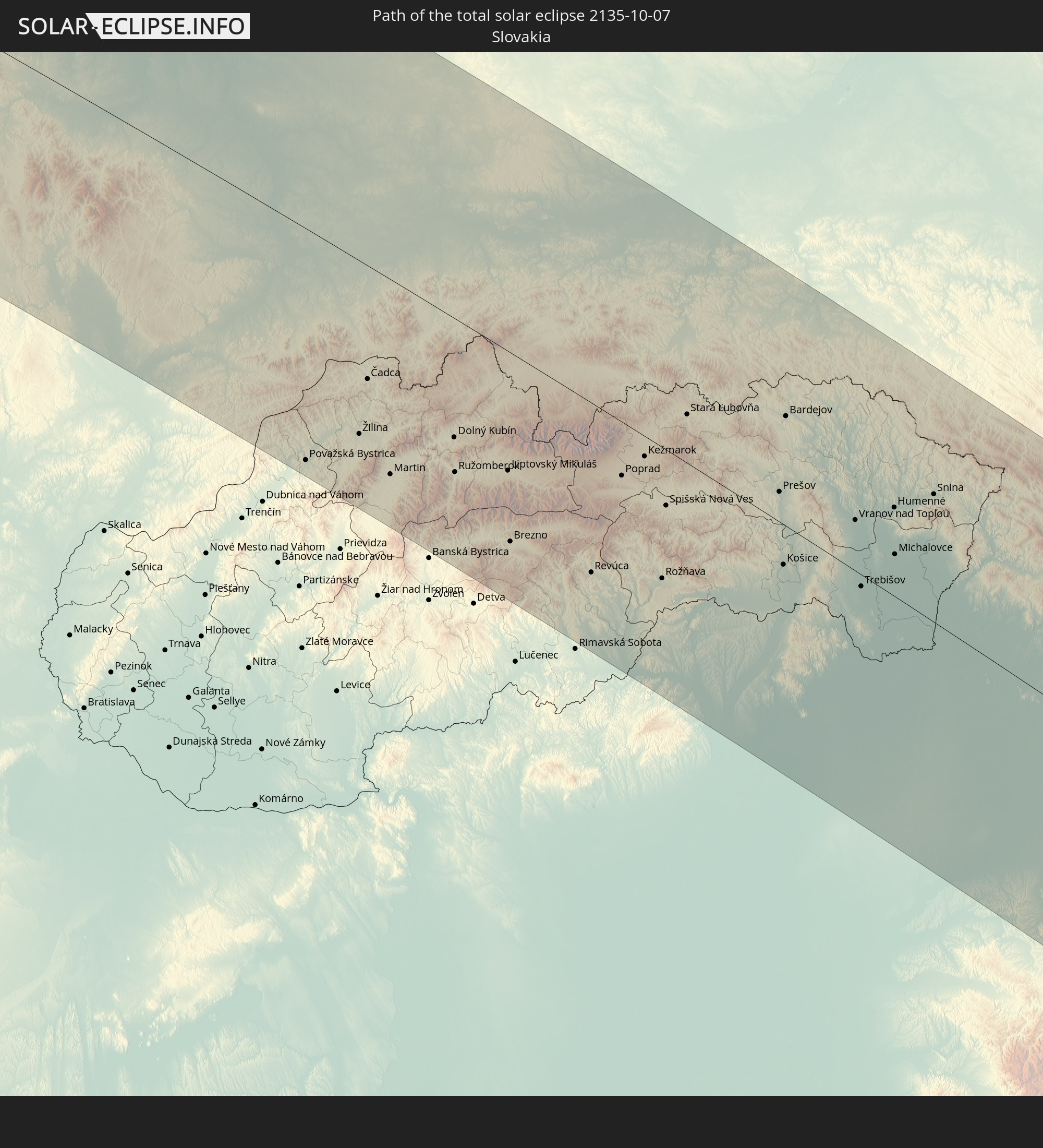 Slovakia
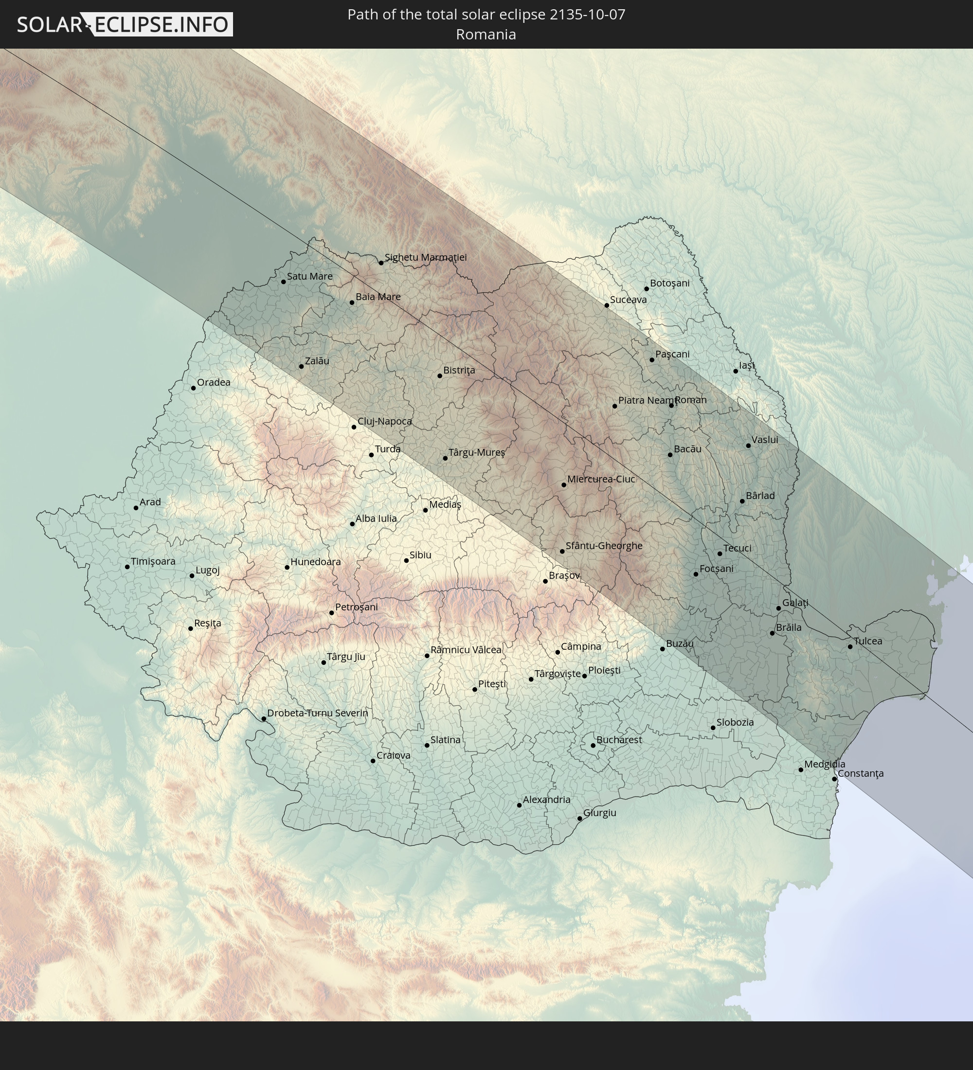 Romania
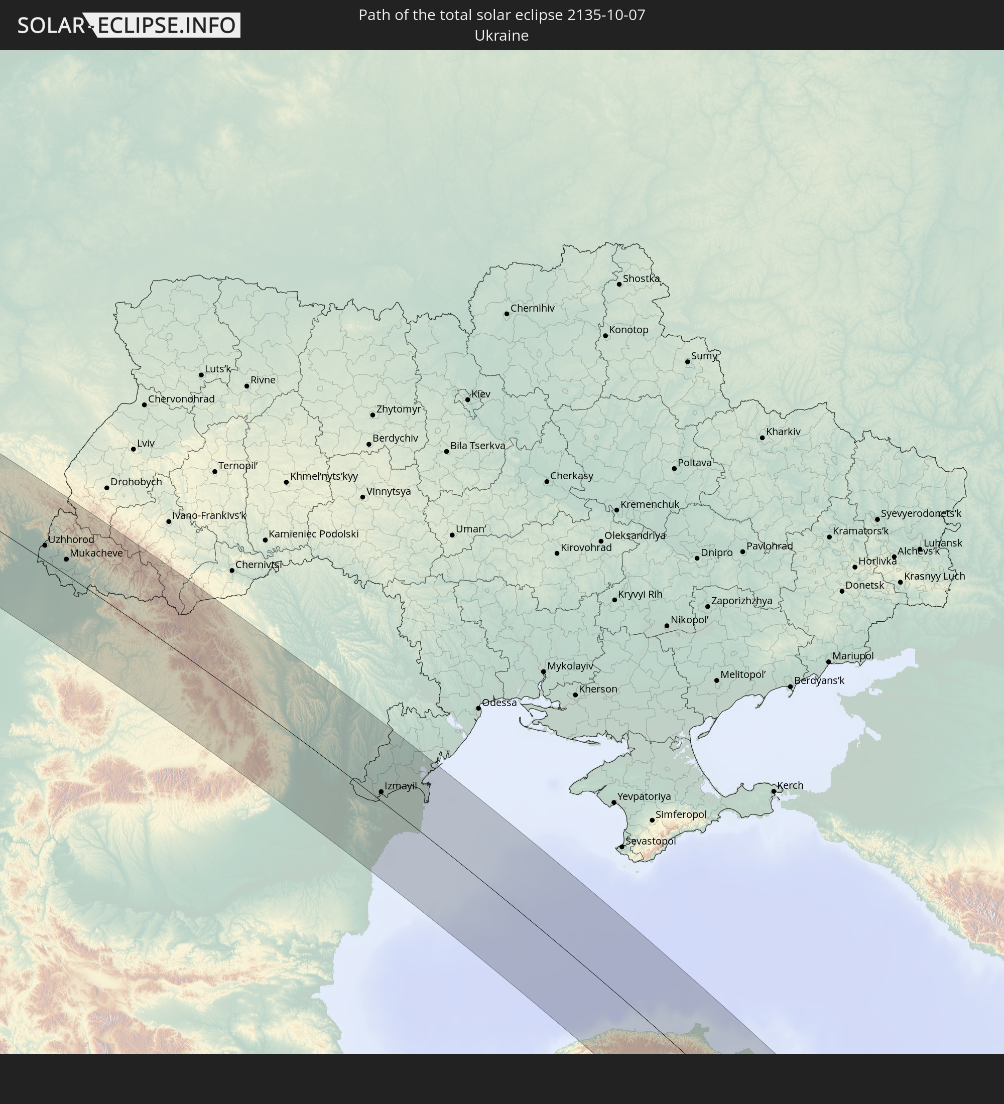 Ukraine
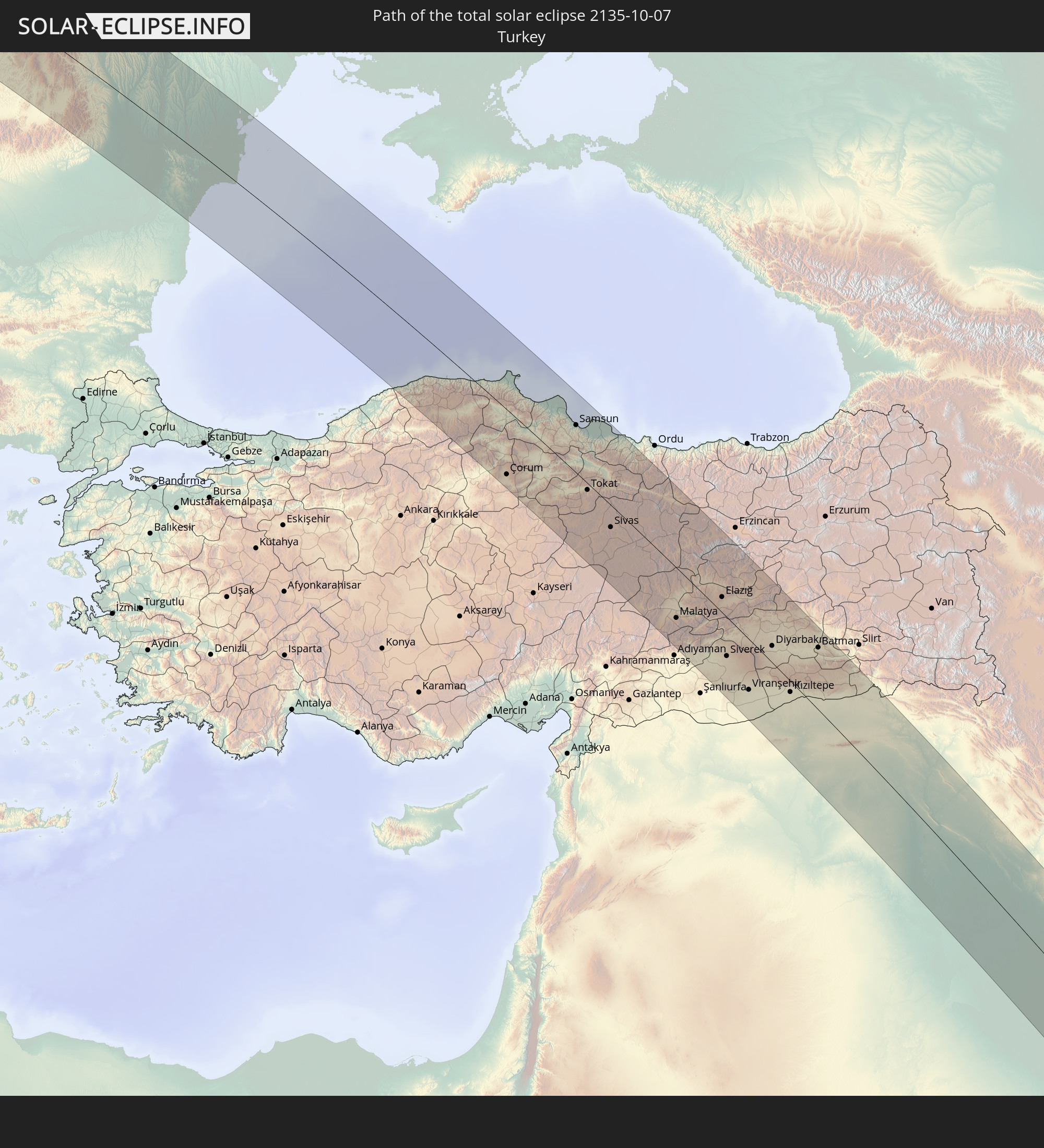 Turkey
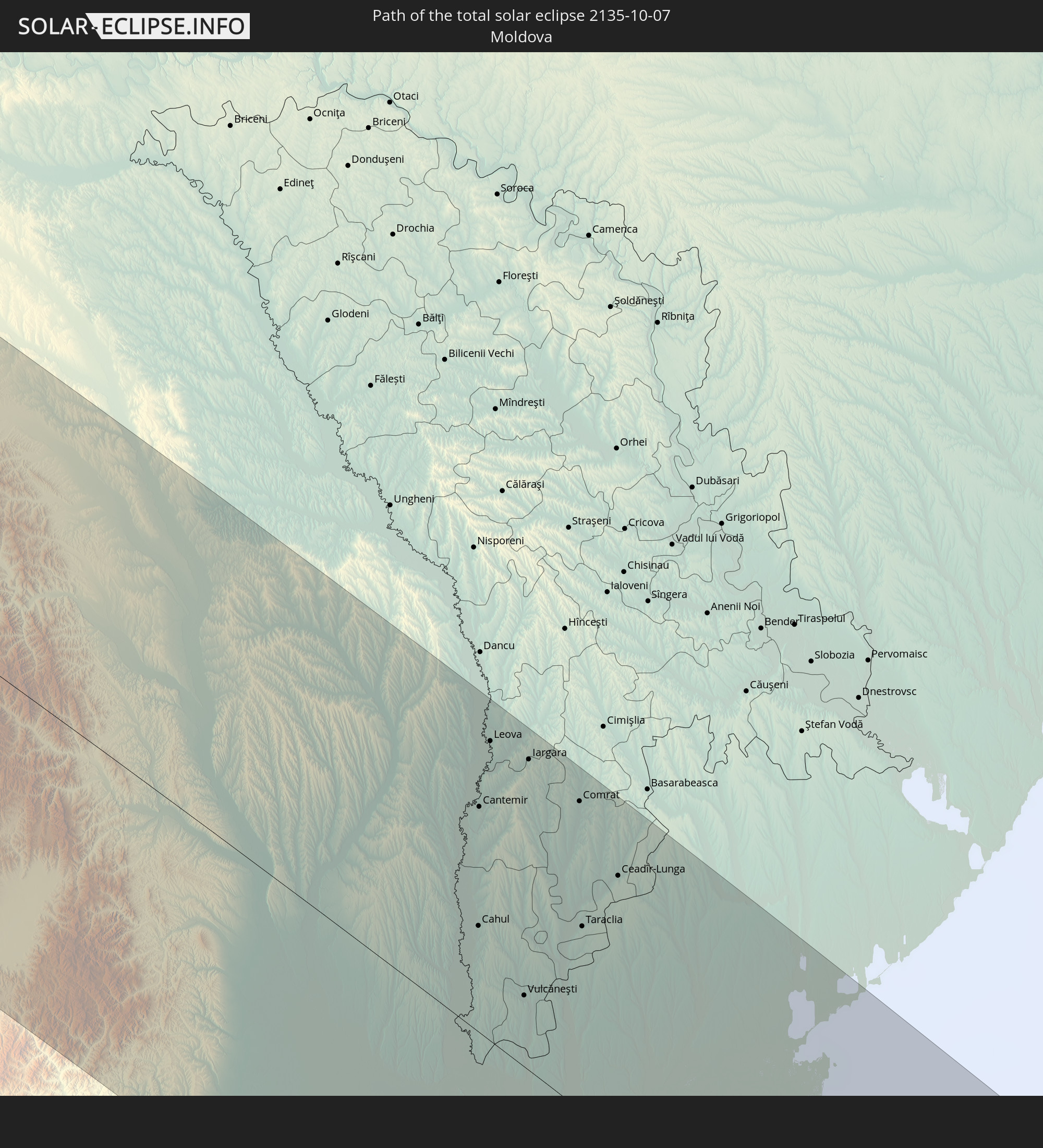 Moldova
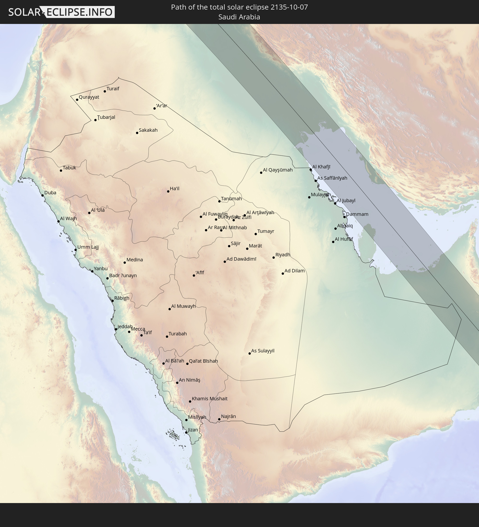 Saudi Arabia
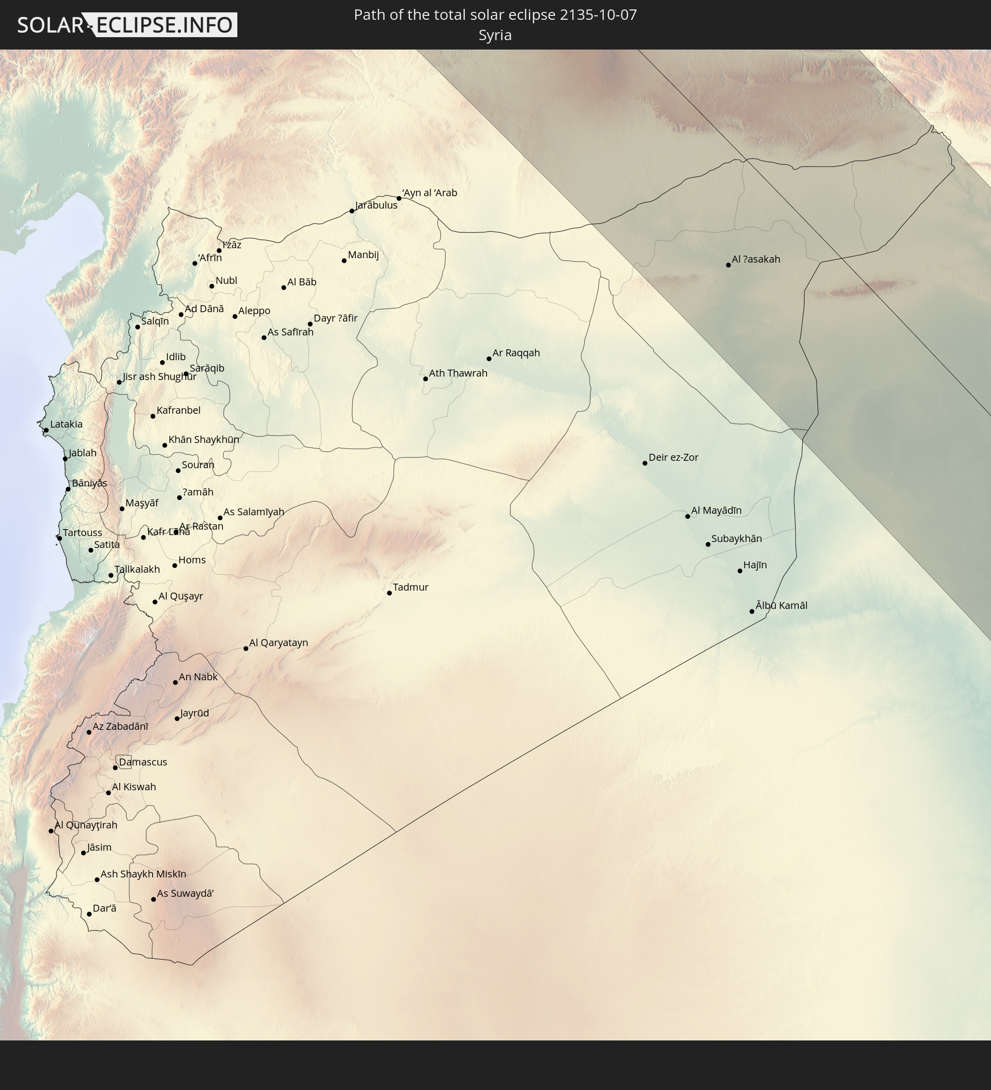 Syria
Syria
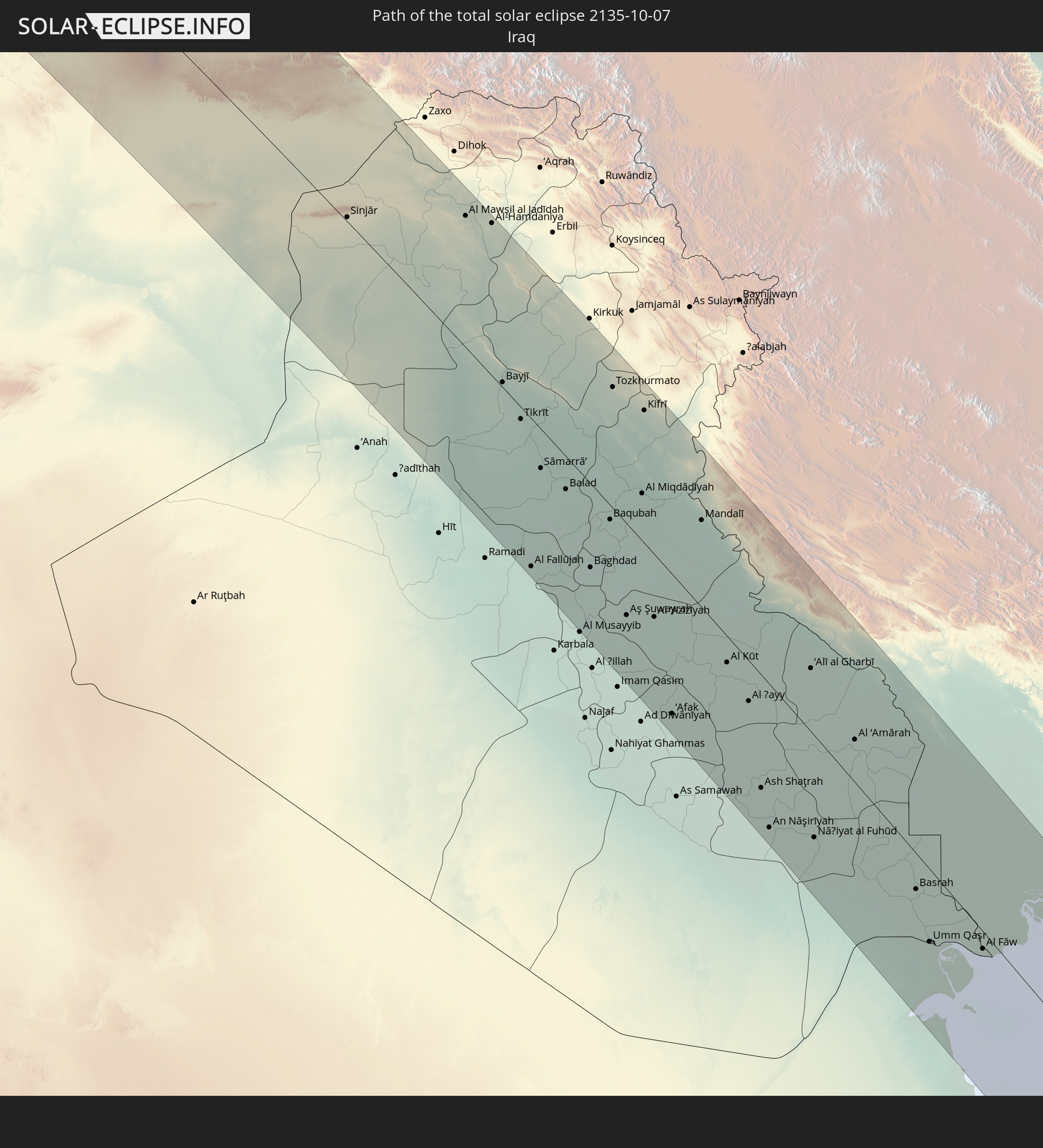 Iraq
Iraq
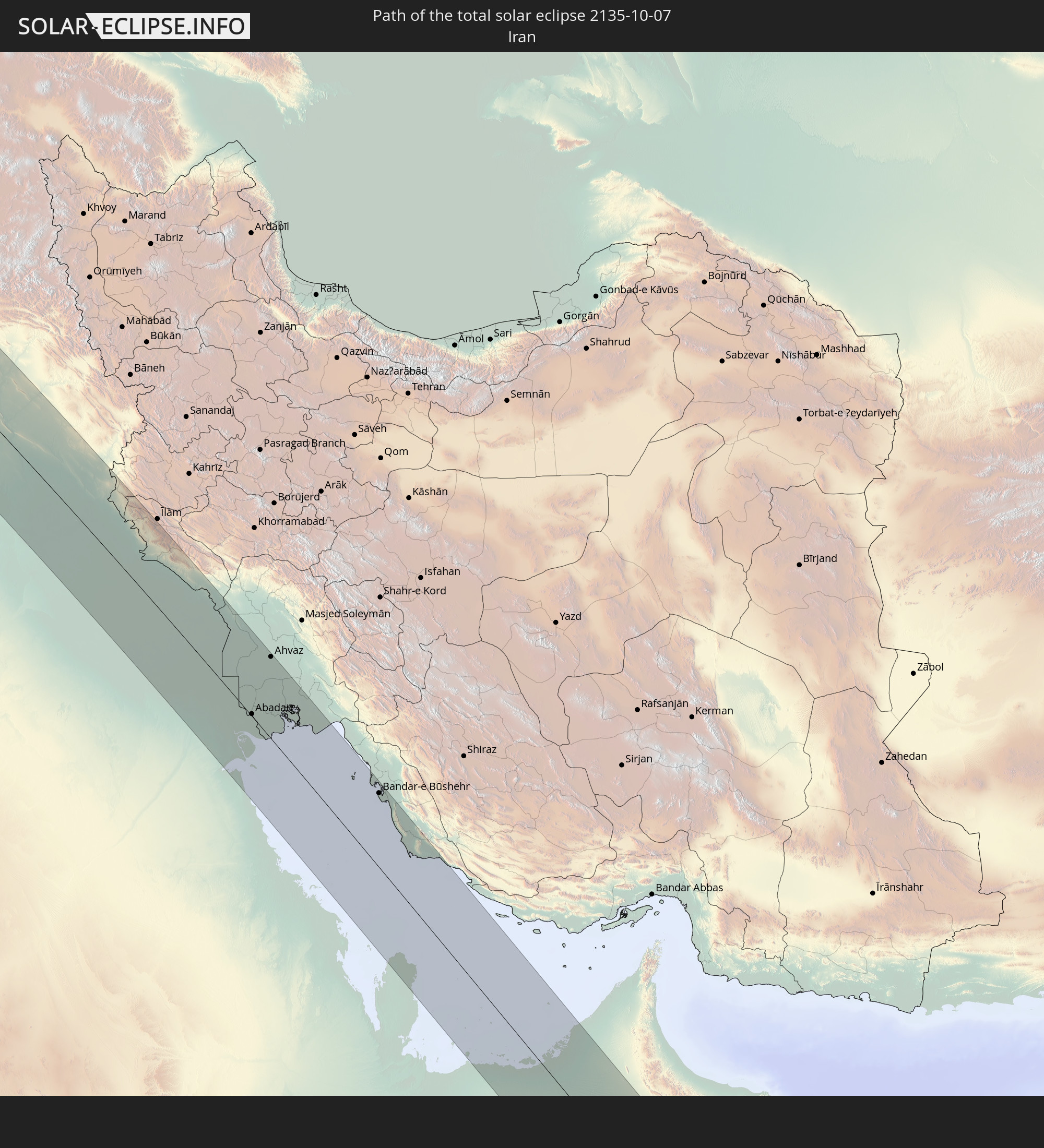 Iran
Iran
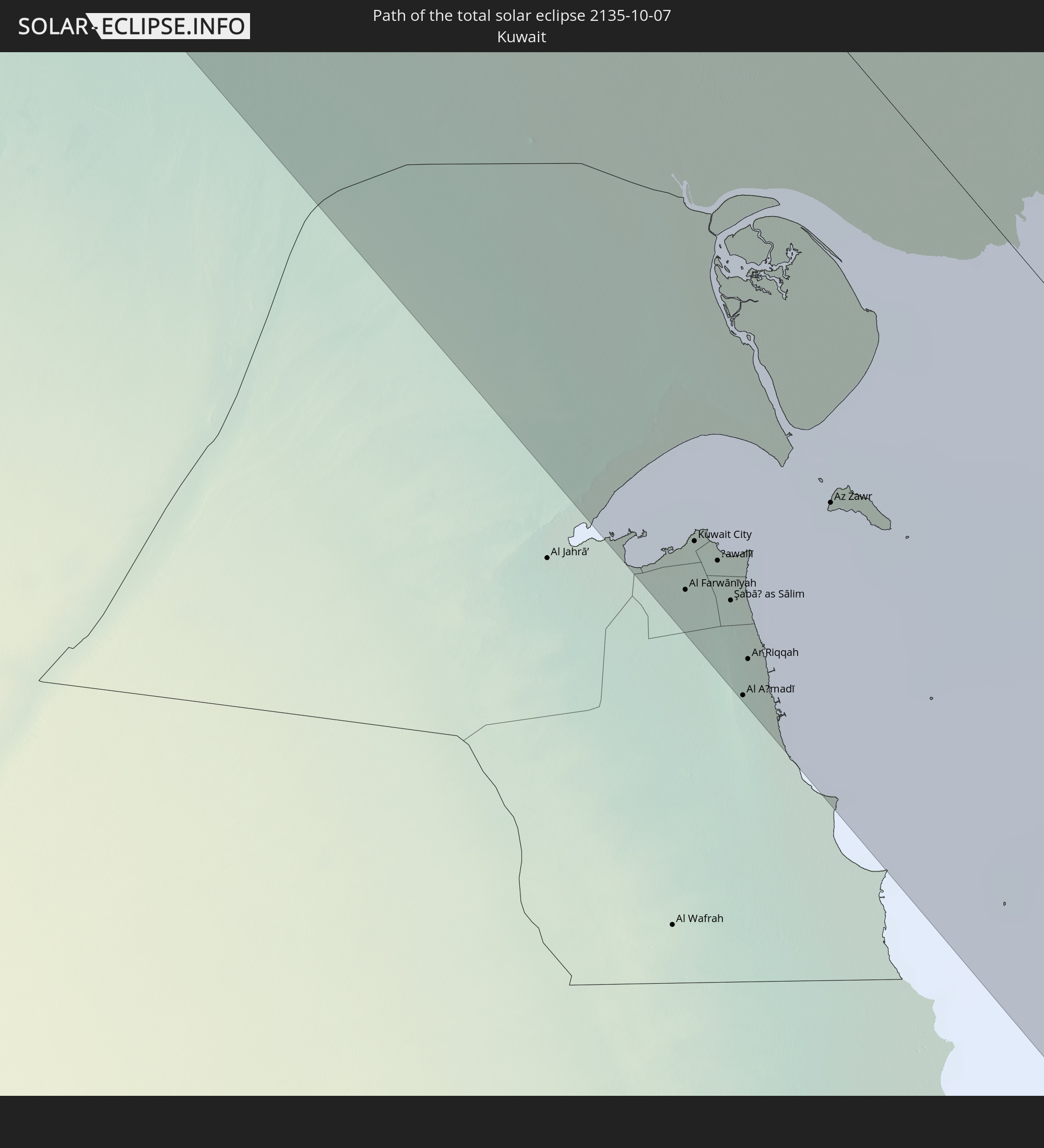 Kuwait
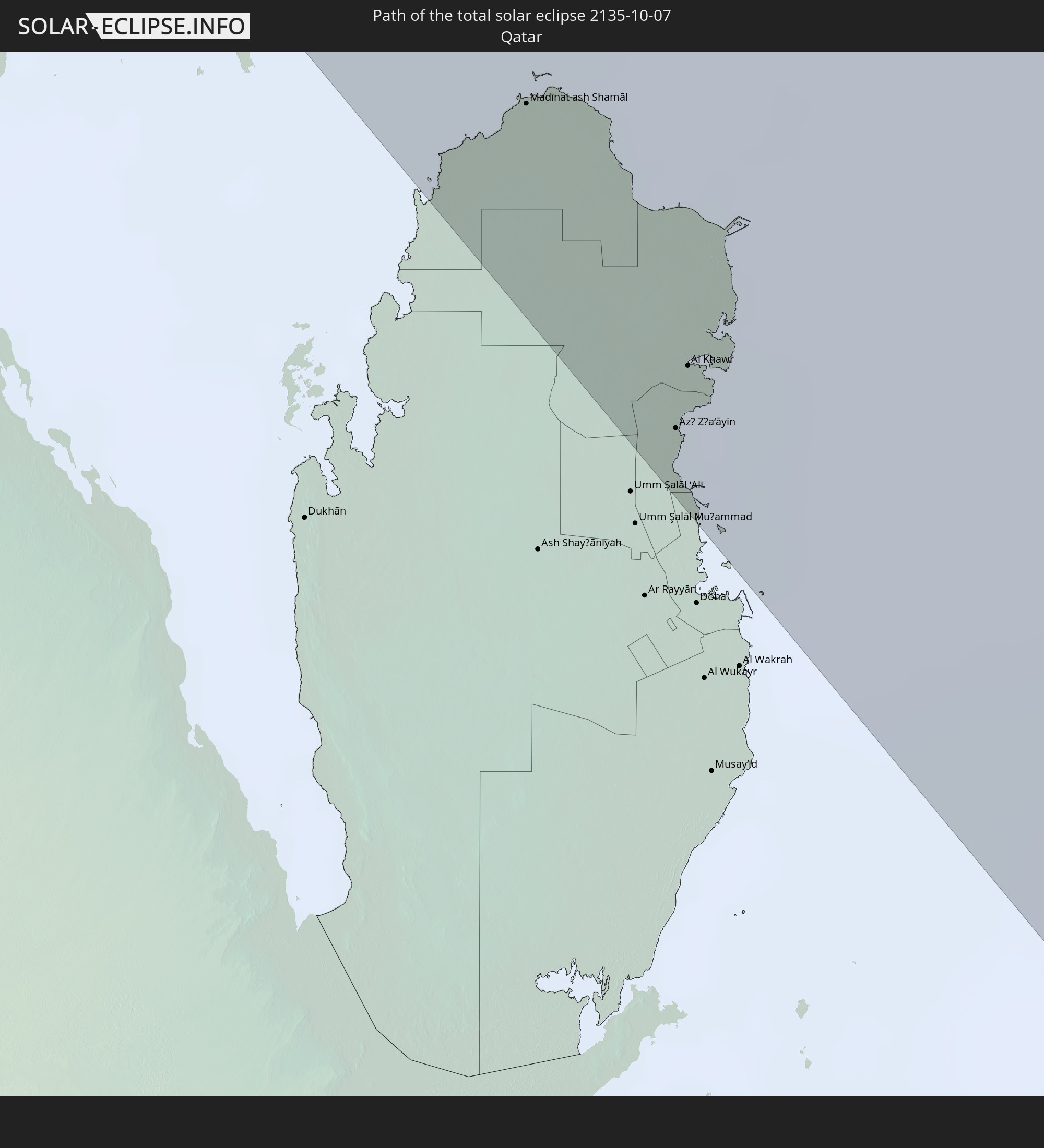 Qatar
Qatar
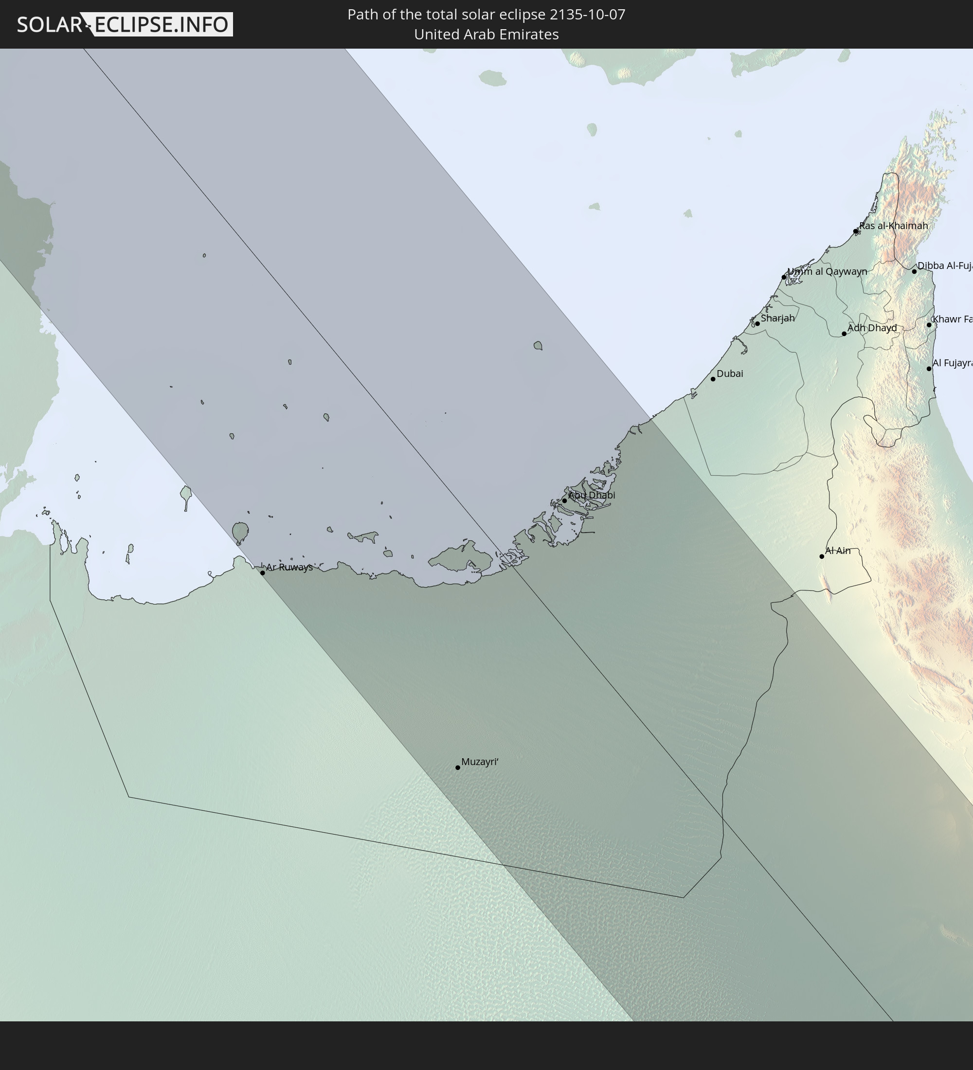 United Arab Emirates
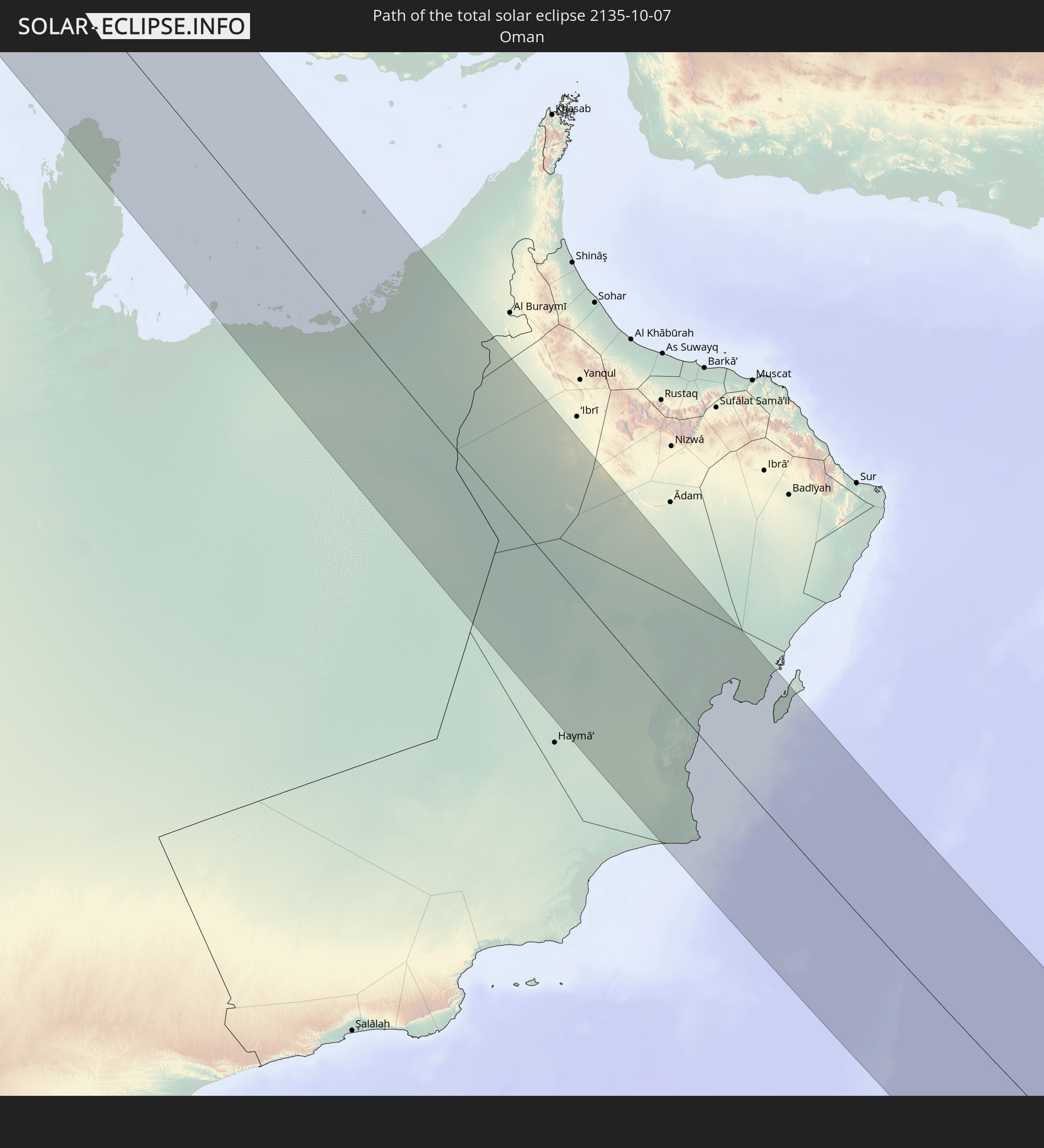 Oman
Oman
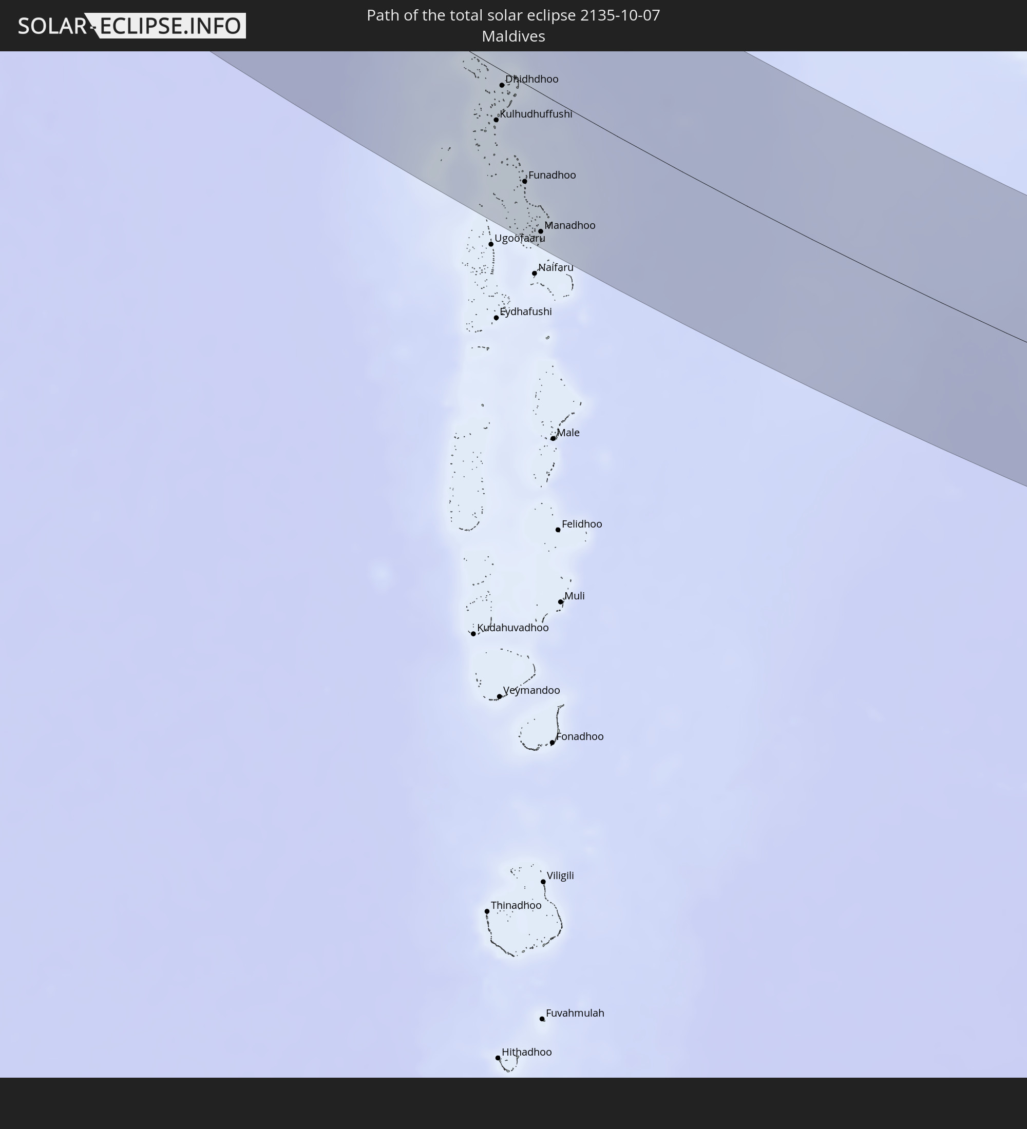 Maldives
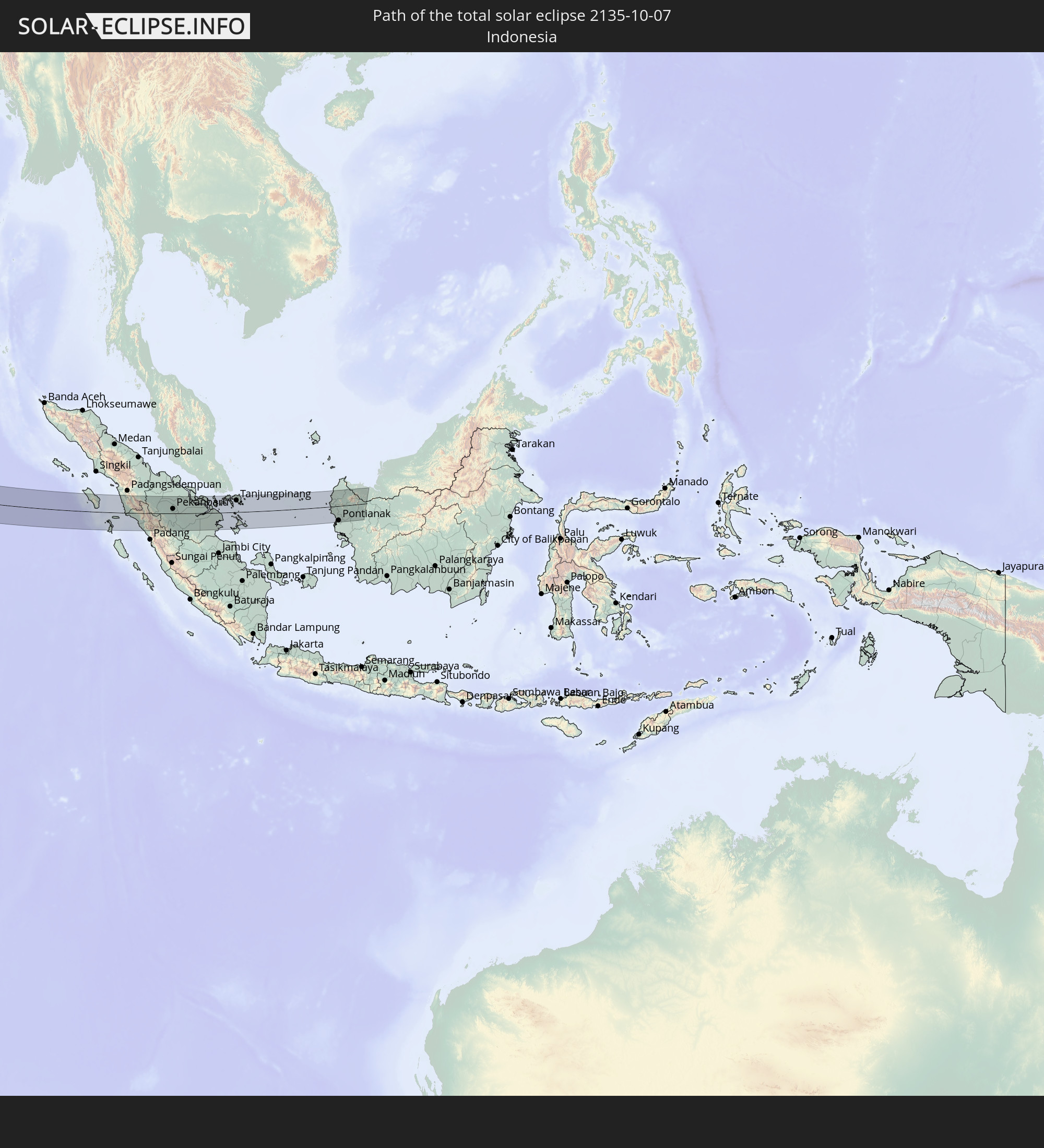 Indonesia
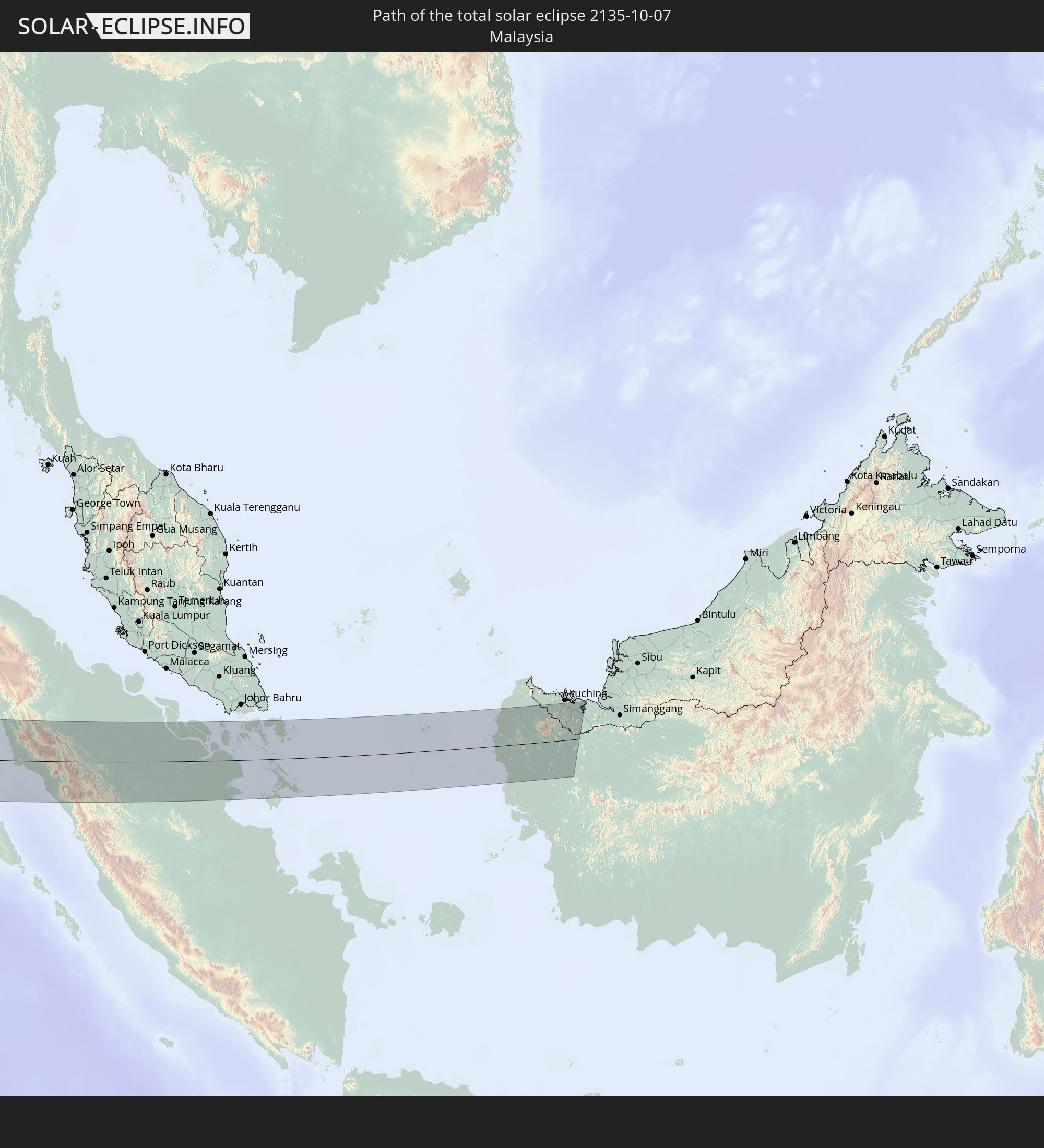 Malaysia
In den folgenden Ländern ist die Sonnenfinsternis partiell zu sehen
 Russia
 Portugal
 Iceland
 Spain
Spain
 Mauritania
 Morocco
 Mali
Mali
 Republic of Ireland
 Svalbard and Jan Mayen
 Algeria
 United Kingdom
 Faroe Islands
 Gibraltar
 France
 Isle of Man
 Guernsey
 Jersey
 Niger
Niger
 Andorra
 Belgium
 Netherlands
 Norway
 Luxembourg
 Germany
 Switzerland
 Italy
Italy
 Monaco
 Tunisia
 Denmark
 Libya
Libya
 Liechtenstein
 Austria
 Sweden
 Czechia
 Democratic Republic of the Congo
 San Marino
 Vatican City
 Slovenia
 Chad
Chad
 Croatia
 Poland
 Malta
Malta
 Central African Republic
 Bosnia and Herzegovina
 Hungary
 Slovakia
 Montenegro
 Serbia
 Albania
 Åland Islands
 Greece
 Romania
 Republic of Macedonia
 Finland
 Lithuania
 Latvia
 Estonia
 Sudan
Sudan
 Ukraine
 Bulgaria
 Belarus
 Egypt
Egypt
 Turkey
 Moldova
 Tanzania
 Uganda
 Cyprus
 Ethiopia
 Kenya
Kenya
 State of Palestine
 Israel
 Saudi Arabia
 Jordan
 Lebanon
 Syria
Syria
 Eritrea
 Iraq
Iraq
 Georgia
 French Southern and Antarctic Lands
 Somalia
 Djibouti
 Yemen
Yemen
 Madagascar
 Comoros
 Armenia
 Iran
Iran
 Azerbaijan
 Mayotte
 Seychelles
 Kazakhstan
 Kuwait
 Bahrain
 Qatar
Qatar
 United Arab Emirates
 Oman
Oman
 Turkmenistan
 Réunion
 Uzbekistan
 Mauritius
 Afghanistan
 Pakistan
 Tajikistan
 India
India
 Kyrgyzstan
 British Indian Ocean Territory
 Maldives
 China
China
 Sri Lanka
 Nepal
Nepal
 Mongolia
 Bangladesh
 Bhutan
 Myanmar
 Indonesia
 Cocos Islands
 Thailand
 Malaysia
 Laos
Laos
 Vietnam
 Cambodia
 Singapore
 Christmas Island
 Macau
Macau
 Hong Kong
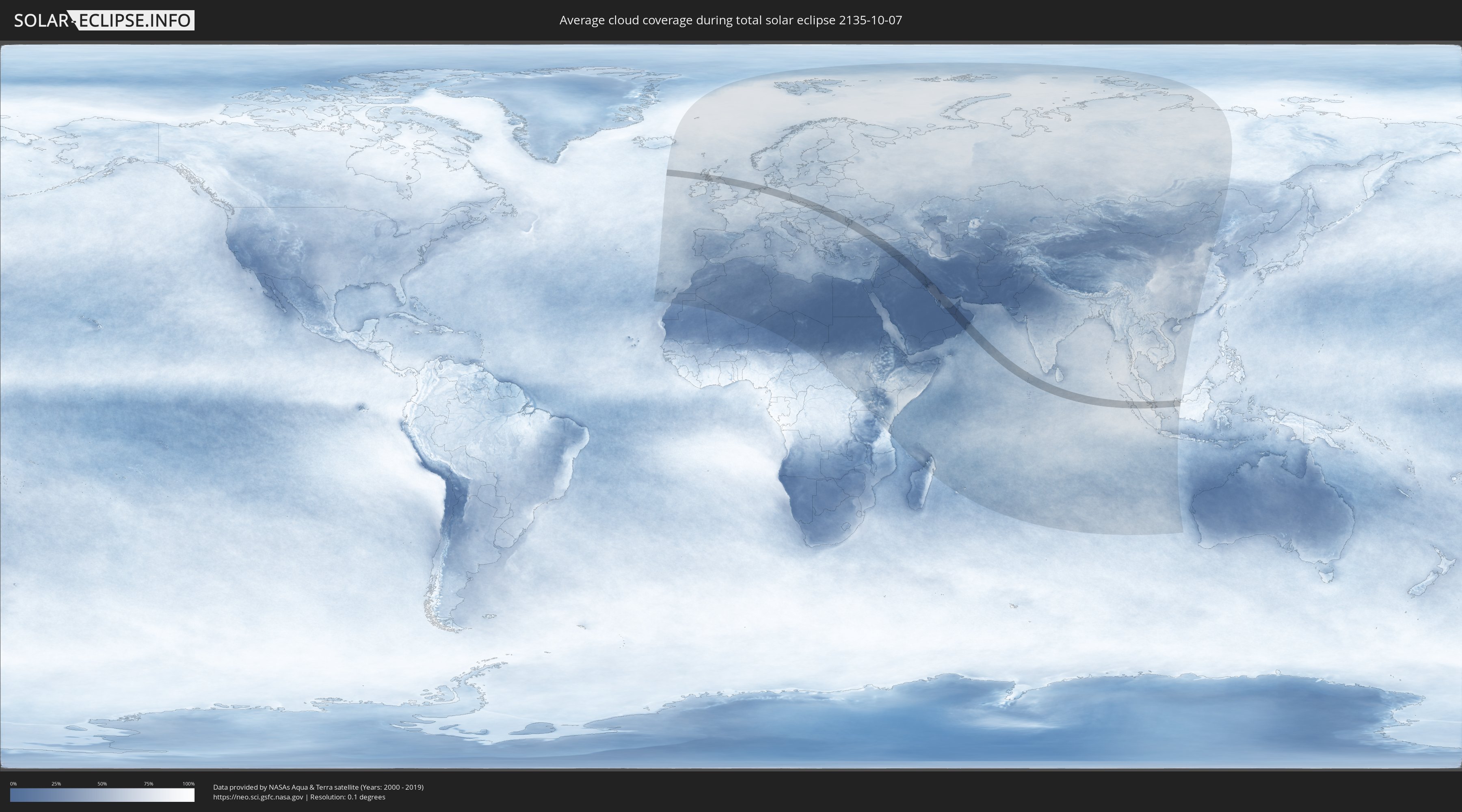
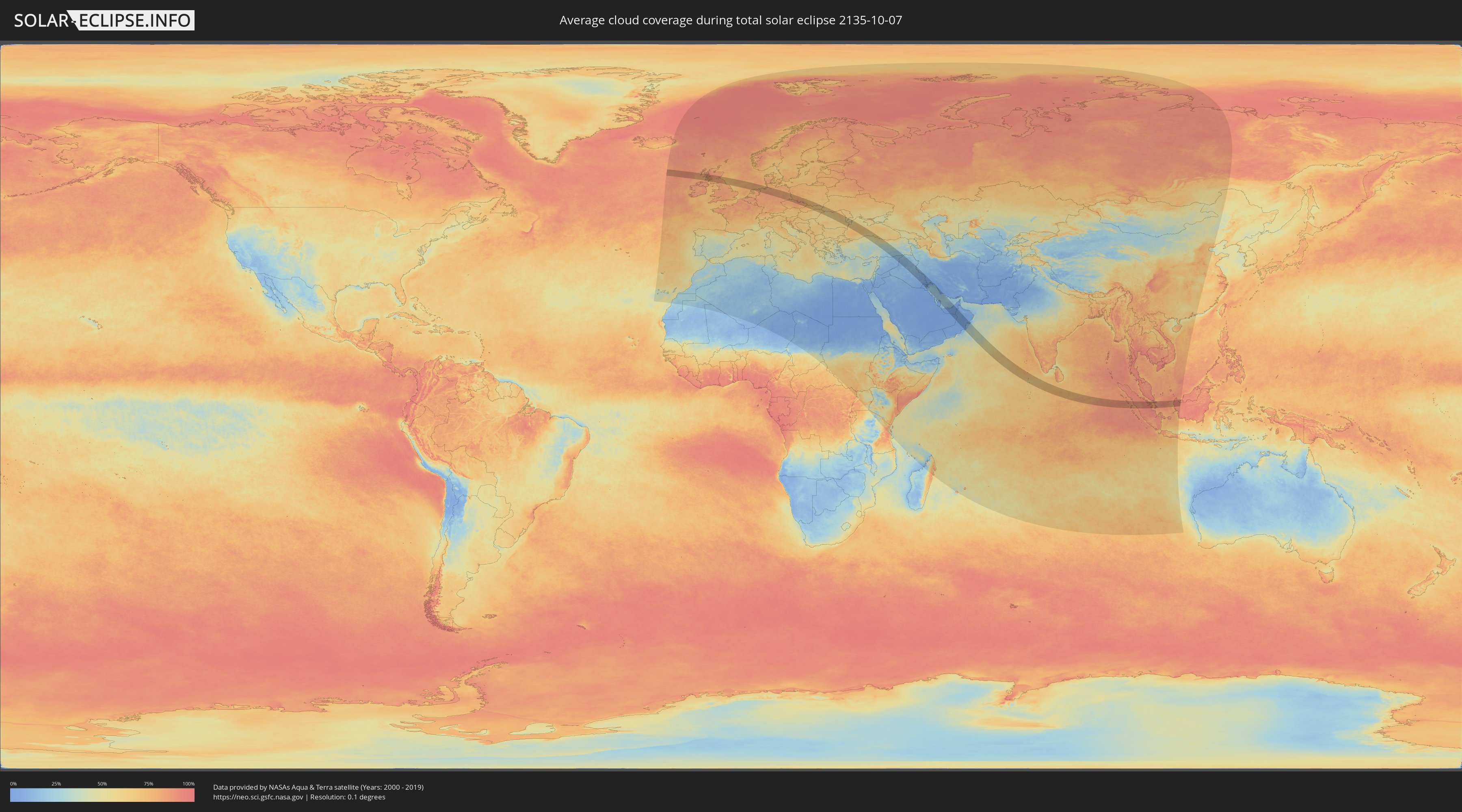
How will be the weather during the total solar eclipse on 10/07/2135?
Where is the best place to see the total solar eclipse of 10/07/2135?
The following maps show the average cloud coverage for the day of the total solar eclipse.
With the help of these maps, it is possible to find the place along the eclipse path, which has the best
chance of a cloudless sky.
Nevertheless, you should consider local circumstances and inform about the weather of your chosen
observation site.
The data is provided by NASAs satellites
AQUA and TERRA.
The cloud maps are averaged over a period of 19 years (2000 - 2019).
Detailed country maps
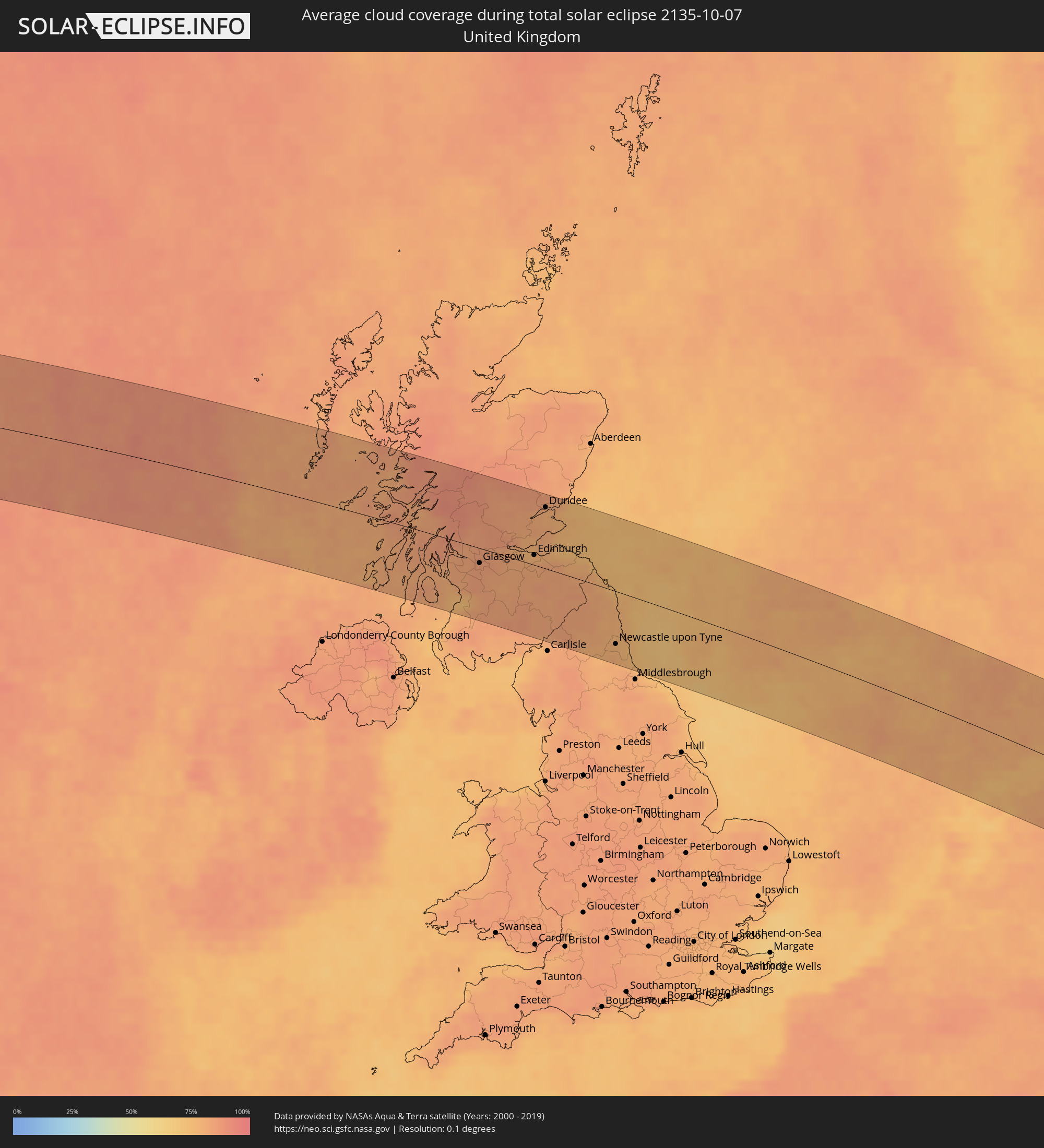 United Kingdom
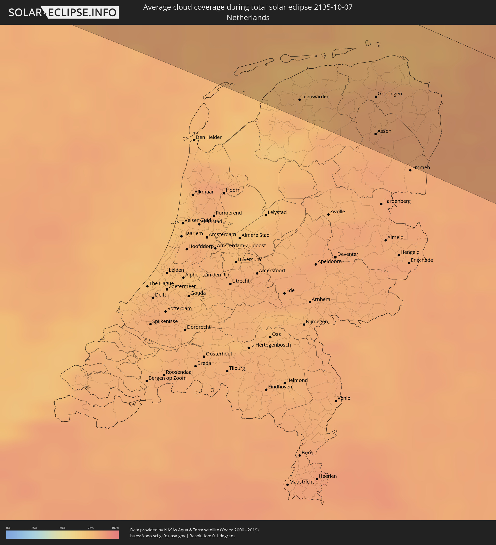 Netherlands
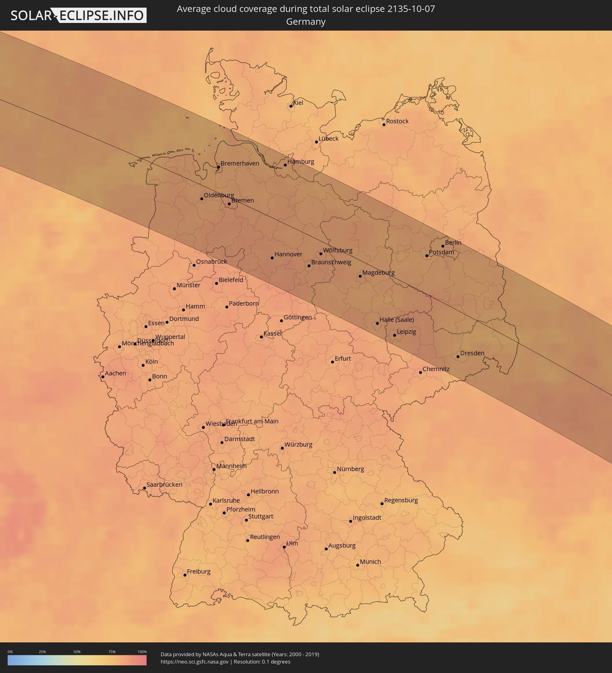 Germany
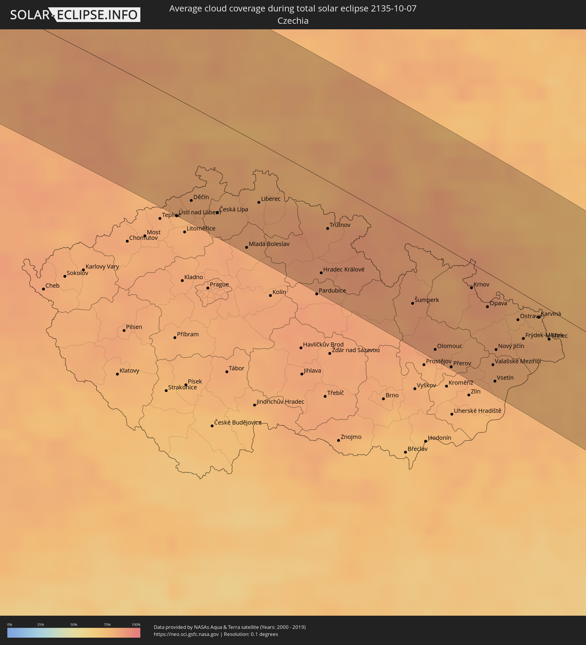 Czechia
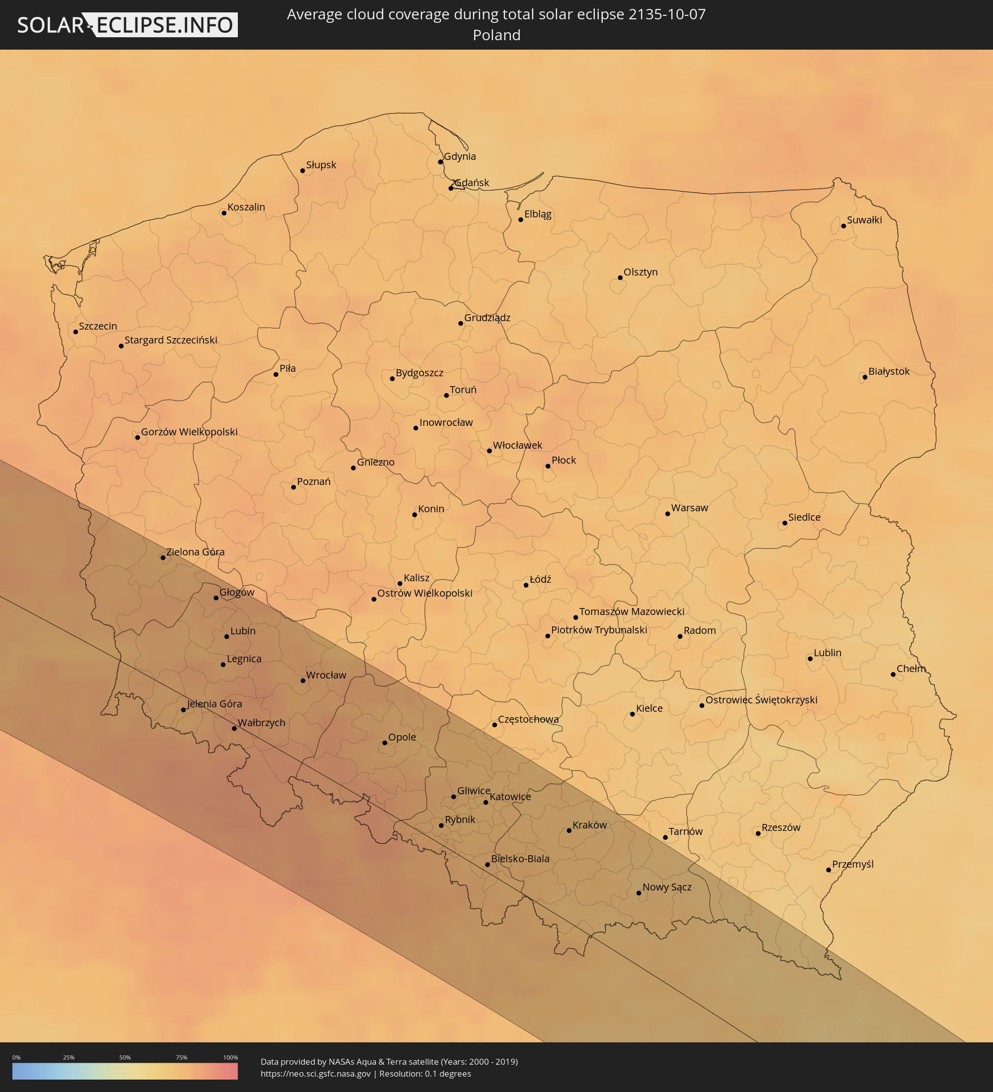 Poland
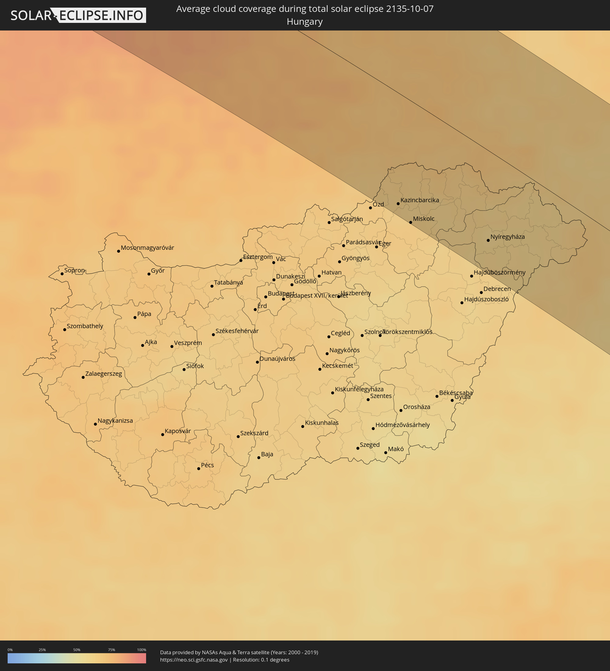 Hungary
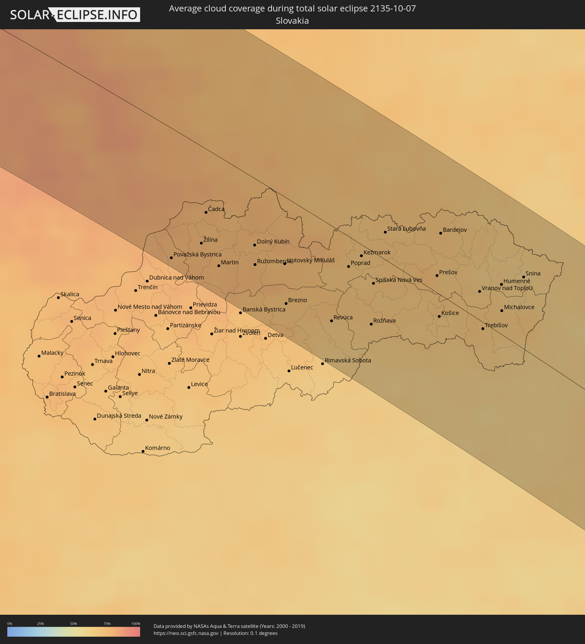 Slovakia
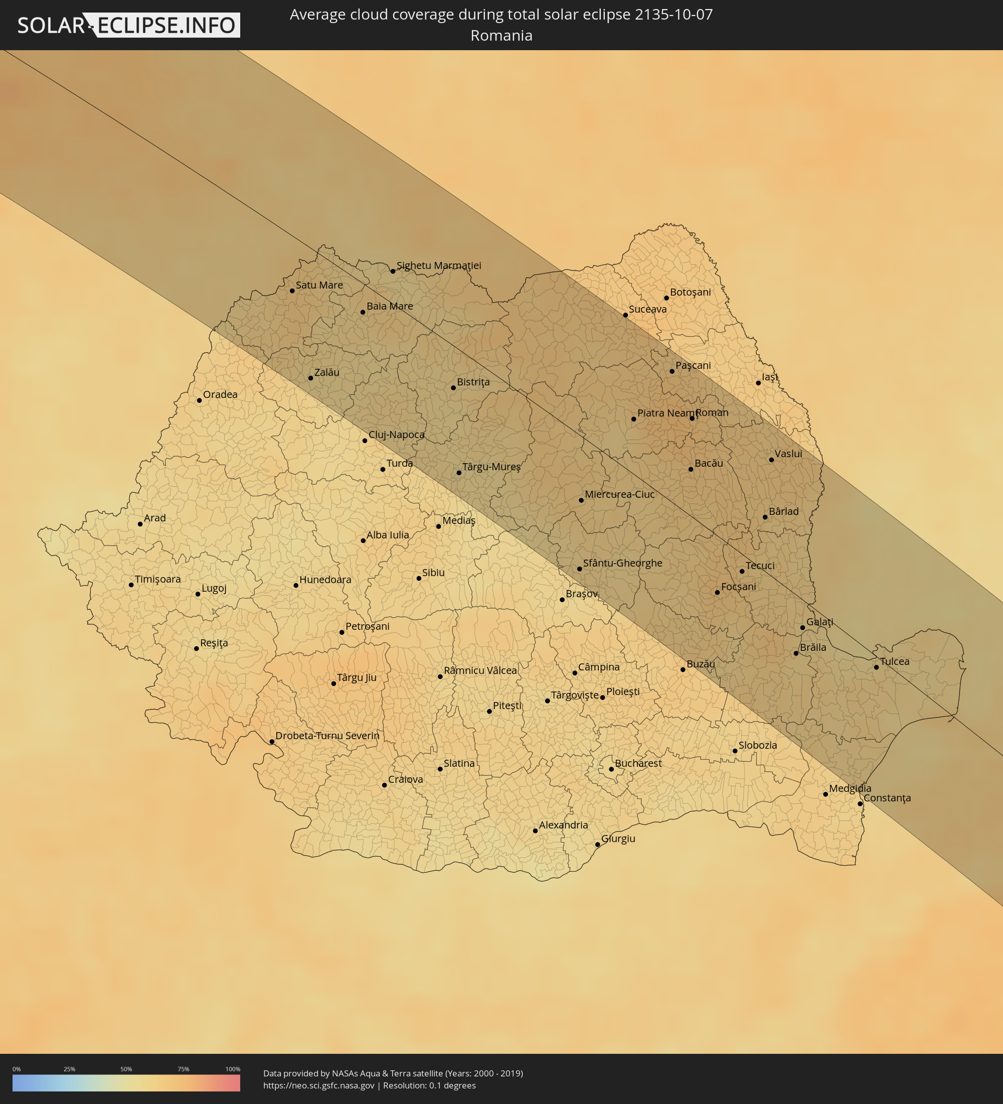 Romania
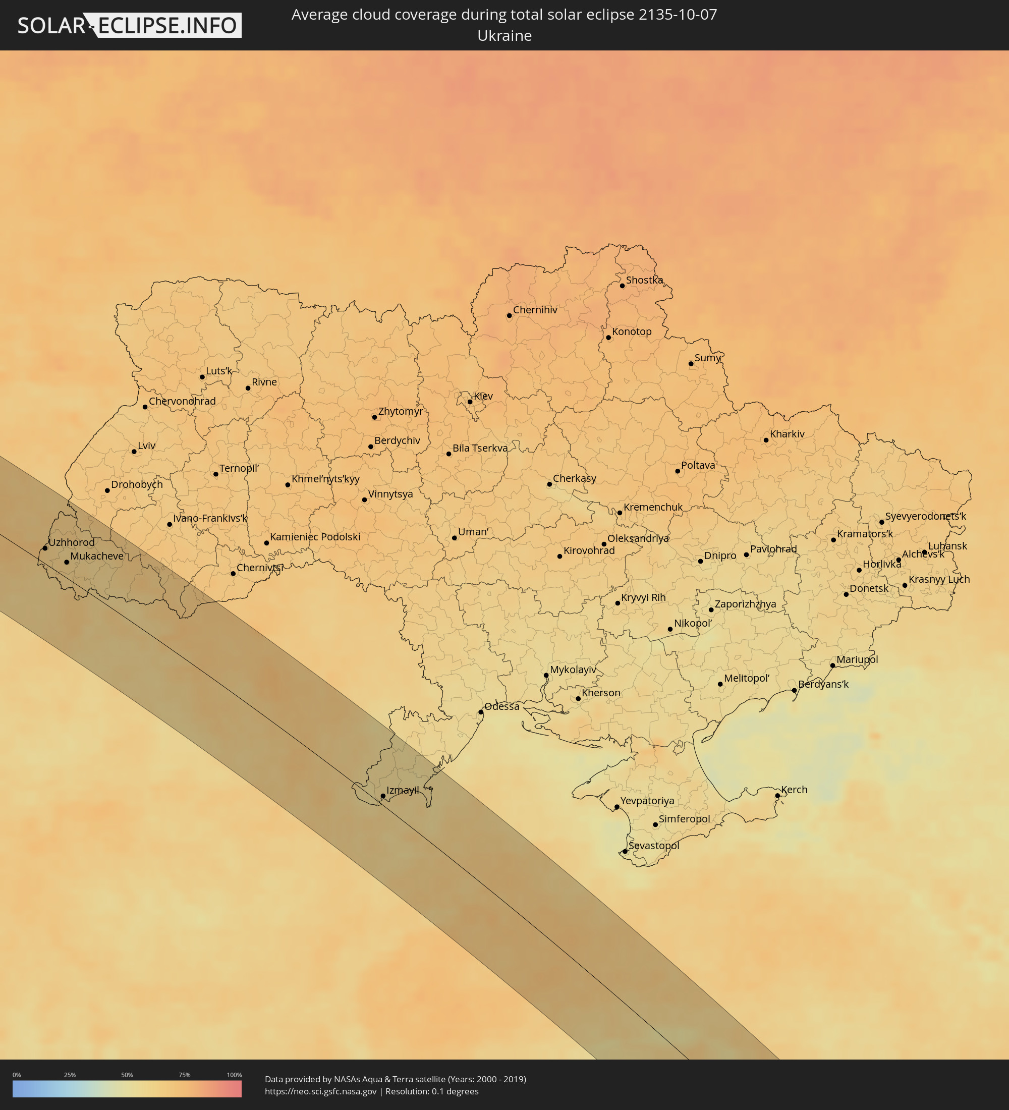 Ukraine
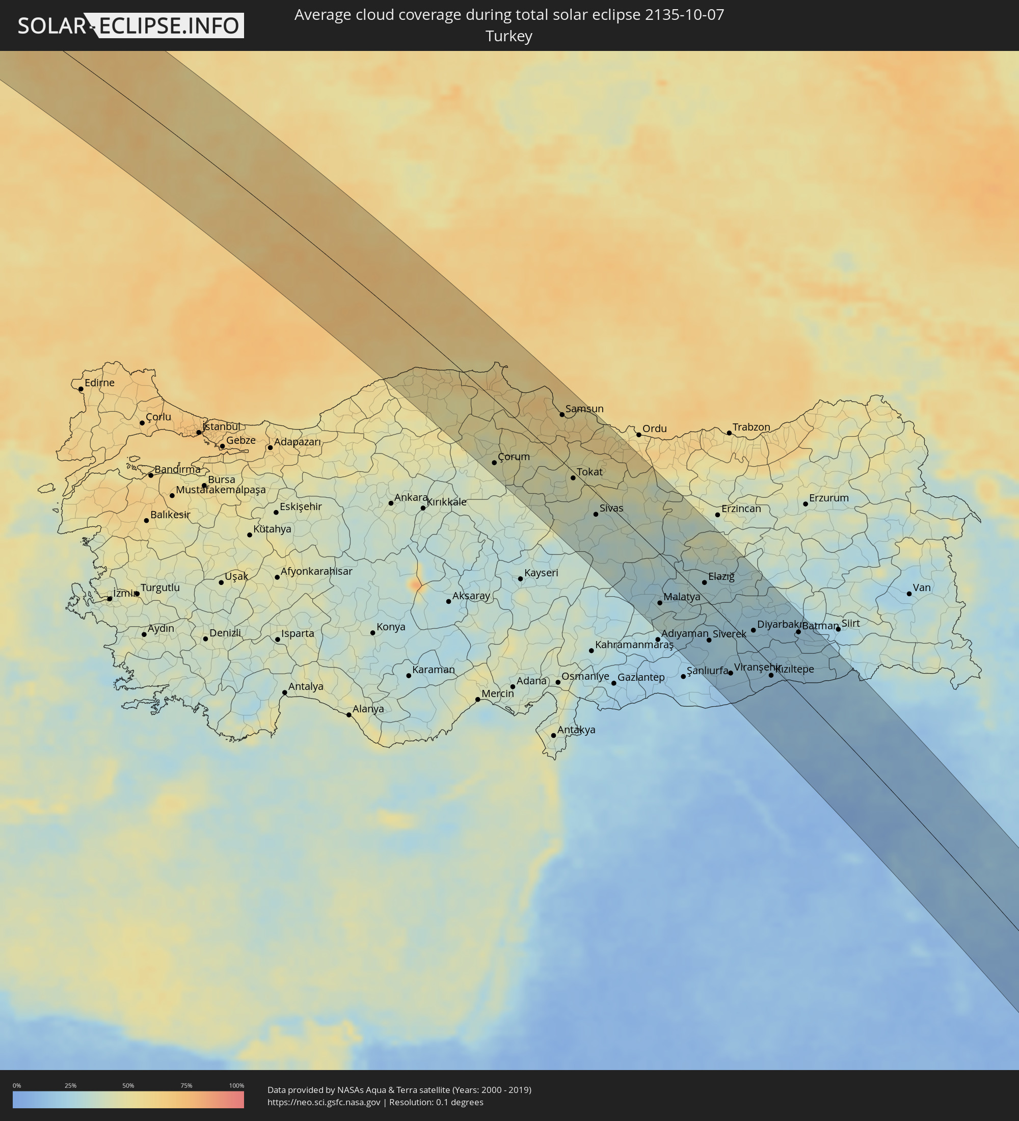 Turkey
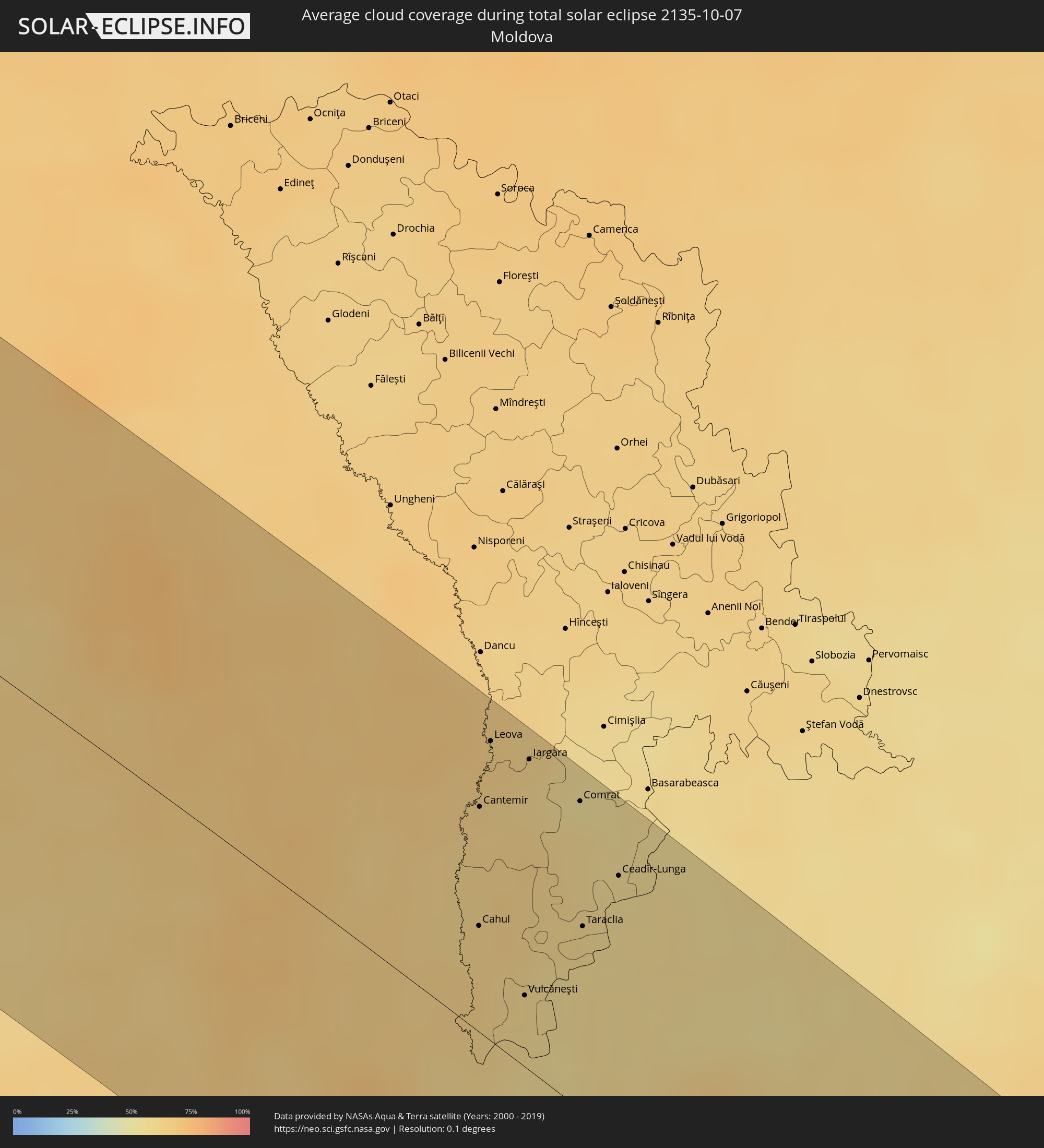 Moldova
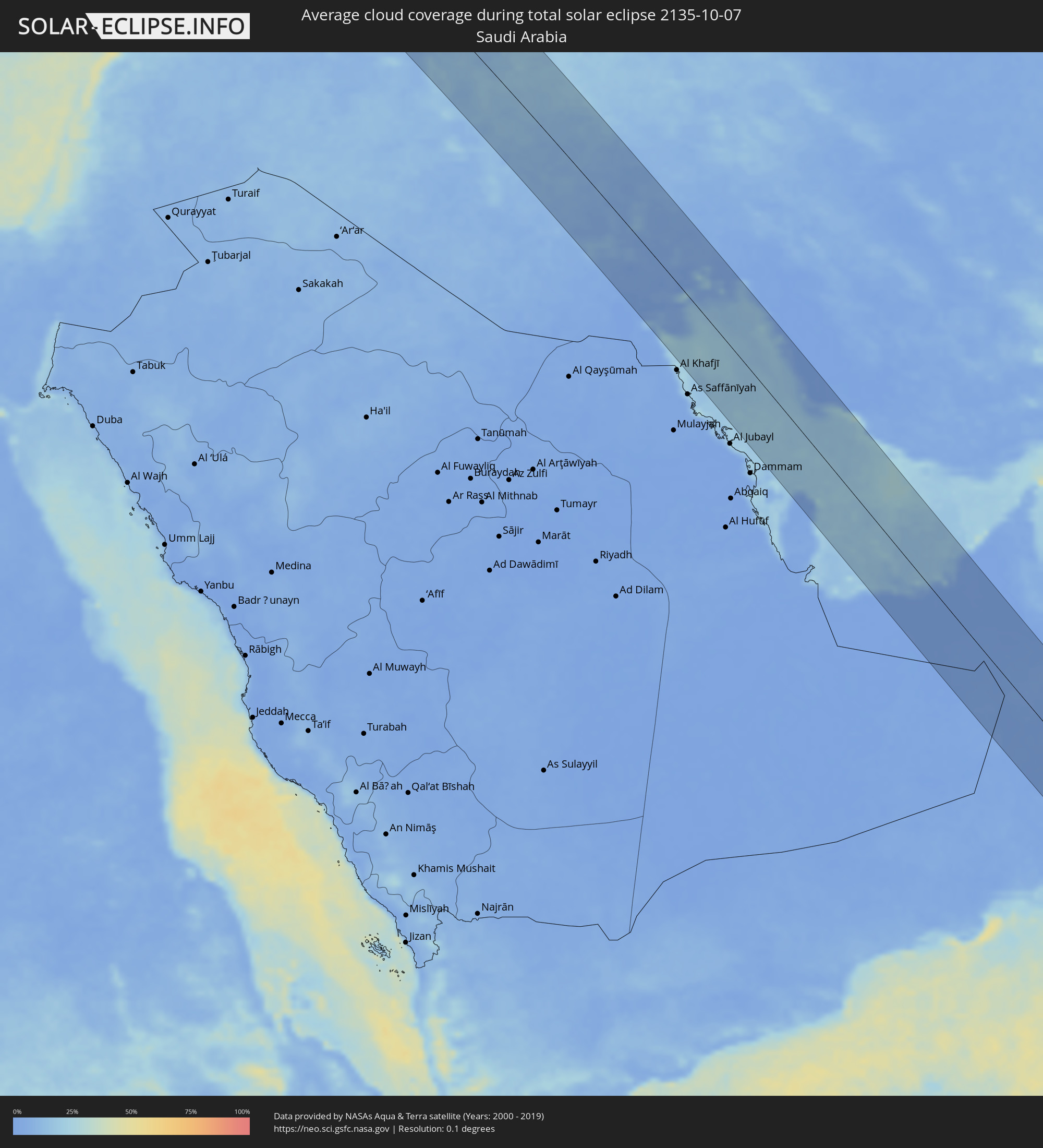 Saudi Arabia
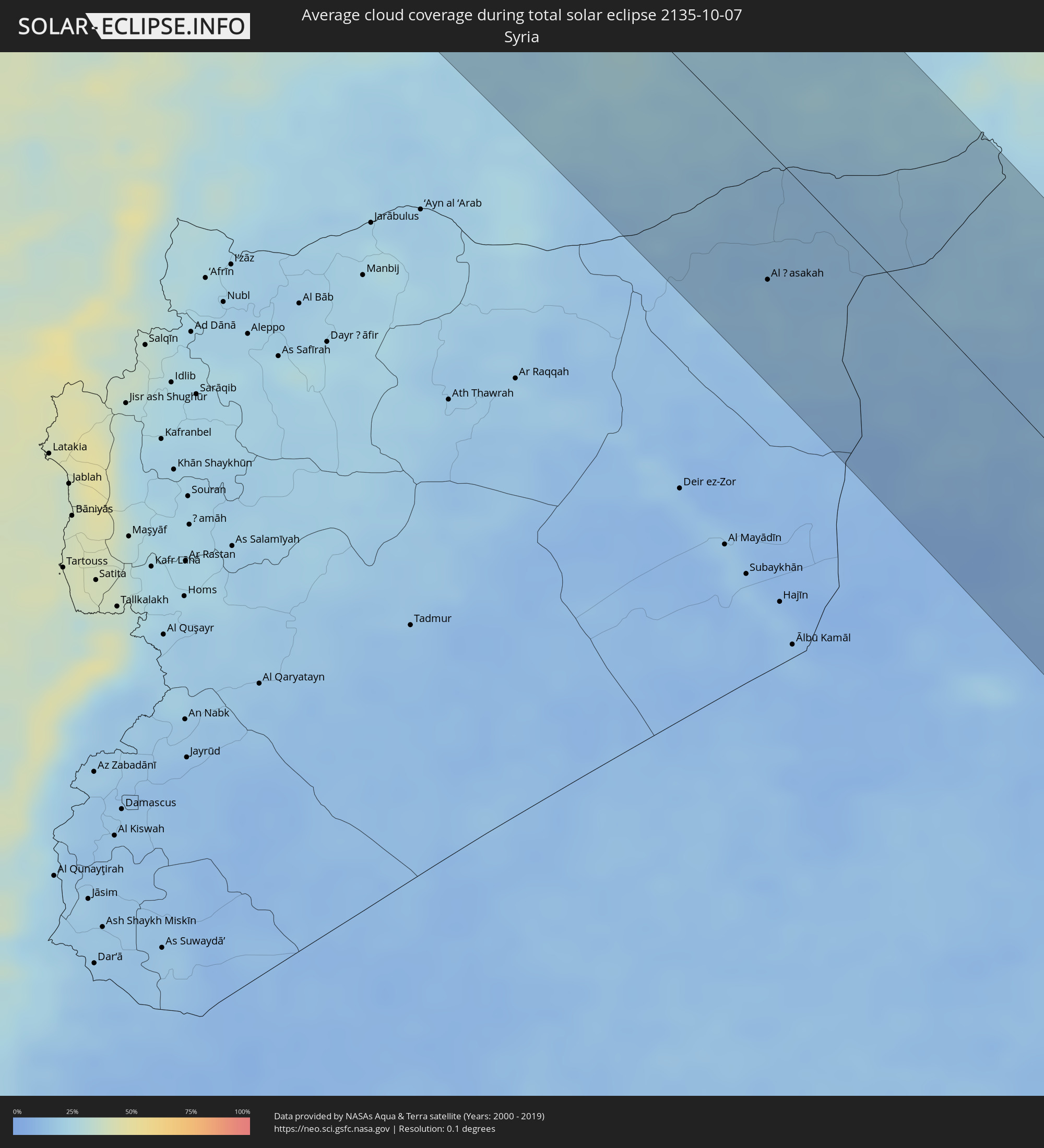 Syria
Syria
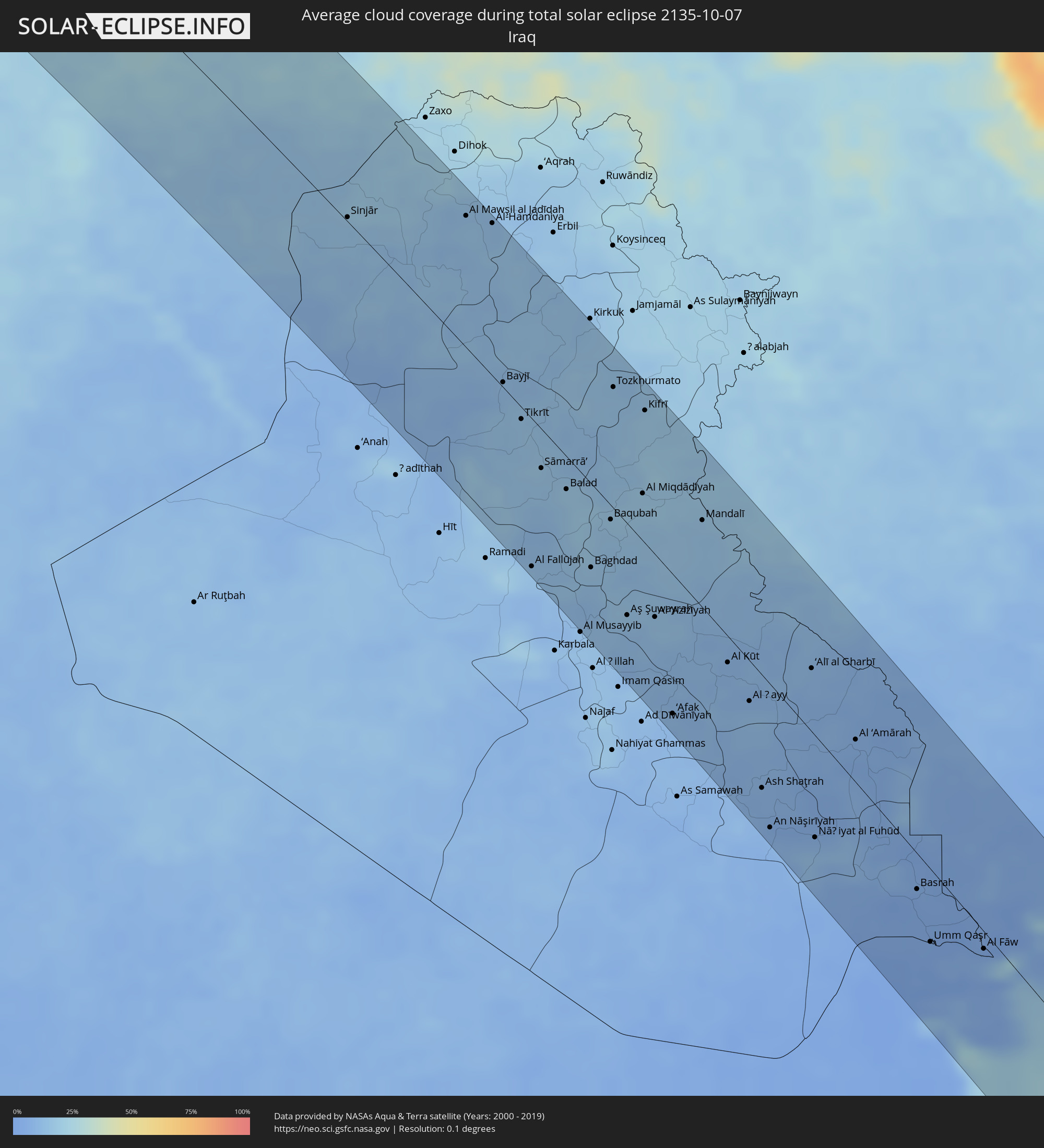 Iraq
Iraq
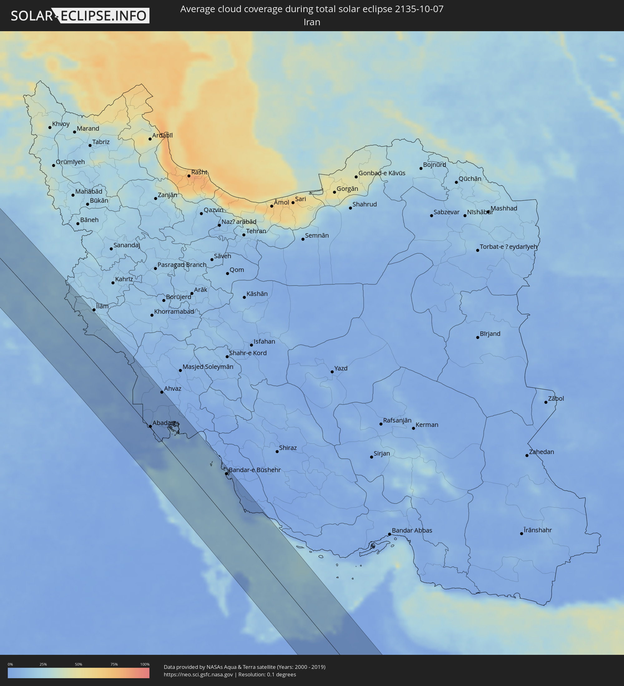 Iran
Iran
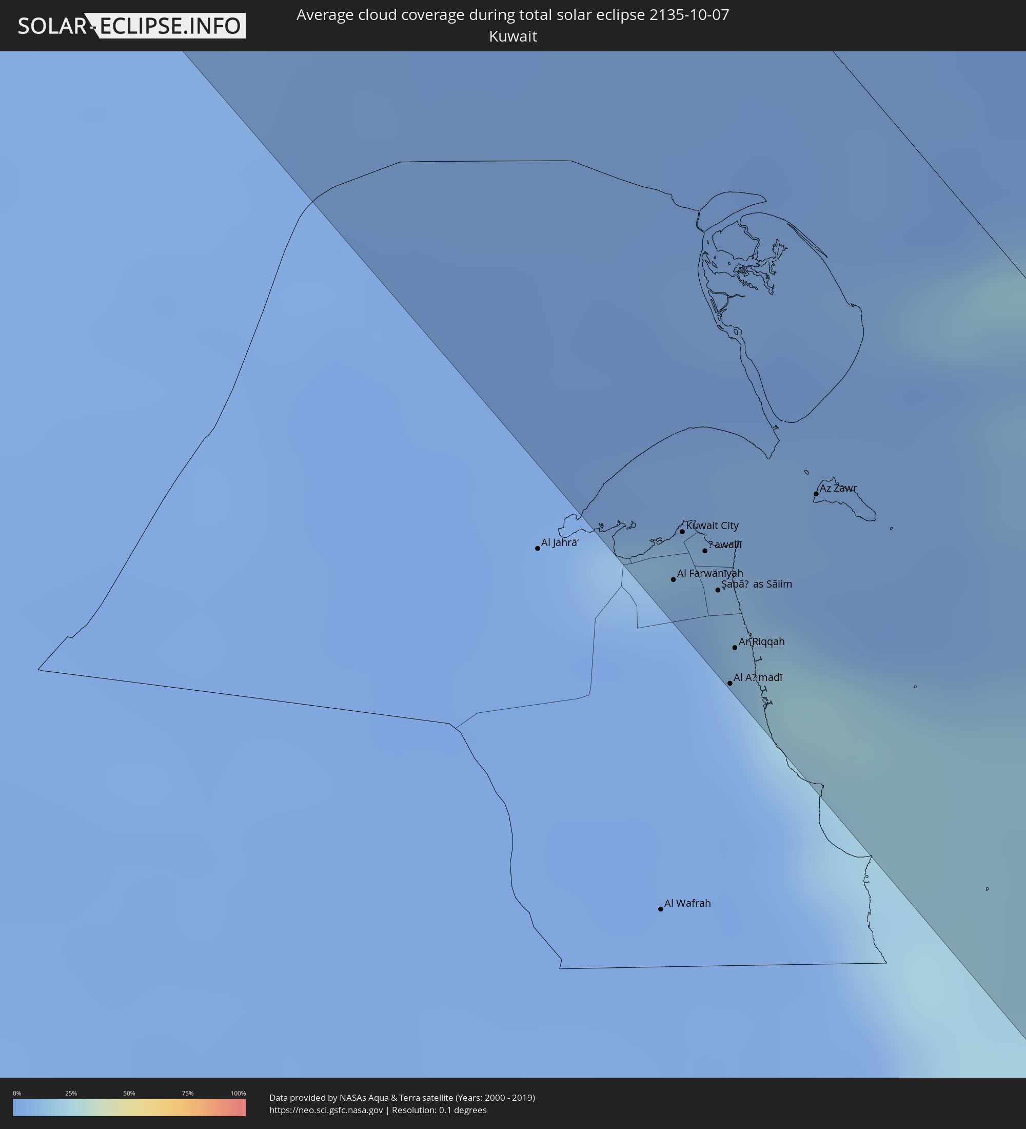 Kuwait
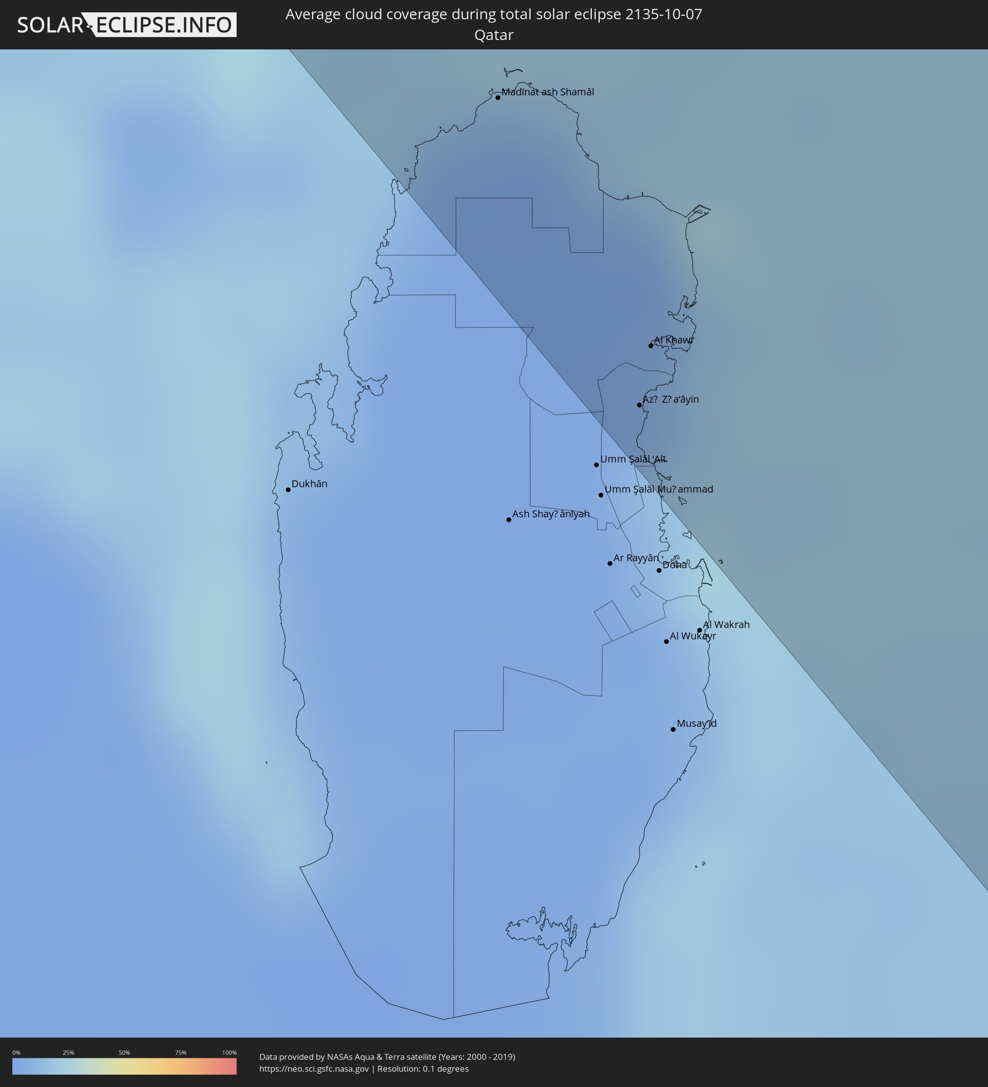 Qatar
Qatar
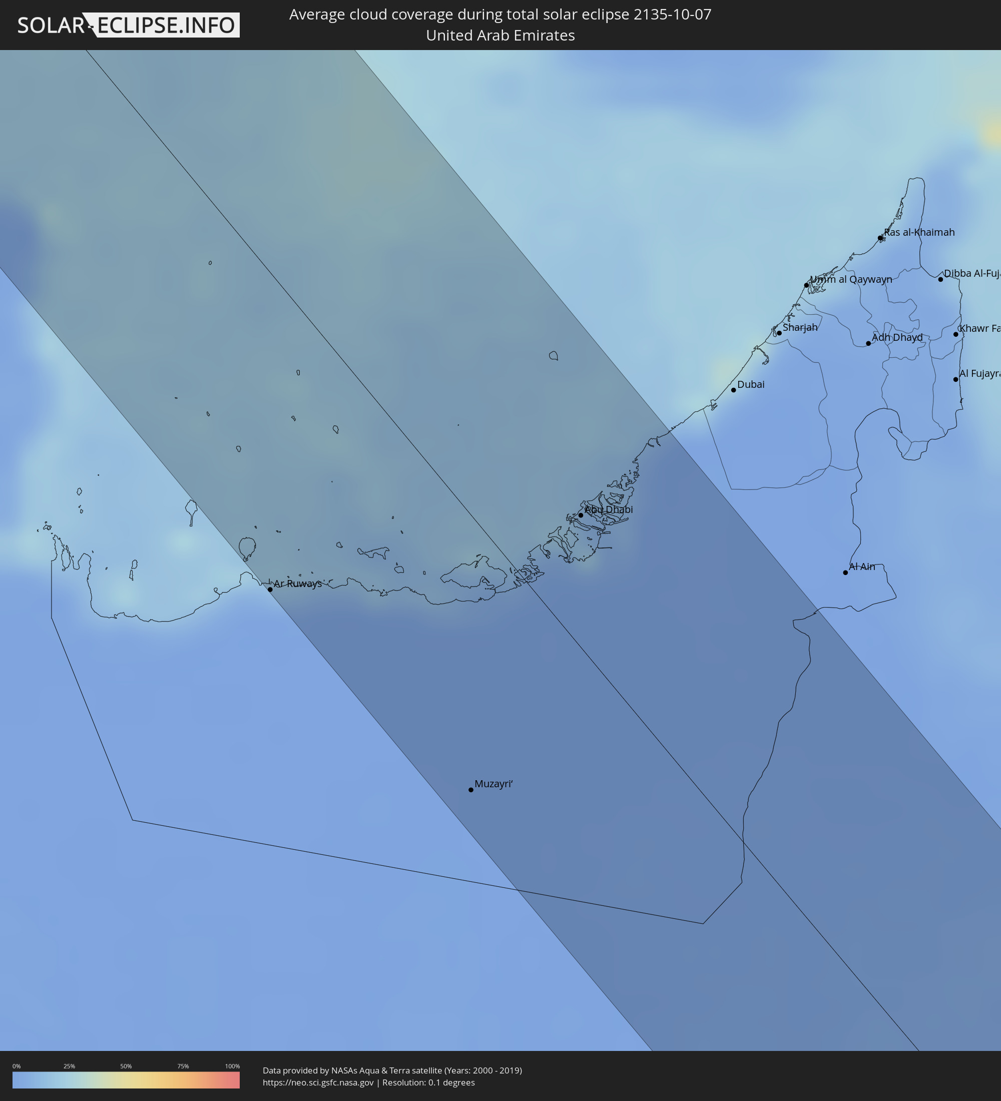 United Arab Emirates
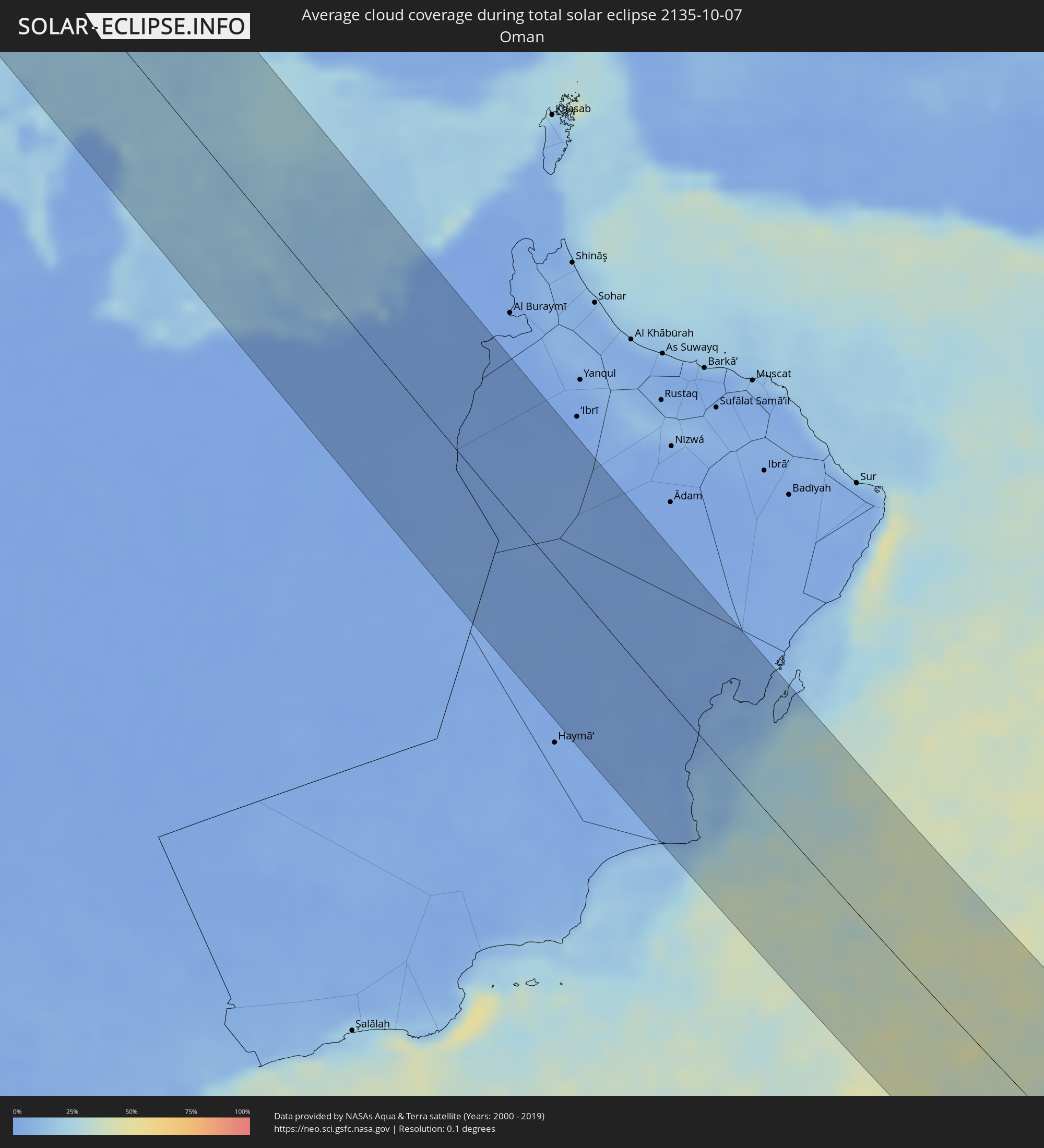 Oman
Oman
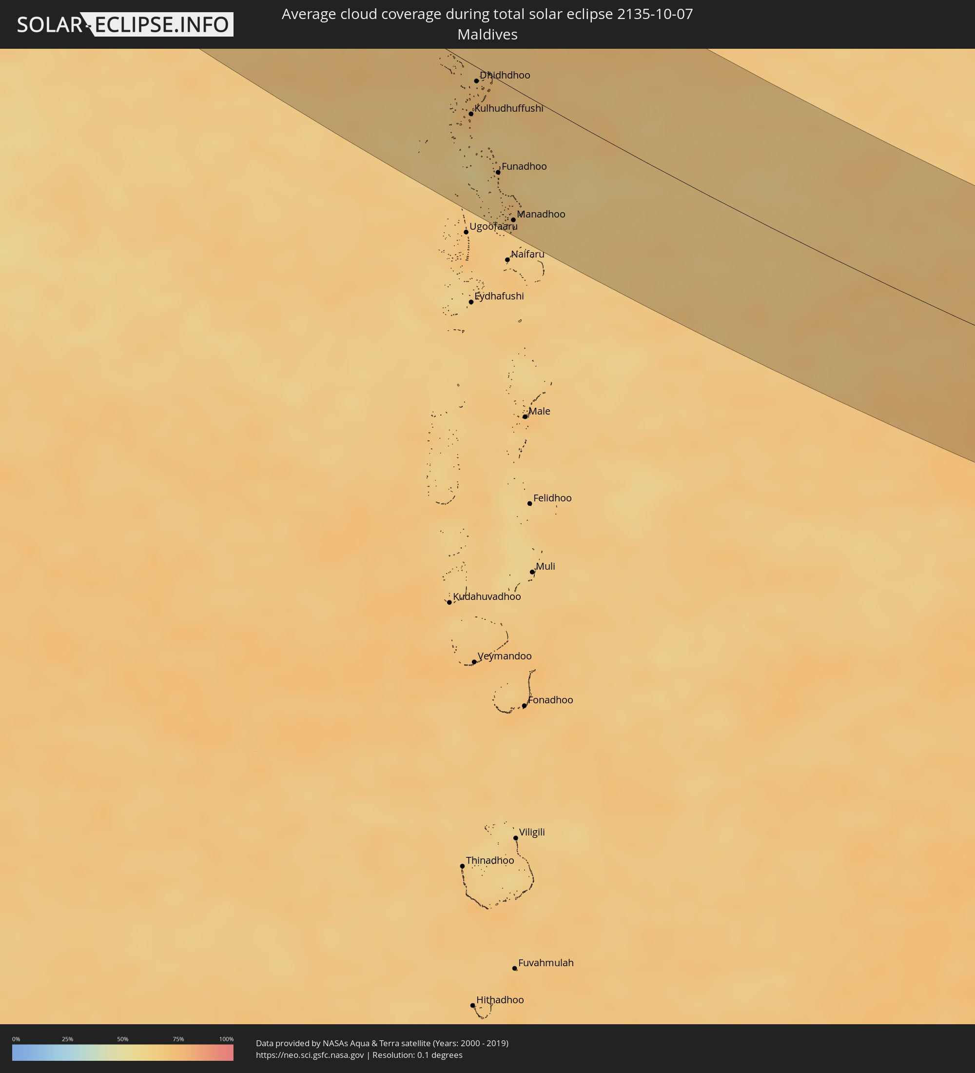 Maldives
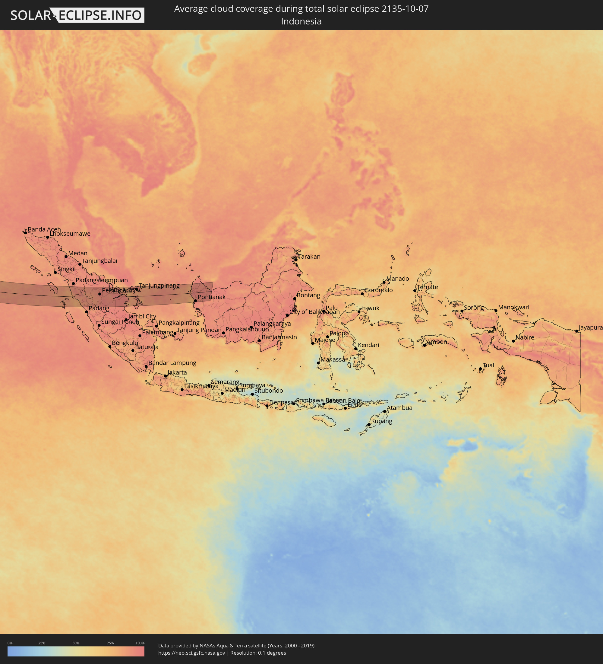 Indonesia
 Malaysia
Cities inside the path of the eclipse
The following table shows all locations with a population of more than 5,000 inside the eclipse path. Cities which have more than 100,000 inhabitants are marked bold. A click at the locations opens a detailed map.
| City | Type | Eclipse duration | Local time of max. eclipse | Distance to central line | Ø Cloud coverage |
|
Glasgow, Scotland
|
total | - | 07:26:17 UTC+00:00 | 17 km | 84% |
|
Hamilton, Scotland
|
total | - | 07:26:17 UTC+00:00 | 24 km | 82% |
|
Cumbernauld, Scotland
|
total | - | 07:26:25 UTC+00:00 | 4 km | 84% |
|
Livingston, Scotland
|
total | - | 07:26:31 UTC+00:00 | 0 km | 82% |
|
Edinburgh, Scotland
|
total | - | 07:26:38 UTC+00:00 | 11 km | 77% |
|
Kirkcaldy, Scotland
|
total | - | 07:26:46 UTC+00:00 | 30 km | 78% |
|
Dundee, Scotland
|
total | - | 07:27:04 UTC+00:00 | 70 km | 79% |
|
Newcastle upon Tyne, England
|
total | - | 07:26:27 UTC+00:00 | 62 km | 78% |
|
Durham, England
|
total | - | 07:26:20 UTC+00:00 | 82 km | 80% |
|
Sunderland, England
|
total | - | 07:26:28 UTC+00:00 | 64 km | 76% |
|
Hartlepool, England
|
total | - | 07:26:23 UTC+00:00 | 84 km | 78% |
|
Franeker, Friesland
|
total | - | 08:28:09 UTC+01:00 | 85 km | 76% |
|
Leeuwarden, Friesland
|
total | - | 08:28:17 UTC+01:00 | 76 km | 78% |
|
Dokkum, Friesland
|
total | - | 08:28:26 UTC+01:00 | 59 km | 76% |
|
Drachten, Friesland
|
total | - | 08:28:22 UTC+01:00 | 78 km | 80% |
|
Grootegast, Groningen
|
total | - | 08:28:30 UTC+01:00 | 63 km | 80% |
|
Assen, Drenthe
|
total | - | 08:28:32 UTC+01:00 | 78 km | 82% |
|
Groningen, Groningen
|
total | - | 08:28:39 UTC+01:00 | 55 km | 80% |
|
Borger, Drenthe
|
total | - | 08:28:37 UTC+01:00 | 79 km | 81% |
|
Veendam, Groningen
|
total | - | 08:28:45 UTC+01:00 | 58 km | 81% |
|
Delfzijl, Groningen
|
total | - | 08:28:52 UTC+01:00 | 34 km | 80% |
|
Vlagtwedde, Groningen
|
total | - | 08:28:49 UTC+01:00 | 60 km | 82% |
|
Oldenburg, Lower Saxony
|
total | - | 08:29:25 UTC+01:00 | 18 km | 81% |
|
Bremen, Bremen
|
total | - | 08:29:41 UTC+01:00 | 8 km | 84% |
|
Hannover, Lower Saxony
|
total | - | 08:29:52 UTC+01:00 | 53 km | 85% |
|
Hamburg, Hamburg
|
total | - | 08:30:34 UTC+01:00 | 76 km | 78% |
|
Braunschweig, Lower Saxony
|
total | - | 08:30:15 UTC+01:00 | 40 km | 83% |
|
Magdeburg, Saxony-Anhalt
|
total | - | 08:30:50 UTC+01:00 | 21 km | 80% |
|
Halle (Saale), Saxony-Anhalt
|
total | - | 08:30:49 UTC+01:00 | 72 km | 81% |
|
Leipzig, Saxony
|
total | - | 08:30:58 UTC+01:00 | 77 km | 81% |
|
Potsdam, Brandenburg
|
total | - | 08:31:47 UTC+01:00 | 50 km | 78% |
|
Berlin, Berlin
|
total | - | 08:32:02 UTC+01:00 | 73 km | 79% |
|
Dresden, Saxony
|
total | - | 08:31:44 UTC+01:00 | 61 km | 78% |
|
Děčín, Ústecký
|
total | - | 08:31:57 UTC+01:00 | 72 km | 81% |
|
Česká Lípa, Liberecký
|
total | - | 08:32:08 UTC+01:00 | 71 km | 80% |
|
Mladá Boleslav, Central Bohemia
|
total | - | 08:32:18 UTC+01:00 | 85 km | 82% |
|
Liberec, Liberecký
|
total | - | 08:32:30 UTC+01:00 | 46 km | 80% |
|
Zielona Góra, Lubusz
|
total | - | 08:33:08 UTC+01:00 | 84 km | 77% |
|
Hradec Králové, Královéhradecký
|
total | - | 08:32:52 UTC+01:00 | 73 km | 84% |
|
Legnica, Lower Silesian Voivodeship
|
total | - | 08:33:21 UTC+01:00 | 35 km | 80% |
|
Wałbrzych, Lower Silesian Voivodeship
|
total | - | 08:33:19 UTC+01:00 | 3 km | 80% |
|
Wrocław, Lower Silesian Voivodeship
|
total | - | 08:33:55 UTC+01:00 | 55 km | 76% |
|
Olomouc, Olomoucký
|
total | - | 08:33:44 UTC+01:00 | 83 km | 82% |
|
Přerov, Olomoucký
|
total | - | 08:33:51 UTC+01:00 | 89 km | 80% |
|
Opava, Moravskoslezský
|
total | - | 08:34:17 UTC+01:00 | 26 km | 81% |
|
Opole, Opole Voivodeship
|
total | - | 08:34:27 UTC+01:00 | 45 km | 77% |
|
Ostrava, Moravskoslezský
|
total | - | 08:34:32 UTC+01:00 | 22 km | 79% |
|
Frýdek-Místek, Moravskoslezský
|
total | - | 08:34:33 UTC+01:00 | 34 km | 81% |
|
Považská Bystrica, Trenčiansky
|
total | - | 08:34:31 UTC+01:00 | 85 km | 76% |
|
Karviná, Moravskoslezský
|
total | - | 08:34:44 UTC+01:00 | 11 km | 77% |
|
Rybnik, Silesian Voivodeship
|
total | - | 08:34:46 UTC+01:00 | 12 km | 76% |
|
Gliwice, Silesian Voivodeship
|
total | - | 08:34:55 UTC+01:00 | 37 km | 74% |
|
Žilina, Žilinský
|
total | - | 08:34:46 UTC+01:00 | 64 km | 75% |
|
Martin, Žilinský
|
total | - | 08:34:54 UTC+01:00 | 72 km | 75% |
|
Katowice, Silesian Voivodeship
|
total | - | 08:35:10 UTC+01:00 | 46 km | 73% |
|
Bielsko-Biala, Silesian Voivodeship
|
total | - | 08:35:06 UTC+01:00 | 5 km | 76% |
|
Dąbrowa Górnicza, Silesian Voivodeship
|
total | - | 08:35:20 UTC+01:00 | 59 km | 72% |
|
Liptovský Mikuláš, Žilinský
|
total | - | 08:35:26 UTC+01:00 | 44 km | 75% |
|
Kraków, Lesser Poland Voivodeship
|
total | - | 08:35:49 UTC+01:00 | 61 km | 72% |
|
Poprad, Prešovský
|
total | - | 08:35:57 UTC+01:00 | 20 km | 70% |
|
Spišská Nová Ves, Košický
|
total | - | 08:36:09 UTC+01:00 | 20 km | 68% |
|
Kazincbarcika, Borsod-Abaúj-Zemplén
|
total | - | 08:36:09 UTC+01:00 | 83 km | 63% |
|
Miskolc, Borsod-Abaúj-Zemplén
|
total | - | 08:36:16 UTC+01:00 | 91 km | 65% |
|
Szerencs, Borsod-Abaúj-Zemplén
|
total | - | 08:36:37 UTC+01:00 | 69 km | 61% |
|
Prešov, Prešovský
|
total | - | 08:36:42 UTC+01:00 | 11 km | 71% |
|
Košice, Košický
|
total | - | 08:36:41 UTC+01:00 | 15 km | 68% |
|
Bardejov, Prešovský
|
total | - | 08:36:45 UTC+01:00 | 40 km | 70% |
|
Hajdúnánás, Hajdú-Bihar
|
total | - | 08:36:47 UTC+01:00 | 89 km | 61% |
|
Sátoraljaújhely, Borsod-Abaúj-Zemplén
|
total | - | 08:37:00 UTC+01:00 | 29 km | 65% |
|
Újfehértó, Szabolcs-Szatmár-Bereg
|
total | - | 08:37:00 UTC+01:00 | 83 km | 63% |
|
Nyíregyháza, Szabolcs-Szatmár-Bereg
|
total | - | 08:37:02 UTC+01:00 | 67 km | 61% |
|
Humenné, Prešovský
|
total | - | 08:37:14 UTC+01:00 | 32 km | 67% |
|
Michalovce, Košický
|
total | - | 08:37:14 UTC+01:00 | 15 km | 70% |
|
Kisvárda, Szabolcs-Szatmár-Bereg
|
total | - | 08:37:20 UTC+01:00 | 28 km | 62% |
|
Nyírbátor, Szabolcs-Szatmár-Bereg
|
total | - | 08:37:22 UTC+01:00 | 62 km | 62% |
|
Uzhhorod, Zakarpattia
|
total | - | 09:37:32 UTC+02:00 | 18 km | 65% |
|
Vásárosnamény, Szabolcs-Szatmár-Bereg
|
total | - | 08:37:32 UTC+01:00 | 27 km | 61% |
|
Mátészalka, Szabolcs-Szatmár-Bereg
|
total | - | 08:37:32 UTC+01:00 | 43 km | 61% |
|
Berehove, Zakarpattia
|
total | - | 09:37:49 UTC+02:00 | 6 km | 62% |
|
Mukacheve, Zakarpattia
|
total | - | 09:37:53 UTC+02:00 | 18 km | 63% |
|
Satu Mare, Satu Mare
|
total | - | 09:37:59 UTC+02:00 | 35 km | 67% |
|
Svalyava, Zakarpattia
|
total | - | 09:38:07 UTC+02:00 | 40 km | 61% |
|
Vynohradiv, Zakarpattia
|
total | - | 09:38:08 UTC+02:00 | 4 km | 65% |
|
Khust, Zakarpattia
|
total | - | 09:38:22 UTC+02:00 | 18 km | 61% |
|
Baia Mare, Satu Mare
|
total | - | 09:38:37 UTC+02:00 | 18 km | 62% |
|
Bistriţa, Bistriţa-Năsăud
|
total | - | 09:39:27 UTC+02:00 | 27 km | 58% |
|
Târgu-Mureş, Mureş
|
total | - | 09:39:33 UTC+02:00 | 78 km | 58% |
|
Piatra Neamţ, Neamţ
|
total | - | 09:41:09 UTC+02:00 | 34 km | 63% |
|
Bacău, Bacău
|
total | - | 09:41:44 UTC+02:00 | 29 km | 68% |
|
Focșani, Vrancea
|
total | - | 09:42:09 UTC+02:00 | 36 km | 65% |
|
Vaslui, Vaslui
|
total | - | 09:42:31 UTC+02:00 | 73 km | 66% |
|
Brăila, Brăila
|
total | - | 09:43:02 UTC+02:00 | 37 km | 61% |
|
Galaţi, Galaţi
|
total | - | 09:43:03 UTC+02:00 | 18 km | 60% |
|
Cahul, Cahul
|
total | - | 09:43:06 UTC+02:00 | 30 km | 62% |
|
Cantemir, Cantemir
|
total | - | 09:43:02 UTC+02:00 | 63 km | 62% |
|
Leova, Leova
|
total | - | 09:43:03 UTC+02:00 | 83 km | 63% |
|
Reni, Odessa
|
total | - | 09:43:18 UTC+02:00 | 6 km | 58% |
|
Vulcăneşti, Găgăuzia
|
total | - | 09:43:21 UTC+02:00 | 20 km | 58% |
|
Iargara, Cantemir
|
total | - | 09:43:13 UTC+02:00 | 86 km | 60% |
|
Bolhrad, Odessa
|
total | - | 09:43:34 UTC+02:00 | 30 km | 56% |
|
Comrat, Găgăuzia
|
total | - | 09:43:29 UTC+02:00 | 86 km | 58% |
|
Taraclia, Taraclia
|
total | - | 09:43:34 UTC+02:00 | 52 km | 56% |
|
Tulcea, Tulcea
|
total | - | 09:43:52 UTC+02:00 | 7 km | 63% |
|
Ceadîr-Lunga, Găgăuzia
|
total | - | 09:43:42 UTC+02:00 | 73 km | 57% |
|
Izmayil, Odessa
|
total | - | 09:43:52 UTC+02:00 | 11 km | 61% |
|
Kiliya, Odessa
|
total | - | 09:44:16 UTC+02:00 | 41 km | 63% |
|
Artsyz, Odessa
|
total | - | 09:44:18 UTC+02:00 | 95 km | 56% |
|
Çorum, Çorum
|
total | - | 10:52:47 UTC+03:00 | 80 km | 43% |
|
Samsun, Samsun
|
total | - | 10:54:01 UTC+03:00 | 58 km | 57% |
|
Tokat, Tokat
|
total | - | 10:54:55 UTC+03:00 | 8 km | 45% |
|
Sivas, Sivas
|
total | - | 10:55:54 UTC+03:00 | 27 km | 37% |
|
Malatya, Malatya
|
total | - | 10:58:40 UTC+03:00 | 62 km | 30% |
|
Elazığ, Elazığ
|
total | - | 10:59:36 UTC+03:00 | 19 km | 29% |
|
Siverek, Şanlıurfa
|
total | - | 11:00:30 UTC+03:00 | 48 km | 21% |
|
Viranşehir, Şanlıurfa
|
total | - | 11:01:34 UTC+03:00 | 62 km | 20% |
|
Diyarbakır, Diyarbakır
|
total | - | 11:01:35 UTC+03:00 | 21 km | 22% |
|
Kızıltepe, Mardin
|
total | - | 11:02:44 UTC+03:00 | 13 km | 17% |
|
Ad Darbāsīyah, Al-Hasakah
|
total | - | 10:02:57 UTC+02:00 | 18 km | 15% |
|
Al Ḩasakah, Al-Hasakah
|
total | - | 10:03:38 UTC+02:00 | 56 km | 17% |
|
Batman, Batman
|
total | - | 11:02:51 UTC+03:00 | 76 km | 21% |
|
Al Mawşil al Jadīdah, Nīnawá
|
total | - | 11:07:08 UTC+03:00 | 84 km | 14% |
|
Al Fallūjah, Anbar
|
total | - | 11:11:28 UTC+03:00 | 96 km | 13% |
|
Sāmarrā’, Salah ad Din Governorate
|
total | - | 11:10:37 UTC+03:00 | 25 km | 15% |
|
Abū Ghurayb, Mayorality of Baghdad
|
total | - | 11:12:07 UTC+03:00 | 72 km | 14% |
|
Baghdad, Mayorality of Baghdad
|
total | - | 11:12:24 UTC+03:00 | 54 km | 13% |
|
Baqubah, Diyālá
|
total | - | 11:12:13 UTC+03:00 | 9 km | 17% |
|
Al Kūt, Wāsiţ
|
total | - | 11:15:36 UTC+03:00 | 17 km | 9% |
|
Mehrān, Īlām
|
total | - | 11:45:21 UTC+03:30 | 52 km | 12% |
|
An Nāşirīyah, Dhi Qar
|
total | - | 11:18:12 UTC+03:00 | 93 km | 7% |
|
Al ‘Amārah, Maysan
|
total | - | 11:18:33 UTC+03:00 | 28 km | 6% |
|
Dehlorān, Īlām
|
total | - | 11:47:36 UTC+03:30 | 99 km | 9% |
|
Basrah, Basra Governorate
|
total | - | 11:21:23 UTC+03:00 | 23 km | 4% |
|
Umm Qaşr, Basra Governorate
|
total | - | 11:22:16 UTC+03:00 | 47 km | 3% |
|
Ar Rābiyah, Al Asimah
|
total | - | 11:23:22 UTC+03:00 | 100 km | 2% |
|
Ash Shāmīyah, Al Asimah
|
total | - | 11:23:20 UTC+03:00 | 94 km | 4% |
|
Janūb as Surrah, Al Farwaniyah
|
total | - | 11:23:29 UTC+03:00 | 99 km | 4% |
|
Ad Dasmah, Al Asimah
|
total | - | 11:23:23 UTC+03:00 | 90 km | 8% |
|
Ḩawallī, Hawalli
|
total | - | 11:23:28 UTC+03:00 | 90 km | 4% |
|
Bayān, Hawalli
|
total | - | 11:23:33 UTC+03:00 | 91 km | 4% |
|
Al Aḩmadī, Al Aḩmadī
|
total | - | 11:23:56 UTC+03:00 | 105 km | 7% |
|
Al Finţās, Al Aḩmadī
|
total | - | 11:23:51 UTC+03:00 | 95 km | 11% |
|
Al Mahbūlah, Al Aḩmadī
|
total | - | 11:23:55 UTC+03:00 | 96 km | 7% |
|
Al Manqaf, Al Aḩmadī
|
total | - | 11:23:59 UTC+03:00 | 100 km | 7% |
|
Khorramshahr, Khuzestan
|
total | - | 11:52:07 UTC+03:30 | 2 km | 3% |
|
Sūsangerd, Khuzestan
|
total | - | 11:50:34 UTC+03:30 | 83 km | 5% |
|
Az Zawr, Al Asimah
|
total | - | 11:23:42 UTC+03:00 | 64 km | 4% |
|
Abadan, Khuzestan
|
total | - | 11:52:28 UTC+03:30 | 3 km | 3% |
|
Shādegān, Khuzestan
|
total | - | 11:52:36 UTC+03:30 | 52 km | 4% |
|
Ahvaz, Khuzestan
|
total | - | 11:51:41 UTC+03:30 | 101 km | 4% |
|
Khārk, Bushehr
|
total | - | 11:57:21 UTC+03:30 | 75 km | 19% |
|
Bandar-e Būshehr, Bushehr
|
total | - | 11:58:38 UTC+03:30 | 93 km | 6% |
|
Madīnat ash Shamāl, Madīnat ash Shamāl
|
total | - | 11:33:45 UTC+03:00 | 82 km | 3% |
|
Az̧ Z̧a‘āyin, Baladīyat az̧ Z̧a‘āyin
|
total | - | 11:35:09 UTC+03:00 | 100 km | 13% |
|
Al Khawr, Al Khawr
|
total | - | 11:35:00 UTC+03:00 | 90 km | 6% |
|
Ar Ruways, Abu Dhabi
|
total | - | 12:39:48 UTC+04:00 | 108 km | 1% |
|
Muzayri‘, Abu Dhabi
|
total | - | 12:43:20 UTC+04:00 | 94 km | 0% |
|
Abu Dhabi, Abu Dhabi
|
total | - | 12:42:01 UTC+04:00 | 45 km | 10% |
|
Kulhudhuffushi, Haa Dhaalu Atholhu
|
total | - | 14:47:39 UTC+05:00 | 39 km | 68% |
|
Dhidhdhoo, Haa Alifu Atholhu
|
total | - | 14:47:16 UTC+05:00 | 11 km | 70% |
|
Funadhoo, Shaviyani Atholhu
|
total | - | 14:48:47 UTC+05:00 | 72 km | 68% |
|
Manadhoo, Noonu Atoll
|
total | - | 14:49:37 UTC+05:00 | 103 km | 70% |
|
Bukittinggi, West Sumatra
|
total | - | 17:23:33 UTC+07:00 | 68 km | 91% |
|
Payakumbuh, West Sumatra
|
total | - | 17:23:34 UTC+07:00 | 58 km | 87% |
|
Balaipungut, Riau
|
total | - | 17:22:38 UTC+07:00 | 84 km | 92% |
|
Pekanbaru, Riau
|
total | - | 17:23:12 UTC+07:00 | 24 km | 96% |
|
Tanjungpinang, Riau Islands
|
total | - | 17:23:50 UTC+07:00 | 62 km | 90% |
|
Kijang, Riau Islands
|
total | - | 17:23:54 UTC+07:00 | 59 km | 92% |
|
Sungai Raya, West Kalimantan
|
total | - | 17:24:57 UTC+07:00 | 9 km | 88% |
|
Pemangkat, West Kalimantan
|
total | - | 17:24:34 UTC+07:00 | 60 km | 90% |
|
Singkawang, West Kalimantan
|
total | - | 17:24:47 UTC+07:00 | 31 km | 94% |
|
Pontianak, West Kalimantan
|
total | - | 17:25:36 UTC+07:00 | 76 km | 95% |