Total solar eclipse of 05/25/2142
| Day of week: | Friday |
| Maximum duration of eclipse: | 03m17s |
| Maximum width of eclipse path: | 187 km |
| Saros cycle: | 130 |
| Coverage: | 100% |
| Magnitude: | 1.0449 |
| Gamma: | 0.5937 |
Wo kann man die Sonnenfinsternis vom 05/25/2142 sehen?
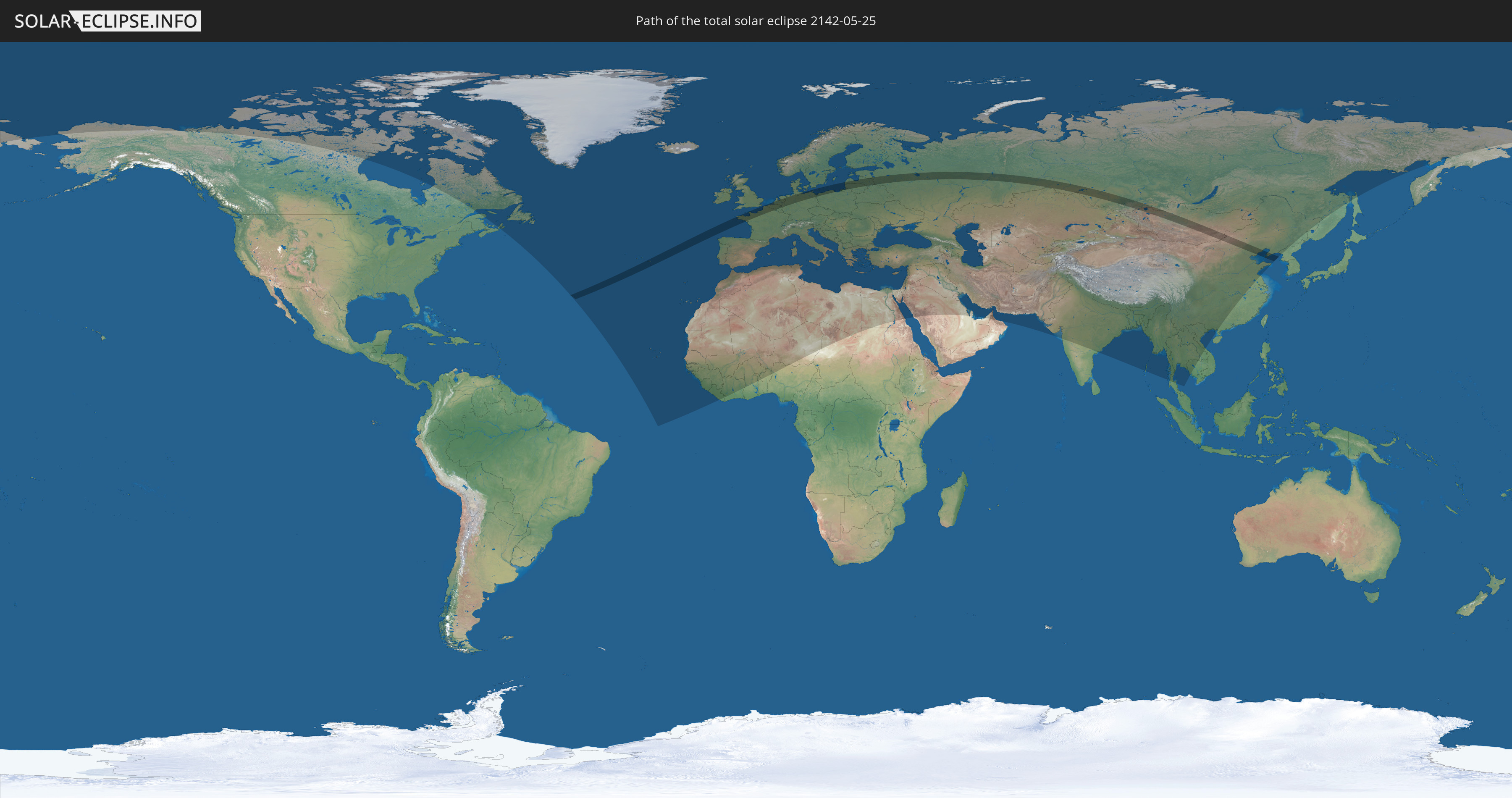
Die Sonnenfinsternis am 05/25/2142 kann man in 115 Ländern als partielle Sonnenfinsternis beobachten.
Der Finsternispfad verläuft durch 16 Länder. Nur in diesen Ländern ist sie als total Sonnenfinsternis zu sehen.
In den folgenden Ländern ist die Sonnenfinsternis total zu sehen
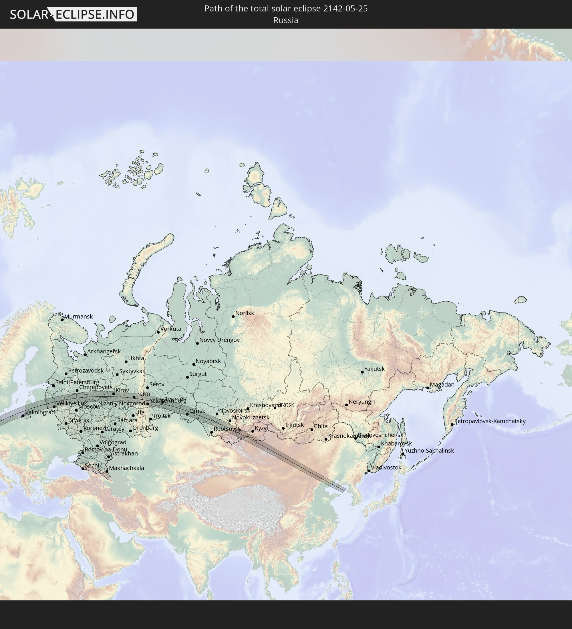 Russia
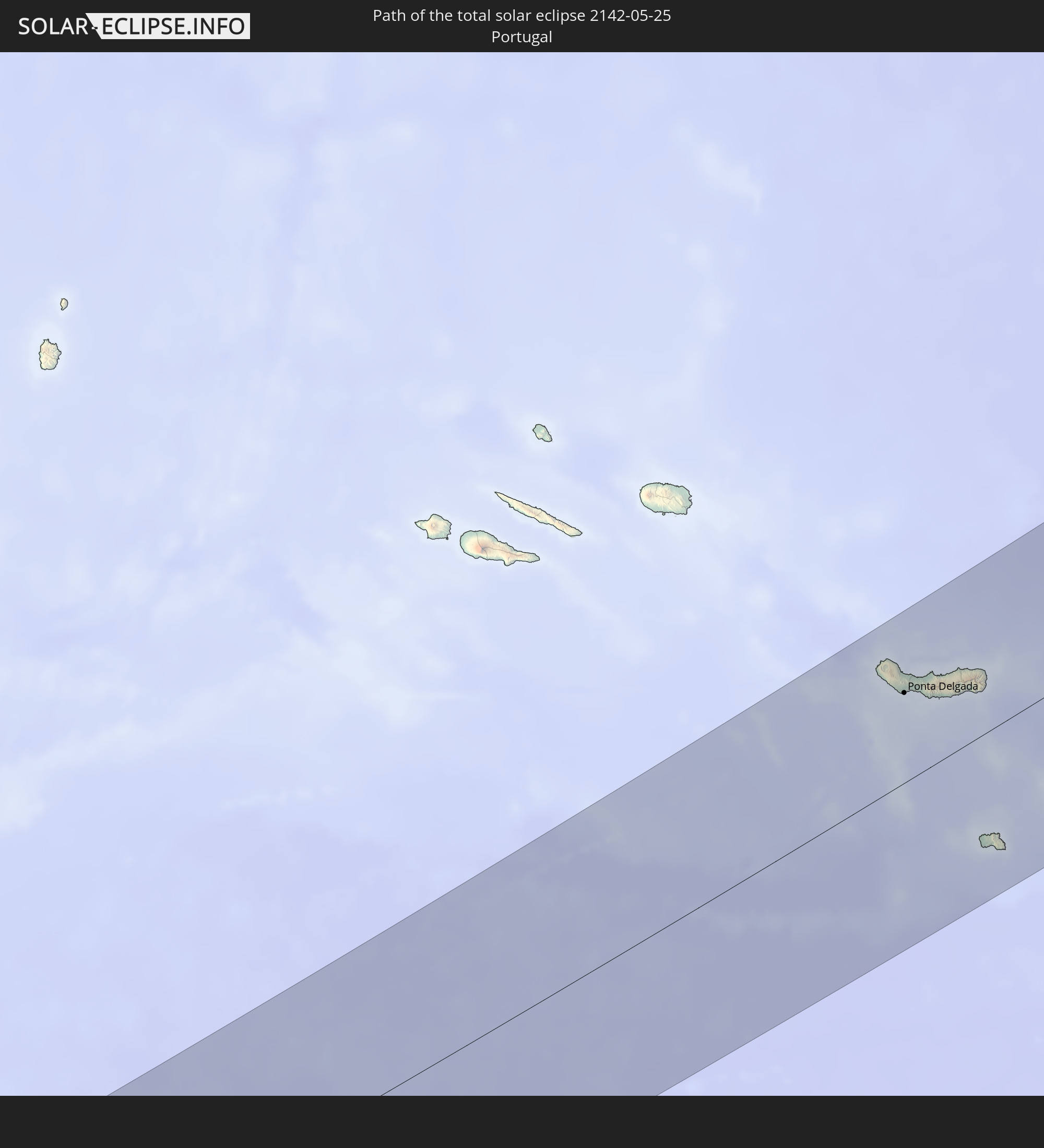 Portugal
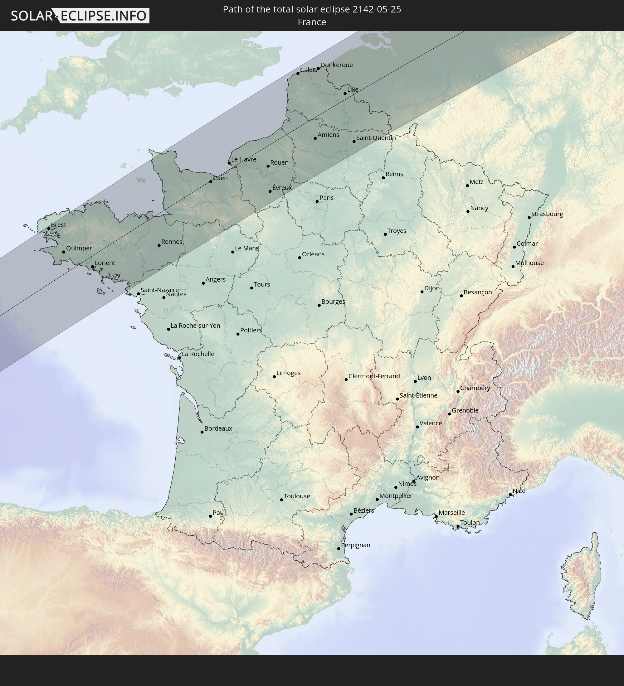 France
 Jersey
 Belgium
 Netherlands
 Germany
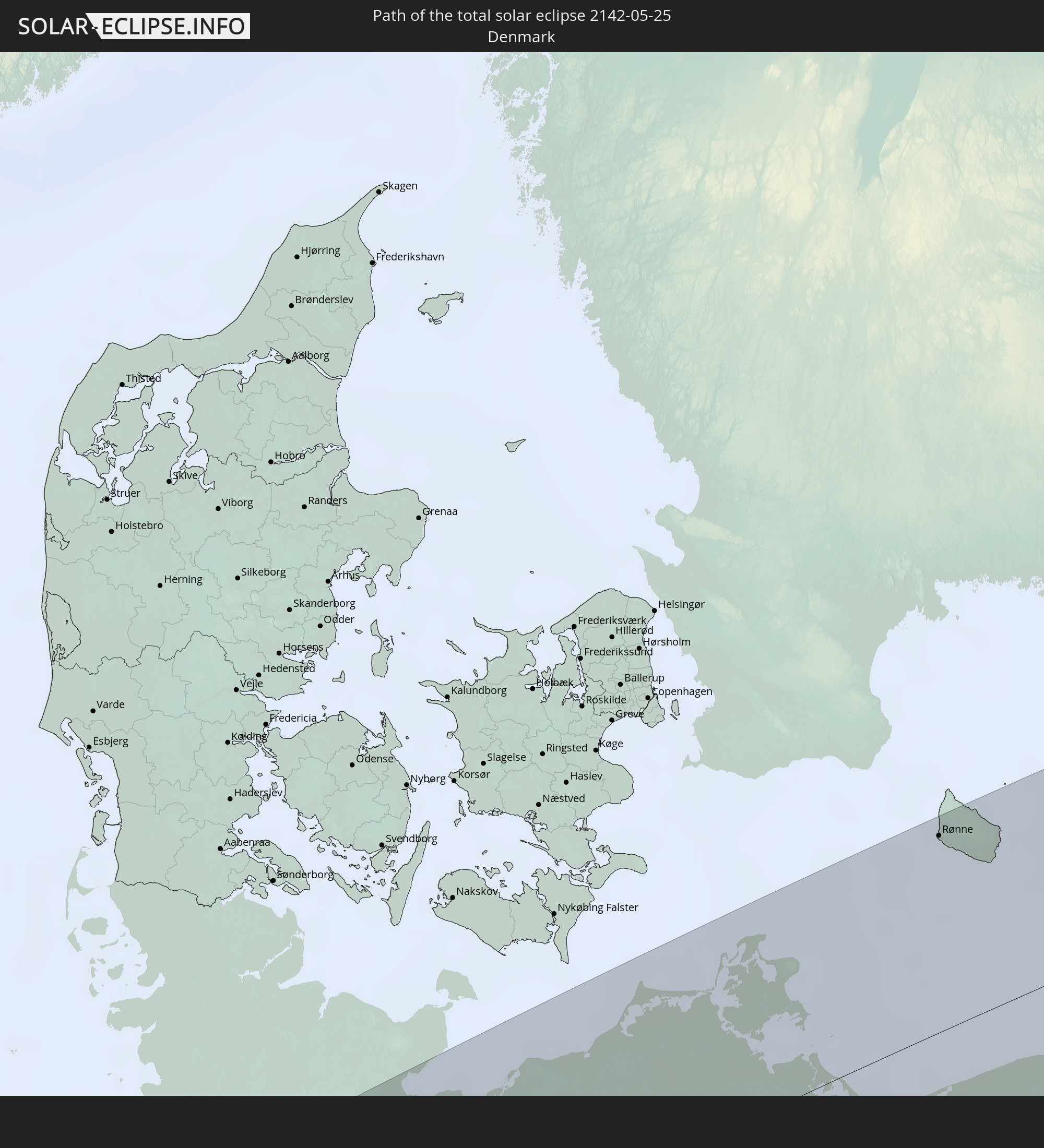 Denmark
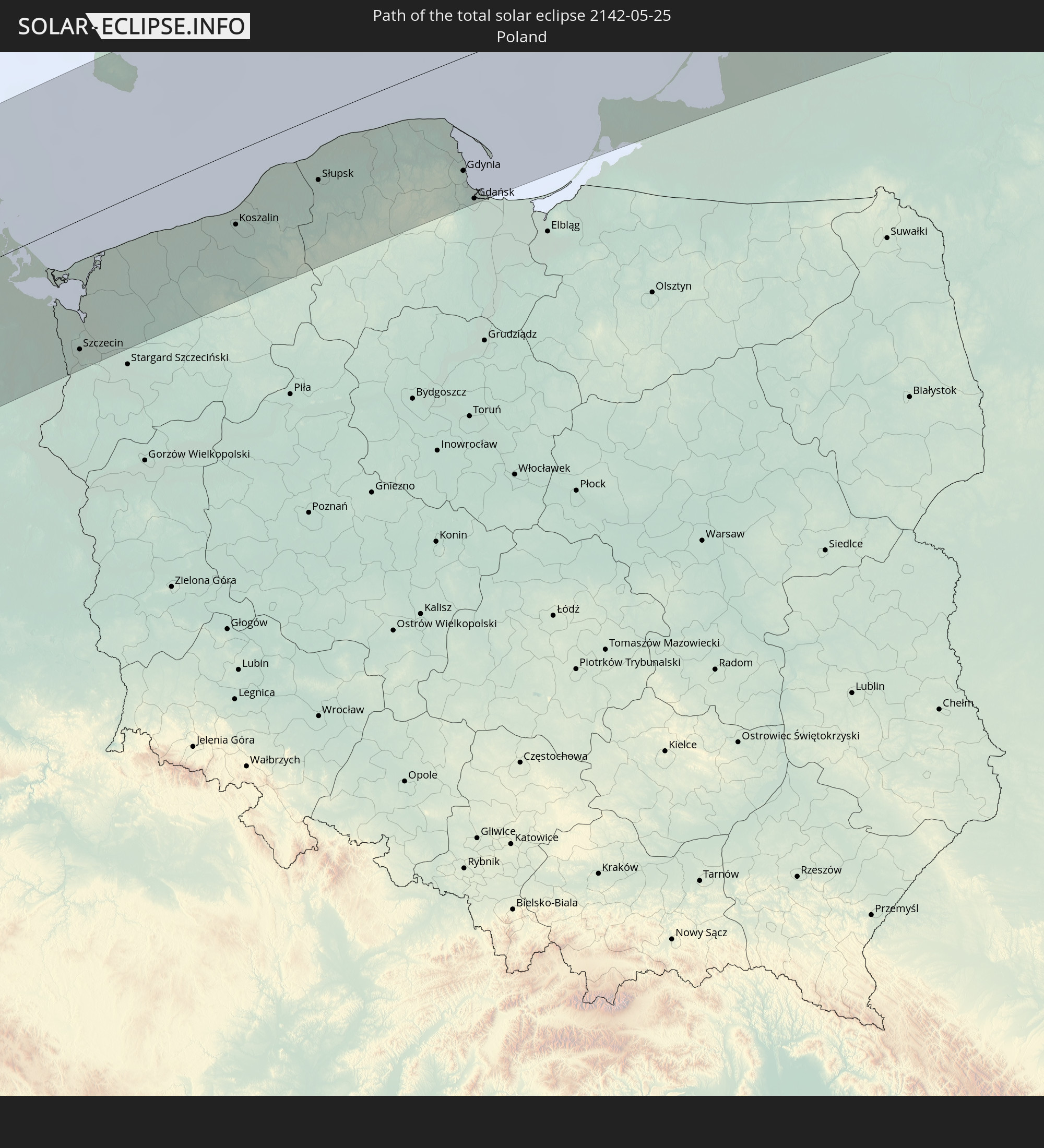 Poland
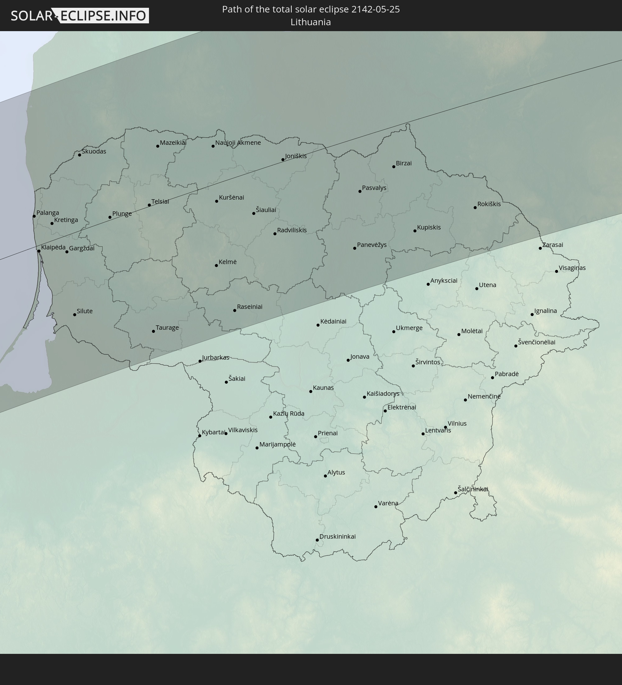 Lithuania
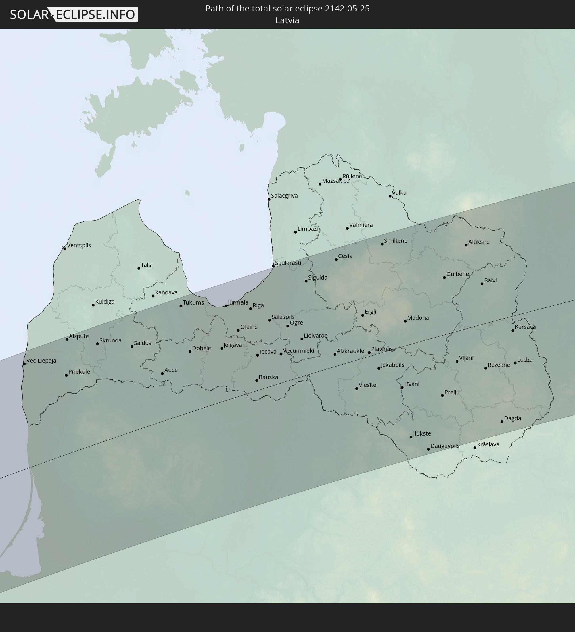 Latvia
 Estonia
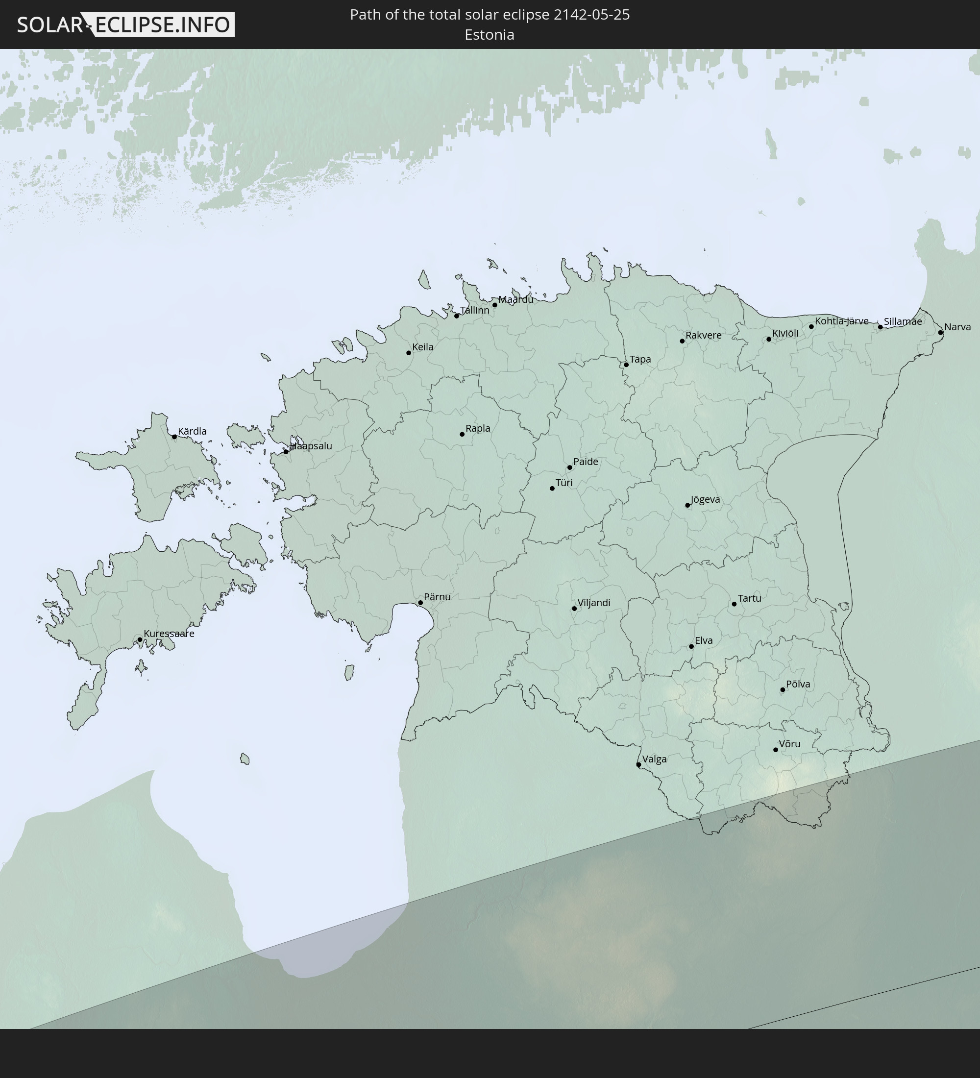
 Belarus
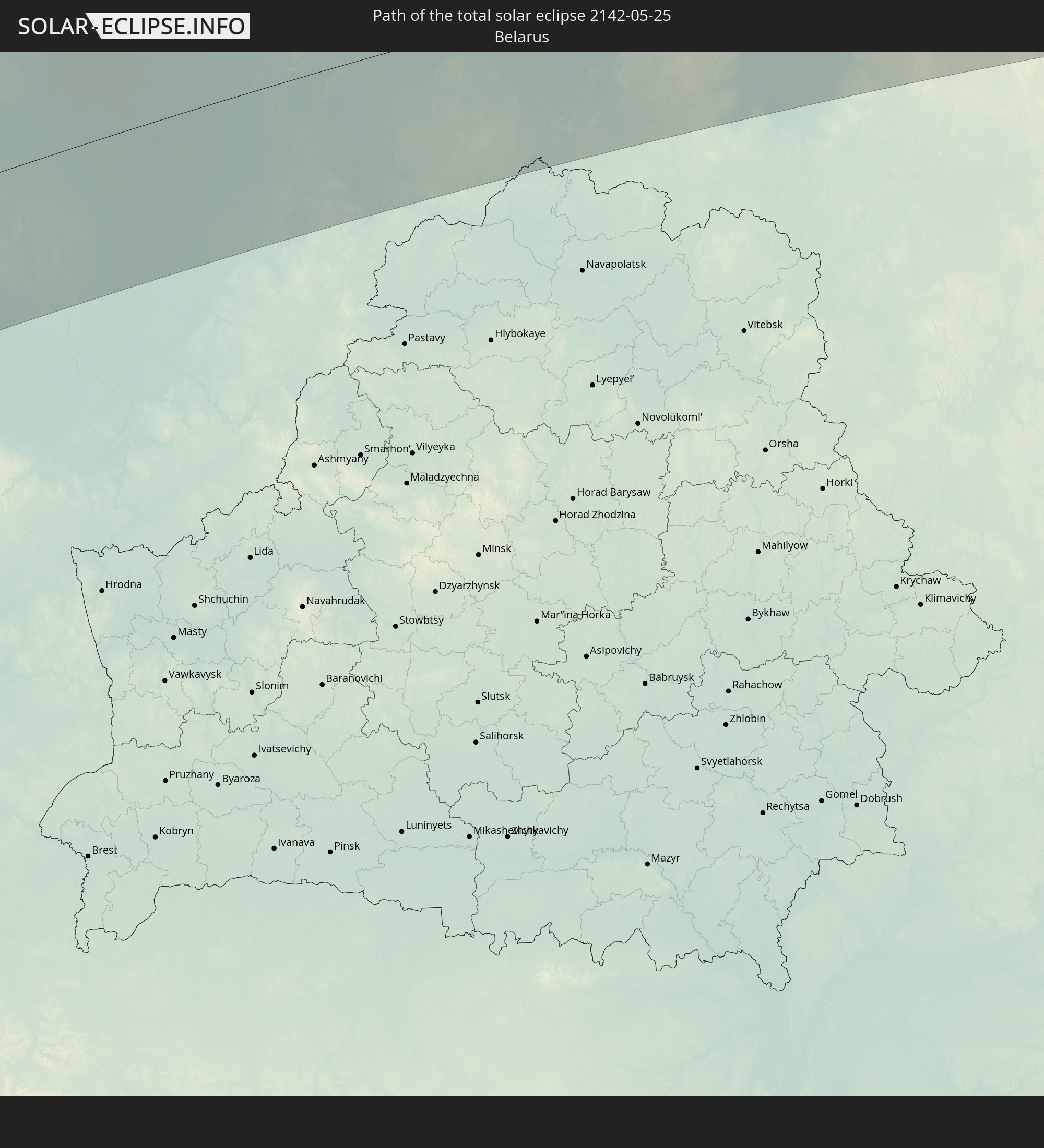
 Kazakhstan
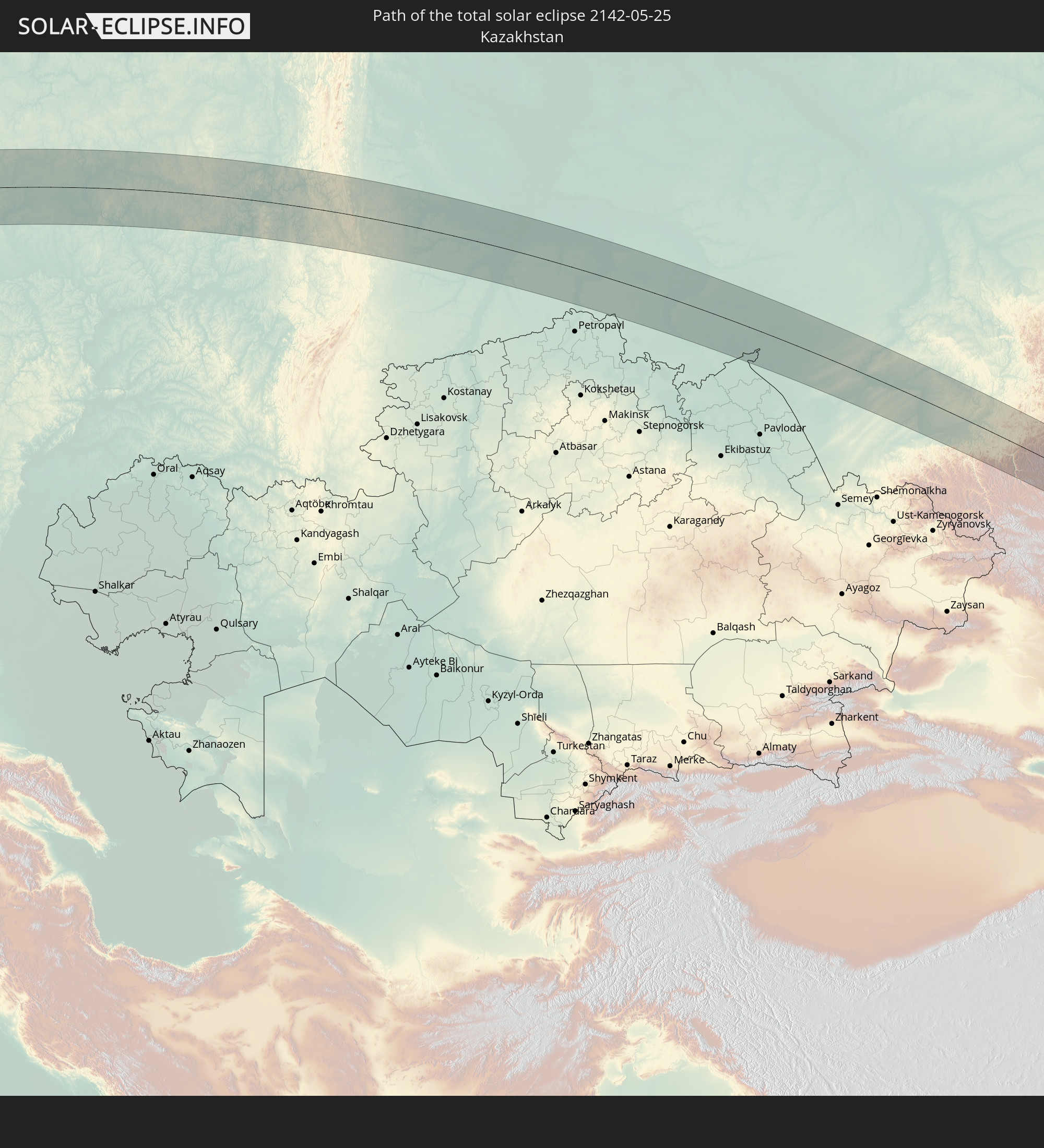
 China
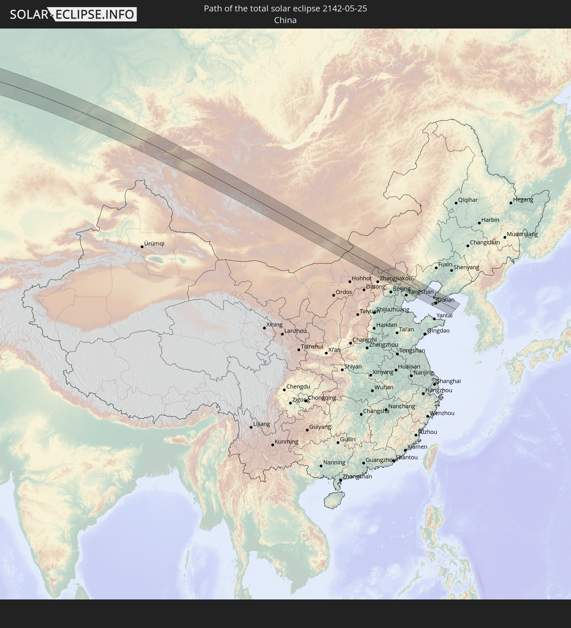
China
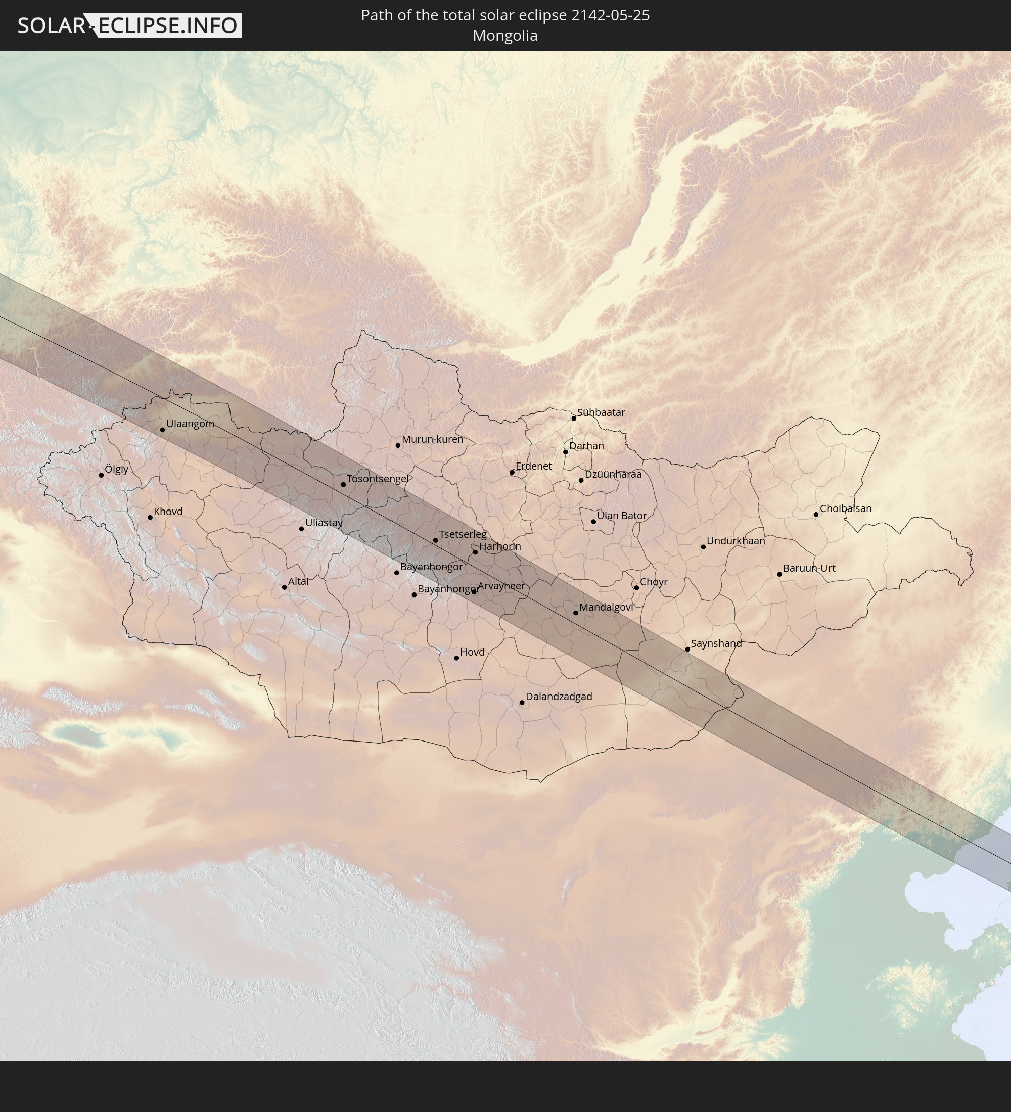 Mongolia
In den folgenden Ländern ist die Sonnenfinsternis partiell zu sehen
 Russia
 United States
 Canada
 Greenland
 Saint Pierre and Miquelon
 Portugal
 Cabo Verde
 Iceland
 Spain
Spain
 Senegal
 Mauritania
 The Gambia
 Guinea-Bissau
 Guinea
 Sierra Leone
 Morocco
 Mali
Mali
 Liberia
 Republic of Ireland
 Svalbard and Jan Mayen
 Algeria
 United Kingdom
 Ivory Coast
 Faroe Islands
 Burkina Faso
 Gibraltar
 France
 Isle of Man
 Ghana
Ghana
 Guernsey
 Jersey
 Togo
Togo
 Niger
Niger
 Benin
Benin
 Andorra
 Belgium
 Nigeria
 Netherlands
 Norway
 Luxembourg
 Germany
 Switzerland
 Italy
Italy
 Monaco
 Tunisia
 Denmark
 Libya
Libya
 Liechtenstein
 Austria
 Sweden
 Czechia
 San Marino
 Vatican City
 Slovenia
 Chad
Chad
 Croatia
 Poland
 Malta
Malta
 Bosnia and Herzegovina
 Hungary
 Slovakia
 Montenegro
 Serbia
 Albania
 Åland Islands
 Greece
 Romania
 Republic of Macedonia
 Finland
 Lithuania
 Latvia
 Estonia
 Sudan
Sudan
 Ukraine
 Bulgaria
 Belarus
 Egypt
Egypt
 Turkey
 Moldova
 Cyprus
 State of Palestine
 Israel
 Saudi Arabia
 Jordan
 Lebanon
 Syria
Syria
 Iraq
Iraq
 Georgia
 Armenia
 Iran
Iran
 Azerbaijan
 Kazakhstan
 Kuwait
 Bahrain
 Qatar
Qatar
 United Arab Emirates
 Oman
Oman
 Turkmenistan
 Uzbekistan
 Afghanistan
 Pakistan
 Tajikistan
 India
India
 Kyrgyzstan
 China
China
 Nepal
Nepal
 Mongolia
 Bangladesh
 Bhutan
 Myanmar
 Thailand
 Laos
Laos
 Vietnam
 Cambodia
 North Korea
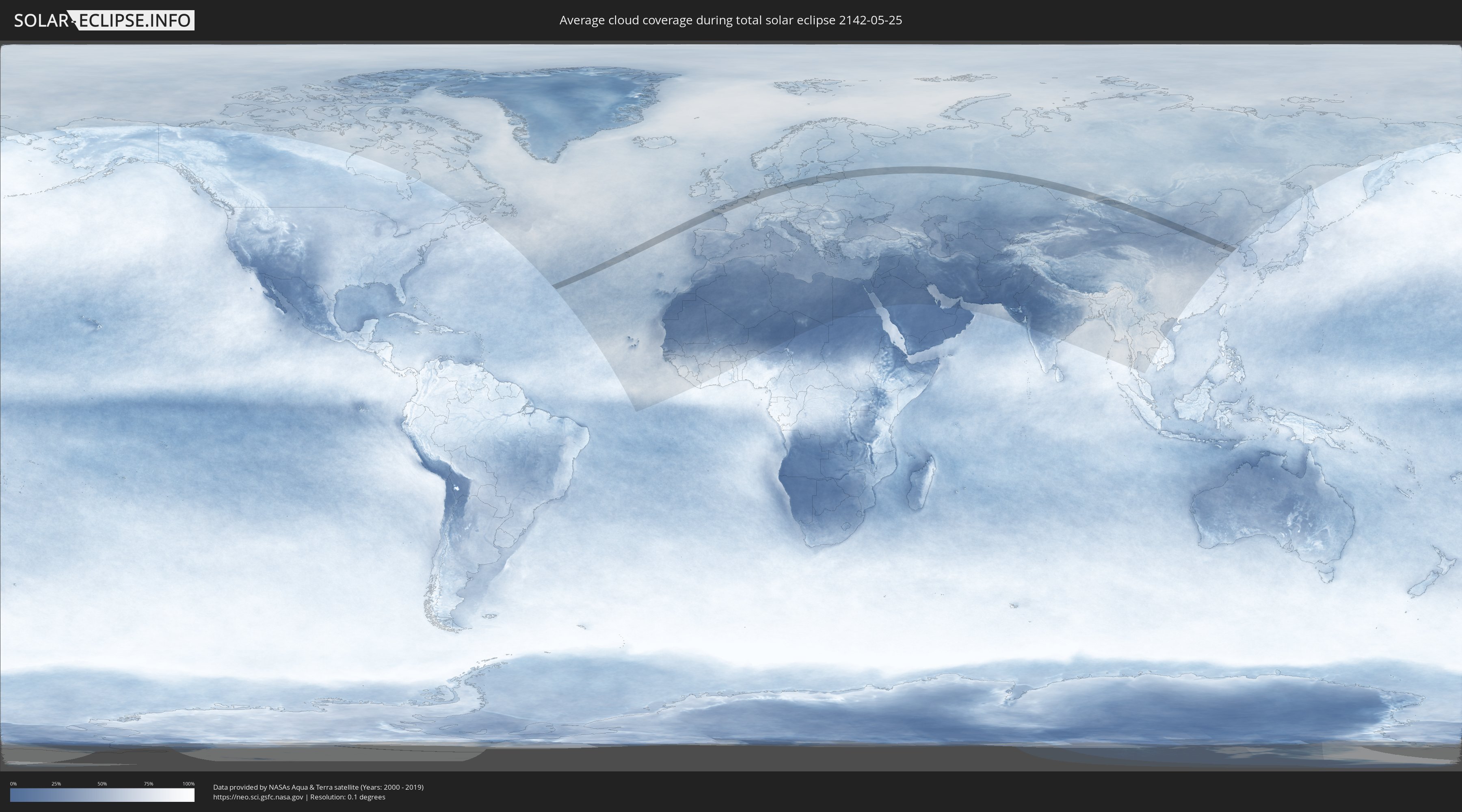
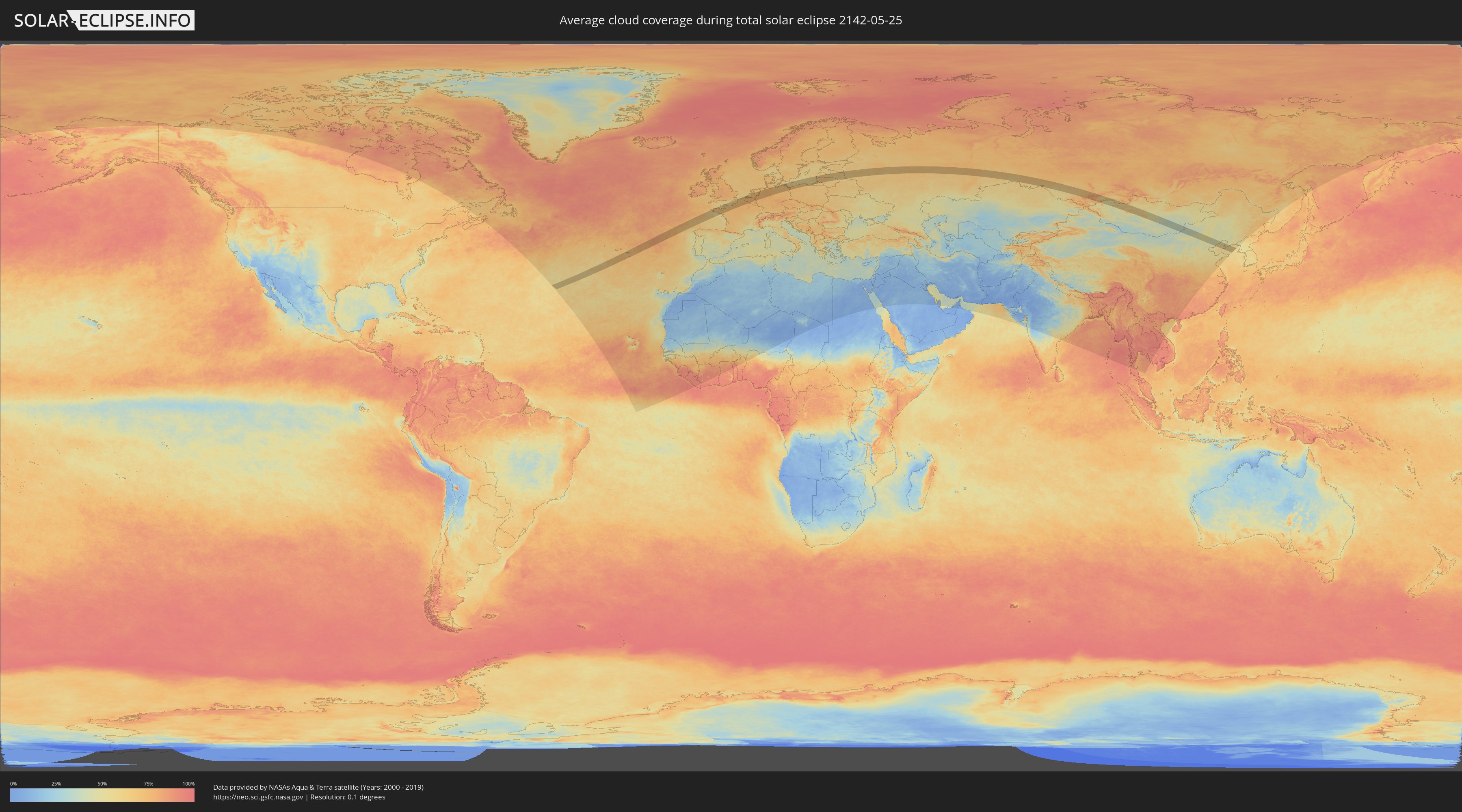
How will be the weather during the total solar eclipse on 05/25/2142?
Where is the best place to see the total solar eclipse of 05/25/2142?
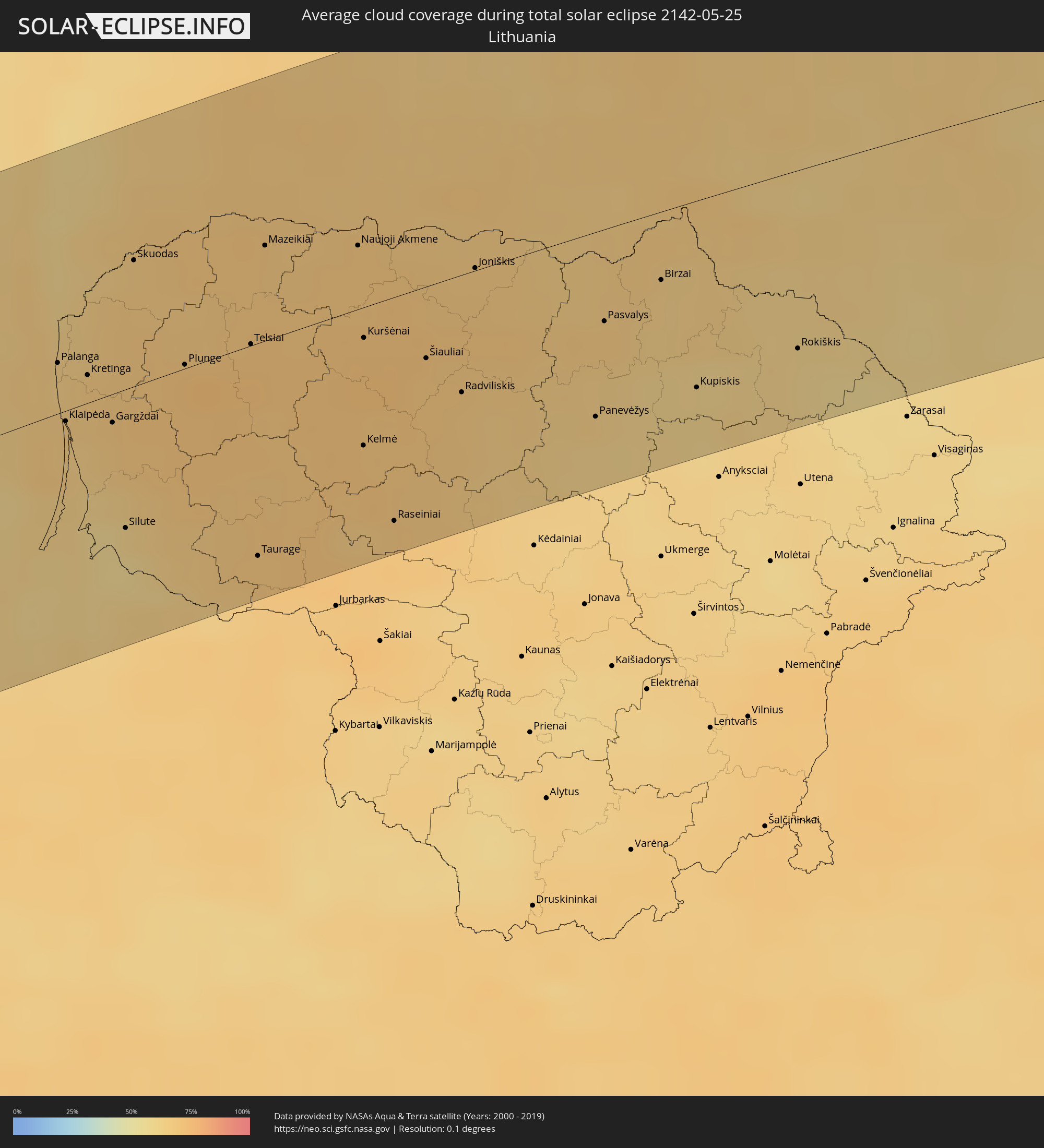
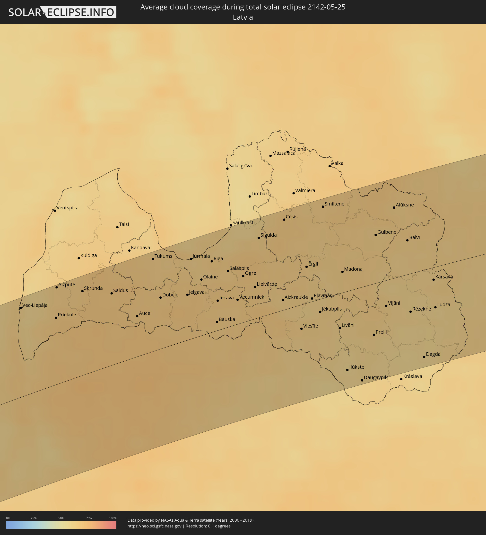
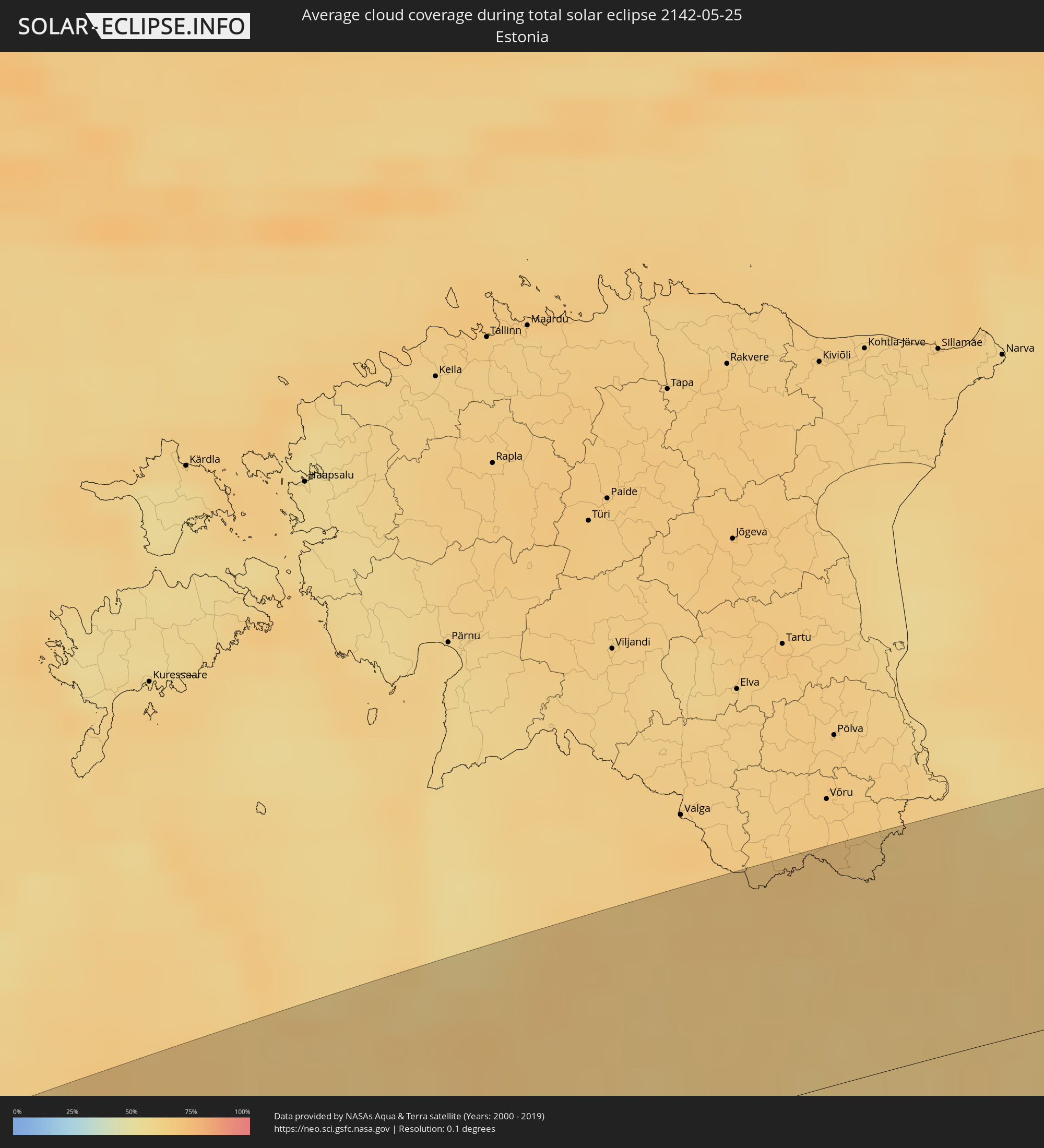
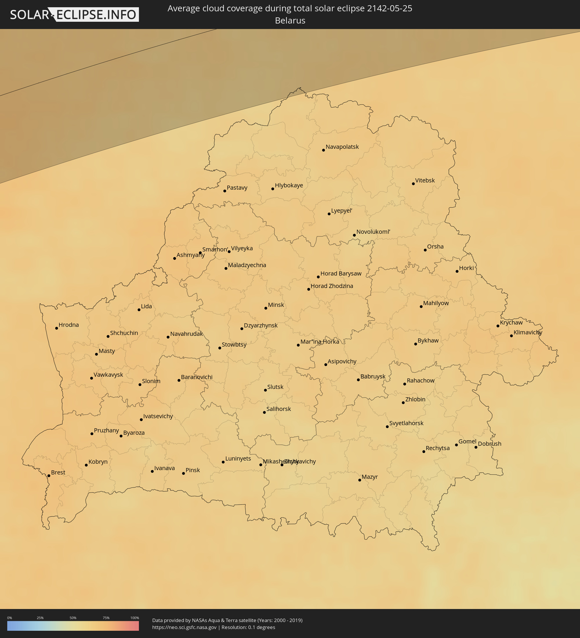
The following maps show the average cloud coverage for the day of the total solar eclipse.
With the help of these maps, it is possible to find the place along the eclipse path, which has the best
chance of a cloudless sky.
Nevertheless, you should consider local circumstances and inform about the weather of your chosen
observation site.
The data is provided by NASAs satellites
AQUA and TERRA.
The cloud maps are averaged over a period of 19 years (2000 - 2019).
Detailed country maps
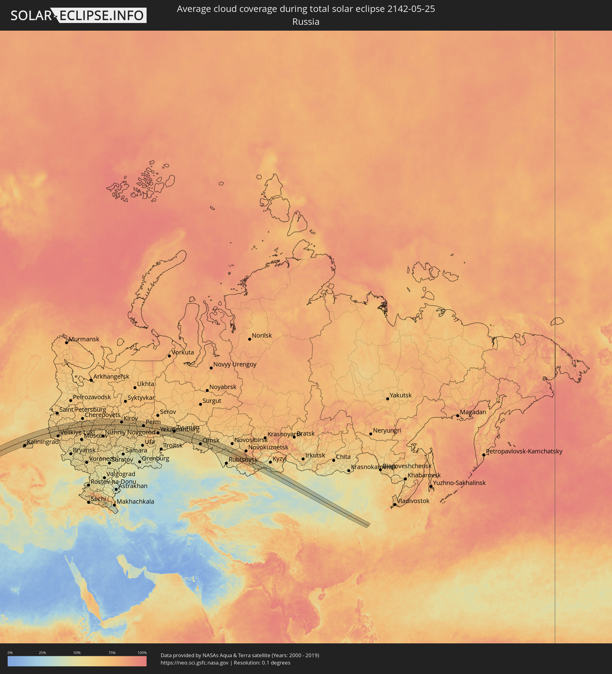 Russia
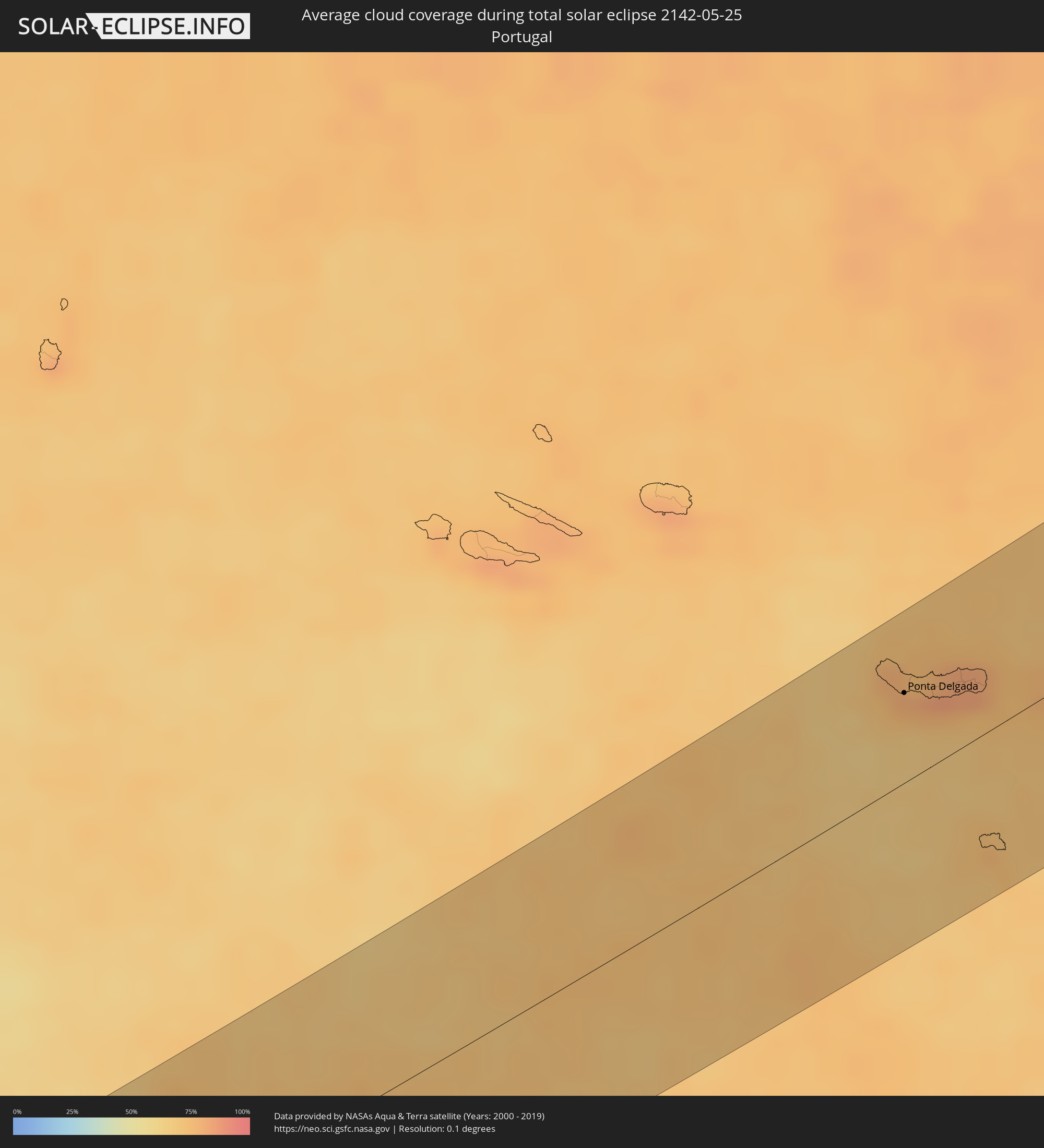 Portugal
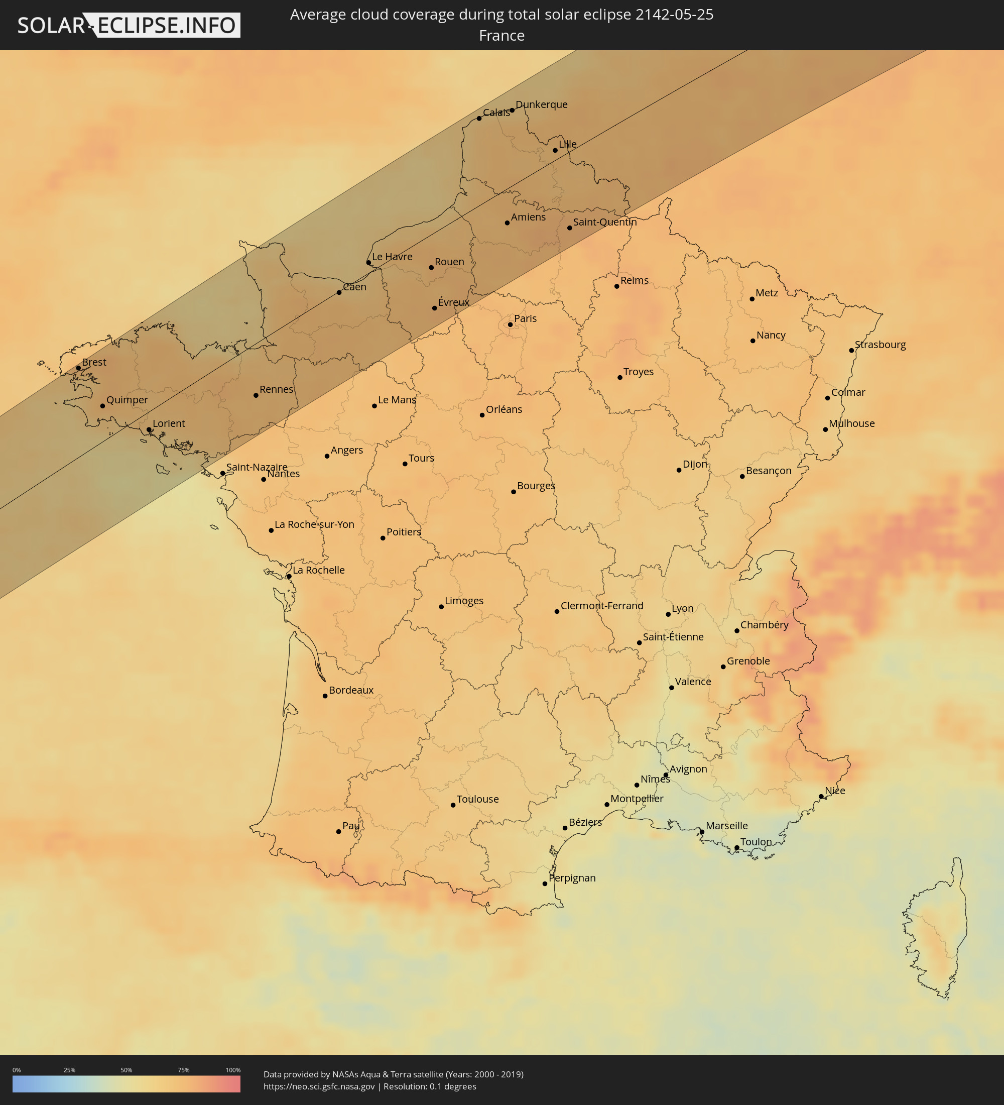 France
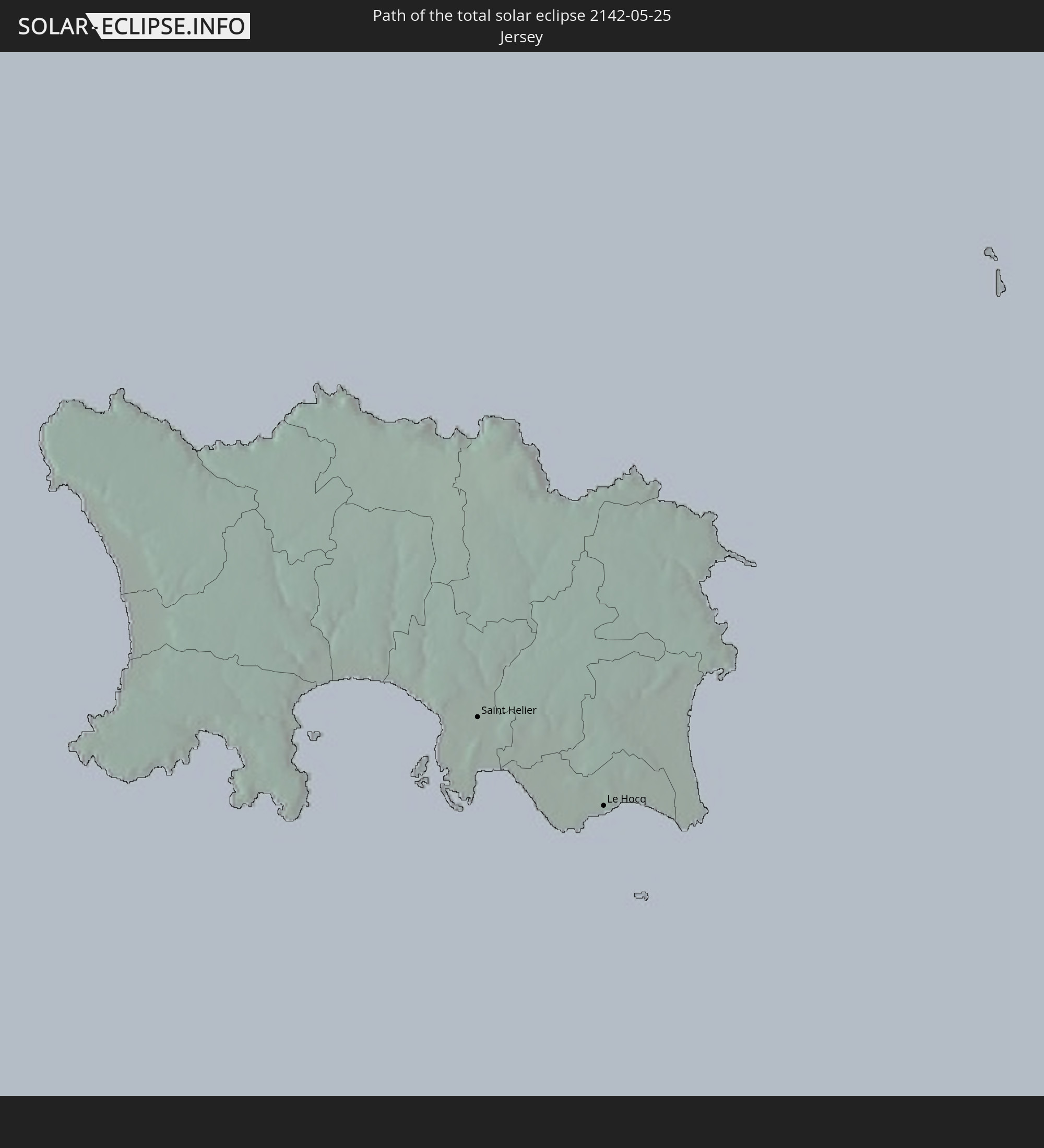
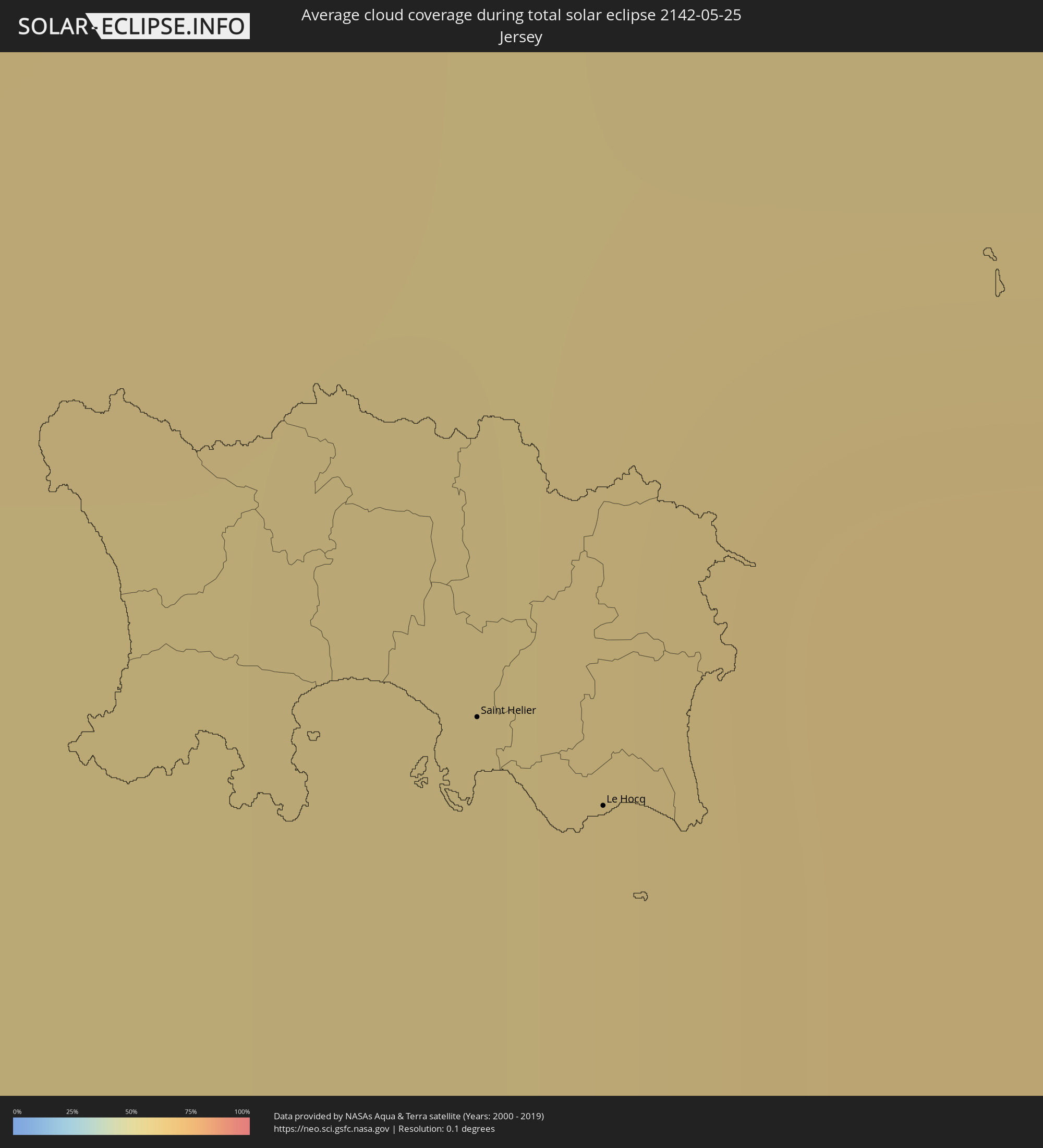 Jersey
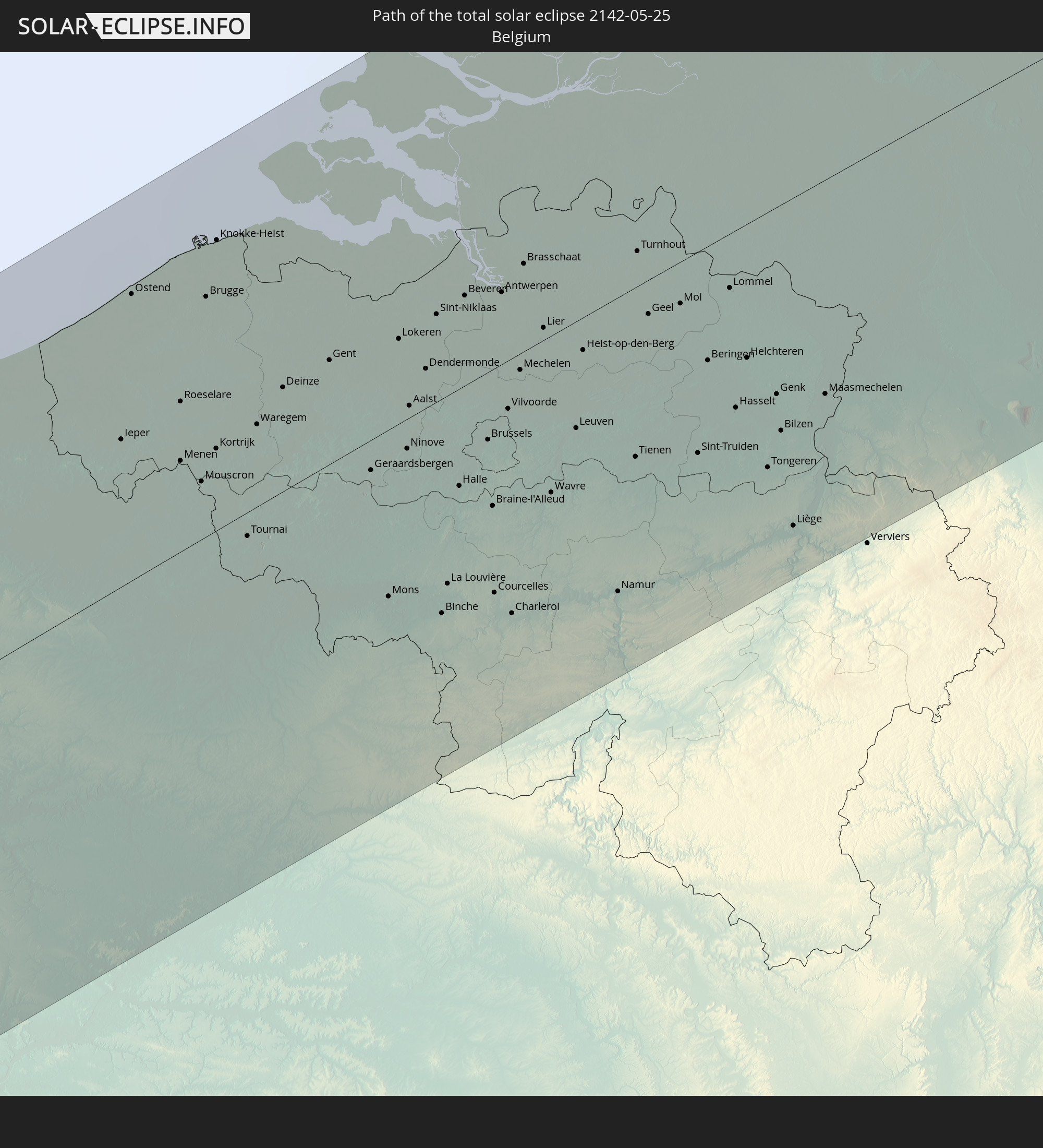
 Belgium
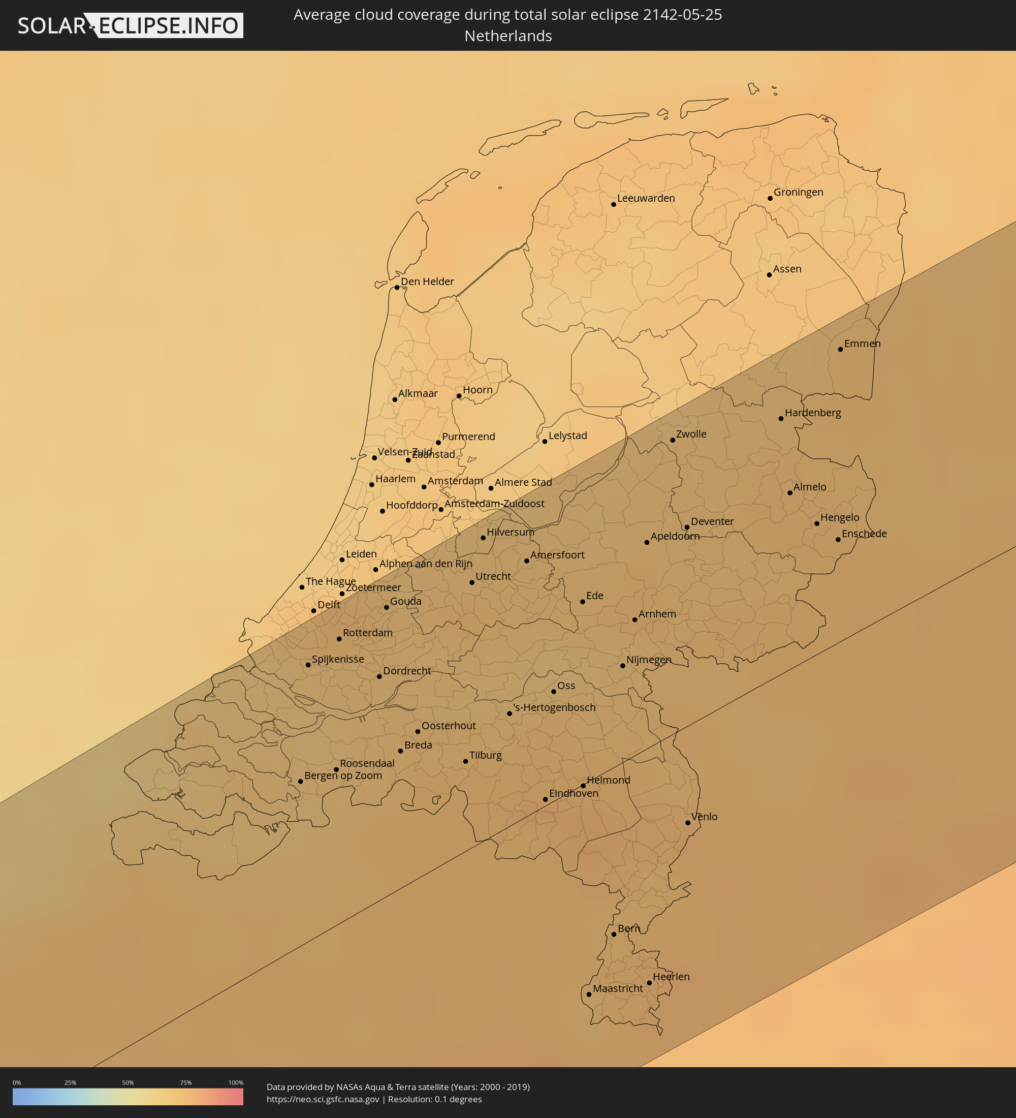 Netherlands
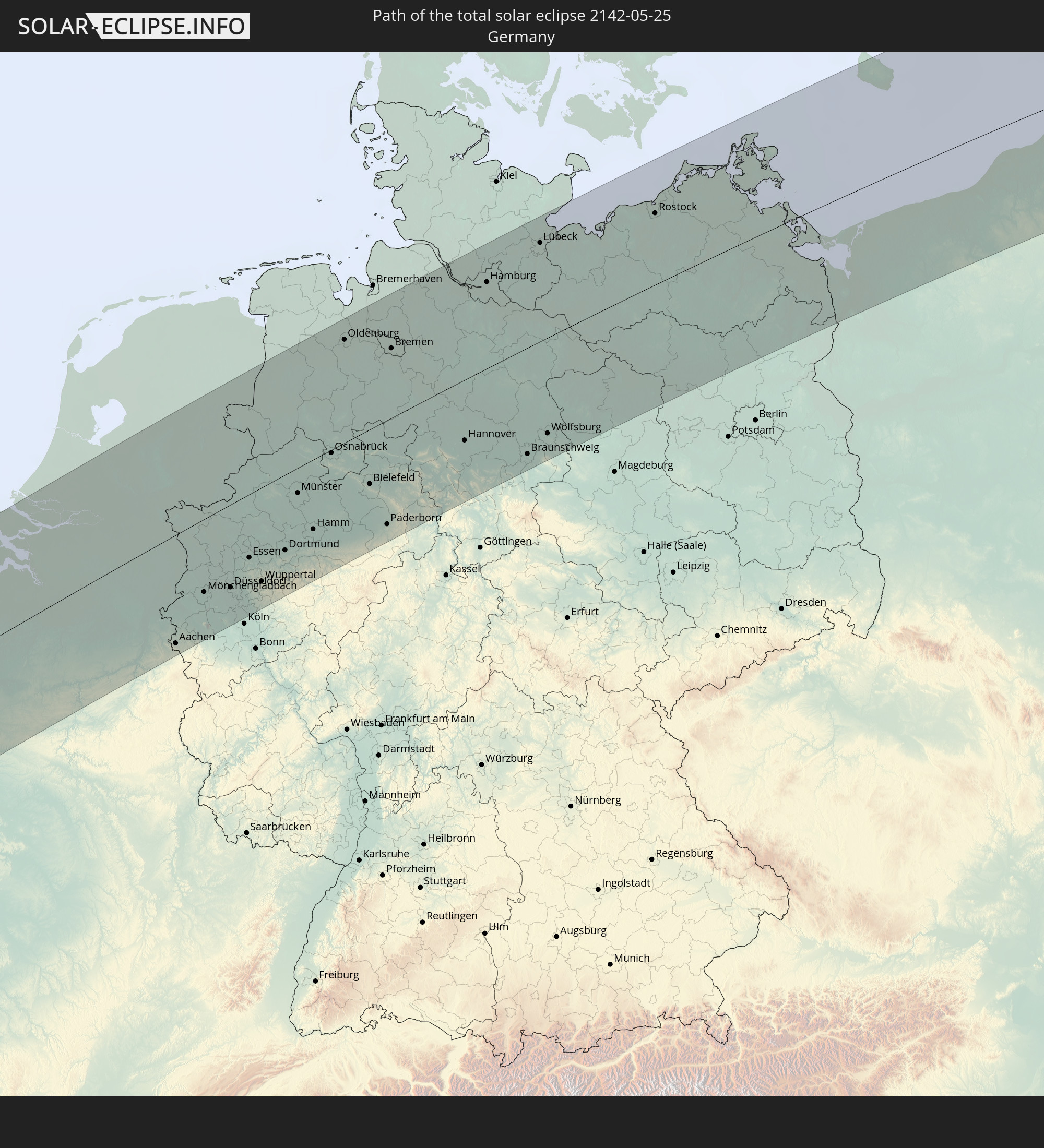
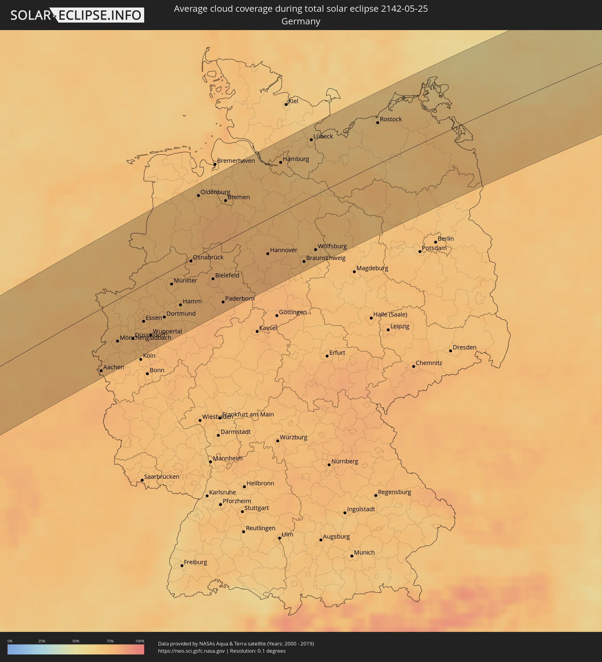 Germany
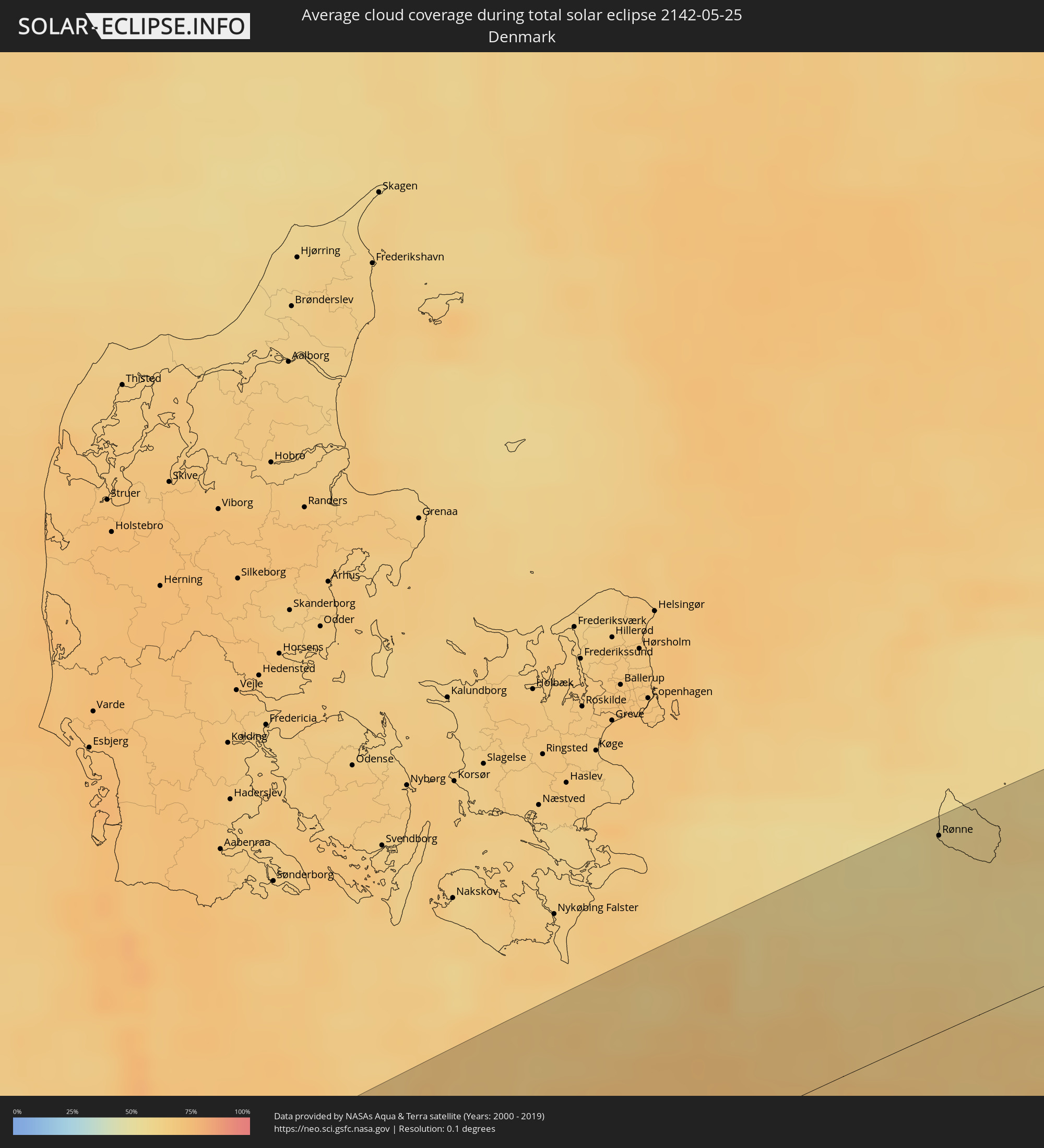 Denmark
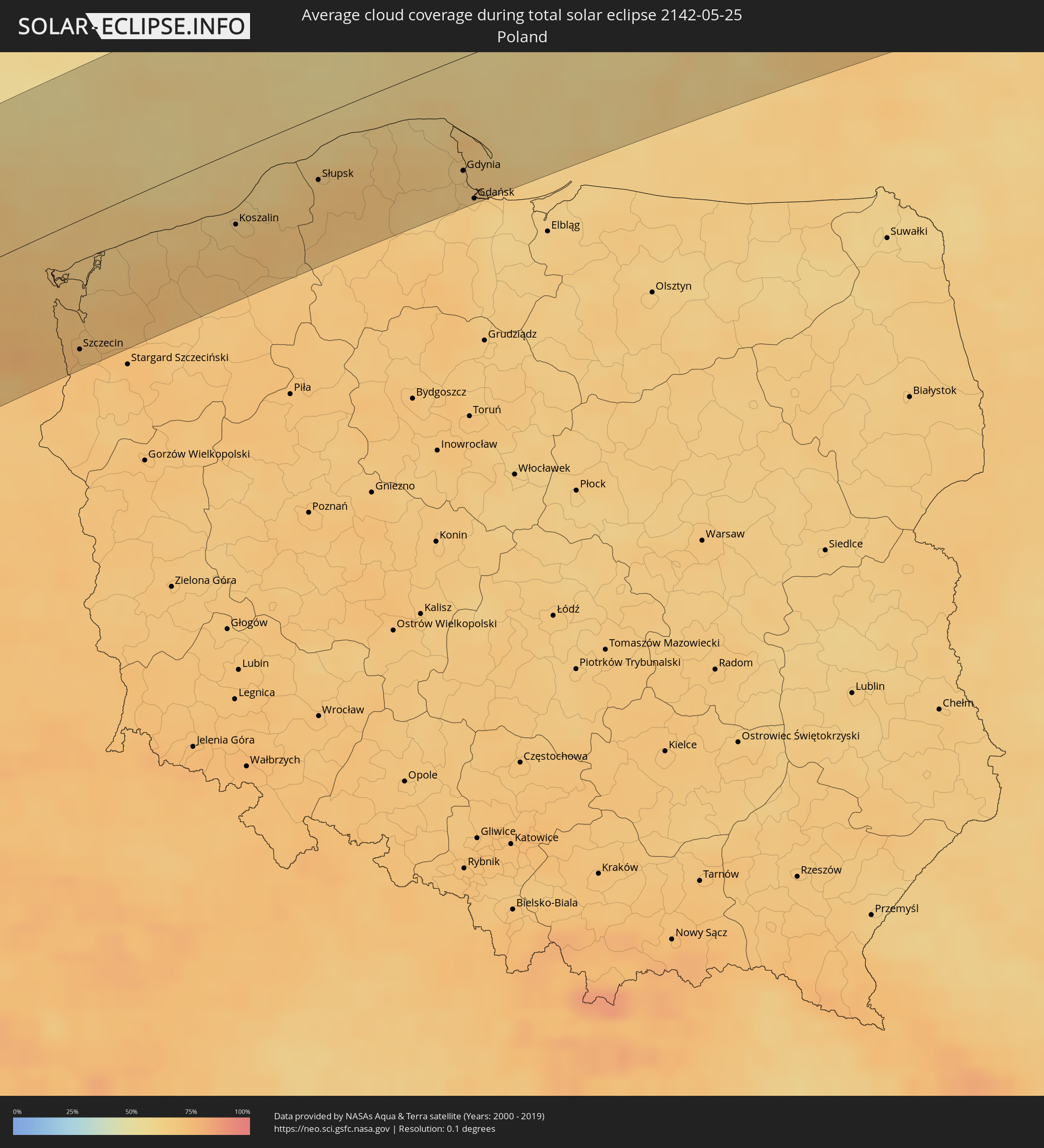 Poland
 Lithuania
 Latvia
 Estonia
 Belarus
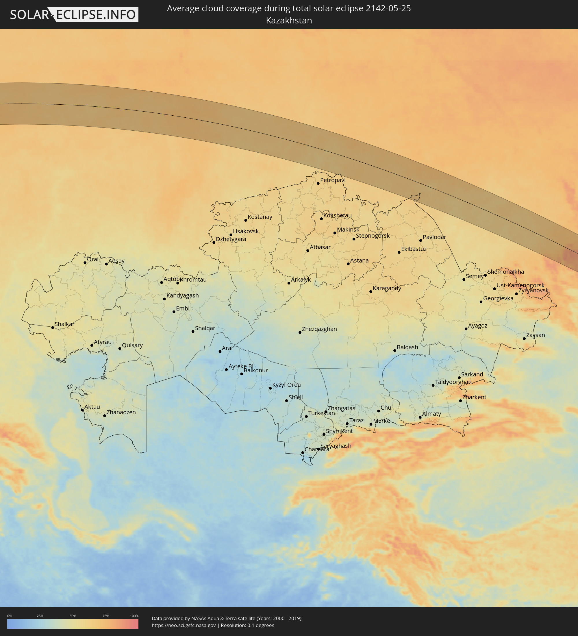 Kazakhstan
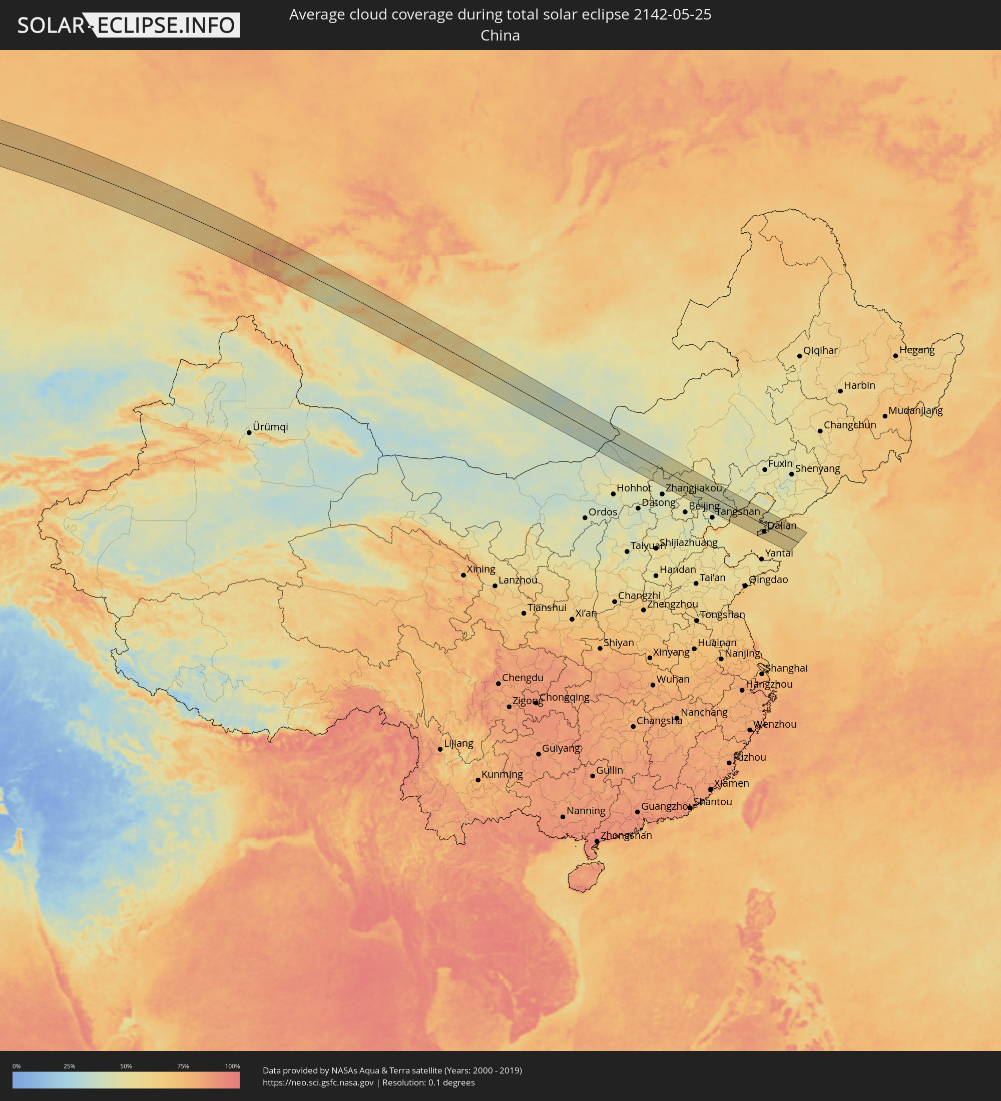 China
China
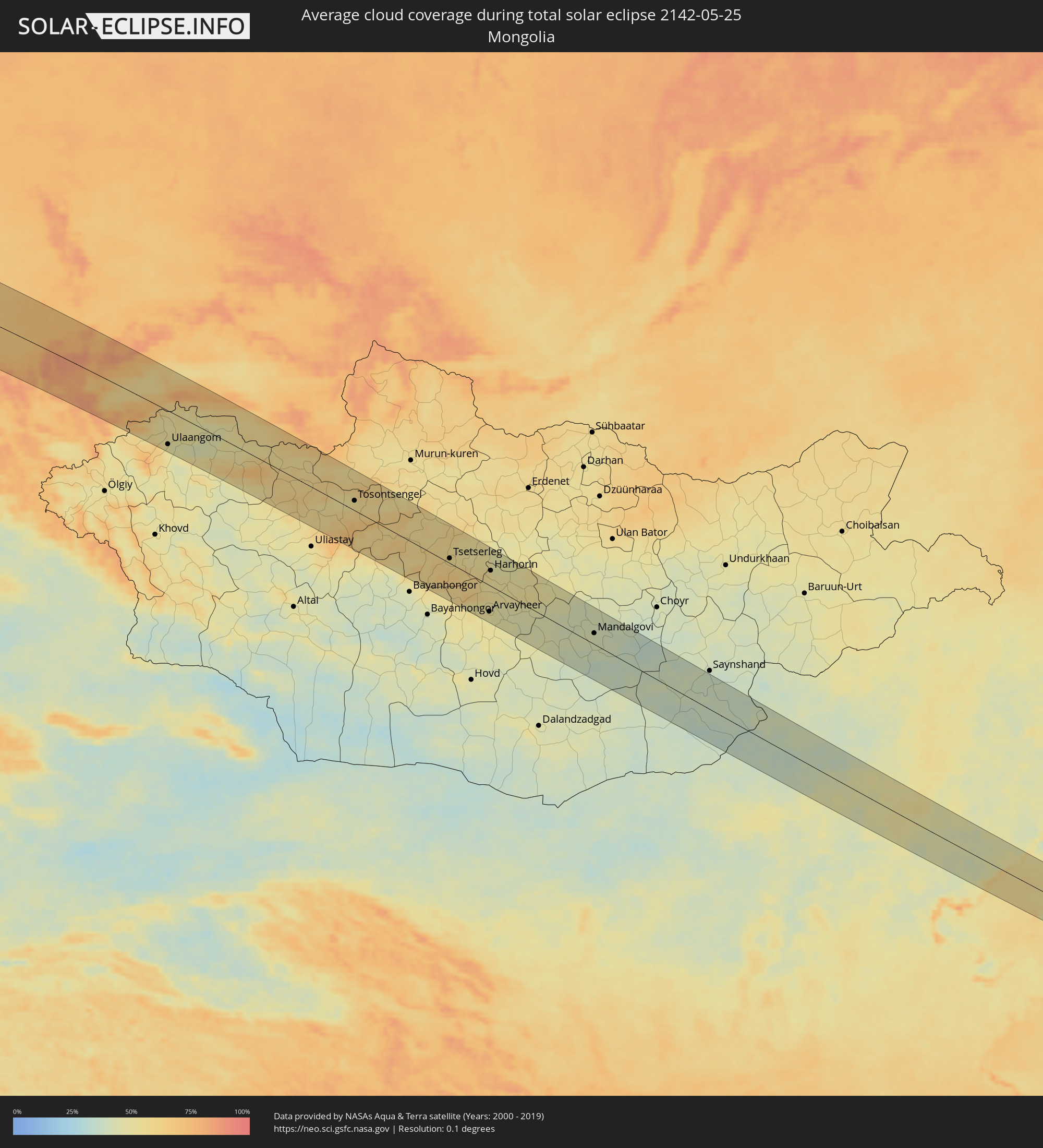 Mongolia
Cities inside the path of the eclipse
The following table shows all locations with a population of more than 5,000 inside the eclipse path. Cities which have more than 100,000 inhabitants are marked bold. A click at the locations opens a detailed map.
| City | Type | Eclipse duration | Local time of max. eclipse | Distance to central line | Ø Cloud coverage |
|
Arrifes, Azores
|
total | - | 07:09:55 UTC-01:00 | 49 km | 79% |
|
Ponta Delgada, Azores
|
total | - | 07:09:52 UTC-01:00 | 45 km | 75% |
|
Rosto de Cão, Azores
|
total | - | 07:09:54 UTC-01:00 | 46 km | 79% |
|
Rabo de Peixe, Azores
|
total | - | 07:09:58 UTC-01:00 | 50 km | 80% |
|
Vila Franca do Campo, Azores
|
total | - | 07:09:52 UTC-01:00 | 40 km | 77% |
|
Brest, Brittany
|
total | - | 09:35:32 UTC+01:00 | 88 km | 71% |
|
Quimper, Brittany
|
total | - | 09:35:09 UTC+01:00 | 37 km | 69% |
|
Lorient, Brittany
|
total | - | 09:35:17 UTC+01:00 | 19 km | 65% |
|
Saint-Brieuc, Brittany
|
total | - | 09:37:01 UTC+01:00 | 29 km | 72% |
|
Vannes, Brittany
|
total | - | 09:35:38 UTC+01:00 | 52 km | 67% |
|
Saint Helier, St Helier
|
total | - | 08:38:40 UTC+00:00 | 67 km | 61% |
|
Le Hocq, St Clement
|
total | - | 08:38:40 UTC+00:00 | 63 km | 61% |
|
Rennes, Brittany
|
total | - | 09:37:14 UTC+01:00 | 52 km | 72% |
|
Caen, Normandy
|
total | - | 09:40:06 UTC+01:00 | 11 km | 72% |
|
Le Havre, Normandy
|
total | - | 09:41:00 UTC+01:00 | 17 km | 65% |
|
Rouen, Normandy
|
total | - | 09:41:47 UTC+01:00 | 35 km | 74% |
|
Évreux, Normandy
|
total | - | 09:41:09 UTC+01:00 | 76 km | 75% |
|
Calais, Hauts-de-France
|
total | - | 09:44:54 UTC+01:00 | 83 km | 67% |
|
Beauvais, Hauts-de-France
|
total | - | 09:42:40 UTC+01:00 | 71 km | 72% |
|
Amiens, Hauts-de-France
|
total | - | 09:43:37 UTC+01:00 | 34 km | 73% |
|
Dunkerque, Hauts-de-France
|
total | - | 09:45:30 UTC+01:00 | 71 km | 70% |
|
Ostend, Flanders
|
total | - | 09:46:18 UTC+01:00 | 69 km | 64% |
|
Lille, Hauts-de-France
|
total | - | 09:45:30 UTC+01:00 | 9 km | 72% |
|
Brugge, Flanders
|
total | - | 09:46:33 UTC+01:00 | 59 km | 69% |
|
Kortrijk, Flanders
|
total | - | 09:46:00 UTC+01:00 | 21 km | 73% |
|
Saint-Quentin, Hauts-de-France
|
total | - | 09:44:28 UTC+01:00 | 75 km | 75% |
|
Gent, Flanders
|
total | - | 09:46:46 UTC+01:00 | 26 km | 74% |
|
Mons, Wallonia
|
total | - | 09:46:04 UTC+01:00 | 43 km | 73% |
|
Aalst, Flanders
|
total | - | 09:46:54 UTC+01:00 | 5 km | 73% |
|
Sint-Niklaas, Flanders
|
total | - | 09:47:22 UTC+01:00 | 27 km | 72% |
|
La Louvière, Wallonia
|
total | - | 09:46:20 UTC+01:00 | 47 km | 73% |
|
Brussels, Brussels Capital
|
total | - | 09:47:04 UTC+01:00 | 25 km | 73% |
|
Antwerpen, Flanders
|
total | - | 09:47:42 UTC+01:00 | 17 km | 72% |
|
Charleroi, Wallonia
|
total | - | 09:46:28 UTC+01:00 | 62 km | 74% |
|
Mechelen, Flanders
|
total | - | 09:47:28 UTC+01:00 | 6 km | 73% |
|
Rotterdam, South Holland
|
total | - | 09:48:52 UTC+01:00 | 83 km | 69% |
|
Dordrecht, South Holland
|
total | - | 09:48:52 UTC+01:00 | 66 km | 70% |
|
Leuven, Flanders
|
total | - | 09:47:27 UTC+01:00 | 26 km | 73% |
|
Breda, North Brabant
|
total | - | 09:48:38 UTC+01:00 | 40 km | 71% |
|
Namur, Wallonia
|
total | - | 09:46:59 UTC+01:00 | 72 km | 76% |
|
Tilburg, North Brabant
|
total | - | 09:48:53 UTC+01:00 | 31 km | 73% |
|
Utrecht, Utrecht
|
total | - | 09:49:44 UTC+01:00 | 78 km | 74% |
|
's-Hertogenbosch, North Brabant
|
total | - | 09:49:19 UTC+01:00 | 33 km | 72% |
|
Hasselt, Flanders
|
total | - | 09:48:10 UTC+01:00 | 43 km | 75% |
|
Amersfoort, Utrecht
|
total | - | 09:50:06 UTC+01:00 | 74 km | 72% |
|
Eindhoven, North Brabant
|
total | - | 09:49:05 UTC+01:00 | 2 km | 75% |
|
Liège, Wallonia
|
total | - | 09:47:56 UTC+01:00 | 80 km | 75% |
|
Maastricht, Limburg
|
total | - | 09:48:23 UTC+01:00 | 66 km | 71% |
|
Born, Limburg
|
total | - | 09:48:48 UTC+01:00 | 50 km | 74% |
|
Nijmegen, Gelderland
|
total | - | 09:50:05 UTC+01:00 | 28 km | 71% |
|
Arnhem, Gelderland
|
total | - | 09:50:21 UTC+01:00 | 42 km | 70% |
|
Apeldoorn, Gelderland
|
total | - | 09:50:45 UTC+01:00 | 60 km | 72% |
|
Heerlen, Limburg
|
total | - | 09:48:44 UTC+01:00 | 70 km | 75% |
|
Aachen, North Rhine-Westphalia
|
total | - | 09:48:41 UTC+01:00 | 84 km | 74% |
|
Zwolle, Overijssel
|
total | - | 09:51:20 UTC+01:00 | 86 km | 71% |
|
Mönchengladbach, North Rhine-Westphalia
|
total | - | 09:49:40 UTC+01:00 | 56 km | 74% |
|
Krefeld, North Rhine-Westphalia
|
total | - | 09:50:03 UTC+01:00 | 49 km | 73% |
|
Duisburg, North Rhine-Westphalia
|
total | - | 09:50:23 UTC+01:00 | 43 km | 74% |
|
Düsseldorf, North Rhine-Westphalia
|
total | - | 09:50:04 UTC+01:00 | 65 km | 73% |
|
Enschede, Overijssel
|
total | - | 09:51:42 UTC+01:00 | 31 km | 74% |
|
Essen, North Rhine-Westphalia
|
total | - | 09:50:40 UTC+01:00 | 50 km | 74% |
|
Wuppertal, North Rhine-Westphalia
|
total | - | 09:50:33 UTC+01:00 | 73 km | 77% |
|
Dortmund, North Rhine-Westphalia
|
total | - | 09:51:14 UTC+01:00 | 58 km | 74% |
|
Hagen, North Rhine-Westphalia
|
total | - | 09:51:01 UTC+01:00 | 73 km | 76% |
|
Münster, North Rhine-Westphalia
|
total | - | 09:52:04 UTC+01:00 | 19 km | 74% |
|
Bielefeld, North Rhine-Westphalia
|
total | - | 09:53:08 UTC+01:00 | 46 km | 76% |
|
Bremen, Bremen
|
total | - | 09:54:56 UTC+01:00 | 54 km | 75% |
|
Hannover, Lower Saxony
|
total | - | 09:54:55 UTC+01:00 | 46 km | 76% |
|
Hamburg, Hamburg
|
total | - | 09:56:56 UTC+01:00 | 65 km | 73% |
|
Braunschweig, Lower Saxony
|
total | - | 09:55:39 UTC+01:00 | 81 km | 74% |
|
Lübeck, Schleswig-Holstein
|
total | - | 09:58:04 UTC+01:00 | 75 km | 68% |
|
Świnoujście, West Pomeranian Voivodeship
|
total | - | 10:02:07 UTC+01:00 | 24 km | 70% |
|
Szczecin, West Pomeranian Voivodeship
|
total | - | 10:01:52 UTC+01:00 | 81 km | 72% |
|
Rønne, Capital Region
|
total | - | 10:04:09 UTC+01:00 | 87 km | 57% |
|
Goleniów, West Pomeranian Voivodeship
|
total | - | 10:02:22 UTC+01:00 | 75 km | 72% |
|
Nowogard, West Pomeranian Voivodeship
|
total | - | 10:02:51 UTC+01:00 | 72 km | 73% |
|
Gryfice, West Pomeranian Voivodeship
|
total | - | 10:03:15 UTC+01:00 | 49 km | 71% |
|
Kołobrzeg, West Pomeranian Voivodeship
|
total | - | 10:04:01 UTC+01:00 | 33 km | 65% |
|
Świdwin, West Pomeranian Voivodeship
|
total | - | 10:03:46 UTC+01:00 | 79 km | 70% |
|
Białogard, West Pomeranian Voivodeship
|
total | - | 10:04:18 UTC+01:00 | 60 km | 70% |
|
Koszalin, West Pomeranian Voivodeship
|
total | - | 10:04:45 UTC+01:00 | 46 km | 67% |
|
Ustka, Pomeranian Voivodeship
|
total | - | 10:06:02 UTC+01:00 | 28 km | 64% |
|
Słupsk, Pomeranian Voivodeship
|
total | - | 10:06:06 UTC+01:00 | 42 km | 68% |
|
Bytów, Pomeranian Voivodeship
|
total | - | 10:06:19 UTC+01:00 | 81 km | 70% |
|
Lębork, Pomeranian Voivodeship
|
total | - | 10:07:04 UTC+01:00 | 49 km | 70% |
|
Wejherowo, Pomeranian Voivodeship
|
total | - | 10:07:44 UTC+01:00 | 55 km | 67% |
|
Gdynia, Pomeranian Voivodeship
|
total | - | 10:08:00 UTC+01:00 | 71 km | 65% |
|
Gdańsk, Pomeranian Voivodeship
|
total | - | 10:07:58 UTC+01:00 | 91 km | 66% |
|
Vec-Liepāja, Liepāja
|
total | - | 11:13:09 UTC+02:00 | 84 km | 60% |
|
Palanga, Klaipėda County
|
total | - | 11:12:37 UTC+02:00 | 21 km | 64% |
|
Klaipėda, Klaipėda County
|
total | - | 11:12:29 UTC+02:00 | 7 km | 66% |
|
Kretinga, Klaipėda County
|
total | - | 11:12:48 UTC+02:00 | 16 km | 67% |
|
Gargždai, Klaipėda County
|
total | - | 11:12:50 UTC+02:00 | 14 km | 66% |
|
Silute, Klaipėda County
|
total | - | 11:12:34 UTC+02:00 | 52 km | 58% |
|
Plunge, Telšiai County
|
total | - | 11:13:34 UTC+02:00 | 10 km | 70% |
|
Telsiai, Telšiai County
|
total | - | 11:14:08 UTC+02:00 | 16 km | 70% |
|
Taurage, Tauragė County
|
total | - | 11:13:30 UTC+02:00 | 78 km | 69% |
|
Mazeikiai, Telšiai County
|
total | - | 11:14:33 UTC+02:00 | 34 km | 69% |
|
Saldus, Saldus Rajons
|
total | - | 11:15:04 UTC+02:00 | 68 km | 67% |
|
Kuršėnai, Šiauliai County
|
total | - | 11:15:01 UTC+02:00 | 14 km | 71% |
|
Raseiniai, Kaunas County
|
total | - | 11:14:41 UTC+02:00 | 82 km | 68% |
|
Tukums, Tukuma Rajons
|
total | - | 11:16:09 UTC+02:00 | 87 km | 64% |
|
Dobele, Dobeles Rajons
|
total | - | 11:16:00 UTC+02:00 | 48 km | 67% |
|
Šiauliai, Šiauliai County
|
total | - | 11:15:26 UTC+02:00 | 29 km | 68% |
|
Radviliskis, Šiauliai County
|
total | - | 11:15:37 UTC+02:00 | 44 km | 67% |
|
Jelgava, Jelgava
|
total | - | 11:16:34 UTC+02:00 | 43 km | 67% |
|
Jūrmala, Jūrmala
|
total | - | 11:16:54 UTC+02:00 | 76 km | 62% |
|
Olaine, Olaine
|
total | - | 11:16:57 UTC+02:00 | 54 km | 66% |
|
Riga, Riga
|
total | - | 11:17:18 UTC+02:00 | 67 km | 65% |
|
Bauska, Bauskas Rajons
|
total | - | 11:16:57 UTC+02:00 | 17 km | 65% |
|
Panevėžys, Panevėžys
|
total | - | 11:16:36 UTC+02:00 | 67 km | 62% |
|
Salaspils, Salaspils
|
total | - | 11:17:33 UTC+02:00 | 53 km | 64% |
|
Ogre, Ogre
|
total | - | 11:17:49 UTC+02:00 | 45 km | 66% |
|
Birzai, Panevėžys
|
total | - | 11:17:30 UTC+02:00 | 26 km | 64% |
|
Cēsis, Cēsu Rajons
|
total | - | 11:19:02 UTC+02:00 | 85 km | 66% |
|
Rokiškis, Panevėžys
|
total | - | 11:18:23 UTC+02:00 | 66 km | 60% |
|
Jēkabpils, Jēkabpils Municipality
|
total | - | 11:19:09 UTC+02:00 | 18 km | 63% |
|
Daugavpils, Daugavpils municipality
|
total | - | 11:19:34 UTC+02:00 | 90 km | 60% |
|
Rēzekne, Rēzekne
|
total | - | 11:21:02 UTC+02:00 | 38 km | 62% |
|
Ludza, Ludzas Rajons
|
total | - | 11:21:35 UTC+02:00 | 39 km | 62% |
|
Pskov, Pskov
|
total | - | 12:23:12 UTC+03:00 | 90 km | 61% |
|
Rybinsk, Jaroslavl
|
total | - | 12:36:40 UTC+03:00 | 10 km | 66% |
|
Yaroslavl, Jaroslavl
|
total | - | 12:37:59 UTC+03:00 | 49 km | 69% |
|
Kostroma, Kostroma
|
total | - | 12:39:21 UTC+03:00 | 40 km | 65% |
|
Kineshma, Ivanovo
|
total | - | 12:40:57 UTC+03:00 | 80 km | 66% |
|
Kirov, Kirov
|
total | - | 12:50:05 UTC+03:00 | 45 km | 68% |
|
Glazov, Udmurtiya
|
total | - | 13:53:54 UTC+04:00 | 10 km | 67% |
|
Perm, Perm
|
total | - | 14:58:09 UTC+05:00 | 19 km | 69% |
|
Pervoural’sk, Sverdlovsk
|
total | - | 15:03:16 UTC+05:00 | 75 km | 71% |
|
Nizhniy Tagil, Sverdlovsk
|
total | - | 15:02:20 UTC+05:00 | 38 km | 71% |
|
Novoural’sk, Sverdlovsk
|
total | - | 15:03:06 UTC+05:00 | 38 km | 70% |
|
Yekaterinburg, Sverdlovsk
|
total | - | 15:04:03 UTC+05:00 | 74 km | 72% |
|
Tyumen, Tyumenskaya
|
total | - | 15:08:53 UTC+05:00 | 24 km | 66% |
|
Omsk, Omsk
|
total | - | 16:18:52 UTC+06:00 | 68 km | 66% |
|
Barnaul, Altai Krai
|
total | - | 17:28:51 UTC+07:00 | 21 km | 65% |
|
Biysk, Altai Krai
|
total | - | 17:30:56 UTC+07:00 | 28 km | 62% |
|
Ulaangom, Uvs
|
total | - | 17:38:07 UTC+07:00 | 71 km | 50% |
|
Tosontsengel, Dzabkhan
|
total | - | 17:41:52 UTC+07:00 | 24 km | 53% |
|
Tsetserleg, Arhangay
|
total | - | 18:44:19 UTC+08:00 | 14 km | 56% |
|
Arvayheer, Övörhangay
|
total | - | 18:46:12 UTC+08:00 | 58 km | 49% |
|
Kharkhorin, Övörhangay
|
total | - | 18:44:54 UTC+08:00 | 33 km | 56% |
|
Harhorin, Övörhangay
|
total | - | 18:44:53 UTC+08:00 | 34 km | 56% |
|
Mandalgovi, Middle Govĭ
|
total | - | 18:47:06 UTC+08:00 | 27 km | 42% |
|
Erenhot, Inner Mongolia
|
total | - | 18:49:33 UTC+08:00 | 47 km | 41% |
|
Chengde, Hebei
|
total | - | 18:51:35 UTC+08:00 | 18 km | 44% |
|
Songling, Hebei
|
total | - | 18:52:15 UTC+08:00 | 35 km | 43% |
|
Changli, Hebei
|
total | - | 18:52:38 UTC+08:00 | 57 km | 50% |
|
Beidaihehaibin, Hebei
|
total | - | 18:52:23 UTC+08:00 | 36 km | 62% |
|
Qinhuangdao, Hebei
|
total | - | 18:52:15 UTC+08:00 | 25 km | 61% |
|
Shanhaiguan, Hebei
|
total | - | 18:52:07 UTC+08:00 | 23 km | 53% |
|
Lüshun, Liaoning
|
total | - | 18:52:54 UTC+08:00 | 61 km | 60% |
|
Dalian, Liaoning
|
total | - | 18:52:39 UTC+08:00 | 42 km | 58% |
|
Dalianwan, Liaoning
|
total | - | 18:52:30 UTC+08:00 | 28 km | 60% |
|
Jinzhou, Liaoning
|
total | - | 18:52:25 UTC+08:00 | 25 km | 54% |
|
Pulandian, Liaoning
|
total | - | 18:52:01 UTC+08:00 | 30 km | 51% |
|
Wafangdian, Liaoning
|
total | - | 18:51:45 UTC+08:00 | 49 km | 51% |