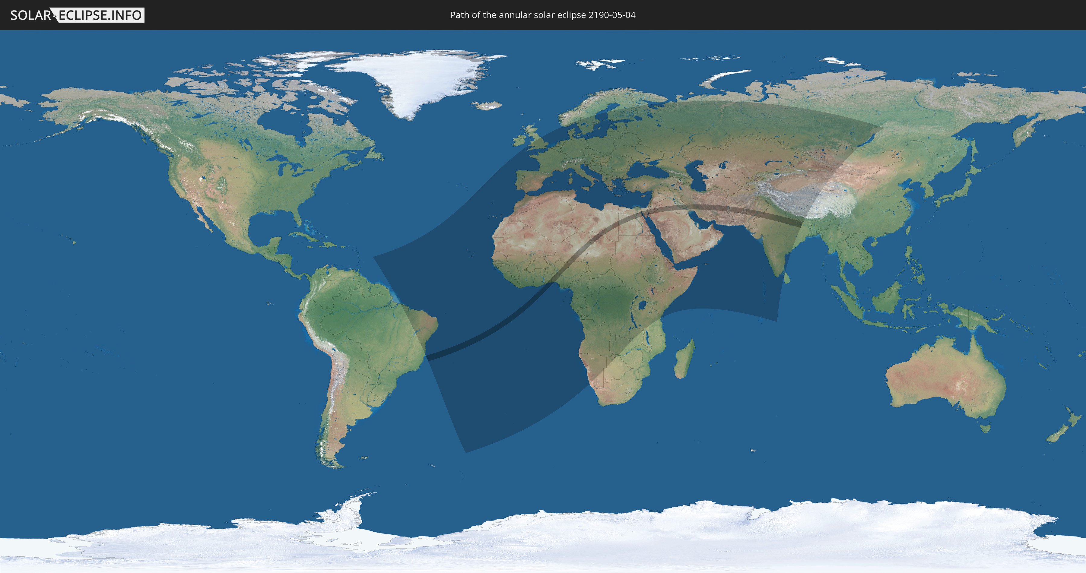
Annular solar eclipse of 05/04/2190
| Day of week: | Tuesday |
| Maximum duration of eclipse: | 04m45s |
| Maximum width of eclipse path: | 154 km |
| Saros cycle: | 141 |
| Coverage: | 95.8% |
| Magnitude: | 0.9577 |
| Gamma: | 0.0608 |
Wo kann man die Sonnenfinsternis vom 05/04/2190 sehen?
Die Sonnenfinsternis am 05/04/2190 kann man in 124 Ländern als partielle Sonnenfinsternis beobachten.
Der Finsternispfad verläuft durch 17 Länder. Nur in diesen Ländern ist sie als annular Sonnenfinsternis zu sehen.
In den folgenden Ländern ist die Sonnenfinsternis annular zu sehen
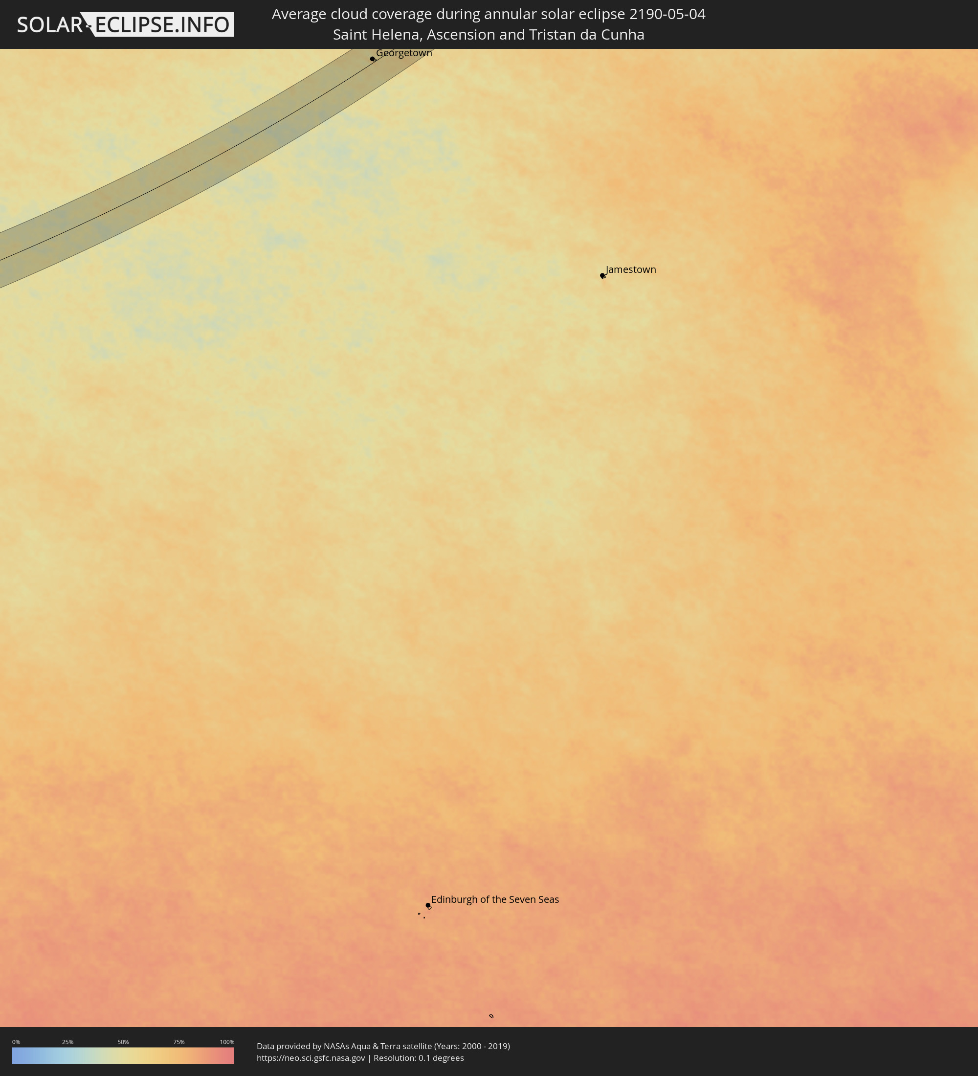
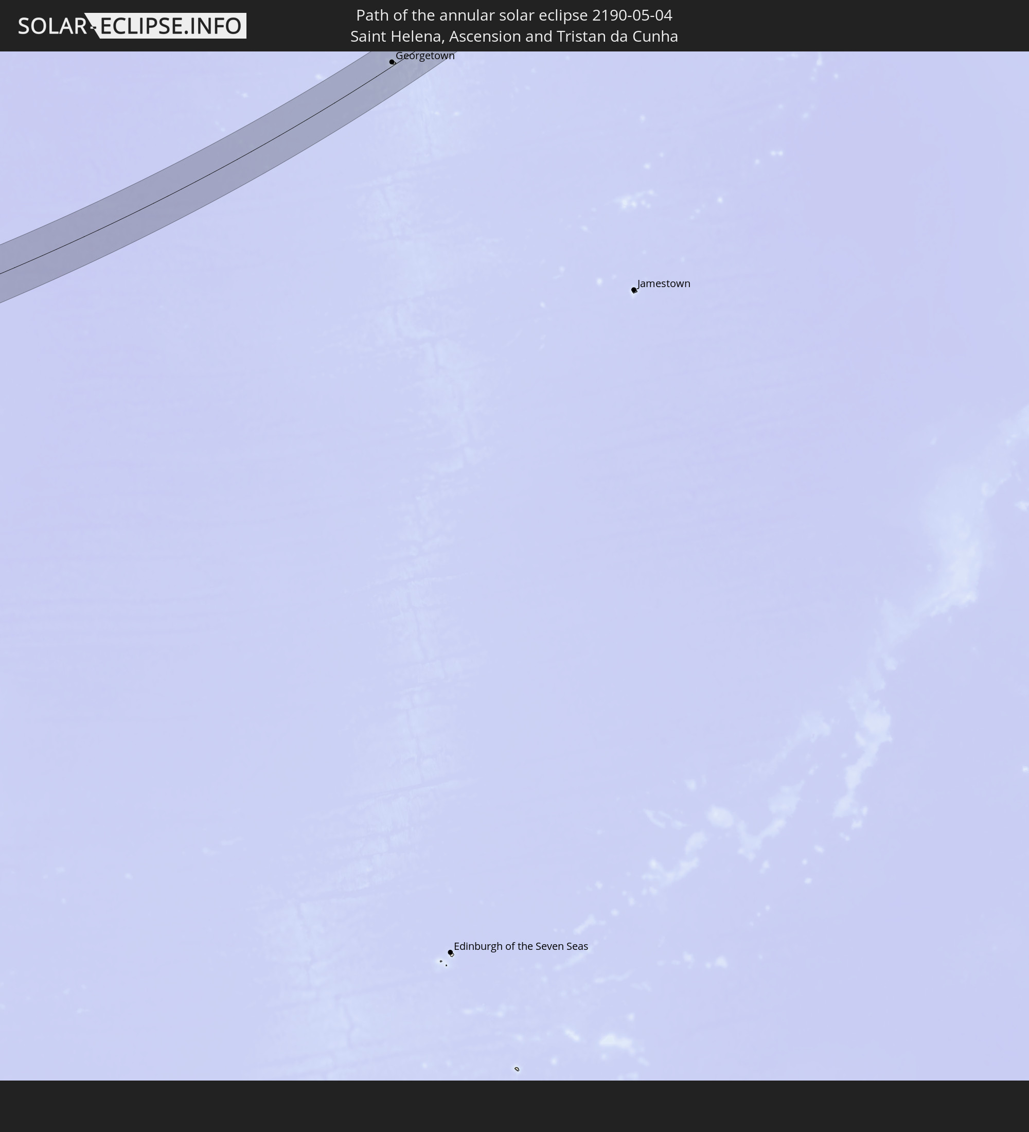 Saint Helena, Ascension and Tristan da Cunha
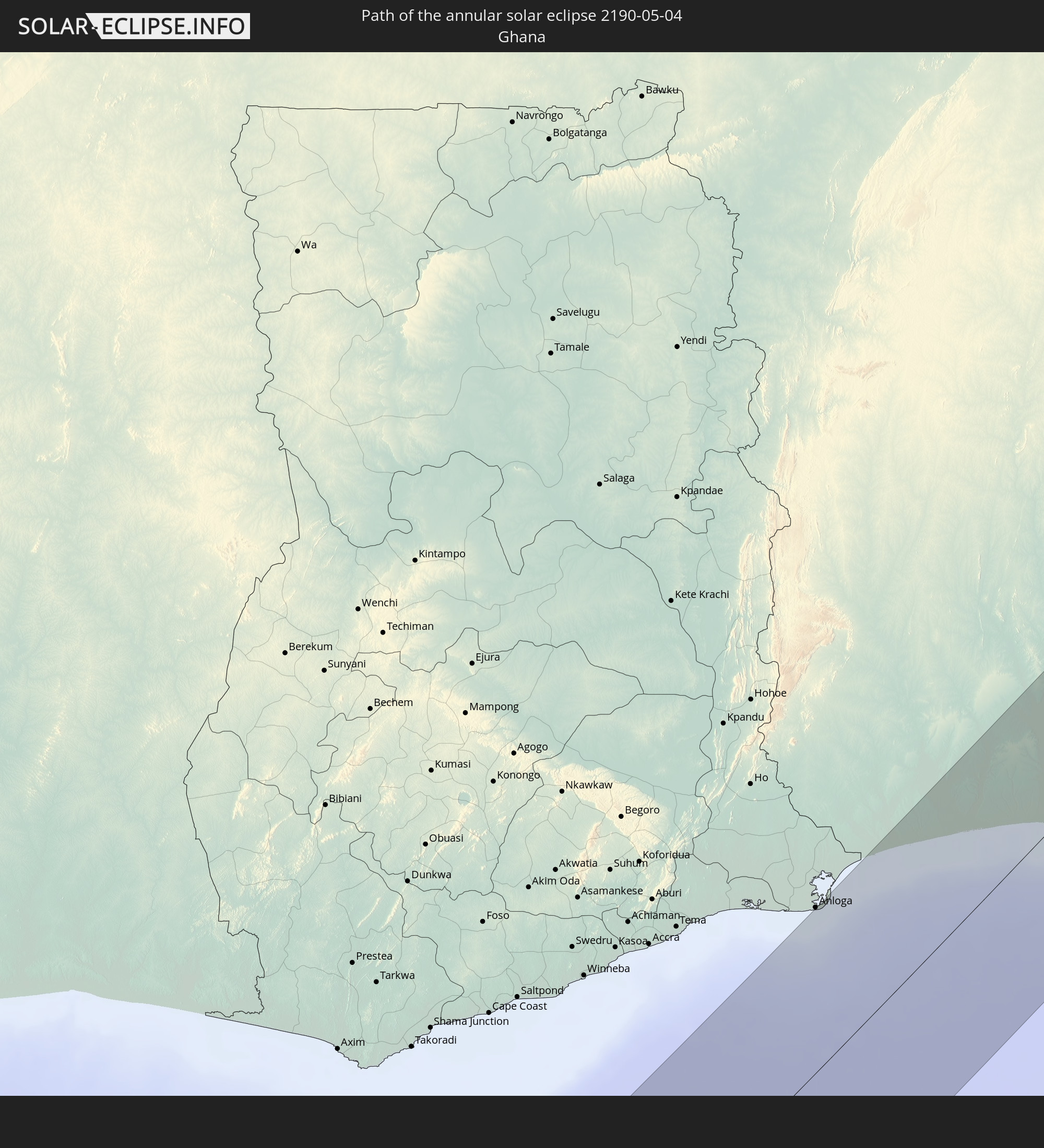 Ghana
Ghana
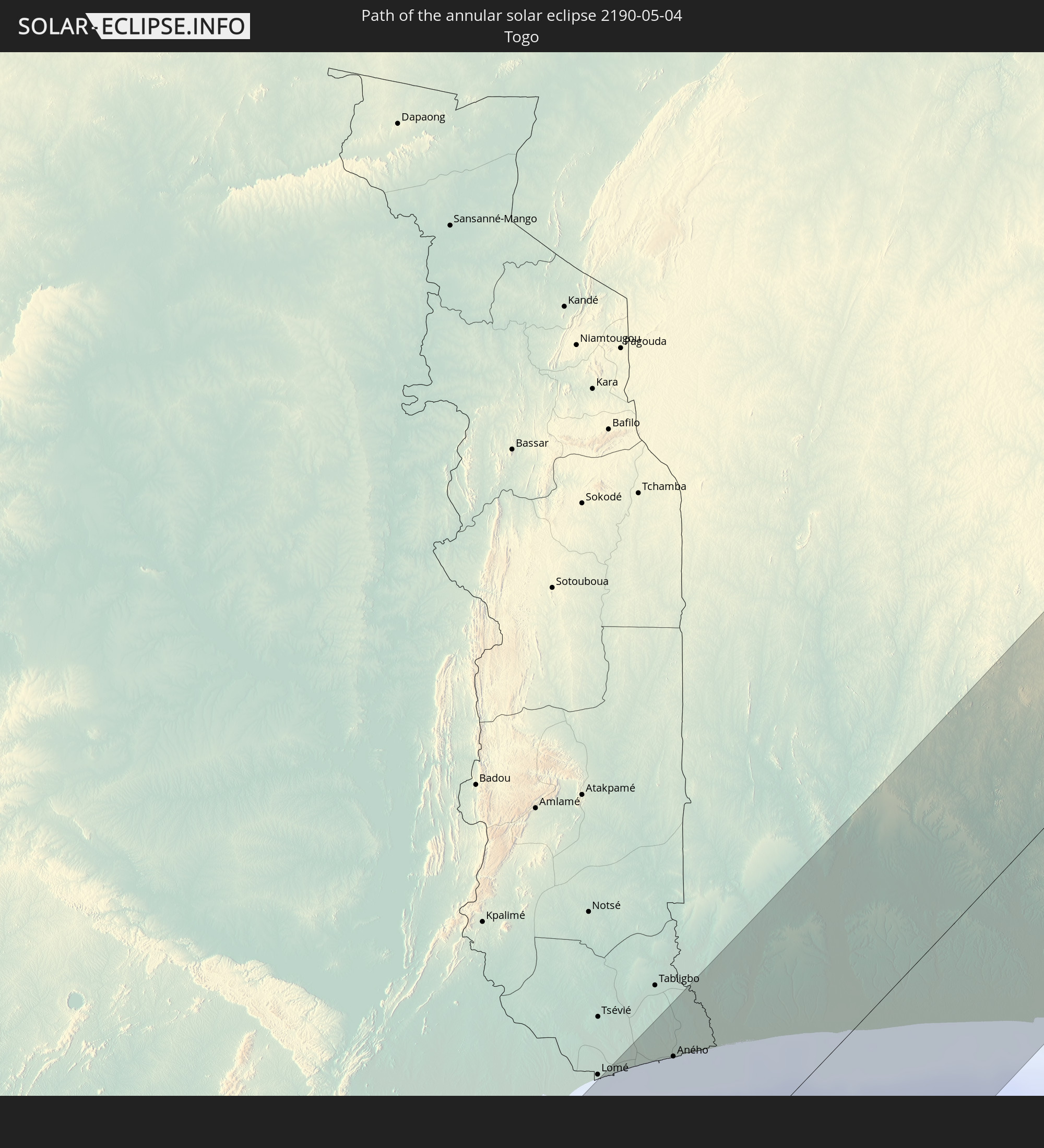 Togo
Togo
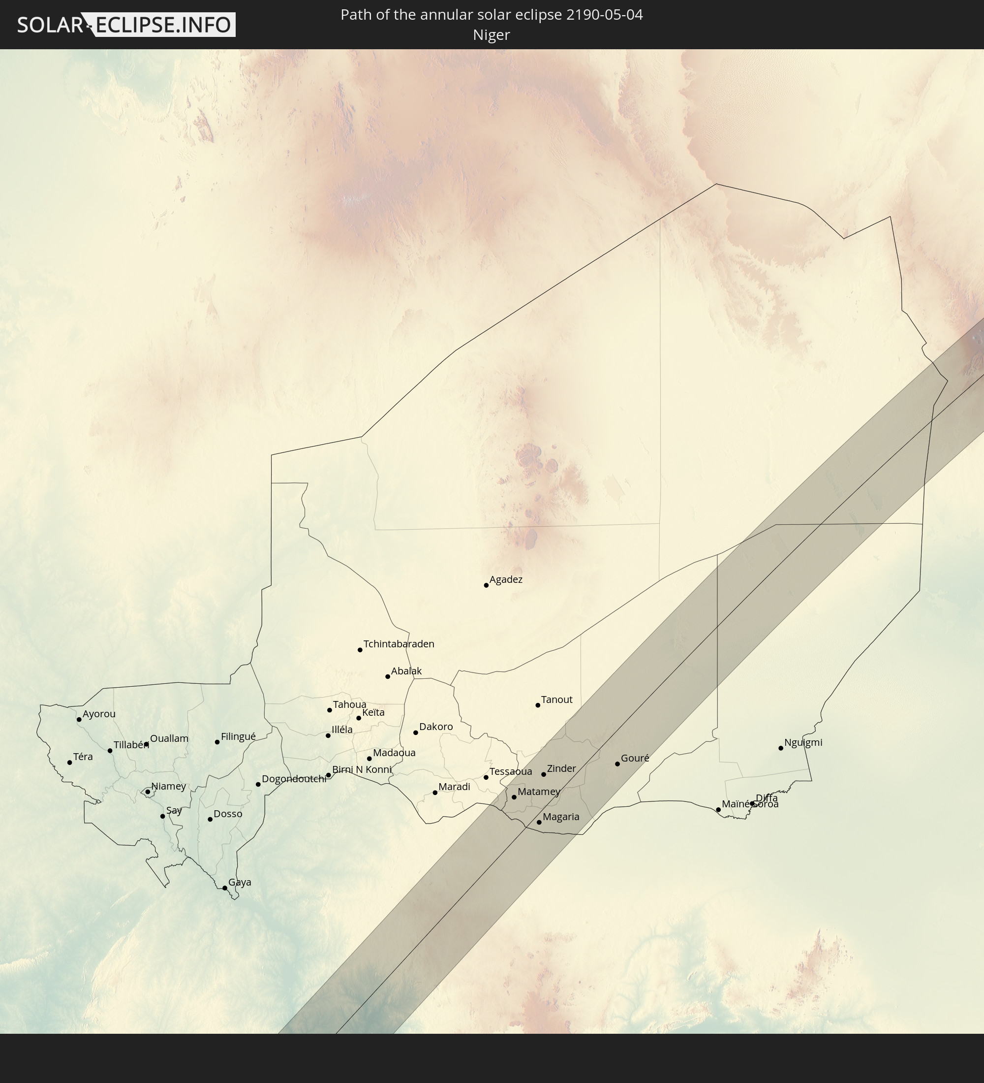 Niger
Niger
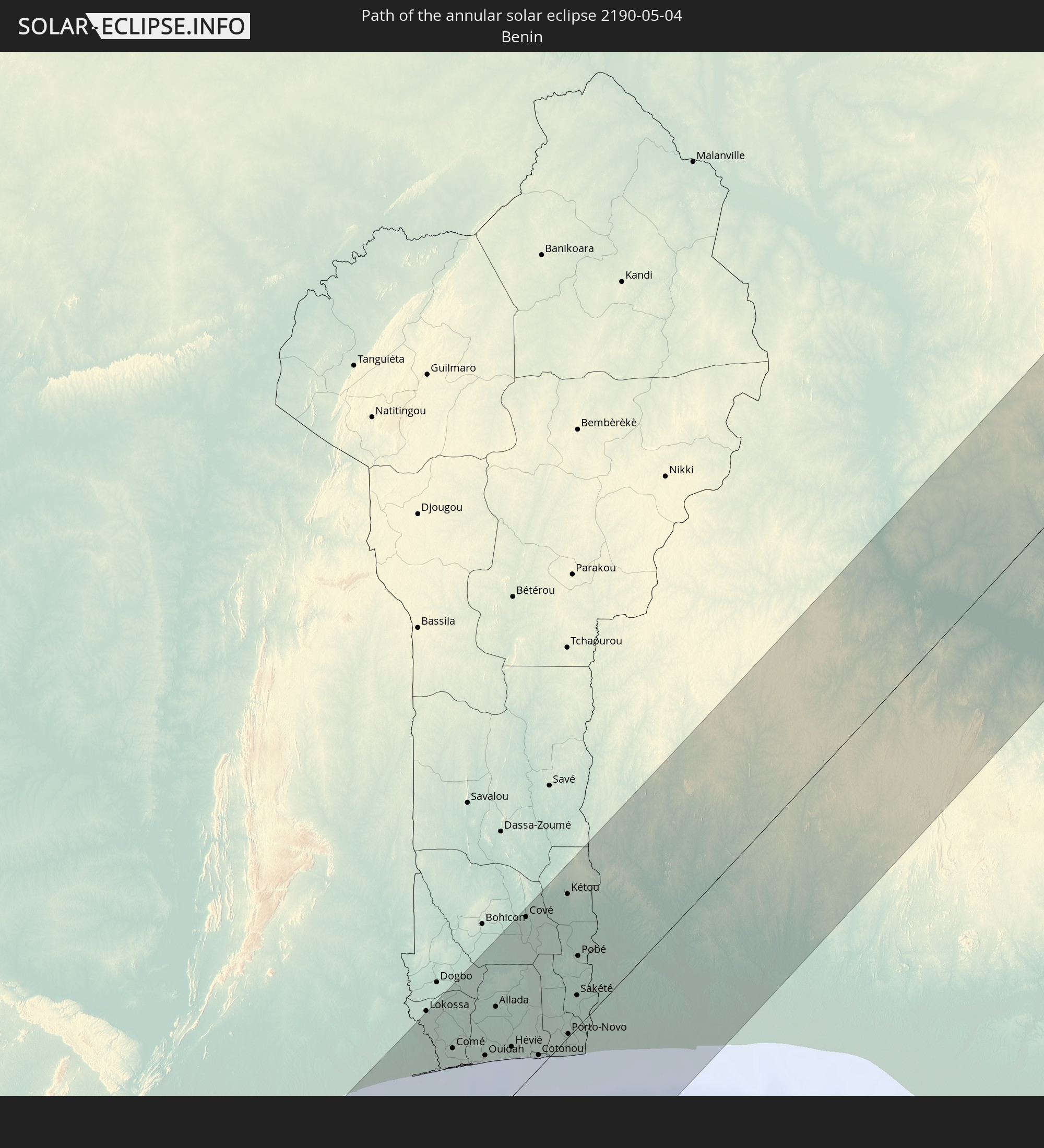 Benin
Benin
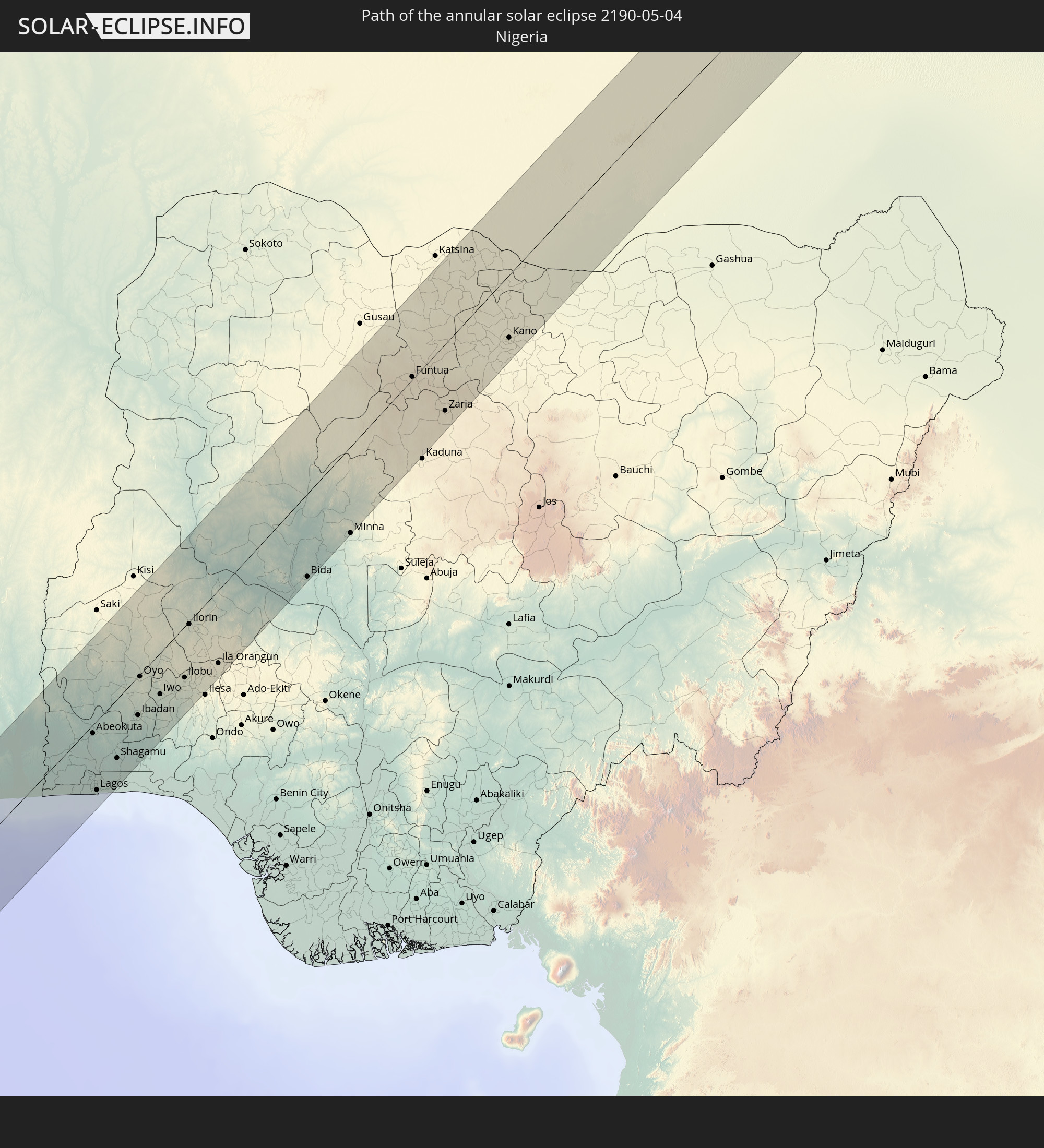 Nigeria
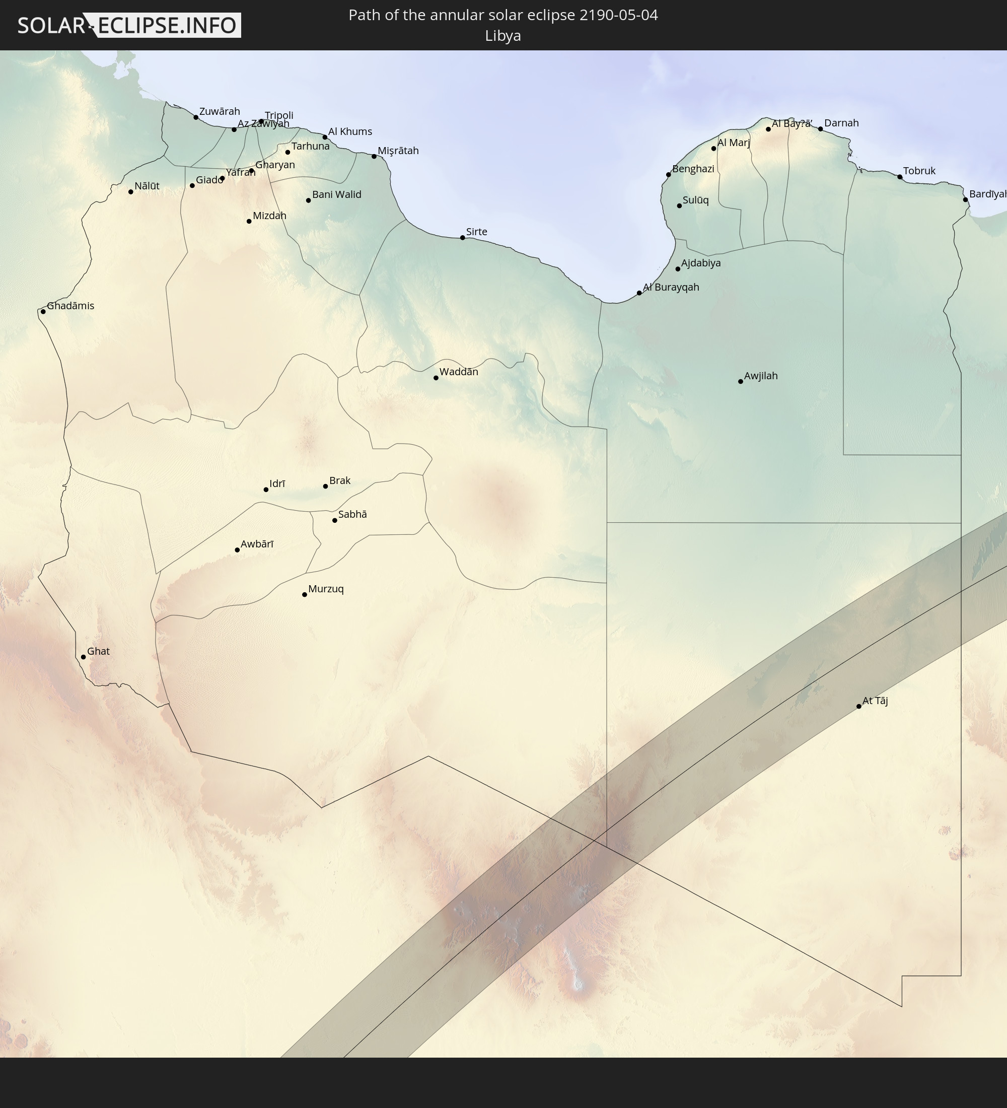 Libya
Libya
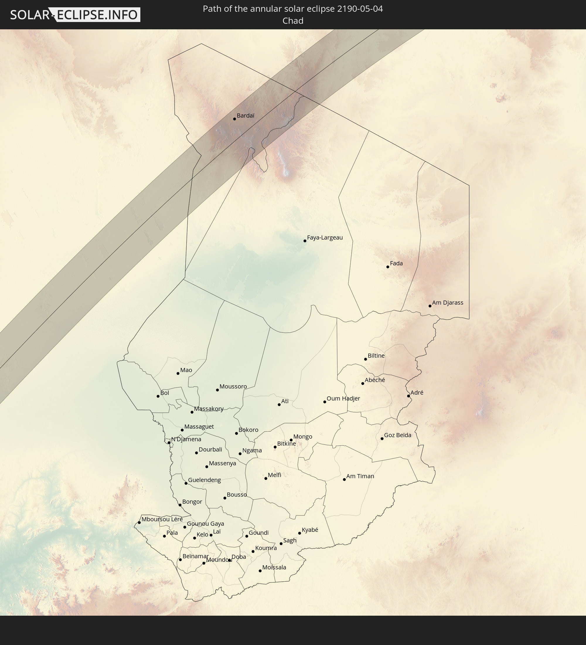 Chad
Chad
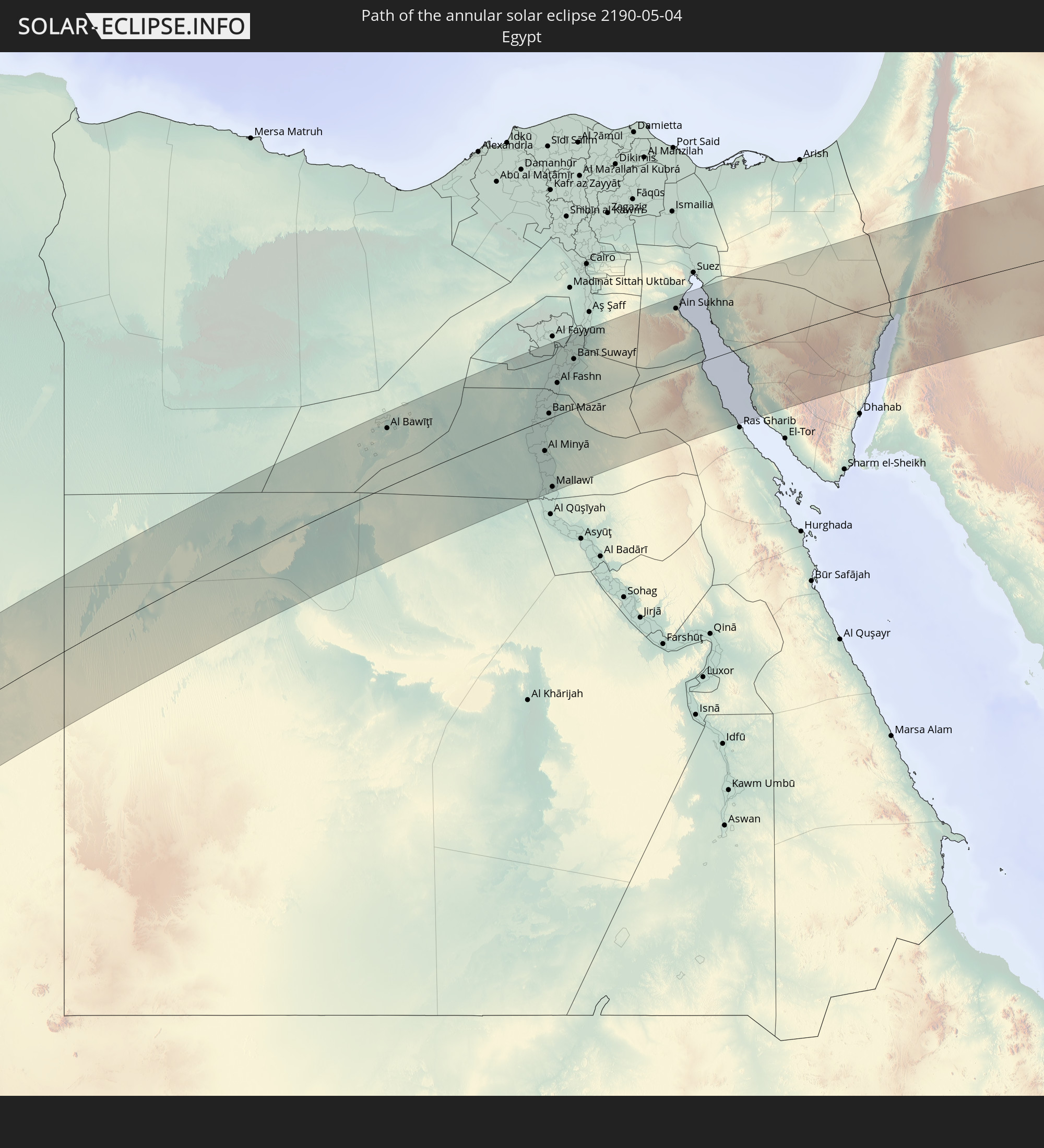 Egypt
Egypt
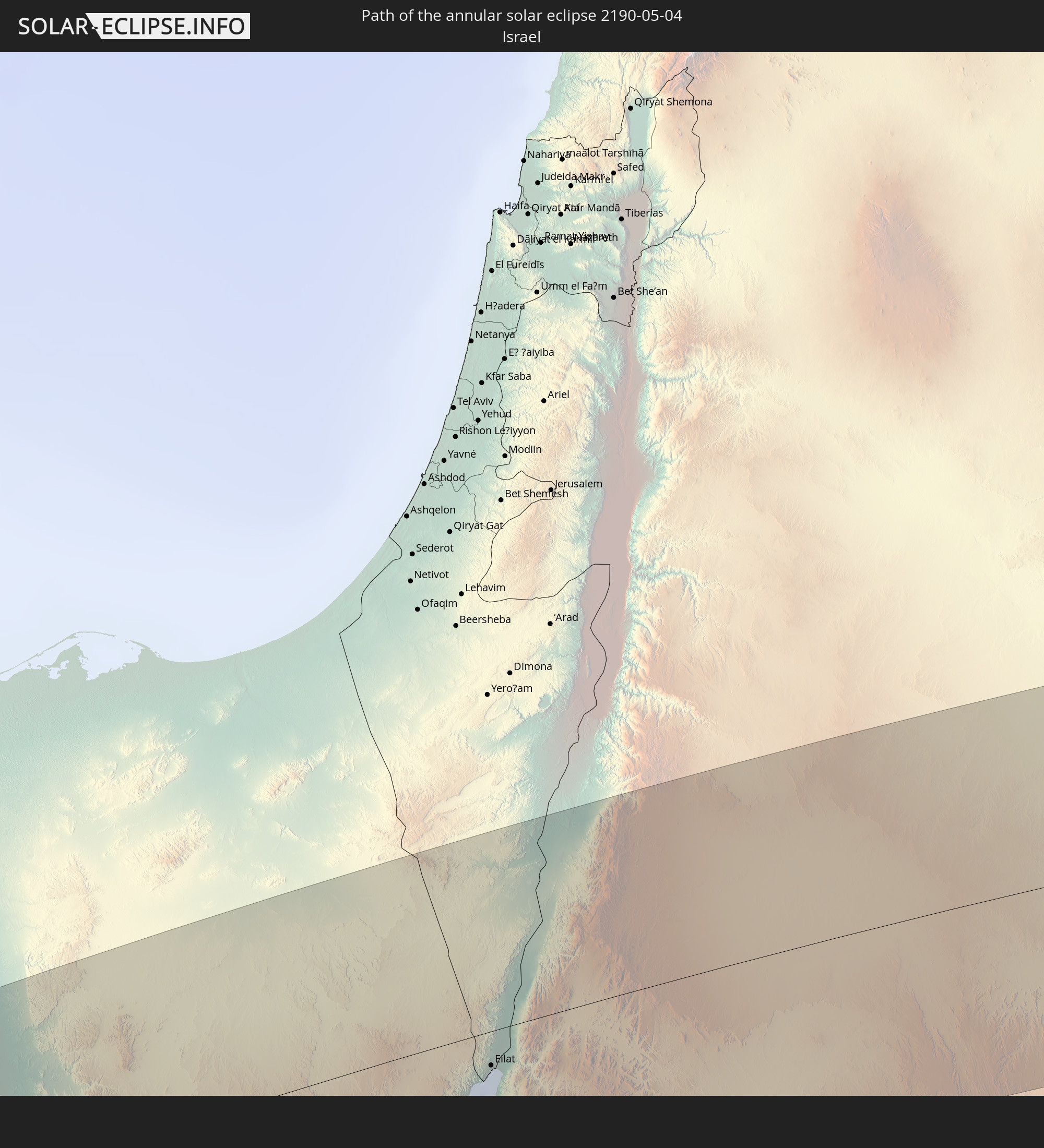 Israel
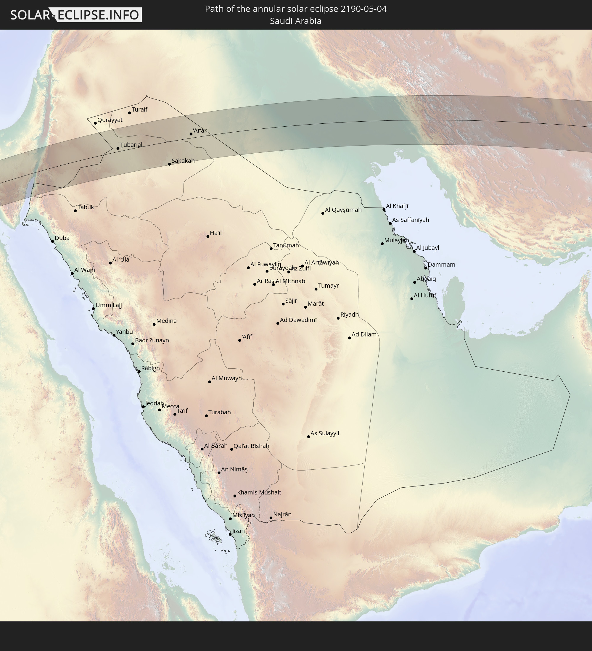 Saudi Arabia
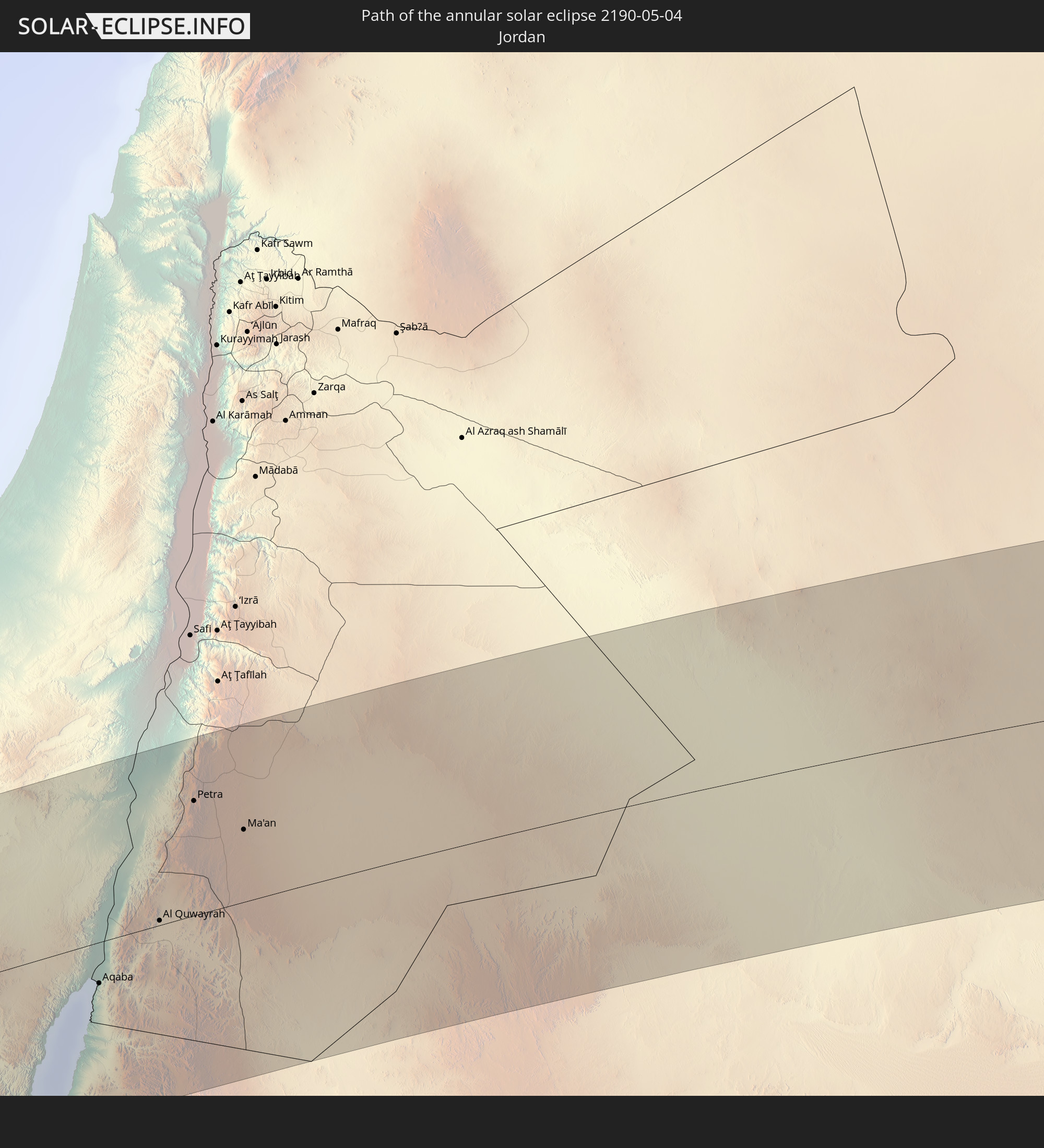 Jordan
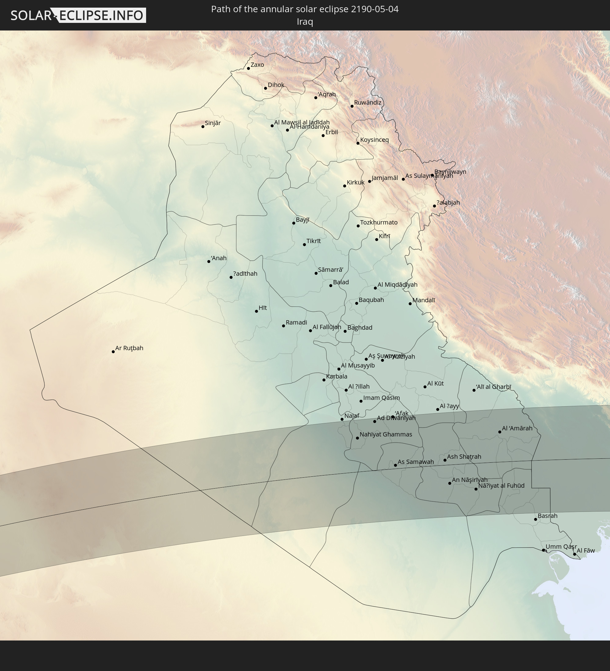 Iraq
Iraq
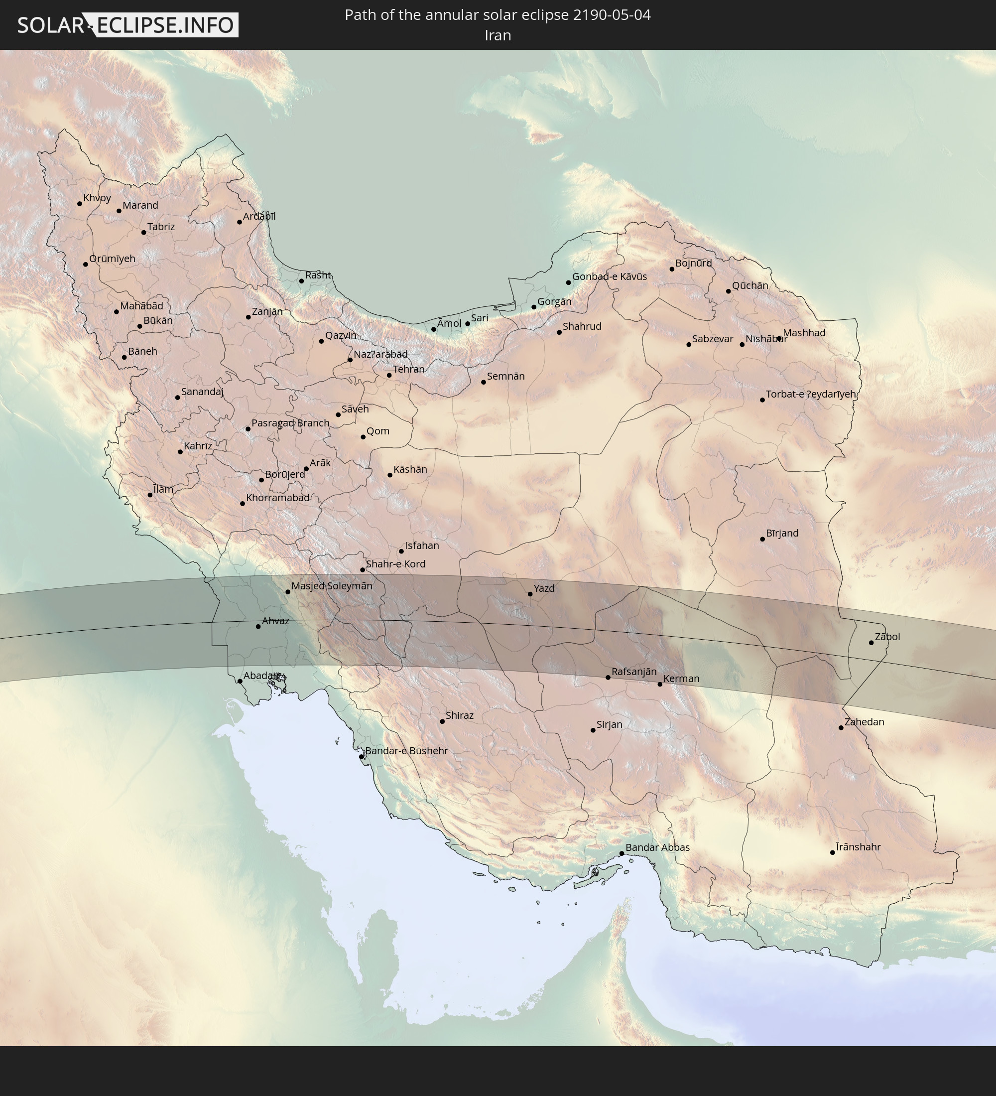 Iran
Iran
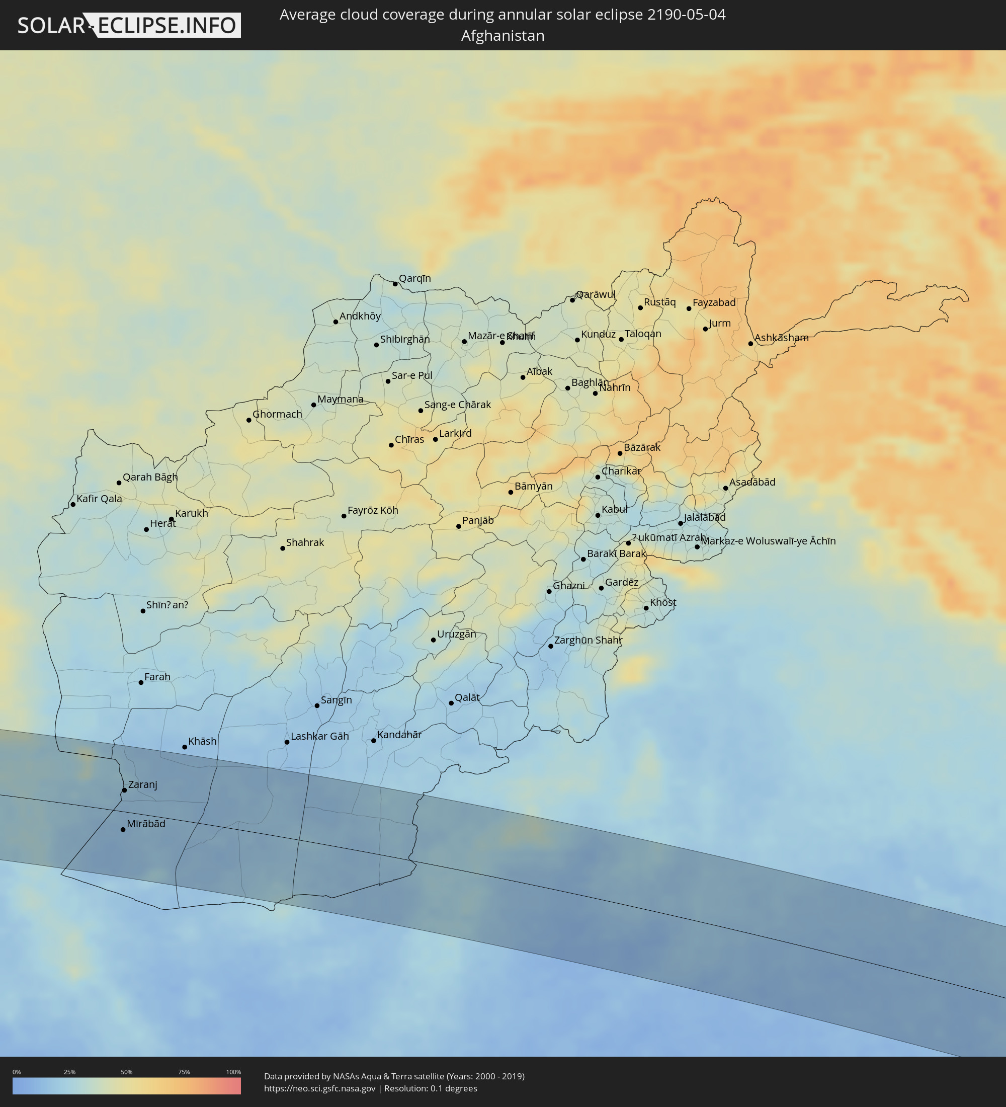
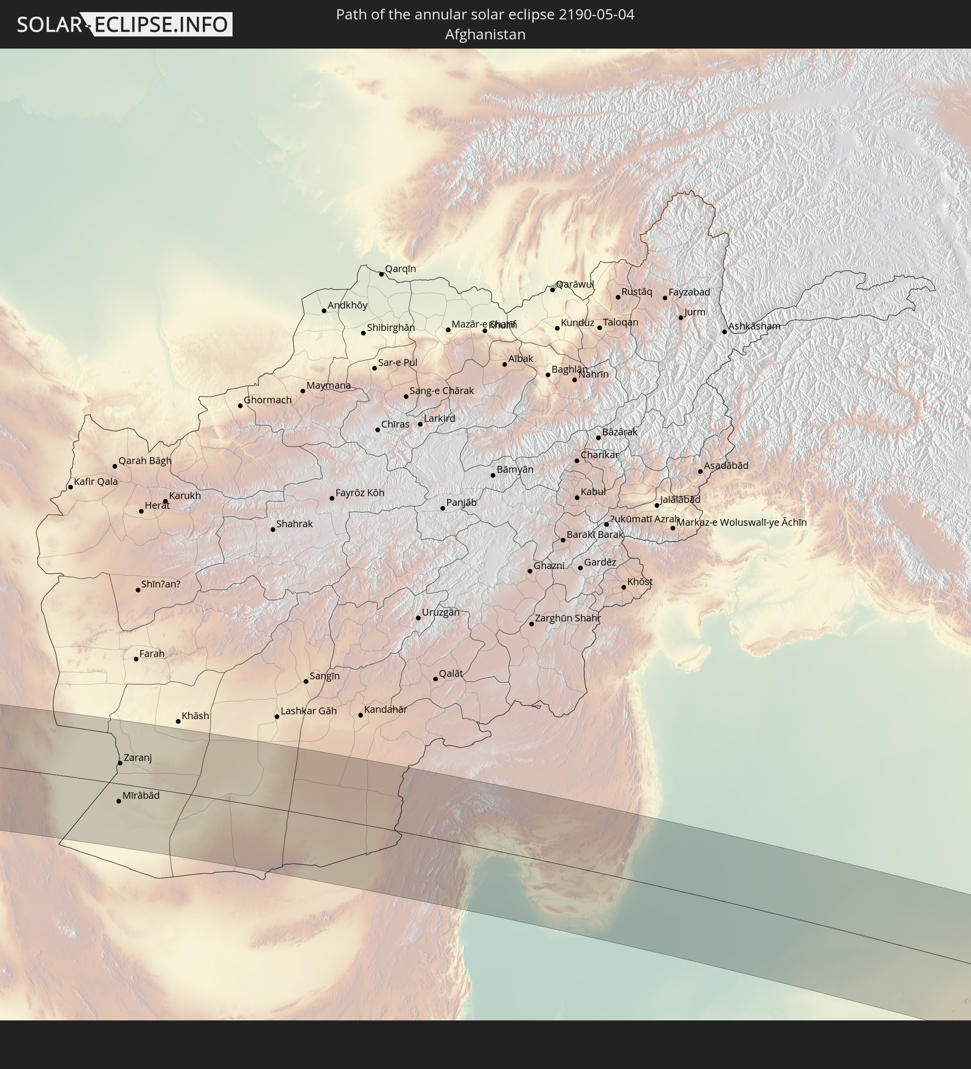 Afghanistan
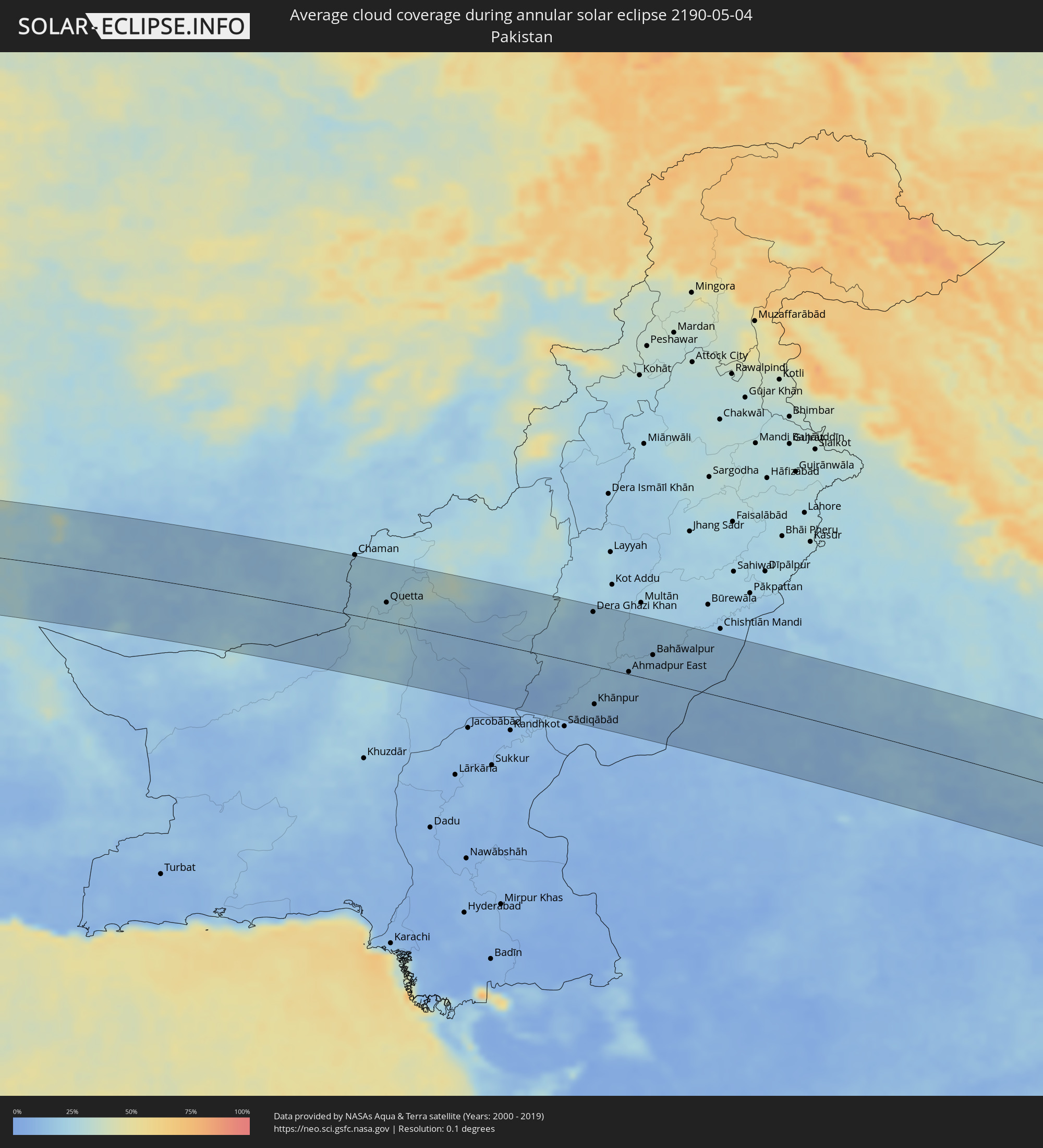
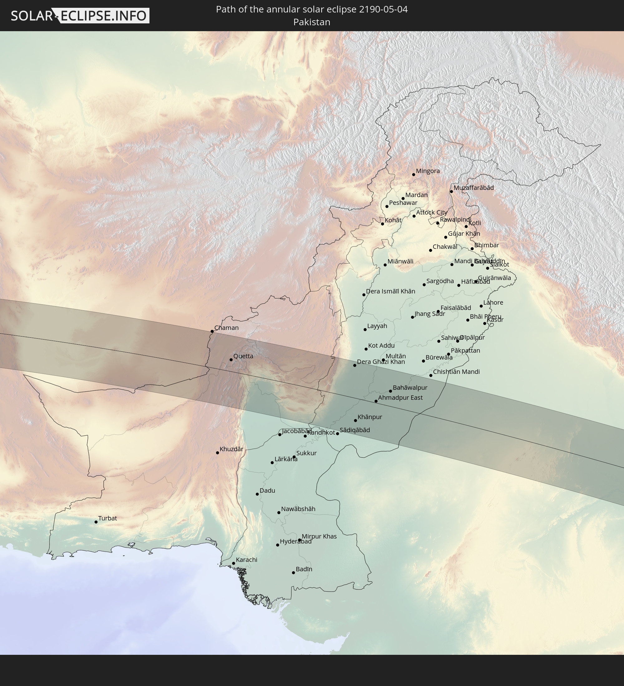 Pakistan
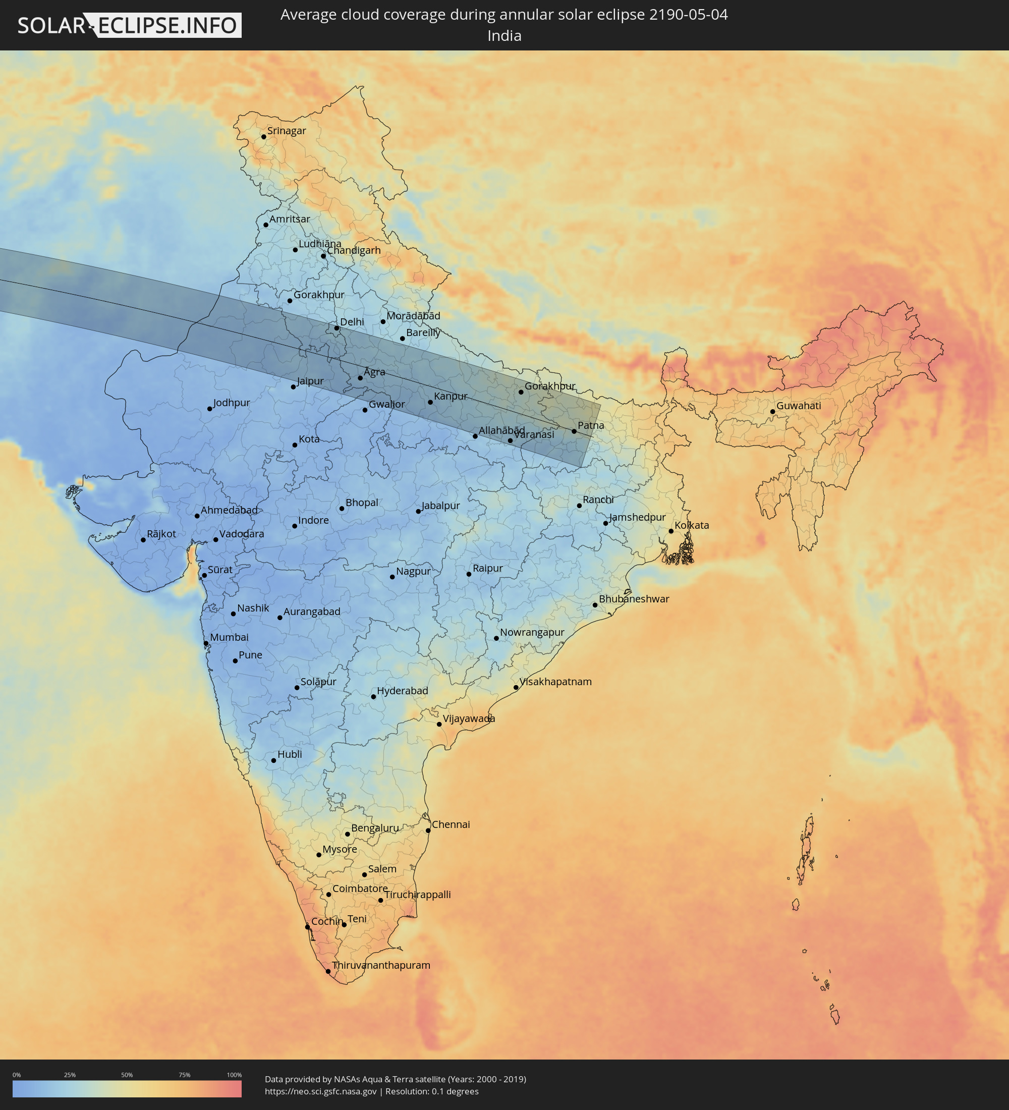
 India
India
In den folgenden Ländern ist die Sonnenfinsternis partiell zu sehen
 Russia
 Brazil
 Portugal
 Cabo Verde
 Spain
Spain
 Senegal
 Mauritania
 The Gambia
 Guinea-Bissau
 Guinea
 Saint Helena, Ascension and Tristan da Cunha
 Sierra Leone
 Morocco
 Mali
Mali
 Liberia
 Algeria
 United Kingdom
 Ivory Coast
 Burkina Faso
 Gibraltar
 France
 Ghana
Ghana
 Guernsey
 Jersey
 Togo
Togo
 Niger
Niger
 Benin
Benin
 Andorra
 Belgium
 Nigeria
 Netherlands
 Norway
 Equatorial Guinea
 Luxembourg
 Germany
 Switzerland
 São Tomé and Príncipe
 Italy
Italy
 Monaco
 Tunisia
 Denmark
 Cameroon
 Gabon
Gabon
 Libya
Libya
 Liechtenstein
 Austria
 Sweden
 Republic of the Congo
 Angola
 Namibia
 Czechia
 Democratic Republic of the Congo
 San Marino
 Vatican City
 Slovenia
 Chad
Chad
 Croatia
 Poland
 Malta
Malta
 Central African Republic
 Bosnia and Herzegovina
 Hungary
 Slovakia
 Montenegro
 Serbia
 Albania
 Åland Islands
 Greece
 Botswana
 Romania
 Republic of Macedonia
 Finland
 Lithuania
 Latvia
 Estonia
 Sudan
Sudan
 Zambia
 Ukraine
 Bulgaria
 Belarus
 Egypt
Egypt
 Turkey
 Moldova
 Rwanda
 Burundi
 Tanzania
 Uganda
 Cyprus
 Malawi
 Ethiopia
 Kenya
Kenya
 State of Palestine
 Israel
 Saudi Arabia
 Jordan
 Lebanon
 Syria
Syria
 Eritrea
 Iraq
Iraq
 Georgia
 Somalia
 Djibouti
 Yemen
Yemen
 Armenia
 Iran
Iran
 Azerbaijan
 Kazakhstan
 Kuwait
 Bahrain
 Qatar
Qatar
 United Arab Emirates
 Oman
Oman
 Turkmenistan
 Uzbekistan
 Afghanistan
 Pakistan
 Tajikistan
 India
India
 Kyrgyzstan
 Maldives
 China
China
 Sri Lanka
 Nepal
Nepal
 Mongolia
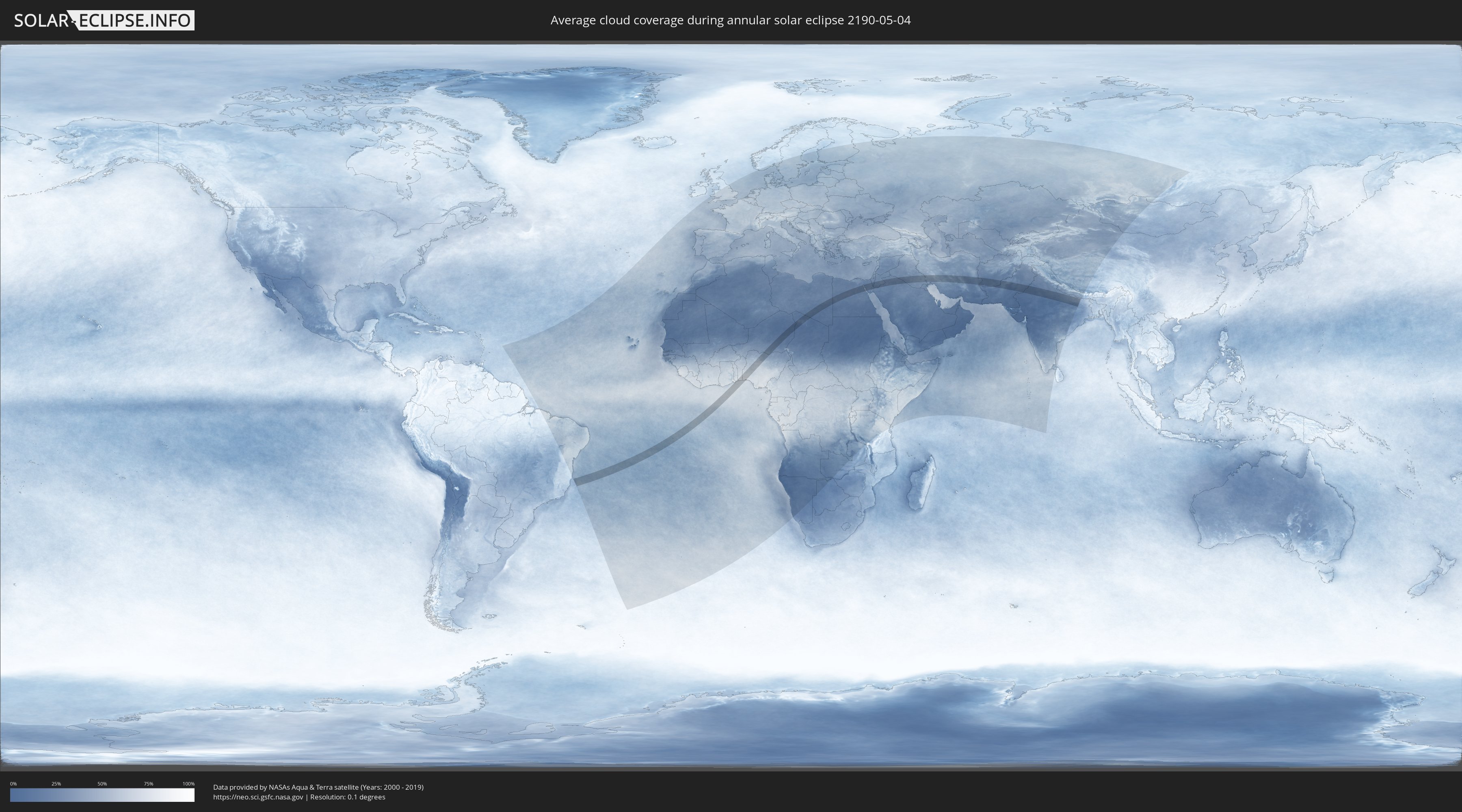
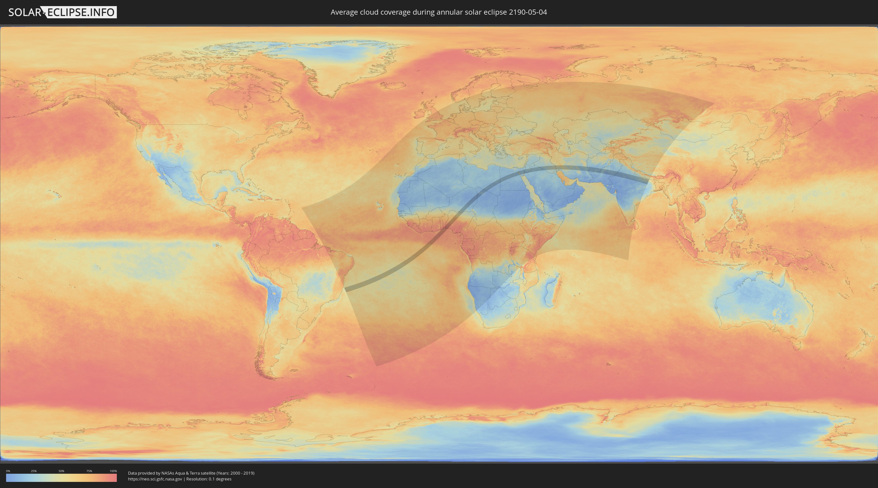
How will be the weather during the annular solar eclipse on 05/04/2190?
Where is the best place to see the annular solar eclipse of 05/04/2190?
The following maps show the average cloud coverage for the day of the annular solar eclipse.
With the help of these maps, it is possible to find the place along the eclipse path, which has the best
chance of a cloudless sky.
Nevertheless, you should consider local circumstances and inform about the weather of your chosen
observation site.
The data is provided by NASAs satellites
AQUA and TERRA.
The cloud maps are averaged over a period of 19 years (2000 - 2019).
Detailed country maps
 Saint Helena, Ascension and Tristan da Cunha
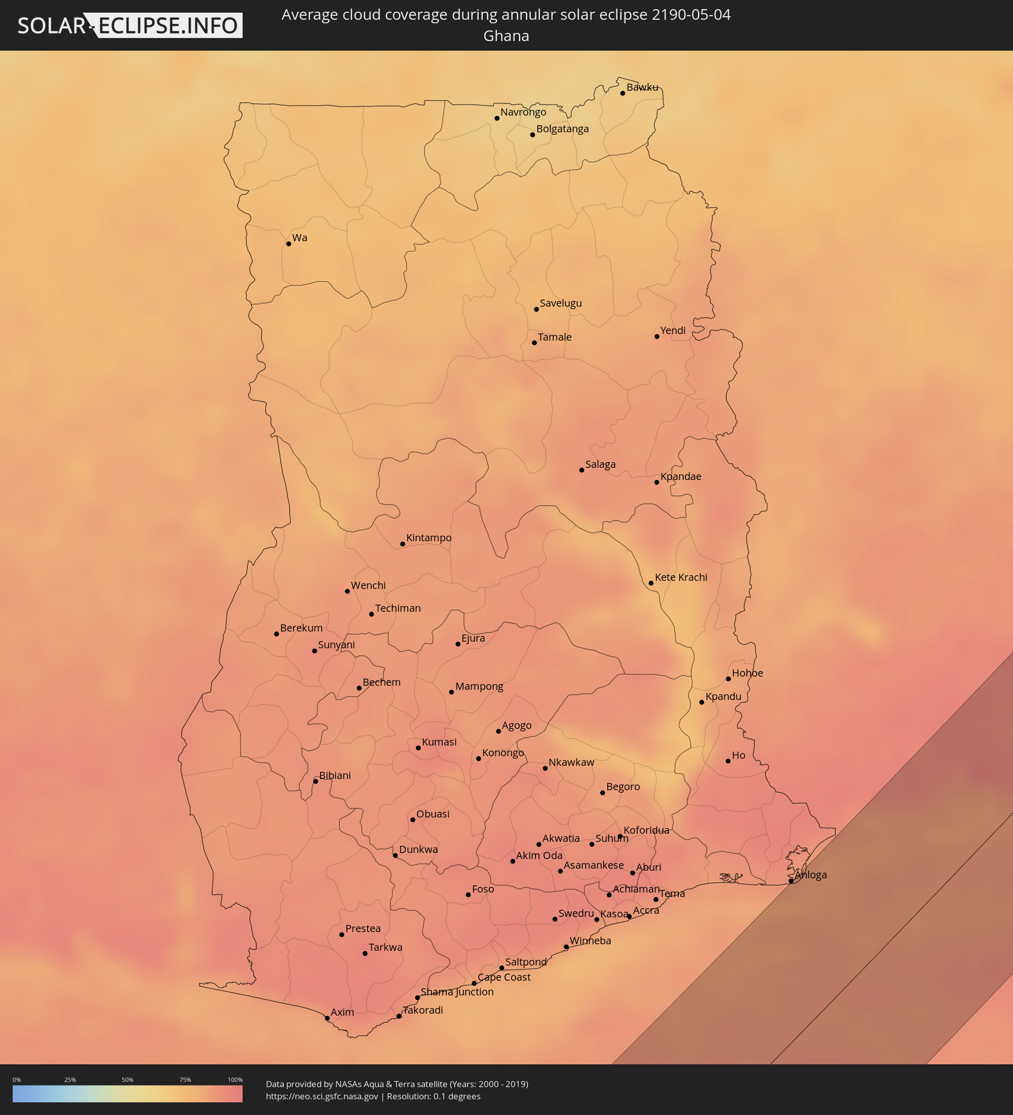 Ghana
Ghana
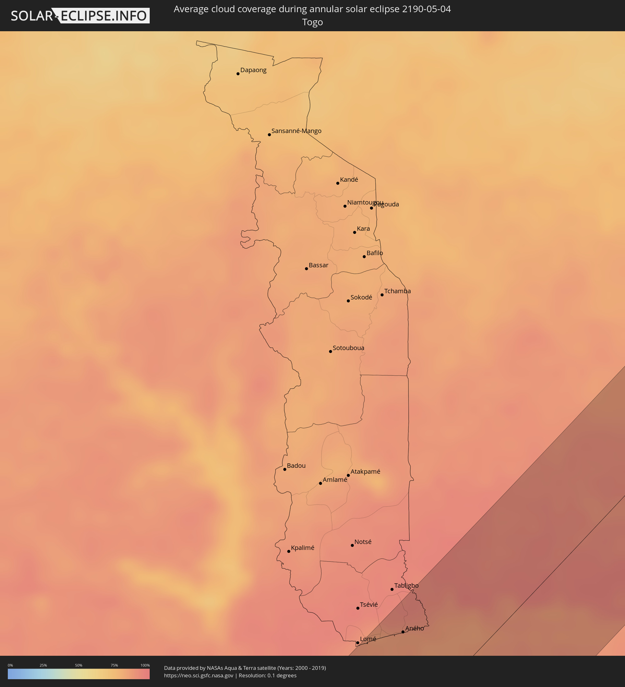 Togo
Togo
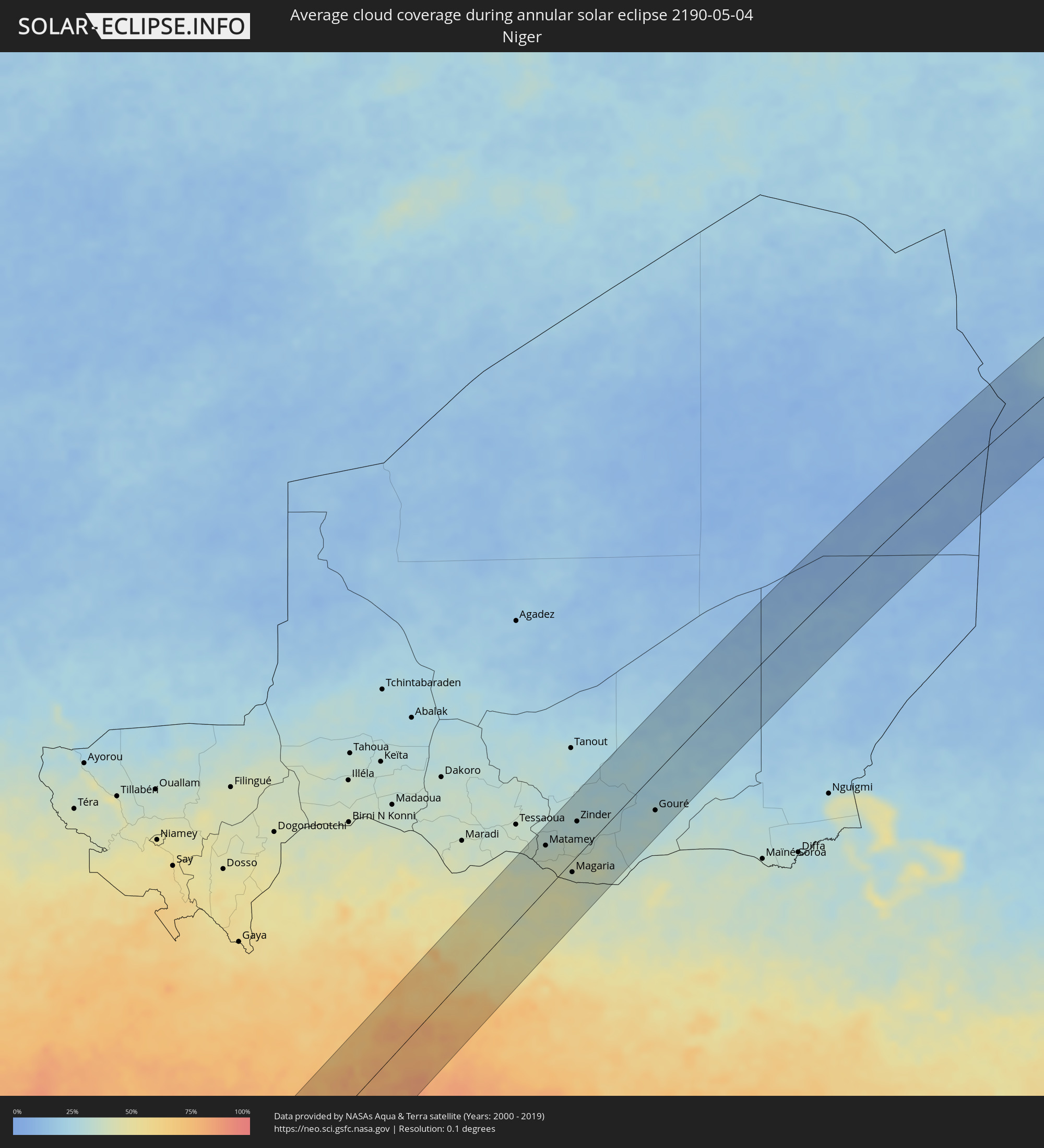 Niger
Niger
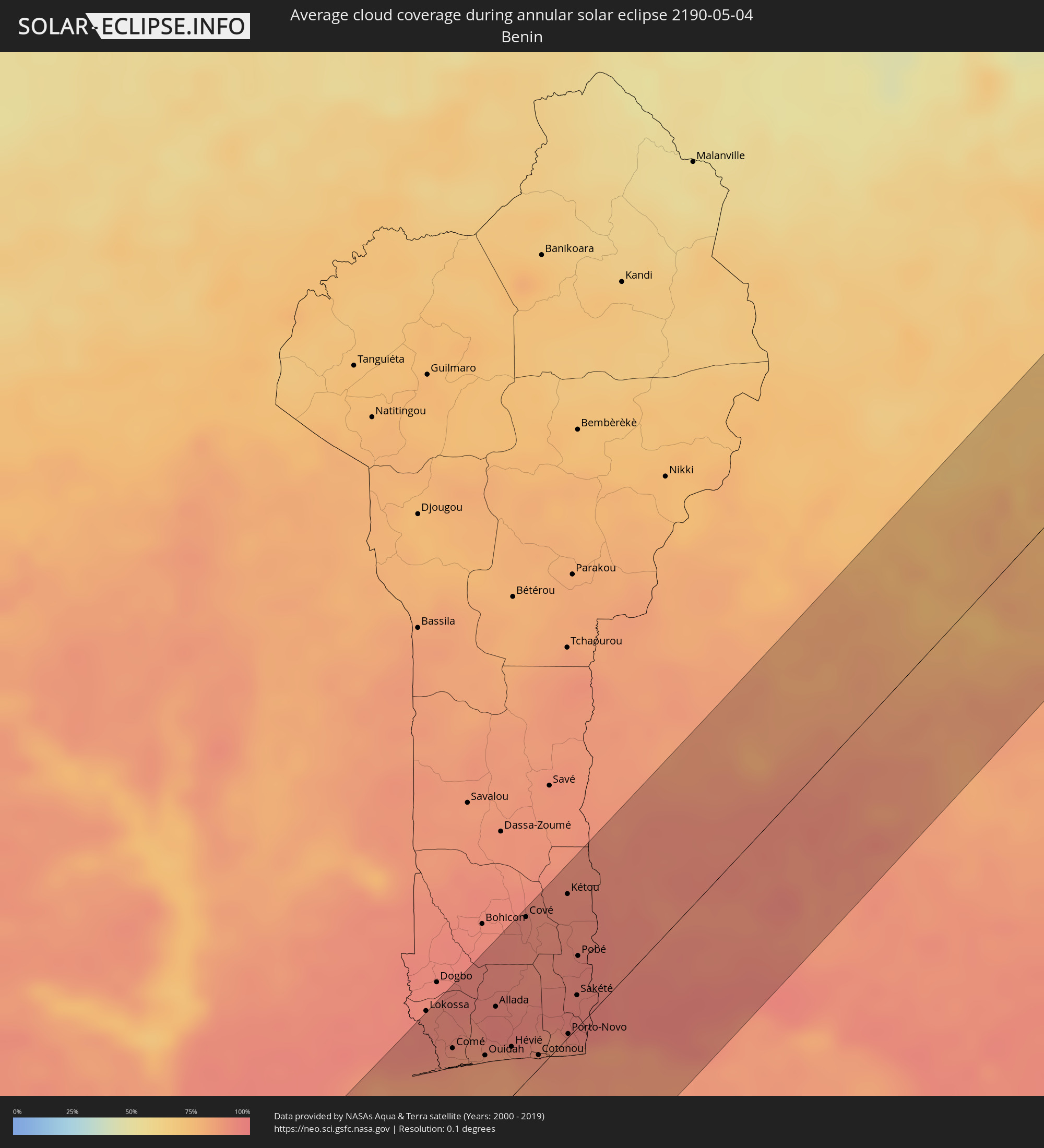 Benin
Benin
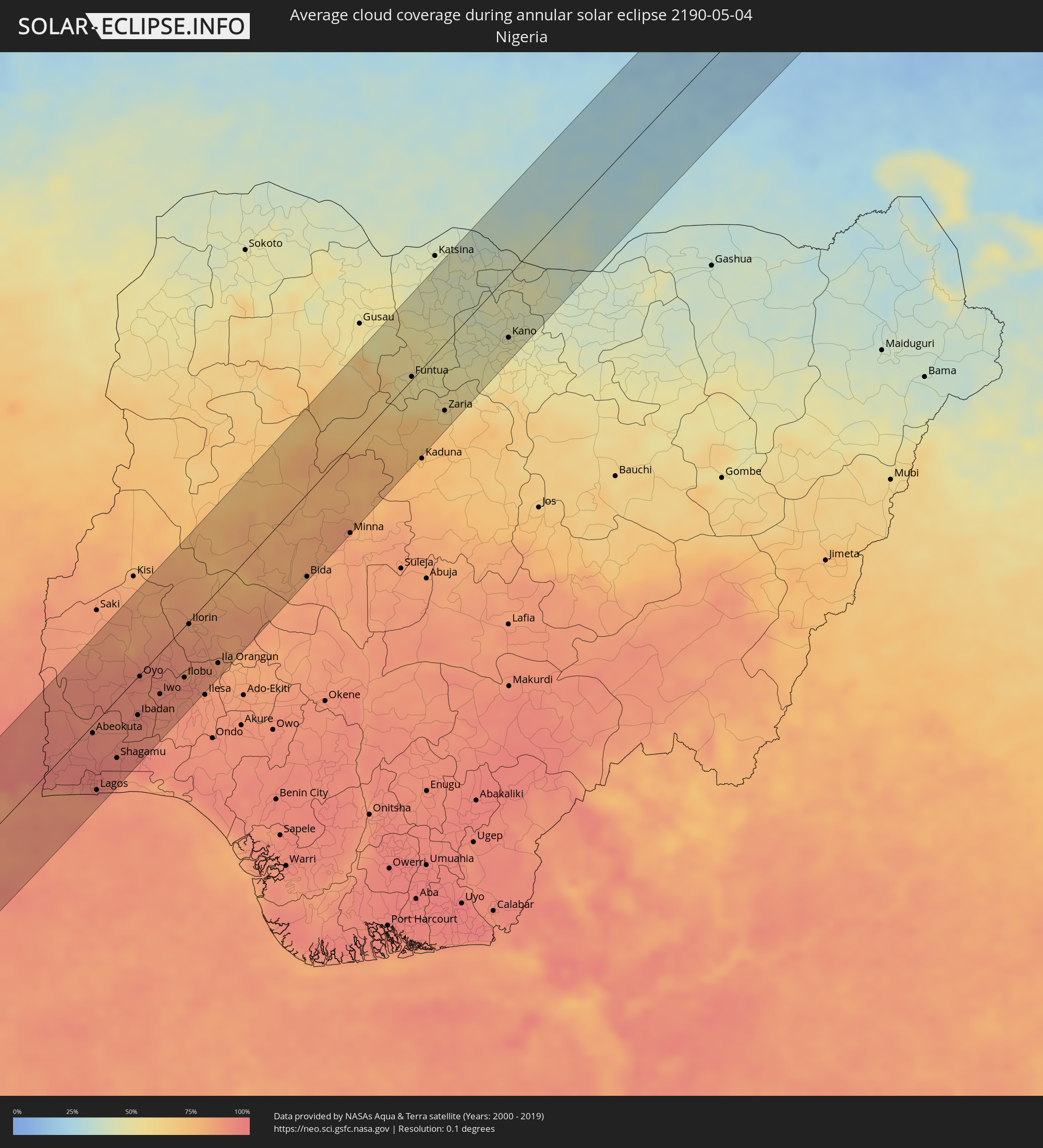 Nigeria
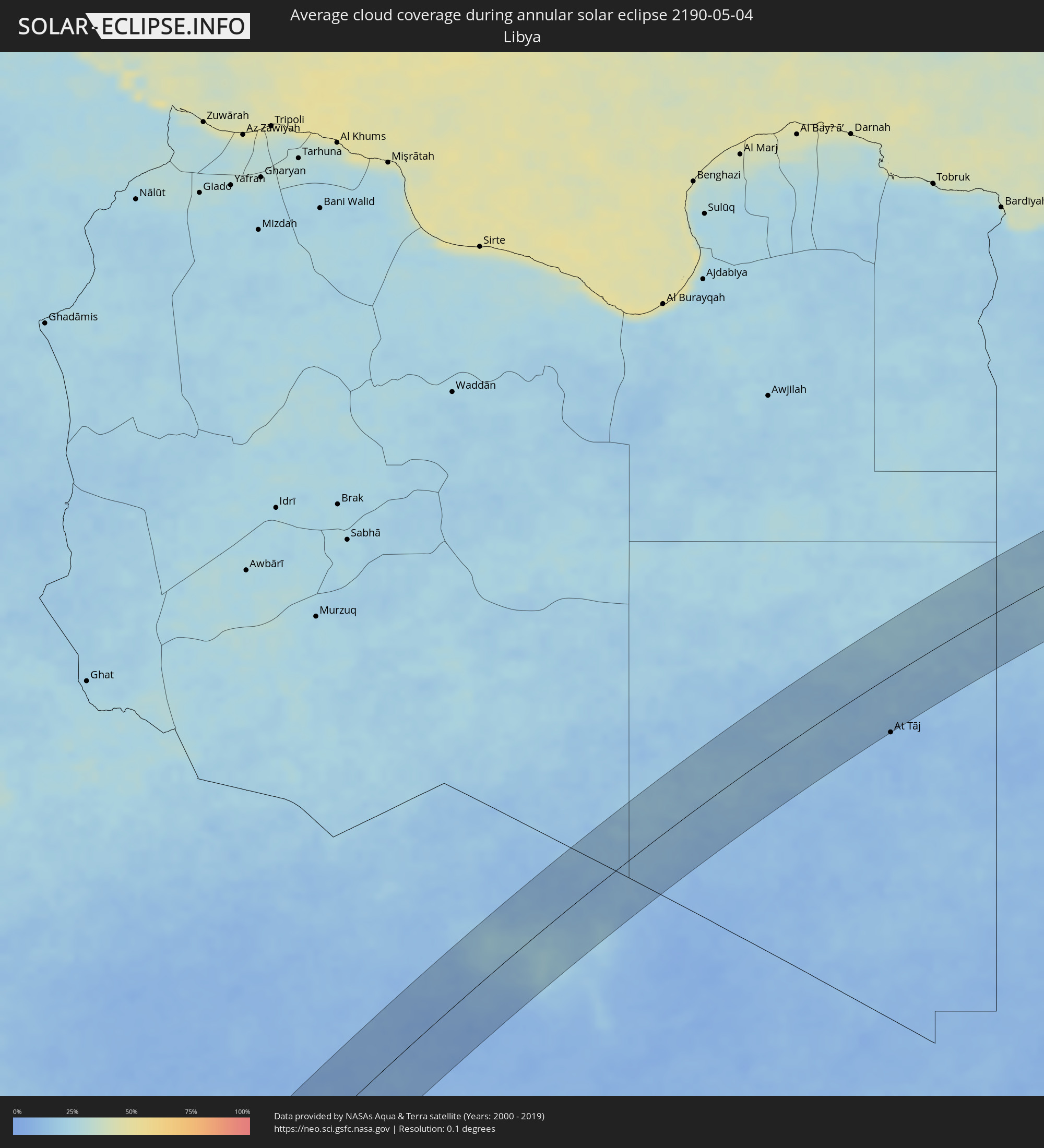 Libya
Libya
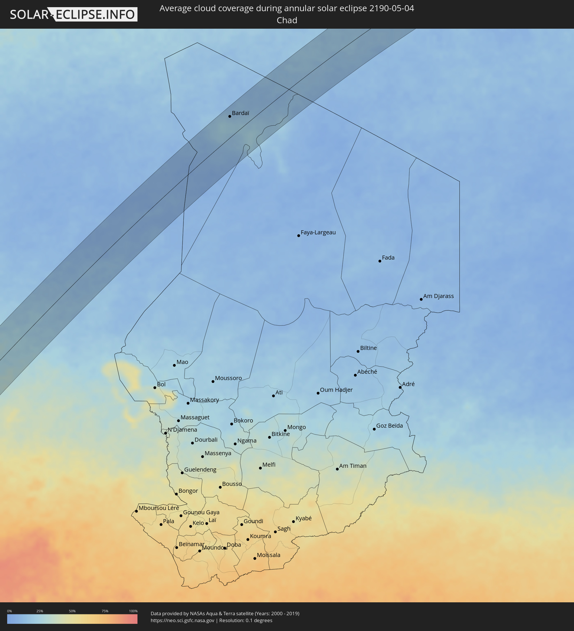 Chad
Chad
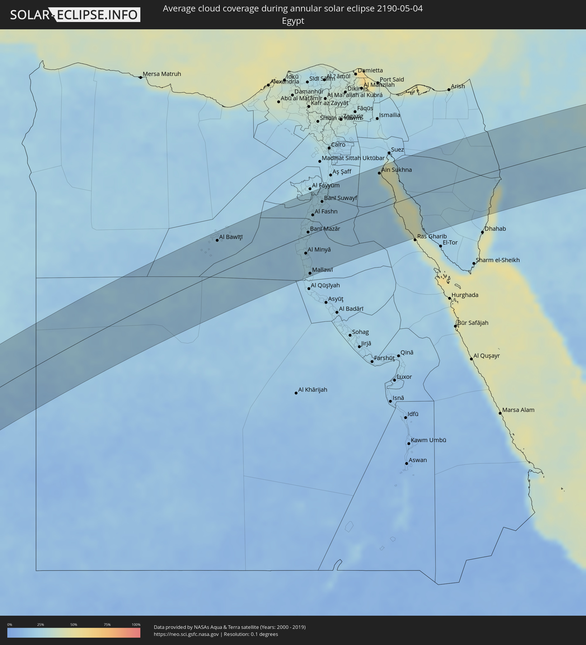 Egypt
Egypt
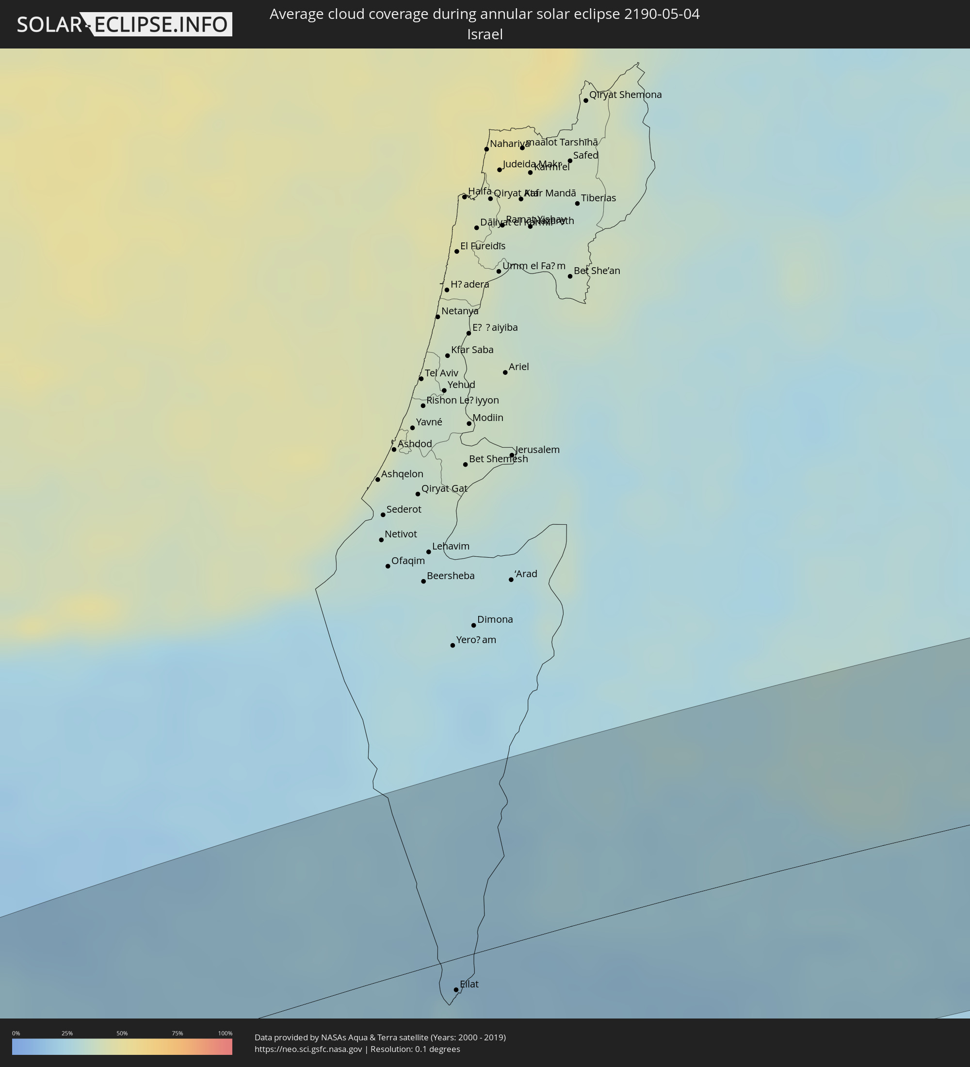 Israel
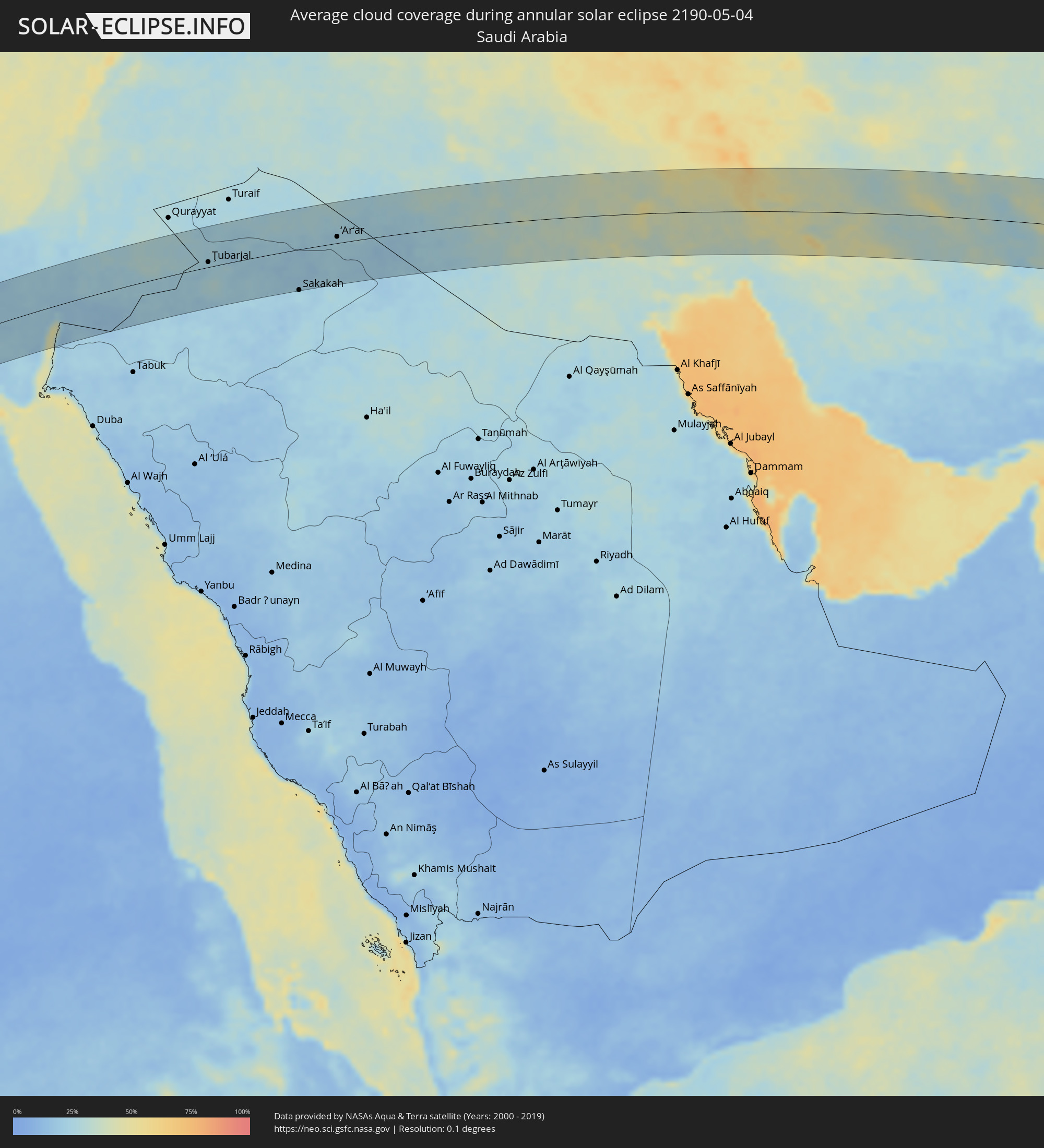 Saudi Arabia
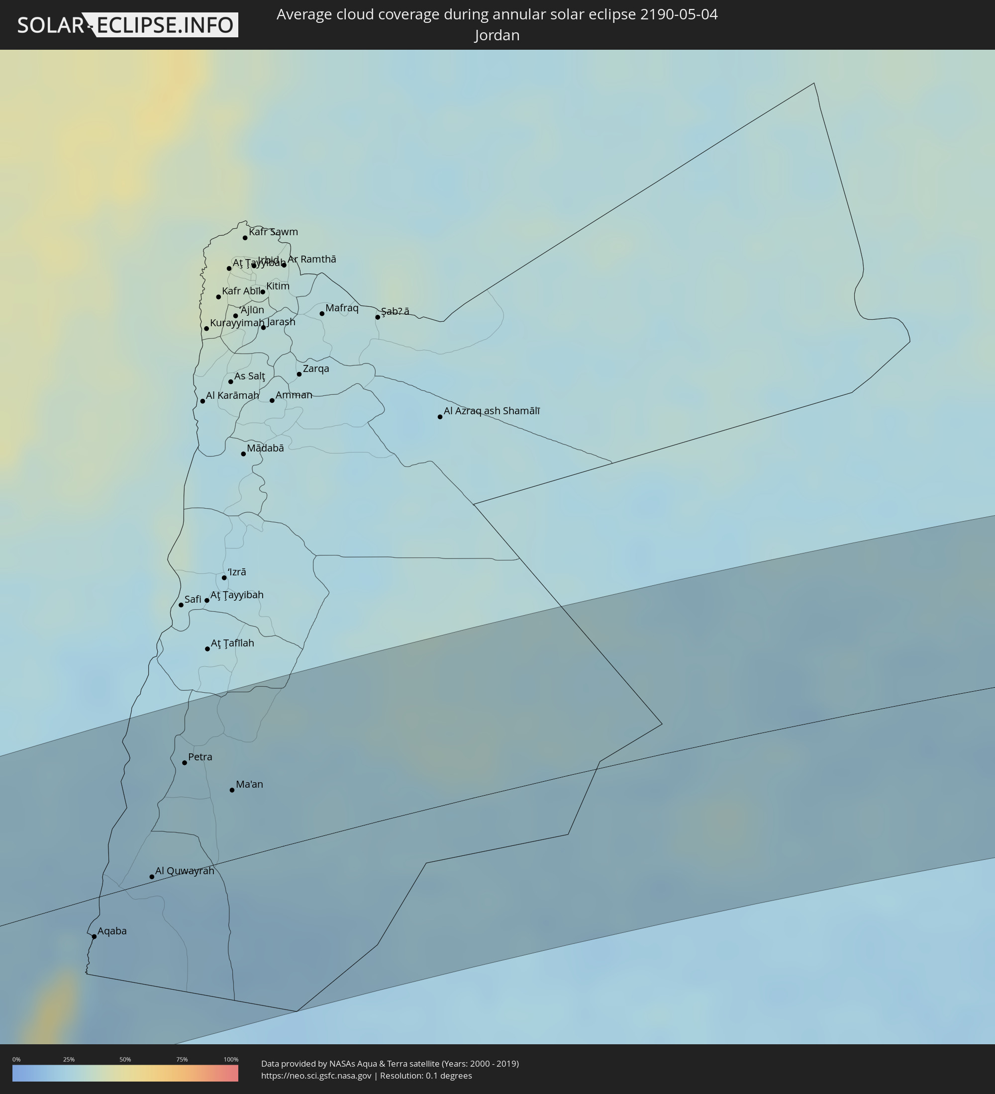 Jordan
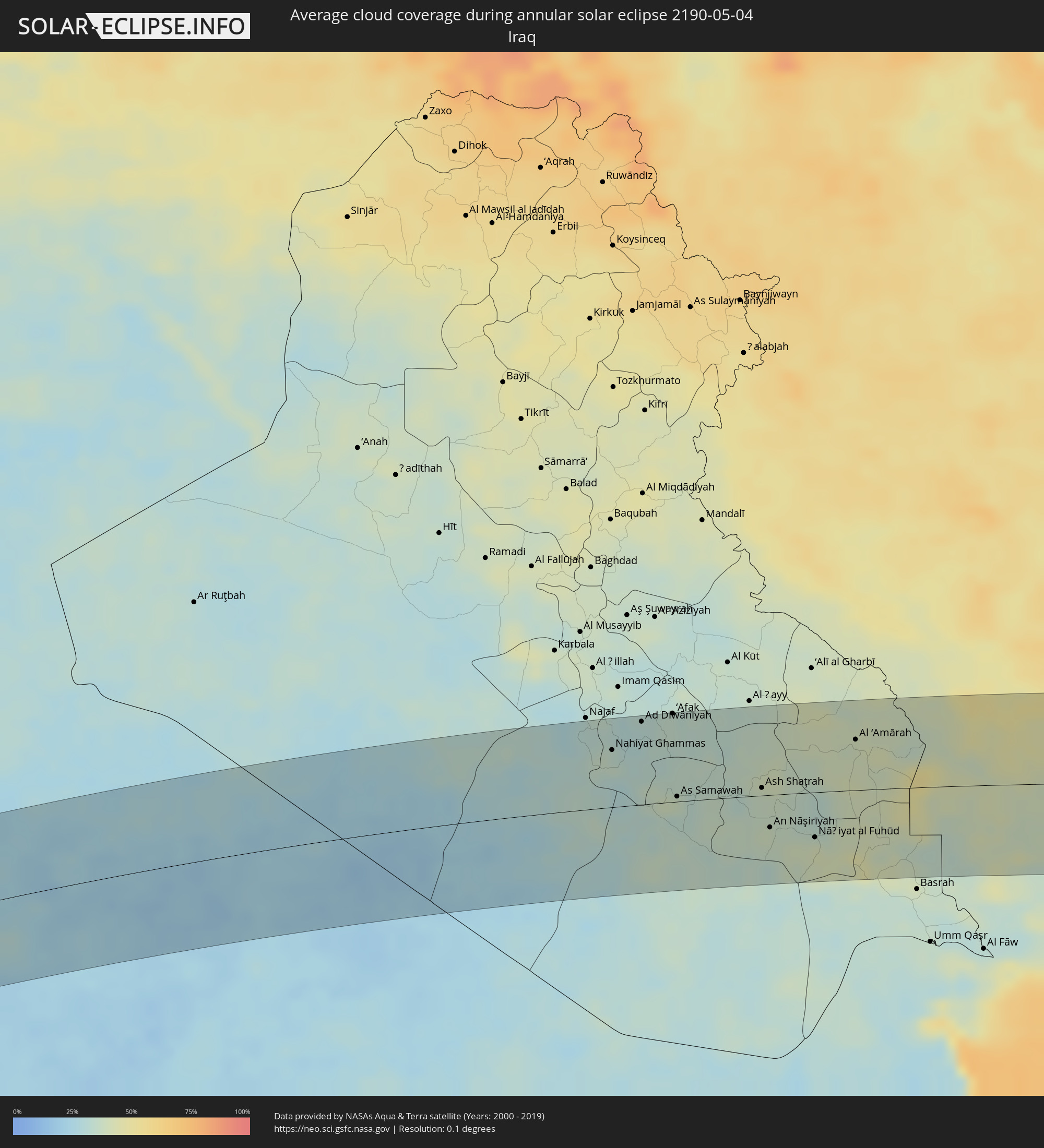 Iraq
Iraq
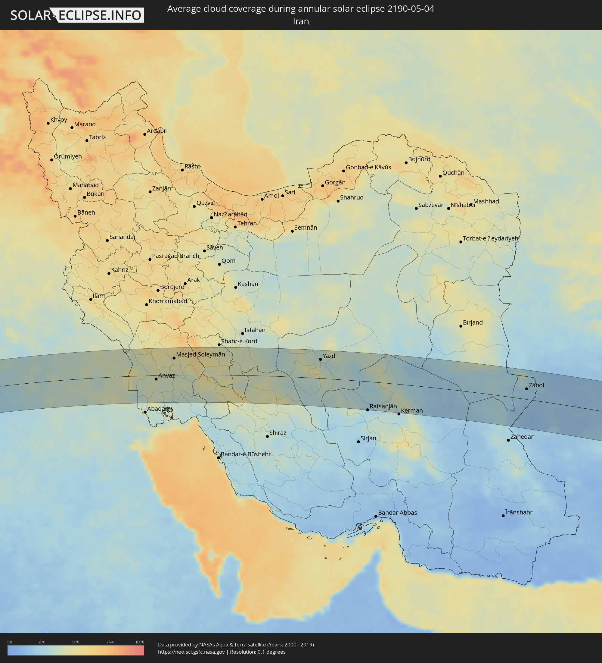 Iran
Iran
 Afghanistan
 Pakistan
 India
India
Cities inside the path of the eclipse
The following table shows all locations with a population of more than 5,000 inside the eclipse path. Cities which have more than 100,000 inhabitants are marked bold. A click at the locations opens a detailed map.
| City | Type | Eclipse duration | Local time of max. eclipse | Distance to central line | Ø Cloud coverage |
|
Georgetown, Ascension
|
annular | - | 09:08:11 UTC+00:00 | 12 km | 62% |
|
Vogan, Maritime
|
annular | - | 09:50:39 UTC+00:00 | 75 km | 86% |
|
Aného, Maritime
|
annular | - | 09:50:31 UTC+00:00 | 62 km | 87% |
|
Grand-Popo, Mono
|
annular | - | 10:51:00 UTC+01:00 | 47 km | 87% |
|
Comé, Mono
|
annular | - | 10:51:22 UTC+01:00 | 53 km | 87% |
|
Ouidah, Atlantique
|
annular | - | 10:51:36 UTC+01:00 | 33 km | 86% |
|
Allada, Atlantique
|
annular | - | 10:52:22 UTC+01:00 | 51 km | 95% |
|
Hévié, Atlantique
|
annular | - | 10:51:59 UTC+01:00 | 24 km | 88% |
|
Cové, Zou
|
annular | - | 10:53:54 UTC+01:00 | 78 km | 93% |
|
Abomey-Calavi, Atlantique
|
annular | - | 10:52:14 UTC+01:00 | 18 km | 89% |
|
Cotonou, Littoral
|
annular | - | 10:52:09 UTC+01:00 | 6 km | 89% |
|
Kétou, Plateau
|
annular | - | 10:54:39 UTC+01:00 | 68 km | 92% |
|
Porto-Novo, Ouémé
|
annular | - | 10:52:45 UTC+01:00 | 2 km | 89% |
|
Sakété, Plateau
|
annular | - | 10:53:22 UTC+01:00 | 15 km | 95% |
|
Pobé, Plateau
|
annular | - | 10:53:55 UTC+01:00 | 34 km | 95% |
|
Ikeja, Lagos
|
annular | - | 10:54:12 UTC+01:00 | 50 km | 95% |
|
Abeokuta, Ogun
|
annular | - | 10:55:27 UTC+01:00 | 8 km | 93% |
|
Lagos, Lagos
|
annular | - | 10:53:59 UTC+01:00 | 65 km | 94% |
|
Ebute Ikorodu, Lagos
|
annular | - | 10:54:28 UTC+01:00 | 62 km | 91% |
|
Shagamu, Ogun
|
annular | - | 10:55:17 UTC+01:00 | 55 km | 94% |
|
Ibadan, Oyo
|
annular | - | 10:56:55 UTC+01:00 | 36 km | 94% |
|
Ijebu-Ode, Ogun
|
annular | - | 10:55:41 UTC+01:00 | 79 km | 95% |
|
Oyo, Oyo
|
annular | - | 10:58:01 UTC+01:00 | 2 km | 92% |
|
Iwo, Osun
|
annular | - | 10:57:58 UTC+01:00 | 39 km | 92% |
|
Ikire, Osun
|
annular | - | 10:57:23 UTC+01:00 | 59 km | 91% |
|
Ilorin, Kwara
|
annular | - | 11:00:34 UTC+01:00 | 3 km | 85% |
|
Minna, Niger
|
annular | - | 11:06:51 UTC+01:00 | 80 km | 84% |
|
Zaria, Kaduna
|
annular | - | 11:12:39 UTC+01:00 | 61 km | 61% |
|
Matamey, Zinder
|
annular | - | 11:19:42 UTC+01:00 | 53 km | 36% |
|
Kano, Kano
|
annular | - | 11:16:22 UTC+01:00 | 58 km | 48% |
|
Magaria, Zinder
|
annular | - | 11:19:35 UTC+01:00 | 13 km | 38% |
|
Zinder, Zinder
|
annular | - | 11:21:41 UTC+01:00 | 42 km | 31% |
|
Mirriah, Zinder
|
annular | - | 11:21:47 UTC+01:00 | 21 km | 31% |
|
Gouré, Zinder
|
annular | - | 11:24:49 UTC+01:00 | 46 km | 30% |
|
Bardaï, Tibesti
|
annular | - | 11:57:38 UTC+01:00 | 51 km | 15% |
|
Al Bawīţī, Giza
|
annular | - | 13:39:13 UTC+02:00 | 63 km | 18% |
|
Samālūţ, Minya
|
annular | - | 13:43:33 UTC+02:00 | 11 km | 24% |
|
Al Minyā, Minya
|
annular | - | 13:43:25 UTC+02:00 | 34 km | 23% |
|
Maţāy, Minya
|
annular | - | 13:43:49 UTC+02:00 | 3 km | 21% |
|
Banī Mazār, Minya
|
annular | - | 13:43:58 UTC+02:00 | 5 km | 23% |
|
Abū Qurqāş, Minya
|
annular | - | 13:43:26 UTC+02:00 | 55 km | 24% |
|
Mallawī, Minya
|
annular | - | 13:43:13 UTC+02:00 | 76 km | 22% |
|
Sumusţā as Sulţānī, Beni Suweif
|
annular | - | 13:44:31 UTC+02:00 | 46 km | 23% |
|
Al Fashn, Beni Suweif
|
annular | - | 13:44:32 UTC+02:00 | 35 km | 21% |
|
Banī Suwayf, Beni Suweif
|
annular | - | 13:45:15 UTC+02:00 | 54 km | 23% |
|
Būsh, Beni Suweif
|
annular | - | 13:45:23 UTC+02:00 | 61 km | 23% |
|
Al Wāsiţah, Faiyum
|
annular | - | 13:45:45 UTC+02:00 | 78 km | 24% |
|
Ain Sukhna, Suez
|
annular | - | 13:48:32 UTC+02:00 | 68 km | 23% |
|
Eilat, Southern District
|
annular | - | 13:54:20 UTC+02:00 | 14 km | 25% |
|
Aqaba, Aqaba
|
annular | - | 13:54:27 UTC+02:00 | 19 km | 25% |
|
Al Quwayrah, Ma’an
|
annular | - | 13:55:18 UTC+02:00 | 2 km | 19% |
|
Petra, Ma’an
|
annular | - | 13:56:02 UTC+02:00 | 53 km | 24% |
|
Ma'an, Ma’an
|
annular | - | 13:56:29 UTC+02:00 | 34 km | 25% |
|
Ţubarjal, Al Jawf
|
annular | - | 15:01:48 UTC+03:00 | 11 km | 23% |
|
Sakakah, Al Jawf
|
annular | - | 15:05:32 UTC+03:00 | 84 km | 25% |
|
Şuwayr, Al Jawf
|
annular | - | 15:05:57 UTC+03:00 | 71 km | 21% |
|
‘Ar‘ar, Northern Borders
|
annular | - | 15:07:29 UTC+03:00 | 13 km | 22% |
|
Al Mishkhāb, An Najaf
|
annular | - | 15:13:46 UTC+03:00 | 64 km | 36% |
|
Ash Shāmīyah, Al Qādisīyah
|
annular | - | 15:13:58 UTC+03:00 | 81 km | 31% |
|
Nahiyat Ghammas, Al Qādisīyah
|
annular | - | 15:13:59 UTC+03:00 | 56 km | 35% |
|
Nāḩiyat ash Shināfīyah, Al Qādisīyah
|
annular | - | 15:14:01 UTC+03:00 | 38 km | 31% |
|
Ad Dīwānīyah, Al Qādisīyah
|
annular | - | 15:14:30 UTC+03:00 | 81 km | 31% |
|
Ar Rumaythah, Al Muthanná
|
annular | - | 15:14:56 UTC+03:00 | 28 km | 34% |
|
‘Afak, Al Qādisīyah
|
annular | - | 15:15:02 UTC+03:00 | 87 km | 35% |
|
As Samawah, Al Muthanná
|
annular | - | 15:15:04 UTC+03:00 | 5 km | 33% |
|
Ash Shaţrah, Dhi Qar
|
annular | - | 15:16:31 UTC+03:00 | 8 km | 37% |
|
An Nāşirīyah, Dhi Qar
|
annular | - | 15:16:38 UTC+03:00 | 32 km | 37% |
|
Nāḩiyat al Fuhūd, Dhi Qar
|
annular | - | 15:17:23 UTC+03:00 | 44 km | 41% |
|
Al ‘Amārah, Maysan
|
annular | - | 15:18:02 UTC+03:00 | 50 km | 40% |
|
Sūsangerd, Khuzestan
|
annular | - | 15:49:38 UTC+03:30 | 16 km | 43% |
|
Shūsh, Khuzestan
|
annular | - | 15:49:40 UTC+03:30 | 86 km | 47% |
|
Ahvaz, Khuzestan
|
annular | - | 15:50:24 UTC+03:30 | 13 km | 41% |
|
Shūshtar, Khuzestan
|
annular | - | 15:50:34 UTC+03:30 | 68 km | 47% |
|
Masjed Soleymān, Khuzestan
|
annular | - | 15:51:14 UTC+03:30 | 55 km | 44% |
|
Omīdīyeh, Khuzestan
|
annular | - | 15:51:56 UTC+03:30 | 77 km | 35% |
|
Dehdasht, Kohgīlūyeh va Būyer Aḩmad
|
annular | - | 15:53:09 UTC+03:30 | 73 km | 38% |
|
Borūjen, Chahār Maḩāll va Bakhtīārī
|
annular | - | 15:53:57 UTC+03:30 | 58 km | 42% |
|
Yasuj, Kohgīlūyeh va Būyer Aḩmad
|
annular | - | 15:54:35 UTC+03:30 | 86 km | 44% |
|
Shāhreẕā, Isfahan
|
annular | - | 15:54:43 UTC+03:30 | 67 km | 41% |
|
Ābādeh, Fars
|
annular | - | 15:55:53 UTC+03:30 | 29 km | 38% |
|
Yazd, Yazd
|
annular | - | 15:57:48 UTC+03:30 | 61 km | 33% |
|
Zarand, Kerman
|
annular | - | 16:00:35 UTC+03:30 | 45 km | 33% |
|
Zābol, Sistan and Baluchestan
|
annular | - | 16:05:12 UTC+03:30 | 33 km | 21% |
|
Mīrābād, Nimroz
|
annular | - | 17:05:43 UTC+04:30 | 27 km | 14% |
|
Zaranj, Nimroz
|
annular | - | 17:05:32 UTC+04:30 | 31 km | 19% |
|
Rūdbār, Nimroz
|
annular | - | 17:06:27 UTC+04:30 | 48 km | 16% |
|
‘Alāqahdārī Dīshū, Helmand
|
annular | - | 17:06:52 UTC+04:30 | 6 km | 19% |
|
Markaz-e Ḩukūmat-e Darwēshān, Helmand
|
annular | - | 17:07:12 UTC+04:30 | 85 km | 20% |
|
Quetta, Balochistān
|
annular | - | 17:39:26 UTC+05:00 | 32 km | 24% |
|
Sibi, Balochistān
|
annular | - | 17:40:13 UTC+05:00 | 23 km | 14% |
|
Rājanpur, Punjab
|
annular | - | 17:41:38 UTC+05:00 | 21 km | 14% |
|
Jāmpur, Punjab
|
annular | - | 17:41:30 UTC+05:00 | 44 km | 20% |
|
Dera Ghazi Khan, Punjab
|
annular | - | 17:41:19 UTC+05:00 | 89 km | 17% |
|
Khānpur, Punjab
|
annular | - | 17:41:59 UTC+05:00 | 63 km | 13% |
|
Ahmadpur East, Punjab
|
annular | - | 17:42:00 UTC+05:00 | 4 km | 17% |
|
Shujāābād, Punjab
|
annular | - | 17:41:40 UTC+05:00 | 85 km | 18% |
|
Lodhrān, Punjab
|
annular | - | 17:41:58 UTC+05:00 | 55 km | 17% |
|
Bahāwalpur, Punjab
|
annular | - | 17:42:03 UTC+05:00 | 41 km | 17% |
|
Kohror Pakka, Punjab
|
annular | - | 17:42:02 UTC+05:00 | 71 km | 19% |
|
Mailsi, Punjab
|
annular | - | 17:42:03 UTC+05:00 | 96 km | 19% |
|
Hāsilpur, Punjab
|
annular | - | 17:42:13 UTC+05:00 | 95 km | 16% |
|
Haru Zbad, Punjab
|
annular | - | 17:42:28 UTC+05:00 | 98 km | 14% |
|
Bīkaner, Rajasthan
|
annular | - | 18:13:16 UTC+05:30 | 70 km | 13% |
|
Delhi, NCT
|
annular | - | 18:13:57 UTC+05:30 | 96 km | 24% |
|
Farīdābād, Haryana
|
annular | - | 18:14:04 UTC+05:30 | 73 km | 20% |
|
Ghāziābād, Uttar Pradesh
|
annular | - | 18:13:58 UTC+05:30 | 103 km | 24% |
|
Mathura, Uttar Pradesh
|
annular | - | 18:14:33 UTC+05:30 | 15 km | 17% |
|
Āgra, Uttar Pradesh
|
annular | - | 18:14:44 UTC+05:30 | 40 km | 16% |
|
Alīgarh, Uttar Pradesh
|
annular | - | 18:14:26 UTC+05:30 | 36 km | 20% |
|
Kanpur, Uttar Pradesh
|
annular | - | 18:15:17 UTC+05:30 | 52 km | 17% |
|
Lucknow, Uttar Pradesh
|
annular | - | 18:15:10 UTC+05:30 | 4 km | 20% |
|
Varanasi, Uttar Pradesh
|
annular | - | 18:15:48 UTC+05:30 | 97 km | 20% |
|
Gorakhpur, Uttar Pradesh
|
annular | - | 18:15:12 UTC+05:30 | 68 km | 33% |
|
Gaya, Bihar
|
annular | - | 18:15:52 UTC+05:30 | 92 km | 21% |
|
Patna, Bihar
|
annular | - | 18:15:34 UTC+05:30 | 3 km | 29% |
|
Muzaffarpur, Bihar
|
annular | - | 18:15:20 UTC+05:30 | 61 km | 39% |