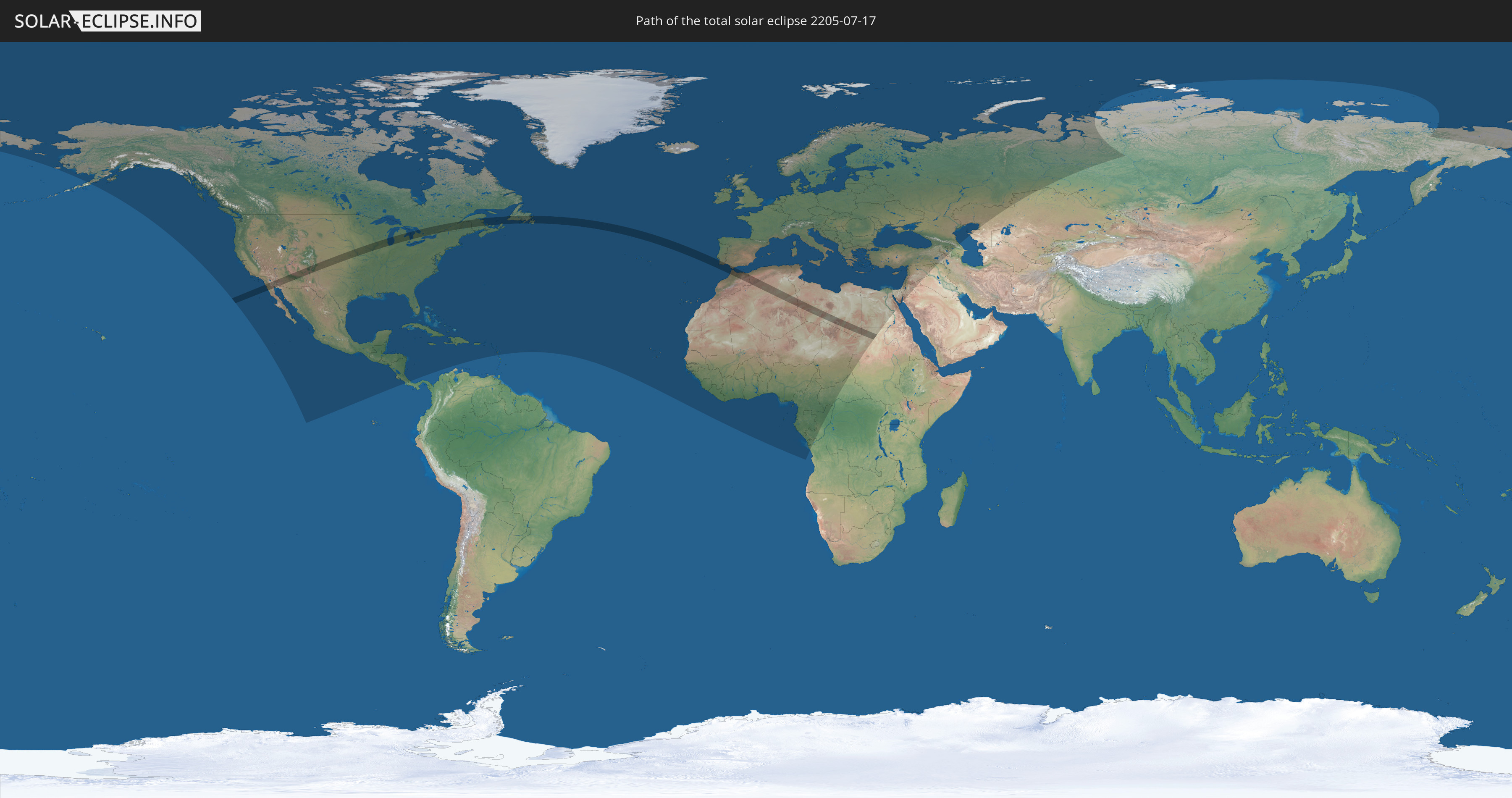
Total solar eclipse of 07/17/2205
| Day of week: | Wednesday |
| Maximum duration of eclipse: | 04m10s |
| Maximum width of eclipse path: | 193 km |
| Saros cycle: | 149 |
| Coverage: | 100% |
| Magnitude: | 1.0525 |
| Gamma: | 0.4367 |
Wo kann man die Sonnenfinsternis vom 07/17/2205 sehen?
Die Sonnenfinsternis am 07/17/2205 kann man in 129 Ländern als partielle Sonnenfinsternis beobachten.
Der Finsternispfad verläuft durch 11 Länder. Nur in diesen Ländern ist sie als total Sonnenfinsternis zu sehen.
In den folgenden Ländern ist die Sonnenfinsternis total zu sehen
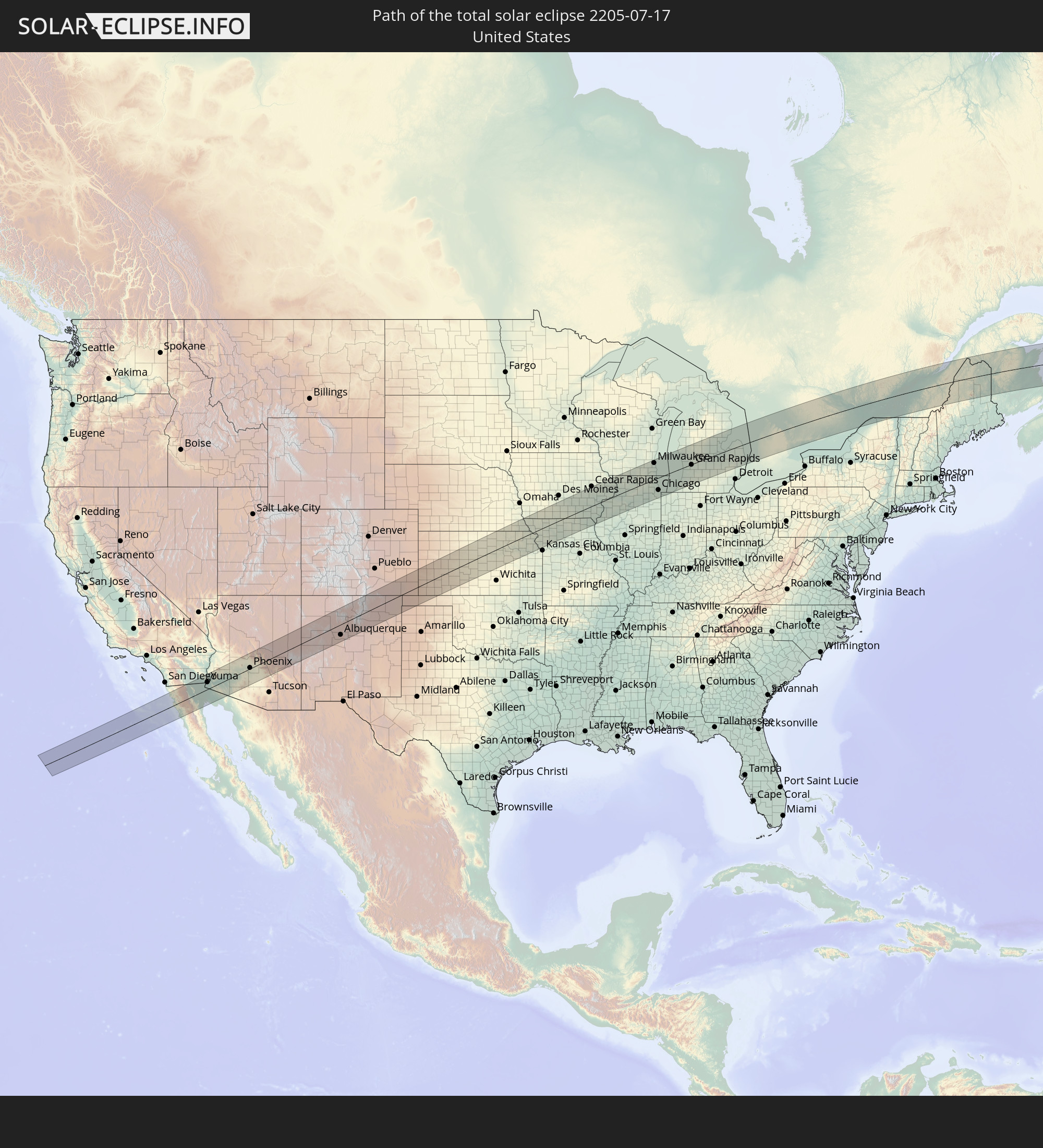 United States
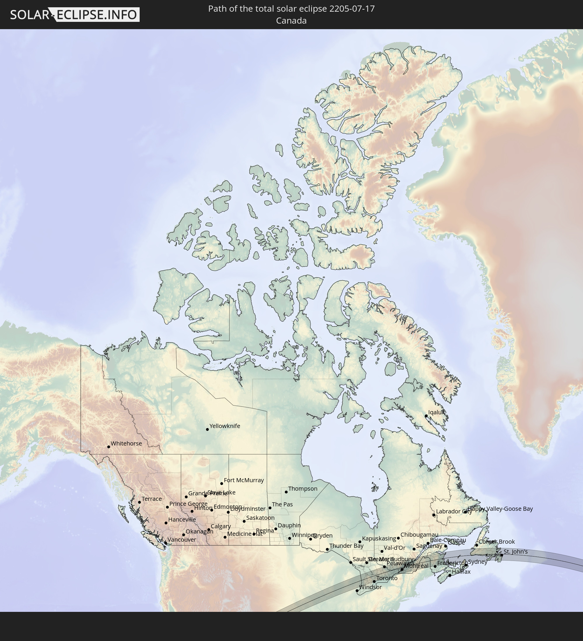 Canada
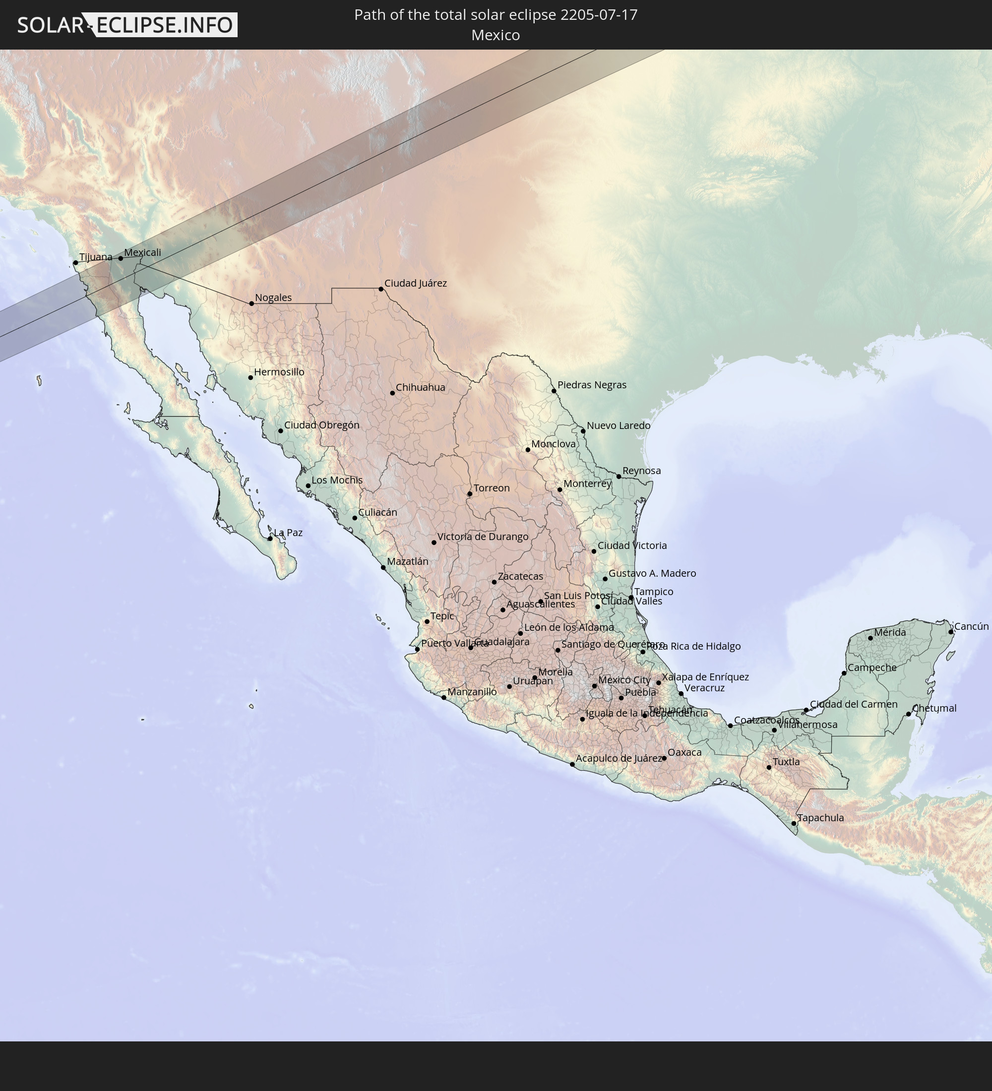 Mexico
 Saint Pierre and Miquelon
 Portugal
 Spain
Spain
 Morocco
 Algeria
 Gibraltar
 Libya
Libya
 Sudan
Sudan
In den folgenden Ländern ist die Sonnenfinsternis partiell zu sehen
 Russia
 United States
 United States Minor Outlying Islands
 Canada
 Mexico
 Greenland
 Guatemala
 El Salvador
 Honduras
 Belize
 Nicaragua
 Costa Rica
 Cuba
Cuba
 Panama
 Colombia
 Cayman Islands
 The Bahamas
 Jamaica
 Haiti
Haiti
 Turks and Caicos Islands
 Dominican Republic
 Puerto Rico
 United States Virgin Islands
 Bermuda
 British Virgin Islands
 Anguilla
 Collectivity of Saint Martin
 Saint Barthélemy
 Saint Kitts and Nevis
 Antigua and Barbuda
 Montserrat
 Guadeloupe
 Dominica
 Saint Pierre and Miquelon
 Portugal
 Cabo Verde
 Iceland
 Spain
Spain
 Senegal
 Mauritania
 The Gambia
 Guinea-Bissau
 Guinea
 Sierra Leone
 Morocco
 Mali
Mali
 Liberia
 Republic of Ireland
 Svalbard and Jan Mayen
 Algeria
 United Kingdom
 Ivory Coast
 Faroe Islands
 Burkina Faso
 Gibraltar
 France
 Isle of Man
 Ghana
Ghana
 Guernsey
 Jersey
 Togo
Togo
 Niger
Niger
 Benin
Benin
 Andorra
 Belgium
 Nigeria
 Netherlands
 Norway
 Equatorial Guinea
 Luxembourg
 Germany
 Switzerland
 São Tomé and Príncipe
 Italy
Italy
 Monaco
 Tunisia
 Denmark
 Cameroon
 Gabon
Gabon
 Libya
Libya
 Liechtenstein
 Austria
 Sweden
 Republic of the Congo
 Angola
 Czechia
 Democratic Republic of the Congo
 San Marino
 Vatican City
 Slovenia
 Chad
Chad
 Croatia
 Poland
 Malta
Malta
 Central African Republic
 Bosnia and Herzegovina
 Hungary
 Slovakia
 Montenegro
 Serbia
 Albania
 Åland Islands
 Greece
 Romania
 Republic of Macedonia
 Finland
 Lithuania
 Latvia
 Estonia
 Sudan
Sudan
 Ukraine
 Bulgaria
 Belarus
 Egypt
Egypt
 Turkey
 Moldova
 Cyprus
 State of Palestine
 Israel
 Saudi Arabia
 Jordan
 Lebanon
 Syria
Syria
 Iraq
Iraq
 Georgia
 Armenia
 Iran
Iran
 Azerbaijan
 Kazakhstan
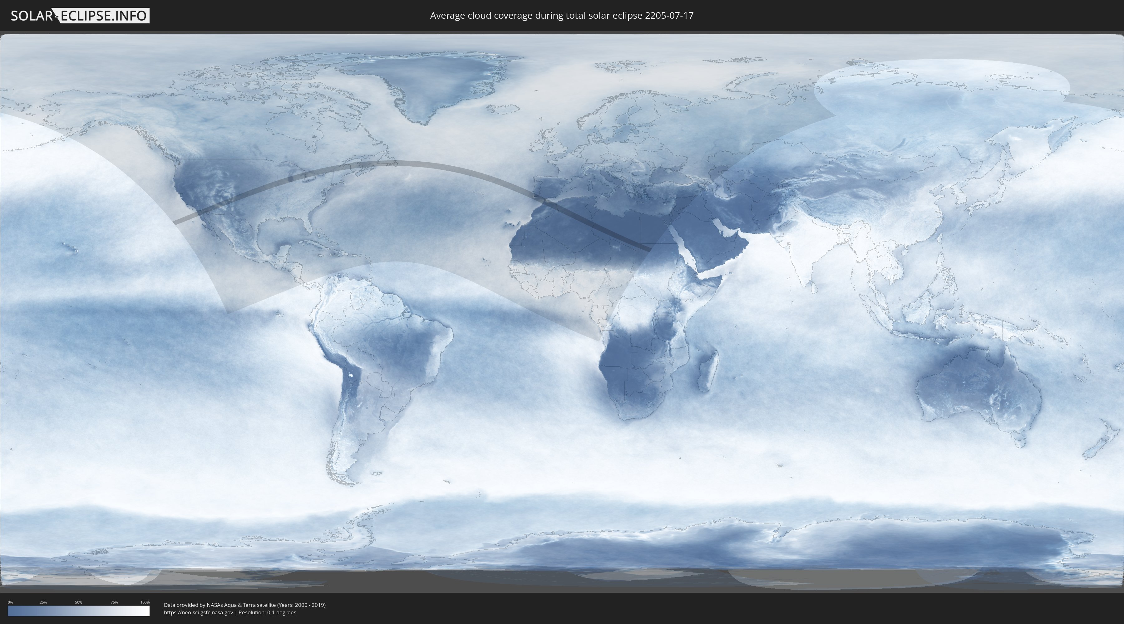
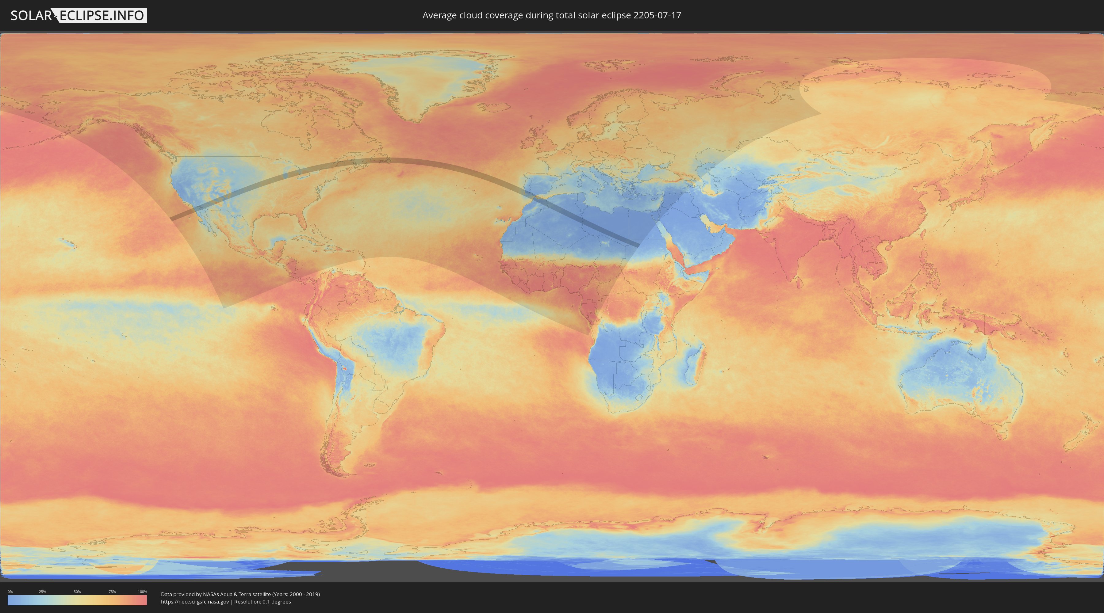
How will be the weather during the total solar eclipse on 07/17/2205?
Where is the best place to see the total solar eclipse of 07/17/2205?
The following maps show the average cloud coverage for the day of the total solar eclipse.
With the help of these maps, it is possible to find the place along the eclipse path, which has the best
chance of a cloudless sky.
Nevertheless, you should consider local circumstances and inform about the weather of your chosen
observation site.
The data is provided by NASAs satellites
AQUA and TERRA.
The cloud maps are averaged over a period of 19 years (2000 - 2019).
Detailed country maps
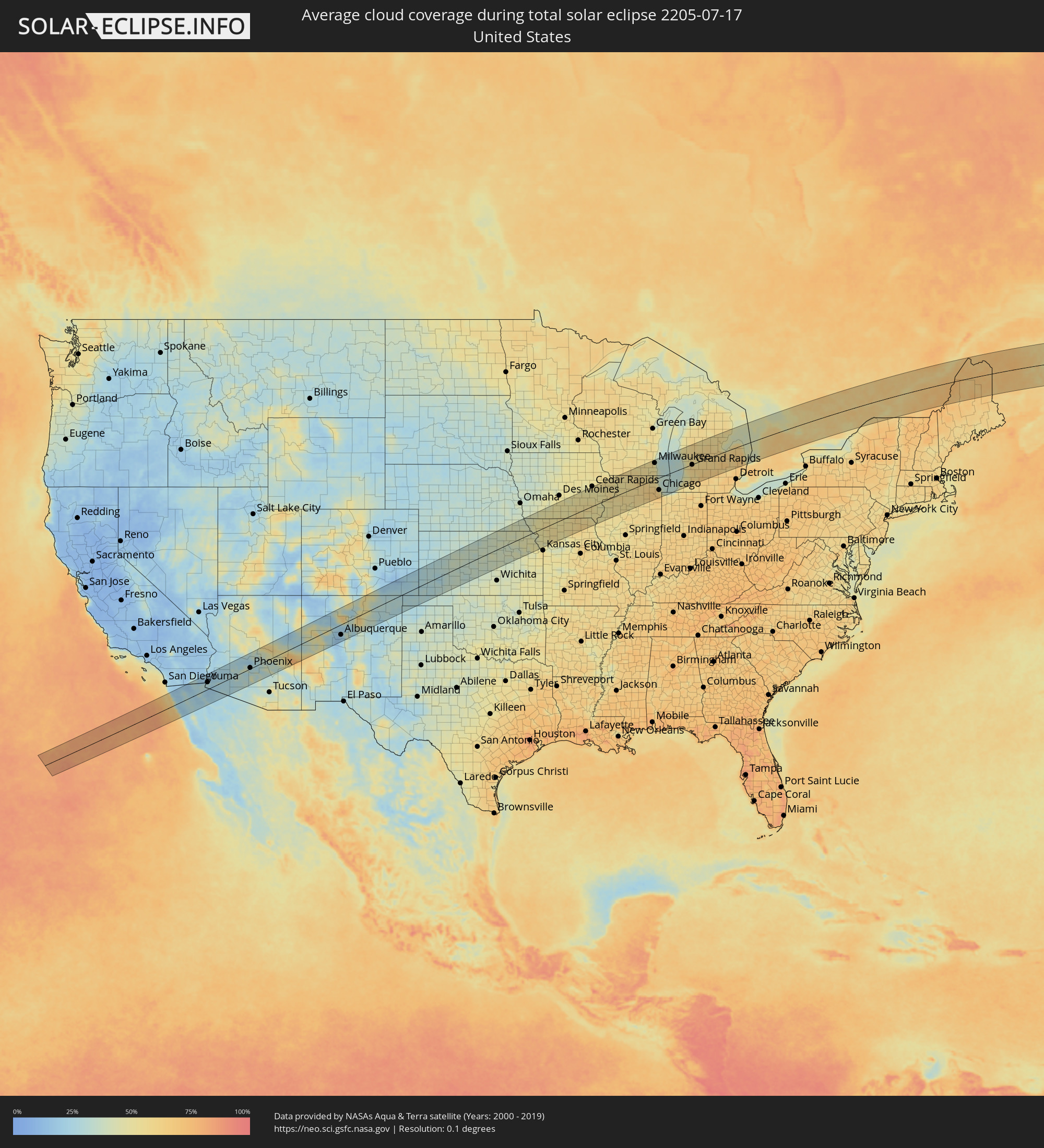 United States
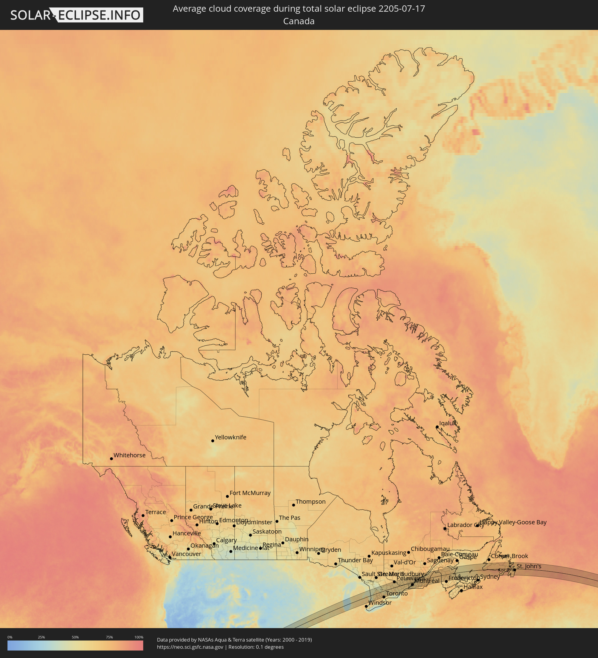 Canada
 Mexico
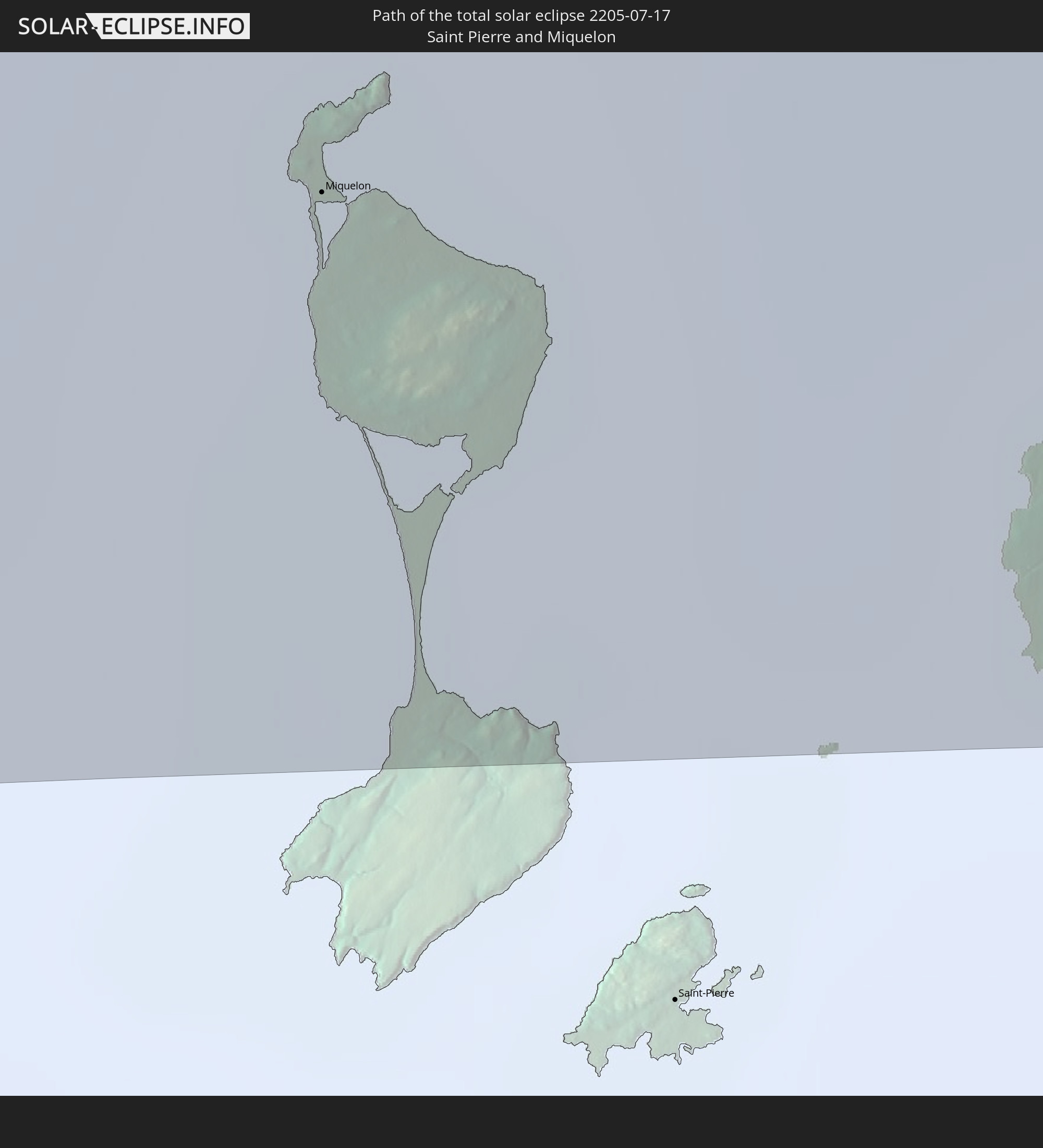
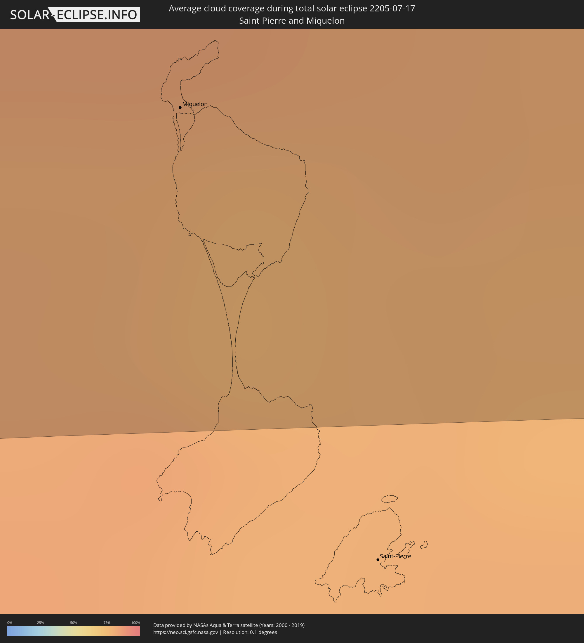 Saint Pierre and Miquelon
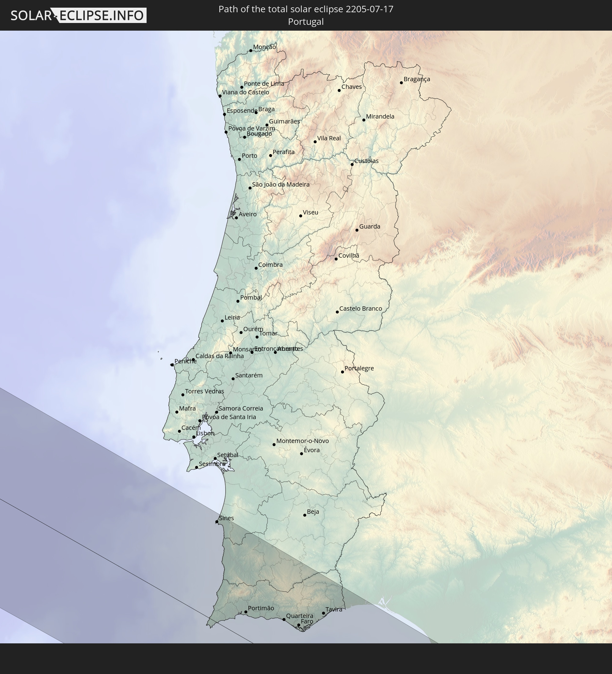
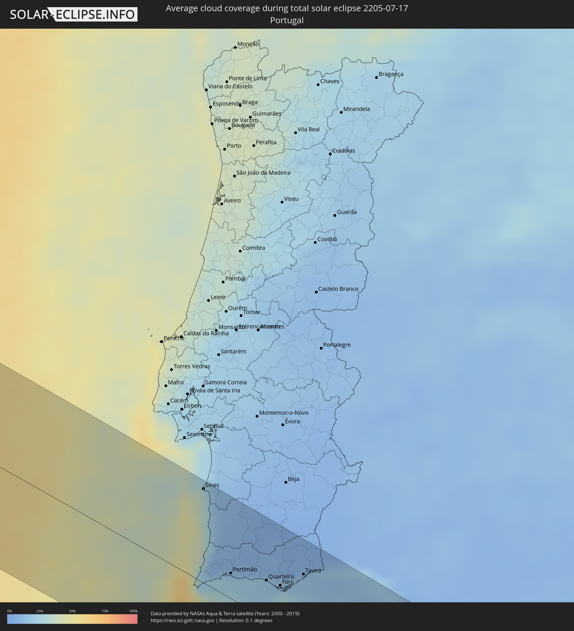 Portugal
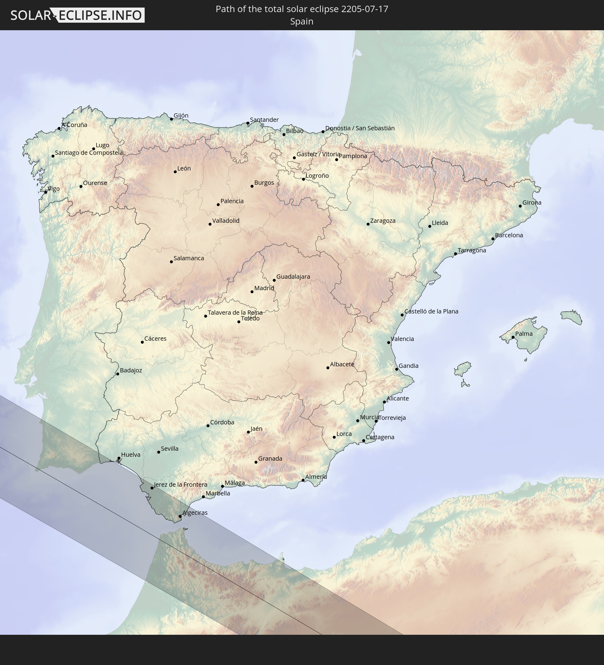
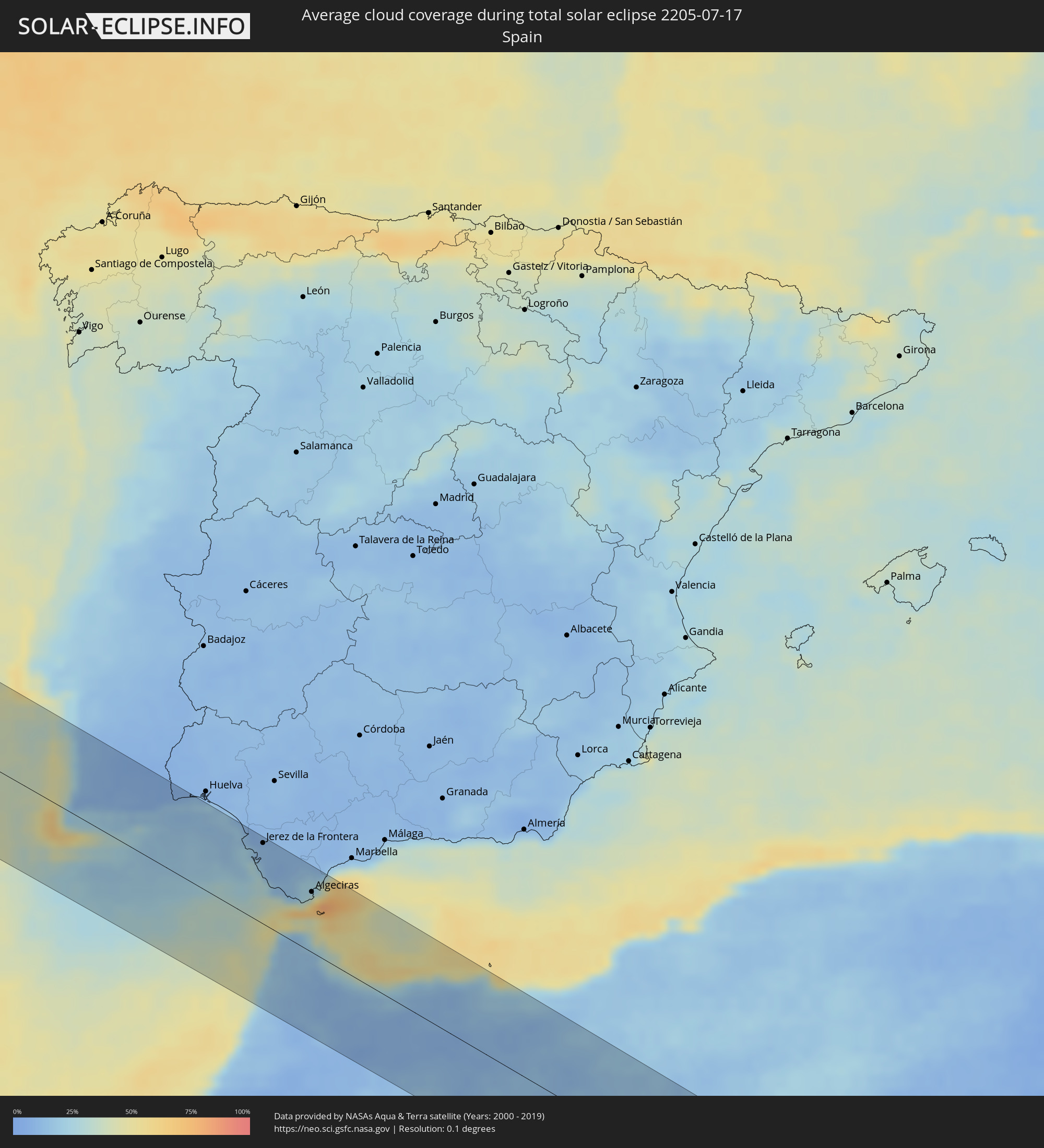 Spain
Spain
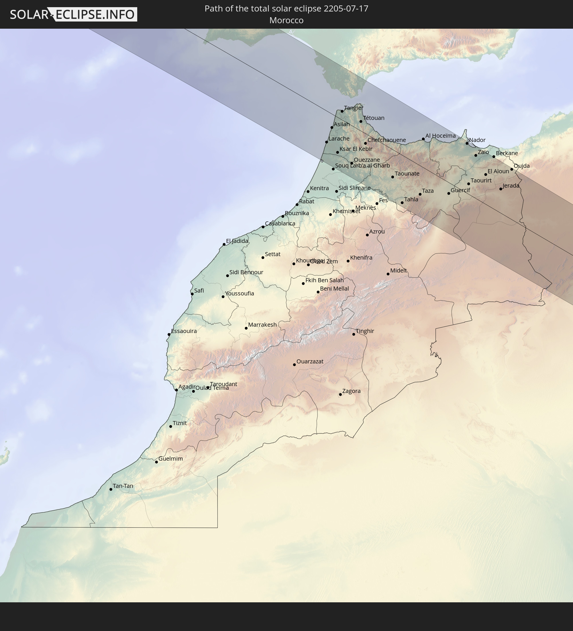
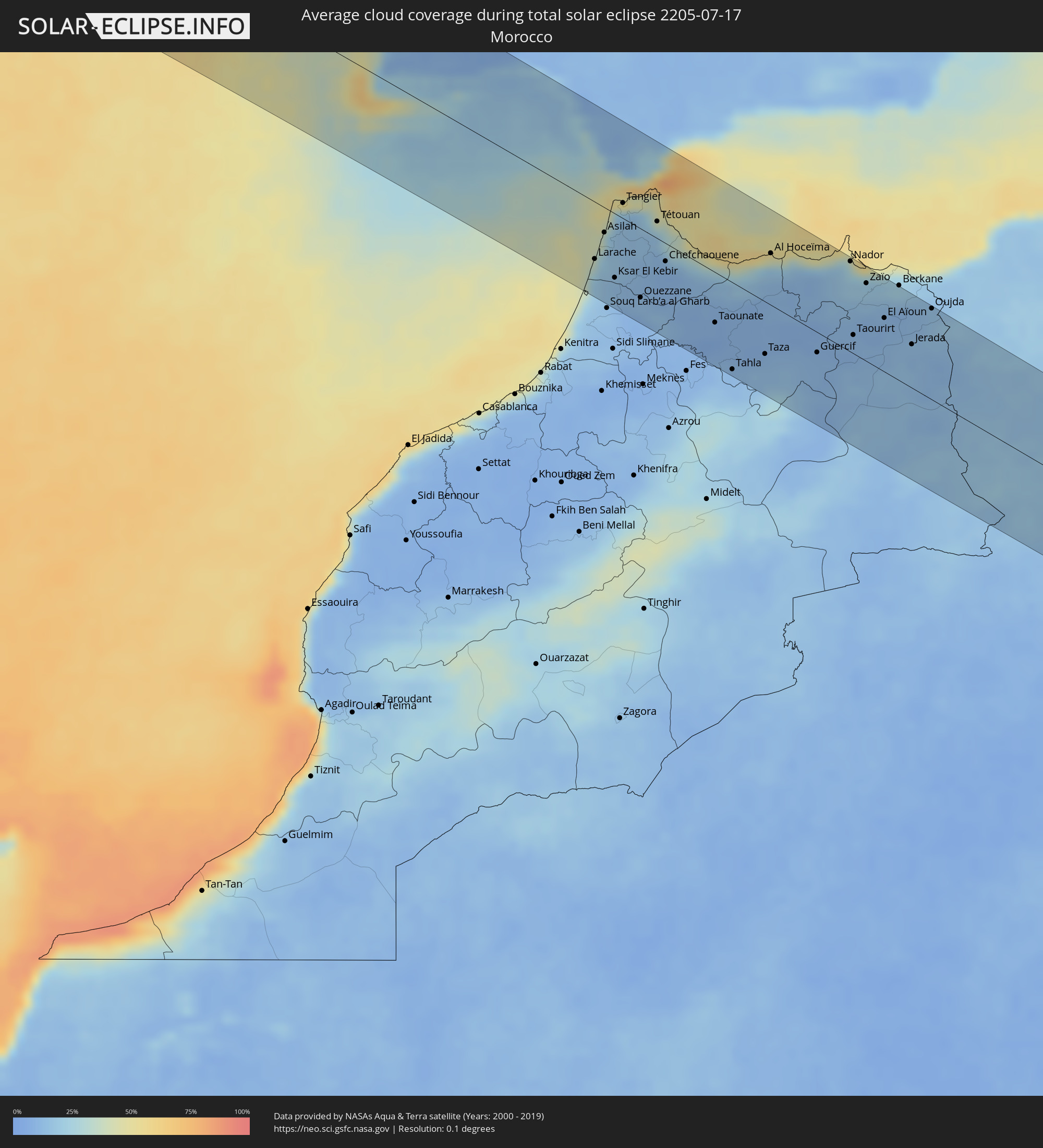 Morocco
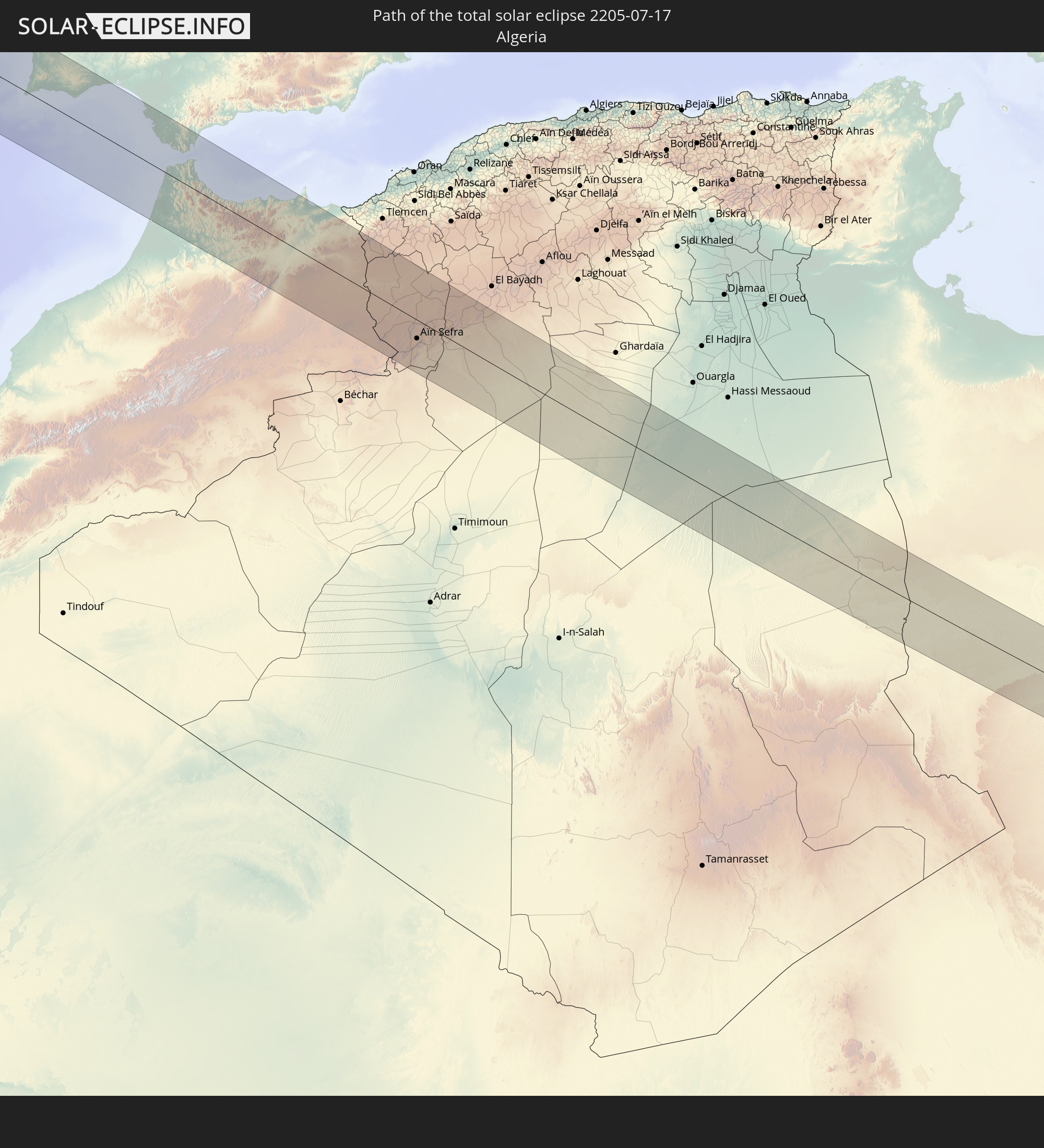
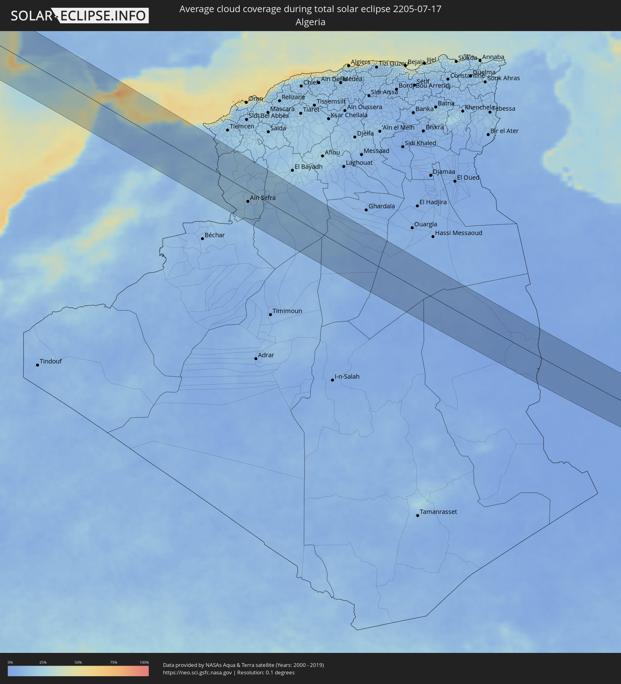 Algeria
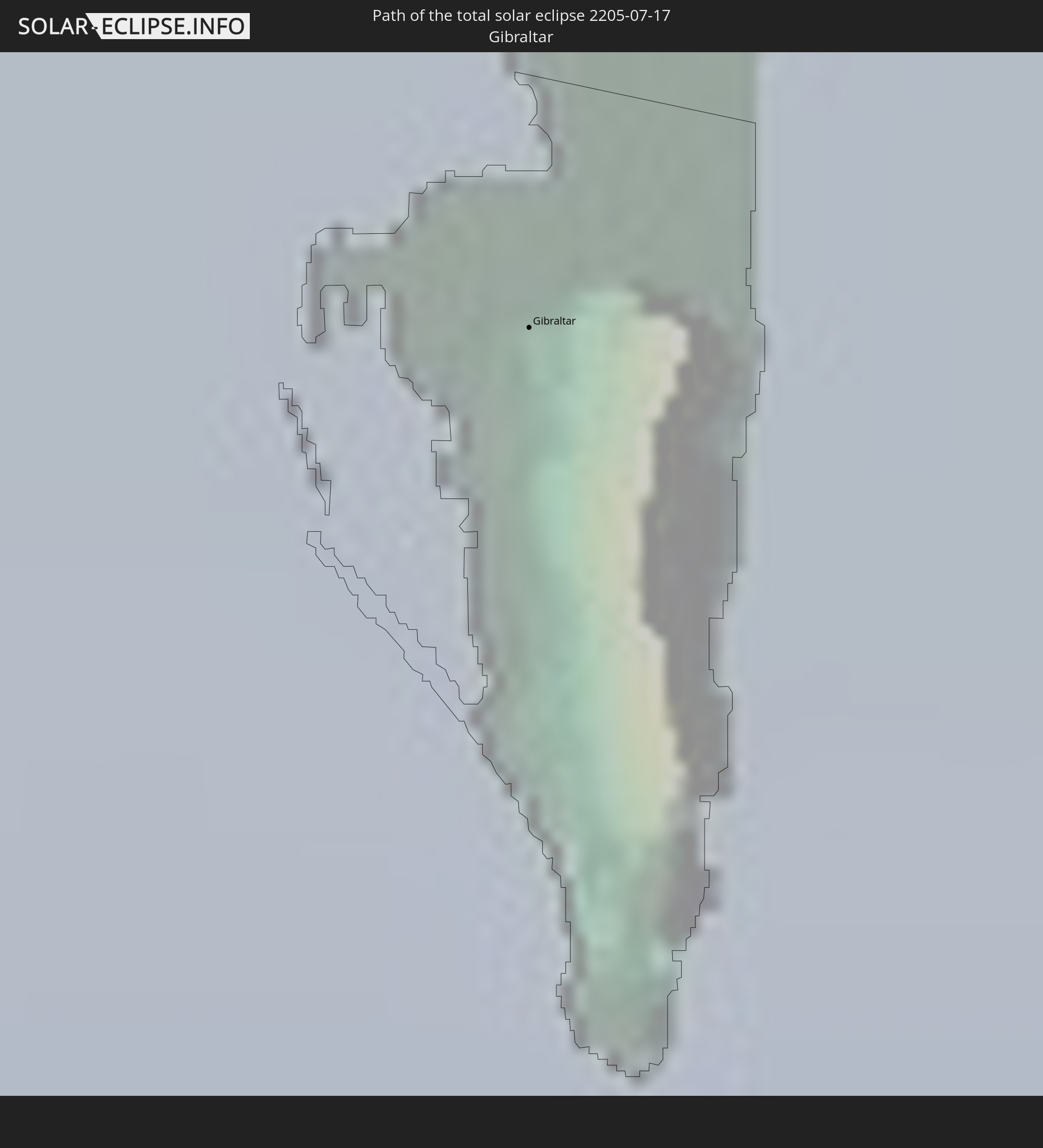
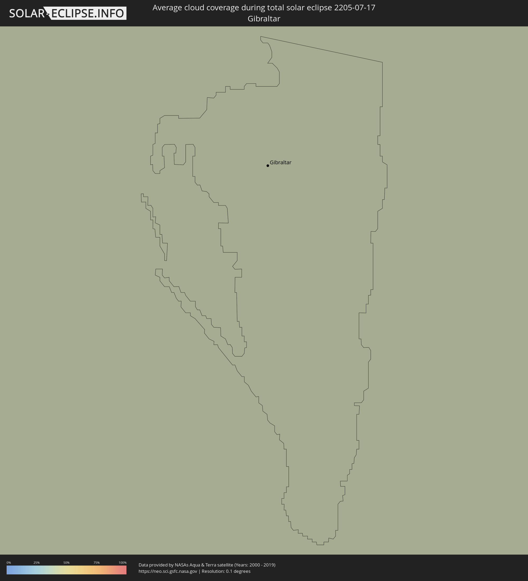 Gibraltar
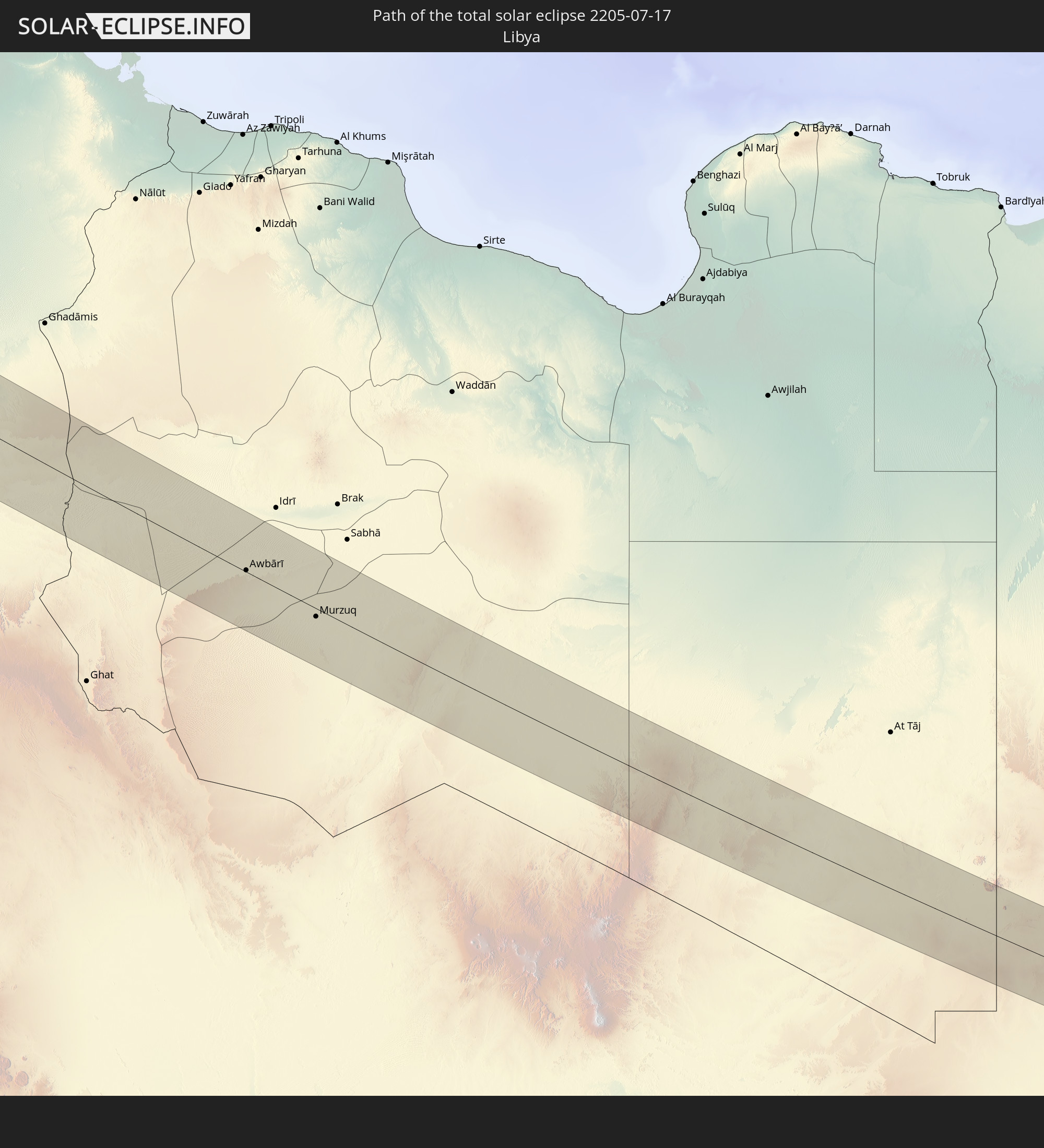
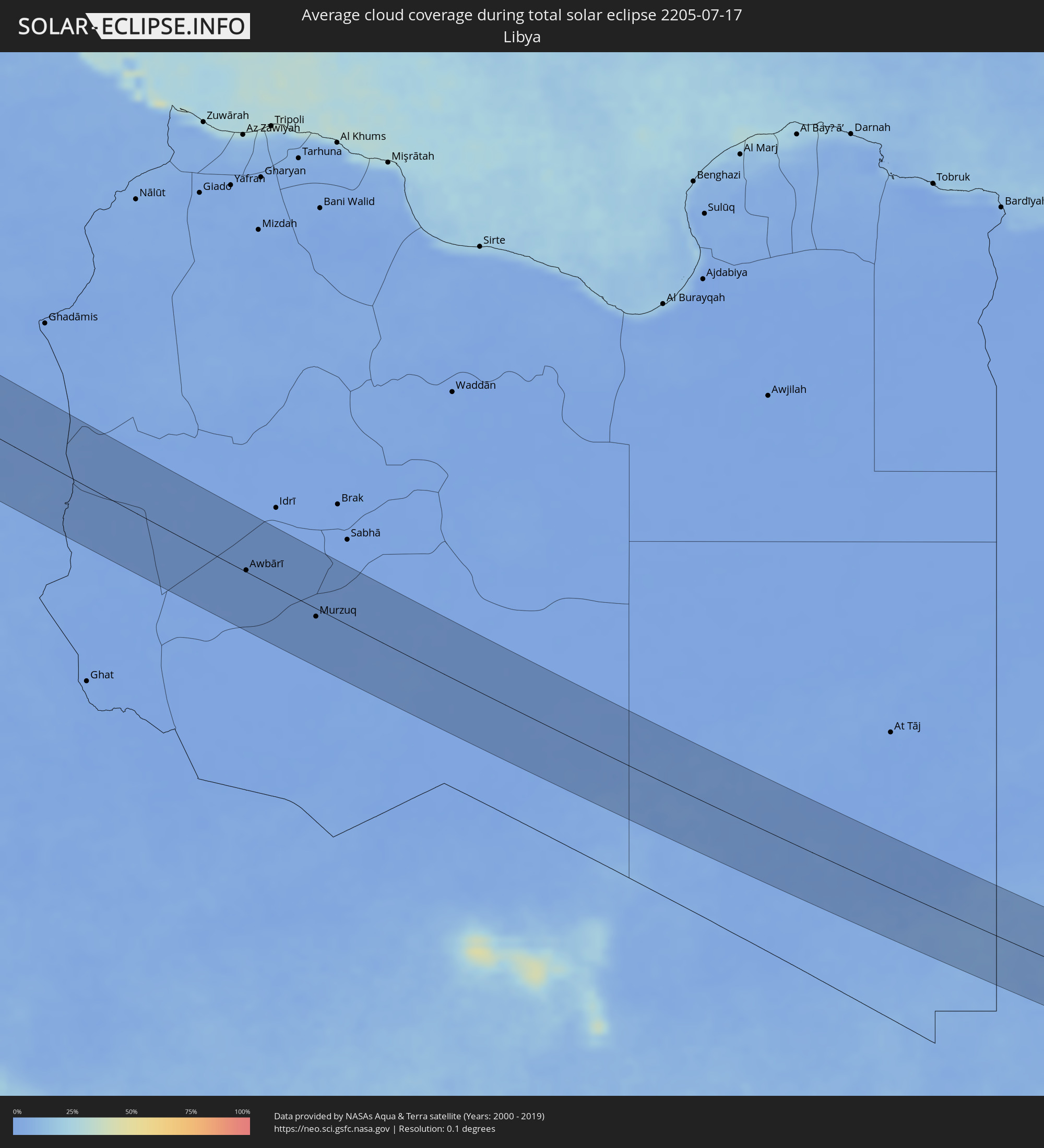 Libya
Libya
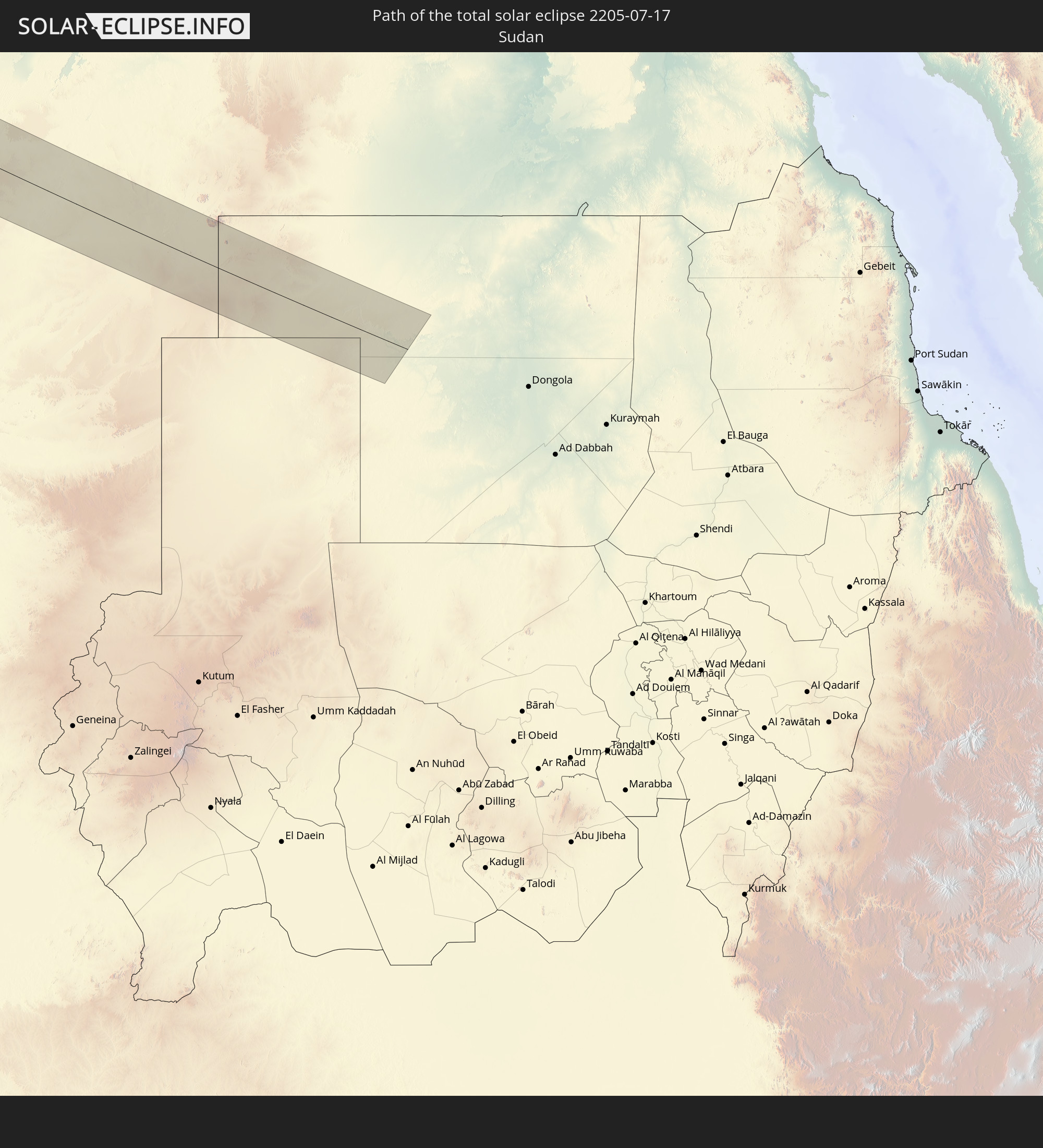
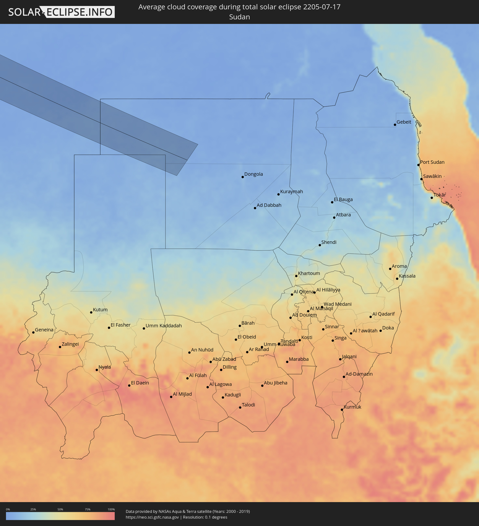 Sudan
Sudan
Cities inside the path of the eclipse
The following table shows all locations with a population of more than 5,000 inside the eclipse path. Cities which have more than 100,000 inhabitants are marked bold. A click at the locations opens a detailed map.
| City | Type | Eclipse duration | Local time of max. eclipse | Distance to central line | Ø Cloud coverage |
|
El Sauzal, Baja California
|
total | - | 05:37:00 UTC-08:00 | 36 km | 52% |
|
Ensenada, Baja California
|
total | - | 05:36:58 UTC-08:00 | 29 km | 37% |
|
Rodolfo Sánchez Taboada, Baja California
|
total | - | 05:36:49 UTC-08:00 | 14 km | 35% |
|
Benito García (El Zorrillo), Baja California
|
total | - | 05:36:45 UTC-08:00 | 6 km | 26% |
|
Progreso, Baja California
|
total | - | 05:37:35 UTC-08:00 | 60 km | 22% |
|
Mexicali, Baja California
|
total | - | 05:37:37 UTC-08:00 | 59 km | 26% |
|
Puebla, Baja California
|
total | - | 05:37:32 UTC-08:00 | 49 km | 28% |
|
Delta, Baja California
|
total | - | 05:37:18 UTC-08:00 | 21 km | 25% |
|
Doctor Alberto Oviedo Mota, Baja California
|
total | - | 05:37:10 UTC-08:00 | 7 km | 34% |
|
Guadalupe Victoria, Baja California
|
total | - | 05:37:13 UTC-08:00 | 11 km | 30% |
|
Ciudad Coahuila (Kilómetro Cincuenta y Siete), Baja California
|
total | - | 05:37:07 UTC-08:00 | 3 km | 30% |
|
Estación Coahuila, Baja California
|
total | - | 05:37:07 UTC-08:00 | 3 km | 30% |
|
Tecolots, Baja California
|
total | - | 05:37:30 UTC-08:00 | 34 km | 31% |
|
Hermosillo, Baja California
|
total | - | 05:37:26 UTC-08:00 | 26 km | 28% |
|
San Luis Río Colorado, Sonora
|
total | - | 06:37:22 UTC-07:00 | 14 km | 23% |
|
Yuma, Arizona
|
total | - | 05:37:38 UTC-08:00 | 35 km | 31% |
|
Peoria, Arizona
|
total | - | 06:38:27 UTC-07:00 | 24 km | 27% |
|
Phoenix, Arizona
|
total | - | 06:38:18 UTC-07:00 | 4 km | 31% |
|
Mesa, Arizona
|
total | - | 06:38:16 UTC-07:00 | 10 km | 31% |
|
San Tan Valley, Arizona
|
total | - | 06:38:01 UTC-07:00 | 44 km | 37% |
|
Albuquerque, New Mexico
|
total | - | 06:40:34 UTC-07:00 | 50 km | 19% |
|
Enchanted Hills, New Mexico
|
total | - | 06:40:52 UTC-07:00 | 27 km | 22% |
|
Topeka, Kansas
|
total | - | 07:49:18 UTC-06:00 | 70 km | 45% |
|
Davenport, Iowa
|
total | - | 07:55:48 UTC-06:00 | 5 km | 54% |
|
Rockford, Illinois
|
total | - | 07:57:55 UTC-06:00 | 33 km | 58% |
|
Aurora, Illinois
|
total | - | 07:57:50 UTC-06:00 | 44 km | 65% |
|
Elgin, Illinois
|
total | - | 07:58:14 UTC-06:00 | 17 km | 63% |
|
Joliet, Illinois
|
total | - | 07:57:43 UTC-06:00 | 76 km | 62% |
|
Milwaukee, Wisconsin
|
total | - | 07:59:54 UTC-06:00 | 74 km | 51% |
|
Waukegan, Illinois
|
total | - | 07:59:02 UTC-06:00 | 3 km | 46% |
|
Kenosha, Wisconsin
|
total | - | 07:59:21 UTC-06:00 | 25 km | 47% |
|
Chicago, Illinois
|
total | - | 07:58:30 UTC-06:00 | 56 km | 61% |
|
Grand Rapids, Michigan
|
total | - | 09:01:42 UTC-05:00 | 2 km | 59% |
|
Lansing, Michigan
|
total | - | 09:02:25 UTC-05:00 | 59 km | 64% |
|
Flint, Michigan
|
total | - | 09:03:37 UTC-05:00 | 55 km | 67% |
|
Brampton, Ontario
|
total | - | 09:08:34 UTC-05:00 | 92 km | 68% |
|
Barrie, Ontario
|
total | - | 09:09:35 UTC-05:00 | 19 km | 59% |
|
Newmarket, Ontario
|
total | - | 09:09:21 UTC-05:00 | 61 km | 65% |
|
North York, Ontario
|
total | - | 09:09:03 UTC-05:00 | 92 km | 66% |
|
Markham, Ontario
|
total | - | 09:09:21 UTC-05:00 | 85 km | 66% |
|
Oshawa, Ontario
|
total | - | 09:09:52 UTC-05:00 | 92 km | 52% |
|
Peterborough, Ontario
|
total | - | 09:10:59 UTC-05:00 | 63 km | 60% |
|
Ottawa, Ontario
|
total | - | 09:15:27 UTC-05:00 | 6 km | 65% |
|
Saint-Jérôme, Quebec
|
total | - | 09:18:01 UTC-05:00 | 2 km | 65% |
|
Terrebonne, Quebec
|
total | - | 09:18:23 UTC-05:00 | 18 km | 59% |
|
Montréal, Quebec
|
total | - | 09:18:15 UTC-05:00 | 40 km | 61% |
|
Repentigny, Quebec
|
total | - | 09:18:41 UTC-05:00 | 18 km | 59% |
|
Saint-Jean-sur-Richelieu, Quebec
|
total | - | 09:18:27 UTC-05:00 | 68 km | 57% |
|
Saint-Hyacinthe, Quebec
|
total | - | 09:19:13 UTC-05:00 | 39 km | 62% |
|
Granby, Quebec
|
total | - | 09:19:16 UTC-05:00 | 69 km | 70% |
|
Trois-Rivières, Quebec
|
total | - | 09:20:33 UTC-05:00 | 30 km | 60% |
|
Drummondville, Quebec
|
total | - | 09:20:08 UTC-05:00 | 22 km | 63% |
|
Sherbrooke, Quebec
|
total | - | 09:20:24 UTC-05:00 | 85 km | 71% |
|
Québec, Quebec
|
total | - | 09:22:49 UTC-05:00 | 55 km | 61% |
|
Miquelon, Miquelon-Langlade
|
total | - | 11:46:16 UTC-03:00 | 70 km | 78% |
|
St. John's, Newfoundland and Labrador
|
total | - | 11:22:51 UTC-03:30 | 21 km | 70% |
|
Sines, Setúbal
|
total | - | 16:12:45 UTC+00:00 | 88 km | 31% |
|
Lagos, Faro
|
total | - | 16:14:16 UTC+00:00 | 14 km | 23% |
|
Odemira, Beja
|
total | - | 16:13:31 UTC+00:00 | 64 km | 10% |
|
Alvor, Faro
|
total | - | 16:14:18 UTC+00:00 | 21 km | 22% |
|
Monchique, Faro
|
total | - | 16:14:02 UTC+00:00 | 40 km | 8% |
|
Portimão, Faro
|
total | - | 16:14:20 UTC+00:00 | 24 km | 21% |
|
Estômbar, Faro
|
total | - | 16:14:22 UTC+00:00 | 27 km | 21% |
|
Lagoa, Faro
|
total | - | 16:14:25 UTC+00:00 | 27 km | 21% |
|
Silves, Faro
|
total | - | 16:14:21 UTC+00:00 | 33 km | 12% |
|
São Bartolomeu de Messines, Faro
|
total | - | 16:14:23 UTC+00:00 | 47 km | 8% |
|
Albufeira, Faro
|
total | - | 16:14:41 UTC+00:00 | 32 km | 20% |
|
Quarteira, Faro
|
total | - | 16:14:51 UTC+00:00 | 37 km | 18% |
|
Almancil, Faro
|
total | - | 16:14:53 UTC+00:00 | 41 km | 15% |
|
Loulé, Faro
|
total | - | 16:14:49 UTC+00:00 | 47 km | 15% |
|
Faro, Faro
|
total | - | 16:15:05 UTC+00:00 | 39 km | 28% |
|
São Brás de Alportel, Faro
|
total | - | 16:14:55 UTC+00:00 | 54 km | 8% |
|
Laranjeiro, Faro
|
total | - | 16:15:08 UTC+00:00 | 50 km | 16% |
|
Moncarapacho, Faro
|
total | - | 16:15:06 UTC+00:00 | 52 km | 16% |
|
Tavira, Faro
|
total | - | 16:15:10 UTC+00:00 | 62 km | 16% |
|
Vila Real de Santo António, Faro
|
total | - | 16:15:16 UTC+00:00 | 79 km | 16% |
|
Ayamonte, Andalusia
|
total | - | 17:15:15 UTC+01:00 | 81 km | 16% |
|
Isla Cristina, Andalusia
|
total | - | 17:15:21 UTC+01:00 | 84 km | 17% |
|
Lepe, Andalusia
|
total | - | 17:15:22 UTC+01:00 | 94 km | 12% |
|
Chipiona, Andalusia
|
total | - | 17:16:50 UTC+01:00 | 79 km | 22% |
|
Rota, Andalusia
|
total | - | 17:17:04 UTC+01:00 | 72 km | 23% |
|
Sanlúcar de Barrameda, Andalusia
|
total | - | 17:16:51 UTC+01:00 | 87 km | 14% |
|
Cadiz, Andalusia
|
total | - | 17:17:17 UTC+01:00 | 66 km | 27% |
|
Puerto Real, Andalusia
|
total | - | 17:17:22 UTC+01:00 | 70 km | 22% |
|
Larache, Tanger-Tétouan
|
total | - | 17:19:27 UTC+01:00 | 56 km | 32% |
|
Chiclana de la Frontera, Andalusia
|
total | - | 17:17:34 UTC+01:00 | 62 km | 15% |
|
Jerez de la Frontera, Andalusia
|
total | - | 17:17:10 UTC+01:00 | 88 km | 11% |
|
Conil de la Frontera, Andalusia
|
total | - | 17:17:50 UTC+01:00 | 51 km | 27% |
|
Asilah, Tanger-Tétouan
|
total | - | 17:19:08 UTC+01:00 | 25 km | 21% |
|
Vejer de la Frontera, Andalusia
|
total | - | 17:17:59 UTC+01:00 | 53 km | 35% |
|
Medina Sidonia, Andalusia
|
total | - | 17:17:42 UTC+01:00 | 76 km | 9% |
|
Barbate de Franco, Andalusia
|
total | - | 17:18:07 UTC+01:00 | 50 km | 32% |
|
Ksar El Kebir, Tanger-Tétouan
|
total | - | 17:19:57 UTC+01:00 | 63 km | 13% |
|
Tangier, Tanger-Tétouan
|
total | - | 17:18:52 UTC+01:00 | 15 km | 21% |
|
Tarifa, Andalusia
|
total | - | 17:18:39 UTC+01:00 | 48 km | 66% |
|
Ouezzane, Gharb-Chrarda-Beni Hssen
|
total | - | 17:20:32 UTC+01:00 | 68 km | 13% |
|
Los Barrios, Andalusia
|
total | - | 17:18:29 UTC+01:00 | 69 km | 32% |
|
Algeciras, Andalusia
|
total | - | 17:18:35 UTC+01:00 | 66 km | 56% |
|
San Roque, Andalusia
|
total | - | 17:18:31 UTC+01:00 | 77 km | 49% |
|
Tétouan, Tanger-Tétouan
|
total | - | 17:19:31 UTC+01:00 | 17 km | 28% |
|
Gibraltar
|
total | - | 17:18:39 UTC+01:00 | 72 km | 72% |
|
La Línea de la Concepción, Andalusia
|
total | - | 17:18:37 UTC+01:00 | 74 km | 64% |
|
Ceuta, Ceuta
|
total | - | 17:19:04 UTC+01:00 | 49 km | 56% |
|
Martil, Tanger-Tétouan
|
total | - | 17:19:32 UTC+01:00 | 25 km | 32% |
|
Chefchaouene, Tanger-Tétouan
|
total | - | 17:20:13 UTC+01:00 | 18 km | 9% |
|
Taounate, Taza-Al Hoceima-Taounate
|
total | - | 17:21:41 UTC+01:00 | 50 km | 7% |
|
Taza, Taza-Al Hoceima-Taounate
|
total | - | 17:22:39 UTC+01:00 | 52 km | 11% |
|
Tirhanimîne, Taza-Al Hoceima-Taounate
|
total | - | 17:21:08 UTC+01:00 | 49 km | 21% |
|
Al Hoceïma, Taza-Al Hoceima-Taounate
|
total | - | 17:21:07 UTC+01:00 | 51 km | 39% |
|
Imzoûrene, Taza-Al Hoceima-Taounate
|
total | - | 17:21:20 UTC+01:00 | 45 km | 21% |
|
Guercif, Taza-Al Hoceima-Taounate
|
total | - | 17:23:07 UTC+01:00 | 20 km | 10% |
|
Nador, Oriental
|
total | - | 17:21:59 UTC+01:00 | 90 km | 40% |
|
Taourirt, Oriental
|
total | - | 17:23:10 UTC+01:00 | 18 km | 10% |
|
Zaïo, Oriental
|
total | - | 17:22:28 UTC+01:00 | 77 km | 16% |
|
El Aïoun, Oriental
|
total | - | 17:23:10 UTC+01:00 | 54 km | 10% |
|
Jerada, Oriental
|
total | - | 17:23:49 UTC+01:00 | 44 km | 12% |
|
Oujda, Oriental
|
total | - | 17:23:26 UTC+01:00 | 91 km | 14% |
|
Aïn Sefra, Naama
|
total | - | 17:27:09 UTC+01:00 | 32 km | 17% |
|
Naama, Naama
|
total | - | 17:26:33 UTC+01:00 | 30 km | 16% |
|
El Abiodh Sidi Cheikh, El Bayadh
|
total | - | 17:27:37 UTC+01:00 | 35 km | 13% |
|
Brezina, El Bayadh
|
total | - | 17:27:43 UTC+01:00 | 89 km | 10% |
|
Awbārī, Sha‘bīyat Wādī al Ḩayāt
|
total | - | 18:40:09 UTC+02:00 | 2 km | 0% |
|
Murzuq, Murzuq
|
total | - | 18:41:04 UTC+02:00 | 12 km | 0% |