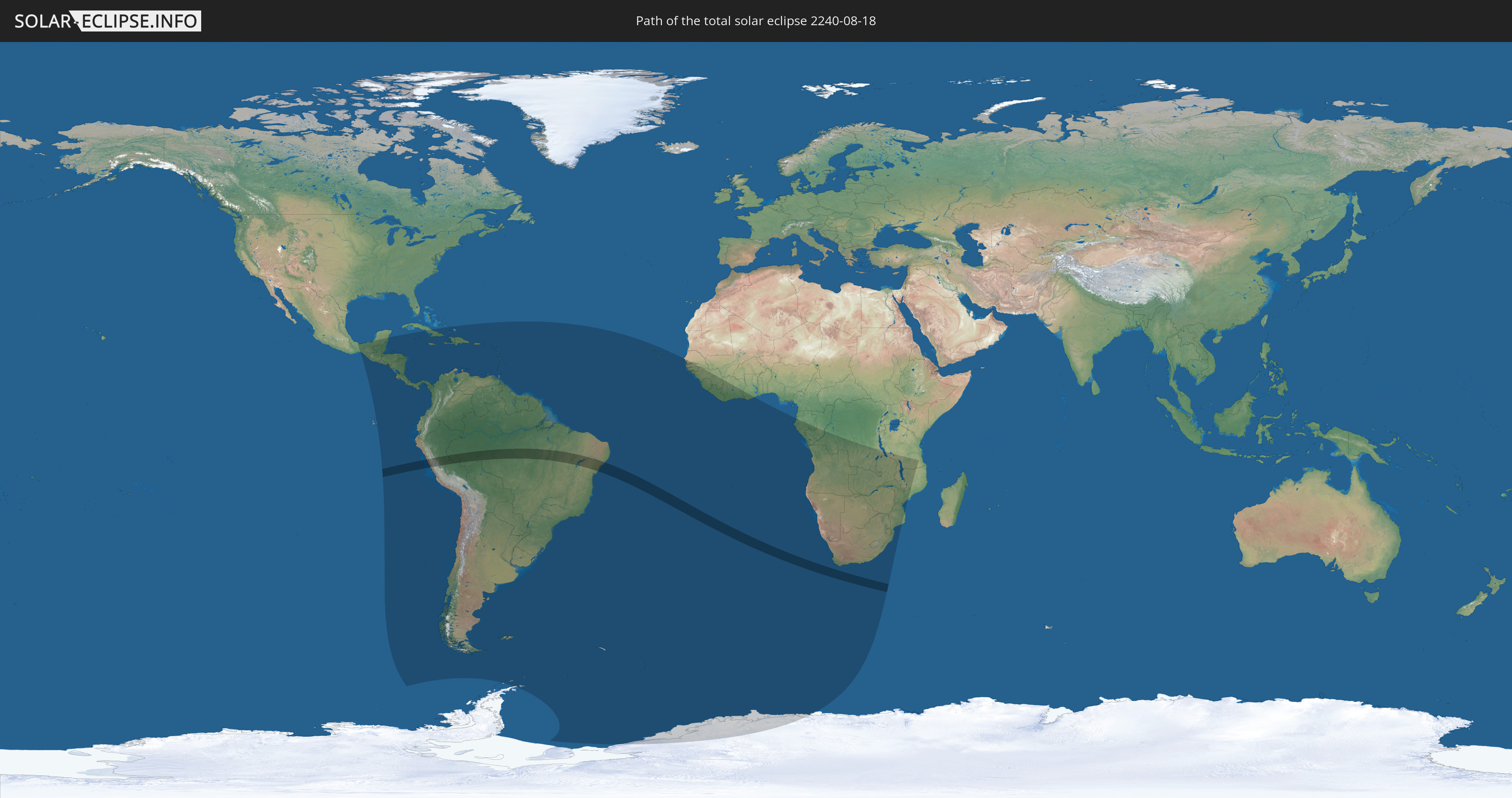
Total solar eclipse of 08/18/2240
| Day of week: | Tuesday |
| Maximum duration of eclipse: | 06m40s |
| Maximum width of eclipse path: | 270 km |
| Saros cycle: | 139 |
| Coverage: | 100% |
| Magnitude: | 1.0746 |
| Gamma: | -0.4522 |
Wo kann man die Sonnenfinsternis vom 08/18/2240 sehen?
Die Sonnenfinsternis am 08/18/2240 kann man in 77 Ländern als partielle Sonnenfinsternis beobachten.
Der Finsternispfad verläuft durch 2 Länder. Nur in diesen Ländern ist sie als total Sonnenfinsternis zu sehen.
In den folgenden Ländern ist die Sonnenfinsternis total zu sehen
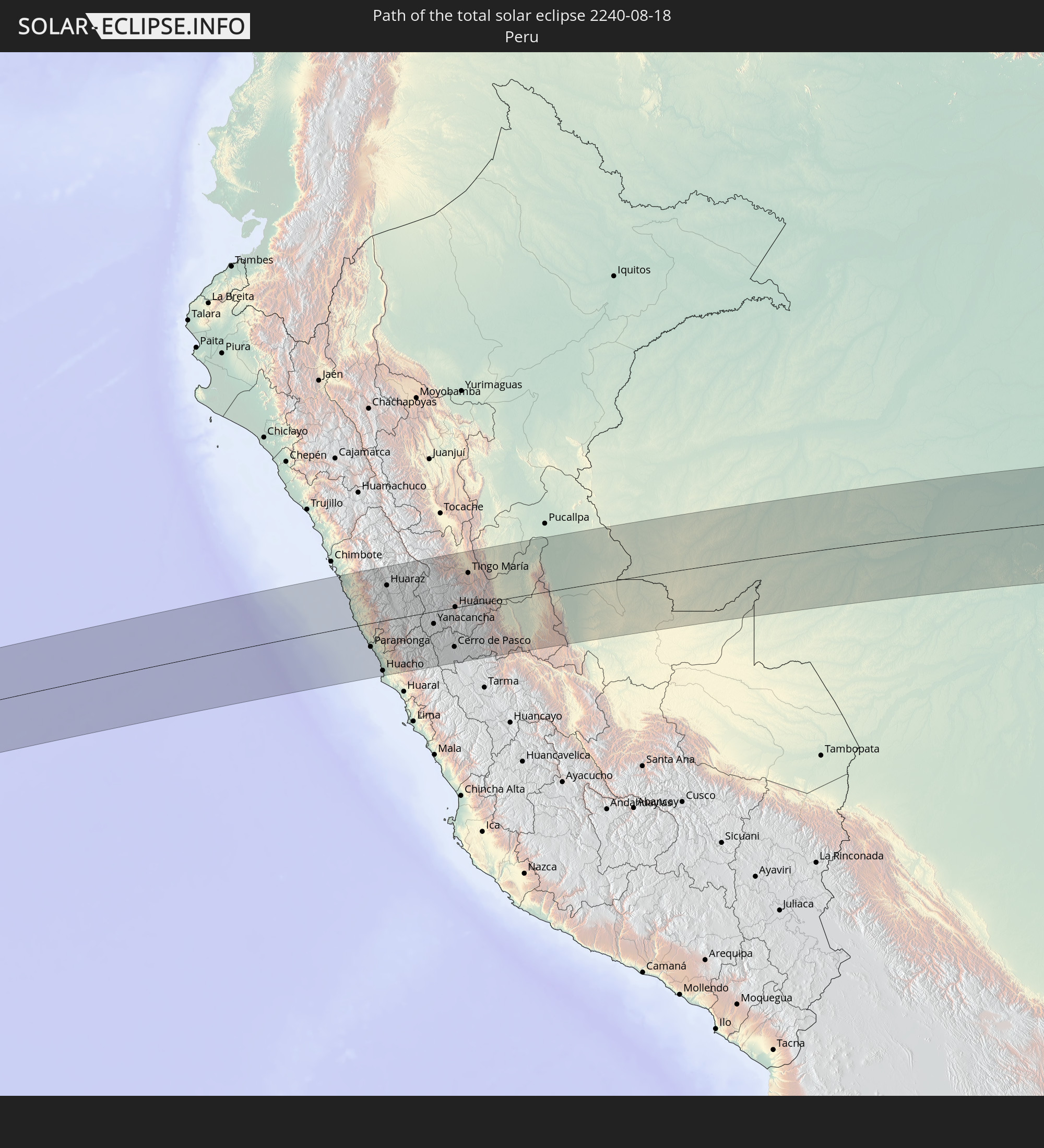 Peru
Peru
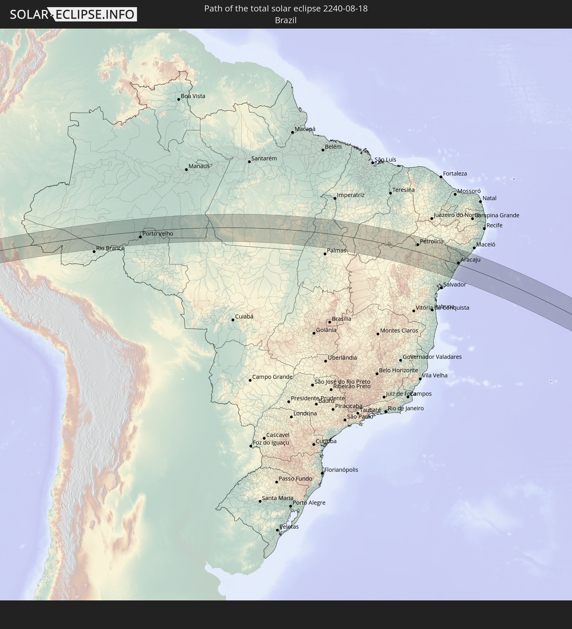 Brazil
In den folgenden Ländern ist die Sonnenfinsternis partiell zu sehen
 Antarctica
 United States Minor Outlying Islands
 Mexico
 Chile
Chile
 Guatemala
 Ecuador
 El Salvador
 Honduras
 Belize
 Nicaragua
 Costa Rica
 Cuba
Cuba
 Panama
 Colombia
 Cayman Islands
 Peru
Peru
 The Bahamas
 Jamaica
 Haiti
Haiti
 Brazil
 Argentina
 Venezuela
 Turks and Caicos Islands
 Dominican Republic
 Aruba
Aruba
 Bolivia
 Puerto Rico
 United States Virgin Islands
 British Virgin Islands
 Anguilla
 Collectivity of Saint Martin
 Saint Barthélemy
 Saint Kitts and Nevis
 Paraguay
 Antigua and Barbuda
 Montserrat
 Trinidad and Tobago
 Guadeloupe
 Grenada
 Dominica
 Saint Vincent and the Grenadines
 Falkland Islands
 Guyana
 Martinique
 Saint Lucia
 Barbados
 Uruguay
 Suriname
 French Guiana
 South Georgia and the South Sandwich Islands
 Cabo Verde
 Senegal
 The Gambia
 Guinea-Bissau
 Guinea
 Saint Helena, Ascension and Tristan da Cunha
 Sierra Leone
 Liberia
 Ivory Coast
 Ghana
Ghana
 Bouvet Island
 Equatorial Guinea
 São Tomé and Príncipe
 Gabon
Gabon
 Republic of the Congo
 Angola
 Namibia
 Democratic Republic of the Congo
 South Africa
 Botswana
 Zambia
 Zimbabwe
 Lesotho
 Tanzania
 Mozambique
 Swaziland
 Malawi
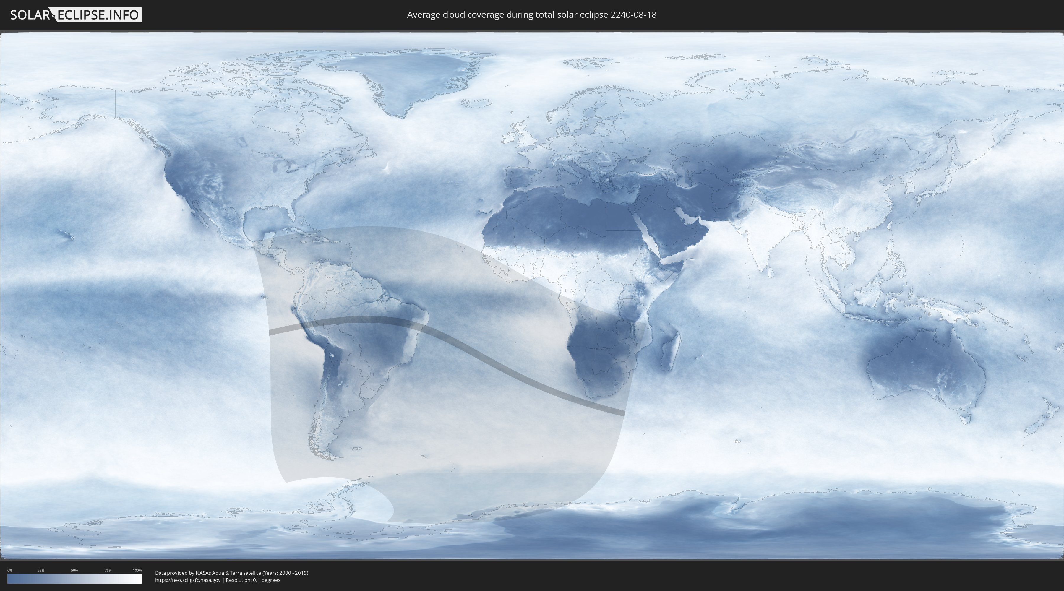
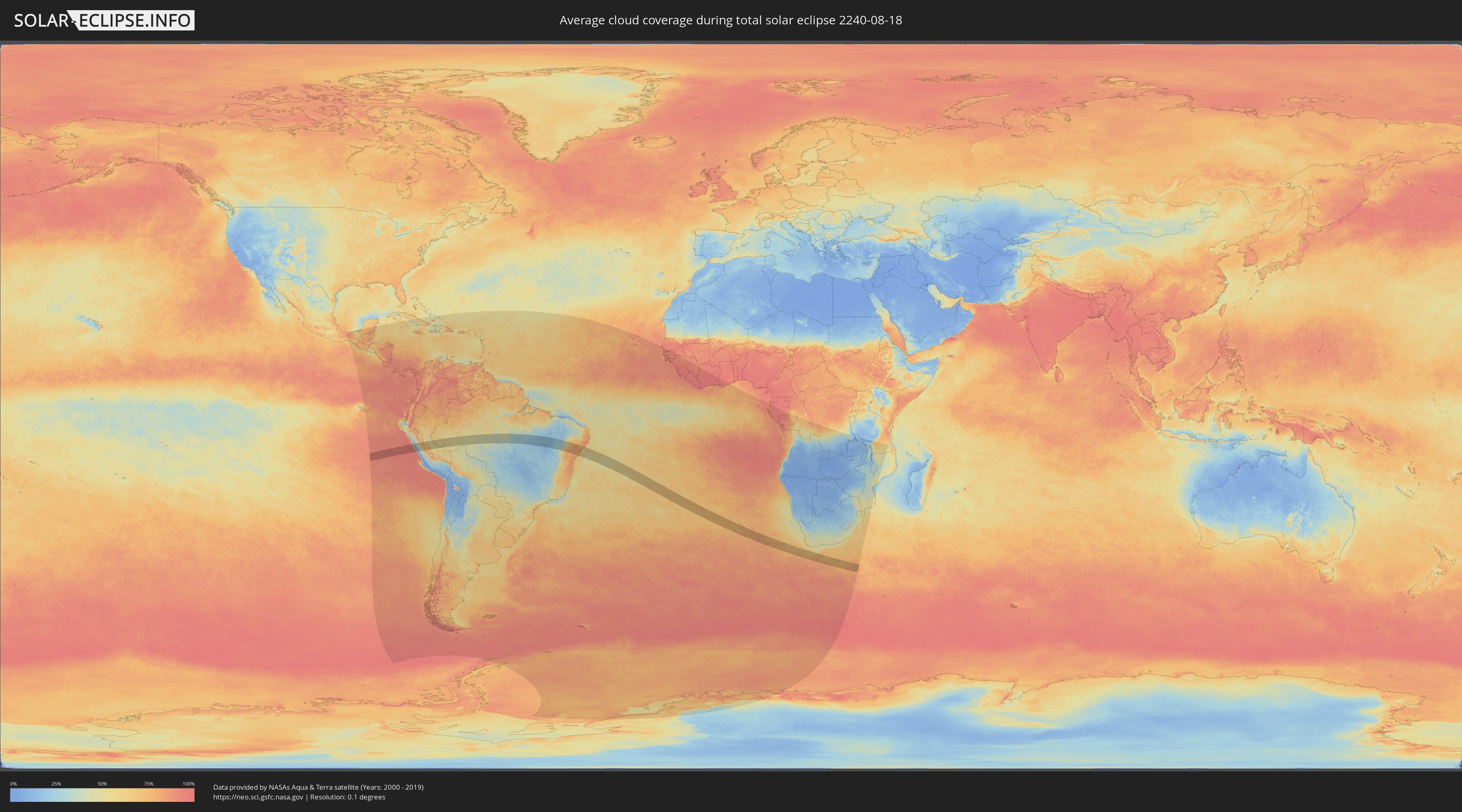
How will be the weather during the total solar eclipse on 08/18/2240?
Where is the best place to see the total solar eclipse of 08/18/2240?
The following maps show the average cloud coverage for the day of the total solar eclipse.
With the help of these maps, it is possible to find the place along the eclipse path, which has the best
chance of a cloudless sky.
Nevertheless, you should consider local circumstances and inform about the weather of your chosen
observation site.
The data is provided by NASAs satellites
AQUA and TERRA.
The cloud maps are averaged over a period of 19 years (2000 - 2019).
Detailed country maps
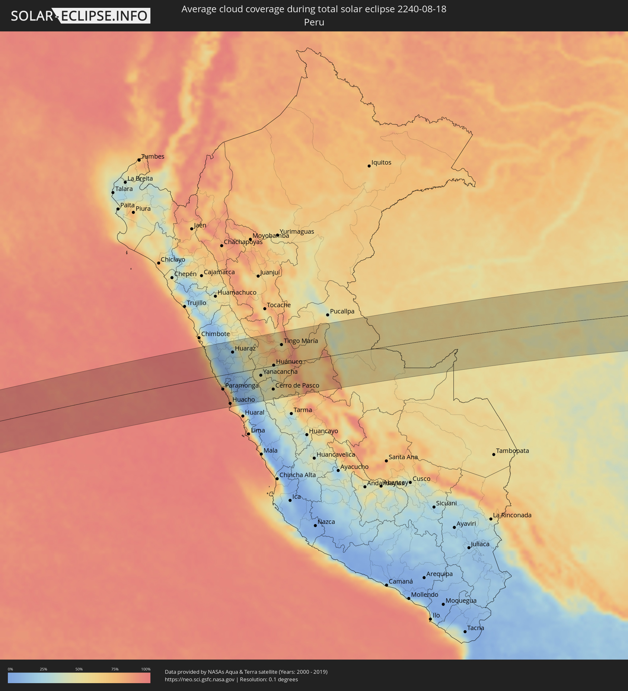 Peru
Peru
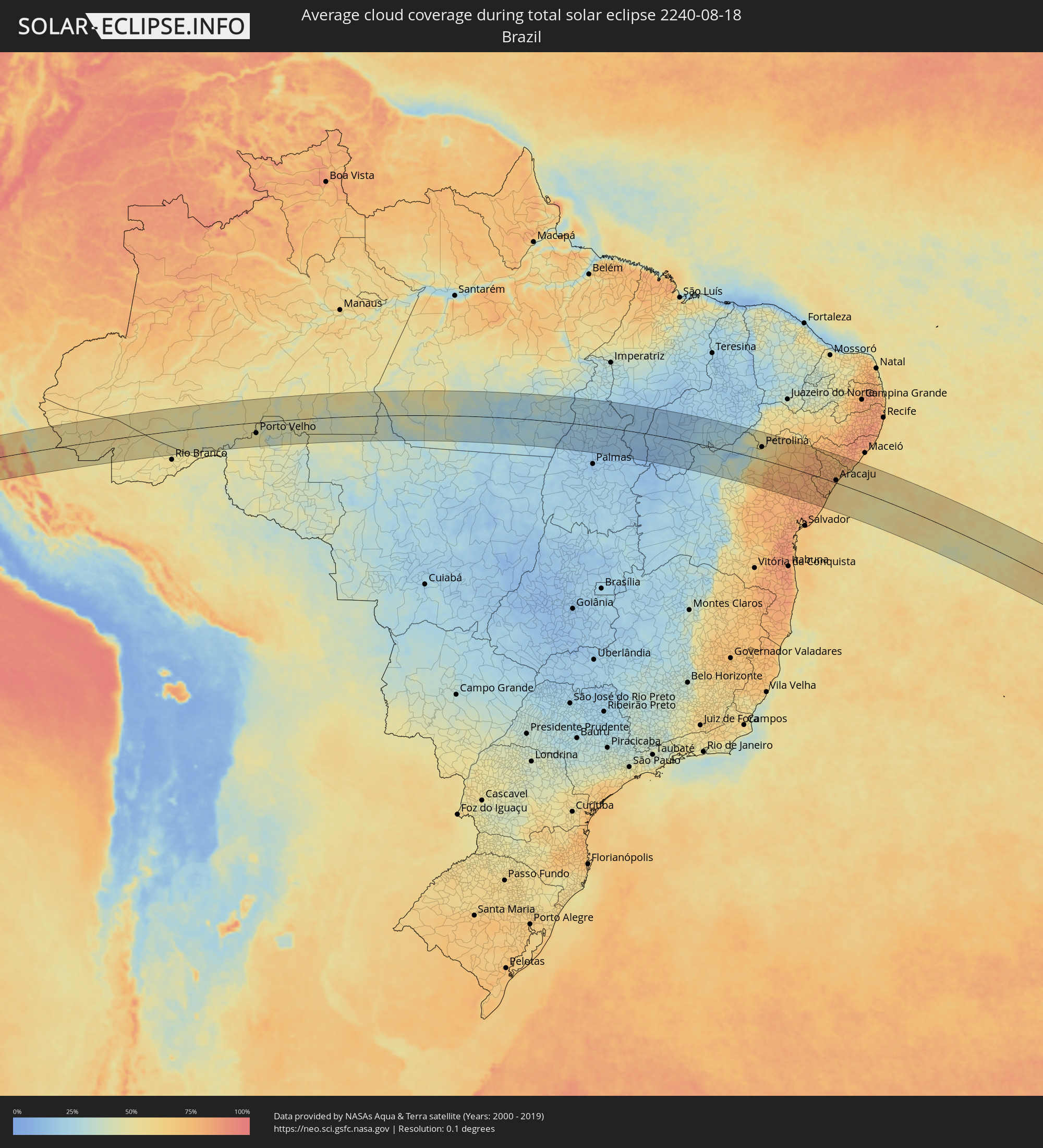 Brazil
Cities inside the path of the eclipse
The following table shows all locations with a population of more than 5,000 inside the eclipse path. Cities which have more than 100,000 inhabitants are marked bold. A click at the locations opens a detailed map.
| City | Type | Eclipse duration | Local time of max. eclipse | Distance to central line | Ø Cloud coverage |
|
Huarmey, Ancash
|
total | - | 07:13:47 UTC-05:00 | 24 km | 80% |
|
Paramonga, Lima region
|
total | - | 07:14:22 UTC-05:00 | 48 km | 91% |
|
Pativilca, Lima region
|
total | - | 07:14:25 UTC-05:00 | 53 km | 91% |
|
Barranca, Lima region
|
total | - | 07:14:28 UTC-05:00 | 58 km | 90% |
|
Puerto Supe, Lima region
|
total | - | 07:14:31 UTC-05:00 | 65 km | 88% |
|
Supe, Lima region
|
total | - | 07:14:32 UTC-05:00 | 65 km | 88% |
|
Carhuaz, Ancash
|
total | - | 07:13:33 UTC-05:00 | 100 km | 17% |
|
Végueta, Lima region
|
total | - | 07:14:44 UTC-05:00 | 91 km | 84% |
|
Caleta de Carquín, Lima region
|
total | - | 07:14:47 UTC-05:00 | 99 km | 85% |
|
Hualmay, Lima region
|
total | - | 07:14:48 UTC-05:00 | 99 km | 85% |
|
Huacho, Lima region
|
total | - | 07:14:49 UTC-05:00 | 101 km | 85% |
|
Huaura, Lima region
|
total | - | 07:14:47 UTC-05:00 | 97 km | 85% |
|
Huaraz, Ancash
|
total | - | 07:13:47 UTC-05:00 | 70 km | 21% |
|
Oyón, Lima region
|
total | - | 07:15:01 UTC-05:00 | 69 km | 26% |
|
Yanacancha, Huanuco
|
total | - | 07:14:48 UTC-05:00 | 25 km | 51% |
|
San Miguel de Cauri, Huanuco
|
total | - | 07:14:45 UTC-05:00 | 14 km | 49% |
|
Yanahuanca, Pasco Region
|
total | - | 07:15:05 UTC-05:00 | 58 km | 42% |
|
Chaupimarca, Pasco Region
|
total | - | 07:15:02 UTC-05:00 | 47 km | 44% |
|
Tinyahuarco, Pasco Region
|
total | - | 07:15:24 UTC-05:00 | 90 km | 47% |
|
Cerro de Pasco, Pasco Region
|
total | - | 07:15:21 UTC-05:00 | 79 km | 47% |
|
Huánuco, Huanuco
|
total | - | 07:14:51 UTC-05:00 | 1 km | 47% |
|
Ambo, Huanuco
|
total | - | 07:15:00 UTC-05:00 | 22 km | 44% |
|
Carhuamayo, Junín Region
|
total | - | 07:15:40 UTC-05:00 | 111 km | 48% |
|
Tingo María, Huanuco
|
total | - | 07:14:35 UTC-05:00 | 66 km | 61% |
|
Oxapampa, Pasco Region
|
total | - | 07:15:52 UTC-05:00 | 86 km | 73% |
|
Villa Rica, Pasco Region
|
total | - | 07:16:04 UTC-05:00 | 106 km | 77% |
|
Tarauacá, Acre
|
total | - | 07:17:54 UTC-05:00 | 99 km | 57% |
|
Feijó, Acre
|
total | - | 07:18:17 UTC-05:00 | 93 km | 55% |
|
Sena Madureira, Acre
|
total | - | 07:20:33 UTC-05:00 | 31 km | 57% |
|
Boca do Acre, Amazonas
|
total | - | 08:21:41 UTC-04:00 | 14 km | 53% |
|
Pauini, Amazonas
|
total | - | 08:21:24 UTC-04:00 | 96 km | 50% |
|
Porto Velho, Rondônia
|
total | - | 08:25:52 UTC-04:00 | 54 km | 51% |
|
Humaitá, Amazonas
|
total | - | 08:26:04 UTC-04:00 | 76 km | 44% |
|
Aripuanã, Mato Grosso
|
total | - | 08:30:46 UTC-04:00 | 124 km | 42% |
|
Conceição do Araguaia, Pará
|
total | - | 09:51:02 UTC-03:00 | 6 km | 19% |
|
Carolina, Maranhão
|
total | - | 09:54:11 UTC-03:00 | 133 km | 19% |
|
Santa Luzia, Maranhão
|
total | - | 09:55:03 UTC-03:00 | 103 km | 17% |
|
Bom Jesus, Piauí
|
total | - | 10:03:21 UTC-03:00 | 1 km | 16% |
|
São Raimundo Nonato, Piauí
|
total | - | 10:07:27 UTC-03:00 | 44 km | 28% |
|
São João do Piauí, Piauí
|
total | - | 10:07:54 UTC-03:00 | 126 km | 22% |
|
Jacobina, Bahia
|
total | - | 10:15:34 UTC-03:00 | 130 km | 77% |
|
Petrolina, Pernambuco
|
total | - | 10:13:34 UTC-03:00 | 61 km | 56% |
|
Pindobaçu, Bahia
|
total | - | 10:15:28 UTC-03:00 | 78 km | 78% |
|
Campo Formoso, Bahia
|
total | - | 10:15:18 UTC-03:00 | 52 km | 76% |
|
Jaguarari, Bahia
|
total | - | 10:15:21 UTC-03:00 | 22 km | 77% |
|
Senhor do Bonfim, Bahia
|
total | - | 10:15:36 UTC-03:00 | 43 km | 79% |
|
Ponto Novo, Bahia
|
total | - | 10:16:12 UTC-03:00 | 84 km | 81% |
|
Capim Grosso, Bahia
|
total | - | 10:17:07 UTC-03:00 | 136 km | 77% |
|
Curaçá, Bahia
|
total | - | 10:14:40 UTC-03:00 | 123 km | 59% |
|
Queimadas, Bahia
|
total | - | 10:17:41 UTC-03:00 | 81 km | 81% |
|
Uauá, Bahia
|
total | - | 10:16:46 UTC-03:00 | 45 km | 72% |
|
Valente, Bahia
|
total | - | 10:18:38 UTC-03:00 | 122 km | 79% |
|
Santaluz, Bahia
|
total | - | 10:18:41 UTC-03:00 | 103 km | 81% |
|
Monte Santo, Bahia
|
total | - | 10:17:51 UTC-03:00 | 14 km | 80% |
|
Conceição do Coité, Bahia
|
total | - | 10:19:17 UTC-03:00 | 132 km | 80% |
|
Euclides da Cunha, Bahia
|
total | - | 10:18:47 UTC-03:00 | 12 km | 78% |
|
Serrinha, Bahia
|
total | - | 10:20:09 UTC-03:00 | 134 km | 83% |
|
Araci, Bahia
|
total | - | 10:19:52 UTC-03:00 | 98 km | 83% |
|
Tucano, Bahia
|
total | - | 10:19:55 UTC-03:00 | 52 km | 80% |
|
Ribeira do Pombal, Bahia
|
total | - | 10:20:27 UTC-03:00 | 30 km | 80% |
|
Cipó, Bahia
|
total | - | 10:20:49 UTC-03:00 | 58 km | 80% |
|
Nova Soure, Bahia
|
total | - | 10:21:04 UTC-03:00 | 71 km | 80% |
|
Jeremoabo, Bahia
|
total | - | 10:19:44 UTC-03:00 | 52 km | 80% |
|
Cícero Dantas, Bahia
|
total | - | 10:20:36 UTC-03:00 | 1 km | 81% |
|
Inhambupe, Bahia
|
total | - | 10:22:03 UTC-03:00 | 125 km | 80% |
|
Olindina, Bahia
|
total | - | 10:21:37 UTC-03:00 | 80 km | 80% |
|
Paulo Afonso, Bahia
|
total | - | 10:19:41 UTC-03:00 | 132 km | 74% |
|
Poço Verde, Sergipe
|
total | - | 10:21:16 UTC-03:00 | 5 km | 79% |
|
Entre Rios, Bahia
|
total | - | 10:22:58 UTC-03:00 | 132 km | 81% |
|
Acajutiba, Bahia
|
total | - | 10:22:49 UTC-03:00 | 100 km | 78% |
|
Tobias Barreto, Sergipe
|
total | - | 10:22:19 UTC-03:00 | 49 km | 81% |
|
Esplanada, Bahia
|
total | - | 10:23:10 UTC-03:00 | 112 km | 81% |
|
Rio Real, Bahia
|
total | - | 10:22:51 UTC-03:00 | 79 km | 80% |
|
Paripiranga, Bahia
|
total | - | 10:22:07 UTC-03:00 | 8 km | 77% |
|
Simão Dias, Sergipe
|
total | - | 10:22:18 UTC-03:00 | 4 km | 78% |
|
Itabaianinha, Sergipe
|
total | - | 10:22:59 UTC-03:00 | 51 km | 79% |
|
Canindé de São Francisco, Sergipe
|
total | - | 10:21:07 UTC-03:00 | 119 km | 81% |
|
Cristinápolis, Sergipe
|
total | - | 10:23:19 UTC-03:00 | 71 km | 81% |
|
Carira, Sergipe
|
total | - | 10:22:10 UTC-03:00 | 48 km | 81% |
|
Umbaúba, Sergipe
|
total | - | 10:23:28 UTC-03:00 | 58 km | 80% |
|
Lagarto, Sergipe
|
total | - | 10:22:57 UTC-03:00 | 9 km | 80% |
|
Boquim, Sergipe
|
total | - | 10:23:18 UTC-03:00 | 32 km | 81% |
|
Conde, Bahia
|
total | - | 10:24:06 UTC-03:00 | 102 km | 70% |
|
Monte Alegre de Sergipe, Sergipe
|
total | - | 10:22:09 UTC-03:00 | 88 km | 76% |
|
Frei Paulo, Sergipe
|
total | - | 10:22:50 UTC-03:00 | 34 km | 79% |
|
Campo do Brito, Sergipe
|
total | - | 10:23:10 UTC-03:00 | 16 km | 79% |
|
Salgado, Sergipe
|
total | - | 10:23:34 UTC-03:00 | 15 km | 81% |
|
Estância, Sergipe
|
total | - | 10:23:56 UTC-03:00 | 38 km | 72% |
|
Pão de Açúcar, Alagoas
|
total | - | 10:22:11 UTC-03:00 | 122 km | 73% |
|
Itabaiana, Sergipe
|
total | - | 10:23:18 UTC-03:00 | 23 km | 80% |
|
Nossa Senhora da Glória, Sergipe
|
total | - | 10:22:46 UTC-03:00 | 73 km | 76% |
|
Ribeirópolis, Sergipe
|
total | - | 10:23:09 UTC-03:00 | 39 km | 79% |
|
Areia Branca, Sergipe
|
total | - | 10:23:41 UTC-03:00 | 20 km | 82% |
|
Malhador, Sergipe
|
total | - | 10:23:35 UTC-03:00 | 31 km | 81% |
|
Porto da Folha, Sergipe
|
total | - | 10:22:48 UTC-03:00 | 110 km | 77% |
|
São Cristóvão, Sergipe
|
total | - | 10:24:17 UTC-03:00 | 3 km | 69% |
|
Nossa Senhora das Dores, Sergipe
|
total | - | 10:23:42 UTC-03:00 | 52 km | 77% |
|
Laranjeiras, Sergipe
|
total | - | 10:24:08 UTC-03:00 | 20 km | 77% |
|
Nossa Senhora do Socorro, Sergipe
|
total | - | 10:24:18 UTC-03:00 | 16 km | 73% |
|
Maruim, Sergipe
|
total | - | 10:24:18 UTC-03:00 | 30 km | 75% |
|
Aracaju, Sergipe
|
total | - | 10:24:31 UTC-03:00 | 12 km | 73% |
|
Santo Amaro das Brotas, Sergipe
|
total | - | 10:24:26 UTC-03:00 | 26 km | 73% |
|
Capela, Sergipe
|
total | - | 10:24:06 UTC-03:00 | 56 km | 78% |
|
Barra dos Coqueiros, Sergipe
|
total | - | 10:24:37 UTC-03:00 | 14 km | 61% |
|
Aquidabã, Sergipe
|
total | - | 10:23:56 UTC-03:00 | 80 km | 79% |
|
Traipu, Alagoas
|
total | - | 10:23:37 UTC-03:00 | 114 km | 70% |
|
Japaratuba, Sergipe
|
total | - | 10:24:31 UTC-03:00 | 50 km | 71% |
|
Propriá, Sergipe
|
total | - | 10:24:20 UTC-03:00 | 94 km | 72% |
|
Porto Real do Colégio, Alagoas
|
total | - | 10:24:19 UTC-03:00 | 97 km | 72% |
|
Girau do Ponciano, Alagoas
|
total | - | 10:23:59 UTC-03:00 | 129 km | 80% |
|
Penedo, Alagoas
|
total | - | 10:25:07 UTC-03:00 | 95 km | 73% |
|
Neópolis, Sergipe
|
total | - | 10:25:11 UTC-03:00 | 92 km | 73% |
|
São Sebastião, Alagoas
|
total | - | 10:24:48 UTC-03:00 | 134 km | 82% |
|
Piaçabuçu, Alagoas
|
total | - | 10:25:40 UTC-03:00 | 89 km | 58% |
|
Coruripe, Alagoas
|
total | - | 10:26:03 UTC-03:00 | 127 km | 64% |