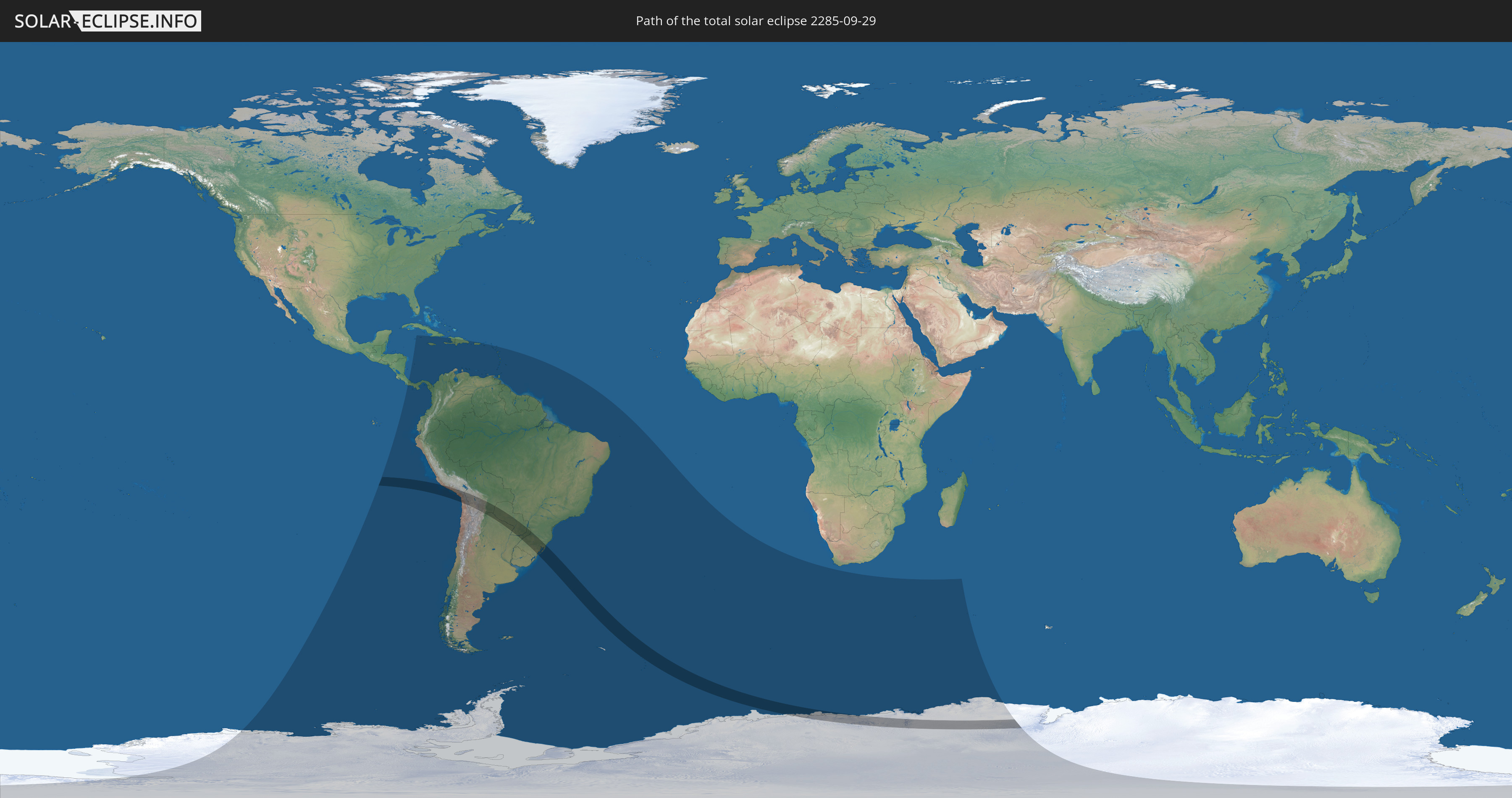
Total solar eclipse of 09/29/2285
| Day of week: | Tuesday |
| Maximum duration of eclipse: | 04m24s |
| Maximum width of eclipse path: | 275 km |
| Saros cycle: | 158 |
| Coverage: | 100% |
| Magnitude: | 1.0621 |
| Gamma: | -0.6859 |
Wo kann man die Sonnenfinsternis vom 09/29/2285 sehen?
Die Sonnenfinsternis am 09/29/2285 kann man in 41 Ländern als partielle Sonnenfinsternis beobachten.
Der Finsternispfad verläuft durch 7 Länder. Nur in diesen Ländern ist sie als total Sonnenfinsternis zu sehen.
In den folgenden Ländern ist die Sonnenfinsternis total zu sehen
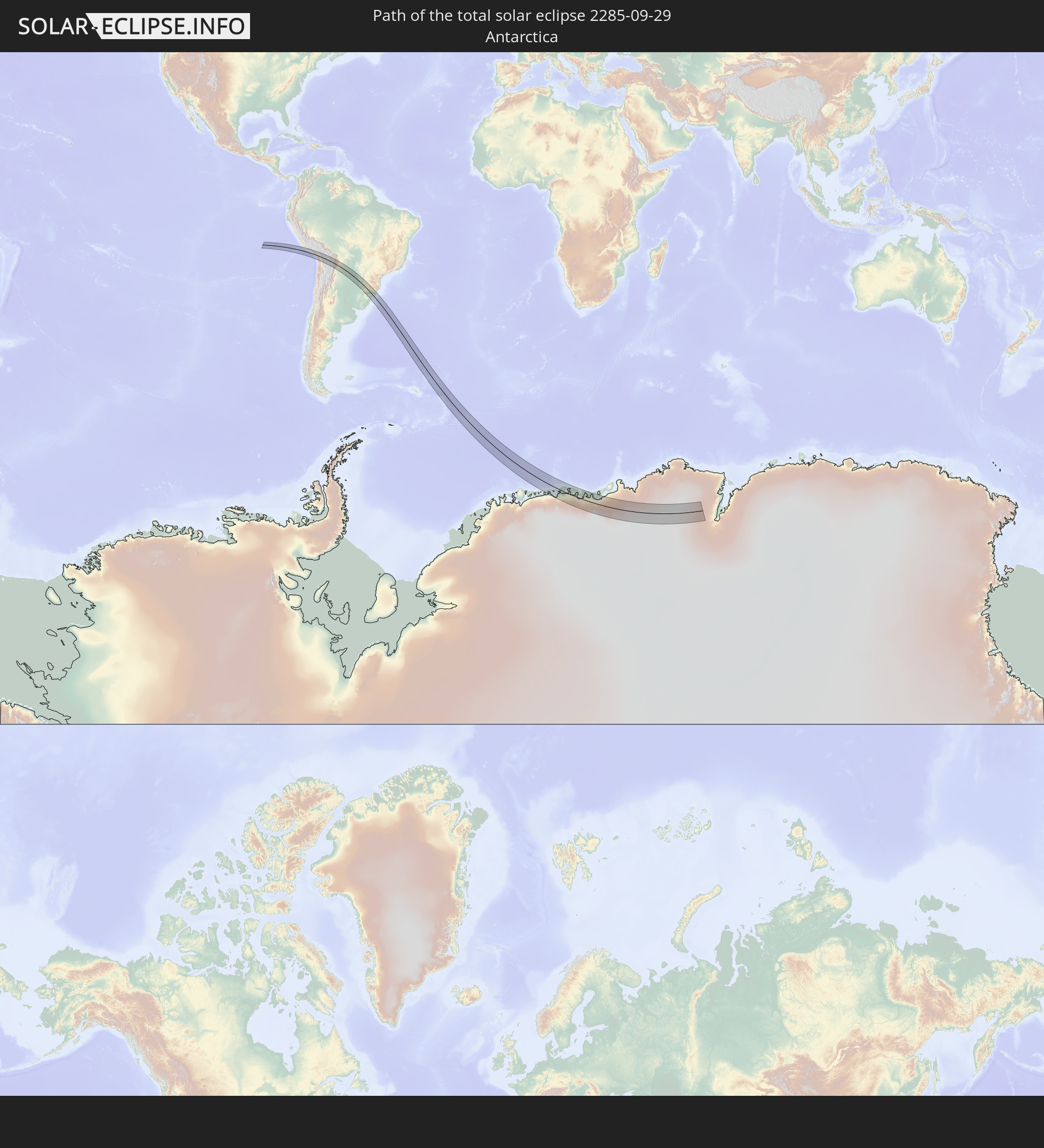 Antarctica
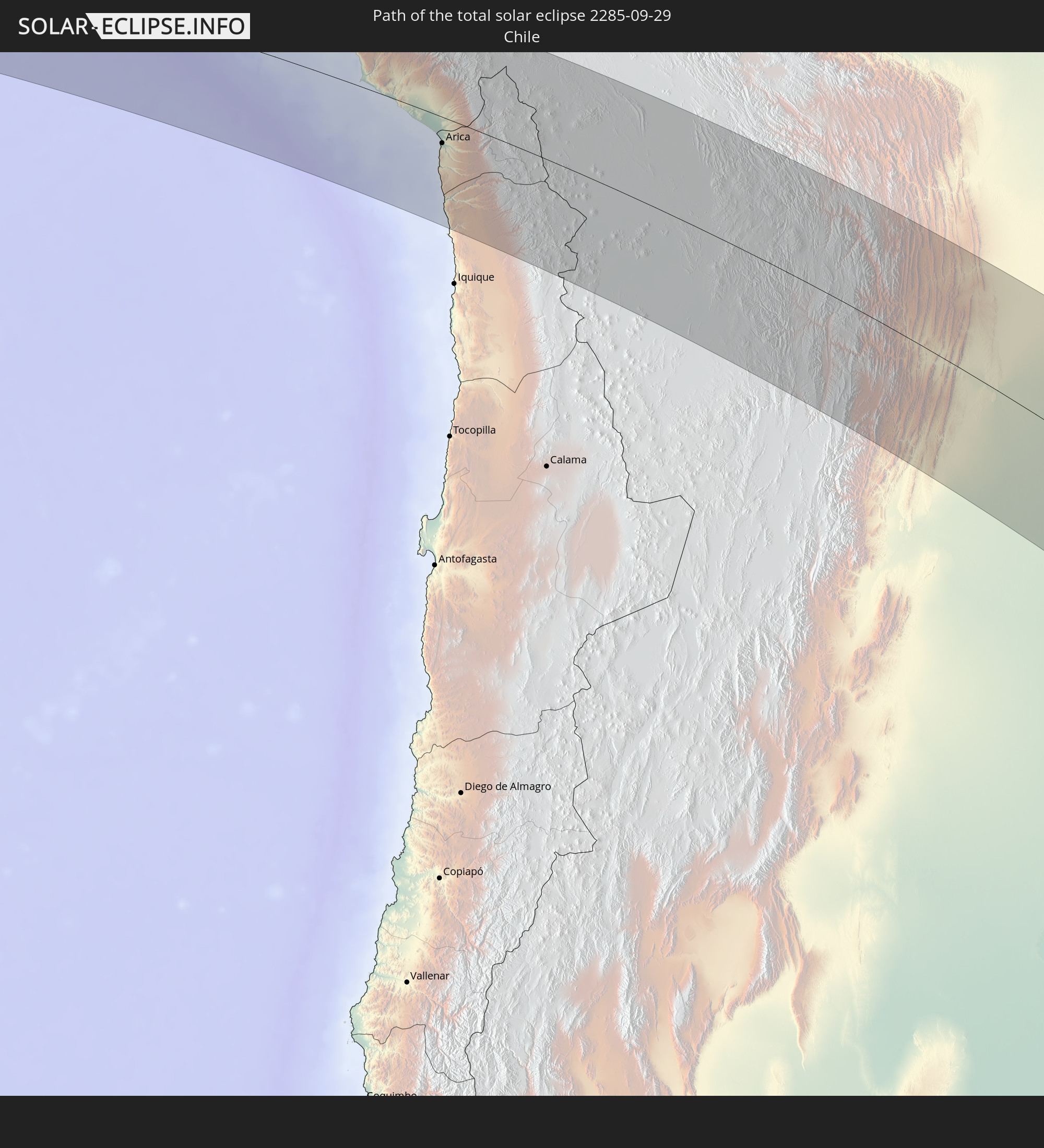 Chile
Chile
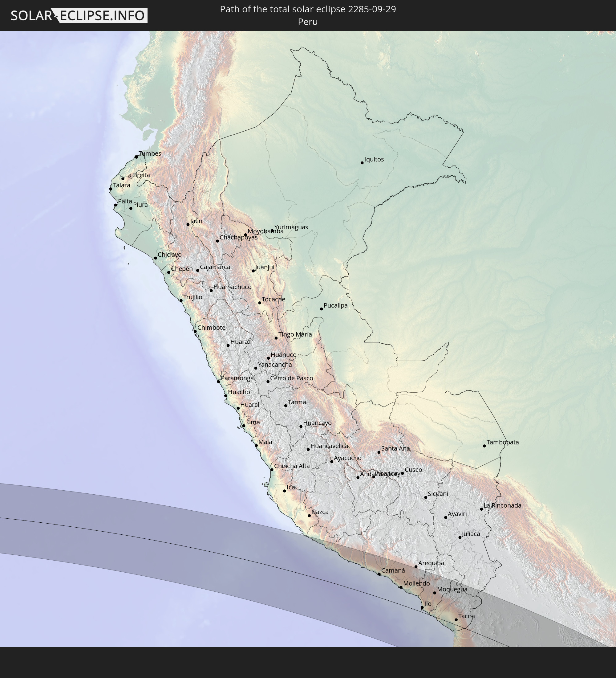 Peru
Peru
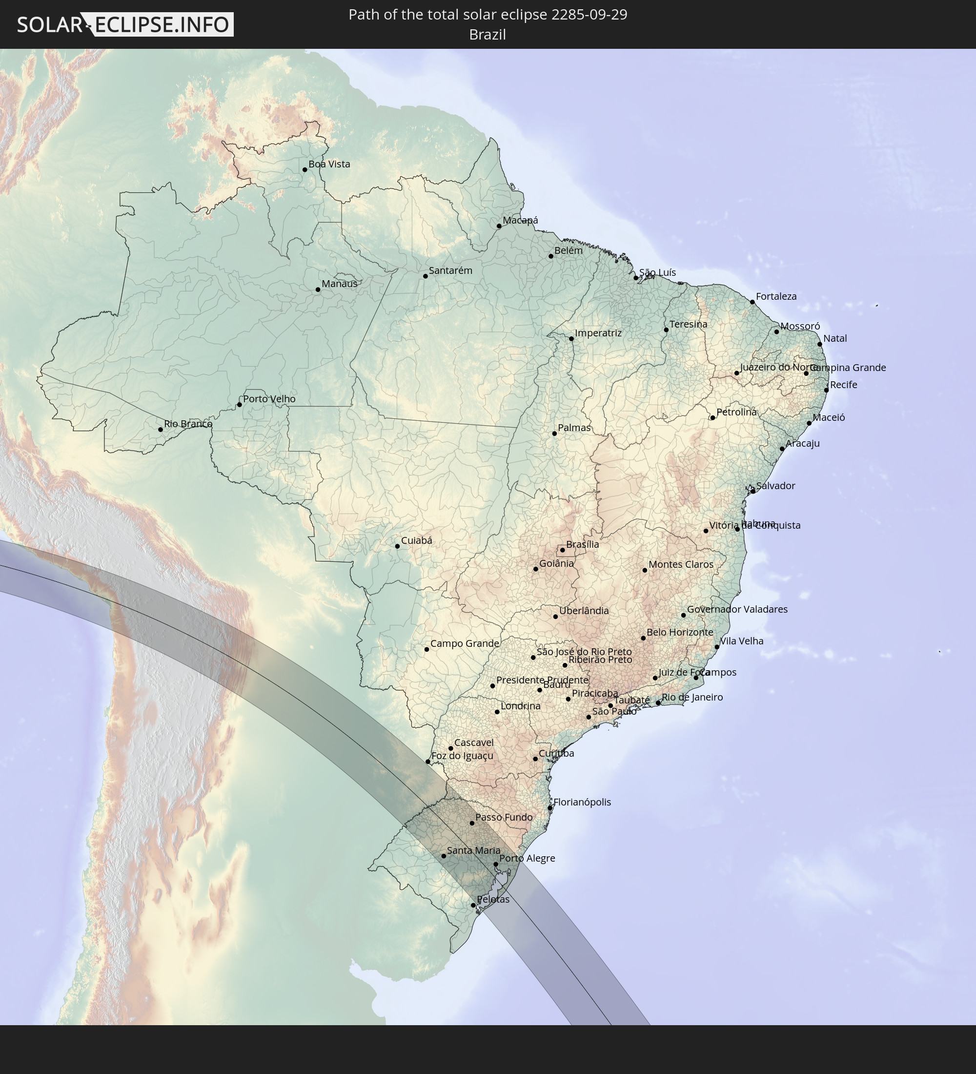 Brazil
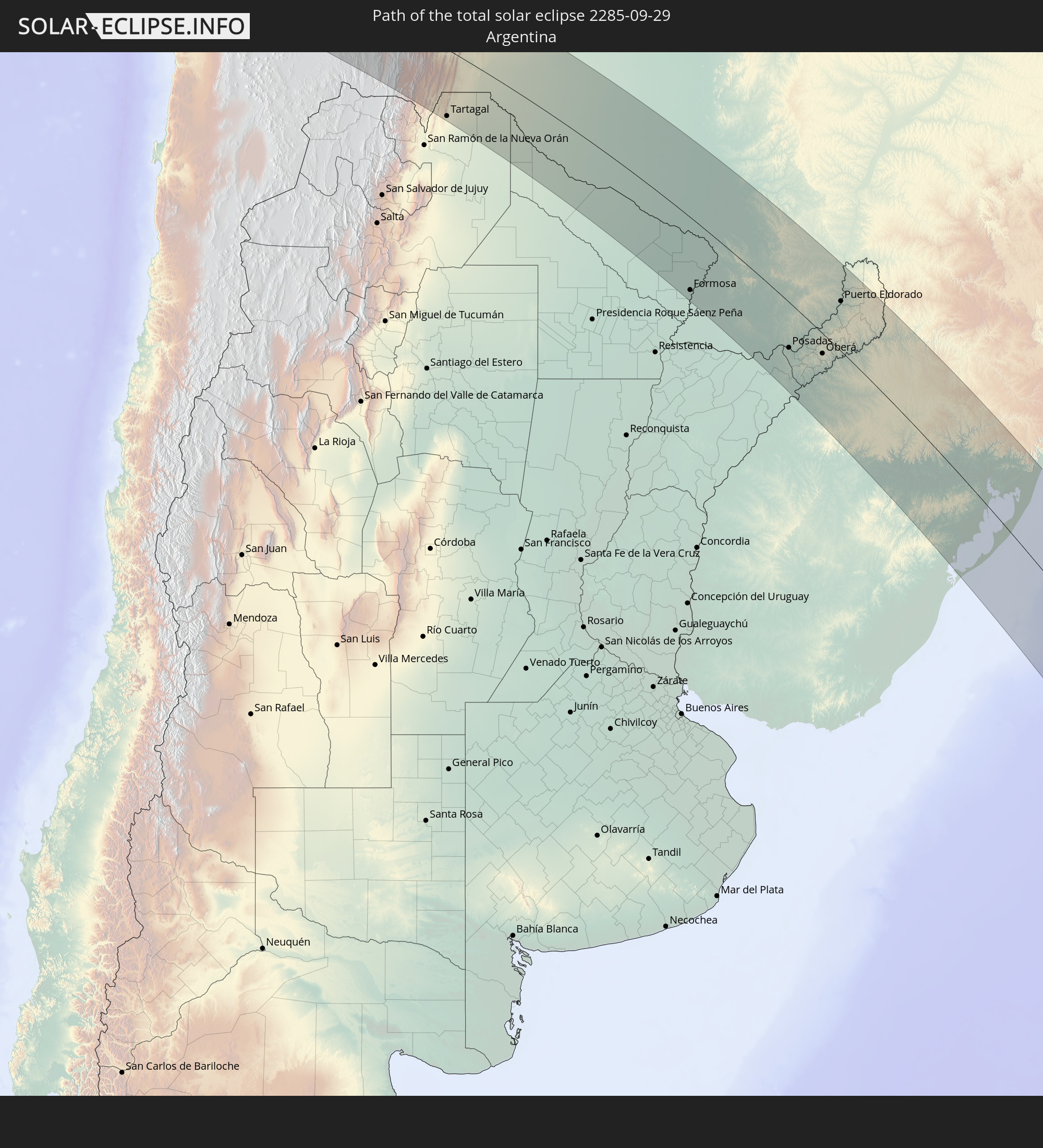 Argentina
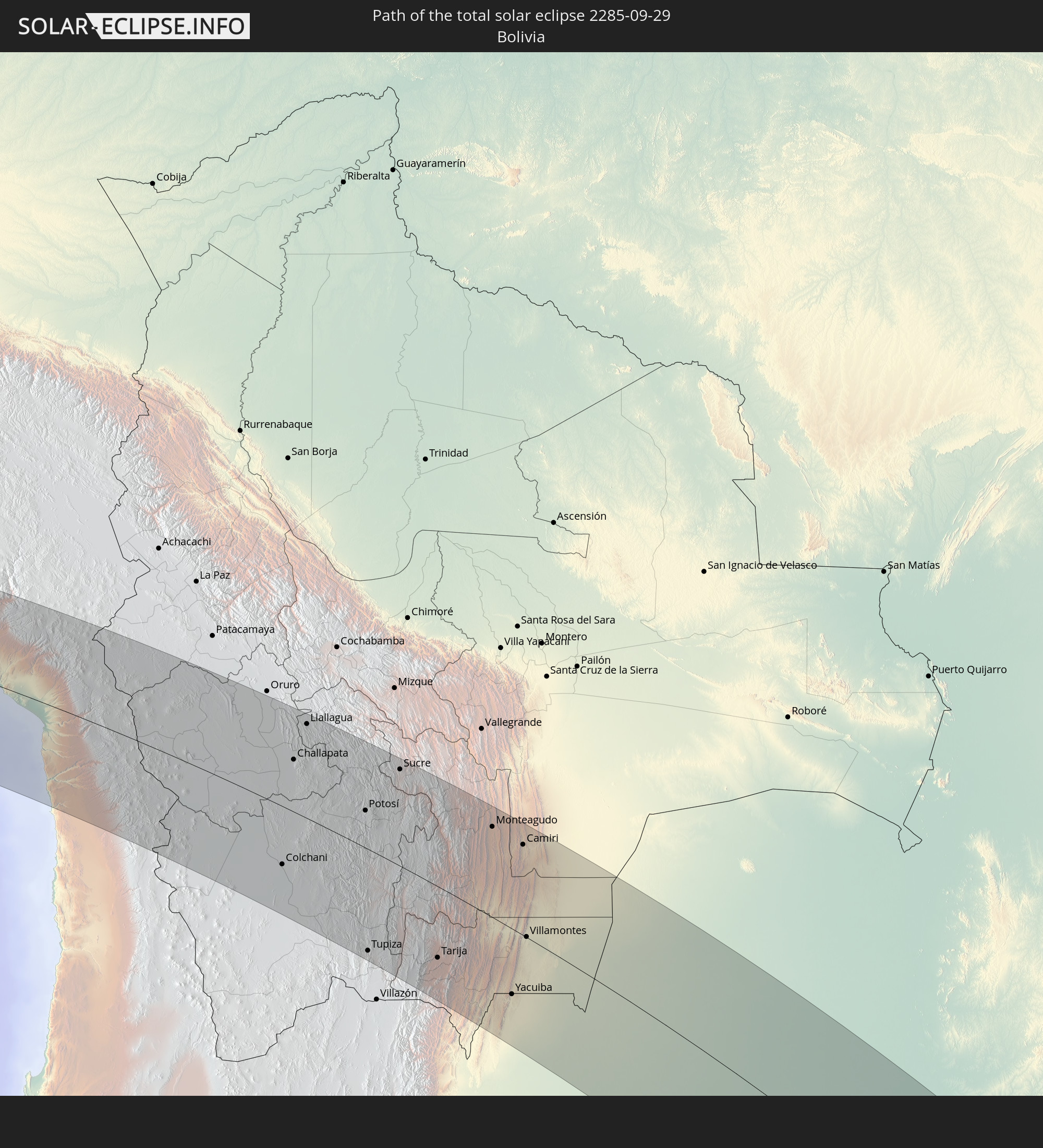 Bolivia
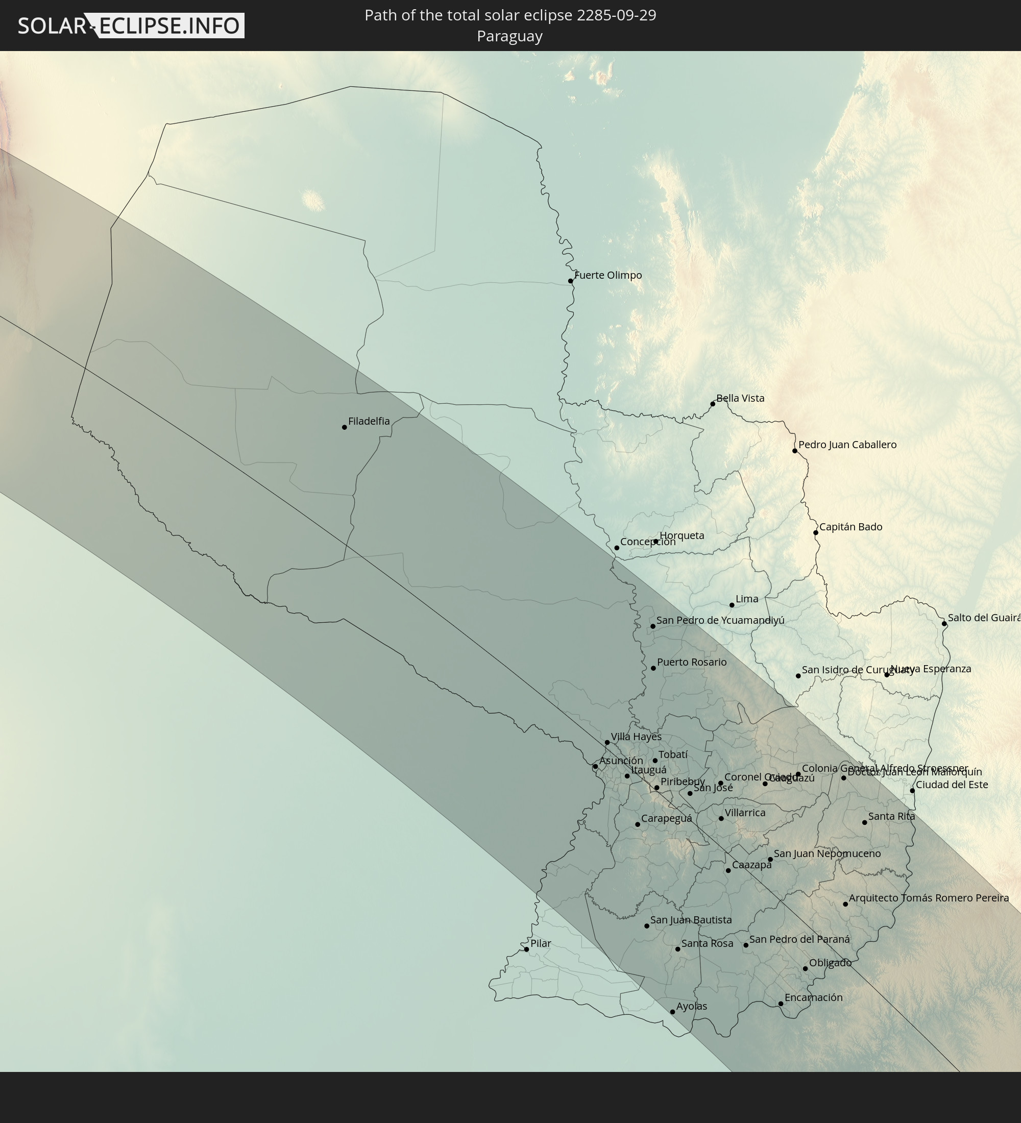 Paraguay
In den folgenden Ländern ist die Sonnenfinsternis partiell zu sehen
 Antarctica
 United States Minor Outlying Islands
 Chile
Chile
 Ecuador
 Costa Rica
 Cuba
Cuba
 Panama
 Colombia
 Cayman Islands
 Peru
Peru
 Jamaica
 Haiti
Haiti
 Brazil
 Argentina
 Venezuela
 Dominican Republic
 Aruba
Aruba
 Bolivia
 Puerto Rico
 United States Virgin Islands
 Saint Kitts and Nevis
 Paraguay
 Antigua and Barbuda
 Montserrat
 Trinidad and Tobago
 Guadeloupe
 Grenada
 Dominica
 Saint Vincent and the Grenadines
 Falkland Islands
 Guyana
 Martinique
 Saint Lucia
 Barbados
 Uruguay
 Suriname
 French Guiana
 South Georgia and the South Sandwich Islands
 Saint Helena, Ascension and Tristan da Cunha
 Bouvet Island
 French Southern and Antarctic Lands
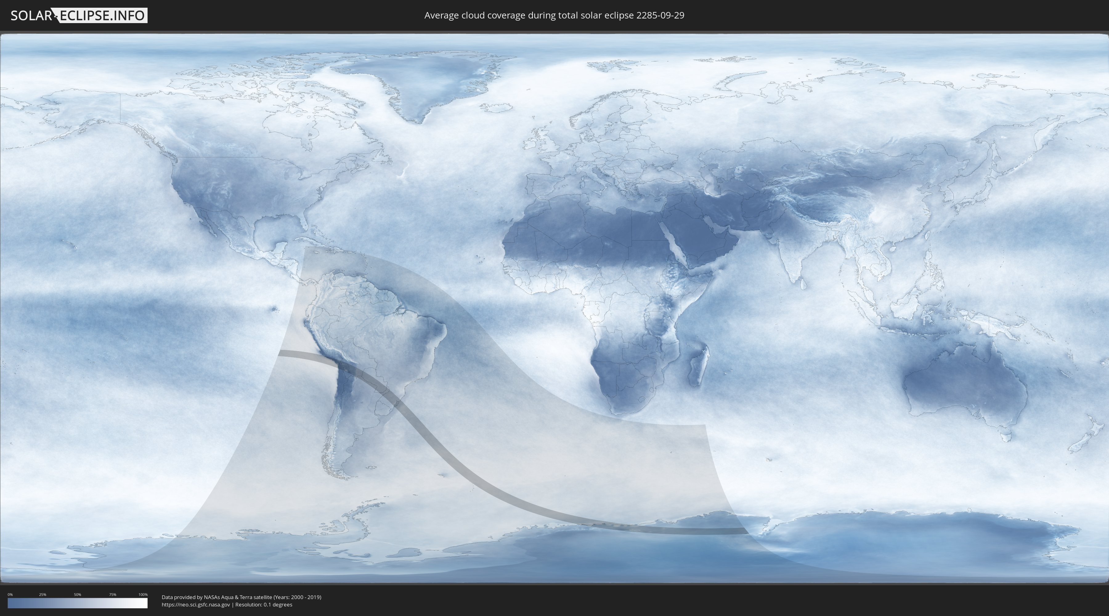
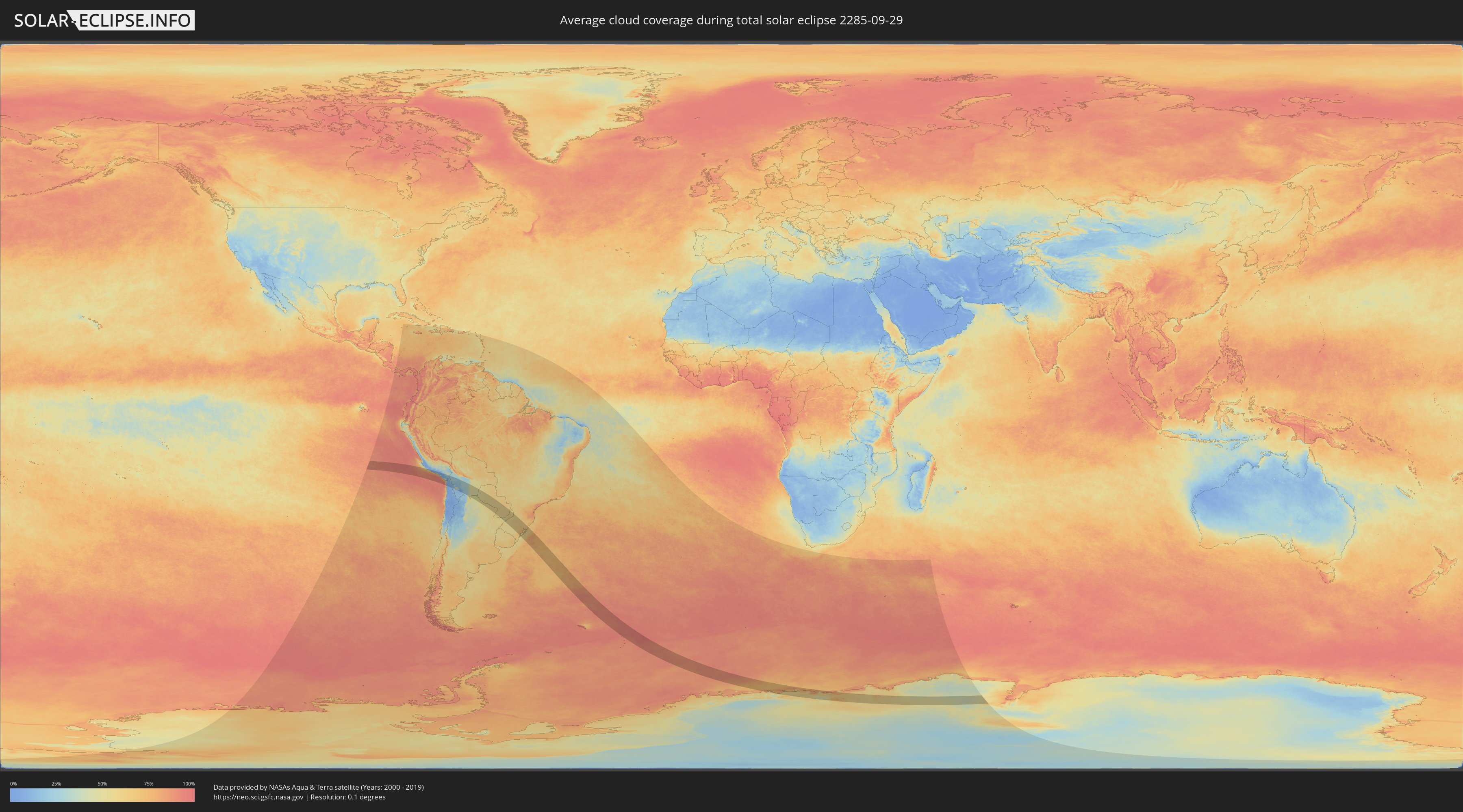
How will be the weather during the total solar eclipse on 09/29/2285?
Where is the best place to see the total solar eclipse of 09/29/2285?
The following maps show the average cloud coverage for the day of the total solar eclipse.
With the help of these maps, it is possible to find the place along the eclipse path, which has the best
chance of a cloudless sky.
Nevertheless, you should consider local circumstances and inform about the weather of your chosen
observation site.
The data is provided by NASAs satellites
AQUA and TERRA.
The cloud maps are averaged over a period of 19 years (2000 - 2019).
Detailed country maps
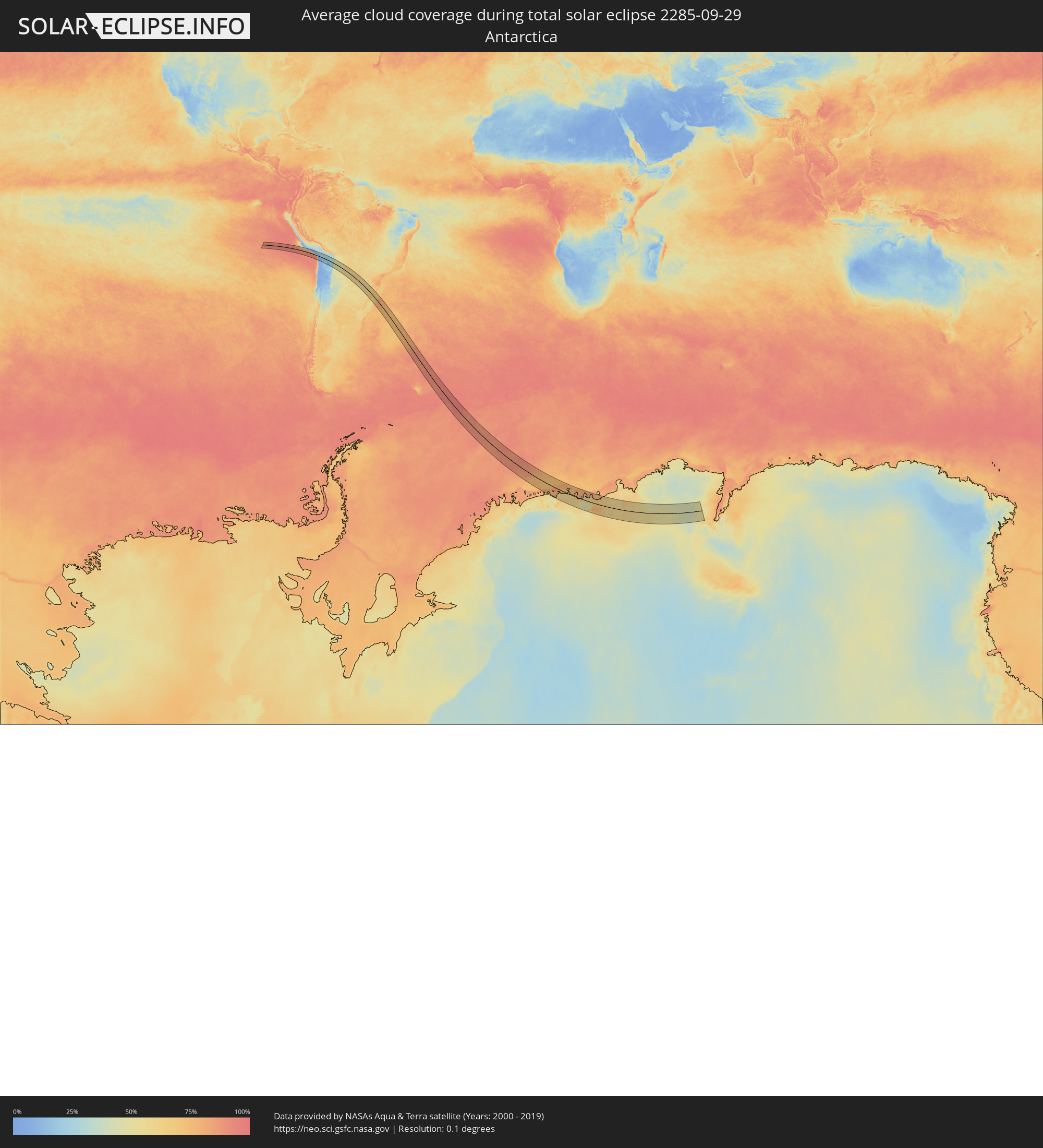 Antarctica
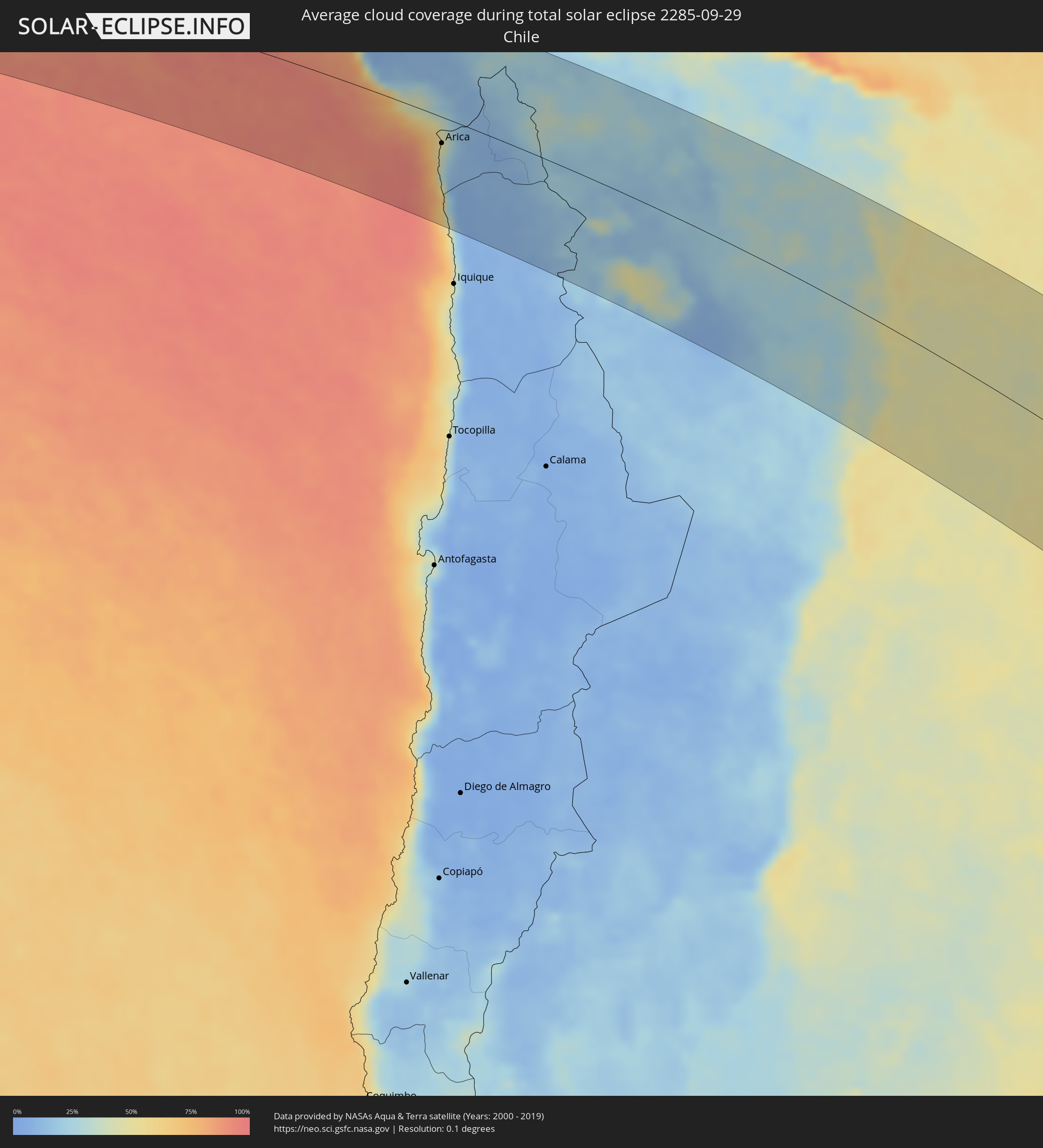 Chile
Chile
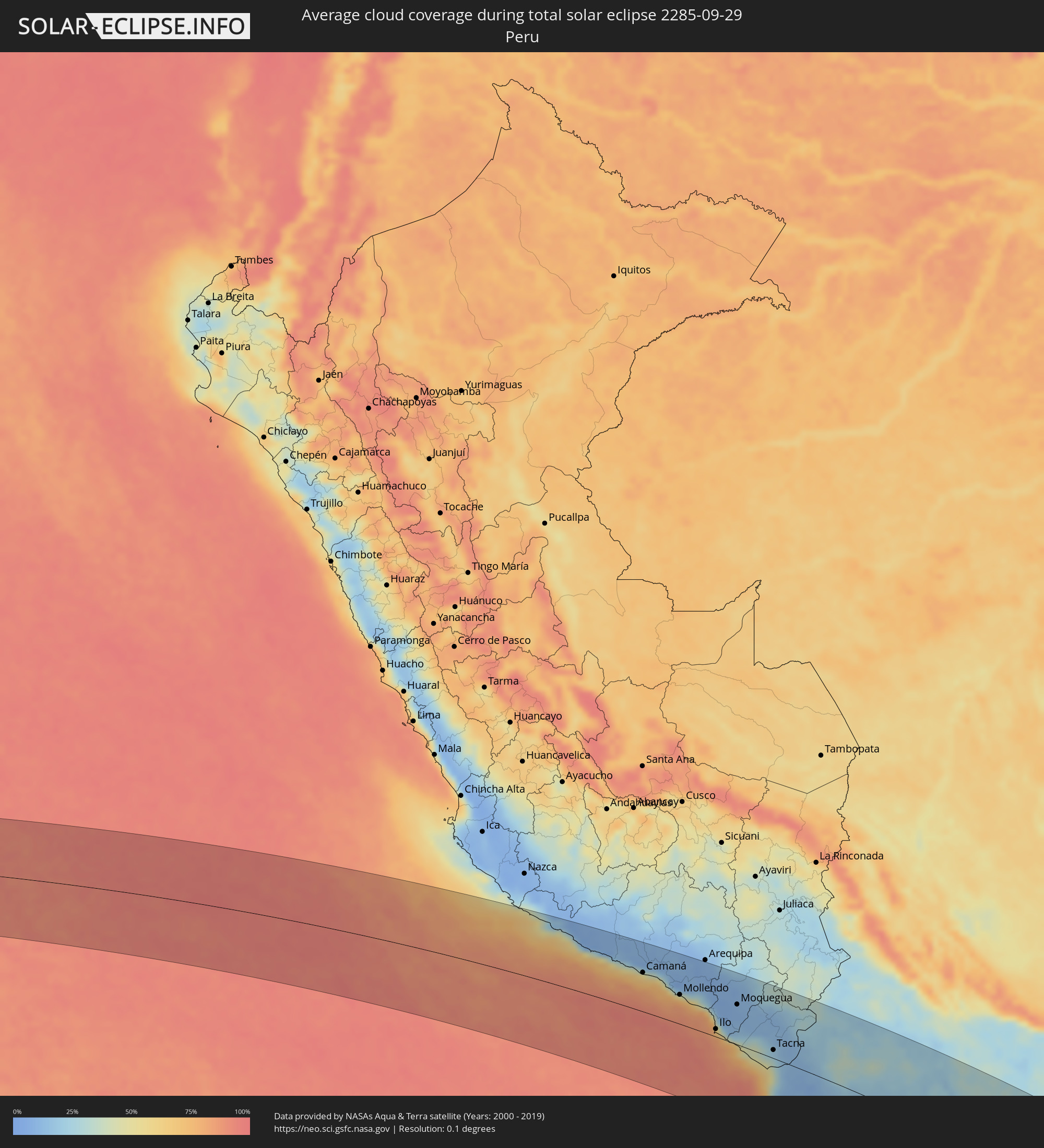 Peru
Peru
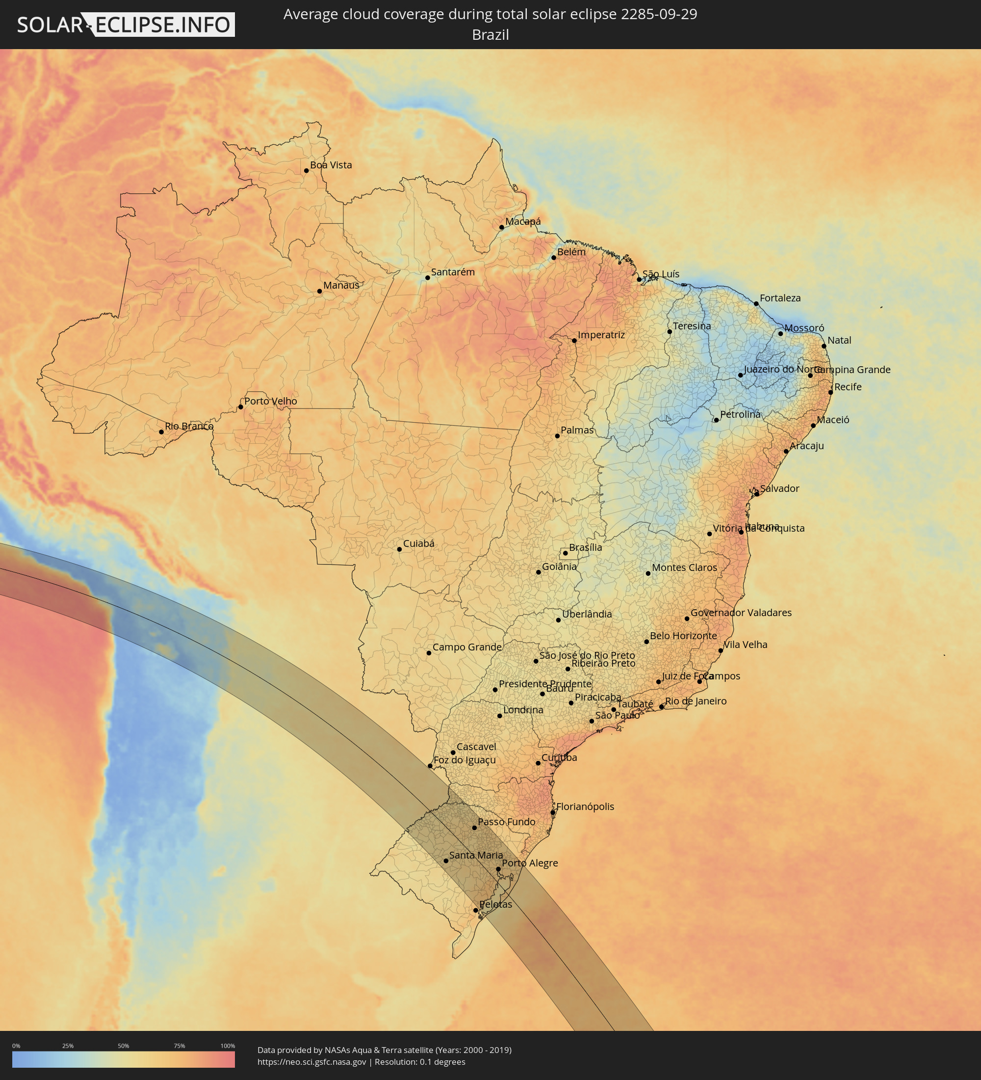 Brazil
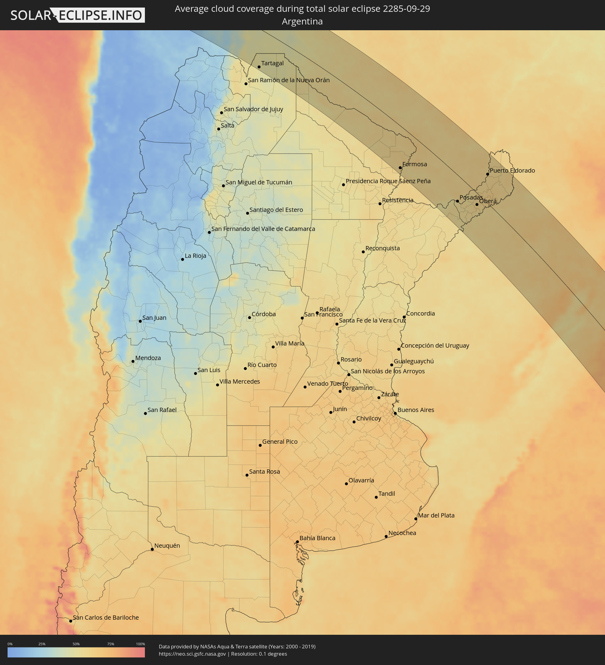 Argentina
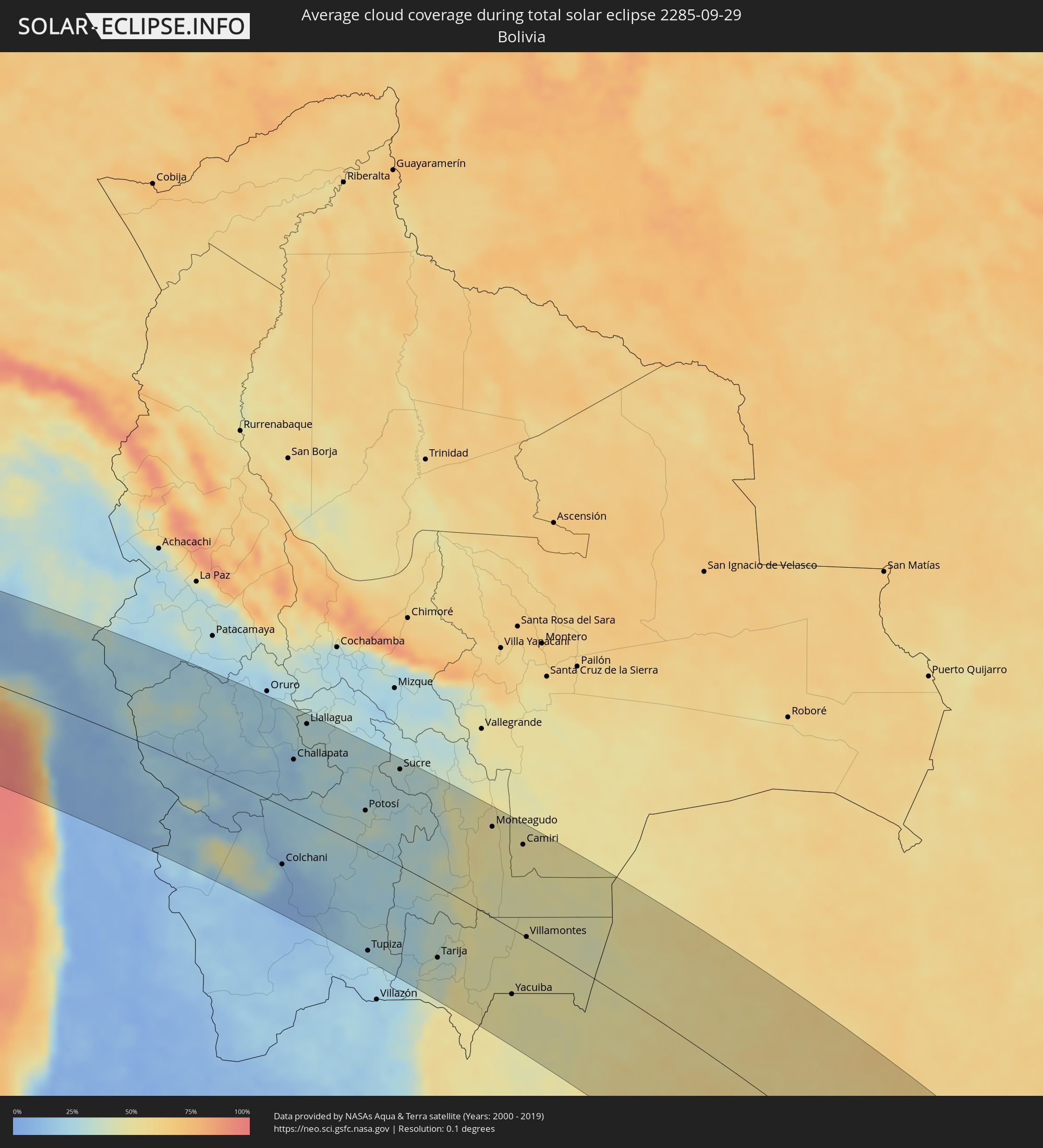 Bolivia
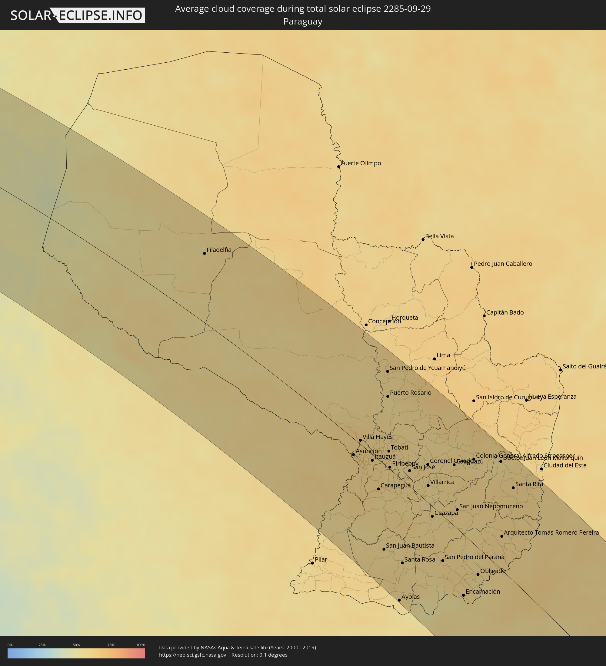 Paraguay
Cities inside the path of the eclipse
The following table shows all locations with a population of more than 5,000 inside the eclipse path. Cities which have more than 100,000 inhabitants are marked bold. A click at the locations opens a detailed map.
| City | Type | Eclipse duration | Local time of max. eclipse | Distance to central line | Ø Cloud coverage |
|
Camaná, Arequipa
|
total | - | 06:51:31 UTC-05:00 | 74 km | 65% |
|
Mollendo, Arequipa
|
total | - | 06:52:26 UTC-05:00 | 55 km | 74% |
|
Punta de Bombón, Arequipa
|
total | - | 06:52:46 UTC-05:00 | 47 km | 80% |
|
Cocachacra, Arequipa
|
total | - | 06:52:39 UTC-05:00 | 57 km | 72% |
|
Ilo, Moquegua
|
total | - | 06:53:42 UTC-05:00 | 14 km | 63% |
|
Pacocha, Moquegua
|
total | - | 06:53:37 UTC-05:00 | 20 km | 63% |
|
Moquegua, Moquegua
|
total | - | 06:53:13 UTC-05:00 | 75 km | 10% |
|
Torata, Moquegua
|
total | - | 06:53:04 UTC-05:00 | 91 km | 11% |
|
Ilabaya, Tacna
|
total | - | 06:53:46 UTC-05:00 | 67 km | 11% |
|
Arica, Arica y Parinacota
|
total | - | 08:55:33 UTC-03:00 | 34 km | 41% |
|
Tacna, Tacna
|
total | - | 06:54:50 UTC-05:00 | 15 km | 32% |
|
Colchani, Potosí
|
total | - | 08:00:30 UTC-04:00 | 77 km | 14% |
|
Huanuni, Oruro
|
total | - | 07:57:14 UTC-04:00 | 129 km | 27% |
|
Uyuni, Potosí
|
total | - | 08:00:50 UTC-04:00 | 88 km | 10% |
|
Challapata, Oruro
|
total | - | 07:58:17 UTC-04:00 | 70 km | 17% |
|
Llallagua, Potosí
|
total | - | 07:57:36 UTC-04:00 | 127 km | 28% |
|
Potosí, Potosí
|
total | - | 08:00:04 UTC-04:00 | 49 km | 32% |
|
Tupiza, Potosí
|
total | - | 08:03:16 UTC-04:00 | 132 km | 24% |
|
Sucre, Chuquisaca
|
total | - | 07:59:29 UTC-04:00 | 127 km | 32% |
|
Tarija, Tarija
|
total | - | 08:04:07 UTC-04:00 | 91 km | 34% |
|
Monteagudo, Chuquisaca
|
total | - | 08:01:42 UTC-04:00 | 116 km | 50% |
|
General Enrique Mosconi, Salta Province
|
total | - | 09:06:40 UTC-03:00 | 145 km | 47% |
|
Tartagal, Salta Province
|
total | - | 09:06:32 UTC-03:00 | 137 km | 47% |
|
Yacuiba, Tarija
|
total | - | 08:05:45 UTC-04:00 | 83 km | 48% |
|
Camiri, Santa Cruz
|
total | - | 08:02:26 UTC-04:00 | 116 km | 51% |
|
Villamontes, Tarija
|
total | - | 08:04:35 UTC-04:00 | 1 km | 48% |
|
Filadelfia, Boquerón
|
total | - | 09:09:17 UTC-03:00 | 93 km | 56% |
|
Colonia Menno, Boquerón
|
total | - | 09:09:31 UTC-03:00 | 103 km | 57% |
|
Formosa, Formosa Province
|
total | - | 09:18:02 UTC-03:00 | 130 km | 57% |
|
Clorinda, Formosa Province
|
total | - | 09:16:48 UTC-03:00 | 24 km | 60% |
|
Asunción, Asunción
|
total | - | 09:16:55 UTC-03:00 | 20 km | 62% |
|
Benjamín Aceval, Presidente Hayes
|
total | - | 09:16:21 UTC-03:00 | 13 km | 61% |
|
Limpio, Central
|
total | - | 09:16:48 UTC-03:00 | 1 km | 64% |
|
Guarambaré, Central
|
total | - | 09:17:25 UTC-03:00 | 25 km | 62% |
|
Capiatá, Central
|
total | - | 09:17:12 UTC-03:00 | 12 km | 62% |
|
Areguá, Central
|
total | - | 09:17:11 UTC-03:00 | 5 km | 62% |
|
Itá, Central
|
total | - | 09:17:33 UTC-03:00 | 20 km | 62% |
|
Emboscada, Cordillera
|
total | - | 09:16:54 UTC-03:00 | 11 km | 62% |
|
Yaguarón, Paraguarí
|
total | - | 09:17:48 UTC-03:00 | 24 km | 60% |
|
Ypacarai, Central
|
total | - | 09:17:27 UTC-03:00 | 7 km | 60% |
|
Carapeguá, Paraguarí
|
total | - | 09:18:14 UTC-03:00 | 36 km | 58% |
|
Paraguarí, Paraguarí
|
total | - | 09:17:59 UTC-03:00 | 16 km | 59% |
|
San Juan Bautista, Misiones
|
total | - | 09:19:57 UTC-03:00 | 103 km | 58% |
|
Caacupé, Cordillera
|
total | - | 09:17:33 UTC-03:00 | 5 km | 60% |
|
San Pedro de Ycuamandiyú, San Pedro
|
total | - | 09:15:10 UTC-03:00 | 120 km | 57% |
|
Tobatí, Cordillera
|
total | - | 09:17:22 UTC-03:00 | 21 km | 61% |
|
Piribebuy, Cordillera
|
total | - | 09:17:49 UTC-03:00 | 3 km | 59% |
|
Eusebio Ayala, Cordillera
|
total | - | 09:17:45 UTC-03:00 | 15 km | 60% |
|
Ayolas, Misiones
|
total | - | 09:21:35 UTC-03:00 | 147 km | 54% |
|
Santa Rosa, Misiones
|
total | - | 09:20:37 UTC-03:00 | 100 km | 59% |
|
Coronel Oviedo, Caaguazú
|
total | - | 09:18:21 UTC-03:00 | 46 km | 57% |
|
Villarrica, Guairá
|
total | - | 09:18:56 UTC-03:00 | 21 km | 56% |
|
Caazapá, Caazapá
|
total | - | 09:19:50 UTC-03:00 | 12 km | 58% |
|
San Pedro del Paraná, Itapúa
|
total | - | 09:21:12 UTC-03:00 | 53 km | 59% |
|
Gobernador Ingeniero Valentín Virasoro, Corrientes Province
|
total | - | 09:23:41 UTC-03:00 | 141 km | 56% |
|
Caaguazú, Caaguazú
|
total | - | 09:18:47 UTC-03:00 | 73 km | 59% |
|
San Juan Nepomuceno, Caazapá
|
total | - | 09:20:03 UTC-03:00 | 23 km | 59% |
|
Repatriación, Caaguazú
|
total | - | 09:19:00 UTC-03:00 | 71 km | 59% |
|
Posadas, Misiones Province
|
total | - | 09:22:31 UTC-03:00 | 76 km | 55% |
|
Encarnación, Itapúa
|
total | - | 09:22:29 UTC-03:00 | 71 km | 54% |
|
Garupá, Misiones Province
|
total | - | 09:22:48 UTC-03:00 | 81 km | 54% |
|
San José, Misiones Province
|
total | - | 09:23:24 UTC-03:00 | 101 km | 56% |
|
Candelaria, Misiones Province
|
total | - | 09:22:51 UTC-03:00 | 73 km | 54% |
|
Colonia General Alfredo Stroessner, Caaguazú
|
total | - | 09:18:56 UTC-03:00 | 101 km | 57% |
|
Obligado, Itapúa
|
total | - | 09:22:09 UTC-03:00 | 31 km | 56% |
|
Concepción de la Sierra, Misiones Province
|
total | - | 09:24:05 UTC-03:00 | 100 km | 56% |
|
Gobernador Roca, Misiones Province
|
total | - | 09:22:37 UTC-03:00 | 32 km | 54% |
|
Doctor Juan León Mallorquín, Alto Paraná
|
total | - | 09:19:26 UTC-03:00 | 127 km | 56% |
|
Jardín América, Misiones Province
|
total | - | 09:22:36 UTC-03:00 | 5 km | 57% |
|
Oberá, Misiones Province
|
total | - | 09:23:33 UTC-03:00 | 33 km | 60% |
|
Santa Rita, Alto Paraná
|
total | - | 09:20:22 UTC-03:00 | 109 km | 61% |
|
Capioví, Misiones Province
|
total | - | 09:22:33 UTC-03:00 | 16 km | 58% |
|
Campo Viera, Misiones Province
|
total | - | 09:23:26 UTC-03:00 | 19 km | 59% |
|
Puerto Rico, Misiones Province
|
total | - | 09:22:20 UTC-03:00 | 29 km | 58% |
|
Campo Ramón, Misiones Province
|
total | - | 09:23:36 UTC-03:00 | 24 km | 58% |
|
Campo Grande, Misiones Province
|
total | - | 09:23:10 UTC-03:00 | 1 km | 61% |
|
São Luiz Gonzaga, Rio Grande do Sul
|
total | - | 09:25:28 UTC-03:00 | 95 km | 59% |
|
Garuhapé, Misiones Province
|
total | - | 09:22:27 UTC-03:00 | 32 km | 58% |
|
Panambí, Misiones Province
|
total | - | 09:24:13 UTC-03:00 | 38 km | 55% |
|
Aristóbulo del Valle, Misiones Province
|
total | - | 09:23:02 UTC-03:00 | 14 km | 62% |
|
Montecarlo, Misiones Province
|
total | - | 09:22:10 UTC-03:00 | 66 km | 57% |
|
Veinticinco de Mayo, Misiones Province
|
total | - | 09:23:44 UTC-03:00 | 2 km | 59% |
|
Puerto Piray, Misiones Province
|
total | - | 09:22:02 UTC-03:00 | 77 km | 58% |
|
Puerto Eldorado, Misiones Province
|
total | - | 09:21:56 UTC-03:00 | 83 km | 58% |
|
Dos de Mayo, Misiones Province
|
total | - | 09:23:07 UTC-03:00 | 34 km | 62% |
|
Alba Posse, Misiones Province
|
total | - | 09:24:10 UTC-03:00 | 10 km | 56% |
|
Puerto Esperanza, Misiones Province
|
total | - | 09:21:13 UTC-03:00 | 117 km | 60% |
|
Puerto Libertad, Misiones Province
|
total | - | 09:21:05 UTC-03:00 | 128 km | 59% |
|
Colonia Aurora, Misiones Province
|
total | - | 09:24:09 UTC-03:00 | 9 km | 57% |
|
Santa Rosa, Rio Grande do Sul
|
total | - | 09:24:57 UTC-03:00 | 20 km | 56% |
|
Colonia Wanda, Misiones Province
|
total | - | 09:21:23 UTC-03:00 | 137 km | 59% |
|
Santo Ângelo, Rio Grande do Sul
|
total | - | 09:26:00 UTC-03:00 | 38 km | 57% |
|
El Soberbio, Misiones Province
|
total | - | 09:24:09 UTC-03:00 | 45 km | 58% |
|
San Vicente, Misiones Province
|
total | - | 09:22:55 UTC-03:00 | 105 km | 59% |
|
San Pedro, Misiones Province
|
total | - | 09:22:57 UTC-03:00 | 106 km | 59% |
|
Ijuí, Rio Grande do Sul
|
total | - | 09:26:32 UTC-03:00 | 21 km | 59% |
|
Santa Maria, Rio Grande do Sul
|
total | - | 09:29:08 UTC-03:00 | 113 km | 61% |
|
Cruz Alta, Rio Grande do Sul
|
total | - | 09:27:21 UTC-03:00 | 19 km | 61% |
|
Panambi, Rio Grande do Sul
|
total | - | 09:26:48 UTC-03:00 | 16 km | 61% |
|
Palmeira das Missões, Rio Grande do Sul
|
total | - | 09:26:15 UTC-03:00 | 60 km | 61% |
|
Cachoeira do Sul, Rio Grande do Sul
|
total | - | 09:30:48 UTC-03:00 | 75 km | 64% |
|
Candelária, Rio Grande do Sul
|
total | - | 09:30:12 UTC-03:00 | 40 km | 63% |
|
Carazinho, Rio Grande do Sul
|
total | - | 09:27:33 UTC-03:00 | 67 km | 64% |
|
Santa Cruz do Sul, Rio Grande do Sul
|
total | - | 09:30:42 UTC-03:00 | 17 km | 64% |
|
Passo Fundo, Rio Grande do Sul
|
total | - | 09:27:56 UTC-03:00 | 95 km | 60% |
|
Rio Pardo, Rio Grande do Sul
|
total | - | 09:31:17 UTC-03:00 | 34 km | 64% |
|
Marau, Rio Grande do Sul
|
total | - | 09:28:31 UTC-03:00 | 95 km | 60% |
|
Venâncio Aires, Rio Grande do Sul
|
total | - | 09:30:45 UTC-03:00 | 8 km | 64% |
|
São Lourenço do Sul, Rio Grande do Sul
|
total | - | 09:34:21 UTC-03:00 | 107 km | 60% |
|
Lajeado, Rio Grande do Sul
|
total | - | 09:30:44 UTC-03:00 | 35 km | 64% |
|
Taquari, Rio Grande do Sul
|
total | - | 09:31:29 UTC-03:00 | 17 km | 63% |
|
Camaquã, Rio Grande do Sul
|
total | - | 09:33:34 UTC-03:00 | 57 km | 73% |
|
Charqueadas, Rio Grande do Sul
|
total | - | 09:32:03 UTC-03:00 | 22 km | 65% |
|
Bento Gonçalves, Rio Grande do Sul
|
total | - | 09:30:40 UTC-03:00 | 89 km | 66% |
|
Montenegro, Rio Grande do Sul
|
total | - | 09:31:43 UTC-03:00 | 54 km | 64% |
|
Farroupilha, Rio Grande do Sul
|
total | - | 09:30:58 UTC-03:00 | 97 km | 64% |
|
Porto Alegre, Rio Grande do Sul
|
total | - | 09:32:39 UTC-03:00 | 45 km | 65% |
|
Caxias do Sul, Rio Grande do Sul
|
total | - | 09:31:02 UTC-03:00 | 113 km | 64% |
|
Sapucaia, Rio Grande do Sul
|
total | - | 09:32:21 UTC-03:00 | 65 km | 67% |
|
Novo Hamburgo, Rio Grande do Sul
|
total | - | 09:32:05 UTC-03:00 | 78 km | 65% |
|
Viamão, Rio Grande do Sul
|
total | - | 09:32:58 UTC-03:00 | 56 km | 68% |
|
Gravataí, Rio Grande do Sul
|
total | - | 09:32:44 UTC-03:00 | 69 km | 65% |
|
Parobé, Rio Grande do Sul
|
total | - | 09:32:19 UTC-03:00 | 103 km | 62% |
|
Canela, Rio Grande do Sul
|
total | - | 09:31:49 UTC-03:00 | 125 km | 65% |
|
Osório, Rio Grande do Sul
|
total | - | 09:33:28 UTC-03:00 | 125 km | 65% |
|
Tramandaí, Rio Grande do Sul
|
total | - | 09:33:48 UTC-03:00 | 127 km | 63% |