Total solar eclipse of 03/19/2379
| Day of week: | Monday |
| Maximum duration of eclipse: | 03m07s |
| Maximum width of eclipse path: | 177 km |
| Saros cycle: | 155 |
| Coverage: | 100% |
| Magnitude: | 1.0409 |
| Gamma: | 0.6512 |
Wo kann man die Sonnenfinsternis vom 03/19/2379 sehen?
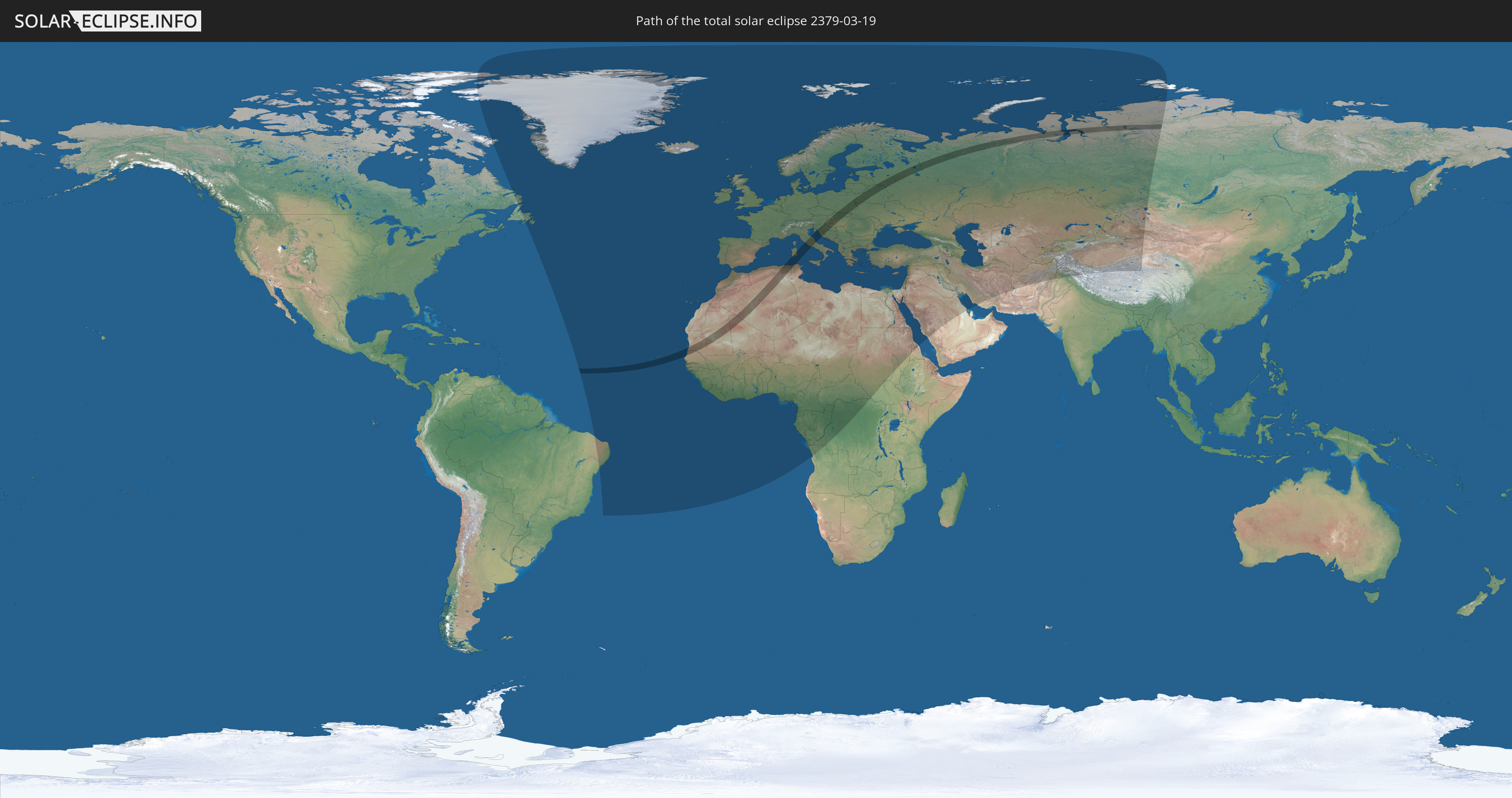
Die Sonnenfinsternis am 03/19/2379 kann man in 111 Ländern als partielle Sonnenfinsternis beobachten.
Der Finsternispfad verläuft durch 18 Länder. Nur in diesen Ländern ist sie als total Sonnenfinsternis zu sehen.
In den folgenden Ländern ist die Sonnenfinsternis total zu sehen
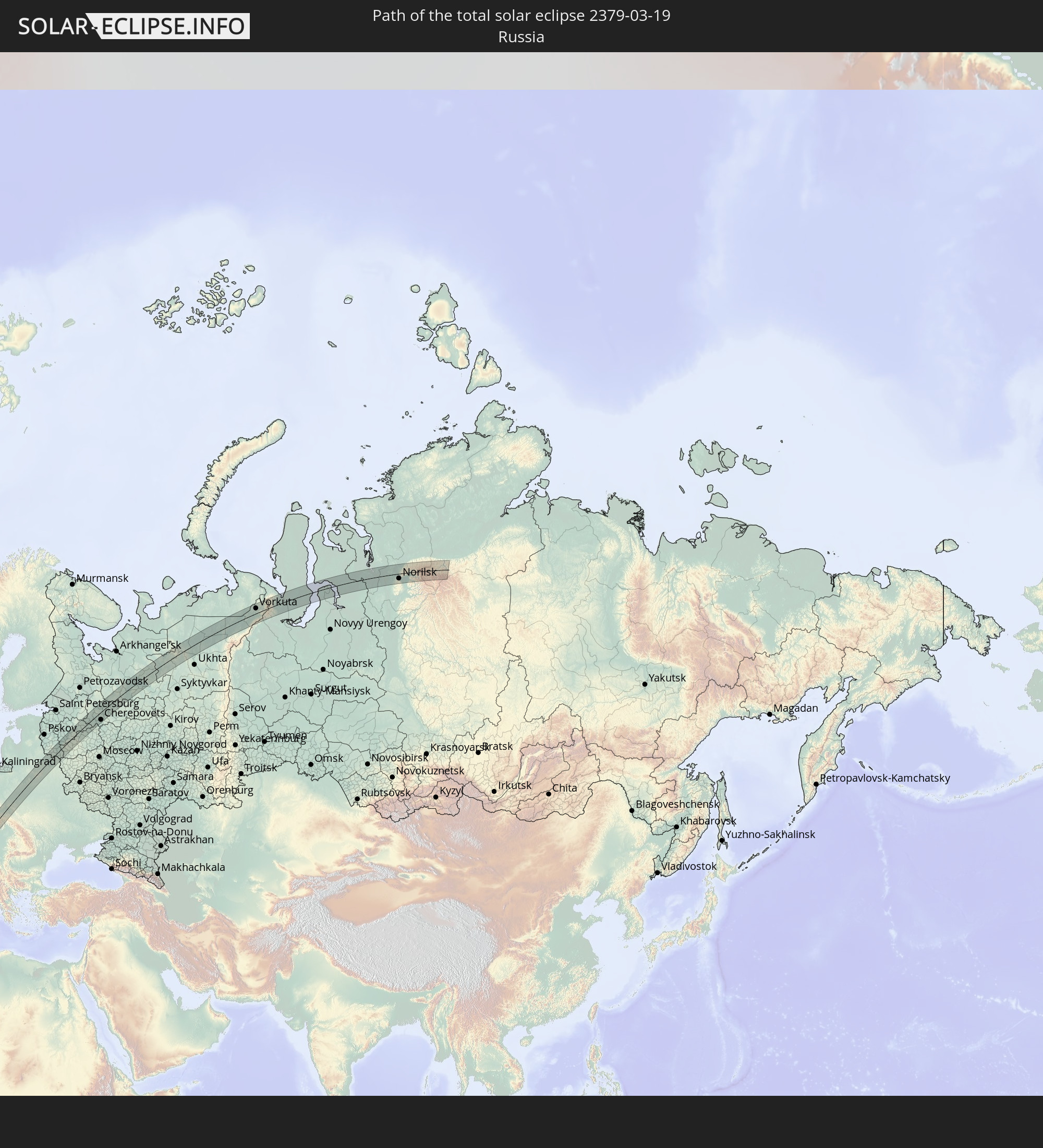 Russia
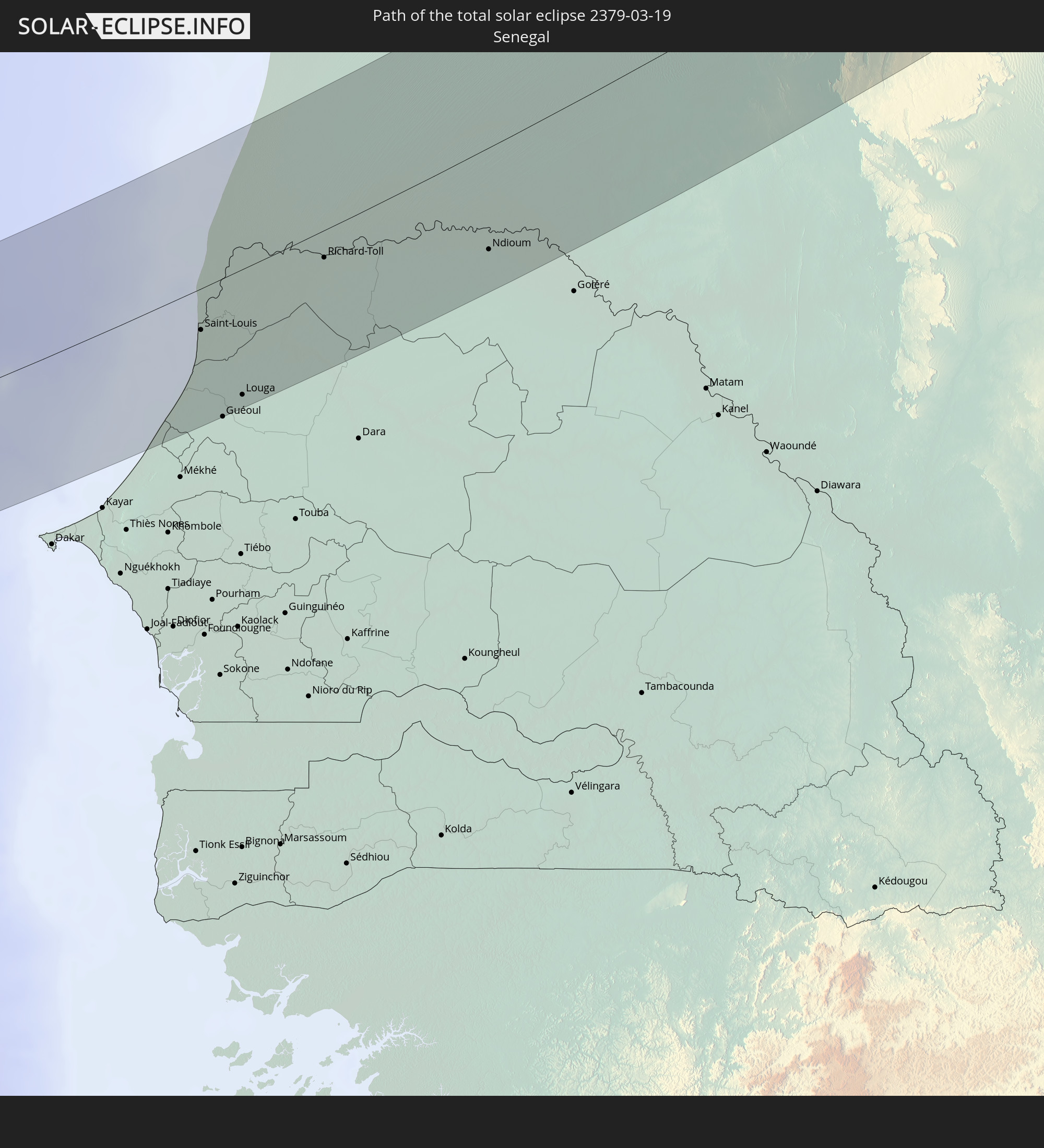 Senegal
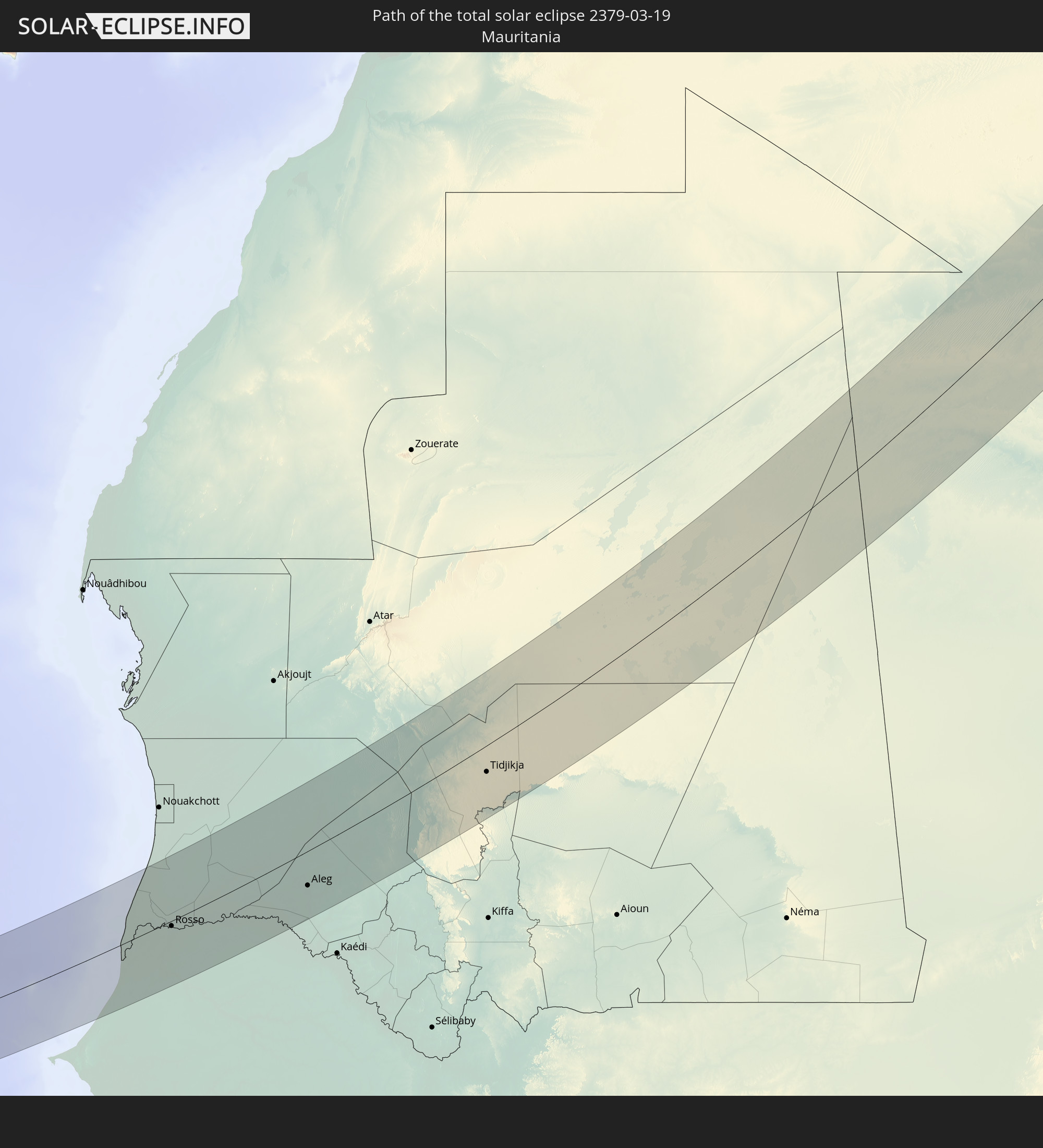 Mauritania
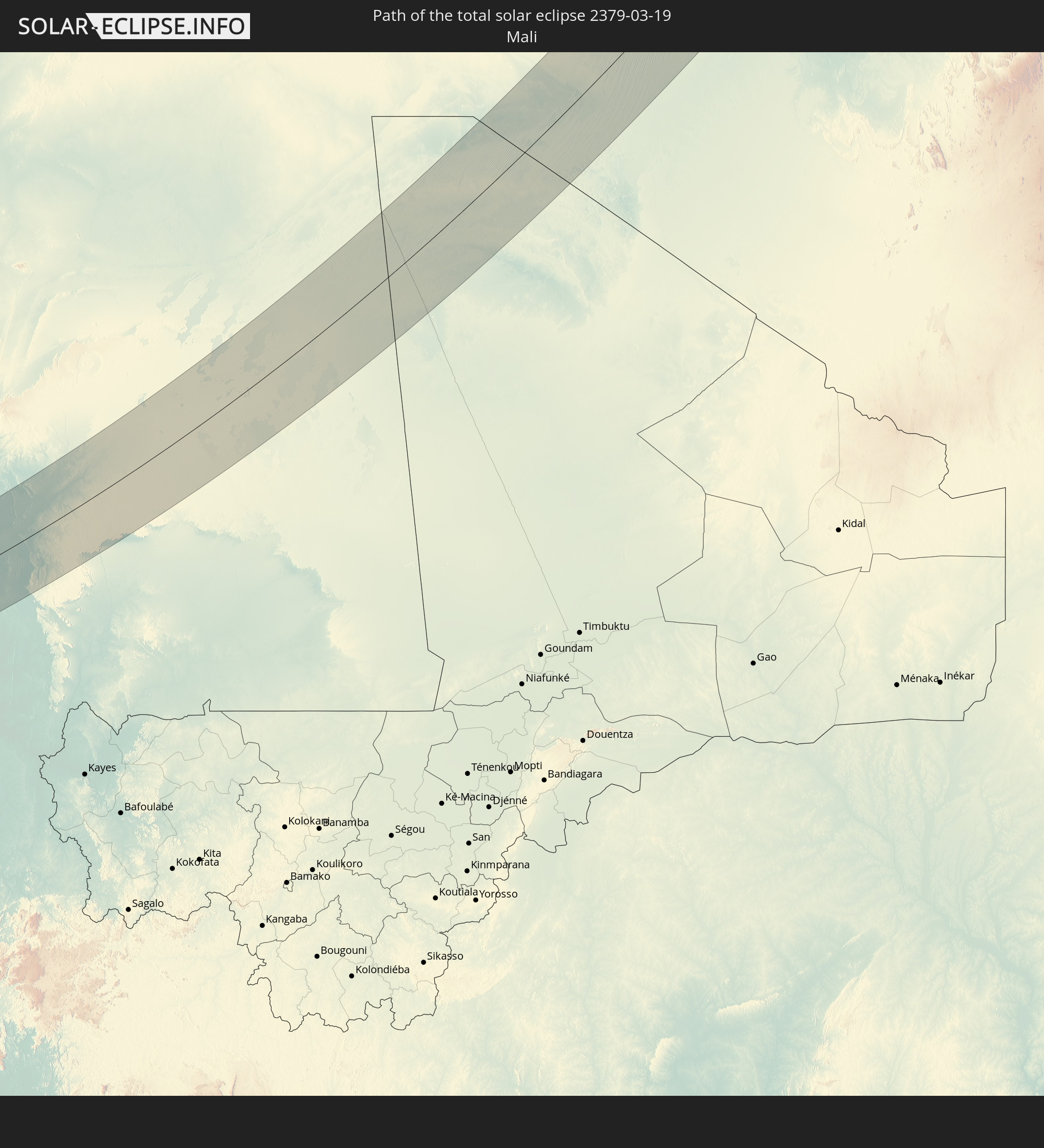 Mali
Mali
 Algeria
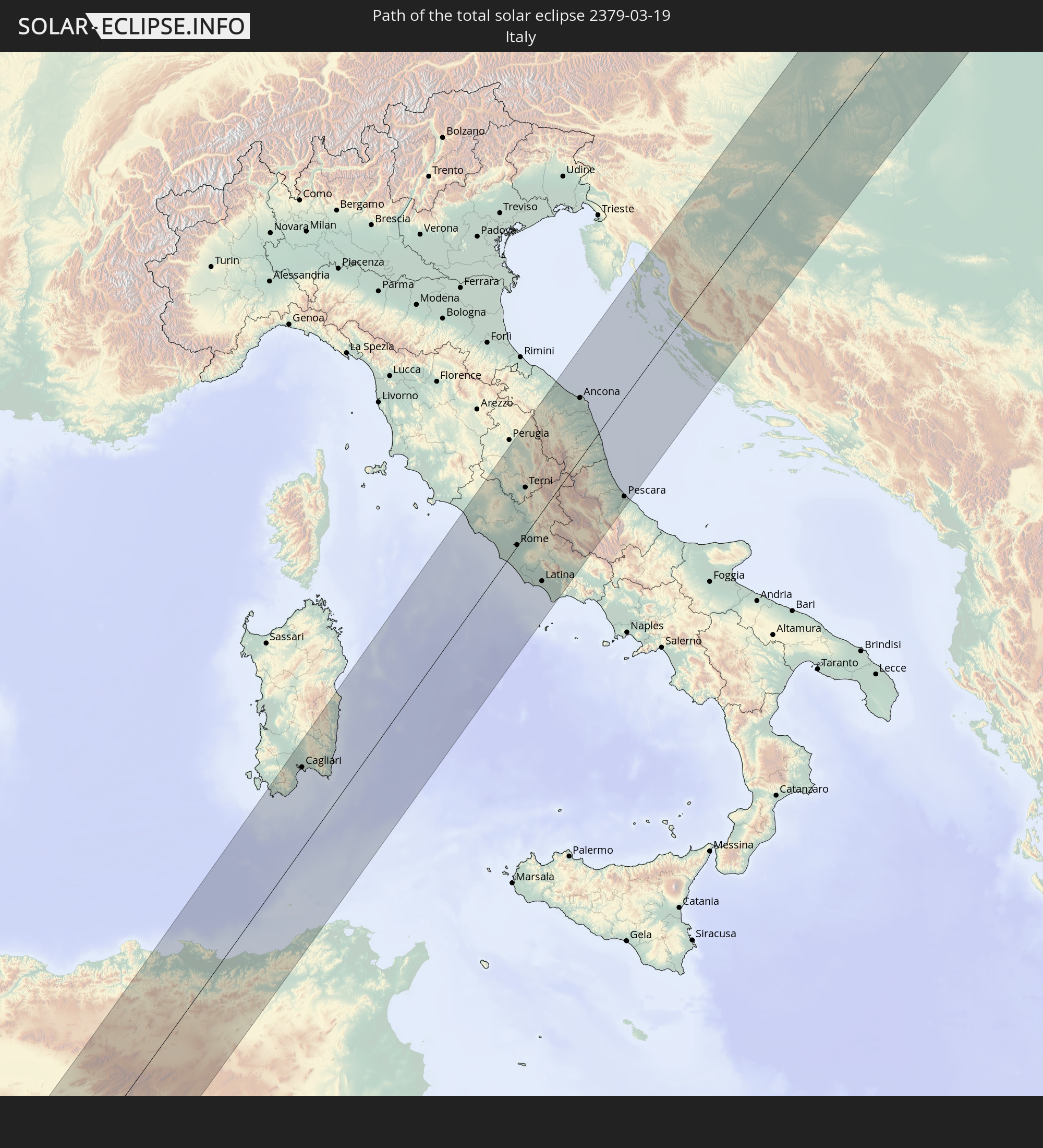 Italy
Italy
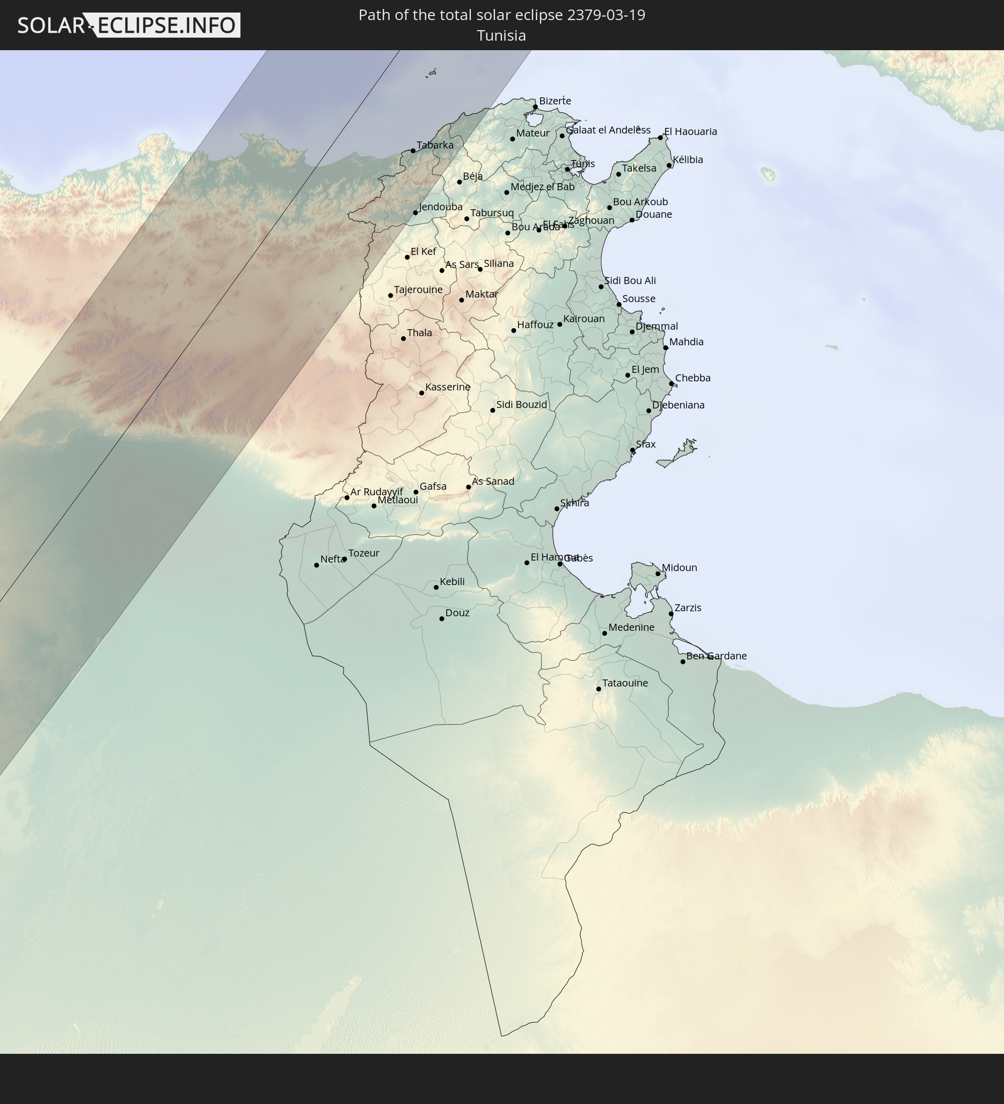 Tunisia
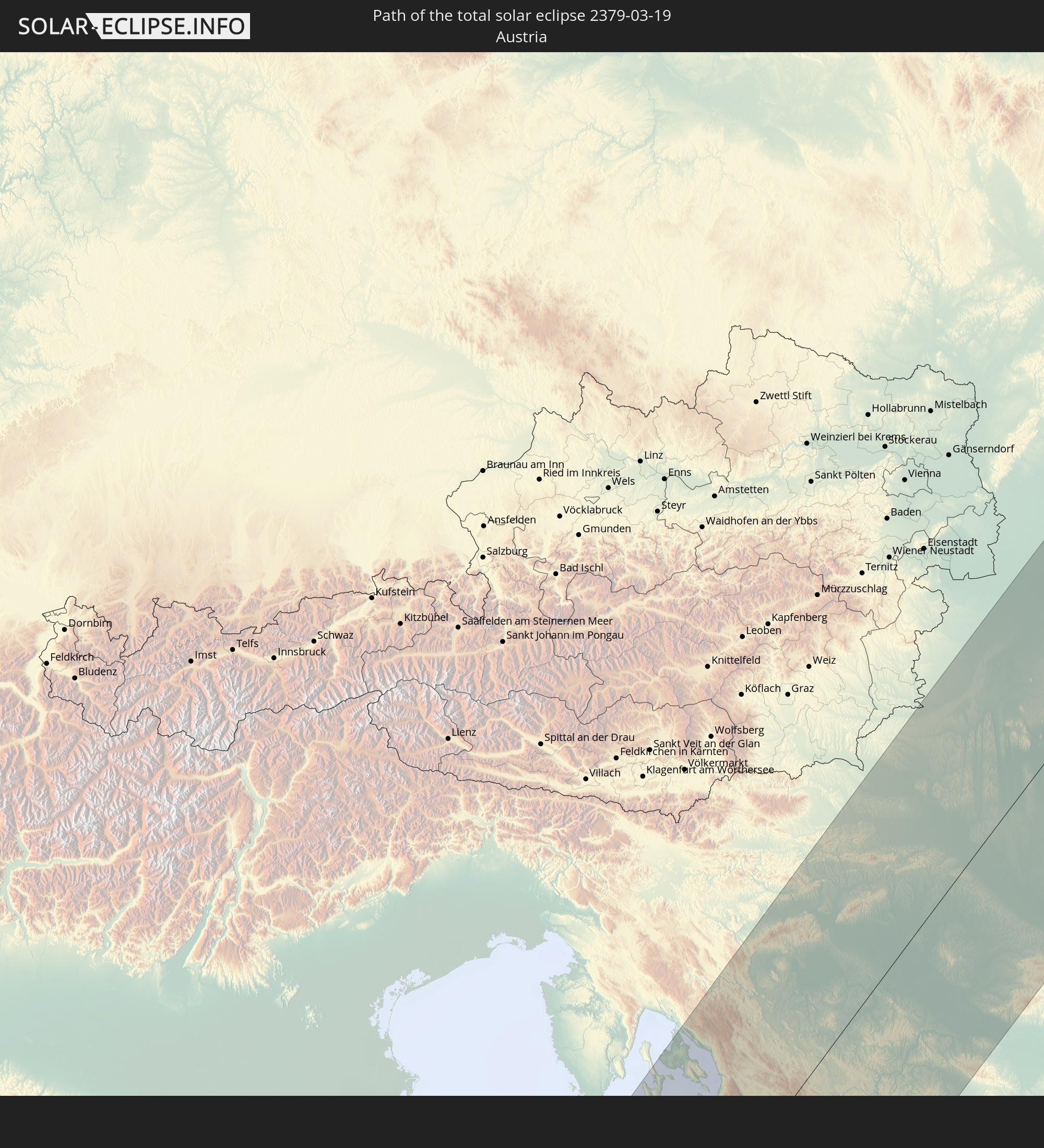 Austria
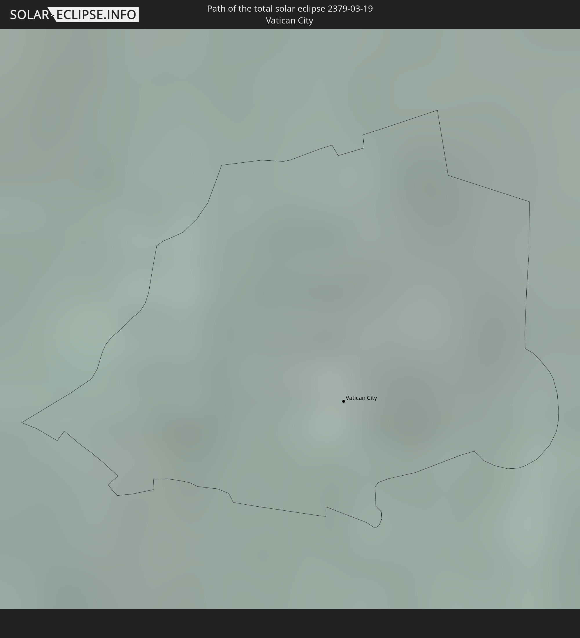 Vatican City
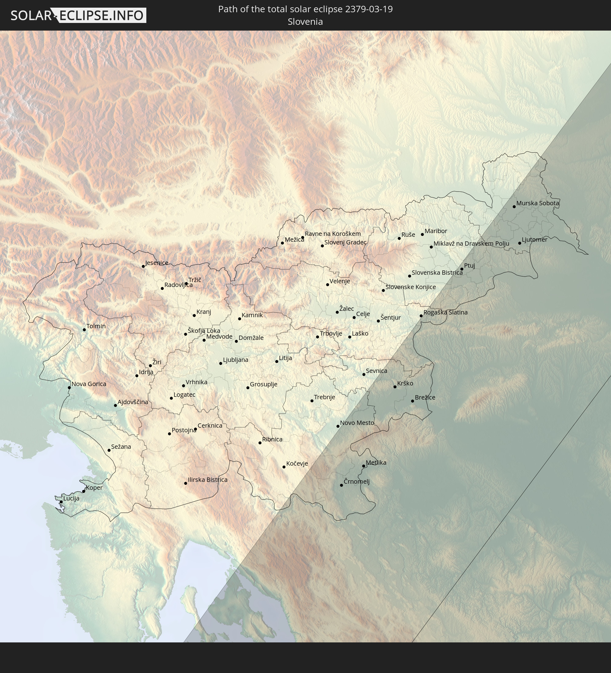 Slovenia
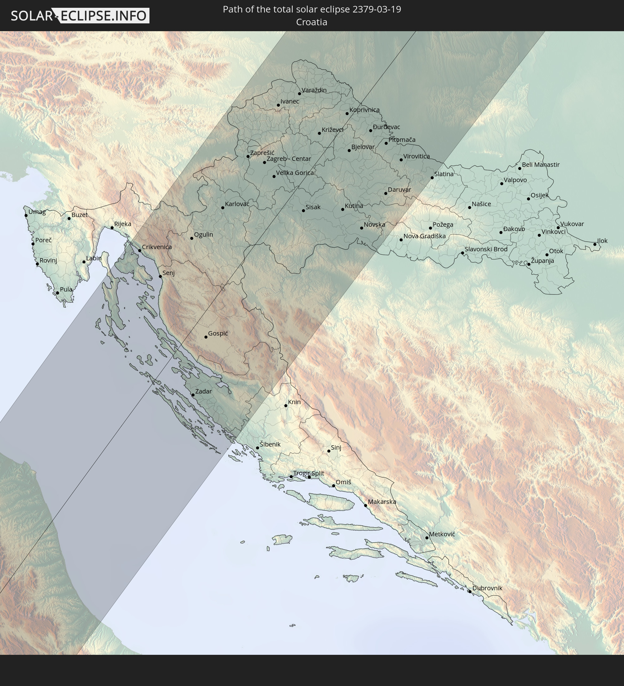 Croatia
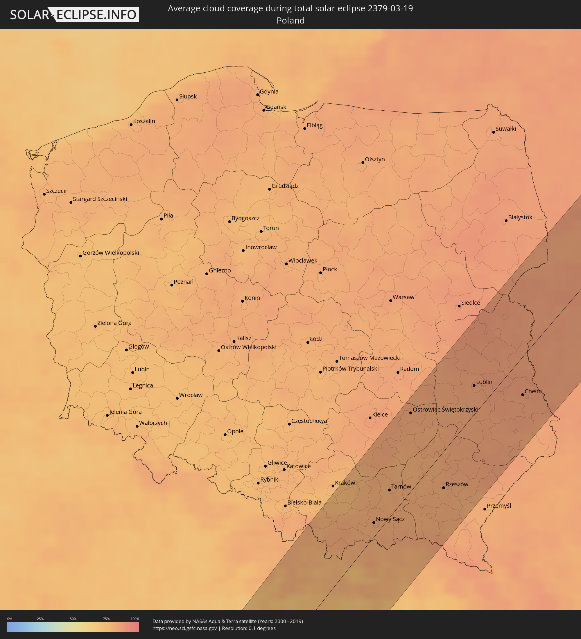
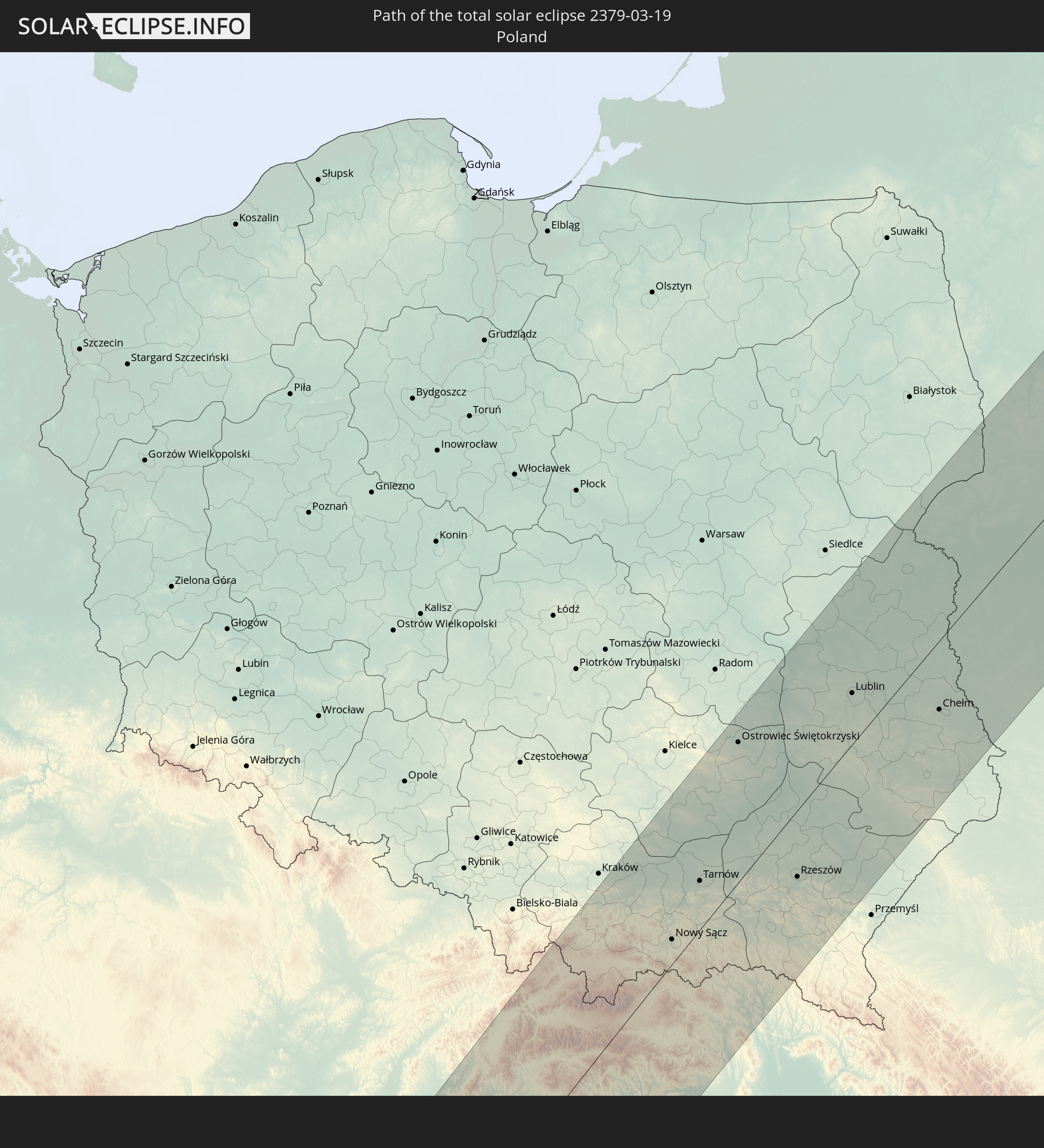 Poland
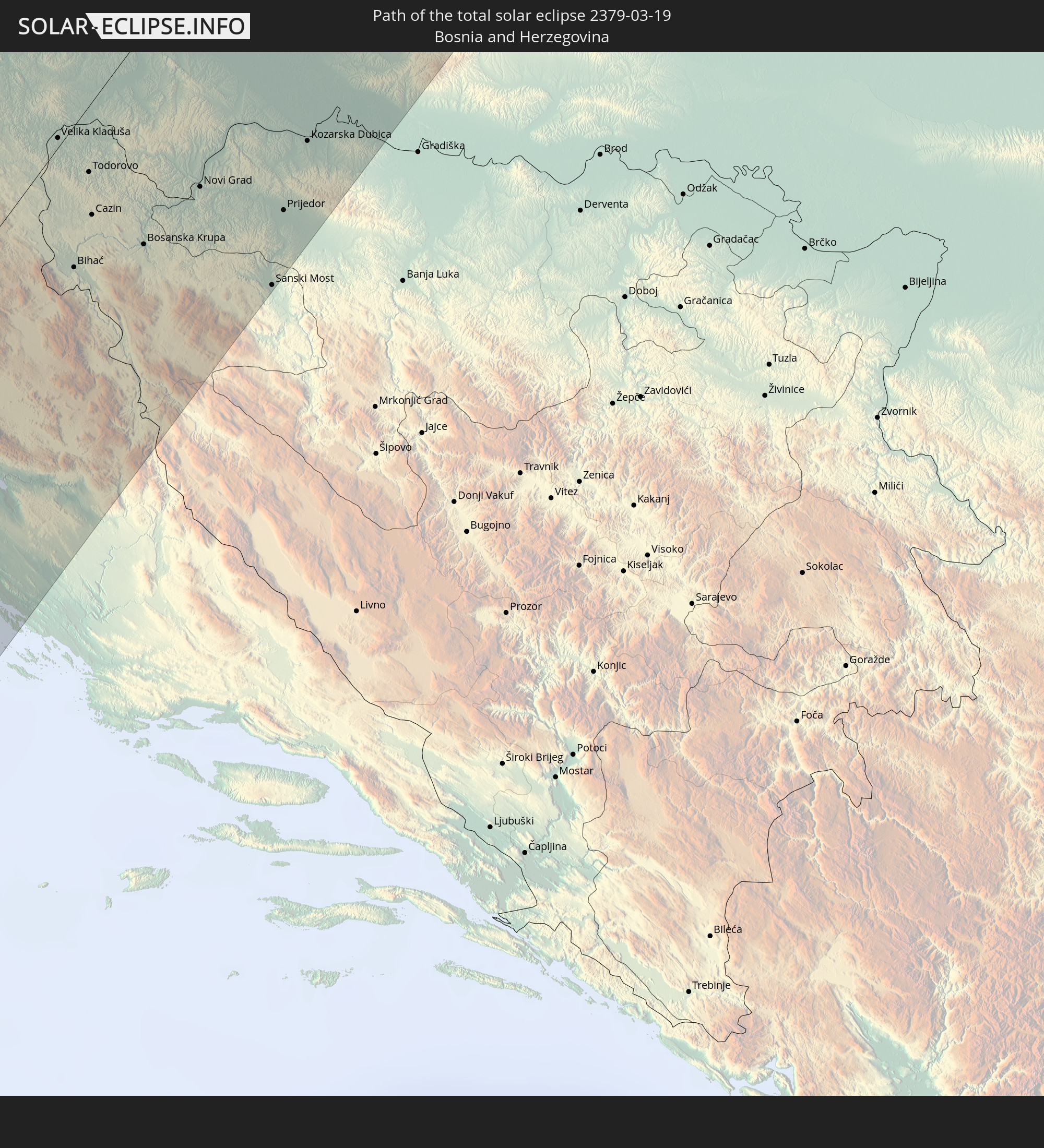 Bosnia and Herzegovina
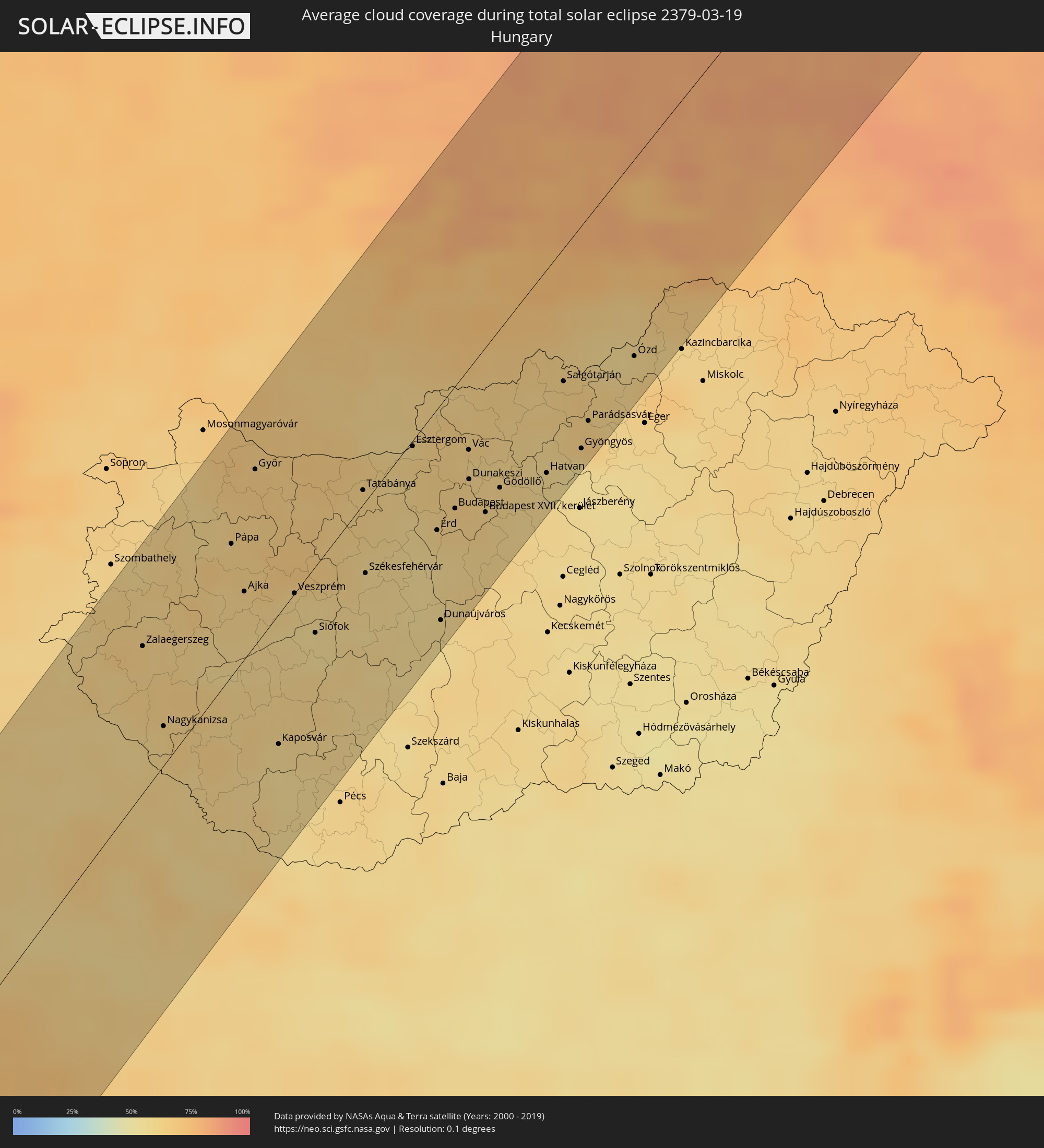
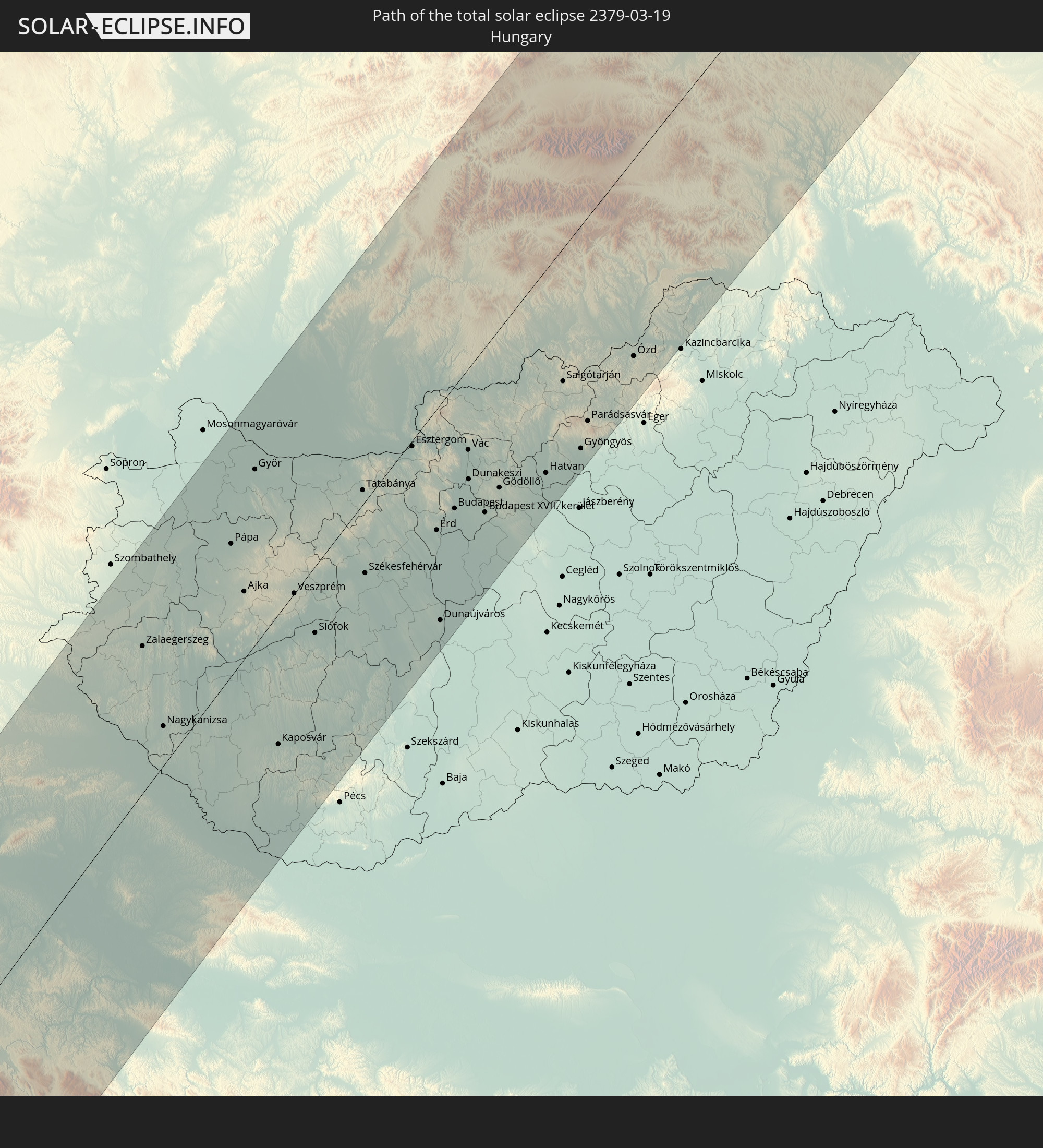 Hungary
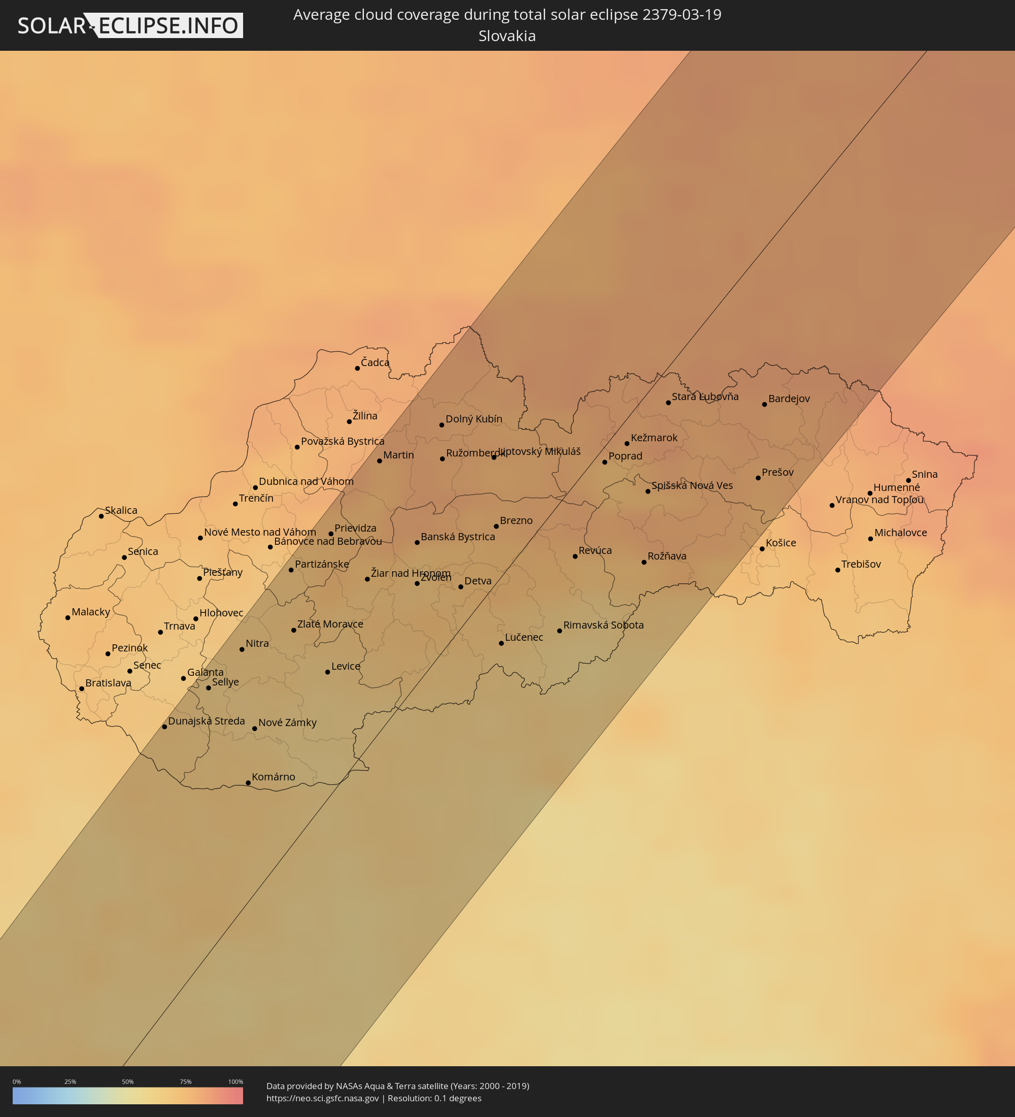
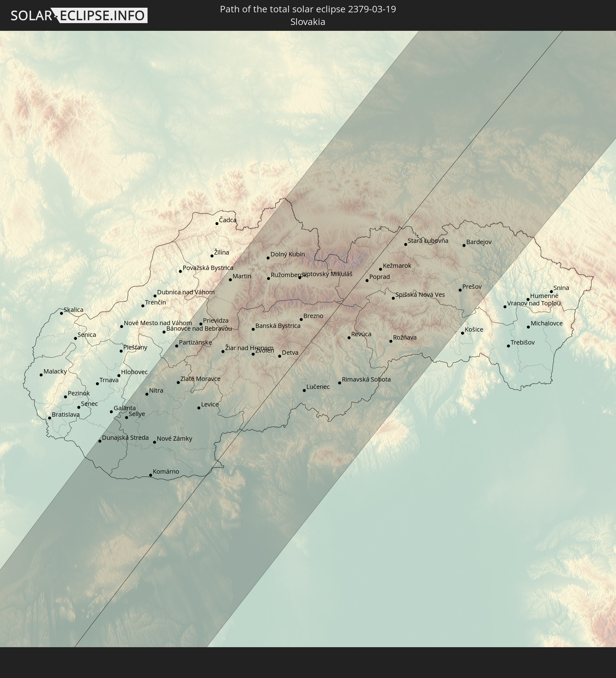 Slovakia
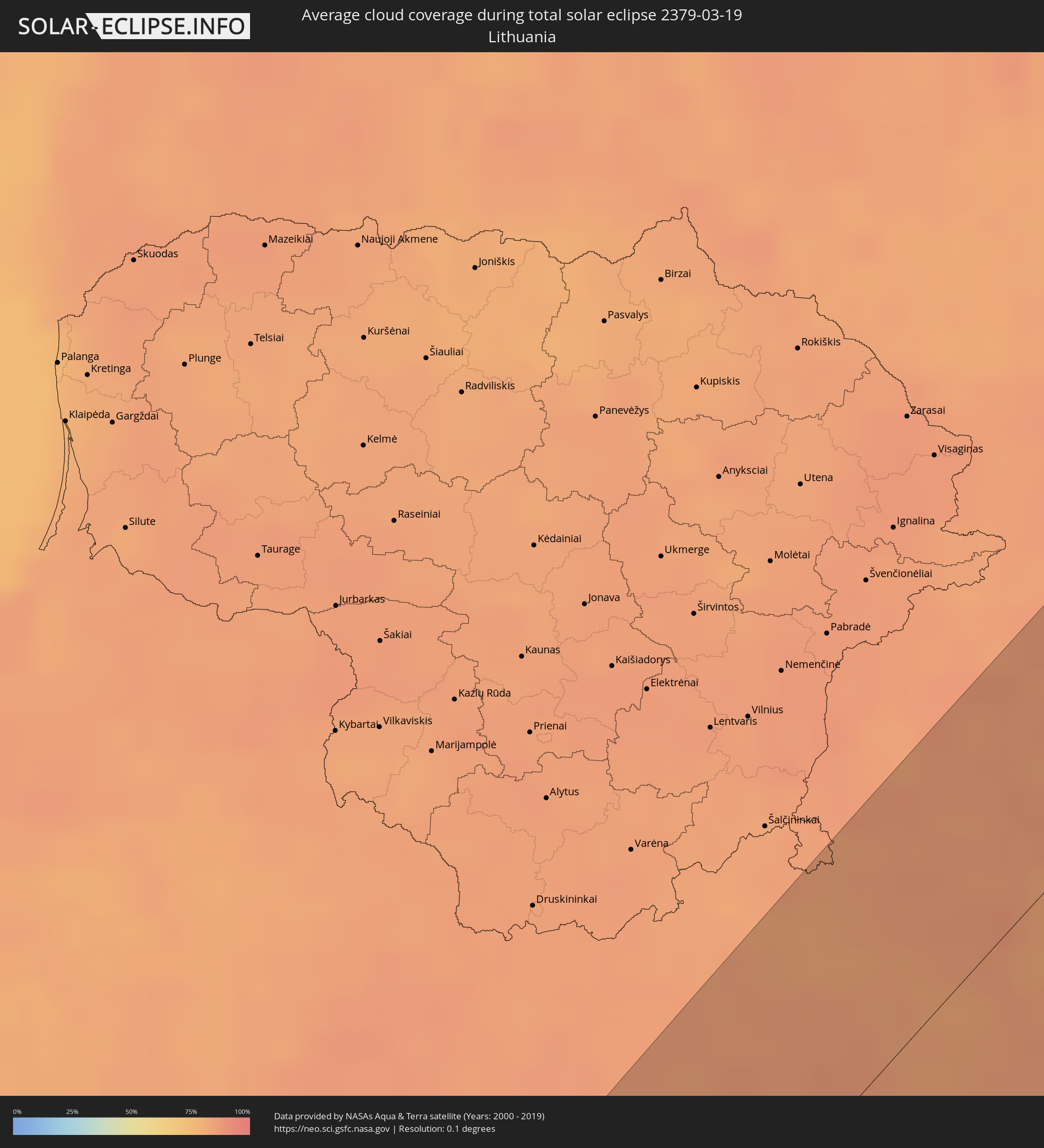
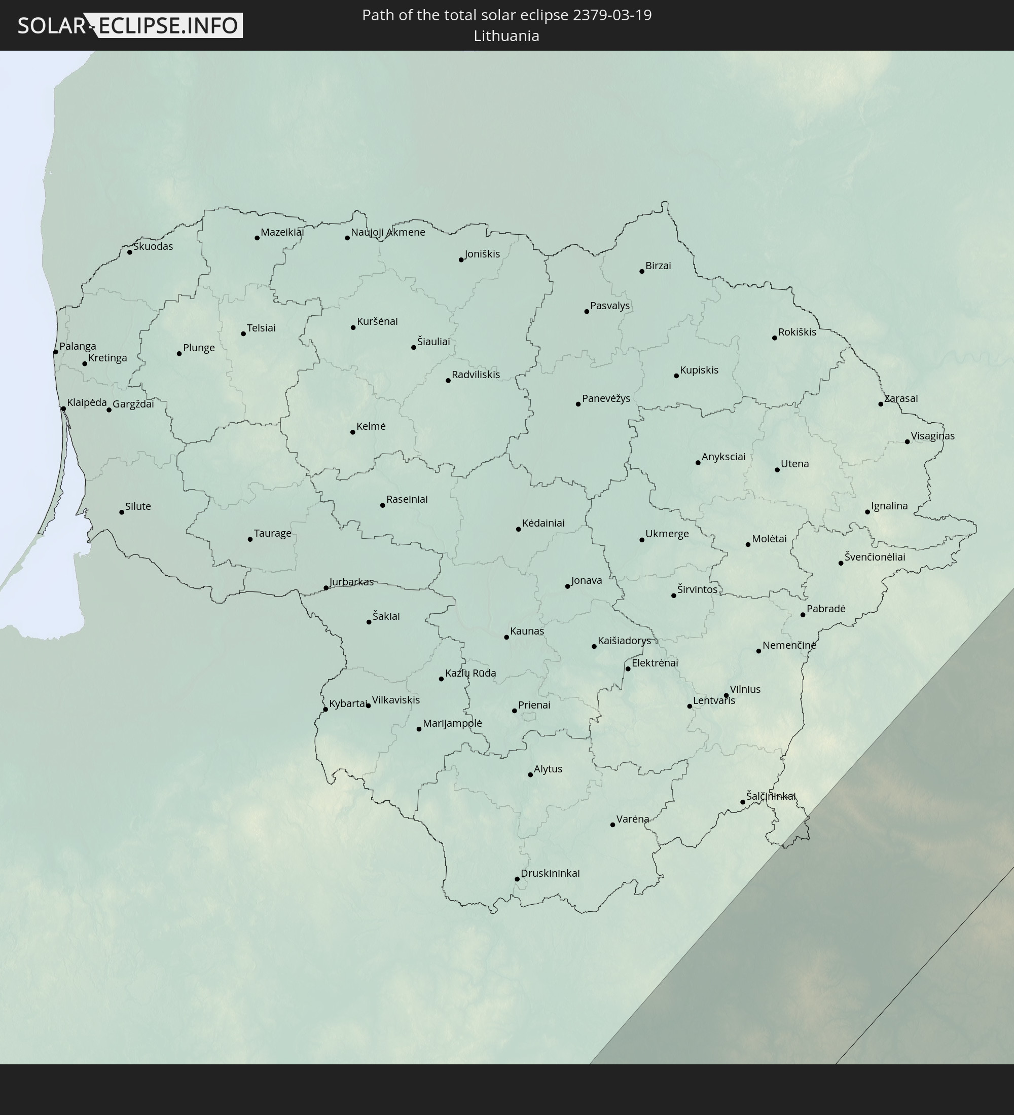 Lithuania
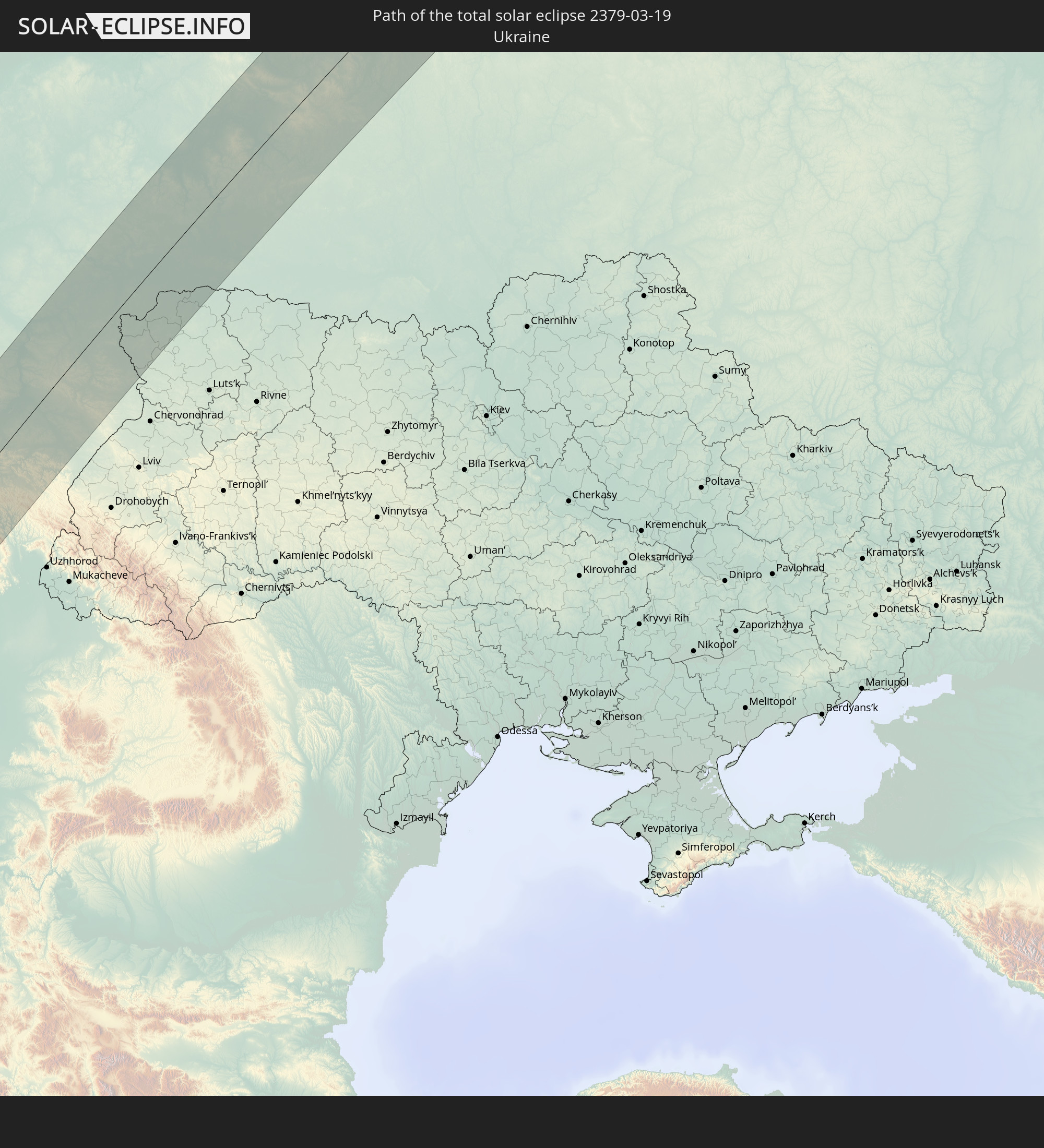 Ukraine
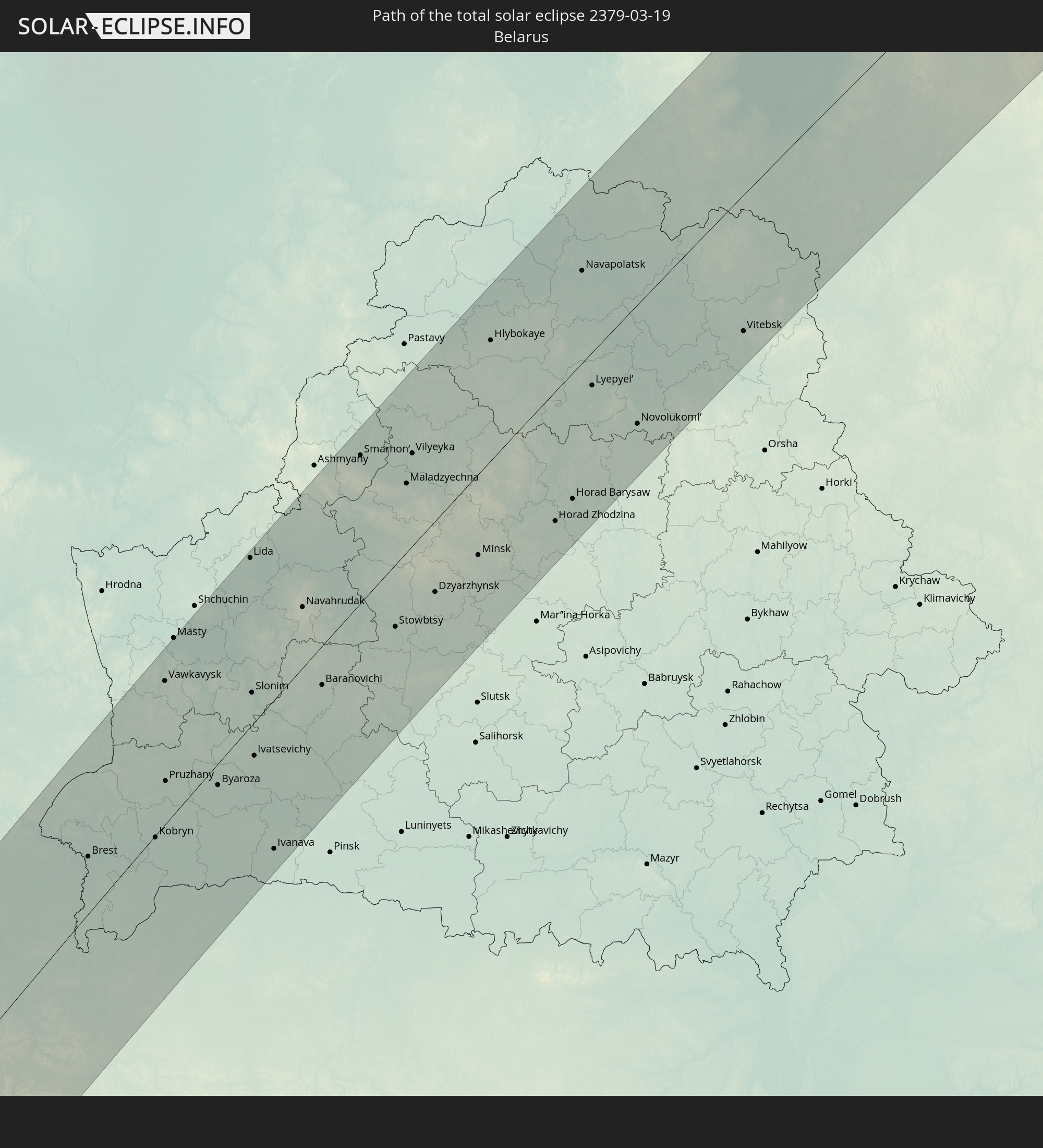 Belarus
In den folgenden Ländern ist die Sonnenfinsternis partiell zu sehen
 Russia
 Canada
 Greenland
 Brazil
 Portugal
 Cabo Verde
 Iceland
 Spain
Spain
 Senegal
 Mauritania
 The Gambia
 Guinea-Bissau
 Guinea
 Saint Helena, Ascension and Tristan da Cunha
 Sierra Leone
 Morocco
 Mali
Mali
 Liberia
 Republic of Ireland
 Svalbard and Jan Mayen
 Algeria
 United Kingdom
 Ivory Coast
 Faroe Islands
 Burkina Faso
 Gibraltar
 France
 Isle of Man
 Ghana
Ghana
 Guernsey
 Jersey
 Togo
Togo
 Niger
Niger
 Benin
Benin
 Andorra
 Belgium
 Nigeria
 Netherlands
 Norway
 Equatorial Guinea
 Luxembourg
 Germany
 Switzerland
 São Tomé and Príncipe
 Italy
Italy
 Monaco
 Tunisia
 Denmark
 Cameroon
 Gabon
Gabon
 Libya
Libya
 Liechtenstein
 Austria
 Sweden
 Republic of the Congo
 Angola
 Czechia
 Democratic Republic of the Congo
 San Marino
 Vatican City
 Slovenia
 Chad
Chad
 Croatia
 Poland
 Malta
Malta
 Central African Republic
 Bosnia and Herzegovina
 Hungary
 Slovakia
 Montenegro
 Serbia
 Albania
 Åland Islands
 Greece
 Romania
 Republic of Macedonia
 Finland
 Lithuania
 Latvia
 Estonia
 Sudan
Sudan
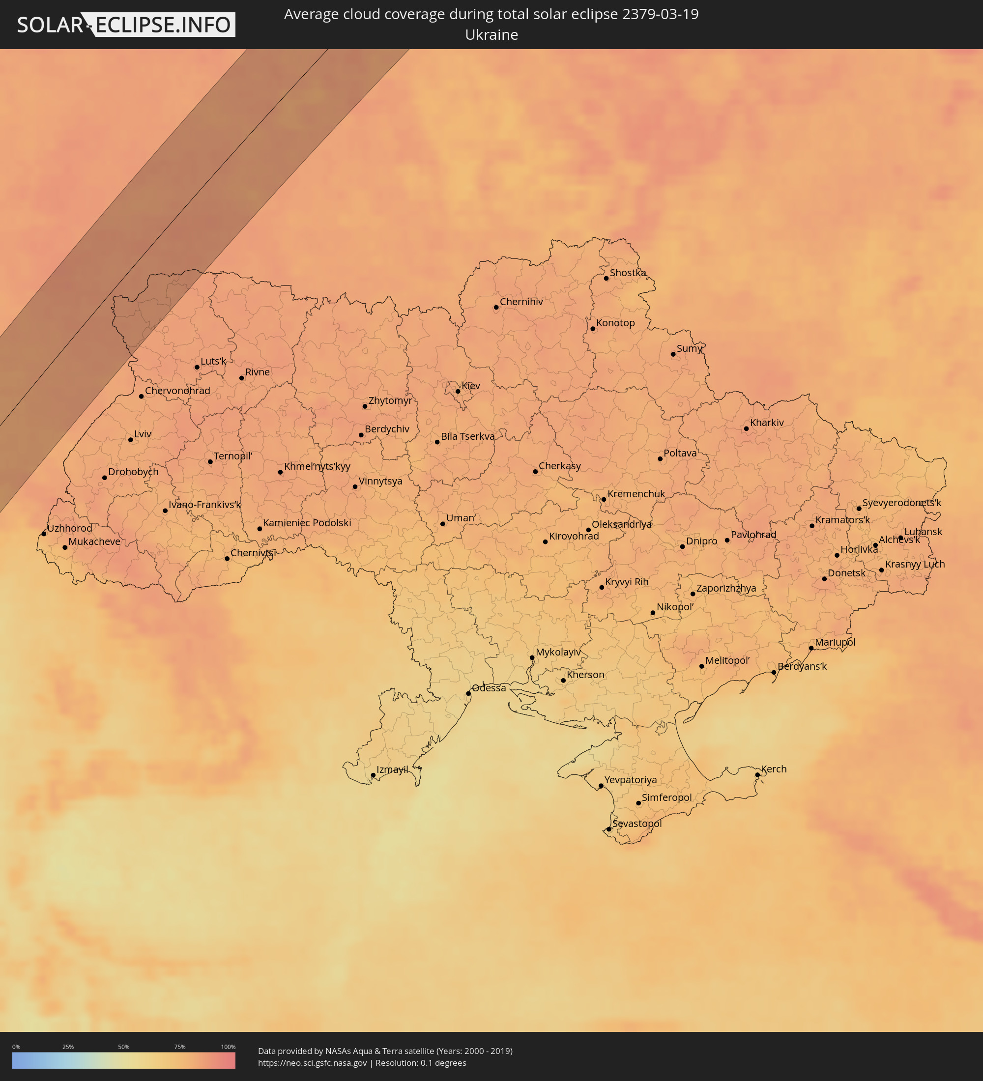
 Ukraine
 Bulgaria
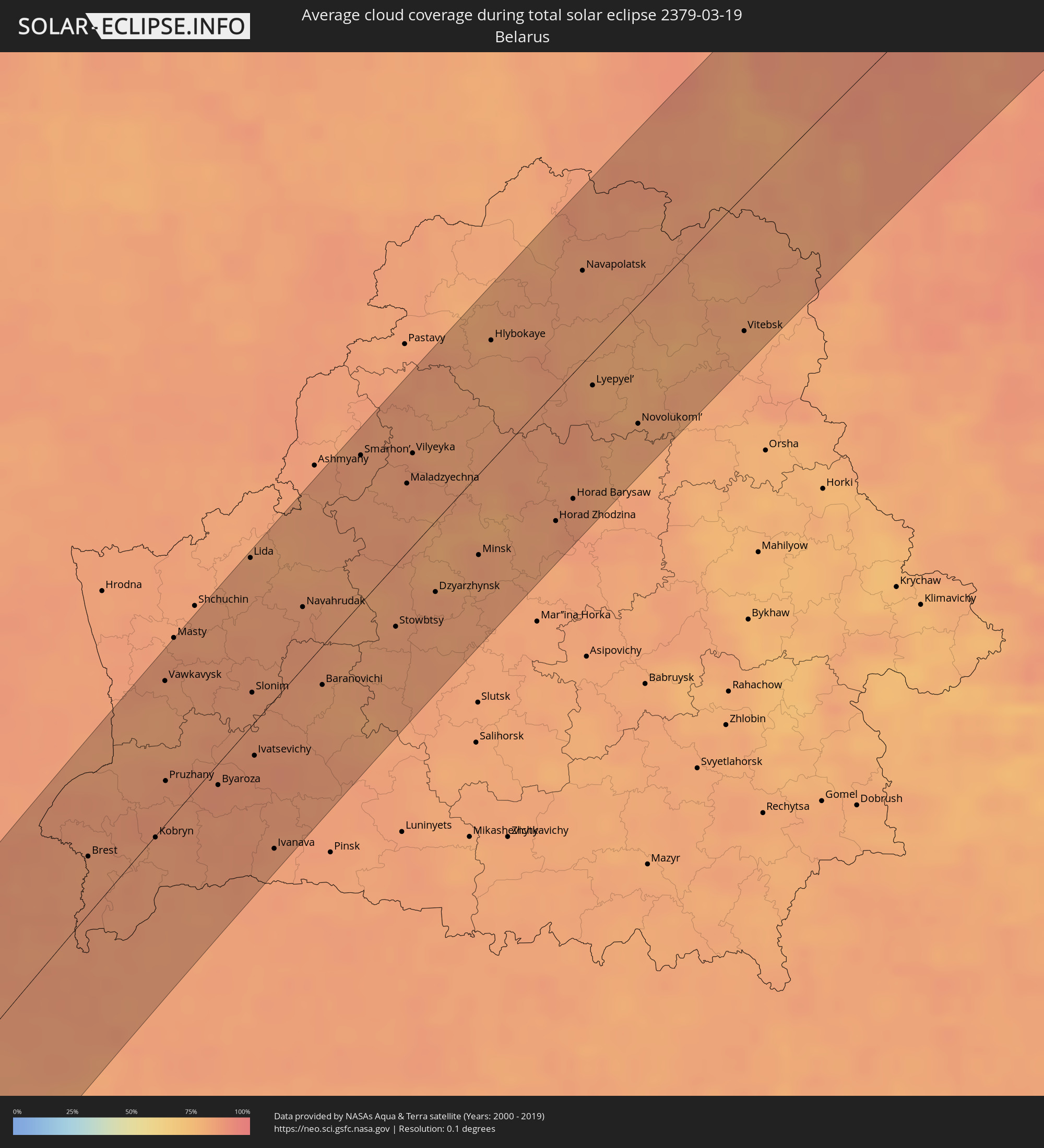
 Belarus
 Egypt
Egypt
 Turkey
 Moldova
 Cyprus
 State of Palestine
 Israel
 Saudi Arabia
 Jordan
 Lebanon
 Syria
Syria
 Eritrea
 Iraq
Iraq
 Georgia
 Armenia
 Iran
Iran
 Azerbaijan
 Kazakhstan
 Kuwait
 Turkmenistan
 Uzbekistan
 Afghanistan
 Pakistan
 Tajikistan
 India
India
 Kyrgyzstan
 China
China
 Mongolia
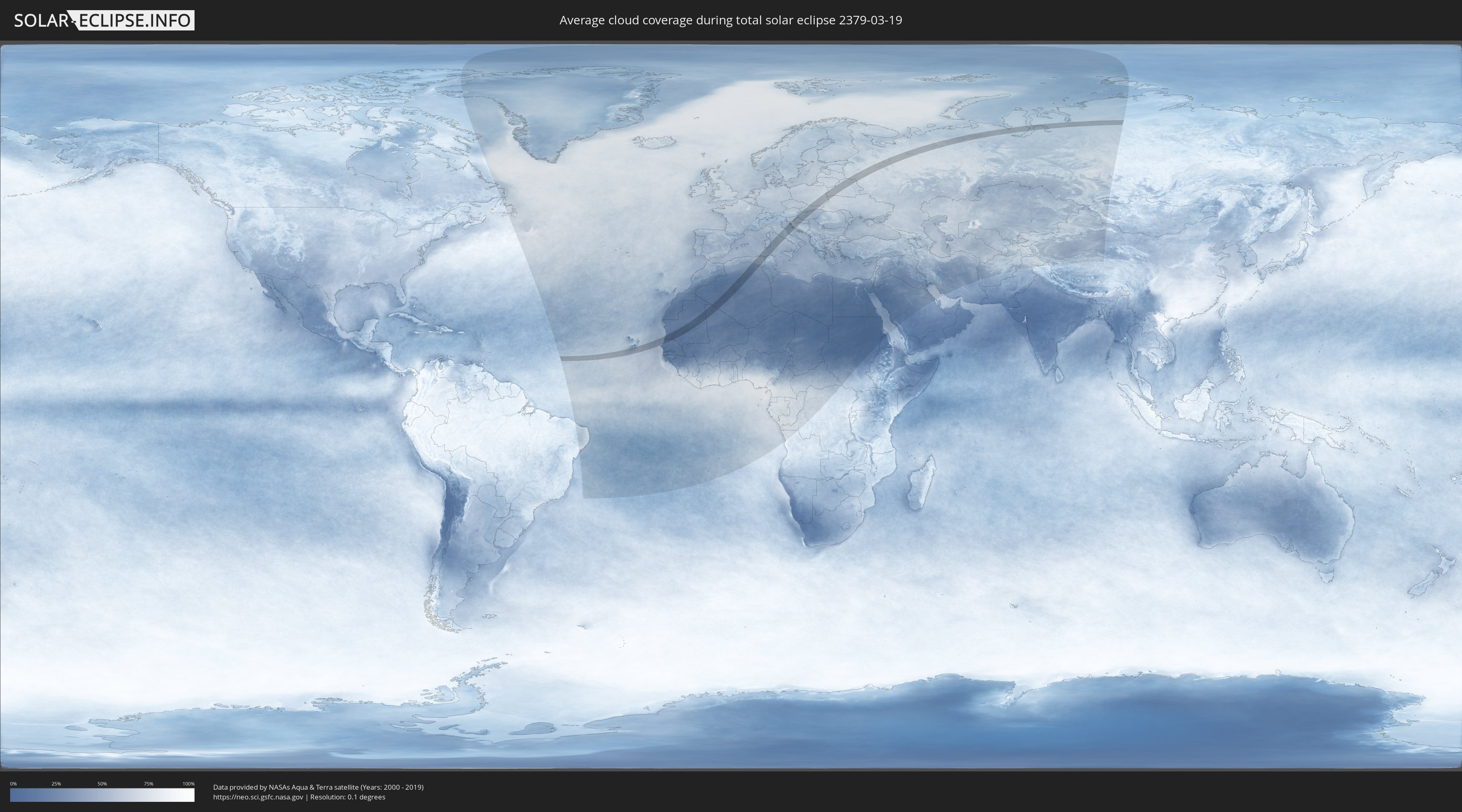
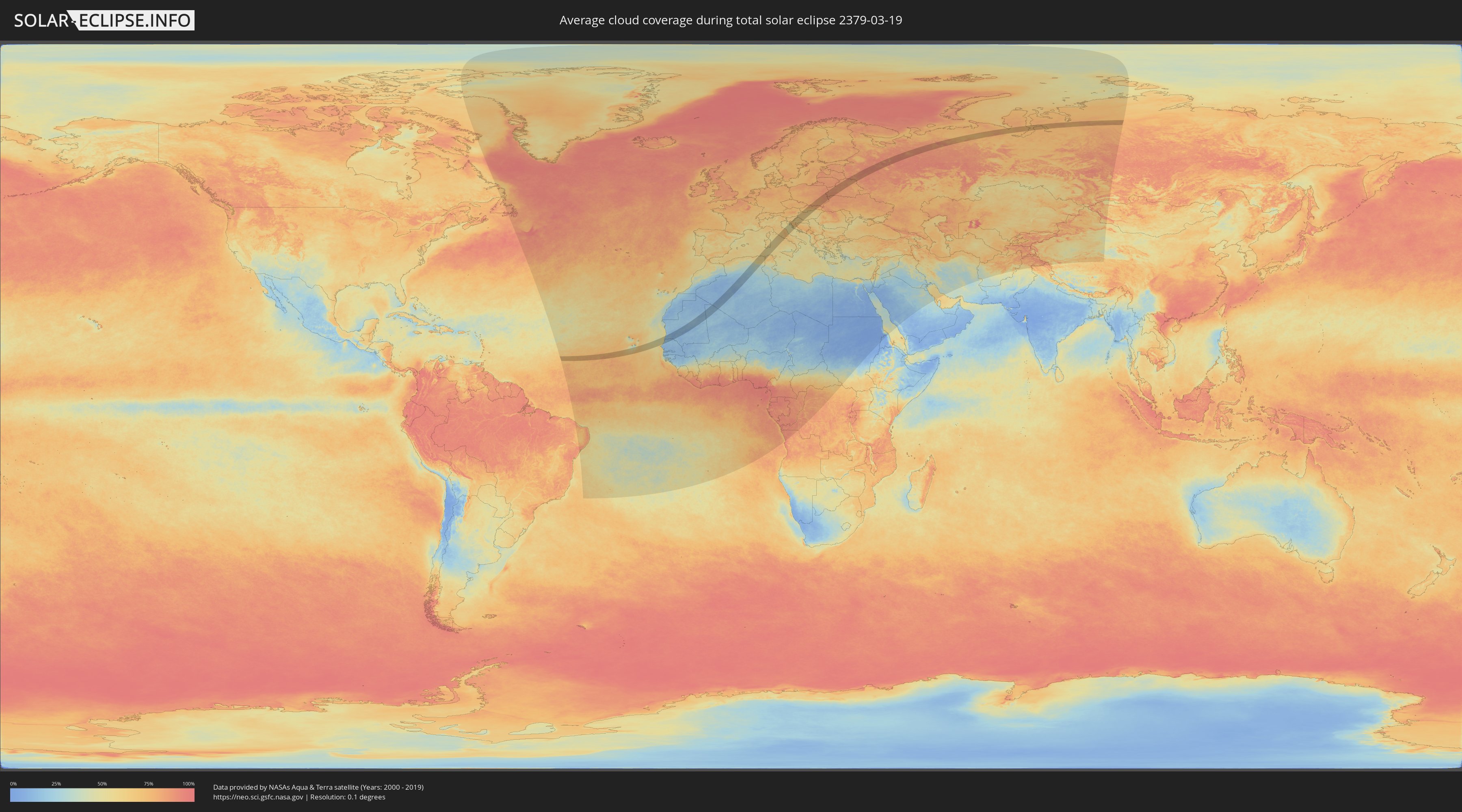
How will be the weather during the total solar eclipse on 03/19/2379?
Where is the best place to see the total solar eclipse of 03/19/2379?
The following maps show the average cloud coverage for the day of the total solar eclipse.
With the help of these maps, it is possible to find the place along the eclipse path, which has the best
chance of a cloudless sky.
Nevertheless, you should consider local circumstances and inform about the weather of your chosen
observation site.
The data is provided by NASAs satellites
AQUA and TERRA.
The cloud maps are averaged over a period of 19 years (2000 - 2019).
Detailed country maps
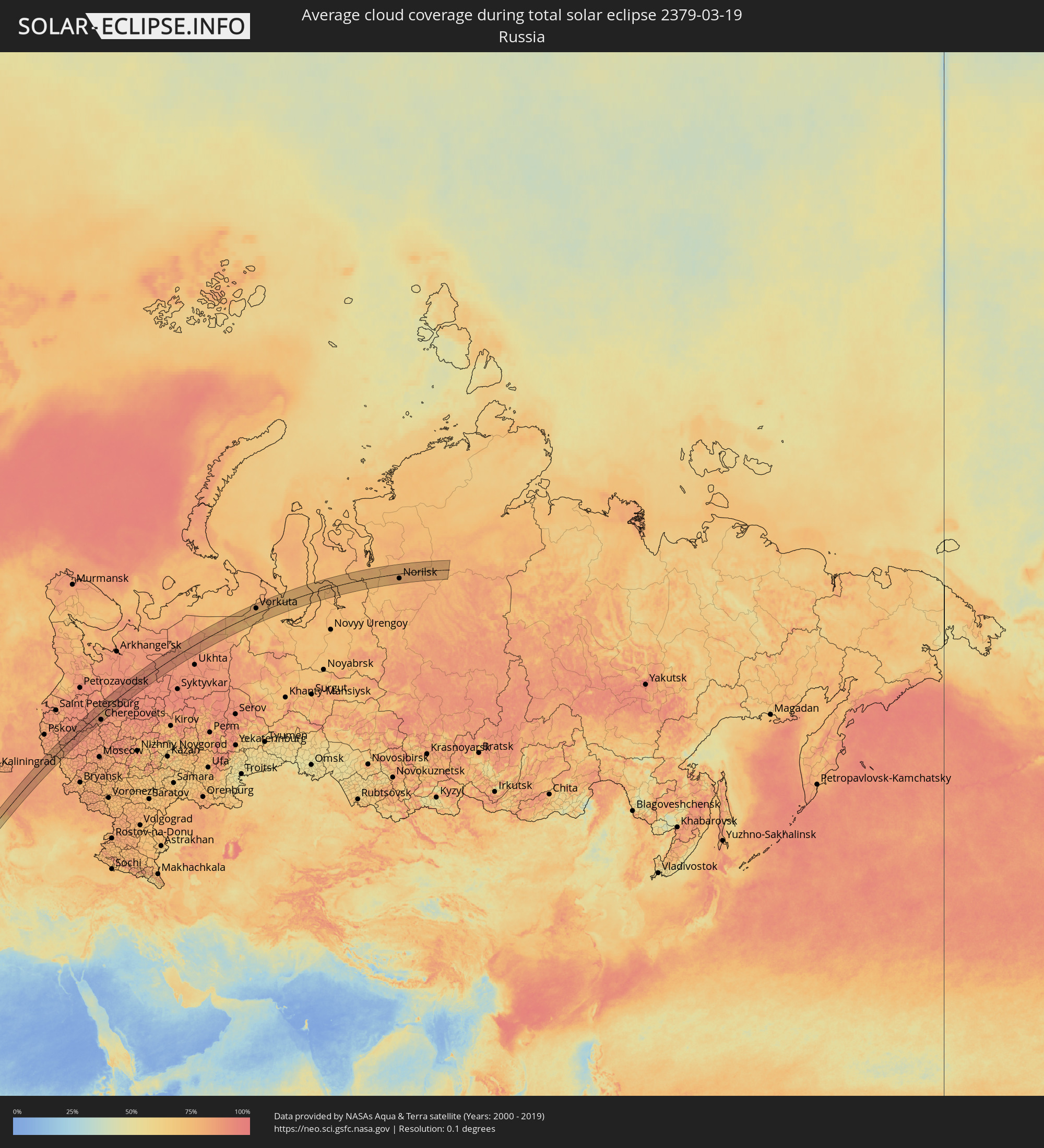 Russia
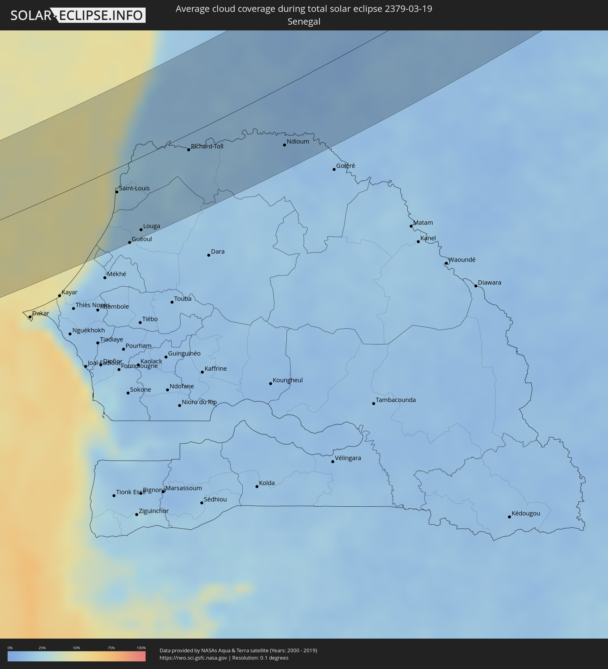 Senegal
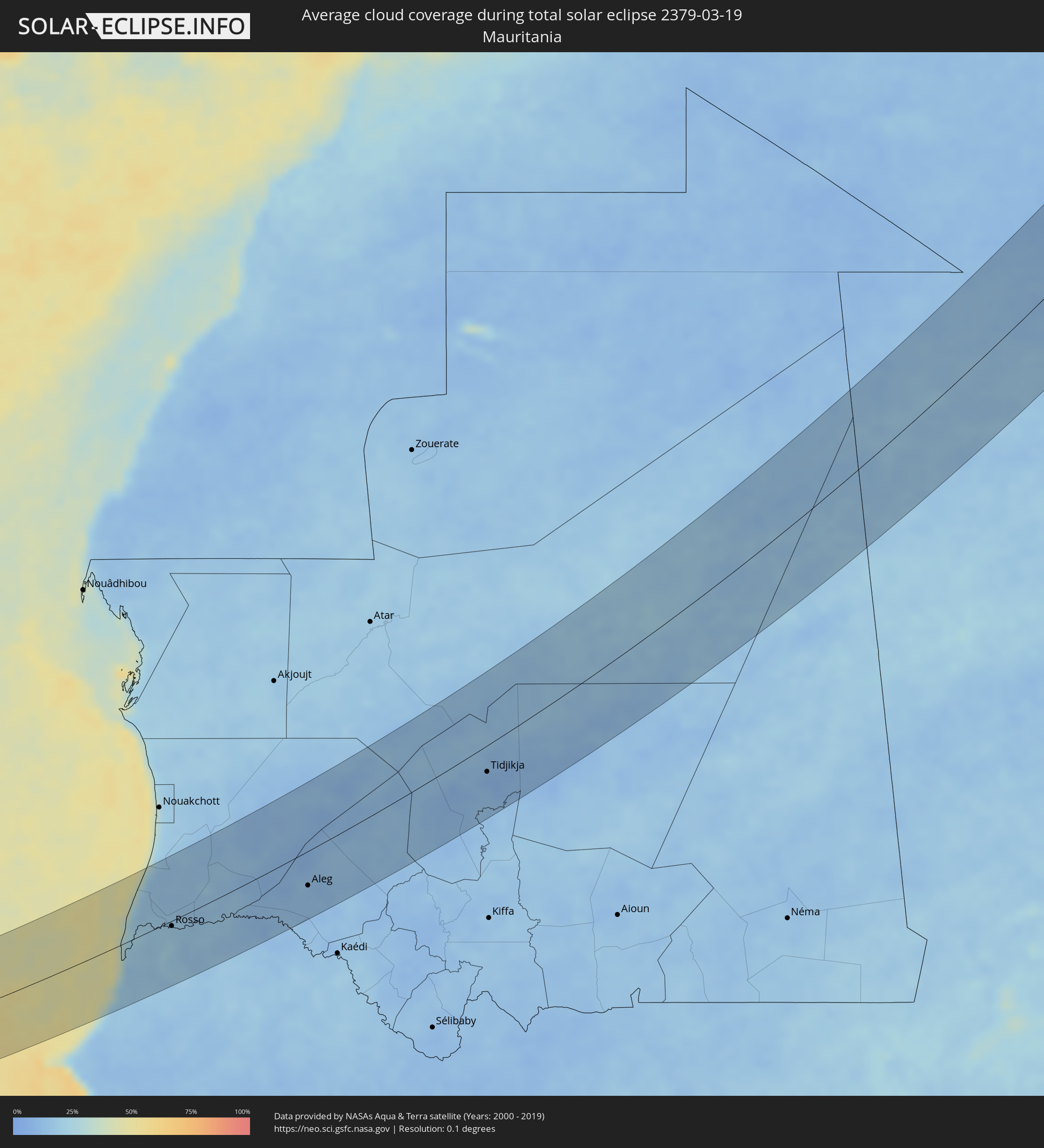 Mauritania
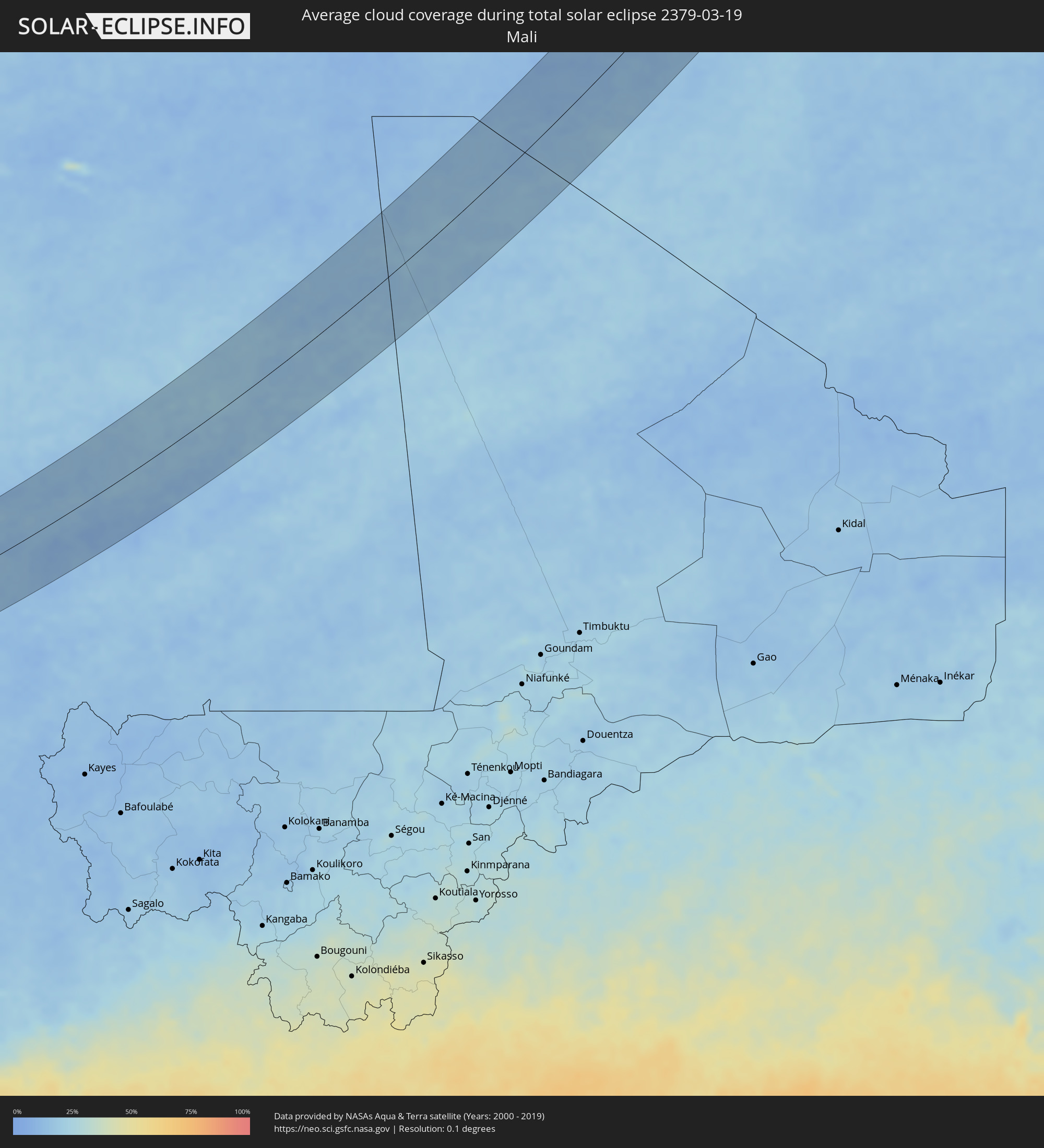 Mali
Mali
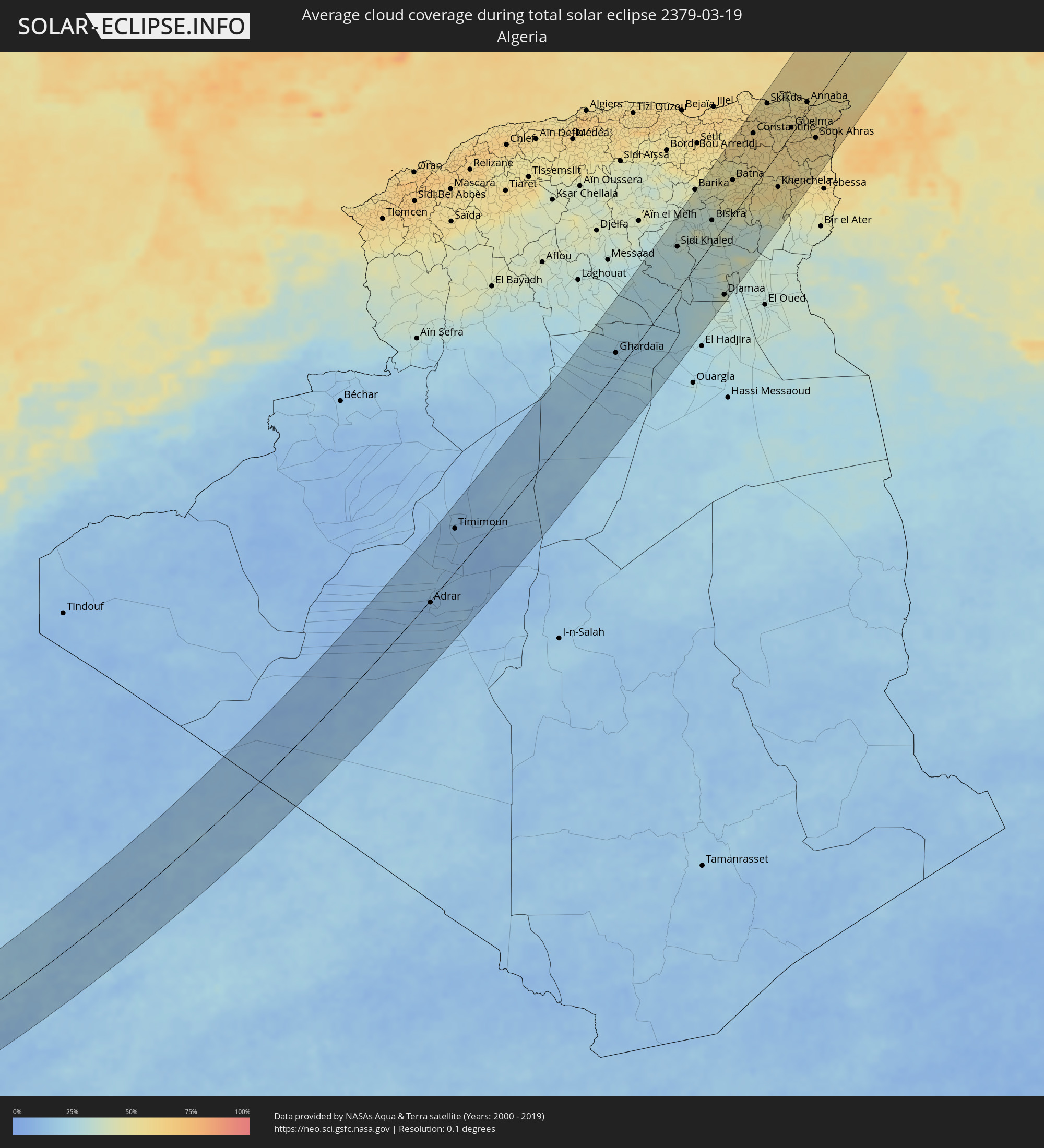 Algeria
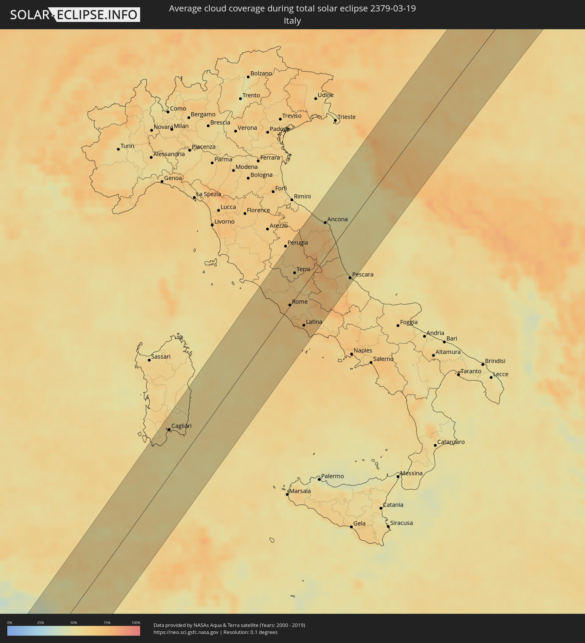 Italy
Italy
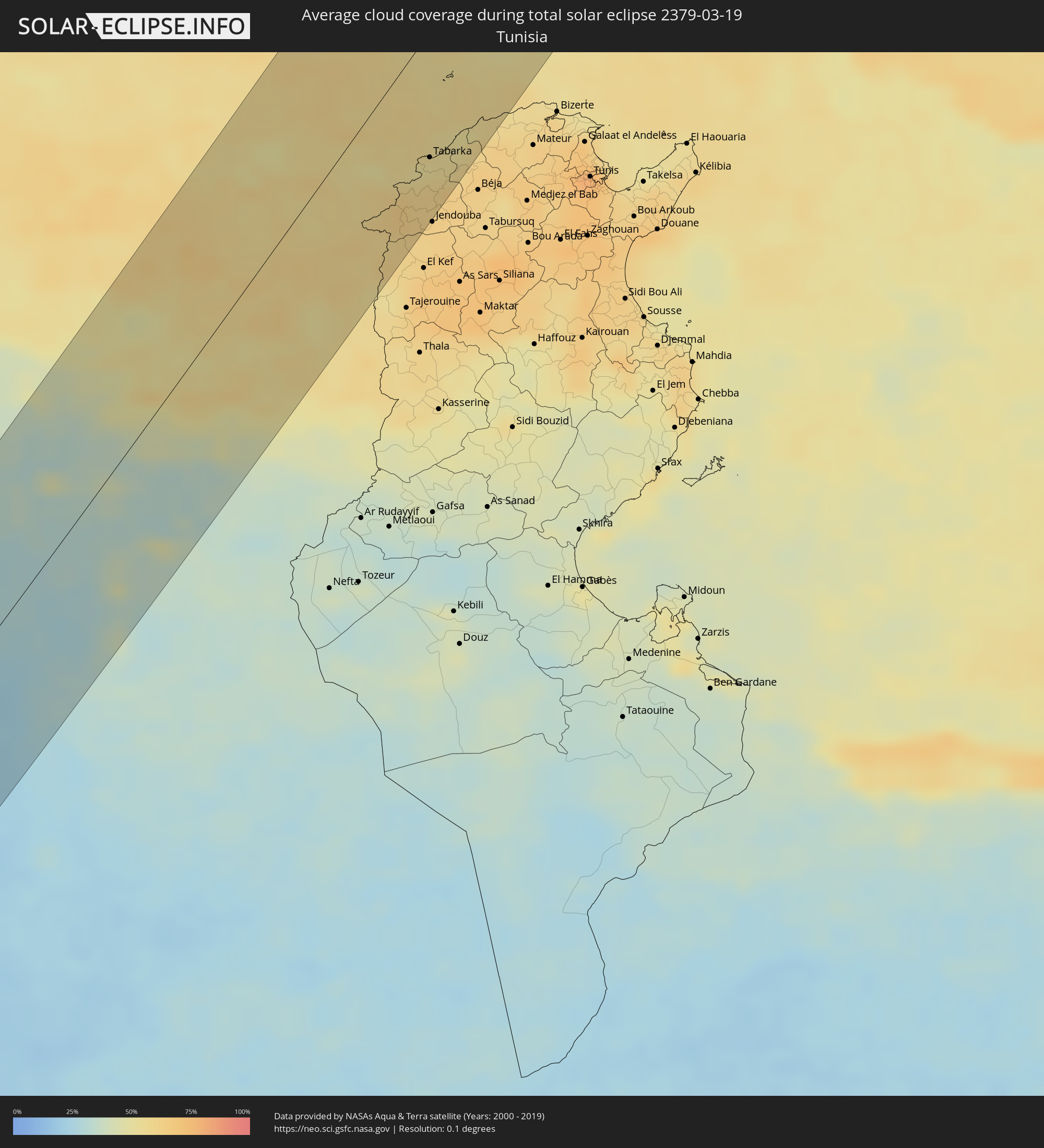 Tunisia
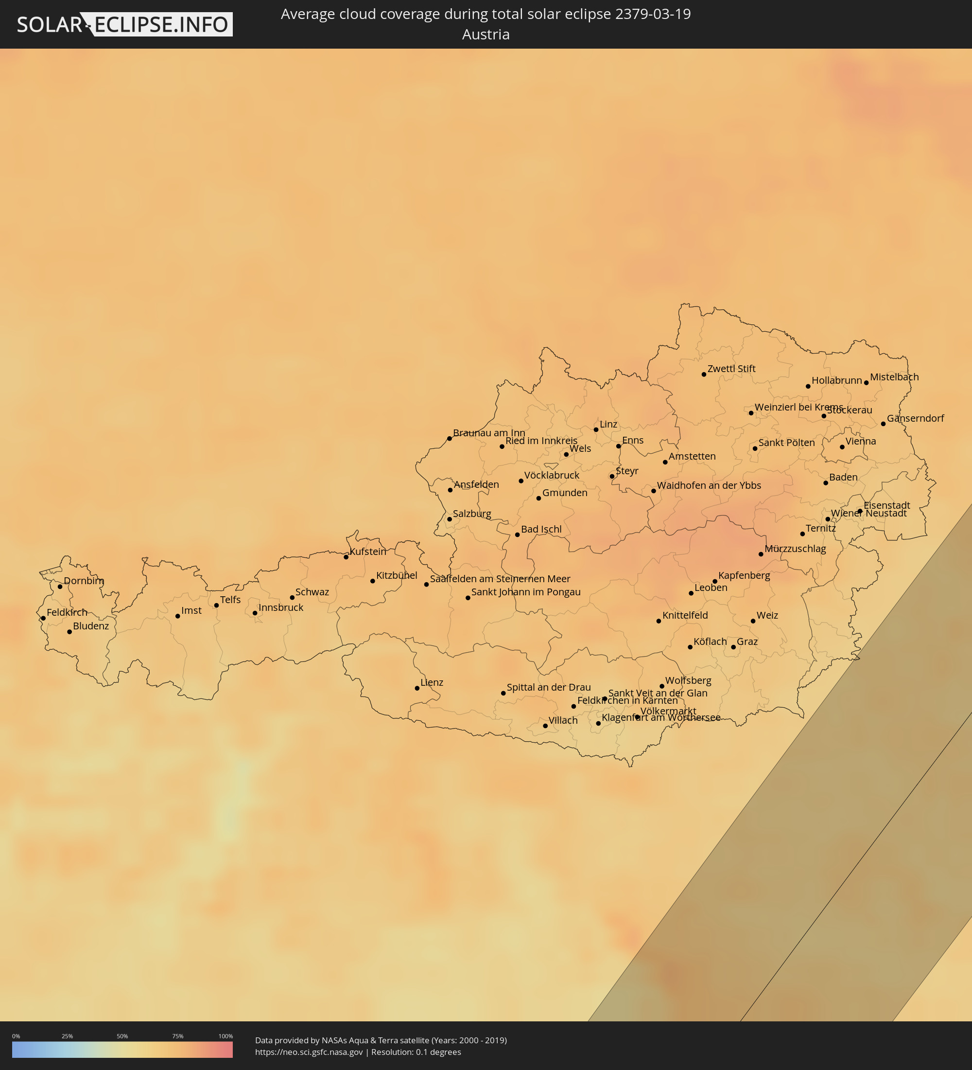 Austria
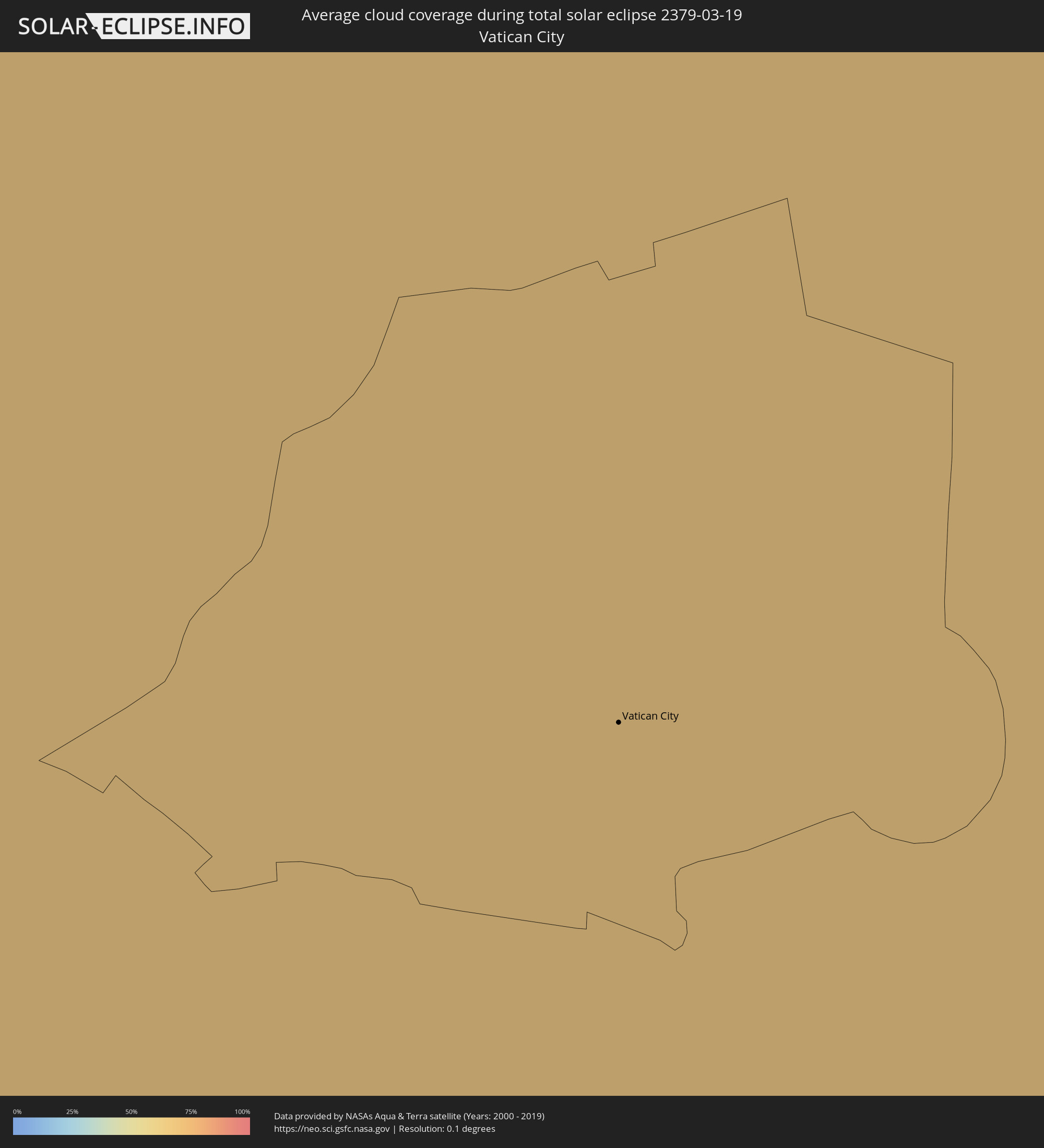 Vatican City
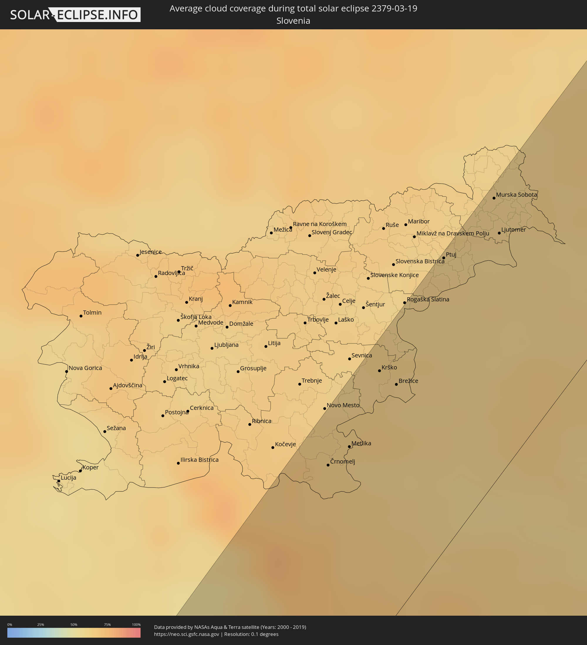 Slovenia
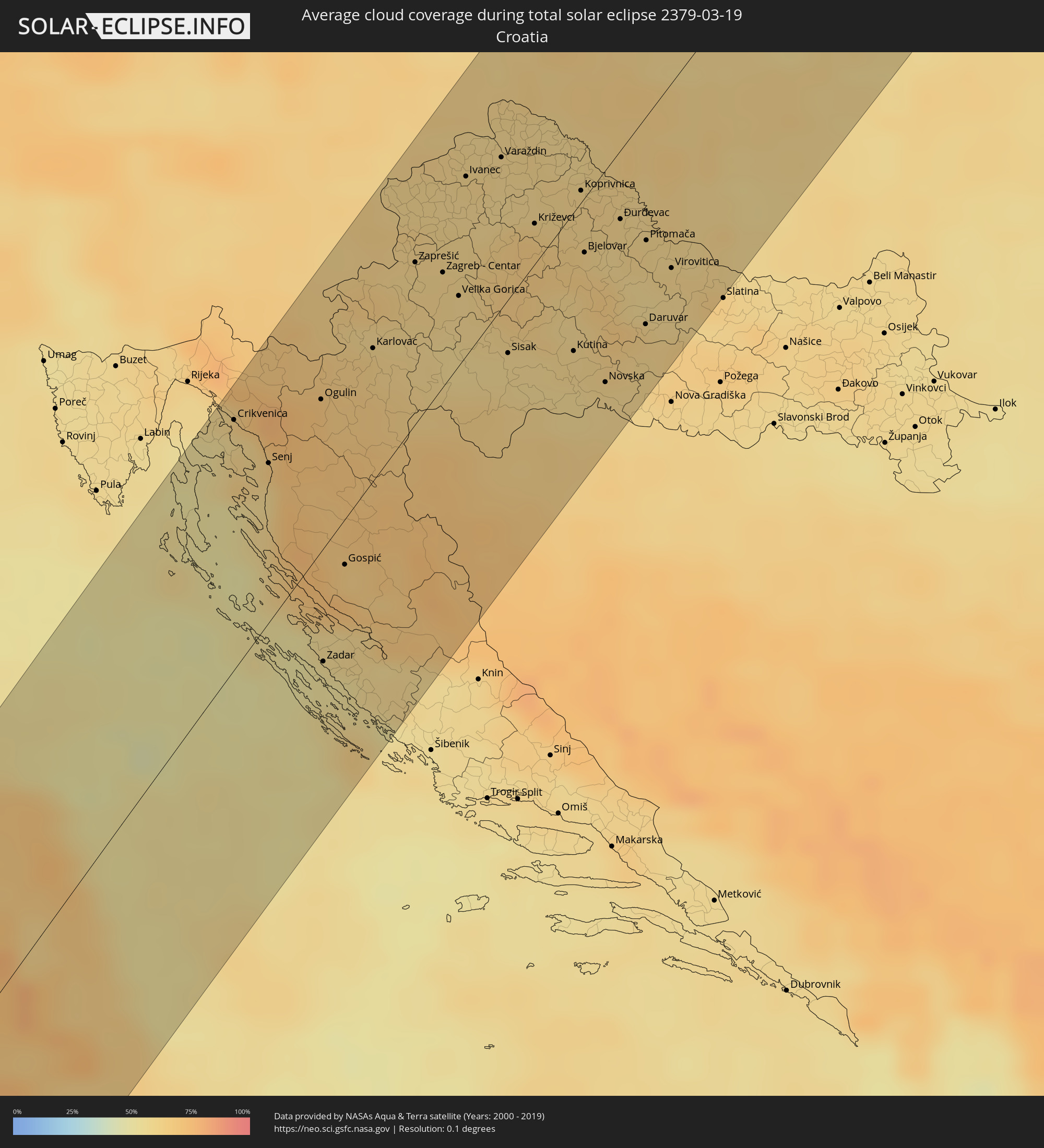 Croatia
 Poland
 Bosnia and Herzegovina
 Hungary
 Slovakia
 Lithuania
 Ukraine
 Belarus
Cities inside the path of the eclipse
The following table shows all locations with a population of more than 5,000 inside the eclipse path. Cities which have more than 100,000 inhabitants are marked bold. A click at the locations opens a detailed map.
| City | Type | Eclipse duration | Local time of max. eclipse | Distance to central line | Ø Cloud coverage |
|
Saint-Louis, Saint-Louis
|
total | - | 09:13:43 UTC+00:00 | 26 km | 37% |
|
Louga, Louga
|
total | - | 09:13:17 UTC+00:00 | 78 km | 16% |
|
Rosso, Trarza
|
total | - | 09:15:10 UTC+00:00 | 7 km | 18% |
|
Rosso, Saint-Louis
|
total | - | 09:15:01 UTC+00:00 | 17 km | 20% |
|
Richard-Toll, Saint-Louis
|
total | - | 09:15:11 UTC+00:00 | 17 km | 18% |
|
Tékane, Trarza
|
total | - | 09:15:36 UTC+00:00 | 16 km | 15% |
|
Ndioum, Saint-Louis
|
total | - | 09:16:15 UTC+00:00 | 62 km | 12% |
|
Aleg, Brakna
|
total | - | 09:17:53 UTC+00:00 | 45 km | 13% |
|
Tidjikja, Tagant
|
total | - | 09:23:07 UTC+00:00 | 33 km | 10% |
|
Ghardaïa, Ghardaia
|
total | - | 11:09:22 UTC+01:00 | 23 km | 21% |
|
Biskra, Biskra
|
total | - | 11:16:37 UTC+01:00 | 27 km | 36% |
|
Aïn Touta, Batna
|
total | - | 11:17:48 UTC+01:00 | 49 km | 44% |
|
Chelghoum el Aïd, Mila
|
total | - | 11:19:34 UTC+01:00 | 80 km | 59% |
|
Batna, Batna
|
total | - | 11:18:31 UTC+01:00 | 40 km | 52% |
|
Constantine, Constantine
|
total | - | 11:20:34 UTC+01:00 | 60 km | 63% |
|
Skikda, Skikda
|
total | - | 11:21:52 UTC+01:00 | 72 km | 57% |
|
Azzaba, Skikda
|
total | - | 11:21:54 UTC+01:00 | 49 km | 55% |
|
Oum el Bouaghi, Oum el Bouaghi
|
total | - | 11:20:25 UTC+01:00 | 8 km | 57% |
|
Khenchela, Khenchela
|
total | - | 11:19:42 UTC+01:00 | 39 km | 57% |
|
Aïn Beïda, Oum el Bouaghi
|
total | - | 11:20:41 UTC+01:00 | 34 km | 56% |
|
Guelma, Guelma
|
total | - | 11:21:53 UTC+01:00 | 7 km | 57% |
|
Annaba, Annaba
|
total | - | 11:23:08 UTC+01:00 | 11 km | 58% |
|
Souk Ahras, Souk Ahras
|
total | - | 11:22:20 UTC+01:00 | 42 km | 58% |
|
Sakiet Sidi Youssef, Kef
|
total | - | 11:22:49 UTC+01:00 | 76 km | 57% |
|
Tabarka, Jundūbah
|
total | - | 11:24:38 UTC+01:00 | 57 km | 53% |
|
Cagliari, Sardinia
|
total | - | 11:28:54 UTC+01:00 | 64 km | 56% |
|
Sejenane, Banzart
|
total | - | 11:25:30 UTC+01:00 | 85 km | 60% |
|
Civitavecchia, Latium
|
total | - | 11:37:00 UTC+01:00 | 62 km | 60% |
|
Viterbo, Latium
|
total | - | 11:37:53 UTC+01:00 | 62 km | 66% |
|
Acilia-Castel Fusano-Ostia Antica, Latium
|
total | - | 11:37:15 UTC+01:00 | 5 km | 63% |
|
Vatican City
|
total | - | 11:37:37 UTC+01:00 | 5 km | 66% |
|
Rome, Latium
|
total | - | 11:37:41 UTC+01:00 | 1 km | 66% |
|
Anzio, Latium
|
total | - | 11:37:12 UTC+01:00 | 35 km | 63% |
|
Terni, Umbria
|
total | - | 11:38:49 UTC+01:00 | 35 km | 62% |
|
Foligno, Umbria
|
total | - | 11:39:27 UTC+01:00 | 57 km | 65% |
|
Guidonia Montecelio, Latium
|
total | - | 11:38:07 UTC+01:00 | 7 km | 66% |
|
Velletri, Latium
|
total | - | 11:37:45 UTC+01:00 | 30 km | 69% |
|
Latina, Latium
|
total | - | 11:37:36 UTC+01:00 | 53 km | 69% |
|
Ancona, The Marches
|
total | - | 11:41:24 UTC+01:00 | 45 km | 64% |
|
San Benedetto del Tronto, The Marches
|
total | - | 11:41:02 UTC+01:00 | 21 km | 61% |
|
Pescara, Abruzzo
|
total | - | 11:40:48 UTC+01:00 | 75 km | 56% |
|
Črnomelj, Črnomelj
|
total | - | 11:46:11 UTC+01:00 | 66 km | 65% |
|
Ogulin, Karlovačka
|
total | - | 11:45:52 UTC+01:00 | 44 km | 71% |
|
Zadar, Zadarska
|
total | - | 11:44:26 UTC+01:00 | 33 km | 52% |
|
Šentjernej, Šentjernej
|
total | - | 11:46:42 UTC+01:00 | 75 km | 64% |
|
Krško, Krško
|
total | - | 11:47:03 UTC+01:00 | 73 km | 63% |
|
Karlovac, Karlovačka
|
total | - | 11:46:33 UTC+01:00 | 38 km | 64% |
|
Rogatec, Rogatec
|
total | - | 11:47:38 UTC+01:00 | 77 km | 60% |
|
Samobor, Zagrebačka
|
total | - | 11:47:09 UTC+01:00 | 48 km | 63% |
|
Tržačka Raštela, Federation of Bosnia and Herzegovina
|
total | - | 11:46:14 UTC+01:00 | 11 km | 69% |
|
Velika Kladuša, Federation of Bosnia and Herzegovina
|
total | - | 11:46:31 UTC+01:00 | 2 km | 67% |
|
Žetale, Žetale
|
total | - | 11:47:51 UTC+01:00 | 73 km | 61% |
|
Ptuj, Ptuj
|
total | - | 11:48:05 UTC+01:00 | 80 km | 62% |
|
Bihać, Federation of Bosnia and Herzegovina
|
total | - | 11:46:09 UTC+01:00 | 27 km | 71% |
|
Podzvizd, Federation of Bosnia and Herzegovina
|
total | - | 11:46:35 UTC+01:00 | 3 km | 67% |
|
Podlehnik, Podlehnik
|
total | - | 11:48:00 UTC+01:00 | 73 km | 60% |
|
Todorovo, Federation of Bosnia and Herzegovina
|
total | - | 11:46:34 UTC+01:00 | 12 km | 69% |
|
Cazin, Federation of Bosnia and Herzegovina
|
total | - | 11:46:25 UTC+01:00 | 21 km | 71% |
|
Vrnograč, Federation of Bosnia and Herzegovina
|
total | - | 11:46:41 UTC+01:00 | 9 km | 66% |
|
Juršinci, Juršinci
|
total | - | 11:48:17 UTC+01:00 | 78 km | 60% |
|
Zagreb - Centar, City of Zagreb
|
total | - | 11:47:30 UTC+01:00 | 33 km | 61% |
|
Cirkulane, Cirkulane
|
total | - | 11:48:09 UTC+01:00 | 67 km | 60% |
|
Bužim, Federation of Bosnia and Herzegovina
|
total | - | 11:46:39 UTC+01:00 | 21 km | 69% |
|
Bosanska Krupa, Federation of Bosnia and Herzegovina
|
total | - | 11:46:36 UTC+01:00 | 40 km | 67% |
|
Murska Sobota, Murska Sobota
|
total | - | 11:48:45 UTC+01:00 | 77 km | 62% |
|
Otoka, Federation of Bosnia and Herzegovina
|
total | - | 11:46:44 UTC+01:00 | 37 km | 67% |
|
Ljutomer, Ljutomer
|
total | - | 11:48:37 UTC+01:00 | 66 km | 59% |
|
Središče ob Dravi, Središče ob Dravi
|
total | - | 11:48:34 UTC+01:00 | 53 km | 60% |
|
Šalovci, Šalovci
|
total | - | 11:49:06 UTC+01:00 | 80 km | 60% |
|
Varaždin, Varaždinska
|
total | - | 11:48:33 UTC+01:00 | 43 km | 60% |
|
Novi Grad, Republic of Srspka
|
total | - | 11:47:06 UTC+01:00 | 43 km | 64% |
|
Sisak, Sisačko-Moslavačka
|
total | - | 11:47:36 UTC+01:00 | 15 km | 59% |
|
Lendava, Lendava-Lendva
|
total | - | 11:49:00 UTC+01:00 | 53 km | 60% |
|
Križevci, Koprivničko-Križevačka
|
total | - | 11:48:29 UTC+01:00 | 12 km | 66% |
|
Sanski Most, Federation of Bosnia and Herzegovina
|
total | - | 11:47:08 UTC+01:00 | 80 km | 65% |
|
Prijedor, Republic of Srspka
|
total | - | 11:47:27 UTC+01:00 | 69 km | 63% |
|
Kutina, Sisačko-Moslavačka
|
total | - | 11:48:08 UTC+01:00 | 40 km | 60% |
|
Kozarska Dubica, Republic of Srspka
|
total | - | 11:47:49 UTC+01:00 | 62 km | 61% |
|
Koprivnica, Koprivničko-Križevačka
|
total | - | 11:49:01 UTC+01:00 | 3 km | 62% |
|
Zalaegerszeg, Zala
|
total | - | 11:49:49 UTC+01:00 | 48 km | 62% |
|
Bjelovar, Bjelovarsko-Bilogorska
|
total | - | 11:48:44 UTC+01:00 | 16 km | 65% |
|
Novska, Sisačko-Moslavačka
|
total | - | 11:48:14 UTC+01:00 | 61 km | 60% |
|
Nagykanizsa, Zala
|
total | - | 11:49:33 UTC+01:00 | 13 km | 63% |
|
Daruvar, Bjelovarsko-Bilogorska
|
total | - | 11:48:51 UTC+01:00 | 60 km | 63% |
|
Virovitica, Virovitičk-Podravska
|
total | - | 11:49:21 UTC+01:00 | 53 km | 59% |
|
Győr, Győr-Moson-Sopron
|
total | - | 11:51:44 UTC+01:00 | 56 km | 66% |
|
Kaposvár, Somogy
|
total | - | 11:50:30 UTC+01:00 | 42 km | 59% |
|
Veszprém, Veszprém
|
total | - | 11:51:27 UTC+01:00 | 0 km | 60% |
|
Nitra, Nitriansky
|
total | - | 11:52:57 UTC+01:00 | 72 km | 66% |
|
Komárno, Nitriansky
|
total | - | 11:52:26 UTC+01:00 | 33 km | 66% |
|
Nové Zámky, Nitriansky
|
total | - | 11:52:43 UTC+01:00 | 46 km | 64% |
|
Tatabánya, Komárom-Esztergom
|
total | - | 11:52:35 UTC+01:00 | 5 km | 63% |
|
Székesfehérvár, Fejér
|
total | - | 11:52:11 UTC+01:00 | 23 km | 60% |
|
Levice, Nitriansky
|
total | - | 11:53:30 UTC+01:00 | 35 km | 62% |
|
Prievidza, Nitriansky
|
total | - | 11:54:06 UTC+01:00 | 72 km | 72% |
|
Martin, Žilinský
|
total | - | 11:54:45 UTC+01:00 | 74 km | 77% |
|
Dunaújváros, Fejér
|
total | - | 11:52:36 UTC+01:00 | 70 km | 58% |
|
Budapest, Budapest
|
total | - | 11:53:18 UTC+01:00 | 40 km | 63% |
|
Vác, Pest
|
total | - | 11:53:43 UTC+01:00 | 26 km | 62% |
|
Zvolen, Banskobystrický
|
total | - | 11:54:32 UTC+01:00 | 27 km | 69% |
|
Banská Bystrica, Banskobystrický
|
total | - | 11:54:42 UTC+01:00 | 39 km | 69% |
|
Budapest XVII. kerület, Budapest
|
total | - | 11:53:33 UTC+01:00 | 54 km | 61% |
|
Ružomberok, Žilinský
|
total | - | 11:55:13 UTC+01:00 | 53 km | 79% |
|
Liptovský Mikuláš, Žilinský
|
total | - | 11:55:36 UTC+01:00 | 35 km | 76% |
|
Salgótarján, Nógrád
|
total | - | 11:54:52 UTC+01:00 | 43 km | 63% |
|
Parádsasvár, Heves
|
total | - | 11:54:54 UTC+01:00 | 66 km | 66% |
|
Poprad, Prešovský
|
total | - | 11:56:24 UTC+01:00 | 5 km | 72% |
|
Ózd, Borsod-Abaúj-Zemplén
|
total | - | 11:55:36 UTC+01:00 | 64 km | 62% |
|
Spišská Nová Ves, Košický
|
total | - | 11:56:37 UTC+01:00 | 28 km | 79% |
|
Nowy Sącz, Lesser Poland Voivodeship
|
total | - | 11:57:24 UTC+01:00 | 12 km | 80% |
|
Tarnów, Lesser Poland Voivodeship
|
total | - | 11:58:06 UTC+01:00 | 23 km | 80% |
|
Prešov, Prešovský
|
total | - | 11:57:29 UTC+01:00 | 62 km | 76% |
|
Bardejov, Prešovský
|
total | - | 11:57:48 UTC+01:00 | 44 km | 78% |
|
Ostrowiec Świętokrzyski, Świętokrzyskie
|
total | - | 11:59:21 UTC+01:00 | 65 km | 81% |
|
Dębica, Subcarpathian Voivodeship
|
total | - | 11:58:38 UTC+01:00 | 2 km | 80% |
|
Mielec, Subcarpathian Voivodeship
|
total | - | 11:58:51 UTC+01:00 | 18 km | 79% |
|
Tarnobrzeg, Subcarpathian Voivodeship
|
total | - | 11:59:24 UTC+01:00 | 24 km | 82% |
|
Krosno, Subcarpathian Voivodeship
|
total | - | 11:58:45 UTC+01:00 | 44 km | 81% |
|
Puławy, Lublin Voivodeship
|
total | - | 12:00:25 UTC+01:00 | 68 km | 82% |
|
Rzeszów, Subcarpathian Voivodeship
|
total | - | 11:59:19 UTC+01:00 | 31 km | 81% |
|
Stalowa Wola, Subcarpathian Voivodeship
|
total | - | 11:59:50 UTC+01:00 | 4 km | 82% |
|
Lublin, Lublin Voivodeship
|
total | - | 12:00:58 UTC+01:00 | 24 km | 83% |
|
Biała Podlaska, Lublin Voivodeship
|
total | - | 12:02:11 UTC+01:00 | 51 km | 85% |
|
Zamość, Lublin Voivodeship
|
total | - | 12:01:21 UTC+01:00 | 51 km | 83% |
|
Chełm, Lublin Voivodeship
|
total | - | 12:01:55 UTC+01:00 | 32 km | 85% |
|
Brest, Brest
|
total | - | 14:02:52 UTC+03:00 | 25 km | 83% |
|
Shats’k, Volyn
|
total | - | 13:02:43 UTC+02:00 | 31 km | 84% |
|
Lyuboml’, Volyn
|
total | - | 13:02:38 UTC+02:00 | 56 km | 84% |
|
Kobryn, Brest
|
total | - | 14:03:42 UTC+03:00 | 1 km | 84% |
|
Stara Vyzhivka, Volyn
|
total | - | 13:03:15 UTC+02:00 | 62 km | 84% |
|
Vawkavysk, Grodnenskaya
|
total | - | 14:04:25 UTC+03:00 | 63 km | 84% |
|
Ratne, Volyn
|
total | - | 13:03:31 UTC+02:00 | 50 km | 84% |
|
Kamin’-Kashyrs’kyy, Volyn
|
total | - | 13:03:58 UTC+02:00 | 75 km | 84% |
|
Lida, Grodnenskaya
|
total | - | 14:05:47 UTC+03:00 | 74 km | 83% |
|
Slonim, Grodnenskaya
|
total | - | 14:05:19 UTC+03:00 | 14 km | 84% |
|
Navahrudak, Grodnenskaya
|
total | - | 14:06:10 UTC+03:00 | 27 km | 85% |
|
Baranovichi, Brest
|
total | - | 14:06:06 UTC+03:00 | 17 km | 82% |
|
Smarhon’, Grodnenskaya
|
total | - | 14:07:15 UTC+03:00 | 64 km | 84% |
|
Maladzyechna, Minsk
|
total | - | 14:07:39 UTC+03:00 | 30 km | 84% |
|
Minsk, Minsk City
|
total | - | 14:08:11 UTC+03:00 | 36 km | 85% |
|
Horad Zhodzina, Minsk
|
total | - | 14:09:04 UTC+03:00 | 57 km | 84% |
|
Horad Barysaw, Minsk
|
total | - | 14:09:19 UTC+03:00 | 55 km | 85% |
|
Navapolatsk, Vitebsk
|
total | - | 14:09:59 UTC+03:00 | 40 km | 85% |
|
Vitebsk, Vitebsk
|
total | - | 14:11:27 UTC+03:00 | 60 km | 81% |
|
Velikiye Luki, Pskov
|
total | - | 14:12:11 UTC+03:00 | 15 km | 81% |
|
Borovichi, Novgorod
|
total | - | 14:15:45 UTC+03:00 | 36 km | 87% |
|
Bologoye, Tverskaya
|
total | - | 14:15:51 UTC+03:00 | 13 km | 88% |
|
Vyshniy Volochëk, Tverskaya
|
total | - | 14:16:13 UTC+03:00 | 55 km | 87% |
|
Udomlya, Tverskaya
|
total | - | 14:16:38 UTC+03:00 | 49 km | 89% |
|
Cherepovets, Vologda
|
total | - | 14:19:12 UTC+03:00 | 56 km | 86% |
|
Sheksna, Vologda
|
total | - | 14:19:42 UTC+03:00 | 72 km | 86% |
|
Vel’sk, Arkhangelskaya
|
total | - | 14:22:16 UTC+03:00 | 37 km | 87% |
|
Usinsk, Komi Republic
|
total | - | 14:29:10 UTC+03:00 | 7 km | 70% |
|
Vorkuta, Komi Republic
|
total | - | 14:30:40 UTC+03:00 | 33 km | 77% |
|
Dudinka, Krasnoyarskiy
|
total | - | 18:34:01 UTC+07:00 | 14 km | 76% |
|
Kayyerkan, Krasnoyarskiy
|
total | - | 18:34:13 UTC+07:00 | 26 km | 78% |
|
Norilsk, Krasnoyarskiy
|
total | - | 18:34:17 UTC+07:00 | 31 km | 83% |
|
Talnakh, Krasnoyarskiy
|
total | - | 18:34:09 UTC+07:00 | 17 km | 82% |