Total solar eclipse of 07/22/2381
| Day of week: | Wednesday |
| Maximum duration of eclipse: | 05m32s |
| Maximum width of eclipse path: | 285 km |
| Saros cycle: | 142 |
| Coverage: | 100% |
| Magnitude: | 1.0777 |
| Gamma: | 0.4748 |
Wo kann man die Sonnenfinsternis vom 07/22/2381 sehen?
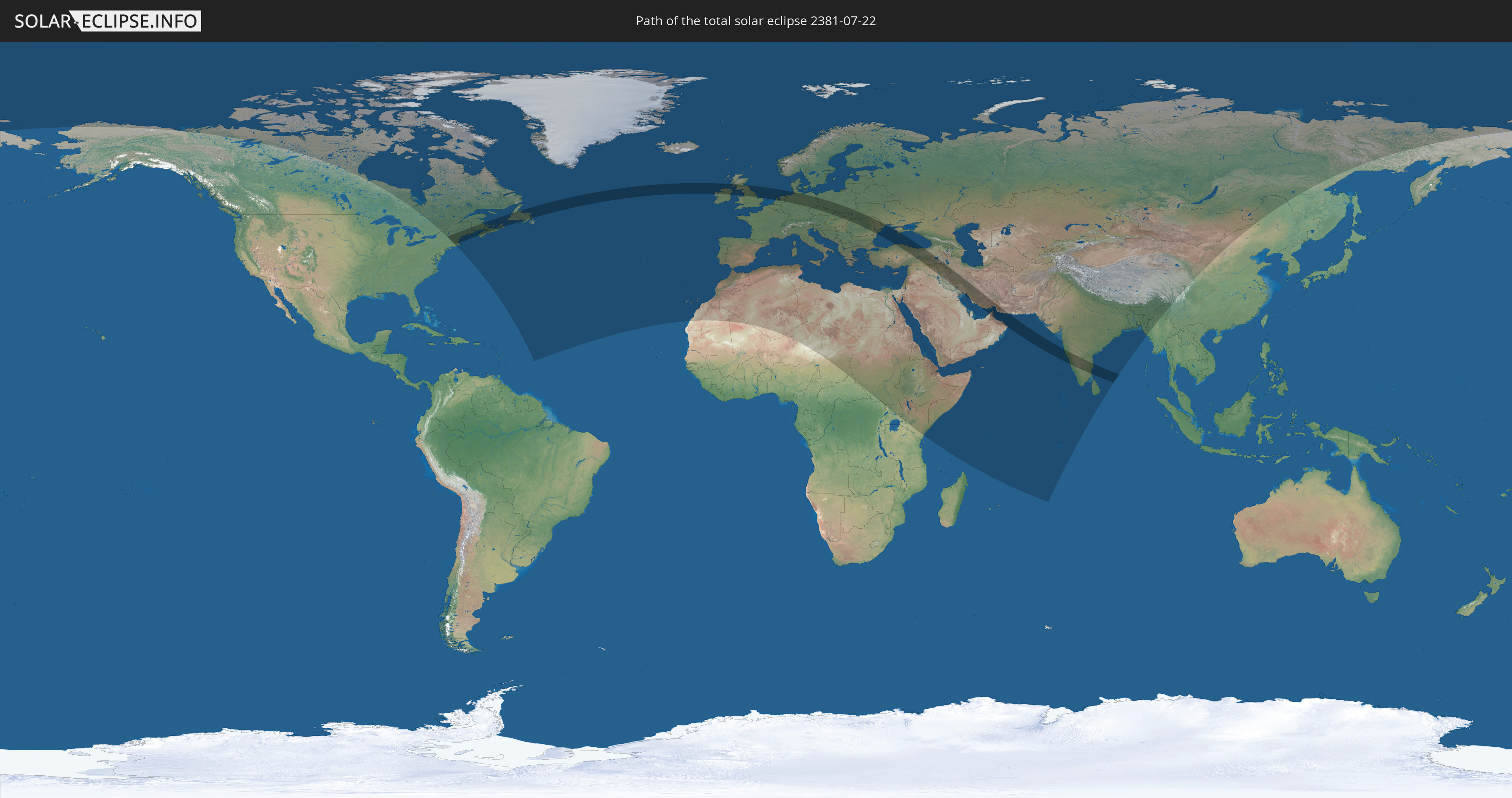
Die Sonnenfinsternis am 07/22/2381 kann man in 111 Ländern als partielle Sonnenfinsternis beobachten.
Der Finsternispfad verläuft durch 21 Länder. Nur in diesen Ländern ist sie als total Sonnenfinsternis zu sehen.
In den folgenden Ländern ist die Sonnenfinsternis total zu sehen
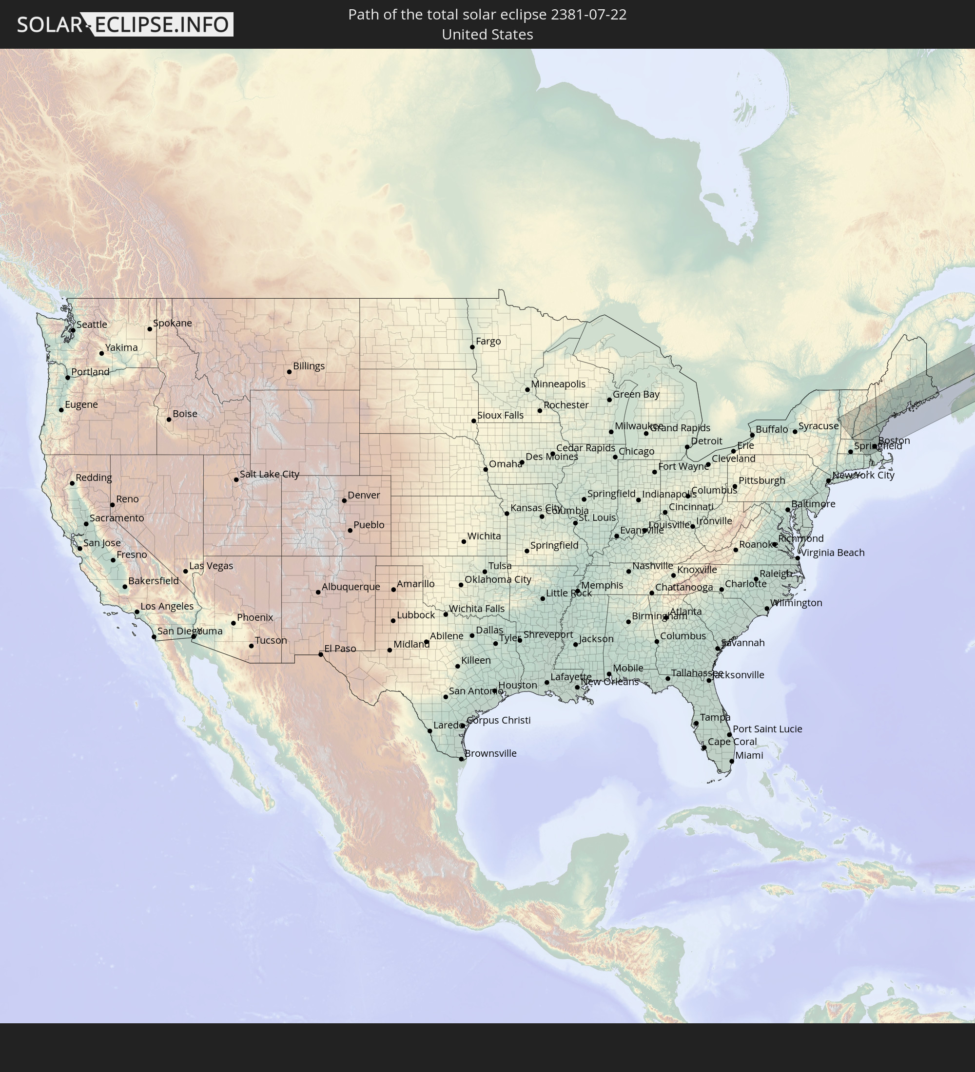 United States
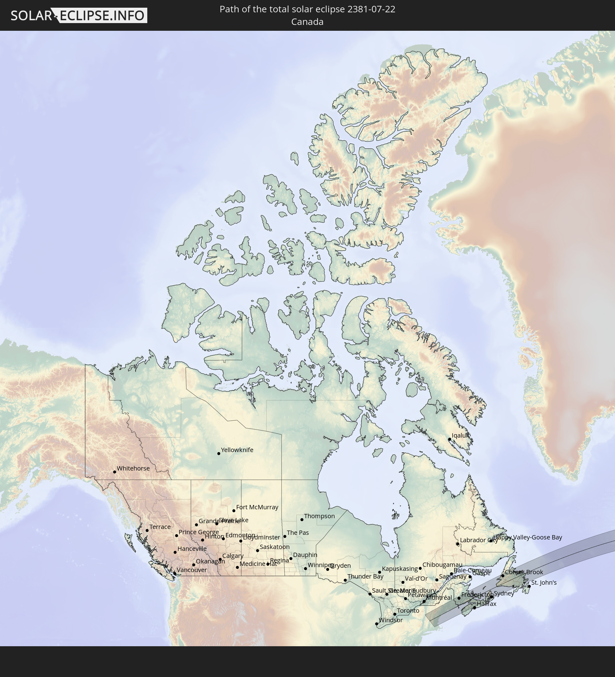 Canada
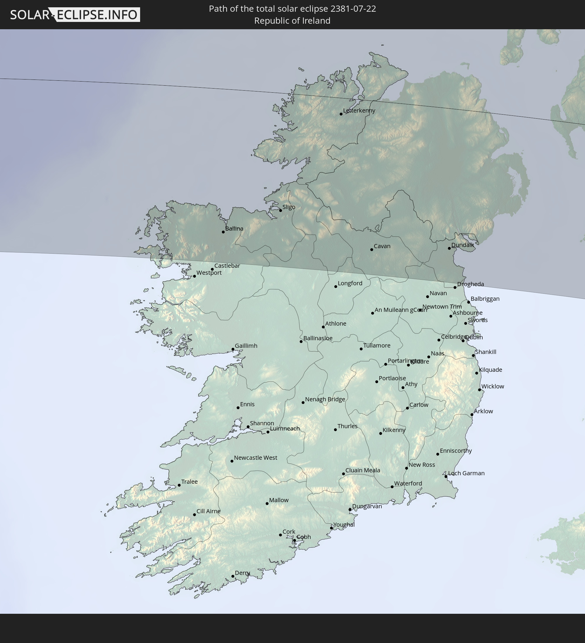 Republic of Ireland
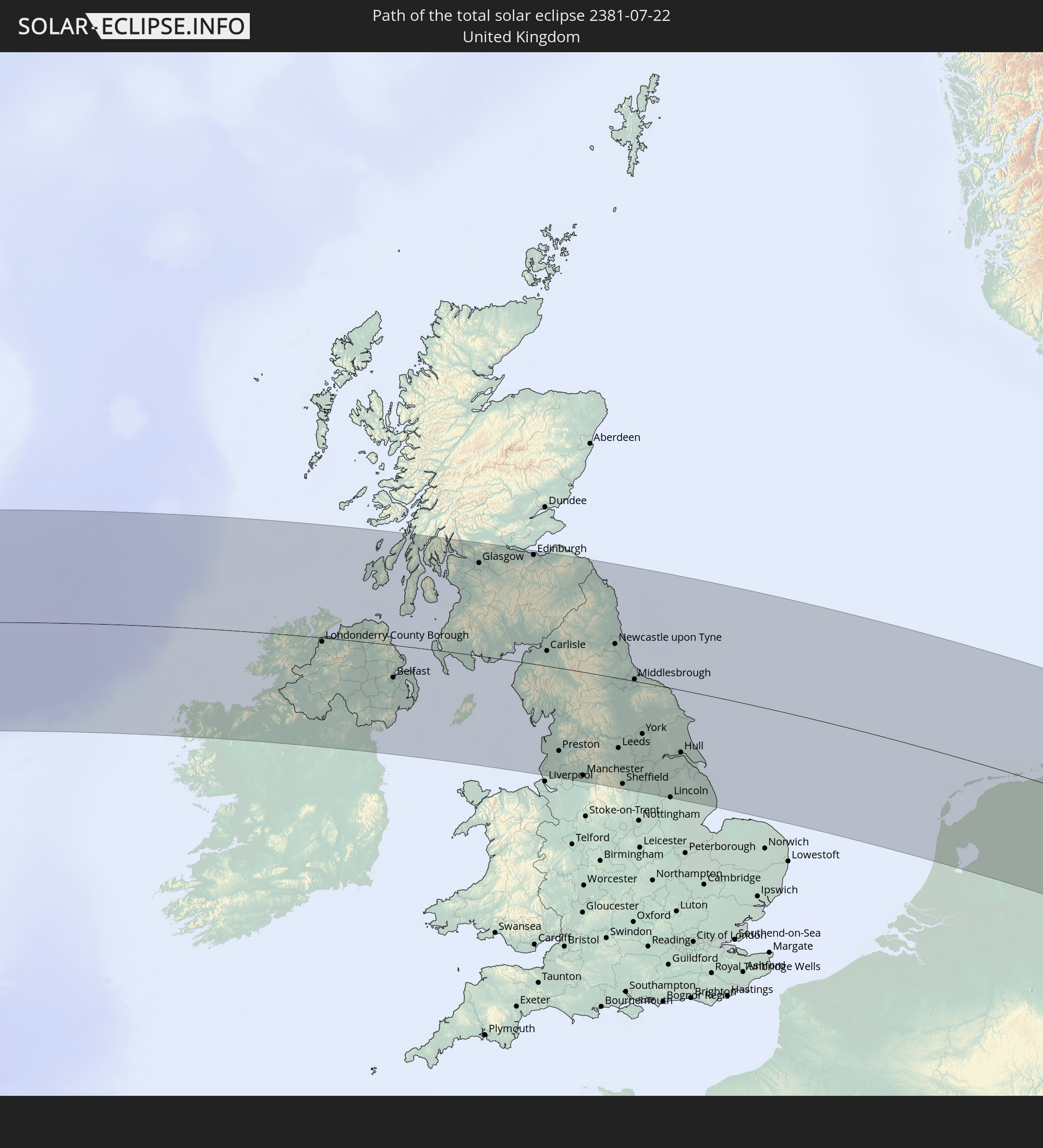 United Kingdom
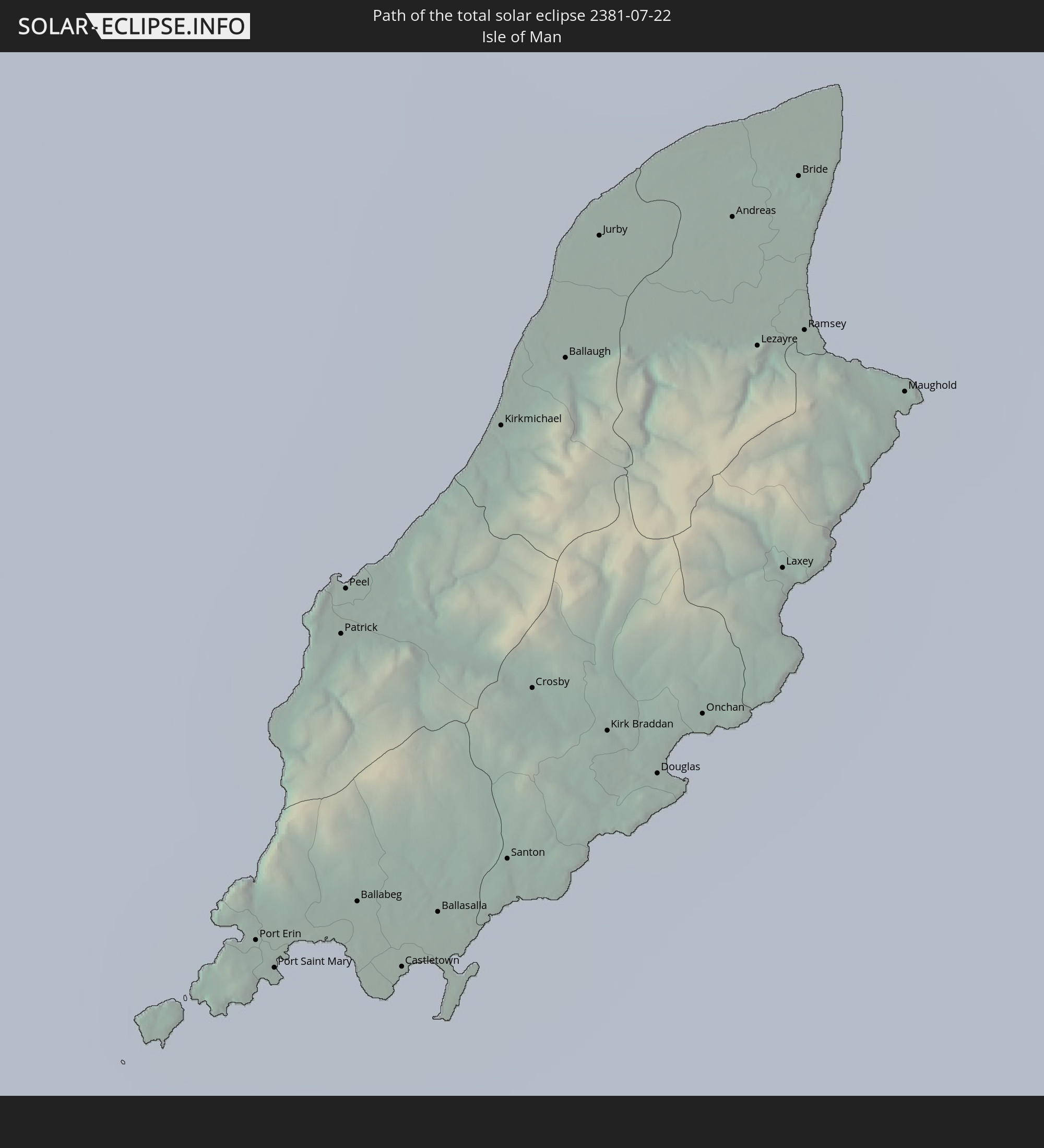 Isle of Man
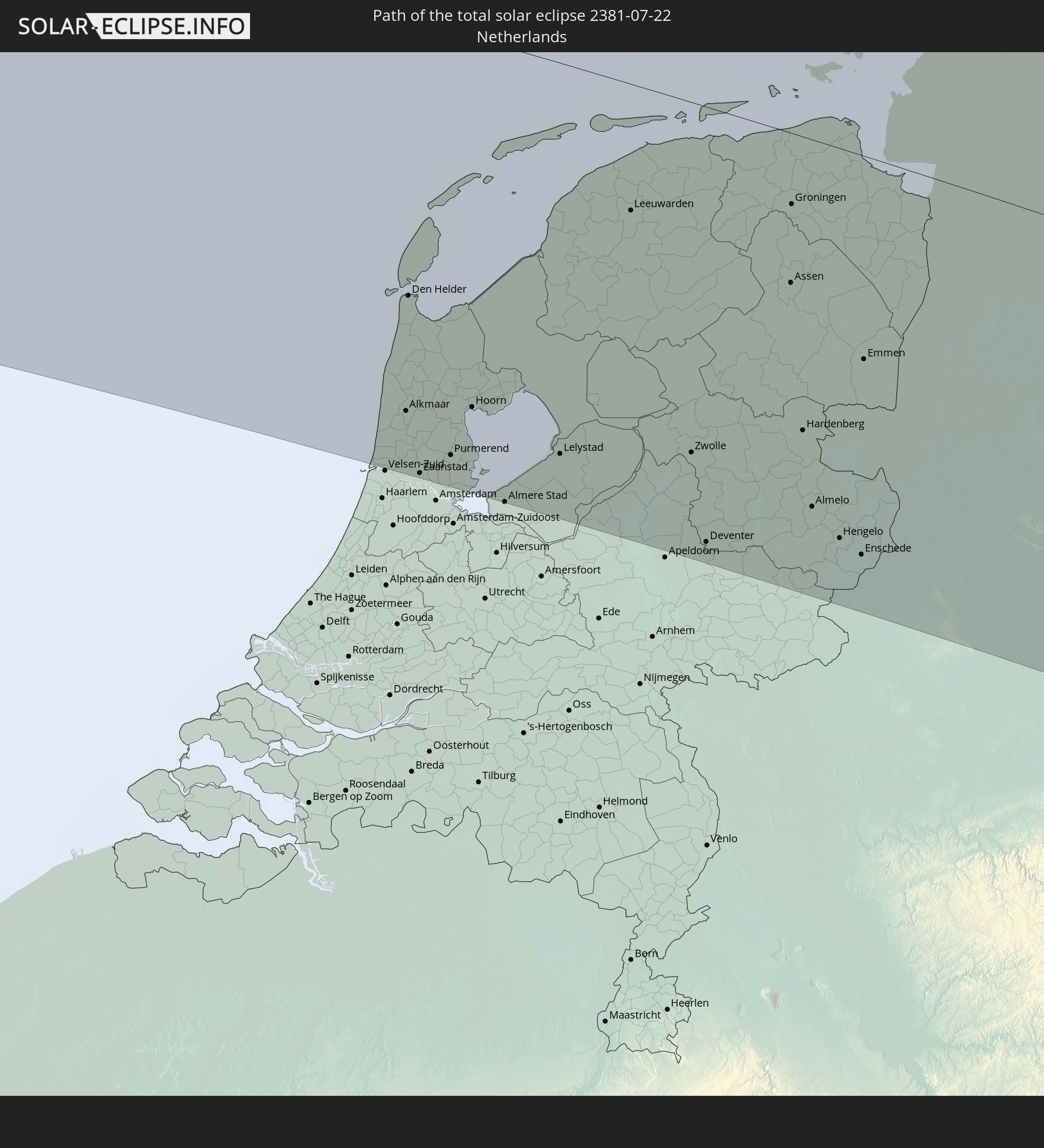 Netherlands
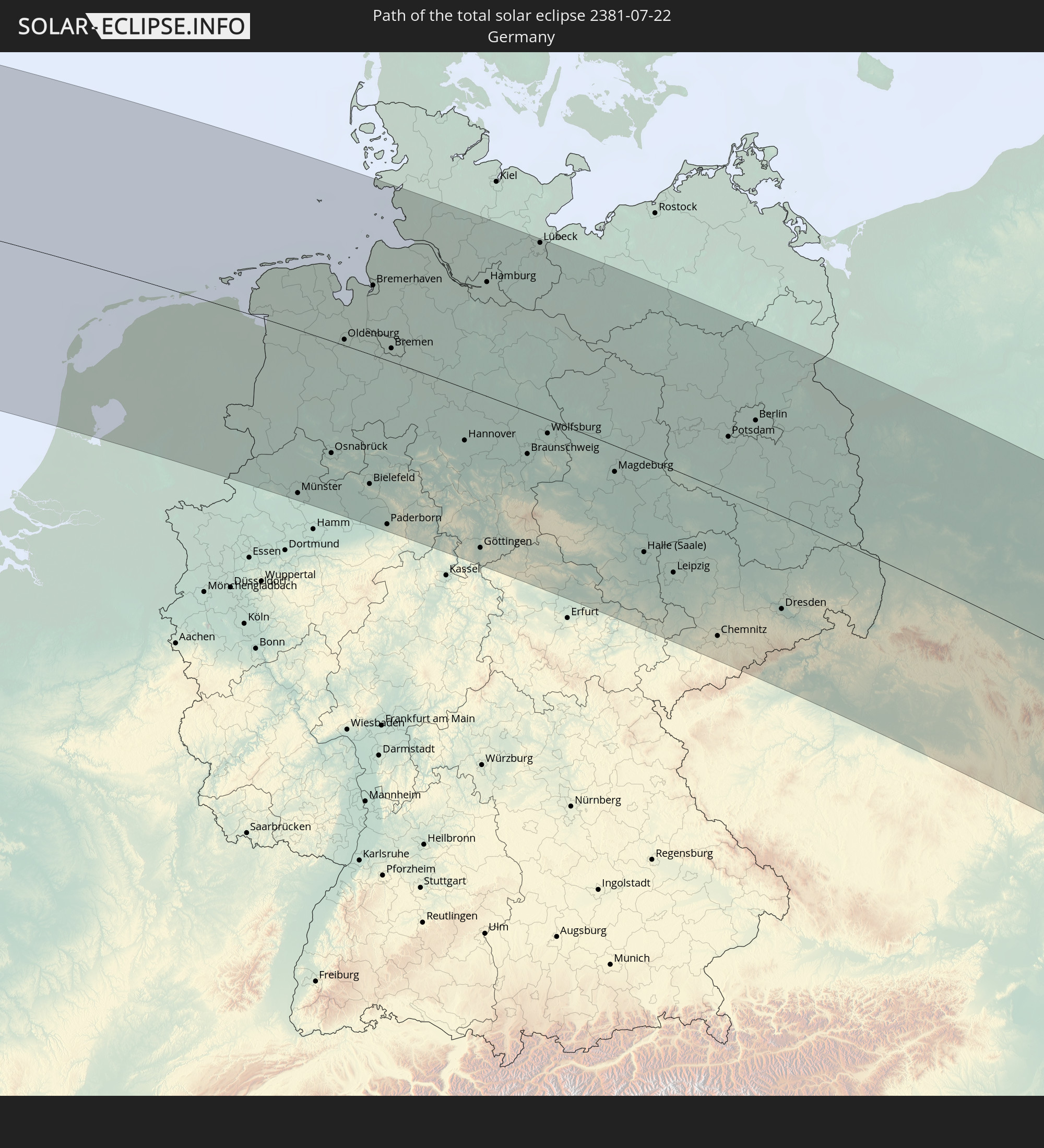 Germany
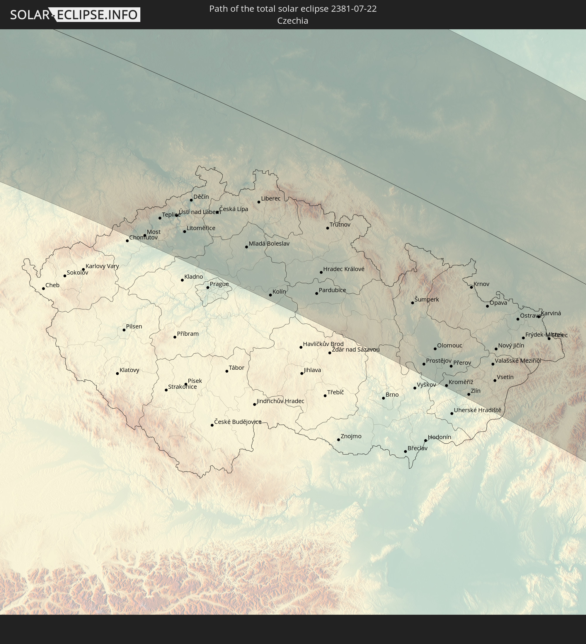 Czechia
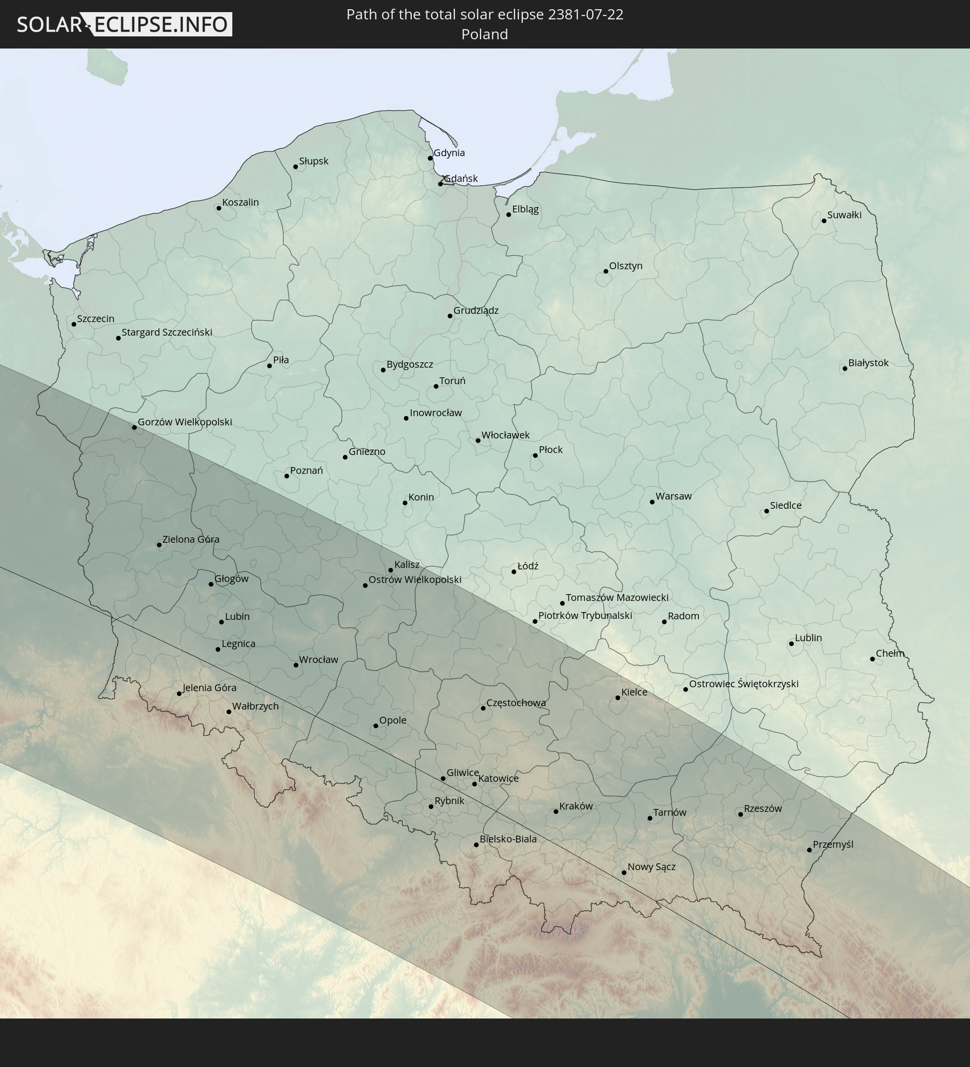 Poland
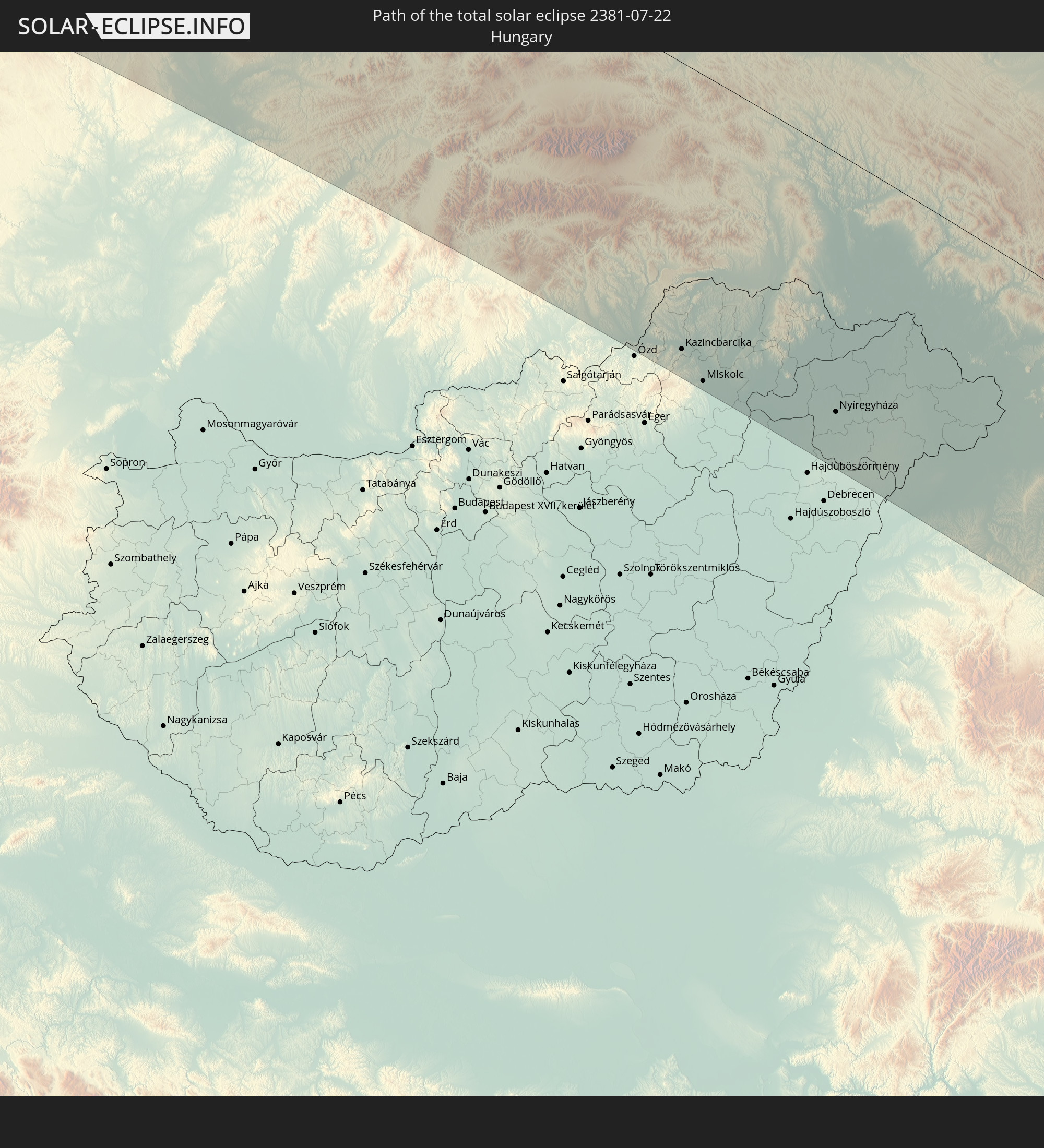 Hungary
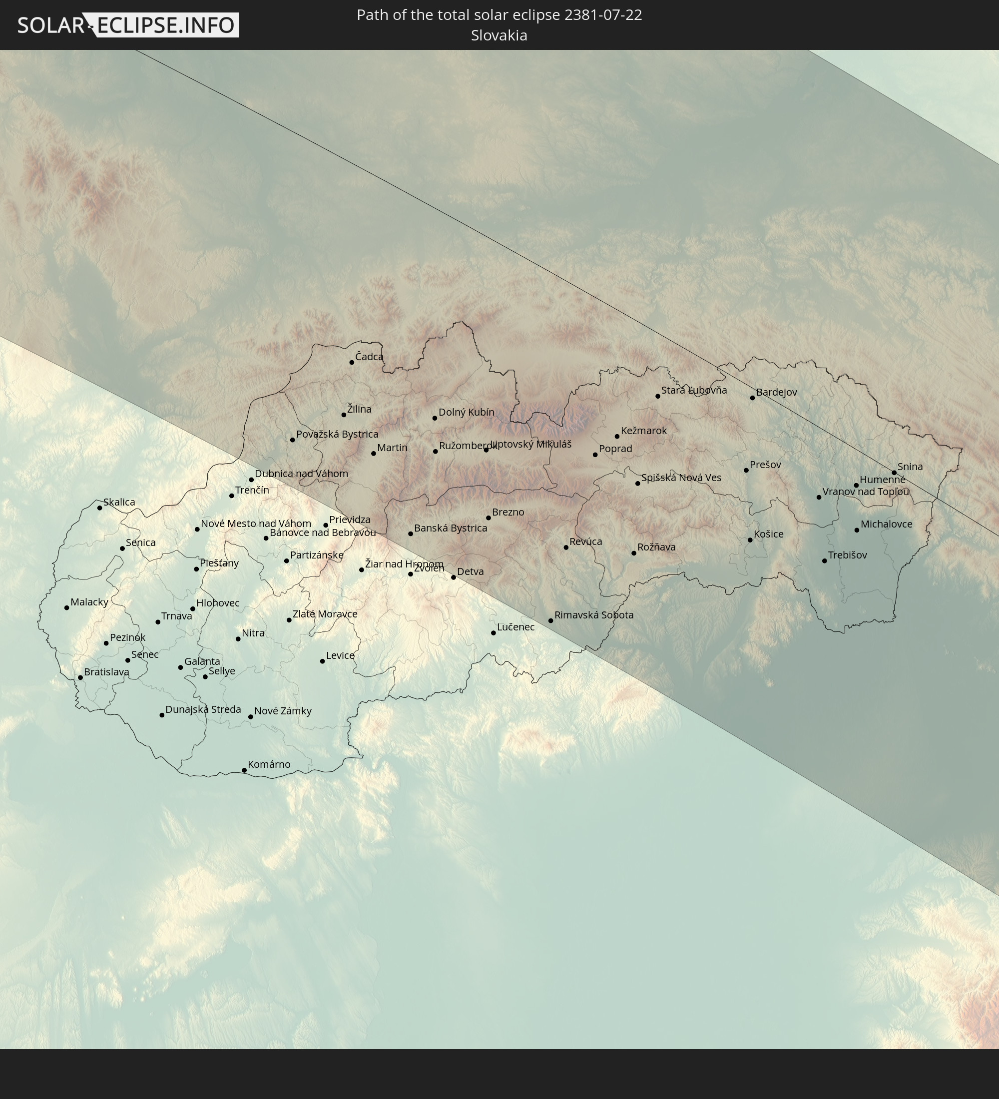 Slovakia
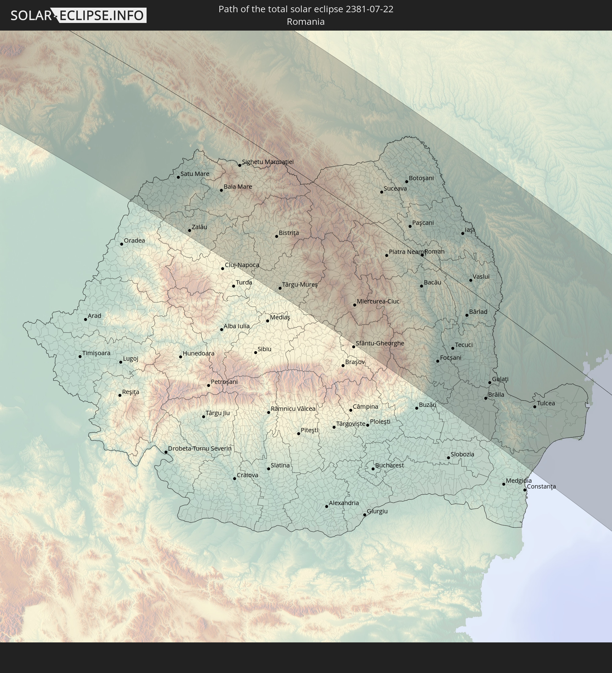 Romania
 Ukraine
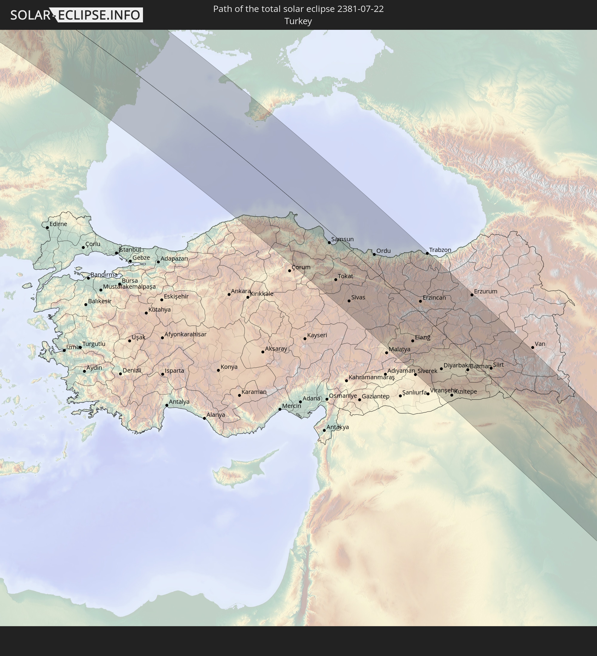 Turkey
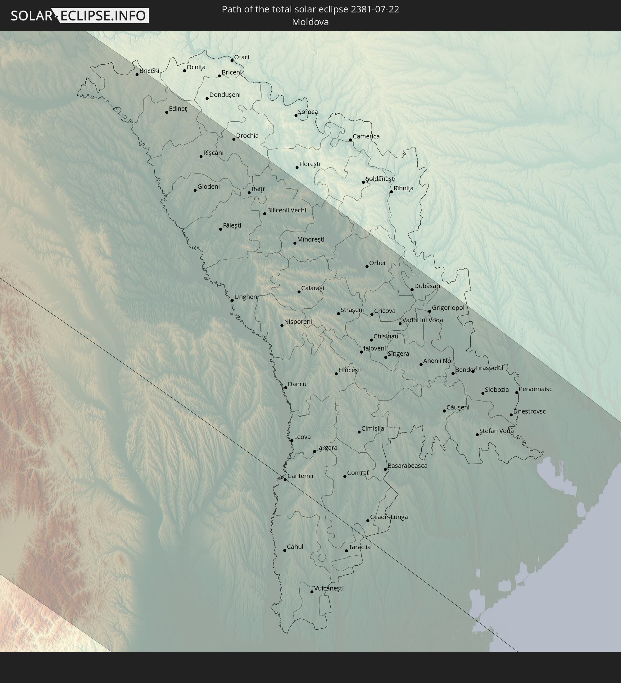 Moldova
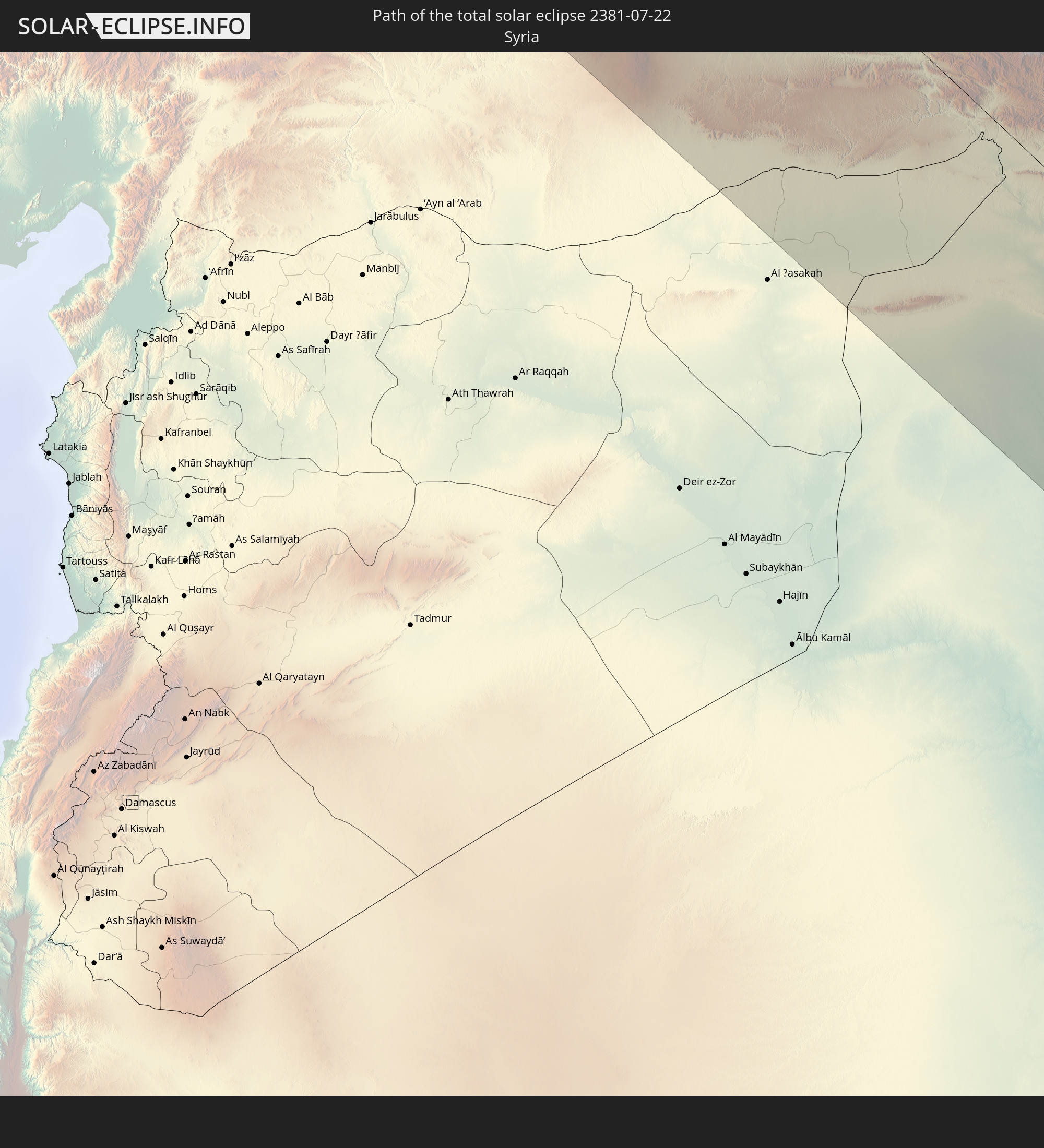 Syria
Syria
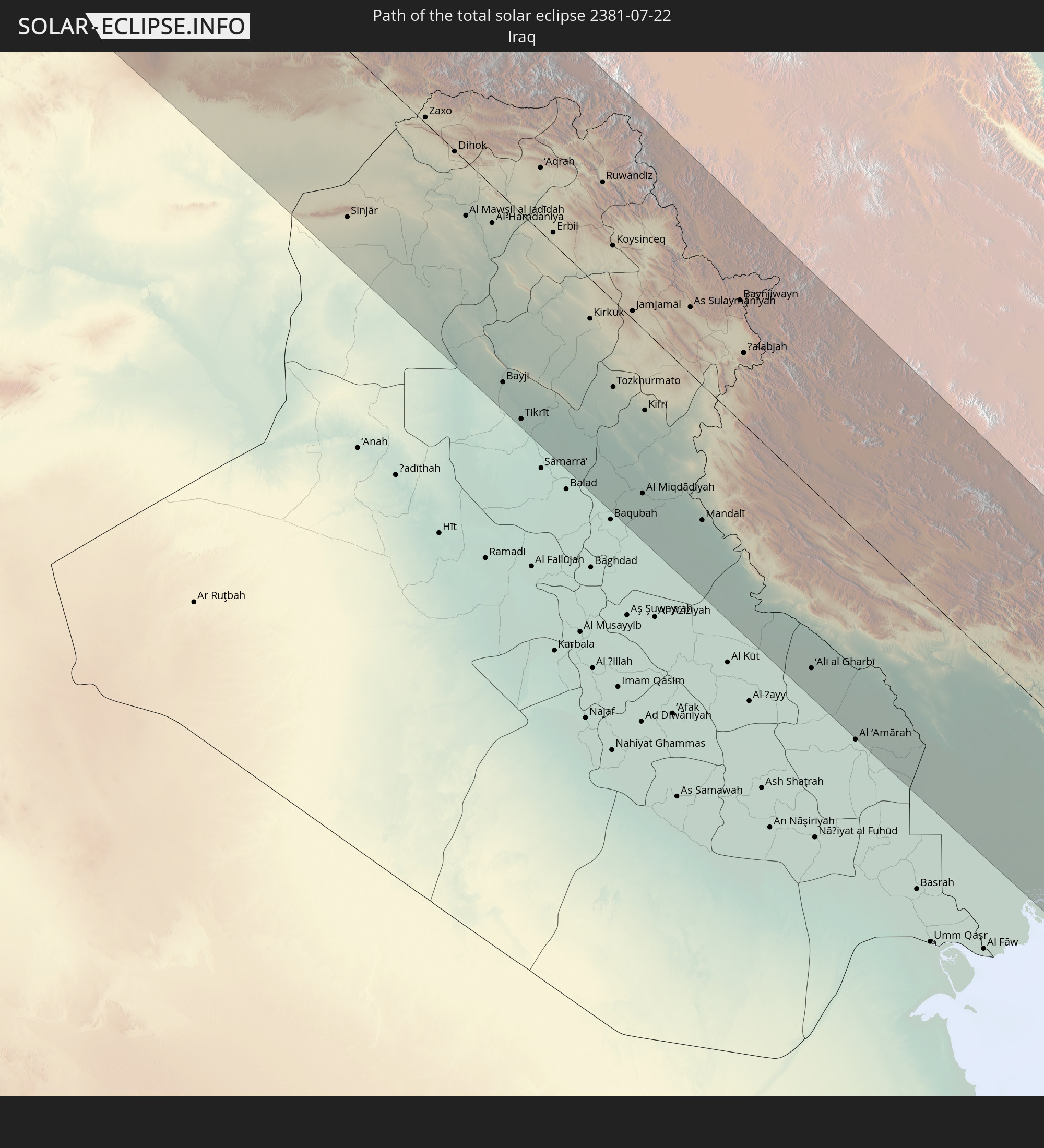 Iraq
Iraq
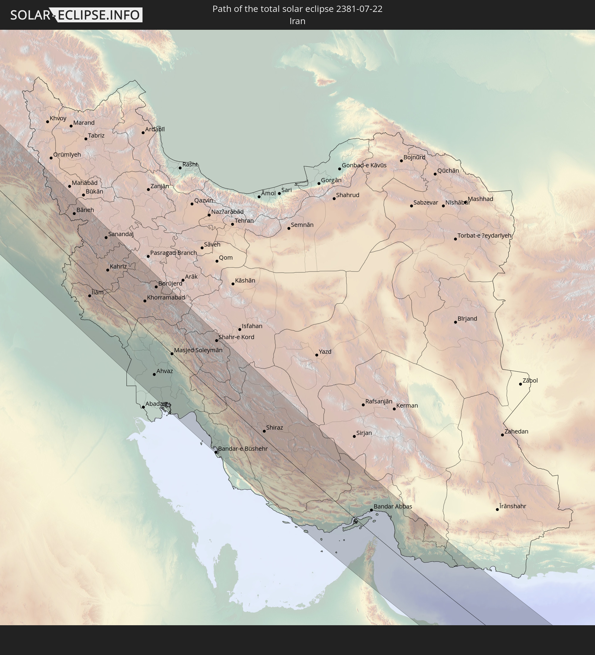 Iran
Iran
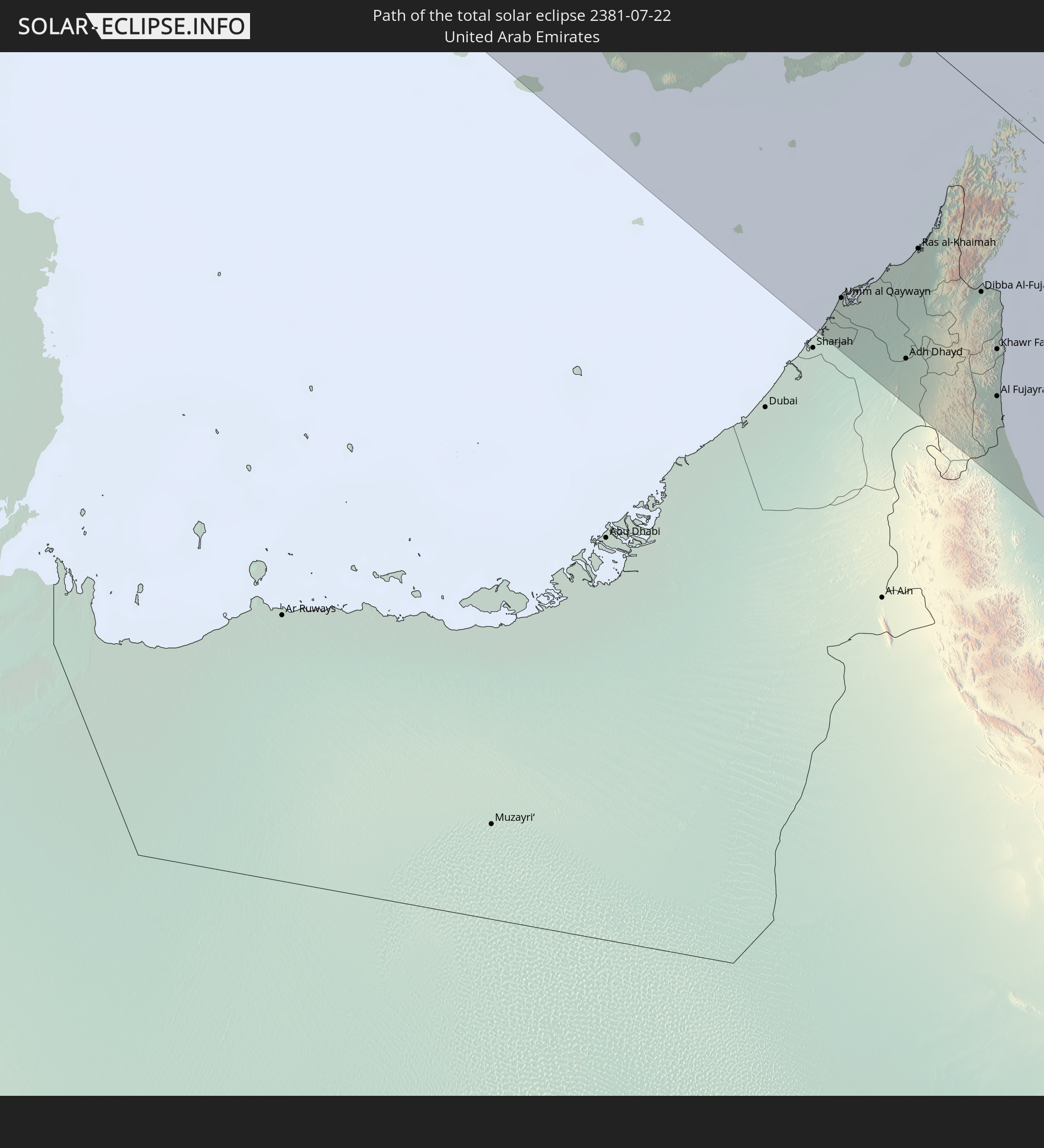 United Arab Emirates
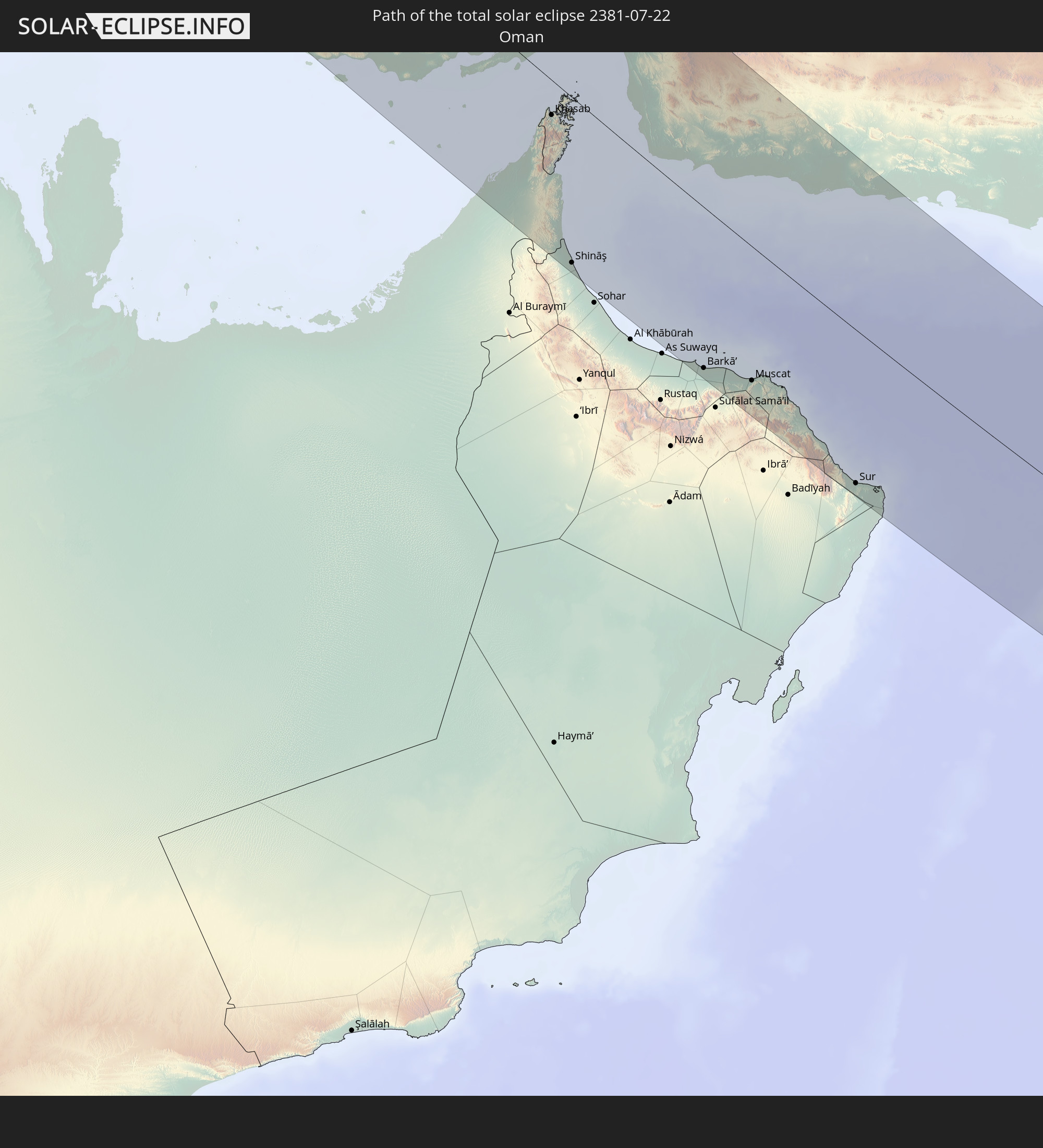 Oman
Oman
 India
India
In den folgenden Ländern ist die Sonnenfinsternis partiell zu sehen
 Russia
 United States
 Canada
 Greenland
 Saint Pierre and Miquelon
 Portugal
 Iceland
 Spain
Spain
 Mauritania
 Morocco
 Mali
Mali
 Republic of Ireland
 Svalbard and Jan Mayen
 Algeria
 United Kingdom
 Faroe Islands
 Gibraltar
 France
 Isle of Man
 Guernsey
 Jersey
 Niger
Niger
 Andorra
 Belgium
 Netherlands
 Norway
 Luxembourg
 Germany
 Switzerland
 Italy
Italy
 Monaco
 Tunisia
 Denmark
 Libya
Libya
 Liechtenstein
 Austria
 Sweden
 Czechia
 Democratic Republic of the Congo
 San Marino
 Vatican City
 Slovenia
 Chad
Chad
 Croatia
 Poland
 Malta
Malta
 Central African Republic
 Bosnia and Herzegovina
 Hungary
 Slovakia
 Montenegro
 Serbia
 Albania
 Åland Islands
 Greece
 Romania
 Republic of Macedonia
 Finland
 Lithuania
 Latvia
 Estonia
 Sudan
Sudan
 Ukraine
 Bulgaria
 Belarus
 Egypt
Egypt
 Turkey
 Moldova
 Uganda
 Cyprus
 Ethiopia
 Kenya
Kenya
 State of Palestine
 Israel
 Saudi Arabia
 Jordan
 Lebanon
 Syria
Syria
 Eritrea
 Iraq
Iraq
 Georgia
 Somalia
 Djibouti
 Yemen
Yemen
 Armenia
 Iran
Iran
 Azerbaijan
 Seychelles
 Kazakhstan
 Kuwait
 Bahrain
 Qatar
Qatar
 United Arab Emirates
 Oman
Oman
 Turkmenistan
 Uzbekistan
 Mauritius
 Afghanistan
 Pakistan
 Tajikistan
 India
India
 Kyrgyzstan
 British Indian Ocean Territory
 Maldives
 China
China
 Sri Lanka
 Nepal
Nepal
 Mongolia
 Bangladesh
 Bhutan
 Myanmar
How will be the weather during the total solar eclipse on 07/22/2381?
Where is the best place to see the total solar eclipse of 07/22/2381?
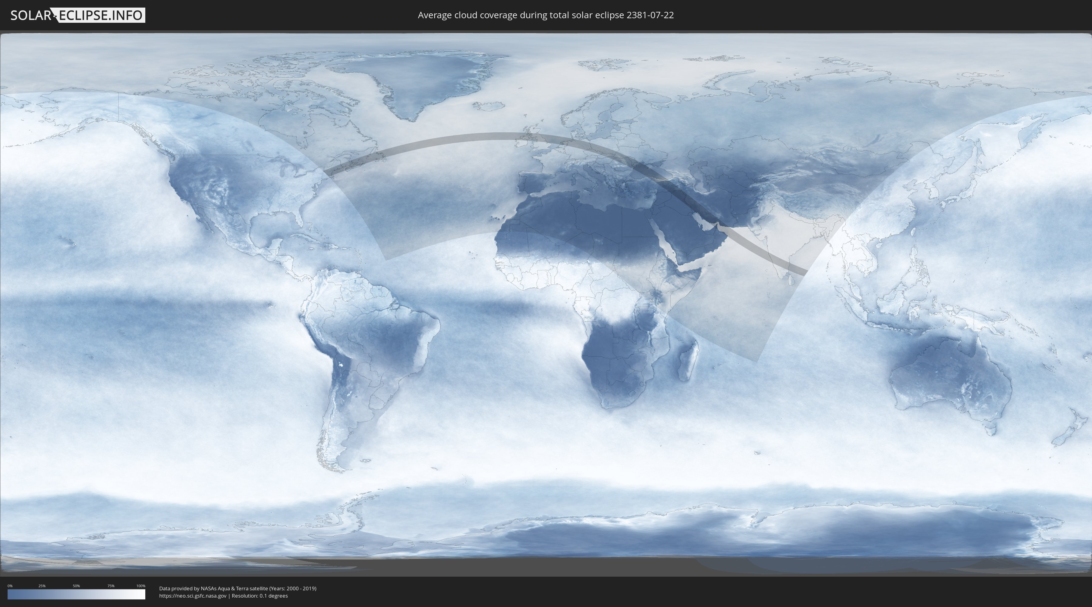
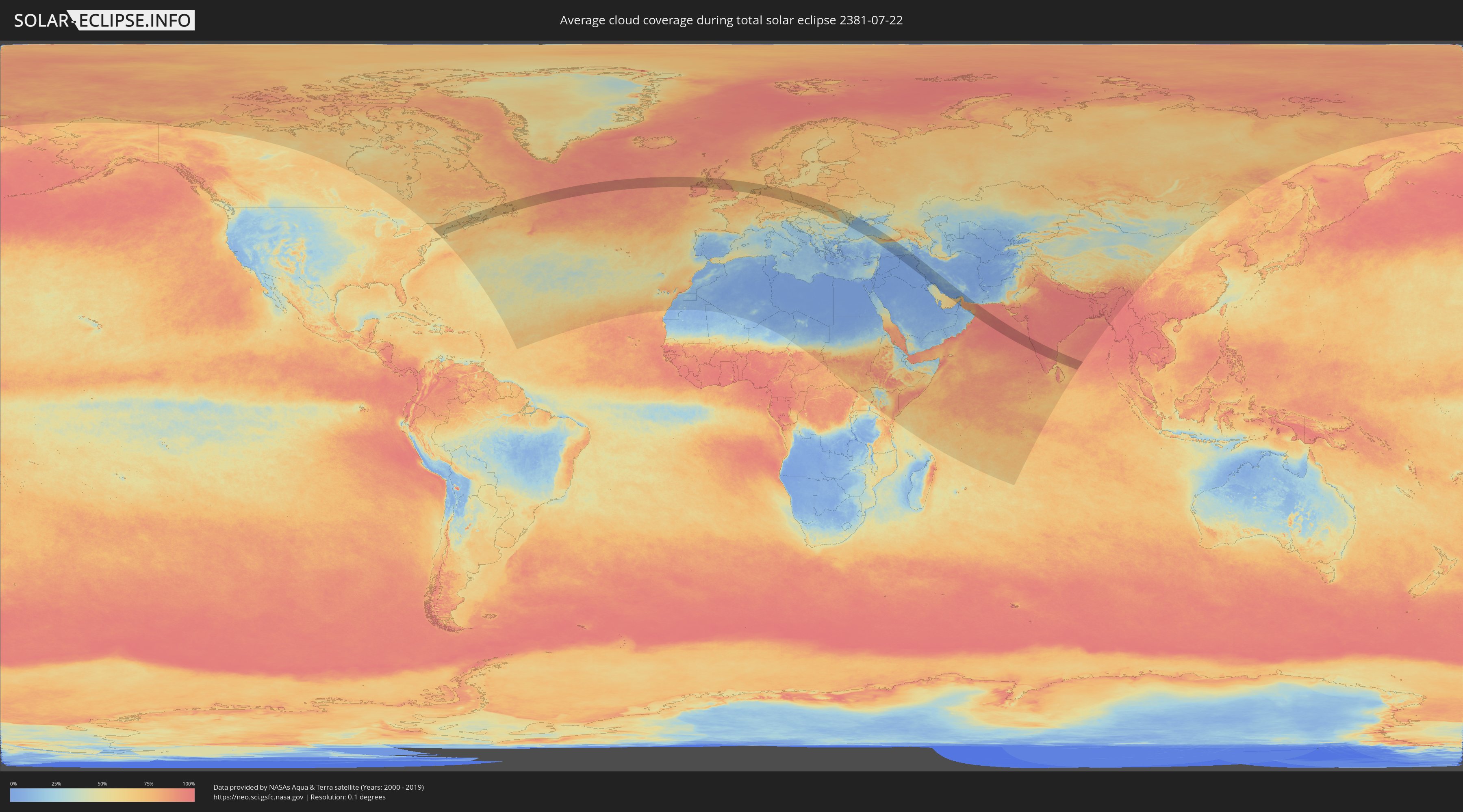
The following maps show the average cloud coverage for the day of the total solar eclipse.
With the help of these maps, it is possible to find the place along the eclipse path, which has the best
chance of a cloudless sky.
Nevertheless, you should consider local circumstances and inform about the weather of your chosen
observation site.
The data is provided by NASAs satellites
AQUA and TERRA.
The cloud maps are averaged over a period of 19 years (2000 - 2019).
Detailed country maps
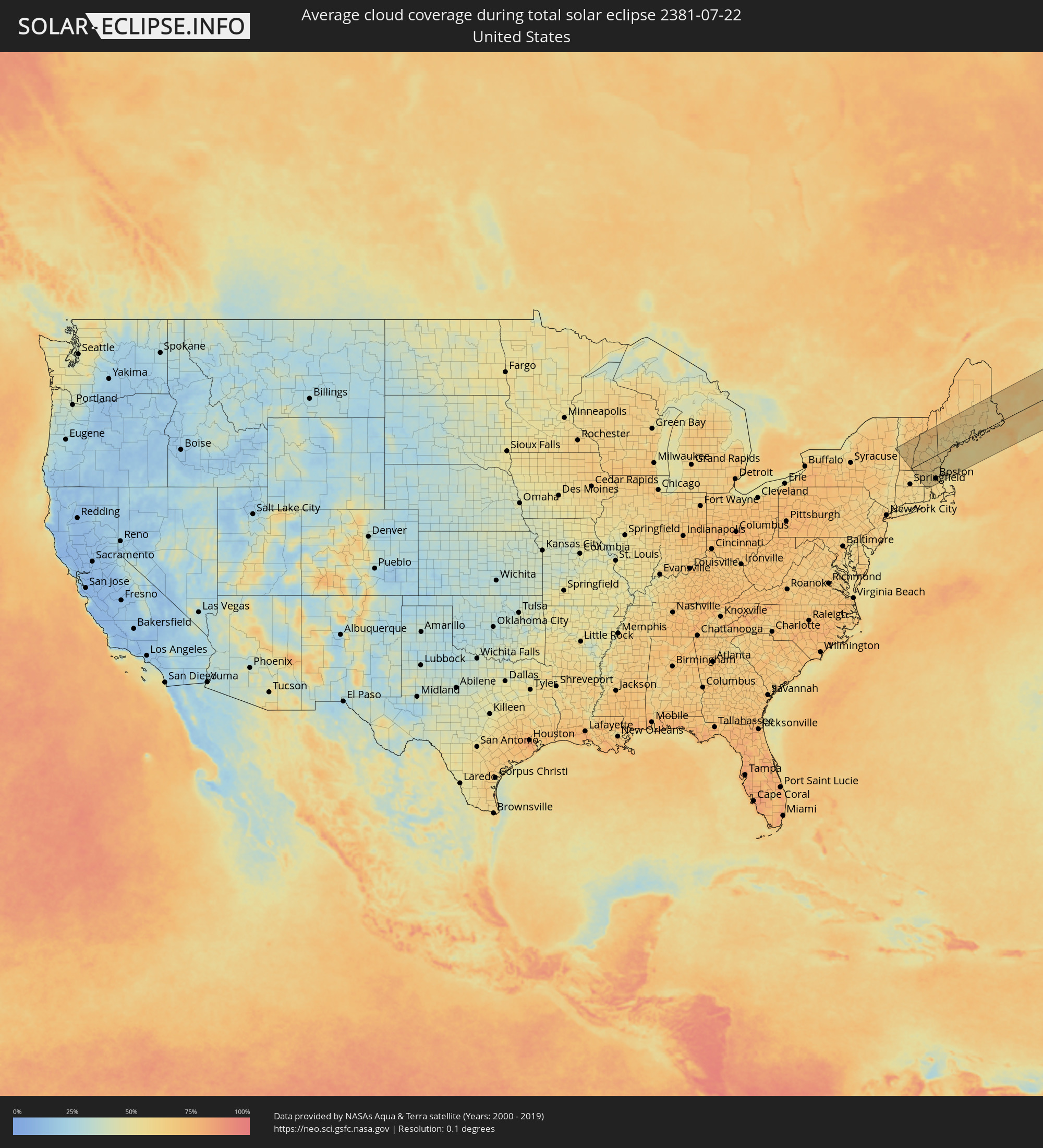 United States
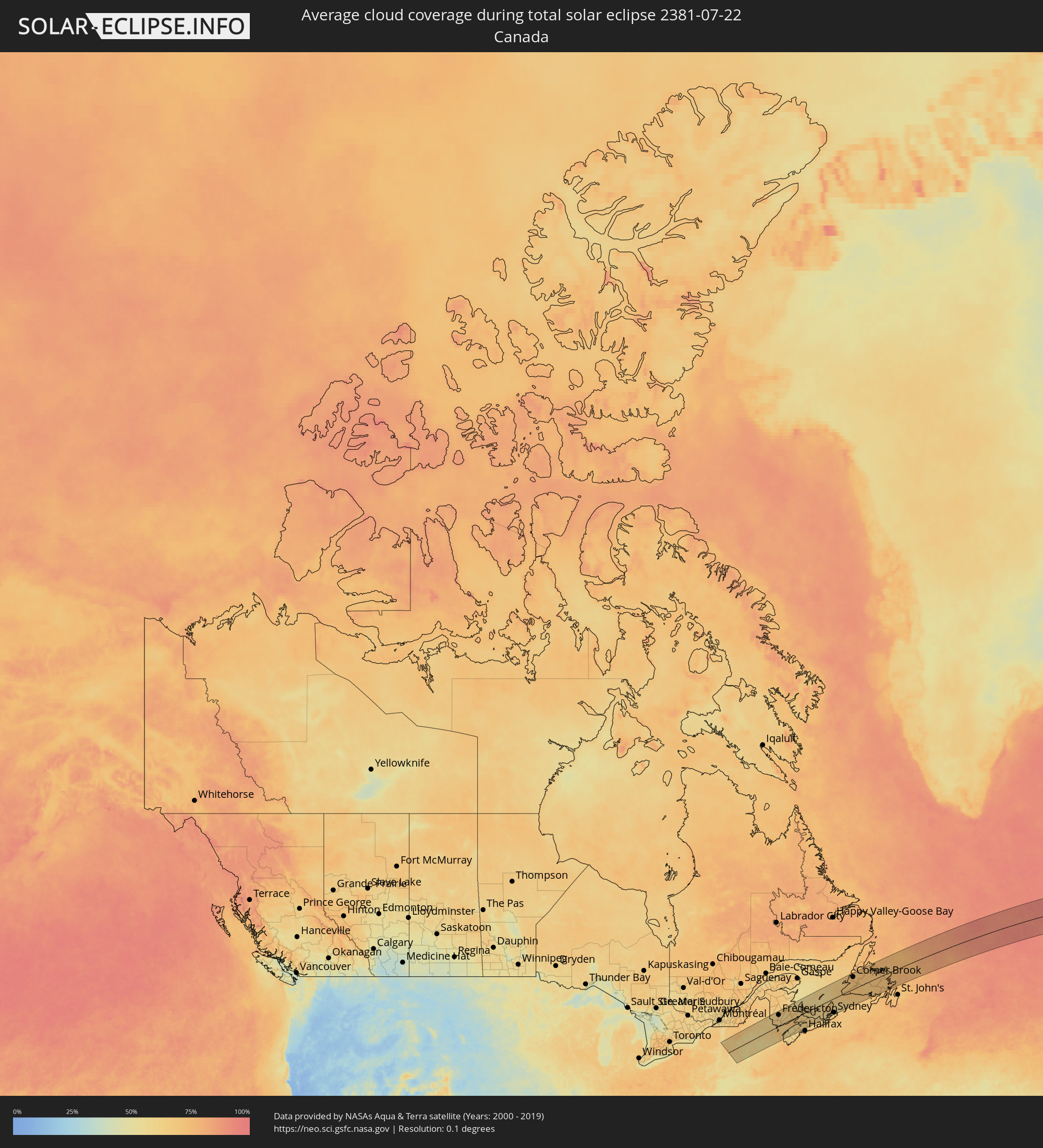 Canada
 Republic of Ireland
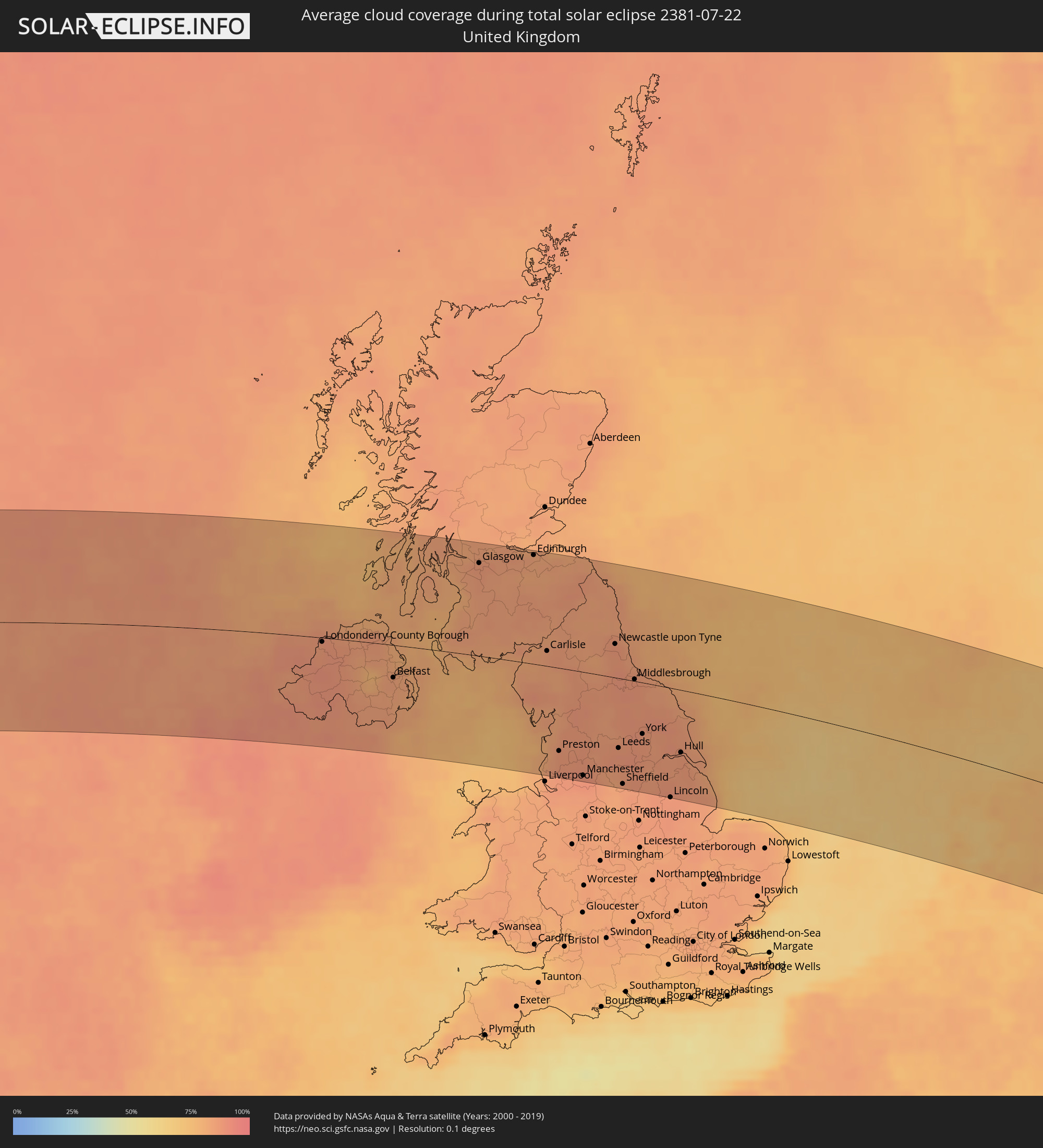 United Kingdom
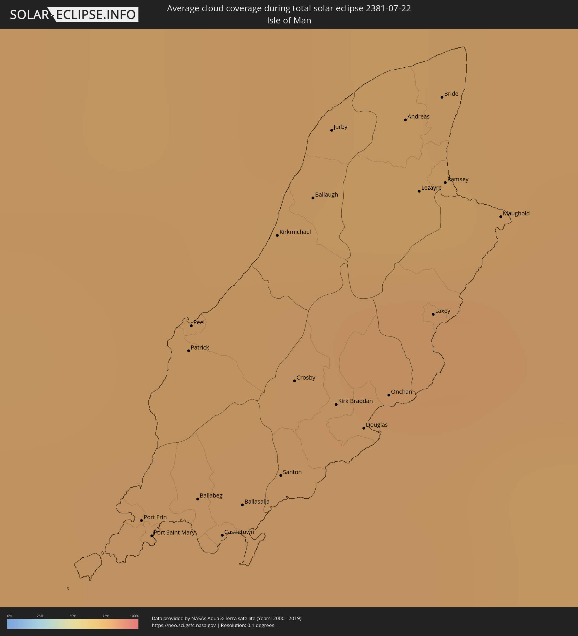 Isle of Man
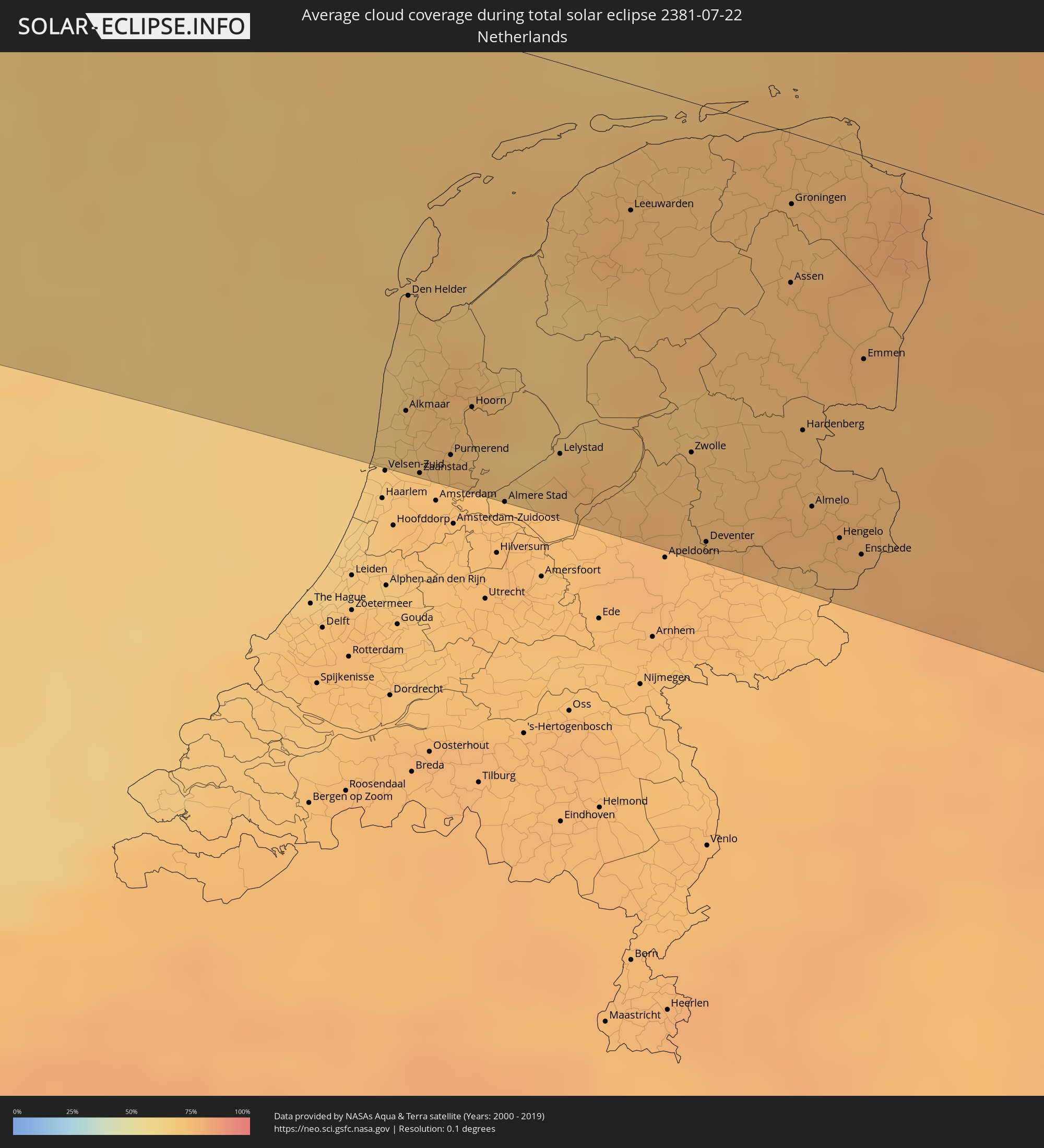 Netherlands
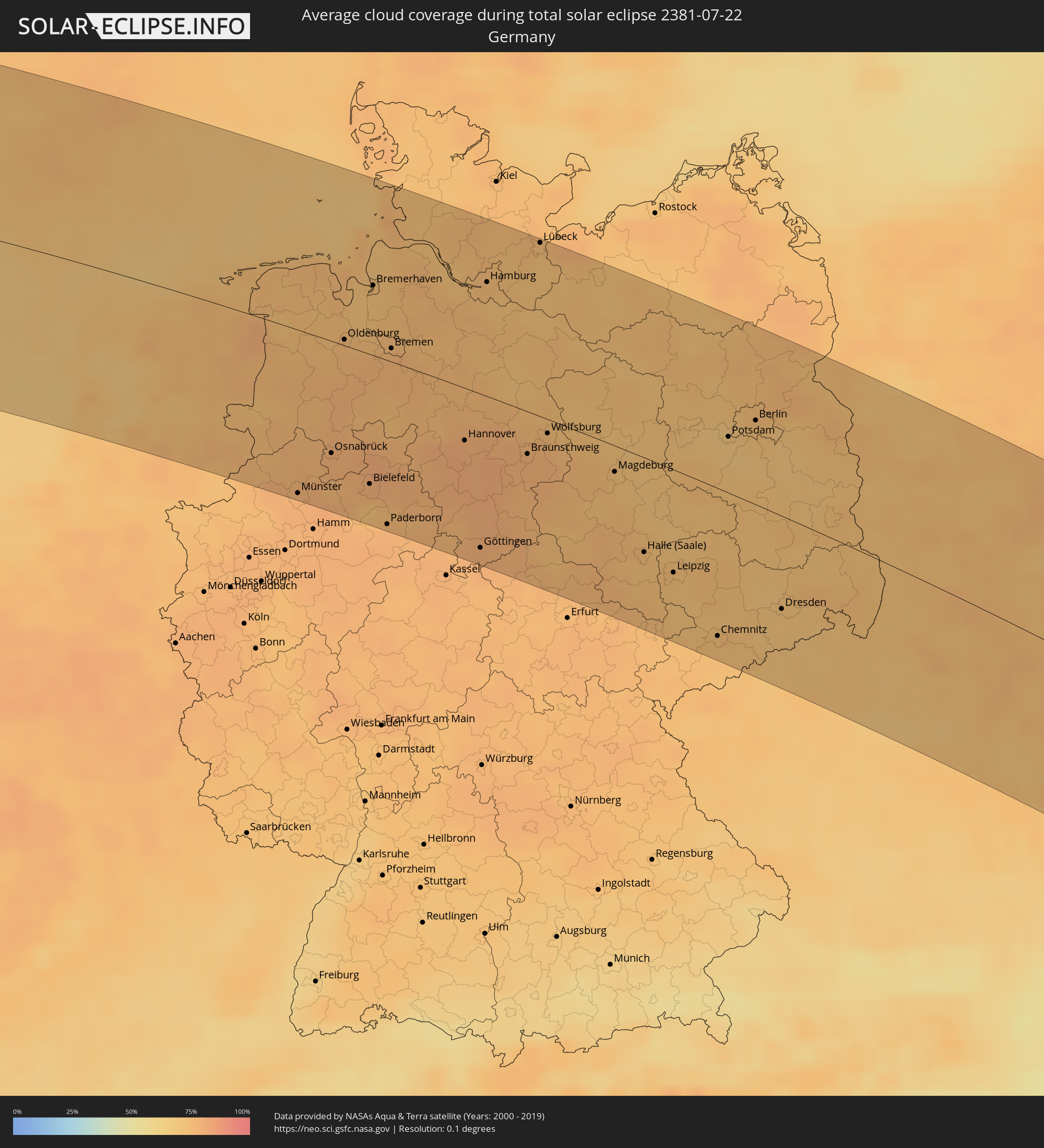 Germany
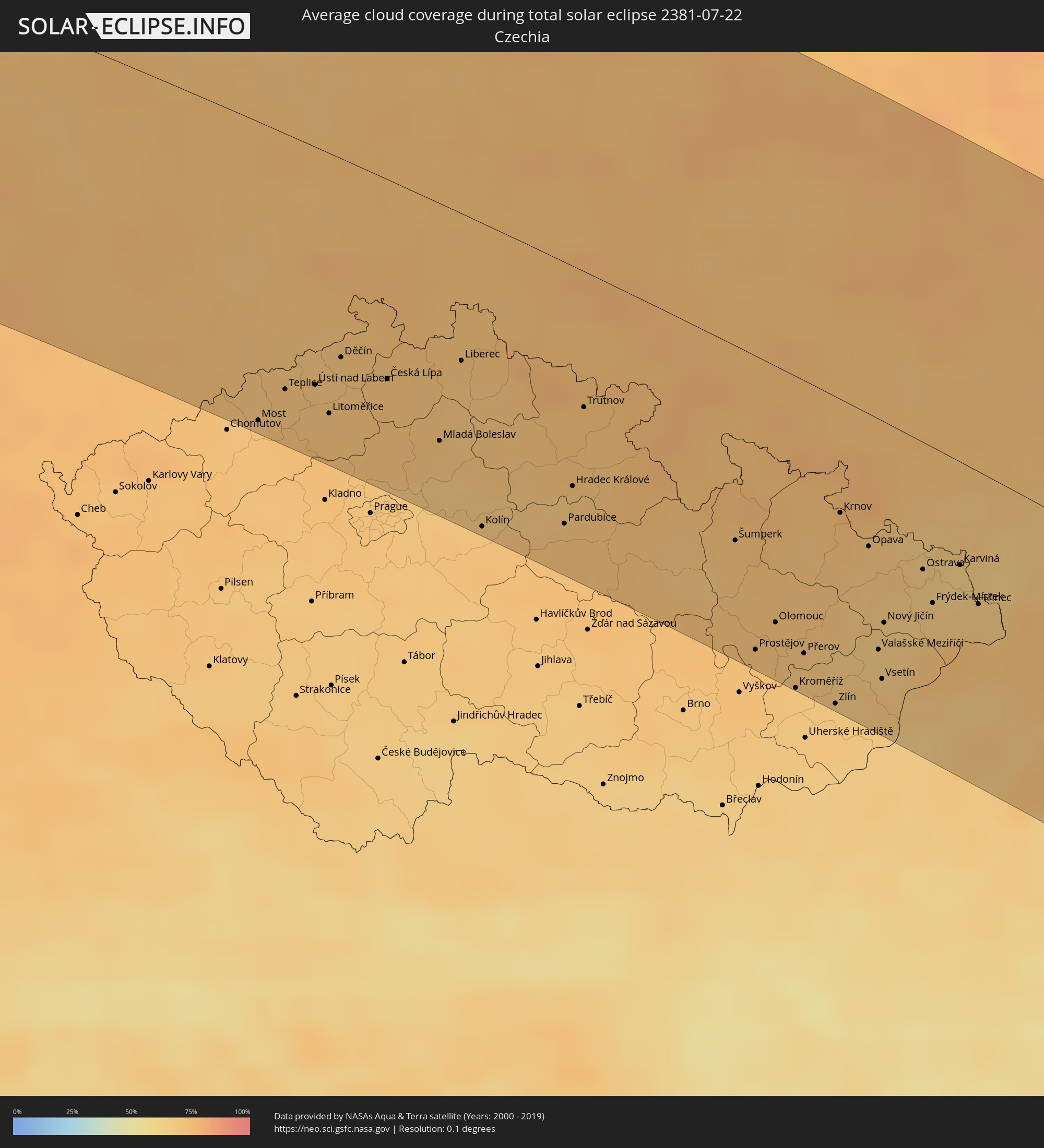 Czechia
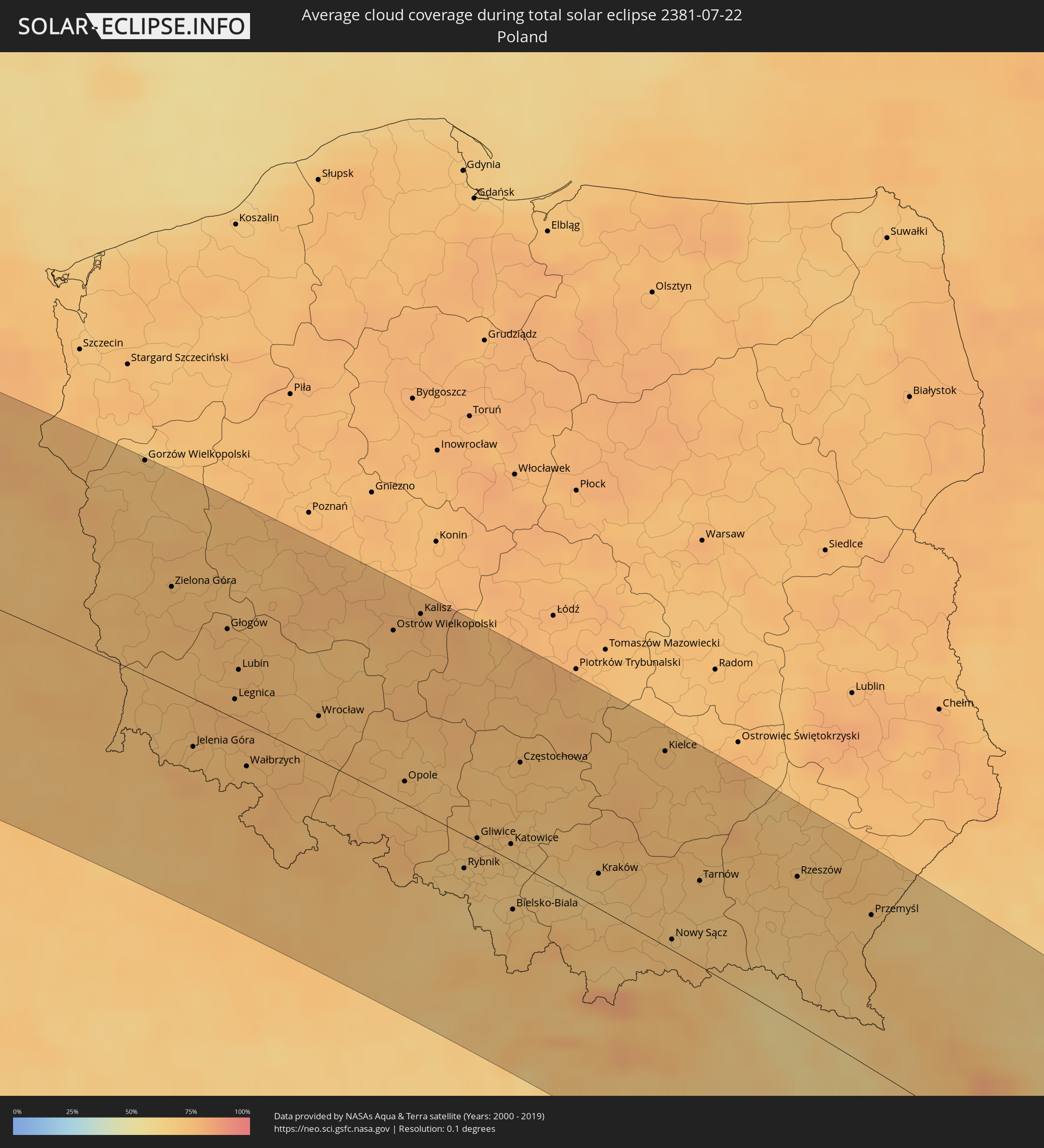 Poland
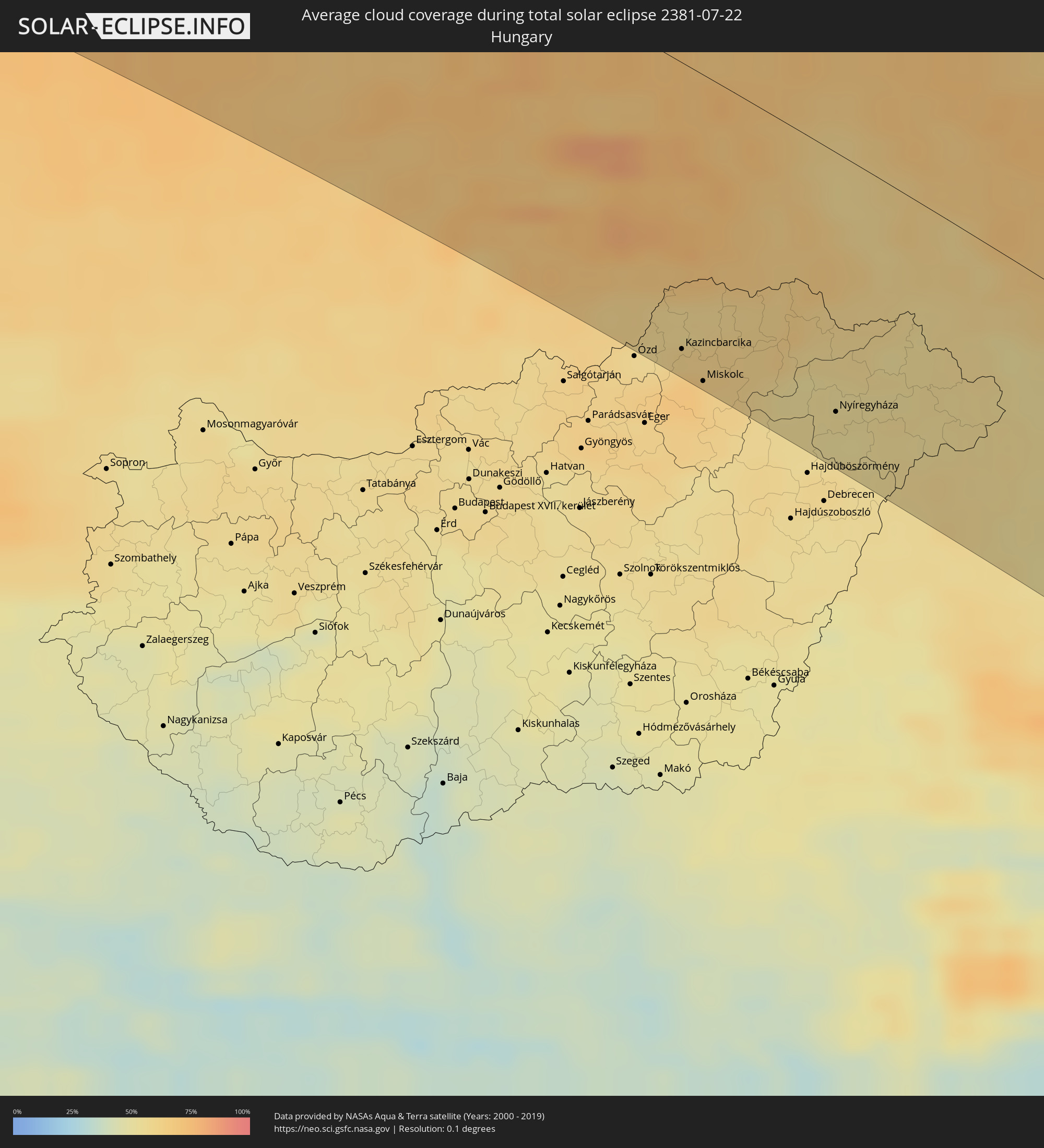 Hungary
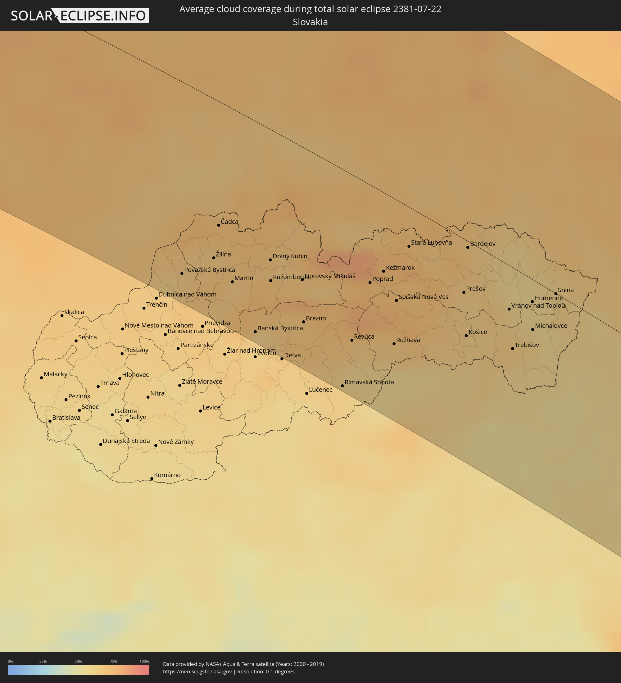 Slovakia
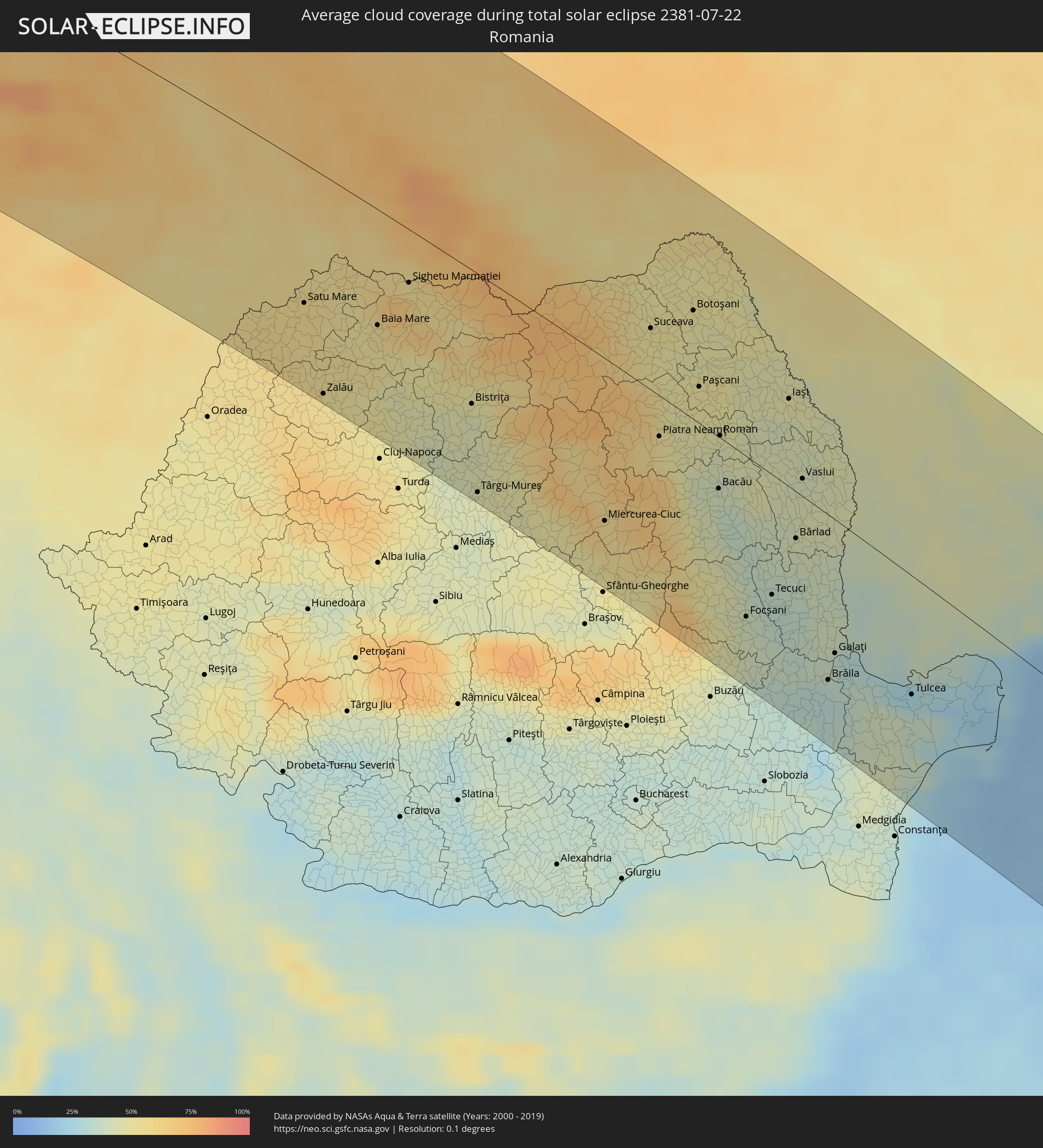 Romania
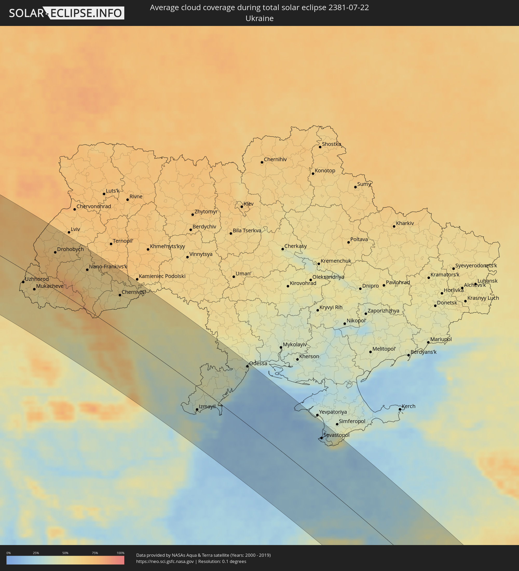 Ukraine
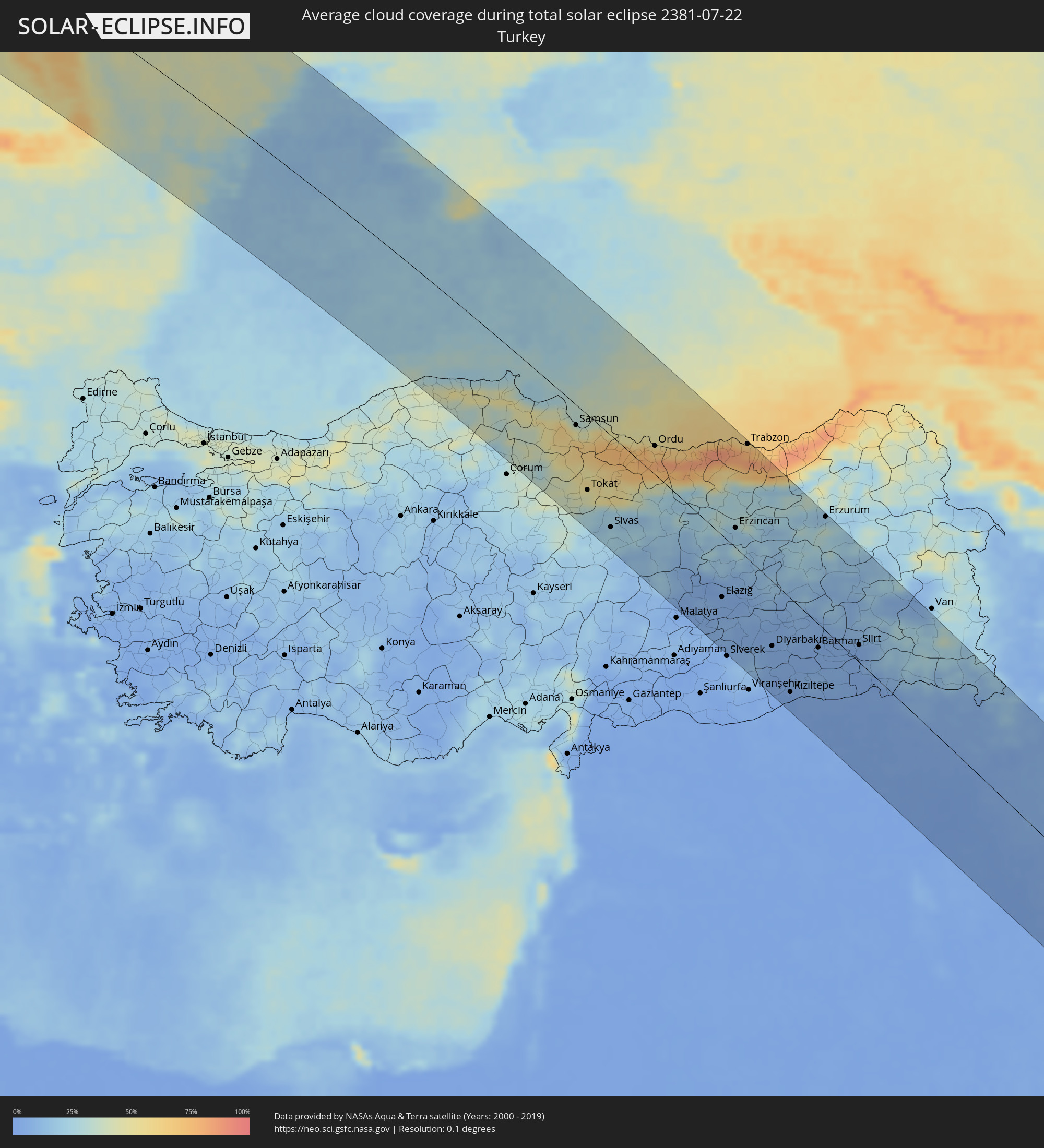 Turkey
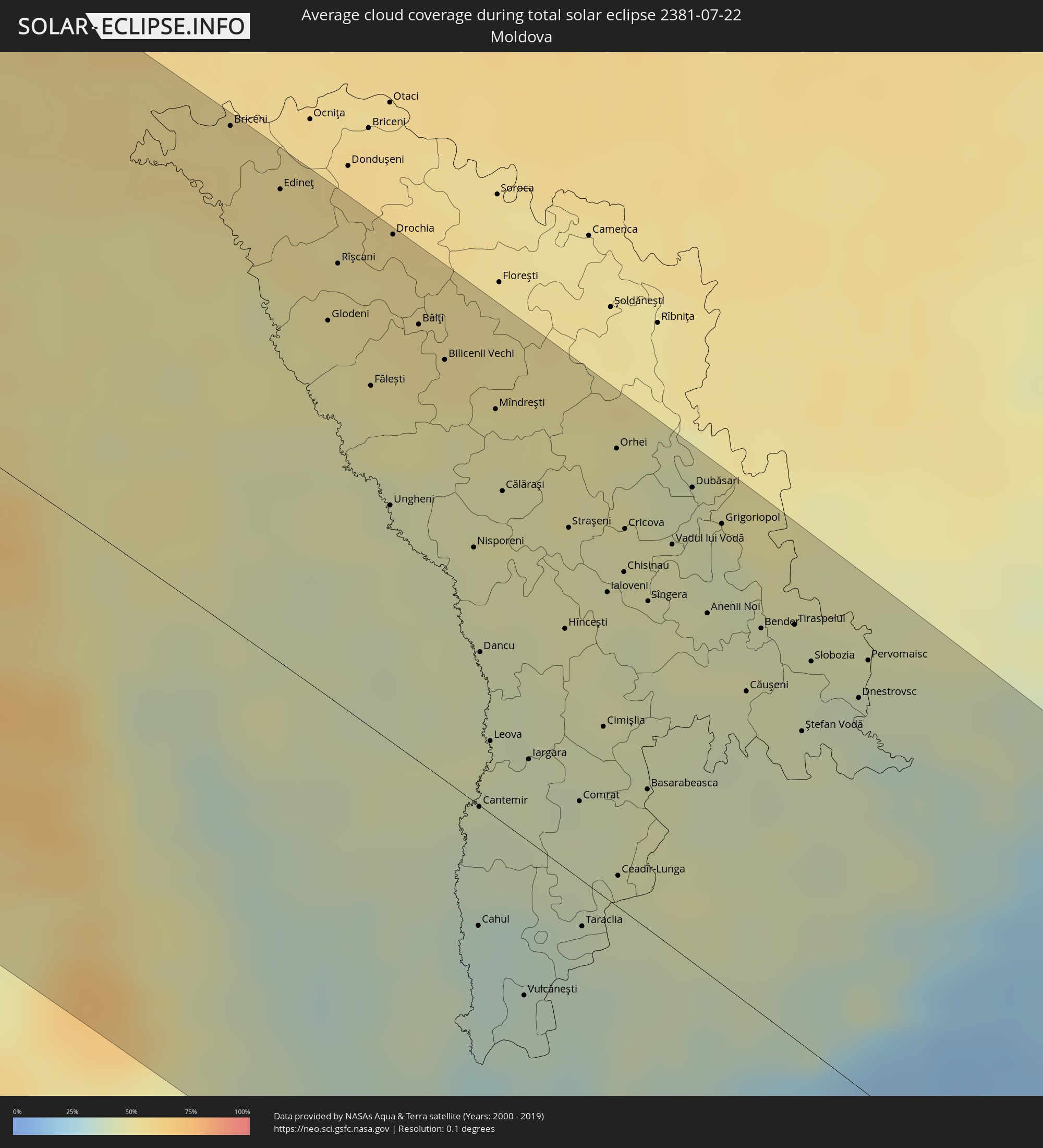 Moldova
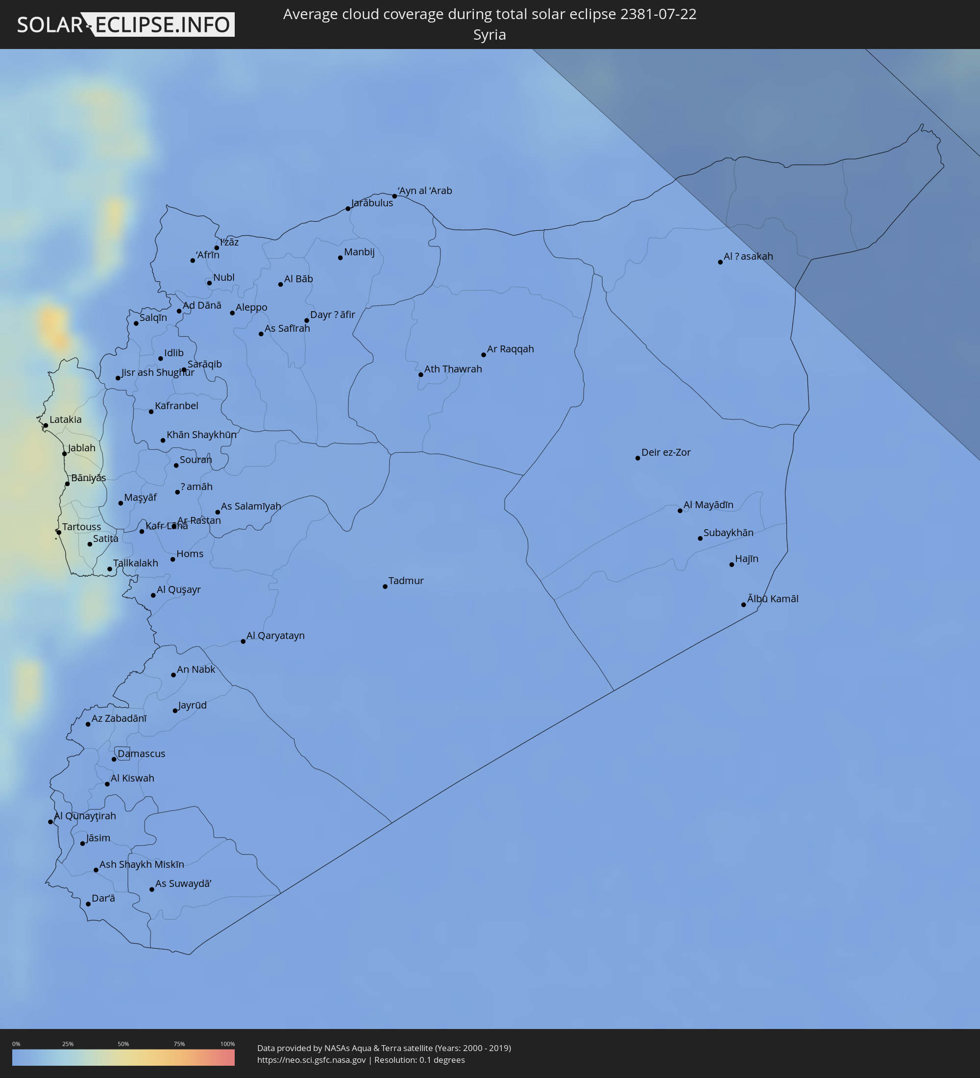 Syria
Syria
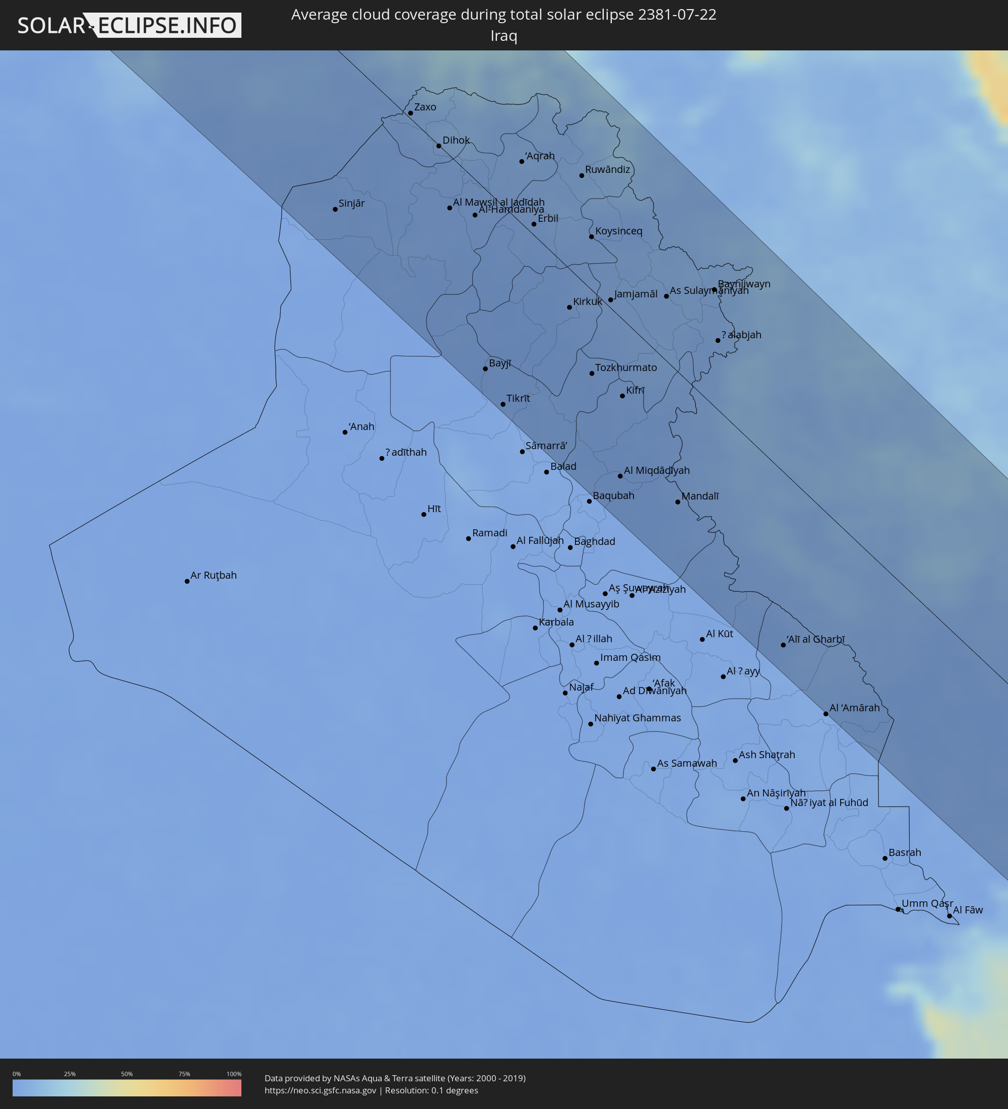 Iraq
Iraq
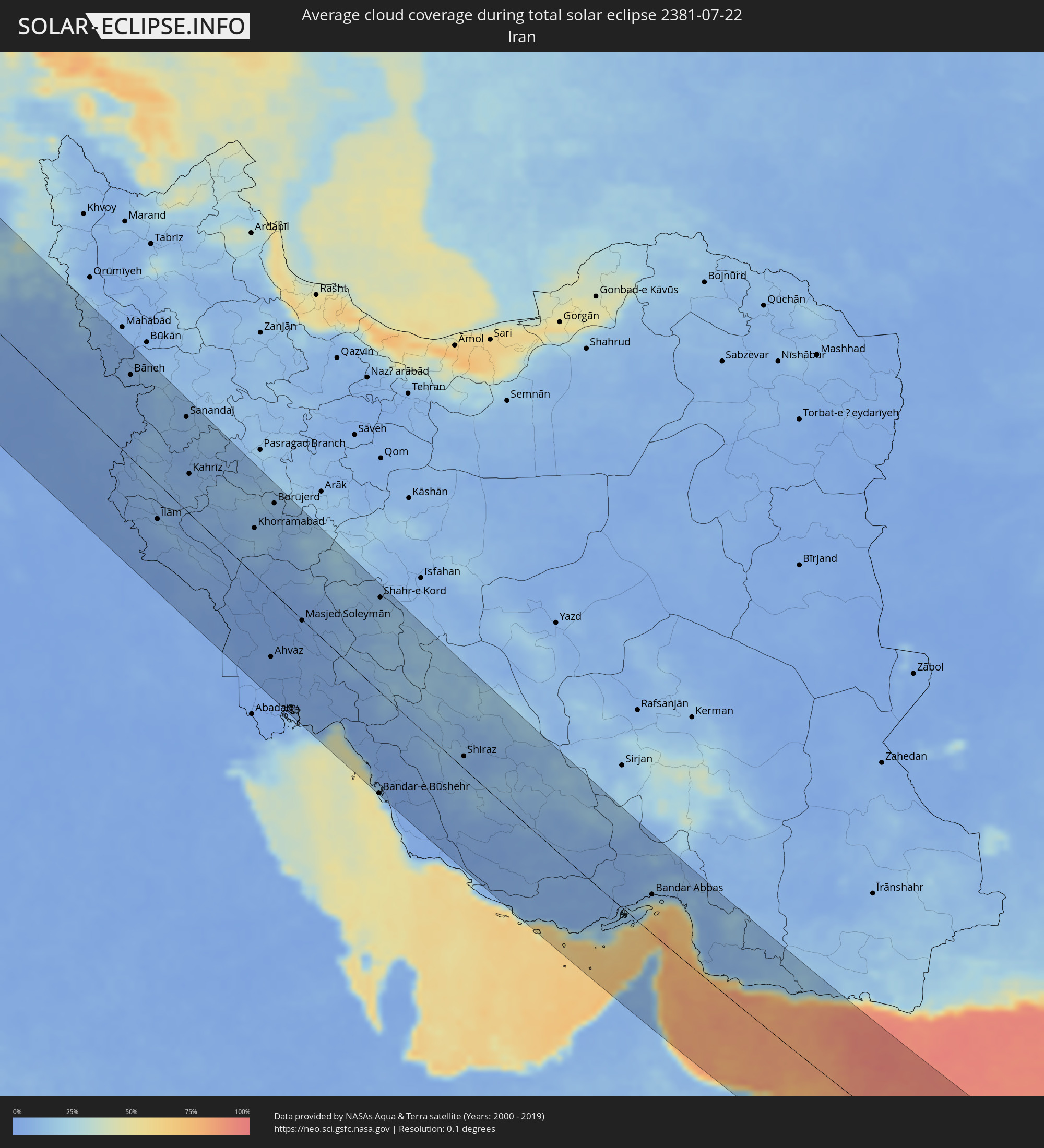 Iran
Iran
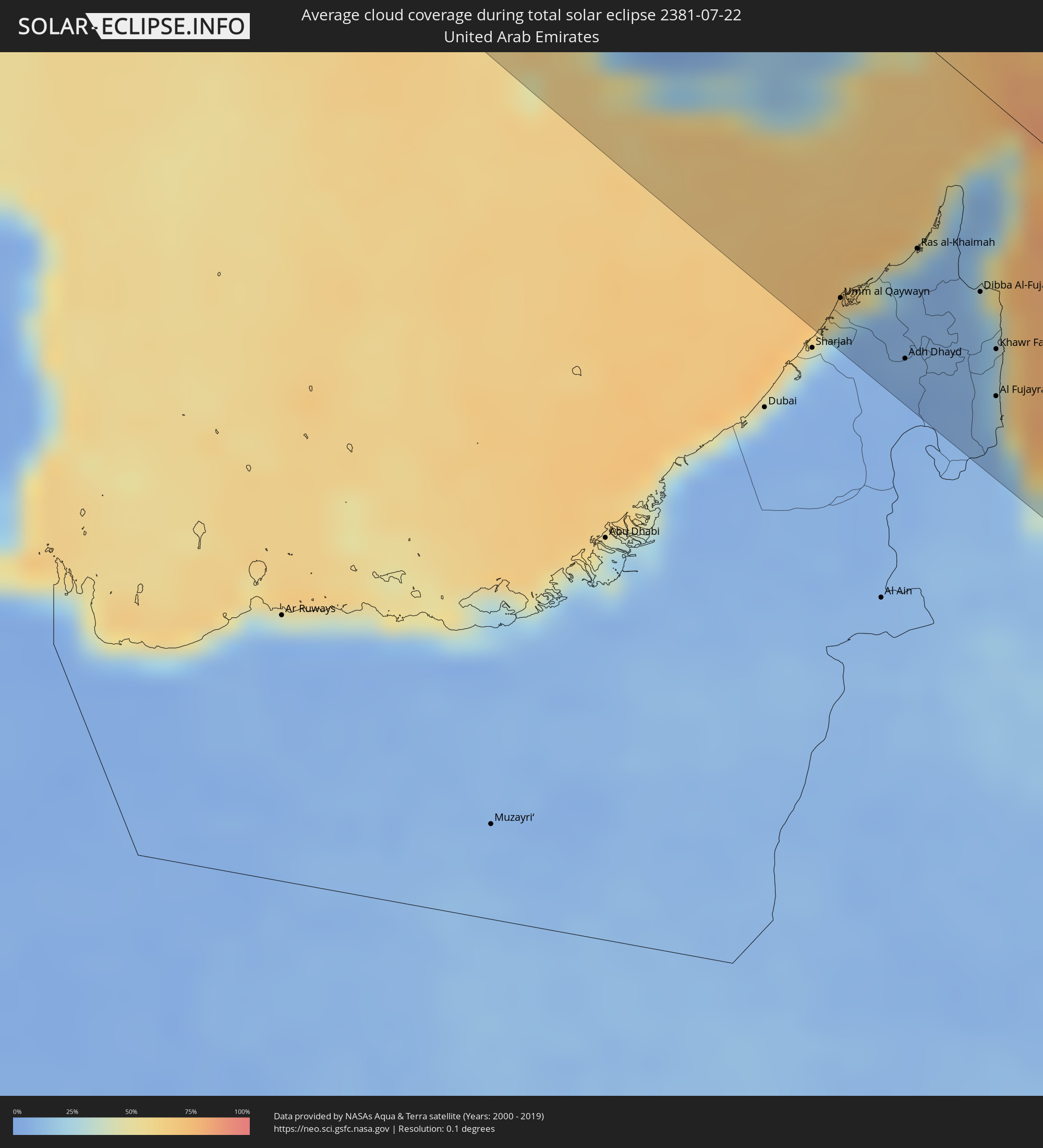 United Arab Emirates
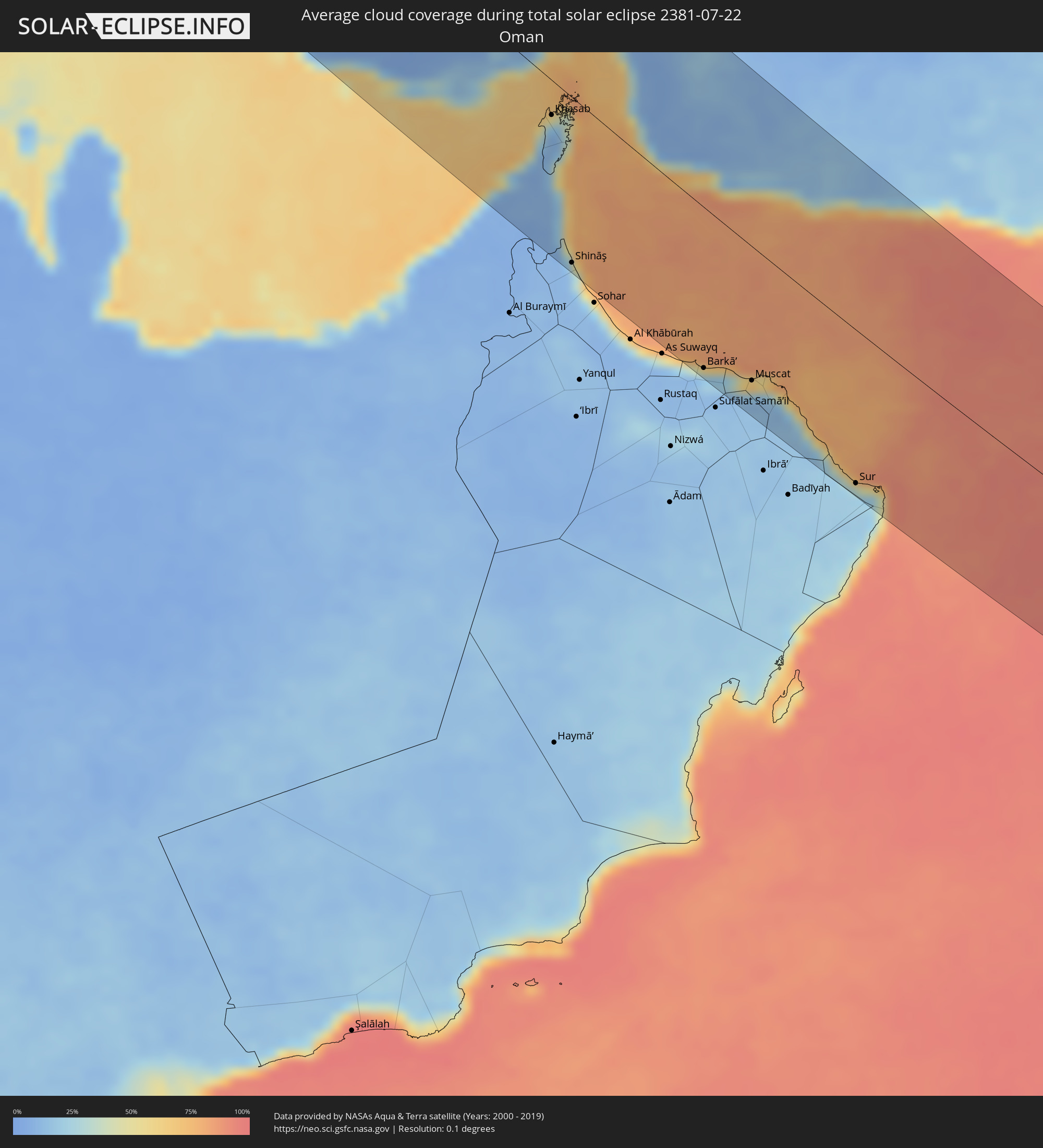 Oman
Oman
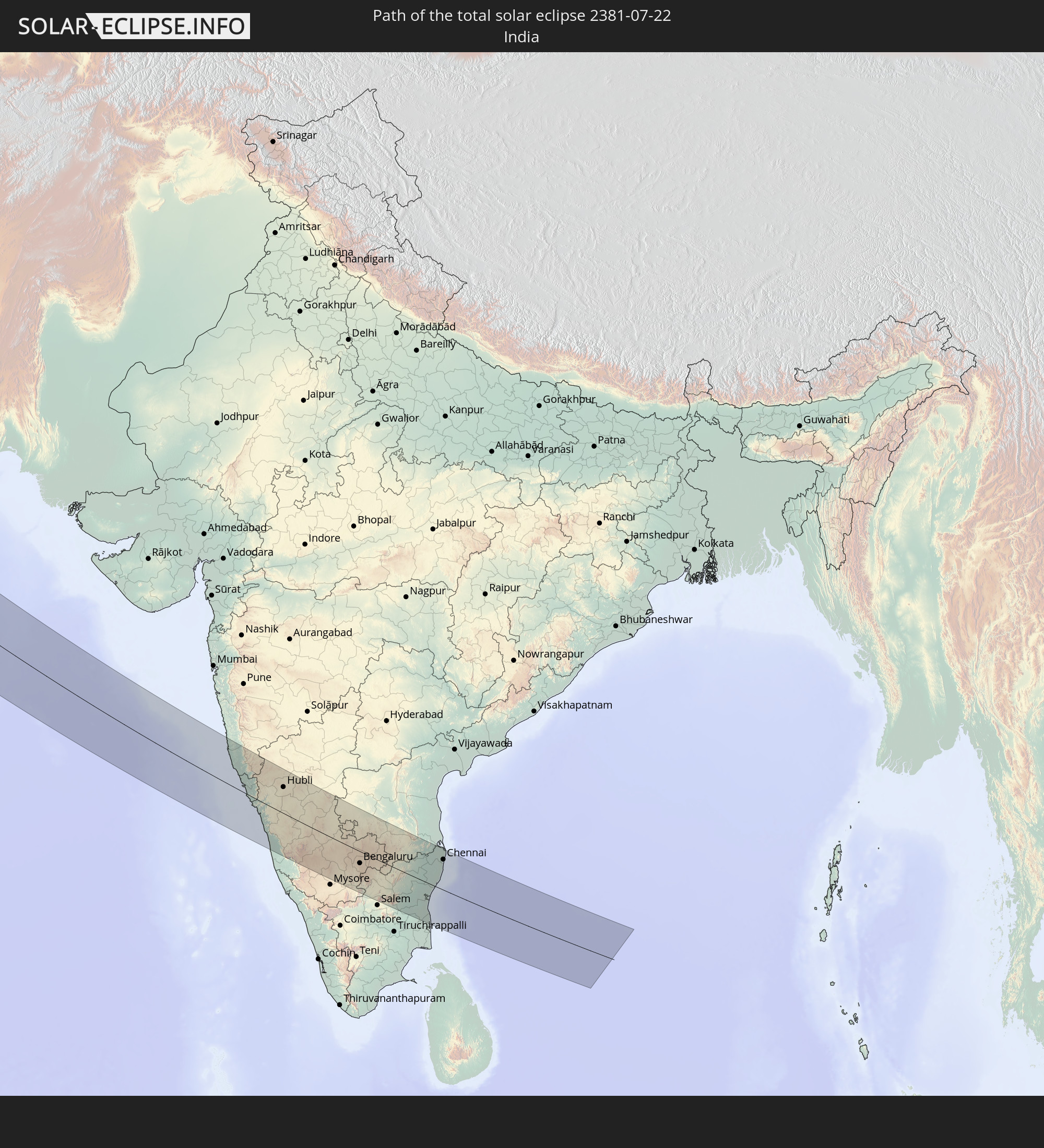
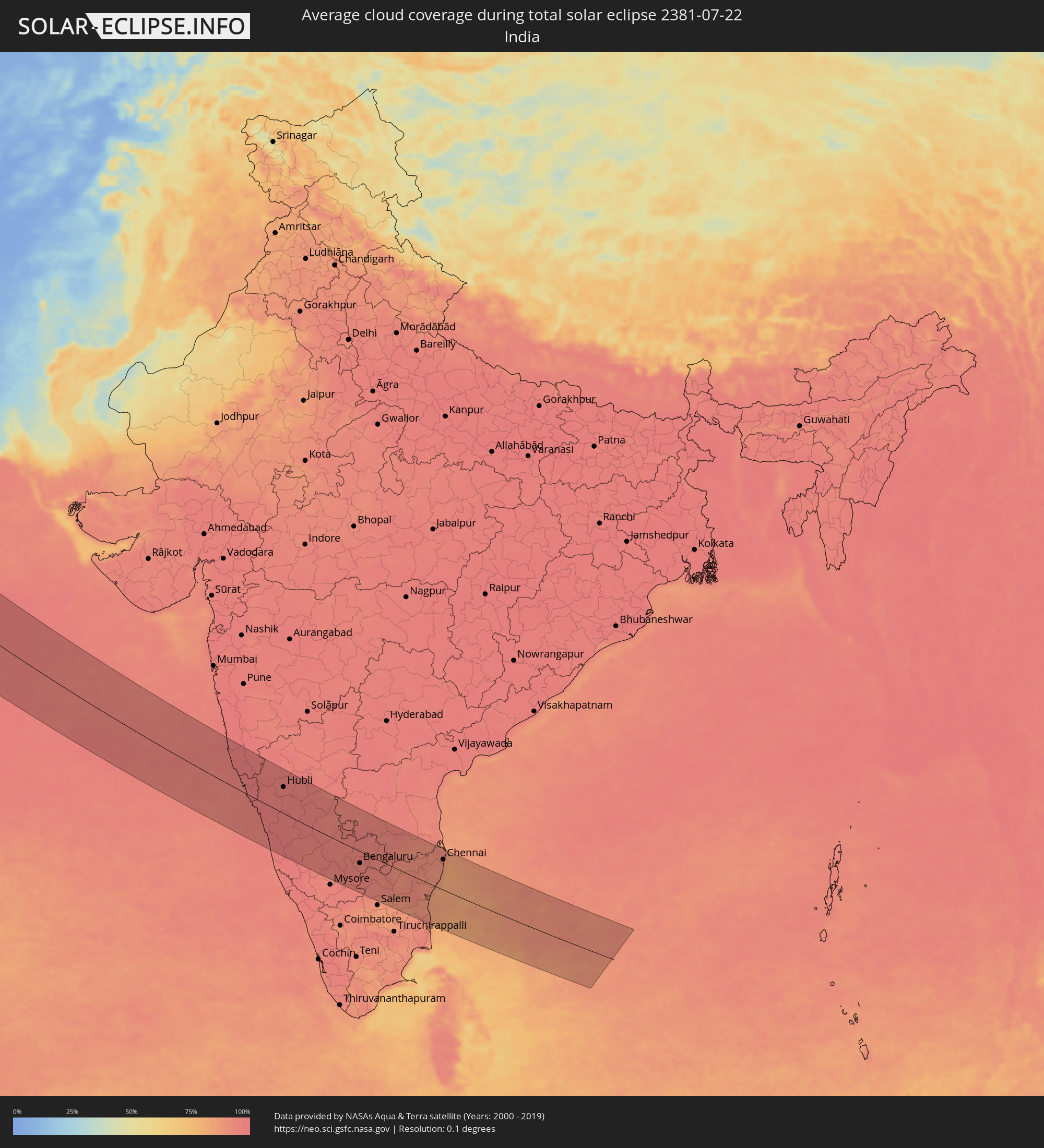 India
India
Cities inside the path of the eclipse
The following table shows all locations with a population of more than 5,000 inside the eclipse path. Cities which have more than 100,000 inhabitants are marked bold. A click at the locations opens a detailed map.
| City | Type | Eclipse duration | Local time of max. eclipse | Distance to central line | Ø Cloud coverage |
|
Worcester, Massachusetts
|
total | - | 04:37:37 UTC-05:00 | 81 km | 60% |
|
Nashua, New Hampshire
|
total | - | 04:37:56 UTC-05:00 | 45 km | 62% |
|
Manchester, New Hampshire
|
total | - | 04:38:08 UTC-05:00 | 22 km | 65% |
|
Framingham, Massachusetts
|
total | - | 04:37:30 UTC-05:00 | 94 km | 58% |
|
Lowell, Massachusetts
|
total | - | 04:37:46 UTC-05:00 | 63 km | 62% |
|
Haverhill, Massachusetts
|
total | - | 04:37:49 UTC-05:00 | 58 km | 58% |
|
Boston, Massachusetts
|
total | - | 04:37:27 UTC-05:00 | 100 km | 61% |
|
Lynn, Massachusetts
|
total | - | 04:37:31 UTC-05:00 | 94 km | 59% |
|
Weymouth, Massachusetts
|
total | - | 04:37:18 UTC-05:00 | 118 km | 59% |
|
Portland, Maine
|
total | - | 04:38:22 UTC-05:00 | 2 km | 60% |
|
Fredericton, New Brunswick
|
total | - | 05:39:38 UTC-04:00 | 91 km | 65% |
|
Saint John, New Brunswick
|
total | - | 05:38:51 UTC-04:00 | 3 km | 65% |
|
Moncton, New Brunswick
|
total | - | 05:39:26 UTC-04:00 | 39 km | 66% |
|
Summerside, Prince Edward Island
|
total | - | 05:39:35 UTC-04:00 | 34 km | 61% |
|
Truro, Nova Scotia
|
total | - | 05:38:29 UTC-04:00 | 87 km | 60% |
|
Charlottetown, Prince Edward Island
|
total | - | 05:39:20 UTC-04:00 | 5 km | 65% |
|
New Glasgow, Nova Scotia
|
total | - | 05:38:37 UTC-04:00 | 87 km | 65% |
|
Sydney, Nova Scotia
|
total | - | 05:38:56 UTC-04:00 | 115 km | 58% |
|
Glace Bay, Nova Scotia
|
total | - | 05:38:59 UTC-04:00 | 117 km | 58% |
|
Corner Brook, Newfoundland and Labrador
|
total | - | 06:11:51 UTC-03:30 | 95 km | 70% |
|
Ballina, Connaught
|
total | - | 10:15:07 UTC+00:00 | 112 km | 87% |
|
Sligo, Connaught
|
total | - | 10:15:58 UTC+00:00 | 92 km | 89% |
|
Letterkenny, Ulster
|
total | - | 10:17:06 UTC+00:00 | 13 km | 88% |
|
Buncrana, Ulster
|
total | - | 10:17:29 UTC+00:00 | 9 km | 86% |
|
Cavan, Ulster
|
total | - | 10:17:06 UTC+00:00 | 117 km | 89% |
|
Monaghan, Ulster
|
total | - | 10:17:39 UTC+00:00 | 86 km | 88% |
|
Dundalk, Leinster
|
total | - | 10:18:11 UTC+00:00 | 110 km | 87% |
|
Belfast, Northern Ireland
|
total | - | 10:18:59 UTC+00:00 | 40 km | 84% |
|
Port Erin, Port Erin
|
total | - | 10:20:10 UTC+00:00 | 88 km | 77% |
|
Port Saint Mary, Port St Mary
|
total | - | 10:20:11 UTC+00:00 | 89 km | 77% |
|
Peel, Peel
|
total | - | 10:20:17 UTC+00:00 | 72 km | 76% |
|
Ballasalla, Malew
|
total | - | 10:20:19 UTC+00:00 | 85 km | 77% |
|
Kirkmichael, Michael
|
total | - | 10:20:26 UTC+00:00 | 64 km | 76% |
|
Santon, Santon
|
total | - | 10:20:23 UTC+00:00 | 83 km | 77% |
|
Crosby, Marown
|
total | - | 10:20:25 UTC+00:00 | 75 km | 76% |
|
Jurby, Jurby
|
total | - | 10:20:32 UTC+00:00 | 55 km | 74% |
|
Douglas, Douglas
|
total | - | 10:20:31 UTC+00:00 | 78 km | 76% |
|
Ramsey, Ramsey
|
total | - | 10:20:41 UTC+00:00 | 58 km | 77% |
|
Glasgow, Scotland
|
total | - | 10:21:19 UTC+00:00 | 113 km | 86% |
|
Edinburgh, Scotland
|
total | - | 10:22:32 UTC+00:00 | 132 km | 83% |
|
Preston, England
|
total | - | 10:22:33 UTC+00:00 | 103 km | 87% |
|
Manchester, England
|
total | - | 10:23:05 UTC+00:00 | 129 km | 89% |
|
Newcastle upon Tyne, England
|
total | - | 10:24:07 UTC+00:00 | 41 km | 87% |
|
Leeds, England
|
total | - | 10:23:59 UTC+00:00 | 87 km | 88% |
|
Sheffield, England
|
total | - | 10:24:02 UTC+00:00 | 131 km | 85% |
|
Sunderland, England
|
total | - | 10:24:23 UTC+00:00 | 36 km | 85% |
|
Hull, England
|
total | - | 10:25:30 UTC+00:00 | 78 km | 87% |
|
Alkmaar, North Holland
|
total | - | 11:32:10 UTC+01:00 | 119 km | 68% |
|
Zaanstad, North Holland
|
total | - | 11:32:17 UTC+01:00 | 137 km | 72% |
|
Almere Stad, Flevoland
|
total | - | 11:32:51 UTC+01:00 | 138 km | 74% |
|
Lelystad, Flevoland
|
total | - | 11:33:10 UTC+01:00 | 118 km | 75% |
|
Leeuwarden, Friesland
|
total | - | 11:33:29 UTC+01:00 | 38 km | 76% |
|
Zwolle, Overijssel
|
total | - | 11:34:01 UTC+01:00 | 106 km | 74% |
|
Deventer, Overijssel
|
total | - | 11:34:10 UTC+01:00 | 132 km | 75% |
|
Groningen, Groningen
|
total | - | 11:34:29 UTC+01:00 | 21 km | 75% |
|
Almelo, Overijssel
|
total | - | 11:34:50 UTC+01:00 | 111 km | 76% |
|
Enschede, Overijssel
|
total | - | 11:35:11 UTC+01:00 | 121 km | 76% |
|
Münster, North Rhine-Westphalia
|
total | - | 11:36:17 UTC+01:00 | 132 km | 78% |
|
Bielefeld, North Rhine-Westphalia
|
total | - | 11:37:31 UTC+01:00 | 105 km | 76% |
|
Bremen, Bremen
|
total | - | 11:37:32 UTC+01:00 | 11 km | 77% |
|
Hannover, Lower Saxony
|
total | - | 11:39:03 UTC+01:00 | 42 km | 80% |
|
Hamburg, Hamburg
|
total | - | 11:38:58 UTC+01:00 | 90 km | 75% |
|
Braunschweig, Lower Saxony
|
total | - | 11:40:12 UTC+01:00 | 34 km | 79% |
|
Leipzig, Saxony
|
total | - | 11:43:15 UTC+01:00 | 83 km | 73% |
|
Chemnitz, Saxony
|
total | - | 11:44:21 UTC+01:00 | 119 km | 74% |
|
Berlin, Berlin
|
total | - | 11:44:02 UTC+01:00 | 67 km | 74% |
|
Most, Ústecký
|
total | - | 11:45:35 UTC+01:00 | 133 km | 71% |
|
Dresden, Saxony
|
total | - | 11:45:23 UTC+01:00 | 75 km | 71% |
|
Ústí nad Labem, Ústecký
|
total | - | 11:46:03 UTC+01:00 | 106 km | 71% |
|
Liberec, Liberecký
|
total | - | 11:47:28 UTC+01:00 | 65 km | 71% |
|
Pardubice, Pardubický
|
total | - | 11:49:03 UTC+01:00 | 117 km | 72% |
|
Hradec Králové, Královéhradecký
|
total | - | 11:49:00 UTC+01:00 | 98 km | 68% |
|
Wrocław, Lower Silesian Voivodeship
|
total | - | 11:50:01 UTC+01:00 | 29 km | 72% |
|
Olomouc, Olomoucký
|
total | - | 11:51:34 UTC+01:00 | 114 km | 72% |
|
Zlín, Zlín
|
total | - | 11:52:30 UTC+01:00 | 137 km | 68% |
|
Opava, Moravskoslezský
|
total | - | 11:52:13 UTC+01:00 | 59 km | 69% |
|
Ostrava, Moravskoslezský
|
total | - | 11:52:52 UTC+01:00 | 56 km | 66% |
|
Považská Bystrica, Trenčiansky
|
total | - | 11:53:43 UTC+01:00 | 122 km | 66% |
|
Karviná, Moravskoslezský
|
total | - | 11:53:13 UTC+01:00 | 46 km | 64% |
|
Rybnik, Silesian Voivodeship
|
total | - | 11:53:00 UTC+01:00 | 22 km | 68% |
|
Gliwice, Silesian Voivodeship
|
total | - | 11:53:01 UTC+01:00 | 3 km | 71% |
|
Žilina, Žilinský
|
total | - | 11:54:05 UTC+01:00 | 101 km | 69% |
|
Martin, Žilinský
|
total | - | 11:54:30 UTC+01:00 | 110 km | 68% |
|
Katowice, Silesian Voivodeship
|
total | - | 11:53:33 UTC+01:00 | 11 km | 72% |
|
Bielsko-Biala, Silesian Voivodeship
|
total | - | 11:53:59 UTC+01:00 | 31 km | 69% |
|
Częstochowa, Silesian Voivodeship
|
total | - | 11:53:12 UTC+01:00 | 66 km | 72% |
|
Banská Bystrica, Banskobystrický
|
total | - | 11:55:09 UTC+01:00 | 134 km | 62% |
|
Dąbrowa Górnicza, Silesian Voivodeship
|
total | - | 11:53:48 UTC+01:00 | 23 km | 70% |
|
Kraków, Lesser Poland Voivodeship
|
total | - | 11:55:01 UTC+01:00 | 23 km | 69% |
|
Poprad, Prešovský
|
total | - | 11:56:31 UTC+01:00 | 62 km | 74% |
|
Spišská Nová Ves, Košický
|
total | - | 11:57:01 UTC+01:00 | 63 km | 74% |
|
Kielce, Świętokrzyskie
|
total | - | 11:55:13 UTC+01:00 | 125 km | 75% |
|
Kazincbarcika, Borsod-Abaúj-Zemplén
|
total | - | 11:57:50 UTC+01:00 | 128 km | 61% |
|
Miskolc, Borsod-Abaúj-Zemplén
|
total | - | 11:58:13 UTC+01:00 | 137 km | 63% |
|
Szerencs, Borsod-Abaúj-Zemplén
|
total | - | 11:58:47 UTC+01:00 | 115 km | 59% |
|
Prešov, Prešovský
|
total | - | 11:57:56 UTC+01:00 | 34 km | 64% |
|
Košice, Košický
|
total | - | 11:58:16 UTC+01:00 | 60 km | 64% |
|
Hajdúnánás, Hajdú-Bihar
|
total | - | 11:59:27 UTC+01:00 | 136 km | 56% |
|
Sátoraljaújhely, Borsod-Abaúj-Zemplén
|
total | - | 11:59:12 UTC+01:00 | 76 km | 59% |
|
Újfehértó, Szabolcs-Szatmár-Bereg
|
total | - | 11:59:53 UTC+01:00 | 132 km | 56% |
|
Nyíregyháza, Szabolcs-Szatmár-Bereg
|
total | - | 11:59:45 UTC+01:00 | 115 km | 55% |
|
Humenné, Prešovský
|
total | - | 11:58:59 UTC+01:00 | 14 km | 58% |
|
Michalovce, Košický
|
total | - | 11:59:11 UTC+01:00 | 31 km | 60% |
|
Rzeszów, Subcarpathian Voivodeship
|
total | - | 11:57:56 UTC+01:00 | 95 km | 71% |
|
Kisvárda, Szabolcs-Szatmár-Bereg
|
total | - | 12:00:00 UTC+01:00 | 76 km | 56% |
|
Nyírbátor, Szabolcs-Szatmár-Bereg
|
total | - | 12:00:30 UTC+01:00 | 111 km | 56% |
|
Uzhhorod, Zakarpattia
|
total | - | 12:59:53 UTC+02:00 | 30 km | 58% |
|
Mátészalka, Szabolcs-Szatmár-Bereg
|
total | - | 12:00:39 UTC+01:00 | 92 km | 55% |
|
Mukacheve, Zakarpattia
|
total | - | 13:00:41 UTC+02:00 | 31 km | 56% |
|
Satu Mare, Satu Mare
|
total | - | 13:01:37 UTC+02:00 | 86 km | 57% |
|
Drohobych, Lviv
|
total | - | 13:00:47 UTC+02:00 | 86 km | 68% |
|
Baia Mare, Satu Mare
|
total | - | 13:02:50 UTC+02:00 | 71 km | 57% |
|
Kalush, Ivano-Frankivsk
|
total | - | 13:02:22 UTC+02:00 | 88 km | 61% |
|
Târgu-Mureş, Mureş
|
total | - | 13:05:37 UTC+02:00 | 135 km | 43% |
|
Ivano-Frankivs’k, Ivano-Frankivsk
|
total | - | 13:02:57 UTC+02:00 | 93 km | 60% |
|
Chernivtsi, Chernivtsi
|
total | - | 13:05:25 UTC+02:00 | 85 km | 54% |
|
Suceava, Suceava
|
total | - | 13:06:40 UTC+02:00 | 37 km | 48% |
|
Piatra Neamţ, Neamţ
|
total | - | 13:07:43 UTC+02:00 | 25 km | 54% |
|
Botoşani, Botoşani
|
total | - | 13:07:06 UTC+02:00 | 66 km | 48% |
|
Bacău, Bacău
|
total | - | 13:09:00 UTC+02:00 | 32 km | 39% |
|
Edineţ, Raionul Edineţ
|
total | - | 13:07:26 UTC+02:00 | 132 km | 53% |
|
Iaşi, Iaşi
|
total | - | 13:09:10 UTC+02:00 | 53 km | 47% |
|
Ungheni, Ungheni
|
total | - | 13:09:23 UTC+02:00 | 66 km | 45% |
|
Bălţi, Bălţi
|
total | - | 13:08:50 UTC+02:00 | 121 km | 54% |
|
Brăila, Brăila
|
total | - | 13:12:18 UTC+02:00 | 102 km | 33% |
|
Galaţi, Galaţi
|
total | - | 13:12:08 UTC+02:00 | 82 km | 32% |
|
Cahul, Cahul
|
total | - | 13:11:43 UTC+02:00 | 34 km | 34% |
|
Comrat, Găgăuzia
|
total | - | 13:11:49 UTC+02:00 | 22 km | 42% |
|
Orhei, Orhei
|
total | - | 13:10:33 UTC+02:00 | 127 km | 47% |
|
Ceadîr-Lunga, Găgăuzia
|
total | - | 13:12:23 UTC+02:00 | 9 km | 43% |
|
Izmayil, Odessa
|
total | - | 13:13:24 UTC+02:00 | 54 km | 26% |
|
Chisinau, Chişinău
|
total | - | 13:11:07 UTC+02:00 | 95 km | 46% |
|
Dubăsari, Teleneşti
|
total | - | 13:11:11 UTC+02:00 | 132 km | 44% |
|
Tiraspolul, Stînga Nistrului
|
total | - | 13:12:23 UTC+02:00 | 115 km | 44% |
|
Odessa, Odessa
|
total | - | 13:14:23 UTC+02:00 | 134 km | 38% |
|
Sevastopol, Gorod Sevastopol
|
total | - | 14:20:55 UTC+03:00 | 106 km | 23% |
|
Yalta, Republic of Crimea
|
total | - | 14:21:53 UTC+03:00 | 132 km | 38% |
|
Samsun, Samsun
|
total | - | 14:29:56 UTC+03:00 | 25 km | 50% |
|
Tokat, Tokat
|
total | - | 14:31:52 UTC+03:00 | 94 km | 45% |
|
Sivas, Sivas
|
total | - | 14:33:26 UTC+03:00 | 116 km | 24% |
|
Ordu, Ordu
|
total | - | 14:32:25 UTC+03:00 | 36 km | 66% |
|
Elazığ, Elazığ
|
total | - | 14:38:03 UTC+03:00 | 78 km | 5% |
|
Trabzon, Trabzon
|
total | - | 14:34:35 UTC+03:00 | 142 km | 78% |
|
Diyarbakır, Diyarbakır
|
total | - | 14:40:35 UTC+03:00 | 82 km | 5% |
|
Kızıltepe, Mardin
|
total | - | 14:42:18 UTC+03:00 | 120 km | 1% |
|
Ad Darbāsīyah, Al-Hasakah
|
total | - | 13:42:35 UTC+02:00 | 125 km | 2% |
|
Batman, Batman
|
total | - | 14:41:42 UTC+03:00 | 30 km | 4% |
|
Erzurum, Erzurum
|
total | - | 14:38:17 UTC+03:00 | 143 km | 31% |
|
Zaxo, Dahūk
|
total | - | 14:44:46 UTC+03:00 | 4 km | 5% |
|
Dihok, Dahūk
|
total | - | 14:45:36 UTC+03:00 | 1 km | 3% |
|
Al Mawşil al Jadīdah, Nīnawá
|
total | - | 14:46:41 UTC+03:00 | 37 km | 2% |
|
Erbil, Arbīl
|
total | - | 14:47:55 UTC+03:00 | 8 km | 2% |
|
Kirkuk, At Taʼmīm
|
total | - | 14:49:37 UTC+03:00 | 27 km | 2% |
|
Tozkhurmato, Salah ad Din Governorate
|
total | - | 14:50:55 UTC+03:00 | 59 km | 1% |
|
Jamjamāl, As Sulaymānīyah
|
total | - | 14:49:57 UTC+03:00 | 6 km | 4% |
|
Al Miqdādīyah, Diyālá
|
total | - | 14:52:52 UTC+03:00 | 114 km | 1% |
|
As Sulaymānīyah, As Sulaymānīyah
|
total | - | 14:50:31 UTC+03:00 | 46 km | 4% |
|
Ḩalabjah, As Sulaymānīyah
|
total | - | 14:51:46 UTC+03:00 | 49 km | 5% |
|
Īlām, Īlām
|
total | - | 15:24:57 UTC+03:30 | 48 km | 9% |
|
Sanandaj, Kordestān
|
total | - | 15:22:30 UTC+03:30 | 124 km | 10% |
|
Kahrīz, Kermānshāh
|
total | - | 15:24:13 UTC+03:30 | 53 km | 7% |
|
Khorramabad, Lorestān
|
total | - | 15:27:02 UTC+03:30 | 64 km | 12% |
|
Ahvaz, Khuzestan
|
total | - | 15:31:12 UTC+03:30 | 91 km | 2% |
|
Borūjerd, Lorestān
|
total | - | 15:26:40 UTC+03:30 | 122 km | 11% |
|
Bandar-e Būshehr, Bushehr
|
total | - | 15:37:08 UTC+03:30 | 145 km | 28% |
|
Shahr-e Kord, Chahār Maḩāll va Bakhtīārī
|
total | - | 15:31:16 UTC+03:30 | 131 km | 12% |
|
Shiraz, Fars
|
total | - | 15:37:18 UTC+03:30 | 18 km | 9% |
|
Ajman, Ajman
|
total | - | 16:16:20 UTC+04:00 | 147 km | 30% |
|
Umm al Qaywayn, Umm al Qaywayn
|
total | - | 16:16:09 UTC+04:00 | 126 km | 27% |
|
Adh Dhayd, Ash Shāriqah
|
total | - | 16:16:48 UTC+04:00 | 128 km | 8% |
|
Ras al-Khaimah, Raʼs al Khaymah
|
total | - | 16:16:01 UTC+04:00 | 82 km | 37% |
|
Khasab, Musandam
|
total | - | 16:15:33 UTC+04:00 | 29 km | 23% |
|
Dibba Al-Fujairah, Al Fujayrah
|
total | - | 16:16:31 UTC+04:00 | 78 km | 28% |
|
Dibba Al-Hisn, Al Fujayrah
|
total | - | 16:16:29 UTC+04:00 | 75 km | 28% |
|
Bandar Abbas, Hormozgan
|
total | - | 15:43:55 UTC+03:30 | 59 km | 34% |
|
Al Fujayrah, Al Fujayrah
|
total | - | 16:17:21 UTC+04:00 | 114 km | 19% |
|
Khawr Fakkān, Ash Shāriqah
|
total | - | 16:17:00 UTC+04:00 | 95 km | 21% |
|
Shināş, Al Batinah North Governorate
|
total | - | 16:18:01 UTC+04:00 | 138 km | 32% |
|
Barkā’, Al Batinah South Governorate
|
total | - | 16:20:25 UTC+04:00 | 137 km | 20% |
|
Seeb, Muḩāfaz̧at Masqaţ
|
total | - | 16:20:38 UTC+04:00 | 121 km | 35% |
|
Bawshar, Muḩāfaz̧at Masqaţ
|
total | - | 16:20:55 UTC+04:00 | 118 km | 21% |
|
Muscat, Muḩāfaz̧at Masqaţ
|
total | - | 16:20:53 UTC+04:00 | 114 km | 21% |
|
Sur, Ash Sharqiyah South Governorate
|
total | - | 16:22:58 UTC+04:00 | 133 km | 33% |
|
Belgaum, Karnataka
|
total | - | 18:04:59 UTC+05:30 | 98 km | 97% |
|
Hubli, Karnataka
|
total | - | 18:05:33 UTC+05:30 | 80 km | 97% |
|
Shimoga, Karnataka
|
total | - | 18:07:08 UTC+05:30 | 38 km | 97% |
|
Tumkūr, Karnataka
|
total | - | 18:07:37 UTC+05:30 | 23 km | 96% |
|
Bengaluru, Karnataka
|
total | - | 18:07:57 UTC+05:30 | 37 km | 95% |
|
Vellore, Tamil Nadu
|
total | - | 18:07:46 UTC+05:30 | 28 km | 90% |
|
Tirupati, Andhra Pradesh
|
total | - | 18:06:58 UTC+05:30 | 114 km | 91% |
|
Puducherry, Pondicherry
|
total | - | 18:08:39 UTC+05:30 | 40 km | 88% |
|
Āvadi, Tamil Nadu
|
total | - | 18:07:24 UTC+05:30 | 92 km | 92% |
|
Chennai, Tamil Nadu
|
total | - | 18:07:23 UTC+05:30 | 97 km | 89% |