Total solar eclipse of 08/24/2435
| Day of week: | Friday |
| Maximum duration of eclipse: | 04m35s |
| Maximum width of eclipse path: | 304 km |
| Saros cycle: | 142 |
| Coverage: | 100% |
| Magnitude: | 1.0684 |
| Gamma: | 0.6875 |
Wo kann man die Sonnenfinsternis vom 08/24/2435 sehen?
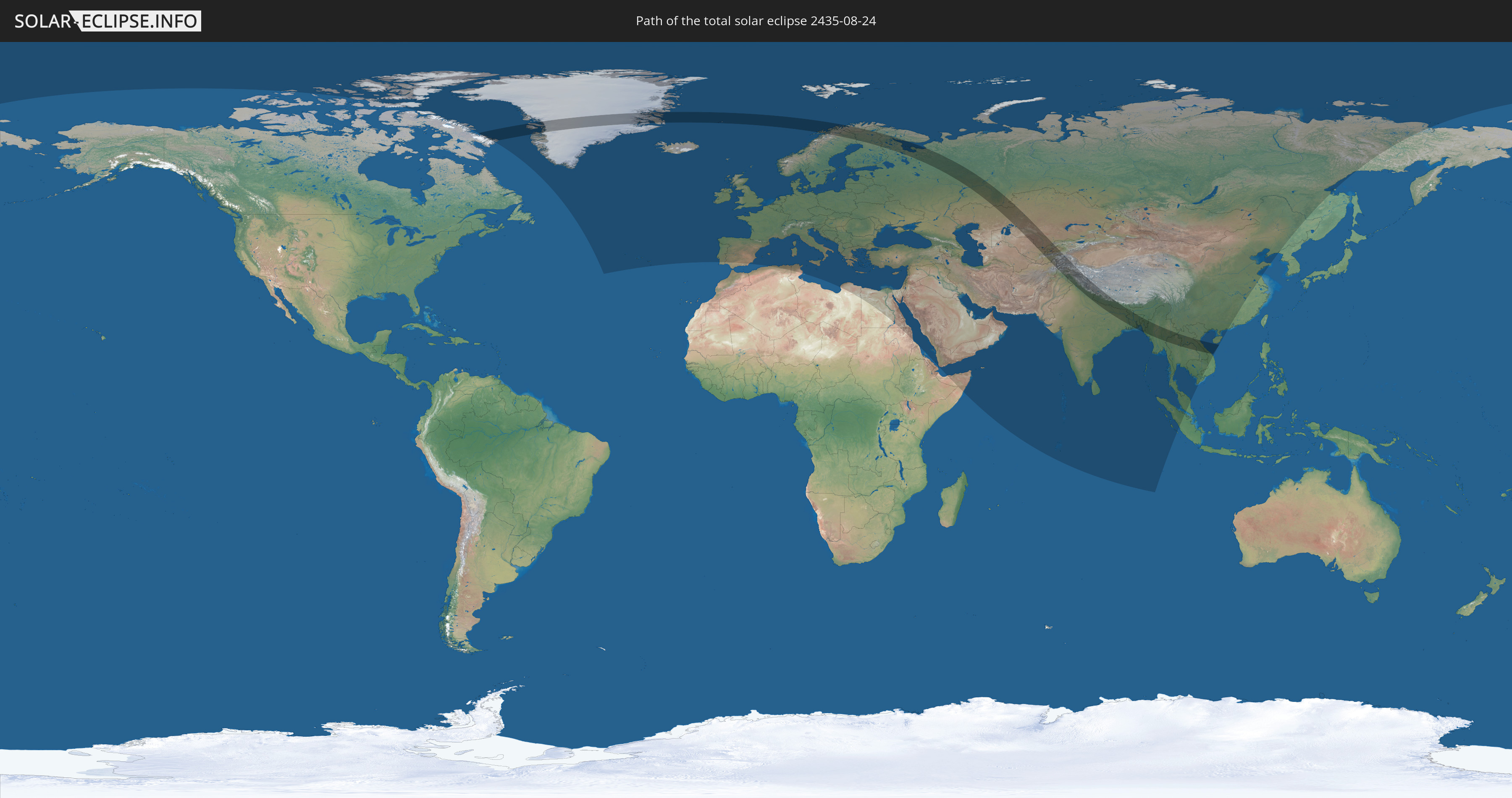
Die Sonnenfinsternis am 08/24/2435 kann man in 102 Ländern als partielle Sonnenfinsternis beobachten.
Der Finsternispfad verläuft durch 21 Länder. Nur in diesen Ländern ist sie als total Sonnenfinsternis zu sehen.
In den folgenden Ländern ist die Sonnenfinsternis total zu sehen
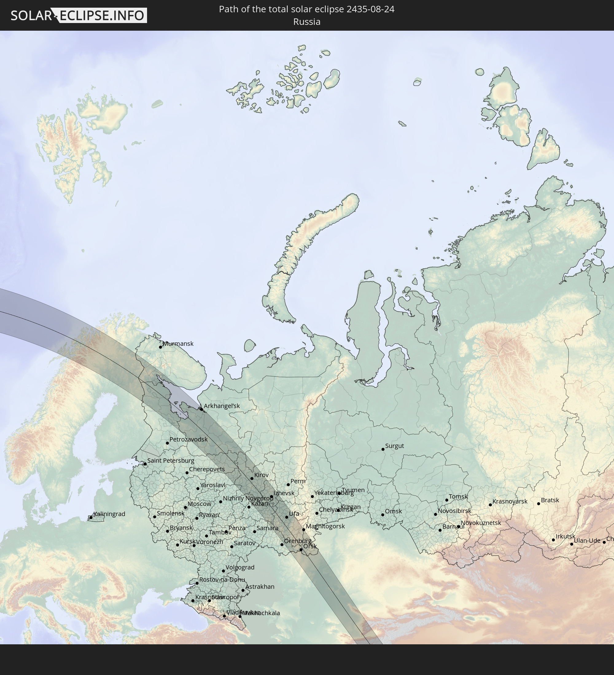 Russia
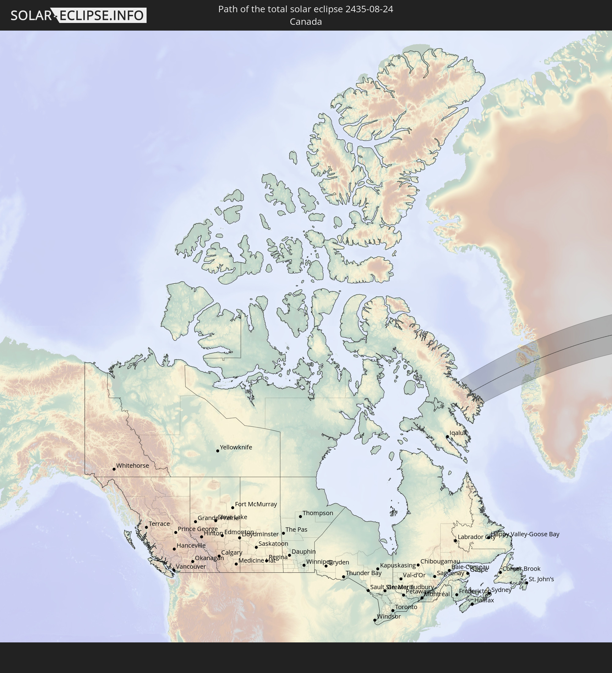 Canada
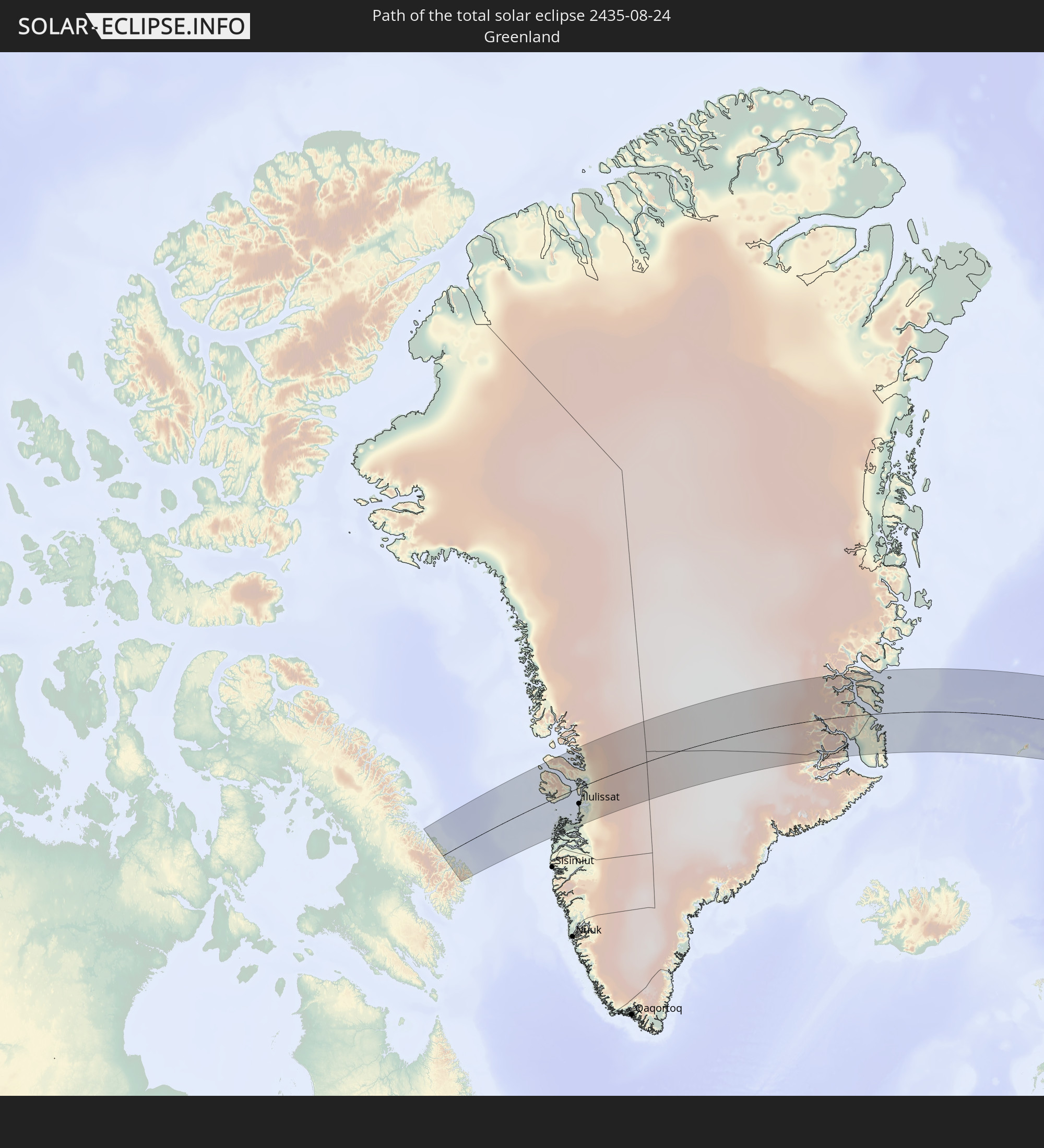 Greenland
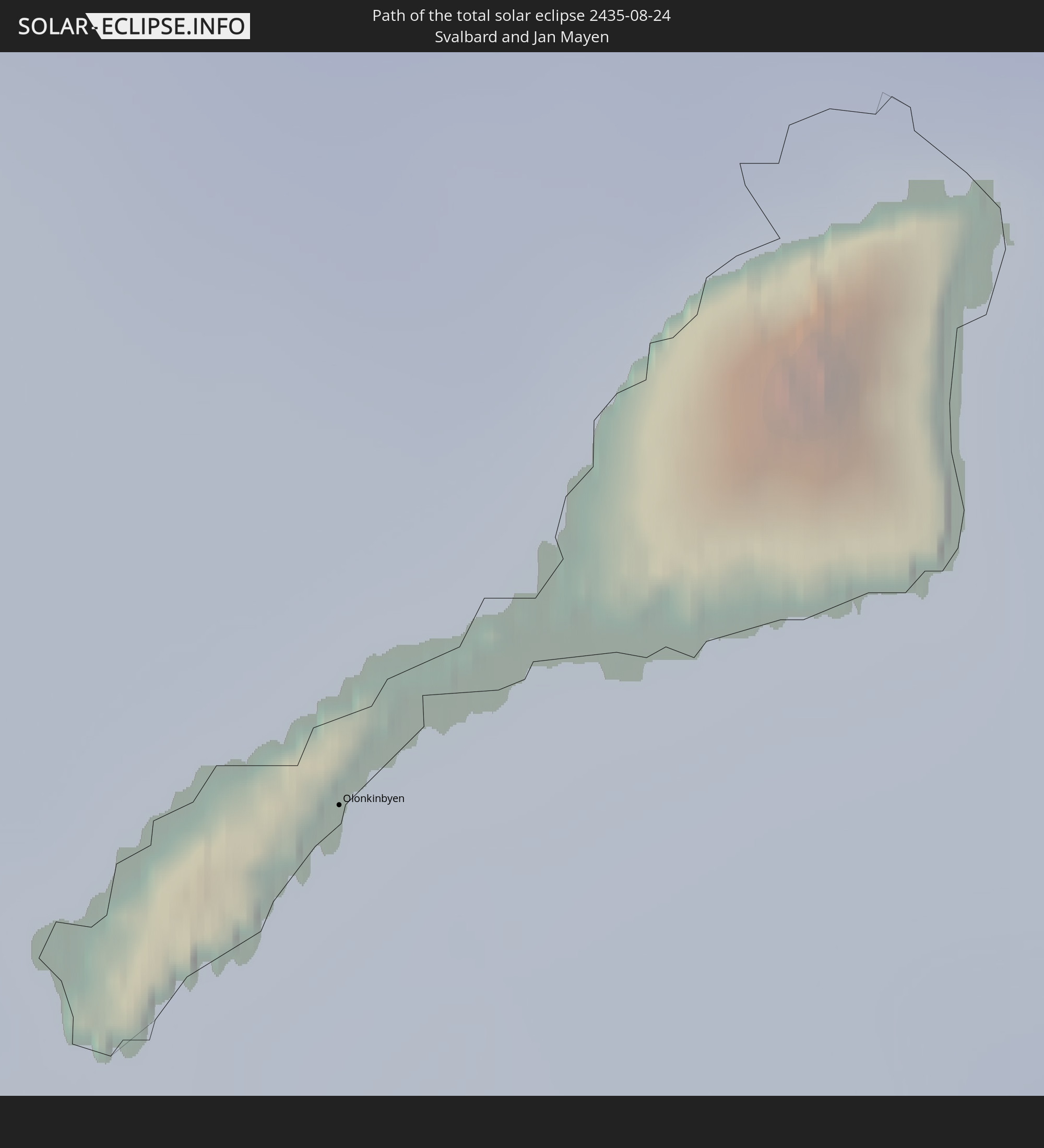 Svalbard and Jan Mayen
 Norway
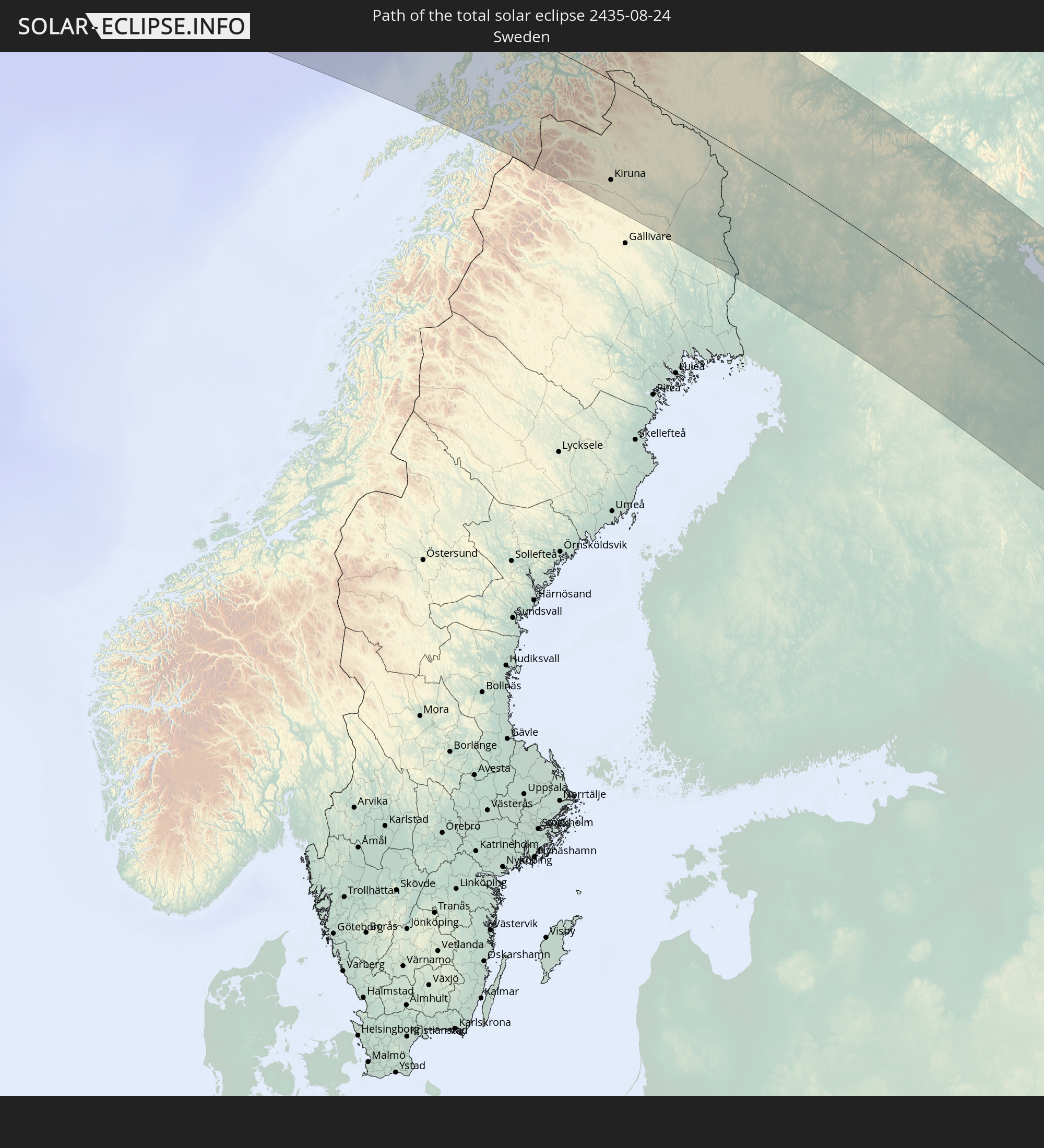 Sweden
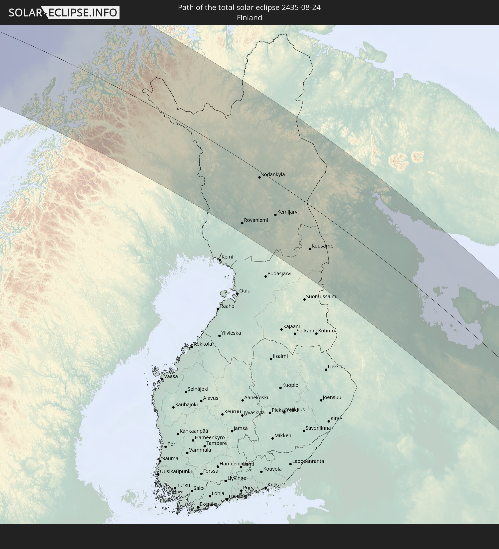 Finland
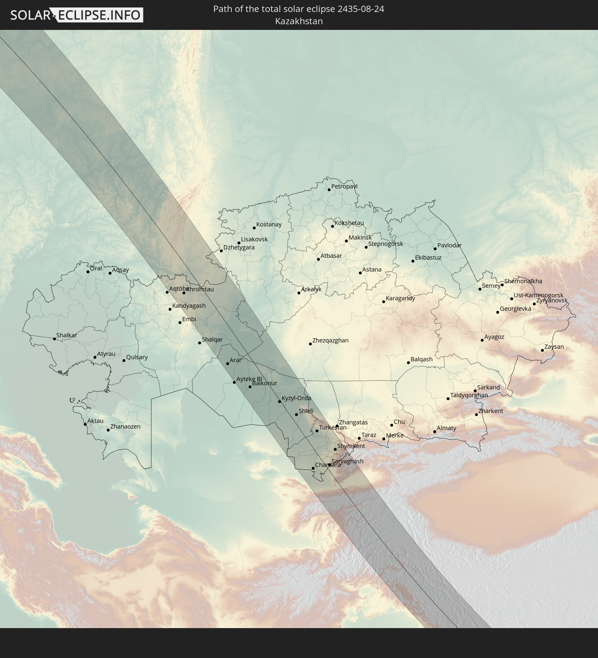 Kazakhstan
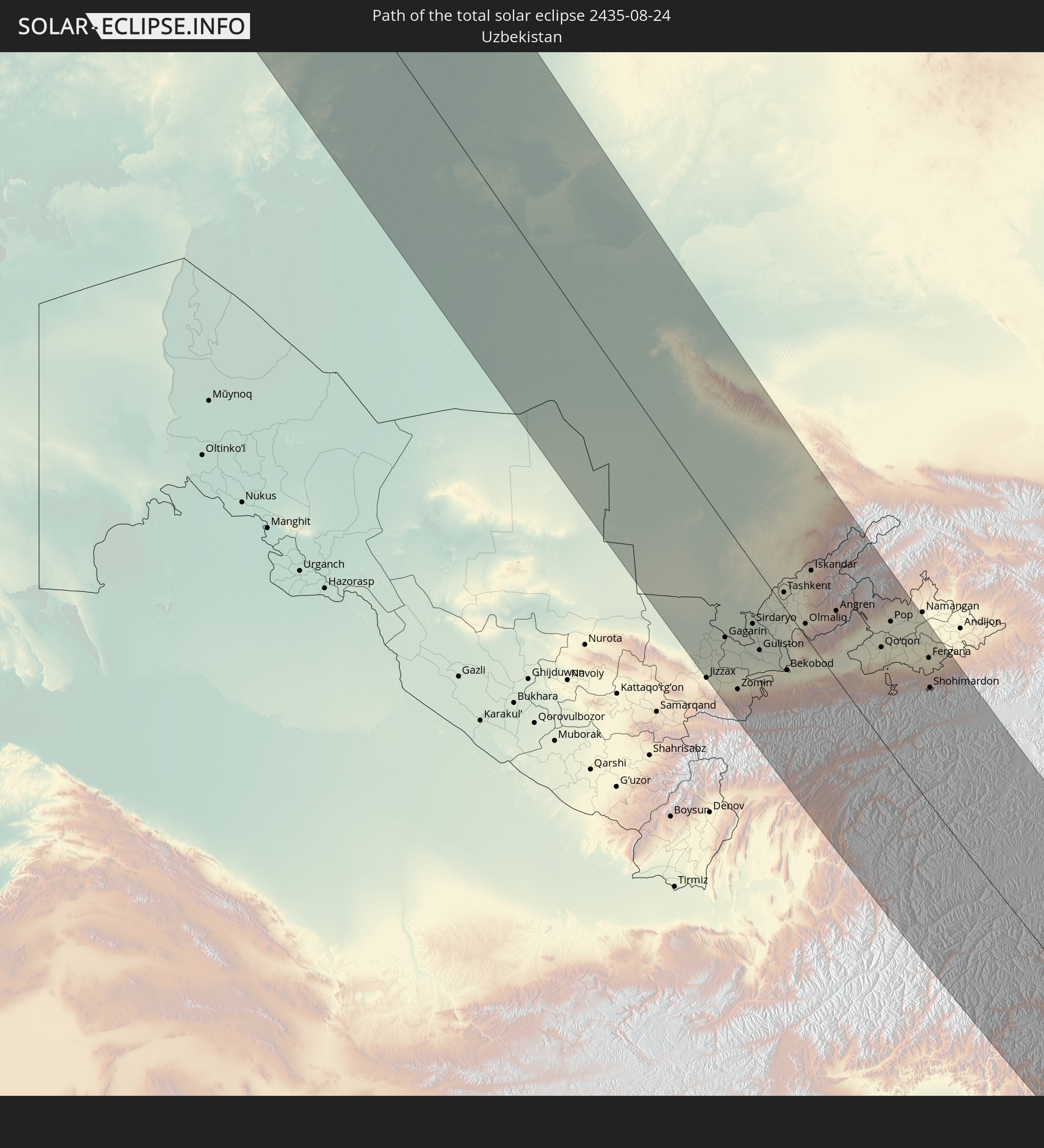 Uzbekistan
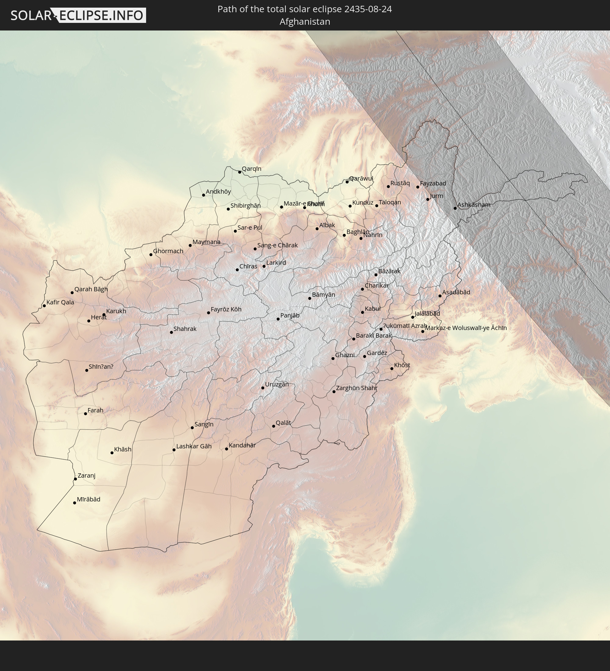 Afghanistan
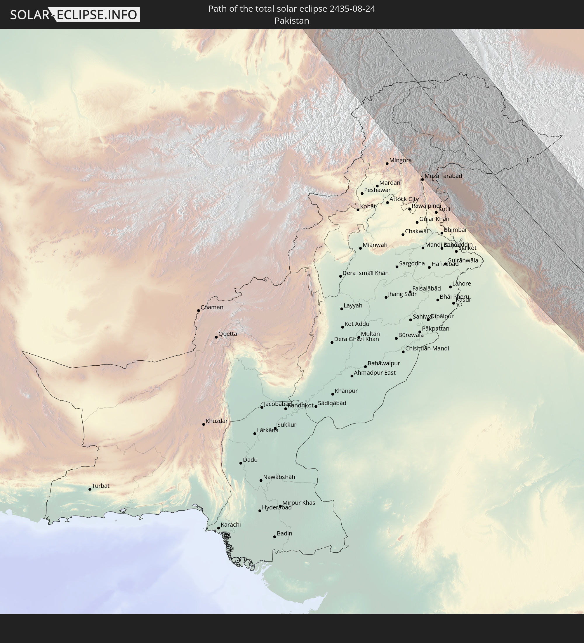 Pakistan
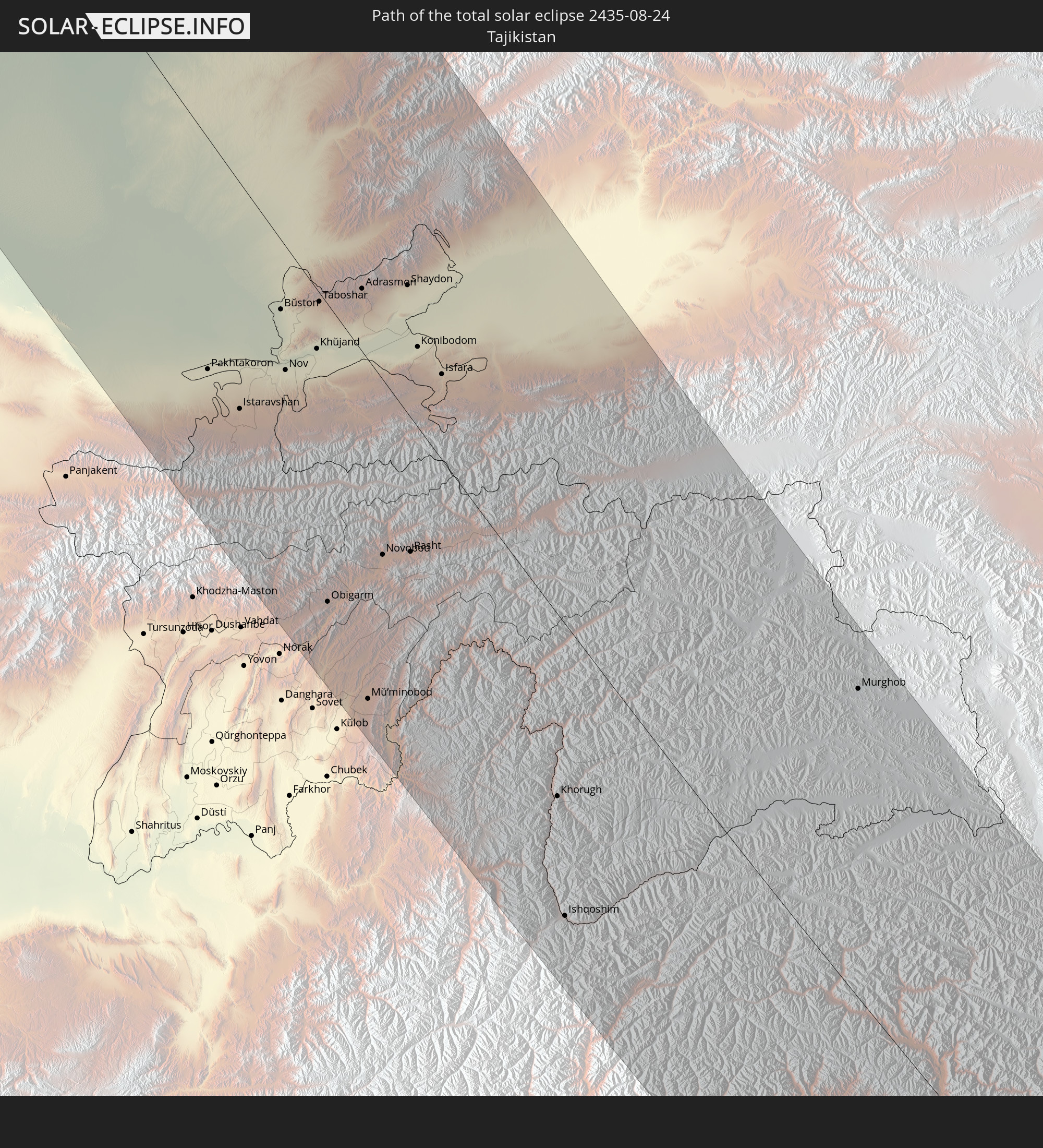 Tajikistan
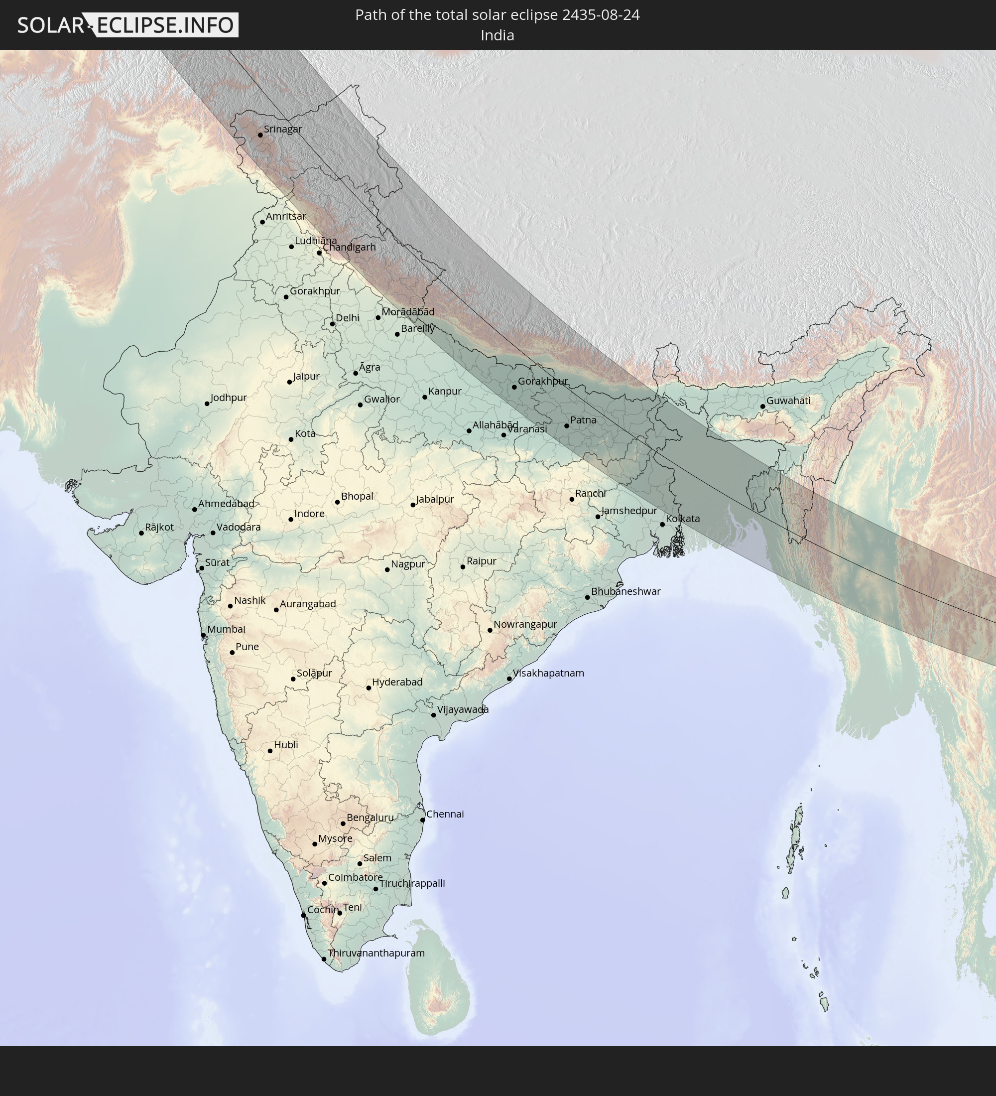 India
India
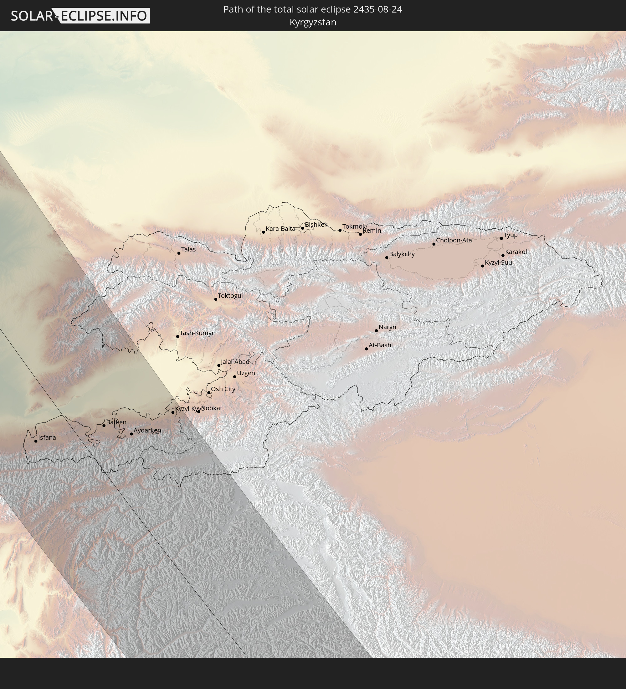 Kyrgyzstan
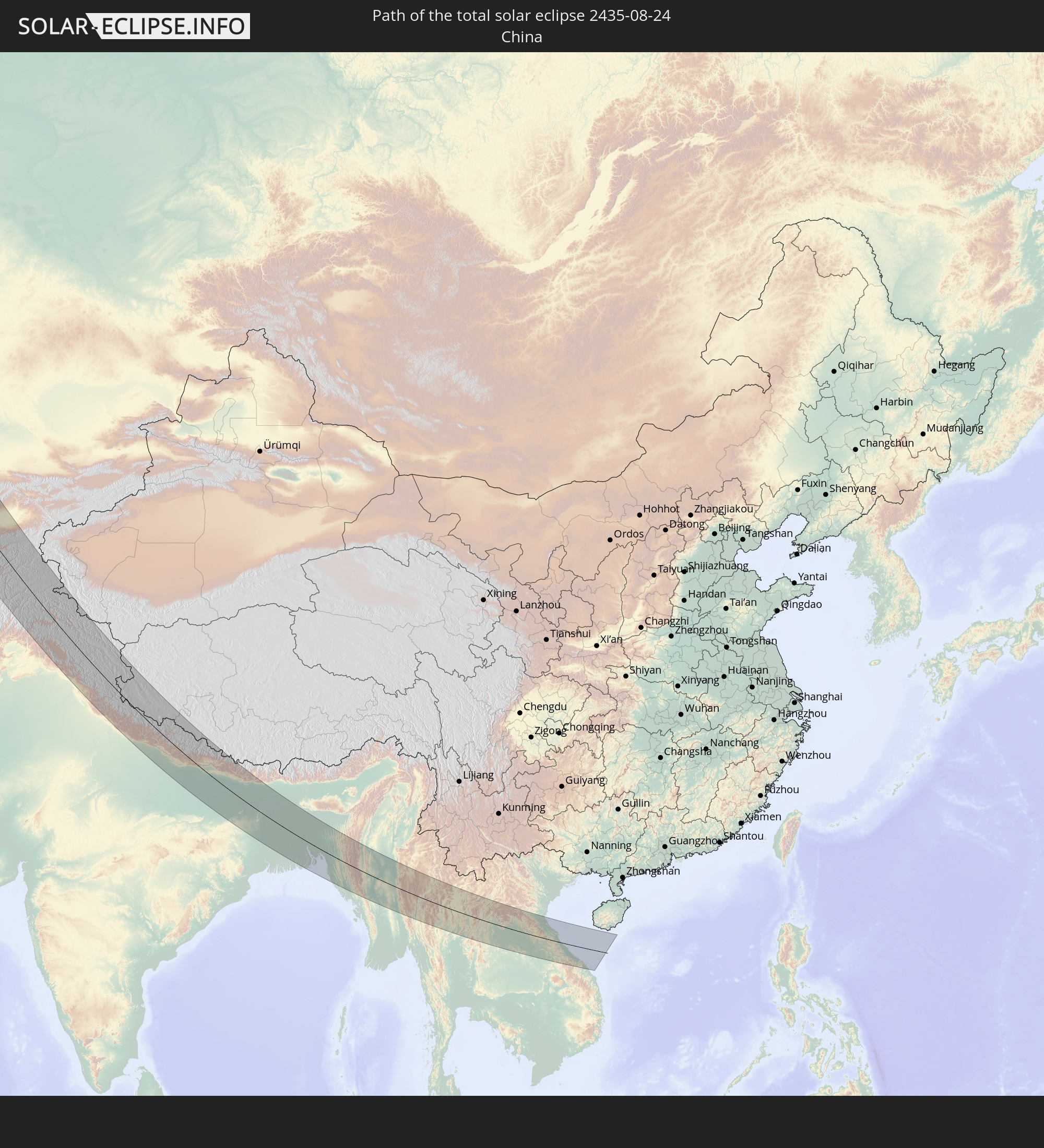 China
China
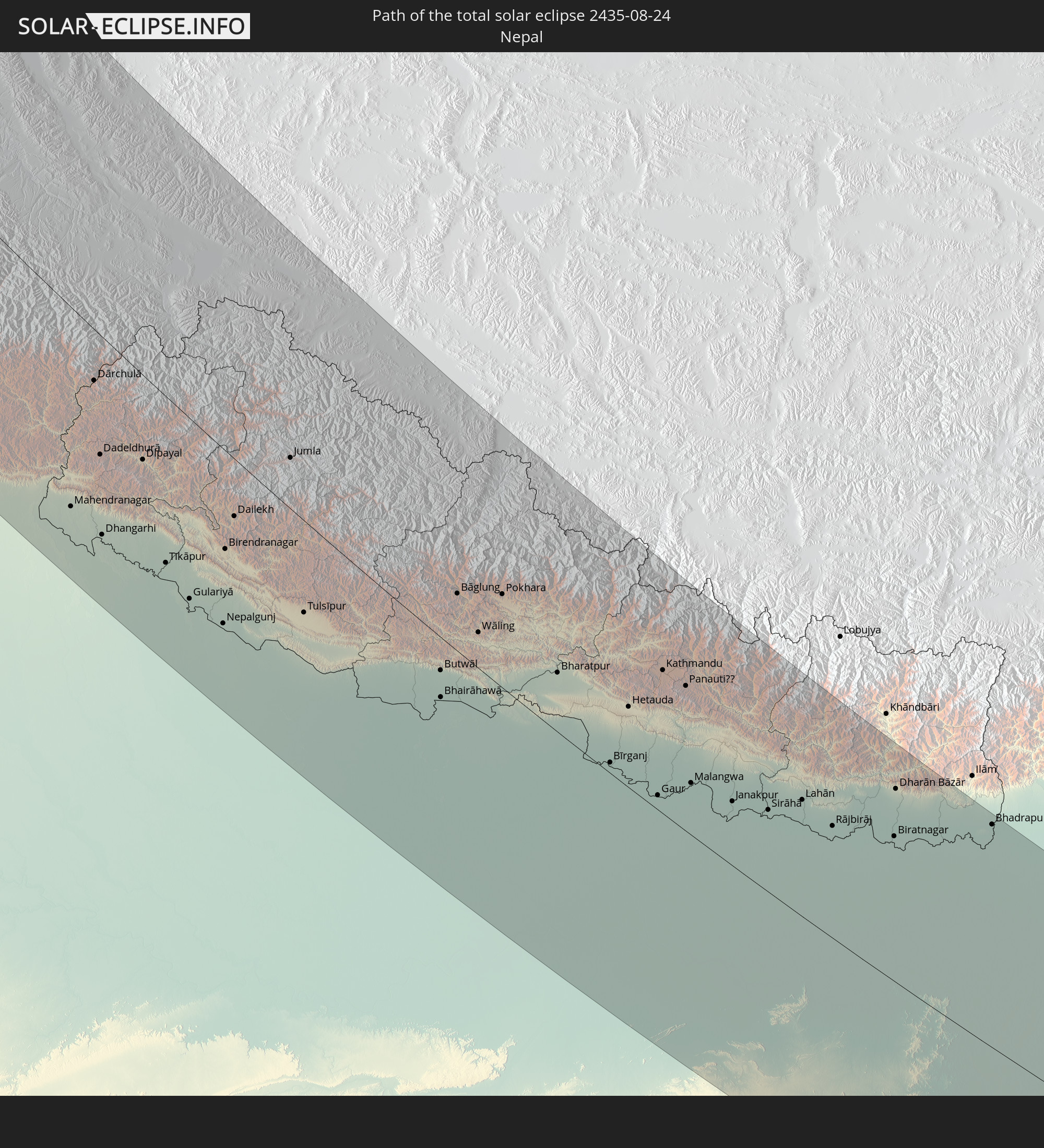 Nepal
Nepal
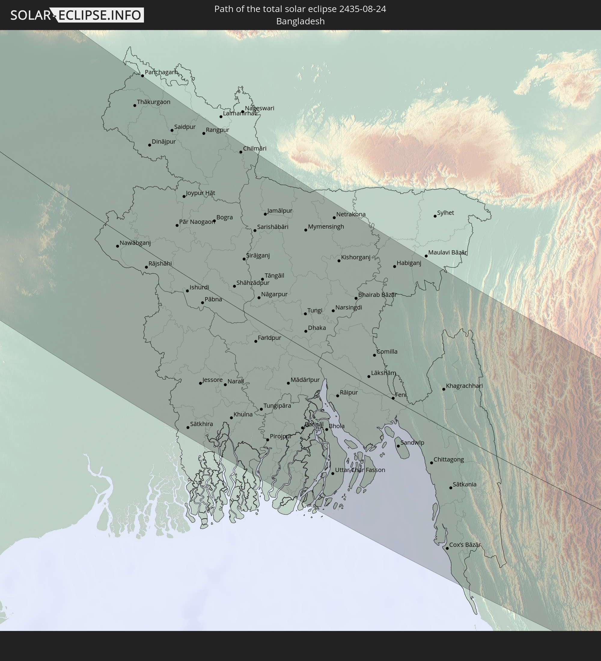 Bangladesh
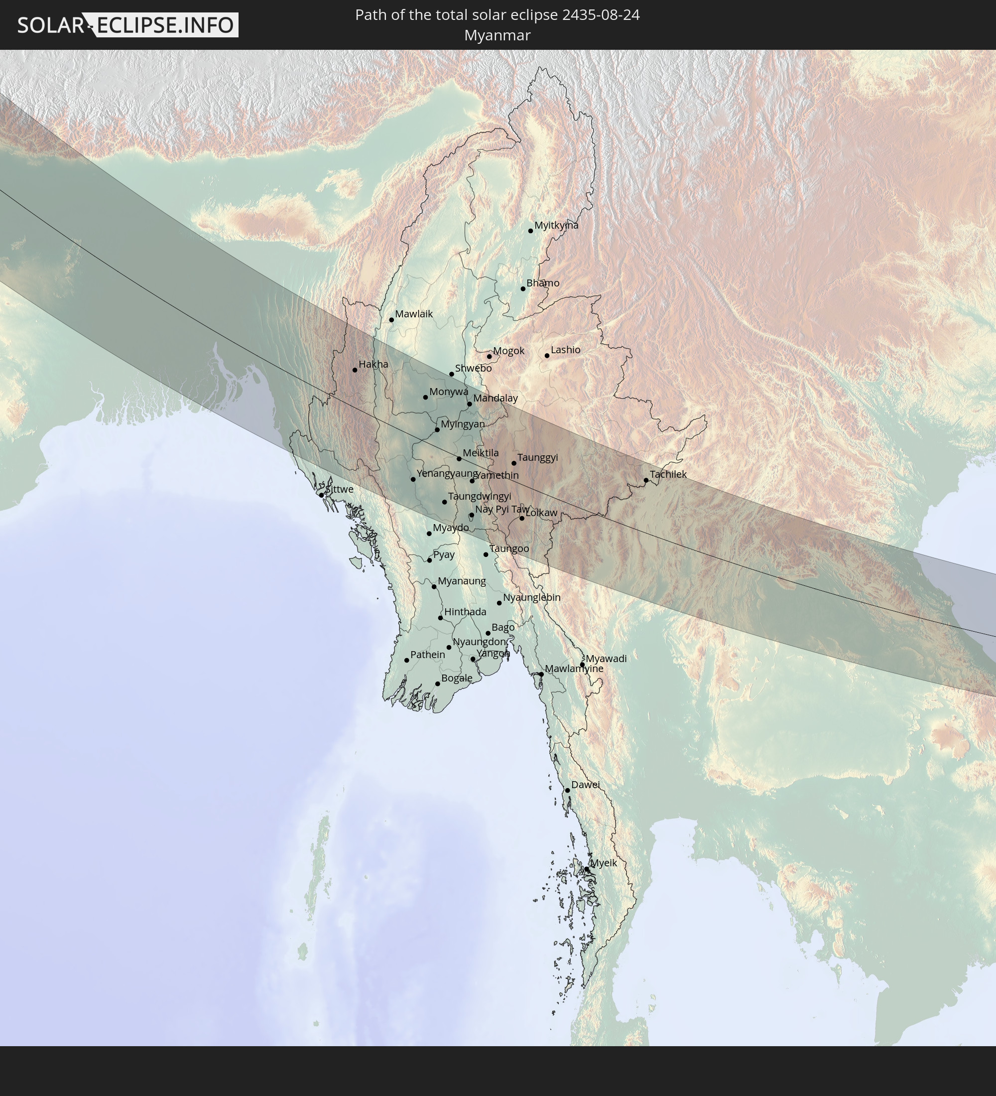 Myanmar
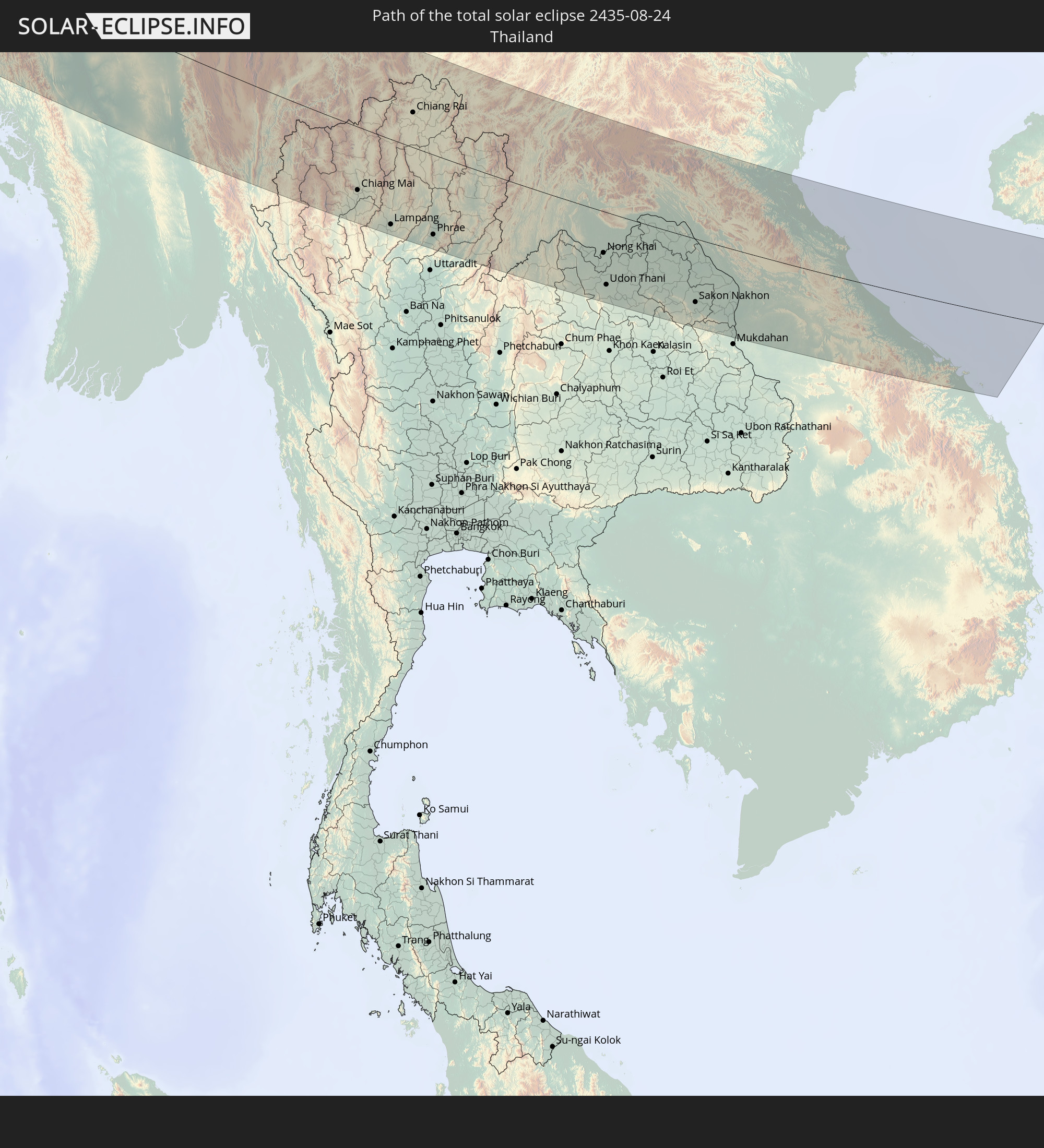 Thailand
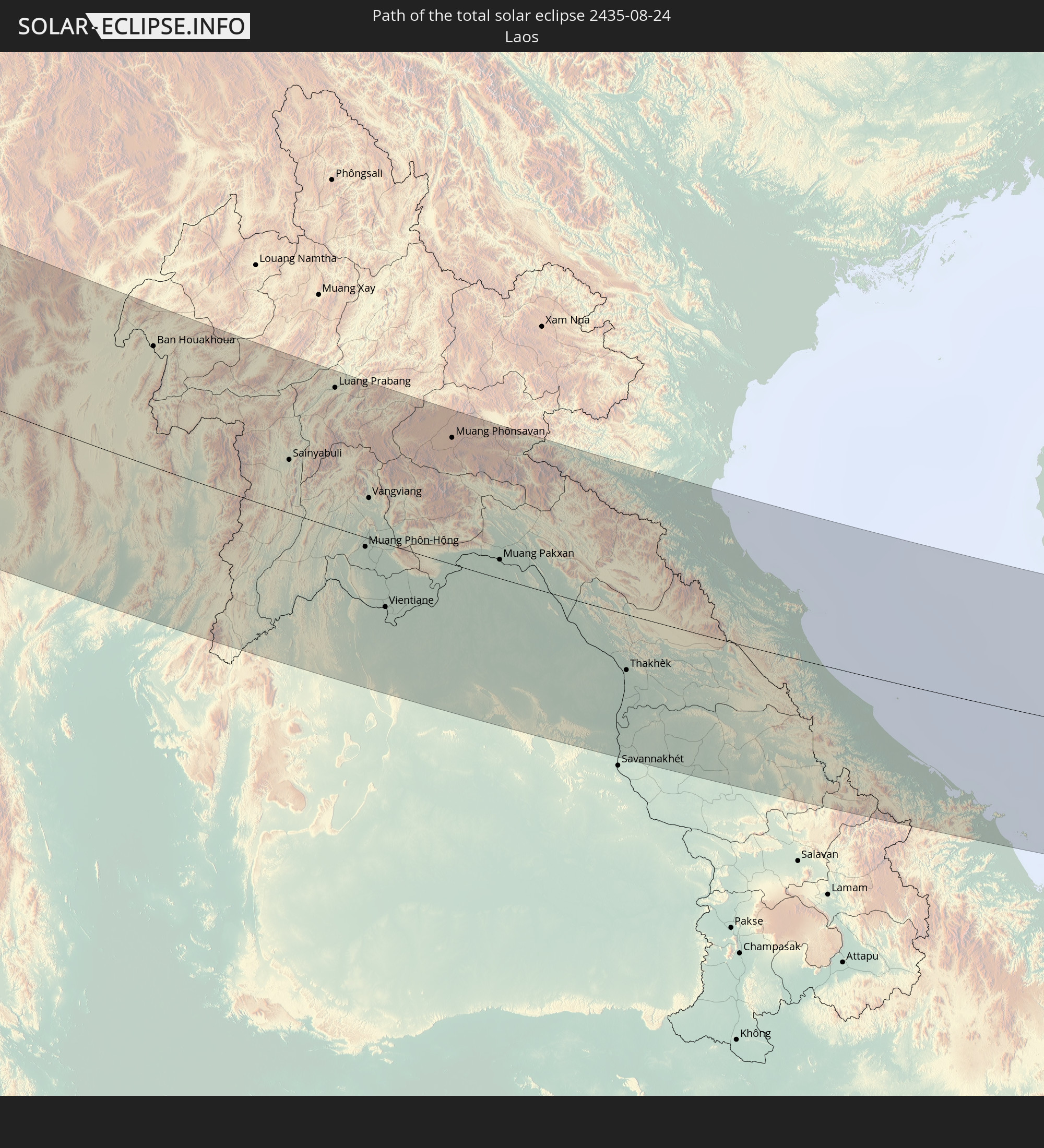 Laos
Laos
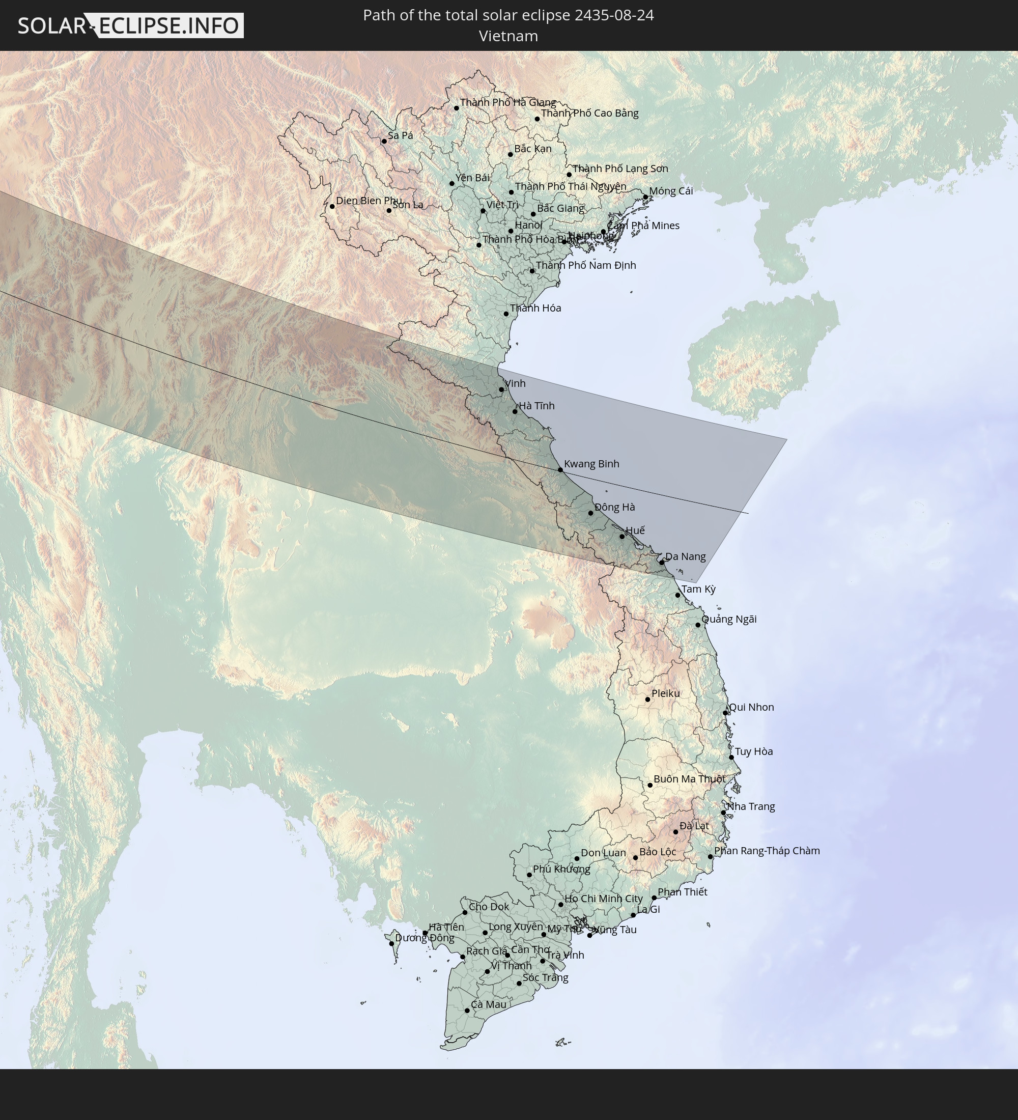 Vietnam
In den folgenden Ländern ist die Sonnenfinsternis partiell zu sehen
 Russia
 Canada
 Greenland
 Portugal
 Iceland
 Spain
Spain
 Republic of Ireland
 Svalbard and Jan Mayen
 Algeria
 United Kingdom
 Faroe Islands
 France
 Isle of Man
 Guernsey
 Jersey
 Andorra
 Belgium
 Netherlands
 Norway
 Luxembourg
 Germany
 Switzerland
 Italy
Italy
 Monaco
 Tunisia
 Denmark
 Libya
Libya
 Liechtenstein
 Austria
 Sweden
 Czechia
 San Marino
 Vatican City
 Slovenia
 Croatia
 Poland
 Malta
Malta
 Bosnia and Herzegovina
 Hungary
 Slovakia
 Montenegro
 Serbia
 Albania
 Åland Islands
 Greece
 Romania
 Republic of Macedonia
 Finland
 Lithuania
 Latvia
 Estonia
 Sudan
Sudan
 Ukraine
 Bulgaria
 Belarus
 Egypt
Egypt
 Turkey
 Moldova
 Cyprus
 State of Palestine
 Israel
 Saudi Arabia
 Jordan
 Lebanon
 Syria
Syria
 Eritrea
 Iraq
Iraq
 Georgia
 Somalia
 Yemen
Yemen
 Armenia
 Iran
Iran
 Azerbaijan
 Kazakhstan
 Kuwait
 Bahrain
 Qatar
Qatar
 United Arab Emirates
 Oman
Oman
 Turkmenistan
 Uzbekistan
 Afghanistan
 Pakistan
 Tajikistan
 India
India
 Kyrgyzstan
 British Indian Ocean Territory
 Maldives
 China
China
 Sri Lanka
 Nepal
Nepal
 Mongolia
 Bangladesh
 Bhutan
 Myanmar
 Indonesia
 Thailand
 Malaysia
 Laos
Laos
 Vietnam
 Cambodia
 North Korea
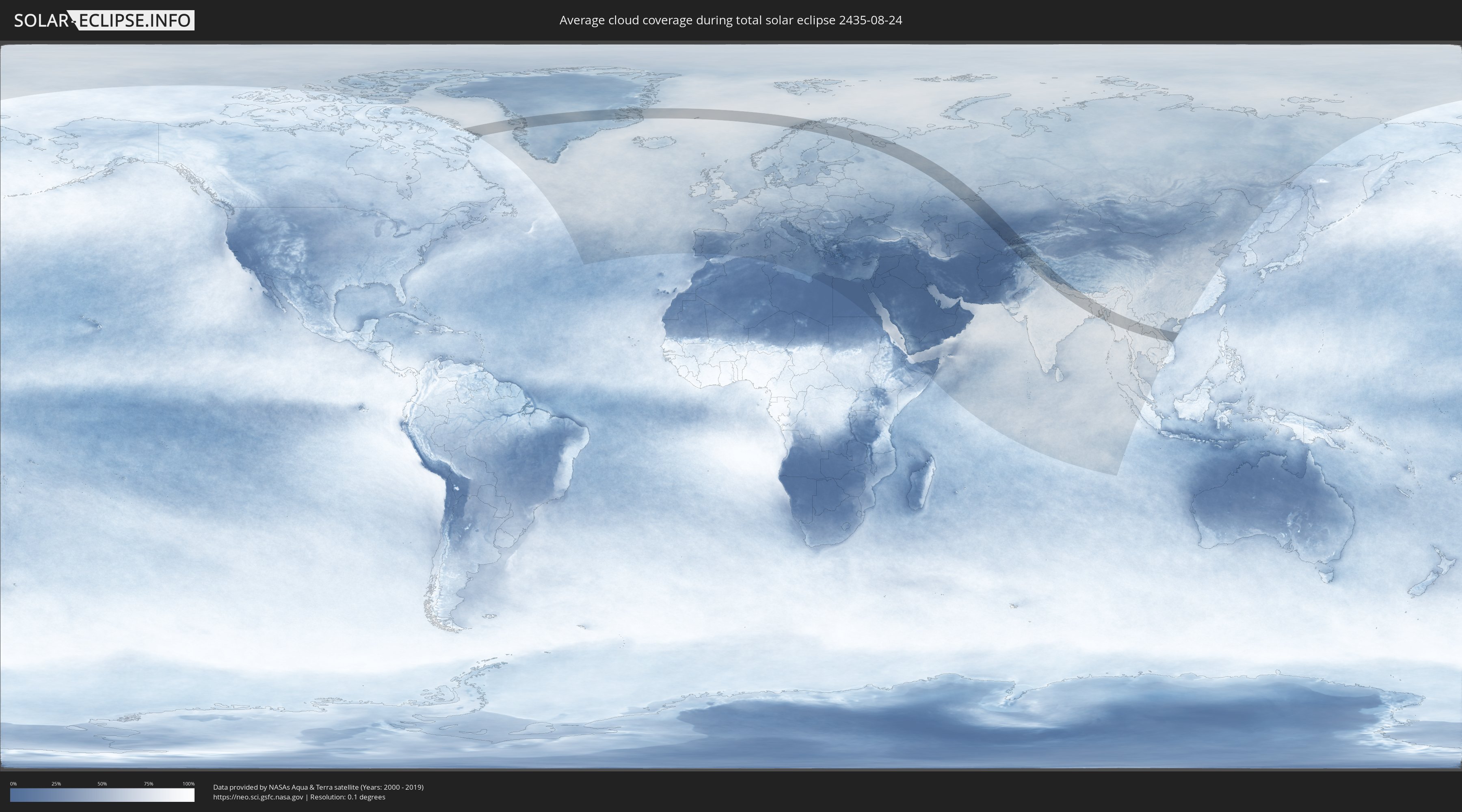
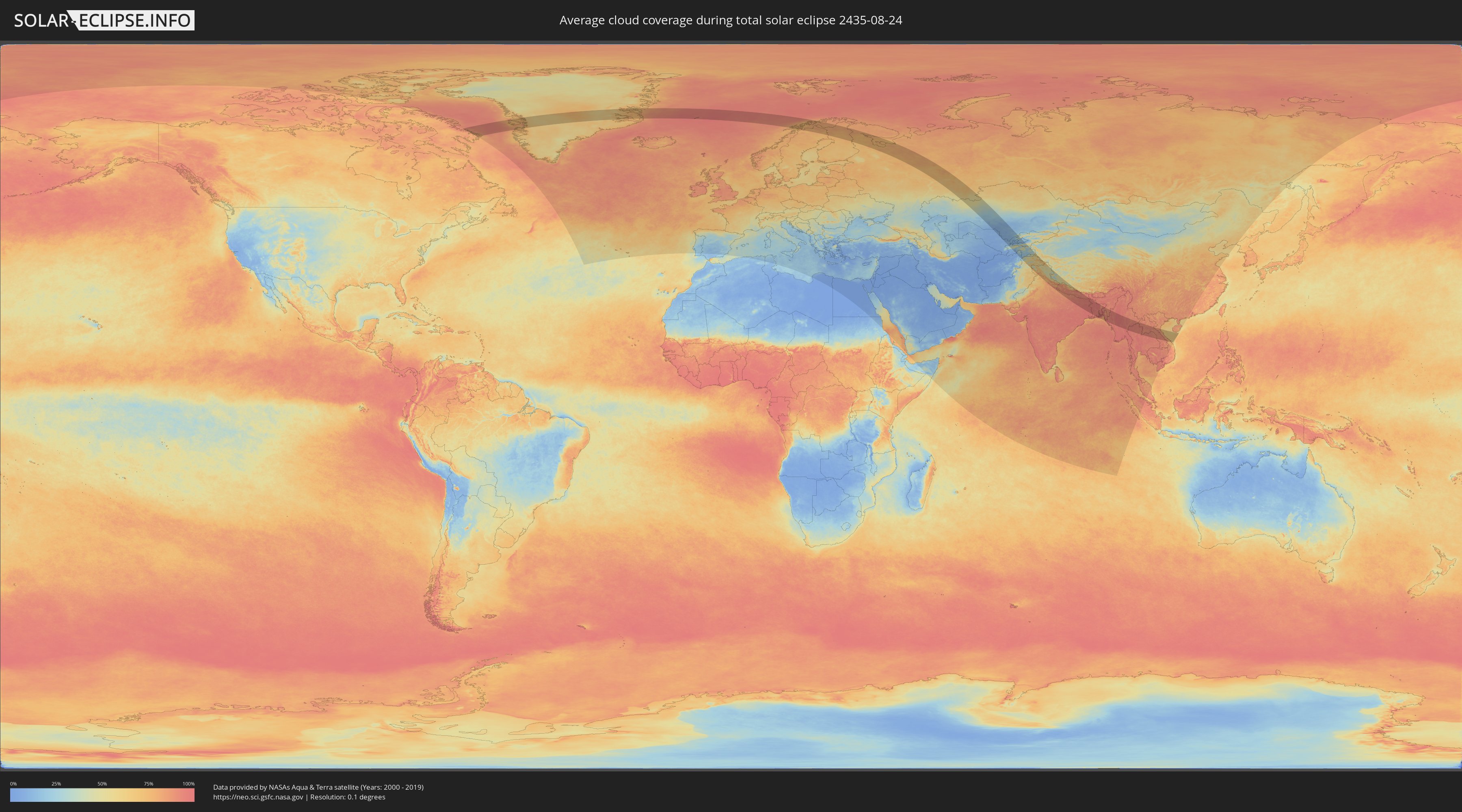
How will be the weather during the total solar eclipse on 08/24/2435?
Where is the best place to see the total solar eclipse of 08/24/2435?
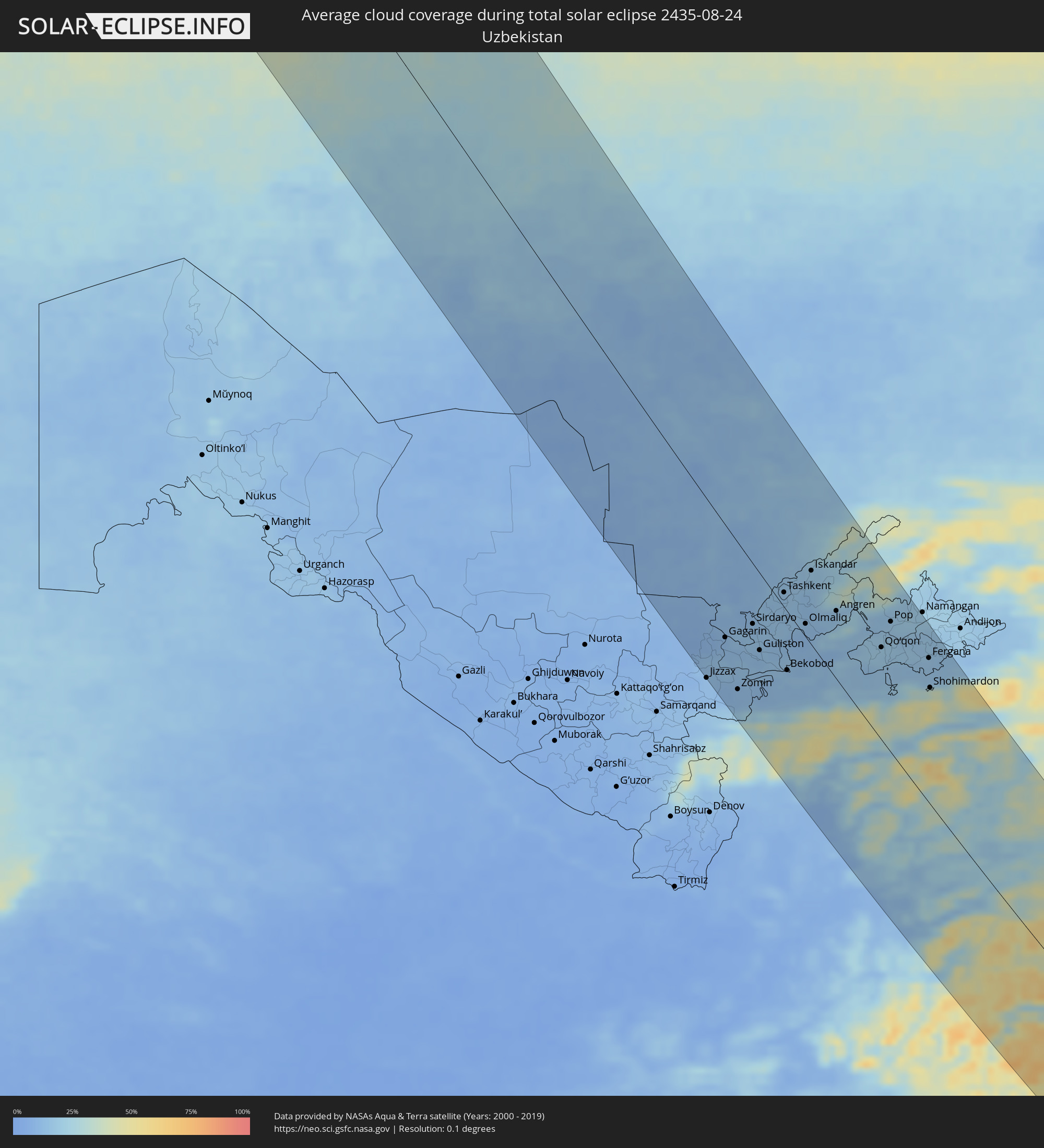
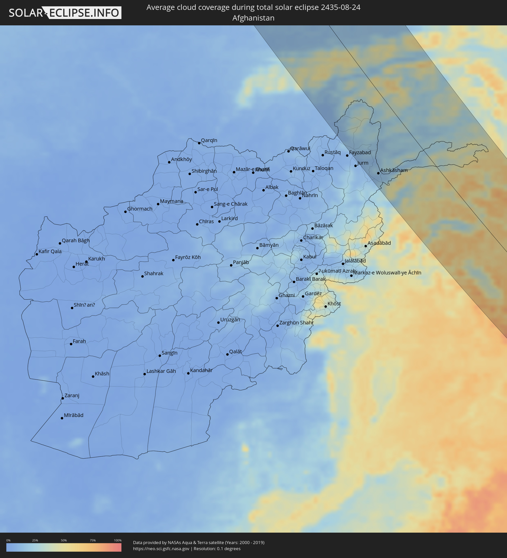
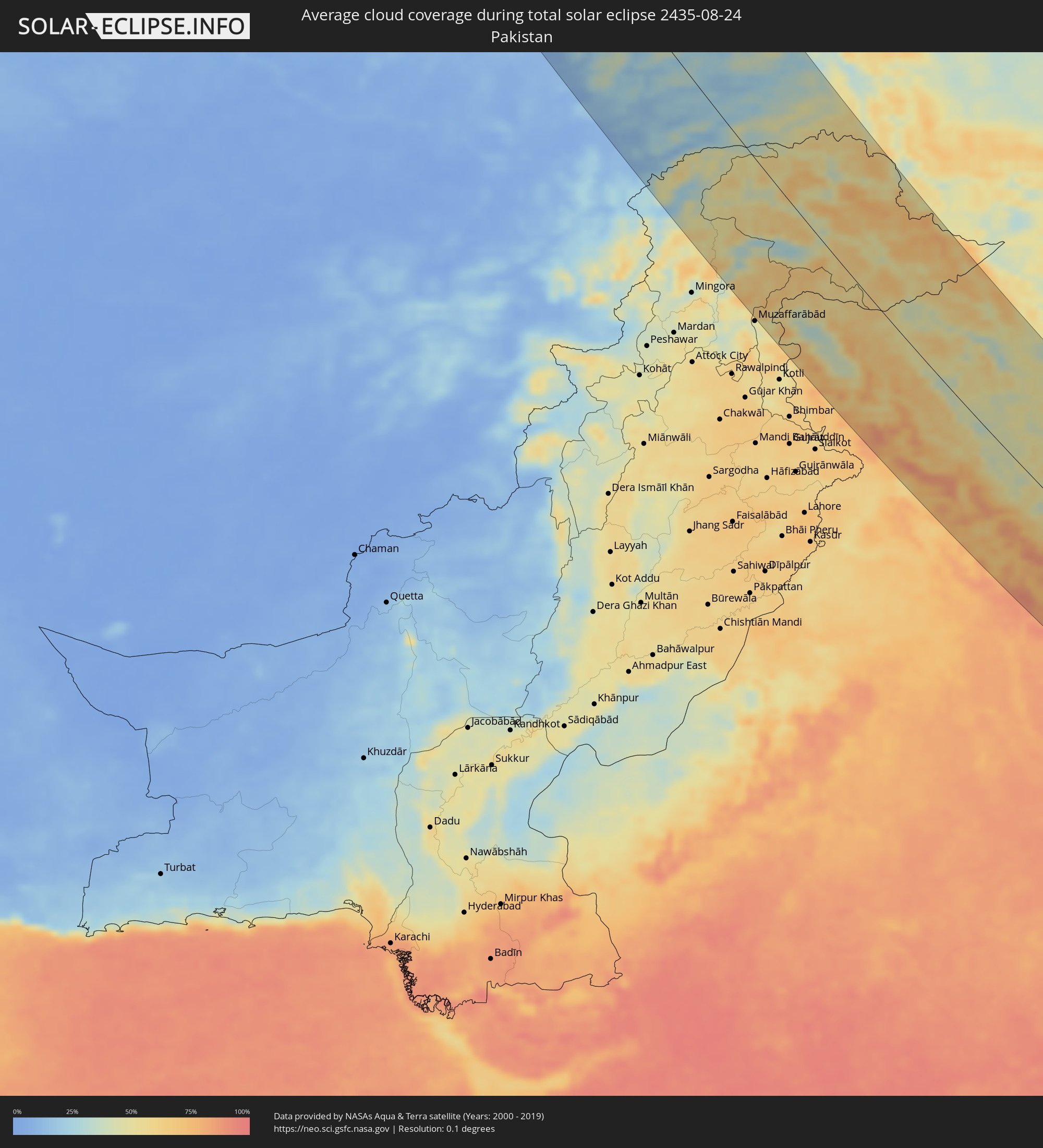
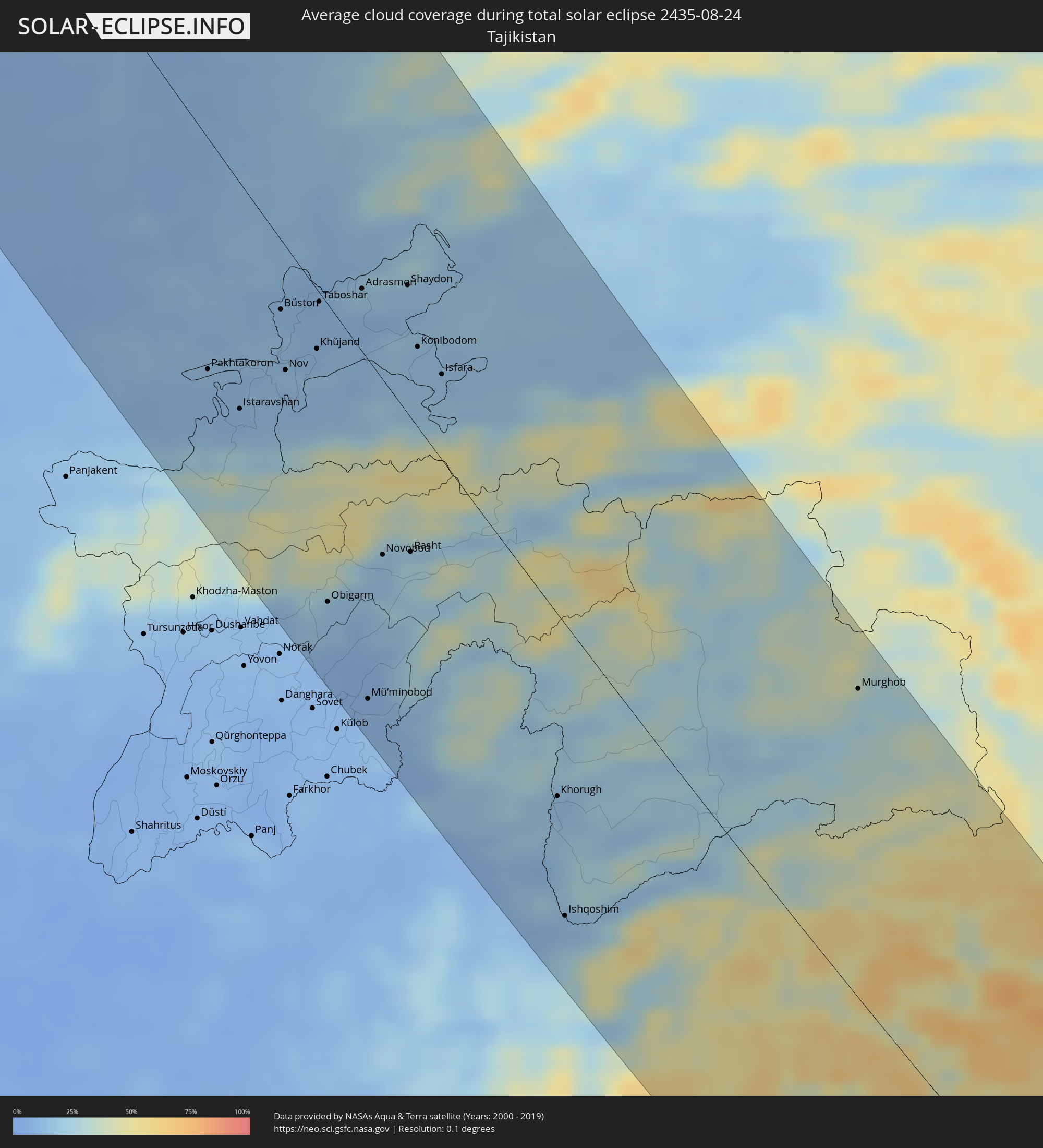
The following maps show the average cloud coverage for the day of the total solar eclipse.
With the help of these maps, it is possible to find the place along the eclipse path, which has the best
chance of a cloudless sky.
Nevertheless, you should consider local circumstances and inform about the weather of your chosen
observation site.
The data is provided by NASAs satellites
AQUA and TERRA.
The cloud maps are averaged over a period of 19 years (2000 - 2019).
Detailed country maps
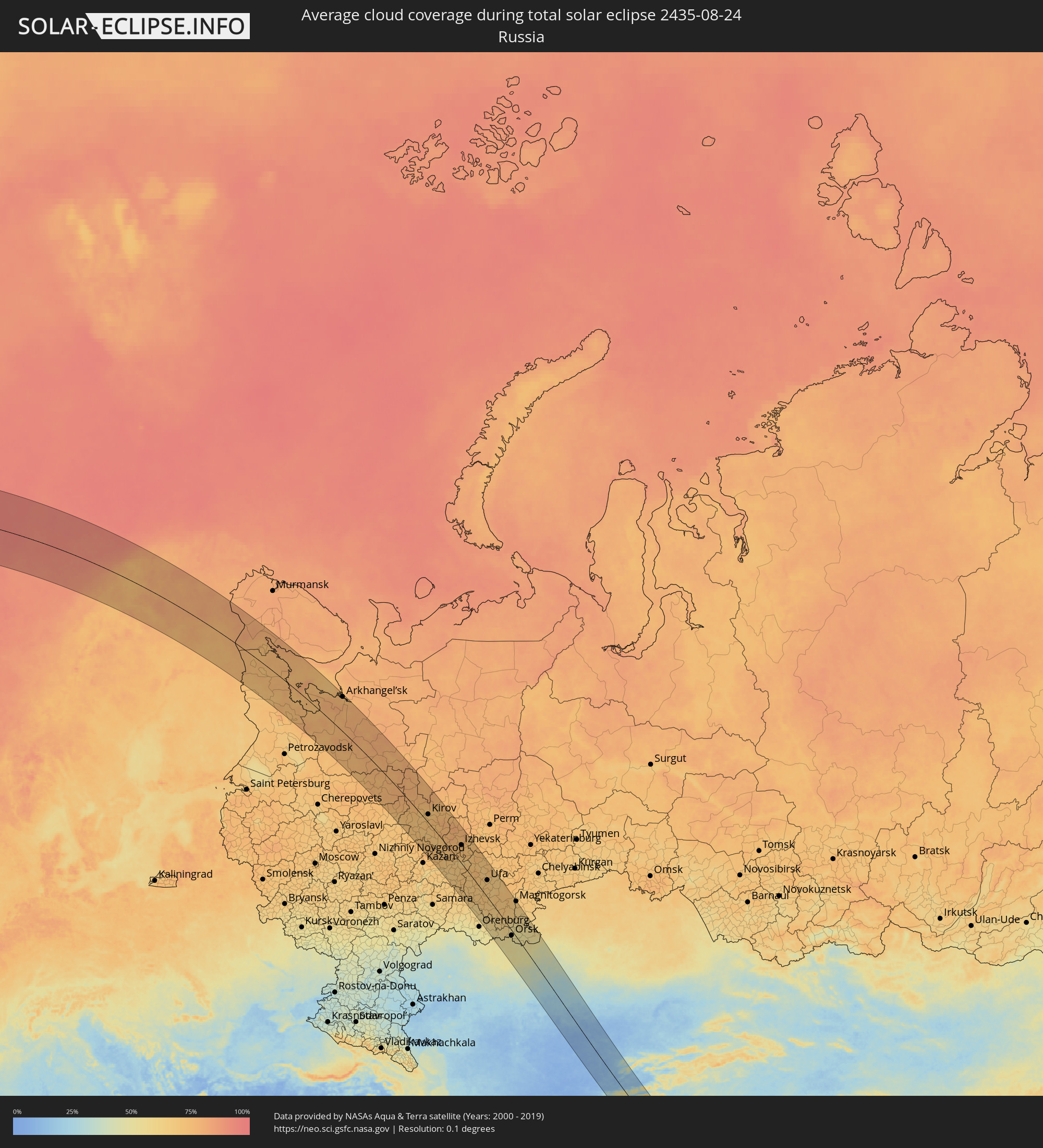 Russia
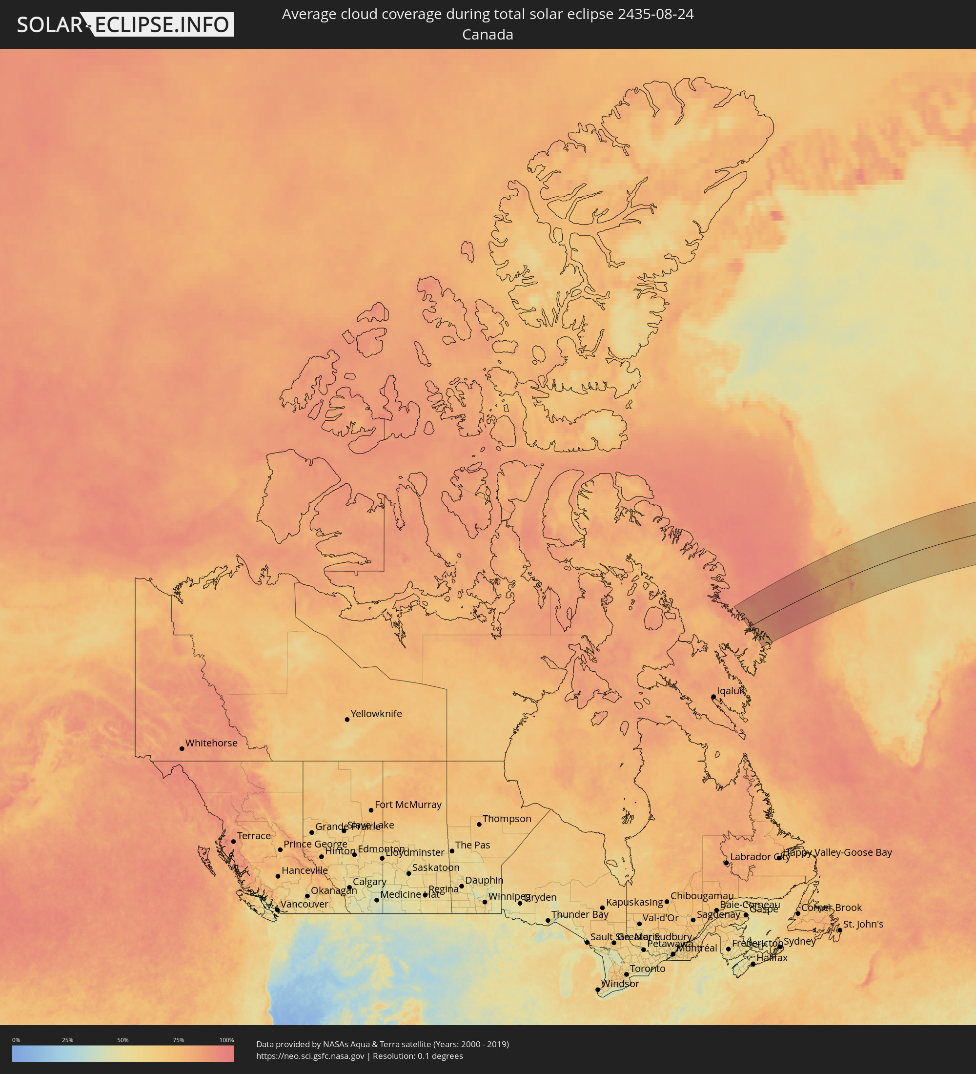 Canada
 Greenland
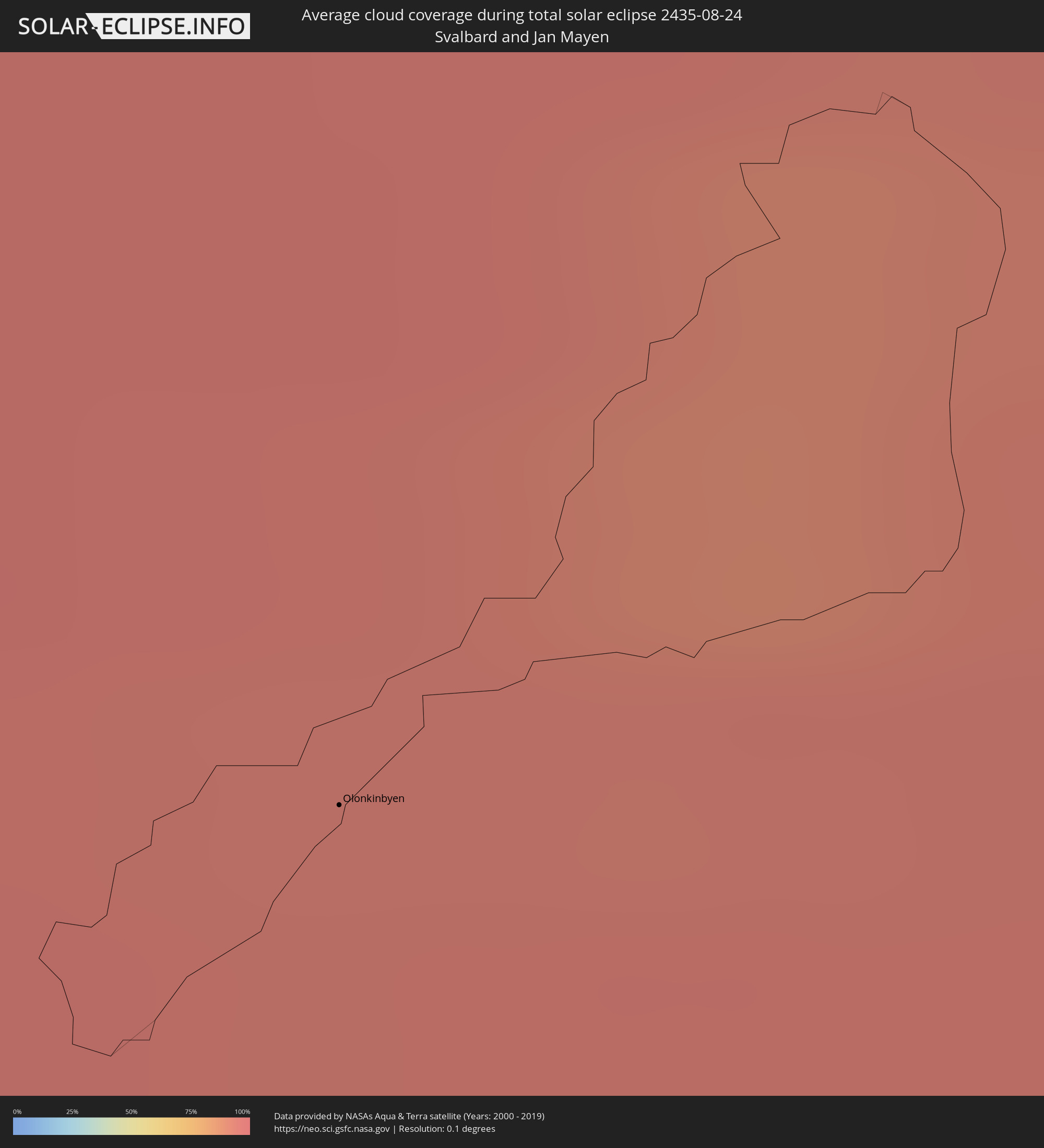 Svalbard and Jan Mayen
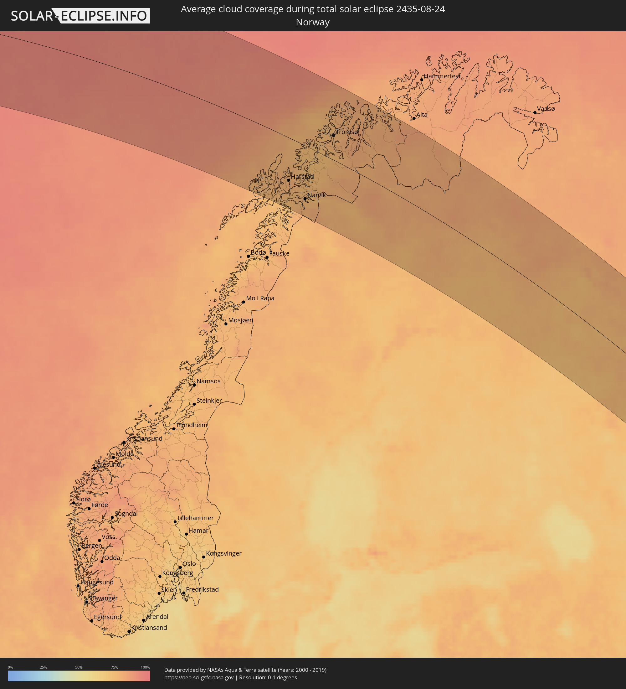 Norway
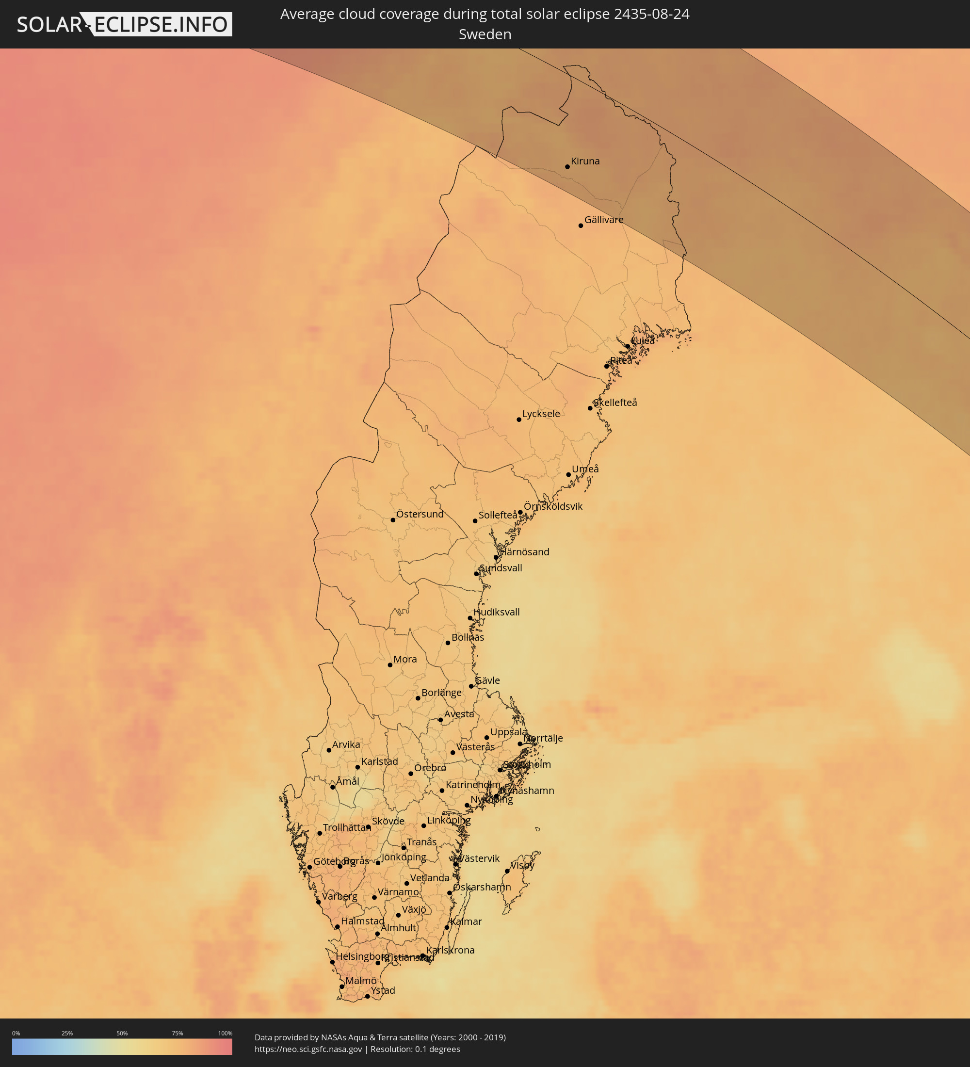 Sweden
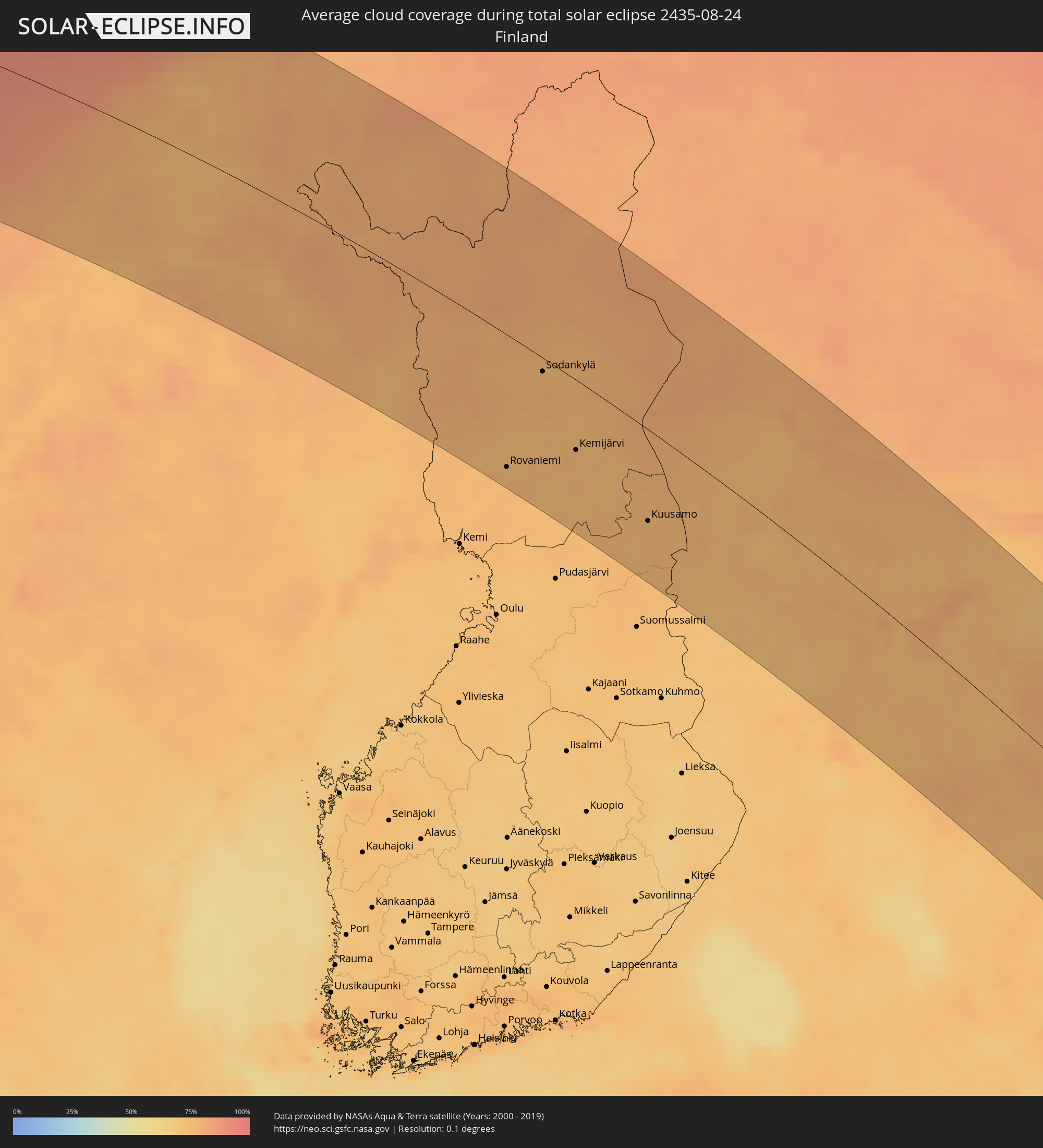 Finland
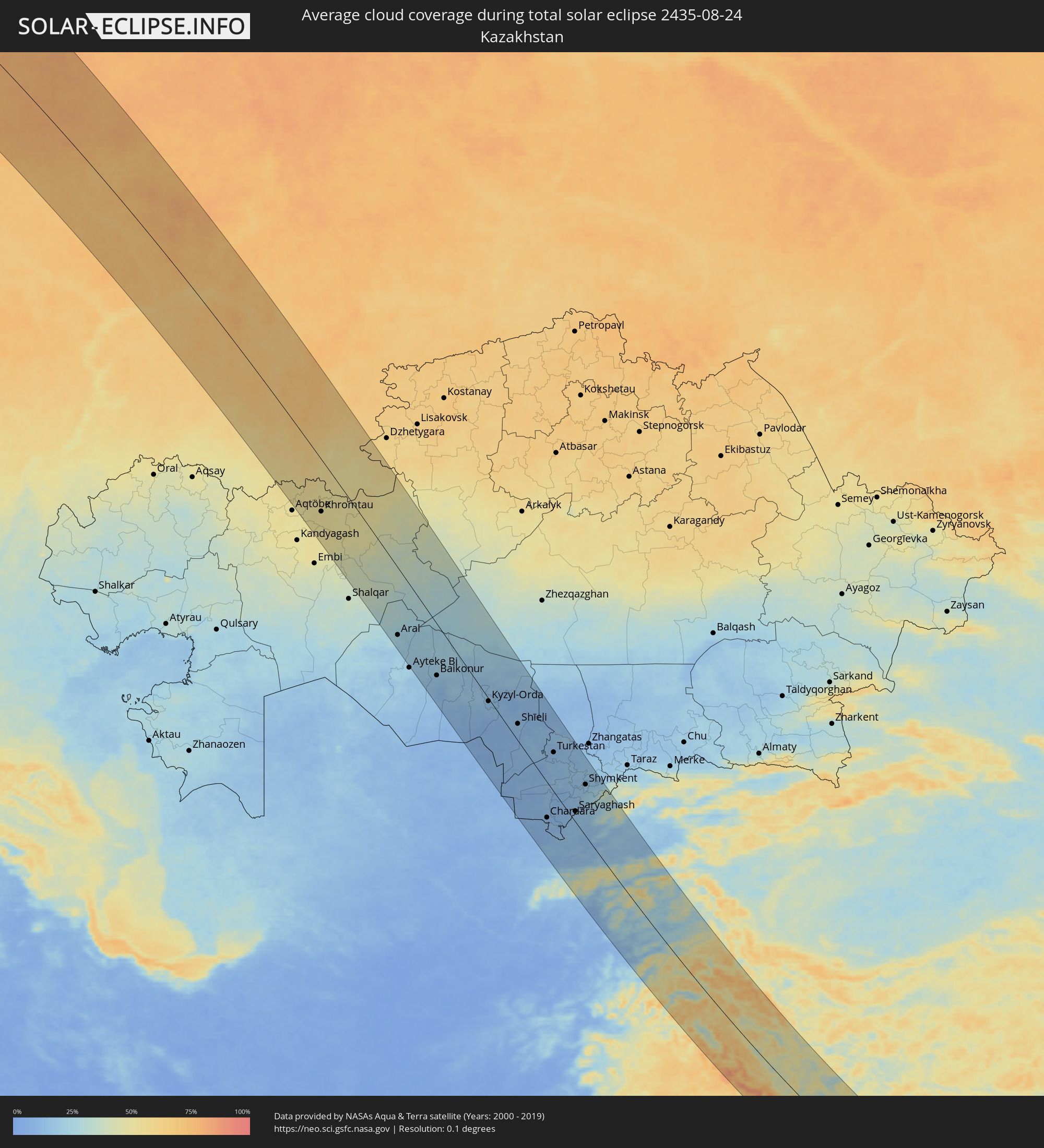 Kazakhstan
 Uzbekistan
 Afghanistan
 Pakistan
 Tajikistan
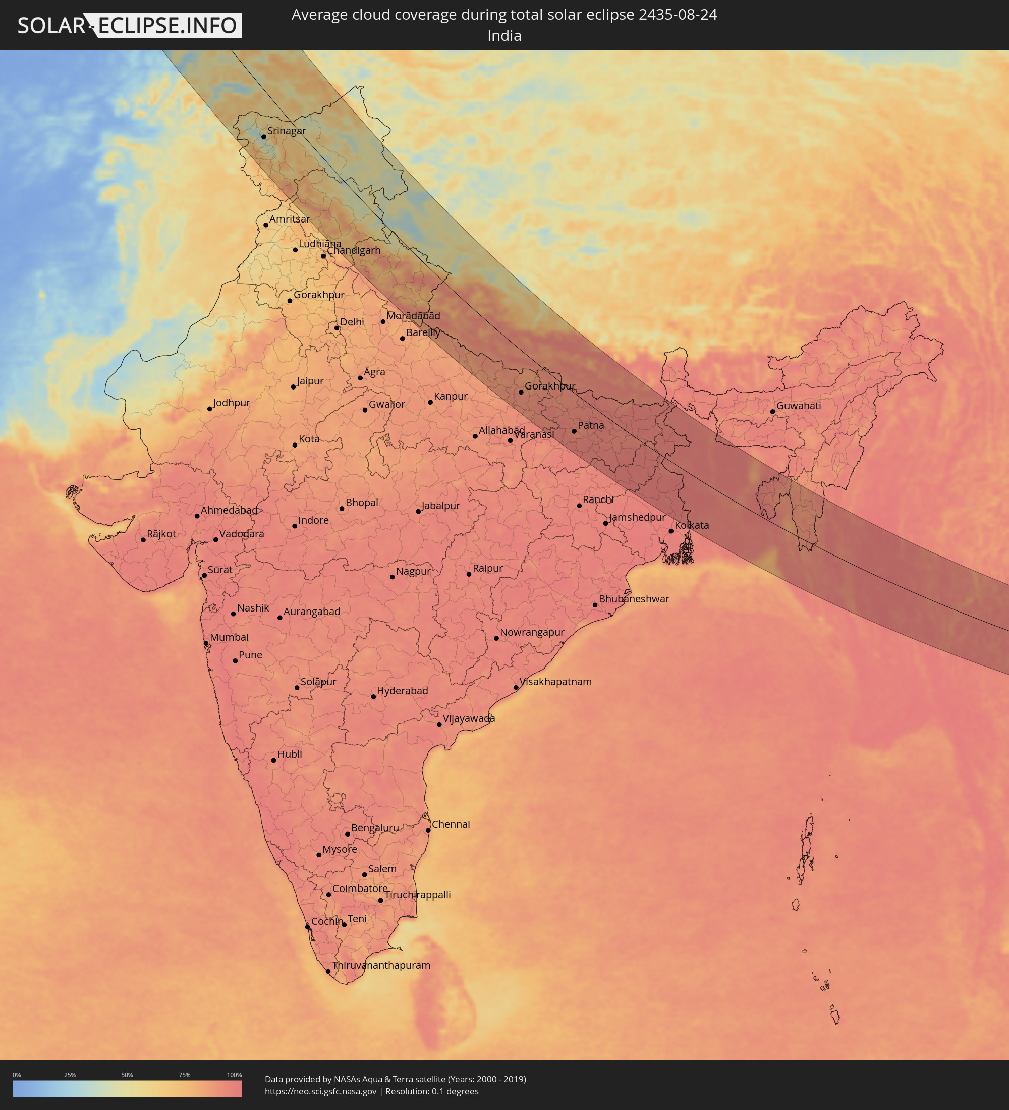 India
India
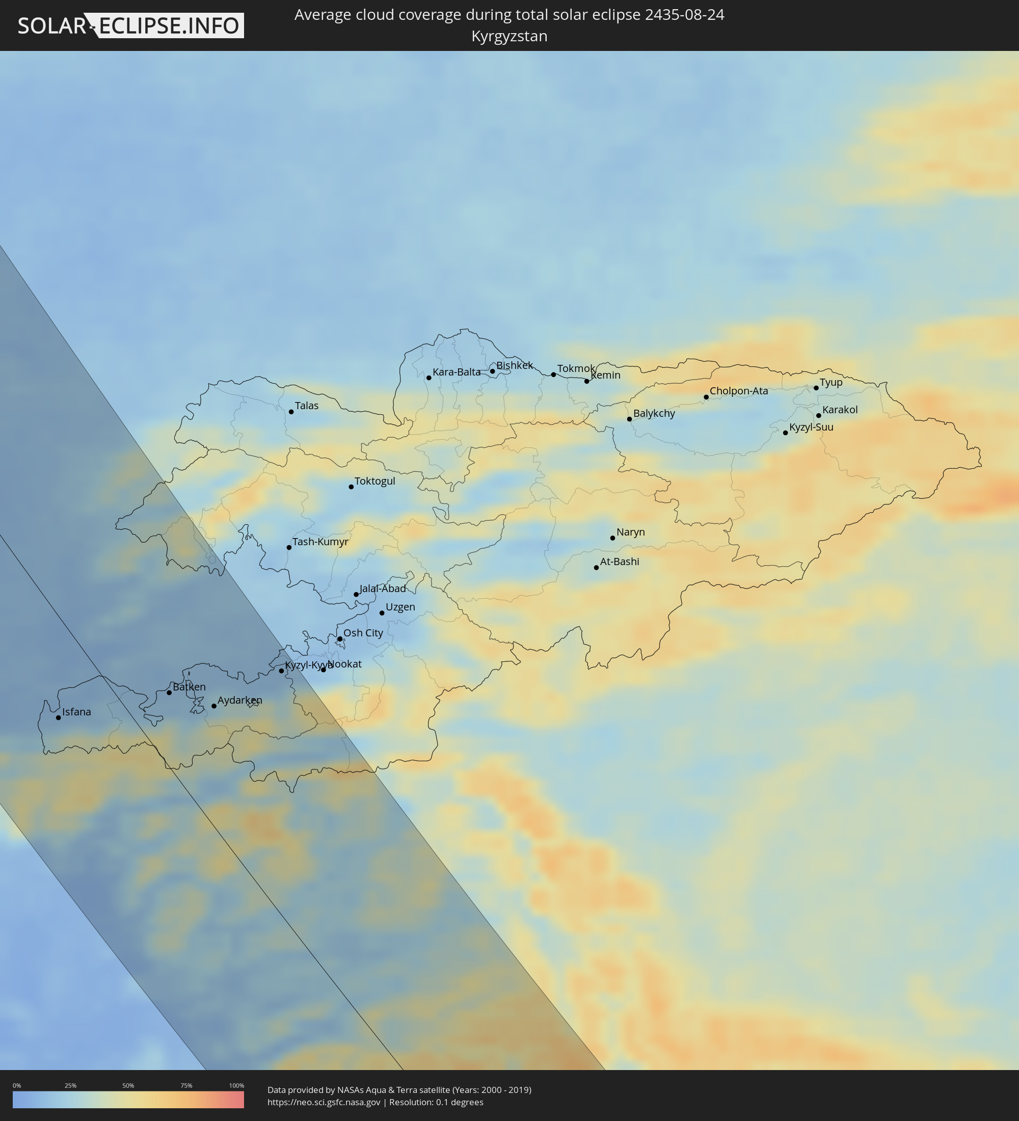 Kyrgyzstan
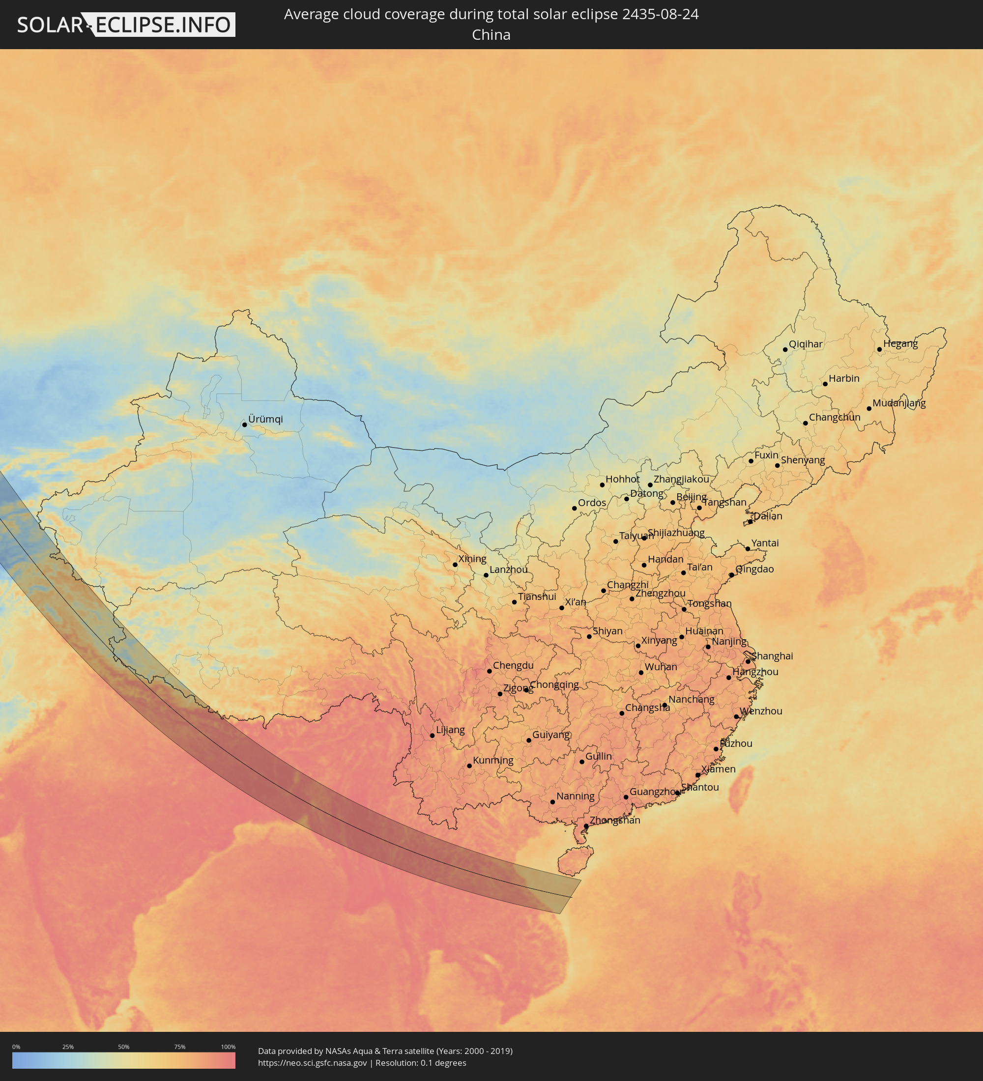 China
China
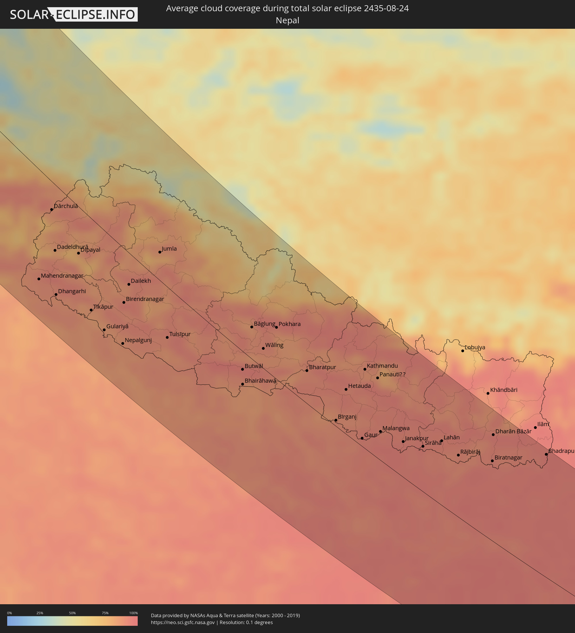 Nepal
Nepal
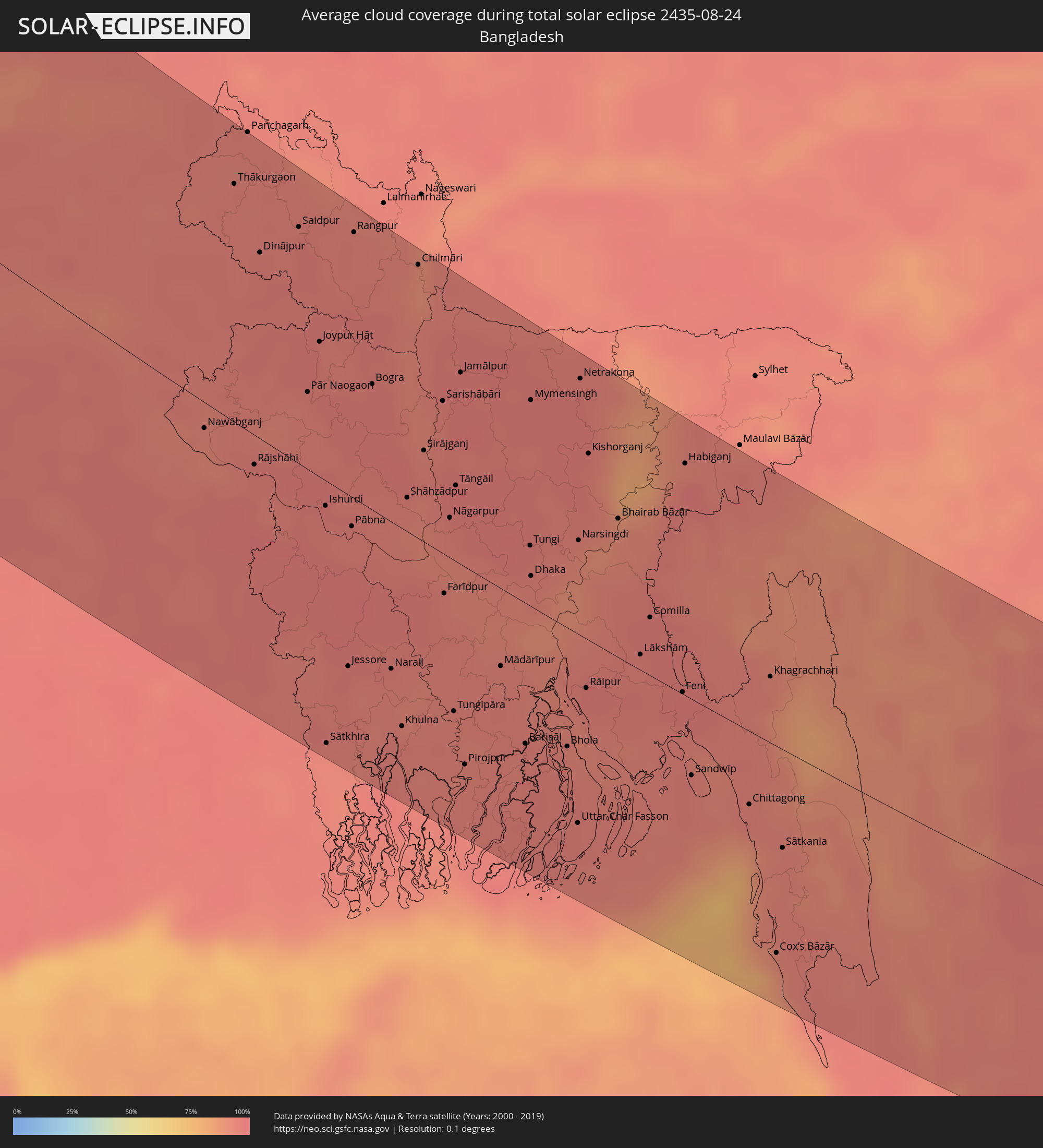 Bangladesh
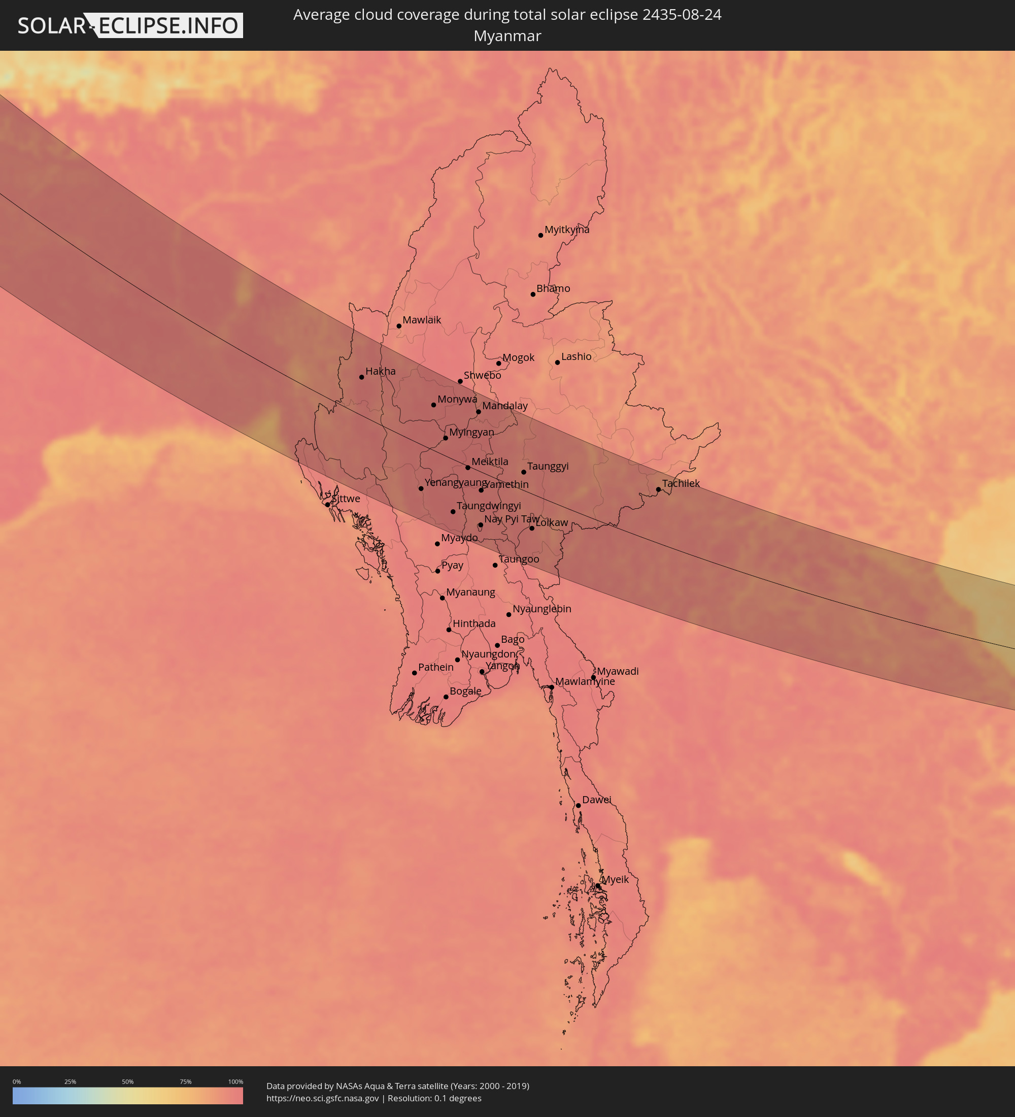 Myanmar
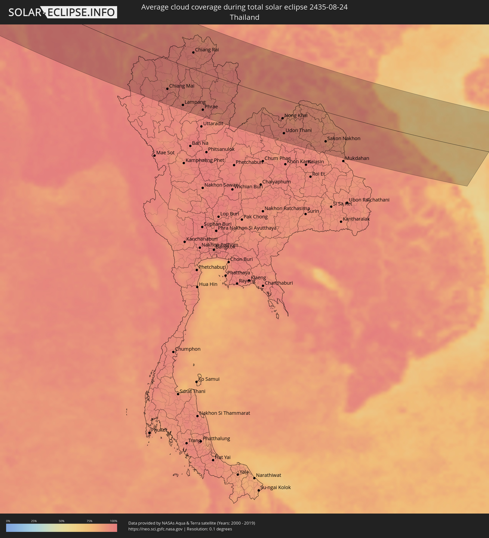 Thailand
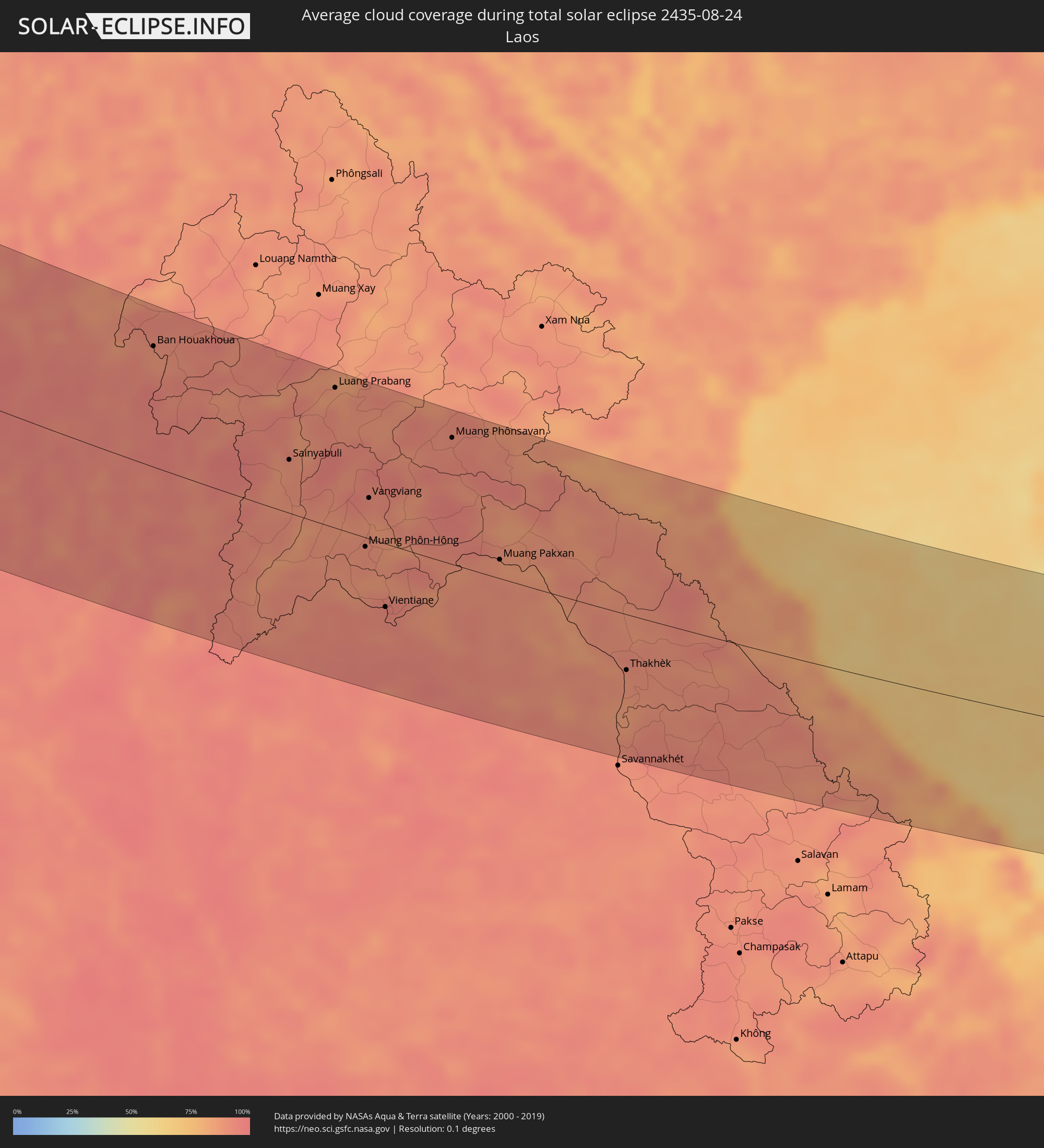 Laos
Laos
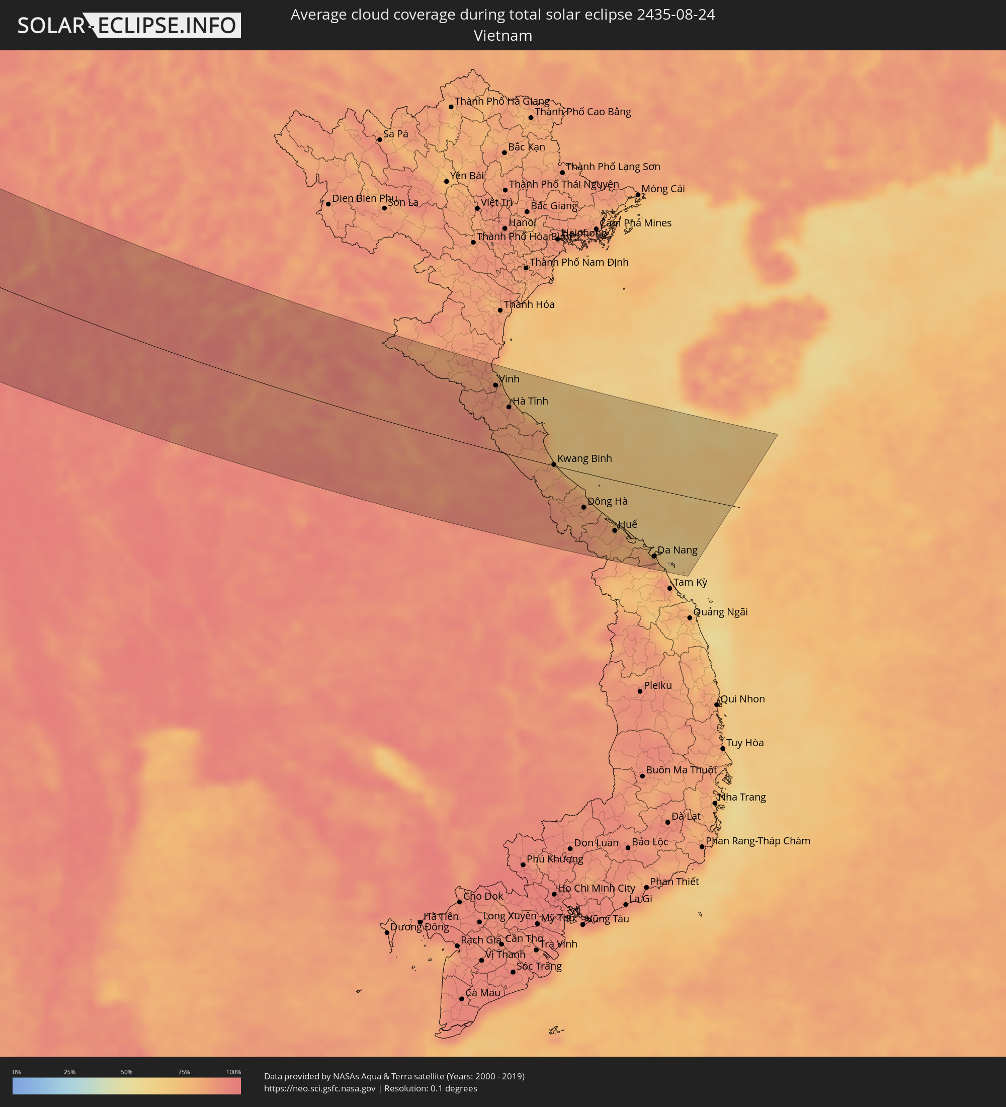 Vietnam
Cities inside the path of the eclipse
The following table shows all locations with a population of more than 5,000 inside the eclipse path. Cities which have more than 100,000 inhabitants are marked bold. A click at the locations opens a detailed map.
| City | Type | Eclipse duration | Local time of max. eclipse | Distance to central line | Ø Cloud coverage |
|
Ilulissat, Qaasuitsup
|
total | - | 05:28:54 UTC-03:00 | 55 km | 76% |
|
Olonkinbyen, Jan Mayen
|
total | - | 09:36:07 UTC+01:00 | 119 km | 94% |
|
Harstad, Troms
|
total | - | 09:46:14 UTC+01:00 | 82 km | 78% |
|
Narvik, Nordland
|
total | - | 09:46:38 UTC+01:00 | 103 km | 77% |
|
Tromsø, Troms
|
total | - | 09:47:57 UTC+01:00 | 45 km | 77% |
|
Kiruna, Norrbotten
|
total | - | 09:48:12 UTC+01:00 | 108 km | 76% |
|
Kittilä, Lapland
|
total | - | 10:51:13 UTC+02:00 | 27 km | 79% |
|
Rovaniemi, Lapland
|
total | - | 10:51:43 UTC+02:00 | 119 km | 74% |
|
Sodankylä, Lapland
|
total | - | 10:52:21 UTC+02:00 | 12 km | 76% |
|
Inari, Lapland
|
total | - | 10:52:42 UTC+02:00 | 136 km | 81% |
|
Pyhäjärvi, Lapland
|
total | - | 10:52:47 UTC+02:00 | 29 km | 75% |
|
Kemijärvi, Lapland
|
total | - | 10:52:56 UTC+02:00 | 62 km | 75% |
|
Kuusamo, Northern Ostrobothnia
|
total | - | 10:54:15 UTC+02:00 | 82 km | 75% |
|
Severodvinsk, Arkhangelskaya
|
total | - | 12:02:54 UTC+03:00 | 111 km | 76% |
|
Arkhangel’sk, Arkhangelskaya
|
total | - | 12:03:29 UTC+03:00 | 132 km | 75% |
|
Kirov, Kirov
|
total | - | 12:16:16 UTC+03:00 | 33 km | 70% |
|
Nizhnekamsk, Tatarstan
|
total | - | 12:21:47 UTC+03:00 | 76 km | 69% |
|
Naberezhnyye Chelny, Tatarstan
|
total | - | 12:22:15 UTC+03:00 | 41 km | 68% |
|
Izhevsk, Udmurtiya
|
total | - | 13:21:38 UTC+04:00 | 75 km | 74% |
|
Sterlitamak, Bashkortostan
|
total | - | 14:28:36 UTC+05:00 | 5 km | 69% |
|
Ufa, Bashkortostan
|
total | - | 14:27:04 UTC+05:00 | 71 km | 65% |
|
Orsk, Orenburg
|
total | - | 14:34:51 UTC+05:00 | 21 km | 54% |
|
Magnitogorsk, Chelyabinsk
|
total | - | 14:31:58 UTC+05:00 | 148 km | 65% |
|
Aral, Qyzylorda
|
total | - | 14:45:16 UTC+05:00 | 123 km | 24% |
|
Baikonur, Baikonur
|
total | - | 14:49:01 UTC+05:00 | 96 km | 17% |
|
Kyzyl-Orda, Qyzylorda
|
total | - | 14:52:35 UTC+05:00 | 5 km | 13% |
|
Shīeli, Qyzylorda
|
total | - | 14:55:01 UTC+05:00 | 33 km | 12% |
|
Jizzax, Jizzax
|
total | - | 15:03:38 UTC+05:00 | 156 km | 11% |
|
Chardara, Ongtüstik Qazaqstan
|
total | - | 15:01:36 UTC+05:00 | 72 km | 10% |
|
Turkestan, Ongtüstik Qazaqstan
|
total | - | 14:58:03 UTC+05:00 | 78 km | 11% |
|
Kentau, Ongtüstik Qazaqstan
|
total | - | 14:57:53 UTC+05:00 | 109 km | 11% |
|
Arys, Ongtüstik Qazaqstan
|
total | - | 15:00:11 UTC+05:00 | 60 km | 12% |
|
Istaravshan, Viloyati Sughd
|
total | - | 15:05:07 UTC+05:00 | 90 km | 12% |
|
Yangiyŭl, Toshkent
|
total | - | 15:02:53 UTC+05:00 | 9 km | 14% |
|
Tashkent, Toshkent Shahri
|
total | - | 15:02:45 UTC+05:00 | 13 km | 13% |
|
Bekobod, Toshkent
|
total | - | 15:04:47 UTC+05:00 | 52 km | 15% |
|
Bŭston, Viloyati Sughd
|
total | - | 15:04:16 UTC+05:00 | 28 km | 14% |
|
Proletar, Viloyati Sughd
|
total | - | 15:05:05 UTC+05:00 | 40 km | 16% |
|
Isfana, Batken
|
total | - | 16:05:44 UTC+06:00 | 60 km | 20% |
|
Suluktu, Batken
|
total | - | 16:05:35 UTC+06:00 | 50 km | 15% |
|
Chirchiq, Toshkent
|
total | - | 15:02:42 UTC+05:00 | 51 km | 15% |
|
Olmaliq, Toshkent
|
total | - | 15:03:54 UTC+05:00 | 12 km | 11% |
|
Shymkent, Ongtüstik Qazaqstan
|
total | - | 15:01:09 UTC+05:00 | 105 km | 18% |
|
Khŭjand, Viloyati Sughd
|
total | - | 15:04:59 UTC+05:00 | 24 km | 12% |
|
Belyye Vody, Ongtüstik Qazaqstan
|
total | - | 15:01:08 UTC+05:00 | 128 km | 16% |
|
Adrasmon, Viloyati Sughd
|
total | - | 15:04:37 UTC+05:00 | 25 km | 11% |
|
Mŭ’minobod, Khatlon
|
total | - | 15:09:30 UTC+05:00 | 141 km | 10% |
|
Angren, Toshkent
|
total | - | 15:04:04 UTC+05:00 | 60 km | 14% |
|
Konibodom, Viloyati Sughd
|
total | - | 15:05:41 UTC+05:00 | 33 km | 16% |
|
Isfara, Viloyati Sughd
|
total | - | 15:06:11 UTC+05:00 | 35 km | 15% |
|
Batken, Batken
|
total | - | 16:06:29 UTC+06:00 | 44 km | 15% |
|
Qo‘qon, Fergana
|
total | - | 15:05:42 UTC+05:00 | 83 km | 18% |
|
Chust Shahri, Namangan
|
total | - | 15:05:03 UTC+05:00 | 134 km | 17% |
|
Aydarken, Batken
|
total | - | 16:07:10 UTC+06:00 | 72 km | 37% |
|
Ashkāsham, Badakhshan
|
total | - | 14:43:34 UTC+04:30 | 135 km | 12% |
|
Khorugh, Gorno-Badakhshan
|
total | - | 15:12:02 UTC+05:00 | 78 km | 14% |
|
Ishqoshim, Gorno-Badakhshan
|
total | - | 15:13:33 UTC+05:00 | 127 km | 14% |
|
Fergana, Fergana
|
total | - | 15:06:43 UTC+05:00 | 131 km | 16% |
|
Iradan, Batken
|
total | - | 16:07:12 UTC+06:00 | 145 km | 15% |
|
Kyzyl-Kyya, Batken
|
total | - | 16:07:15 UTC+06:00 | 147 km | 15% |
|
Khandūd, Badakhshan
|
total | - | 14:43:43 UTC+04:30 | 62 km | 16% |
|
Gilgit, Gilgit-Baltistan
|
total | - | 15:17:21 UTC+05:00 | 5 km | 60% |
|
Srinagar, Kashmir
|
total | - | 15:51:14 UTC+05:30 | 93 km | 38% |
|
Dehra Dūn, Uttarakhand
|
total | - | 16:00:40 UTC+05:30 | 158 km | 88% |
|
Mahendranagar, Far Western
|
total | - | 16:19:42 UTC+05:45 | 119 km | 88% |
|
Dhangarhi, Far Western
|
total | - | 16:20:14 UTC+05:45 | 119 km | 88% |
|
Burang, Tibet Autonomous Region
|
total | - | 18:32:41 UTC+08:00 | 49 km | 46% |
|
Gorakhpur, Uttar Pradesh
|
total | - | 16:10:13 UTC+05:30 | 107 km | 89% |
|
Butwāl, Western Region
|
total | - | 16:23:36 UTC+05:45 | 21 km | 90% |
|
Pokhara, Western Region
|
total | - | 16:22:52 UTC+05:45 | 60 km | 89% |
|
Bharatpur, Central Region
|
total | - | 16:24:07 UTC+05:45 | 39 km | 89% |
|
Arrah, Bihar
|
total | - | 16:12:56 UTC+05:30 | 135 km | 95% |
|
Bīrganj, Central Region
|
total | - | 16:25:31 UTC+05:45 | 7 km | 89% |
|
Patna, Bihar
|
total | - | 16:13:04 UTC+05:30 | 103 km | 93% |
|
Kathmandu, Central Region
|
total | - | 16:24:30 UTC+05:45 | 95 km | 87% |
|
Muzaffarpur, Bihar
|
total | - | 16:12:17 UTC+05:30 | 41 km | 94% |
|
Bihār Sharīf, Bihar
|
total | - | 16:13:55 UTC+05:30 | 116 km | 96% |
|
Darbhanga, Bihar
|
total | - | 16:12:27 UTC+05:30 | 8 km | 94% |
|
Janakpur, Central Region
|
total | - | 16:26:29 UTC+05:45 | 43 km | 94% |
|
Bhāgalpur, Bihar
|
total | - | 16:14:26 UTC+05:30 | 27 km | 96% |
|
Biratnagar, Eastern Region
|
total | - | 16:27:30 UTC+05:45 | 100 km | 94% |
|
Dharān Bāzār, Eastern Region
|
total | - | 16:26:53 UTC+05:45 | 133 km | 94% |
|
Rājshāhi, Rājshāhi
|
total | - | 16:46:28 UTC+06:00 | 16 km | 96% |
|
Jessore, Khulna
|
total | - | 16:48:38 UTC+06:00 | 97 km | 97% |
|
Rangpur, Rangpur Division
|
total | - | 16:44:25 UTC+06:00 | 147 km | 95% |
|
Khulna, Khulna
|
total | - | 16:49:19 UTC+06:00 | 113 km | 96% |
|
Tungi, Dhaka
|
total | - | 16:47:49 UTC+06:00 | 34 km | 96% |
|
Dhaka, Dhaka
|
total | - | 16:48:07 UTC+06:00 | 17 km | 94% |
|
Narsingdi, Dhaka
|
total | - | 16:47:52 UTC+06:00 | 54 km | 93% |
|
Comilla, Chittagong
|
total | - | 16:48:43 UTC+06:00 | 34 km | 97% |
|
Chittagong, Chittagong
|
total | - | 16:50:40 UTC+06:00 | 43 km | 90% |
|
Cox’s Bāzār, Chittagong
|
total | - | 16:52:06 UTC+06:00 | 123 km | 87% |
|
Aizawl, Mizoram
|
total | - | 16:18:41 UTC+05:30 | 136 km | 88% |
|
Yenangyaung, Magway
|
total | - | 17:24:04 UTC+06:30 | 88 km | 95% |
|
Magway, Magway
|
total | - | 17:24:33 UTC+06:30 | 118 km | 96% |
|
Pakokku, Magway
|
total | - | 17:22:48 UTC+06:30 | 9 km | 97% |
|
Monywa, Sagain
|
total | - | 17:21:39 UTC+06:30 | 89 km | 96% |
|
Myingyan, Mandalay
|
total | - | 17:22:39 UTC+06:30 | 35 km | 95% |
|
Meiktila, Mandalay
|
total | - | 17:23:35 UTC+06:30 | 4 km | 96% |
|
Mandalay, Mandalay
|
total | - | 17:21:59 UTC+06:30 | 117 km | 96% |
|
Nay Pyi Taw, Nay Pyi Taw
|
total | - | 17:25:16 UTC+06:30 | 108 km | 97% |
|
Pyin Oo Lwin, Mandalay
|
total | - | 17:21:56 UTC+06:30 | 139 km | 96% |
|
Taunggyi, Shan
|
total | - | 17:23:50 UTC+06:30 | 36 km | 94% |
|
Chiang Mai, Chiang Mai
|
total | - | 17:56:47 UTC+07:00 | 95 km | 96% |
|
Lamphun, Lamphun
|
total | - | 17:57:04 UTC+07:00 | 116 km | 95% |
|
Lampang, Lampang
|
total | - | 17:57:28 UTC+07:00 | 129 km | 95% |
|
Chiang Rai, Chiang Rai
|
total | - | 17:55:14 UTC+07:00 | 53 km | 95% |
|
Mae Chan, Chiang Rai
|
total | - | 17:54:54 UTC+07:00 | 78 km | 94% |
|
Phrae, Phrae
|
total | - | 17:57:40 UTC+07:00 | 121 km | 95% |
|
Ban Houayxay, Bokeo Province
|
total | - | 17:54:43 UTC+07:00 | 112 km | 89% |
|
Ban Houakhoua, Bokeo Province
|
total | - | 17:54:46 UTC+07:00 | 110 km | 89% |
|
Sainyabuli, Xiagnabouli
|
total | - | 17:56:06 UTC+07:00 | 49 km | 88% |
|
Luang Prabang, Louangphabang
|
total | - | 17:55:14 UTC+07:00 | 130 km | 86% |
|
Muang Phôn-Hông, Vientiane Province
|
total | - | 17:57:06 UTC+07:00 | 9 km | 91% |
|
Vangviang, Vientiane Province
|
total | - | 17:56:31 UTC+07:00 | 38 km | 89% |
|
Tha Bo, Nong Khai
|
total | - | 17:57:57 UTC+07:00 | 72 km | 90% |
|
Vientiane, Vientiane
|
total | - | 17:57:47 UTC+07:00 | 59 km | 93% |
|
Nong Khai, Nong Khai
|
total | - | 17:57:54 UTC+07:00 | 64 km | 92% |
|
Udon Thani, Changwat Udon Thani
|
total | - | 17:58:30 UTC+07:00 | 112 km | 93% |
|
Muang Phônsavan, Xiangkhoang
|
total | - | 17:55:46 UTC+07:00 | 118 km | 91% |
|
Muang Pakxan, Bolikhamsai Province
|
total | - | 17:57:09 UTC+07:00 | 18 km | 85% |
|
Sakon Nakhon, Sakon Nakhon
|
total | - | 17:58:41 UTC+07:00 | 99 km | 91% |
|
Thakhèk, Khammouan
|
total | - | 17:58:17 UTC+07:00 | 53 km | 89% |
|
Yên Vinh, Nghệ An
|
total | - | 17:56:33 UTC+07:00 | 105 km | 88% |
|
Vinh, Nghệ An
|
total | - | 17:56:33 UTC+07:00 | 107 km | 88% |
|
Hà Tĩnh, Hà Tĩnh
|
total | - | 17:56:56 UTC+07:00 | 77 km | 85% |
|
Kwang Binh, Quảng Bình
|
total | - | 17:57:57 UTC+07:00 | 1 km | 83% |
|
Ðông Hà, Quảng Trị
|
total | - | 17:58:40 UTC+07:00 | 57 km | 83% |
|
Huế, Thừa Thiên-Huế
|
total | - | 17:59:01 UTC+07:00 | 84 km | 82% |
|
Da Nang, Đà Nẵng
|
total | - | 17:59:22 UTC+07:00 | 112 km | 85% |
|
Hội An, Quảng Nam
|
total | - | 17:59:34 UTC+07:00 | 130 km | 78% |