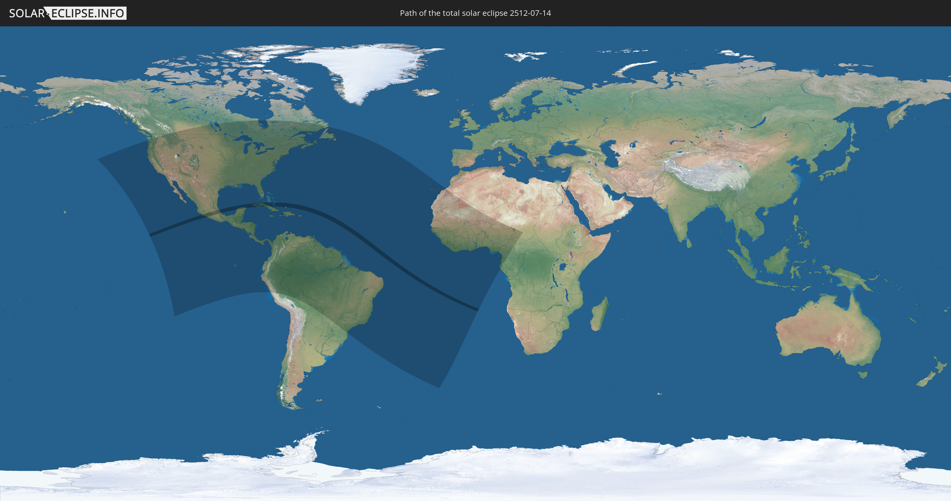
Total solar eclipse of 07/14/2512
| Day of week: | Thursday |
| Maximum duration of eclipse: | 04m47s |
| Maximum width of eclipse path: | 170 km |
| Saros cycle: | 154 |
| Coverage: | 100% |
| Magnitude: | 1.051 |
| Gamma: | -0.0634 |
Wo kann man die Sonnenfinsternis vom 07/14/2512 sehen?
Die Sonnenfinsternis am 07/14/2512 kann man in 72 Ländern als partielle Sonnenfinsternis beobachten.
Der Finsternispfad verläuft durch 4 Länder. Nur in diesen Ländern ist sie als total Sonnenfinsternis zu sehen.
In den folgenden Ländern ist die Sonnenfinsternis total zu sehen
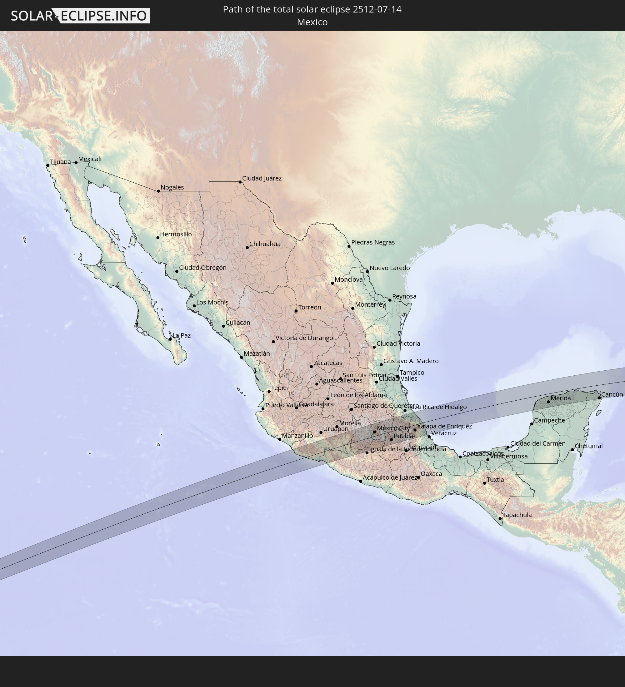 Mexico
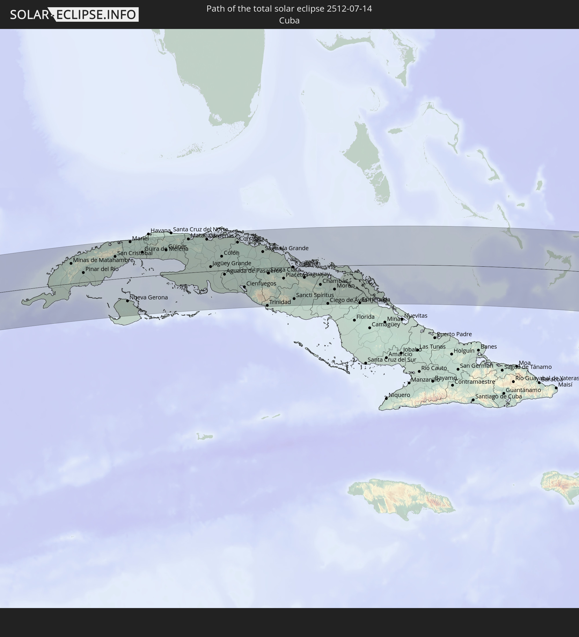 Cuba
Cuba
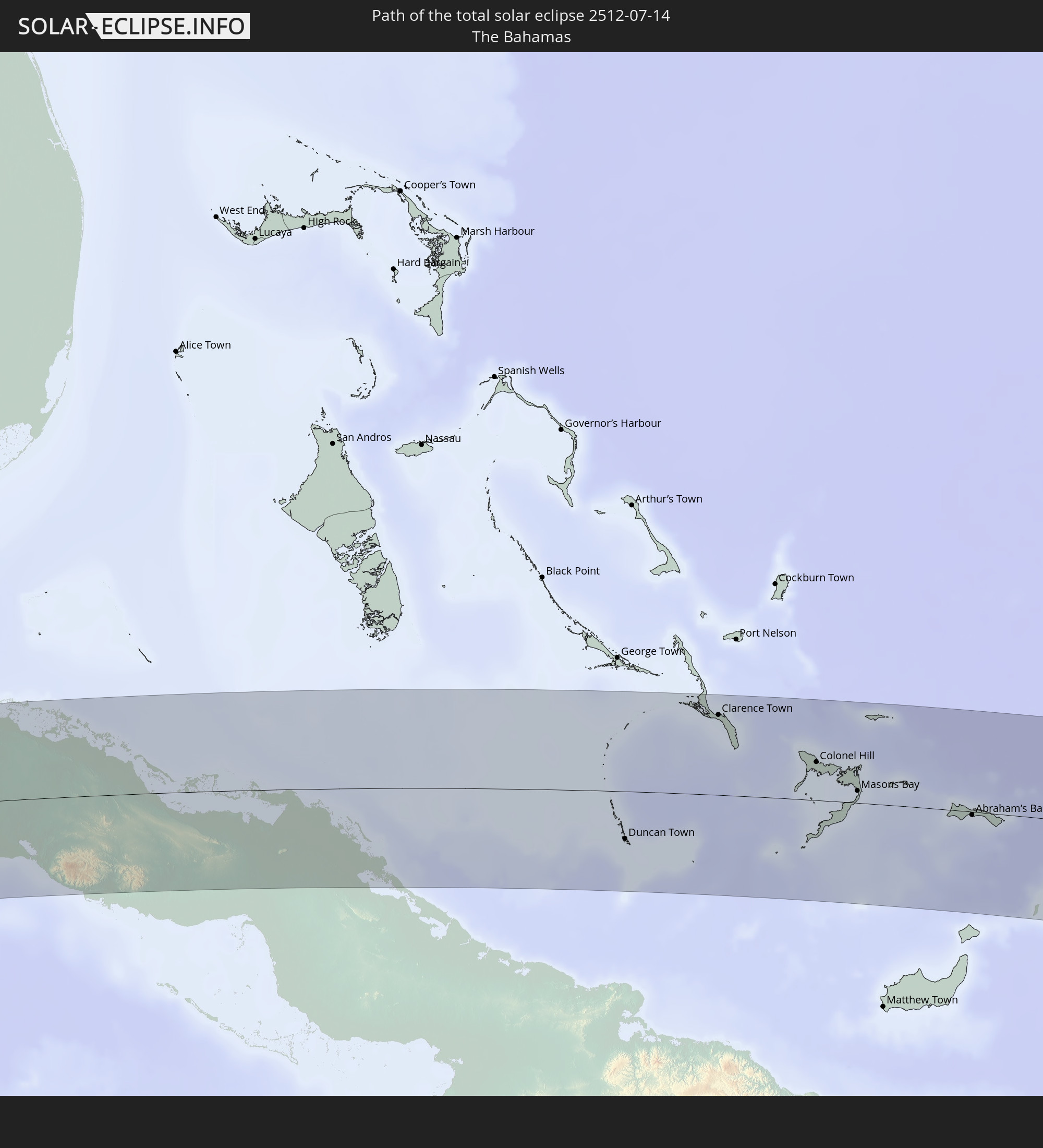 The Bahamas
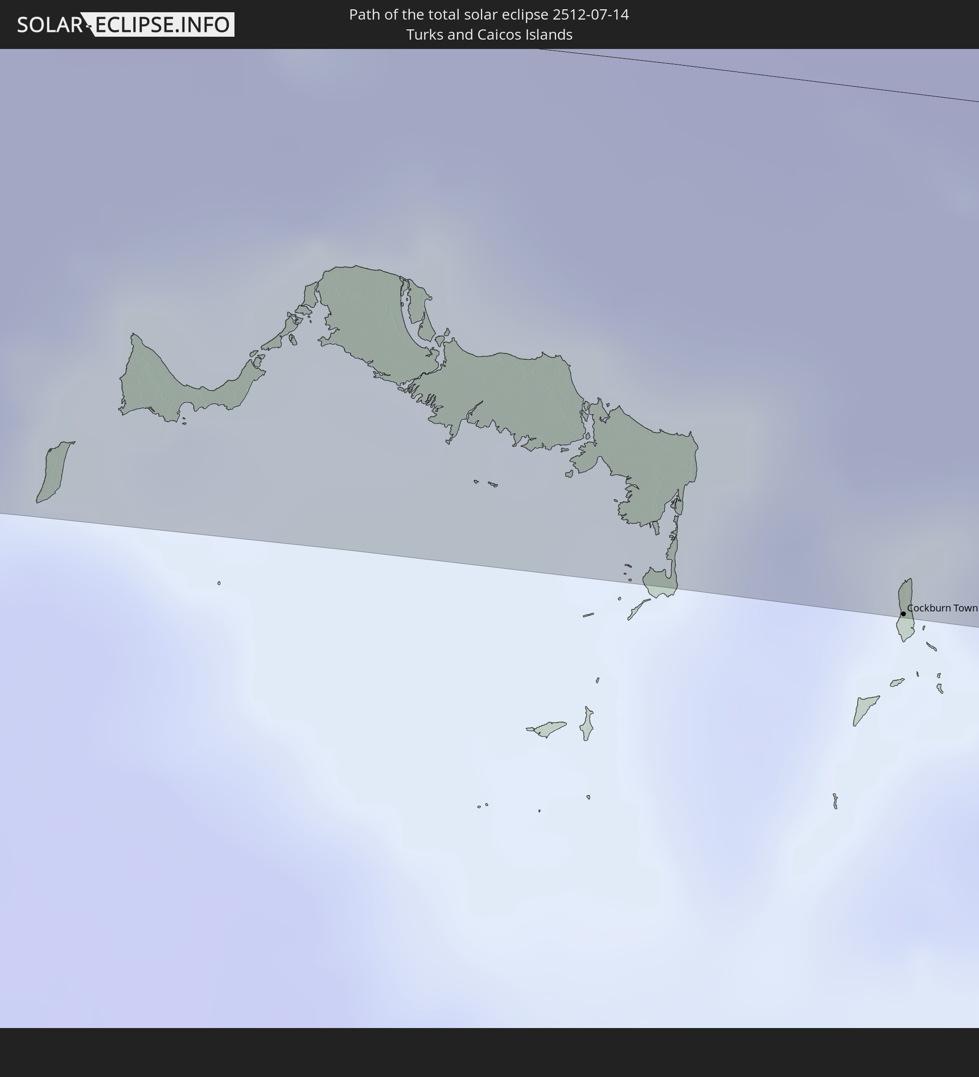 Turks and Caicos Islands
In den folgenden Ländern ist die Sonnenfinsternis partiell zu sehen
 United States
 United States Minor Outlying Islands
 Canada
 Mexico
 Guatemala
 Ecuador
 El Salvador
 Honduras
 Belize
 Nicaragua
 Costa Rica
 Cuba
Cuba
 Panama
 Colombia
 Cayman Islands
 Peru
Peru
 The Bahamas
 Jamaica
 Haiti
Haiti
 Brazil
 Venezuela
 Turks and Caicos Islands
 Dominican Republic
 Aruba
Aruba
 Bolivia
 Puerto Rico
 United States Virgin Islands
 Bermuda
 British Virgin Islands
 Anguilla
 Collectivity of Saint Martin
 Saint Barthélemy
 Saint Kitts and Nevis
 Antigua and Barbuda
 Montserrat
 Trinidad and Tobago
 Guadeloupe
 Grenada
 Dominica
 Saint Vincent and the Grenadines
 Guyana
 Martinique
 Saint Lucia
 Barbados
 Suriname
 Saint Pierre and Miquelon
 French Guiana
 Portugal
 Cabo Verde
 Spain
Spain
 Senegal
 Mauritania
 The Gambia
 Guinea-Bissau
 Guinea
 Saint Helena, Ascension and Tristan da Cunha
 Sierra Leone
 Morocco
 Mali
Mali
 Liberia
 Ivory Coast
 Burkina Faso
 Ghana
Ghana
 Togo
Togo
 Niger
Niger
 Benin
Benin
 Nigeria
 Equatorial Guinea
 São Tomé and Príncipe
 Cameroon
 Gabon
Gabon
 Chad
Chad
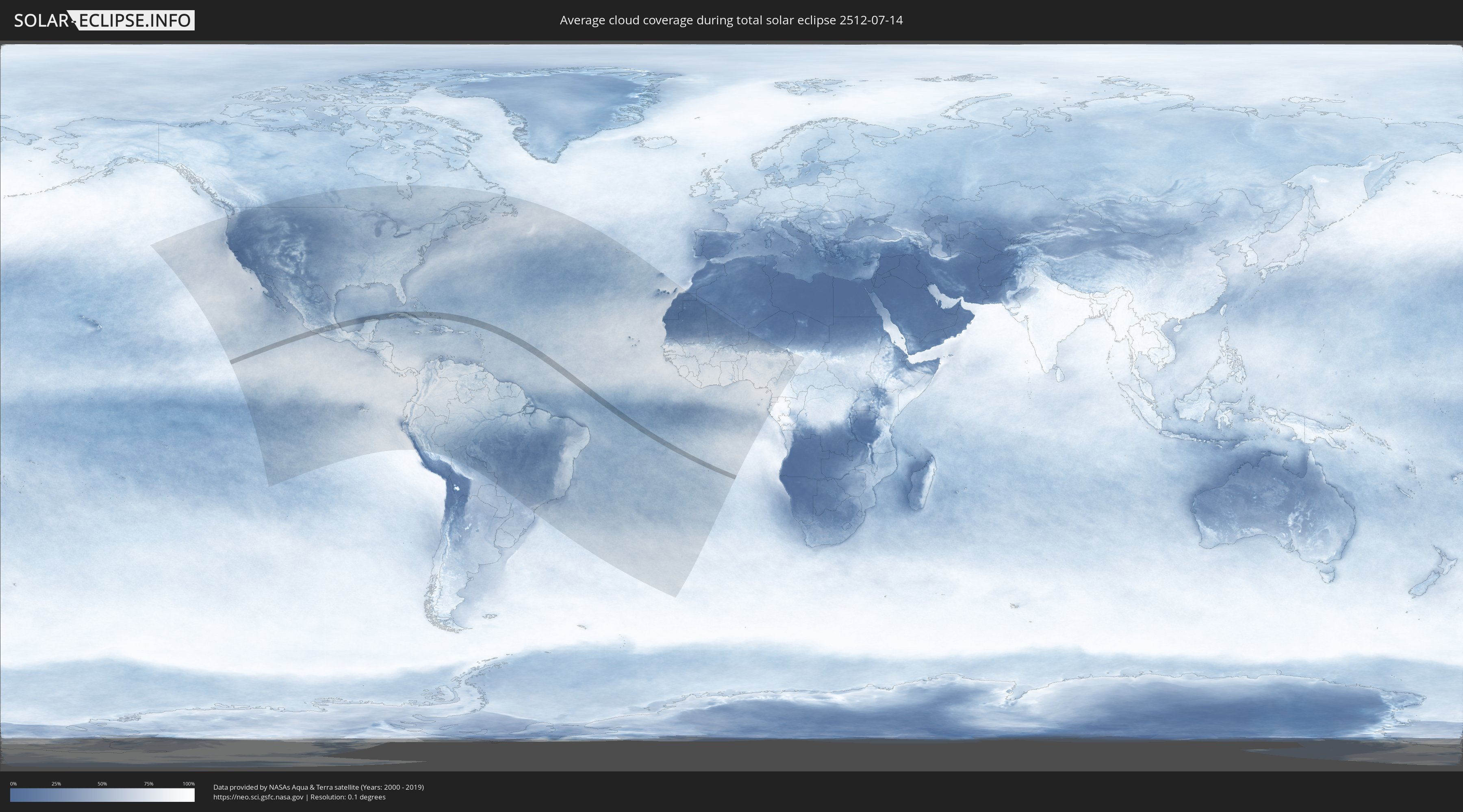
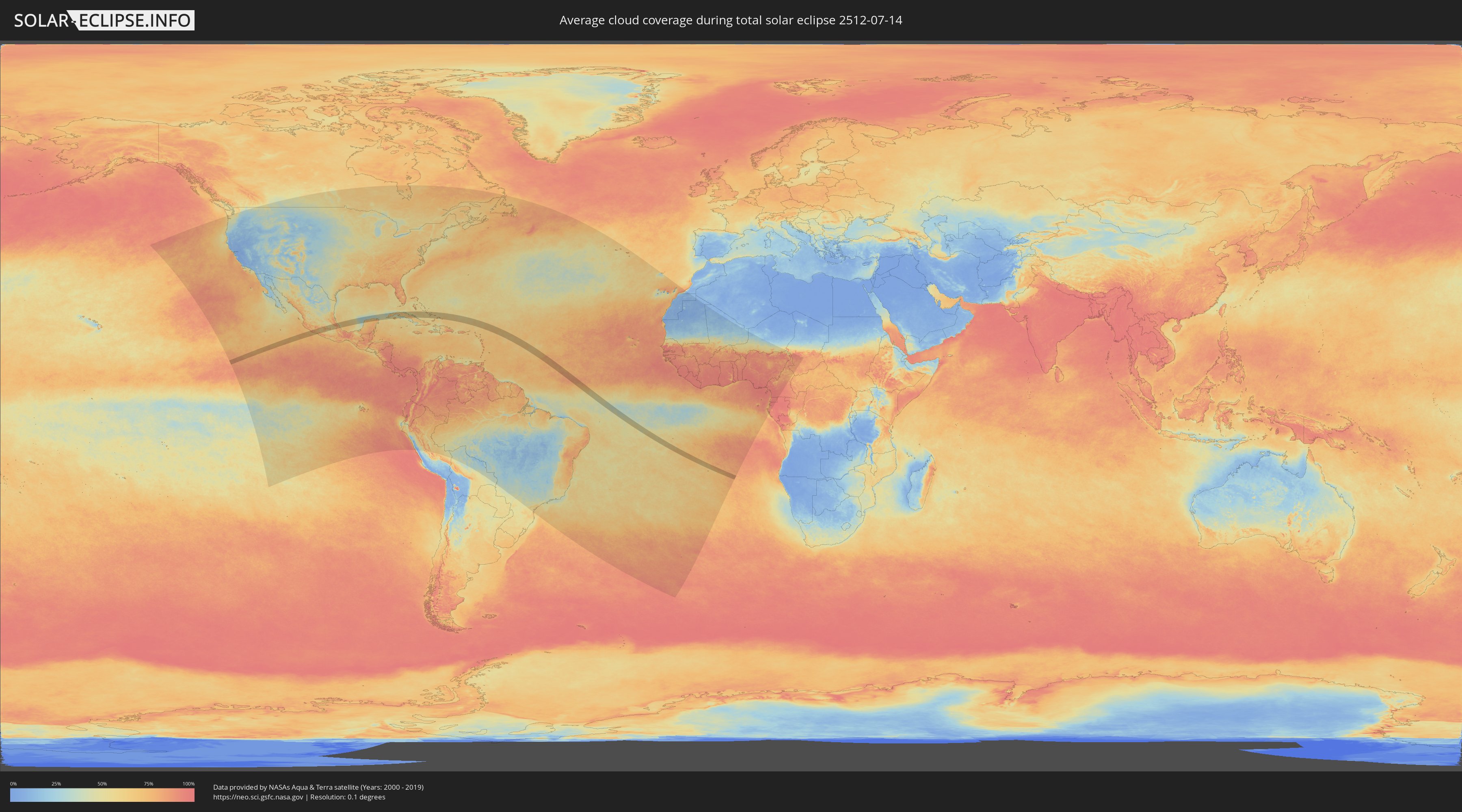
How will be the weather during the total solar eclipse on 07/14/2512?
Where is the best place to see the total solar eclipse of 07/14/2512?
The following maps show the average cloud coverage for the day of the total solar eclipse.
With the help of these maps, it is possible to find the place along the eclipse path, which has the best
chance of a cloudless sky.
Nevertheless, you should consider local circumstances and inform about the weather of your chosen
observation site.
The data is provided by NASAs satellites
AQUA and TERRA.
The cloud maps are averaged over a period of 19 years (2000 - 2019).
Detailed country maps
 Mexico
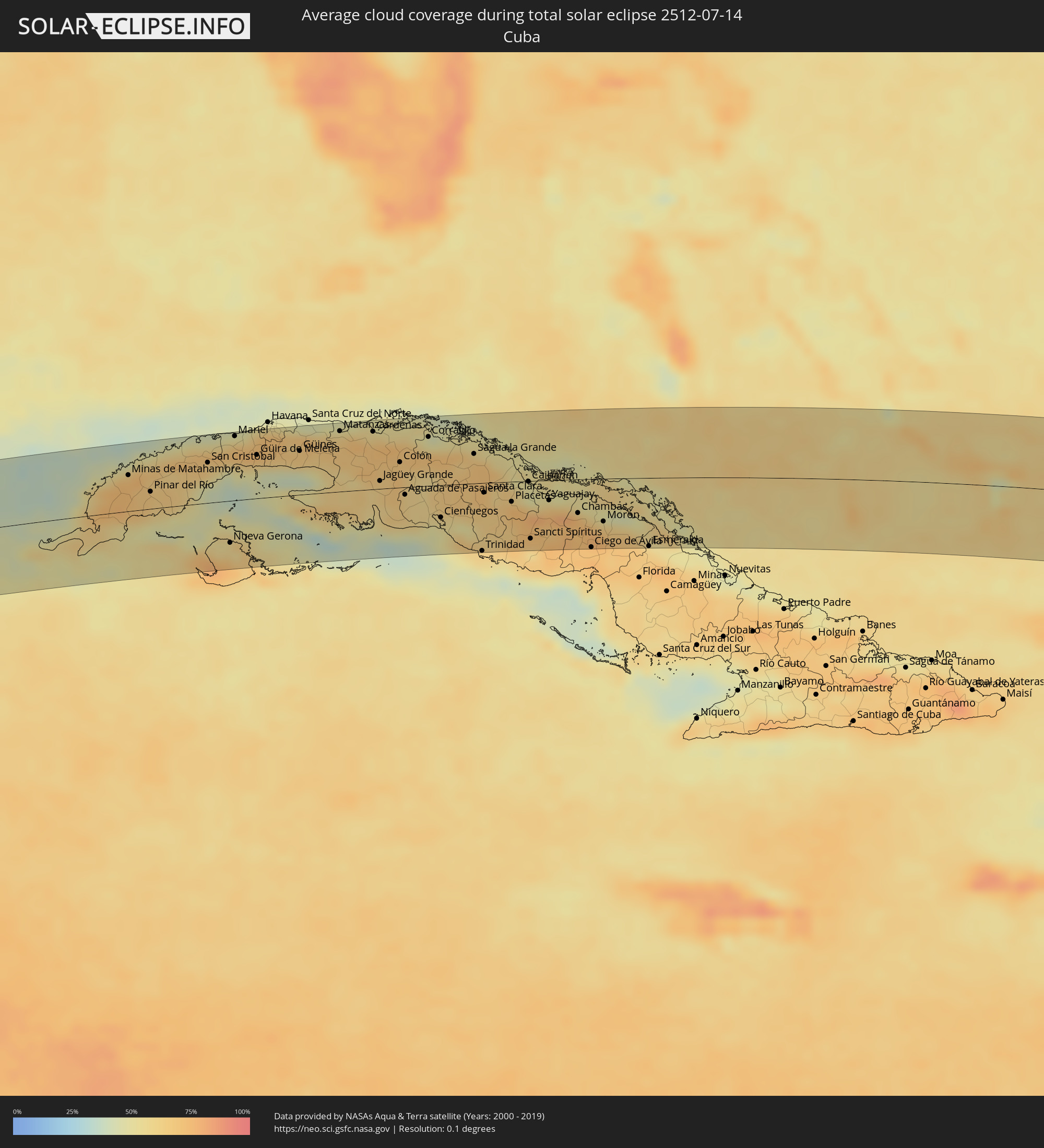 Cuba
Cuba
 The Bahamas
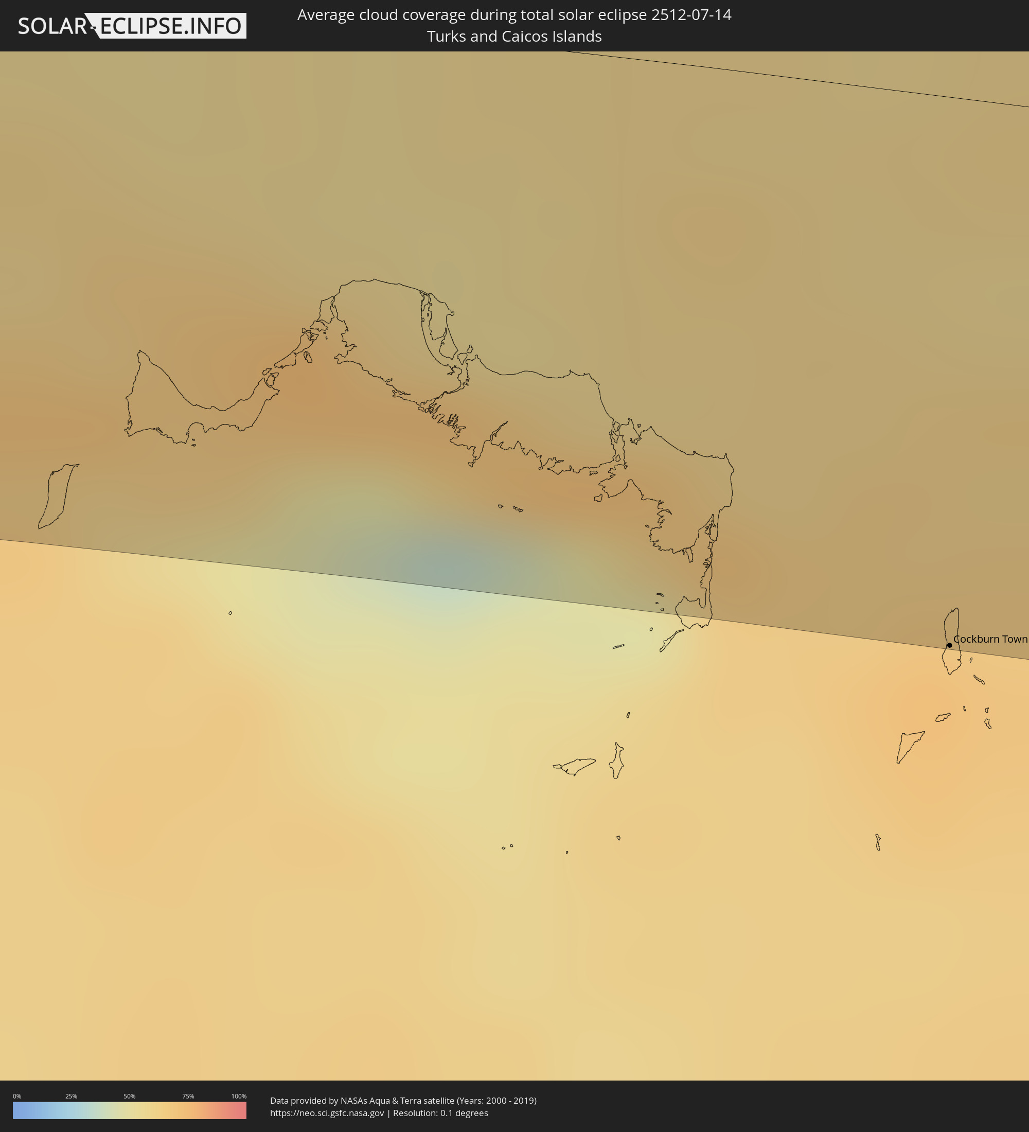 Turks and Caicos Islands
Cities inside the path of the eclipse
The following table shows all locations with a population of more than 5,000 inside the eclipse path. Cities which have more than 100,000 inhabitants are marked bold. A click at the locations opens a detailed map.
| City | Type | Eclipse duration | Local time of max. eclipse | Distance to central line | Ø Cloud coverage |
|
Ciudad Lázaro Cárdenas, Michoacán
|
total | - | 08:12:20 UTC-06:00 | 39 km | 69% |
|
Nueva Italia de Ruiz, Michoacán
|
total | - | 08:12:51 UTC-06:00 | 69 km | 74% |
|
Huetamo de Núñez, Michoacán
|
total | - | 08:13:40 UTC-06:00 | 11 km | 64% |
|
Ciudad Altamirano, Guerrero
|
total | - | 08:13:46 UTC-06:00 | 47 km | 66% |
|
Heróica Zitácuaro, Michoacán
|
total | - | 08:14:27 UTC-06:00 | 59 km | 74% |
|
Tejupilco de Hidalgo, México
|
total | - | 08:14:26 UTC-06:00 | 4 km | 67% |
|
Valle de Bravo, México
|
total | - | 08:14:34 UTC-06:00 | 26 km | 79% |
|
Toluca, México
|
total | - | 08:15:02 UTC-06:00 | 22 km | 65% |
|
Taxco de Alarcón, Guerrero
|
total | - | 08:14:47 UTC-06:00 | 58 km | 62% |
|
Ocoyoacac, México
|
total | - | 08:15:12 UTC-06:00 | 14 km | 69% |
|
Huixquilucan, México
|
total | - | 08:15:20 UTC-06:00 | 20 km | 69% |
|
Ciudad López Mateos, México
|
total | - | 08:15:30 UTC-06:00 | 42 km | 53% |
|
Cuernavaca, Morelos
|
total | - | 08:15:17 UTC-06:00 | 30 km | 54% |
|
Teoloyucan, México
|
total | - | 08:15:39 UTC-06:00 | 56 km | 52% |
|
Tlalpan, Mexico City
|
total | - | 08:15:29 UTC-06:00 | 8 km | 67% |
|
Mexico City, Mexico City
|
total | - | 08:15:34 UTC-06:00 | 21 km | 56% |
|
Yautepec, Morelos
|
total | - | 08:15:25 UTC-06:00 | 39 km | 55% |
|
Ecatepec, México
|
total | - | 08:15:42 UTC-06:00 | 39 km | 56% |
|
Tizayuca, Hidalgo
|
total | - | 08:15:52 UTC-06:00 | 60 km | 52% |
|
Santa María Chimalhuacán, México
|
total | - | 08:15:44 UTC-06:00 | 15 km | 57% |
|
Cuautla Morelos, Morelos
|
total | - | 08:15:30 UTC-06:00 | 51 km | 56% |
|
San Miguel Xico Viejo, México
|
total | - | 08:15:41 UTC-06:00 | 2 km | 66% |
|
Chiautla, México
|
total | - | 08:15:51 UTC-06:00 | 27 km | 61% |
|
Teotihuacán de Arista, México
|
total | - | 08:15:55 UTC-06:00 | 41 km | 54% |
|
Amecameca, México
|
total | - | 08:15:48 UTC-06:00 | 22 km | 74% |
|
Ciudad Sahagun, Hidalgo
|
total | - | 08:16:14 UTC-06:00 | 42 km | 55% |
|
Calpulalpan, Tlaxcala
|
total | - | 08:16:10 UTC-06:00 | 22 km | 56% |
|
San Martin Texmelucan de Labastida, Puebla
|
total | - | 08:16:10 UTC-06:00 | 15 km | 50% |
|
Atlixco, Puebla
|
total | - | 08:16:02 UTC-06:00 | 55 km | 56% |
|
Tulancingo, Hidalgo
|
total | - | 08:16:34 UTC-06:00 | 69 km | 55% |
|
Puebla, Puebla
|
total | - | 08:16:19 UTC-06:00 | 48 km | 56% |
|
Tlaxcala, Tlaxcala
|
total | - | 08:16:25 UTC-06:00 | 18 km | 67% |
|
Huauchinango, Puebla
|
total | - | 08:16:54 UTC-06:00 | 70 km | 76% |
|
Amozoc de Mota, Puebla
|
total | - | 08:16:28 UTC-06:00 | 51 km | 58% |
|
Zacatlán, Puebla
|
total | - | 08:16:54 UTC-06:00 | 42 km | 59% |
|
Huamantla, Tlaxcala
|
total | - | 08:16:42 UTC-06:00 | 26 km | 59% |
|
Tepeaca, Puebla
|
total | - | 08:16:36 UTC-06:00 | 64 km | 56% |
|
Teziutlan, Puebla
|
total | - | 08:17:28 UTC-06:00 | 12 km | 81% |
|
Perote, Veracruz
|
total | - | 08:17:29 UTC-06:00 | 19 km | 69% |
|
Tlapacoyan, Veracruz
|
total | - | 08:17:41 UTC-06:00 | 24 km | 84% |
|
Martínez de la Torre, Veracruz
|
total | - | 08:17:52 UTC-06:00 | 31 km | 83% |
|
Huatusco de Chicuellar, Veracruz
|
total | - | 08:17:38 UTC-06:00 | 71 km | 77% |
|
Xalapa de Enríquez, Veracruz
|
total | - | 08:17:49 UTC-06:00 | 31 km | 71% |
|
Misantla, Veracruz
|
total | - | 08:18:02 UTC-06:00 | 10 km | 88% |
|
Hunucmá, Yucatán
|
total | - | 08:27:14 UTC-06:00 | 38 km | 71% |
|
Uman, Yucatán
|
total | - | 08:27:23 UTC-06:00 | 55 km | 72% |
|
Progreso de Castro, Yucatán
|
total | - | 08:27:39 UTC-06:00 | 13 km | 65% |
|
Mérida, Yucatán
|
total | - | 08:27:37 UTC-06:00 | 48 km | 81% |
|
Tizimín, Yucatán
|
total | - | 08:29:54 UTC-06:00 | 57 km | 73% |
|
Cancún, Quintana Roo
|
total | - | 09:32:02 UTC-05:00 | 75 km | 66% |
|
Minas de Matahambre, Pinar del Río
|
total | - | 09:37:21 UTC-05:00 | 41 km | 72% |
|
Viñales, Pinar del Río
|
total | - | 09:37:47 UTC-05:00 | 42 km | 66% |
|
Pinar del Río, Pinar del Río
|
total | - | 09:37:46 UTC-05:00 | 20 km | 67% |
|
Consolación del Sur, Pinar del Río
|
total | - | 09:38:07 UTC-05:00 | 27 km | 66% |
|
Los Palacios, Pinar del Río
|
total | - | 09:38:38 UTC-05:00 | 34 km | 63% |
|
San Cristobal, Artemisa
|
total | - | 09:39:00 UTC-05:00 | 46 km | 67% |
|
Artemisa, Artemisa
|
total | - | 09:39:34 UTC-05:00 | 54 km | 60% |
|
Mariel, Artemisa
|
total | - | 09:39:36 UTC-05:00 | 74 km | 63% |
|
Guanajay, Artemisa
|
total | - | 09:39:43 UTC-05:00 | 66 km | 73% |
|
Bauta, Artemisa
|
total | - | 09:39:59 UTC-05:00 | 71 km | 70% |
|
Güira de Melena, Artemisa
|
total | - | 09:40:02 UTC-05:00 | 50 km | 63% |
|
La Salud, Mayabeque
|
total | - | 09:40:13 UTC-05:00 | 57 km | 72% |
|
Arroyo Naranjo, La Habana
|
total | - | 09:40:20 UTC-05:00 | 75 km | 72% |
|
San José de las Lajas, Mayabeque
|
total | - | 09:40:44 UTC-05:00 | 65 km | 70% |
|
Güines, Mayabeque
|
total | - | 09:40:58 UTC-05:00 | 50 km | 63% |
|
Madruga, Mayabeque
|
total | - | 09:41:18 UTC-05:00 | 57 km | 67% |
|
Matanzas, Matanzas
|
total | - | 09:41:51 UTC-05:00 | 69 km | 66% |
|
Unión de Reyes, Matanzas
|
total | - | 09:41:54 UTC-05:00 | 42 km | 67% |
|
Pedro Betancourt, Matanzas
|
total | - | 09:42:23 UTC-05:00 | 32 km | 70% |
|
Cárdenas, Matanzas
|
total | - | 09:42:34 UTC-05:00 | 66 km | 69% |
|
Jovellanos, Matanzas
|
total | - | 09:42:35 UTC-05:00 | 40 km | 70% |
|
Jagüey Grande, Matanzas
|
total | - | 09:42:41 UTC-05:00 | 9 km | 62% |
|
Perico, Matanzas
|
total | - | 09:42:55 UTC-05:00 | 35 km | 69% |
|
Calimete, Matanzas
|
total | - | 09:43:07 UTC-05:00 | 8 km | 68% |
|
Colón, Matanzas
|
total | - | 09:43:08 UTC-05:00 | 29 km | 69% |
|
Aguada de Pasajeros, Cienfuegos
|
total | - | 09:43:14 UTC-05:00 | 9 km | 61% |
|
Corralillo, Villa Clara
|
total | - | 09:43:48 UTC-05:00 | 56 km | 56% |
|
Cienfuegos, Cienfuegos
|
total | - | 09:44:02 UTC-05:00 | 37 km | 50% |
|
Cruces, Cienfuegos
|
total | - | 09:44:24 UTC-05:00 | 17 km | 57% |
|
Santo Domingo, Villa Clara
|
total | - | 09:44:28 UTC-05:00 | 10 km | 69% |
|
Cumanayagua, Cienfuegos
|
total | - | 09:44:32 UTC-05:00 | 38 km | 50% |
|
Ranchuelo, Villa Clara
|
total | - | 09:44:39 UTC-05:00 | 14 km | 67% |
|
Sagua la Grande, Villa Clara
|
total | - | 09:44:49 UTC-05:00 | 34 km | 66% |
|
Cifuentes, Villa Clara
|
total | - | 09:44:52 UTC-05:00 | 16 km | 70% |
|
Trinidad, Sancti Spíritus
|
total | - | 09:44:59 UTC-05:00 | 78 km | 57% |
|
Manicaragua, Villa Clara
|
total | - | 09:45:00 UTC-05:00 | 40 km | 59% |
|
Santa Clara, Villa Clara
|
total | - | 09:45:02 UTC-05:00 | 11 km | 67% |
|
Encrucijada, Villa Clara
|
total | - | 09:45:14 UTC-05:00 | 12 km | 70% |
|
Condado, Sancti Spíritus
|
total | - | 09:45:17 UTC-05:00 | 71 km | 63% |
|
Camajuaní, Villa Clara
|
total | - | 09:45:29 UTC-05:00 | 4 km | 61% |
|
Placetas, Villa Clara
|
total | - | 09:45:40 UTC-05:00 | 23 km | 66% |
|
Remedios, Villa Clara
|
total | - | 09:45:54 UTC-05:00 | 3 km | 55% |
|
Cabaiguán, Sancti Spíritus
|
total | - | 09:46:00 UTC-05:00 | 50 km | 72% |
|
Caibarién, Villa Clara
|
total | - | 09:46:04 UTC-05:00 | 1 km | 55% |
|
Sancti Spíritus, Sancti Spíritus
|
total | - | 09:46:07 UTC-05:00 | 66 km | 57% |
|
Yaguajay, Sancti Spíritus
|
total | - | 09:46:33 UTC-05:00 | 23 km | 75% |
|
Chambas, Ciego de Ávila
|
total | - | 09:47:14 UTC-05:00 | 39 km | 73% |
|
Ciego de Ávila, Ciego de Ávila
|
total | - | 09:47:35 UTC-05:00 | 79 km | 73% |
|
Ciro Redondo, Ciego de Ávila
|
total | - | 09:47:42 UTC-05:00 | 59 km | 76% |
|
Morón, Ciego de Ávila
|
total | - | 09:47:51 UTC-05:00 | 49 km | 73% |
|
Duncan Town, Ragged Island
|
total | - | 09:54:19 UTC-05:00 | 39 km | 62% |
|
Clarence Town, Long Island
|
total | - | 09:55:51 UTC-05:00 | 65 km | 68% |
|
Colonel Hill, Crooked Island and Long Cay
|
total | - | 09:57:45 UTC-05:00 | 31 km | 64% |
|
Masons Bay, Acklins
|
total | - | 09:58:35 UTC-05:00 | 10 km | 58% |
|
Abraham’s Bay, Mayaguana
|
total | - | 10:00:49 UTC-05:00 | 3 km | 66% |
|
Cockburn Town
|
total | - | 10:05:44 UTC-05:00 | 83 km | 68% |