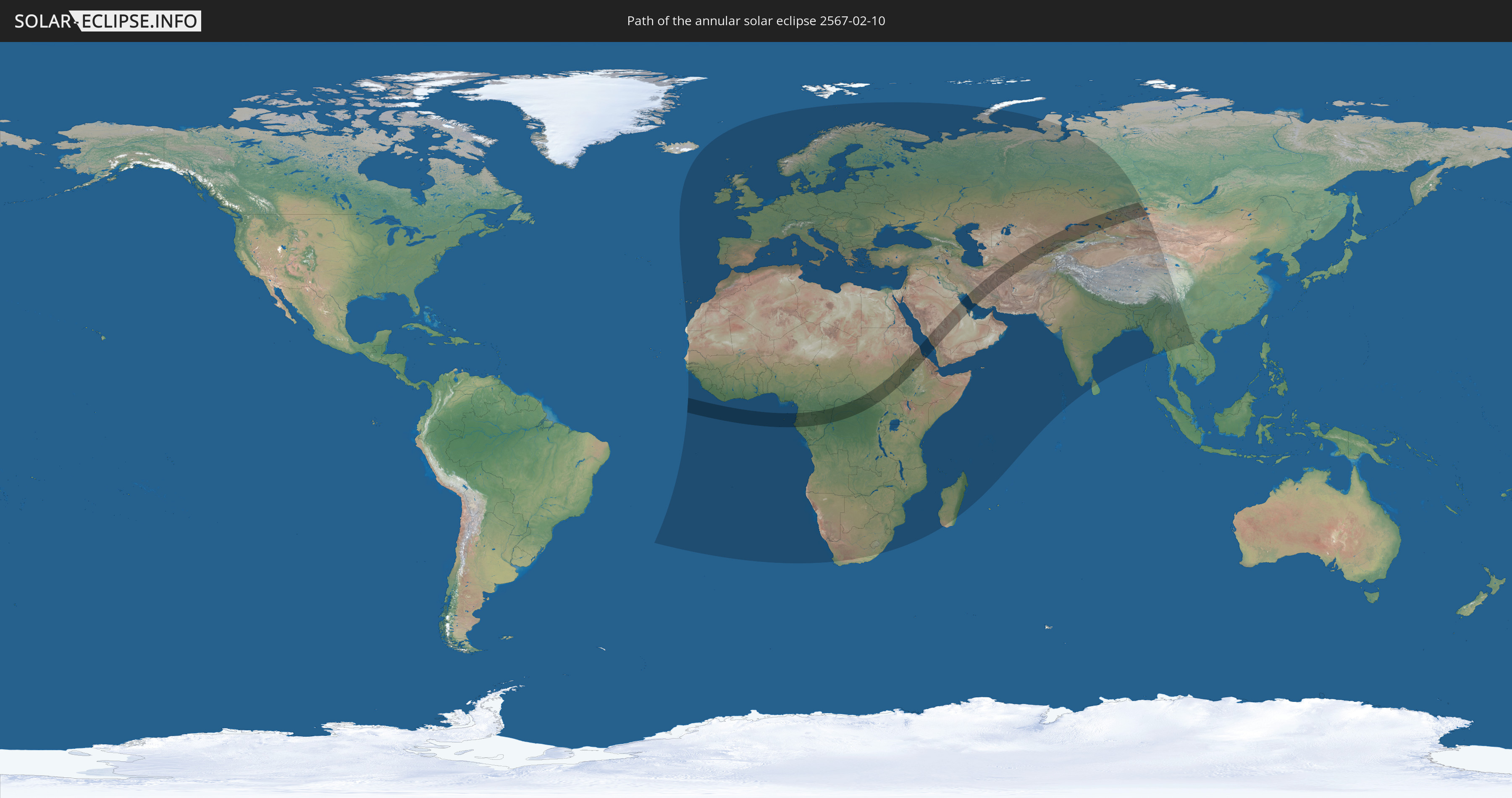
Annular solar eclipse of 02/10/2567
| Day of week: | Tuesday |
| Maximum duration of eclipse: | 09m37s |
| Maximum width of eclipse path: | 328 km |
| Saros cycle: | 159 |
| Coverage: | 92.2% |
| Magnitude: | 0.9223 |
| Gamma: | 0.4703 |
Wo kann man die Sonnenfinsternis vom 02/10/2567 sehen?
Die Sonnenfinsternis am 02/10/2567 kann man in 143 Ländern als partielle Sonnenfinsternis beobachten.
Der Finsternispfad verläuft durch 23 Länder. Nur in diesen Ländern ist sie als annular Sonnenfinsternis zu sehen.
In den folgenden Ländern ist die Sonnenfinsternis annular zu sehen
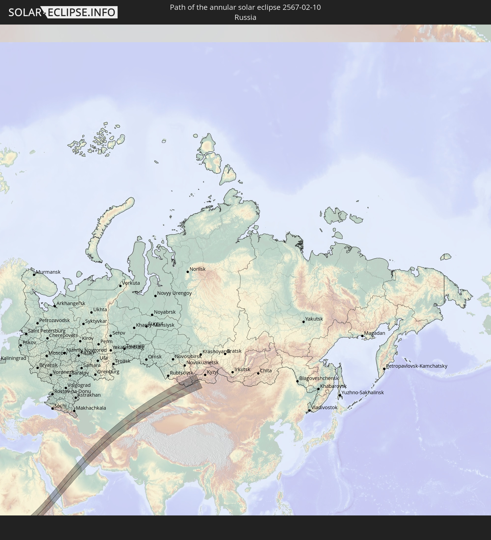 Russia
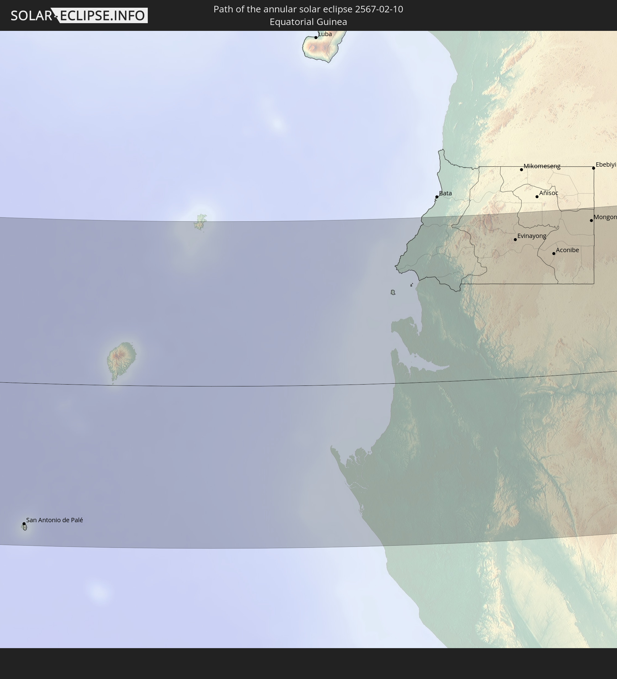 Equatorial Guinea
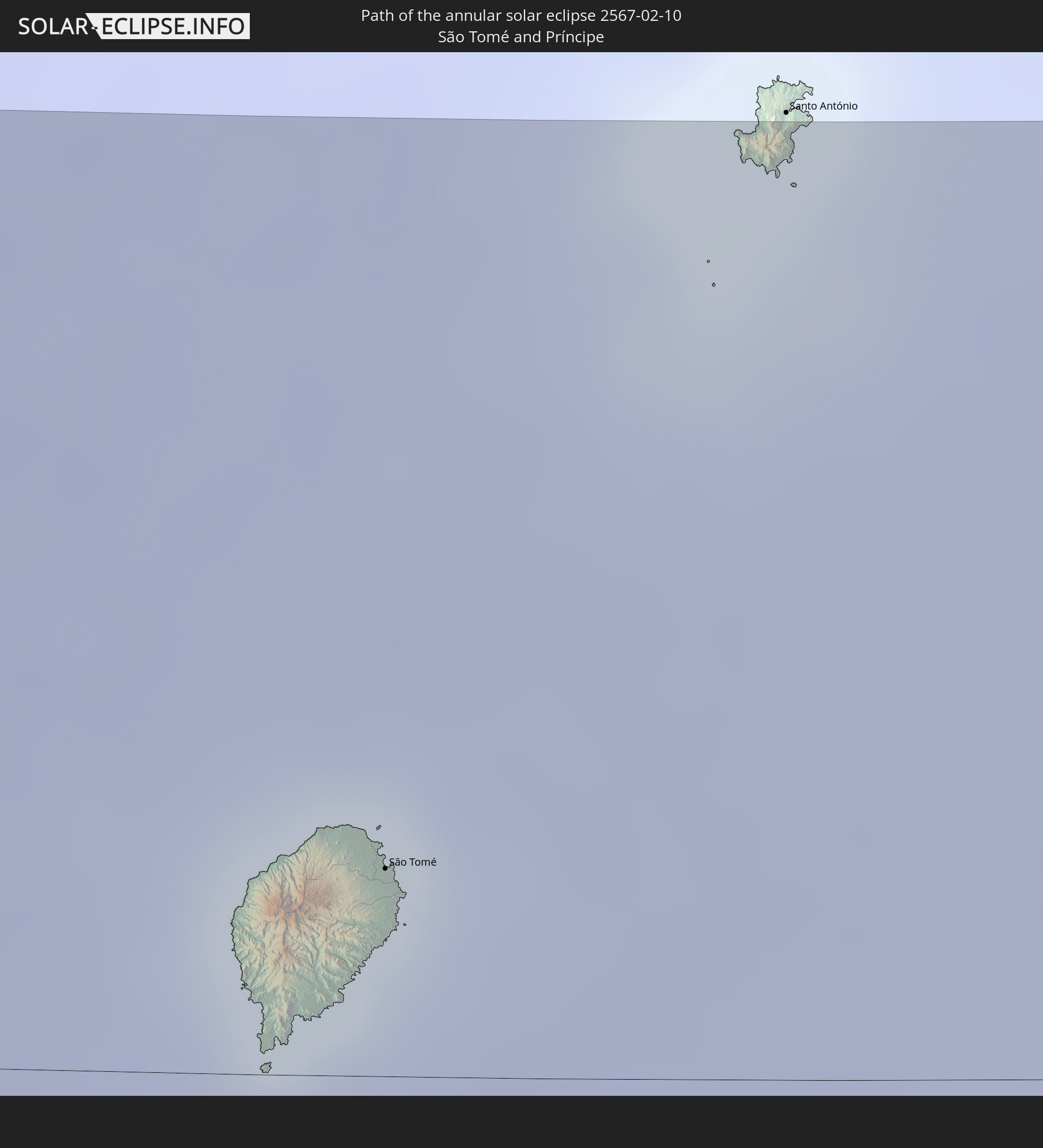 São Tomé and Príncipe
 Cameroon
 Gabon
Gabon
 Republic of the Congo
 Democratic Republic of the Congo
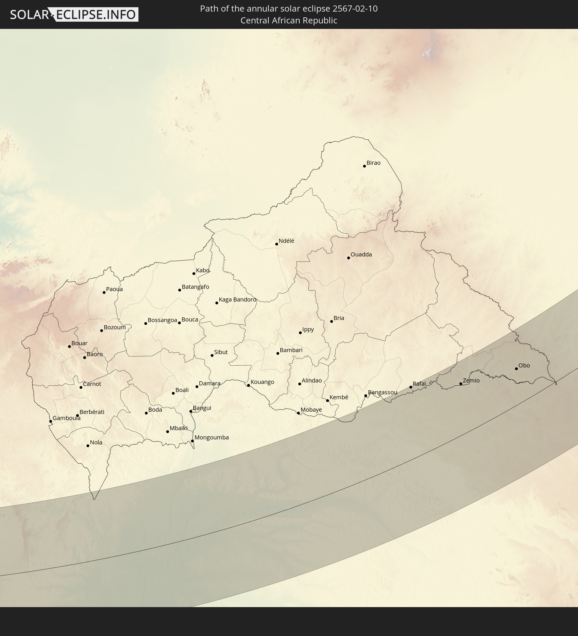 Central African Republic
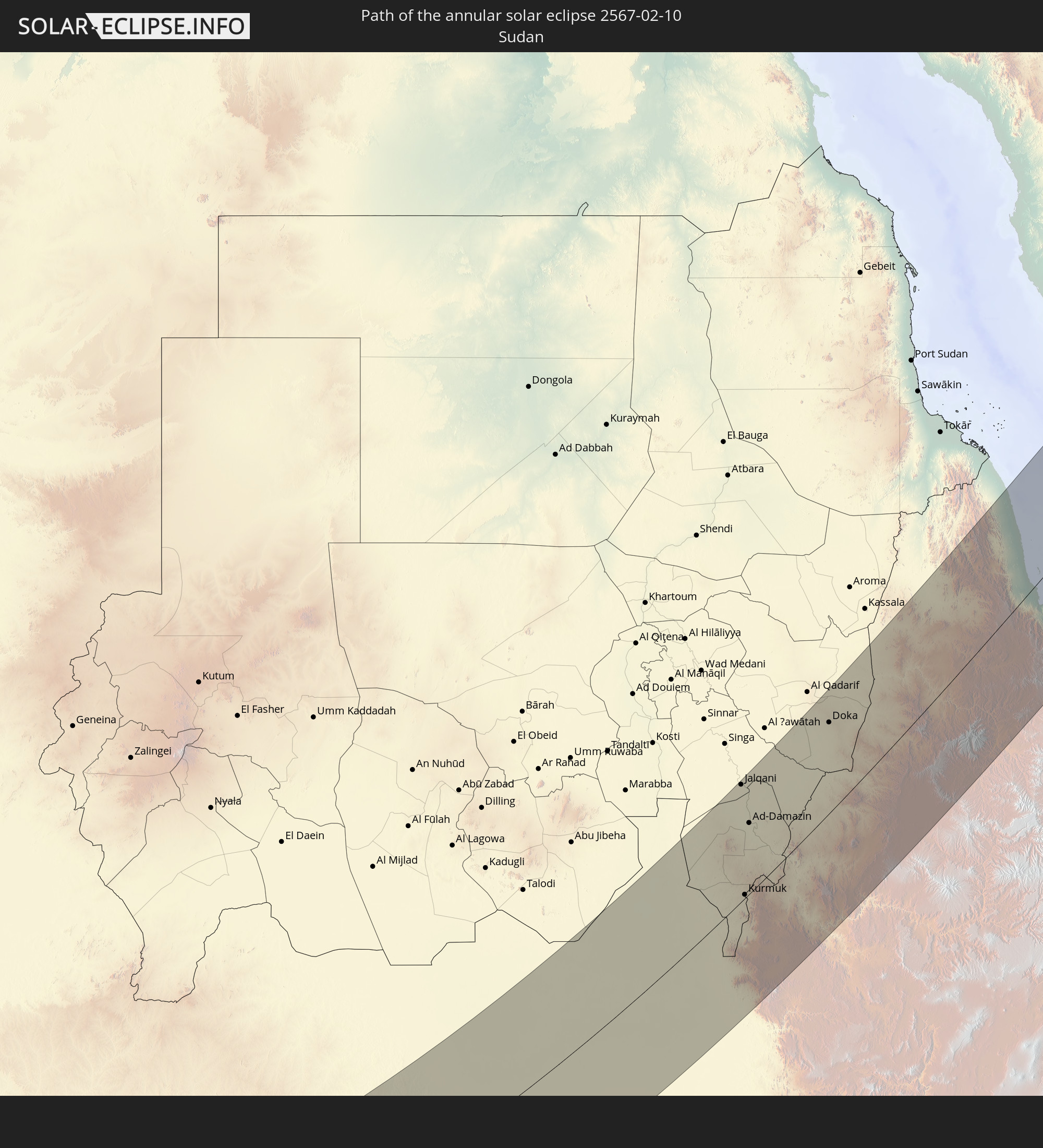 Sudan
Sudan
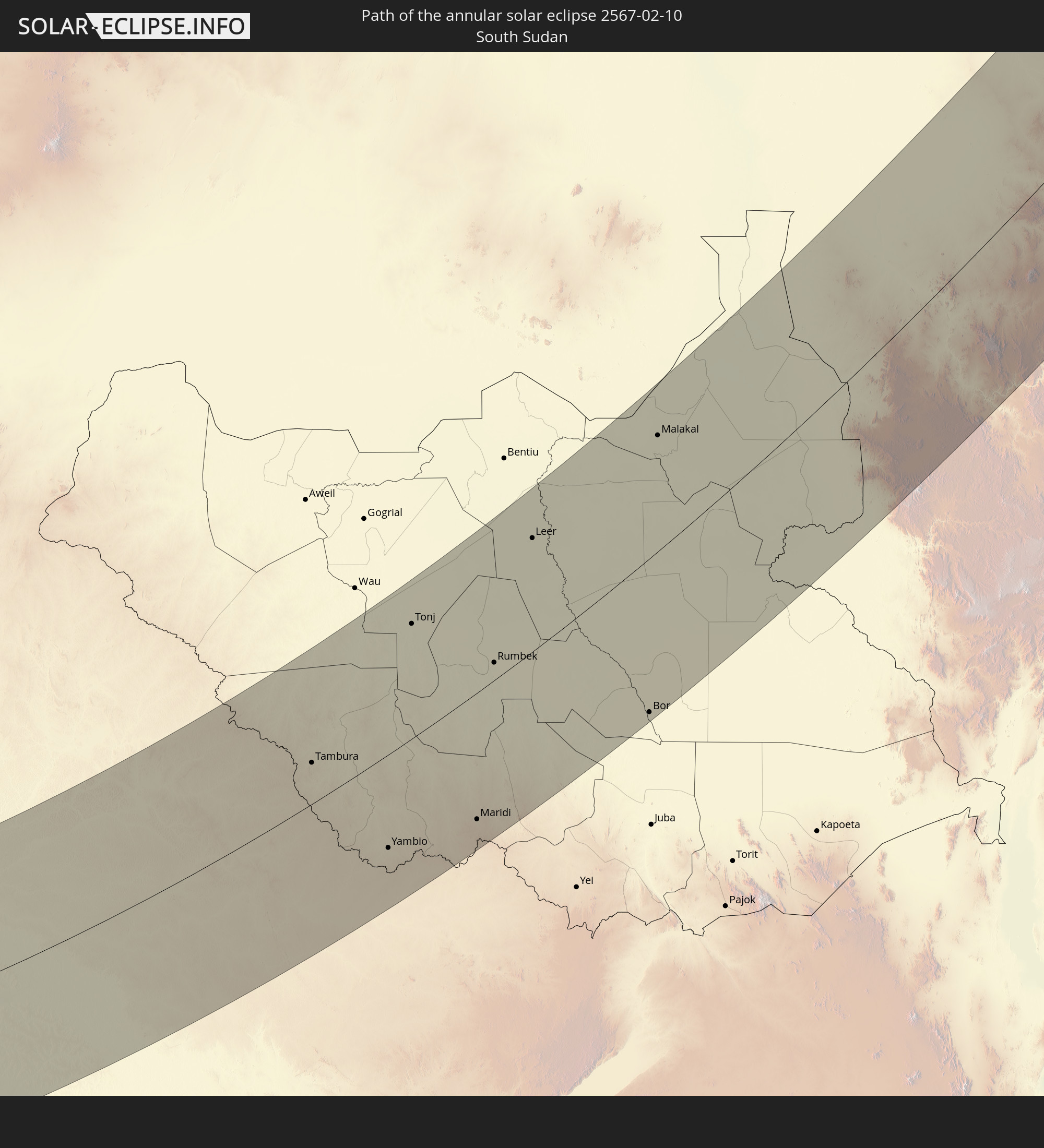 South Sudan
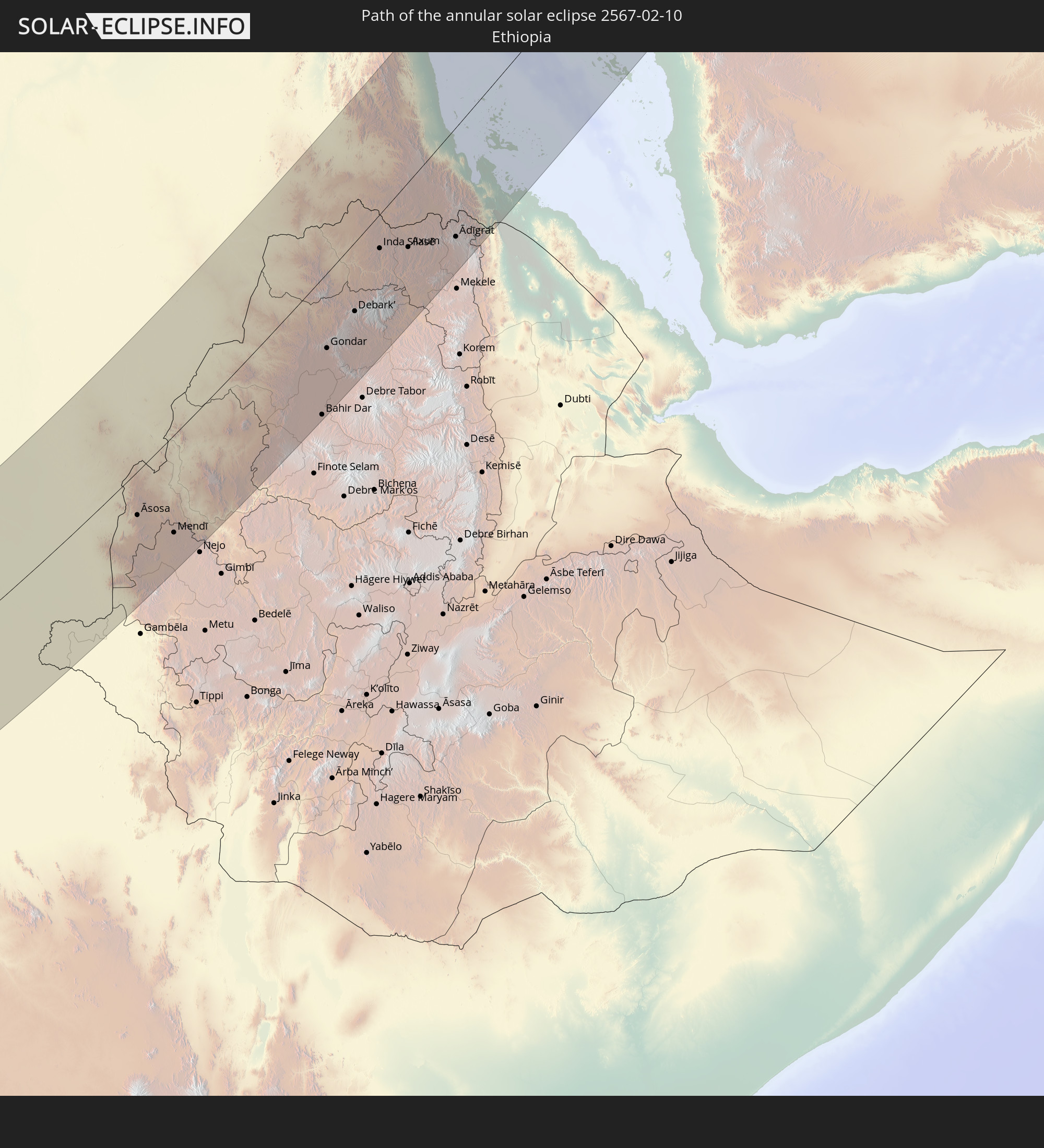 Ethiopia
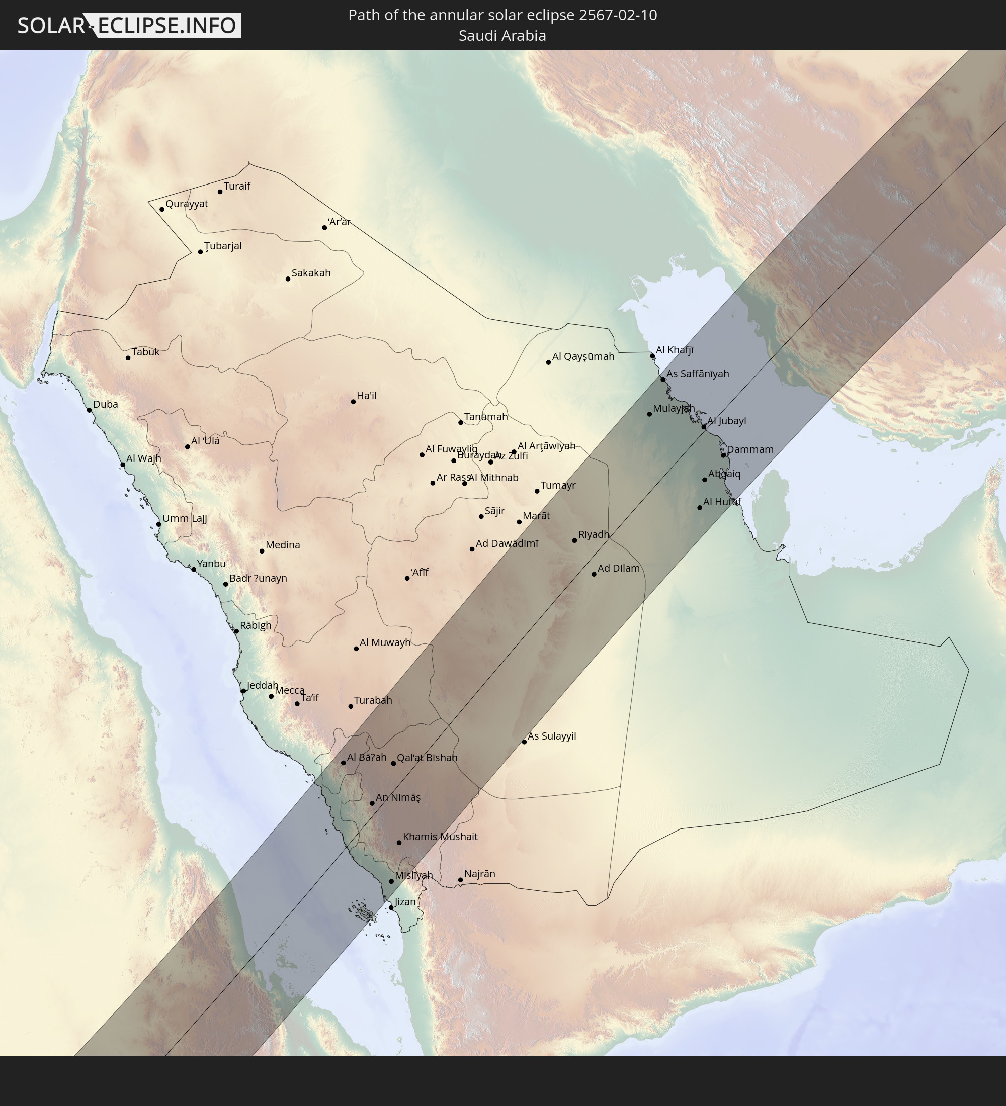 Saudi Arabia
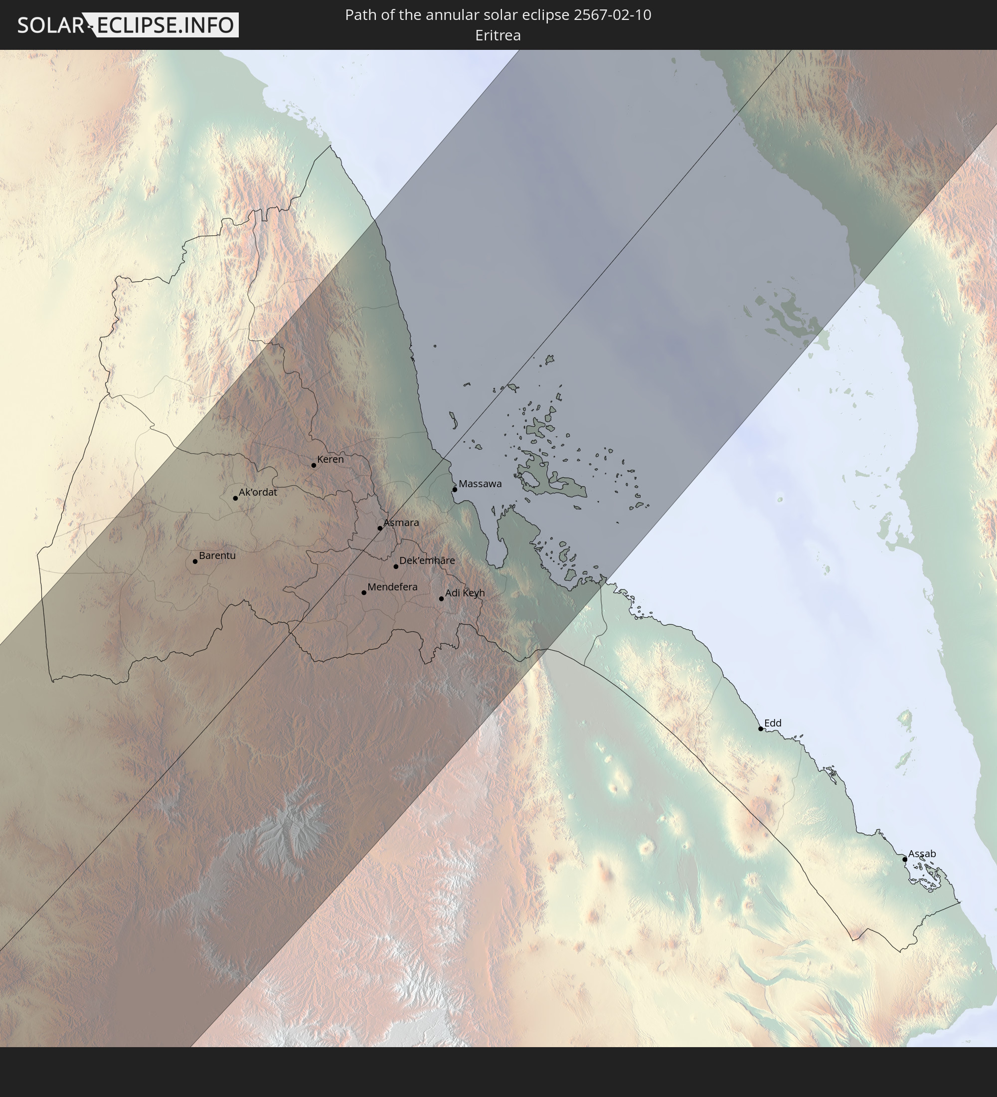 Eritrea
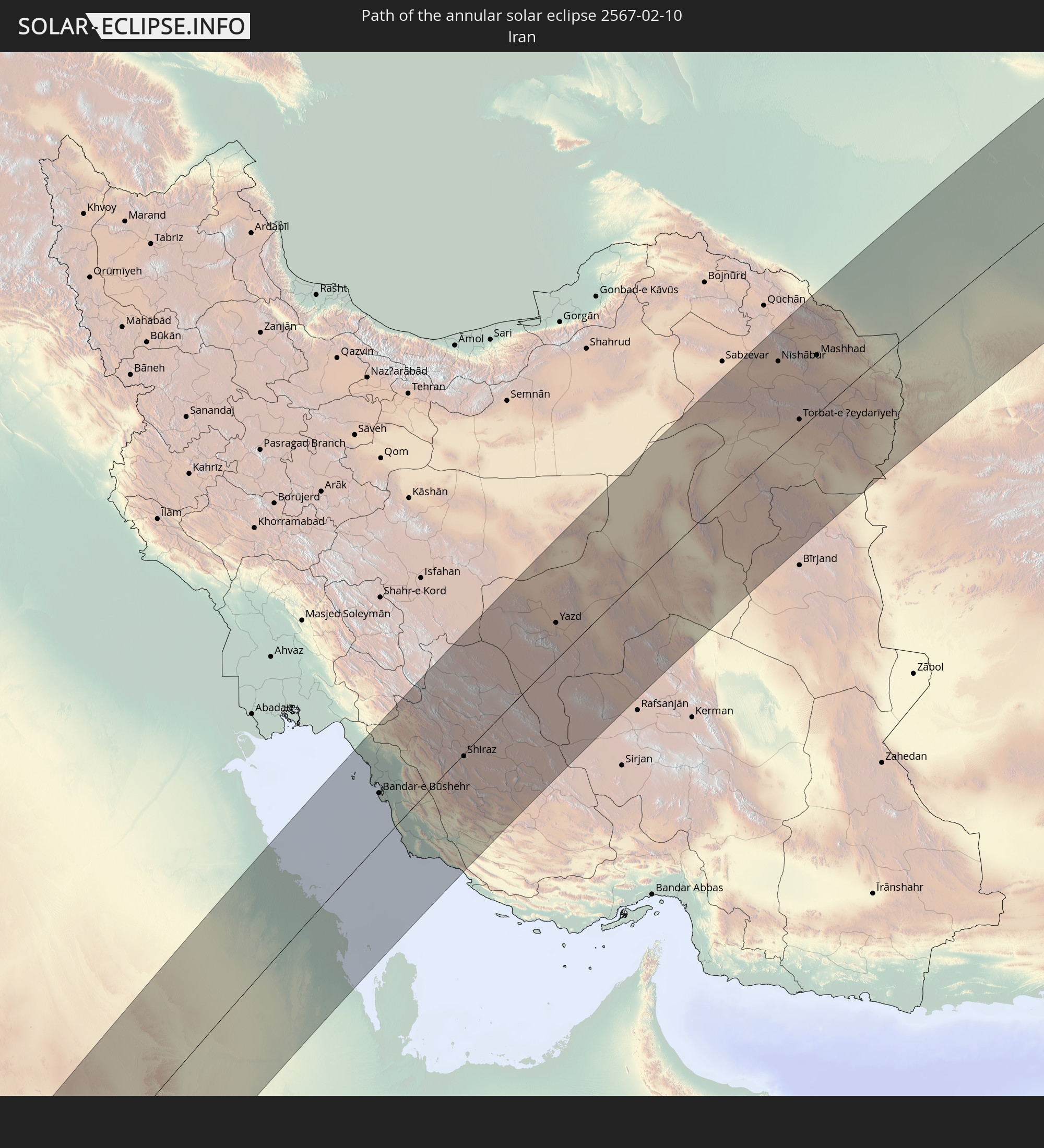 Iran
Iran
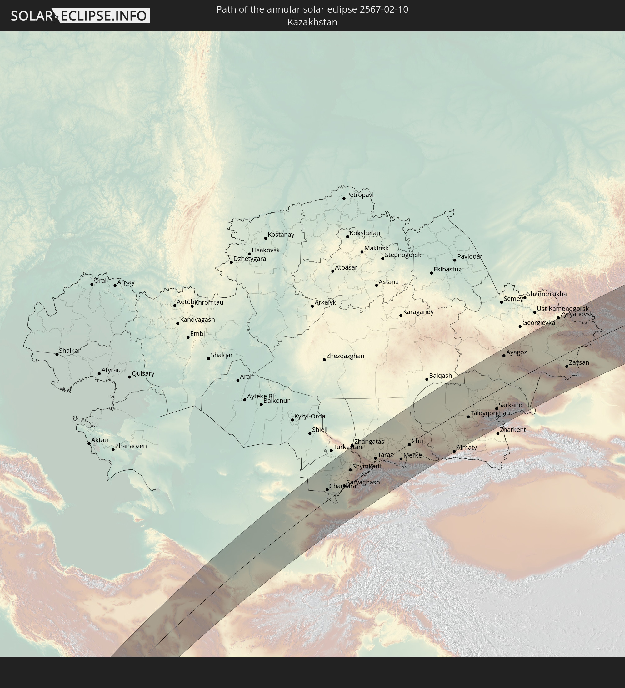 Kazakhstan
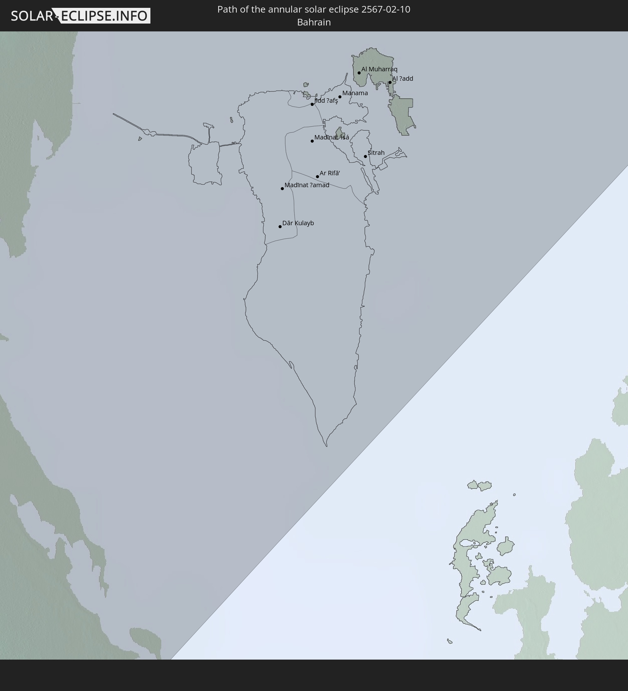 Bahrain
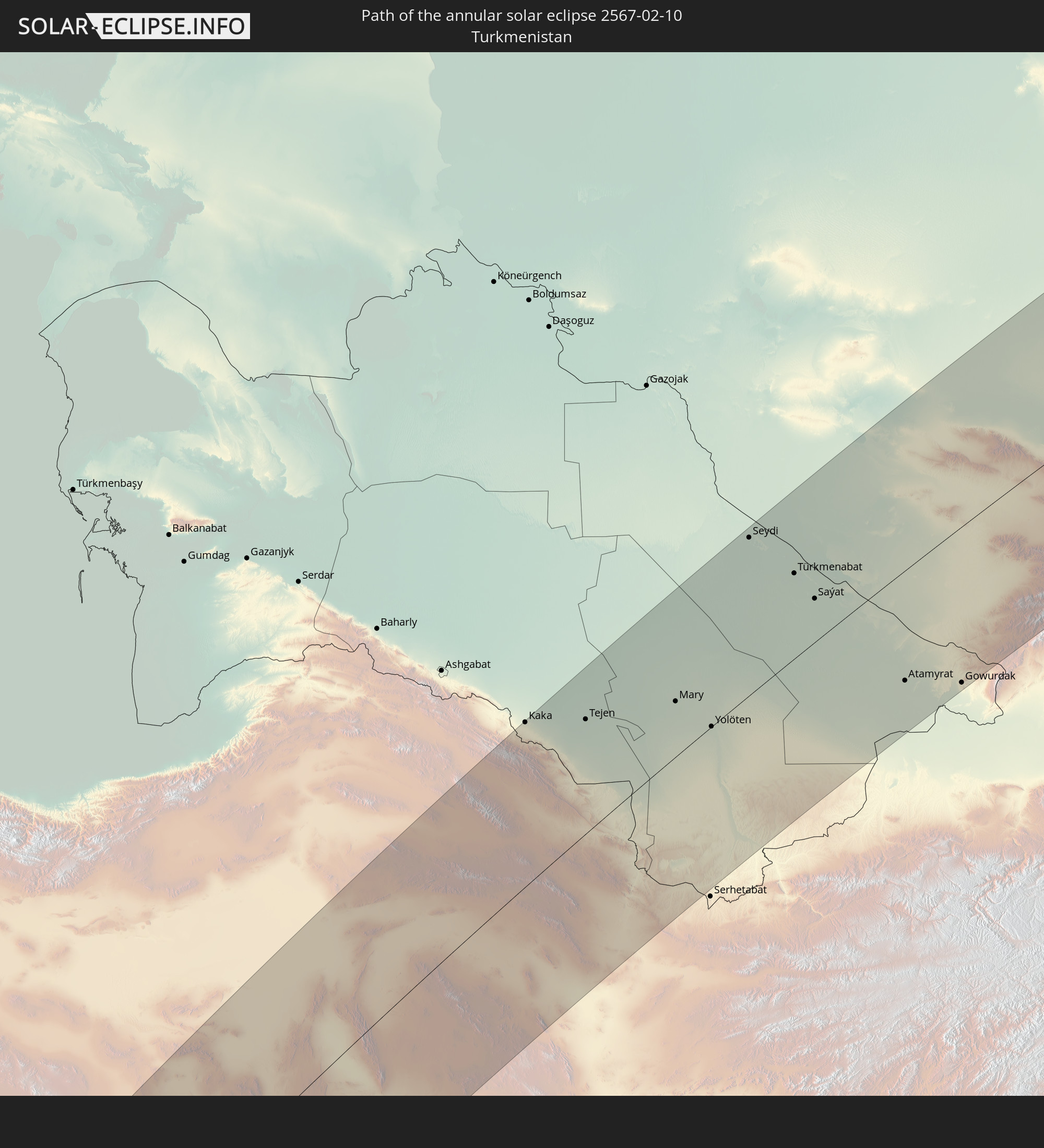 Turkmenistan
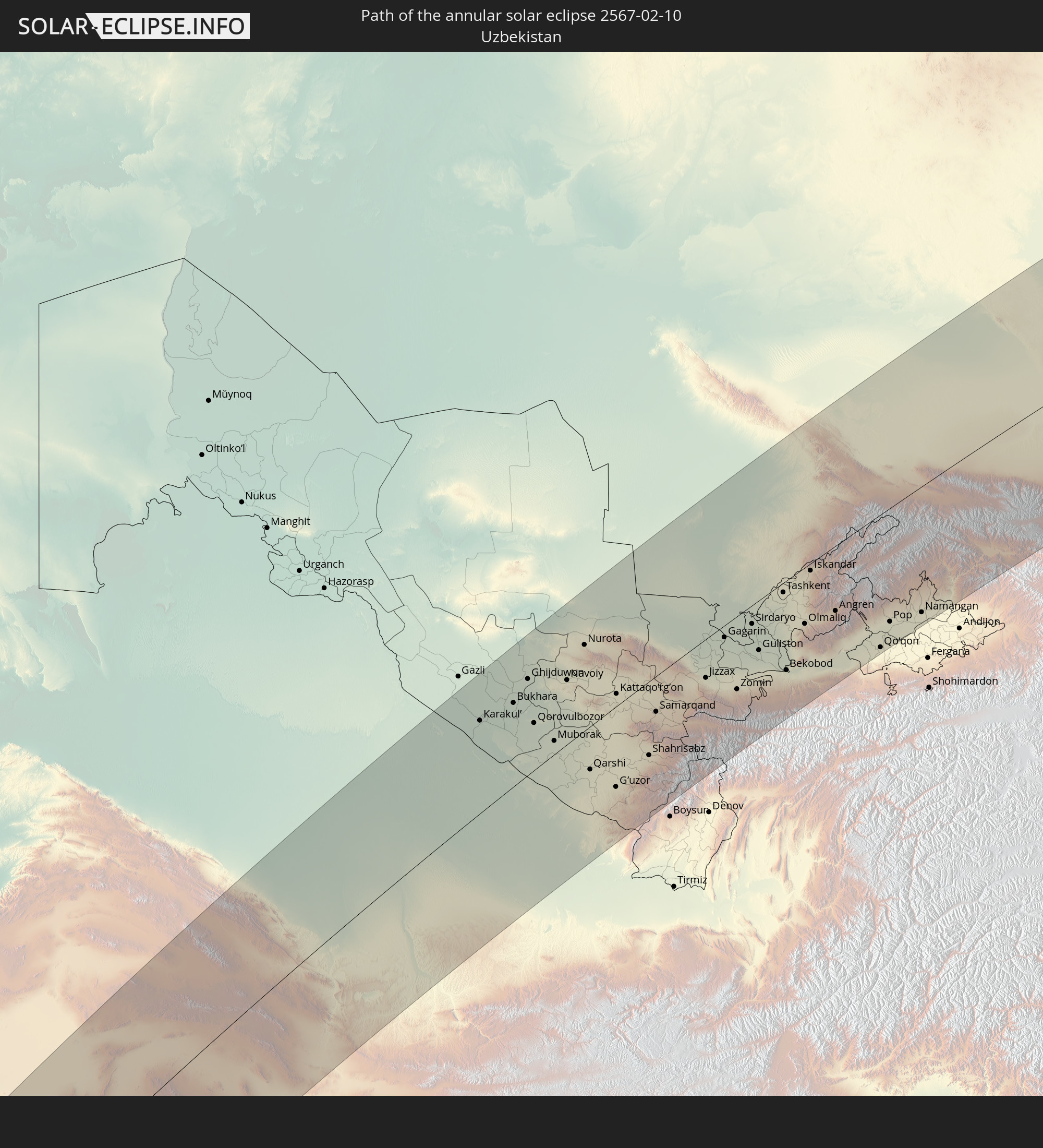 Uzbekistan
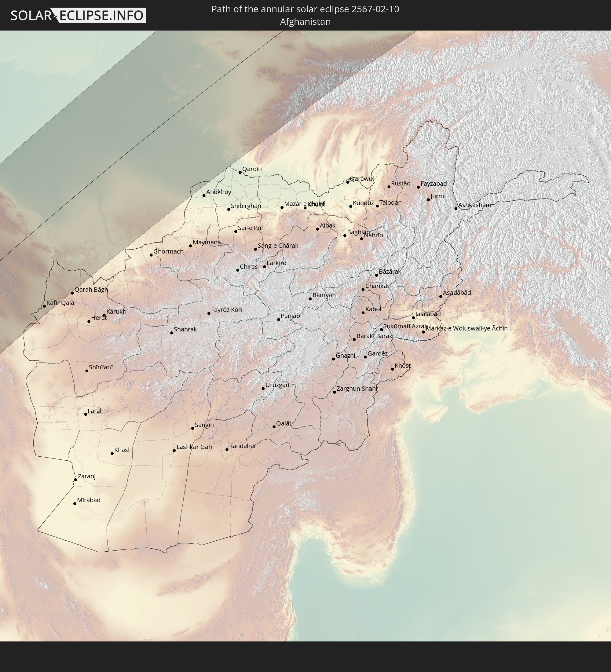 Afghanistan
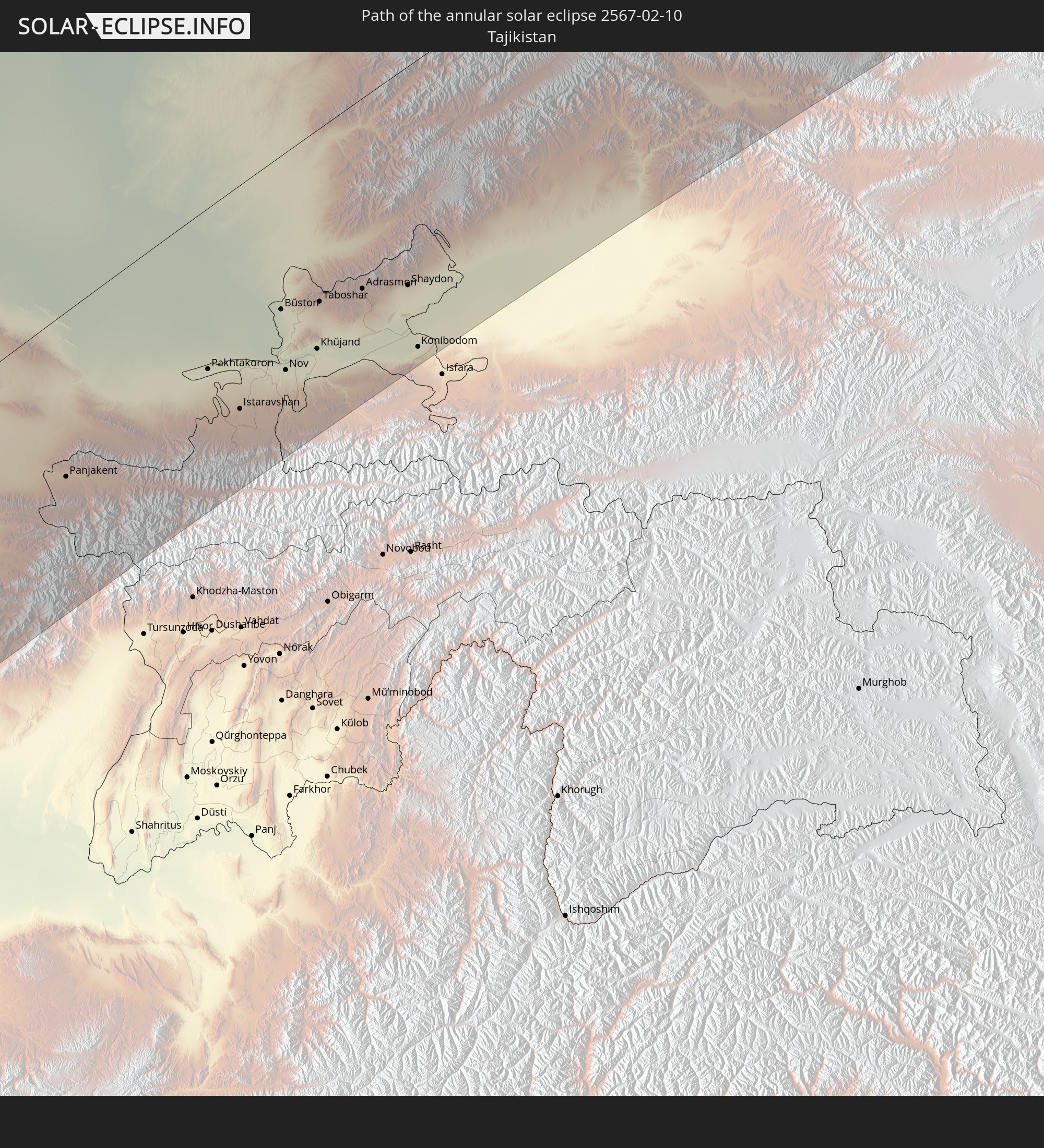 Tajikistan
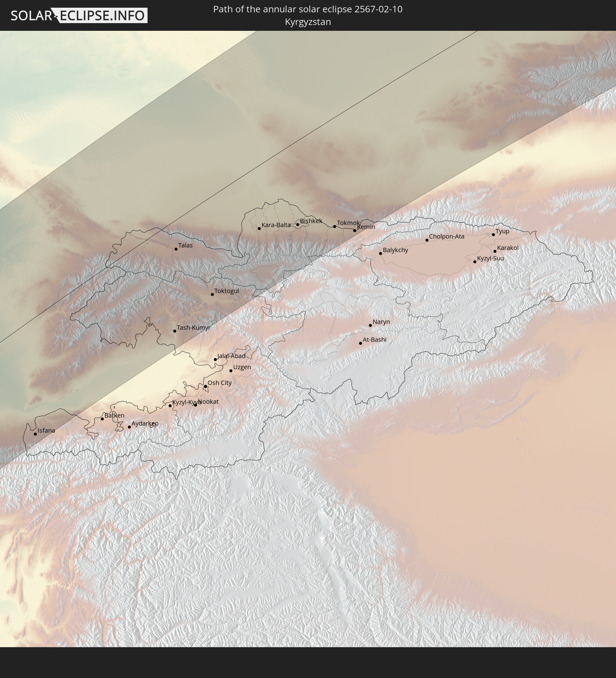 Kyrgyzstan
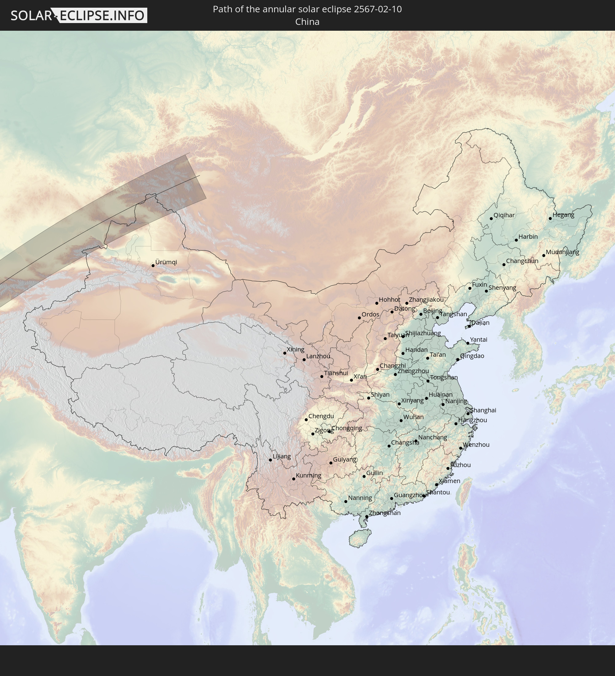 China
China
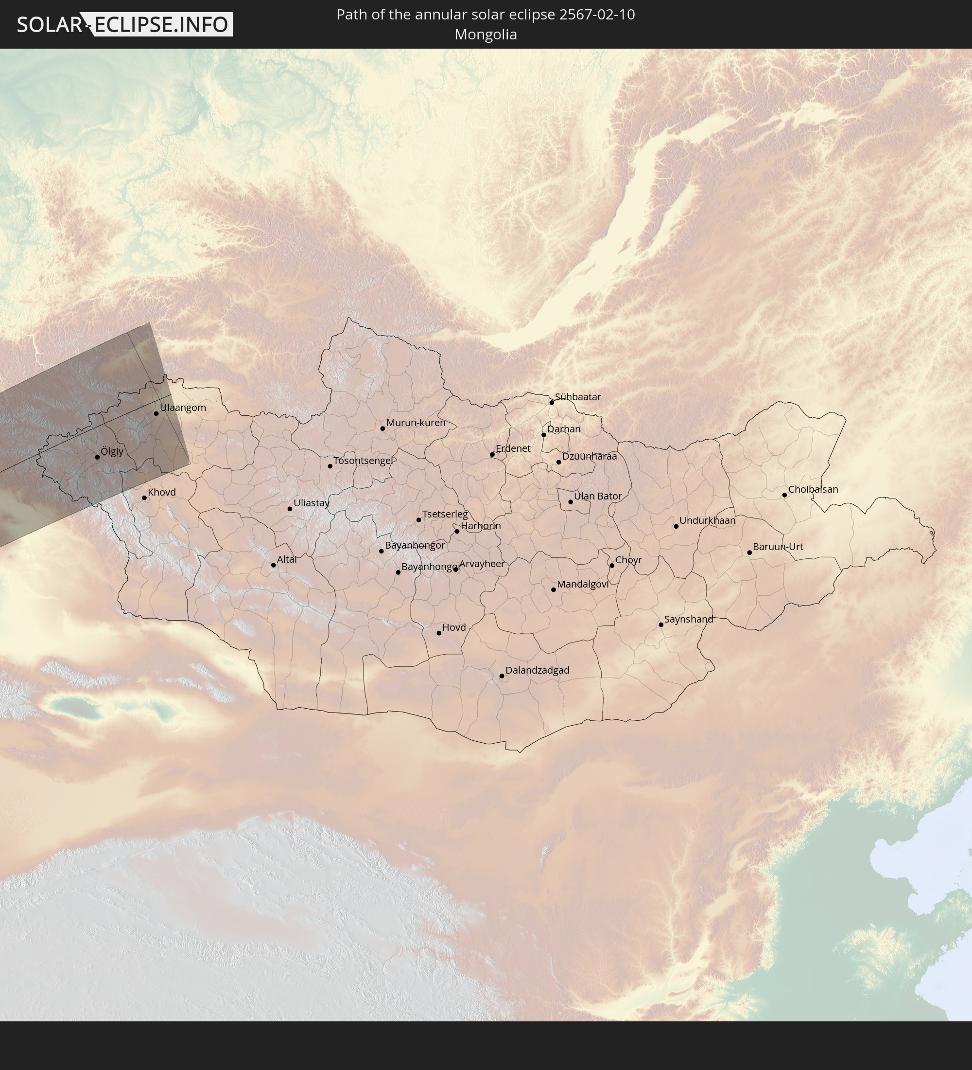 Mongolia
In den folgenden Ländern ist die Sonnenfinsternis partiell zu sehen
 Russia
 Portugal
 Spain
Spain
 Senegal
 Mauritania
 The Gambia
 Guinea-Bissau
 Guinea
 Saint Helena, Ascension and Tristan da Cunha
 Sierra Leone
 Morocco
 Mali
Mali
 Liberia
 Republic of Ireland
 Svalbard and Jan Mayen
 Algeria
 United Kingdom
 Ivory Coast
 Faroe Islands
 Burkina Faso
 Gibraltar
 France
 Isle of Man
 Ghana
Ghana
 Guernsey
 Jersey
 Togo
Togo
 Niger
Niger
 Benin
Benin
 Andorra
 Belgium
 Nigeria
 Netherlands
 Norway
 Equatorial Guinea
 Luxembourg
 Germany
 Switzerland
 São Tomé and Príncipe
 Italy
Italy
 Monaco
 Tunisia
 Denmark
 Cameroon
 Gabon
Gabon
 Libya
Libya
 Liechtenstein
 Austria
 Sweden
 Republic of the Congo
 Angola
 Namibia
 Czechia
 Democratic Republic of the Congo
 San Marino
 Vatican City
 Slovenia
 Chad
Chad
 Croatia
 Poland
 Malta
Malta
 Central African Republic
 Bosnia and Herzegovina
 Hungary
 South Africa
 Slovakia
 Montenegro
 Serbia
 Albania
 Åland Islands
 Greece
 Botswana
 Romania
 Republic of Macedonia
 Finland
 Lithuania
 Latvia
 Estonia
 Sudan
Sudan
 Zambia
 Ukraine
 Bulgaria
 Belarus
 Egypt
Egypt
 Zimbabwe
 Turkey
 Moldova
 Lesotho
 Rwanda
 Burundi
 Tanzania
 Uganda
 Mozambique
 Swaziland
 Cyprus
 Malawi
 Ethiopia
 Kenya
Kenya
 State of Palestine
 Israel
 Saudi Arabia
 Jordan
 Lebanon
 Syria
Syria
 Eritrea
 Iraq
Iraq
 Georgia
 French Southern and Antarctic Lands
 Somalia
 Djibouti
 Yemen
Yemen
 Madagascar
 Comoros
 Armenia
 Iran
Iran
 Azerbaijan
 Mayotte
 Seychelles
 Kazakhstan
 Kuwait
 Bahrain
 Qatar
Qatar
 United Arab Emirates
 Oman
Oman
 Turkmenistan
 Uzbekistan
 Mauritius
 Afghanistan
 Pakistan
 Tajikistan
 India
India
 Kyrgyzstan
 Maldives
 China
China
 Sri Lanka
 Nepal
Nepal
 Mongolia
 Bangladesh
 Bhutan
 Myanmar
 Thailand
 Laos
Laos
 Vietnam
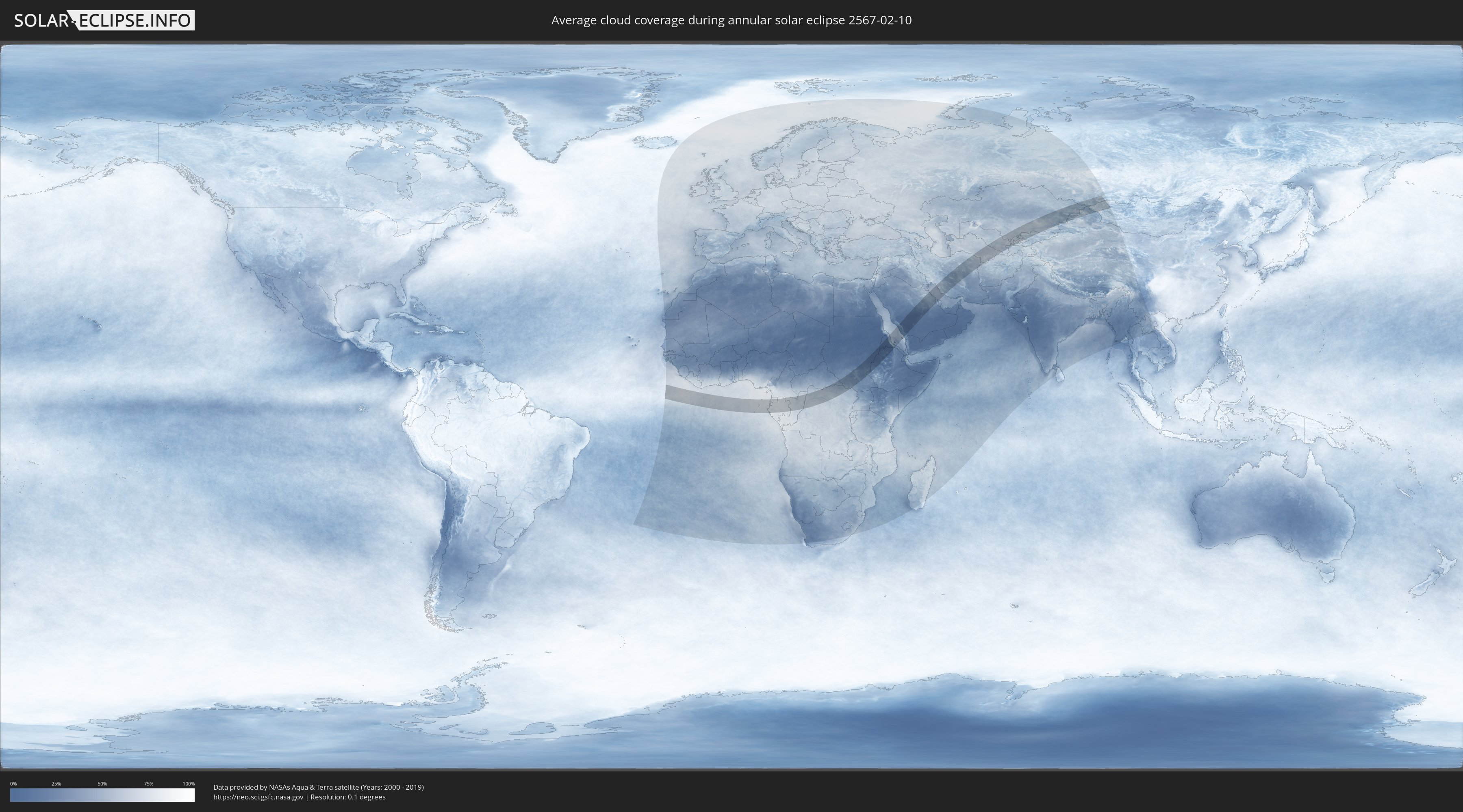
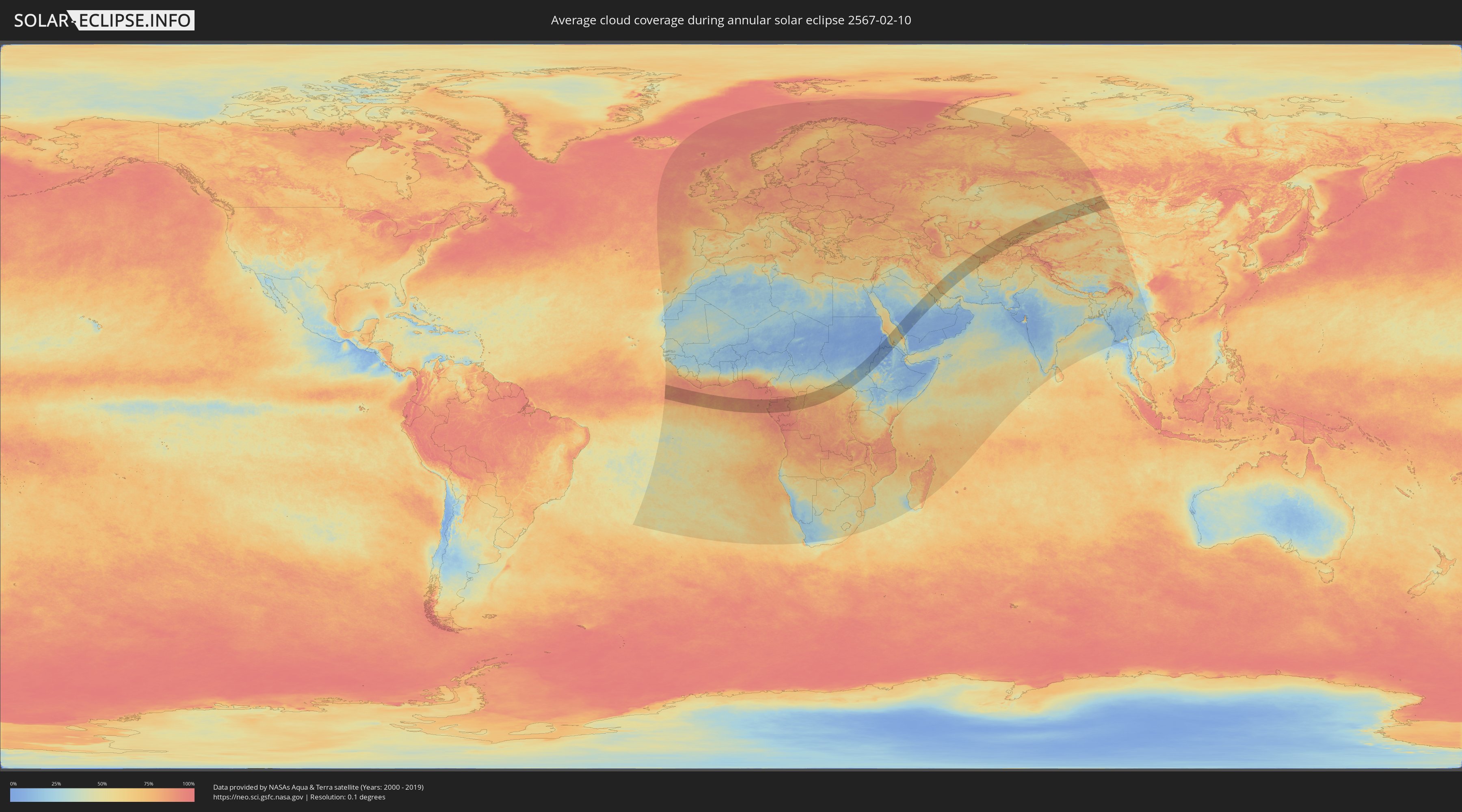
How will be the weather during the annular solar eclipse on 02/10/2567?
Where is the best place to see the annular solar eclipse of 02/10/2567?
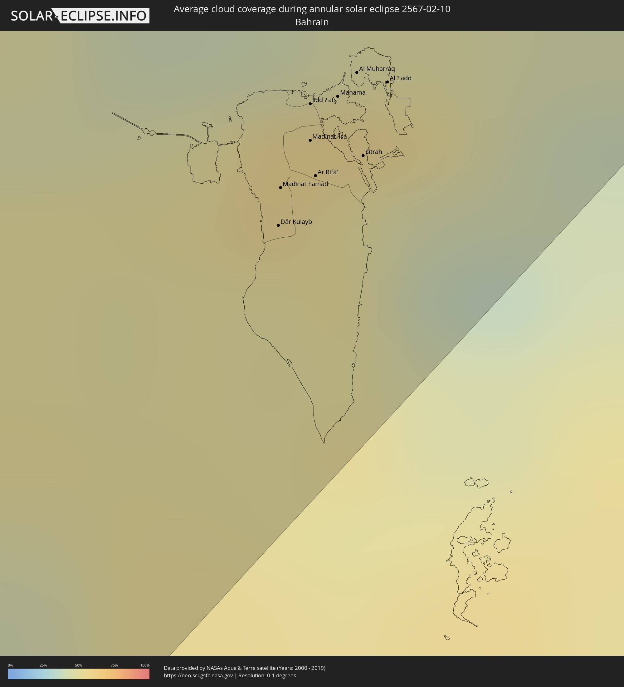
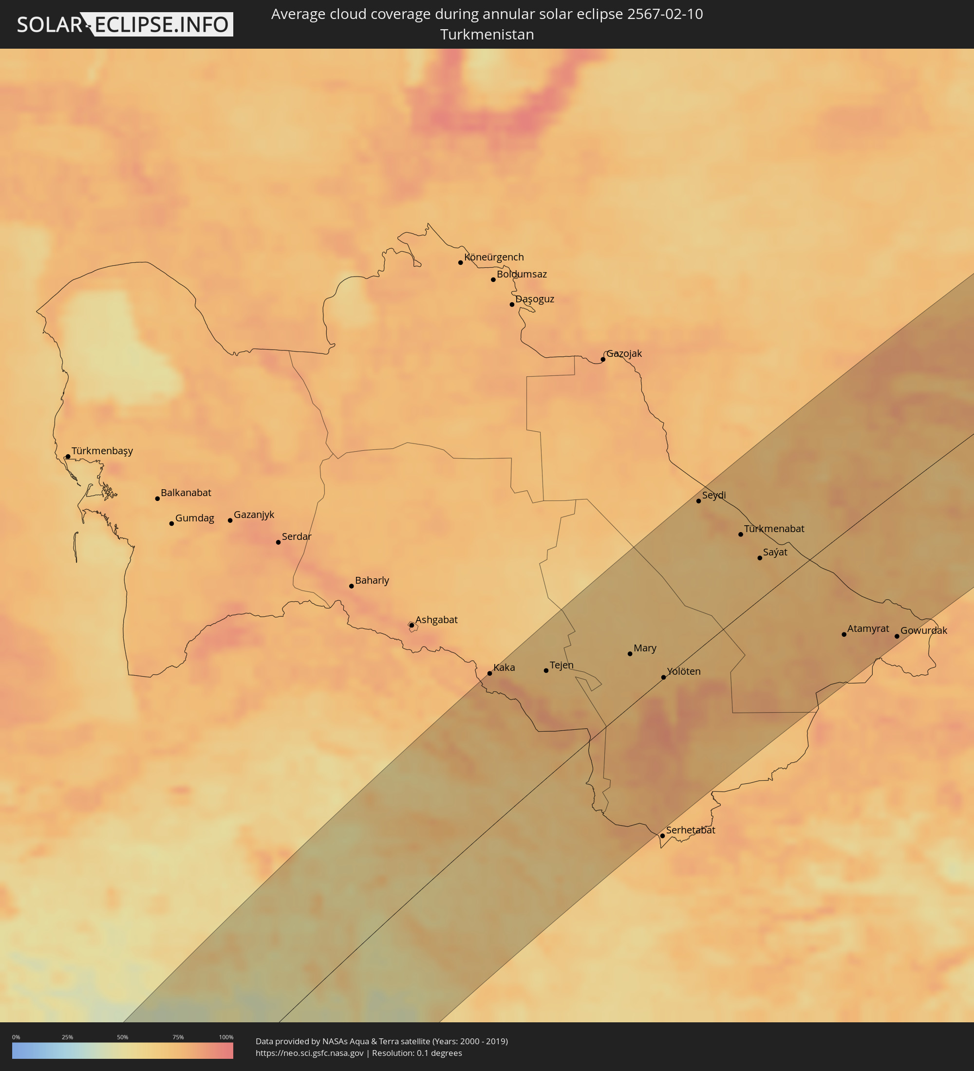
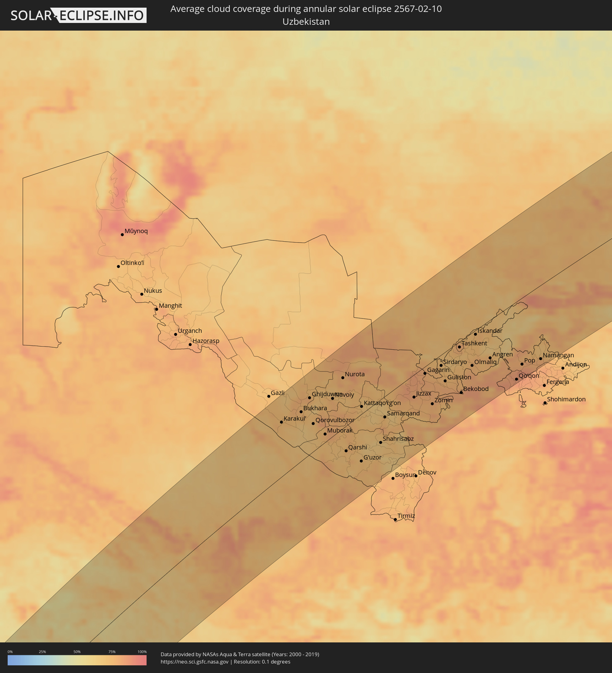
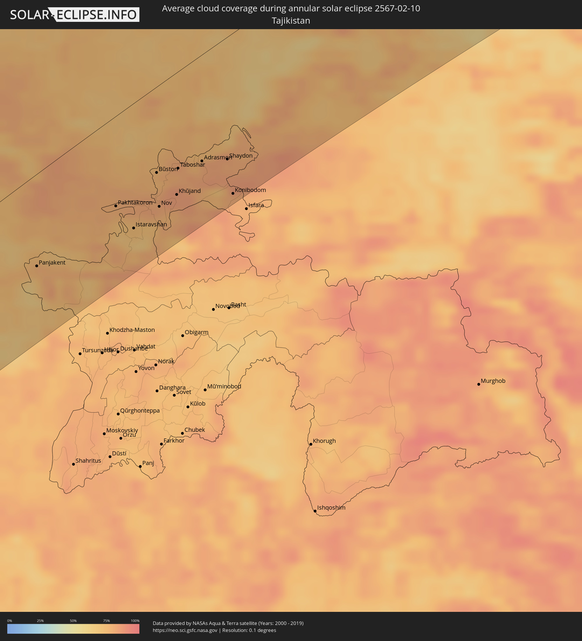
The following maps show the average cloud coverage for the day of the annular solar eclipse.
With the help of these maps, it is possible to find the place along the eclipse path, which has the best
chance of a cloudless sky.
Nevertheless, you should consider local circumstances and inform about the weather of your chosen
observation site.
The data is provided by NASAs satellites
AQUA and TERRA.
The cloud maps are averaged over a period of 19 years (2000 - 2019).
Detailed country maps
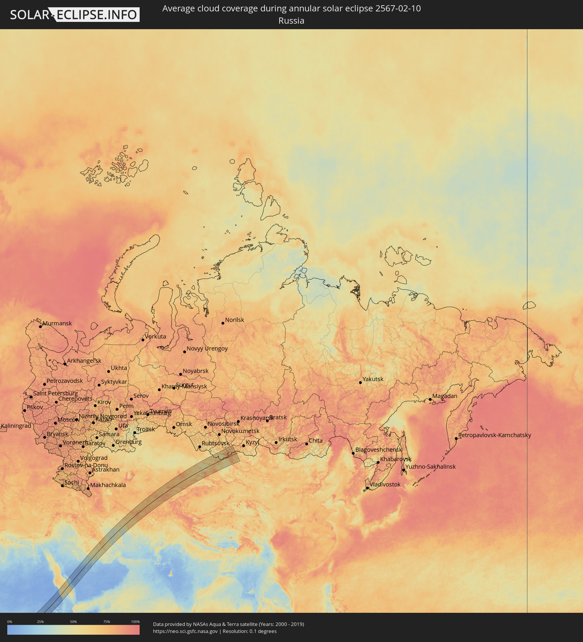 Russia
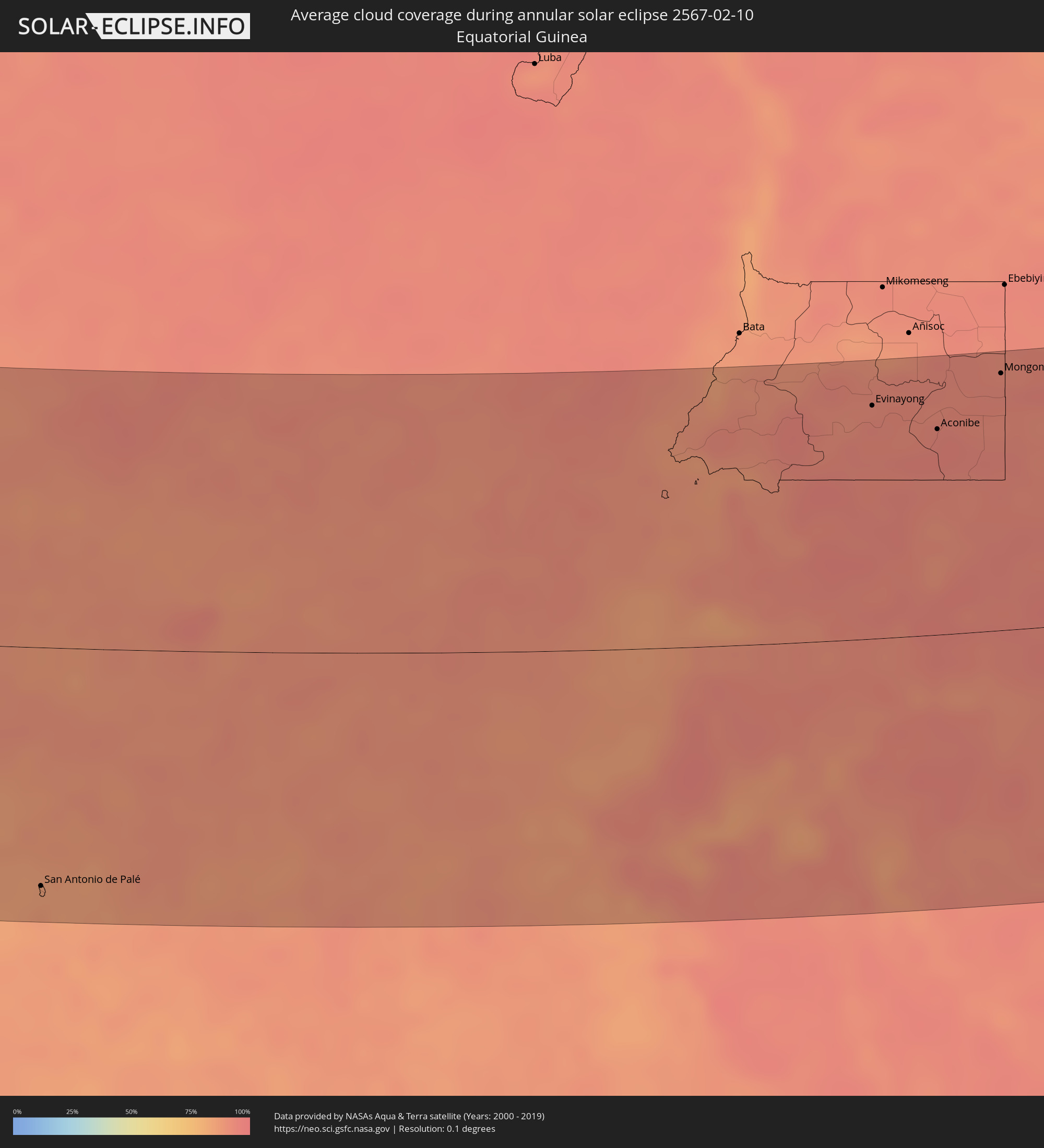 Equatorial Guinea
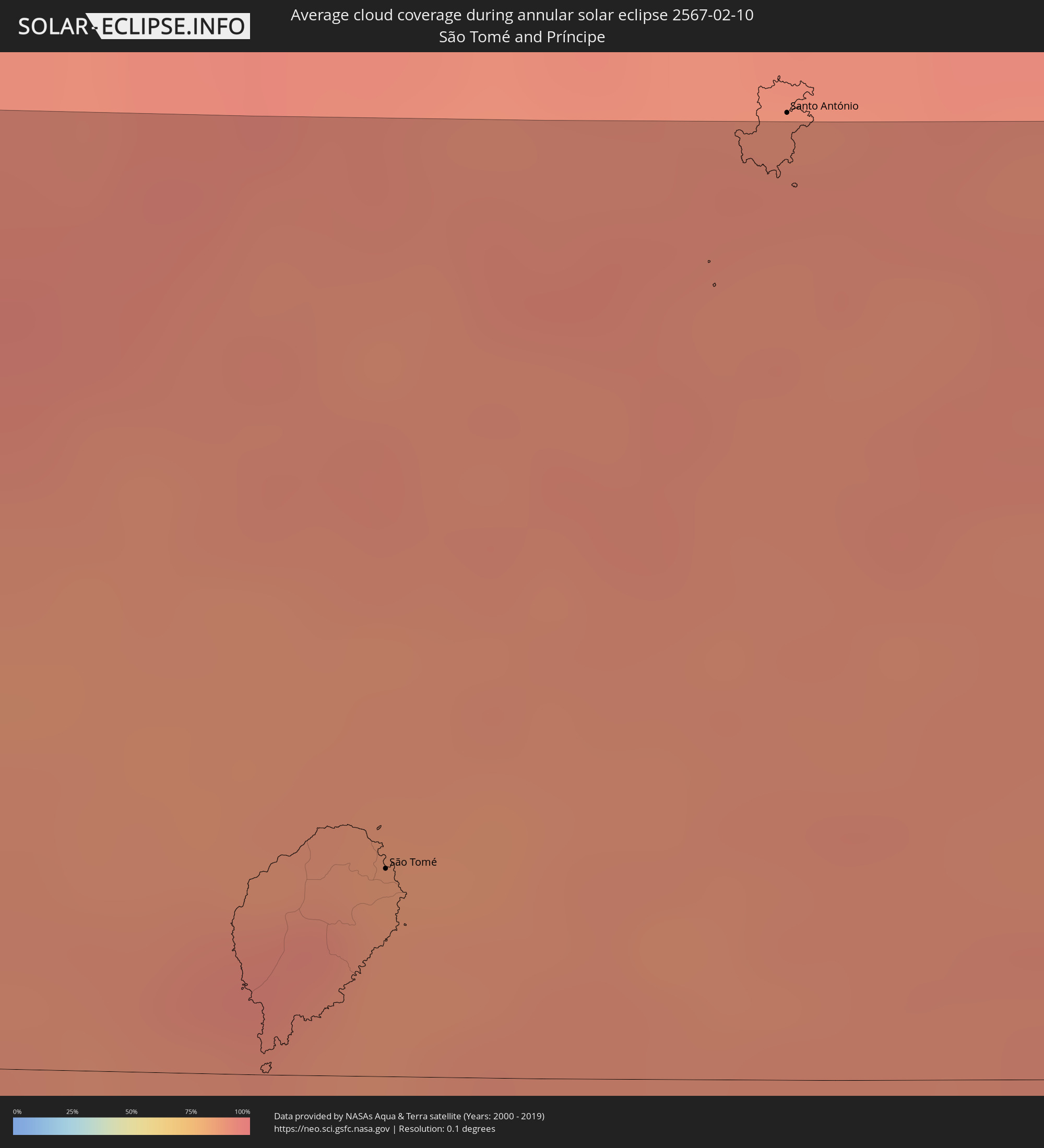 São Tomé and Príncipe
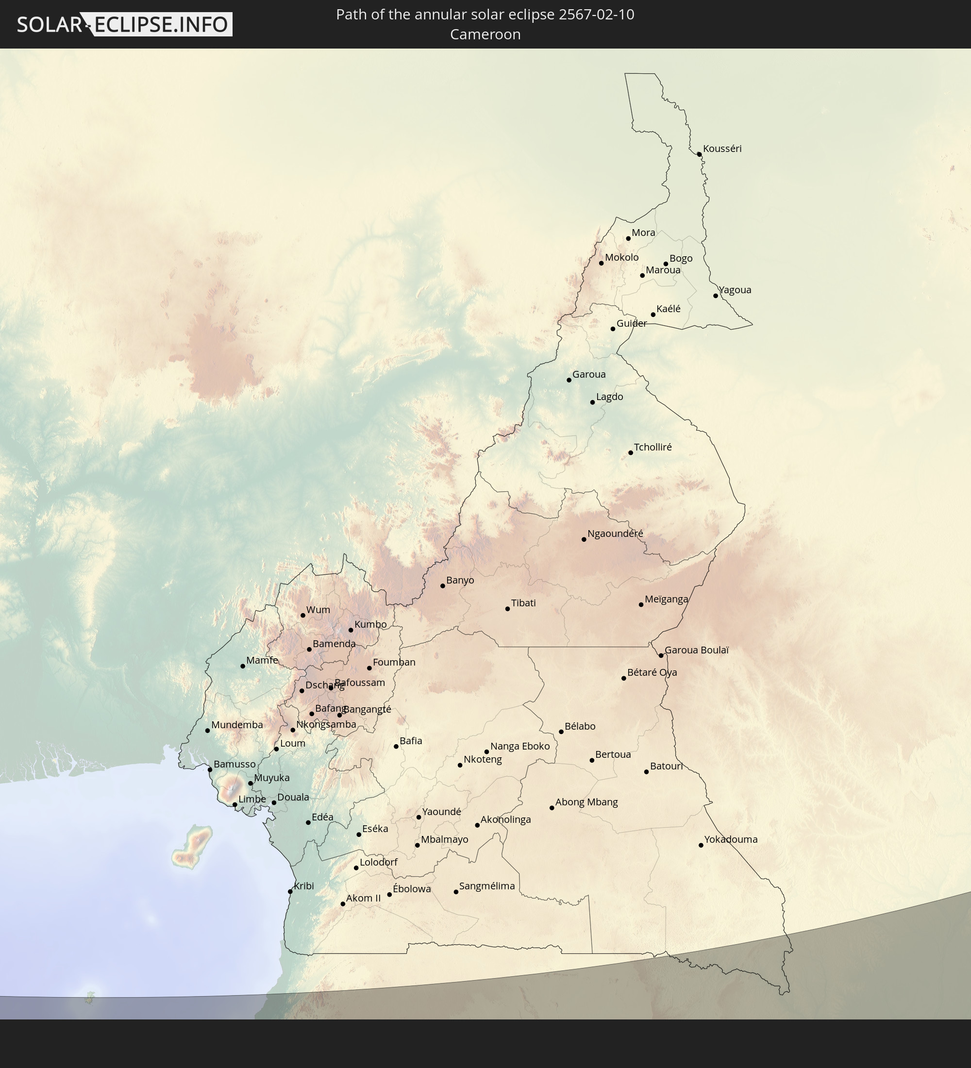
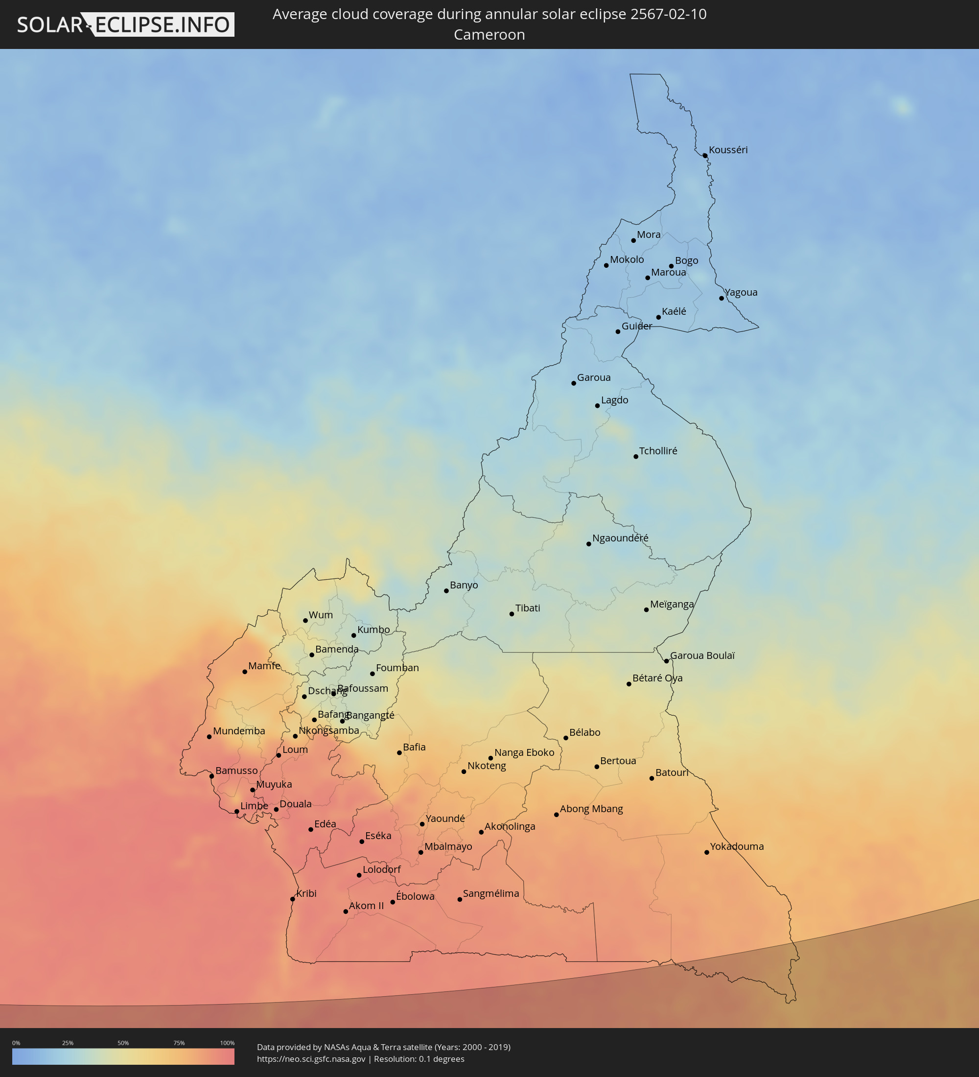 Cameroon
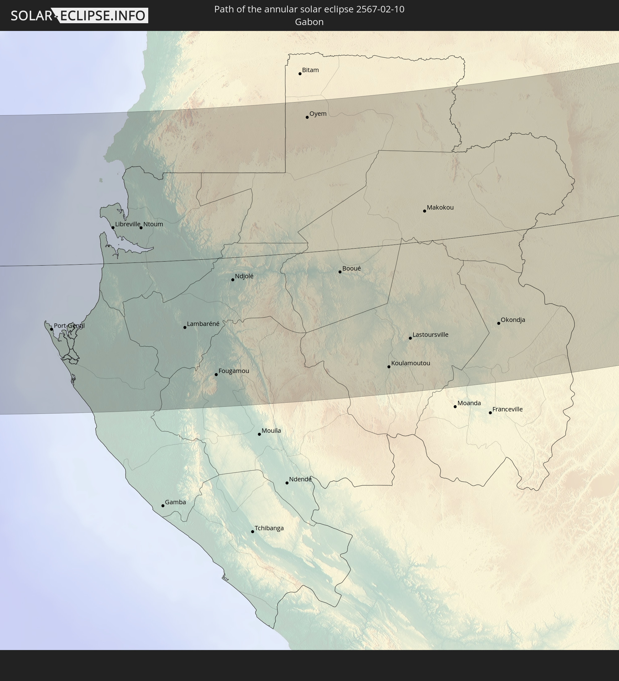
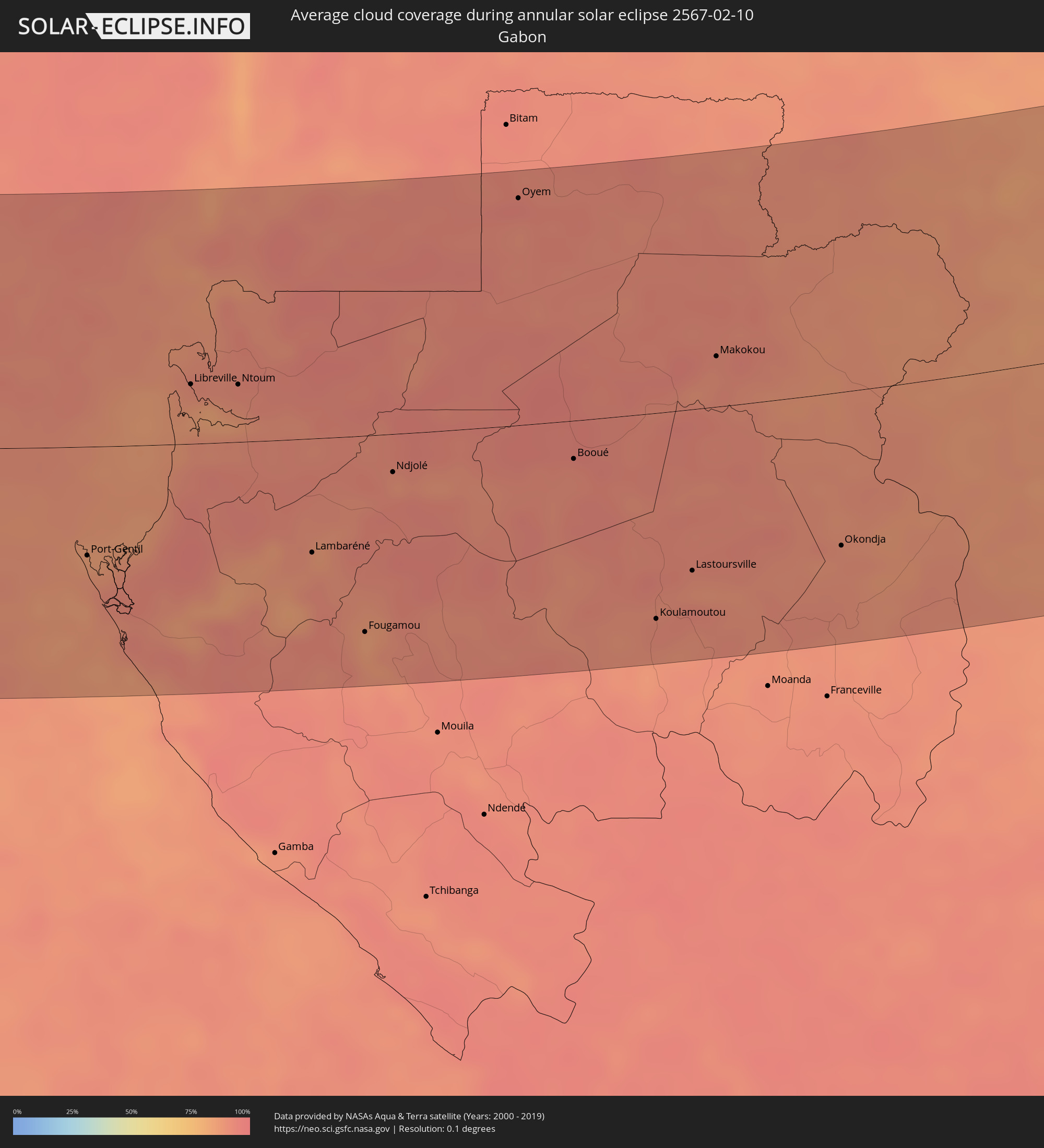 Gabon
Gabon
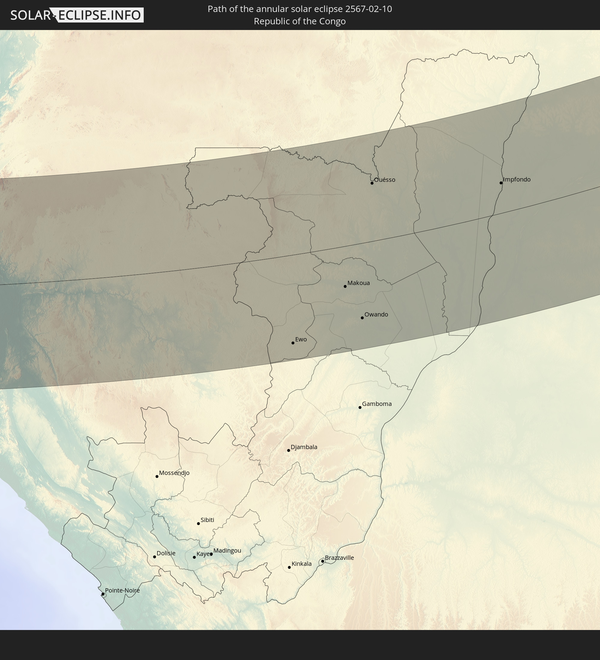
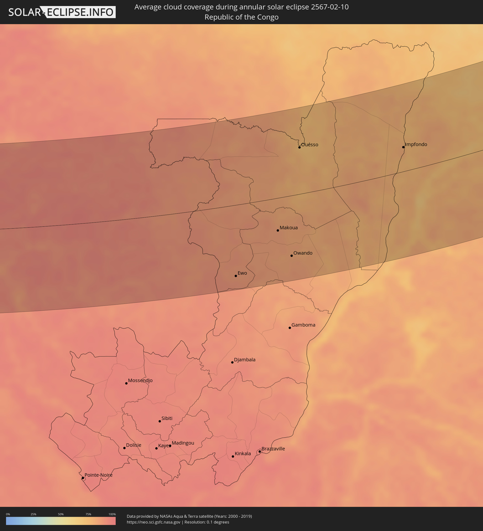 Republic of the Congo
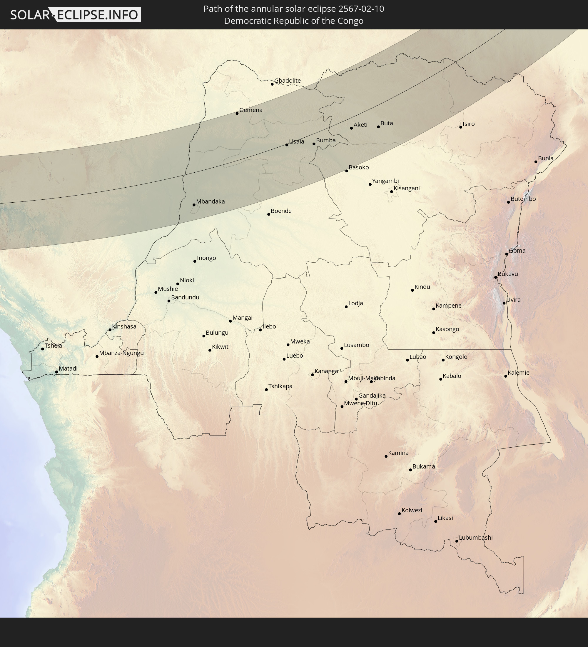
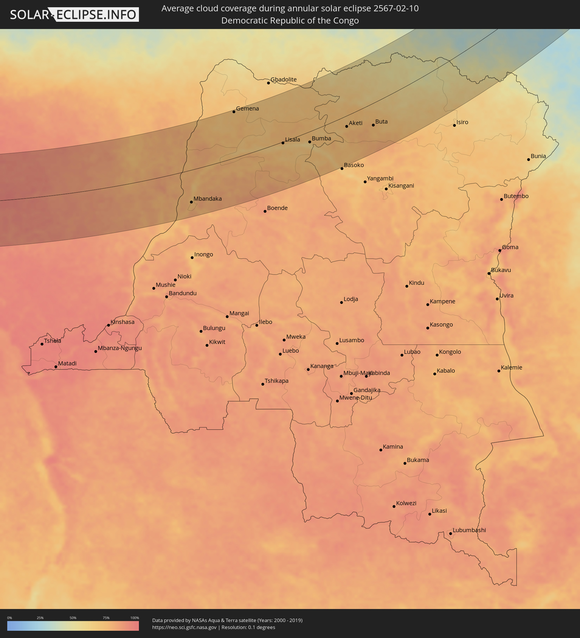 Democratic Republic of the Congo
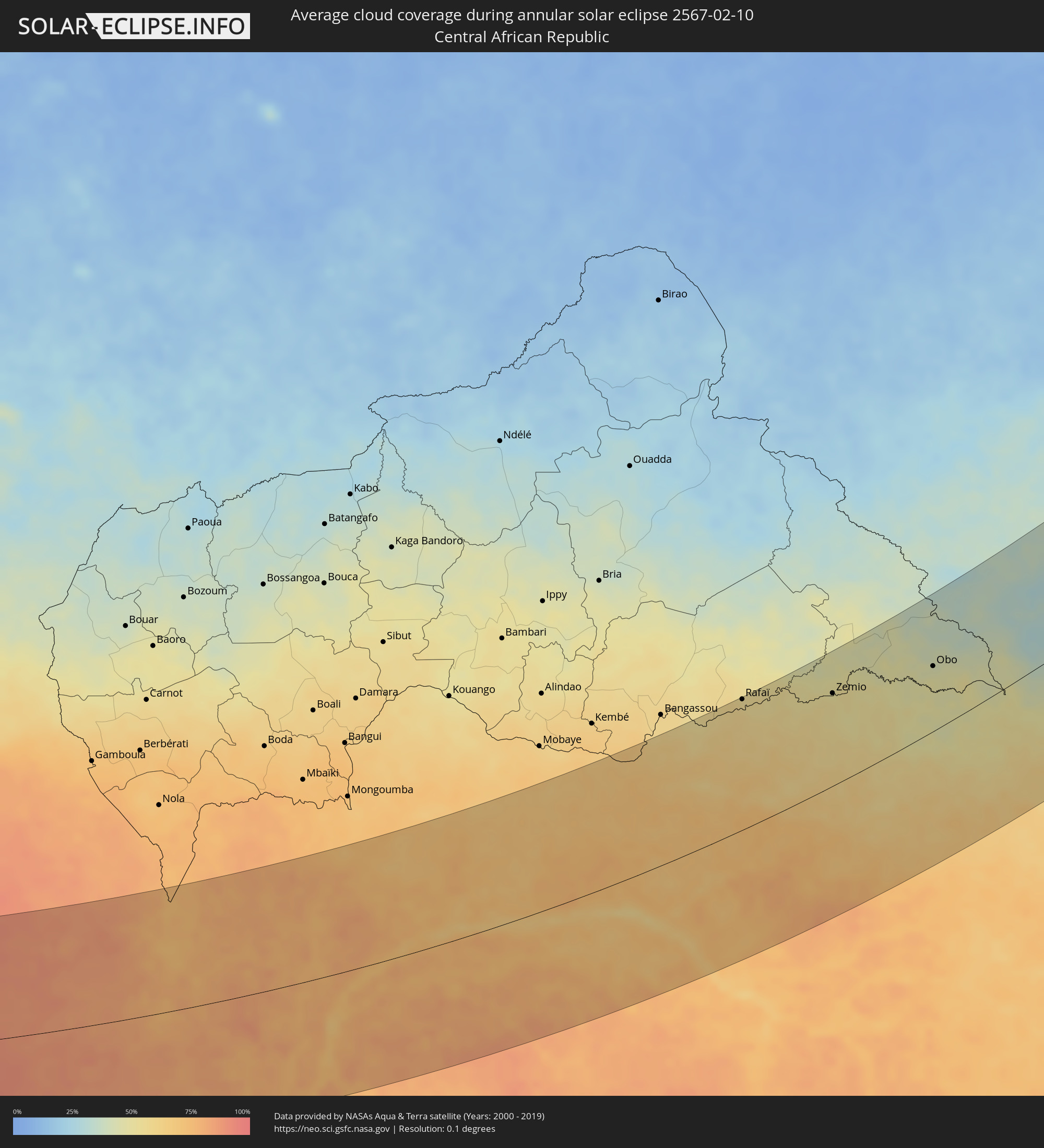 Central African Republic
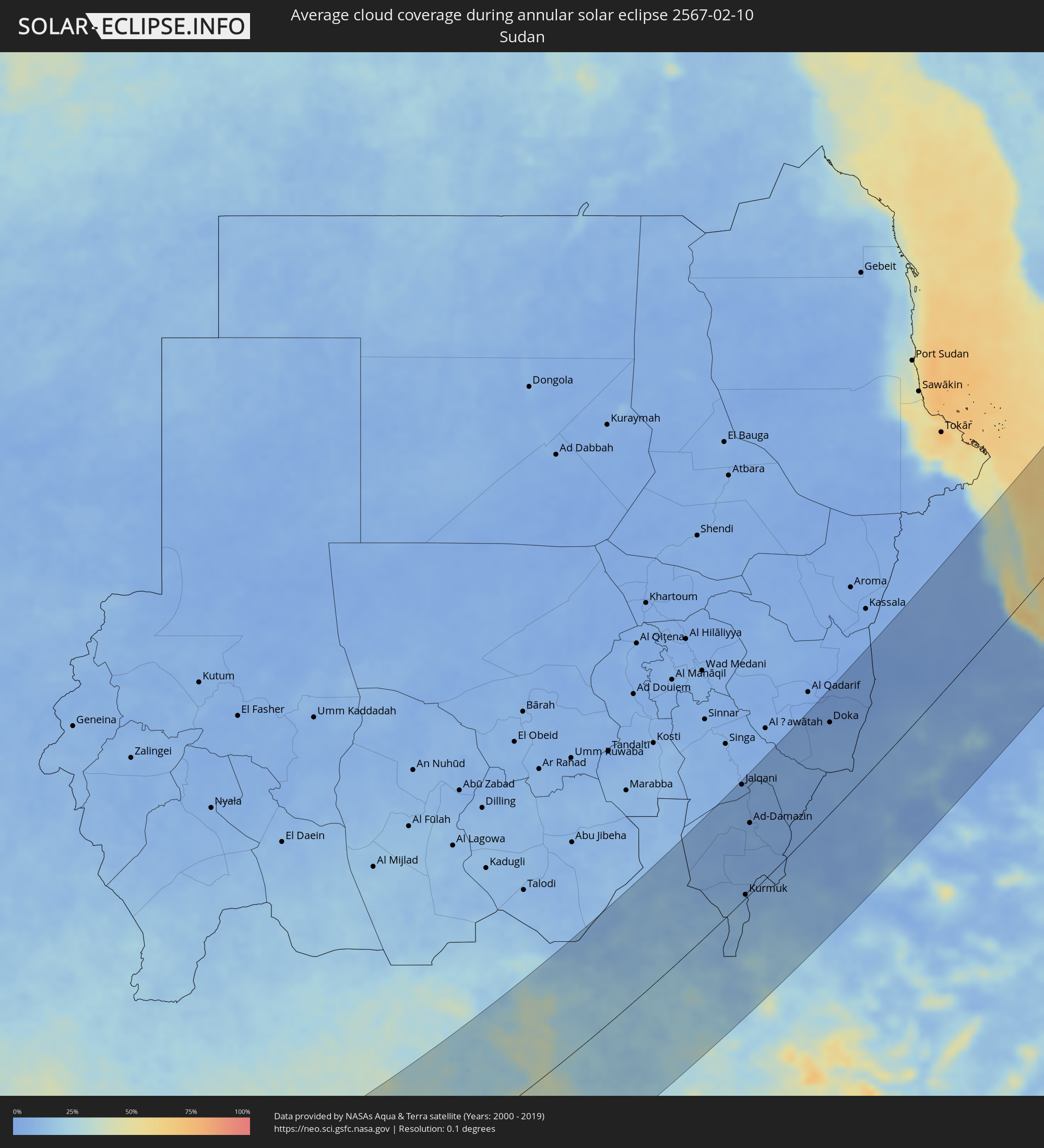 Sudan
Sudan
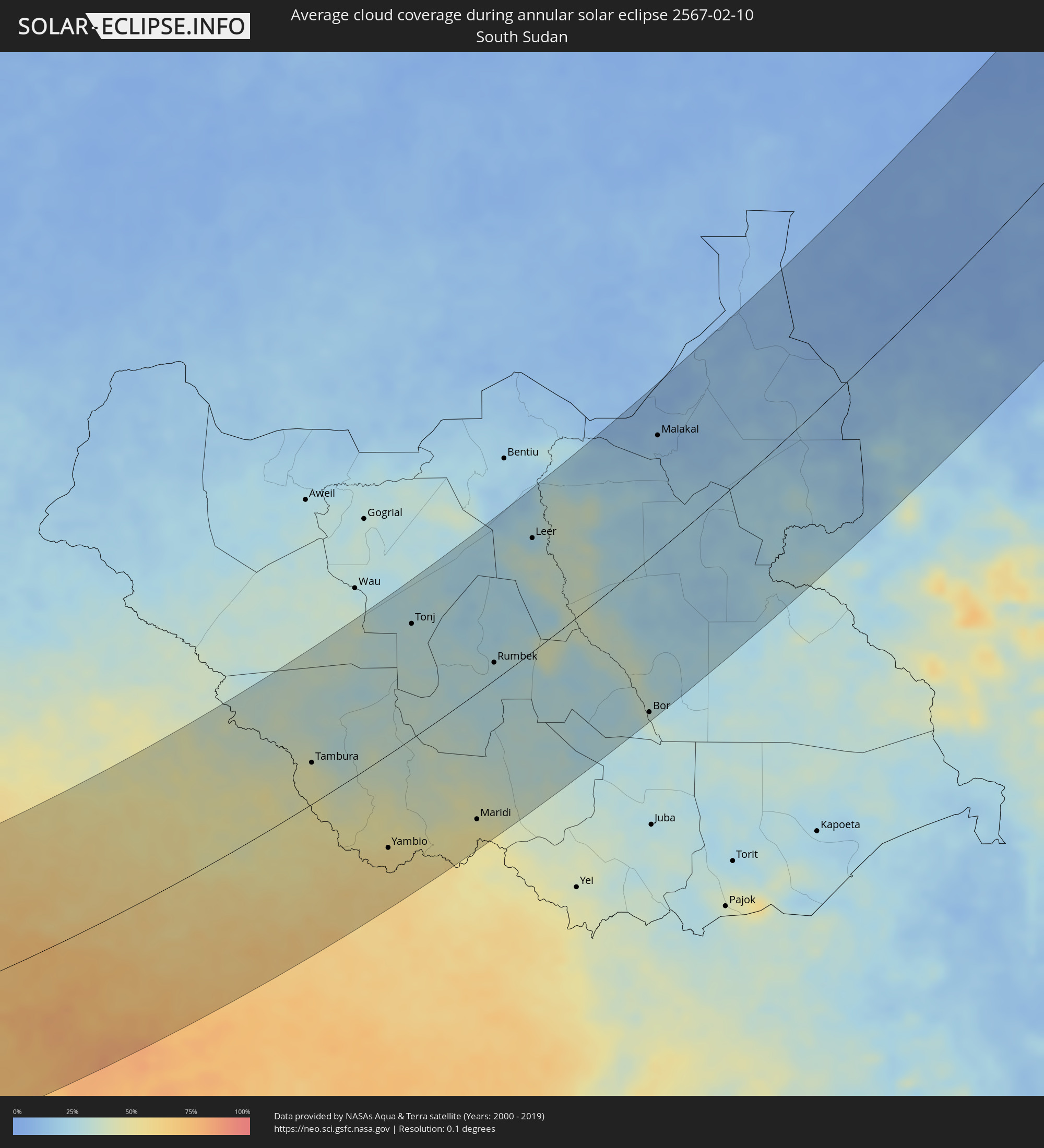 South Sudan
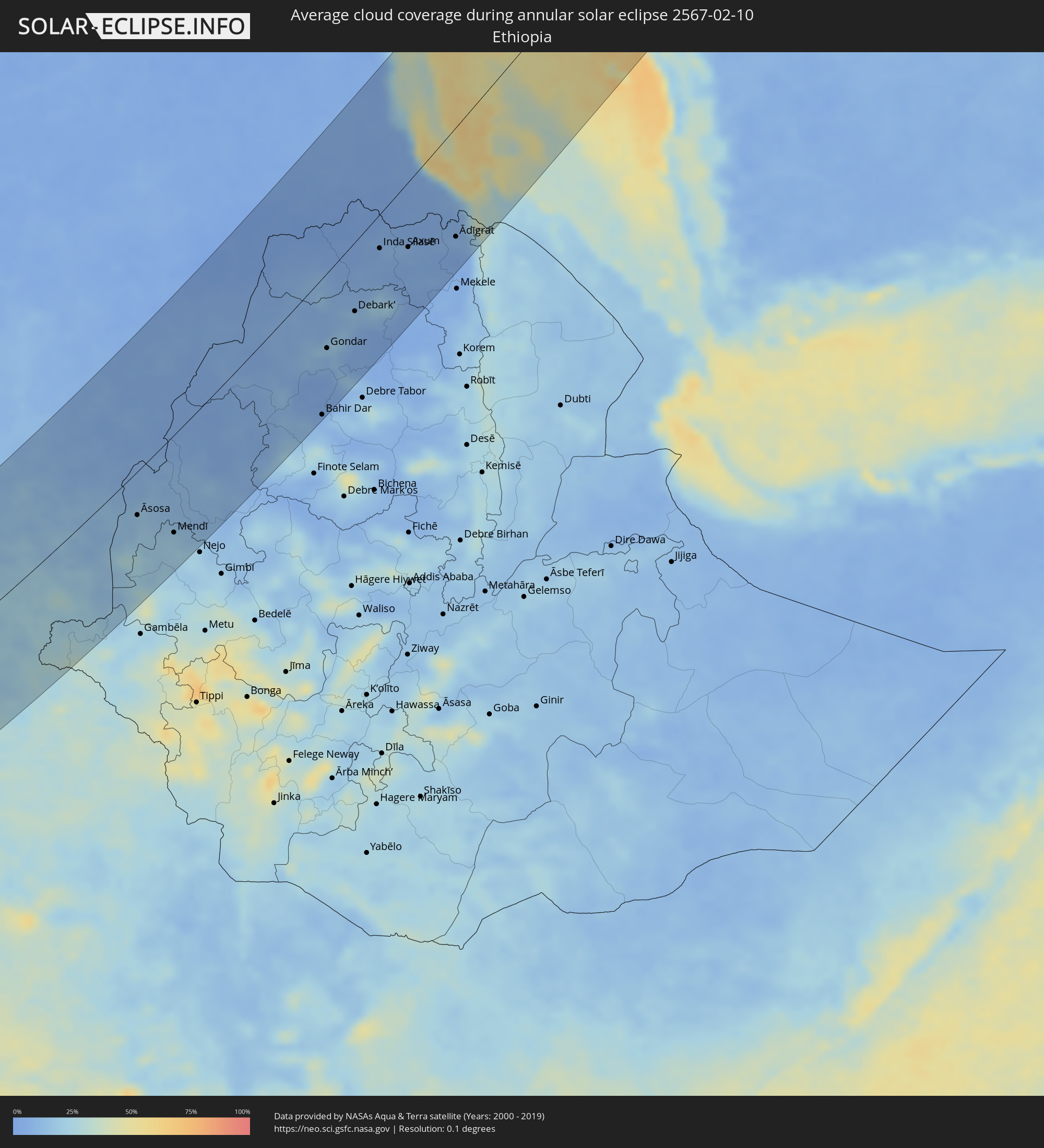 Ethiopia
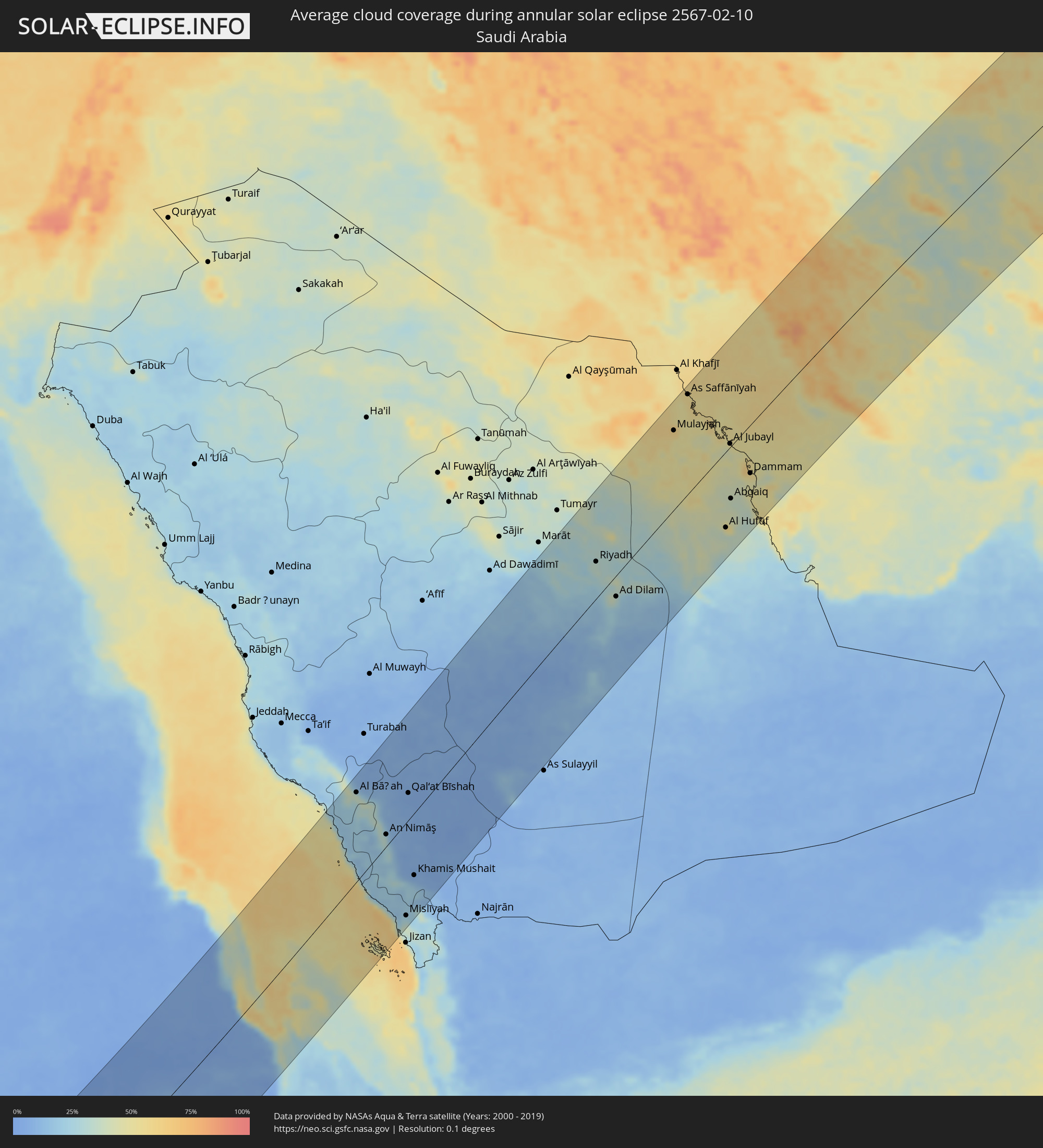 Saudi Arabia
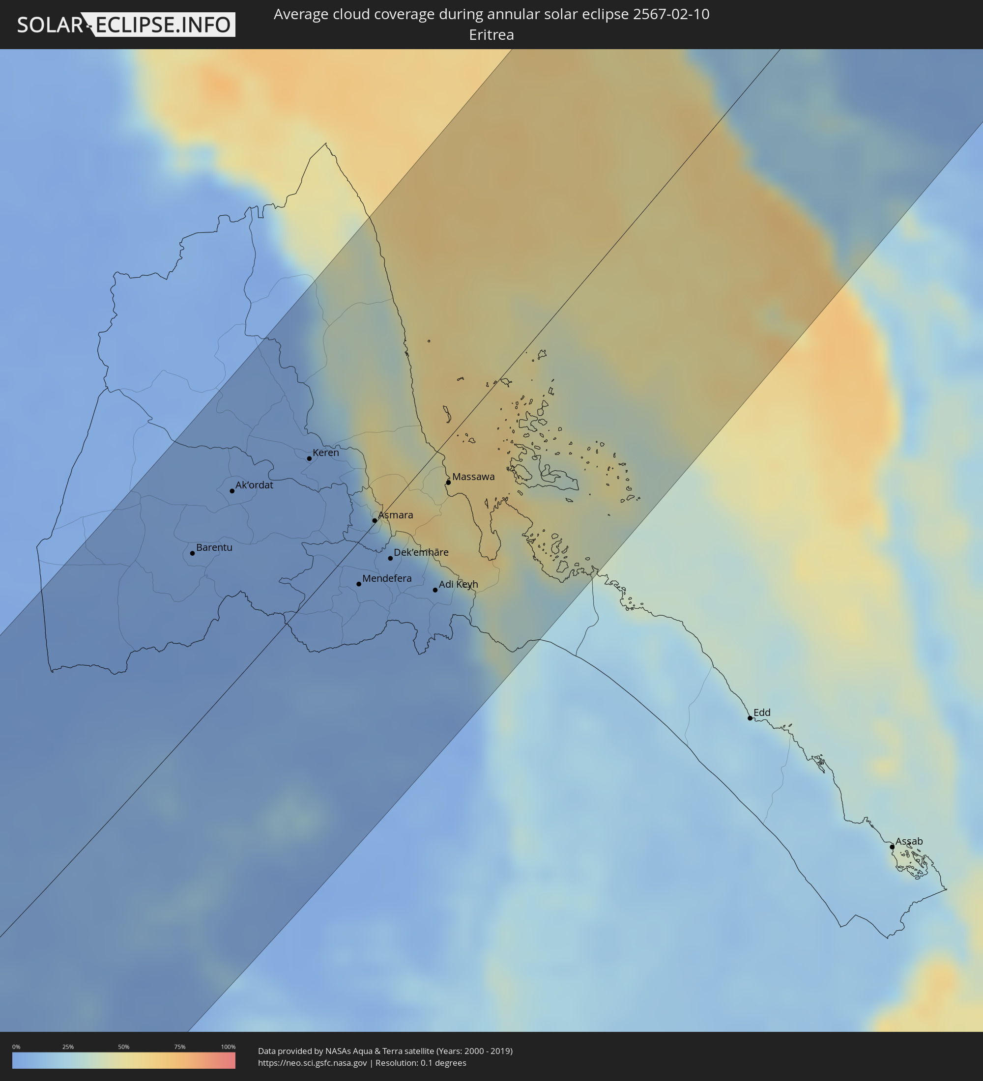 Eritrea
 Iran
Iran
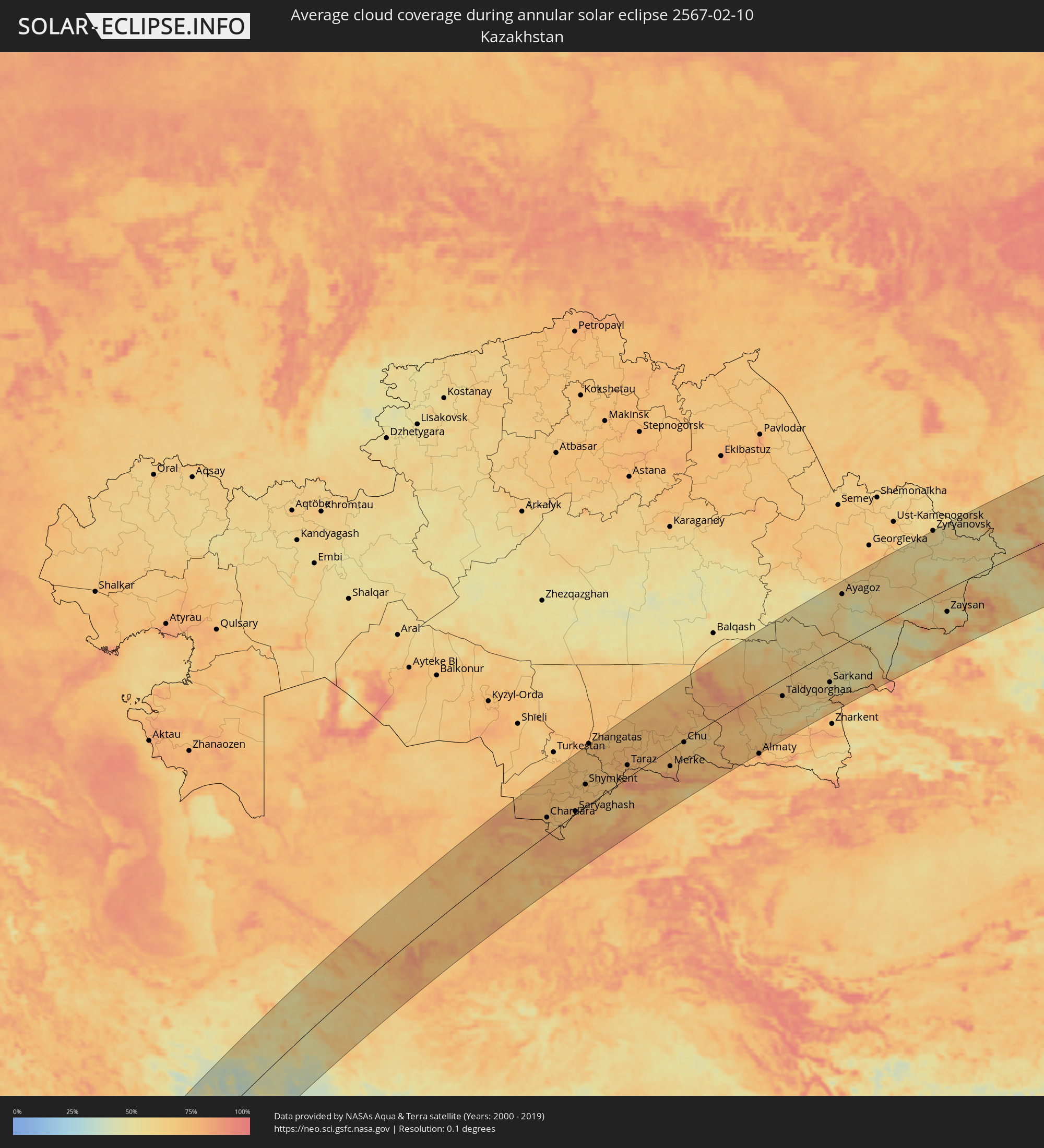 Kazakhstan
 Bahrain
 Turkmenistan
 Uzbekistan
 Afghanistan
 Tajikistan
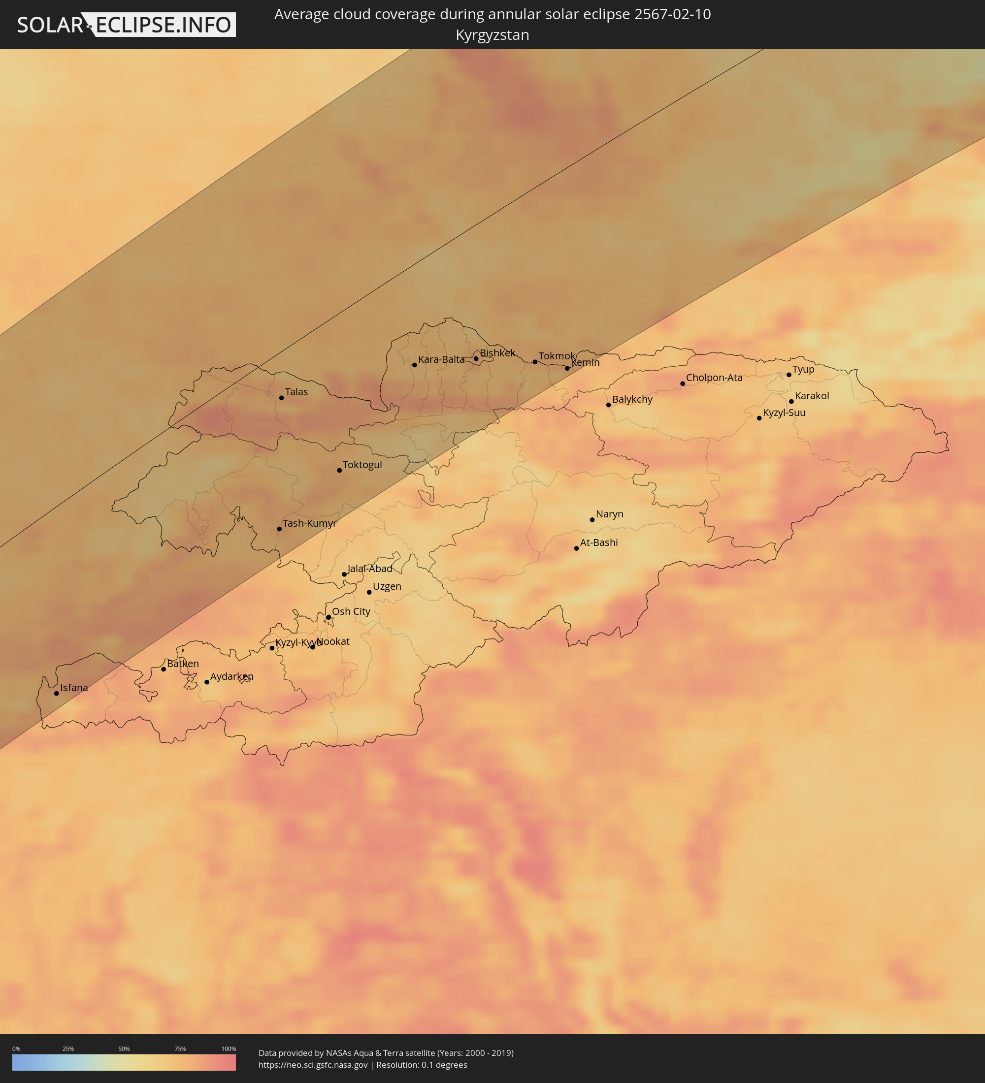 Kyrgyzstan
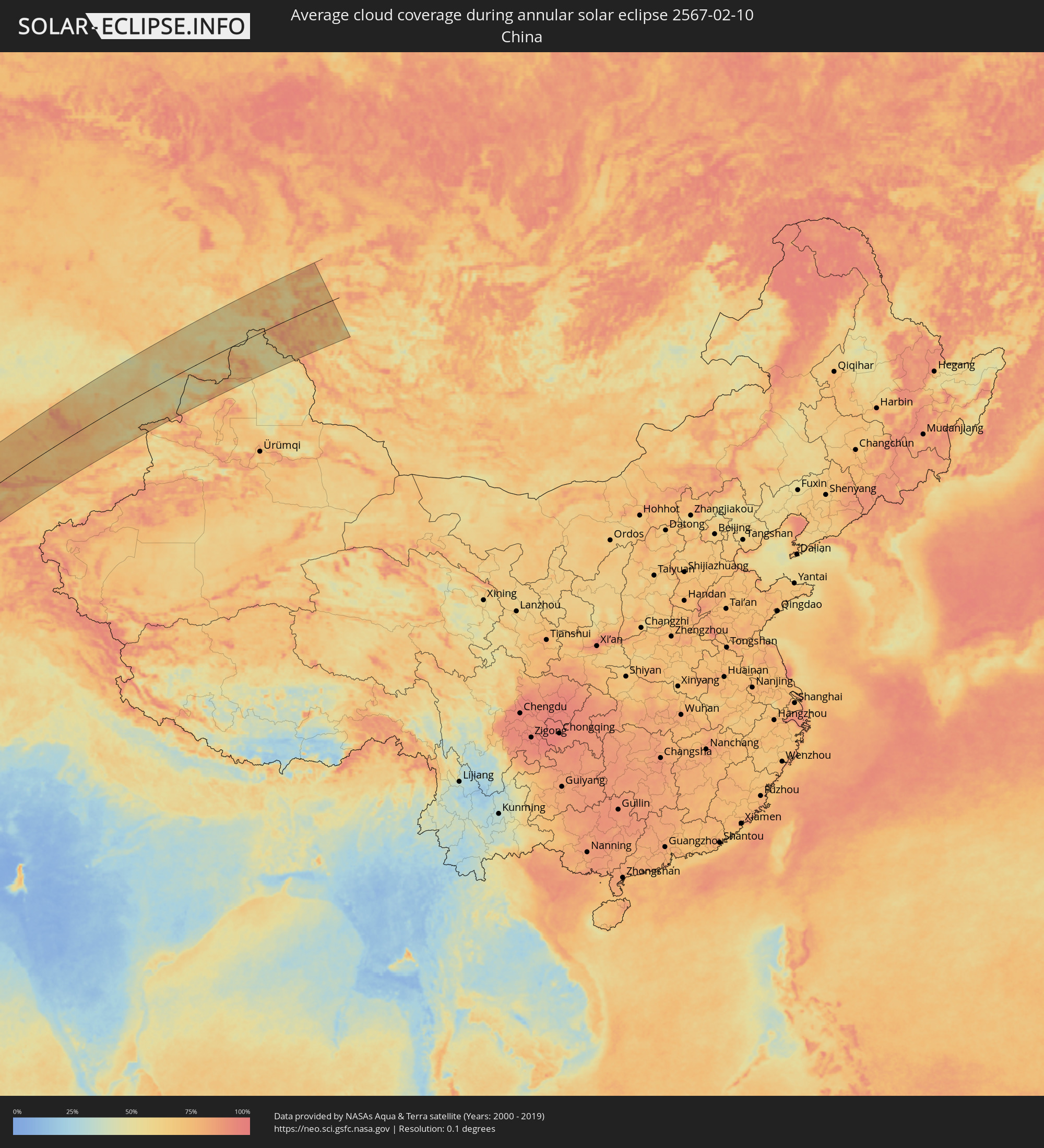 China
China
 Mongolia
Cities inside the path of the eclipse
The following table shows all locations with a population of more than 5,000 inside the eclipse path. Cities which have more than 100,000 inhabitants are marked bold. A click at the locations opens a detailed map.
| City | Type | Eclipse duration | Local time of max. eclipse | Distance to central line | Ø Cloud coverage |
|
San Antonio de Palé, Annobón Province
|
annular | - | 08:33:21 UTC+01:00 | 157 km | 86% |
|
São Tomé, São Tomé Island
|
annular | - | 07:36:43 UTC+00:00 | 40 km | 88% |
|
Port-Gentil, Ogooué-Maritime
|
annular | - | 08:38:37 UTC+01:00 | 79 km | 87% |
|
Libreville, Estuaire
|
annular | - | 08:41:01 UTC+01:00 | 43 km | 90% |
|
Ntoum, Estuaire
|
annular | - | 08:41:31 UTC+01:00 | 41 km | 91% |
|
Lambaréné, Moyen-Ogooué
|
annular | - | 08:41:00 UTC+01:00 | 82 km | 88% |
|
Evinayong, Centro Sur
|
annular | - | 08:44:12 UTC+01:00 | 153 km | 93% |
|
Aconibe, Wele-Nzas
|
annular | - | 08:44:43 UTC+01:00 | 135 km | 94% |
|
Mongomo, Wele-Nzas
|
annular | - | 08:45:50 UTC+01:00 | 169 km | 93% |
|
Oyem, Woleu-Ntem
|
annular | - | 08:46:17 UTC+01:00 | 163 km | 94% |
|
Booué, Ogooué-Ivindo
|
annular | - | 08:44:42 UTC+01:00 | 28 km | 91% |
|
Koulamoutou, Ogooué-Lolo
|
annular | - | 08:44:20 UTC+01:00 | 148 km | 92% |
|
Lastoursville, Ogooué-Lolo
|
annular | - | 08:45:10 UTC+01:00 | 116 km | 89% |
|
Makokou, Ogooué-Ivindo
|
annular | - | 08:47:18 UTC+01:00 | 36 km | 92% |
|
Okondja, Haut-Ogooué
|
annular | - | 08:47:11 UTC+01:00 | 110 km | 89% |
|
Ewo, Cuvette-Ouest
|
annular | - | 08:49:06 UTC+01:00 | 151 km | 88% |
|
Makoua, Cuvette
|
annular | - | 08:51:59 UTC+01:00 | 69 km | 84% |
|
Owando, Cuvette
|
annular | - | 08:51:49 UTC+01:00 | 128 km | 84% |
|
Ouésso, Sangha
|
annular | - | 08:55:16 UTC+01:00 | 98 km | 73% |
|
Impfondo, Likouala
|
annular | - | 08:59:44 UTC+01:00 | 50 km | 75% |
|
Mbandaka, Équateur
|
annular | - | 08:57:40 UTC+01:00 | 125 km | 79% |
|
Gemena, Équateur
|
annular | - | 09:06:37 UTC+01:00 | 174 km | 71% |
|
Businga, Équateur
|
annular | - | 09:09:32 UTC+01:00 | 143 km | 69% |
|
Lisala, Équateur
|
annular | - | 09:08:55 UTC+01:00 | 5 km | 71% |
|
Bumba, Équateur
|
annular | - | 09:11:22 UTC+01:00 | 39 km | 61% |
|
Bondo, Orientale
|
annular | - | 10:17:40 UTC+02:00 | 74 km | 64% |
|
Aketi, Orientale
|
annular | - | 10:15:47 UTC+02:00 | 40 km | 74% |
|
Rafaï, Mbomou
|
annular | - | 09:20:34 UTC+01:00 | 177 km | 54% |
|
Buta, Orientale
|
annular | - | 10:18:21 UTC+02:00 | 79 km | 74% |
|
Zemio, Haut-Mbomou
|
annular | - | 09:24:02 UTC+01:00 | 123 km | 53% |
|
Obo, Haut-Mbomou
|
annular | - | 09:28:31 UTC+01:00 | 84 km | 45% |
 Tambura, Western Equatoria
|
annular | - | 10:31:39 UTC+02:00 | 47 km | 43% |
|
Yambio, Western Equatoria
|
annular | - | 10:31:56 UTC+02:00 | 105 km | 54% |
|
Tonj, Warrap
|
annular | - | 10:38:46 UTC+02:00 | 126 km | 30% |
|
Maridi, Western Equatoria
|
annular | - | 10:35:39 UTC+02:00 | 139 km | 48% |
|
Rumbek, Lakes
|
annular | - | 10:40:29 UTC+02:00 | 19 km | 28% |
|
Leer, Unity
|
annular | - | 10:45:13 UTC+02:00 | 120 km | 27% |
|
Bor, Jonglei
|
annular | - | 10:44:19 UTC+02:00 | 160 km | 33% |
|
Malakal, Upper Nile
|
annular | - | 10:52:21 UTC+02:00 | 117 km | 14% |
|
Jalqani, Sinnār
|
annular | - | 11:06:13 UTC+02:00 | 159 km | 4% |
|
Kurmuk, Blue Nile
|
annular | - | 11:01:57 UTC+02:00 | 5 km | 9% |
|
Ad-Damazin, Blue Nile
|
annular | - | 11:05:04 UTC+02:00 | 97 km | 7% |
|
Ar Ruseris, Blue Nile
|
annular | - | 11:05:19 UTC+02:00 | 101 km | 5% |
|
Āsosa, Bīnshangul Gumuz
|
annular | - | 12:01:29 UTC+03:00 | 53 km | 14% |
|
Mendī, Oromiya
|
annular | - | 12:02:23 UTC+03:00 | 118 km | 20% |
|
Doka, Al Qaḑārif
|
annular | - | 11:12:50 UTC+02:00 | 119 km | 4% |
|
Bahir Dar, Amhara
|
annular | - | 12:12:37 UTC+03:00 | 156 km | 8% |
|
Gondar, Amhara
|
annular | - | 12:15:09 UTC+03:00 | 85 km | 15% |
|
Barentu, Gash-Barka
|
annular | - | 12:21:10 UTC+03:00 | 92 km | 3% |
|
Werota, Amhara
|
annular | - | 12:14:10 UTC+03:00 | 156 km | 8% |
|
Ādīs Zemen, Amhara
|
annular | - | 12:14:51 UTC+03:00 | 147 km | 10% |
|
Ak’ordat, Gash-Barka
|
annular | - | 12:22:53 UTC+03:00 | 101 km | 4% |
|
Debark’, Amhara
|
annular | - | 12:17:32 UTC+03:00 | 78 km | 14% |
|
Inda Silasē, Tigray
|
annular | - | 12:20:40 UTC+03:00 | 38 km | 6% |
|
Keren, Anseba
|
annular | - | 12:24:49 UTC+03:00 | 72 km | 5% |
|
Axum, Tigray
|
annular | - | 12:21:49 UTC+03:00 | 72 km | 8% |
|
Mendefera, Debub
|
annular | - | 12:23:46 UTC+03:00 | 23 km | 5% |
|
Asmara, Maekel
|
annular | - | 12:25:03 UTC+03:00 | 1 km | 5% |
|
Dek’emhāre, Debub
|
annular | - | 12:24:45 UTC+03:00 | 28 km | 5% |
|
Adi Keyh, Debub
|
annular | - | 12:25:03 UTC+03:00 | 71 km | 6% |
|
Ādīgrat, Tigray
|
annular | - | 12:24:00 UTC+03:00 | 120 km | 9% |
|
Massawa, Northern Red Sea
|
annular | - | 12:26:59 UTC+03:00 | 23 km | 53% |
|
Al Bāḩah, Al Bahah
|
annular | - | 12:40:49 UTC+03:00 | 132 km | 35% |
|
Abha, 'Asir
|
annular | - | 12:39:38 UTC+03:00 | 80 km | 25% |
|
Qal‘at Bīshah, 'Asir
|
annular | - | 12:43:22 UTC+03:00 | 40 km | 6% |
|
Khamis Mushait, 'Asir
|
annular | - | 12:40:19 UTC+03:00 | 92 km | 8% |
|
Riyadh, Ar Riyāḑ
|
annular | - | 13:00:06 UTC+03:00 | 54 km | 33% |
|
Al Hufūf, Eastern Province
|
annular | - | 13:06:29 UTC+03:00 | 111 km | 46% |
|
Al Jubayl, Eastern Province
|
annular | - | 13:08:54 UTC+03:00 | 5 km | 47% |
|
Tārūt, Eastern Province
|
annular | - | 13:09:00 UTC+03:00 | 56 km | 62% |
|
Dammam, Eastern Province
|
annular | - | 13:08:56 UTC+03:00 | 71 km | 47% |
|
Khobar, Eastern Province
|
annular | - | 13:08:55 UTC+03:00 | 90 km | 45% |
|
Dār Kulayb, Southern Governorate
|
annular | - | 13:09:09 UTC+03:00 | 128 km | 49% |
|
Madīnat Ḩamad, Central Governorate
|
annular | - | 13:09:13 UTC+03:00 | 125 km | 49% |
|
Jidd Ḩafş, Manama
|
annular | - | 13:09:26 UTC+03:00 | 120 km | 56% |
|
Madīnat ‘Īsá, Southern Governorate
|
annular | - | 13:09:22 UTC+03:00 | 123 km | 56% |
|
Ar Rifā‘, Southern Governorate
|
annular | - | 13:09:20 UTC+03:00 | 127 km | 50% |
|
Manama, Manama
|
annular | - | 13:09:31 UTC+03:00 | 122 km | 50% |
|
Al Muharraq, Muharraq
|
annular | - | 13:09:36 UTC+03:00 | 122 km | 56% |
|
Sitrah, Manama
|
annular | - | 13:09:29 UTC+03:00 | 130 km | 50% |
|
Al Ḩadd, Muharraq
|
annular | - | 13:09:40 UTC+03:00 | 126 km | 44% |
|
Bandar-e Būshehr, Bushehr
|
annular | - | 13:43:22 UTC+03:30 | 67 km | 59% |
|
Yasuj, Kohgīlūyeh va Būyer Aḩmad
|
annular | - | 13:46:28 UTC+03:30 | 144 km | 74% |
|
Shiraz, Fars
|
annular | - | 13:46:53 UTC+03:30 | 4 km | 55% |
|
Akbarābād, Fars
|
annular | - | 13:46:54 UTC+03:30 | 49 km | 47% |
|
Fasā, Fars
|
annular | - | 13:47:58 UTC+03:30 | 133 km | 45% |
|
Yazd, Yazd
|
annular | - | 13:51:58 UTC+03:30 | 50 km | 43% |
|
Kāshmar, Razavi Khorasan
|
annular | - | 14:00:02 UTC+03:30 | 57 km | 65% |
|
Nīshābūr, Razavi Khorasan
|
annular | - | 14:00:58 UTC+03:30 | 117 km | 60% |
|
Torbat-e Ḩeydarīyeh, Razavi Khorasan
|
annular | - | 14:01:01 UTC+03:30 | 14 km | 64% |
|
Mashhad, Razavi Khorasan
|
annular | - | 14:01:58 UTC+03:30 | 79 km | 66% |
|
Kaka, Ahal
|
annular | - | 15:32:28 UTC+05:00 | 163 km | 78% |
|
Tejen, Ahal
|
annular | - | 15:33:32 UTC+05:00 | 114 km | 71% |
|
Kafir Qala, Herat
|
annular | - | 15:02:59 UTC+04:30 | 148 km | 64% |
|
Kuhsān, Herat
|
annular | - | 15:03:09 UTC+04:30 | 157 km | 66% |
|
Mary, Mary
|
annular | - | 15:35:09 UTC+05:00 | 55 km | 70% |
|
Bayramaly, Mary
|
annular | - | 15:35:32 UTC+05:00 | 38 km | 71% |
|
Yolöten, Mary
|
annular | - | 15:35:39 UTC+05:00 | 0 km | 73% |
|
Seydi, Mary
|
annular | - | 15:36:49 UTC+05:00 | 156 km | 72% |
|
Türkmenabat, Lebap
|
annular | - | 15:37:27 UTC+05:00 | 85 km | 75% |
|
Saýat, Lebap
|
annular | - | 15:37:42 UTC+05:00 | 44 km | 73% |
|
Bukhara, Bukhara
|
annular | - | 15:38:27 UTC+05:00 | 100 km | 75% |
|
Atamyrat, Lebap
|
annular | - | 15:38:52 UTC+05:00 | 111 km | 77% |
|
Navoiy, Navoiy
|
annular | - | 15:39:26 UTC+05:00 | 77 km | 78% |
|
Qarshi, Qashqadaryo
|
annular | - | 15:39:40 UTC+05:00 | 52 km | 74% |
|
Gowurdak, Lebap
|
annular | - | 15:39:43 UTC+05:00 | 158 km | 79% |
|
Samarqand, Samarqand
|
annular | - | 15:40:54 UTC+05:00 | 43 km | 74% |
|
Panjakent, Viloyati Sughd
|
annular | - | 15:41:30 UTC+05:00 | 91 km | 77% |
|
Jizzax, Jizzax
|
annular | - | 15:41:46 UTC+05:00 | 47 km | 78% |
|
Arys, Ongtüstik Qazaqstan
|
annular | - | 15:42:34 UTC+05:00 | 114 km | 74% |
|
Istaravshan, Viloyati Sughd
|
annular | - | 15:42:47 UTC+05:00 | 123 km | 71% |
|
Tashkent, Toshkent Shahri
|
annular | - | 15:42:59 UTC+05:00 | 11 km | 78% |
|
Bŭston, Viloyati Sughd
|
annular | - | 15:43:06 UTC+05:00 | 84 km | 75% |
|
Nov, Viloyati Sughd
|
annular | - | 15:43:07 UTC+05:00 | 120 km | 80% |
|
Proletar, Viloyati Sughd
|
annular | - | 15:43:14 UTC+05:00 | 125 km | 79% |
|
Isfana, Batken
|
annular | - | 16:43:15 UTC+06:00 | 156 km | 74% |
|
Suluktu, Batken
|
annular | - | 16:43:17 UTC+06:00 | 149 km | 73% |
|
Chirchiq, Toshkent
|
annular | - | 15:43:17 UTC+05:00 | 11 km | 74% |
|
Shymkent, Ongtüstik Qazaqstan
|
annular | - | 15:43:14 UTC+05:00 | 64 km | 72% |
|
Khŭjand, Viloyati Sughd
|
annular | - | 15:43:21 UTC+05:00 | 120 km | 84% |
|
Chkalov, Viloyati Sughd
|
annular | - | 15:43:24 UTC+05:00 | 128 km | 82% |
|
Adrasmon, Viloyati Sughd
|
annular | - | 15:43:39 UTC+05:00 | 105 km | 82% |
|
Angren, Toshkent
|
annular | - | 15:43:47 UTC+05:00 | 79 km | 76% |
|
Shaydon, Viloyati Sughd
|
annular | - | 15:43:57 UTC+05:00 | 121 km | 81% |
|
Konibodom, Viloyati Sughd
|
annular | - | 15:44:02 UTC+05:00 | 159 km | 80% |
|
Karatau, Zhambyl
|
annular | - | 15:43:50 UTC+05:00 | 103 km | 73% |
|
Qo‘qon, Fergana
|
annular | - | 15:44:27 UTC+05:00 | 162 km | 84% |
|
Taraz, Zhambyl
|
annular | - | 15:44:34 UTC+05:00 | 36 km | 76% |
|
Namangan, Namangan
|
annular | - | 15:45:01 UTC+05:00 | 153 km | 79% |
|
Tash-Kumyr, Jalal-Abad
|
annular | - | 16:45:25 UTC+06:00 | 147 km | 74% |
|
Talas, Talas
|
annular | - | 16:45:18 UTC+06:00 | 39 km | 75% |
|
Toktogul, Jalal-Abad
|
annular | - | 16:45:54 UTC+06:00 | 131 km | 78% |
|
Kaindy, Chüy
|
annular | - | 16:46:17 UTC+06:00 | 75 km | 71% |
|
Chu, Zhambyl
|
annular | - | 15:46:11 UTC+05:00 | 6 km | 69% |
|
Kara-Balta, Chüy
|
annular | - | 16:46:25 UTC+06:00 | 84 km | 70% |
|
Bishkek, Bishkek
|
annular | - | 16:46:55 UTC+06:00 | 111 km | 79% |
|
Kant, Chüy
|
annular | - | 16:47:05 UTC+06:00 | 121 km | 71% |
|
Tokmok, Chüy
|
annular | - | 16:47:24 UTC+06:00 | 145 km | 71% |
|
Kapshagay, Almaty Oblysy
|
annular | - | 15:48:16 UTC+05:00 | 122 km | 73% |
|
Taldyqorghan, Almaty Oblysy
|
annular | - | 15:48:24 UTC+05:00 | 48 km | 68% |
|
Taldykorgan, Almaty Oblysy
|
annular | - | 15:48:39 UTC+05:00 | 65 km | 66% |
|
Sarkand, Almaty Oblysy
|
annular | - | 15:49:19 UTC+05:00 | 87 km | 56% |
|
Zyryanovsk, East Kazakhstan
|
annular | - | 15:48:58 UTC+05:00 | 180 km | 62% |
|
Altay, Xinjiang Uyghur Autonomous Region
|
annular | - | 18:51:27 UTC+08:00 | 132 km | 48% |
|
Kosh-Agach, Altai Republic
|
annular | - | 17:50:14 UTC+07:00 | 68 km | 72% |
|
Ölgiy, Bayan-Ölgiy
|
annular | - | 17:51:16 UTC+07:00 | 75 km | 75% |
|
Kyzyl-Mazhalyk, Tyva
|
annular | - | 17:49:53 UTC+07:00 | 128 km | 60% |
|
Ak-Dovurak, Tyva
|
annular | - | 17:49:51 UTC+07:00 | 132 km | 70% |
|
Ulaangom, Uvs
|
annular | - | 17:51:04 UTC+07:00 | 32 km | 77% |