Total solar eclipse of 08/16/2585
| Day of week: | Tuesday |
| Maximum duration of eclipse: | 06m16s |
| Maximum width of eclipse path: | 281 km |
| Saros cycle: | 164 |
| Coverage: | 100% |
| Magnitude: | 1.0753 |
| Gamma: | -0.5094 |
Wo kann man die Sonnenfinsternis vom 08/16/2585 sehen?
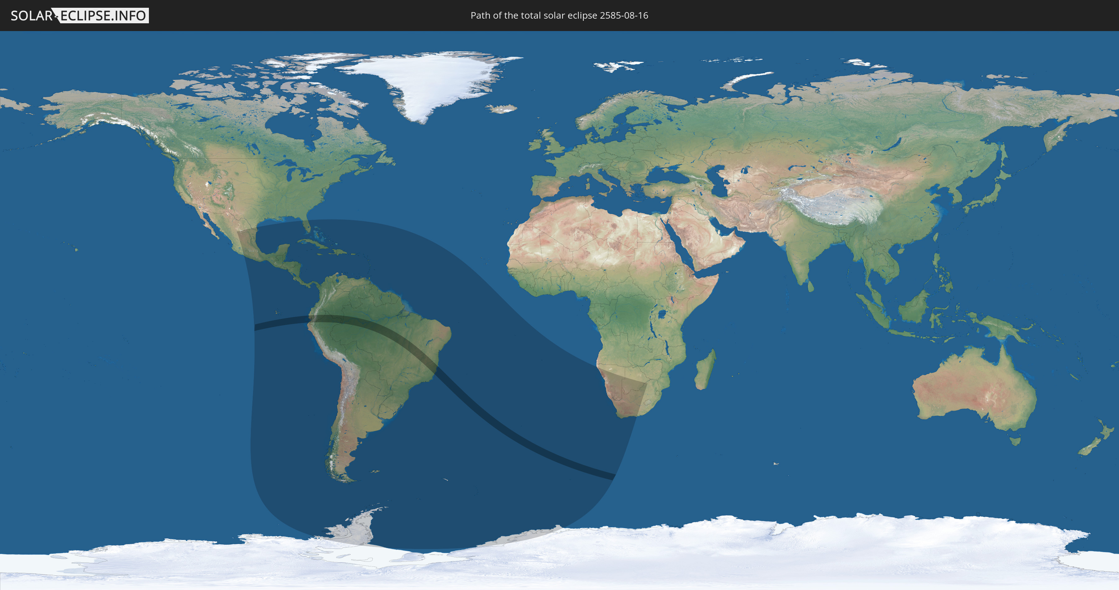
Die Sonnenfinsternis am 08/16/2585 kann man in 56 Ländern als partielle Sonnenfinsternis beobachten.
Der Finsternispfad verläuft durch 4 Länder. Nur in diesen Ländern ist sie als total Sonnenfinsternis zu sehen.
In den folgenden Ländern ist die Sonnenfinsternis total zu sehen
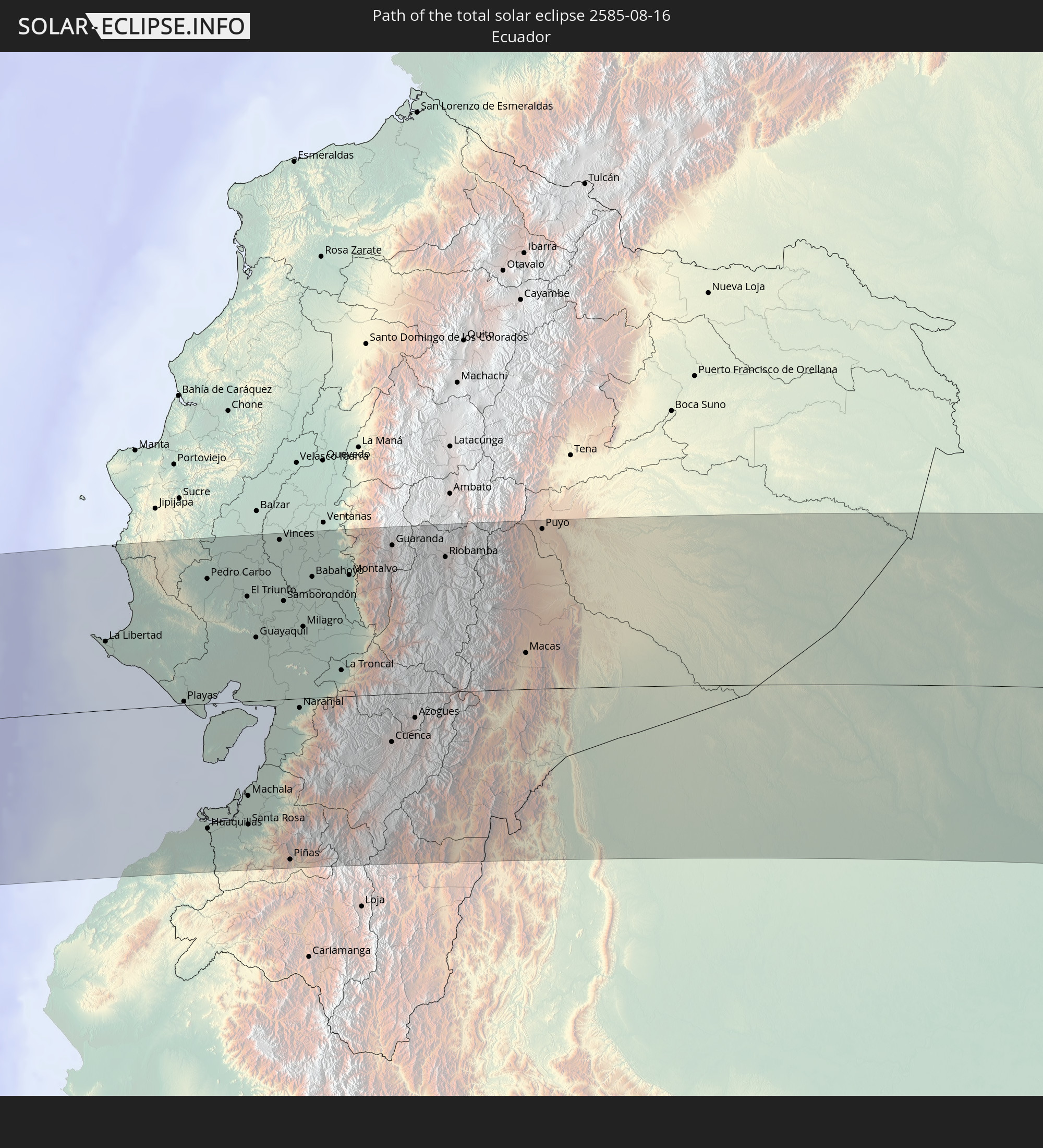 Ecuador
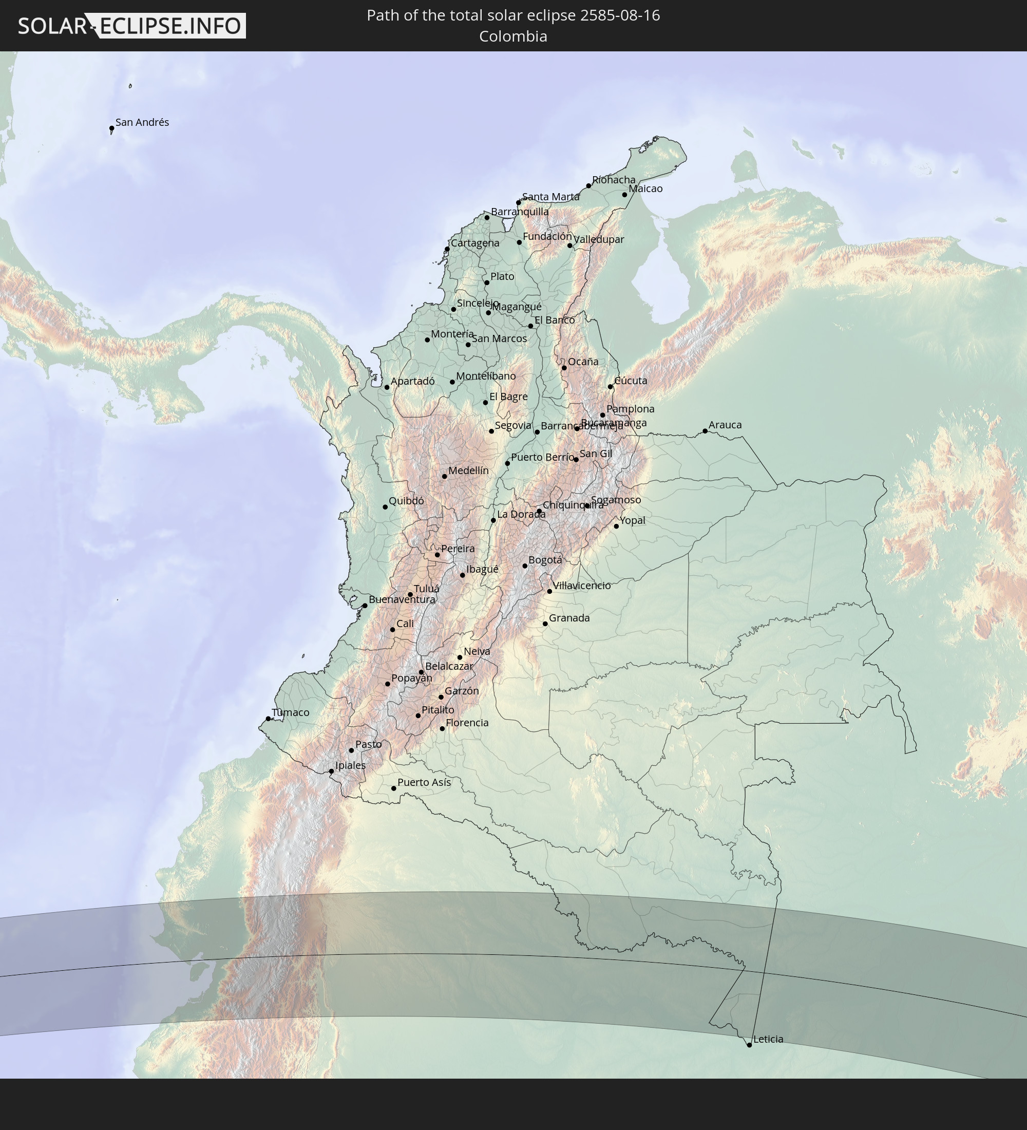 Colombia
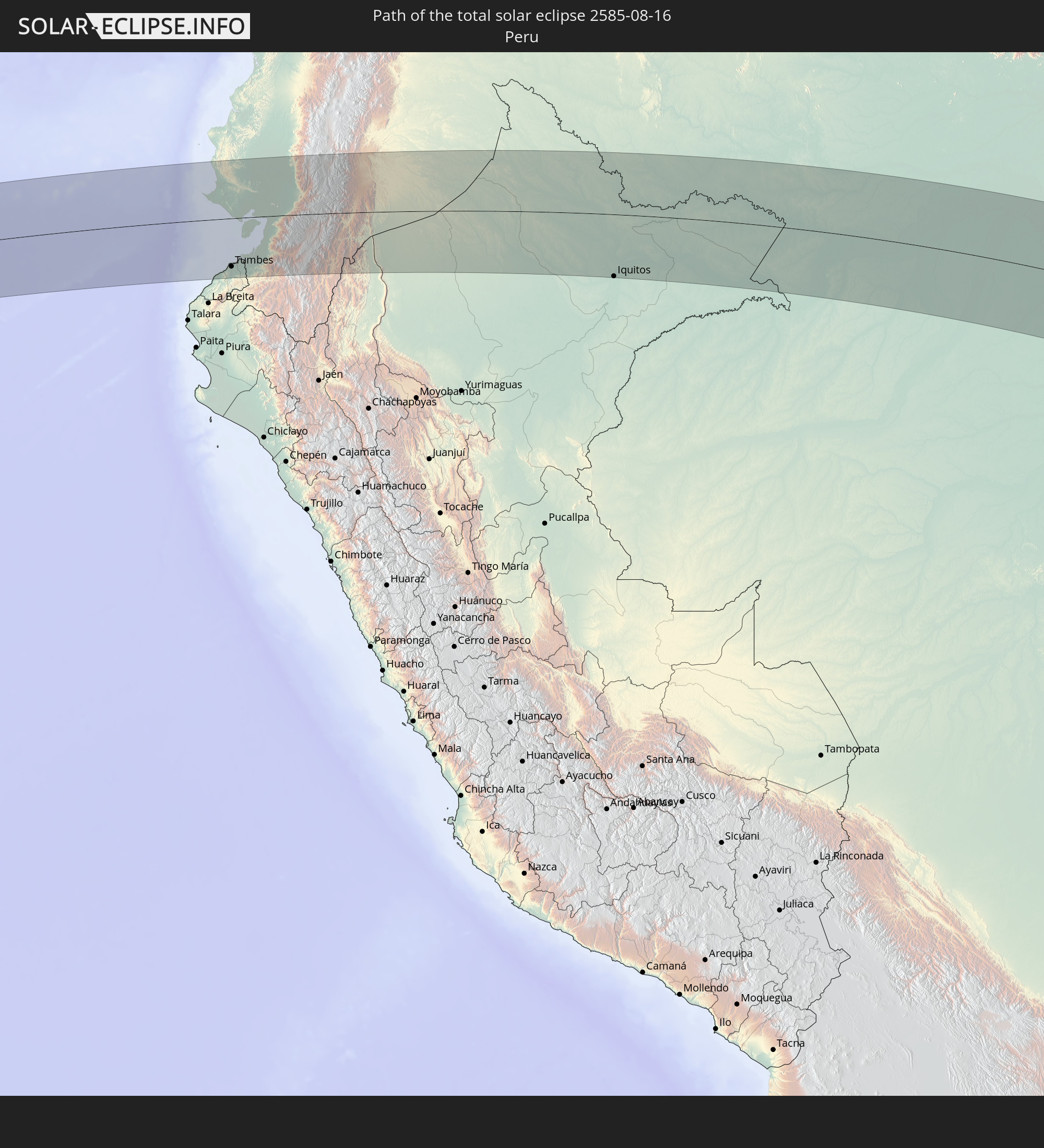 Peru
Peru
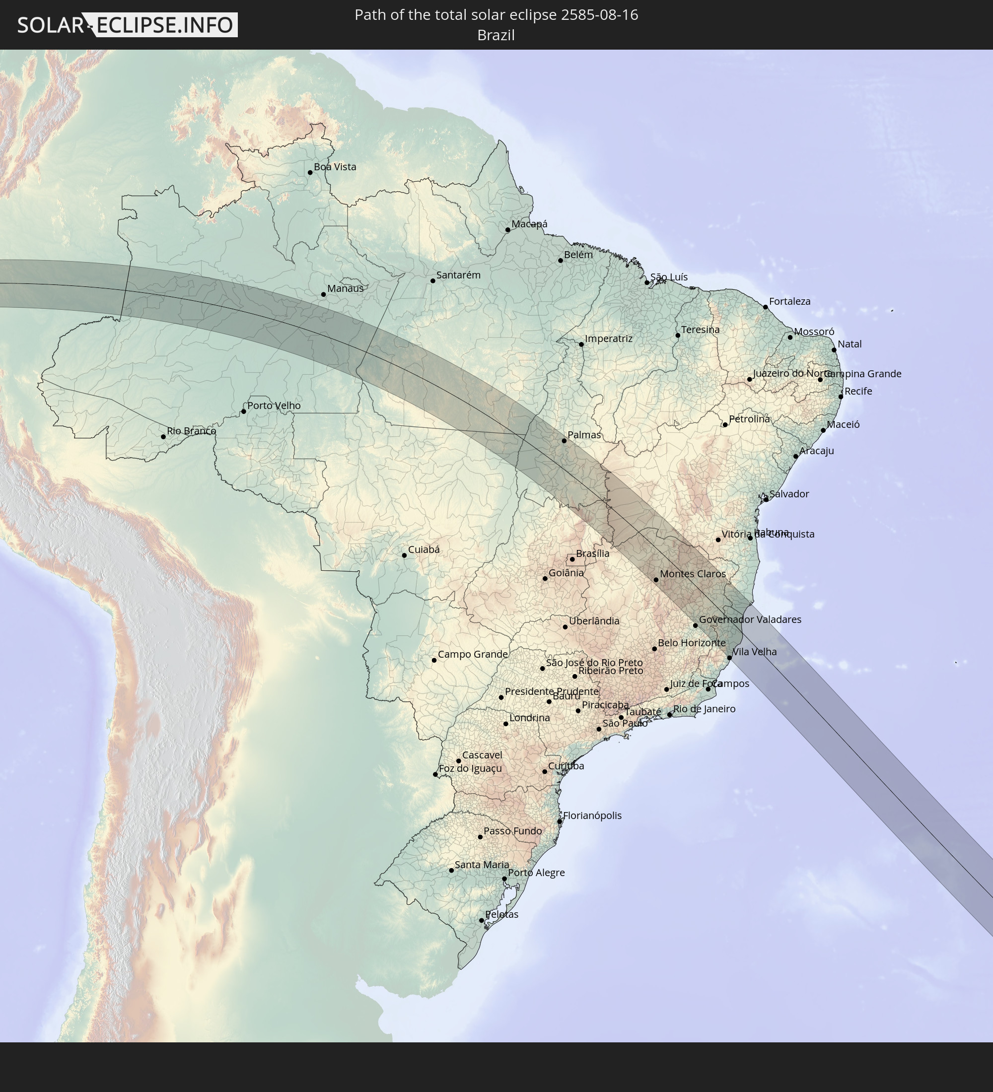 Brazil
In den folgenden Ländern ist die Sonnenfinsternis partiell zu sehen
 Antarctica
 United States
 United States Minor Outlying Islands
 Mexico
 Chile
Chile
 Guatemala
 Ecuador
 El Salvador
 Honduras
 Belize
 Nicaragua
 Costa Rica
 Cuba
Cuba
 Panama
 Colombia
 Cayman Islands
 Peru
Peru
 The Bahamas
 Jamaica
 Haiti
Haiti
 Brazil
 Argentina
 Venezuela
 Turks and Caicos Islands
 Dominican Republic
 Aruba
Aruba
 Bolivia
 Puerto Rico
 United States Virgin Islands
 British Virgin Islands
 Anguilla
 Collectivity of Saint Martin
 Saint Barthélemy
 Saint Kitts and Nevis
 Paraguay
 Antigua and Barbuda
 Montserrat
 Trinidad and Tobago
 Guadeloupe
 Grenada
 Dominica
 Saint Vincent and the Grenadines
 Falkland Islands
 Guyana
 Martinique
 Saint Lucia
 Barbados
 Uruguay
 Suriname
 French Guiana
 South Georgia and the South Sandwich Islands
 Saint Helena, Ascension and Tristan da Cunha
 Bouvet Island
 Namibia
 South Africa
 Botswana
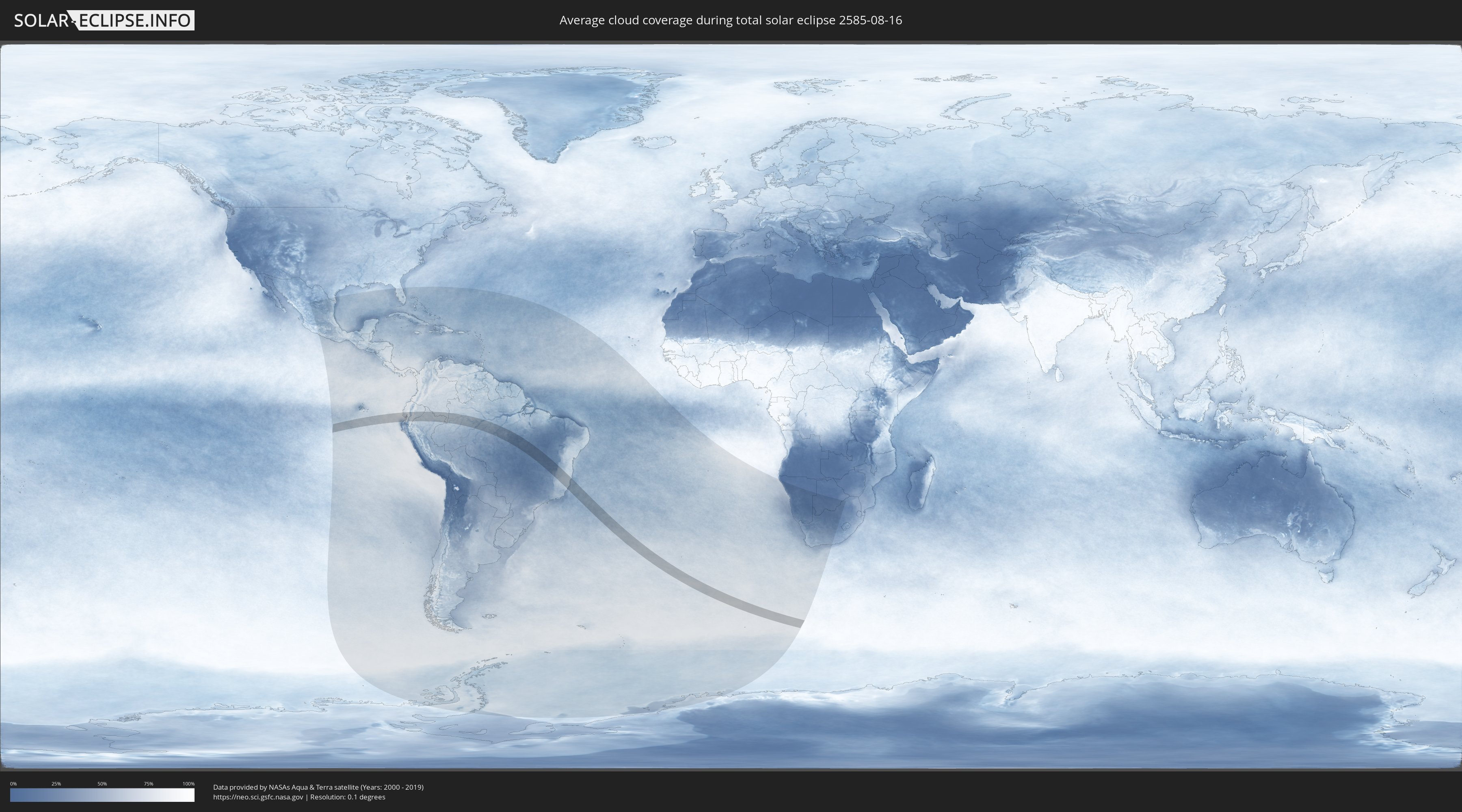
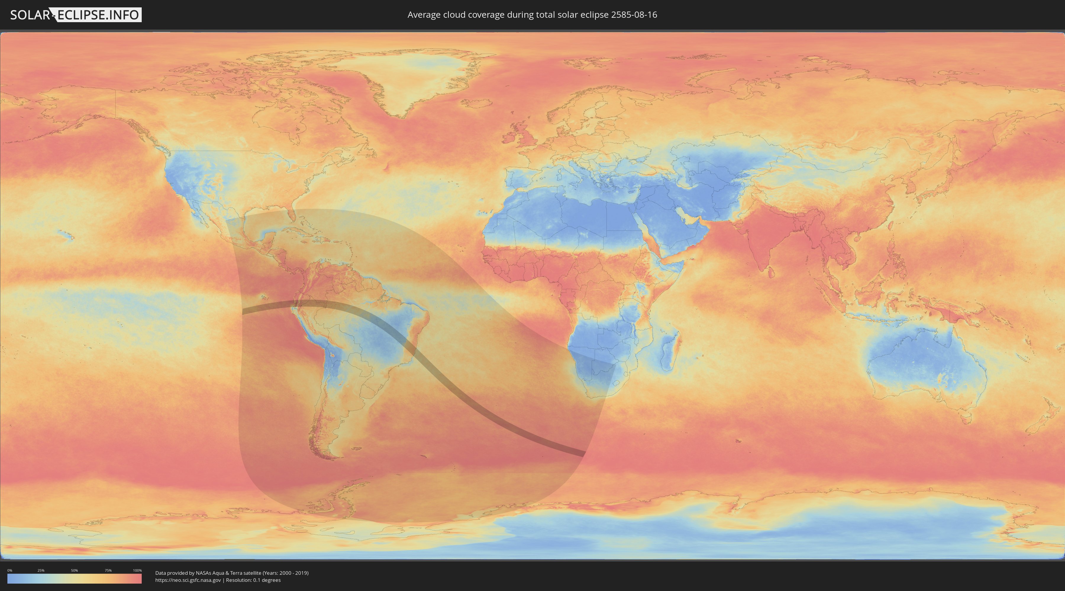
How will be the weather during the total solar eclipse on 08/16/2585?
Where is the best place to see the total solar eclipse of 08/16/2585?
The following maps show the average cloud coverage for the day of the total solar eclipse.
With the help of these maps, it is possible to find the place along the eclipse path, which has the best
chance of a cloudless sky.
Nevertheless, you should consider local circumstances and inform about the weather of your chosen
observation site.
The data is provided by NASAs satellites
AQUA and TERRA.
The cloud maps are averaged over a period of 19 years (2000 - 2019).
Detailed country maps
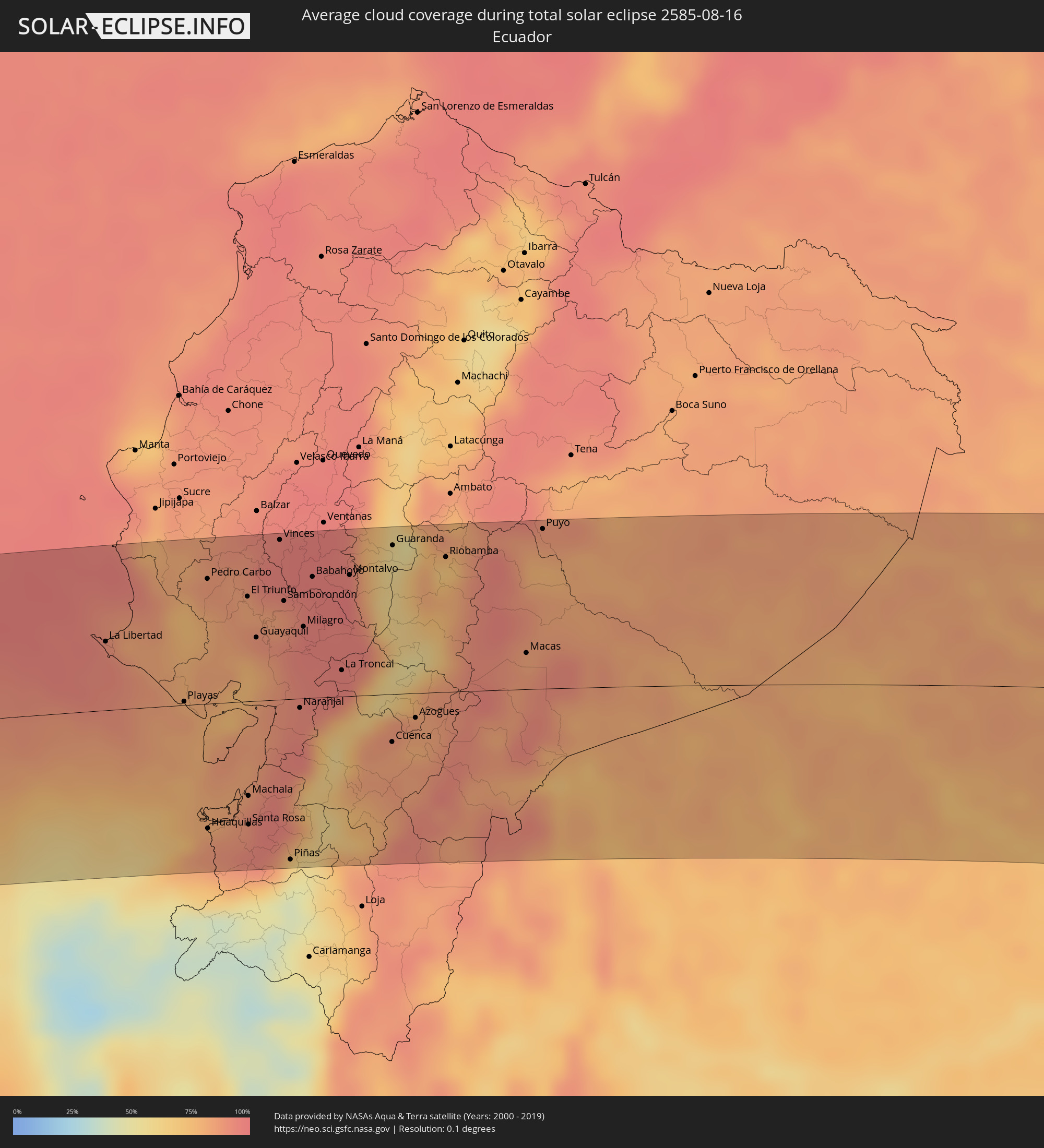 Ecuador
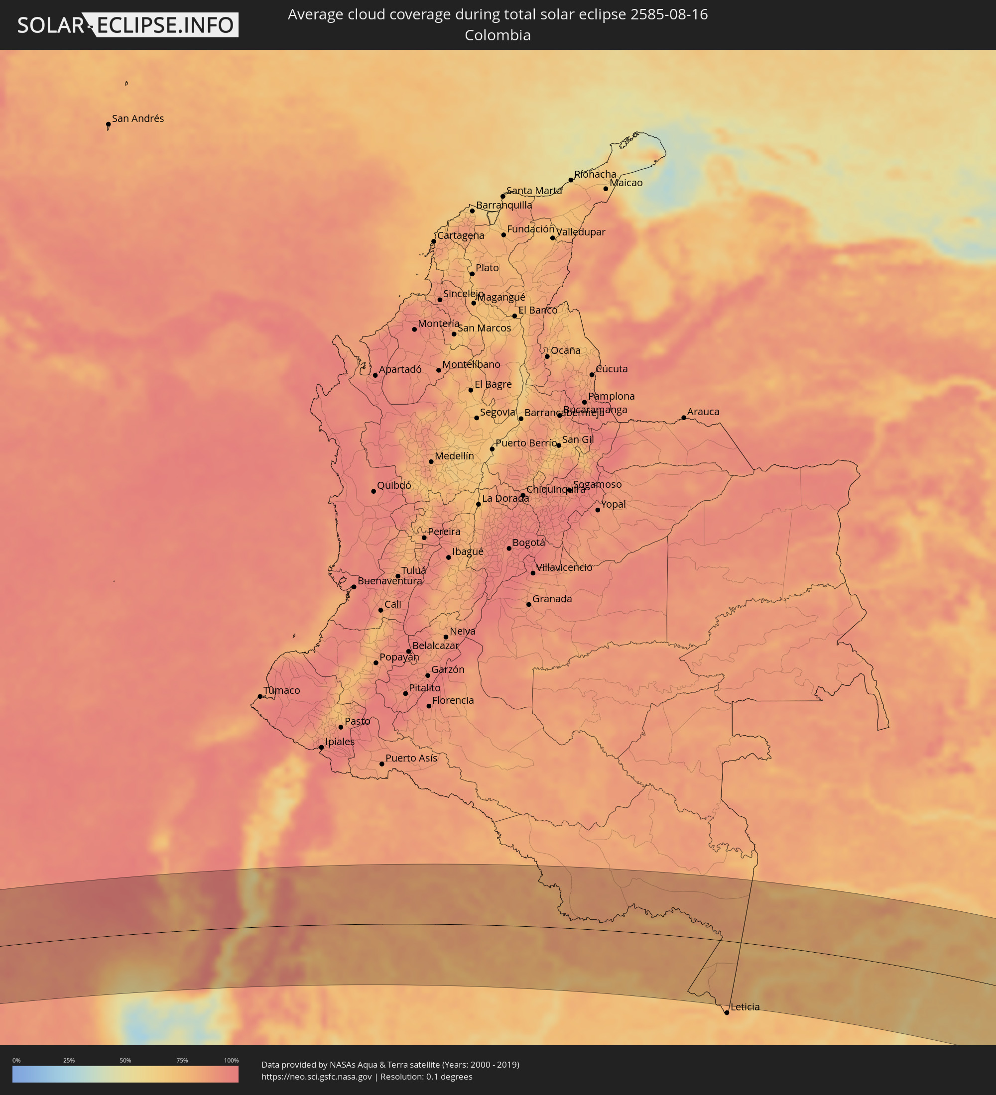 Colombia
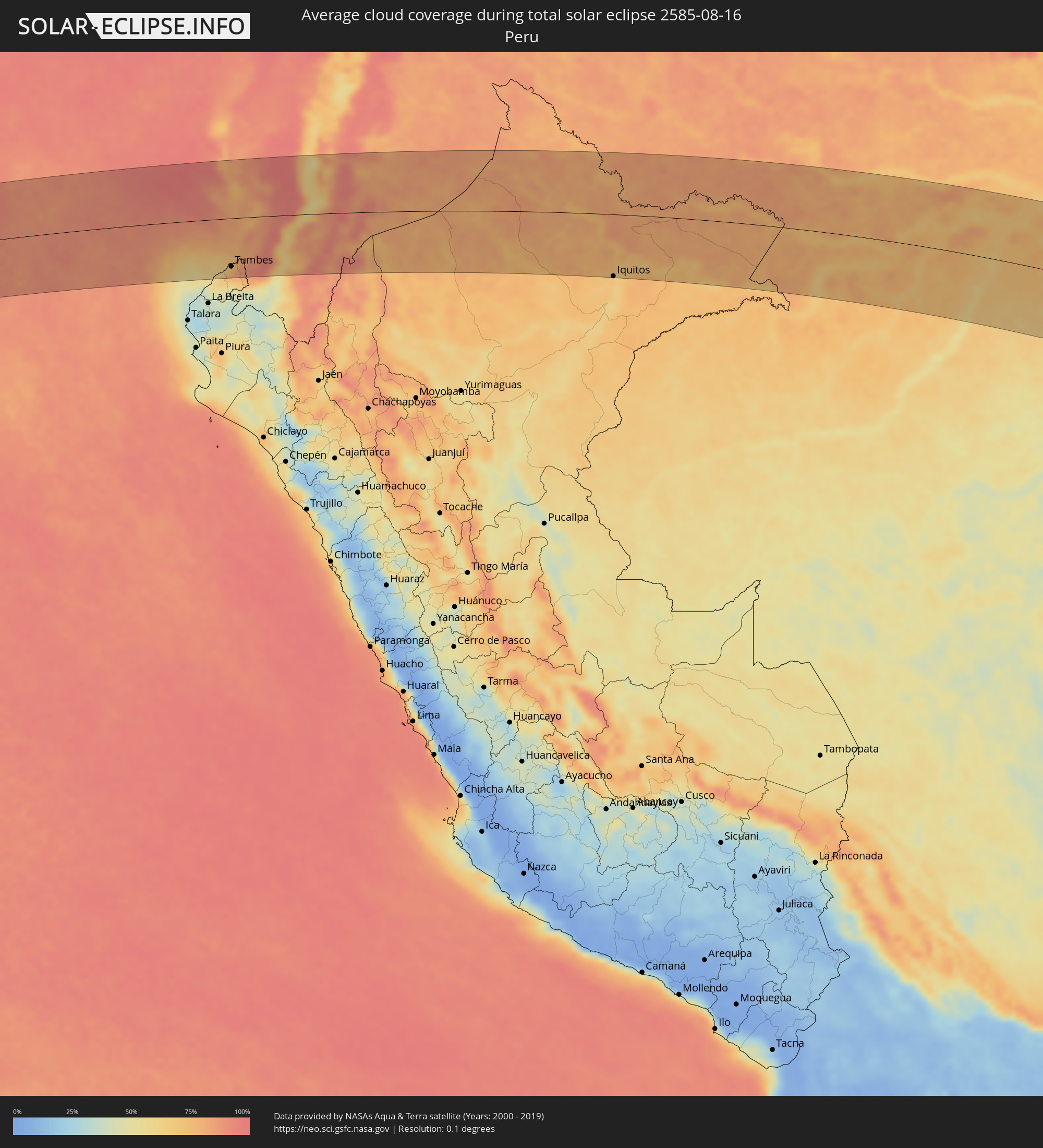 Peru
Peru
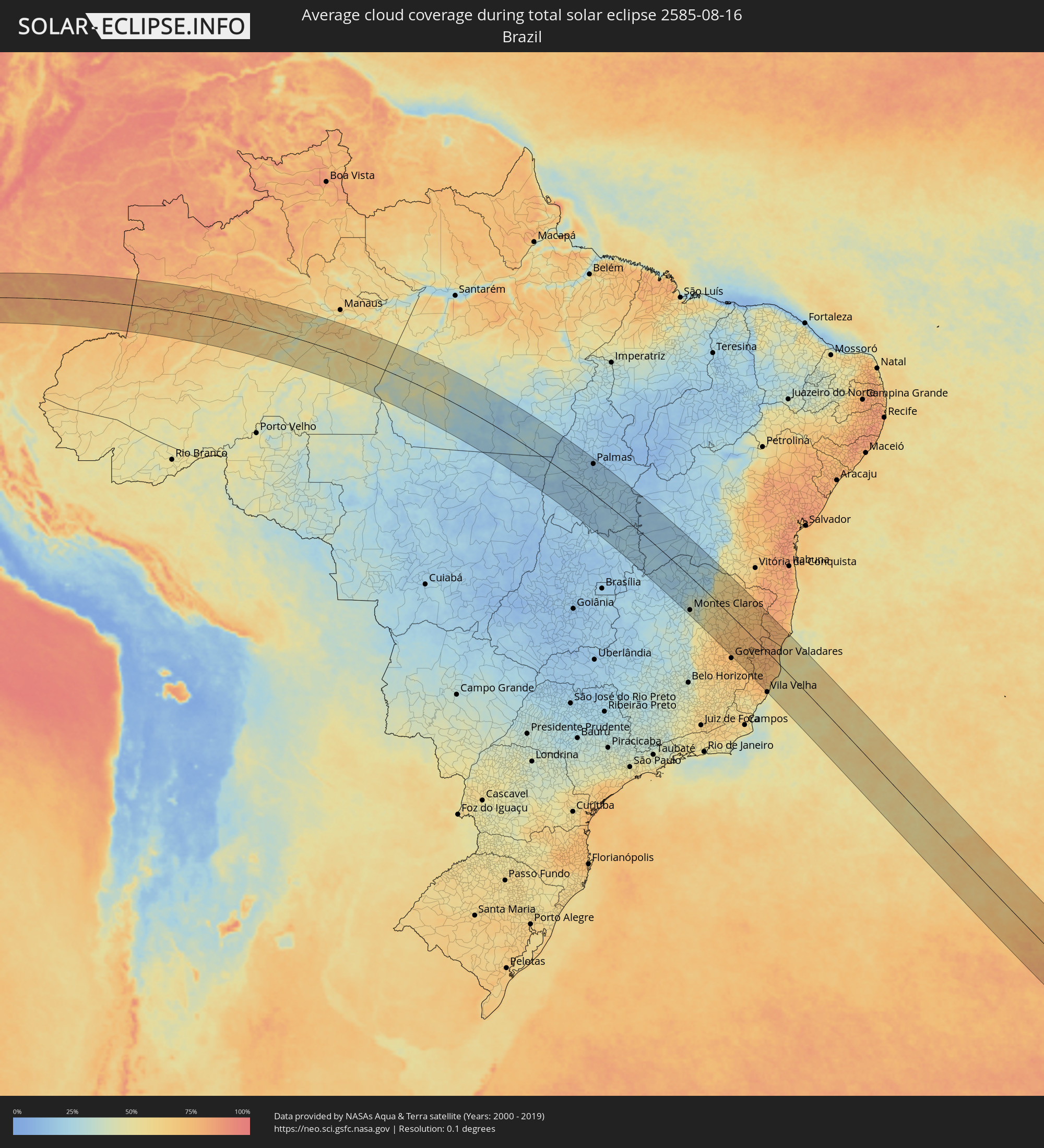 Brazil
Cities inside the path of the eclipse
The following table shows all locations with a population of more than 5,000 inside the eclipse path. Cities which have more than 100,000 inhabitants are marked bold. A click at the locations opens a detailed map.
| City | Type | Eclipse duration | Local time of max. eclipse | Distance to central line | Ø Cloud coverage |
|
Salinas, Santa Elena
|
total | - | 07:49:24 UTC-05:00 | 53 km | 93% |
|
La Libertad, Guayas
|
total | - | 07:49:27 UTC-05:00 | 51 km | 92% |
|
Santa Elena, Santa Elena
|
total | - | 07:49:29 UTC-05:00 | 51 km | 92% |
|
Zorritos, Tumbes
|
total | - | 07:51:01 UTC-05:00 | 112 km | 63% |
|
Tumbes, Tumbes
|
total | - | 07:51:07 UTC-05:00 | 101 km | 77% |
|
Playas, Guayas
|
total | - | 07:50:17 UTC-05:00 | 3 km | 83% |
|
Zarumilla, Tumbes
|
total | - | 07:51:13 UTC-05:00 | 95 km | 86% |
|
Aguas Verdes, Tumbes
|
total | - | 07:51:13 UTC-05:00 | 93 km | 88% |
|
Pedro Carbo, Guayas
|
total | - | 07:49:40 UTC-05:00 | 92 km | 85% |
|
Huaquillas, El Oro
|
total | - | 07:51:14 UTC-05:00 | 92 km | 88% |
|
Lomas de Sargentillo, Guayas
|
total | - | 07:49:52 UTC-05:00 | 84 km | 85% |
|
Colimes, Guayas
|
total | - | 07:49:37 UTC-05:00 | 121 km | 89% |
|
Santa Lucía, Guayas
|
total | - | 07:50:13 UTC-05:00 | 50 km | 78% |
|
Puerto Bolívar, El Oro
|
total | - | 07:51:15 UTC-05:00 | 71 km | 88% |
|
El Triunfo, Guayas
|
total | - | 07:50:01 UTC-05:00 | 77 km | 83% |
|
Machala, El Oro
|
total | - | 07:51:16 UTC-05:00 | 70 km | 88% |
|
Santa Rosa, El Oro
|
total | - | 07:51:27 UTC-05:00 | 91 km | 90% |
|
Guayaquil, Guayas
|
total | - | 07:50:19 UTC-05:00 | 47 km | 82% |
|
Eloy Alfaro, Guayas
|
total | - | 07:50:21 UTC-05:00 | 50 km | 82% |
|
Baláo, Guayas
|
total | - | 07:51:04 UTC-05:00 | 32 km | 92% |
|
Pasaje, El Oro
|
total | - | 07:51:29 UTC-05:00 | 78 km | 96% |
|
Vinces, Los Ríos
|
total | - | 07:49:52 UTC-05:00 | 118 km | 96% |
|
Samborondón, Guayas
|
total | - | 07:50:16 UTC-05:00 | 73 km | 90% |
|
Palestina, Guayas
|
total | - | 07:50:15 UTC-05:00 | 76 km | 89% |
|
Yaguachi Nuevo, Guayas
|
total | - | 07:50:25 UTC-05:00 | 58 km | 93% |
|
Piñas, El Oro
|
total | - | 07:51:57 UTC-05:00 | 118 km | 47% |
|
Portovelo, El Oro
|
total | - | 07:52:03 UTC-05:00 | 123 km | 48% |
|
Naranjal, Guayas
|
total | - | 07:51:02 UTC-05:00 | 7 km | 91% |
|
Zaruma, El Oro
|
total | - | 07:52:01 UTC-05:00 | 120 km | 48% |
|
Milagro, Guayas
|
total | - | 07:50:33 UTC-05:00 | 53 km | 96% |
|
Babahoyo, Los Ríos
|
total | - | 07:50:18 UTC-05:00 | 90 km | 96% |
|
Alfredo Baquerizo Moreno, Guayas
|
total | - | 07:50:25 UTC-05:00 | 77 km | 97% |
|
Naranjito, Guayas
|
total | - | 07:50:42 UTC-05:00 | 49 km | 95% |
|
Catarama, Los Ríos
|
total | - | 07:50:09 UTC-05:00 | 114 km | 97% |
|
Coronel Marcelino Maridueña, Guayas
|
total | - | 07:50:46 UTC-05:00 | 44 km | 97% |
|
La Troncal, Cañar
|
total | - | 07:51:04 UTC-05:00 | 19 km | 93% |
|
Montalvo, Los Ríos
|
total | - | 07:50:31 UTC-05:00 | 90 km | 96% |
|
San Miguel, Bolívar
|
total | - | 07:50:40 UTC-05:00 | 97 km | 60% |
|
Cuenca, Azuay
|
total | - | 07:51:50 UTC-05:00 | 35 km | 84% |
|
Guaranda, Bolívar
|
total | - | 07:50:36 UTC-05:00 | 110 km | 57% |
|
Cañar, Cañar
|
total | - | 07:51:35 UTC-05:00 | 2 km | 85% |
|
Azogues, Cañar
|
total | - | 07:51:50 UTC-05:00 | 18 km | 83% |
|
Alausí, Chimborazo
|
total | - | 07:51:20 UTC-05:00 | 41 km | 58% |
|
Gualaceo, Azuay
|
total | - | 07:52:03 UTC-05:00 | 36 km | 86% |
|
Riobamba, Chimborazo
|
total | - | 07:51:01 UTC-05:00 | 100 km | 78% |
|
Guano, Chimborazo
|
total | - | 07:50:59 UTC-05:00 | 107 km | 72% |
|
Sucúa, Morona-Santiago
|
total | - | 07:52:15 UTC-05:00 | 10 km | 86% |
|
Macas, Morona-Santiago
|
total | - | 07:52:09 UTC-05:00 | 27 km | 87% |
|
Puyo, Pastaza
|
total | - | 07:51:29 UTC-05:00 | 118 km | 81% |
|
Palora, Morona-Santiago
|
total | - | 07:51:43 UTC-05:00 | 94 km | 80% |
|
Iquitos, Loreto
|
total | - | 07:59:15 UTC-05:00 | 129 km | 70% |
|
São Paulo de Olivença, Amazonas
|
total | - | 09:04:56 UTC-04:00 | 45 km | 68% |
|
Fonte Boa, Amazonas
|
total | - | 09:08:12 UTC-04:00 | 100 km | 68% |
|
Tefé, Amazonas
|
total | - | 09:11:34 UTC-04:00 | 37 km | 67% |
|
Coari, Amazonas
|
total | - | 09:15:17 UTC-04:00 | 2 km | 57% |
|
Codajás, Amazonas
|
total | - | 09:16:53 UTC-04:00 | 61 km | 55% |
|
Manicoré, Amazonas
|
total | - | 09:21:07 UTC-04:00 | 123 km | 50% |
|
Novo Aripuanã, Amazonas
|
total | - | 09:21:51 UTC-04:00 | 18 km | 49% |
|
Borba, Amazonas
|
total | - | 09:22:18 UTC-04:00 | 88 km | 61% |
|
Alvorada, Tocantins
|
total | - | 10:57:44 UTC-03:00 | 137 km | 18% |
|
Gurupi, Tocantins
|
total | - | 10:56:32 UTC-03:00 | 67 km | 18% |
|
Palmas, Tocantins
|
total | - | 10:55:26 UTC-03:00 | 121 km | 16% |
|
Campos Belos, Goiás
|
total | - | 11:03:53 UTC-03:00 | 24 km | 21% |
|
Taguatinga, Tocantins
|
total | - | 11:03:31 UTC-03:00 | 53 km | 18% |
|
Posse, Goiás
|
total | - | 11:06:36 UTC-03:00 | 85 km | 21% |
|
São Francisco, Minas Gerais
|
total | - | 11:13:05 UTC-03:00 | 131 km | 23% |
|
Correntina, Bahia
|
total | - | 11:09:05 UTC-03:00 | 101 km | 18% |
|
Brasília de Minas, Minas Gerais
|
total | - | 11:14:27 UTC-03:00 | 120 km | 23% |
|
Januária, Minas Gerais
|
total | - | 11:13:23 UTC-03:00 | 56 km | 22% |
|
Santa Maria da Vitória, Bahia
|
total | - | 11:10:08 UTC-03:00 | 129 km | 20% |
|
Itacarambi, Minas Gerais
|
total | - | 11:13:18 UTC-03:00 | 5 km | 24% |
|
Manga, Minas Gerais
|
total | - | 11:13:03 UTC-03:00 | 35 km | 24% |
|
Montes Claros, Minas Gerais
|
total | - | 11:16:35 UTC-03:00 | 121 km | 39% |
|
Carinhanha, Bahia
|
total | - | 11:12:38 UTC-03:00 | 84 km | 23% |
|
Barreiro do Jaíba, Minas Gerais
|
total | - | 11:15:15 UTC-03:00 | 10 km | 25% |
|
Francisco Sá, Minas Gerais
|
total | - | 11:16:57 UTC-03:00 | 72 km | 34% |
|
Janaúba, Minas Gerais
|
total | - | 11:16:11 UTC-03:00 | 5 km | 30% |
|
Porteirinha, Minas Gerais
|
total | - | 11:16:41 UTC-03:00 | 21 km | 31% |
|
Monte Azul, Minas Gerais
|
total | - | 11:16:00 UTC-03:00 | 80 km | 27% |
|
Itamarandiba, Minas Gerais
|
total | - | 11:20:35 UTC-03:00 | 135 km | 64% |
|
Espinosa, Minas Gerais
|
total | - | 11:15:44 UTC-03:00 | 102 km | 30% |
|
Capelinha, Minas Gerais
|
total | - | 11:21:02 UTC-03:00 | 97 km | 68% |
|
Santa Maria do Suaçuí, Minas Gerais
|
total | - | 11:22:05 UTC-03:00 | 128 km | 71% |
|
Salinas, Minas Gerais
|
total | - | 11:18:58 UTC-03:00 | 41 km | 61% |
|
Taiobeiras, Minas Gerais
|
total | - | 11:18:29 UTC-03:00 | 74 km | 62% |
|
Araçuaí, Minas Gerais
|
total | - | 11:20:35 UTC-03:00 | 3 km | 64% |
|
Novo Cruzeiro, Minas Gerais
|
total | - | 11:22:01 UTC-03:00 | 31 km | 70% |
|
Itambacuri, Minas Gerais
|
total | - | 11:23:21 UTC-03:00 | 61 km | 74% |
|
Teófilo Otoni, Minas Gerais
|
total | - | 11:23:26 UTC-03:00 | 34 km | 74% |
|
Padre Paraíso, Minas Gerais
|
total | - | 11:22:11 UTC-03:00 | 29 km | 70% |
|
Medina, Minas Gerais
|
total | - | 11:20:47 UTC-03:00 | 97 km | 67% |
|
Conselheiro Pena, Minas Gerais
|
total | - | 11:25:38 UTC-03:00 | 135 km | 72% |
|
Águas Vermelhas, Minas Gerais
|
total | - | 11:20:01 UTC-03:00 | 137 km | 67% |
|
Pedra Azul, Minas Gerais
|
total | - | 11:20:47 UTC-03:00 | 128 km | 68% |
|
Resplendor, Minas Gerais
|
total | - | 11:26:20 UTC-03:00 | 130 km | 72% |
|
Aimorés, Minas Gerais
|
total | - | 11:27:00 UTC-03:00 | 129 km | 71% |
|
Baixo Guandu, Espírito Santo
|
total | - | 11:27:08 UTC-03:00 | 127 km | 70% |
|
Jequitinhonha, Minas Gerais
|
total | - | 11:22:07 UTC-03:00 | 116 km | 70% |
|
Águas Formosas, Minas Gerais
|
total | - | 11:23:21 UTC-03:00 | 70 km | 74% |
|
Barra de São Francisco, Espírito Santo
|
total | - | 11:26:10 UTC-03:00 | 58 km | 76% |
|
Ecoporanga, Espírito Santo
|
total | - | 11:25:41 UTC-03:00 | 24 km | 77% |
|
Carlos Chagas, Minas Gerais
|
total | - | 11:24:43 UTC-03:00 | 33 km | 76% |
|
Colatina, Espírito Santo
|
total | - | 11:27:58 UTC-03:00 | 100 km | 75% |
|
Fundão, Espírito Santo
|
total | - | 11:29:03 UTC-03:00 | 113 km | 71% |
|
Nova Venécia, Espírito Santo
|
total | - | 11:27:06 UTC-03:00 | 18 km | 78% |
|
João Neiva, Espírito Santo
|
total | - | 11:28:48 UTC-03:00 | 98 km | 74% |
|
Montanha, Espírito Santo
|
total | - | 11:26:14 UTC-03:00 | 30 km | 77% |
|
Nanuque, Minas Gerais
|
total | - | 11:25:48 UTC-03:00 | 54 km | 77% |
|
Itanhém, Bahia
|
total | - | 11:24:44 UTC-03:00 | 108 km | 76% |
|
Serra, Espírito Santo
|
total | - | 11:29:33 UTC-03:00 | 121 km | 67% |
|
Vila Velha, Espírito Santo
|
total | - | 11:29:53 UTC-03:00 | 135 km | 52% |
|
Aracruz, Espírito Santo
|
total | - | 11:29:08 UTC-03:00 | 94 km | 71% |
|
Medeiros Neto, Bahia
|
total | - | 11:25:18 UTC-03:00 | 100 km | 76% |
|
Linhares, Espírito Santo
|
total | - | 11:28:52 UTC-03:00 | 46 km | 73% |
|
São Mateus, Espírito Santo
|
total | - | 11:28:14 UTC-03:00 | 22 km | 75% |
|
Conceição da Barra, Espírito Santo
|
total | - | 11:28:17 UTC-03:00 | 42 km | 52% |
|
Mucuri, Bahia
|
total | - | 11:27:50 UTC-03:00 | 95 km | 63% |
|
Nova Viçosa, Bahia
|
total | - | 11:27:53 UTC-03:00 | 124 km | 57% |