Total solar eclipse of 05/05/2600
| Day of week: | Monday |
| Maximum duration of eclipse: | 02m57s |
| Maximum width of eclipse path: | 579 km |
| Saros cycle: | 167 |
| Coverage: | 100% |
| Magnitude: | 1.0552 |
| Gamma: | 0.9474 |
Wo kann man die Sonnenfinsternis vom 05/05/2600 sehen?
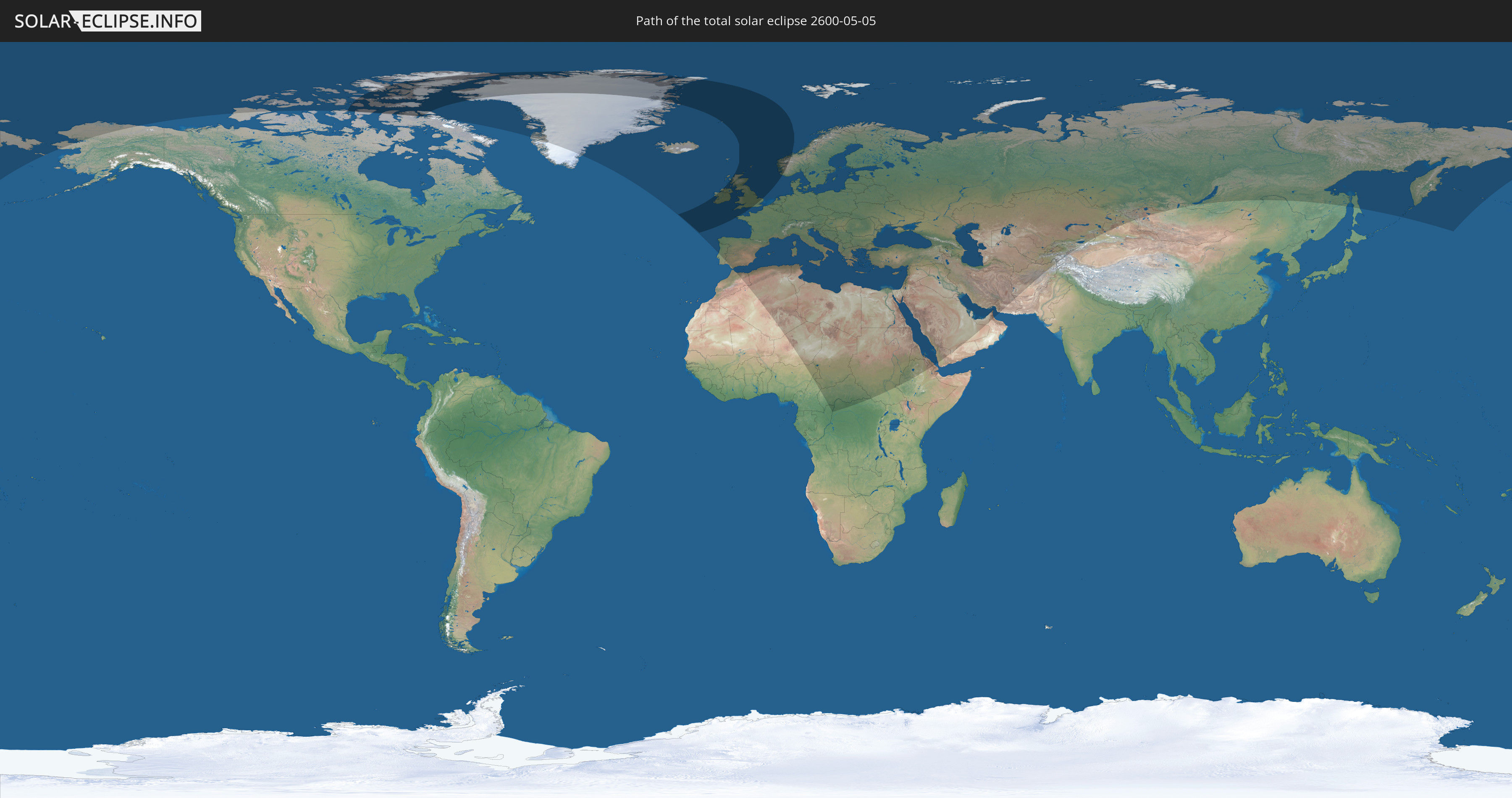
Die Sonnenfinsternis am 05/05/2600 kann man in 97 Ländern als partielle Sonnenfinsternis beobachten.
Der Finsternispfad verläuft durch 8 Länder. Nur in diesen Ländern ist sie als total Sonnenfinsternis zu sehen.
In den folgenden Ländern ist die Sonnenfinsternis total zu sehen
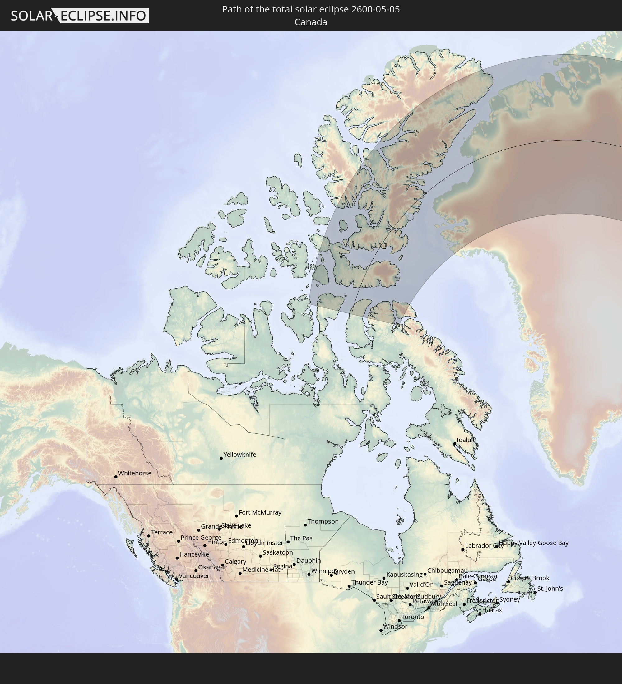 Canada
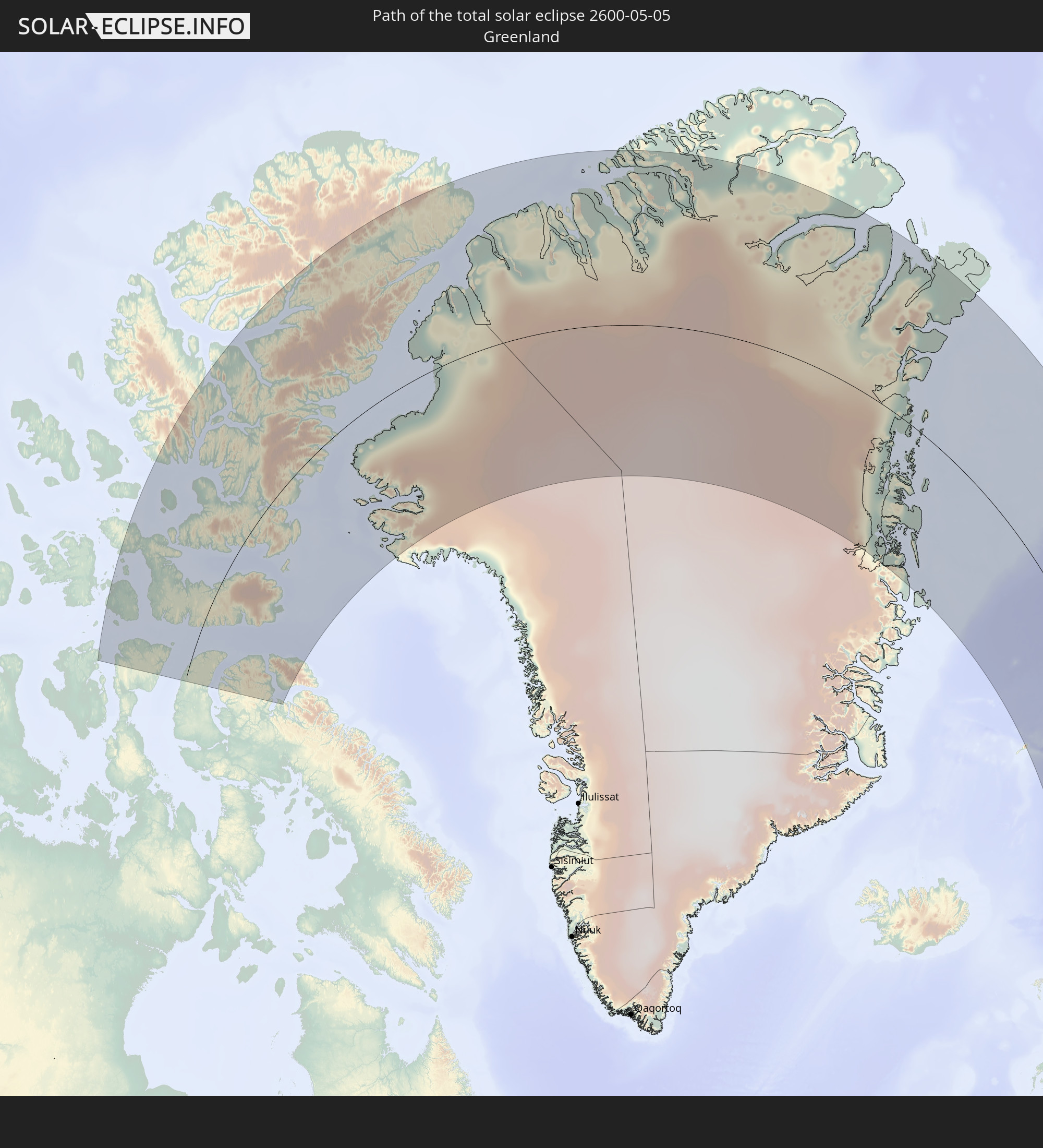 Greenland
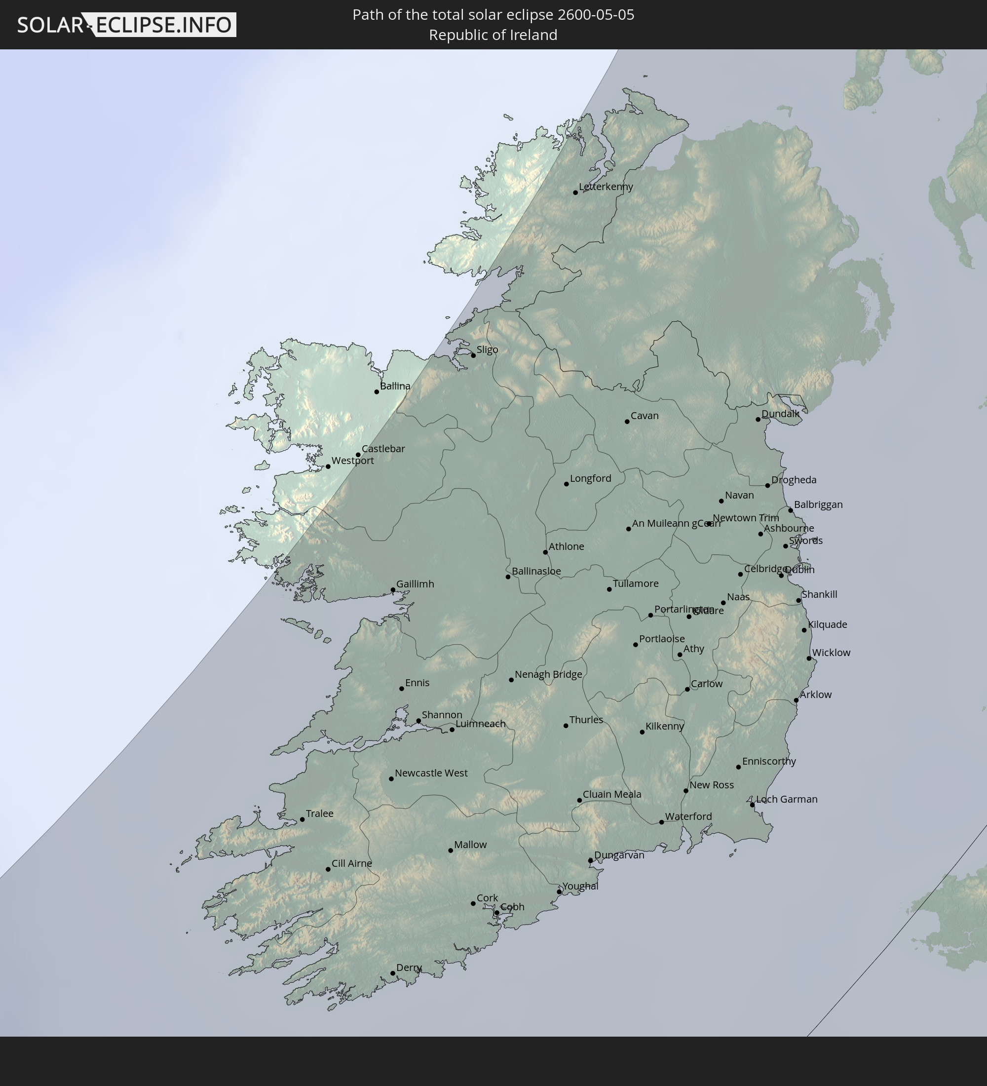 Republic of Ireland
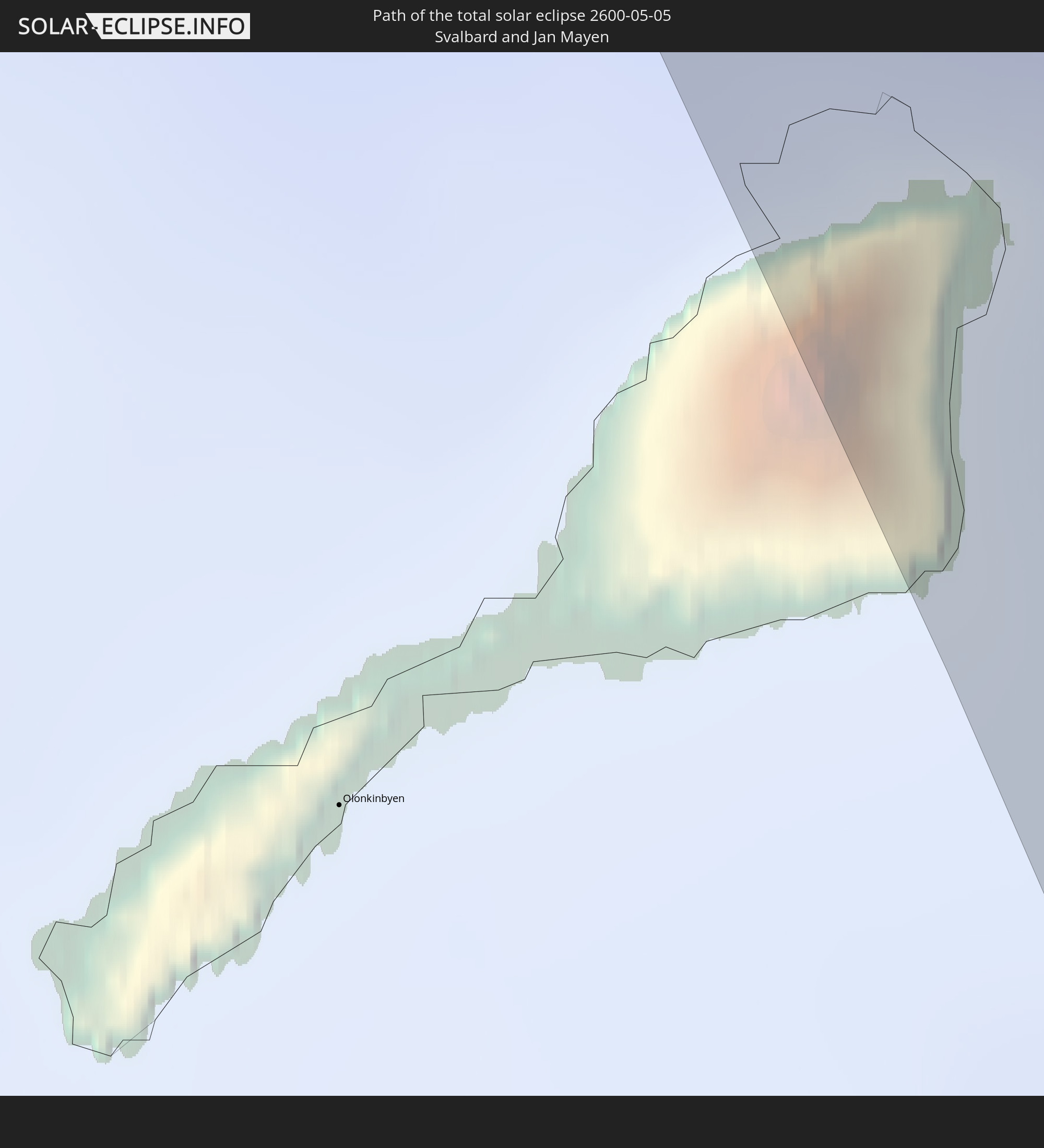 Svalbard and Jan Mayen
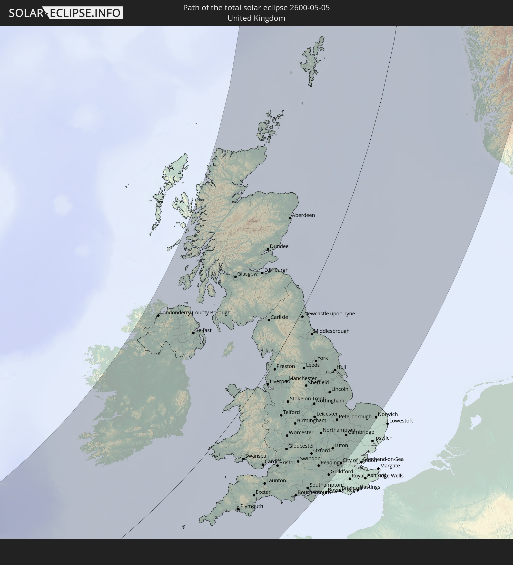 United Kingdom
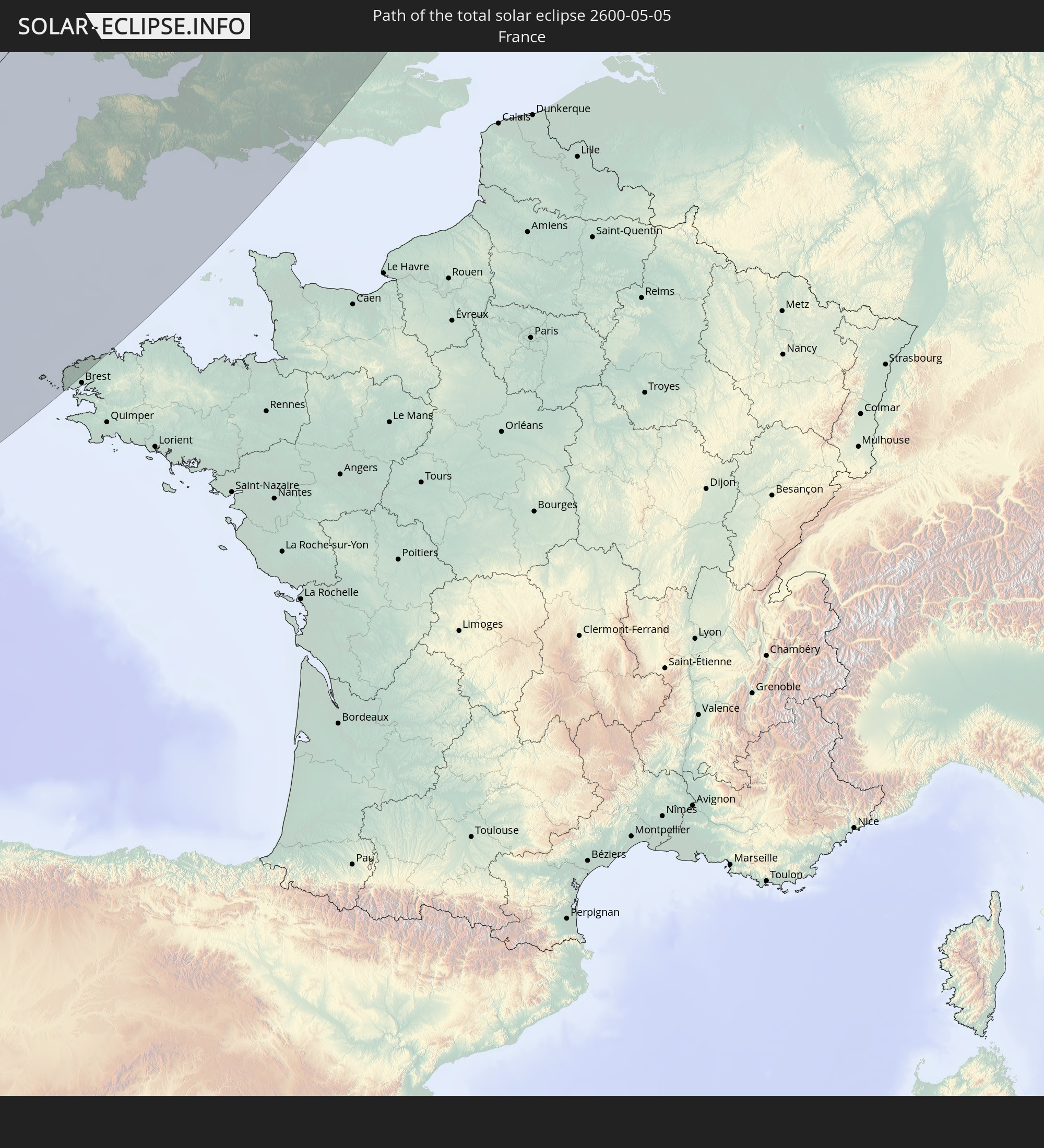 France
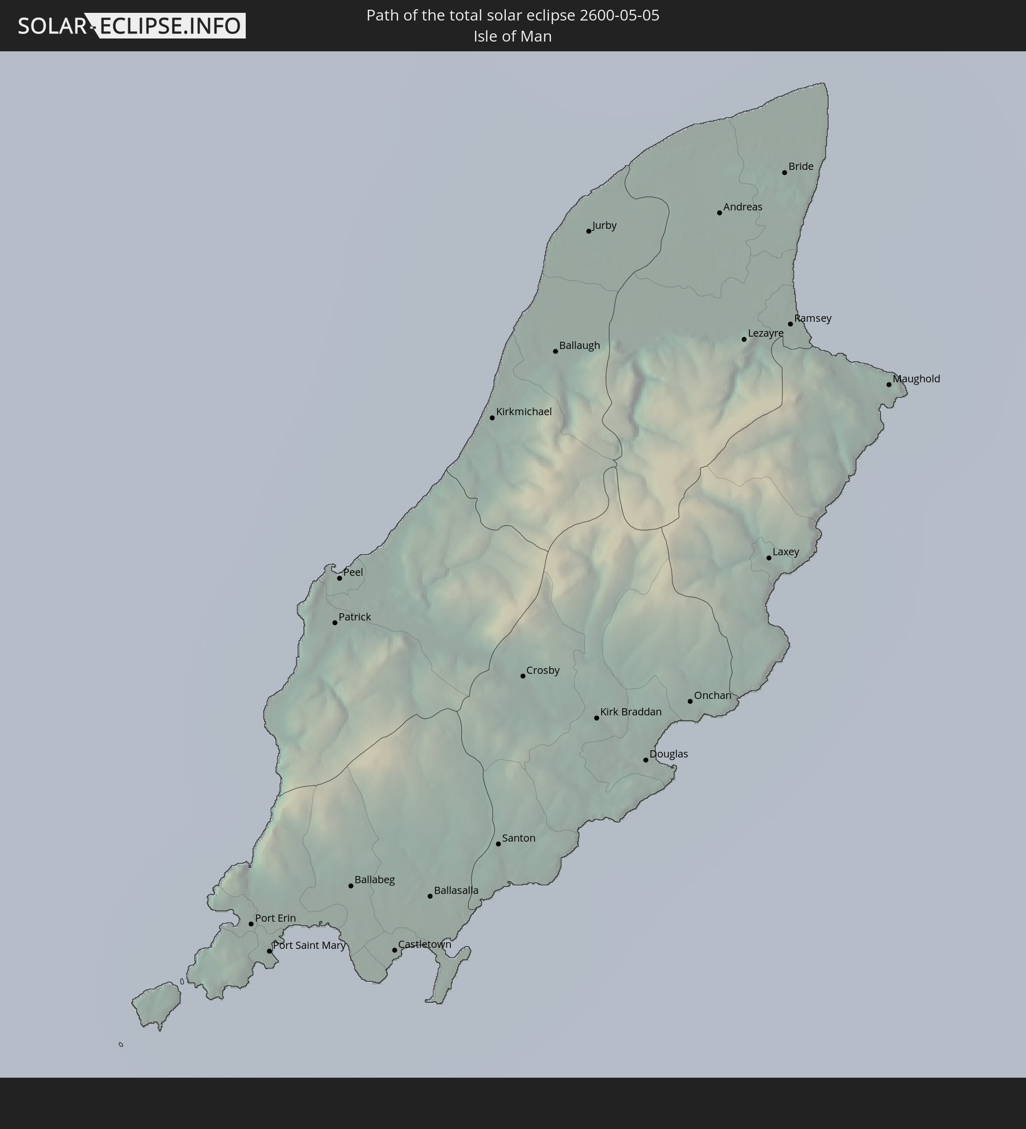 Isle of Man
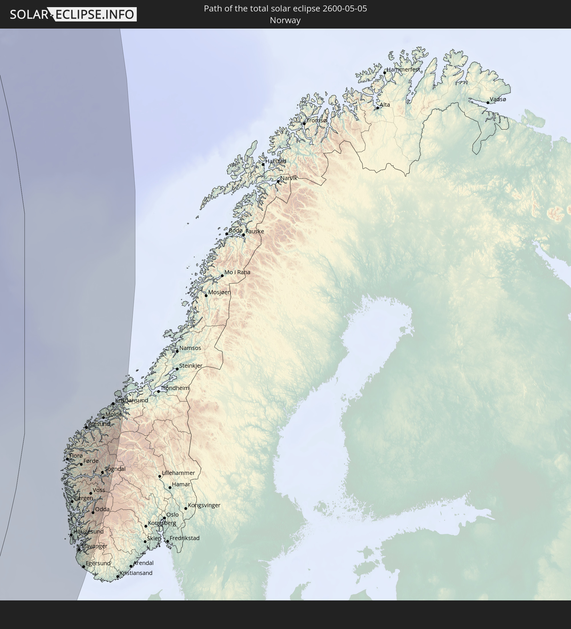 Norway
In den folgenden Ländern ist die Sonnenfinsternis partiell zu sehen
 Russia
 United States
 Canada
 Greenland
 Portugal
 Iceland
 Spain
Spain
 Morocco
 Republic of Ireland
 Svalbard and Jan Mayen
 Algeria
 United Kingdom
 Faroe Islands
 Gibraltar
 France
 Isle of Man
 Guernsey
 Jersey
 Niger
Niger
 Andorra
 Belgium
 Nigeria
 Netherlands
 Norway
 Luxembourg
 Germany
 Switzerland
 Italy
Italy
 Monaco
 Tunisia
 Denmark
 Cameroon
 Libya
Libya
 Liechtenstein
 Austria
 Sweden
 Republic of the Congo
 Czechia
 Democratic Republic of the Congo
 San Marino
 Vatican City
 Slovenia
 Chad
Chad
 Croatia
 Poland
 Malta
Malta
 Central African Republic
 Bosnia and Herzegovina
 Hungary
 Slovakia
 Montenegro
 Serbia
 Albania
 Åland Islands
 Greece
 Romania
 Republic of Macedonia
 Finland
 Lithuania
 Latvia
 Estonia
 Sudan
Sudan
 Ukraine
 Bulgaria
 Belarus
 Egypt
Egypt
 Turkey
 Moldova
 Cyprus
 Ethiopia
 State of Palestine
 Israel
 Saudi Arabia
 Jordan
 Lebanon
 Syria
Syria
 Eritrea
 Iraq
Iraq
 Georgia
 Yemen
Yemen
 Armenia
 Iran
Iran
 Azerbaijan
 Kazakhstan
 Kuwait
 Bahrain
 Qatar
Qatar
 United Arab Emirates
 Oman
Oman
 Turkmenistan
 Uzbekistan
 Afghanistan
 Pakistan
 Tajikistan
 Kyrgyzstan
 China
China
 Mongolia
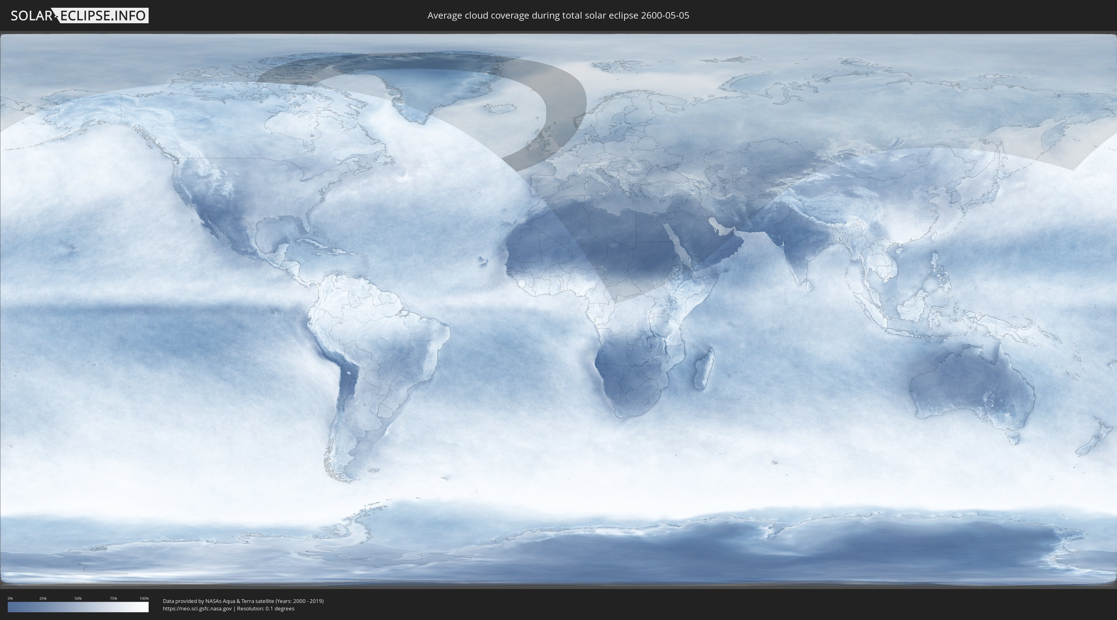
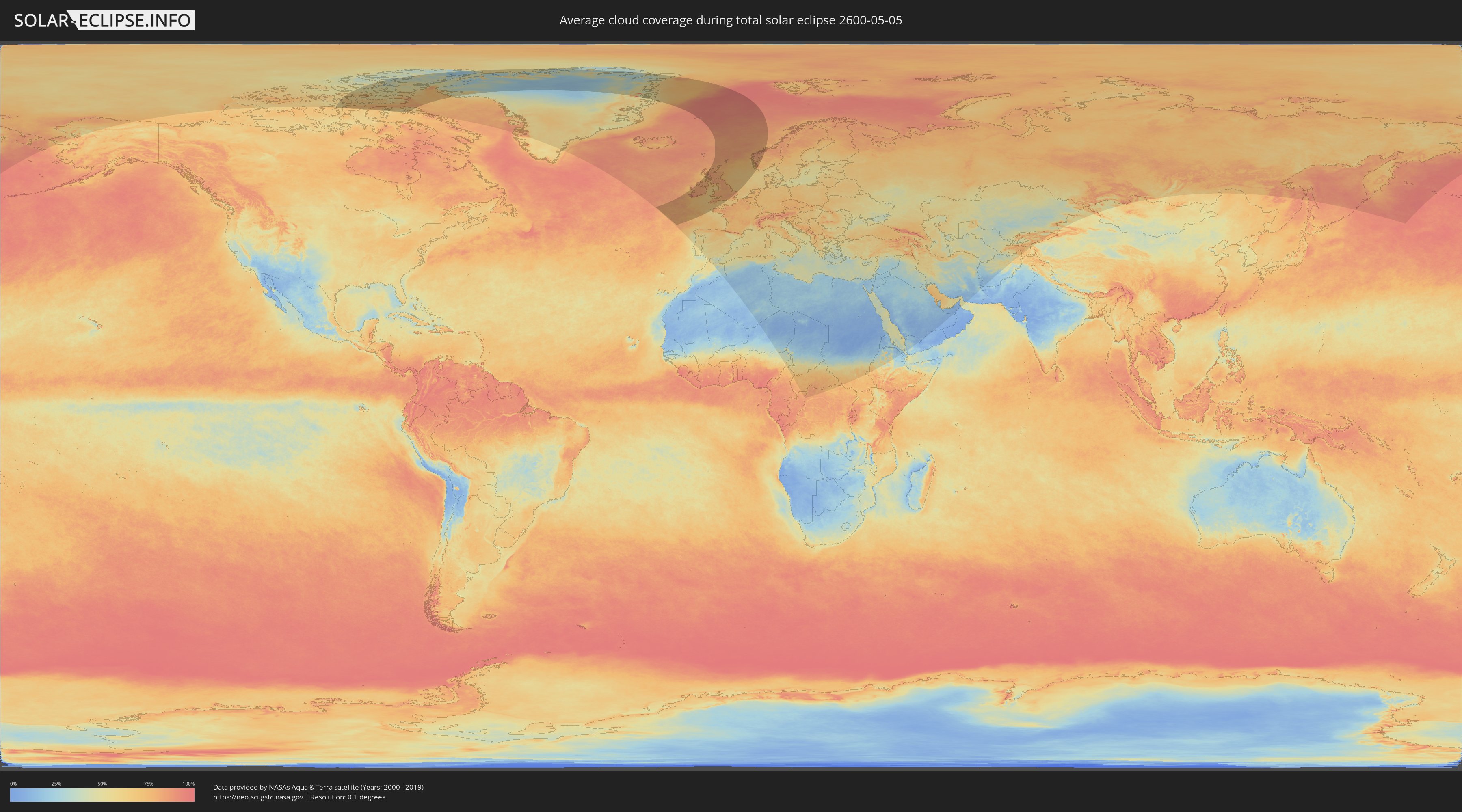
How will be the weather during the total solar eclipse on 05/05/2600?
Where is the best place to see the total solar eclipse of 05/05/2600?
The following maps show the average cloud coverage for the day of the total solar eclipse.
With the help of these maps, it is possible to find the place along the eclipse path, which has the best
chance of a cloudless sky.
Nevertheless, you should consider local circumstances and inform about the weather of your chosen
observation site.
The data is provided by NASAs satellites
AQUA and TERRA.
The cloud maps are averaged over a period of 19 years (2000 - 2019).
Detailed country maps
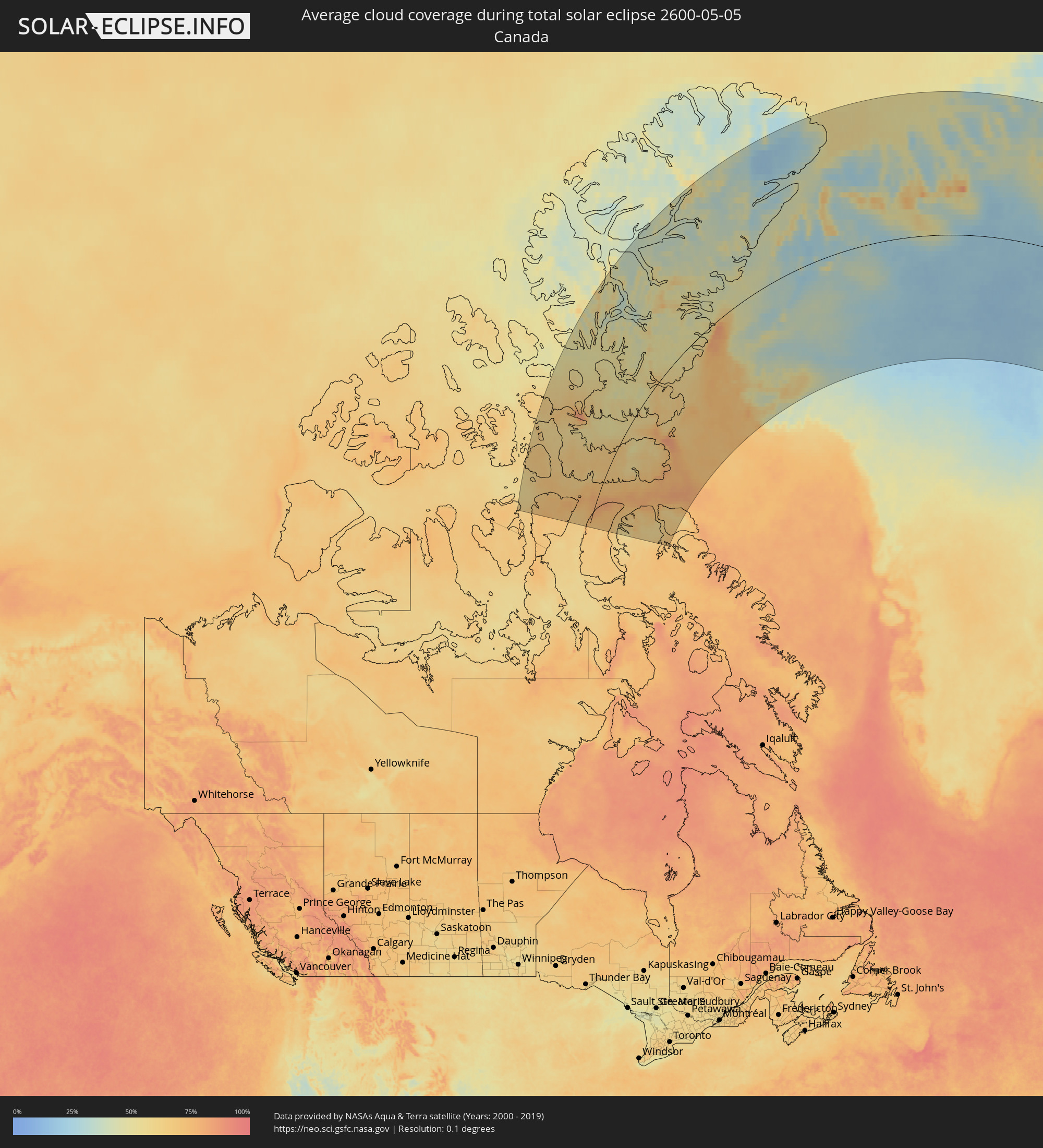 Canada
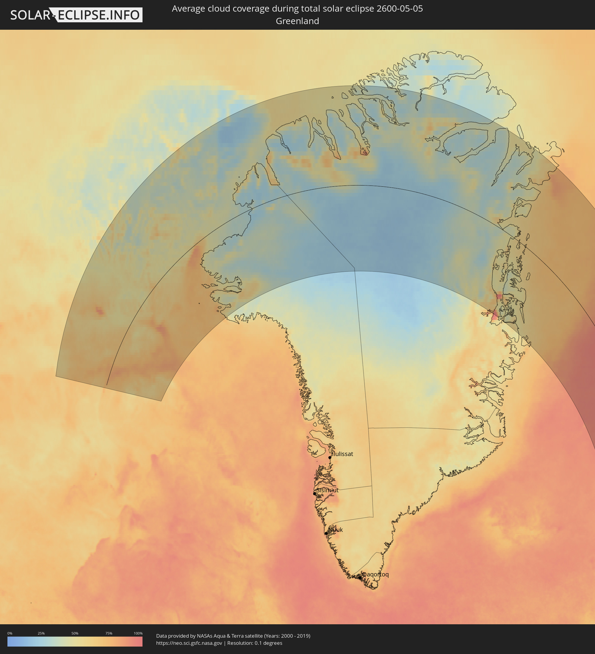 Greenland
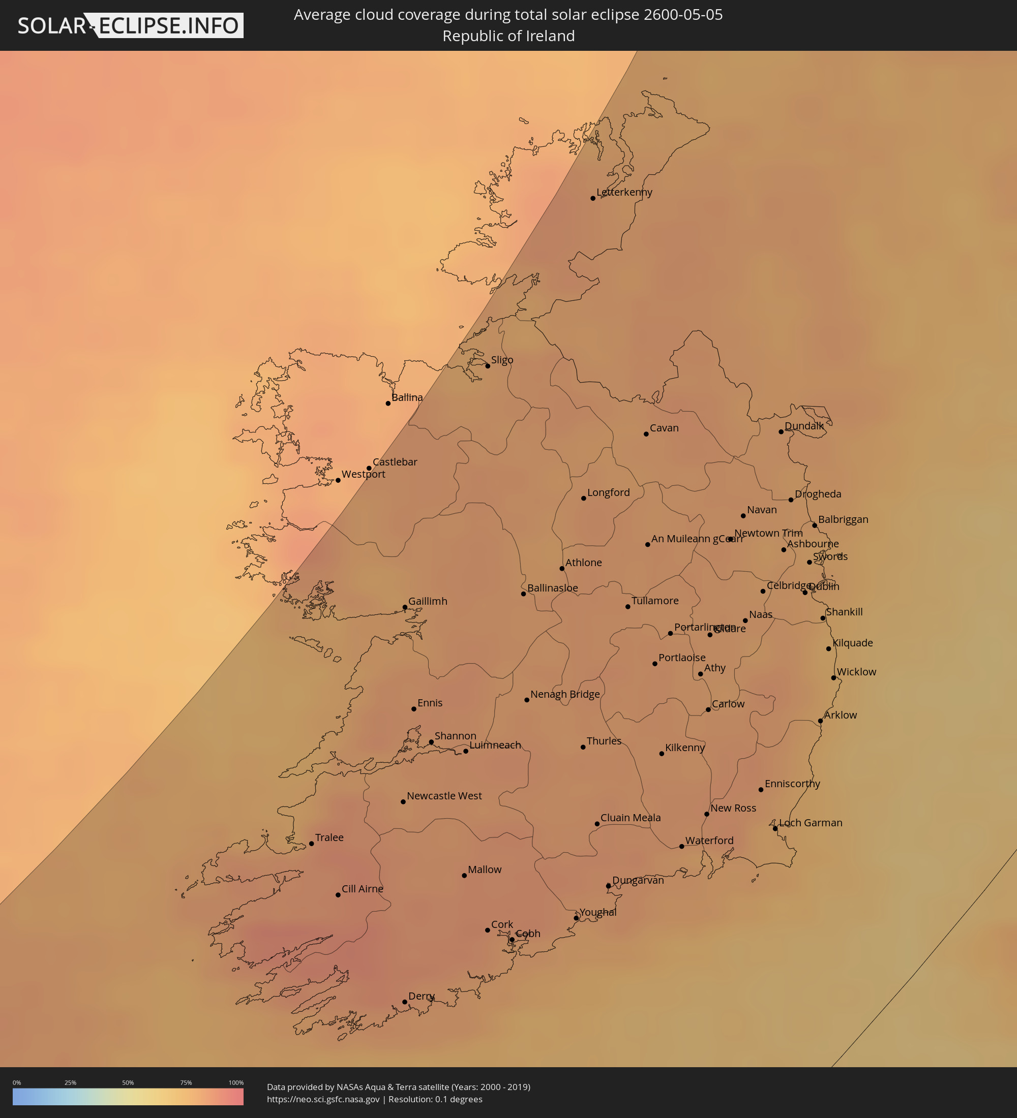 Republic of Ireland
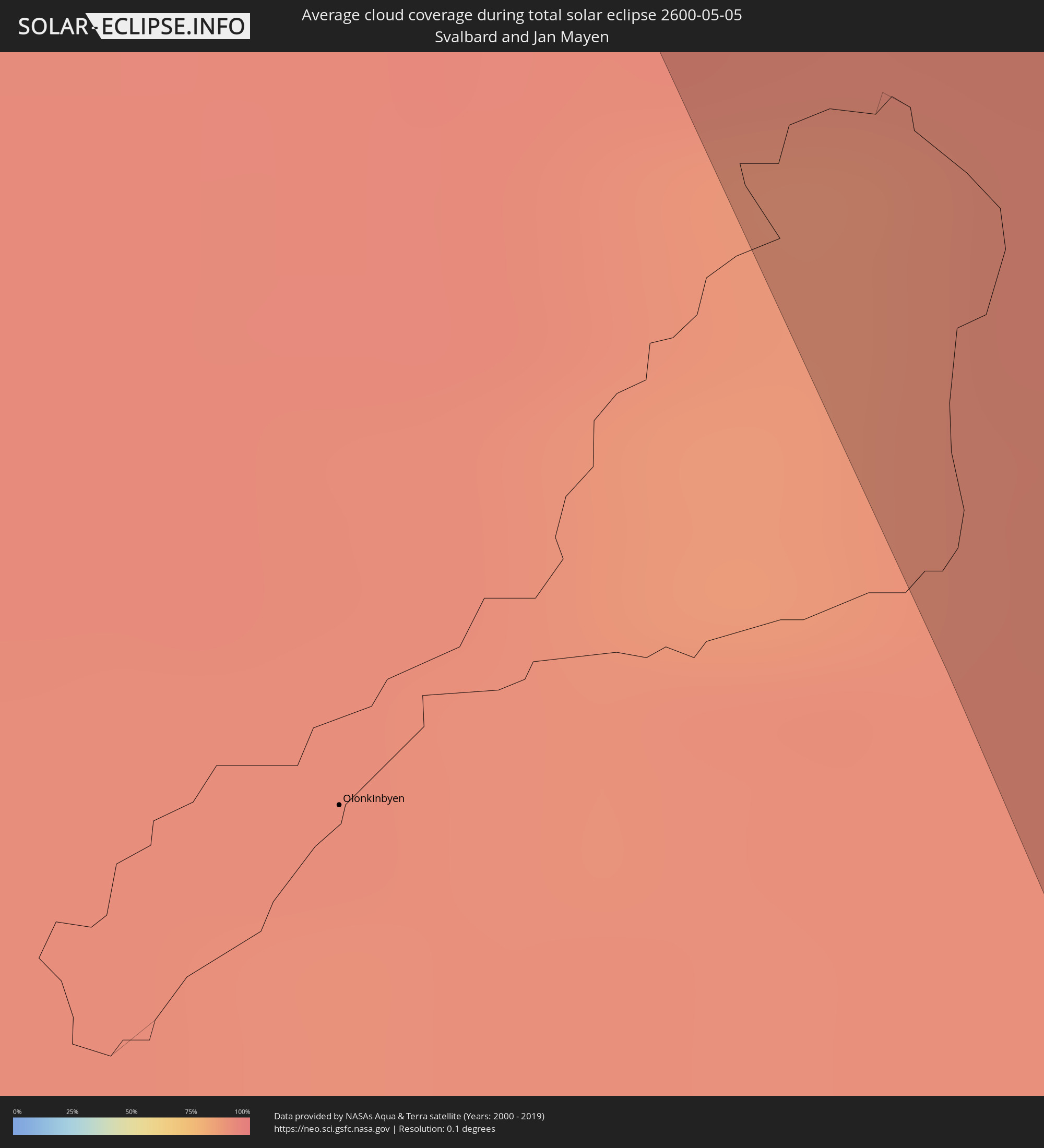 Svalbard and Jan Mayen
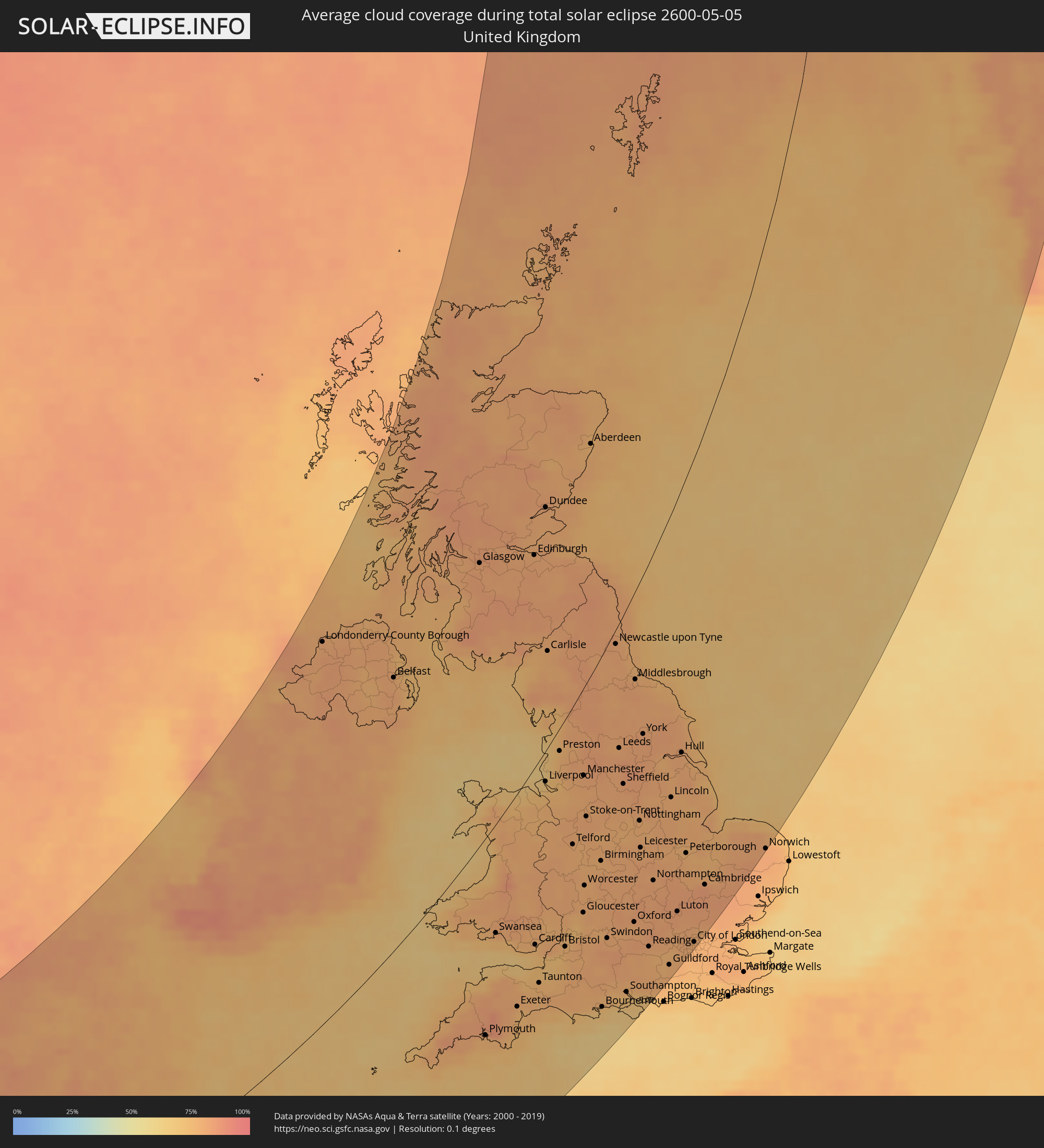 United Kingdom
 France
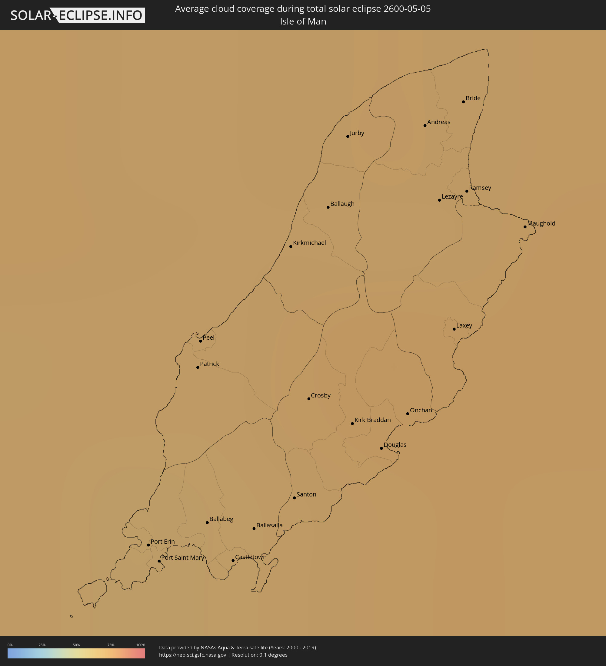 Isle of Man
 Norway
Cities inside the path of the eclipse
The following table shows all locations with a population of more than 5,000 inside the eclipse path. Cities which have more than 100,000 inhabitants are marked bold. A click at the locations opens a detailed map.
| City | Type | Eclipse duration | Local time of max. eclipse | Distance to central line | Ø Cloud coverage |
|
Tralee, Munster
|
total | - | 05:55:34 UTC+00:00 | 257 km | 84% |
|
Cill Airne, Munster
|
total | - | 05:55:10 UTC+00:00 | 231 km | 86% |
|
Derry, Munster
|
total | - | 05:54:19 UTC+00:00 | 172 km | 81% |
|
Gaillimh, Connaught
|
total | - | 05:56:58 UTC+00:00 | 296 km | 78% |
|
Ennis, Munster
|
total | - | 05:56:16 UTC+00:00 | 263 km | 81% |
|
Shannon, Munster
|
total | - | 05:56:01 UTC+00:00 | 247 km | 82% |
|
Mallow, Munster
|
total | - | 05:55:03 UTC+00:00 | 193 km | 85% |
|
Luimneach, Munster
|
total | - | 05:55:53 UTC+00:00 | 231 km | 83% |
|
Cork, Munster
|
total | - | 05:54:38 UTC+00:00 | 167 km | 84% |
|
Sligo, Connaught
|
total | - | 05:58:25 UTC+00:00 | 332 km | 77% |
|
Midleton, Munster
|
total | - | 05:54:35 UTC+00:00 | 153 km | 80% |
|
Athlone, Leinster
|
total | - | 05:56:57 UTC+00:00 | 250 km | 82% |
|
Thurles, Munster
|
total | - | 05:55:42 UTC+00:00 | 190 km | 82% |
|
Longford, Leinster
|
total | - | 05:57:23 UTC+00:00 | 261 km | 82% |
|
Letterkenny, Ulster
|
total | - | 05:59:21 UTC+00:00 | 332 km | 81% |
|
Cluain Meala, Munster
|
total | - | 05:55:10 UTC+00:00 | 162 km | 83% |
|
Dungarvan, Munster
|
total | - | 05:54:43 UTC+00:00 | 138 km | 81% |
|
Tullamore, Leinster
|
total | - | 05:56:35 UTC+00:00 | 215 km | 81% |
|
An Muileann gCearr, Leinster
|
total | - | 05:56:58 UTC+00:00 | 224 km | 80% |
|
Portlaoise, Leinster
|
total | - | 05:56:09 UTC+00:00 | 188 km | 82% |
|
Kilkenny, Leinster
|
total | - | 05:55:32 UTC+00:00 | 160 km | 81% |
|
Portarlington, Leinster
|
total | - | 05:56:20 UTC+00:00 | 191 km | 81% |
|
Waterford, Munster
|
total | - | 05:54:51 UTC+00:00 | 124 km | 79% |
|
Athy, Leinster
|
total | - | 05:56:00 UTC+00:00 | 169 km | 80% |
|
Carlow, Leinster
|
total | - | 05:55:45 UTC+00:00 | 155 km | 82% |
|
Kildare, Leinster
|
total | - | 05:56:15 UTC+00:00 | 176 km | 80% |
|
Navan, Leinster
|
total | - | 05:57:00 UTC+00:00 | 196 km | 81% |
|
Naas, Leinster
|
total | - | 05:56:17 UTC+00:00 | 167 km | 80% |
|
Enniscorthy, Leinster
|
total | - | 05:55:07 UTC+00:00 | 112 km | 81% |
|
Celbridge, Leinster
|
total | - | 05:56:28 UTC+00:00 | 168 km | 80% |
|
Loch Garman, Leinster
|
total | - | 05:54:49 UTC+00:00 | 95 km | 76% |
|
Dundalk, Leinster
|
total | - | 05:57:30 UTC+00:00 | 204 km | 80% |
|
Ashbourne, Leinster
|
total | - | 05:56:42 UTC+00:00 | 172 km | 80% |
|
Drogheda, Leinster
|
total | - | 05:57:02 UTC+00:00 | 182 km | 78% |
|
Greenhills, Leinster
|
total | - | 05:56:24 UTC+00:00 | 155 km | 79% |
|
Dublin, Leinster
|
total | - | 05:56:23 UTC+00:00 | 152 km | 78% |
|
Balbriggan, Leinster
|
total | - | 05:56:49 UTC+00:00 | 167 km | 76% |
|
Arklow, Leinster
|
total | - | 05:55:29 UTC+00:00 | 110 km | 73% |
|
Sallynoggin, Leinster
|
total | - | 05:56:16 UTC+00:00 | 143 km | 75% |
|
Kilquade
|
total | - | 05:55:58 UTC+00:00 | 128 km | 74% |
|
Belfast, Northern Ireland
|
total | - | 05:58:23 UTC+00:00 | 212 km | 79% |
|
Port Erin, Port Erin
|
total | - | 05:57:18 UTC+00:00 | 117 km | 71% |
|
Port Saint Mary, Port St Mary
|
total | - | 05:57:17 UTC+00:00 | 116 km | 70% |
|
Patrick, Patrick
|
total | - | 05:57:29 UTC+00:00 | 121 km | 69% |
|
Peel, Peel
|
total | - | 05:57:31 UTC+00:00 | 122 km | 69% |
|
Ballabeg, Arbory
|
total | - | 05:57:19 UTC+00:00 | 114 km | 70% |
|
Castletown, Castletown
|
total | - | 05:57:16 UTC+00:00 | 111 km | 70% |
|
Ploudalmézeau, Brittany
|
total | - | 06:48:19 UTC+01:00 | 291 km | 73% |
|
Ballasalla, Malew
|
total | - | 05:57:17 UTC+00:00 | 111 km | 69% |
|
Saint-Renan, Brittany
|
total | - | 06:48:09 UTC+01:00 | 301 km | 74% |
|
Kirkmichael, Michael
|
total | - | 05:57:36 UTC+00:00 | 120 km | 72% |
|
Santon, Santon
|
total | - | 05:57:19 UTC+00:00 | 110 km | 69% |
|
Rd pt des Chataigniers, Rte de Milizac, Guilers, Finistère, France, Brittany
|
total | - | 06:48:09 UTC+01:00 | 304 km | 74% |
|
Crosby, Marown
|
total | - | 05:57:25 UTC+00:00 | 113 km | 70% |
|
Ballaugh, Ballaugh
|
total | - | 05:57:38 UTC+00:00 | 119 km | 73% |
|
Jurby, Jurby
|
total | - | 05:57:42 UTC+00:00 | 121 km | 70% |
|
Kirk Braddan, Braddan
|
total | - | 05:57:23 UTC+00:00 | 109 km | 72% |
|
Plouguerneau, Brittany
|
total | - | 06:48:23 UTC+01:00 | 293 km | 75% |
|
Douglas, Douglas
|
total | - | 05:57:21 UTC+00:00 | 106 km | 72% |
|
Onchan, Onchan
|
total | - | 05:57:23 UTC+00:00 | 106 km | 72% |
|
Andreas, Andreas
|
total | - | 05:57:42 UTC+00:00 | 116 km | 71% |
|
Lezayre, Lezayre
|
total | - | 05:57:37 UTC+00:00 | 112 km | 73% |
|
Laxey, Laxey
|
total | - | 05:57:28 UTC+00:00 | 107 km | 73% |
|
Bride, Bride
|
total | - | 05:57:43 UTC+00:00 | 115 km | 71% |
|
Ramsey, Ramsey
|
total | - | 05:57:37 UTC+00:00 | 111 km | 73% |
|
Lesneven, Brittany
|
total | - | 06:48:18 UTC+01:00 | 304 km | 79% |
|
Maughold, Maughold
|
total | - | 05:57:34 UTC+00:00 | 106 km | 73% |
|
Glasgow, Scotland
|
total | - | 06:00:10 UTC+00:00 | 185 km | 80% |
|
Plymouth, England
|
total | - | 05:51:07 UTC+00:00 | 170 km | 76% |
|
Swansea, Wales
|
total | - | 05:53:06 UTC+00:00 | 88 km | 74% |
|
Edinburgh, Scotland
|
total | - | 06:00:08 UTC+00:00 | 130 km | 79% |
|
Cardiff, Wales
|
total | - | 05:52:43 UTC+00:00 | 139 km | 75% |
|
Blackpool, England
|
total | - | 05:56:32 UTC+00:00 | 7 km | 67% |
|
Liverpool, England
|
total | - | 05:55:51 UTC+00:00 | 21 km | 70% |
|
Dundee, Scotland
|
total | - | 06:00:59 UTC+00:00 | 141 km | 78% |
|
Preston, England
|
total | - | 05:56:23 UTC+00:00 | 15 km | 76% |
|
Bristol, England
|
total | - | 05:52:33 UTC+00:00 | 172 km | 77% |
|
Bolton, England
|
total | - | 05:56:02 UTC+00:00 | 41 km | 79% |
|
Manchester, England
|
total | - | 05:55:50 UTC+00:00 | 58 km | 80% |
|
Stoke-on-Trent, England
|
total | - | 05:55:02 UTC+00:00 | 91 km | 80% |
|
Wolverhampton, England
|
total | - | 05:54:20 UTC+00:00 | 121 km | 77% |
|
Aberdeen, Scotland
|
total | - | 06:02:00 UTC+00:00 | 119 km | 77% |
|
Birmingham, England
|
total | - | 05:54:07 UTC+00:00 | 140 km | 78% |
|
Bournemouth, England
|
total | - | 05:51:12 UTC+00:00 | 263 km | 70% |
|
Huddersfield, England
|
total | - | 05:56:03 UTC+00:00 | 73 km | 81% |
|
Swindon, England
|
total | - | 05:52:34 UTC+00:00 | 209 km | 79% |
|
Newcastle upon Tyne, England
|
total | - | 05:58:15 UTC+00:00 | 8 km | 80% |
|
Leeds, England
|
total | - | 05:56:15 UTC+00:00 | 78 km | 80% |
|
Coventry, England
|
total | - | 05:53:55 UTC+00:00 | 166 km | 79% |
|
Derby, England
|
total | - | 05:54:47 UTC+00:00 | 135 km | 77% |
|
Sheffield, England
|
total | - | 05:55:33 UTC+00:00 | 107 km | 81% |
|
Southampton, England
|
total | - | 05:51:25 UTC+00:00 | 275 km | 71% |
|
Sunderland, England
|
total | - | 05:58:06 UTC+00:00 | 25 km | 77% |
|
Oxford, England
|
total | - | 05:52:48 UTC+00:00 | 224 km | 79% |
|
Middlesbrough, England
|
total | - | 05:57:31 UTC+00:00 | 51 km | 79% |
|
Nottingham, England
|
total | - | 05:54:47 UTC+00:00 | 151 km | 78% |
|
Leicester, England
|
total | - | 05:54:15 UTC+00:00 | 172 km | 79% |
|
Portsmouth, England
|
total | - | 05:51:11 UTC+00:00 | 299 km | 66% |
|
York, England
|
total | - | 05:56:27 UTC+00:00 | 94 km | 81% |
|
Reading, England
|
total | - | 05:52:15 UTC+00:00 | 260 km | 78% |
|
Northampton, England
|
total | - | 05:53:33 UTC+00:00 | 211 km | 81% |
|
Milton Keynes, England
|
total | - | 05:53:11 UTC+00:00 | 232 km | 82% |
|
Luton, England
|
total | - | 05:52:52 UTC+00:00 | 261 km | 81% |
|
Hull, England
|
total | - | 05:55:59 UTC+00:00 | 149 km | 79% |
|
London, England
|
total | - | 05:52:12 UTC+00:00 | 302 km | 79% |
|
Norwich, England
|
total | - | 05:53:52 UTC+00:00 | 308 km | 82% |
|
Florø, Sogn og Fjordane
|
total | - | 07:09:24 UTC+01:00 | 144 km | 81% |
|
Askøy, Hordaland
|
total | - | 07:07:14 UTC+01:00 | 179 km | 72% |
|
Åkrehamn, Rogaland
|
total | - | 07:05:12 UTC+01:00 | 212 km | 67% |
|
Haugesund, Rogaland
|
total | - | 07:05:28 UTC+01:00 | 212 km | 66% |
|
Ytrebygda, Hordaland
|
total | - | 07:07:04 UTC+01:00 | 187 km | 75% |
|
Kopervik, Rogaland
|
total | - | 07:05:14 UTC+01:00 | 218 km | 67% |
|
Bergen, Hordaland
|
total | - | 07:07:13 UTC+01:00 | 186 km | 72% |
|
Indre Arna, Hordaland
|
total | - | 07:07:16 UTC+01:00 | 194 km | 77% |
|
Leirvik, Hordaland
|
total | - | 07:06:07 UTC+01:00 | 214 km | 75% |
|
Tananger, Rogaland
|
total | - | 07:04:36 UTC+01:00 | 244 km | 65% |
|
Bryne, Rogaland
|
total | - | 07:04:15 UTC+01:00 | 255 km | 67% |
|
Stavanger, Rogaland
|
total | - | 07:04:40 UTC+01:00 | 251 km | 68% |
|
Sandnes, Rogaland
|
total | - | 07:04:27 UTC+01:00 | 256 km | 66% |
|
Ulsteinvik, Møre og Romsdal
|
total | - | 07:10:45 UTC+01:00 | 173 km | 84% |
|
Hommersåk, Rogaland
|
total | - | 07:04:35 UTC+01:00 | 259 km | 71% |
|
Førde, Sogn og Fjordane
|
total | - | 07:09:08 UTC+01:00 | 190 km | 85% |
|
Egersund, Rogaland
|
total | - | 07:03:44 UTC+01:00 | 285 km | 65% |
|
Jørpeland, Rogaland
|
total | - | 07:04:46 UTC+01:00 | 266 km | 73% |
|
Volda, Møre og Romsdal
|
total | - | 07:10:24 UTC+01:00 | 186 km | 85% |
|
Ørsta, Møre og Romsdal
|
total | - | 07:10:29 UTC+01:00 | 188 km | 85% |
|
Ålesund, Møre og Romsdal
|
total | - | 07:10:59 UTC+01:00 | 189 km | 83% |
|
Voss, Hordaland
|
total | - | 07:07:39 UTC+01:00 | 239 km | 81% |
|
Odda, Hordaland
|
total | - | 07:06:39 UTC+01:00 | 261 km | 81% |
|
Hermansverk, Sogn og Fjordane
|
total | - | 07:08:40 UTC+01:00 | 248 km | 82% |
|
Sogndal, Sogn og Fjordane
|
total | - | 07:08:45 UTC+01:00 | 260 km | 80% |
|
Molde, Møre og Romsdal
|
total | - | 07:11:30 UTC+01:00 | 244 km | 81% |
|
Kristiansund, Møre og Romsdal
|
total | - | 07:12:12 UTC+01:00 | 281 km | 78% |