Total solar eclipse of 11/23/2728
| Day of week: | Friday |
| Maximum duration of eclipse: | 04m17s |
| Maximum width of eclipse path: | 188 km |
| Saros cycle: | 154 |
| Coverage: | 100% |
| Magnitude: | 1.0468 |
| Gamma: | 0.5701 |
Wo kann man die Sonnenfinsternis vom 11/23/2728 sehen?
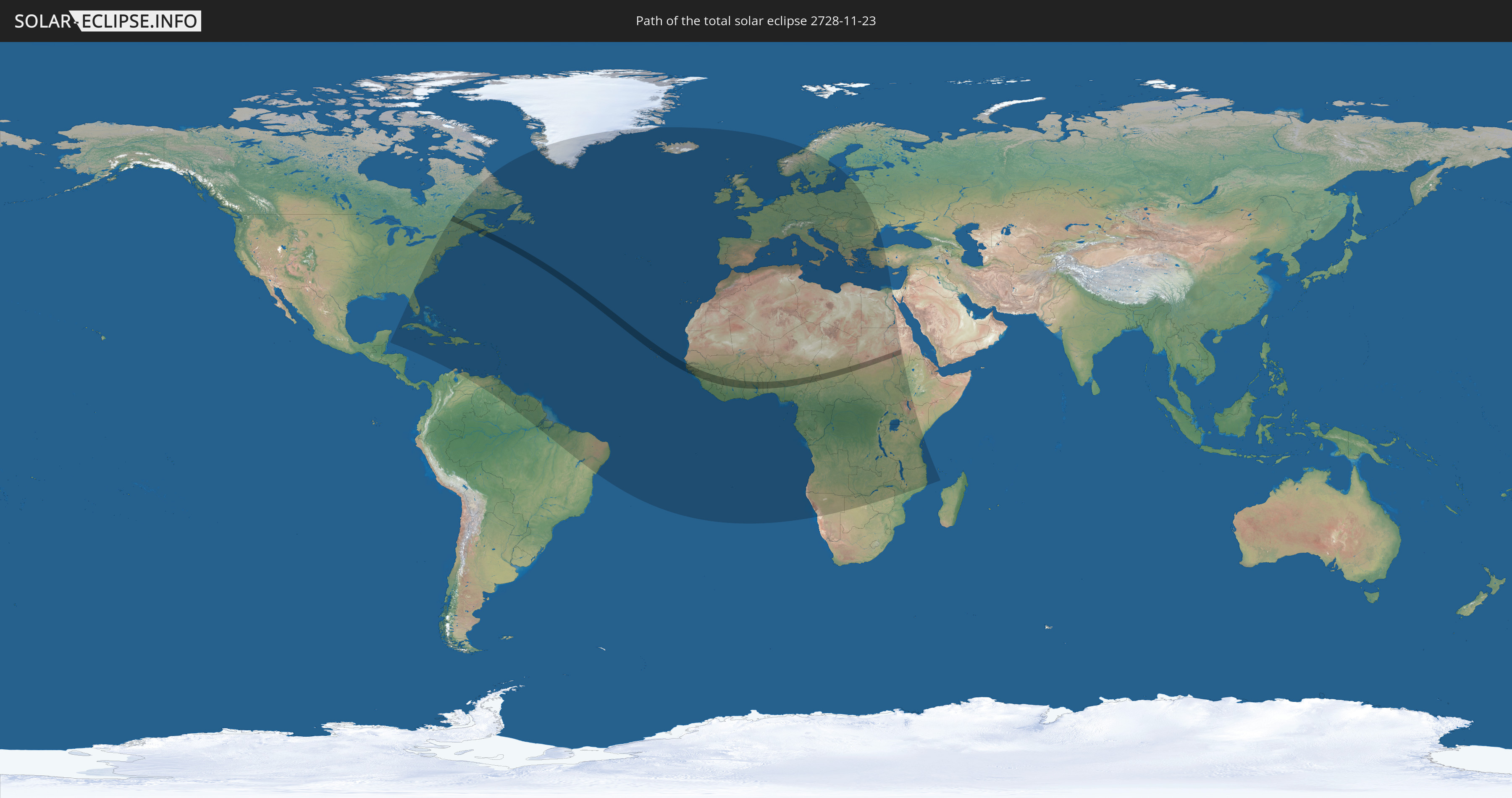
Die Sonnenfinsternis am 11/23/2728 kann man in 132 Ländern als partielle Sonnenfinsternis beobachten.
Der Finsternispfad verläuft durch 16 Länder. Nur in diesen Ländern ist sie als total Sonnenfinsternis zu sehen.
In den folgenden Ländern ist die Sonnenfinsternis total zu sehen
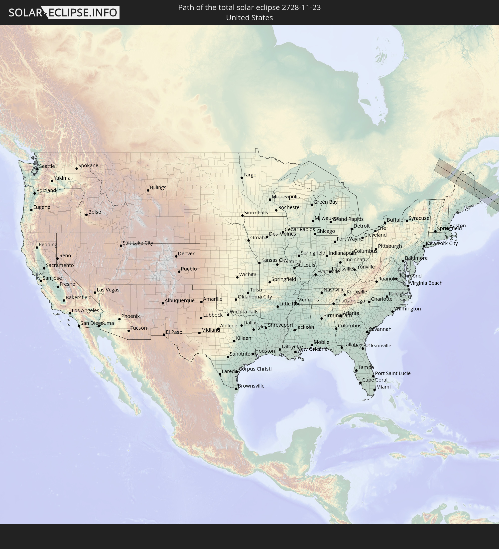 United States
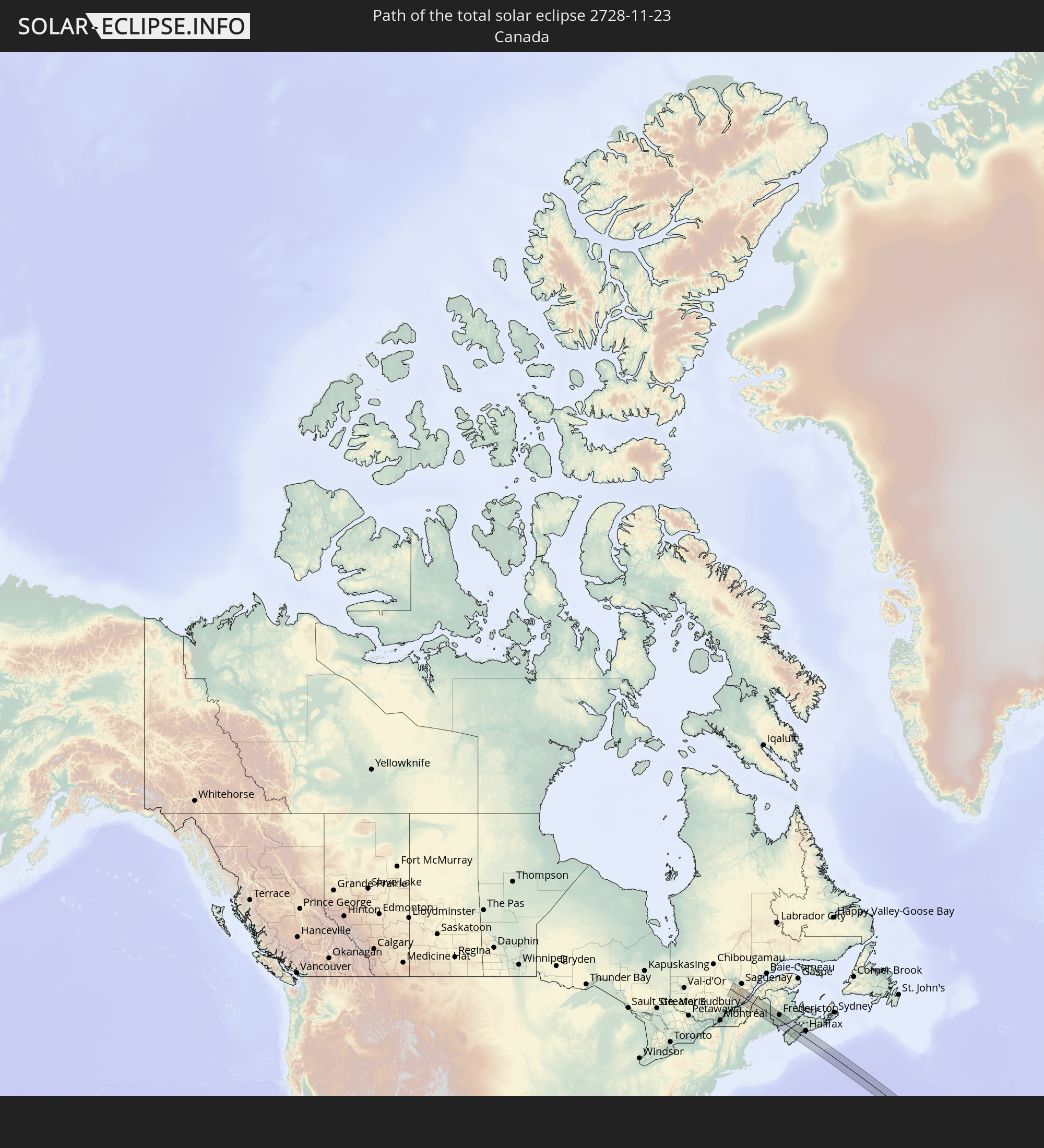 Canada
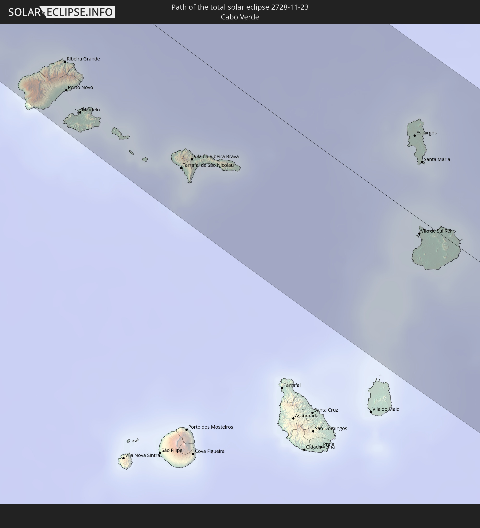 Cabo Verde
 Senegal
 The Gambia
 Guinea-Bissau
 Guinea
 Sierra Leone
 Ivory Coast
 Ghana
Ghana
 Togo
Togo
 Benin
Benin
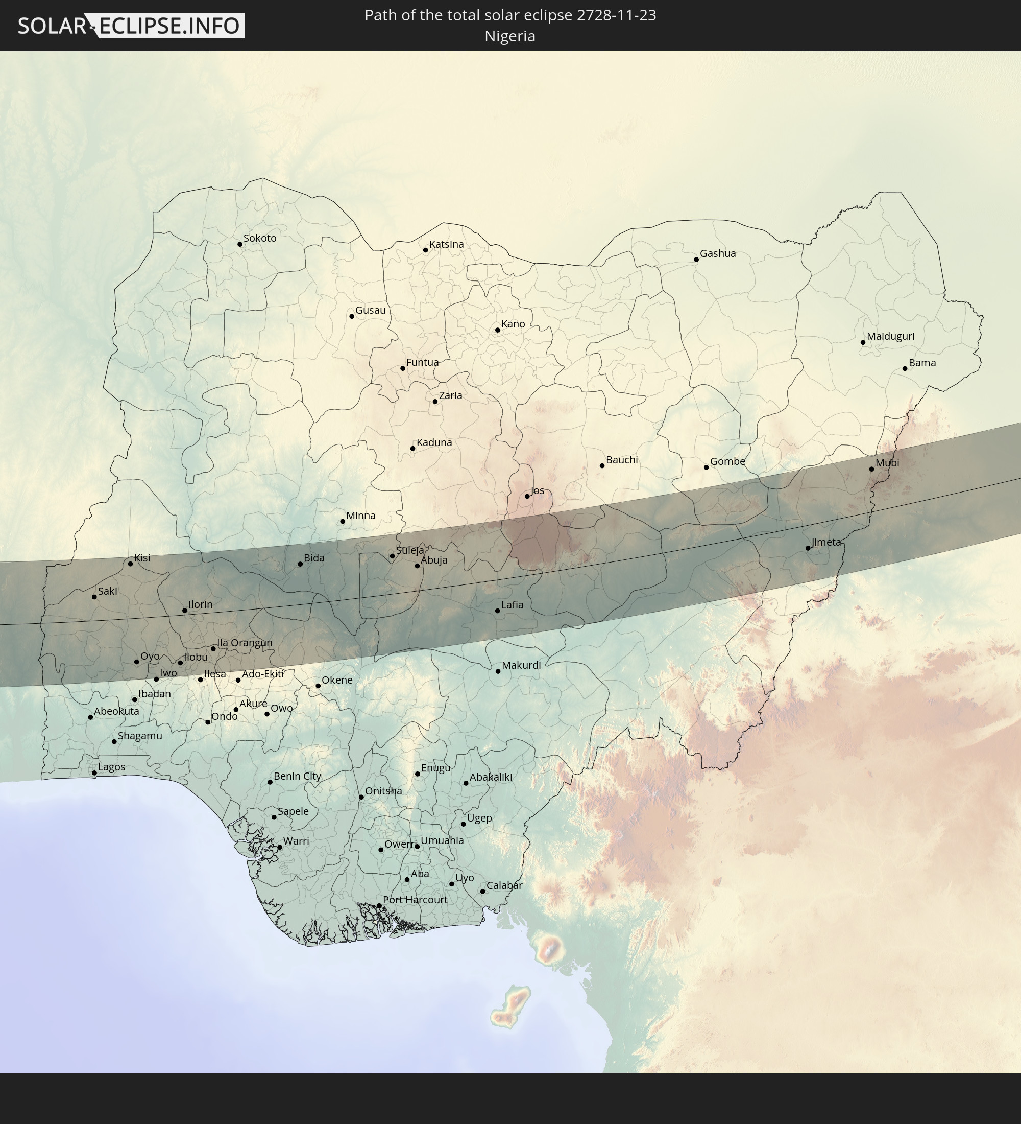 Nigeria
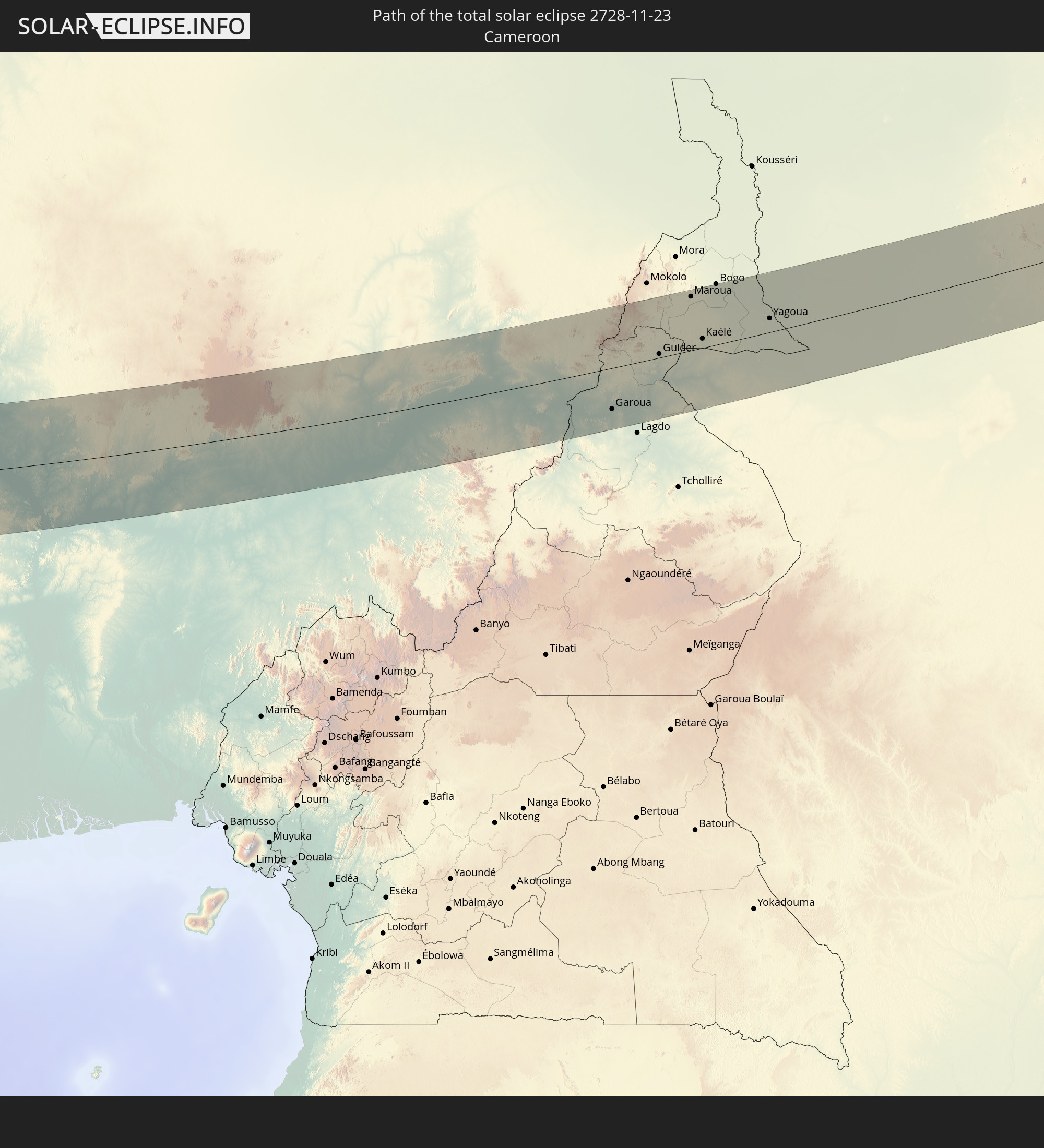 Cameroon
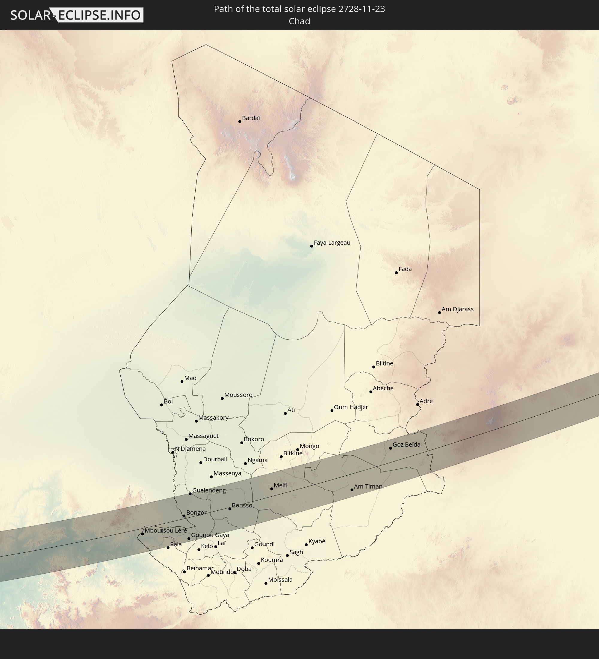 Chad
Chad
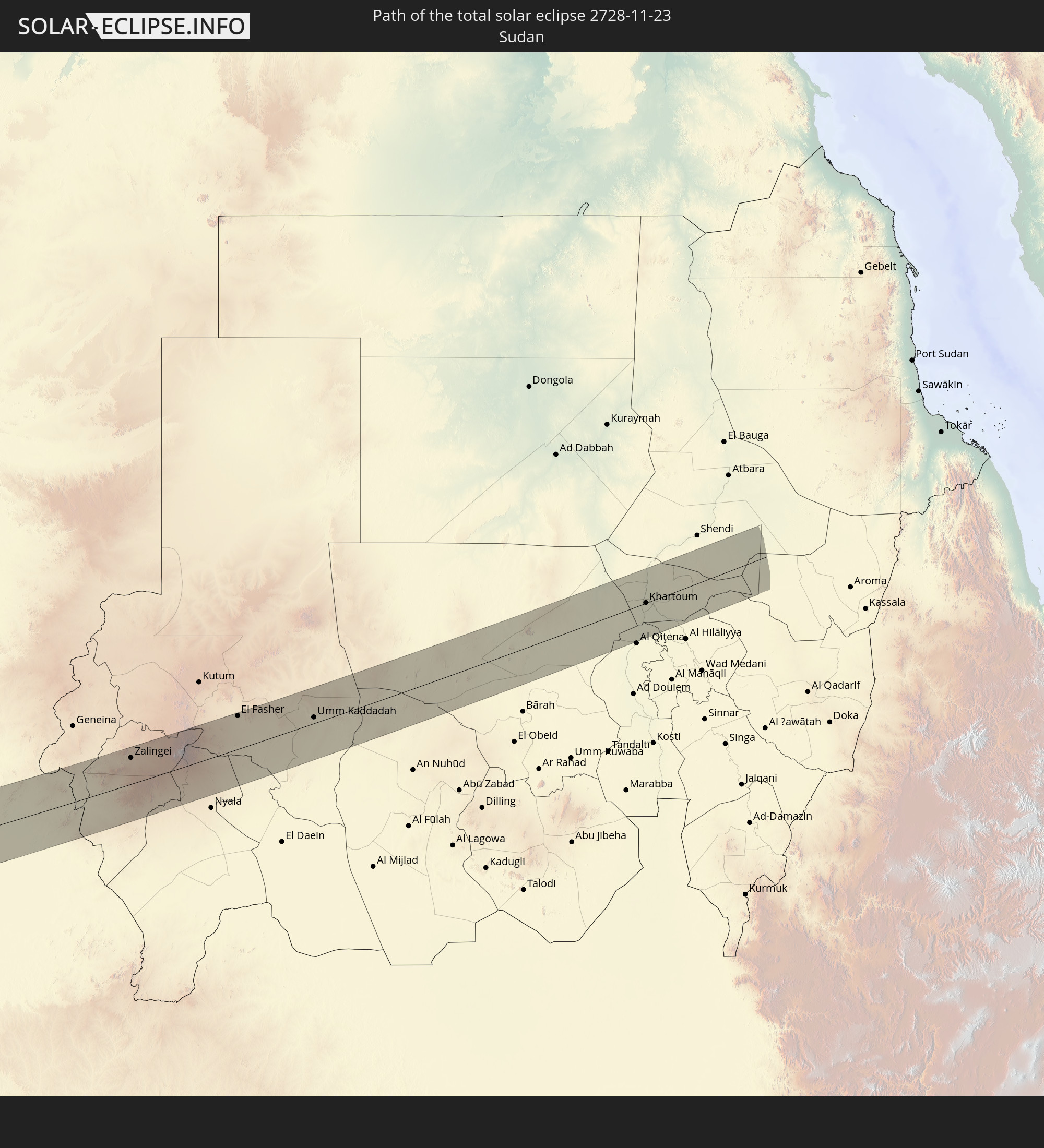 Sudan
Sudan
In den folgenden Ländern ist die Sonnenfinsternis partiell zu sehen
 Russia
 United States
 United States Minor Outlying Islands
 Canada
 Greenland
 Honduras
 Cuba
Cuba
 Colombia
 Cayman Islands
 The Bahamas
 Jamaica
 Haiti
Haiti
 Brazil
 Venezuela
 Turks and Caicos Islands
 Dominican Republic
 Aruba
Aruba
 Puerto Rico
 United States Virgin Islands
 Bermuda
 British Virgin Islands
 Anguilla
 Collectivity of Saint Martin
 Saint Barthélemy
 Saint Kitts and Nevis
 Antigua and Barbuda
 Montserrat
 Trinidad and Tobago
 Guadeloupe
 Grenada
 Dominica
 Saint Vincent and the Grenadines
 Guyana
 Martinique
 Saint Lucia
 Barbados
 Suriname
 Saint Pierre and Miquelon
 French Guiana
 Portugal
 Cabo Verde
 Iceland
 Spain
Spain
 Senegal
 Mauritania
 The Gambia
 Guinea-Bissau
 Guinea
 Saint Helena, Ascension and Tristan da Cunha
 Sierra Leone
 Morocco
 Mali
Mali
 Liberia
 Republic of Ireland
 Algeria
 United Kingdom
 Ivory Coast
 Faroe Islands
 Burkina Faso
 Gibraltar
 France
 Isle of Man
 Ghana
Ghana
 Guernsey
 Jersey
 Togo
Togo
 Niger
Niger
 Benin
Benin
 Andorra
 Belgium
 Nigeria
 Netherlands
 Norway
 Equatorial Guinea
 Luxembourg
 Germany
 Switzerland
 São Tomé and Príncipe
 Italy
Italy
 Monaco
 Tunisia
 Denmark
 Cameroon
 Gabon
Gabon
 Libya
Libya
 Liechtenstein
 Austria
 Sweden
 Republic of the Congo
 Angola
 Namibia
 Czechia
 Democratic Republic of the Congo
 San Marino
 Vatican City
 Slovenia
 Chad
Chad
 Croatia
 Poland
 Malta
Malta
 Central African Republic
 Bosnia and Herzegovina
 Hungary
 Slovakia
 Montenegro
 Serbia
 Albania
 Åland Islands
 Greece
 Botswana
 Romania
 Republic of Macedonia
 Lithuania
 Latvia
 Estonia
 Sudan
Sudan
 Zambia
 Ukraine
 Bulgaria
 Belarus
 Egypt
Egypt
 Zimbabwe
 Turkey
 Moldova
 Rwanda
 Burundi
 Tanzania
 Uganda
 Mozambique
 Malawi
 Ethiopia
 Kenya
Kenya
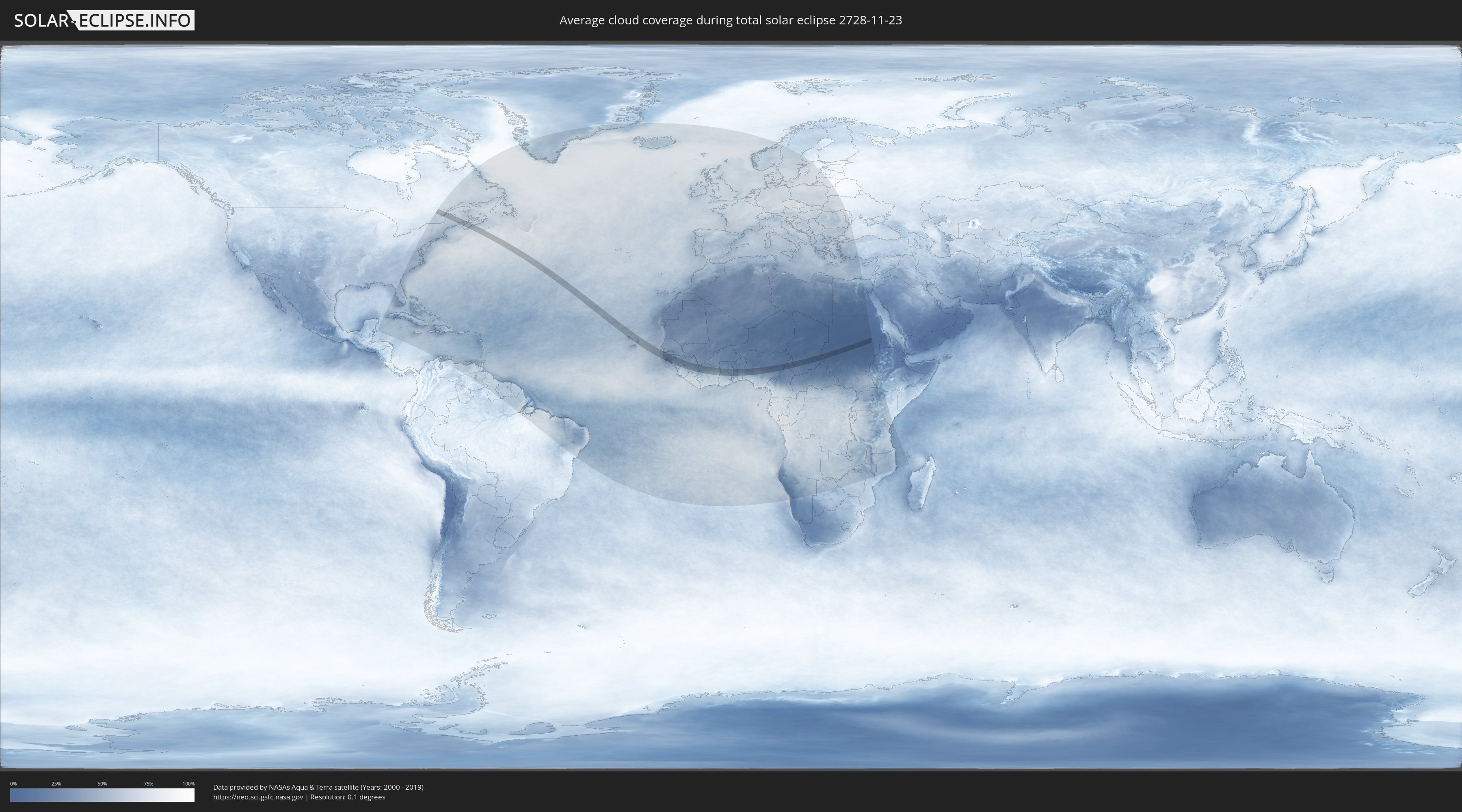
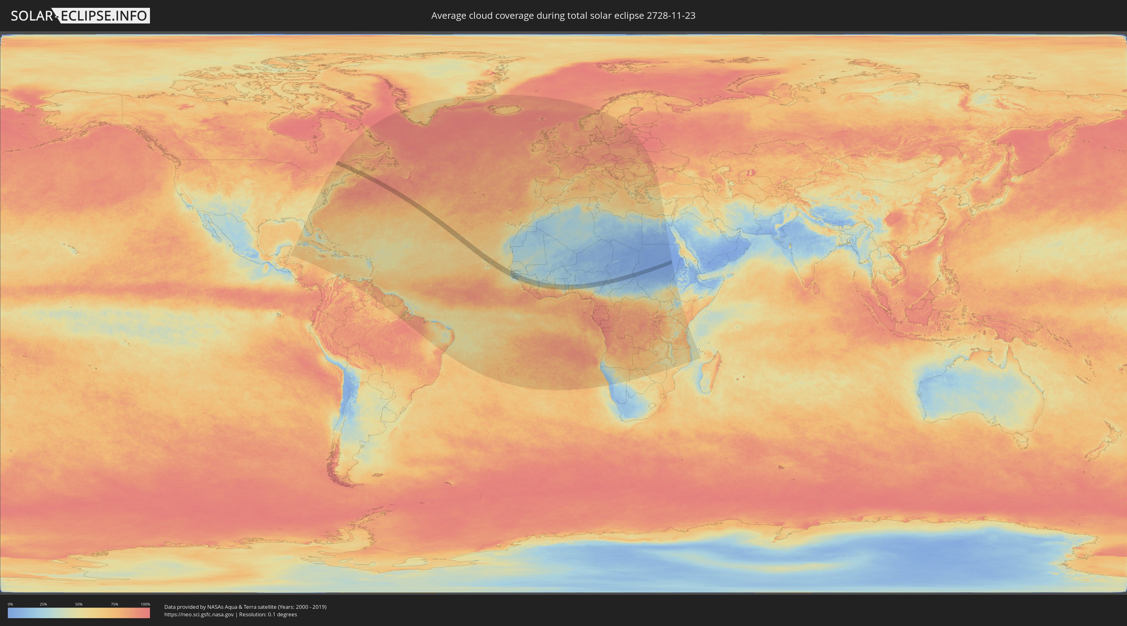
How will be the weather during the total solar eclipse on 11/23/2728?
Where is the best place to see the total solar eclipse of 11/23/2728?
The following maps show the average cloud coverage for the day of the total solar eclipse.
With the help of these maps, it is possible to find the place along the eclipse path, which has the best
chance of a cloudless sky.
Nevertheless, you should consider local circumstances and inform about the weather of your chosen
observation site.
The data is provided by NASAs satellites
AQUA and TERRA.
The cloud maps are averaged over a period of 19 years (2000 - 2019).
Detailed country maps
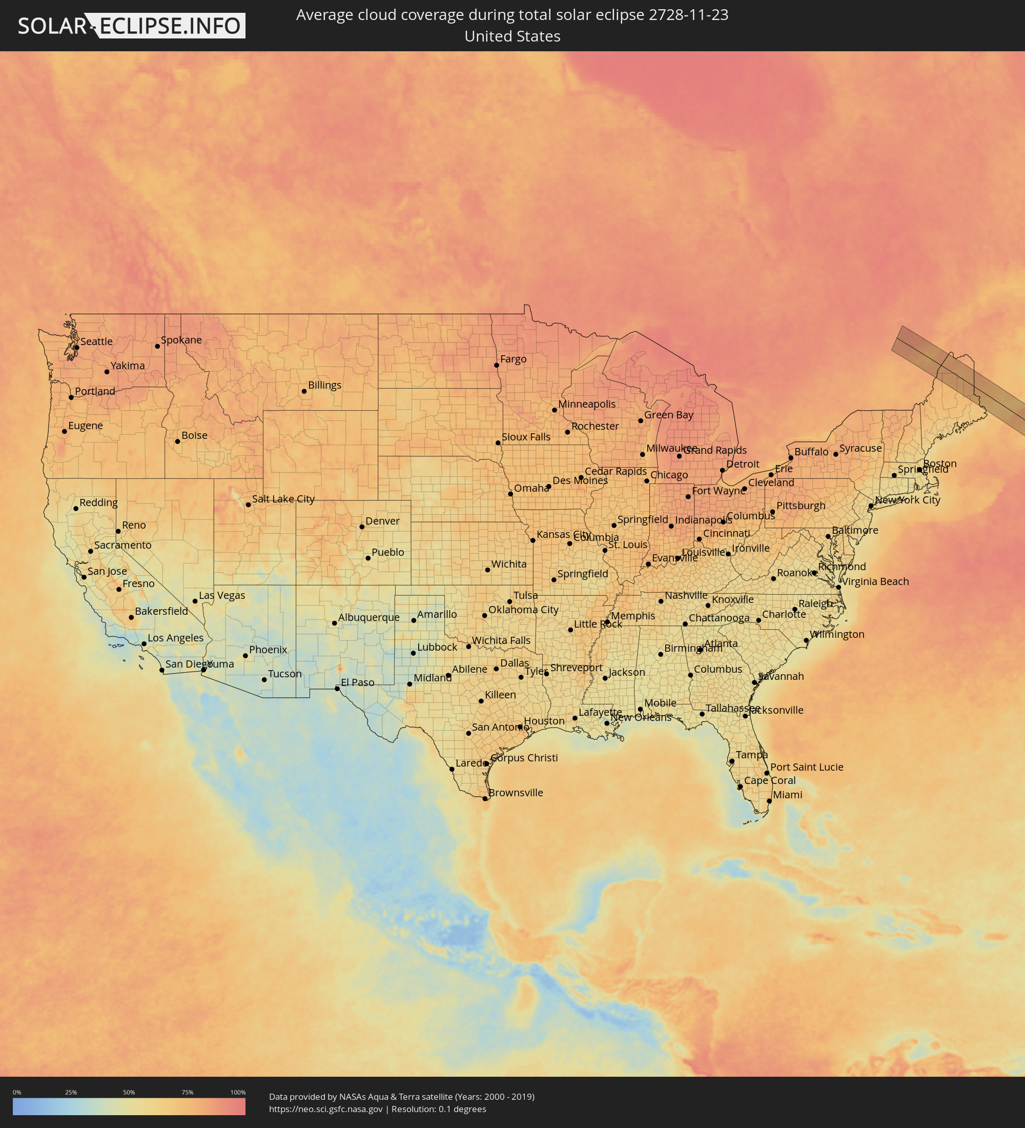 United States
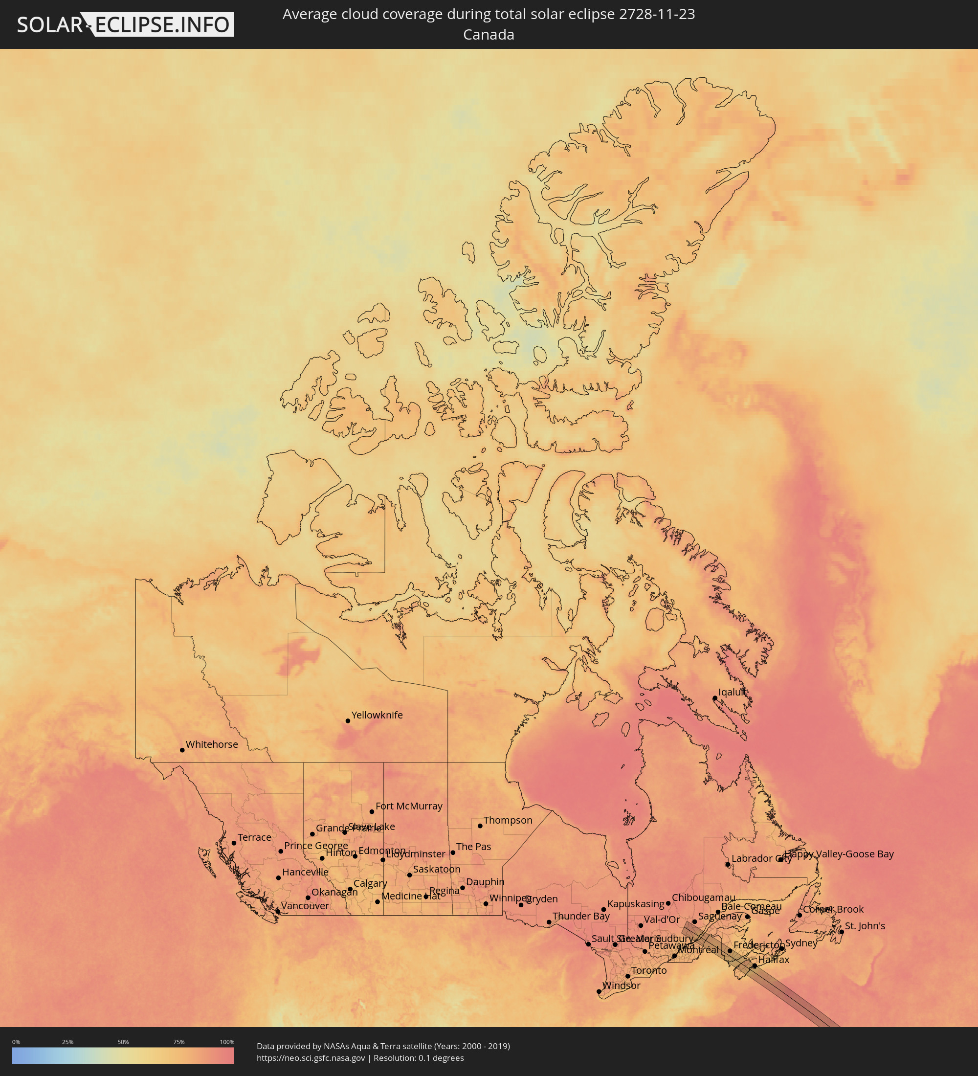 Canada
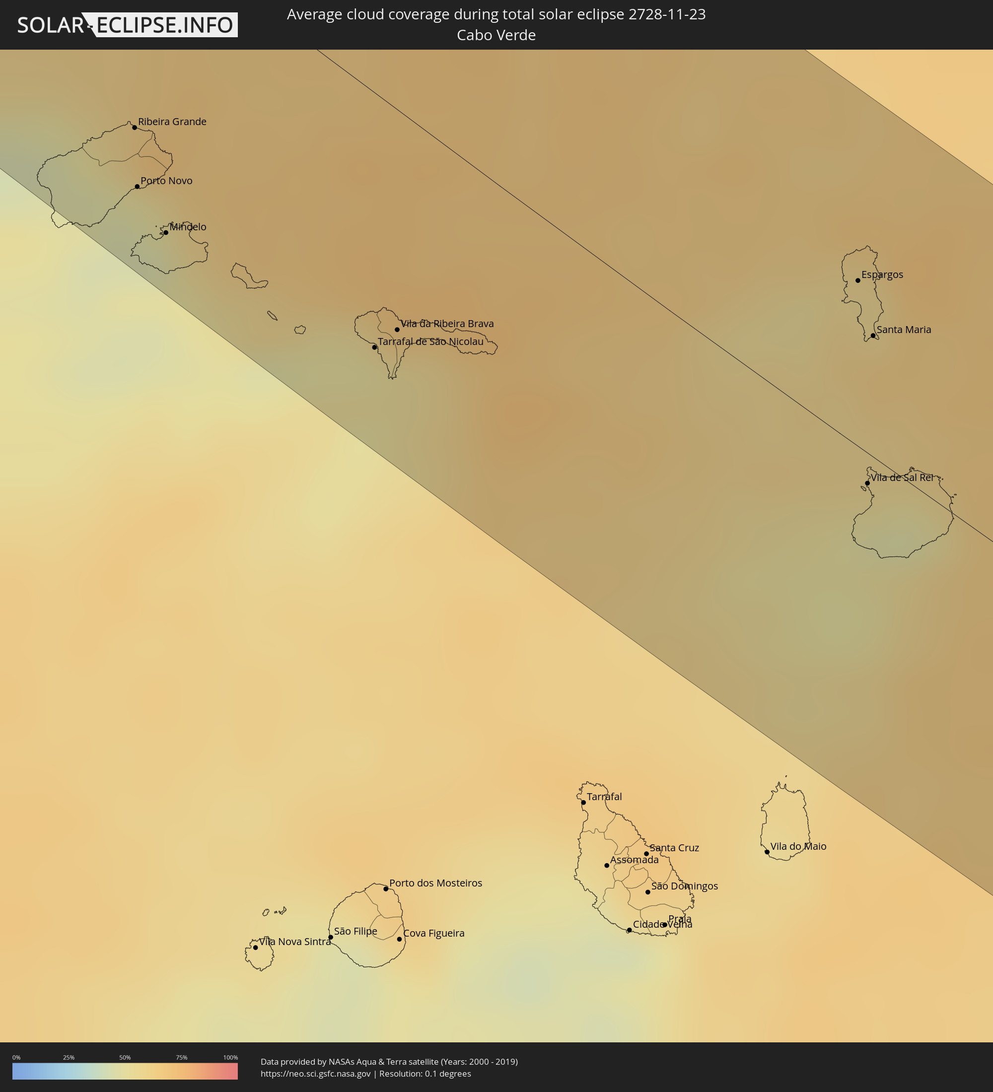 Cabo Verde
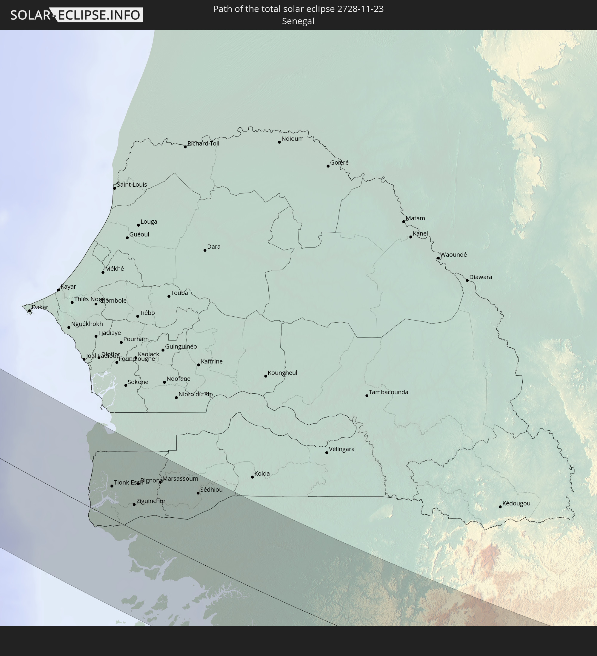
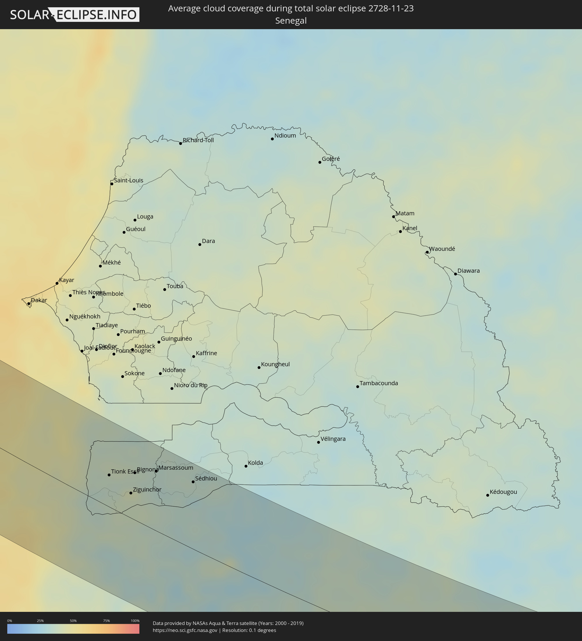 Senegal
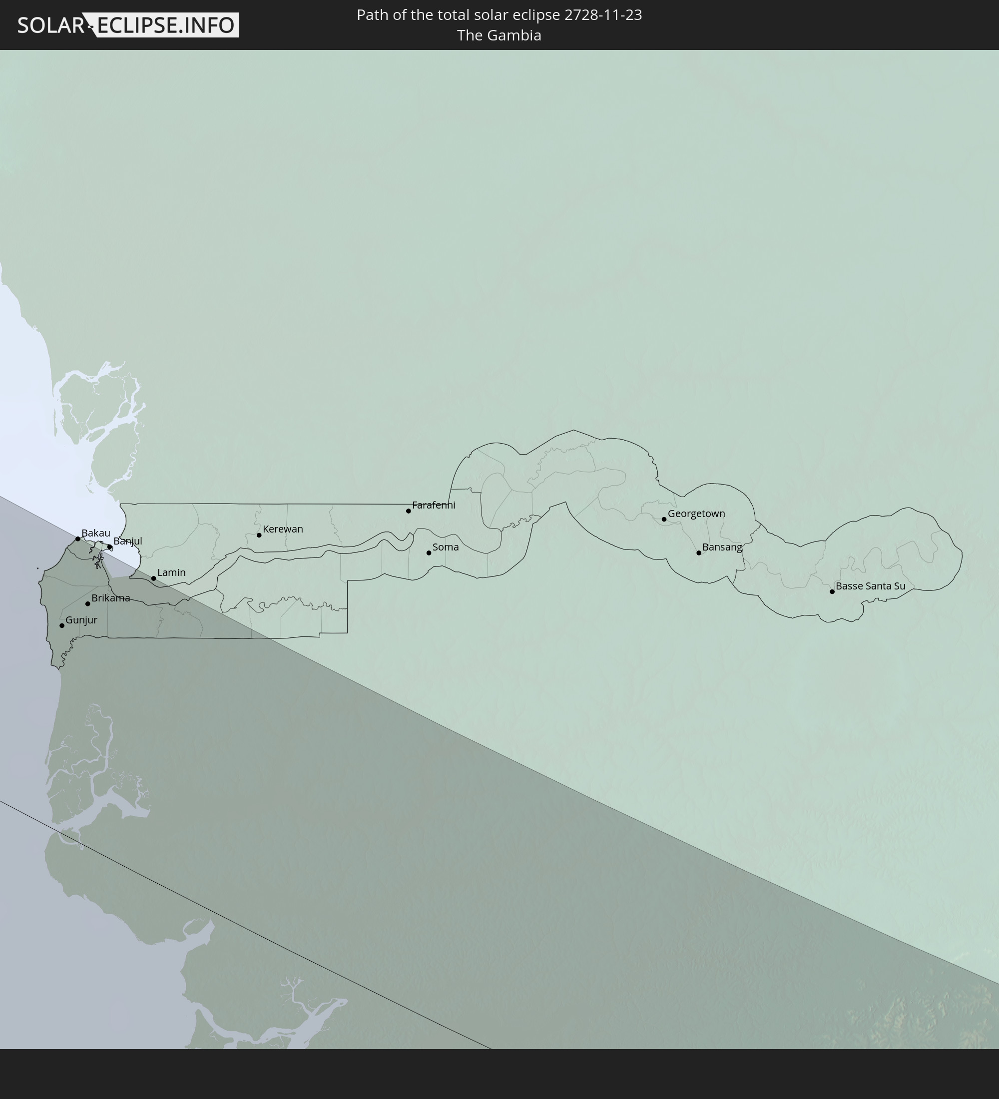
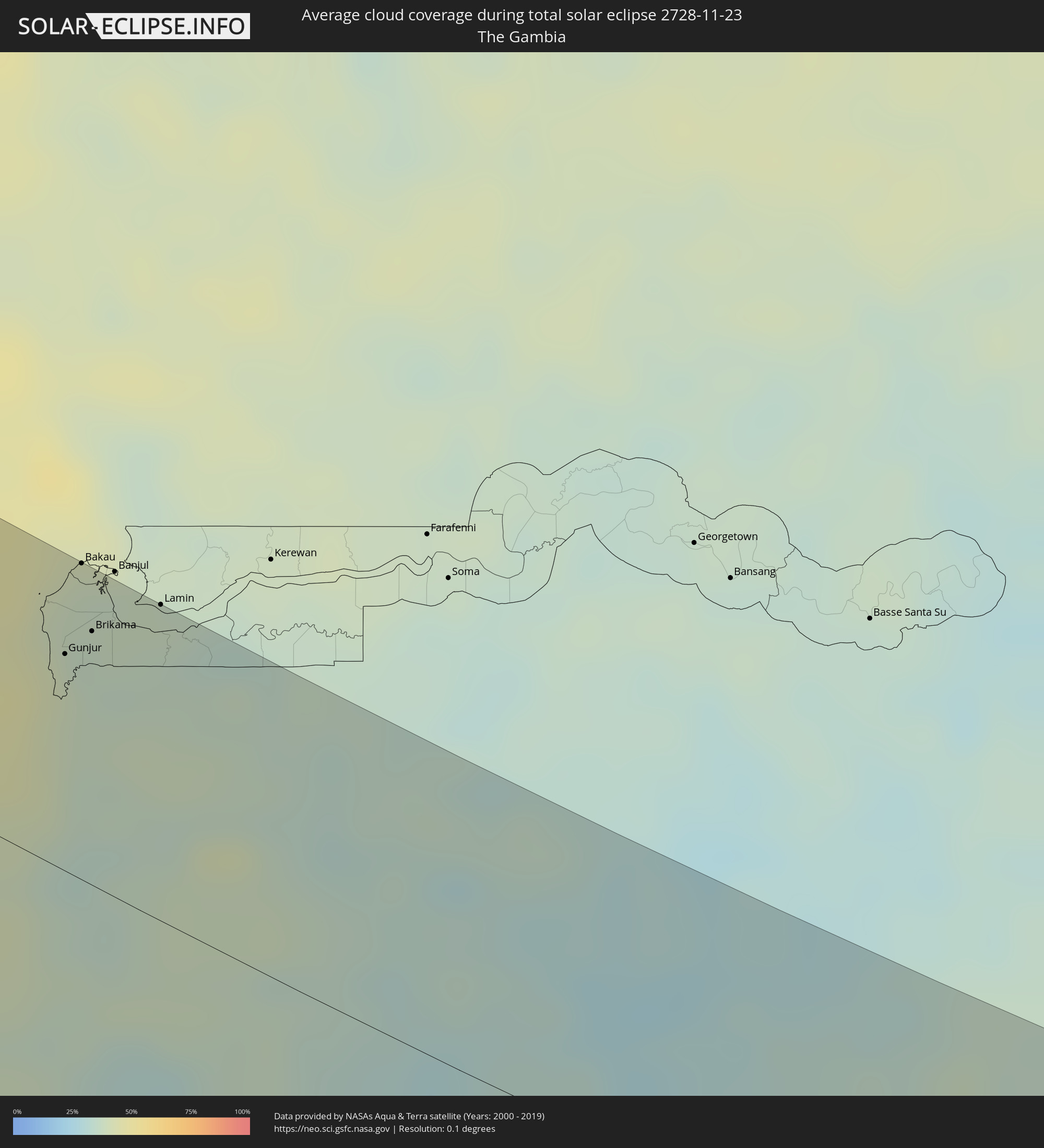 The Gambia
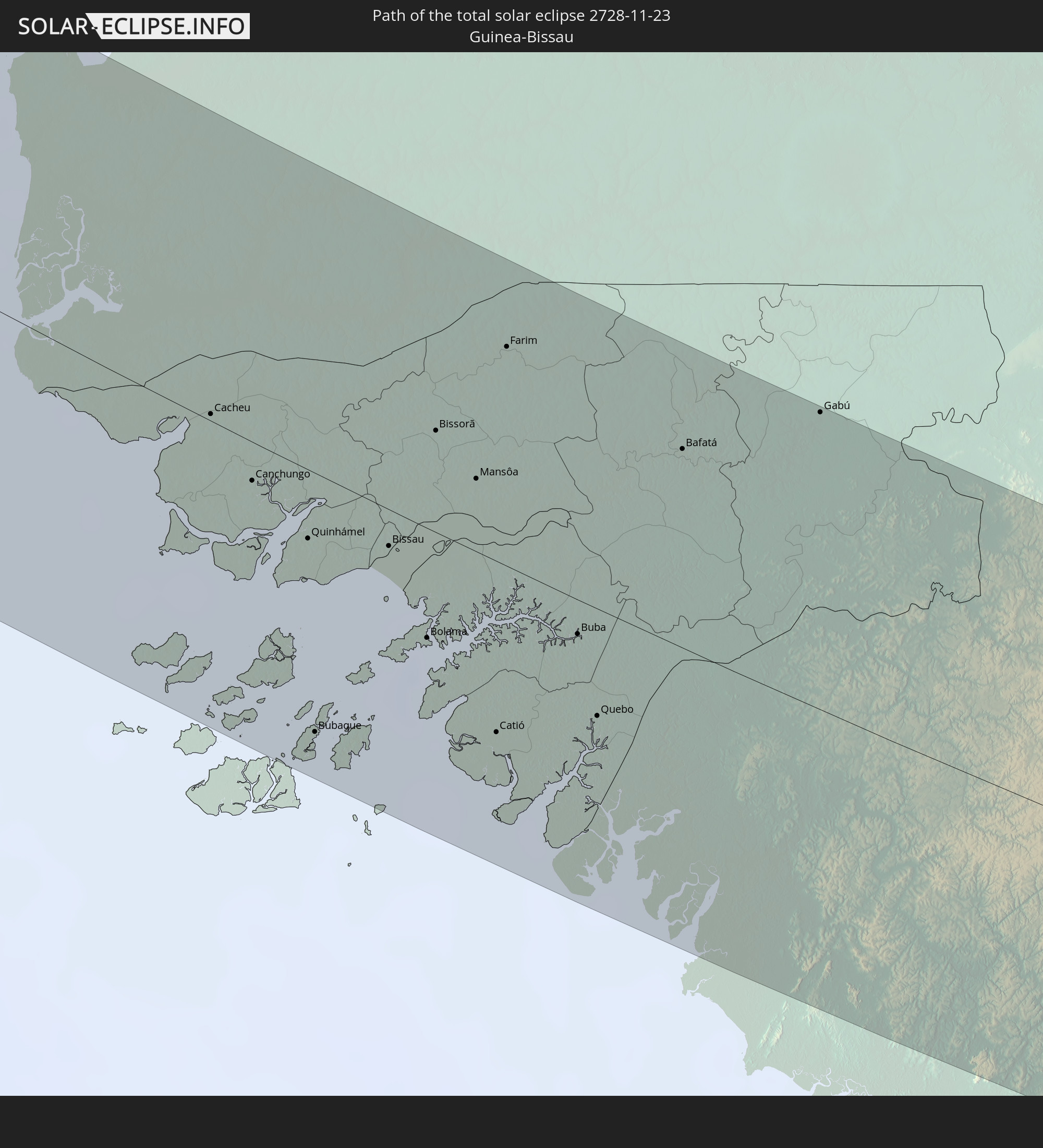
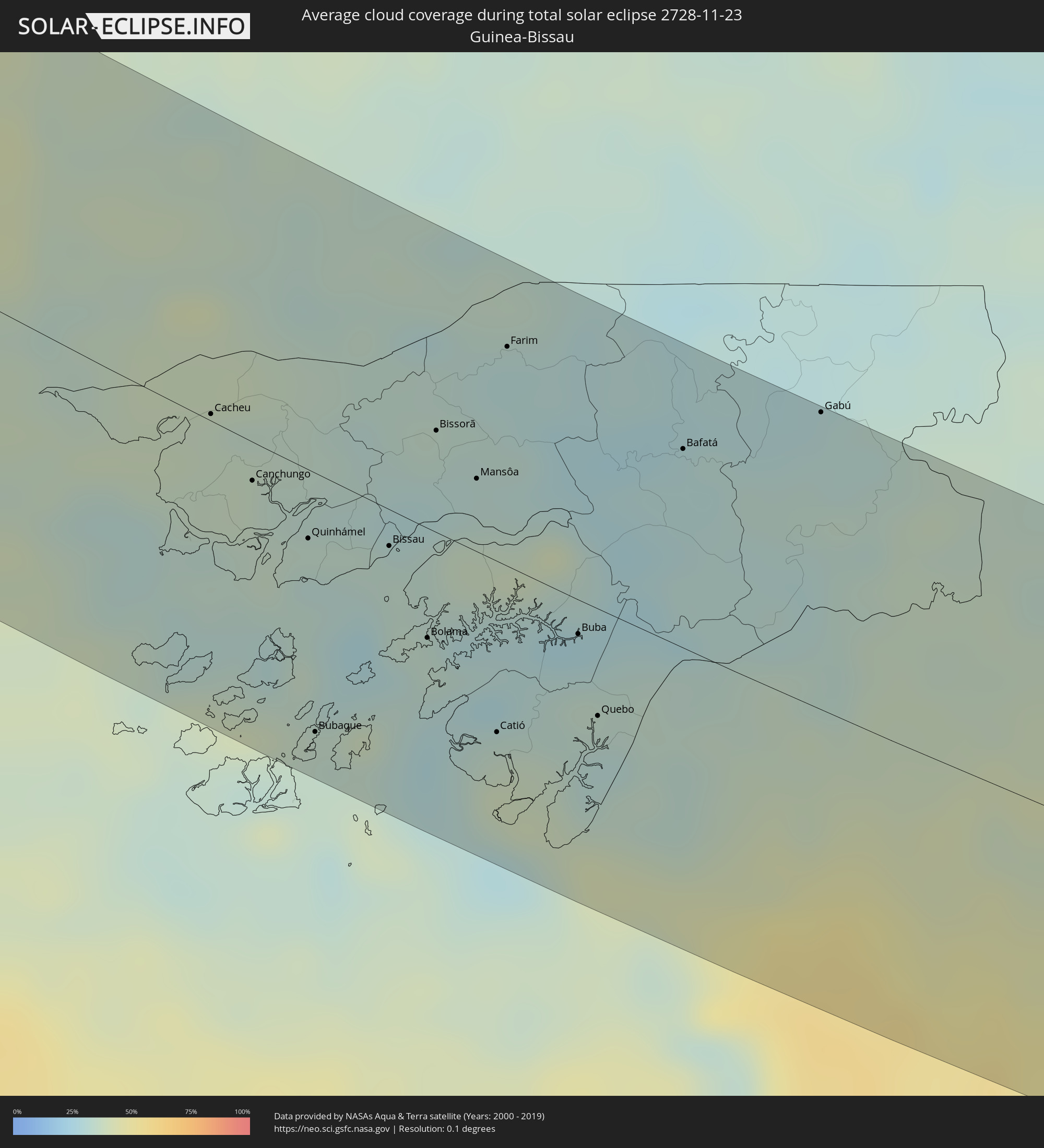 Guinea-Bissau
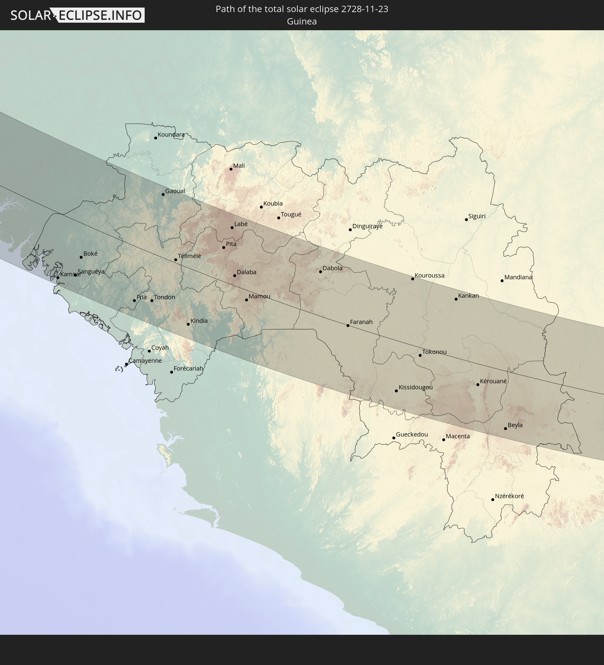
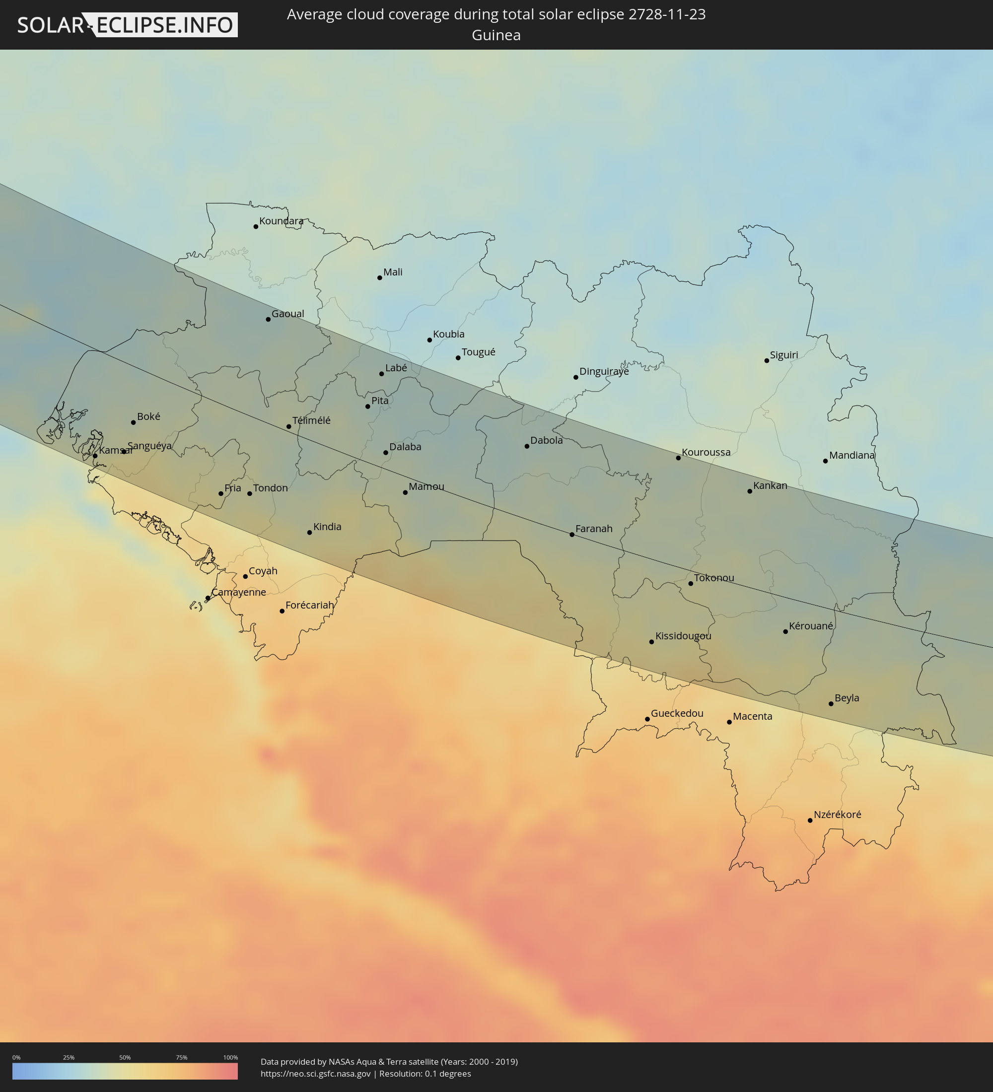 Guinea
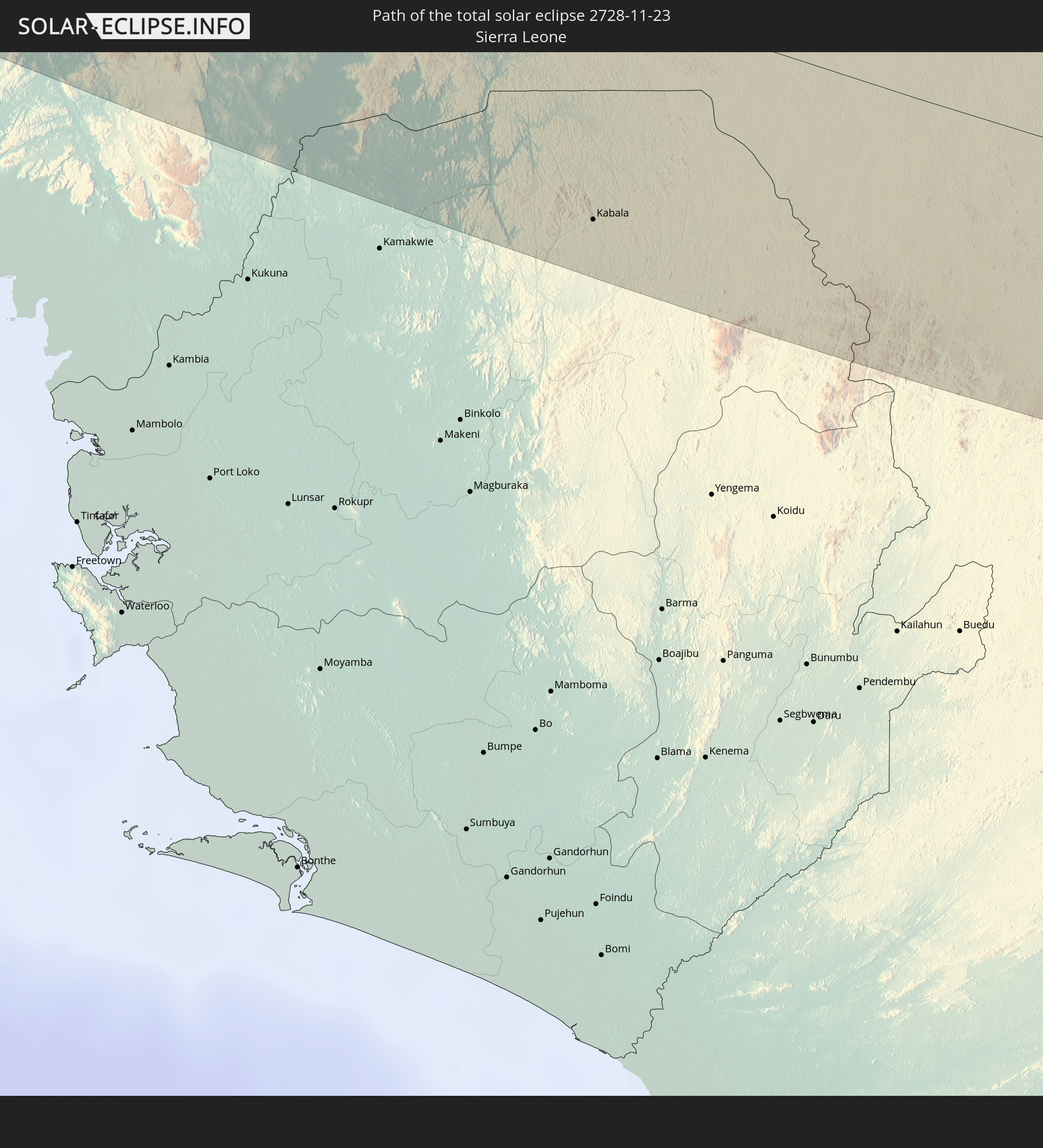
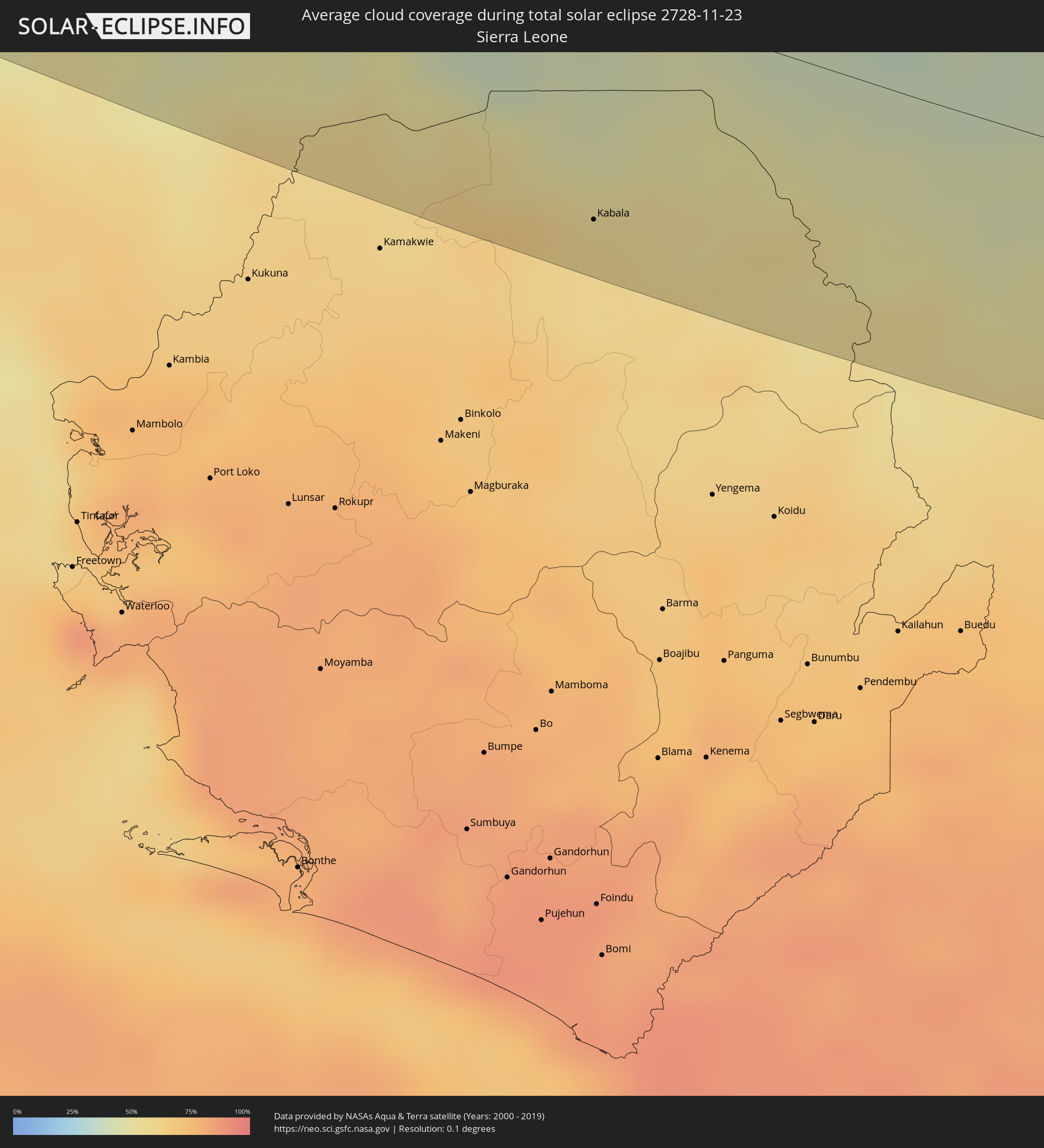 Sierra Leone
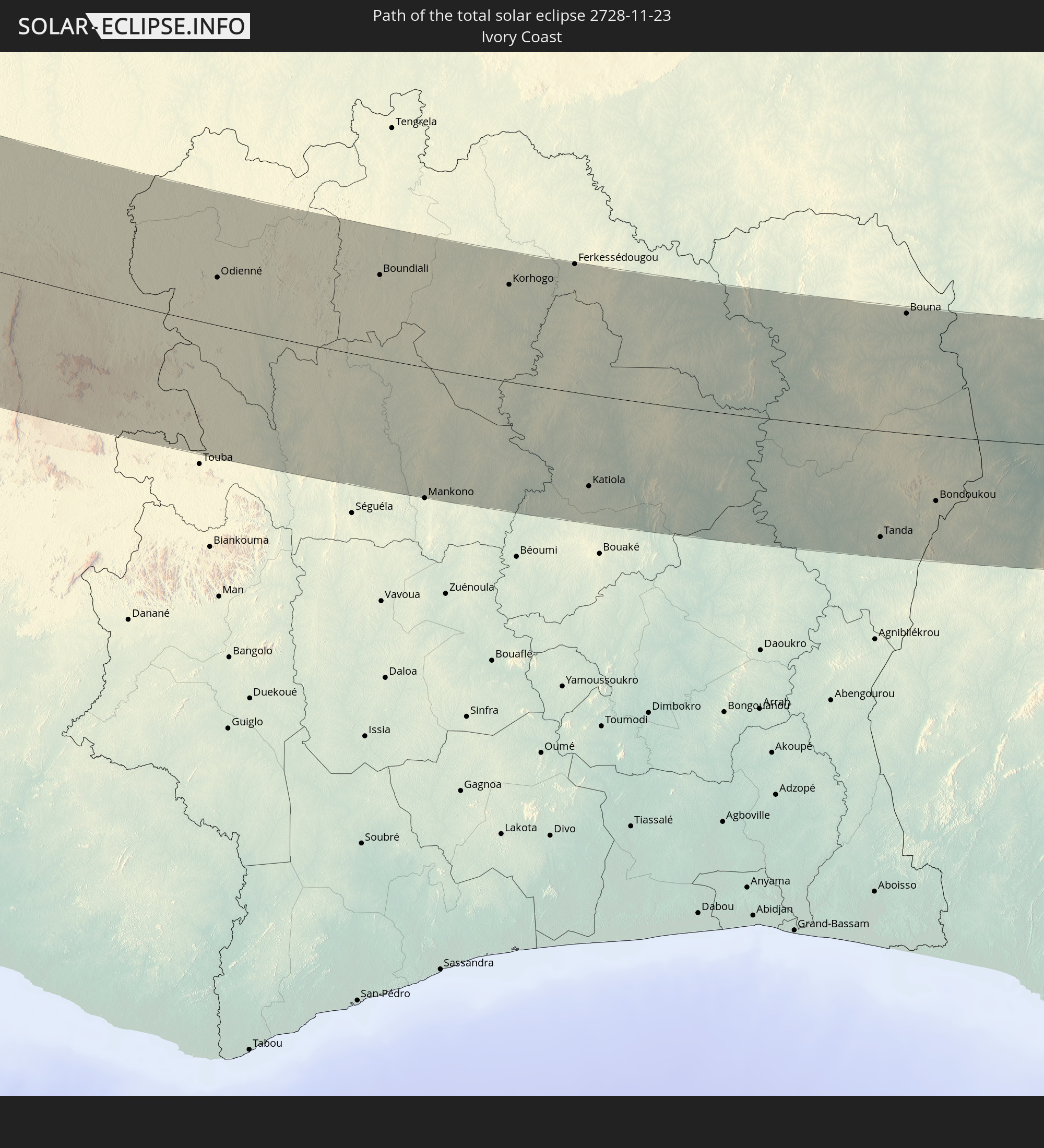
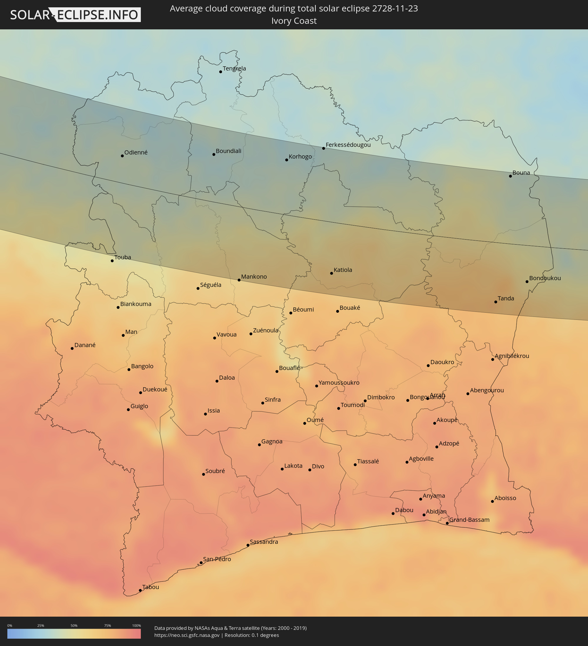 Ivory Coast
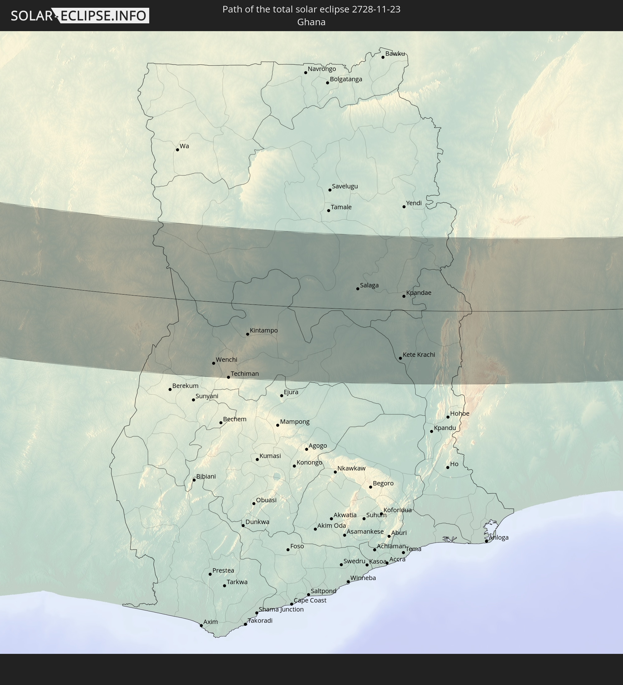
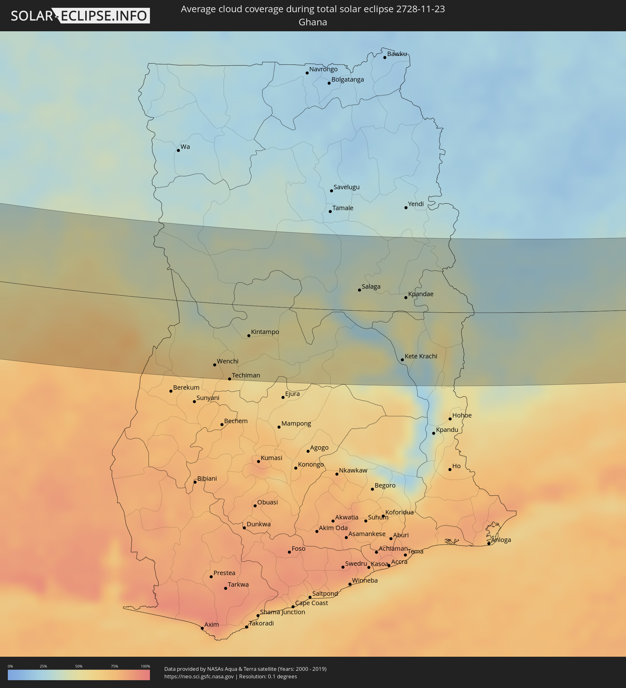 Ghana
Ghana
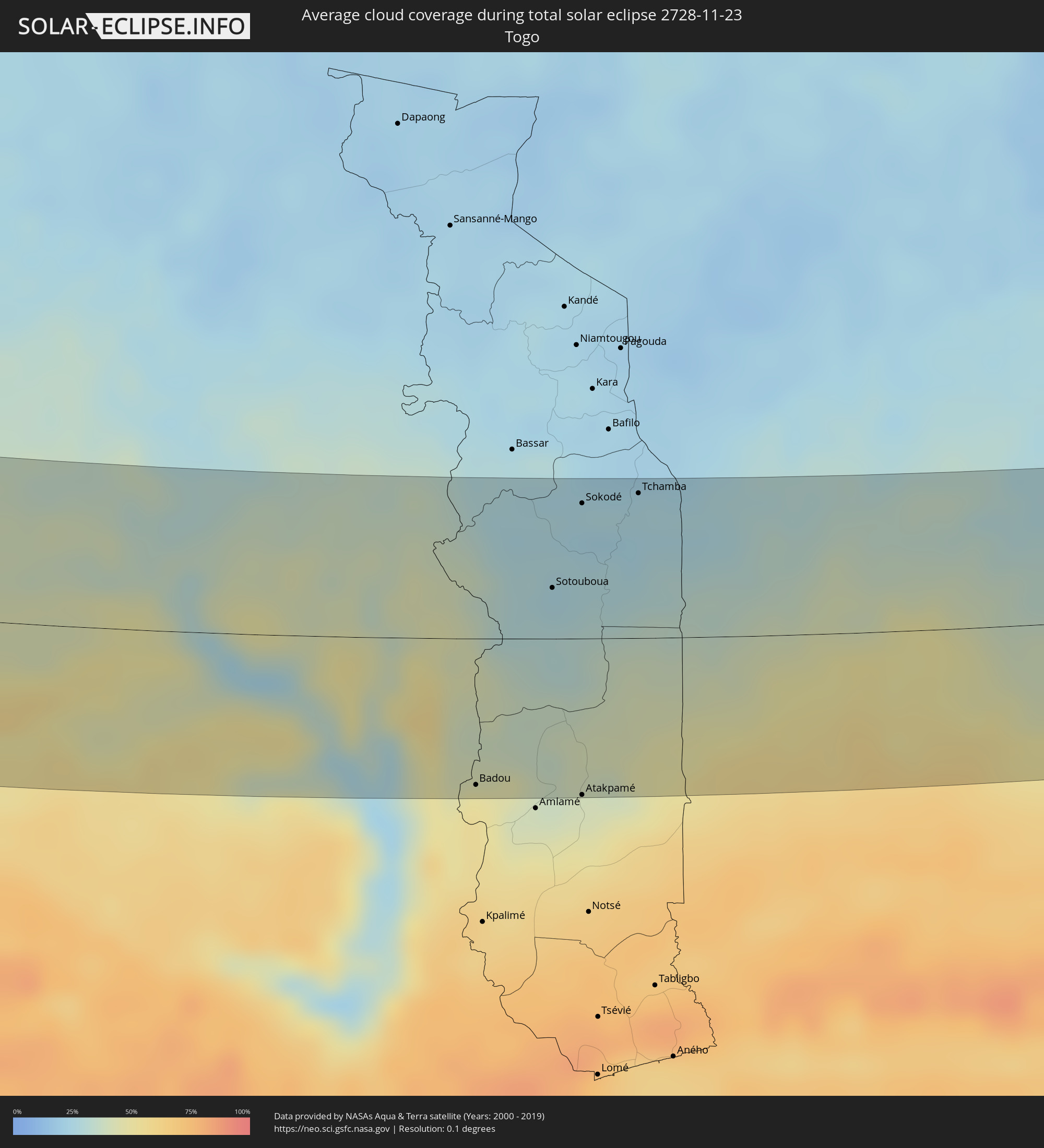 Togo
Togo
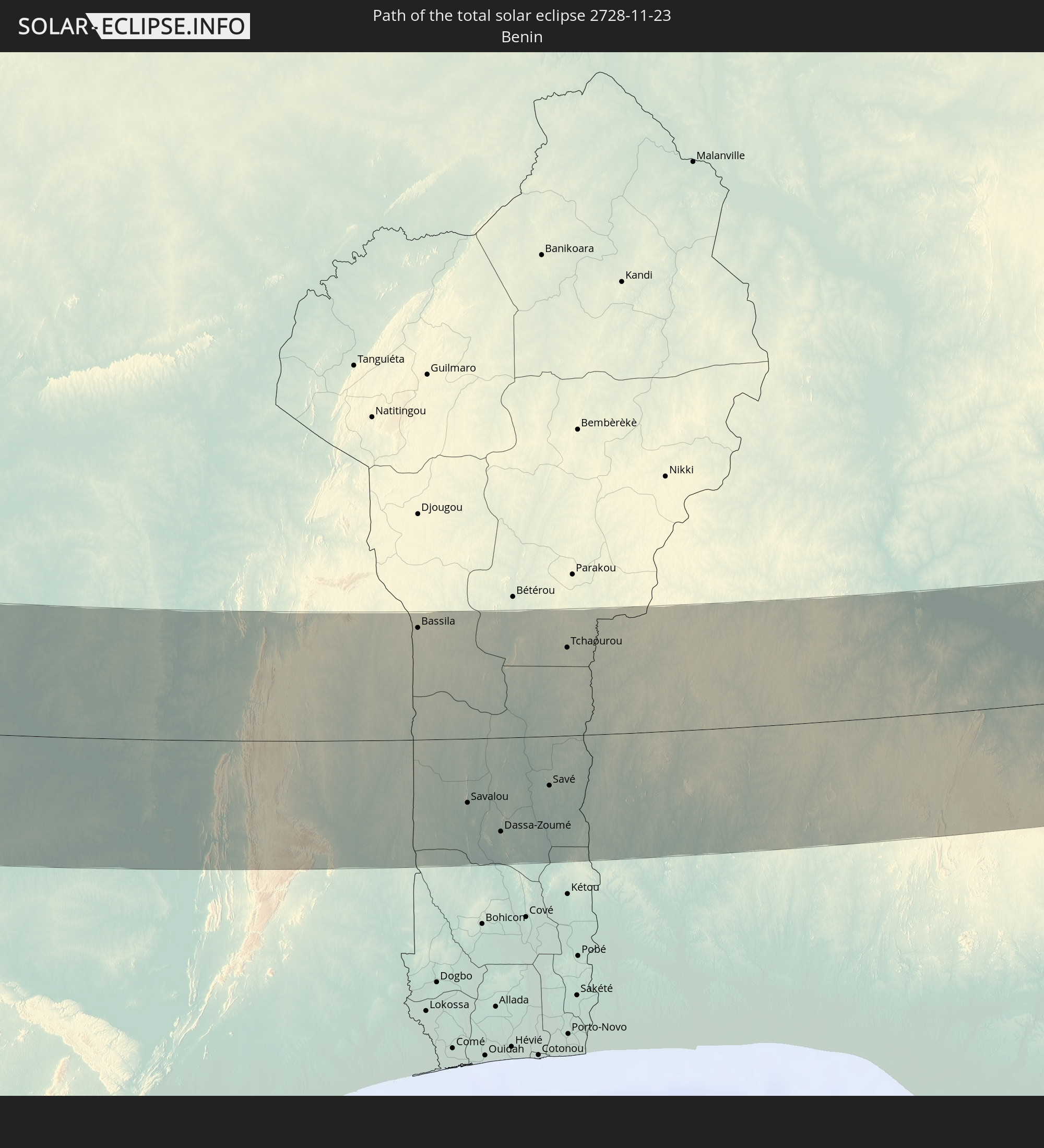
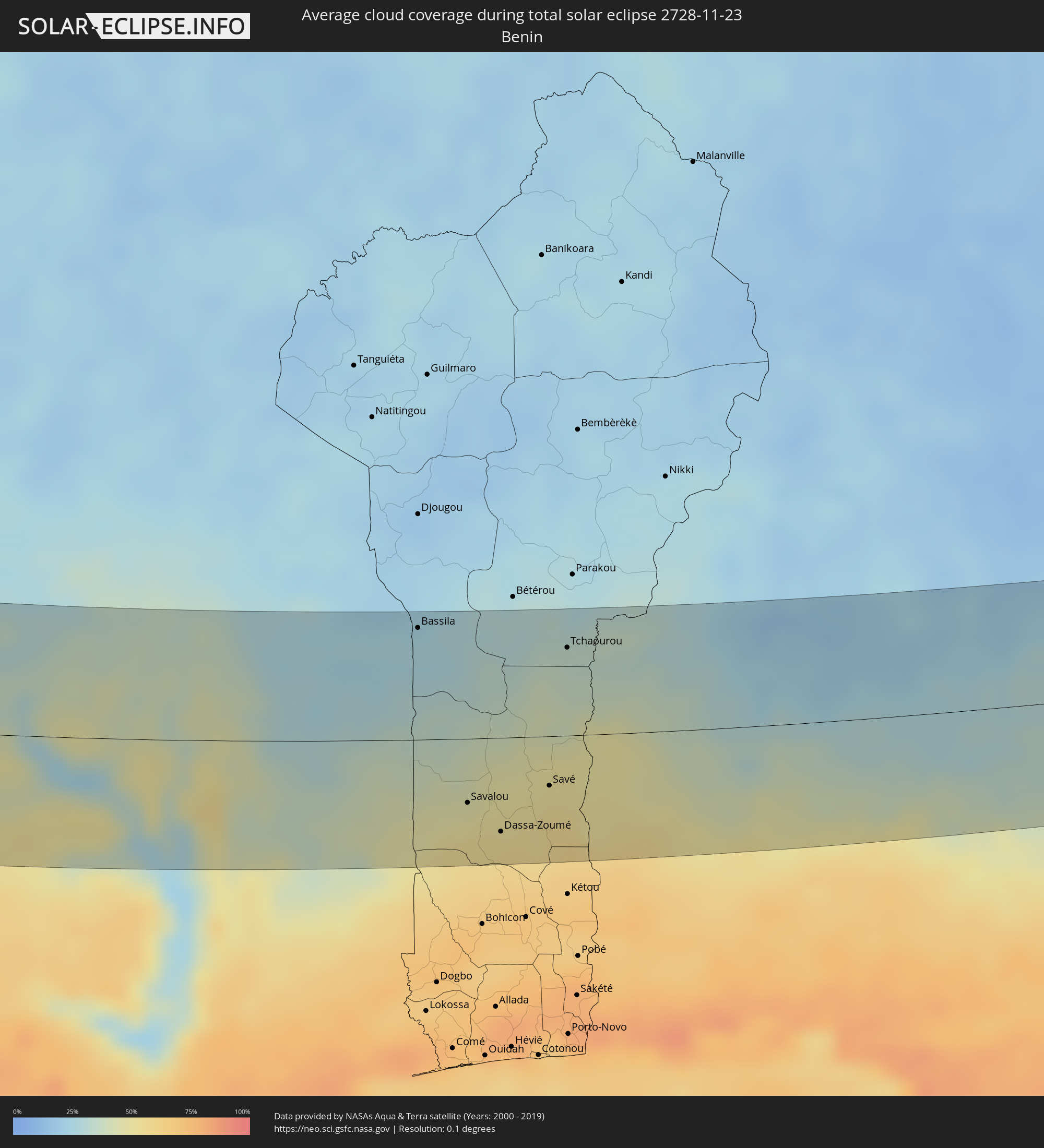 Benin
Benin
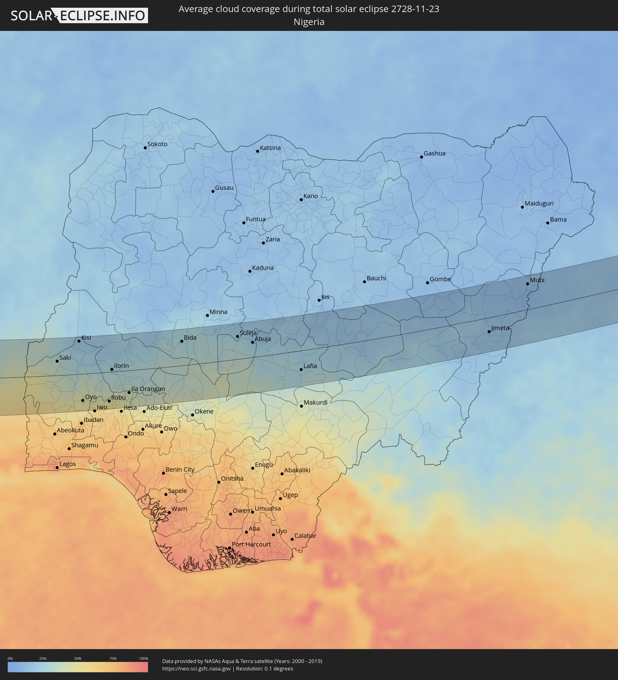 Nigeria
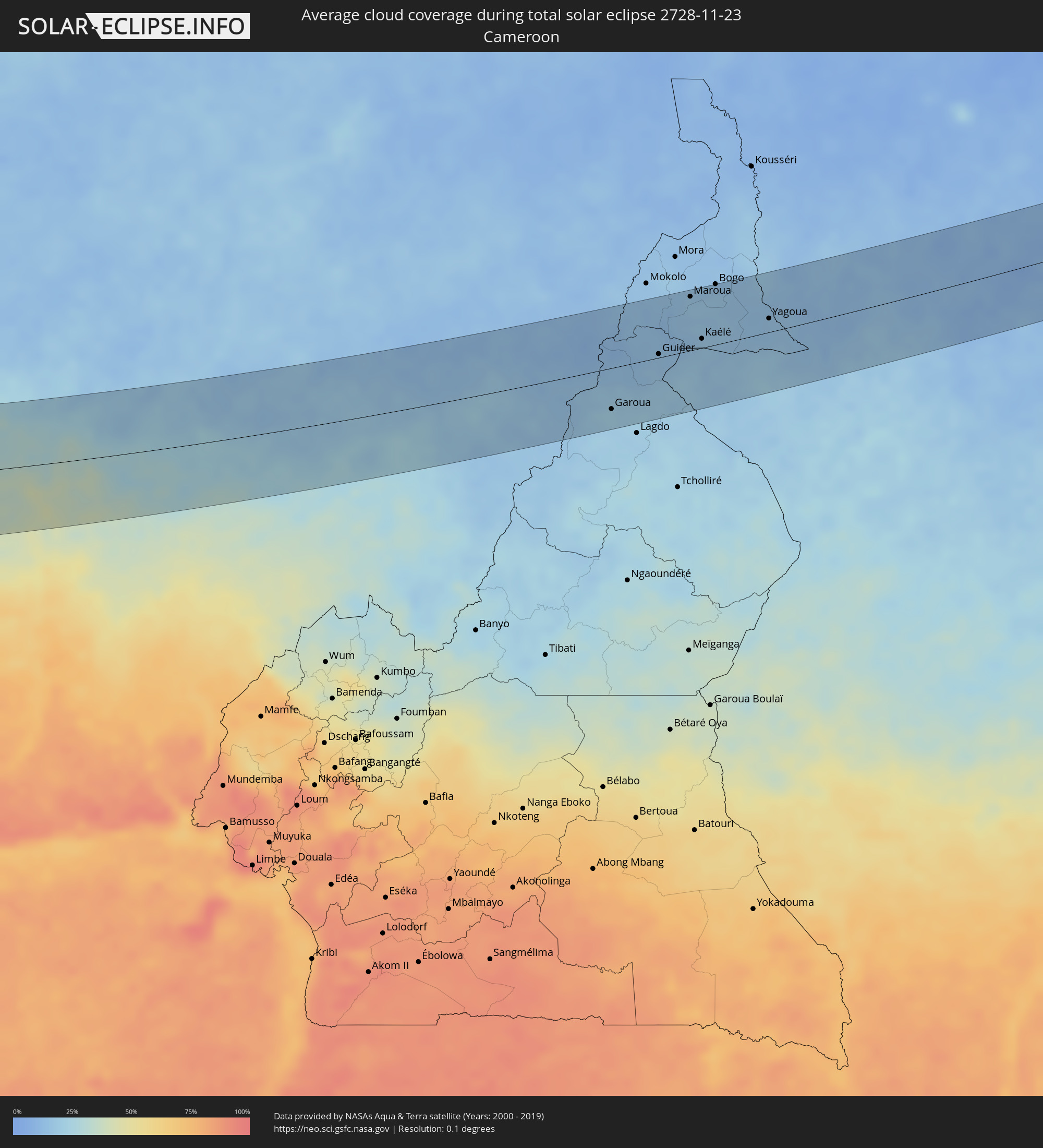 Cameroon
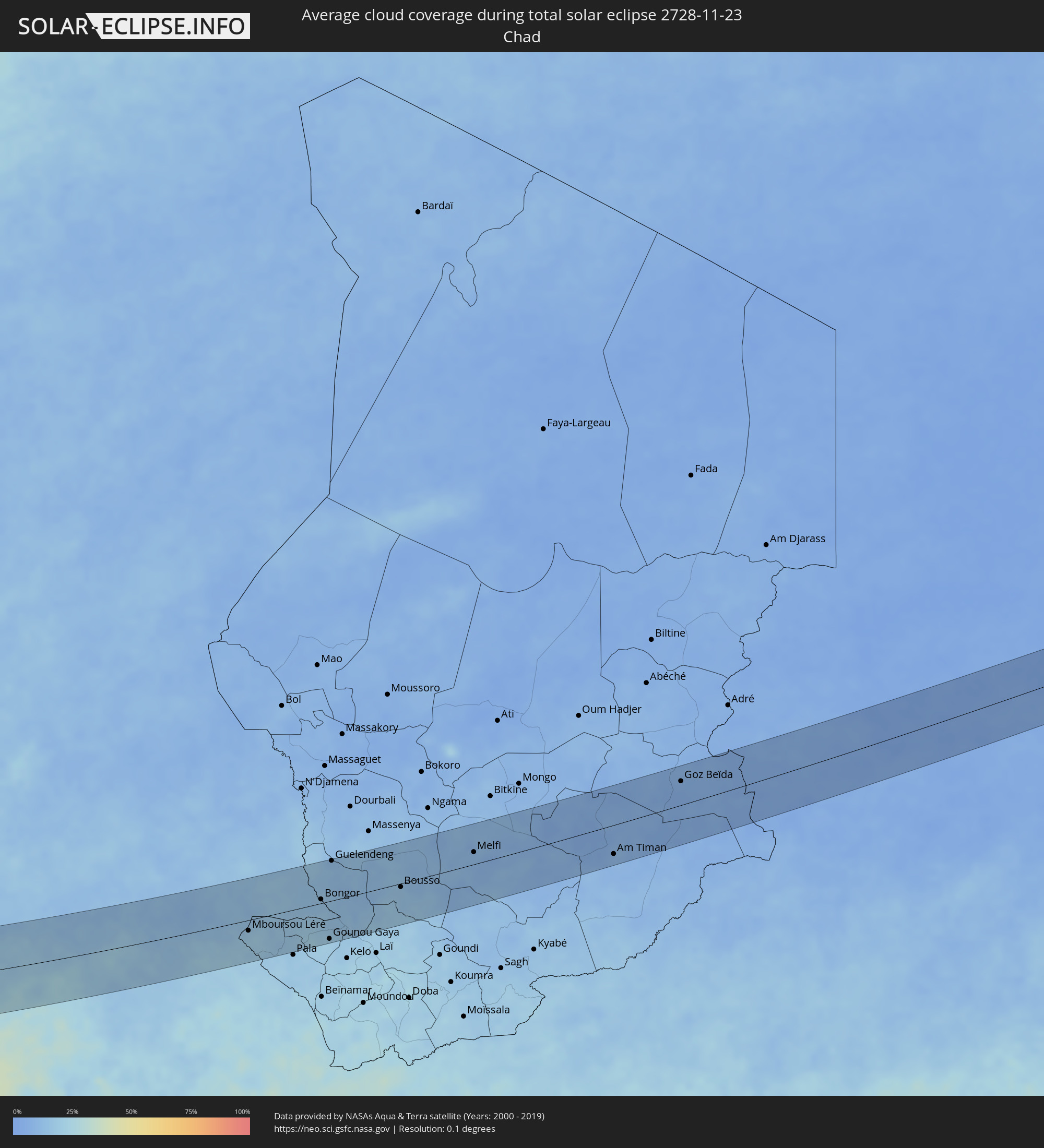 Chad
Chad
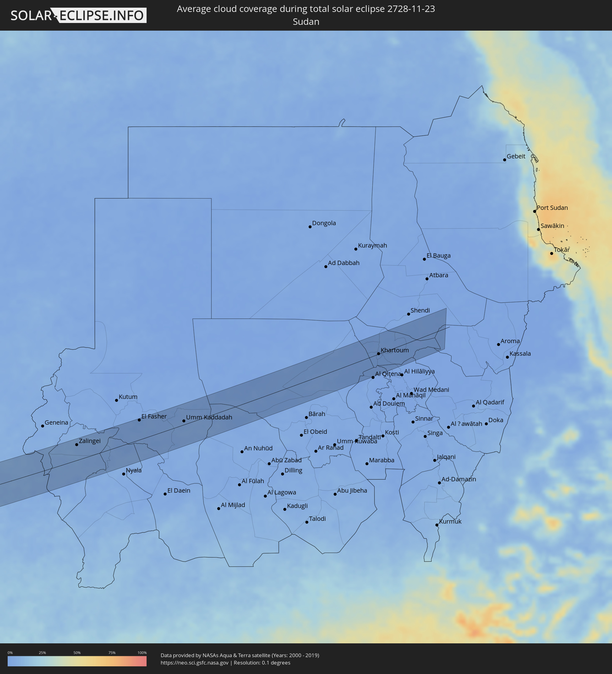 Sudan
Sudan
Cities inside the path of the eclipse
The following table shows all locations with a population of more than 5,000 inside the eclipse path. Cities which have more than 100,000 inhabitants are marked bold. A click at the locations opens a detailed map.
| City | Type | Eclipse duration | Local time of max. eclipse | Distance to central line | Ø Cloud coverage |
|
Montmagny, Quebec
|
total | - | 07:12:22 UTC-05:00 | 24 km | 78% |
|
Baie-Saint-Paul, Quebec
|
total | - | 07:12:43 UTC-05:00 | 22 km | 74% |
|
La Malbaie, Quebec
|
total | - | 07:13:00 UTC-05:00 | 56 km | 79% |
|
Presque Isle, Maine
|
total | - | 07:13:07 UTC-05:00 | 52 km | 79% |
|
Fredericton, New Brunswick
|
total | - | 08:13:13 UTC-04:00 | 40 km | 75% |
|
Oromocto, New Brunswick
|
total | - | 08:13:13 UTC-04:00 | 38 km | 74% |
|
Saint John, New Brunswick
|
total | - | 08:13:03 UTC-04:00 | 3 km | 67% |
|
Greenwood, Nova Scotia
|
total | - | 08:13:25 UTC-04:00 | 25 km | 82% |
|
Bridgewater, Nova Scotia
|
total | - | 08:13:16 UTC-04:00 | 12 km | 74% |
|
Kentville, Nova Scotia
|
total | - | 08:13:42 UTC-04:00 | 54 km | 81% |
|
Lower Sacvkille, Nova Scotia
|
total | - | 08:13:57 UTC-04:00 | 62 km | 73% |
|
Dartmouth, Nova Scotia
|
total | - | 08:13:56 UTC-04:00 | 57 km | 73% |
|
Halifax, Nova Scotia
|
total | - | 08:13:55 UTC-04:00 | 55 km | 70% |
|
Cole Harbour, Nova Scotia
|
total | - | 08:14:00 UTC-04:00 | 62 km | 73% |
|
Ribeira Grande, Ribeira Grande
|
total | - | 12:13:30 UTC-01:00 | 54 km | 58% |
|
Porto Novo, Porto Novo
|
total | - | 12:13:42 UTC-01:00 | 68 km | 45% |
|
Pombas, Paul
|
total | - | 12:13:40 UTC-01:00 | 54 km | 67% |
|
Mindelo, São Vicente
|
total | - | 12:14:04 UTC-01:00 | 74 km | 45% |
|
Tarrafal de São Nicolau, Tarrafal de São Nicolau
|
total | - | 12:15:56 UTC-01:00 | 64 km | 50% |
|
Vila da Ribeira Brava, Ribeira Brava
|
total | - | 12:16:02 UTC-01:00 | 55 km | 54% |
|
Espargos, Sal
|
total | - | 12:19:14 UTC-01:00 | 42 km | 57% |
|
Vila de Sal Rei, Boa Vista
|
total | - | 12:19:59 UTC-01:00 | 8 km | 53% |
|
Santa Maria, Sal
|
total | - | 12:19:32 UTC-01:00 | 31 km | 63% |
|
Gunjur, Western
|
total | - | 13:39:57 UTC+00:00 | 65 km | 37% |
|
Sukuta, Western
|
total | - | 13:39:45 UTC+00:00 | 87 km | 37% |
|
Bakau, Banjul
|
total | - | 13:39:44 UTC+00:00 | 95 km | 37% |
|
Abuko, Western
|
total | - | 13:39:54 UTC+00:00 | 89 km | 37% |
|
Brikama, Western
|
total | - | 13:40:05 UTC+00:00 | 76 km | 37% |
|
Tionk Essil, Ziguinchor
|
total | - | 13:41:03 UTC+00:00 | 35 km | 36% |
|
Lamin, North Bank
|
total | - | 13:40:34 UTC+00:00 | 95 km | 37% |
|
Ziguinchor, Ziguinchor
|
total | - | 13:42:00 UTC+00:00 | 27 km | 39% |
|
Bignona, Ziguinchor
|
total | - | 13:41:50 UTC+00:00 | 52 km | 36% |
|
Cacheu, Cacheu
|
total | - | 13:42:41 UTC+00:00 | 2 km | 37% |
|
Canchungo, Cacheu
|
total | - | 13:43:19 UTC+00:00 | 12 km | 34% |
|
Marsassoum, Kolda
|
total | - | 13:42:28 UTC+00:00 | 66 km | 34% |
|
Bubaque, Bolama and Bijagos
|
total | - | 13:44:52 UTC+00:00 | 81 km | 34% |
|
Bissau, Bissau
|
total | - | 13:44:45 UTC+00:00 | 11 km | 34% |
|
Sédhiou, Sédhiou
|
total | - | 13:43:47 UTC+00:00 | 75 km | 33% |
|
Bolama, Bolama and Bijagos
|
total | - | 13:45:27 UTC+00:00 | 34 km | 34% |
|
Bissorã, Oio
|
total | - | 13:44:42 UTC+00:00 | 32 km | 31% |
|
Mansôa, Oio
|
total | - | 13:45:15 UTC+00:00 | 23 km | 33% |
|
Catió, Tombali
|
total | - | 13:46:26 UTC+00:00 | 54 km | 36% |
|
Farim, Oio
|
total | - | 13:44:59 UTC+00:00 | 69 km | 30% |
|
Buba, Quinara
|
total | - | 13:46:45 UTC+00:00 | 11 km | 30% |
|
Quebo, Tombali
|
total | - | 13:47:15 UTC+00:00 | 34 km | 31% |
|
Bafatá, Bafatá
|
total | - | 13:46:55 UTC+00:00 | 63 km | 30% |
|
Kamsar, Boke
|
total | - | 13:49:01 UTC+00:00 | 87 km | 46% |
|
Boké, Boke
|
total | - | 13:49:31 UTC+00:00 | 46 km | 46% |
|
Gabú, Gabú
|
total | - | 13:47:58 UTC+00:00 | 94 km | 31% |
|
Fria, Boke
|
total | - | 13:52:09 UTC+00:00 | 74 km | 50% |
|
Tondon, Kindia
|
total | - | 13:52:47 UTC+00:00 | 64 km | 47% |
|
Télimélé, Kindia
|
total | - | 13:52:58 UTC+00:00 | 4 km | 37% |
|
Kindia, Kindia
|
total | - | 13:54:29 UTC+00:00 | 77 km | 48% |
|
Pita, Mamou
|
total | - | 13:54:30 UTC+00:00 | 46 km | 36% |
|
Labé, Labe
|
total | - | 13:54:28 UTC+00:00 | 77 km | 34% |
|
Mamou, Mamou
|
total | - | 13:56:11 UTC+00:00 | 14 km | 43% |
|
Kabala, Northern Province
|
total | - | 13:58:37 UTC+00:00 | 77 km | 57% |
|
Dabola, Faranah
|
total | - | 13:58:22 UTC+00:00 | 61 km | 37% |
|
Kissidougou, Faranah
|
total | - | 14:03:00 UTC+00:00 | 71 km | 52% |
|
Kouroussa, Kankan
|
total | - | 14:01:46 UTC+00:00 | 92 km | 36% |
|
Kankan, Kankan
|
total | - | 14:03:38 UTC+00:00 | 82 km | 40% |
|
Odienné, Denguélé
|
total | - | 14:09:15 UTC+00:00 | 34 km | 37% |
|
Boundiali, Savanes
|
total | - | 14:12:00 UTC+00:00 | 60 km | 30% |
|
Korhogo, Savanes
|
total | - | 14:14:14 UTC+00:00 | 70 km | 35% |
|
Ferkessédougou, Savanes
|
total | - | 14:15:10 UTC+00:00 | 92 km | 33% |
|
Katiola, Vallée du Bandama
|
total | - | 14:17:02 UTC+00:00 | 66 km | 67% |
|
Dabakala, Vallée du Bandama
|
total | - | 14:18:25 UTC+00:00 | 31 km | 59% |
|
Tanda, Zanzan
|
total | - | 14:22:02 UTC+00:00 | 77 km | 73% |
|
Bouna, Zanzan
|
total | - | 14:20:52 UTC+00:00 | 87 km | 38% |
|
Bondoukou, Zanzan
|
total | - | 14:22:39 UTC+00:00 | 47 km | 63% |
|
Wenchi, Brong-Ahafo
|
total | - | 14:24:34 UTC+00:00 | 75 km | 65% |
|
Techiman, Brong-Ahafo
|
total | - | 14:25:06 UTC+00:00 | 91 km | 59% |
|
Kintampo, Brong-Ahafo
|
total | - | 14:25:06 UTC+00:00 | 37 km | 55% |
|
Salaga, Northern
|
total | - | 14:27:19 UTC+00:00 | 24 km | 45% |
|
Kete Krachi
|
total | - | 14:29:06 UTC+00:00 | 59 km | 28% |
|
Kpandae
|
total | - | 14:28:31 UTC+00:00 | 17 km | 42% |
|
Badou, Plateaux
|
total | - | 14:30:42 UTC+00:00 | 81 km | 49% |
|
Sotouboua, Centrale
|
total | - | 14:30:33 UTC+00:00 | 28 km | 26% |
|
Sokodé, Centrale
|
total | - | 14:30:27 UTC+00:00 | 75 km | 26% |
|
Atakpamé, Plateaux
|
total | - | 14:31:52 UTC+00:00 | 87 km | 41% |
|
Tchamba, Centrale
|
total | - | 14:31:00 UTC+00:00 | 80 km | 26% |
|
Bassila, Donga
|
total | - | 15:31:33 UTC+01:00 | 77 km | 27% |
|
Savalou, Collines
|
total | - | 15:33:14 UTC+01:00 | 44 km | 51% |
|
Dassa-Zoumé, Collines
|
total | - | 15:33:50 UTC+01:00 | 65 km | 55% |
|
Savé, Collines
|
total | - | 15:34:11 UTC+01:00 | 34 km | 55% |
|
Tchaourou, Borgou
|
total | - | 15:33:35 UTC+01:00 | 60 km | 34% |
|
Saki, Oyo
|
total | - | 15:35:23 UTC+01:00 | 32 km | 33% |
|
Kisi, Oyo
|
total | - | 15:35:53 UTC+01:00 | 75 km | 20% |
|
Oyo, Oyo
|
total | - | 15:37:11 UTC+01:00 | 62 km | 47% |
|
Inisa, Osun
|
total | - | 15:37:57 UTC+01:00 | 65 km | 47% |
|
Ilorin, Kwara
|
total | - | 15:37:46 UTC+01:00 | 5 km | 31% |
|
Osogbo, Osun
|
total | - | 15:38:27 UTC+01:00 | 76 km | 53% |
|
Ila Orangun, Osun
|
total | - | 15:38:52 UTC+01:00 | 52 km | 41% |
|
Ijero-Ekiti, Ekiti
|
total | - | 15:39:21 UTC+01:00 | 75 km | 45% |
|
Bida, Niger
|
total | - | 15:39:56 UTC+01:00 | 55 km | 29% |
|
Suleja, Niger
|
total | - | 15:41:54 UTC+01:00 | 51 km | 26% |
|
Abuja, Abuja Federal Capital Territory
|
total | - | 15:42:33 UTC+01:00 | 33 km | 22% |
|
Jimeta, Adamawa
|
total | - | 15:50:00 UTC+01:00 | 33 km | 18% |
|
Mubi, Adamawa
|
total | - | 15:50:17 UTC+01:00 | 57 km | 12% |
|
Garoua, North
|
total | - | 15:51:15 UTC+01:00 | 51 km | 21% |
|
Pitoa, North
|
total | - | 15:51:19 UTC+01:00 | 45 km | 20% |
|
Guider, North
|
total | - | 15:51:27 UTC+01:00 | 5 km | 16% |
|
Mboursou Léré, Mayo-Kebbi Ouest
|
total | - | 15:51:52 UTC+01:00 | 19 km | 20% |
|
Maroua, Far North
|
total | - | 15:51:23 UTC+01:00 | 67 km | 17% |
|
Mindif, Far North
|
total | - | 15:51:42 UTC+01:00 | 43 km | 17% |
|
Kaélé, Far North
|
total | - | 15:51:57 UTC+01:00 | 11 km | 17% |
|
Bogo, Far North
|
total | - | 15:51:39 UTC+01:00 | 75 km | 17% |
|
Yagoua, Far North
|
total | - | 15:52:44 UTC+01:00 | 17 km | 13% |
|
Bongor, Mayo-Kebbi Est
|
total | - | 15:52:57 UTC+01:00 | 7 km | 15% |
|
Gounou Gaya, Mayo-Kebbi Est
|
total | - | 15:53:39 UTC+01:00 | 67 km | 20% |
|
Guelendeng, Mayo-Kebbi Est
|
total | - | 15:52:39 UTC+01:00 | 71 km | 13% |
|
Bousso, Chari-Baguirmi
|
total | - | 15:54:21 UTC+01:00 | 6 km | 15% |
|
Melfi, Guéra
|
total | - | 15:55:15 UTC+01:00 | 22 km | 11% |
|
Am Timan, Salamat
|
total | - | 15:57:37 UTC+01:00 | 51 km | 10% |
|
Goz Beïda, Sila
|
total | - | 15:57:41 UTC+01:00 | 42 km | 5% |
|
Zalingei, Central Darfur
|
total | - | 16:58:51 UTC+02:00 | 48 km | 5% |
|
El Fasher, Northern Darfur
|
total | - | 16:59:39 UTC+02:00 | 60 km | 2% |
|
Umm Kaddadah, Northern Darfur
|
total | - | 17:00:34 UTC+02:00 | 11 km | 3% |
|
Omdurman, Khartoum
|
total | - | 17:01:50 UTC+02:00 | 12 km | 1% |
|
Khartoum, Khartoum
|
total | - | 17:01:56 UTC+02:00 | 0 km | 1% |