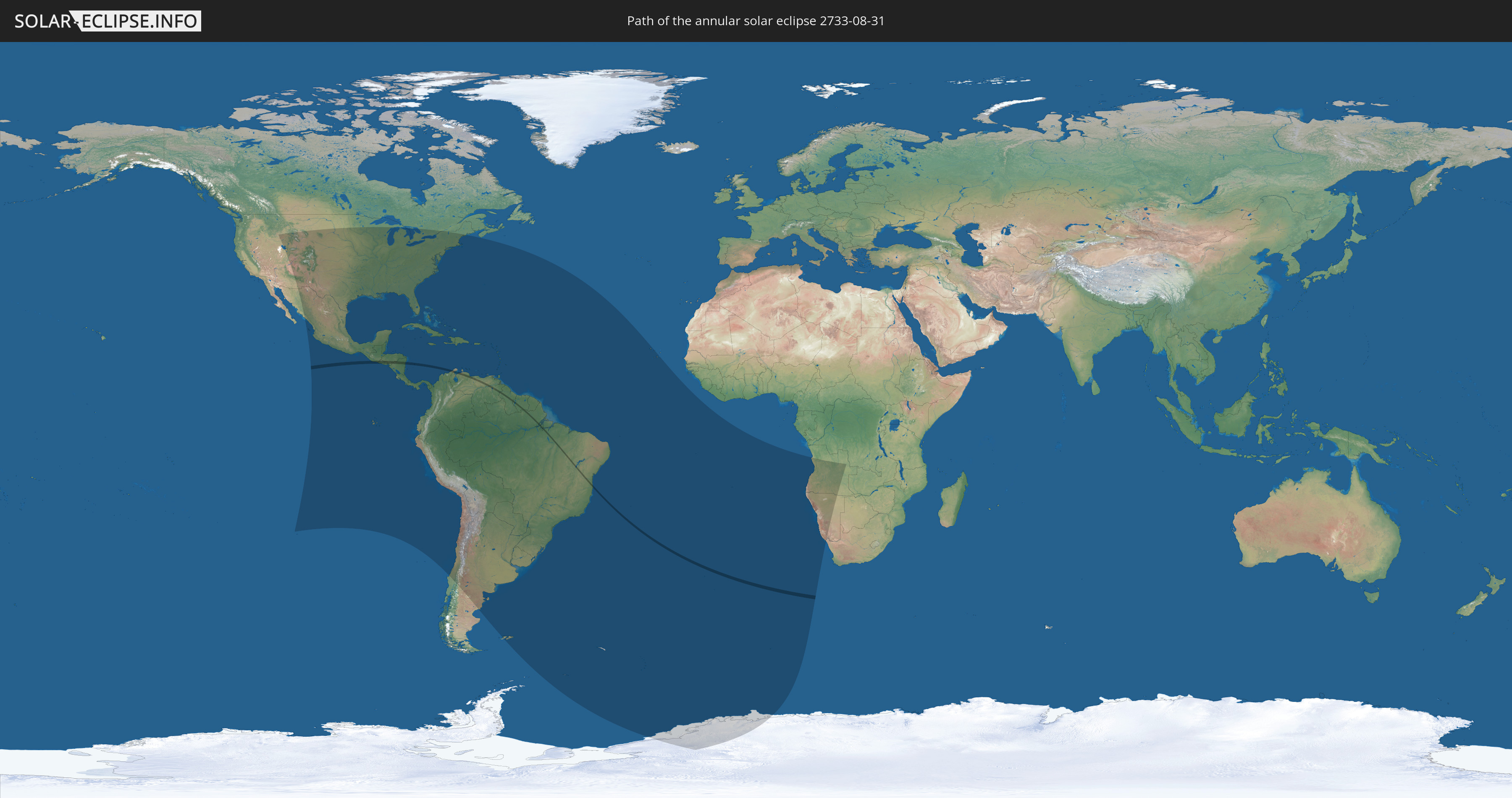
Annular solar eclipse of 08/31/2733
| Day of week: | Thursday |
| Maximum duration of eclipse: | 00m49s |
| Maximum width of eclipse path: | 29 km |
| Saros cycle: | 166 |
| Coverage: | 99.2% |
| Magnitude: | 0.992 |
| Gamma: | -0.2587 |
Wo kann man die Sonnenfinsternis vom 08/31/2733 sehen?
Die Sonnenfinsternis am 08/31/2733 kann man in 59 Ländern als partielle Sonnenfinsternis beobachten.
Der Finsternispfad verläuft durch 9 Länder. Nur in diesen Ländern ist sie als annular Sonnenfinsternis zu sehen.
In den folgenden Ländern ist die Sonnenfinsternis annular zu sehen
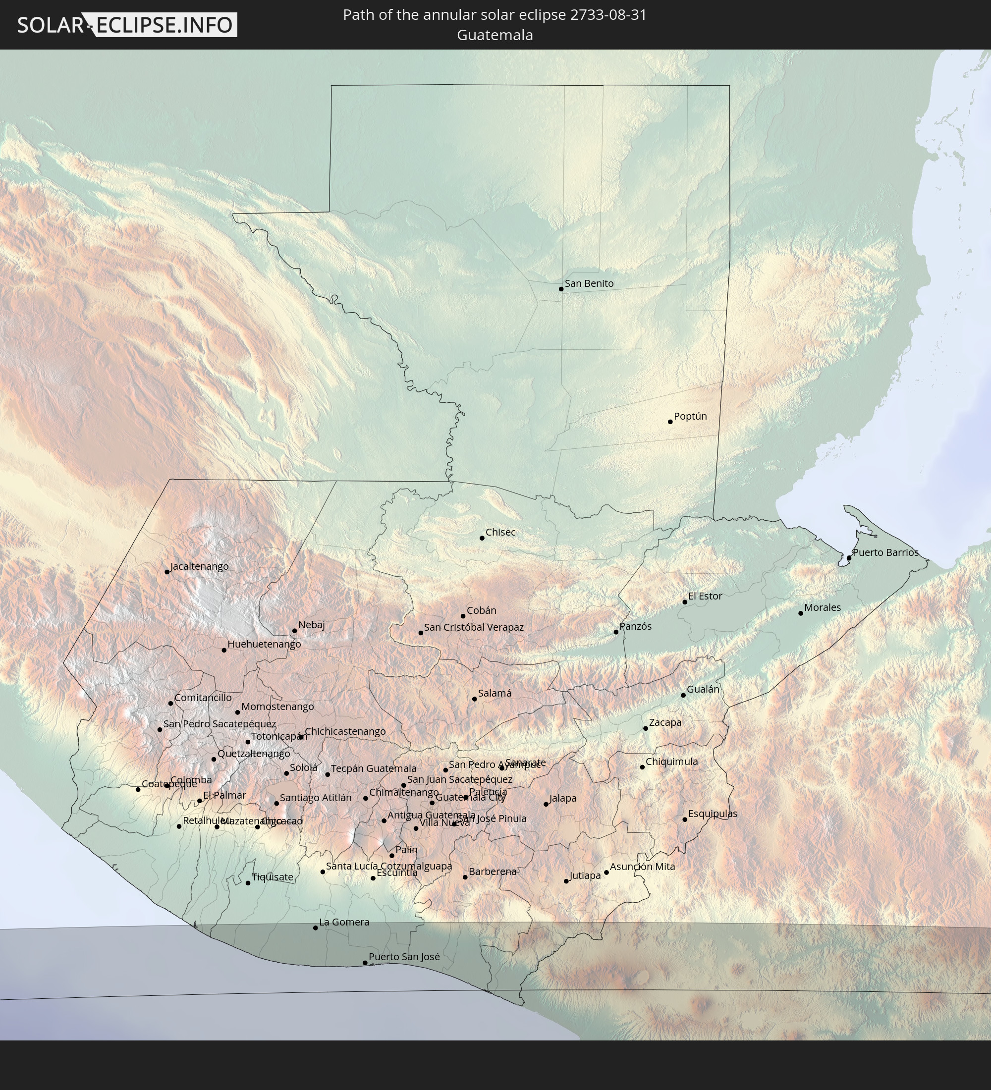 Guatemala
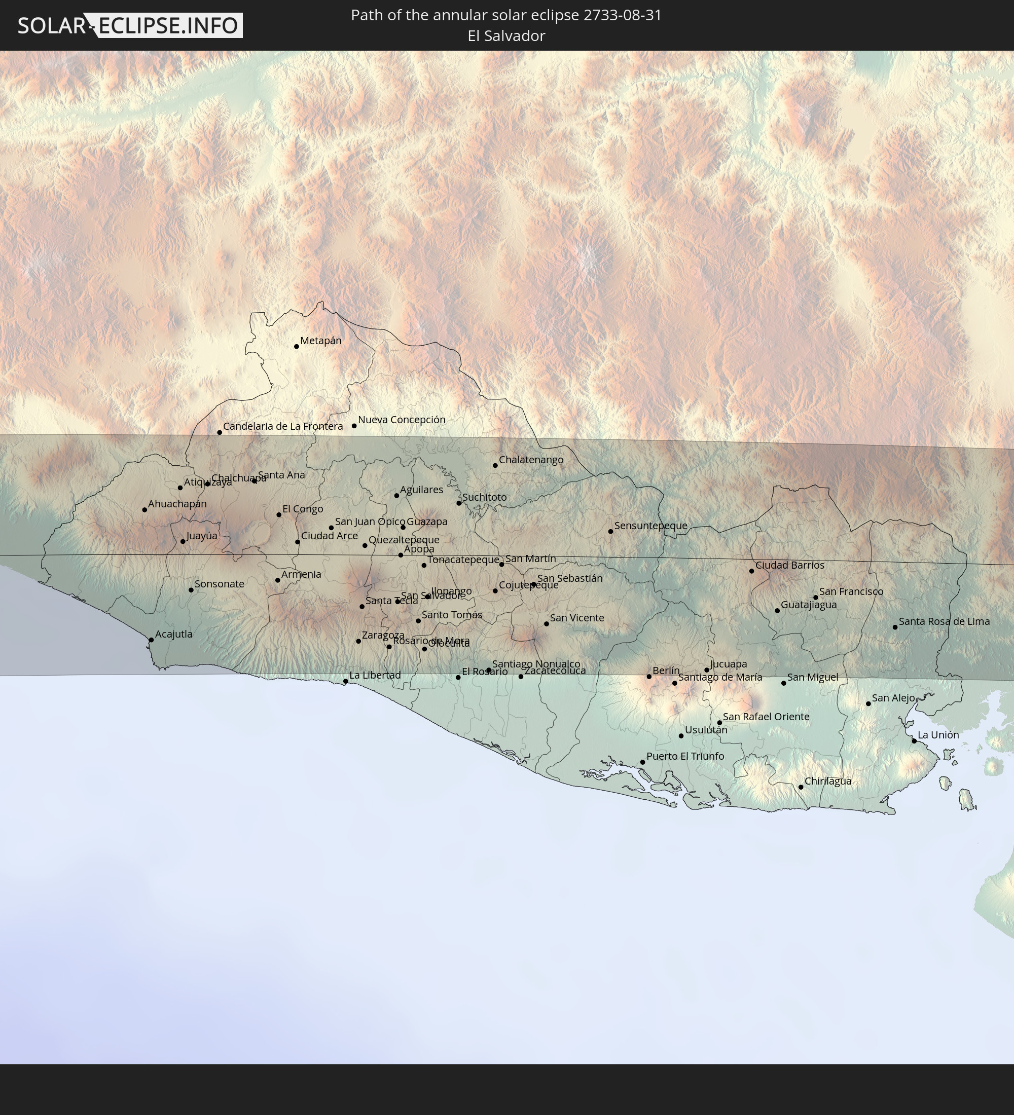 El Salvador
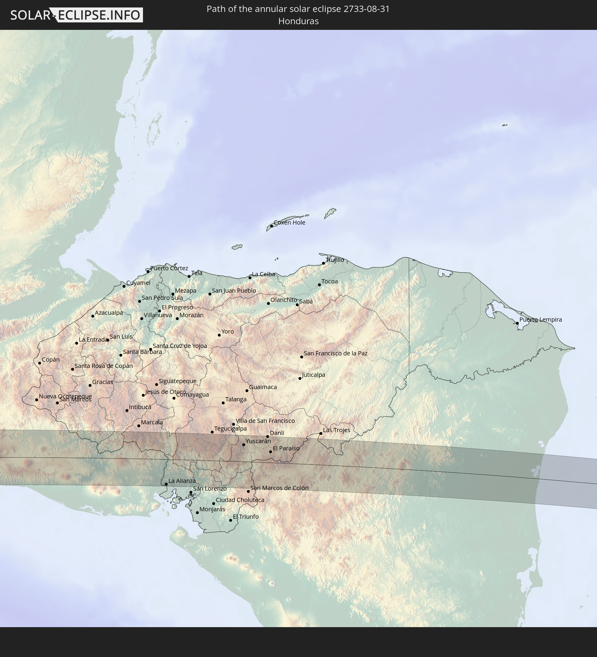 Honduras
 Nicaragua
 Colombia
 Brazil
 Venezuela
 Guyana
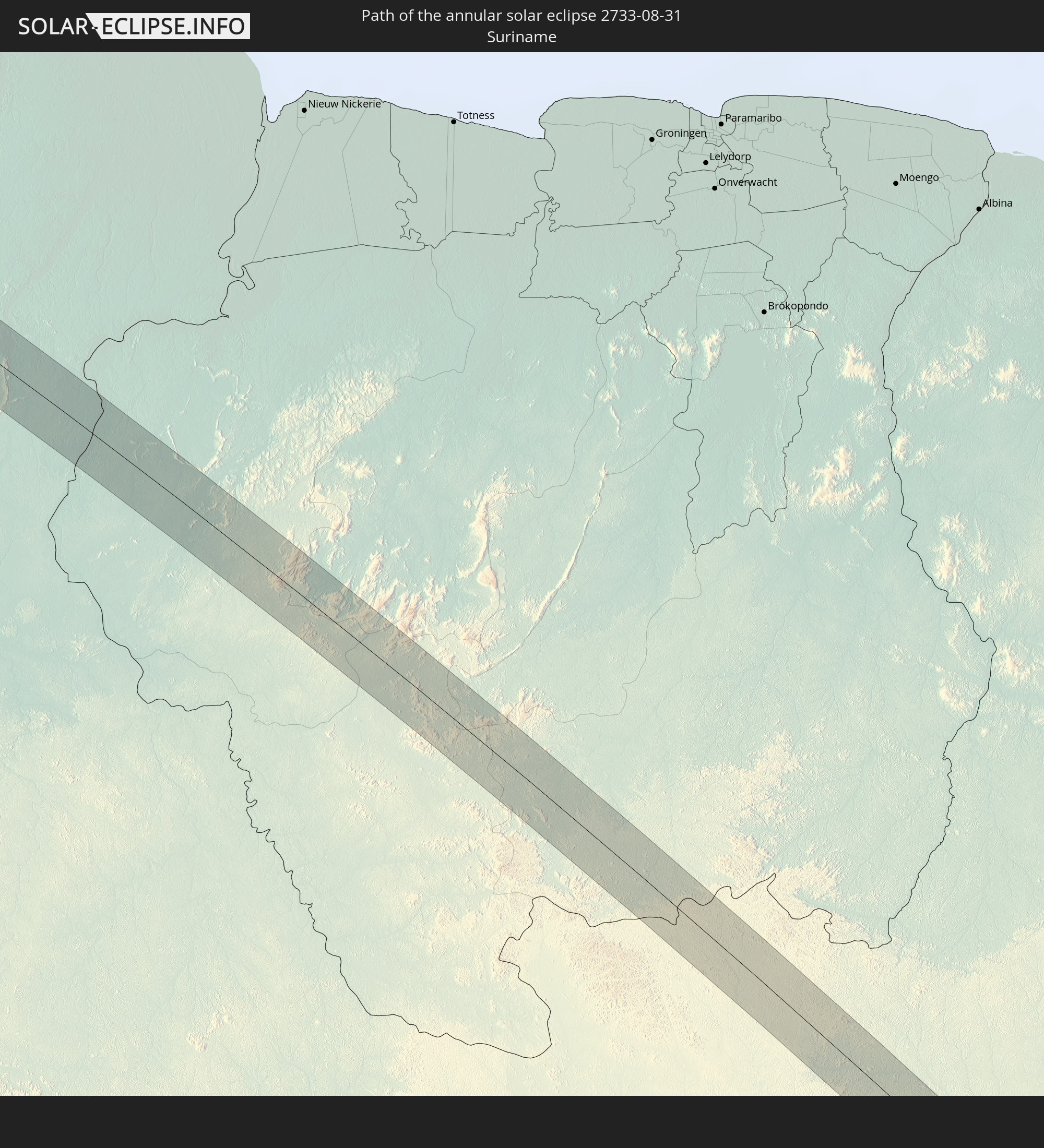 Suriname
In den folgenden Ländern ist die Sonnenfinsternis partiell zu sehen
 Antarctica
 United States
 United States Minor Outlying Islands
 Canada
 Mexico
 Chile
Chile
 Guatemala
 Ecuador
 El Salvador
 Honduras
 Belize
 Nicaragua
 Costa Rica
 Cuba
Cuba
 Panama
 Colombia
 Cayman Islands
 Peru
Peru
 The Bahamas
 Jamaica
 Haiti
Haiti
 Brazil
 Argentina
 Venezuela
 Turks and Caicos Islands
 Dominican Republic
 Aruba
Aruba
 Bolivia
 Puerto Rico
 United States Virgin Islands
 Bermuda
 British Virgin Islands
 Anguilla
 Collectivity of Saint Martin
 Saint Barthélemy
 Saint Kitts and Nevis
 Paraguay
 Antigua and Barbuda
 Montserrat
 Trinidad and Tobago
 Guadeloupe
 Grenada
 Dominica
 Saint Vincent and the Grenadines
 Falkland Islands
 Guyana
 Martinique
 Saint Lucia
 Barbados
 Uruguay
 Suriname
 French Guiana
 South Georgia and the South Sandwich Islands
 Cabo Verde
 Saint Helena, Ascension and Tristan da Cunha
 Bouvet Island
 Angola
 Namibia
 South Africa
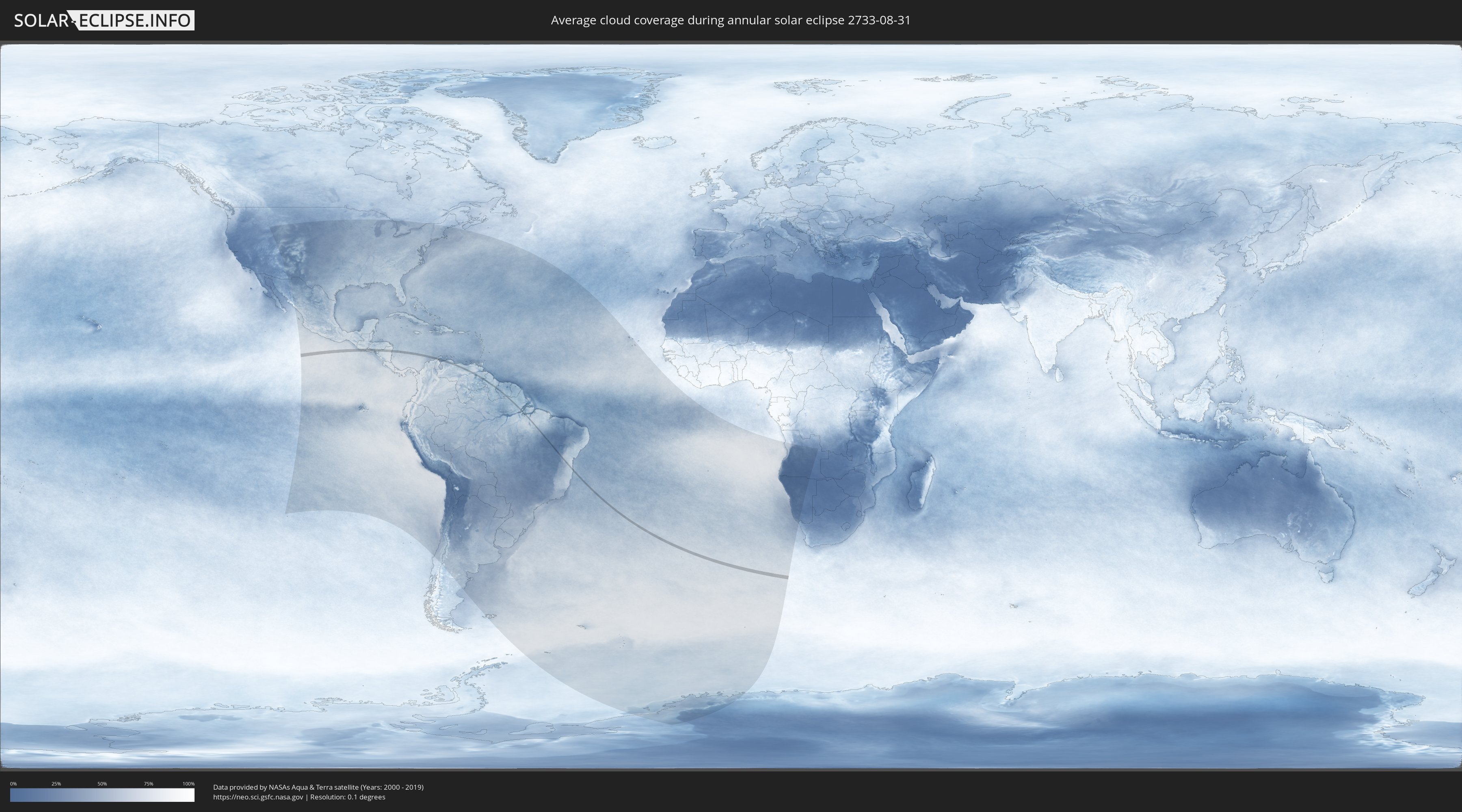
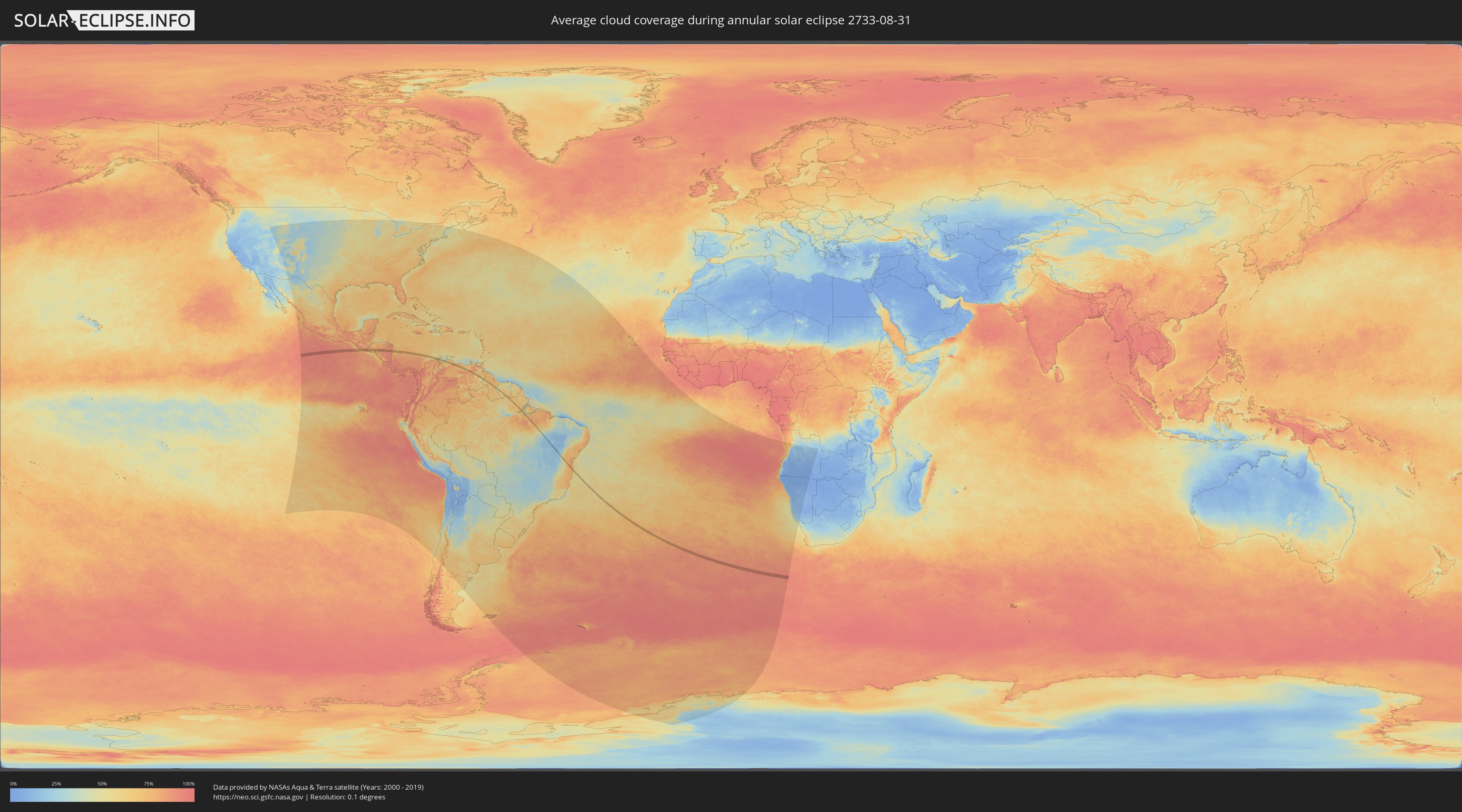
How will be the weather during the annular solar eclipse on 08/31/2733?
Where is the best place to see the annular solar eclipse of 08/31/2733?
The following maps show the average cloud coverage for the day of the annular solar eclipse.
With the help of these maps, it is possible to find the place along the eclipse path, which has the best
chance of a cloudless sky.
Nevertheless, you should consider local circumstances and inform about the weather of your chosen
observation site.
The data is provided by NASAs satellites
AQUA and TERRA.
The cloud maps are averaged over a period of 19 years (2000 - 2019).
Detailed country maps
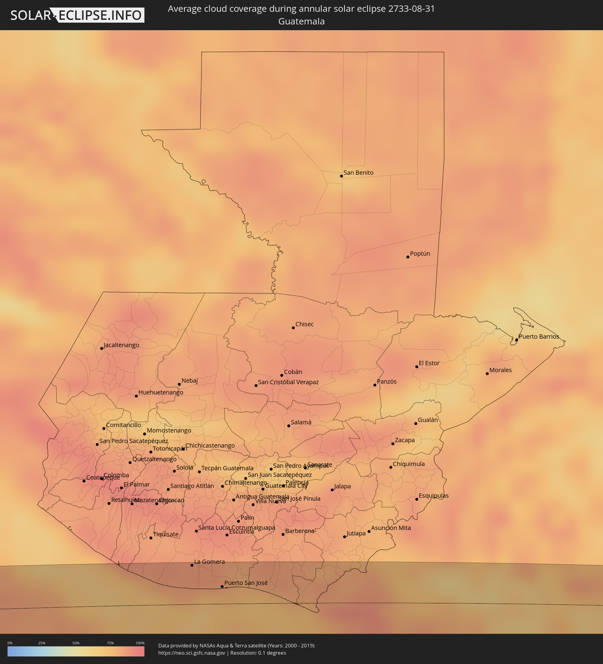 Guatemala
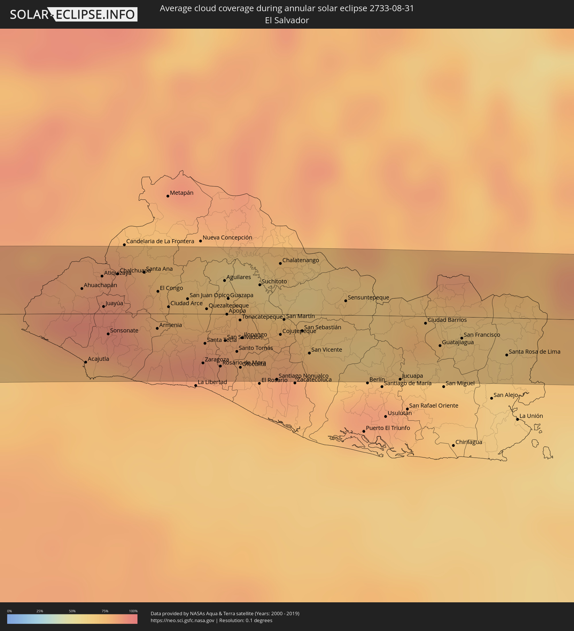 El Salvador
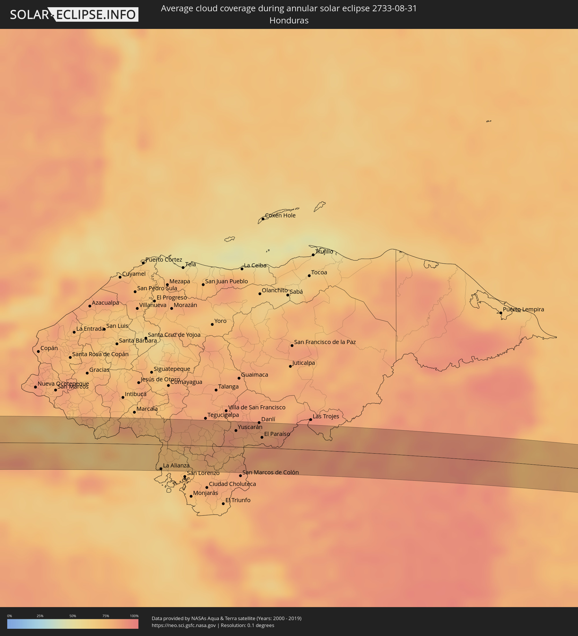 Honduras
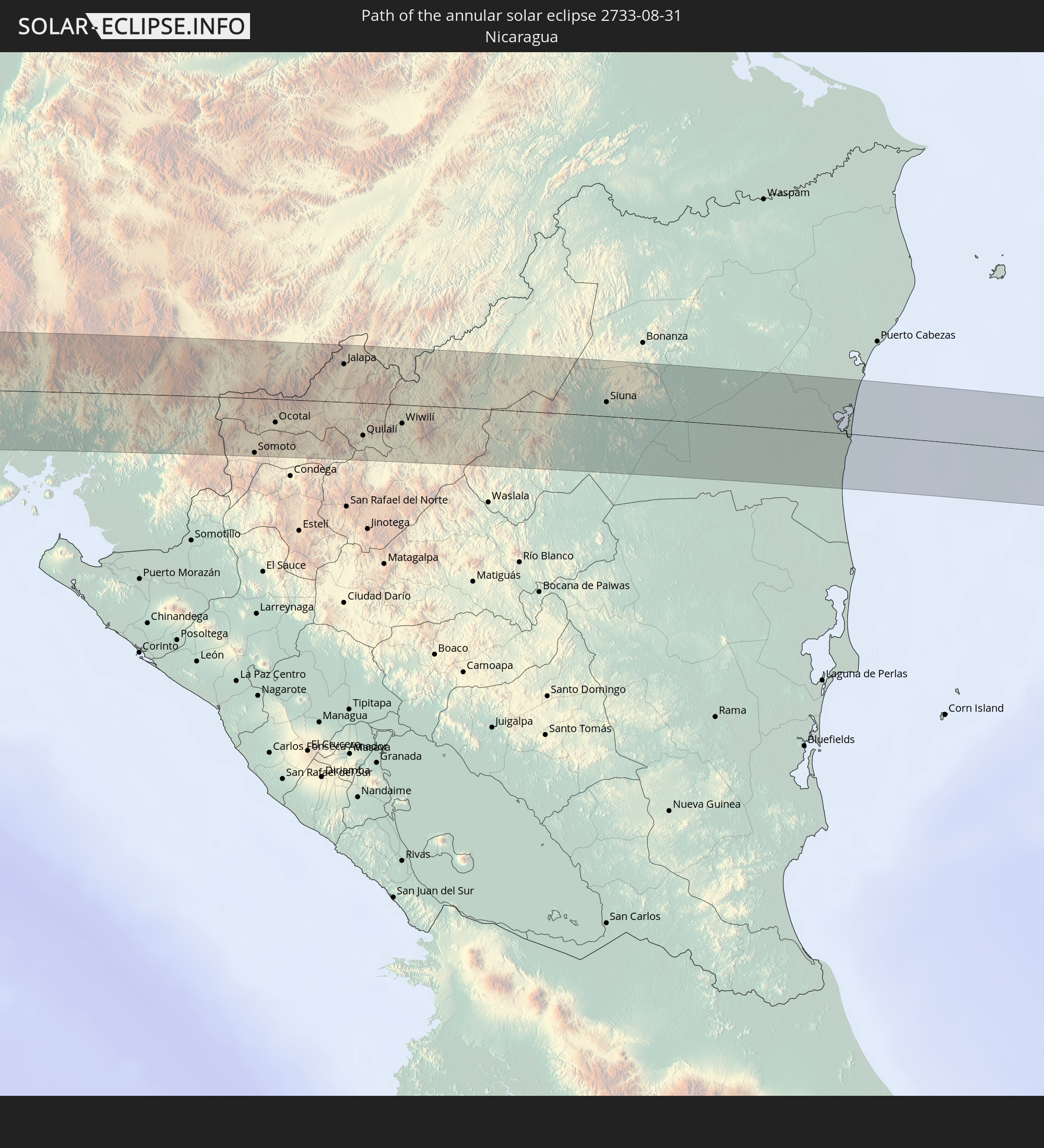
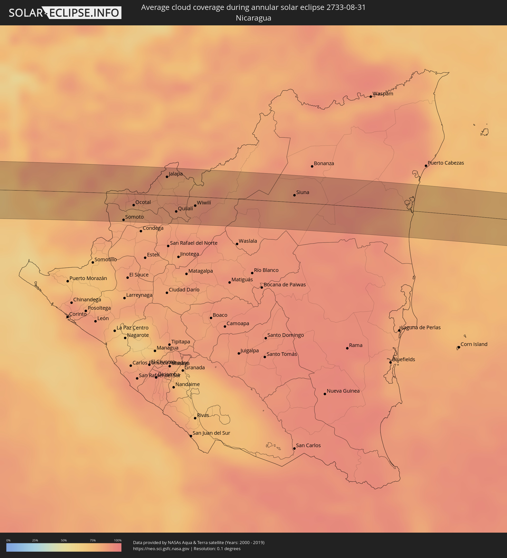 Nicaragua
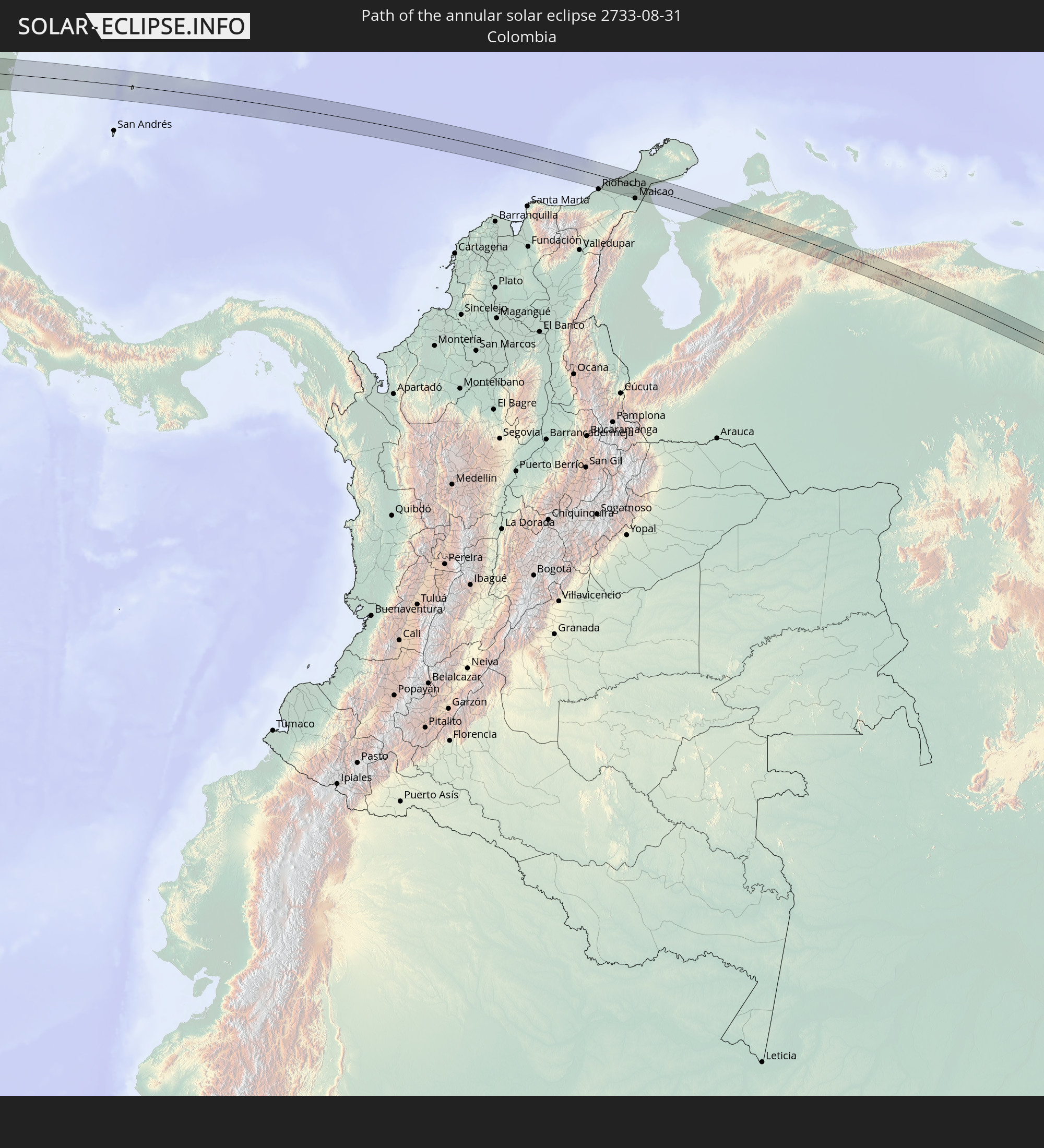
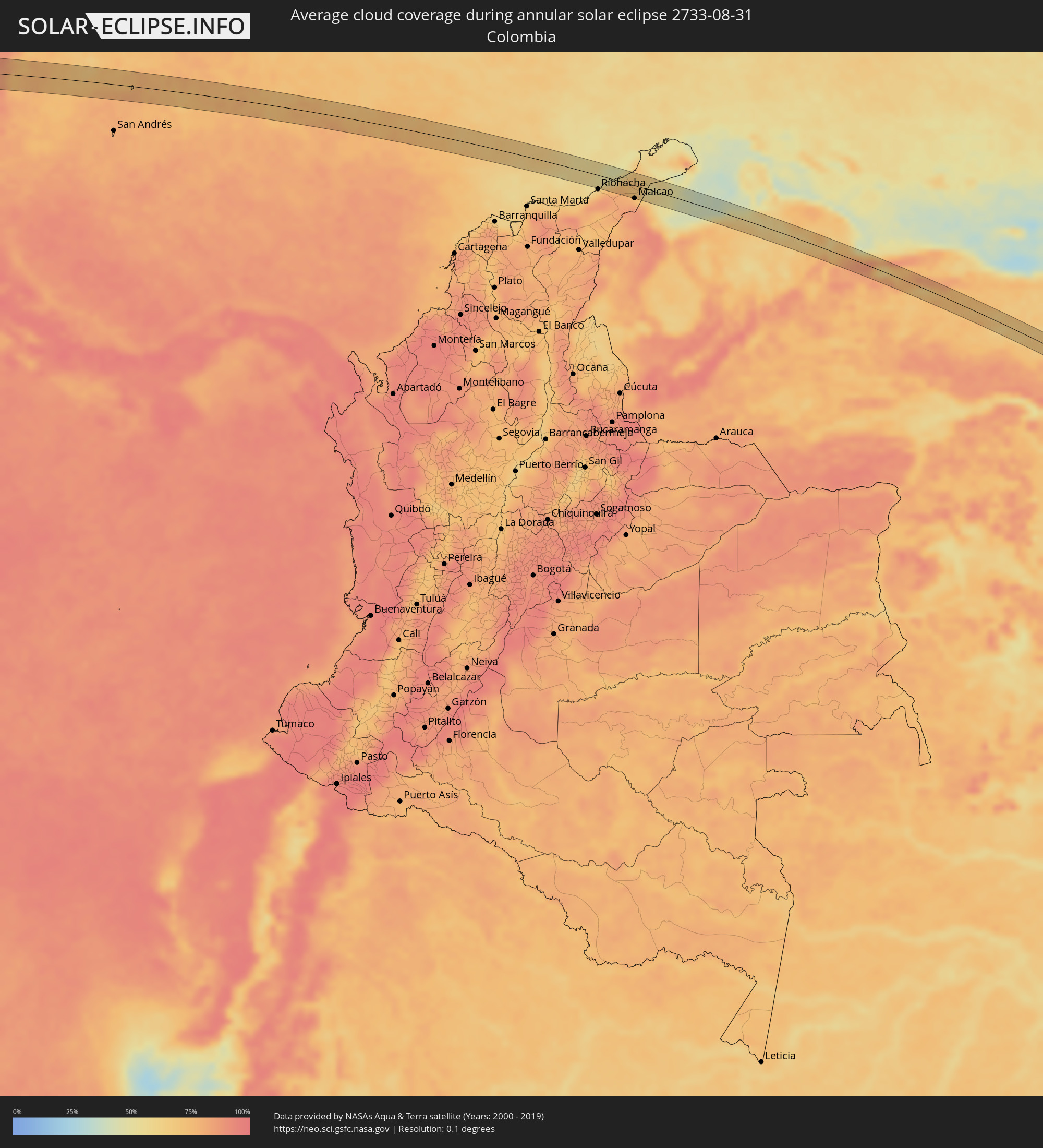 Colombia
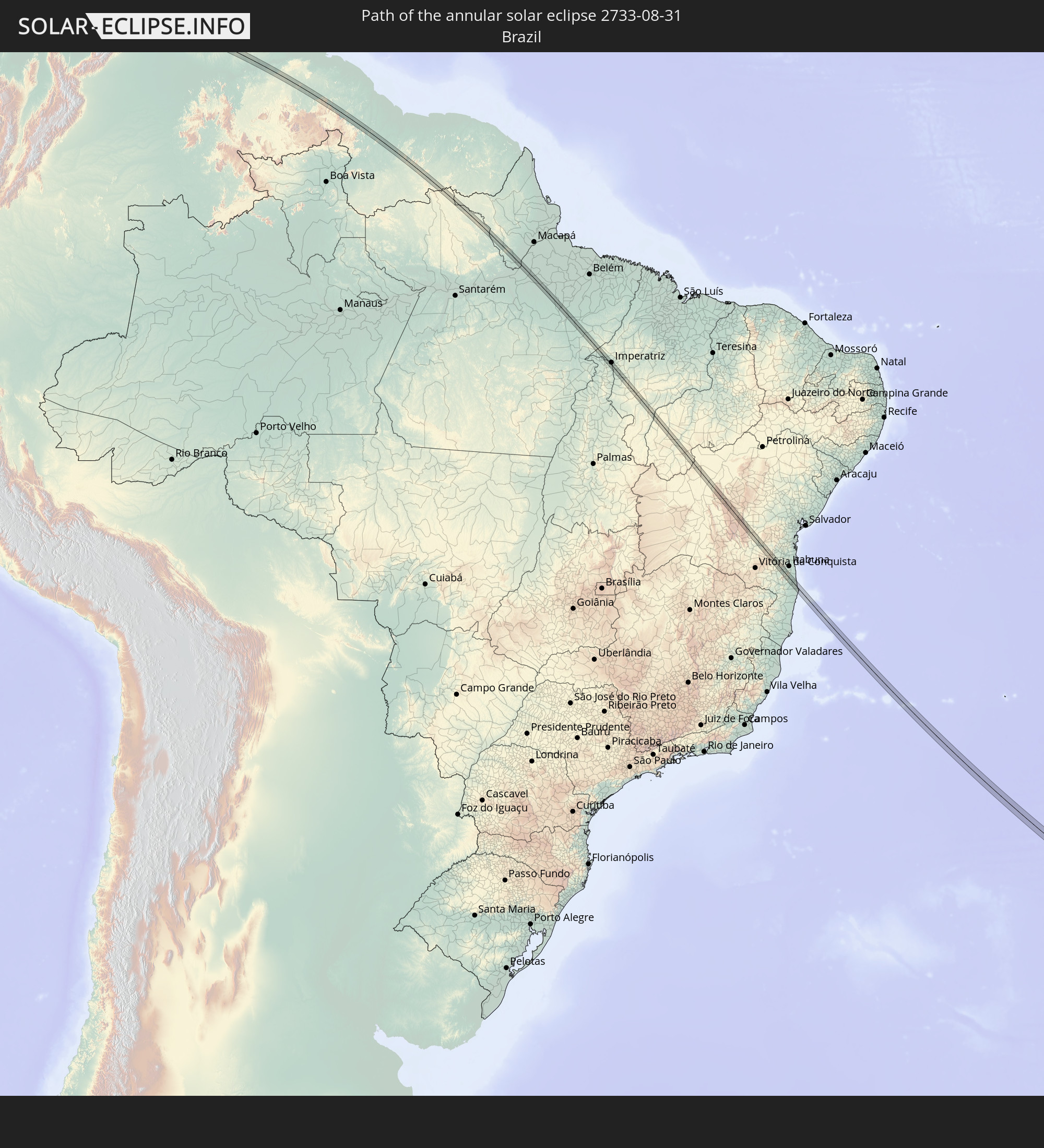
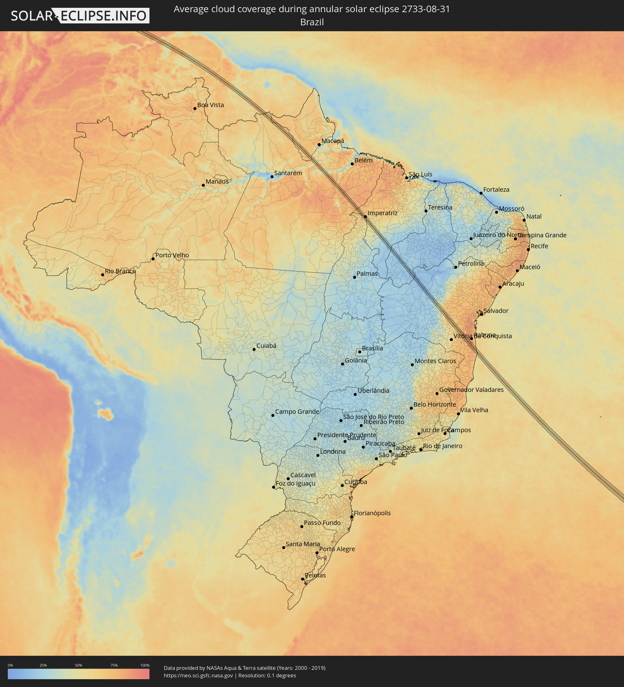 Brazil
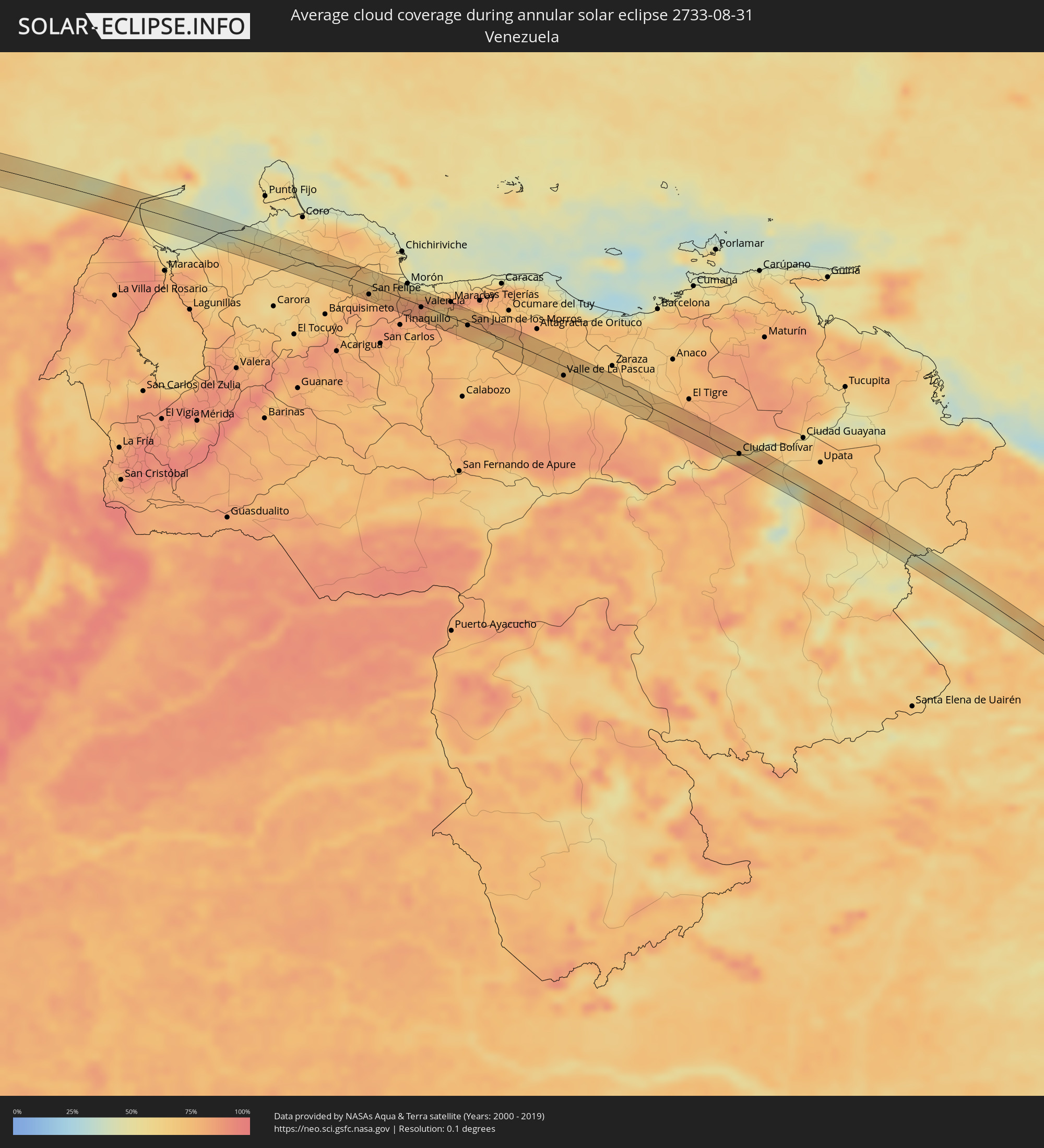 Venezuela
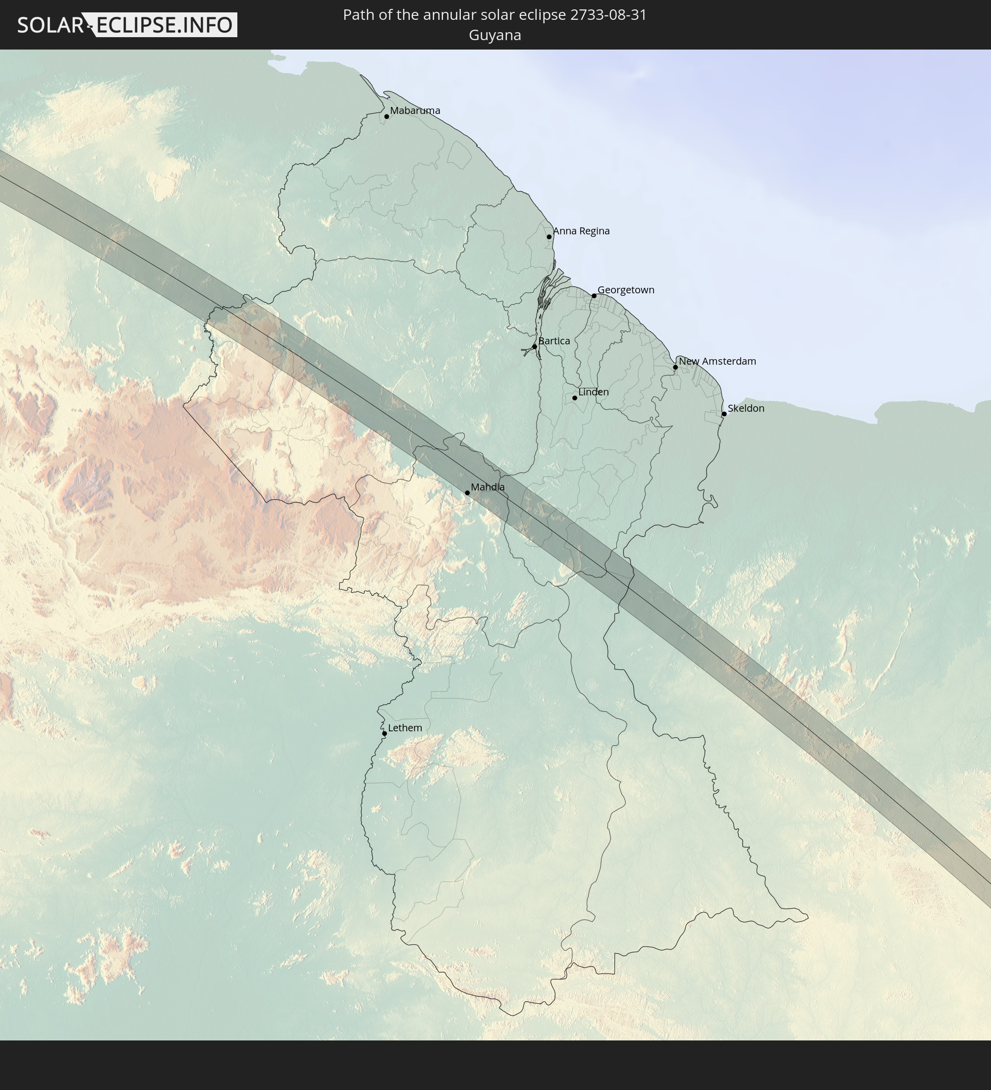
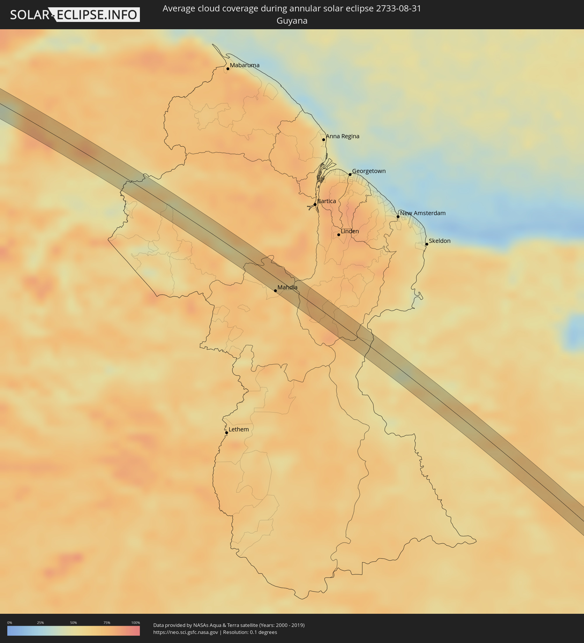 Guyana
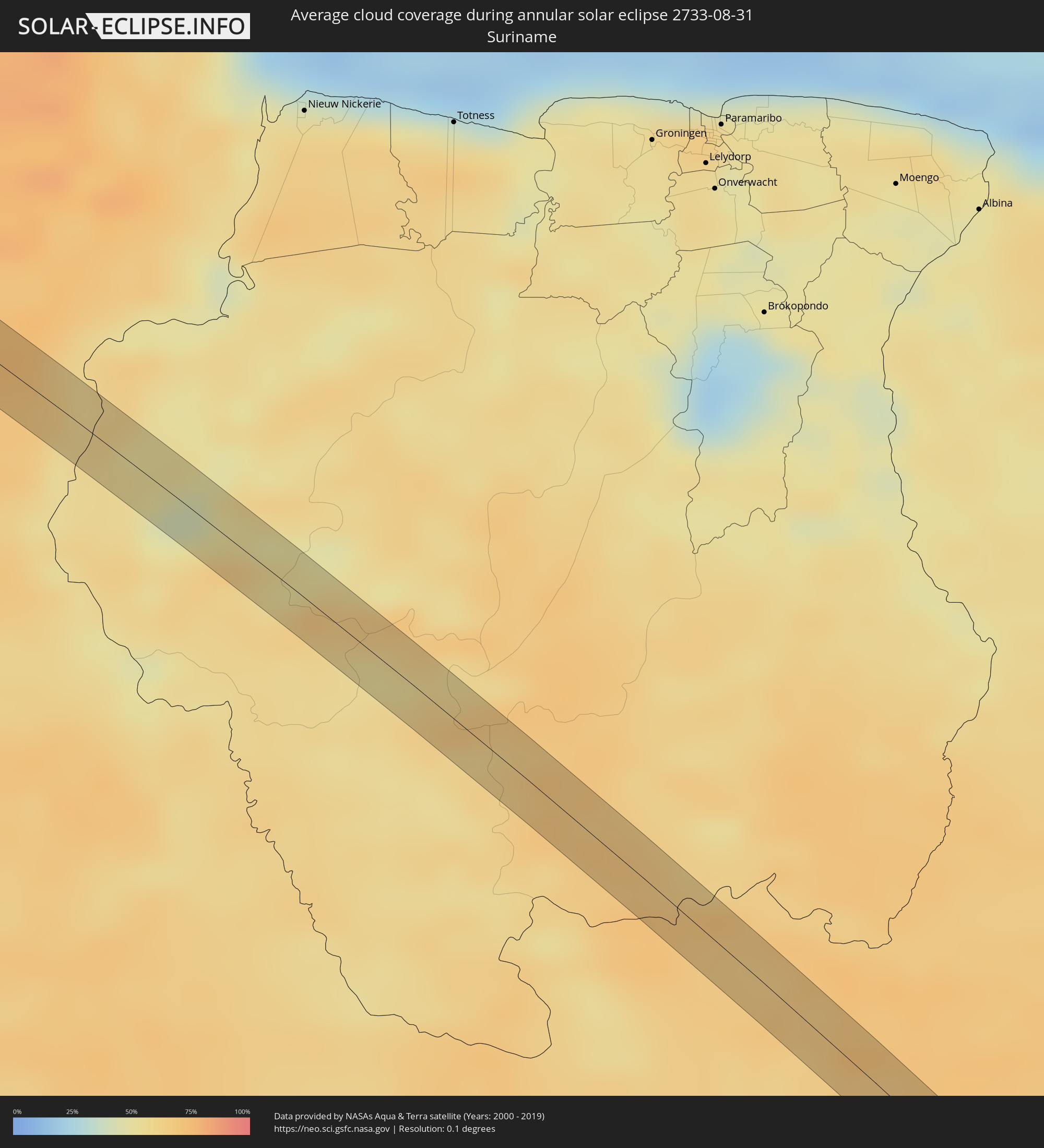 Suriname
Cities inside the path of the eclipse
The following table shows all locations with a population of more than 5,000 inside the eclipse path. Cities which have more than 100,000 inhabitants are marked bold. A click at the locations opens a detailed map.
| City | Type | Eclipse duration | Local time of max. eclipse | Distance to central line | Ø Cloud coverage |
|
La Gomera, Escuintla
|
annular | - | 07:02:01 UTC-06:00 | 32 km | 85% |
|
Puerto San José, Escuintla
|
annular | - | 07:02:15 UTC-06:00 | 14 km | 73% |
|
Taxisco, Santa Rosa
|
annular | - | 07:02:24 UTC-06:00 | 29 km | 83% |
|
Guazacapán, Santa Rosa
|
annular | - | 07:02:26 UTC-06:00 | 30 km | 86% |
|
Chiquimulilla, Santa Rosa
|
annular | - | 07:02:26 UTC-06:00 | 31 km | 86% |
|
Moyuta, Jutiapa
|
annular | - | 07:02:40 UTC-06:00 | 25 km | 84% |
|
Concepción de Ataco, Ahuachapán
|
annular | - | 07:02:55 UTC-06:00 | 7 km | 91% |
|
Ahuachapán, Ahuachapán
|
annular | - | 07:02:53 UTC-06:00 | 12 km | 91% |
|
Acajutla, Sonsonate
|
annular | - | 07:03:05 UTC-06:00 | 24 km | 72% |
|
Atiquizaya, Ahuachapán
|
annular | - | 07:02:55 UTC-06:00 | 19 km | 87% |
|
Juayúa, Sonsonate
|
annular | - | 07:03:00 UTC-06:00 | 3 km | 90% |
|
San Antonio del Monte, Sonsonate
|
annular | - | 07:03:04 UTC-06:00 | 10 km | 81% |
|
Sonsonate, Sonsonate
|
annular | - | 07:03:05 UTC-06:00 | 10 km | 81% |
|
Santa Ana, Santa Ana
|
annular | - | 07:03:02 UTC-06:00 | 20 km | 84% |
|
Armenia, Sonsonate
|
annular | - | 07:03:13 UTC-06:00 | 7 km | 87% |
|
El Congo, Santa Ana
|
annular | - | 07:03:08 UTC-06:00 | 11 km | 78% |
|
Ciudad Arce, La Libertad
|
annular | - | 07:03:12 UTC-06:00 | 3 km | 83% |
|
Zaragoza, La Libertad
|
annular | - | 07:03:27 UTC-06:00 | 24 km | 80% |
|
Quezaltepeque, La Libertad
|
annular | - | 07:03:20 UTC-06:00 | 2 km | 83% |
|
Aguilares, San Salvador
|
annular | - | 07:03:19 UTC-06:00 | 17 km | 73% |
|
San Salvador, San Salvador
|
annular | - | 07:03:28 UTC-06:00 | 13 km | 84% |
|
Guazapa, San Salvador
|
annular | - | 07:03:22 UTC-06:00 | 8 km | 76% |
|
Santiago Nonualco, La Paz
|
annular | - | 07:03:44 UTC-06:00 | 32 km | 79% |
|
Cojutepeque, Cuscatlán
|
annular | - | 07:03:38 UTC-06:00 | 10 km | 82% |
|
Chalatenango, Chalatenango
|
annular | - | 07:03:27 UTC-06:00 | 25 km | 63% |
|
San Vicente, San Vicente
|
annular | - | 07:03:46 UTC-06:00 | 19 km | 80% |
|
Sensuntepeque, Cabañas
|
annular | - | 07:03:46 UTC-06:00 | 7 km | 69% |
|
Jucuapa, Usulután
|
annular | - | 07:04:09 UTC-06:00 | 32 km | 84% |
|
Ciudad Barrios, San Miguel
|
annular | - | 07:04:05 UTC-06:00 | 4 km | 76% |
|
San Francisco, Morazán
|
annular | - | 07:04:15 UTC-06:00 | 11 km | 68% |
|
Santa Rosa de Lima, La Unión
|
annular | - | 07:04:27 UTC-06:00 | 19 km | 67% |
|
La Alianza, Valle
|
annular | - | 07:04:39 UTC-06:00 | 31 km | 66% |
|
Nacaome, Valle
|
annular | - | 07:04:49 UTC-06:00 | 27 km | 73% |
|
Yuscarán, El Paraíso
|
annular | - | 07:05:04 UTC-06:00 | 20 km | 85% |
|
Danlí, El Paraíso
|
annular | - | 07:05:14 UTC-06:00 | 31 km | 81% |
|
Somoto, Madriz
|
annular | - | 07:05:35 UTC-06:00 | 30 km | 83% |
|
El Paraíso, El Paraíso
|
annular | - | 07:05:22 UTC-06:00 | 13 km | 80% |
|
Ocotal, Nueva Segovia
|
annular | - | 07:05:35 UTC-06:00 | 13 km | 82% |
|
Jalapa, Nueva Segovia
|
annular | - | 07:05:41 UTC-06:00 | 21 km | 82% |
|
Quilalí, Nueva Segovia
|
annular | - | 07:06:00 UTC-06:00 | 18 km | 84% |
|
Wiwilí, Nueva Segovia
|
annular | - | 07:06:08 UTC-06:00 | 10 km | 88% |
|
Siuna, Atlántico Norte (RAAN)
|
annular | - | 07:06:59 UTC-06:00 | 8 km | 84% |
|
Manaure, La Guajira
|
annular | - | 08:23:48 UTC-05:00 | 11 km | 72% |
|
Uribia, La Guajira
|
annular | - | 08:24:08 UTC-05:00 | 10 km | 70% |
|
San Felipe, Yaracuy
|
annular | - | 09:31:39 UTC-04:00 | 13 km | 80% |
|
Valencia, Carabobo
|
annular | - | 09:33:11 UTC-04:00 | 3 km | 82% |
|
Tacarigua, Carabobo
|
annular | - | 09:33:27 UTC-04:00 | 7 km | 82% |
|
Guacara, Carabobo
|
annular | - | 09:33:20 UTC-04:00 | 9 km | 71% |
|
San Joaquín, Carabobo
|
annular | - | 09:33:26 UTC-04:00 | 17 km | 65% |
|
Güigüe, Carabobo
|
annular | - | 09:33:42 UTC-04:00 | 1 km | 78% |
|
Palo Negro, Aragua
|
annular | - | 09:34:00 UTC-04:00 | 18 km | 71% |
|
Villa de Cura, Aragua
|
annular | - | 09:34:17 UTC-04:00 | 6 km | 76% |
|
San Juan de los Morros, Guárico
|
annular | - | 09:34:43 UTC-04:00 | 1 km | 76% |
|
Valle de La Pascua, Guárico
|
annular | - | 09:38:13 UTC-04:00 | 13 km | 71% |
|
Ciudad Bolívar, Bolívar
|
annular | - | 09:44:42 UTC-04:00 | 1 km | 84% |
|
Mahdia, Potaro-Siparuni
|
annular | - | 09:59:01 UTC-04:00 | 16 km | 68% |
|
Portel, Pará
|
annular | - | 11:33:10 UTC-03:00 | 2 km | 46% |
|
Imperatriz, Maranhão
|
annular | - | 11:48:53 UTC-03:00 | 8 km | 59% |
|
Bom Jardim, Maranhão
|
annular | - | 11:54:31 UTC-03:00 | 14 km | 36% |
|
Balsas, Maranhão
|
annular | - | 11:56:39 UTC-03:00 | 13 km | 22% |
|
Seabra, Bahia
|
annular | - | 12:16:15 UTC-03:00 | 2 km | 49% |
|
Ibicaraí, Bahia
|
annular | - | 12:25:29 UTC-03:00 | 7 km | 79% |
|
Canavieiras, Bahia
|
annular | - | 12:28:17 UTC-03:00 | 0 km | 54% |
|
Belmonte, Bahia
|
annular | - | 12:28:46 UTC-03:00 | 8 km | 61% |