Total solar eclipse of 12/26/2782
| Day of week: | Sunday |
| Maximum duration of eclipse: | 04m10s |
| Maximum width of eclipse path: | 183 km |
| Saros cycle: | 154 |
| Coverage: | 100% |
| Magnitude: | 1.0435 |
| Gamma: | 0.607 |
Wo kann man die Sonnenfinsternis vom 12/26/2782 sehen?
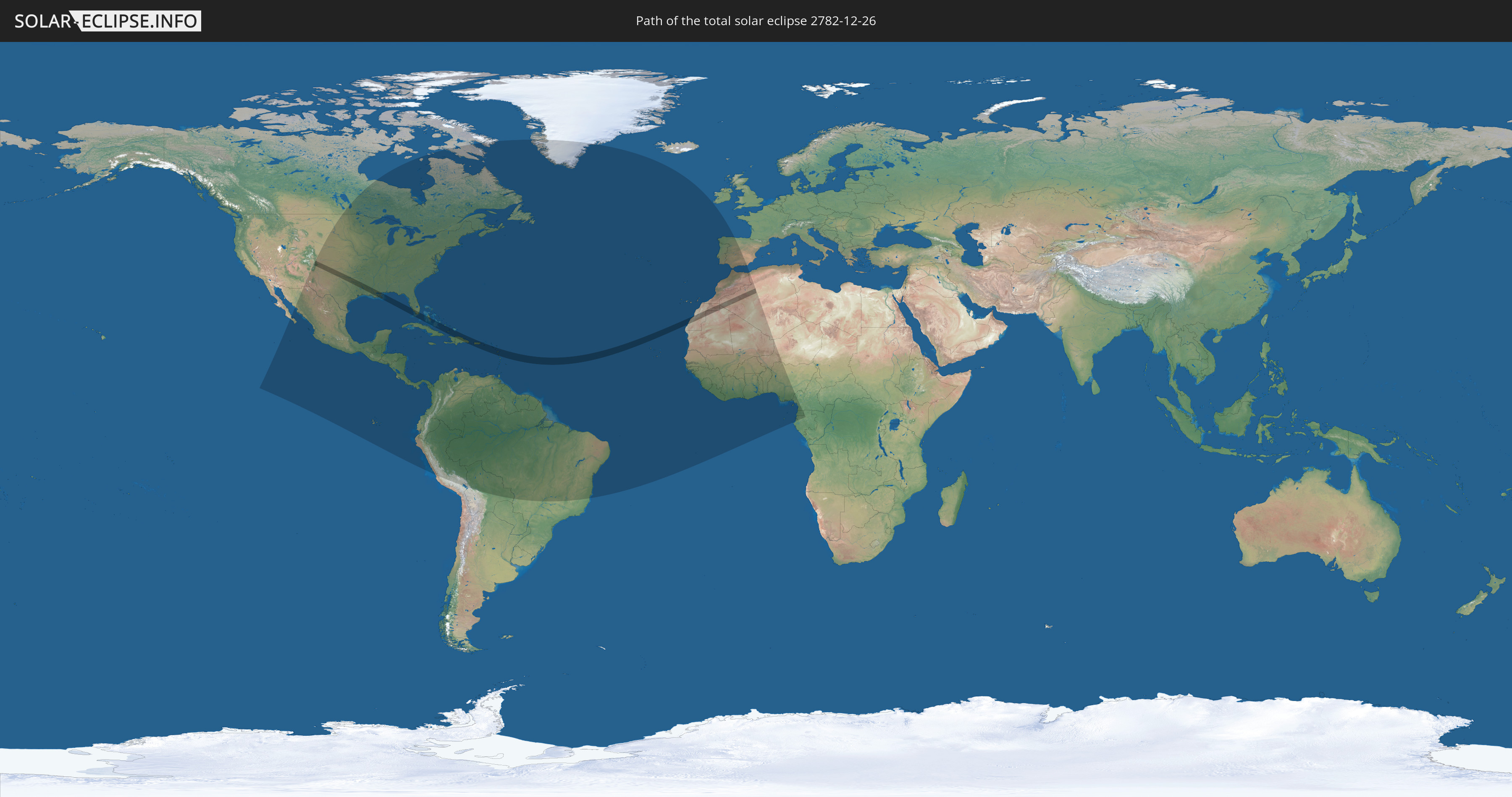
Die Sonnenfinsternis am 12/26/2782 kann man in 75 Ländern als partielle Sonnenfinsternis beobachten.
Der Finsternispfad verläuft durch 15 Länder. Nur in diesen Ländern ist sie als total Sonnenfinsternis zu sehen.
In den folgenden Ländern ist die Sonnenfinsternis total zu sehen
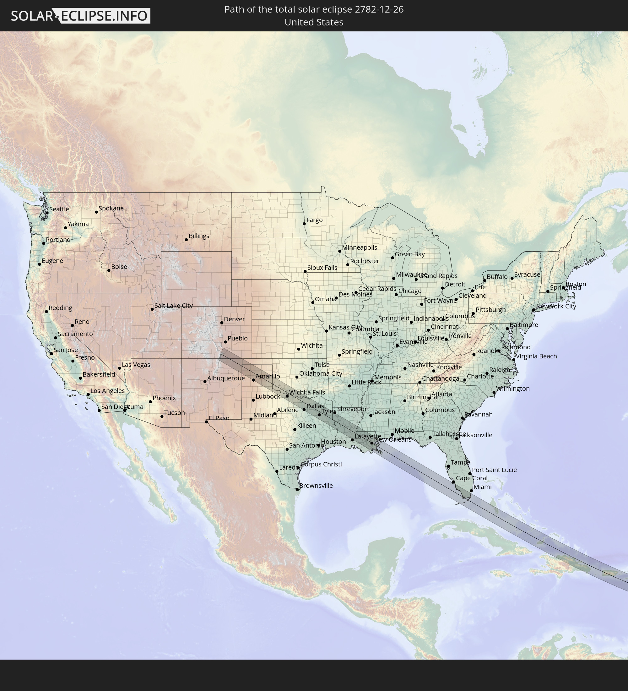 United States
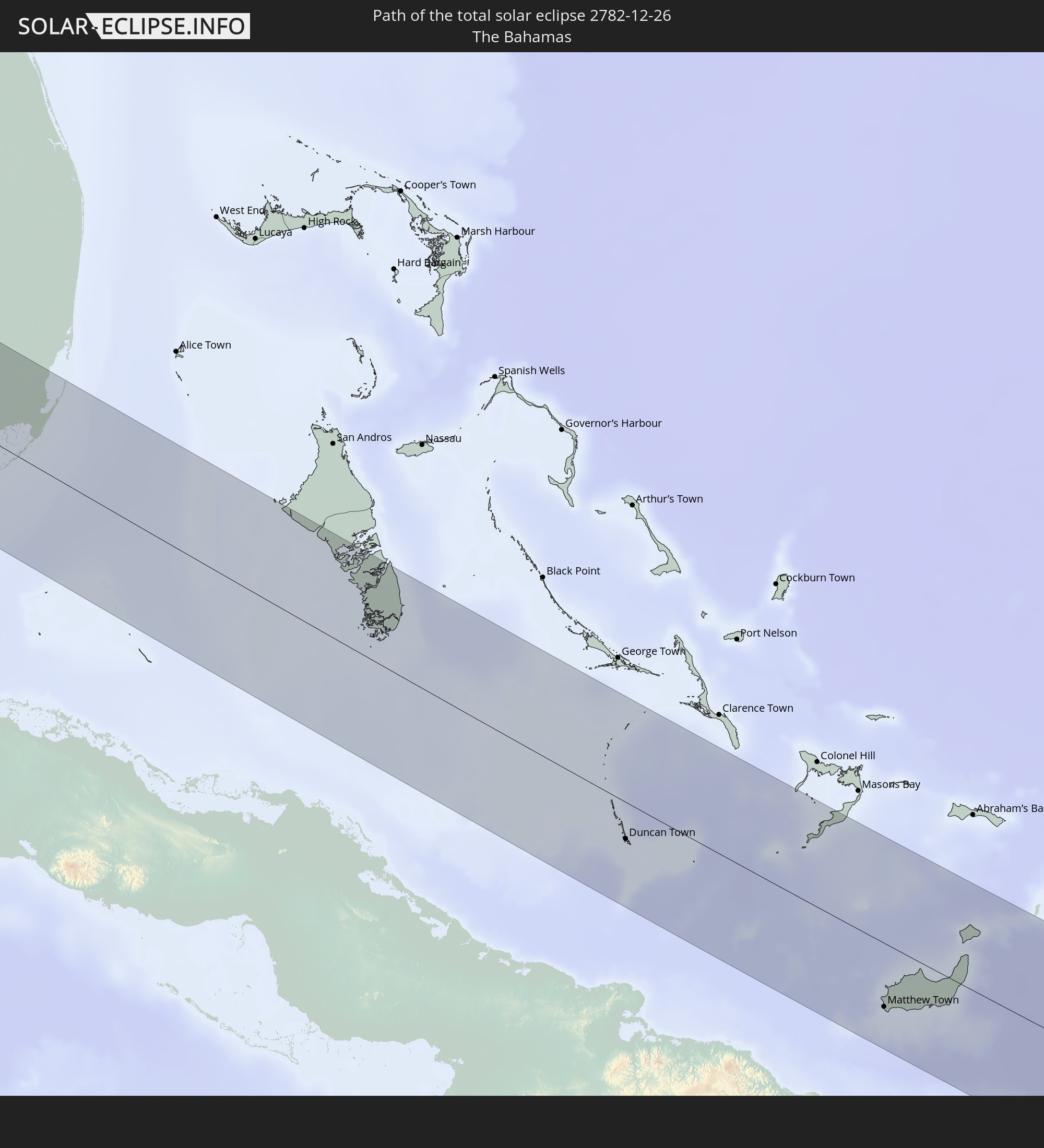 The Bahamas
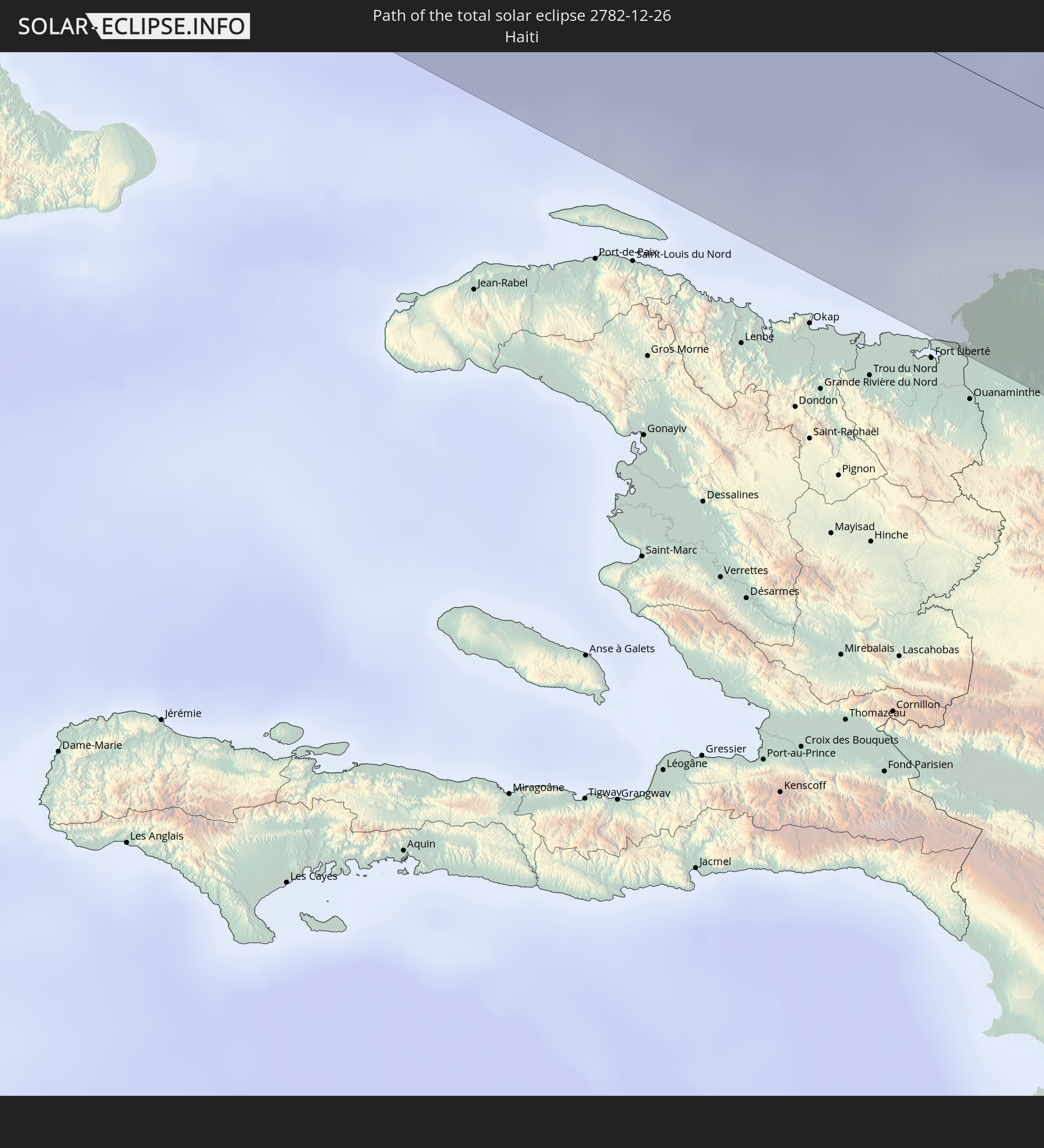 Haiti
Haiti
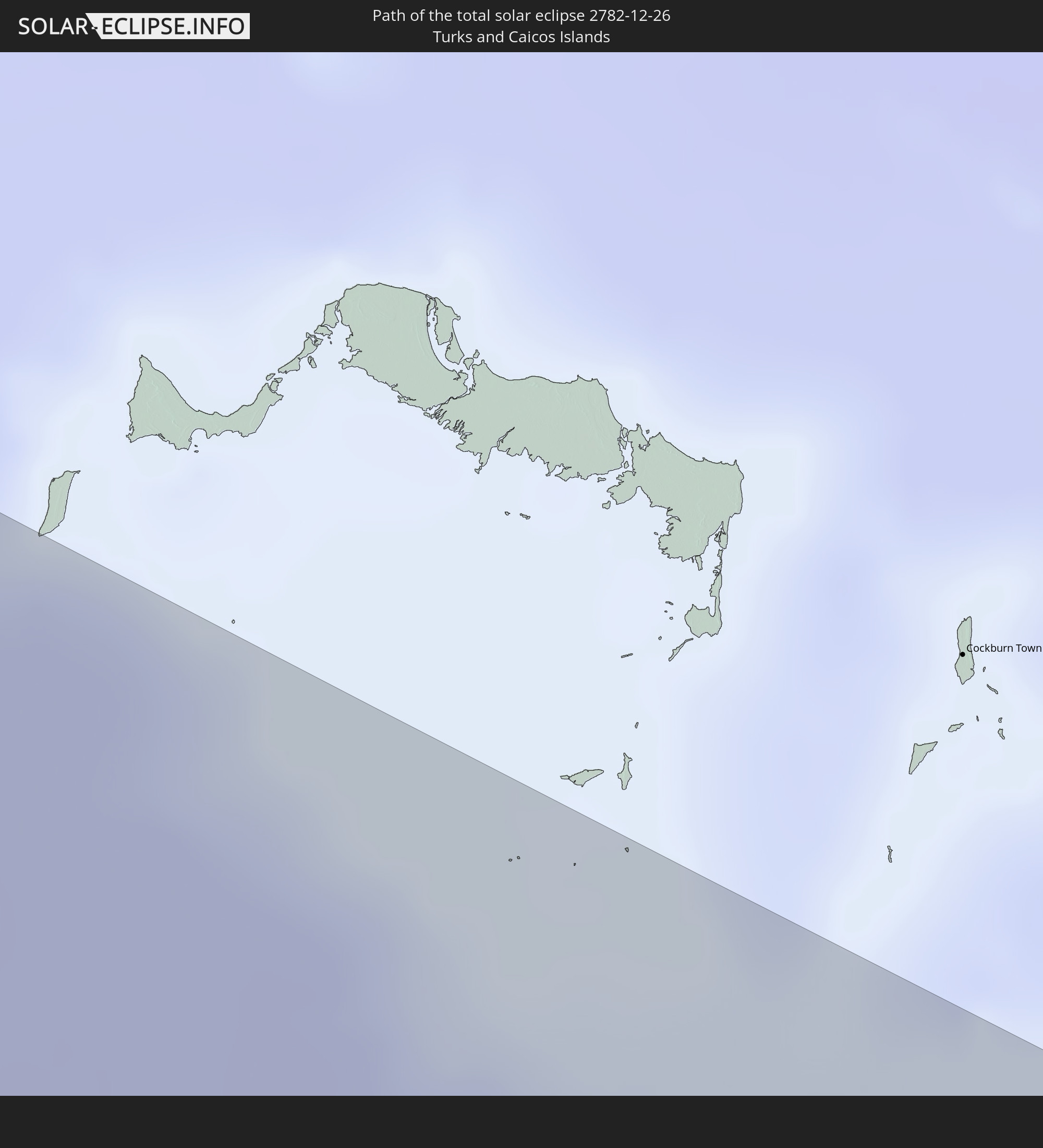 Turks and Caicos Islands
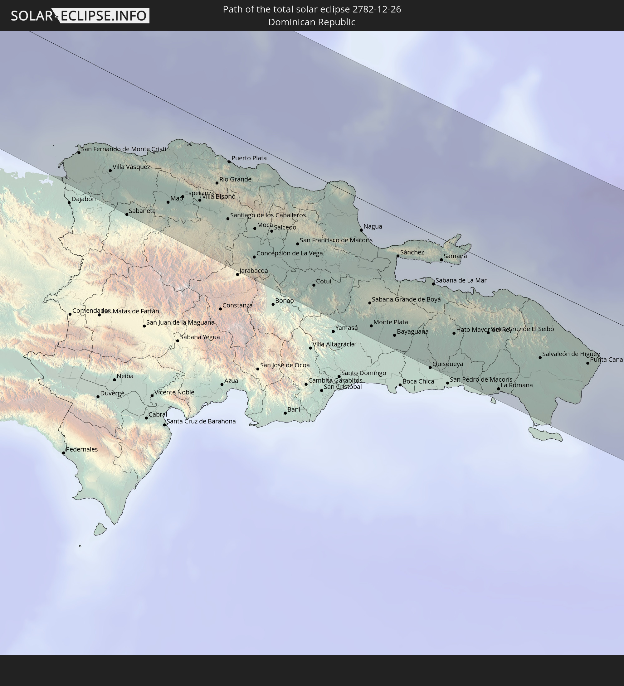 Dominican Republic
 Puerto Rico
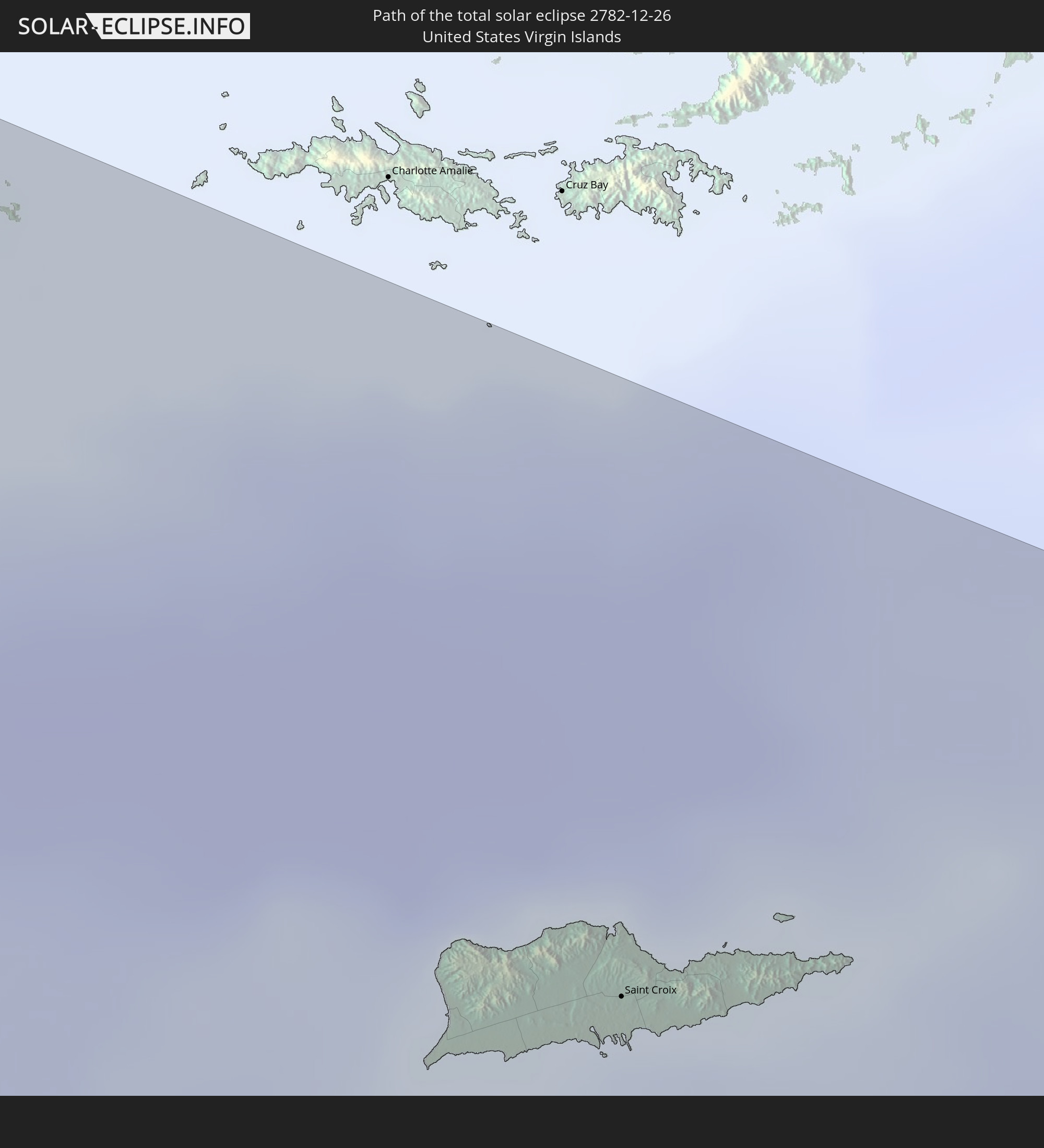 United States Virgin Islands
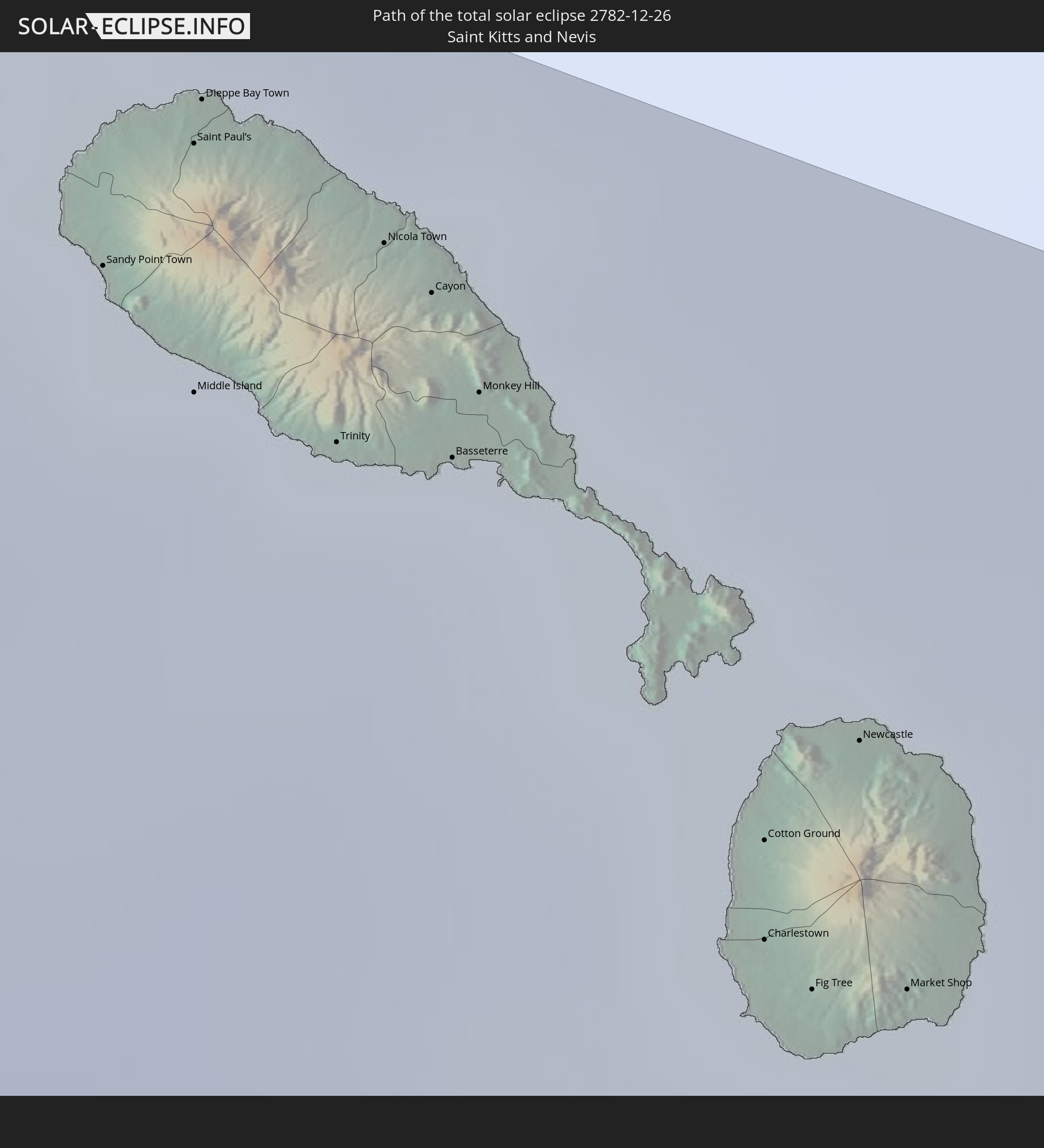 Saint Kitts and Nevis
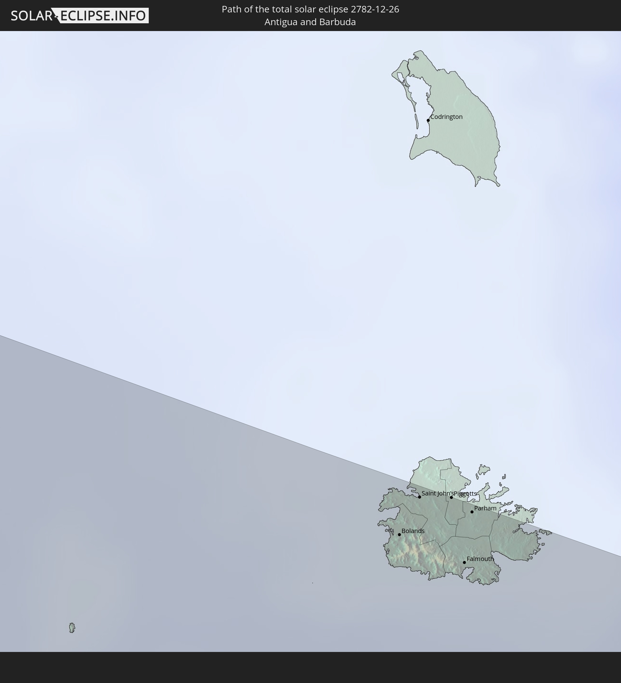 Antigua and Barbuda
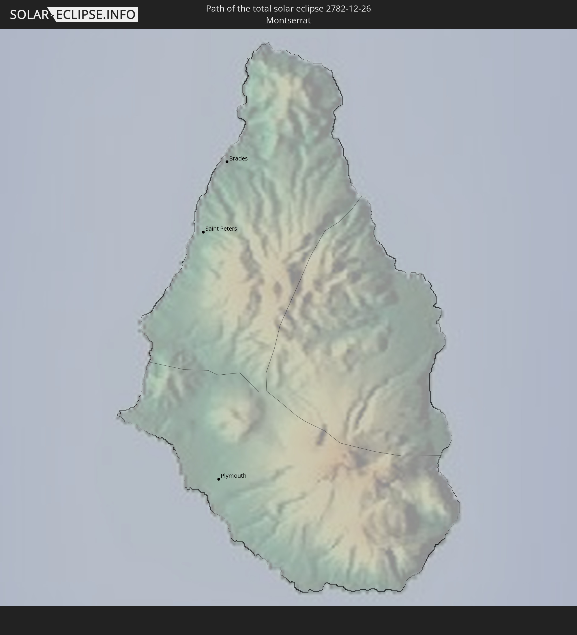 Montserrat
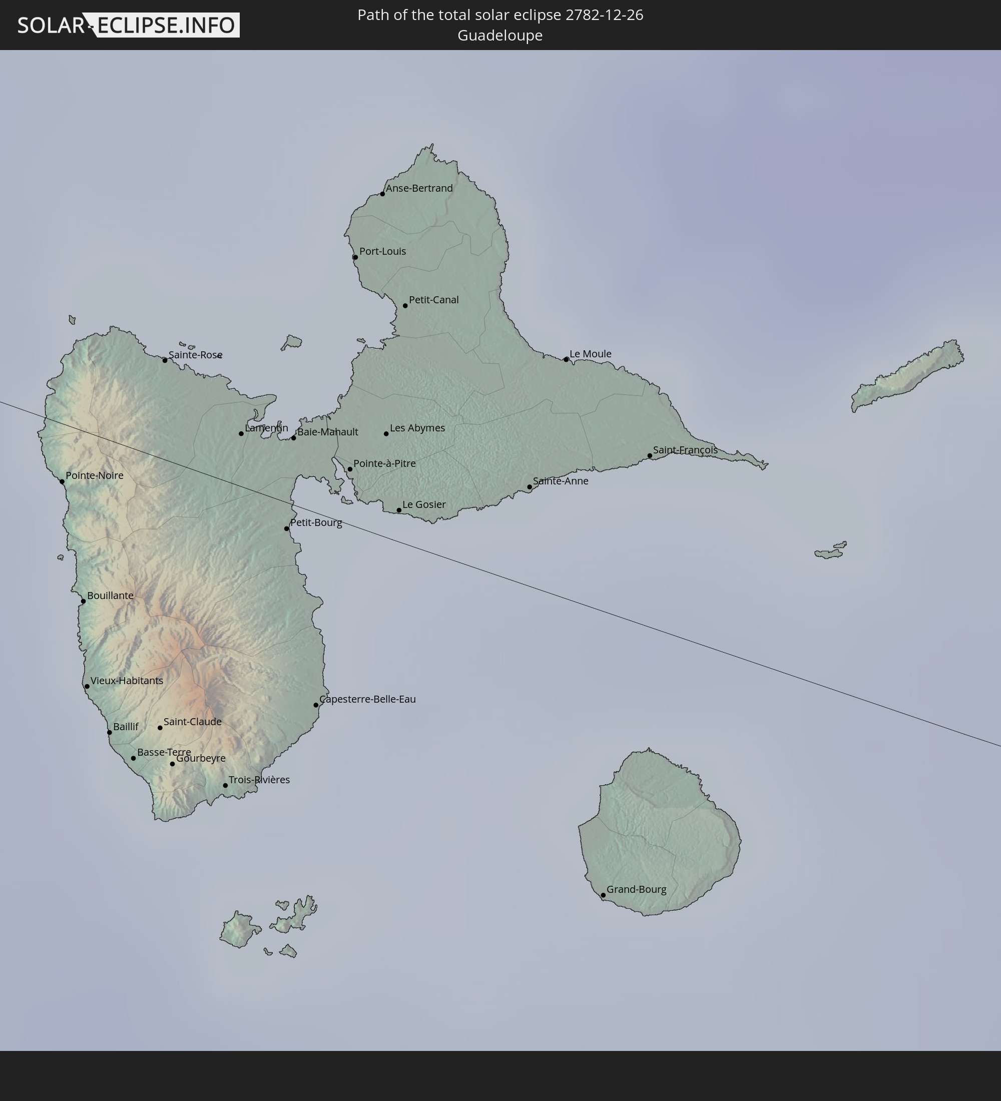 Guadeloupe
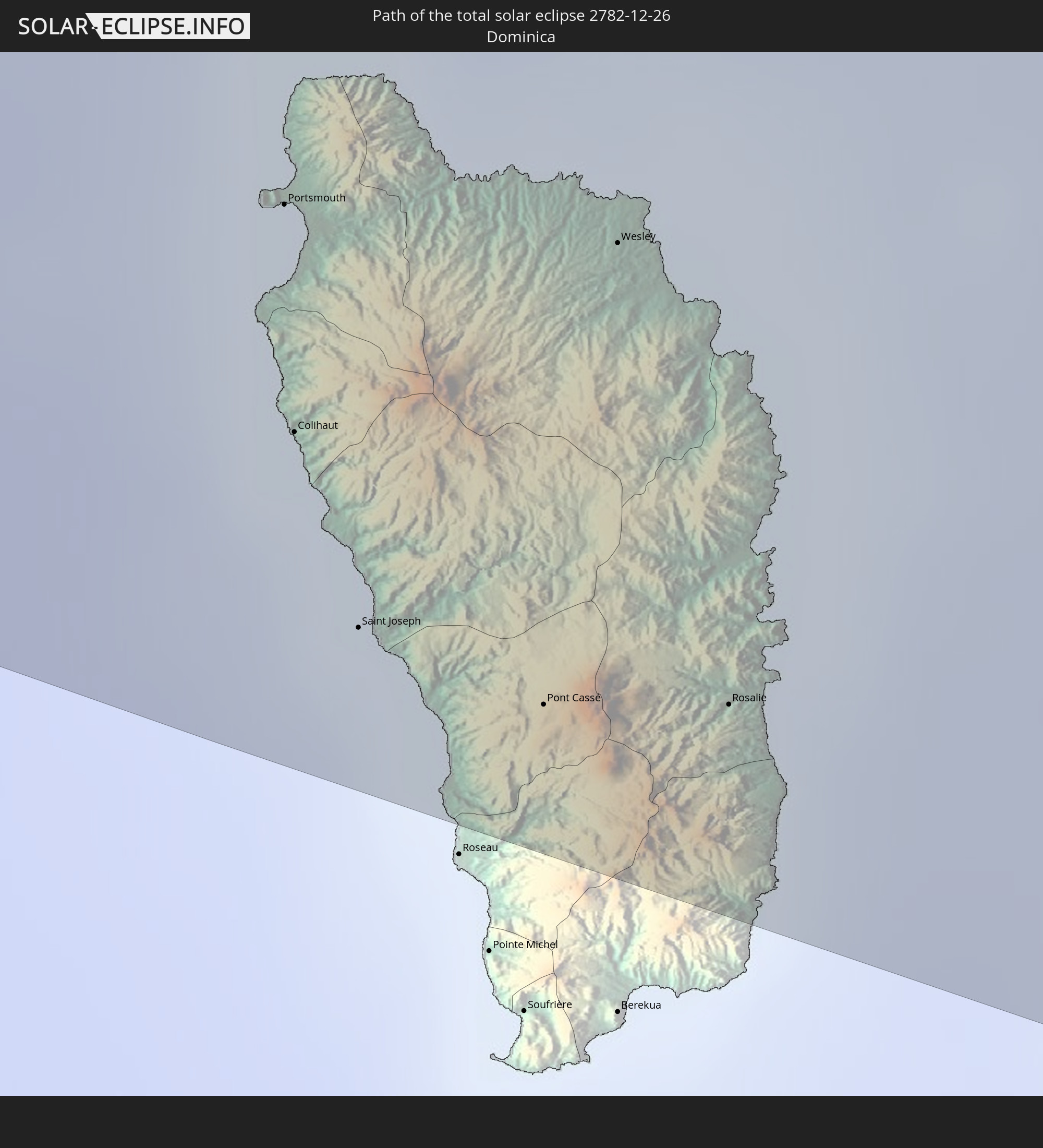 Dominica
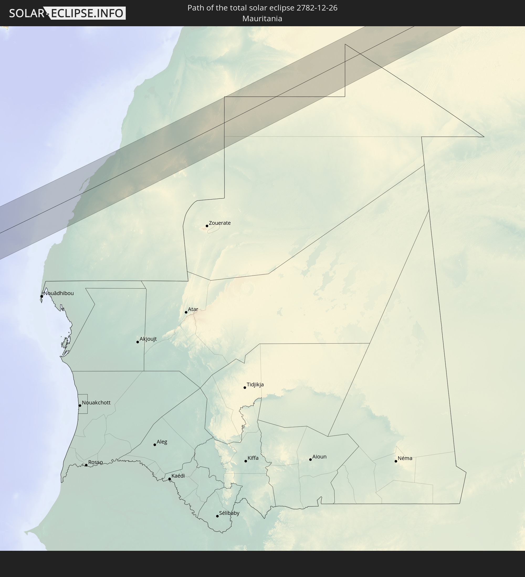 Mauritania
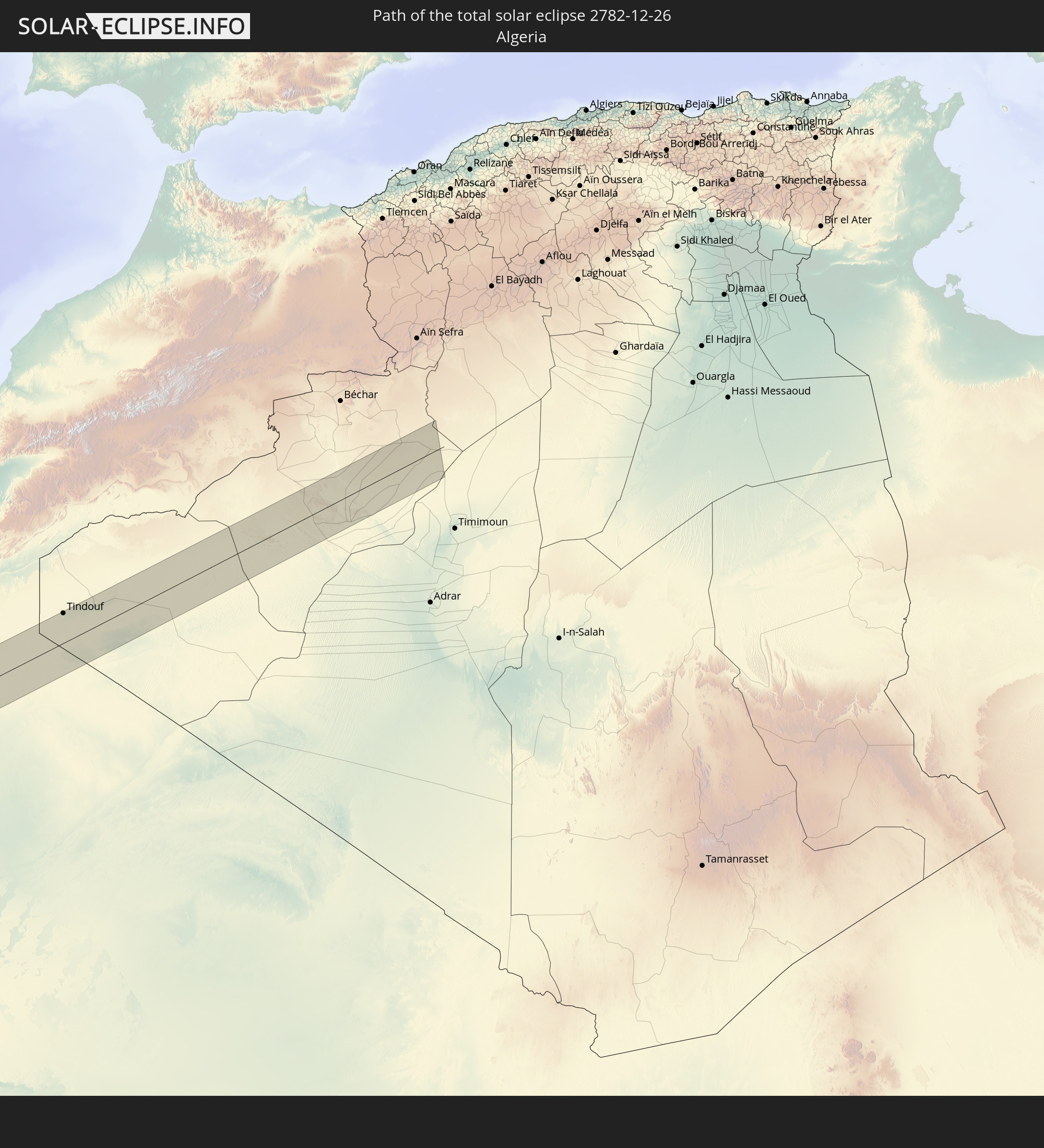 Algeria
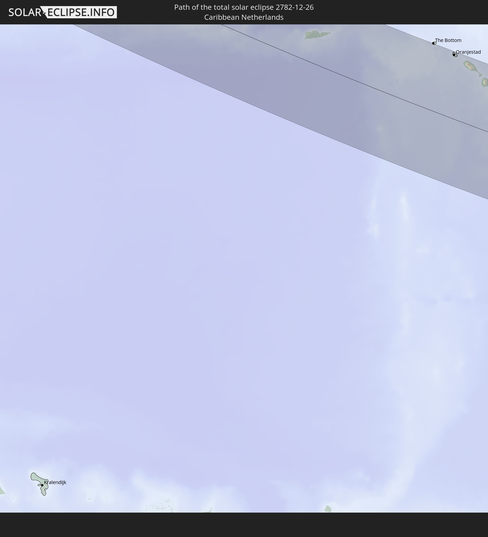 Caribbean Netherlands
In den folgenden Ländern ist die Sonnenfinsternis partiell zu sehen
 United States
 United States Minor Outlying Islands
 Canada
 Mexico
 Greenland
 Guatemala
 Ecuador
 El Salvador
 Honduras
 Belize
 Nicaragua
 Costa Rica
 Cuba
Cuba
 Panama
 Colombia
 Cayman Islands
 Peru
Peru
 The Bahamas
 Jamaica
 Haiti
Haiti
 Brazil
 Venezuela
 Turks and Caicos Islands
 Dominican Republic
 Aruba
Aruba
 Bolivia
 Puerto Rico
 United States Virgin Islands
 Bermuda
 British Virgin Islands
 Anguilla
 Collectivity of Saint Martin
 Saint Barthélemy
 Saint Kitts and Nevis
 Antigua and Barbuda
 Montserrat
 Trinidad and Tobago
 Guadeloupe
 Grenada
 Dominica
 Saint Vincent and the Grenadines
 Guyana
 Martinique
 Saint Lucia
 Barbados
 Suriname
 Saint Pierre and Miquelon
 French Guiana
 Portugal
 Cabo Verde
 Spain
Spain
 Senegal
 Mauritania
 The Gambia
 Guinea-Bissau
 Guinea
 Saint Helena, Ascension and Tristan da Cunha
 Sierra Leone
 Morocco
 Mali
Mali
 Liberia
 Republic of Ireland
 Algeria
 Ivory Coast
 Burkina Faso
 Gibraltar
 Ghana
Ghana
 Togo
Togo
 Niger
Niger
 Benin
Benin
 Nigeria
 Equatorial Guinea
 São Tomé and Príncipe
 Cameroon
 Gabon
Gabon
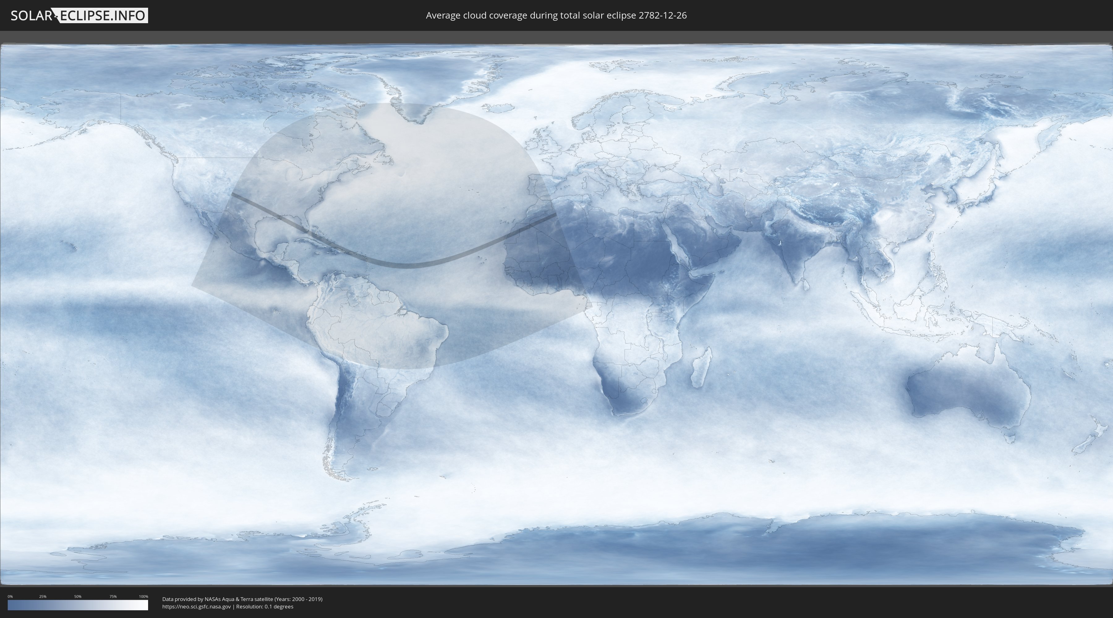
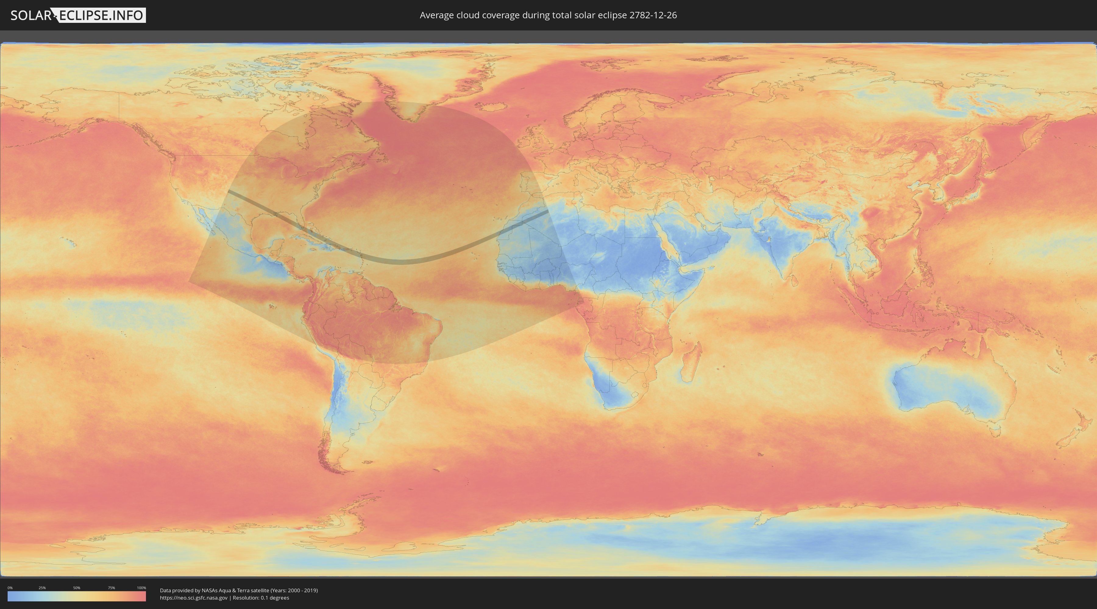
How will be the weather during the total solar eclipse on 12/26/2782?
Where is the best place to see the total solar eclipse of 12/26/2782?
The following maps show the average cloud coverage for the day of the total solar eclipse.
With the help of these maps, it is possible to find the place along the eclipse path, which has the best
chance of a cloudless sky.
Nevertheless, you should consider local circumstances and inform about the weather of your chosen
observation site.
The data is provided by NASAs satellites
AQUA and TERRA.
The cloud maps are averaged over a period of 19 years (2000 - 2019).
Detailed country maps
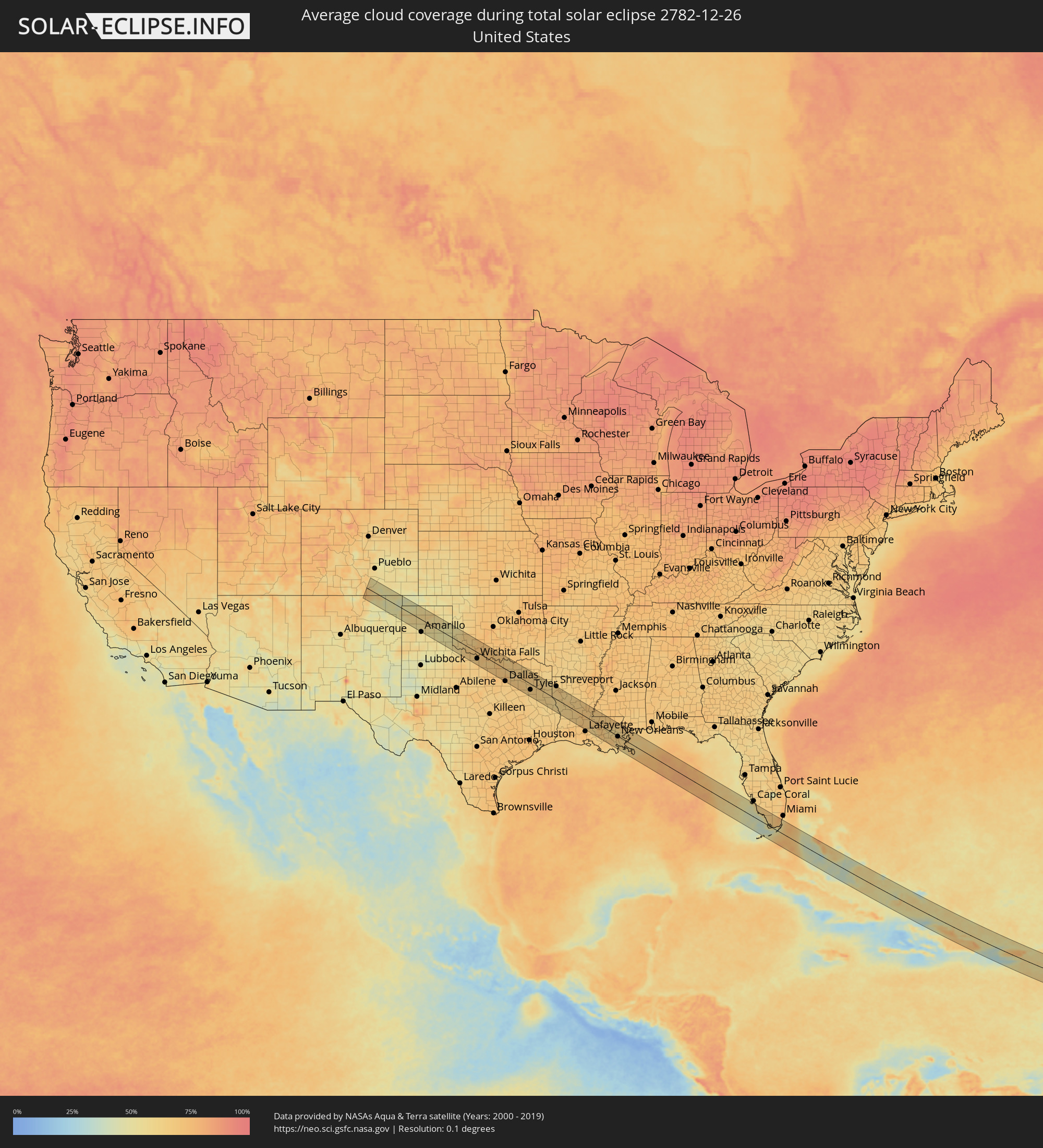 United States
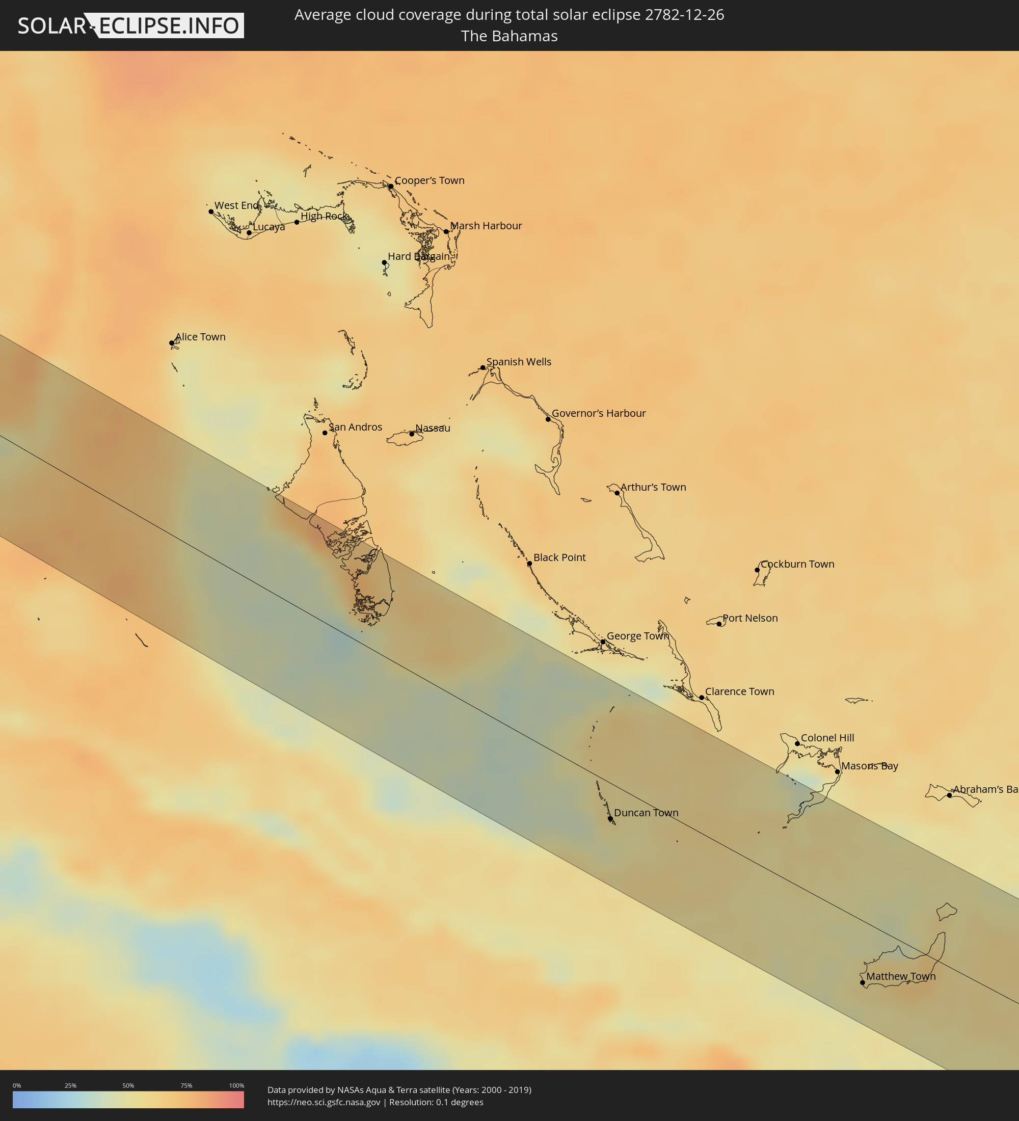 The Bahamas
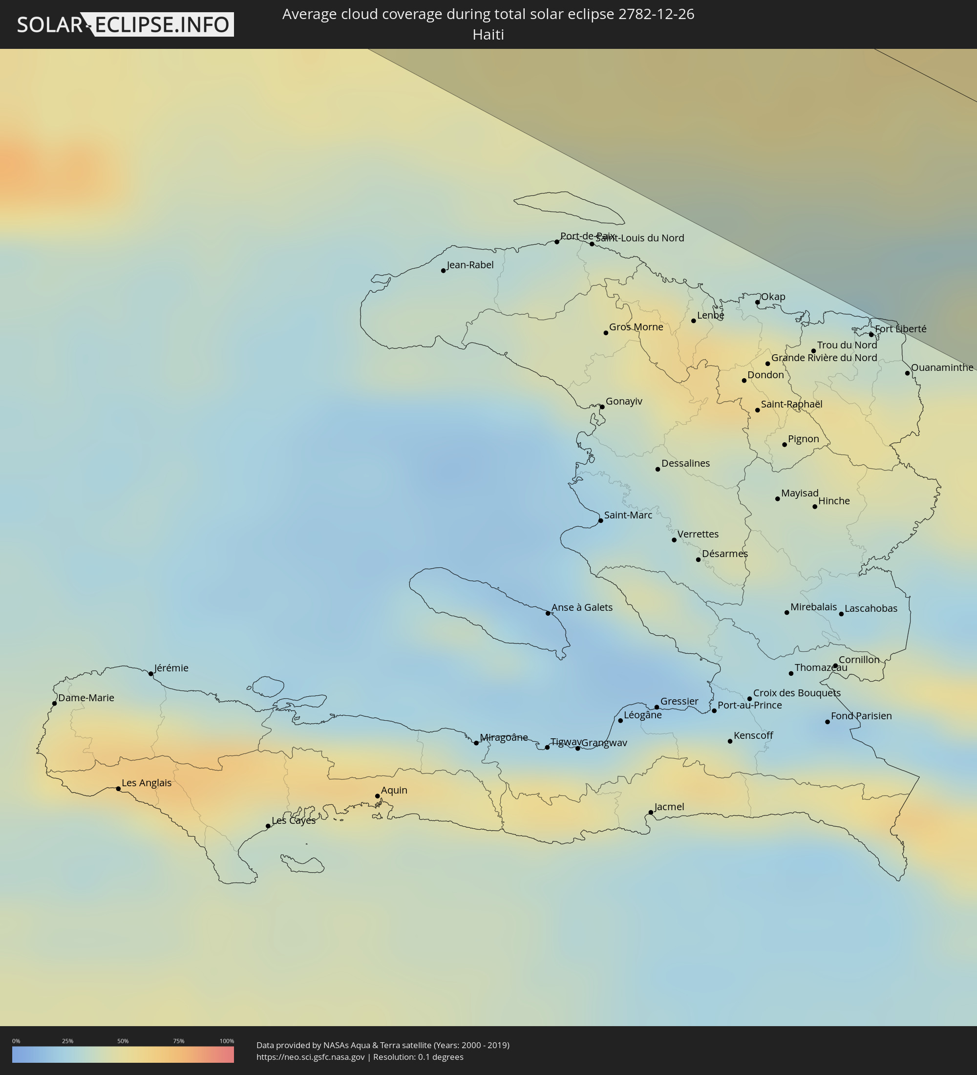 Haiti
Haiti
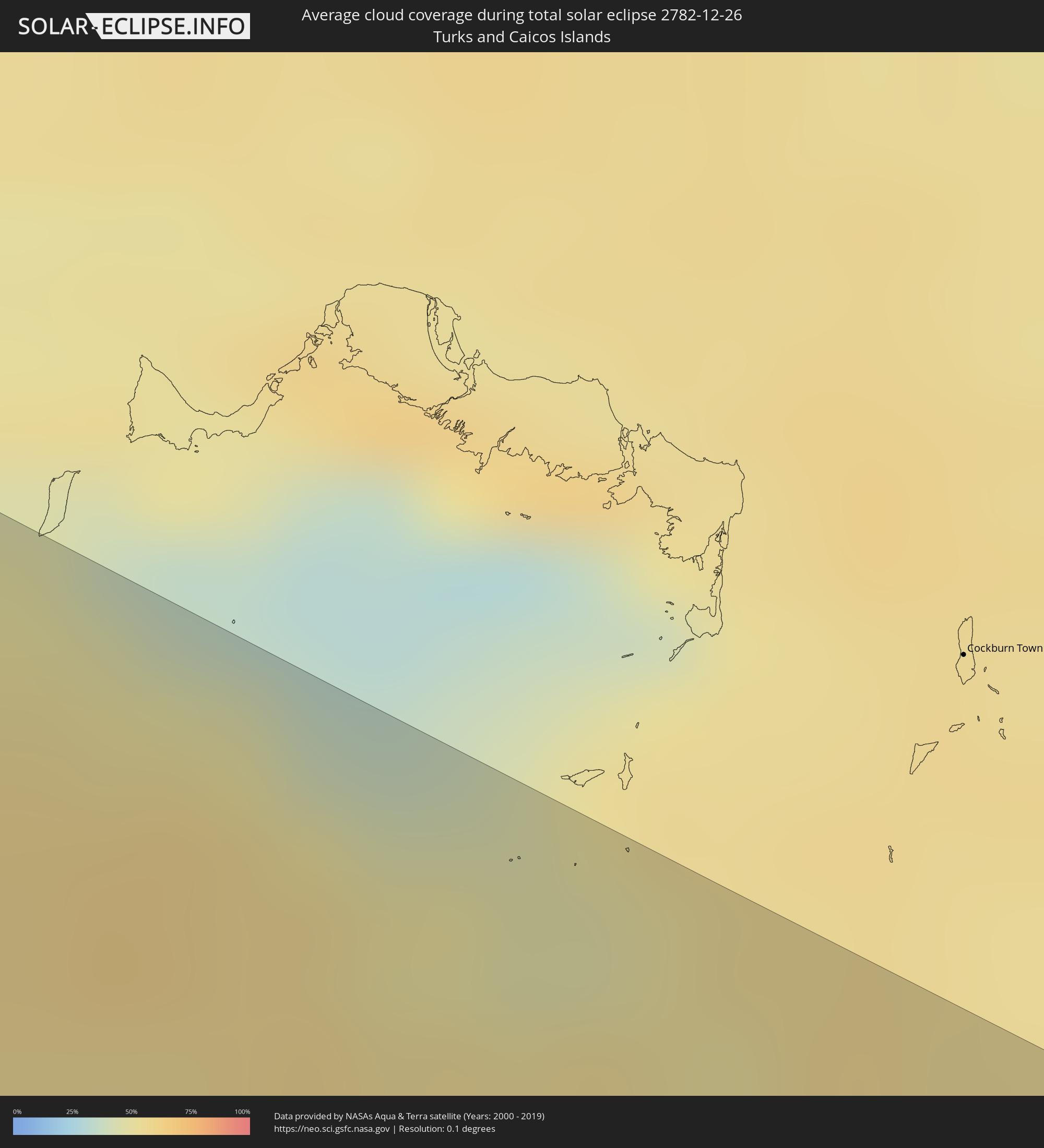 Turks and Caicos Islands
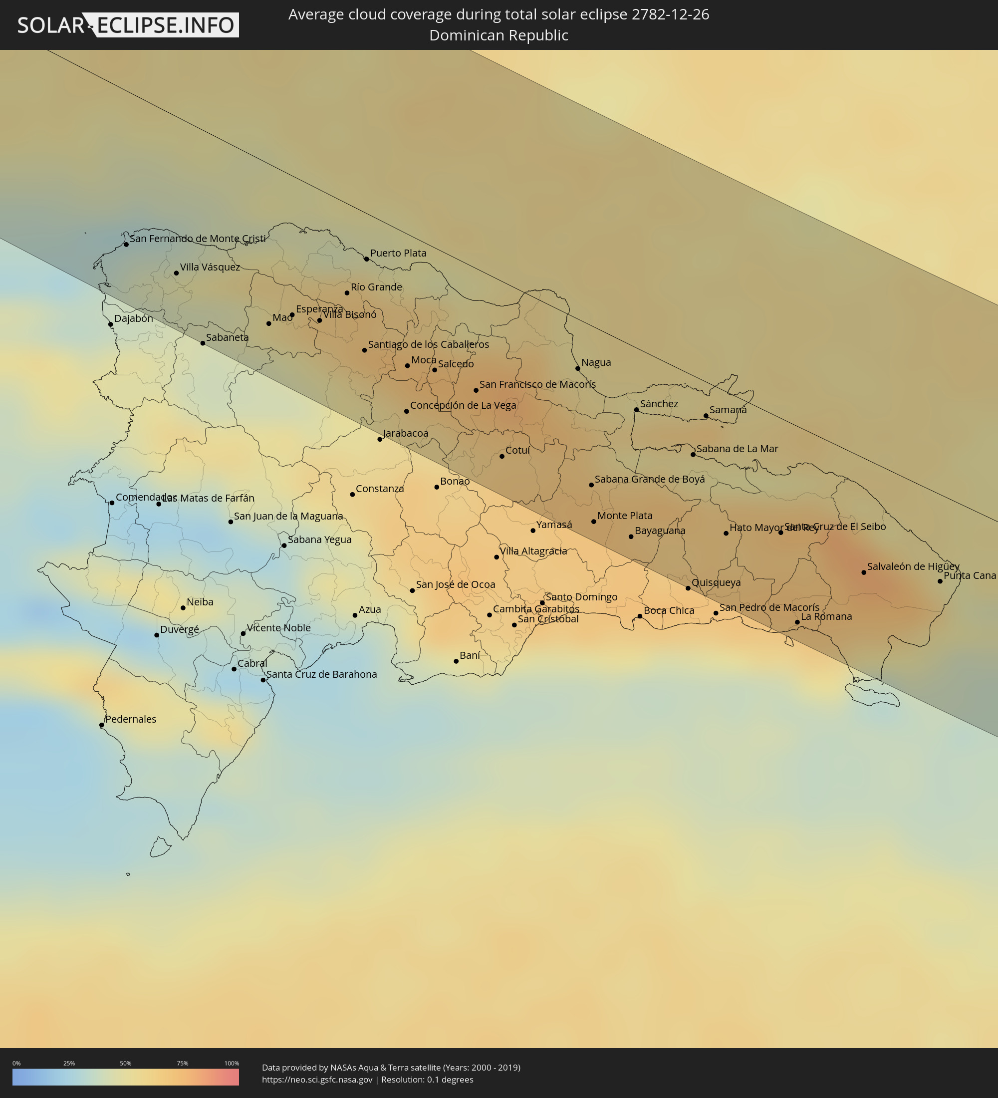 Dominican Republic
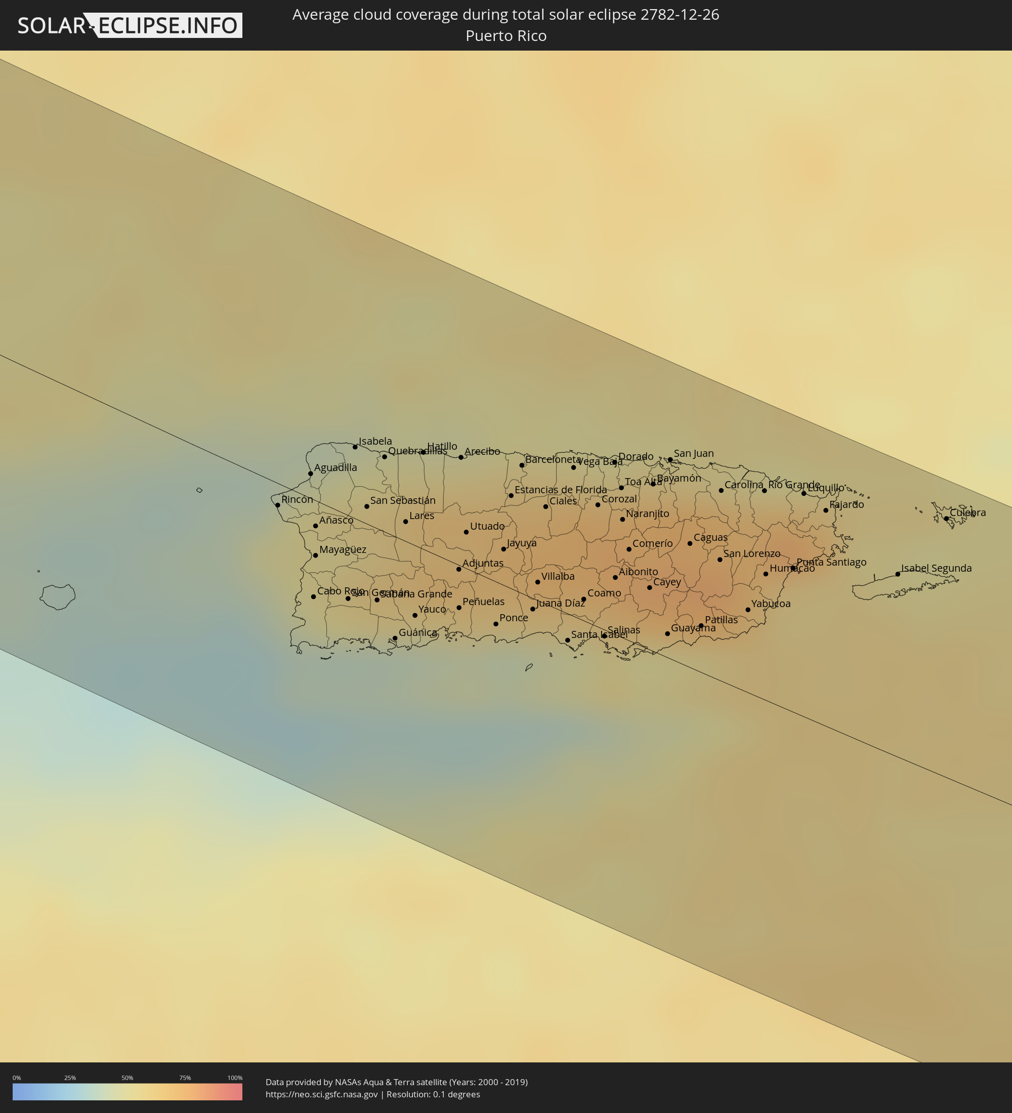 Puerto Rico
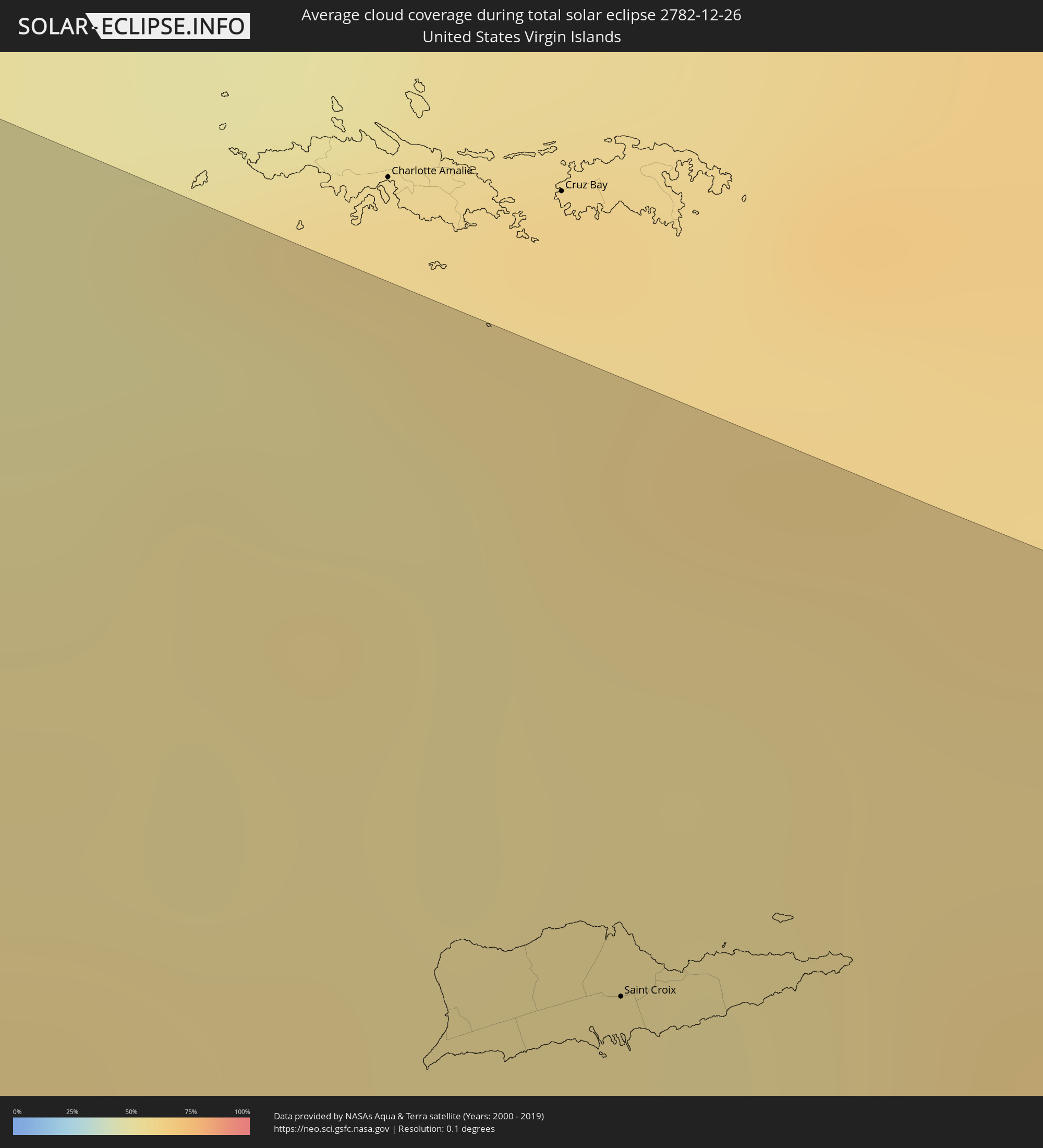 United States Virgin Islands
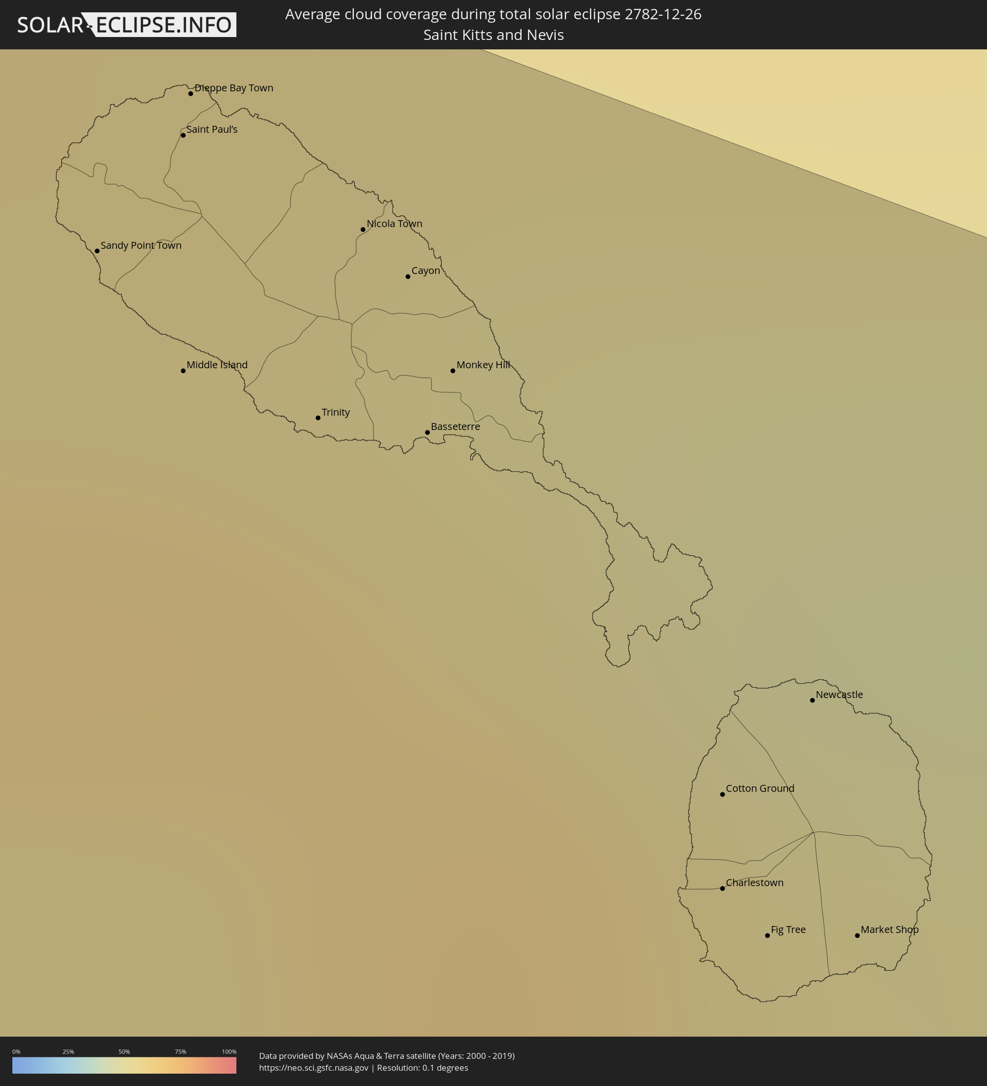 Saint Kitts and Nevis
 Antigua and Barbuda
 Montserrat
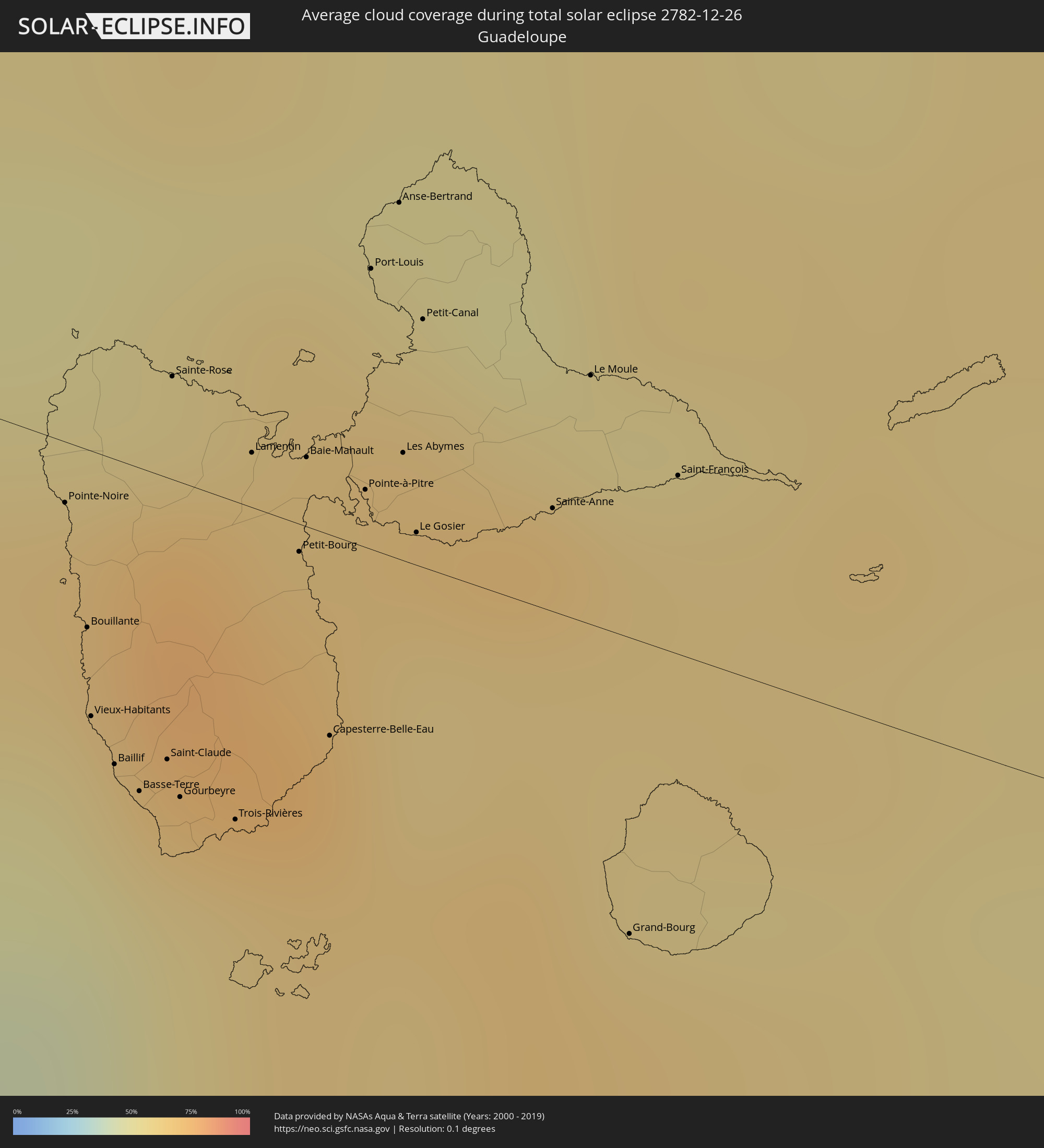 Guadeloupe
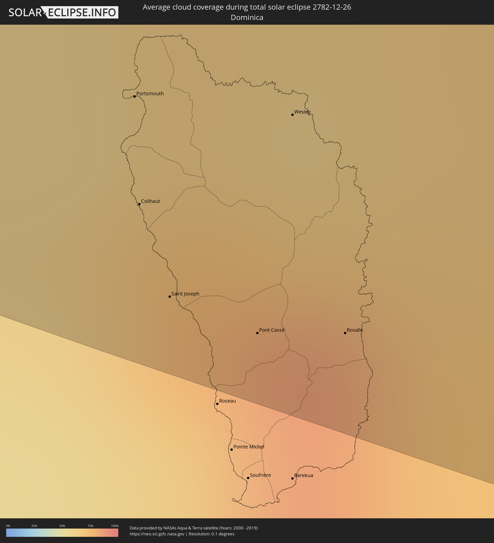 Dominica
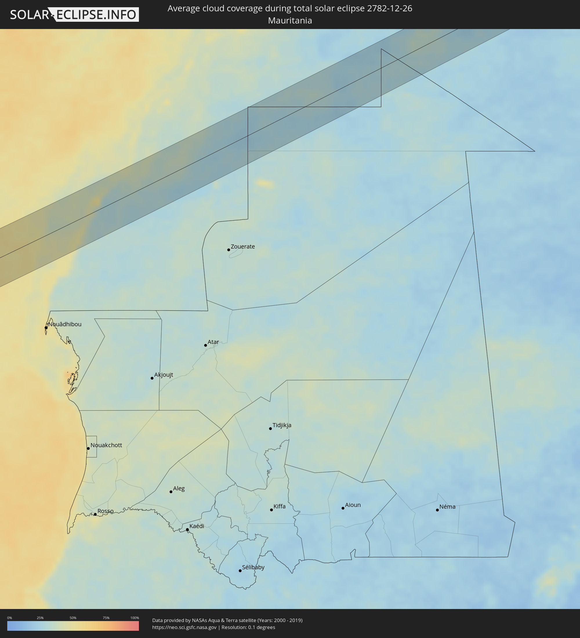 Mauritania
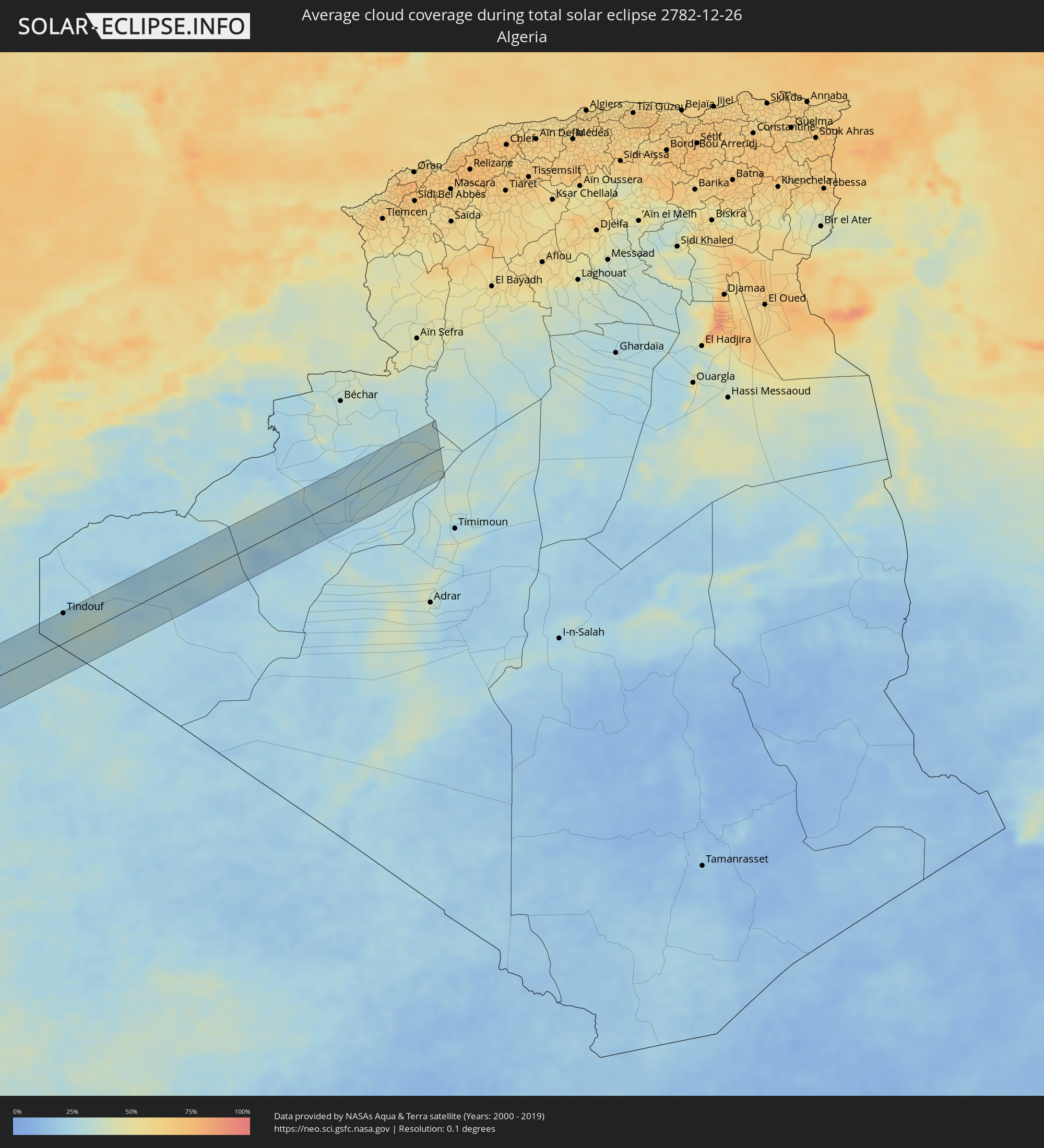 Algeria
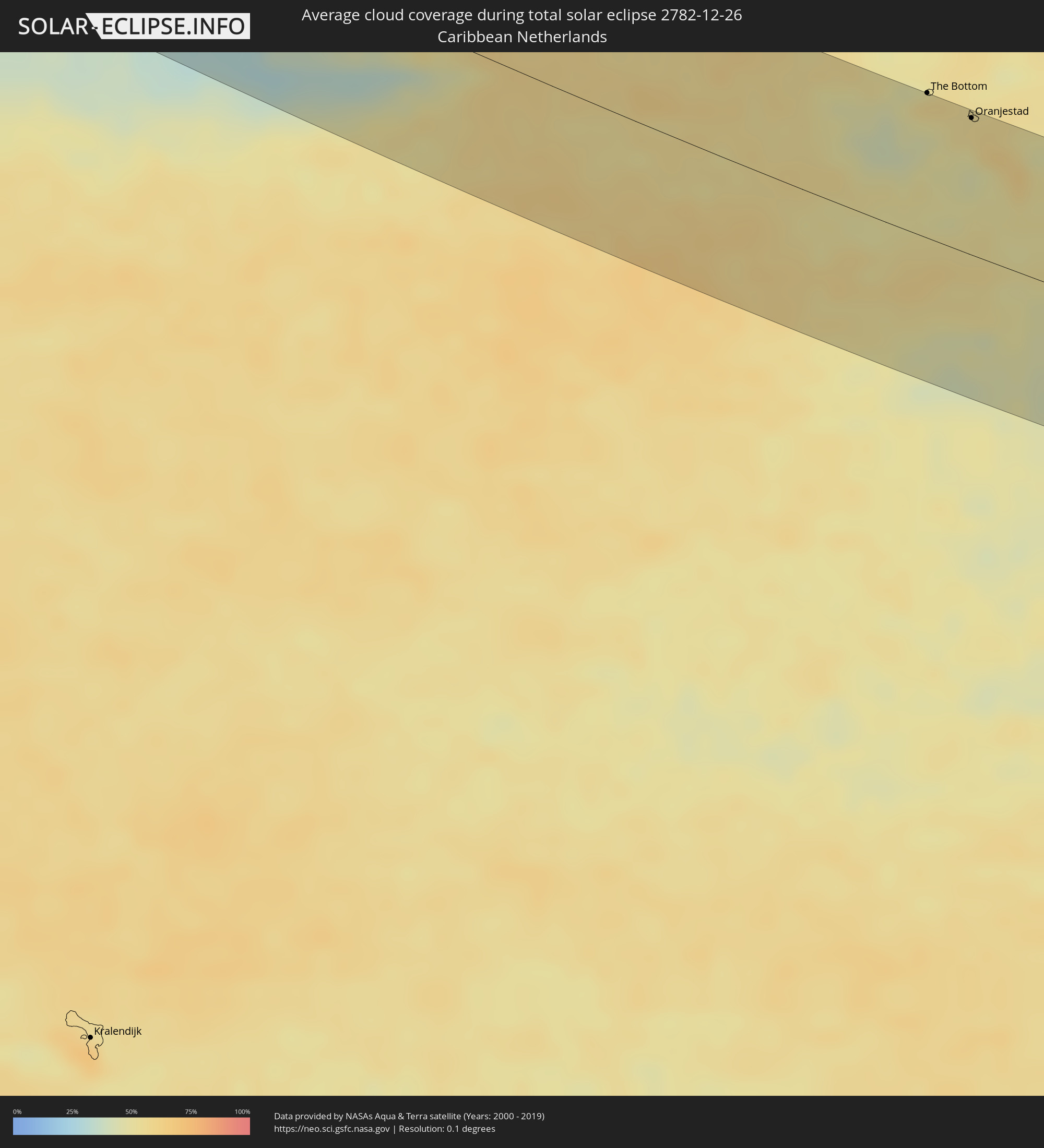 Caribbean Netherlands
Cities inside the path of the eclipse
The following table shows all locations with a population of more than 5,000 inside the eclipse path. Cities which have more than 100,000 inhabitants are marked bold. A click at the locations opens a detailed map.
| City | Type | Eclipse duration | Local time of max. eclipse | Distance to central line | Ø Cloud coverage |
|
Wichita Falls, Texas
|
total | - | 08:16:37 UTC-06:00 | 30 km | 65% |
|
Lawton, Oklahoma
|
total | - | 08:17:10 UTC-06:00 | 42 km | 71% |
|
Denton, Texas
|
total | - | 08:16:59 UTC-06:00 | 33 km | 69% |
|
Flower Mound, Texas
|
total | - | 08:16:53 UTC-06:00 | 50 km | 69% |
|
Carrollton, Texas
|
total | - | 08:16:58 UTC-06:00 | 46 km | 73% |
|
Frisco, Texas
|
total | - | 08:17:09 UTC-06:00 | 24 km | 71% |
|
Dallas, Texas
|
total | - | 08:16:55 UTC-06:00 | 59 km | 68% |
|
Plano, Texas
|
total | - | 08:17:09 UTC-06:00 | 31 km | 70% |
|
McKinney, Texas
|
total | - | 08:17:19 UTC-06:00 | 10 km | 67% |
|
Mesquite, Texas
|
total | - | 08:17:03 UTC-06:00 | 50 km | 68% |
|
Tyler, Texas
|
total | - | 08:17:41 UTC-06:00 | 28 km | 66% |
|
Longview, Texas
|
total | - | 08:18:11 UTC-06:00 | 13 km | 67% |
|
Baton Rouge, Louisiana
|
total | - | 08:19:55 UTC-06:00 | 8 km | 71% |
|
Kenner, Louisiana
|
total | - | 08:20:31 UTC-06:00 | 7 km | 69% |
|
New Orleans, Louisiana
|
total | - | 08:20:39 UTC-06:00 | 3 km | 69% |
|
Duncan Town, Ragged Island
|
total | - | 09:37:25 UTC-05:00 | 26 km | 48% |
|
Matthew Town, Inagua
|
total | - | 09:41:08 UTC-05:00 | 46 km | 48% |
|
Mao, Valverde
|
total | - | 10:46:23 UTC-04:00 | 60 km | 44% |
|
Villa Bisonó, Santiago
|
total | - | 10:46:48 UTC-04:00 | 49 km | 54% |
|
Santiago de los Caballeros, Santiago
|
total | - | 10:47:12 UTC-04:00 | 52 km | 58% |
|
Puerto Plata, Puerto Plata
|
total | - | 10:47:12 UTC-04:00 | 17 km | 60% |
|
Concepción de La Vega, La Vega
|
total | - | 10:47:34 UTC-04:00 | 67 km | 57% |
|
Moca, Espaillat
|
total | - | 10:47:34 UTC-04:00 | 49 km | 64% |
|
San Francisco de Macorís, Duarte
|
total | - | 10:48:10 UTC-04:00 | 46 km | 65% |
|
Cotuí, Sánchez Ramírez
|
total | - | 10:48:24 UTC-04:00 | 66 km | 66% |
|
Nagua, María Trinidad Sánchez
|
total | - | 10:49:02 UTC-04:00 | 19 km | 57% |
|
Bayaguana, Monte Plata
|
total | - | 10:49:33 UTC-04:00 | 72 km | 68% |
|
Hato Mayor del Rey, Hato Mayor
|
total | - | 10:50:24 UTC-04:00 | 54 km | 66% |
|
Santa Cruz de El Seibo, El Seíbo
|
total | - | 10:50:53 UTC-04:00 | 43 km | 67% |
|
La Romana, La Romana
|
total | - | 10:51:04 UTC-04:00 | 74 km | 55% |
|
Salvaleón de Higüey, La Altagracia
|
total | - | 10:51:39 UTC-04:00 | 43 km | 73% |
|
Punta Cana, La Altagracia
|
total | - | 10:52:21 UTC-04:00 | 33 km | 62% |
|
Aguadilla, Aguadilla
|
total | - | 10:55:18 UTC-04:00 | 7 km | 49% |
|
Mayagüez, Mayaguez
|
total | - | 10:55:22 UTC-04:00 | 15 km | 54% |
|
Isabela, Isabela
|
total | - | 10:55:37 UTC-04:00 | 20 km | 50% |
|
Yauco, Yauco
|
total | - | 10:56:05 UTC-04:00 | 20 km | 41% |
|
Arecibo, Arecibo
|
total | - | 10:56:21 UTC-04:00 | 30 km | 56% |
|
Ponce, Ponce
|
total | - | 10:56:40 UTC-04:00 | 12 km | 41% |
|
Barceloneta, Barceloneta
|
total | - | 10:56:47 UTC-04:00 | 36 km | 58% |
|
Vega Baja, Vega Baja
|
total | - | 10:57:09 UTC-04:00 | 42 km | 71% |
|
Cayey, Cayey
|
total | - | 10:57:45 UTC-04:00 | 17 km | 70% |
|
Guayama, Guayama
|
total | - | 10:57:53 UTC-04:00 | 7 km | 53% |
|
San Juan, San Juan
|
total | - | 10:57:51 UTC-04:00 | 56 km | 57% |
|
Caguas, Caguas
|
total | - | 10:58:01 UTC-04:00 | 35 km | 78% |
|
Carolina, Carolina
|
total | - | 10:58:13 UTC-04:00 | 54 km | 71% |
|
Humacao, Humacao
|
total | - | 10:58:34 UTC-04:00 | 36 km | 56% |
|
Fajardo, Fajardo
|
total | - | 10:58:59 UTC-04:00 | 61 km | 70% |
|
Saint Croix, Saint Croix Island
|
total | - | 11:01:21 UTC-04:00 | 37 km | 58% |
 Oranjestad, Sint Eustatius
|
total | - | 11:06:00 UTC-04:00 | 82 km | 54% |
|
Sandy Point Town, Saint Anne Sandy Point
|
total | - | 11:06:23 UTC-04:00 | 74 km | 60% |
|
Middle Island, Saint Thomas Middle Island
|
total | - | 11:06:29 UTC-04:00 | 71 km | 55% |
|
Saint Paul’s, Saint Paul Capesterre
|
total | - | 11:06:28 UTC-04:00 | 79 km | 60% |
|
Dieppe Bay Town, Saint John Capesterre
|
total | - | 11:06:28 UTC-04:00 | 81 km | 60% |
|
Trinity, Trinity Palmetto Point
|
total | - | 11:06:37 UTC-04:00 | 71 km | 55% |
|
Nicola Town, Christ Church Nichola Town
|
total | - | 11:06:39 UTC-04:00 | 78 km | 60% |
|
Cayon, Saint Mary Cayon
|
total | - | 11:06:42 UTC-04:00 | 77 km | 55% |
|
Basseterre, Saint George Basseterre
|
total | - | 11:06:44 UTC-04:00 | 72 km | 61% |
|
Monkey Hill, Saint Peter Basseterre
|
total | - | 11:06:45 UTC-04:00 | 74 km | 61% |
|
Cotton Ground, Saint Thomas Lowland
|
total | - | 11:07:03 UTC-04:00 | 63 km | 52% |
|
Charlestown, Saint Paul Charlestown
|
total | - | 11:07:03 UTC-04:00 | 59 km | 51% |
|
Fig Tree, Saint John Figtree
|
total | - | 11:07:06 UTC-04:00 | 58 km | 51% |
|
Newcastle, Saint James Windwa
|
total | - | 11:07:08 UTC-04:00 | 67 km | 52% |
|
Market Shop, Saint George Gingerland
|
total | - | 11:07:12 UTC-04:00 | 59 km | 51% |
|
Saint Peters, Saint Peter
|
total | - | 11:08:13 UTC-04:00 | 36 km | 61% |
|
Plymouth, Saint Anthony
|
total | - | 11:08:14 UTC-04:00 | 29 km | 60% |
|
Brades, Saint Peter
|
total | - | 11:08:13 UTC-04:00 | 38 km | 61% |
|
Bolands, Saint Mary
|
total | - | 11:09:05 UTC-04:00 | 79 km | 60% |
|
Saint John’s, Saint John
|
total | - | 11:09:09 UTC-04:00 | 86 km | 58% |
|
Piggotts, Saint George
|
total | - | 11:09:17 UTC-04:00 | 87 km | 58% |
|
Pointe-Noire, Guadeloupe
|
total | - | 11:09:30 UTC-04:00 | 5 km | 62% |
|
Falmouth, Saint Paul
|
total | - | 11:09:21 UTC-04:00 | 79 km | 55% |
|
Parham, Saint Peter
|
total | - | 11:09:22 UTC-04:00 | 86 km | 58% |
|
Bouillante, Guadeloupe
|
total | - | 11:09:34 UTC-04:00 | 15 km | 54% |
|
Vieux-Habitants, Guadeloupe
|
total | - | 11:09:36 UTC-04:00 | 22 km | 54% |
|
Basse-Terre, Guadeloupe
|
total | - | 11:09:43 UTC-04:00 | 27 km | 58% |
|
Saint-Claude, Guadeloupe
|
total | - | 11:09:47 UTC-04:00 | 24 km | 58% |
|
Sainte-Rose, Guadeloupe
|
total | - | 11:09:43 UTC-04:00 | 9 km | 72% |
|
Gourbeyre, Guadeloupe
|
total | - | 11:09:49 UTC-04:00 | 27 km | 58% |
|
Trois-Rivières, Guadeloupe
|
total | - | 11:09:57 UTC-04:00 | 27 km | 64% |
|
Lamentin, Guadeloupe
|
total | - | 11:09:55 UTC-04:00 | 5 km | 64% |
|
Capesterre-Belle-Eau, Guadeloupe
|
total | - | 11:10:09 UTC-04:00 | 17 km | 64% |
|
Les Abymes, Guadeloupe
|
total | - | 11:10:16 UTC-04:00 | 9 km | 65% |
|
Petit-Canal, Guadeloupe
|
total | - | 11:10:18 UTC-04:00 | 21 km | 63% |
|
Portsmouth, Saint John
|
total | - | 11:10:32 UTC-04:00 | 62 km | 63% |
|
Colihaut, Saint Peter
|
total | - | 11:10:34 UTC-04:00 | 72 km | 61% |
|
Saint Joseph, Saint Joseph
|
total | - | 11:10:40 UTC-04:00 | 80 km | 66% |
|
Pont Cassé, Saint Paul
|
total | - | 11:10:55 UTC-04:00 | 81 km | 66% |
|
Le Moule, Guadeloupe
|
total | - | 11:10:42 UTC-04:00 | 21 km | 61% |
|
Wesley, Saint Andrew
|
total | - | 11:10:57 UTC-04:00 | 59 km | 70% |
|
Grand-Bourg, Guadeloupe
|
total | - | 11:10:53 UTC-04:00 | 25 km | 62% |
|
Saint-François, Guadeloupe
|
total | - | 11:10:55 UTC-04:00 | 15 km | 61% |
|
Rosalie, Saint David
|
total | - | 11:11:09 UTC-04:00 | 78 km | 83% |
 Dakhla, Oued Ed-Dahab-Lagouira
|
total | - | 17:53:50 UTC+01:00 | 13 km | 43% |
|
Gueltat Zemmour, Laâyoune-Boujdour-Sakia El Hamra
|
total | - | 17:56:21 UTC+01:00 | 4 km | 26% |
|
Tindouf, Tindouf
|
total | - | 17:57:51 UTC+01:00 | 56 km | 26% |