Annular solar eclipse of 10/14/2786
| Day of week: | Tuesday |
| Maximum duration of eclipse: | 06m11s |
| Maximum width of eclipse path: | 296 km |
| Saros cycle: | 156 |
| Coverage: | 94.1% |
| Magnitude: | 0.941 |
| Gamma: | 0.6961 |
Wo kann man die Sonnenfinsternis vom 10/14/2786 sehen?
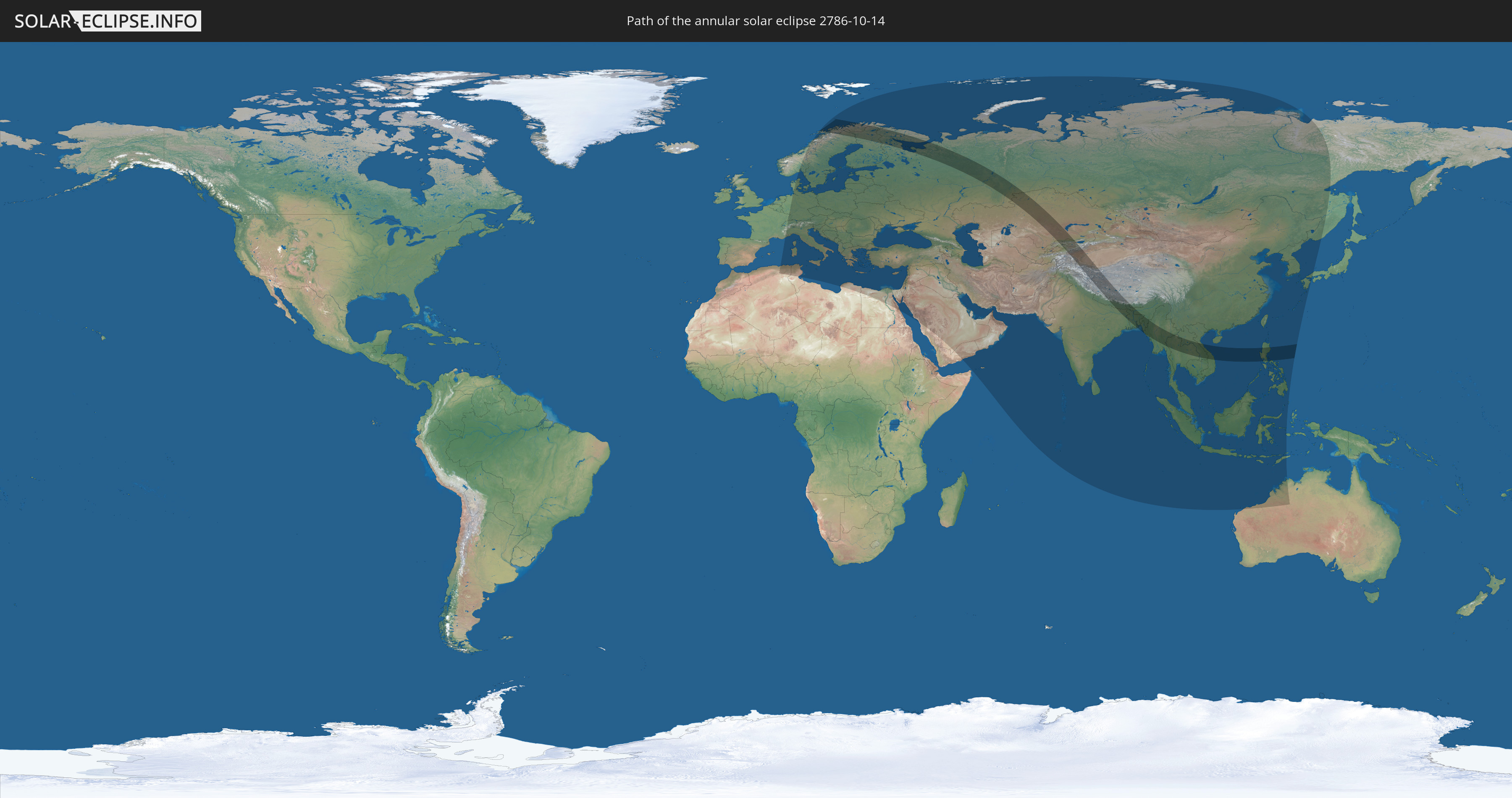
Die Sonnenfinsternis am 10/14/2786 kann man in 95 Ländern als partielle Sonnenfinsternis beobachten.
Der Finsternispfad verläuft durch 17 Länder. Nur in diesen Ländern ist sie als annular Sonnenfinsternis zu sehen.
In den folgenden Ländern ist die Sonnenfinsternis annular zu sehen
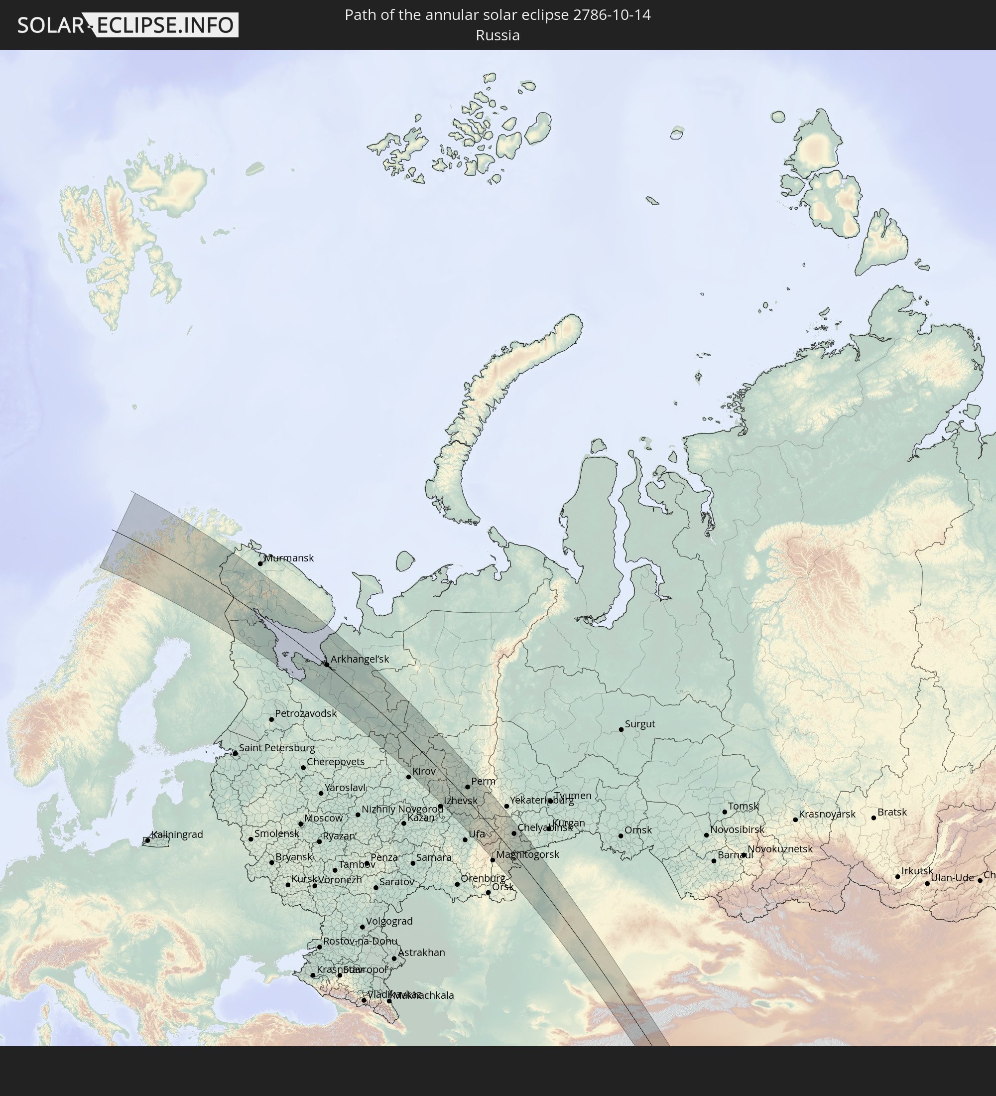 Russia
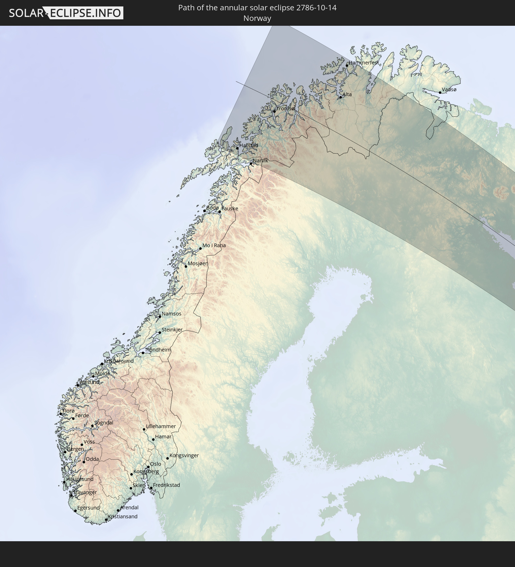 Norway
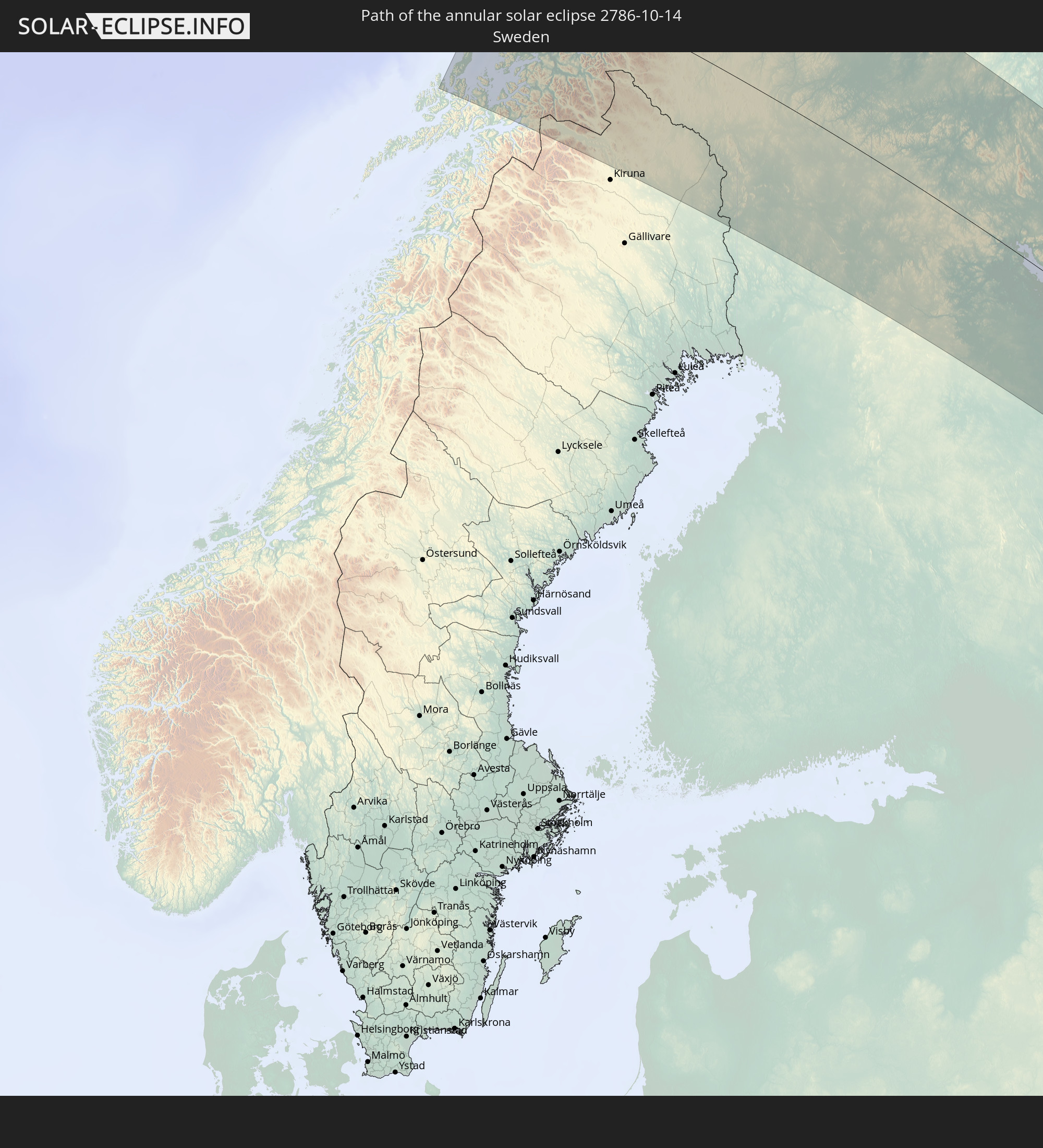 Sweden
 Finland
 Kazakhstan
 India
India
 Kyrgyzstan
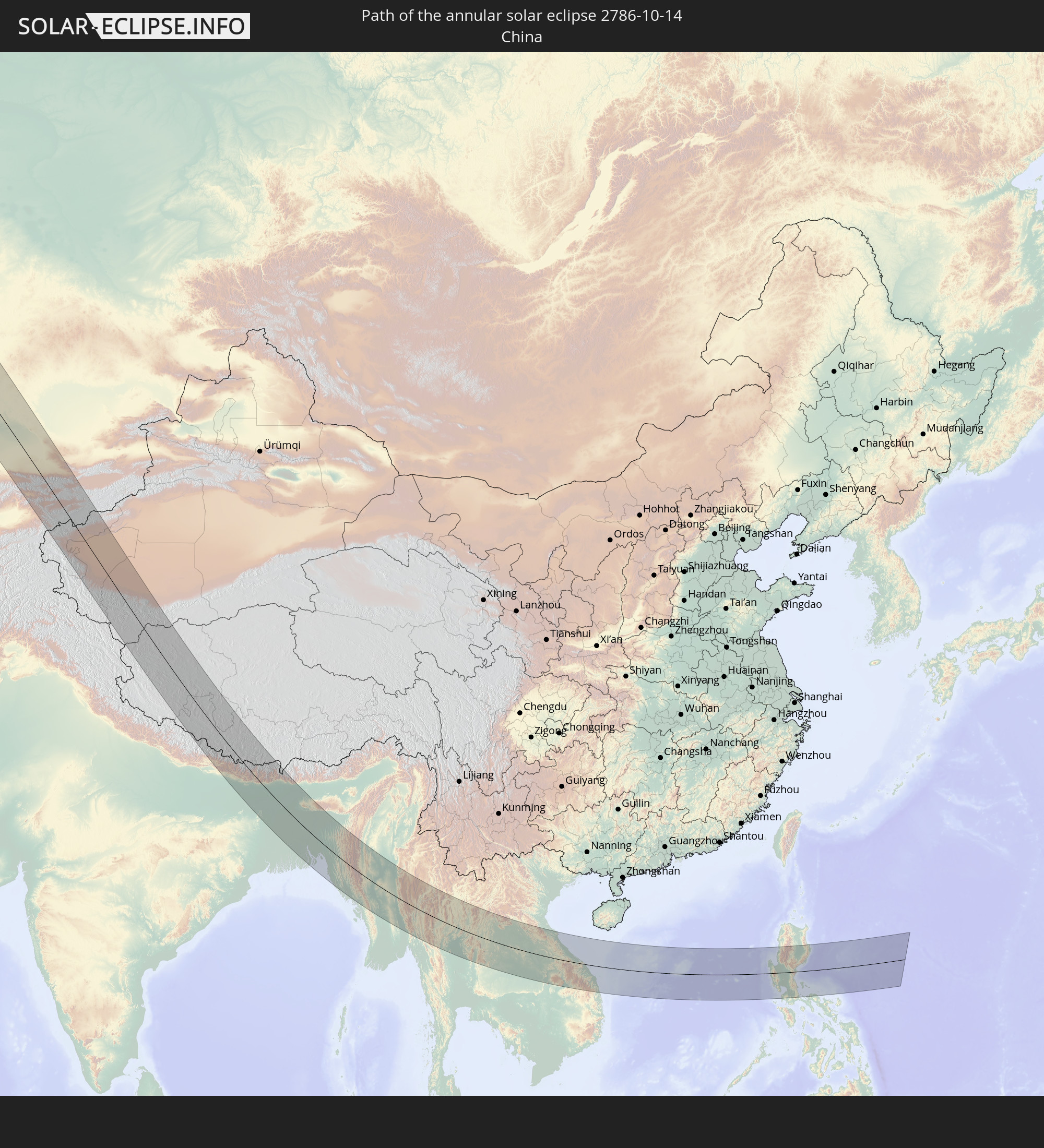 China
China
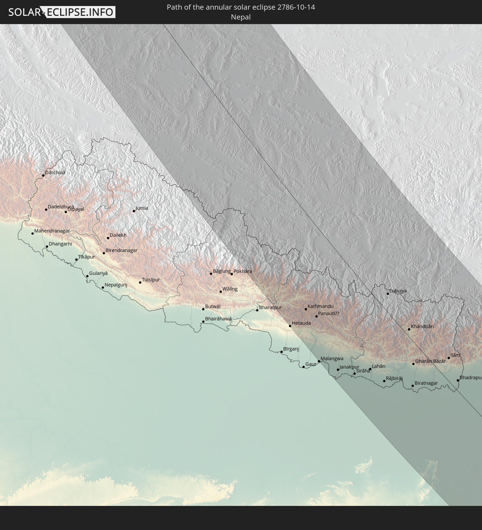 Nepal
Nepal
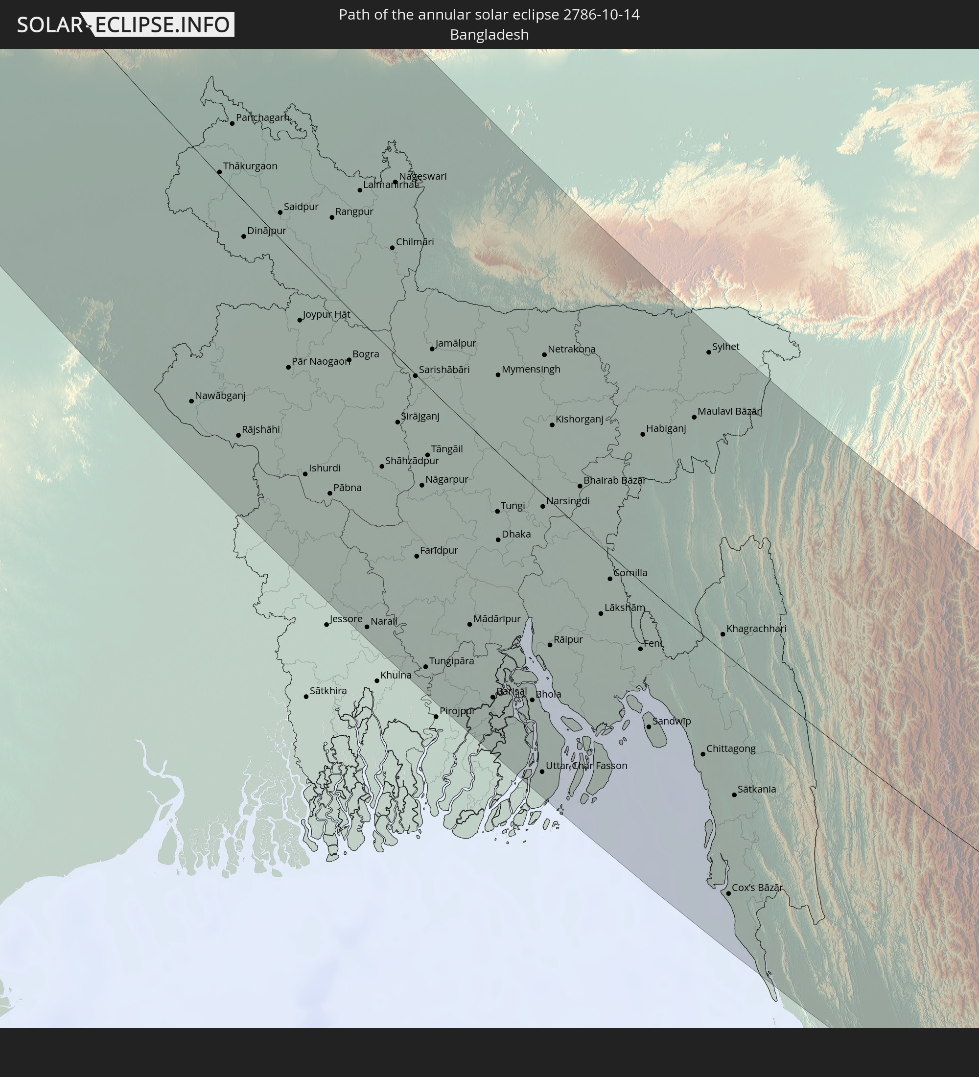 Bangladesh
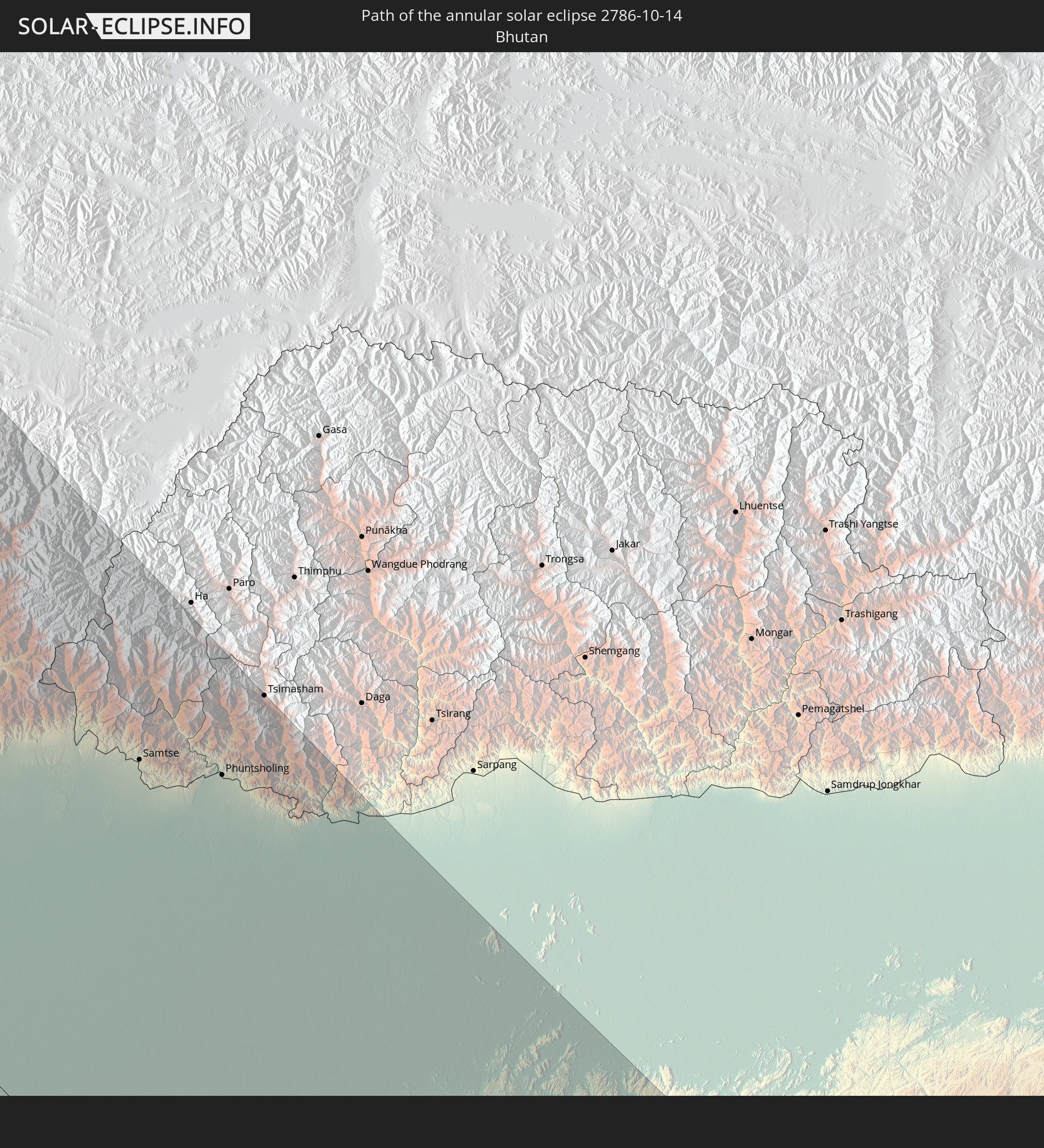 Bhutan
 Myanmar
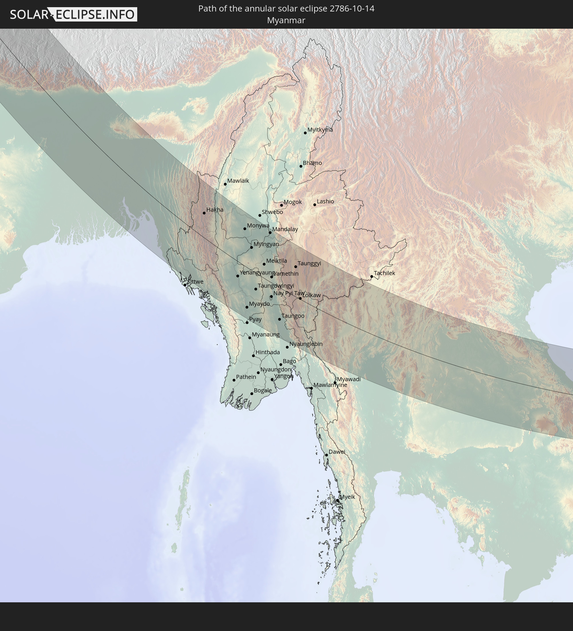
 Thailand
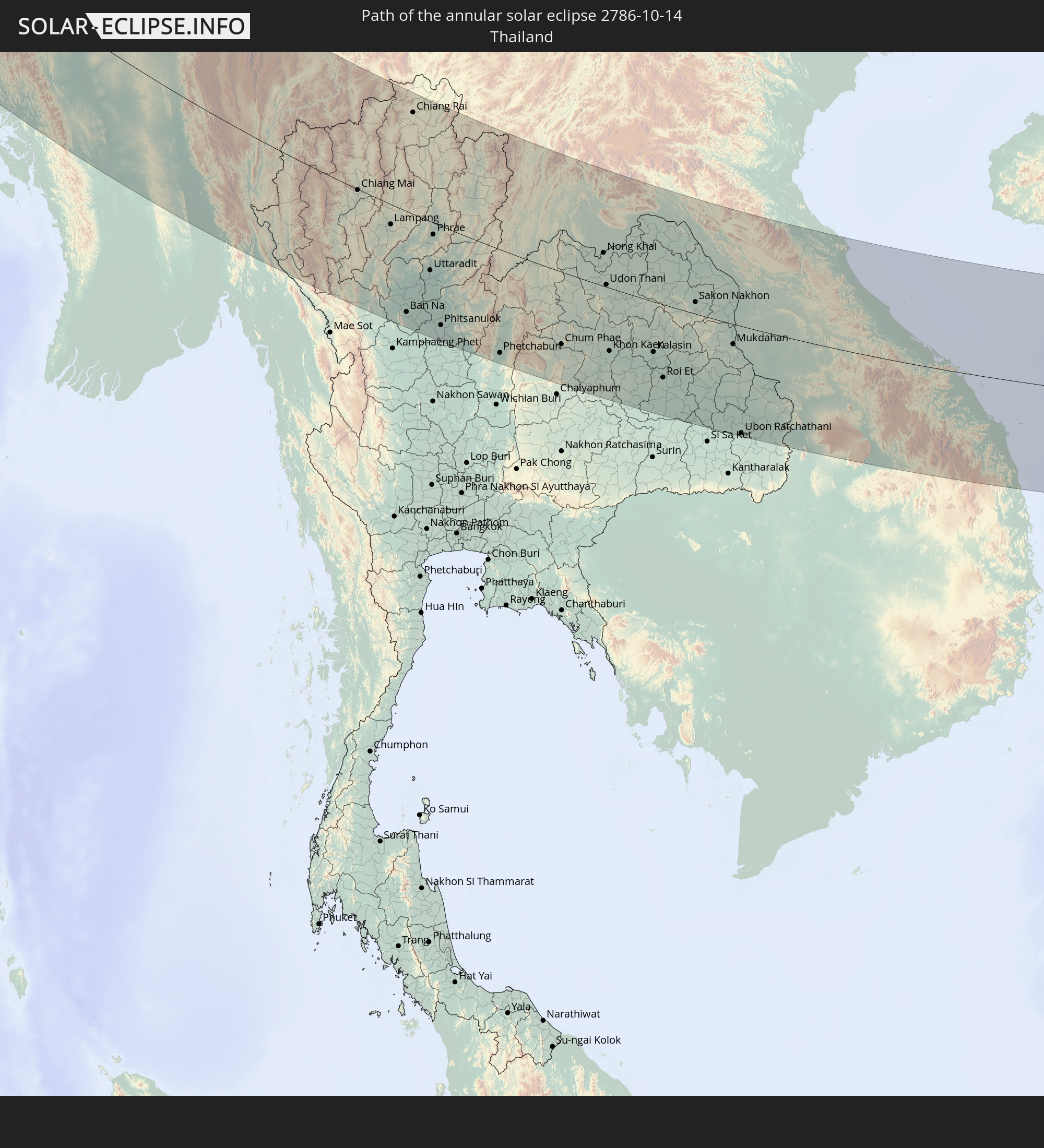
 Laos
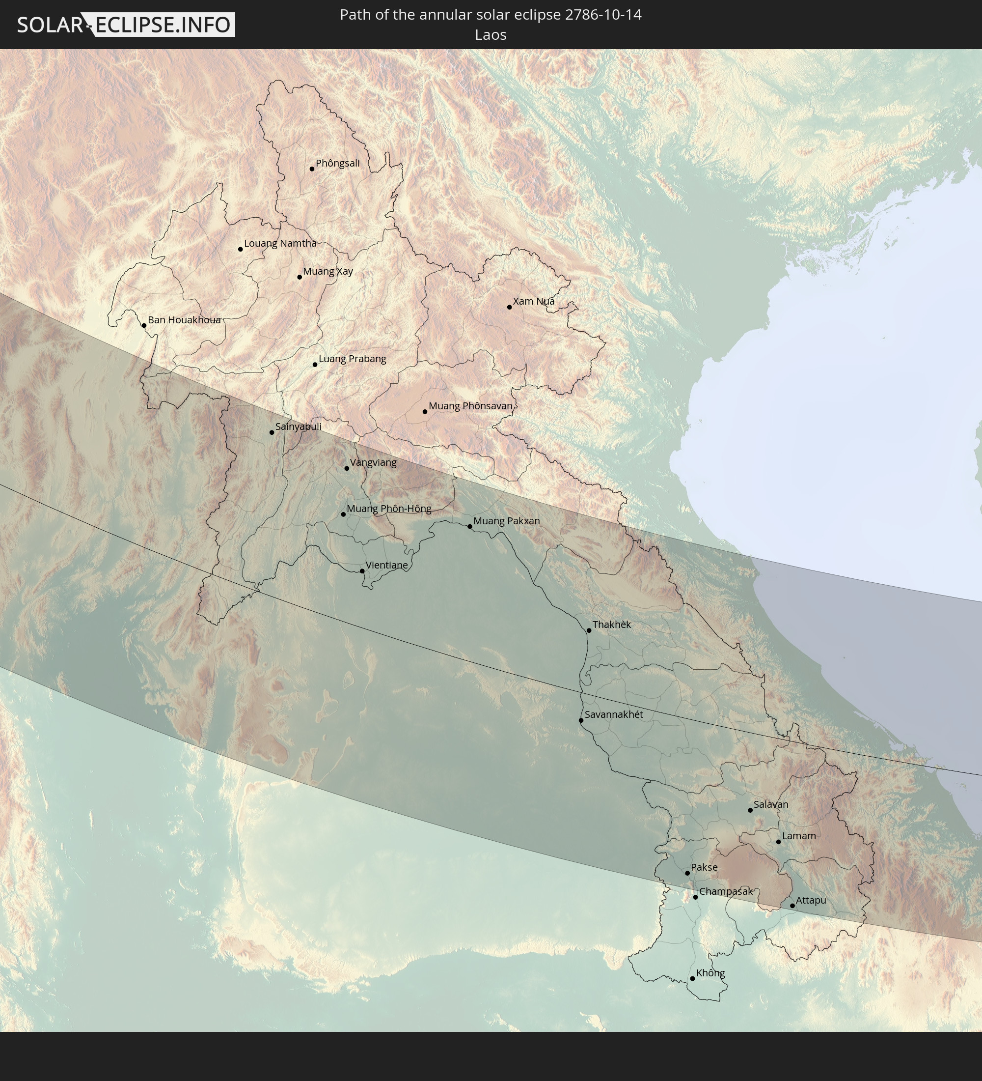
Laos
 Vietnam
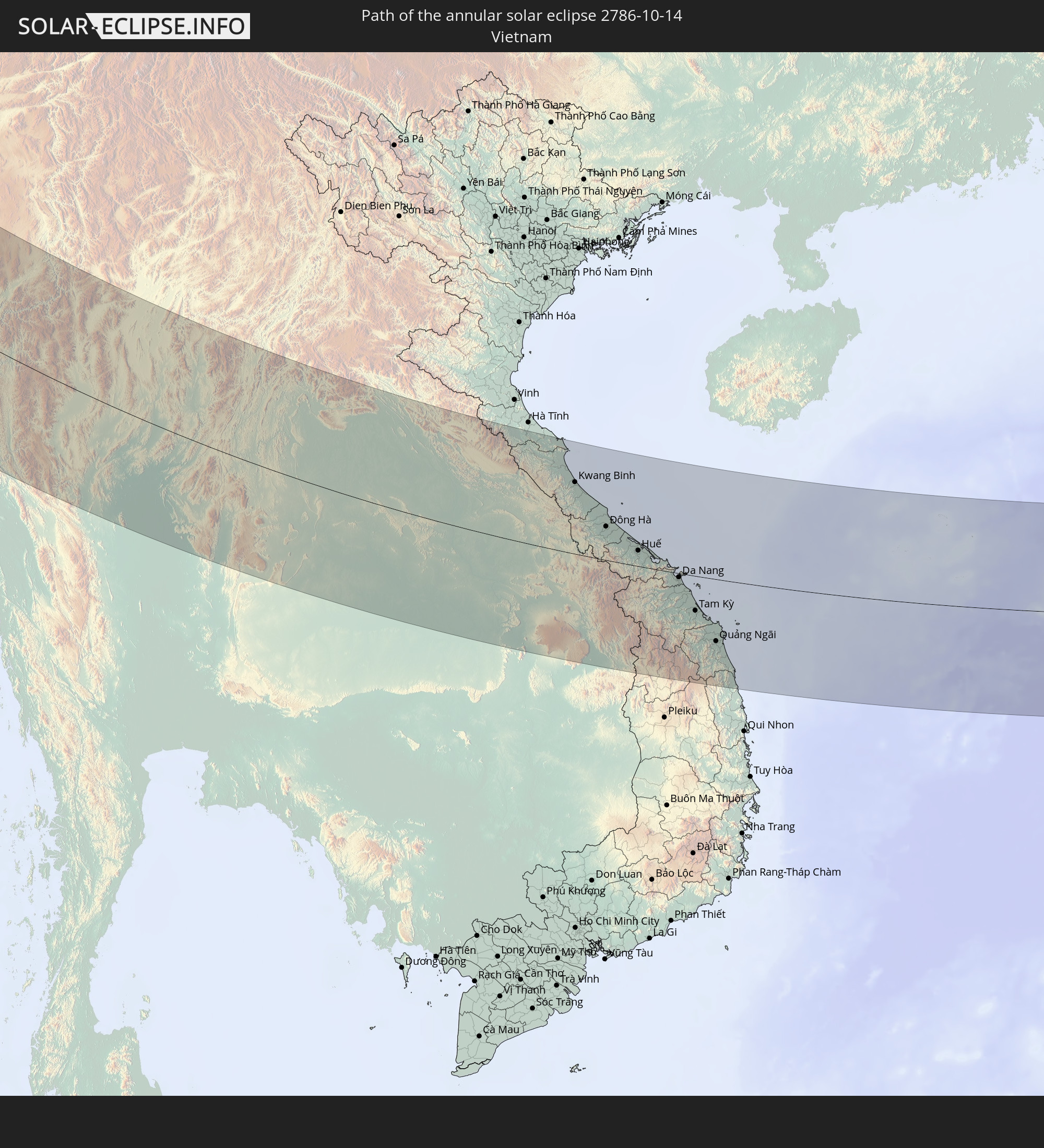
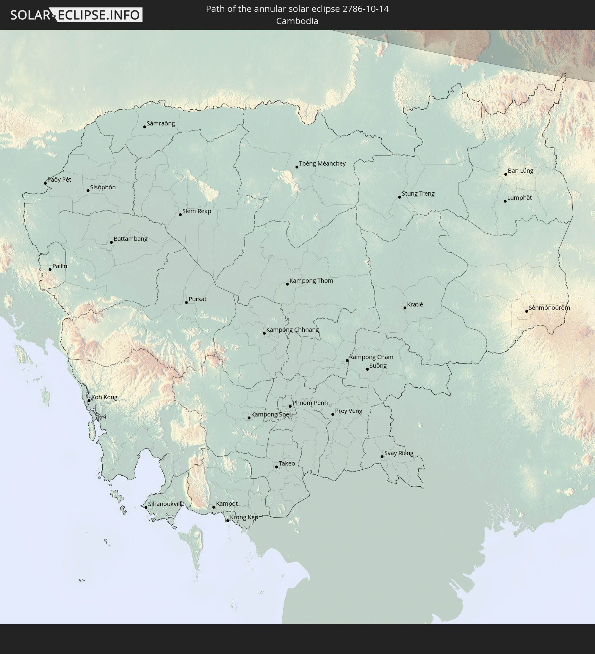 Cambodia
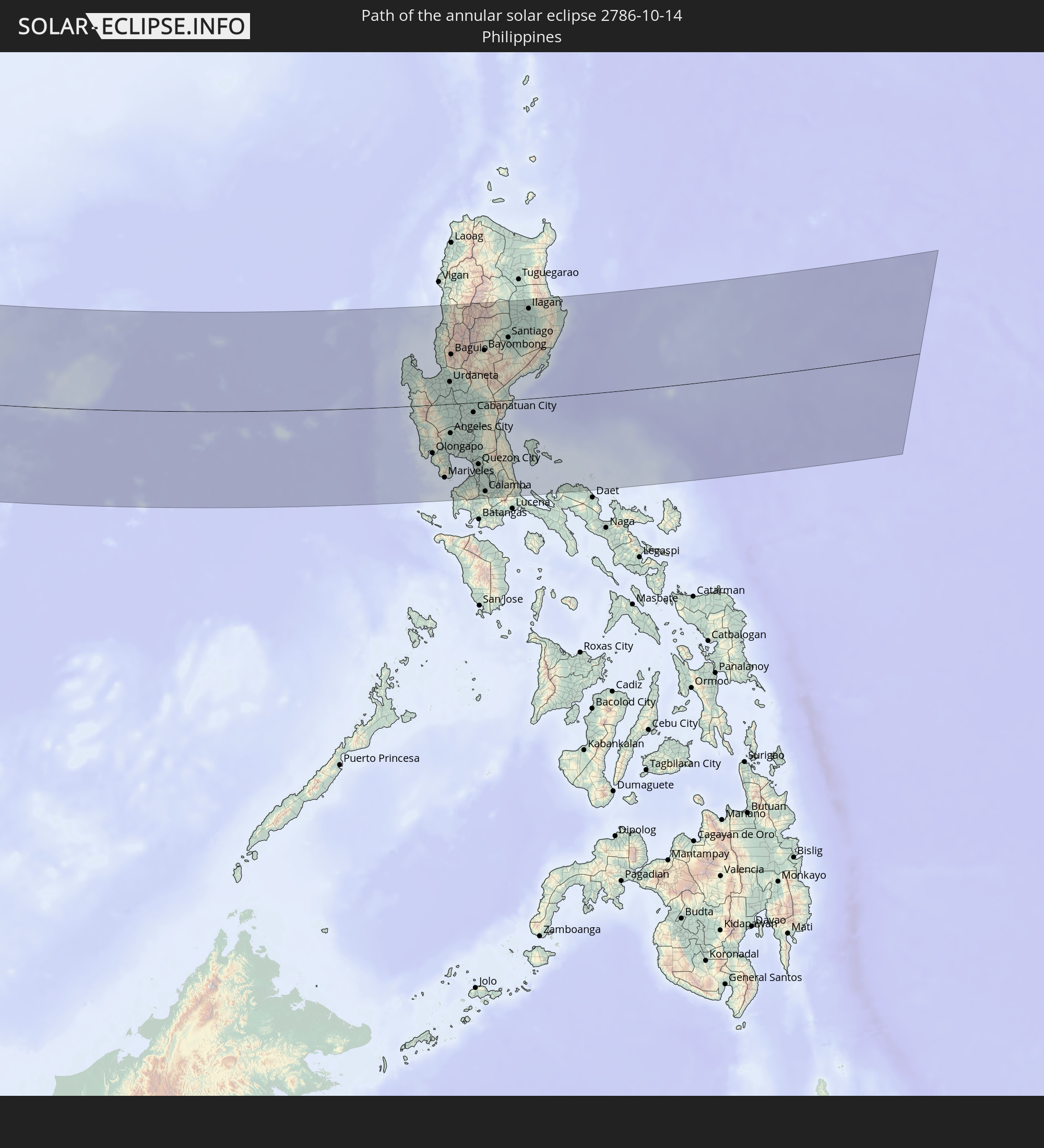 Philippines
In den folgenden Ländern ist die Sonnenfinsternis partiell zu sehen
 Russia
 Algeria
 France
 Norway
 Germany
 Switzerland
 Italy
Italy
 Monaco
 Tunisia
 Denmark
 Libya
Libya
 Liechtenstein
 Austria
 Sweden
 Czechia
 San Marino
 Vatican City
 Slovenia
 Croatia
 Poland
 Malta
Malta
 Bosnia and Herzegovina
 Hungary
 Slovakia
 Montenegro
 Serbia
 Albania
 Åland Islands
 Greece
 Romania
 Republic of Macedonia
 Finland
 Lithuania
 Latvia
 Estonia
 Ukraine
 Bulgaria
 Belarus
 Egypt
Egypt
 Turkey
 Moldova
 Cyprus
 State of Palestine
 Israel
 Saudi Arabia
 Jordan
 Lebanon
 Syria
Syria
 Iraq
Iraq
 Georgia
 Yemen
Yemen
 Armenia
 Iran
Iran
 Azerbaijan
 Kazakhstan
 Kuwait
 Bahrain
 Qatar
Qatar
 United Arab Emirates
 Oman
Oman
 Turkmenistan
 Uzbekistan
 Afghanistan
 Pakistan
 Tajikistan
 India
India
 Kyrgyzstan
 British Indian Ocean Territory
 Maldives
 China
China
 Sri Lanka
 Nepal
Nepal
 Mongolia
 Bangladesh
 Bhutan
 Myanmar
 Indonesia
 Cocos Islands
 Thailand
 Malaysia
 Laos
Laos
 Vietnam
 Cambodia
 Singapore
 Christmas Island
 Australia
 Macau
Macau
 Hong Kong
 Brunei
 Taiwan
 Philippines
 Japan
Japan
 East Timor
 North Korea
 South Korea
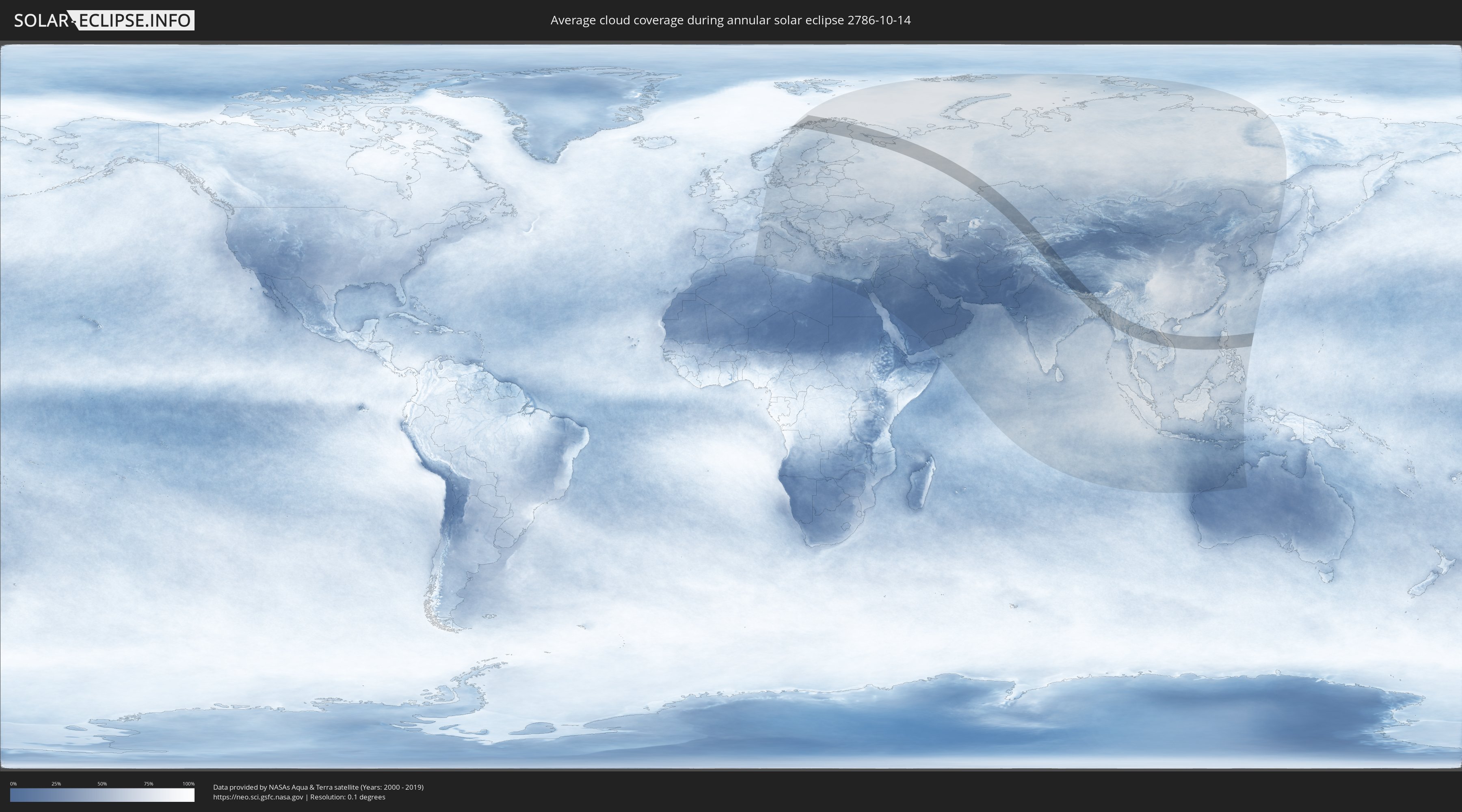
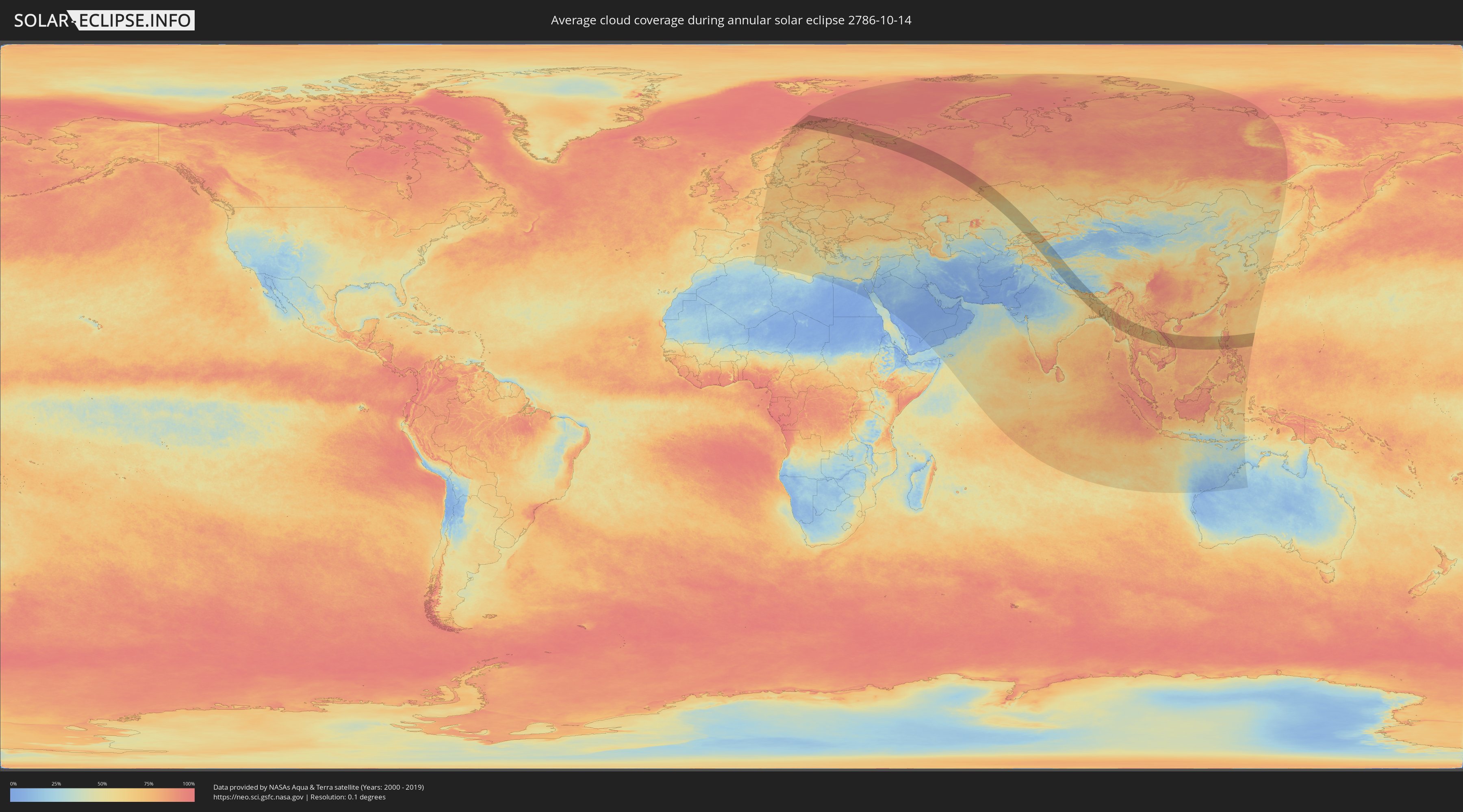
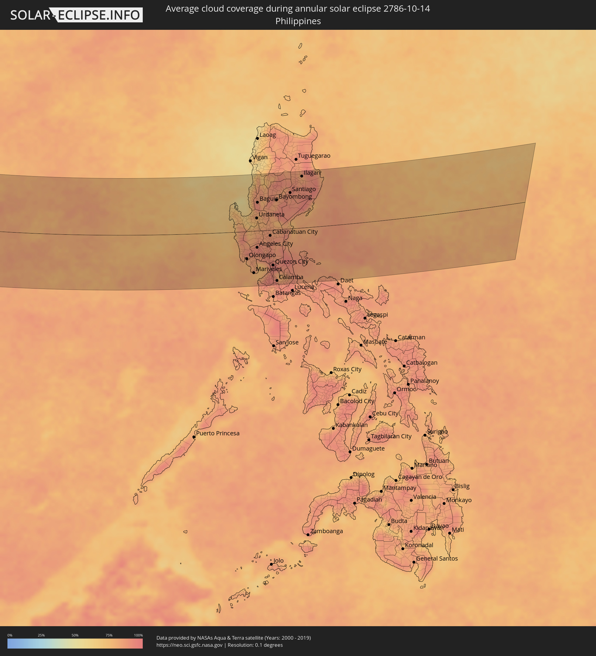
How will be the weather during the annular solar eclipse on 10/14/2786?
Where is the best place to see the annular solar eclipse of 10/14/2786?
The following maps show the average cloud coverage for the day of the annular solar eclipse.
With the help of these maps, it is possible to find the place along the eclipse path, which has the best
chance of a cloudless sky.
Nevertheless, you should consider local circumstances and inform about the weather of your chosen
observation site.
The data is provided by NASAs satellites
AQUA and TERRA.
The cloud maps are averaged over a period of 19 years (2000 - 2019).
Detailed country maps
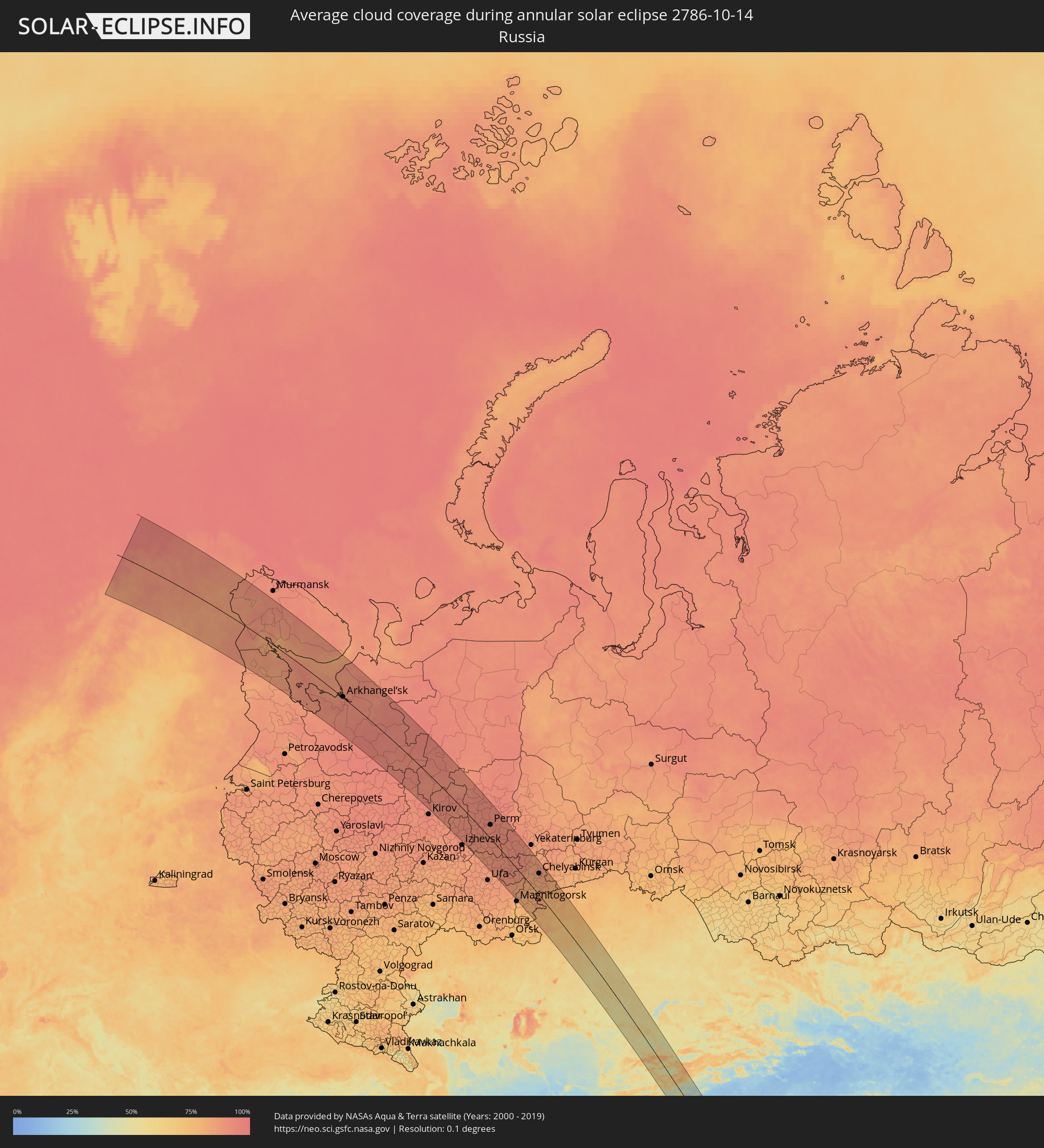 Russia
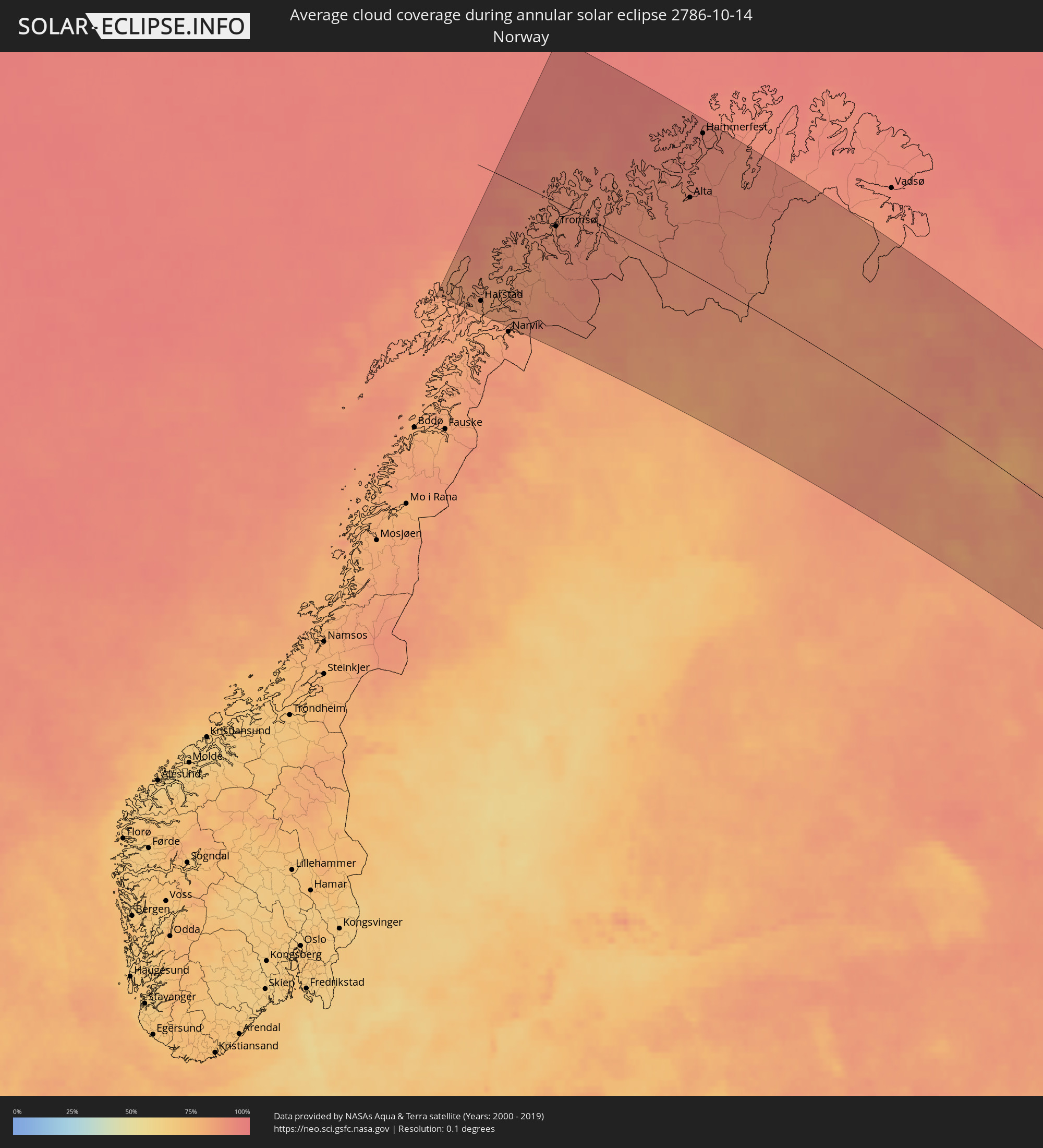 Norway
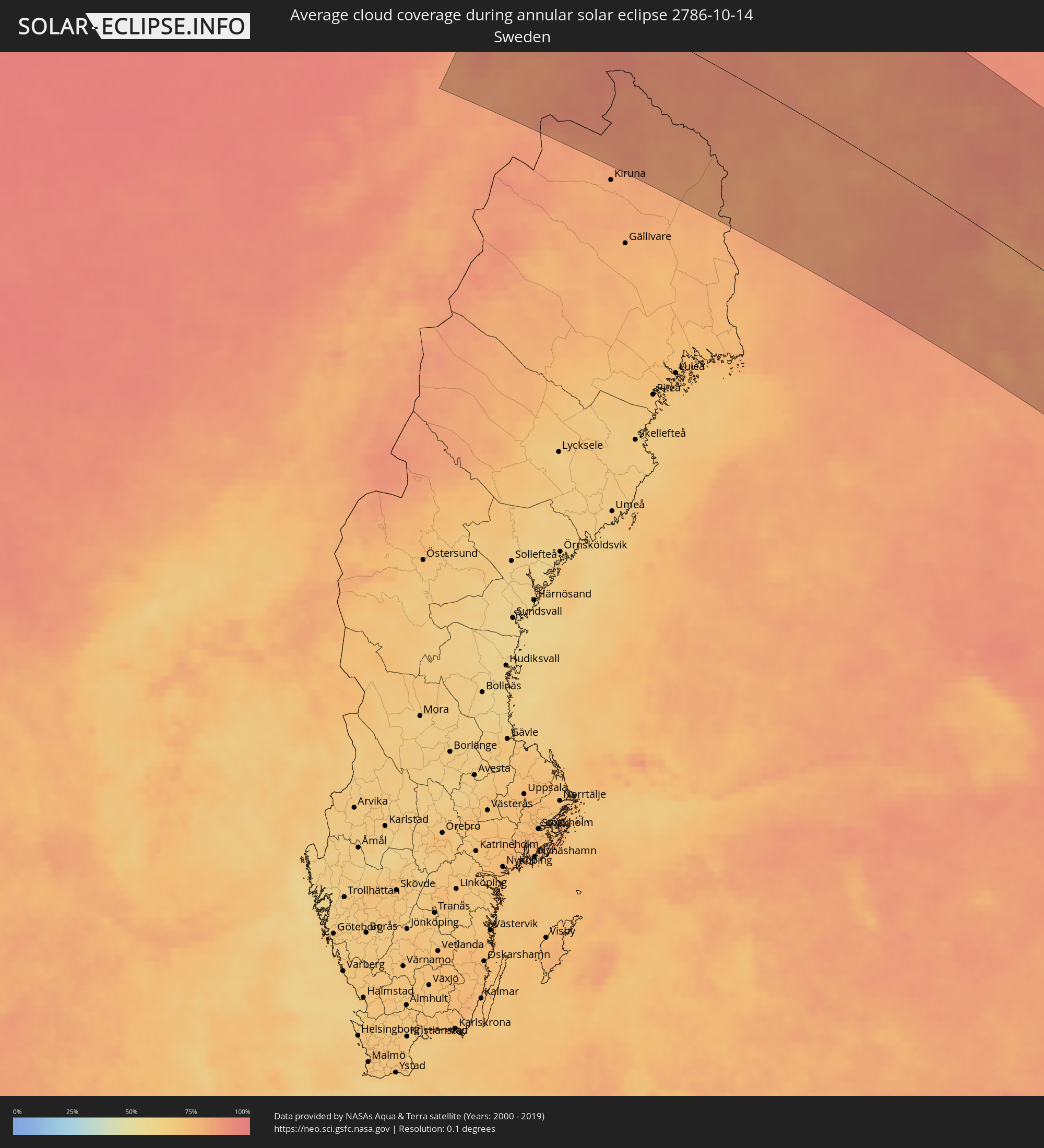 Sweden
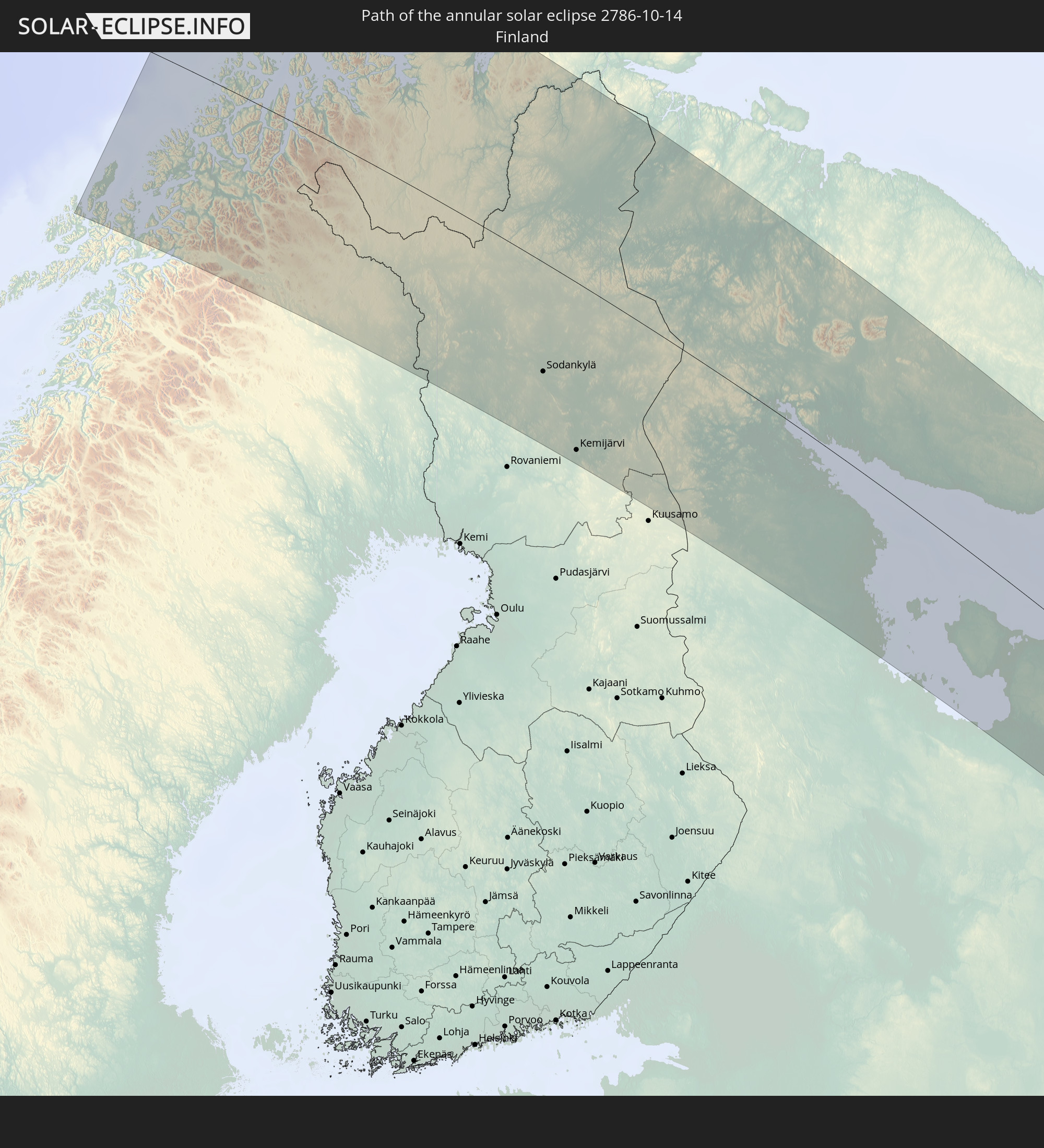
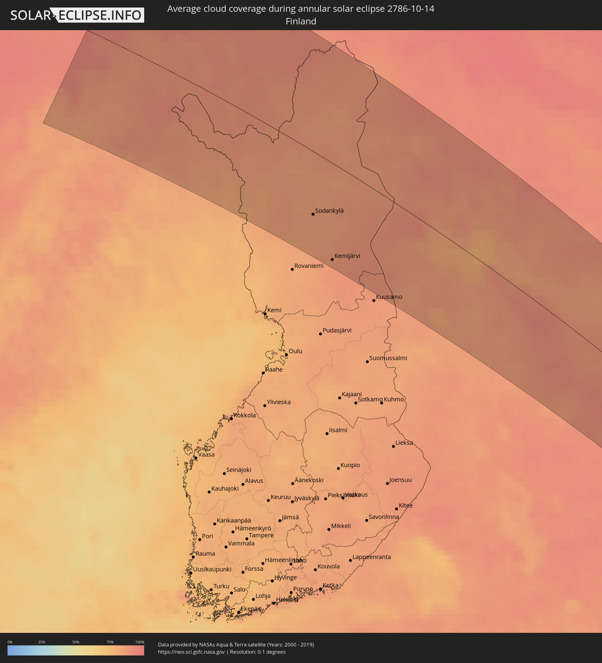 Finland
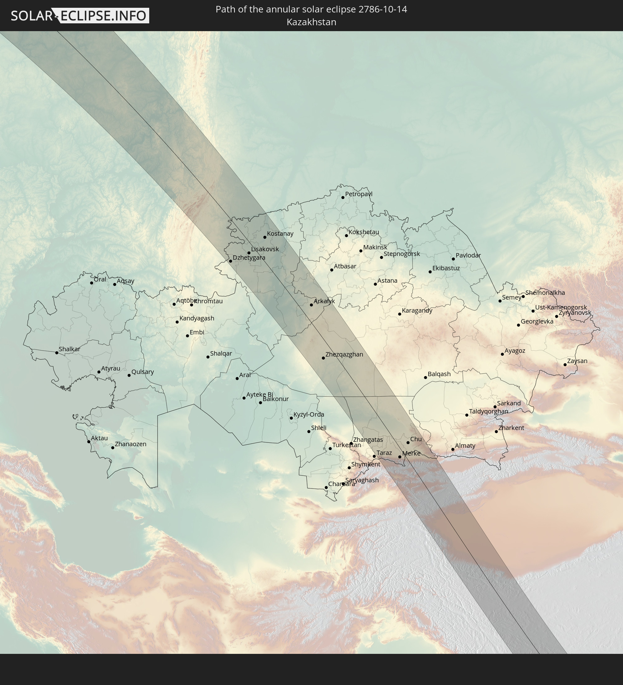
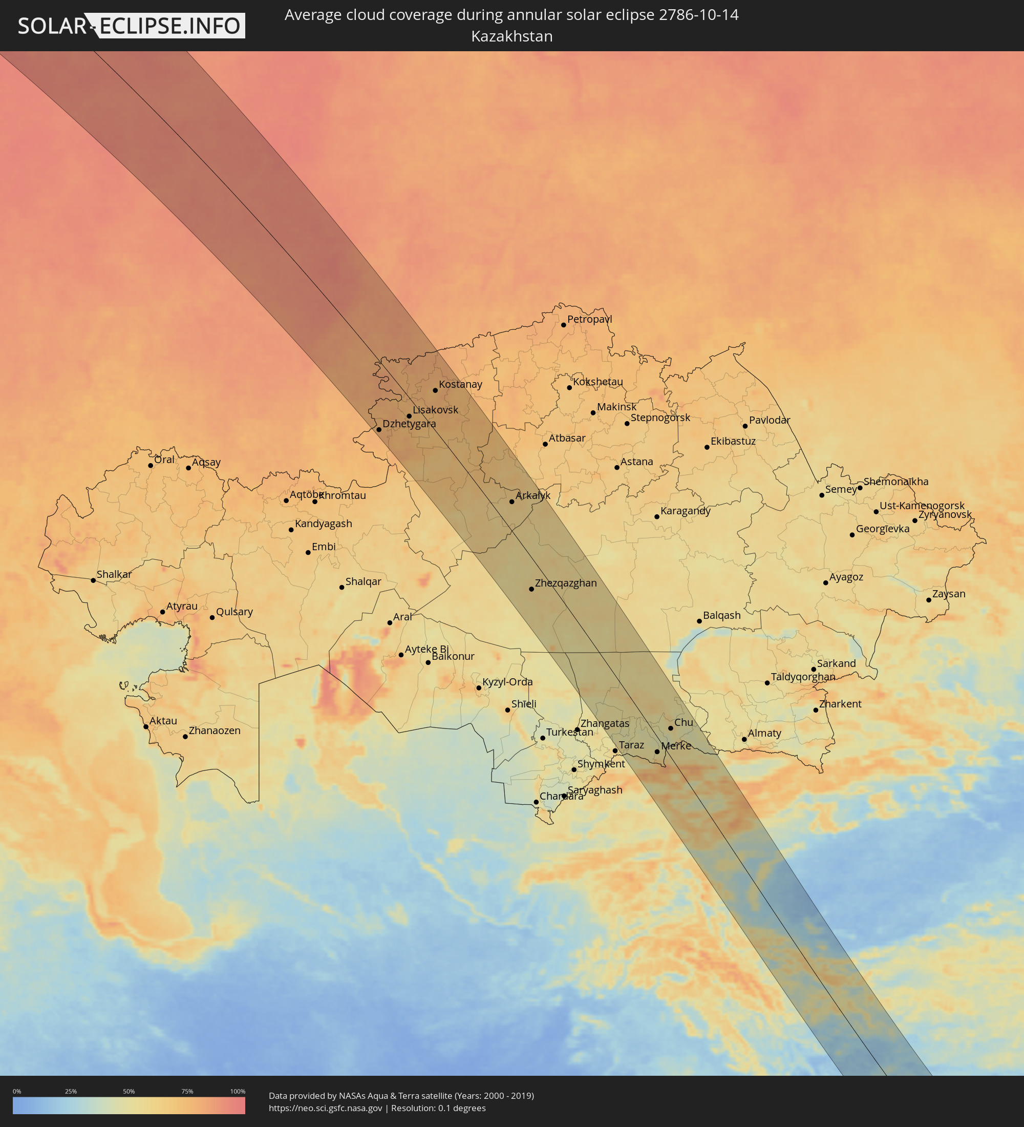 Kazakhstan
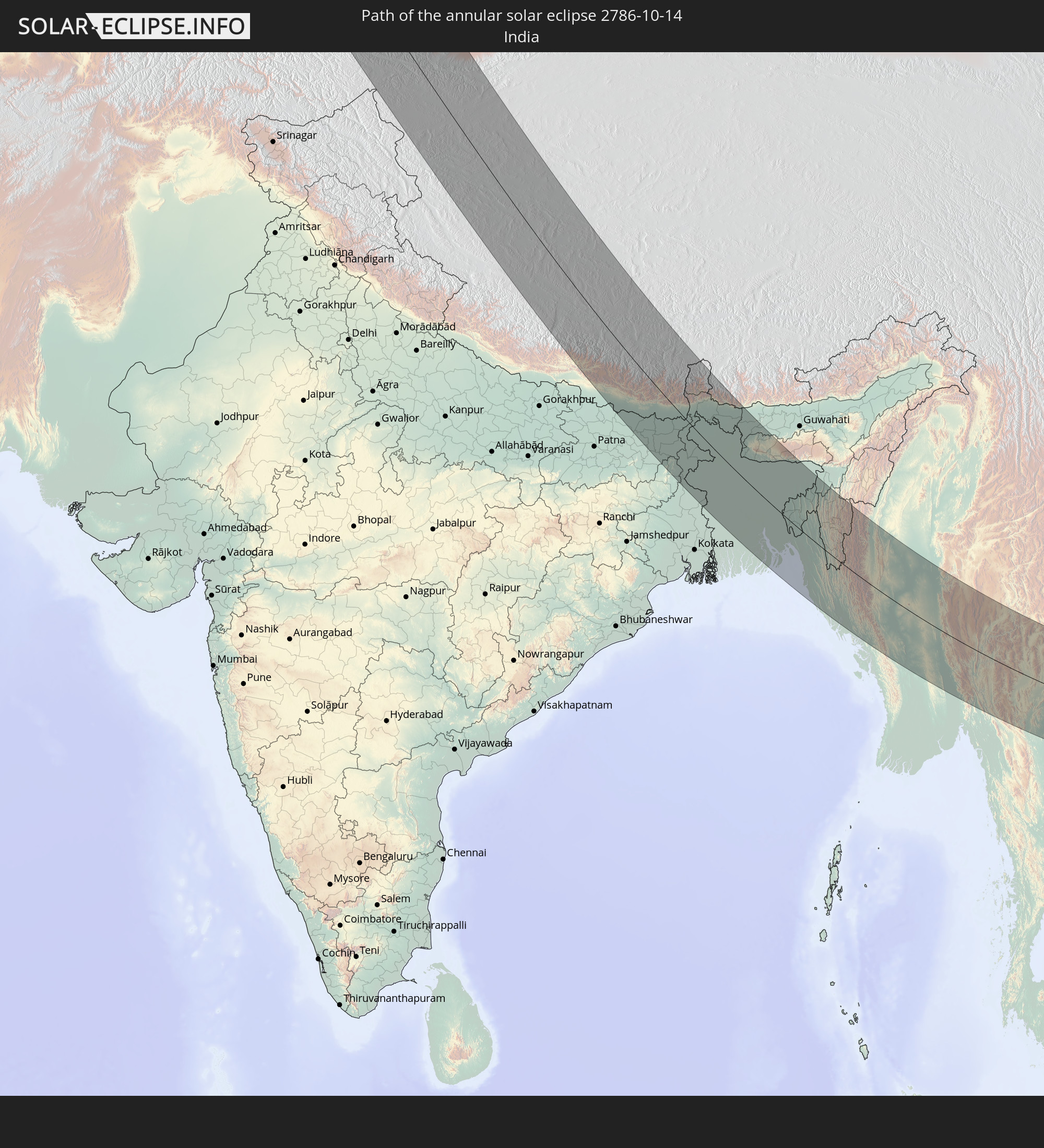
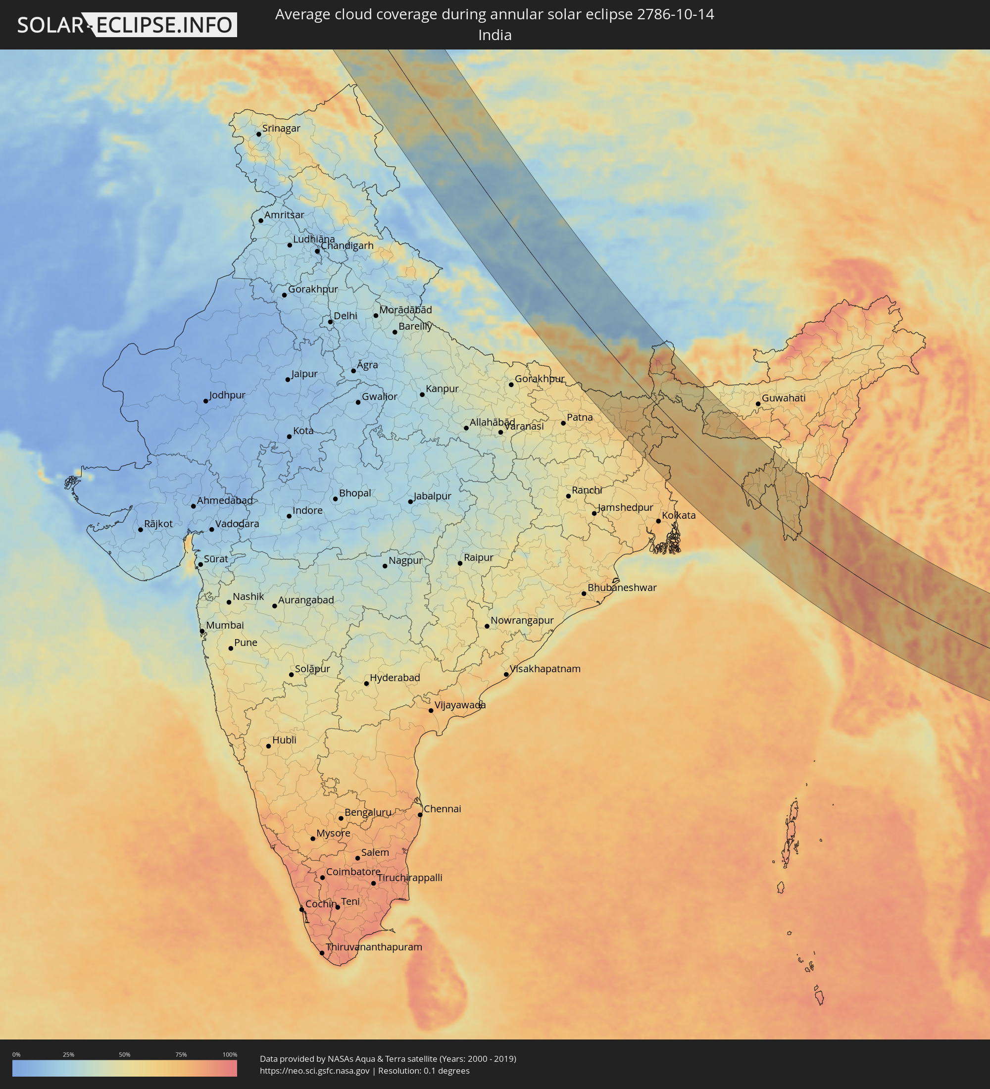 India
India
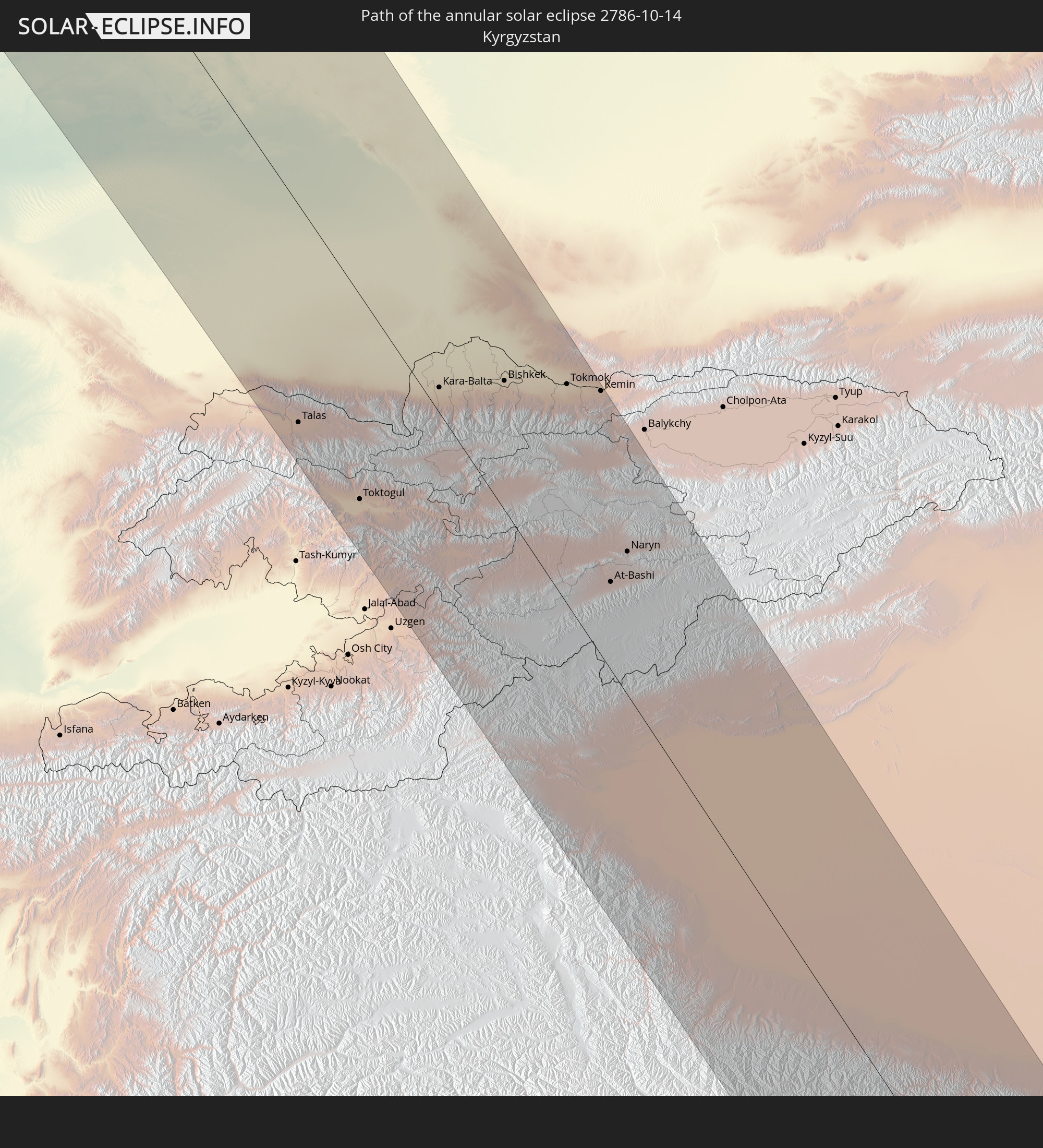
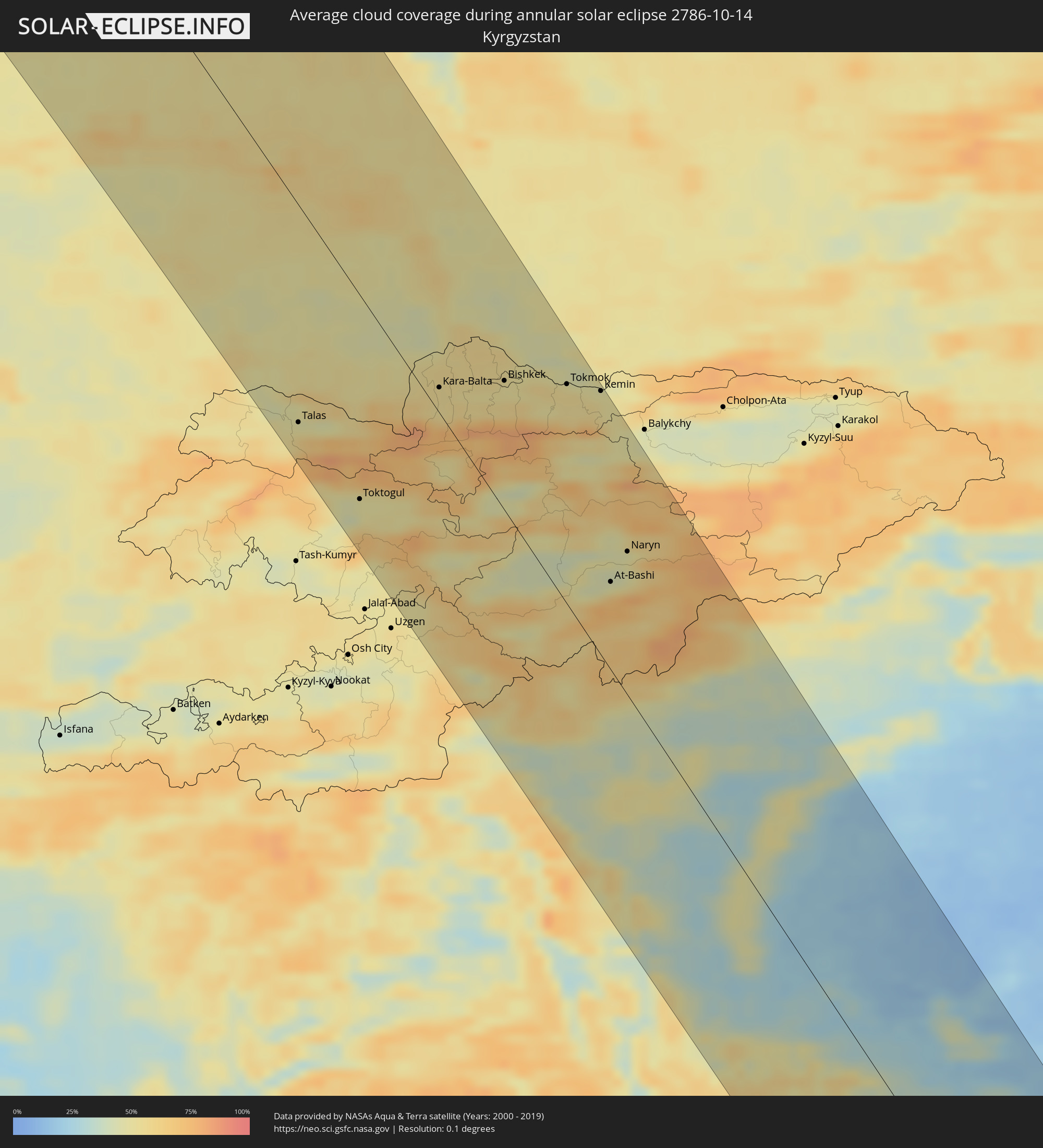 Kyrgyzstan
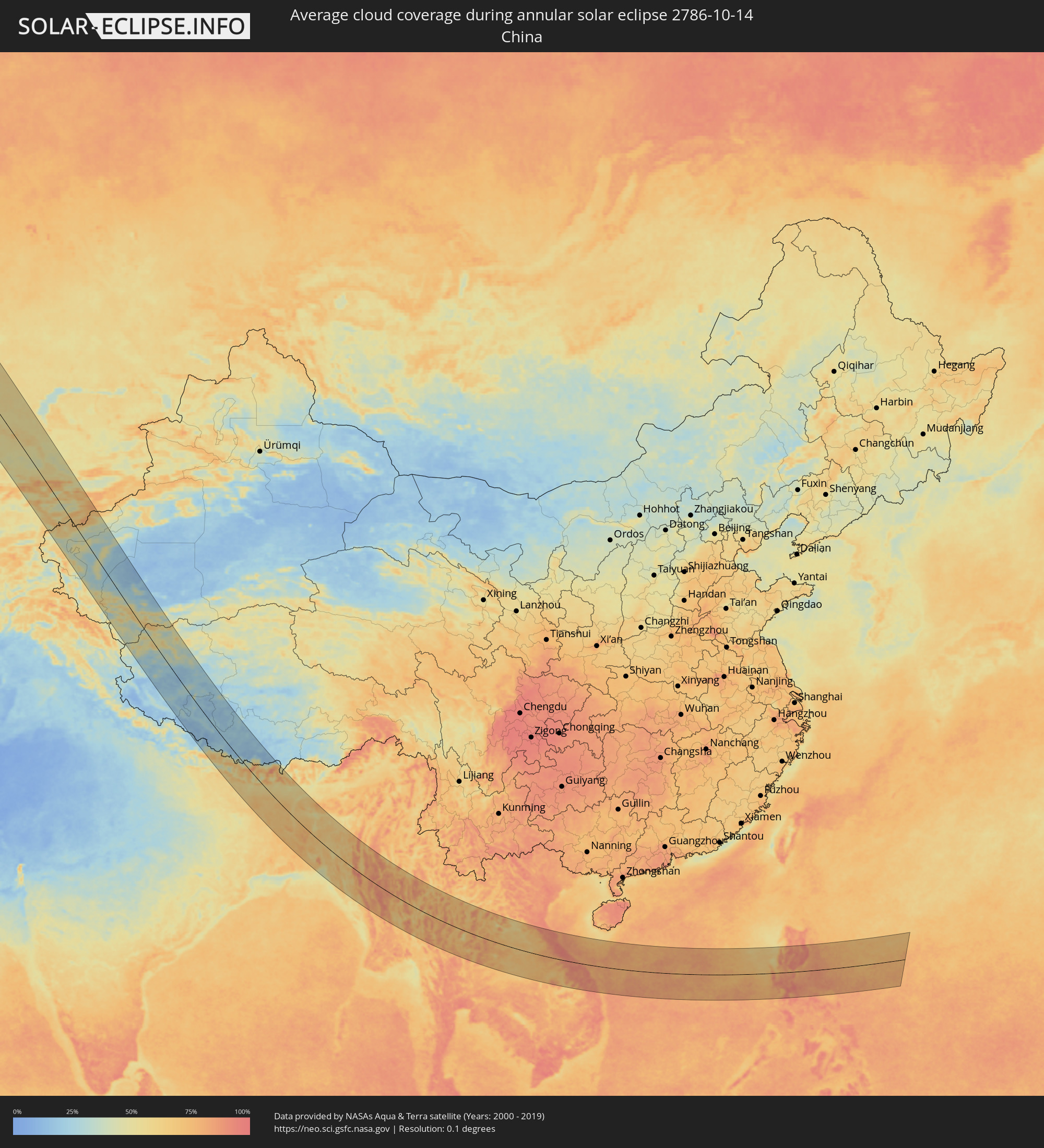 China
China
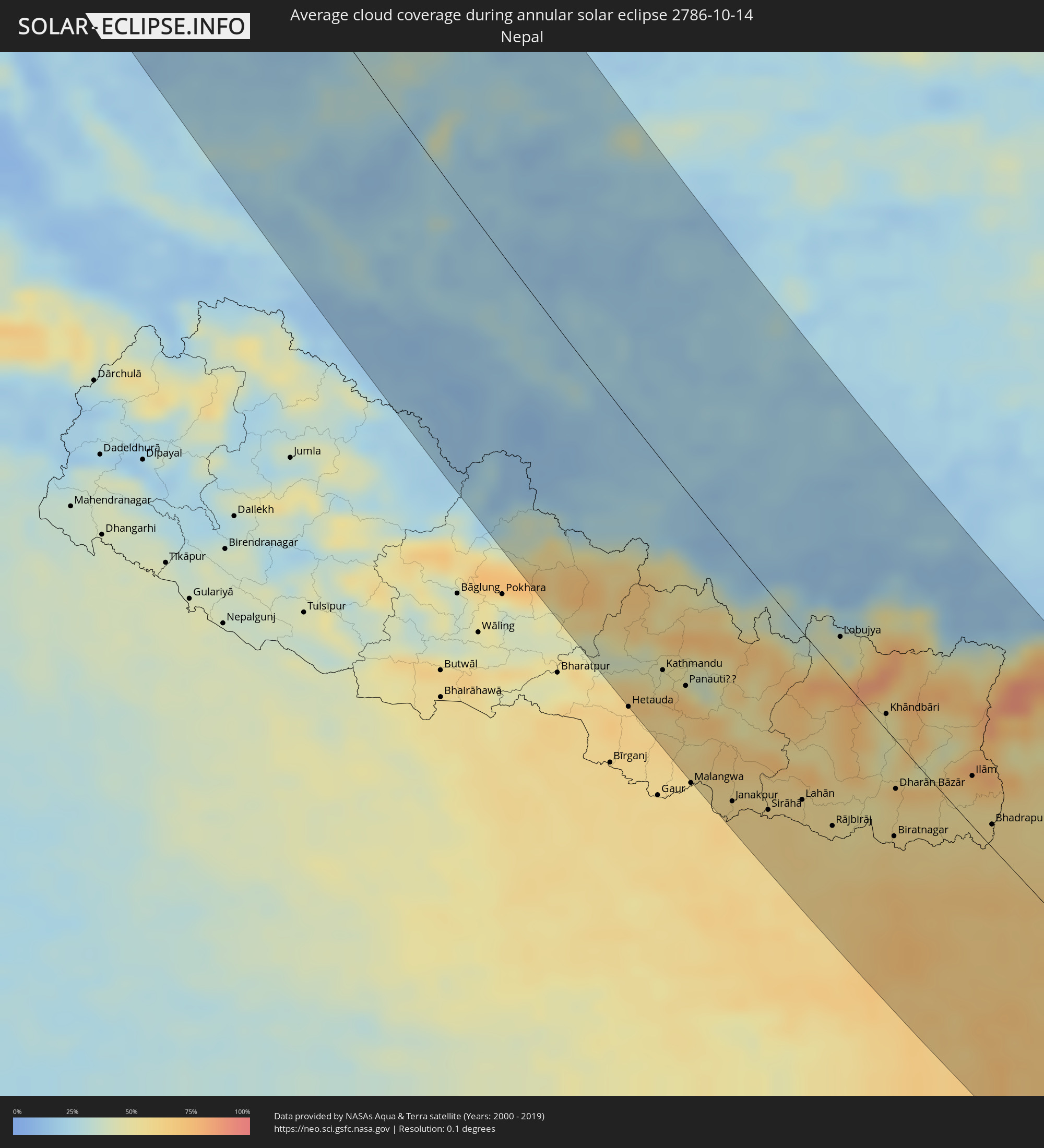 Nepal
Nepal
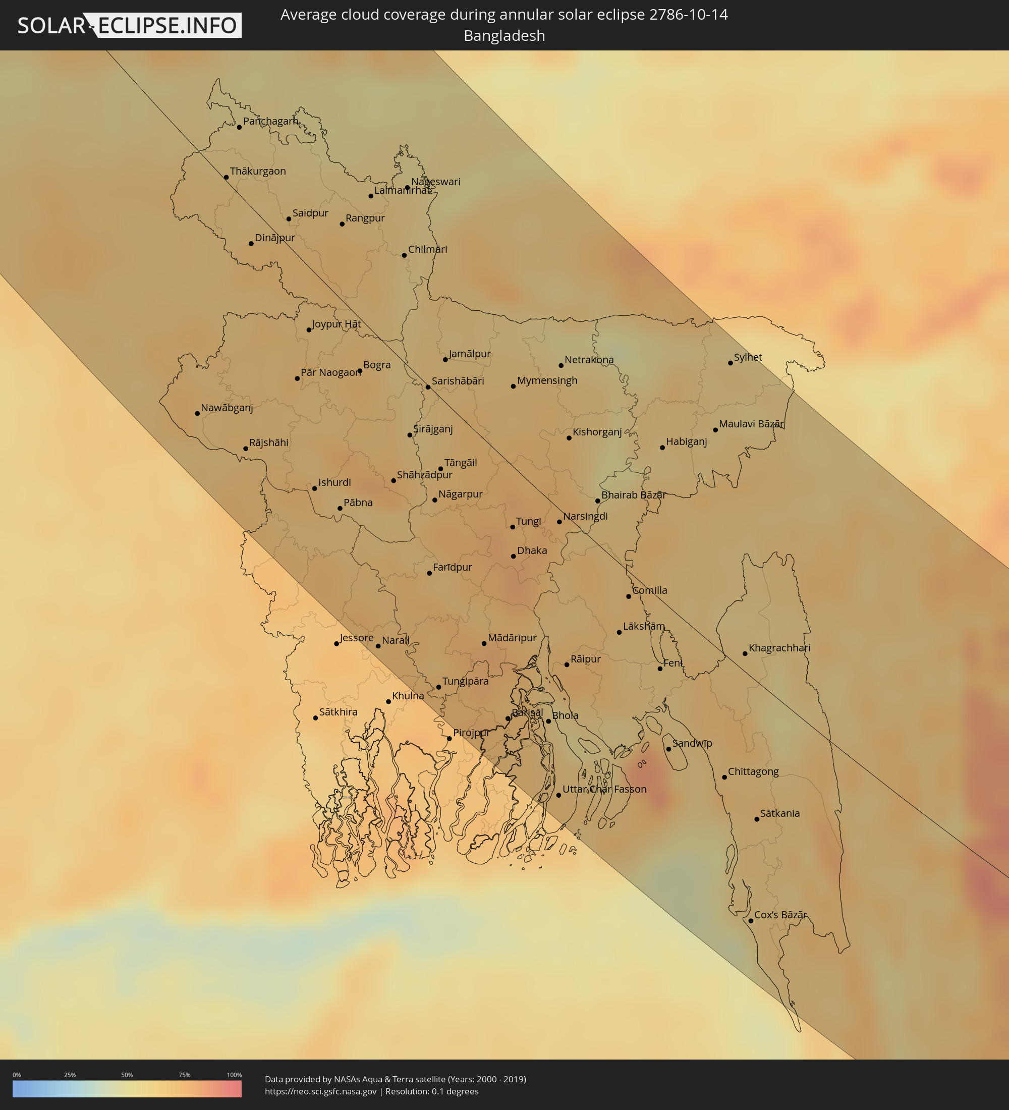 Bangladesh
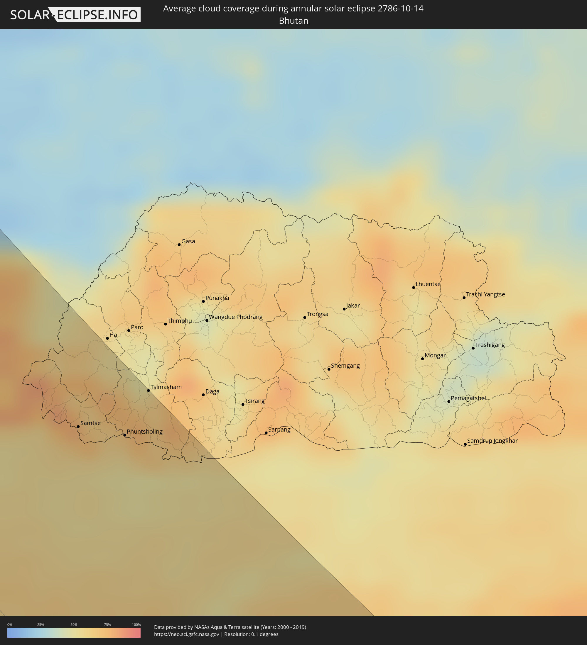 Bhutan
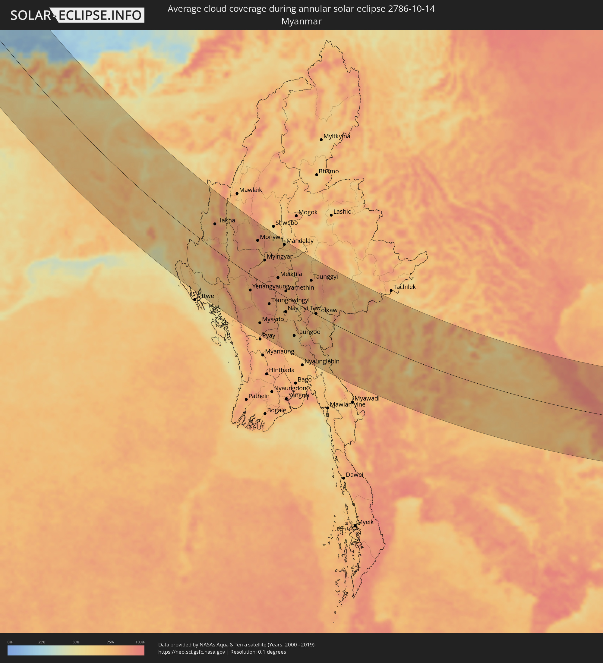 Myanmar
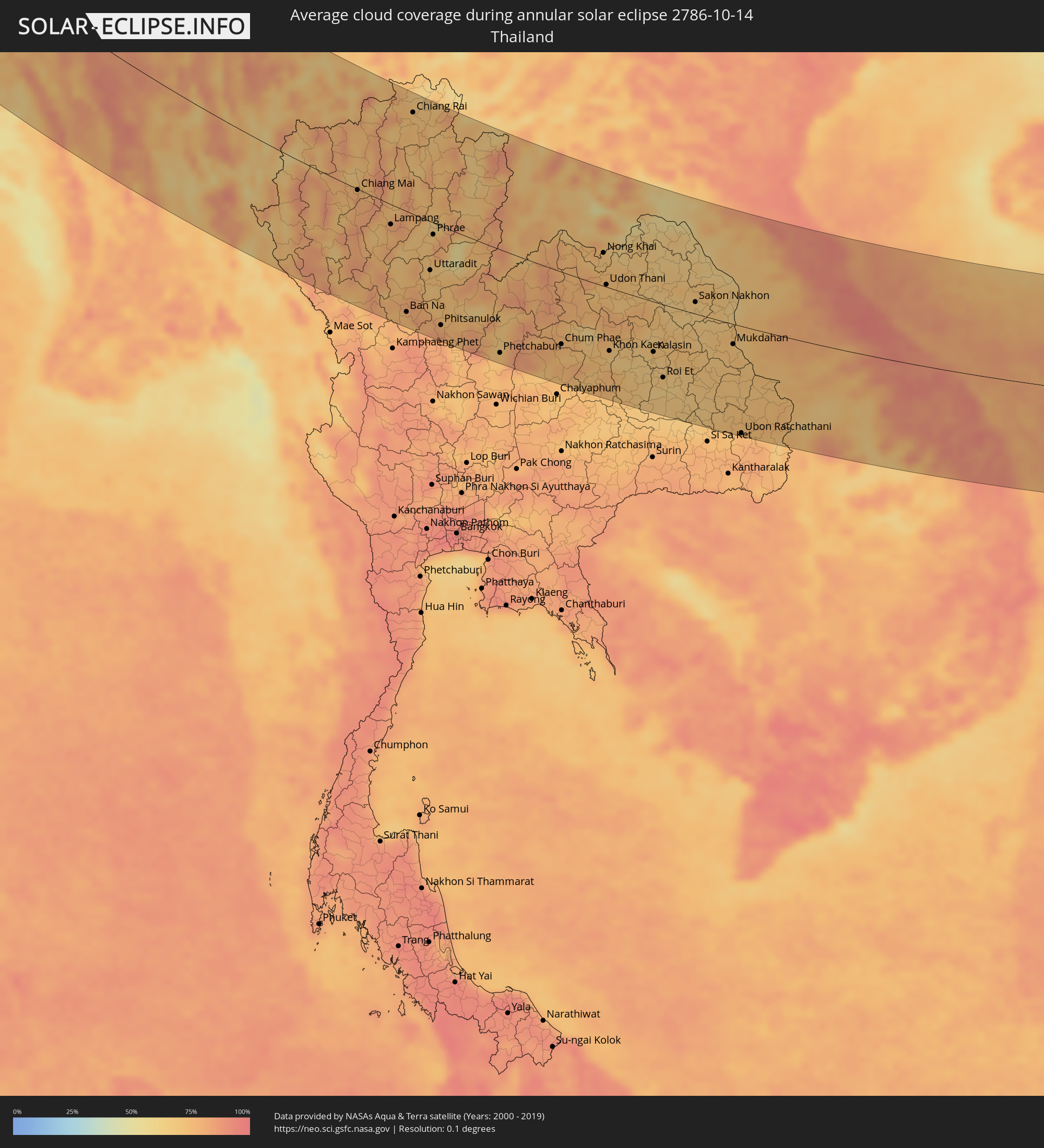 Thailand
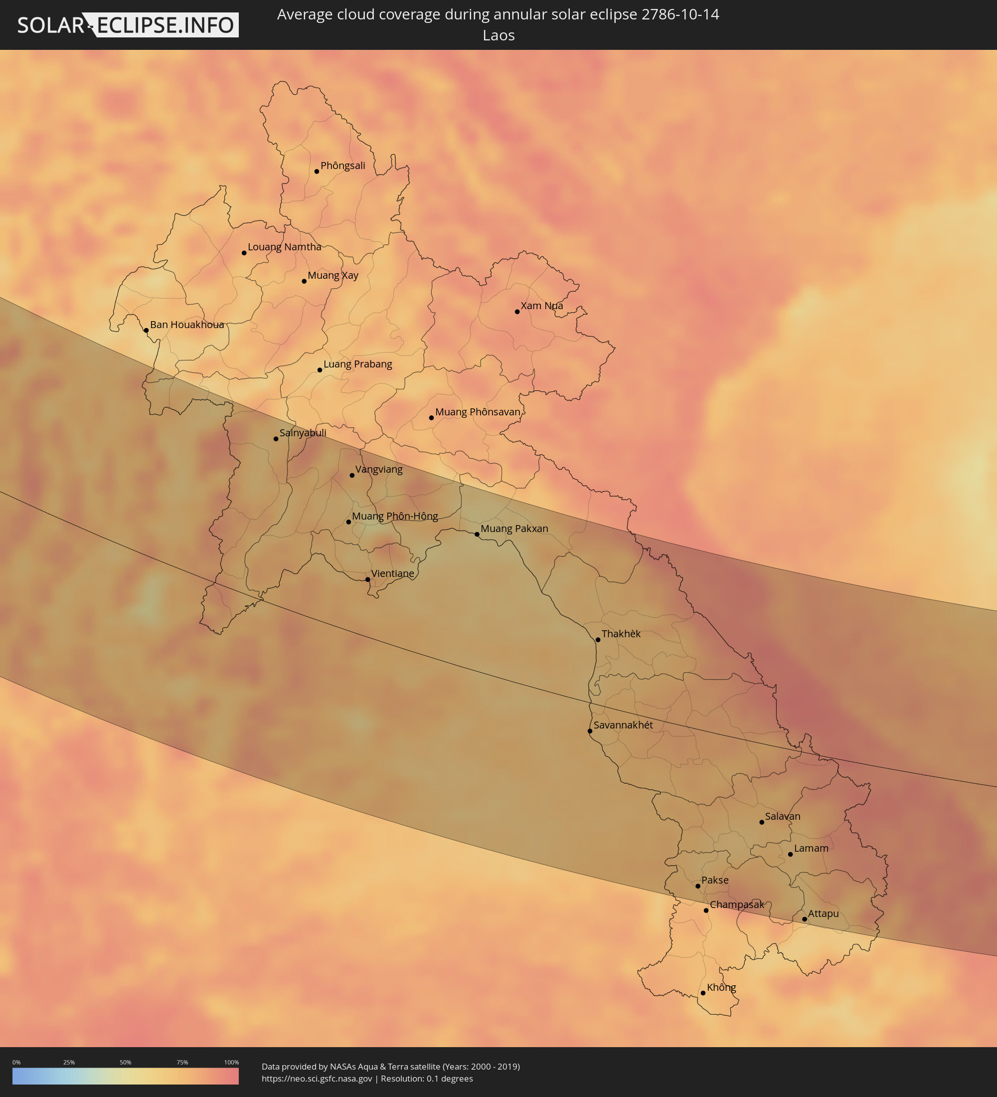 Laos
Laos
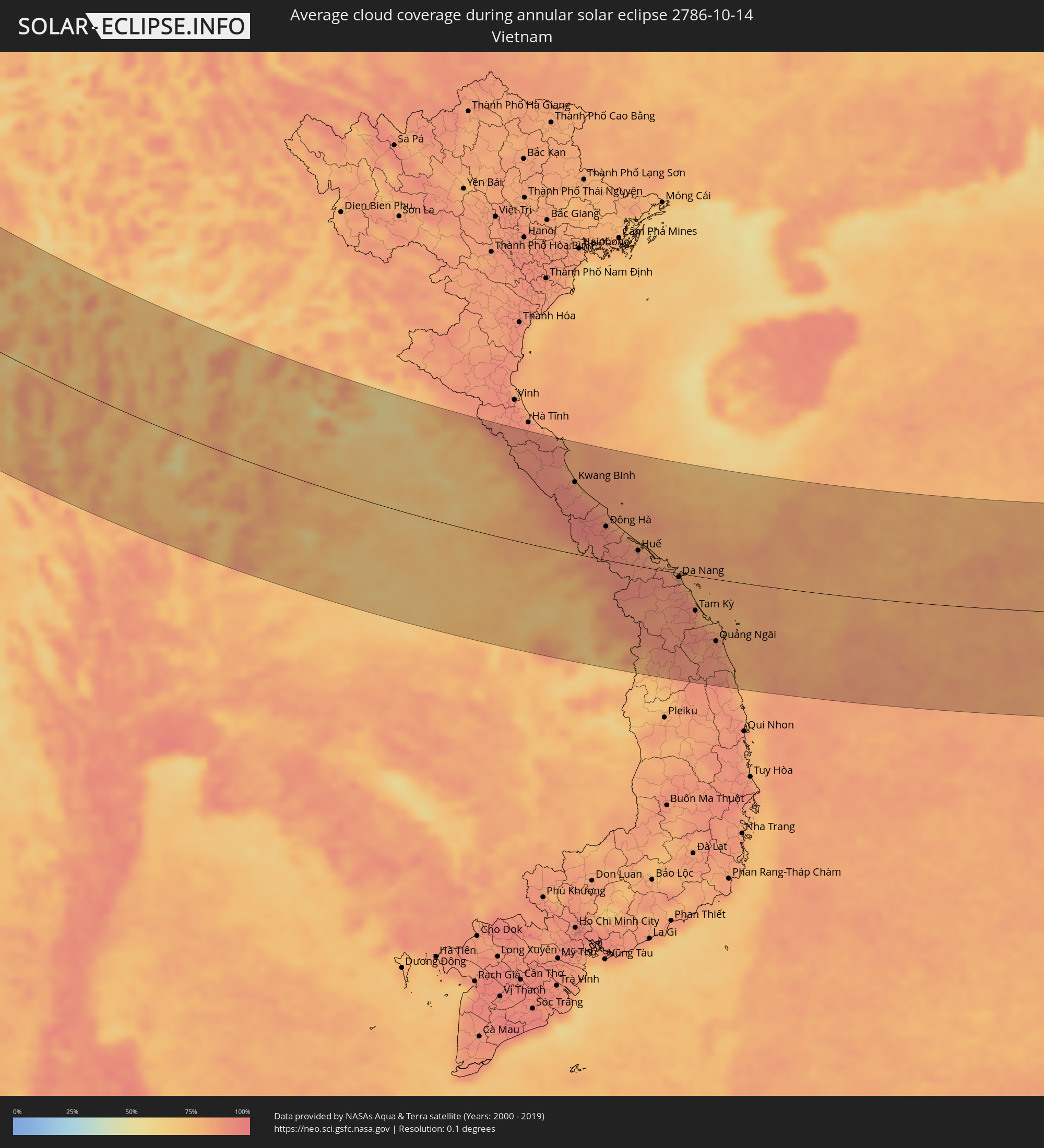 Vietnam
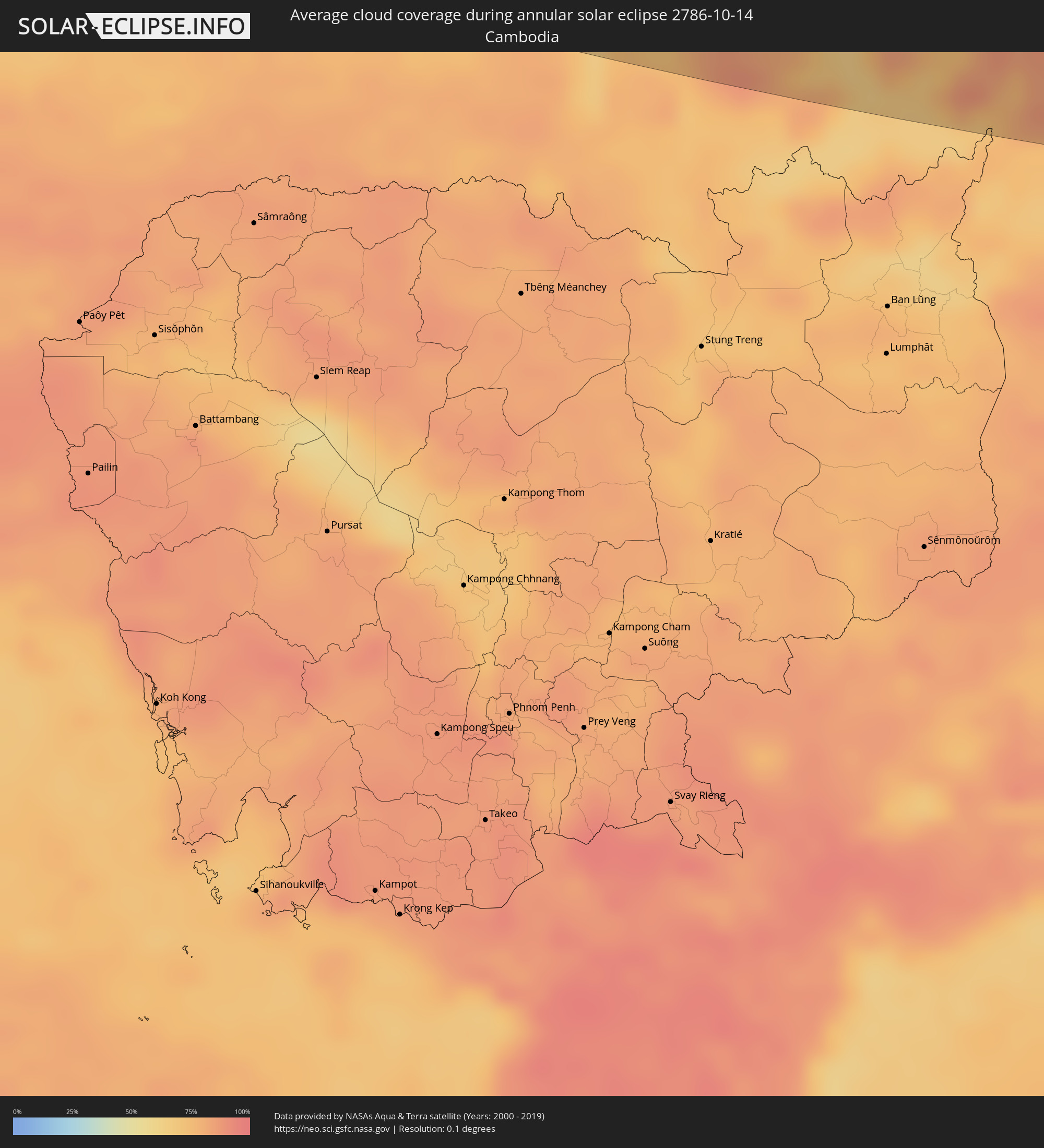 Cambodia
 Philippines
Cities inside the path of the eclipse
The following table shows all locations with a population of more than 5,000 inside the eclipse path. Cities which have more than 100,000 inhabitants are marked bold. A click at the locations opens a detailed map.
| City | Type | Eclipse duration | Local time of max. eclipse | Distance to central line | Ø Cloud coverage |
|
Harstad, Troms
|
annular | - | 07:13:02 UTC+01:00 | 153 km | 83% |
|
Tromsø, Troms
|
annular | - | 07:14:38 UTC+01:00 | 27 km | 88% |
|
Alta, Finnmark Fylke
|
annular | - | 07:16:09 UTC+01:00 | 82 km | 89% |
|
Hammerfest, Finnmark Fylke
|
annular | - | 07:17:06 UTC+01:00 | 157 km | 92% |
|
Kittilä, Lapland
|
annular | - | 08:13:57 UTC+02:00 | 108 km | 85% |
|
Sodankylä, Lapland
|
annular | - | 08:14:16 UTC+02:00 | 96 km | 85% |
|
Inari, Lapland
|
annular | - | 08:16:03 UTC+02:00 | 55 km | 84% |
|
Pyhäjärvi, Lapland
|
annular | - | 08:14:06 UTC+02:00 | 116 km | 84% |
|
Kemijärvi, Lapland
|
annular | - | 08:13:45 UTC+02:00 | 150 km | 86% |
|
Severodvinsk, Arkhangelskaya
|
annular | - | 09:17:40 UTC+03:00 | 16 km | 88% |
|
Arkhangel’sk, Arkhangelskaya
|
annular | - | 09:18:03 UTC+03:00 | 4 km | 90% |
|
Syktyvkar, Komi Republic
|
annular | - | 09:23:24 UTC+03:00 | 116 km | 92% |
|
Glazov, Udmurtiya
|
annular | - | 10:23:59 UTC+04:00 | 86 km | 90% |
|
Votkinsk, Udmurtiya
|
annular | - | 10:25:04 UTC+04:00 | 113 km | 89% |
|
Chaykovskiy, Perm
|
annular | - | 11:25:10 UTC+05:00 | 129 km | 88% |
|
Perm, Perm
|
annular | - | 11:27:17 UTC+05:00 | 59 km | 91% |
|
Beloretsk, Bashkortostan
|
annular | - | 11:29:47 UTC+05:00 | 141 km | 84% |
|
Zlatoust, Chelyabinsk
|
annular | - | 11:30:55 UTC+05:00 | 8 km | 86% |
|
Pervoural’sk, Sverdlovsk
|
annular | - | 11:30:59 UTC+05:00 | 146 km | 89% |
|
Miass, Chelyabinsk
|
annular | - | 11:31:26 UTC+05:00 | 22 km | 82% |
|
Ozersk, Chelyabinsk
|
annular | - | 11:31:57 UTC+05:00 | 101 km | 86% |
|
Dzhetygara, Qostanay
|
annular | - | 11:33:31 UTC+05:00 | 127 km | 78% |
|
Chelyabinsk, Chelyabinsk
|
annular | - | 11:32:52 UTC+05:00 | 94 km | 83% |
|
Troitsk, Chelyabinsk
|
annular | - | 11:33:19 UTC+05:00 | 28 km | 78% |
|
Lisakovsk, Qostanay
|
annular | - | 11:34:56 UTC+05:00 | 33 km | 75% |
|
Rudnyy, Qostanay
|
annular | - | 11:35:30 UTC+05:00 | 29 km | 75% |
|
Kostanay, Qostanay
|
annular | - | 11:36:01 UTC+05:00 | 72 km | 75% |
|
Derzhavīnsk, Aqmola
|
annular | - | 11:40:25 UTC+05:00 | 76 km | 65% |
|
Esil, Aqmola
|
annular | - | 11:40:03 UTC+05:00 | 138 km | 70% |
|
Arkalyk, Qostanay
|
annular | - | 11:41:46 UTC+05:00 | 54 km | 61% |
|
Zhezqazghan, Qaraghandy
|
annular | - | 11:44:47 UTC+05:00 | 59 km | 60% |
|
Qarazhal, Qaraghandy
|
annular | - | 11:48:54 UTC+05:00 | 139 km | 57% |
|
Mikhaylovka, Zhambyl
|
annular | - | 11:55:22 UTC+05:00 | 133 km | 57% |
|
Talas, Talas
|
annular | - | 12:57:10 UTC+06:00 | 114 km | 51% |
|
Lugovoye, Zhambyl
|
annular | - | 11:57:26 UTC+05:00 | 57 km | 54% |
|
Moyynkum, Zhambyl
|
annular | - | 11:56:05 UTC+05:00 | 44 km | 62% |
|
Toktogul, Jalal-Abad
|
annular | - | 12:59:09 UTC+06:00 | 107 km | 47% |
|
Merke, Zhambyl
|
annular | - | 11:58:14 UTC+05:00 | 29 km | 52% |
|
Kaindy, Chüy
|
annular | - | 12:59:06 UTC+06:00 | 2 km | 57% |
|
Chu, Zhambyl
|
annular | - | 11:58:14 UTC+05:00 | 56 km | 53% |
|
Kara-Balta, Chüy
|
annular | - | 12:59:23 UTC+06:00 | 13 km | 55% |
|
Sosnovka, Chüy
|
annular | - | 12:59:42 UTC+06:00 | 6 km | 62% |
|
Bishkek, Bishkek
|
annular | - | 13:00:32 UTC+06:00 | 67 km | 51% |
|
Kant, Chüy
|
annular | - | 13:00:55 UTC+06:00 | 86 km | 56% |
|
Tokmok, Chüy
|
annular | - | 13:01:44 UTC+06:00 | 114 km | 55% |
|
Kemin, Chüy
|
annular | - | 13:02:27 UTC+06:00 | 137 km | 49% |
|
At-Bashi, Naryn
|
annular | - | 13:04:54 UTC+06:00 | 47 km | 48% |
|
Kashgar, Xinjiang Uyghur Autonomous Region
|
annular | - | 15:07:47 UTC+08:00 | 45 km | 50% |
|
Naryn, Naryn
|
annular | - | 13:04:51 UTC+06:00 | 76 km | 49% |
|
Shache, Xinjiang Uyghur Autonomous Region
|
annular | - | 15:11:40 UTC+08:00 | 20 km | 47% |
|
Zangguy, Xinjiang Uyghur Autonomous Region
|
annular | - | 15:16:20 UTC+08:00 | 22 km | 24% |
|
Hotan, Xinjiang Uyghur Autonomous Region
|
annular | - | 15:18:46 UTC+08:00 | 98 km | 36% |
|
Hetauda, Central Region
|
annular | - | 13:33:05 UTC+05:45 | 150 km | 64% |
|
Kathmandu, Central Region
|
annular | - | 13:33:03 UTC+05:45 | 109 km | 48% |
|
Panauti̇̄, Central Region
|
annular | - | 13:33:42 UTC+05:45 | 103 km | 64% |
|
Jaleswar, Central Region
|
annular | - | 13:36:21 UTC+05:45 | 149 km | 63% |
|
Janakpur, Central Region
|
annular | - | 13:36:24 UTC+05:45 | 136 km | 59% |
|
Sirāhā, Eastern Region
|
annular | - | 13:37:08 UTC+05:45 | 118 km | 60% |
|
Lahān, Eastern Region
|
annular | - | 13:37:32 UTC+05:45 | 91 km | 59% |
|
Saharsa, Bihar
|
annular | - | 13:24:39 UTC+05:30 | 148 km | 61% |
|
Rājbirāj, Eastern Region
|
annular | - | 13:38:28 UTC+05:45 | 87 km | 56% |
|
Khāndbāri, Eastern Region
|
annular | - | 13:37:29 UTC+05:45 | 9 km | 50% |
|
Biratnagar, Eastern Region
|
annular | - | 13:39:40 UTC+05:45 | 54 km | 60% |
|
Ithari, Eastern Region
|
annular | - | 13:39:13 UTC+05:45 | 37 km | 56% |
|
Dharān Bāzār, Eastern Region
|
annular | - | 13:38:53 UTC+05:45 | 27 km | 60% |
|
Dhankutā, Eastern Region
|
annular | - | 13:38:36 UTC+05:45 | 10 km | 56% |
|
Purnia, Bihar
|
annular | - | 13:26:35 UTC+05:30 | 90 km | 69% |
|
Katihar, Bihar
|
annular | - | 13:27:19 UTC+05:30 | 102 km | 67% |
|
Sāhibganj, Jharkhand
|
annular | - | 13:28:06 UTC+05:30 | 119 km | 69% |
|
Kishanganj, Bihar
|
annular | - | 13:26:48 UTC+05:30 | 30 km | 68% |
|
Bhadrapur, Eastern Region
|
annular | - | 13:41:04 UTC+05:45 | 13 km | 59% |
|
Rāiganj, West Bengal
|
annular | - | 13:28:14 UTC+05:30 | 55 km | 64% |
|
Ingrāj Bāzār, West Bengal
|
annular | - | 13:29:39 UTC+05:30 | 101 km | 71% |
|
Dārjiling, West Bengal
|
annular | - | 13:25:19 UTC+05:30 | 62 km | 73% |
|
Shiliguri, West Bengal
|
annular | - | 13:26:21 UTC+05:30 | 50 km | 57% |
|
Rājshāhi, Rājshāhi
|
annular | - | 14:01:58 UTC+06:00 | 118 km | 69% |
|
Dinājpur, Rangpur Division
|
annular | - | 13:59:12 UTC+06:00 | 17 km | 71% |
|
Jalpāiguri, West Bengal
|
annular | - | 13:27:23 UTC+05:30 | 58 km | 58% |
|
Bālurghāt, West Bengal
|
annular | - | 13:30:23 UTC+05:30 | 39 km | 69% |
|
Samtse, Samchi
|
annular | - | 13:57:14 UTC+06:00 | 113 km | 67% |
|
Rangpur, Rangpur Division
|
annular | - | 14:00:07 UTC+06:00 | 36 km | 70% |
|
Bogra, Rājshāhi
|
annular | - | 14:02:22 UTC+06:00 | 25 km | 71% |
|
Jaigaon, West Bengal
|
annular | - | 13:27:53 UTC+05:30 | 130 km | 54% |
|
Phuntsholing, Chukha District
|
annular | - | 13:27:54 UTC+05:30 | 131 km | 63% |
|
Tsimasham, Chukha District
|
annular | - | 13:57:38 UTC+06:00 | 160 km | 71% |
|
Nāgarpur, Dhaka
|
annular | - | 14:05:09 UTC+06:00 | 53 km | 70% |
|
Barisāl, Barisāl
|
annular | - | 14:09:09 UTC+06:00 | 131 km | 70% |
|
Tungi, Dhaka
|
annular | - | 14:06:32 UTC+06:00 | 31 km | 75% |
|
Mymensingh, Dhaka
|
annular | - | 14:04:35 UTC+06:00 | 40 km | 68% |
|
Dhaka, Dhaka
|
annular | - | 14:06:57 UTC+06:00 | 45 km | 79% |
|
Narsingdi, Dhaka
|
annular | - | 14:07:04 UTC+06:00 | 6 km | 71% |
|
Comilla, Chittagong
|
annular | - | 14:09:00 UTC+06:00 | 13 km | 69% |
|
Agartala, Tripura
|
annular | - | 13:38:20 UTC+05:30 | 25 km | 70% |
|
Chittagong, Chittagong
|
annular | - | 14:12:45 UTC+06:00 | 66 km | 65% |
|
Sylhet, Sylhet
|
annular | - | 14:07:03 UTC+06:00 | 153 km | 63% |
|
Cox’s Bāzār, Chittagong
|
annular | - | 14:15:06 UTC+06:00 | 133 km | 53% |
|
Aizawl, Mizoram
|
annular | - | 13:41:16 UTC+05:30 | 112 km | 68% |
|
Chauk, Magway
|
annular | - | 14:51:25 UTC+06:30 | 11 km | 81% |
|
Yenangyaung, Magway
|
annular | - | 14:52:28 UTC+06:30 | 48 km | 83% |
|
Magway, Magway
|
annular | - | 14:53:16 UTC+06:30 | 74 km | 83% |
|
Pakokku, Magway
|
annular | - | 14:50:55 UTC+06:30 | 45 km | 81% |
|
Monywa, Sagain
|
annular | - | 14:49:18 UTC+06:30 | 119 km | 82% |
|
Thayetmyo, Magway
|
annular | - | 14:55:31 UTC+06:30 | 139 km | 78% |
|
Myingyan, Mandalay
|
annular | - | 14:51:11 UTC+06:30 | 74 km | 80% |
|
Meiktila, Mandalay
|
annular | - | 14:53:17 UTC+06:30 | 46 km | 76% |
|
Sagaing, Sagain
|
annular | - | 14:51:18 UTC+06:30 | 146 km | 69% |
|
Mandalay, Mandalay
|
annular | - | 14:51:17 UTC+06:30 | 161 km | 75% |
|
Nay Pyi Taw, Nay Pyi Taw
|
annular | - | 14:56:14 UTC+06:30 | 47 km | 76% |
|
Pyinmana, Nay Pyi Taw
|
annular | - | 14:56:22 UTC+06:30 | 44 km | 70% |
|
Taungoo, Bago
|
annular | - | 14:58:28 UTC+06:30 | 109 km | 61% |
|
Taunggyi, Shan
|
annular | - | 14:55:31 UTC+06:30 | 101 km | 81% |
|
Chiang Mai, Chiang Mai
|
annular | - | 15:32:59 UTC+07:00 | 1 km | 80% |
|
Lampang, Lampang
|
annular | - | 15:34:49 UTC+07:00 | 30 km | 80% |
|
Chiang Rai, Chiang Rai
|
annular | - | 15:31:58 UTC+07:00 | 149 km | 73% |
|
Uttaradit, Uttaradit
|
annular | - | 15:37:06 UTC+07:00 | 73 km | 73% |
|
Phitsanulok, Phitsanulok
|
annular | - | 15:38:59 UTC+07:00 | 149 km | 82% |
|
Phetchabun, Phetchabun
|
annular | - | 15:41:07 UTC+07:00 | 157 km | 73% |
|
Sainyabuli, Xiagnabouli
|
annular | - | 15:36:12 UTC+07:00 | 159 km | 69% |
|
Chum Phae, Khon Kaen
|
annular | - | 15:42:12 UTC+07:00 | 111 km | 74% |
|
Muang Phôn-Hông, Vientiane Province
|
annular | - | 15:38:46 UTC+07:00 | 105 km | 68% |
|
Vangviang, Vientiane Province
|
annular | - | 15:37:57 UTC+07:00 | 151 km | 64% |
|
Vientiane, Vientiane
|
annular | - | 15:40:05 UTC+07:00 | 56 km | 75% |
|
Nong Khai, Nong Khai
|
annular | - | 15:40:28 UTC+07:00 | 51 km | 70% |
|
Udon Thani, Changwat Udon Thani
|
annular | - | 15:41:27 UTC+07:00 | 4 km | 72% |
|
Khon Kaen, Khon Kaen
|
annular | - | 15:43:24 UTC+07:00 | 98 km | 68% |
|
Maha Sarakham, Maha Sarakham
|
annular | - | 15:44:33 UTC+07:00 | 111 km | 66% |
|
Kalasin, Kalasin
|
annular | - | 15:44:20 UTC+07:00 | 78 km | 67% |
|
Muang Pakxan, Bolikhamsai Province
|
annular | - | 15:40:44 UTC+07:00 | 134 km | 55% |
|
Sakon Nakhon, Sakon Nakhon
|
annular | - | 15:43:47 UTC+07:00 | 18 km | 67% |
|
Savannakhét, Savannahkhét
|
annular | - | 15:45:43 UTC+07:00 | 29 km | 69% |
|
Thakhèk, Khammouan
|
annular | - | 15:44:12 UTC+07:00 | 64 km | 68% |
|
Ubon Ratchathani, Changwat Ubon Ratchathani
|
annular | - | 15:48:20 UTC+07:00 | 170 km | 77% |
|
Pakse, Champasak
|
annular | - | 15:49:42 UTC+07:00 | 159 km | 76% |
|
Salavan, Salavan
|
annular | - | 15:49:21 UTC+07:00 | 80 km | 69% |
|
Kwang Binh, Quảng Bình
|
annular | - | 15:46:20 UTC+07:00 | 115 km | 90% |
|
Lamam, Xékong
|
annular | - | 15:50:13 UTC+07:00 | 107 km | 66% |
|
Attapu, Attapu
|
annular | - | 15:51:28 UTC+07:00 | 170 km | 64% |
|
Ðông Hà, Quảng Trị
|
annular | - | 15:48:07 UTC+07:00 | 54 km | 93% |
|
Huế, Thừa Thiên-Huế
|
annular | - | 15:49:21 UTC+07:00 | 25 km | 88% |
|
Da Nang, Đà Nẵng
|
annular | - | 15:50:46 UTC+07:00 | 6 km | 88% |
|
Hội An, Quảng Nam
|
annular | - | 15:51:14 UTC+07:00 | 25 km | 89% |
|
Tam Kỳ, Quảng Nam
|
annular | - | 15:51:55 UTC+07:00 | 56 km | 87% |
|
Quảng Ngãi, Quảng Ngãi
|
annular | - | 15:53:04 UTC+07:00 | 101 km | 89% |
|
Olongapo, Central Luzon
|
annular | - | 17:02:24 UTC+08:00 | 86 km | 79% |
|
Angeles City, Central Luzon
|
annular | - | 17:02:04 UTC+08:00 | 52 km | 93% |
|
Baguio, Cordillera
|
annular | - | 17:00:09 UTC+08:00 | 88 km | 90% |
|
Tarlac City, Central Luzon
|
annular | - | 17:01:35 UTC+08:00 | 16 km | 87% |
|
San Fernando, Central Luzon
|
annular | - | 17:02:18 UTC+08:00 | 66 km | 87% |
|
Malolos, Central Luzon
|
annular | - | 17:02:38 UTC+08:00 | 88 km | 83% |
|
Baliuag, Central Luzon
|
annular | - | 17:02:30 UTC+08:00 | 76 km | 90% |
|
Dasmariñas, Calabarzon
|
annular | - | 17:03:27 UTC+08:00 | 146 km | 94% |
|
Cabanatuan City, Central Luzon
|
annular | - | 17:01:45 UTC+08:00 | 17 km | 87% |
|
San Jose del Monte, Central Luzon
|
annular | - | 17:02:47 UTC+08:00 | 93 km | 94% |
|
Quezon City, Metro Manila
|
annular | - | 17:03:02 UTC+08:00 | 111 km | 91% |
|
Calamba, Calabarzon
|
annular | - | 17:03:43 UTC+08:00 | 160 km | 90% |
|
Binangonan, Calabarzon
|
annular | - | 17:03:22 UTC+08:00 | 132 km | 79% |
|
Rodriguez, Calabarzon
|
annular | - | 17:02:56 UTC+08:00 | 100 km | 91% |