Total solar eclipse of 08/13/2808
| Day of week: | Wednesday |
| Maximum duration of eclipse: | 01m32s |
| Maximum width of eclipse path: | 66 km |
| Saros cycle: | 158 |
| Coverage: | 100% |
| Magnitude: | 1.0178 |
| Gamma: | 0.381 |
Wo kann man die Sonnenfinsternis vom 08/13/2808 sehen?
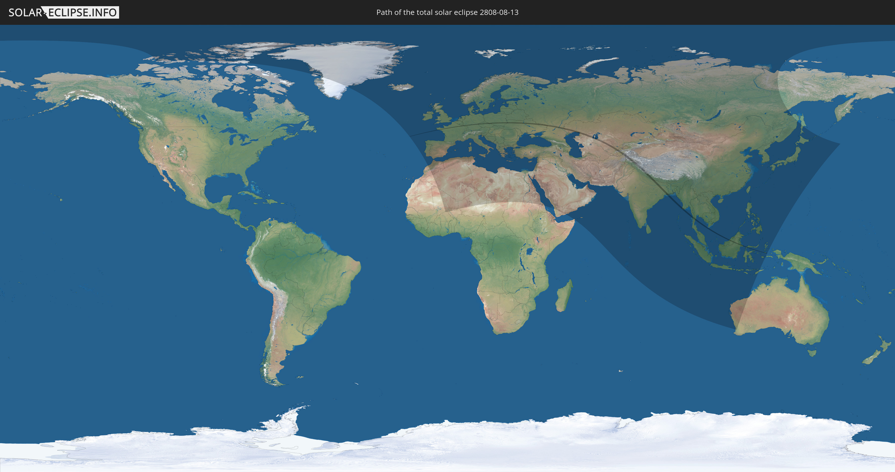
Die Sonnenfinsternis am 08/13/2808 kann man in 121 Ländern als partielle Sonnenfinsternis beobachten.
Der Finsternispfad verläuft durch 19 Länder. Nur in diesen Ländern ist sie als total Sonnenfinsternis zu sehen.
In den folgenden Ländern ist die Sonnenfinsternis total zu sehen
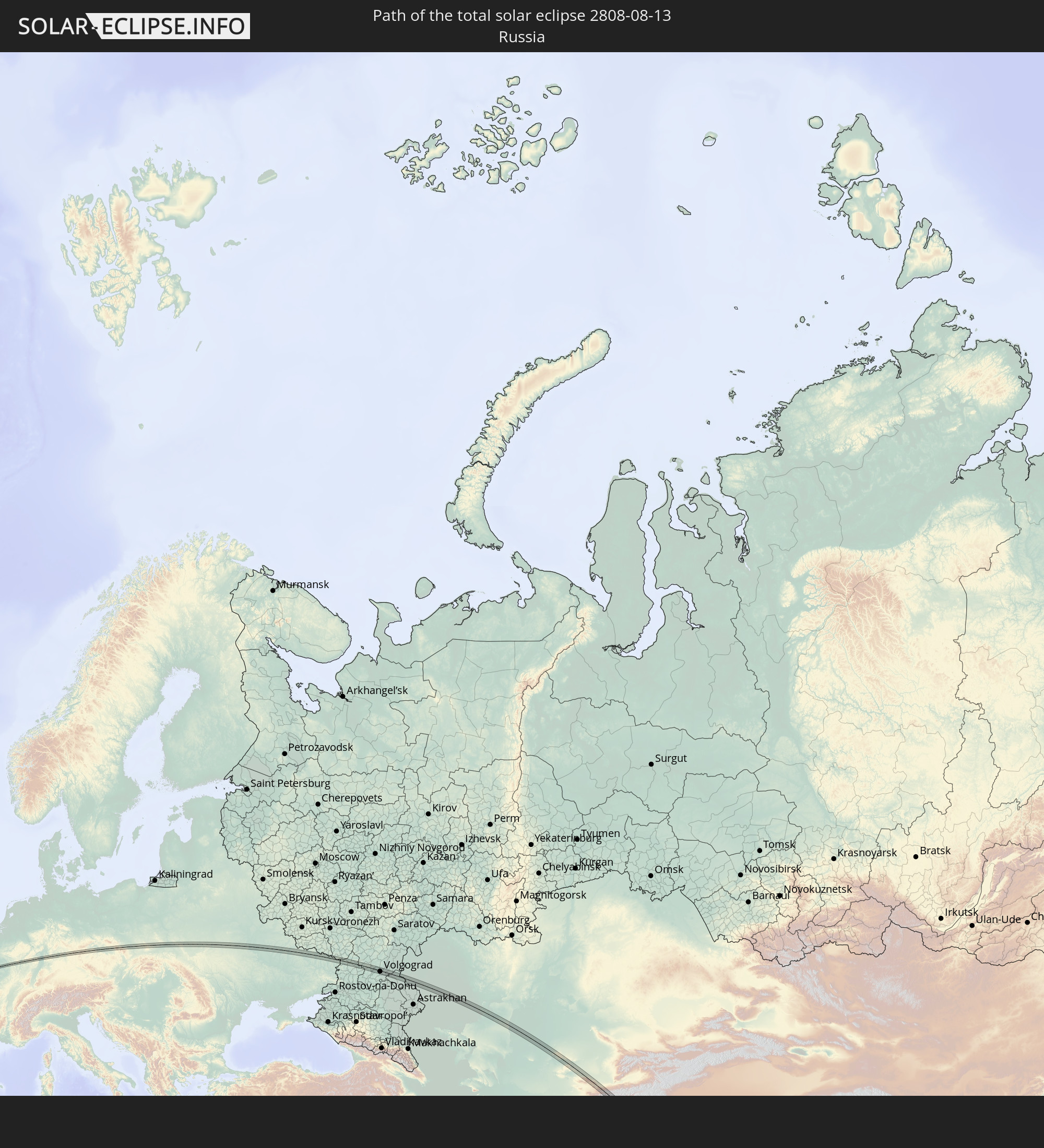 Russia
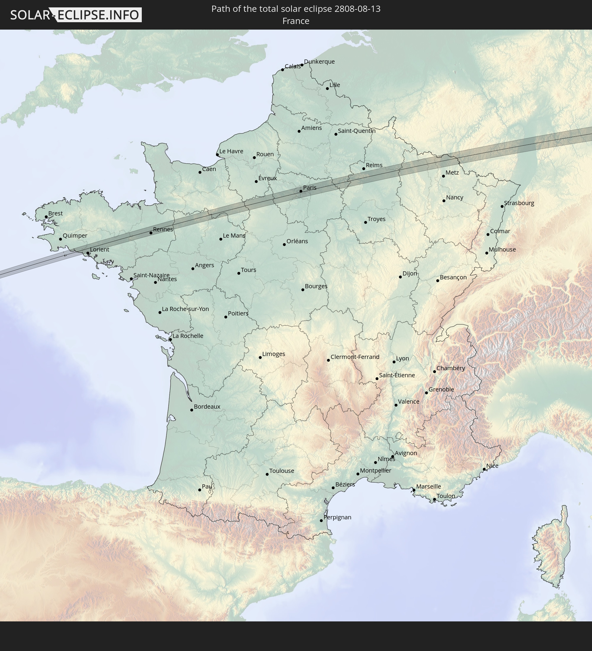 France
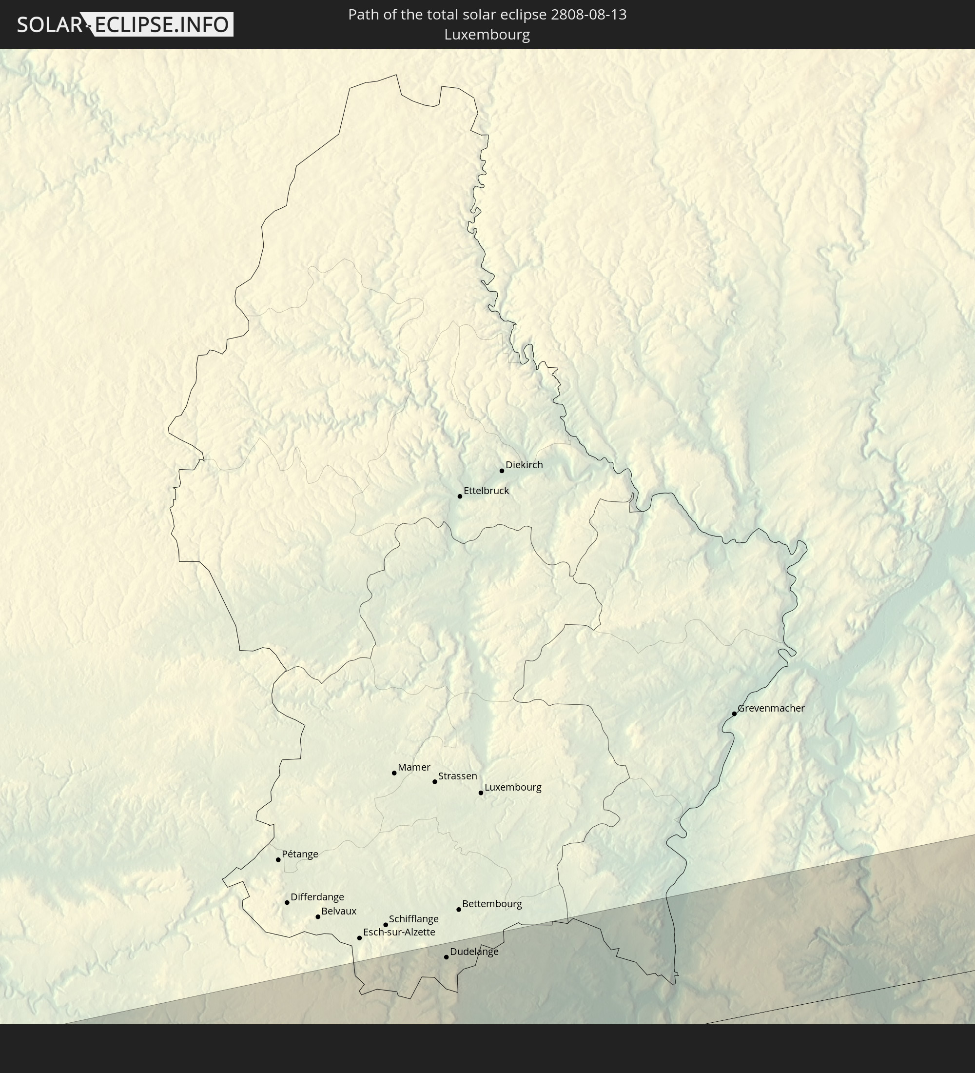 Luxembourg
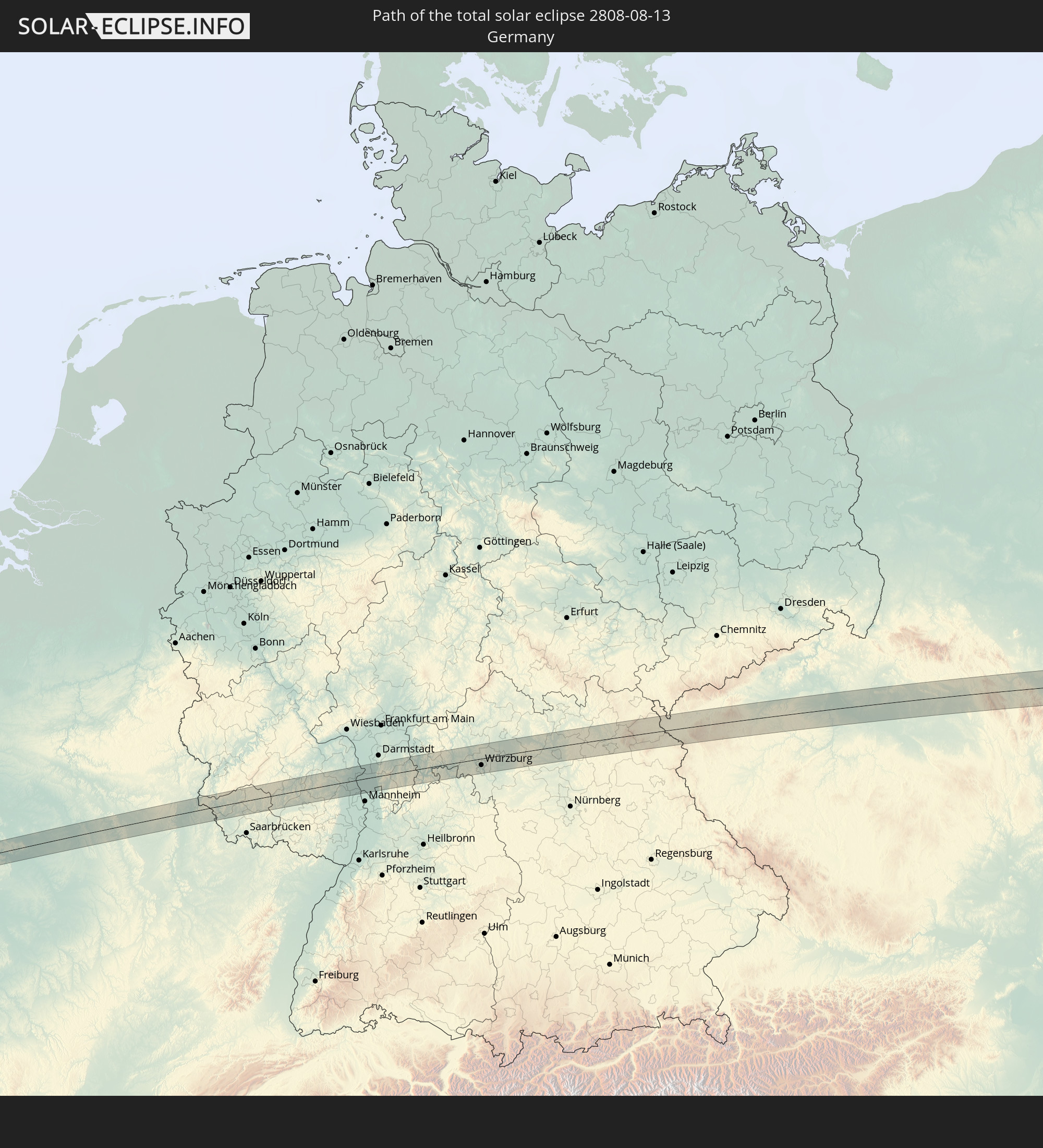 Germany
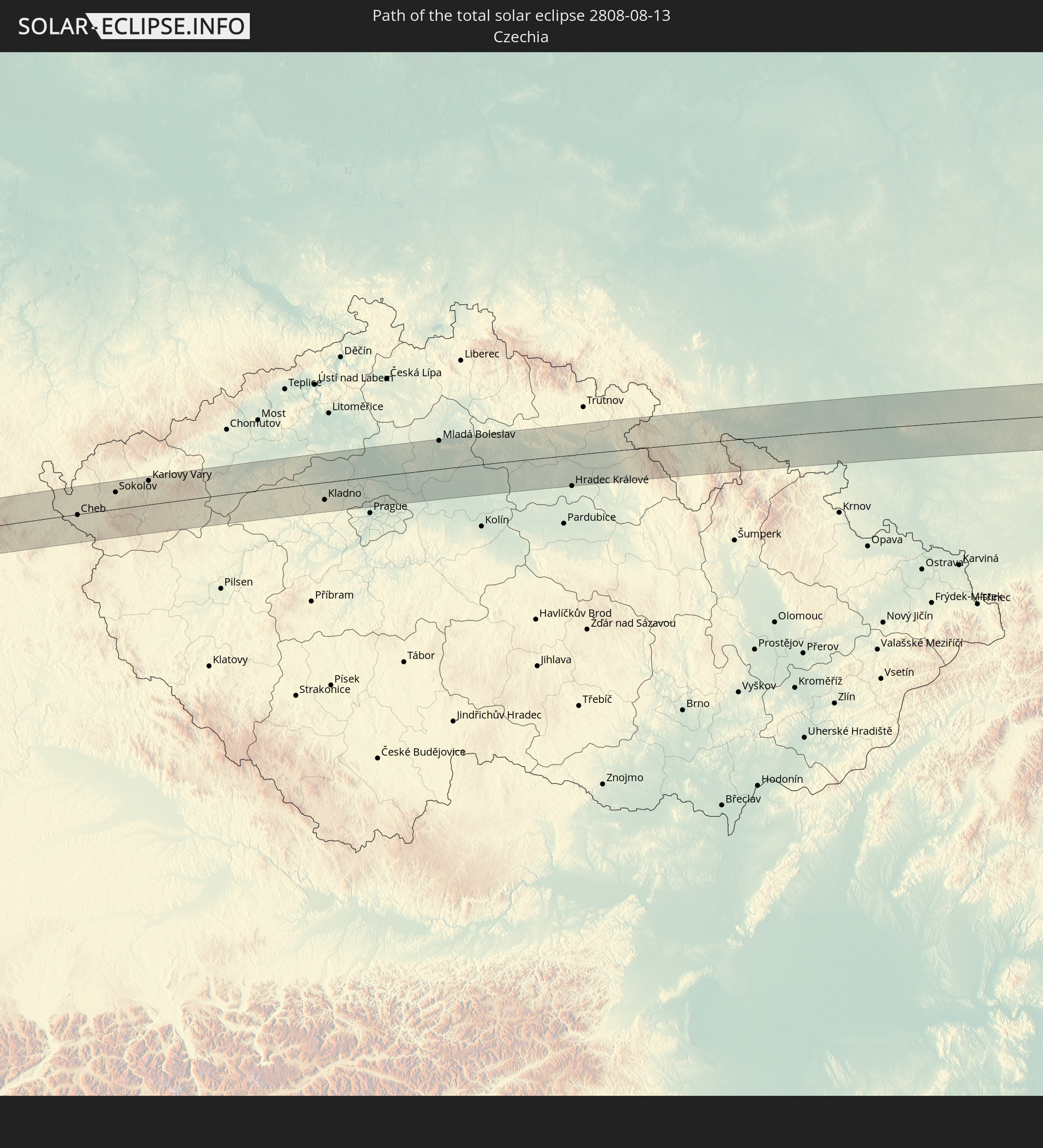 Czechia
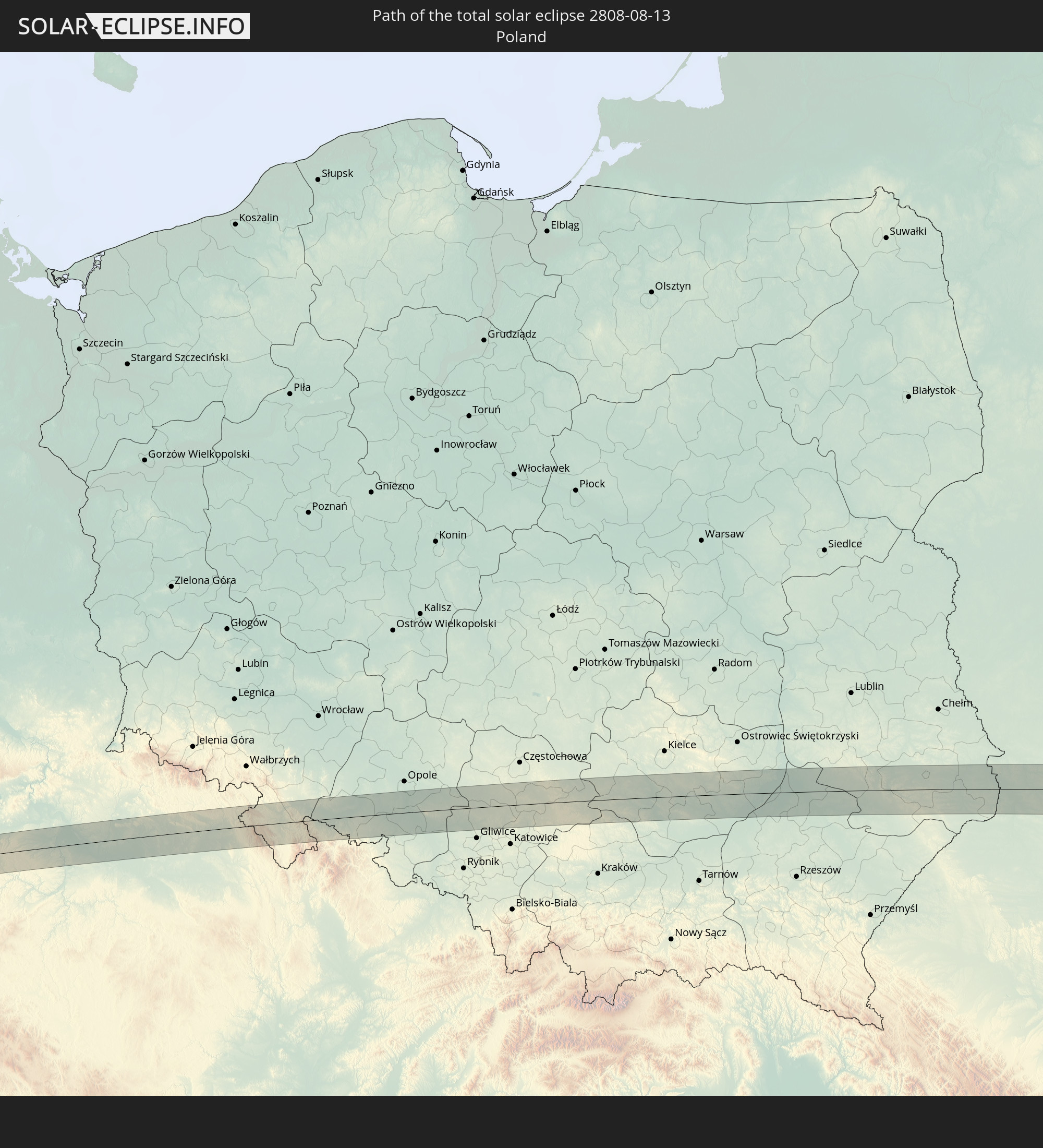 Poland
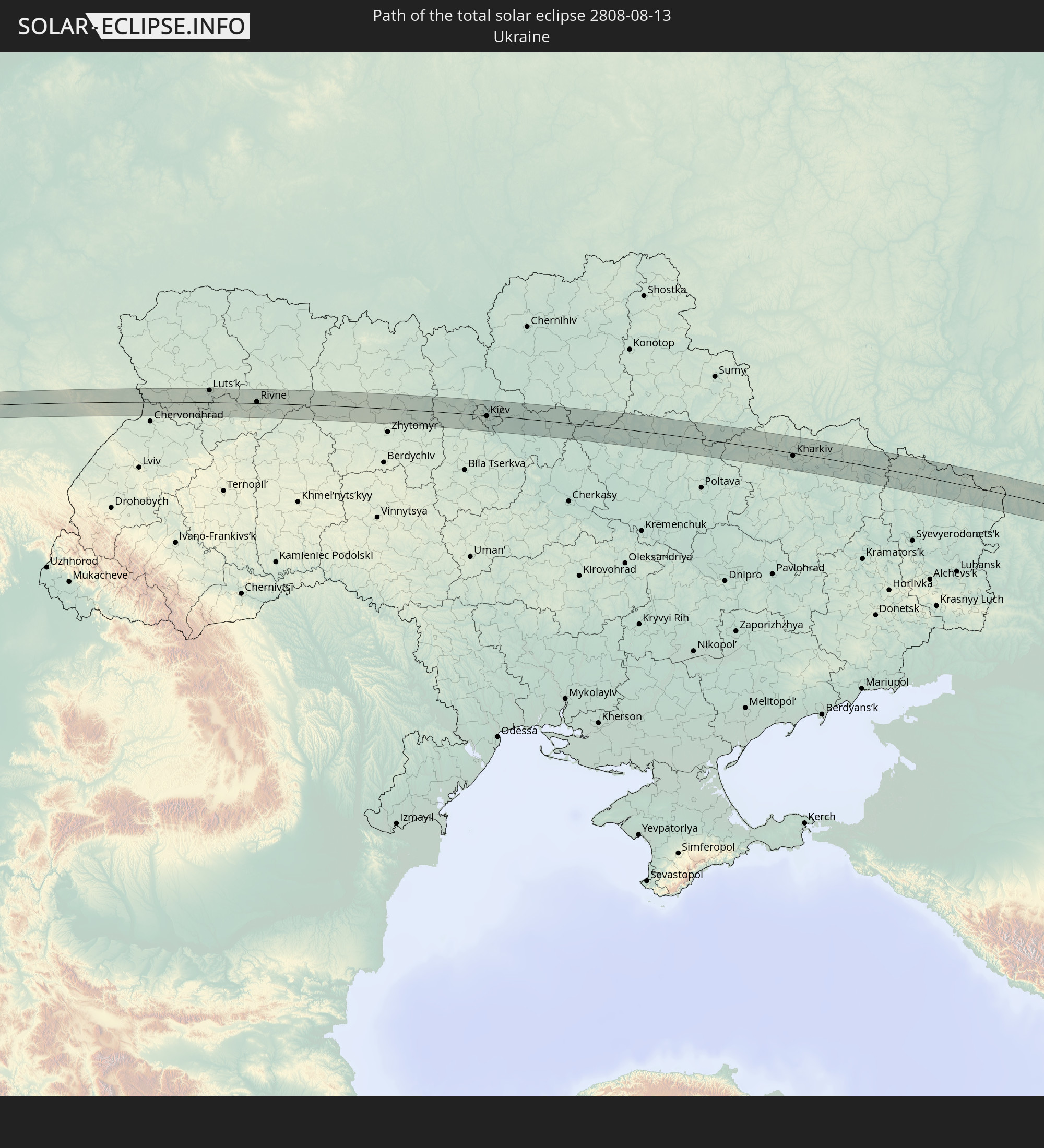 Ukraine
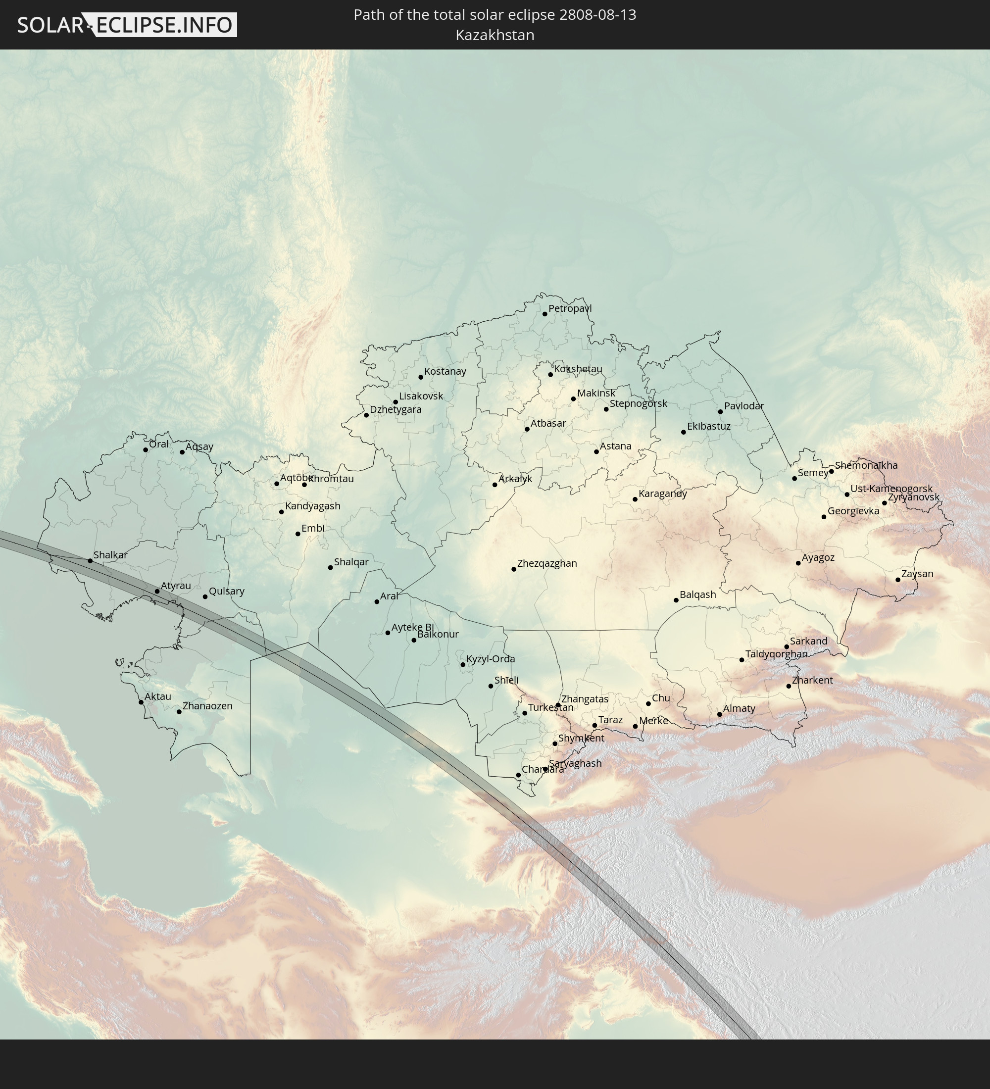 Kazakhstan
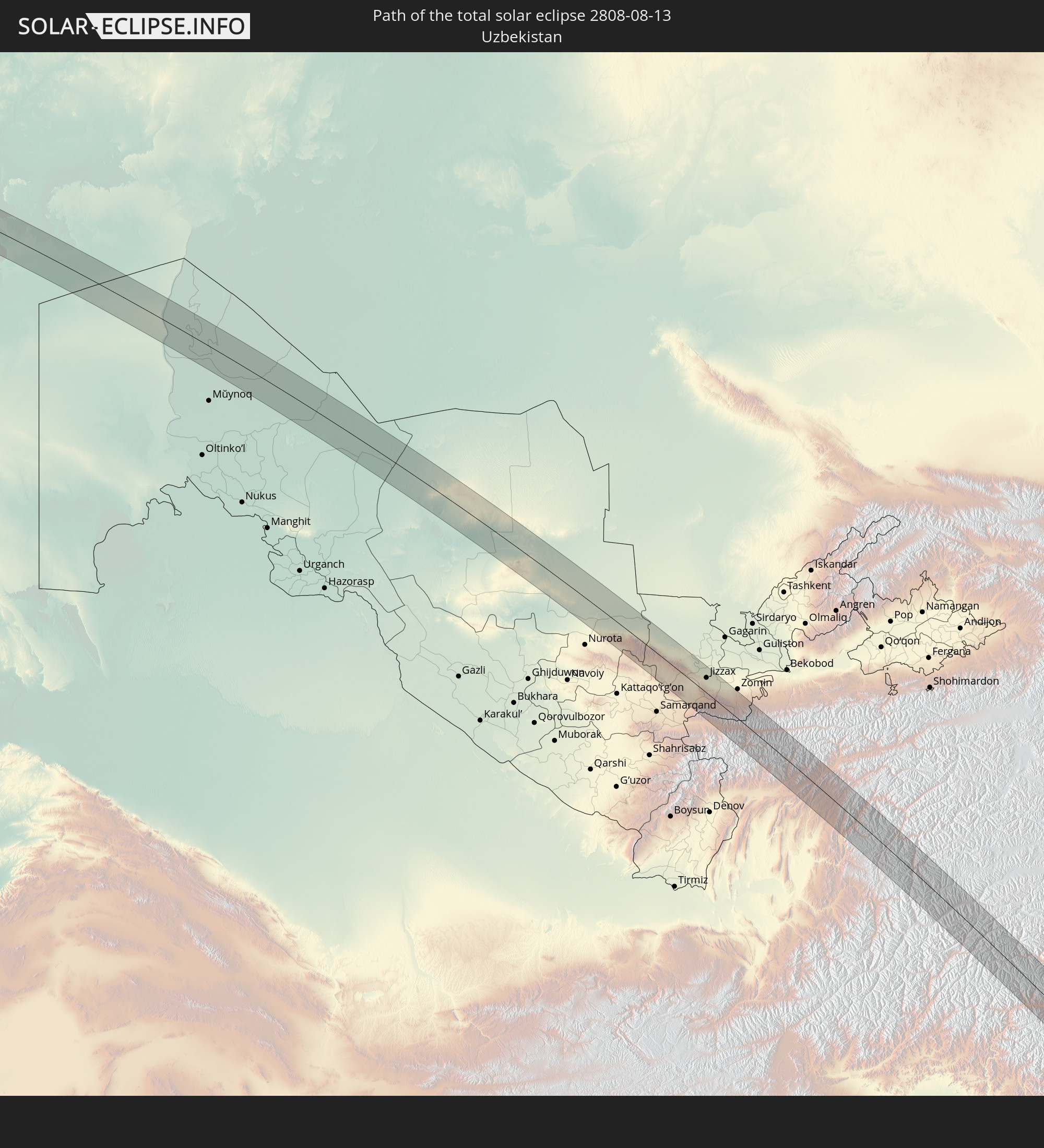 Uzbekistan
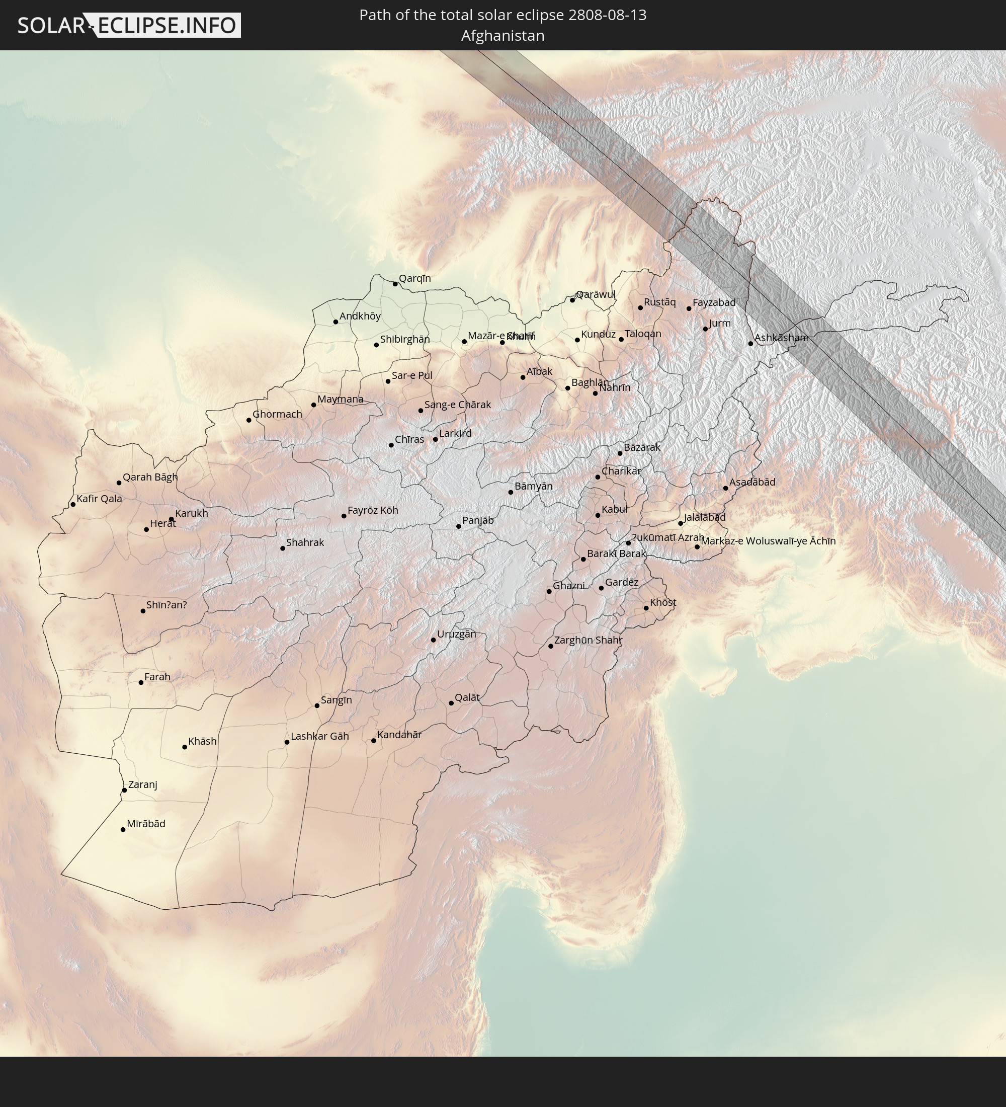 Afghanistan
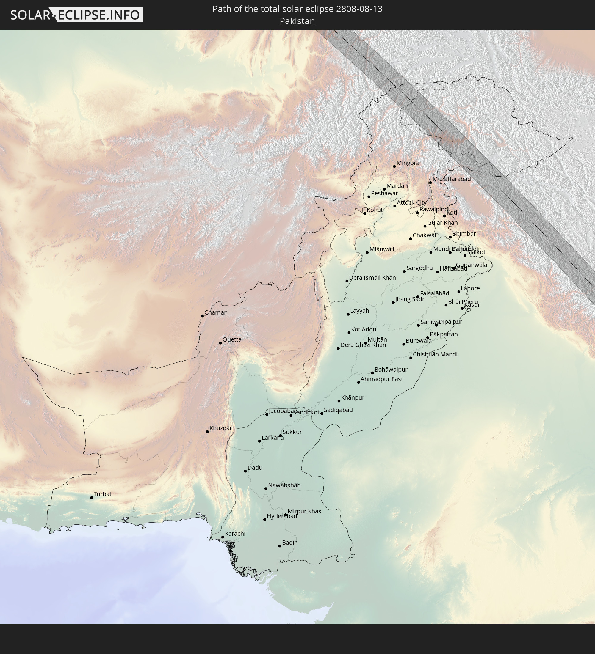 Pakistan
 Tajikistan
 India
India
 China
China
 Nepal
Nepal
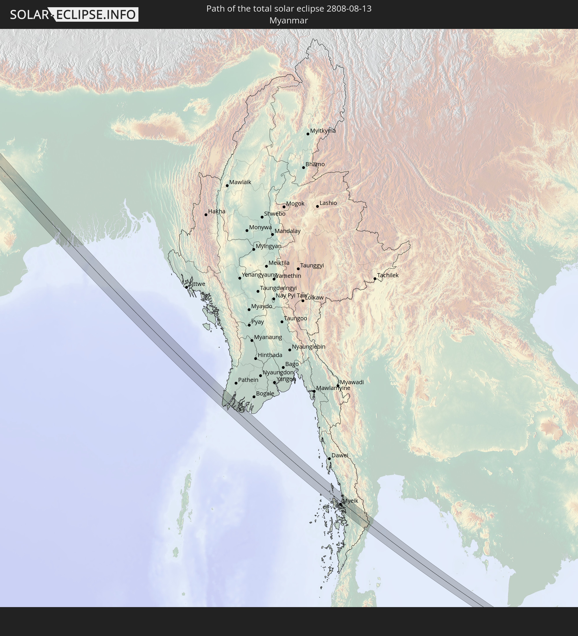 Myanmar
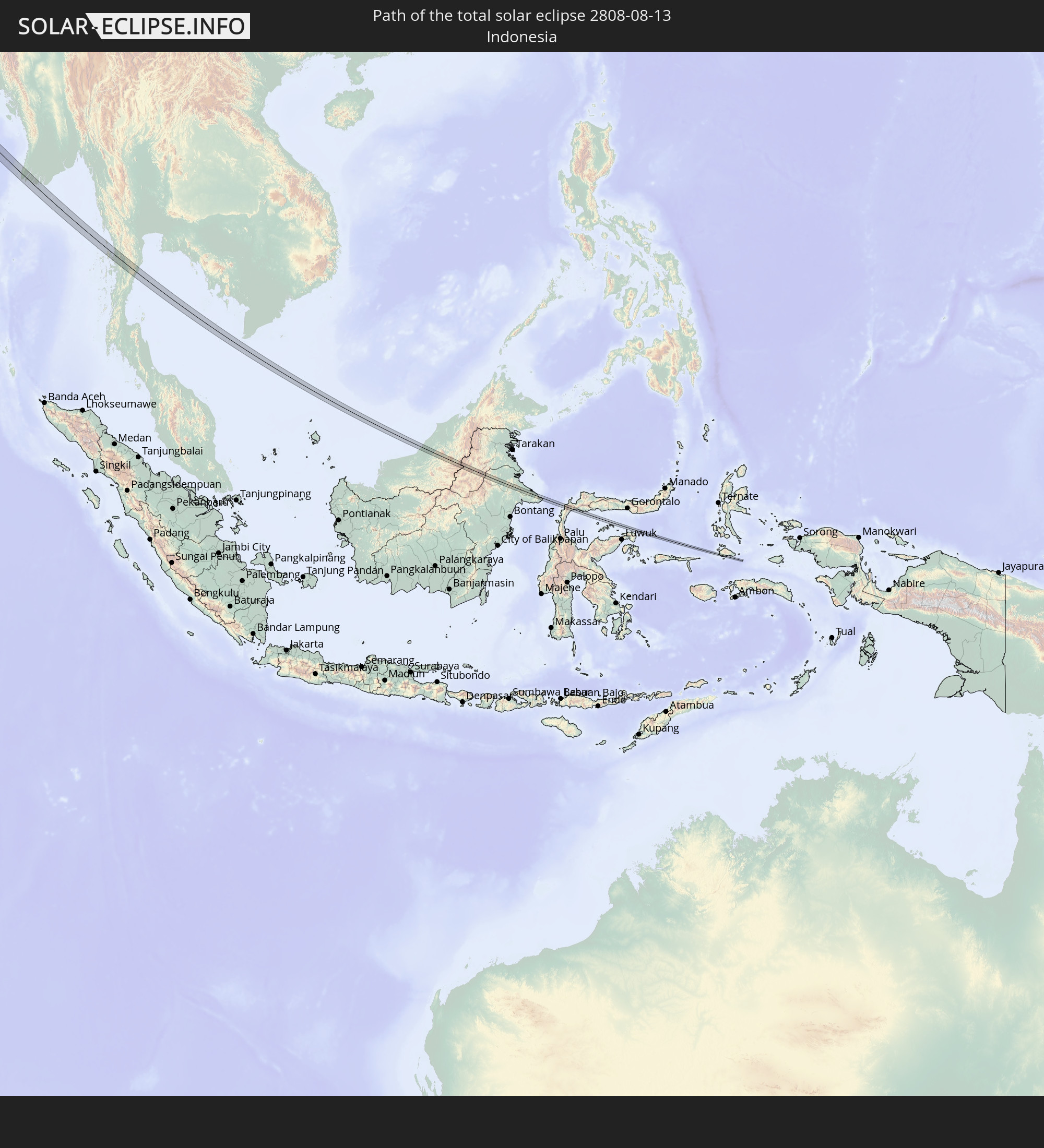 Indonesia
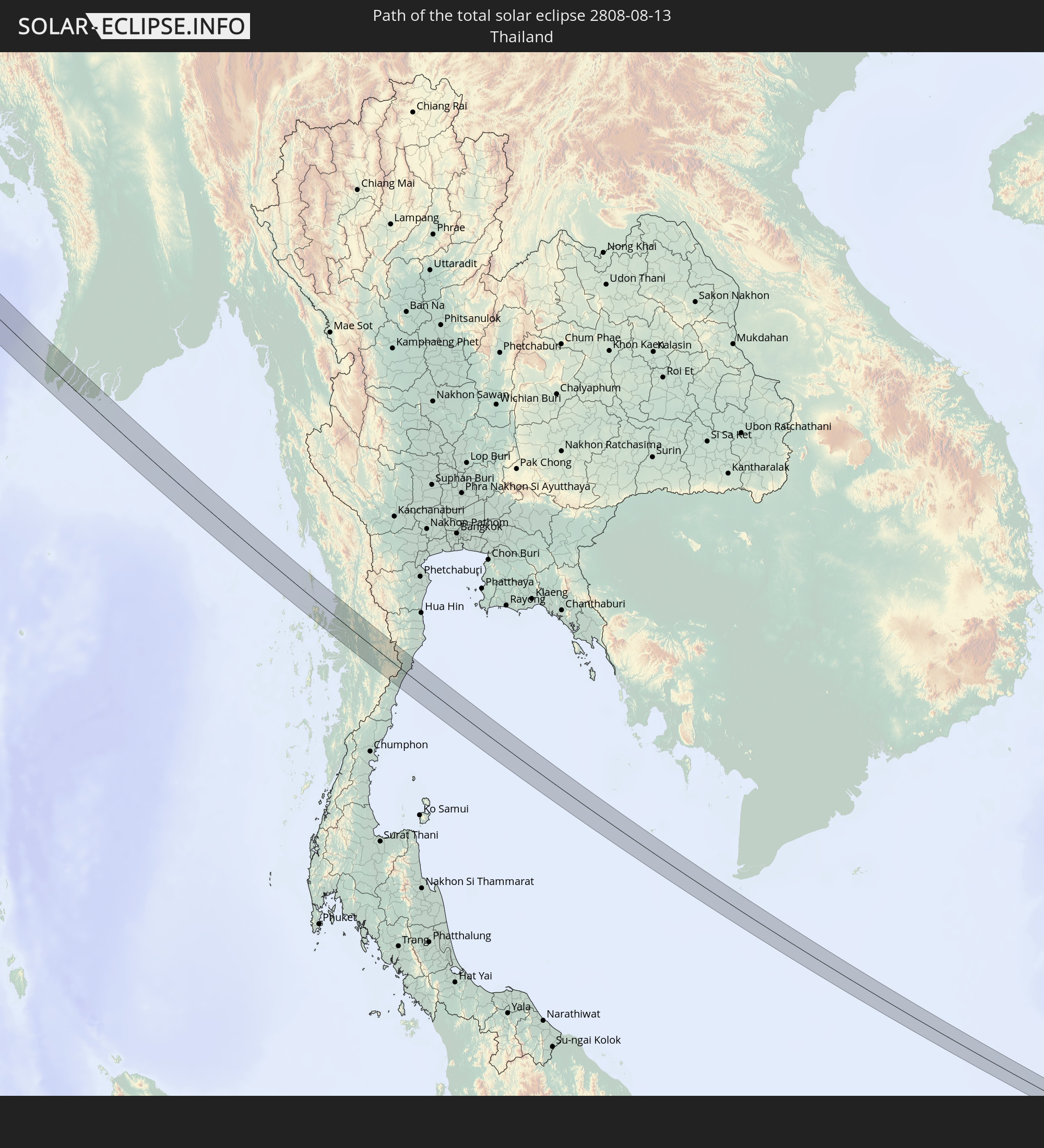 Thailand
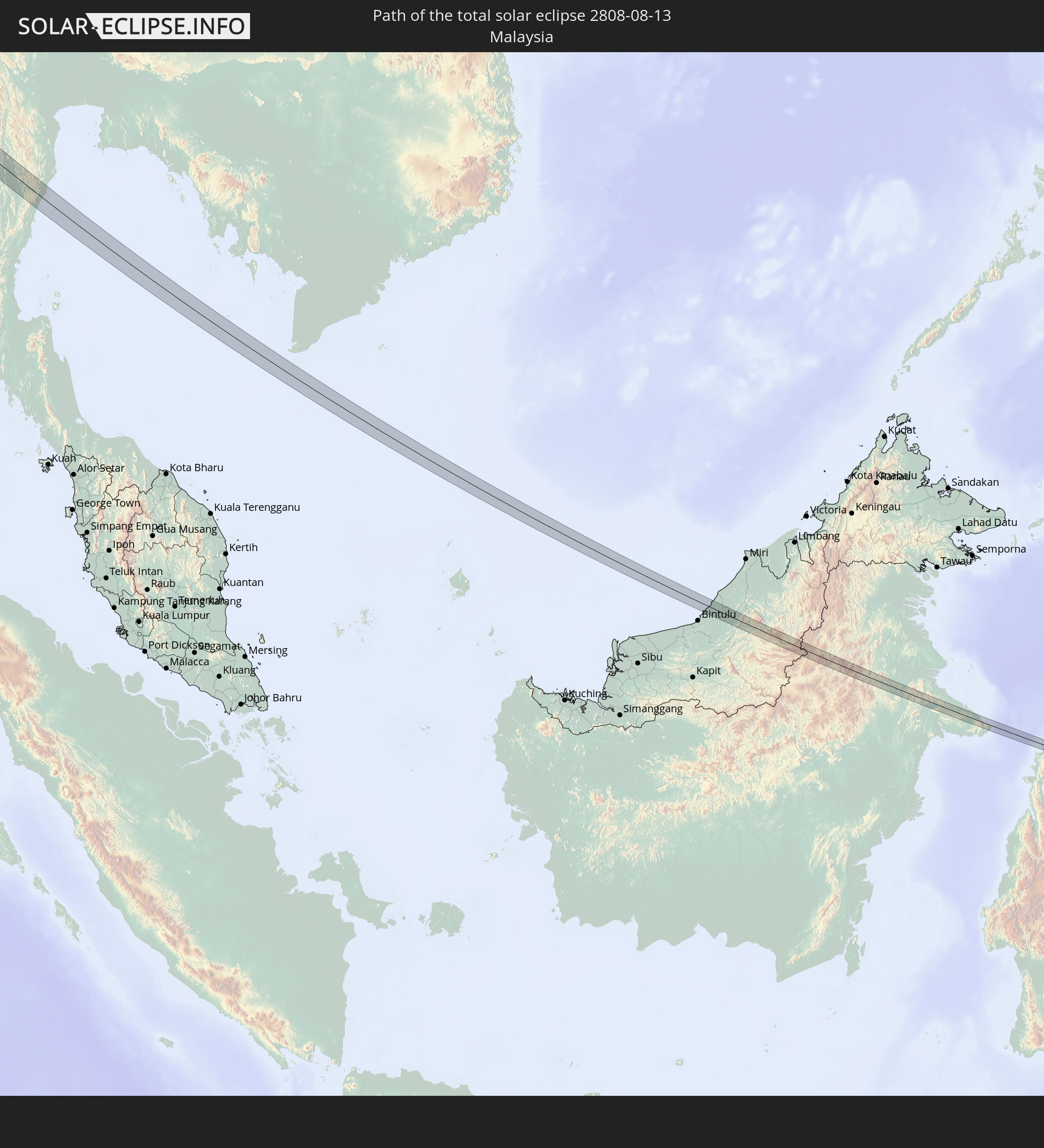 Malaysia
In den folgenden Ländern ist die Sonnenfinsternis partiell zu sehen
 Russia
 Canada
 Greenland
 Portugal
 Iceland
 Spain
Spain
 Morocco
 Mali
Mali
 Republic of Ireland
 Svalbard and Jan Mayen
 Algeria
 United Kingdom
 Faroe Islands
 Burkina Faso
 Gibraltar
 France
 Isle of Man
 Guernsey
 Jersey
 Niger
Niger
 Andorra
 Belgium
 Netherlands
 Norway
 Luxembourg
 Germany
 Switzerland
 Italy
Italy
 Monaco
 Tunisia
 Denmark
 Libya
Libya
 Liechtenstein
 Austria
 Sweden
 Czechia
 San Marino
 Vatican City
 Slovenia
 Chad
Chad
 Croatia
 Poland
 Malta
Malta
 Bosnia and Herzegovina
 Hungary
 Slovakia
 Montenegro
 Serbia
 Albania
 Åland Islands
 Greece
 Romania
 Republic of Macedonia
 Finland
 Lithuania
 Latvia
 Estonia
 Sudan
Sudan
 Ukraine
 Bulgaria
 Belarus
 Egypt
Egypt
 Turkey
 Moldova
 Cyprus
 State of Palestine
 Israel
 Saudi Arabia
 Jordan
 Lebanon
 Syria
Syria
 Eritrea
 Iraq
Iraq
 Georgia
 Somalia
 Yemen
Yemen
 Armenia
 Iran
Iran
 Azerbaijan
 Kazakhstan
 Kuwait
 Bahrain
 Qatar
Qatar
 United Arab Emirates
 Oman
Oman
 Turkmenistan
 Uzbekistan
 Afghanistan
 Pakistan
 Tajikistan
 India
India
 Kyrgyzstan
 British Indian Ocean Territory
 Maldives
 China
China
 Sri Lanka
 Nepal
Nepal
 Mongolia
 Bangladesh
 Bhutan
 Myanmar
 Indonesia
 Cocos Islands
 Thailand
 Malaysia
 Laos
Laos
 Vietnam
 Cambodia
 Singapore
 Christmas Island
 Australia
 Macau
Macau
 Hong Kong
 Brunei
 Taiwan
 Philippines
 Japan
Japan
 East Timor
 North Korea
 South Korea
 Palau
Palau
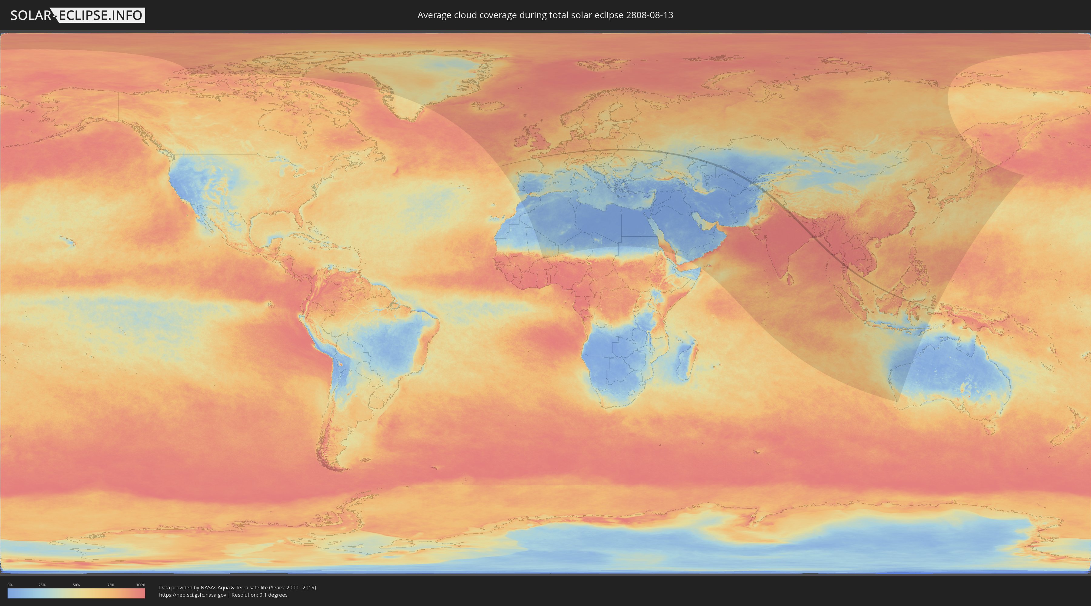
How will be the weather during the total solar eclipse on 08/13/2808?
Where is the best place to see the total solar eclipse of 08/13/2808?
The following maps show the average cloud coverage for the day of the total solar eclipse.
With the help of these maps, it is possible to find the place along the eclipse path, which has the best
chance of a cloudless sky.
Nevertheless, you should consider local circumstances and inform about the weather of your chosen
observation site.
The data is provided by NASAs satellites
AQUA and TERRA.
The cloud maps are averaged over a period of 19 years (2000 - 2019).

Detailed country maps
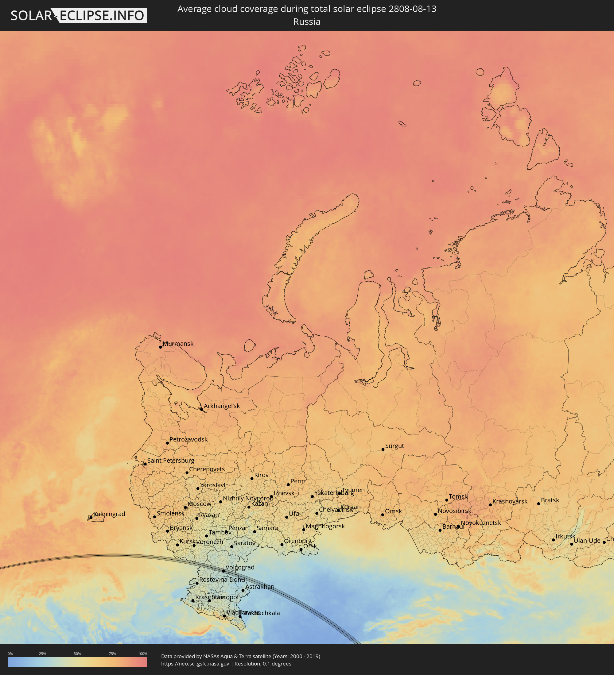 Russia
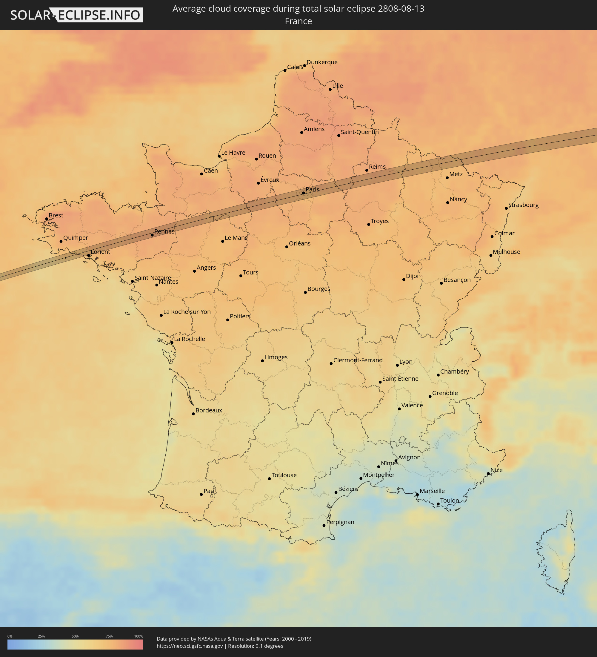 France
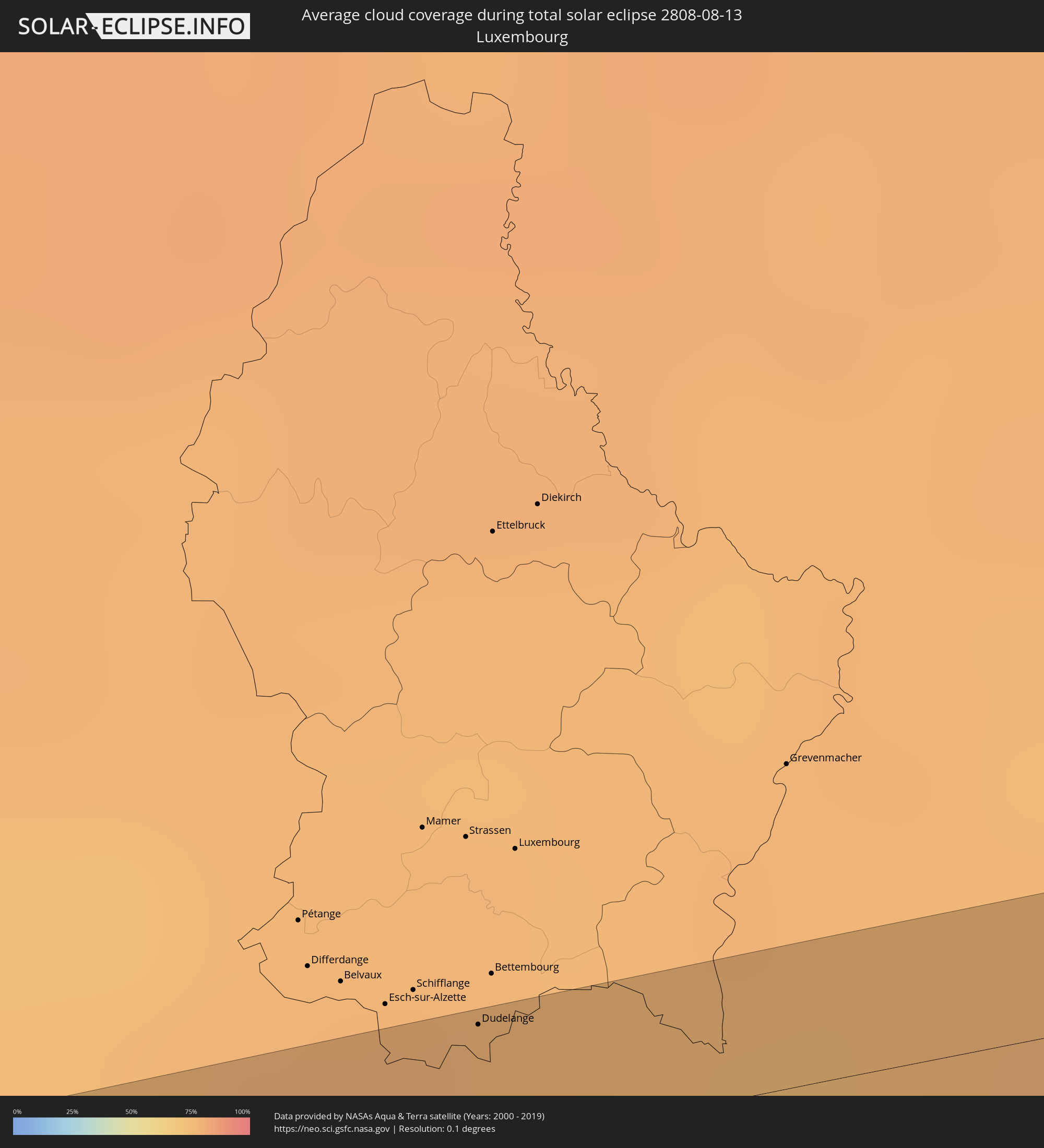 Luxembourg
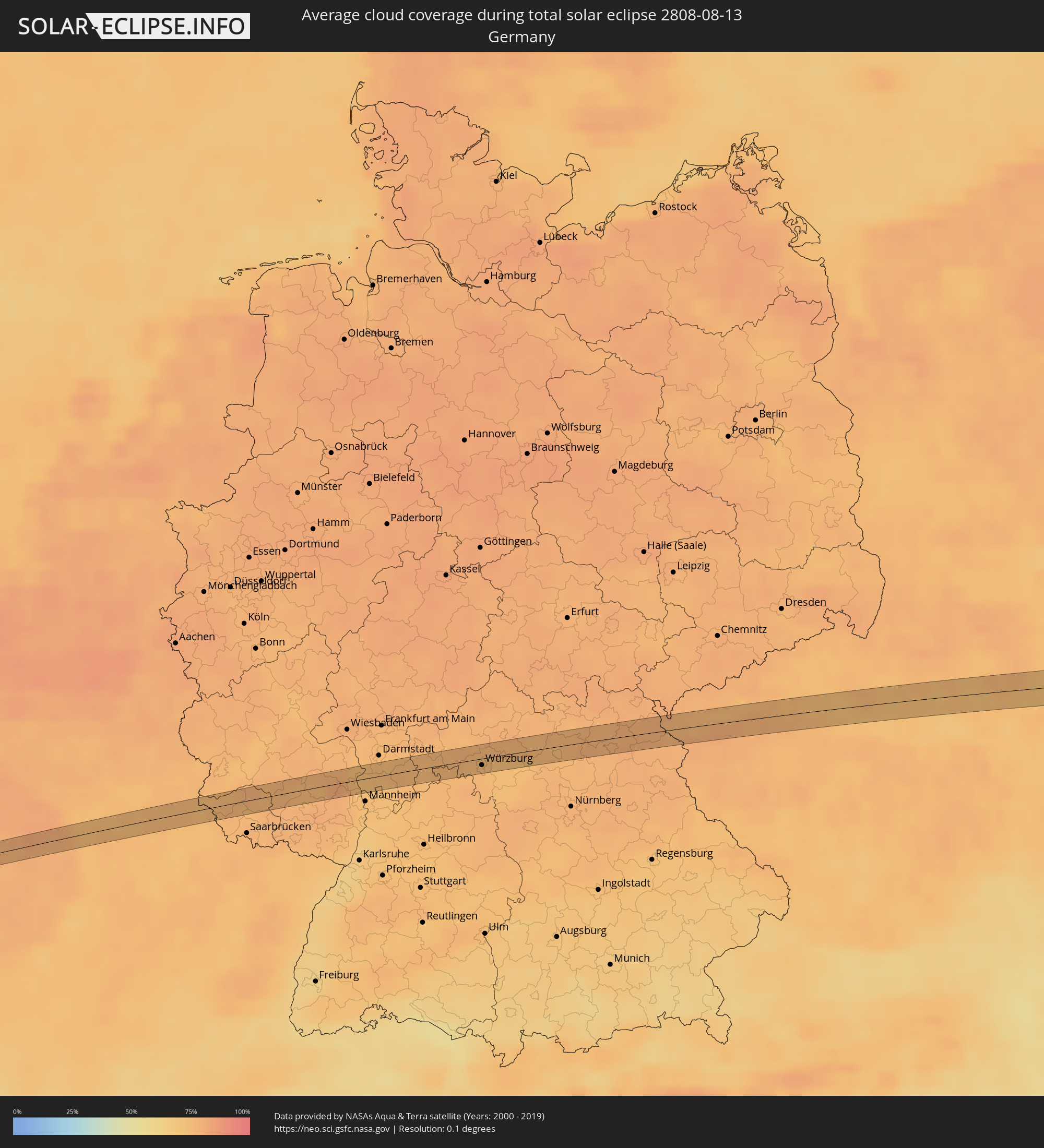 Germany
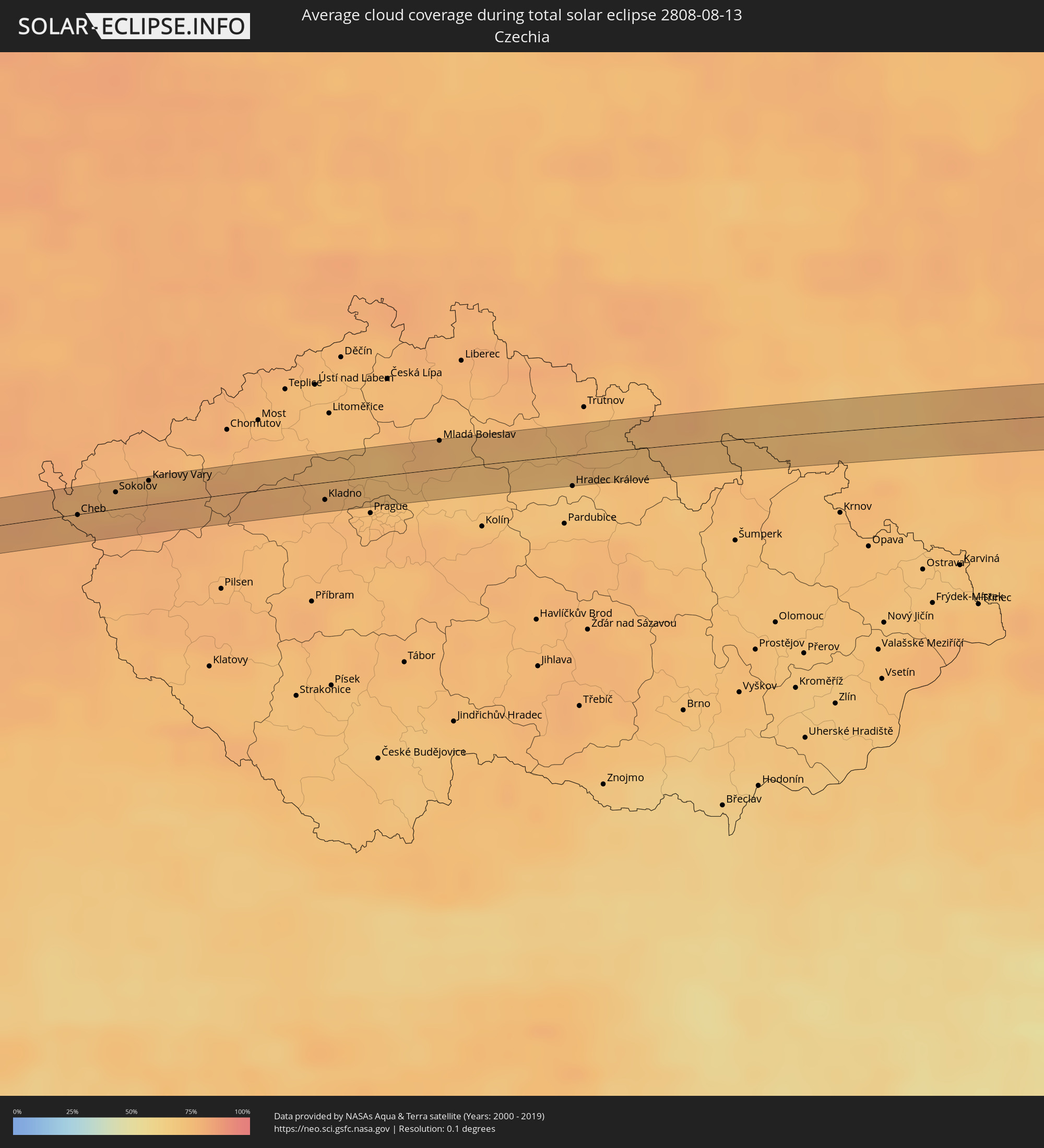 Czechia
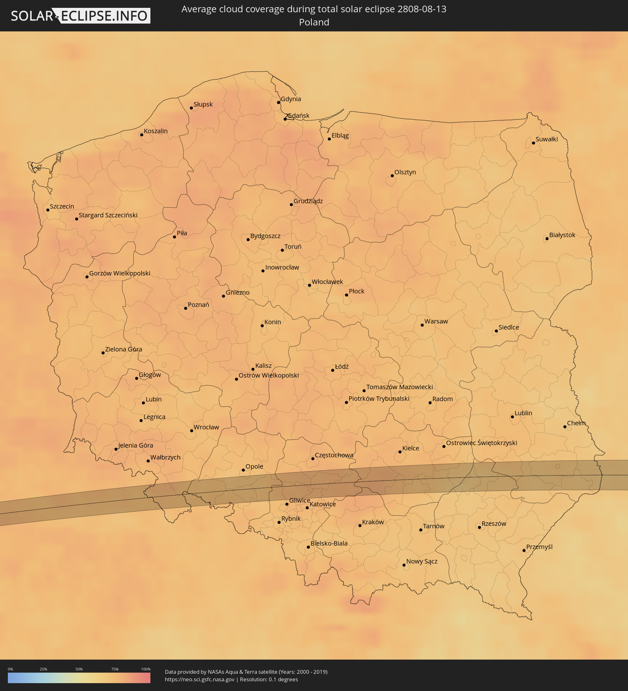 Poland
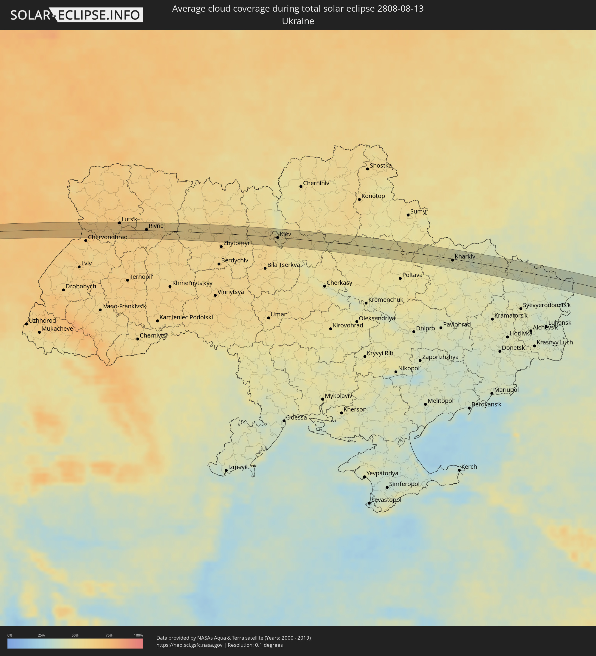 Ukraine
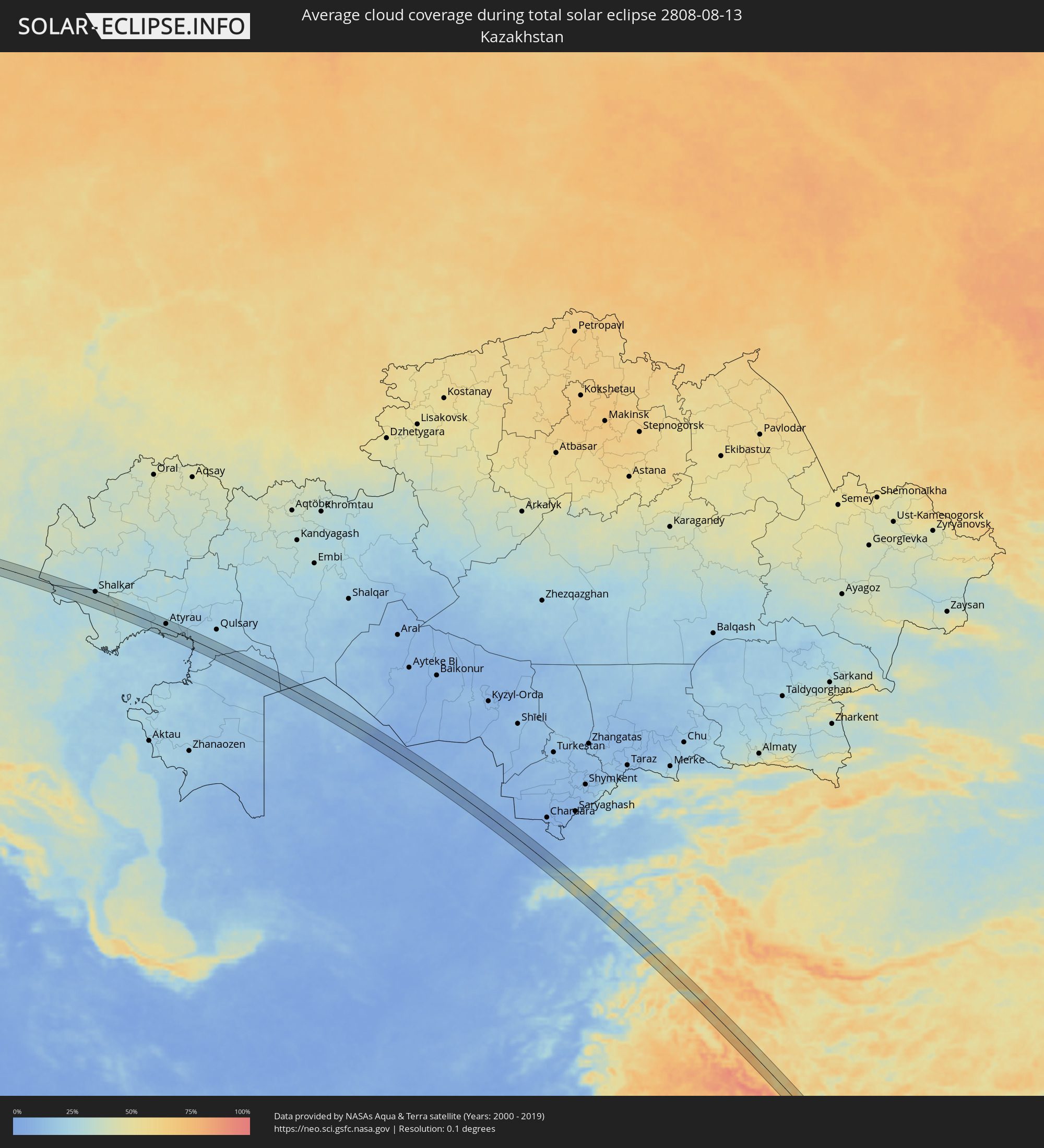 Kazakhstan
 Uzbekistan
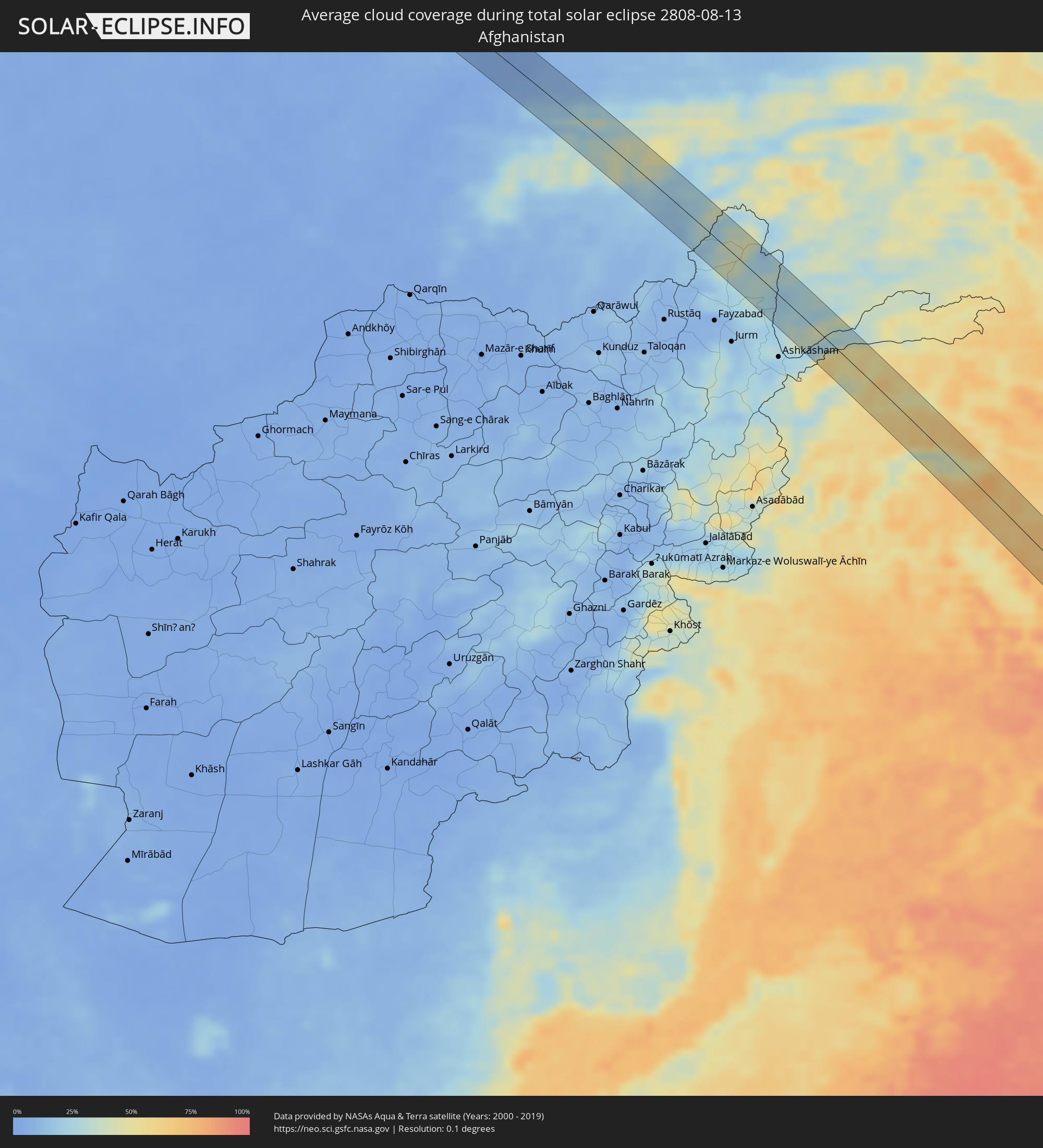 Afghanistan
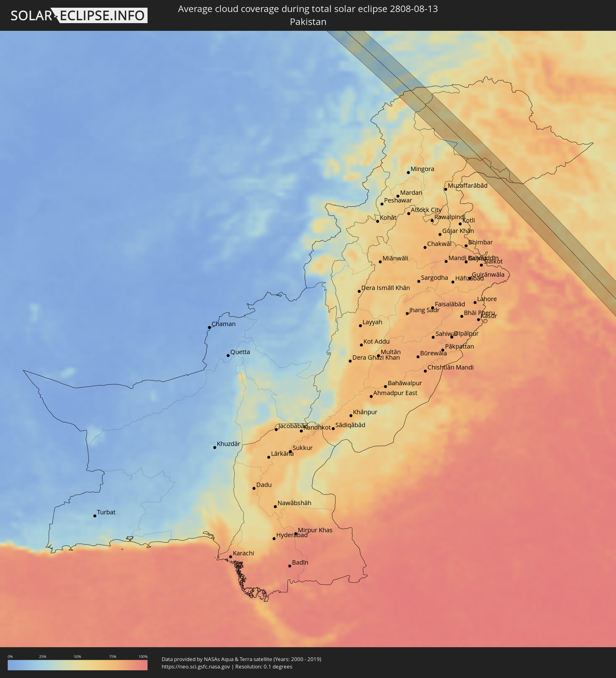 Pakistan
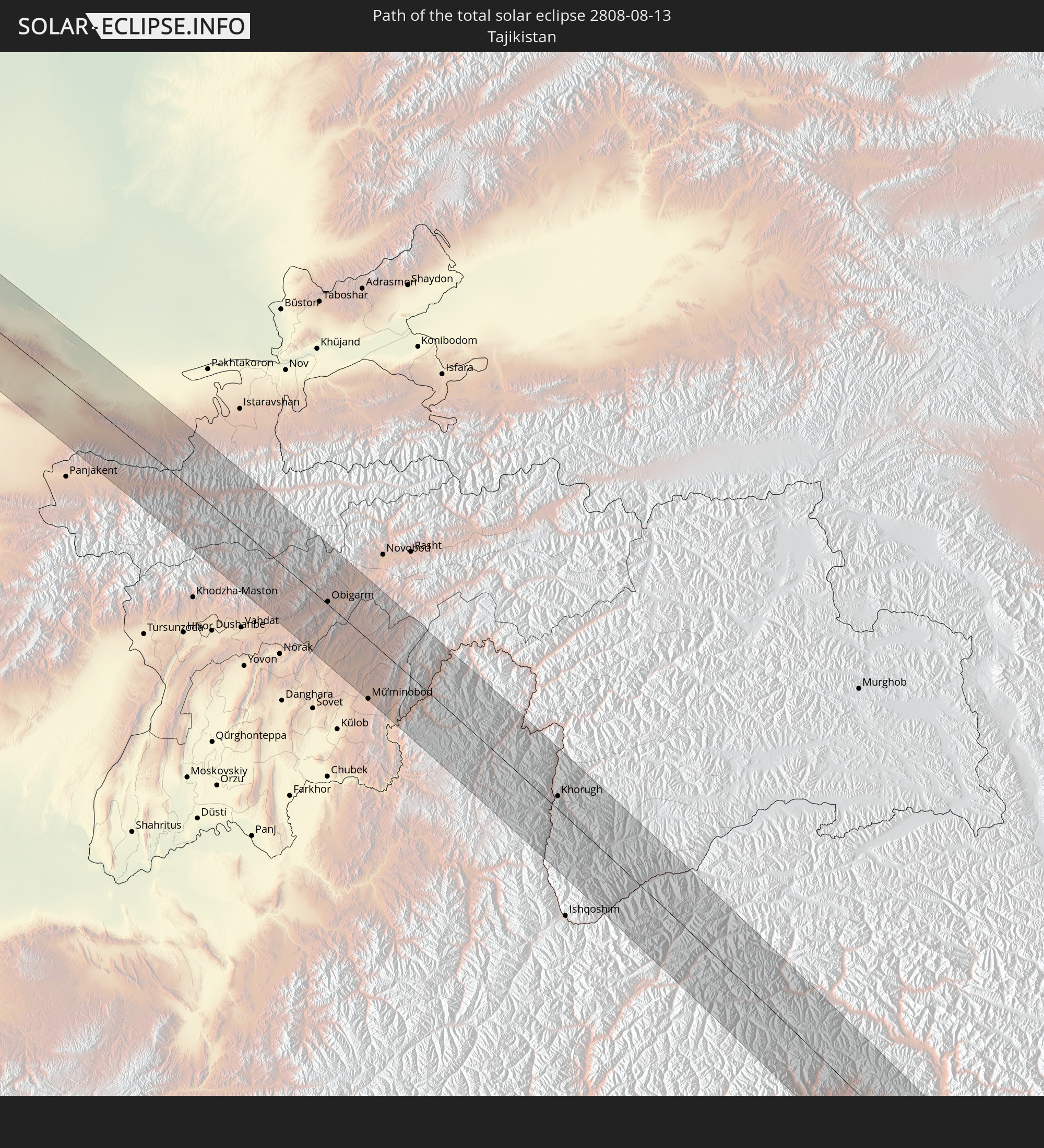
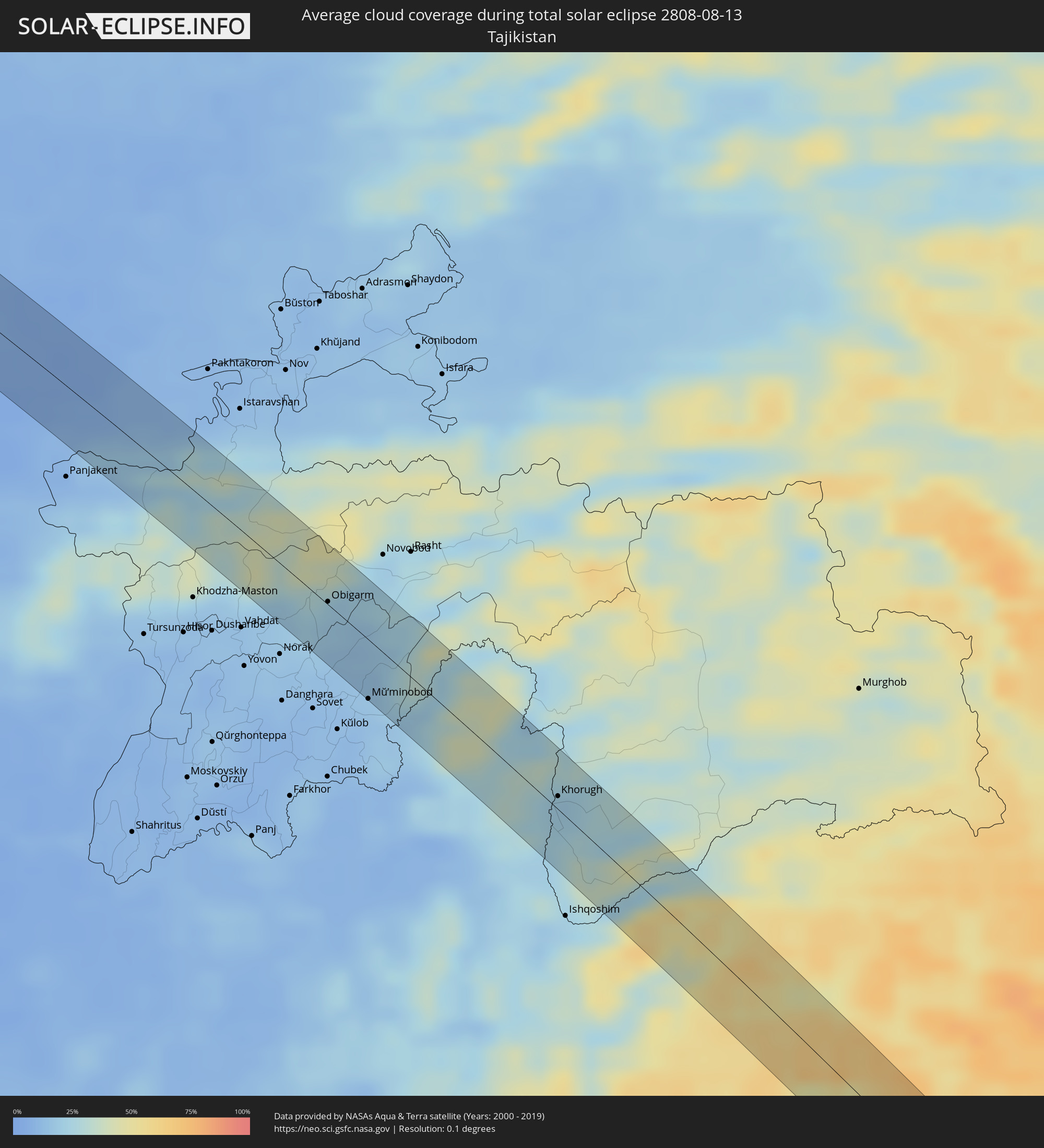 Tajikistan
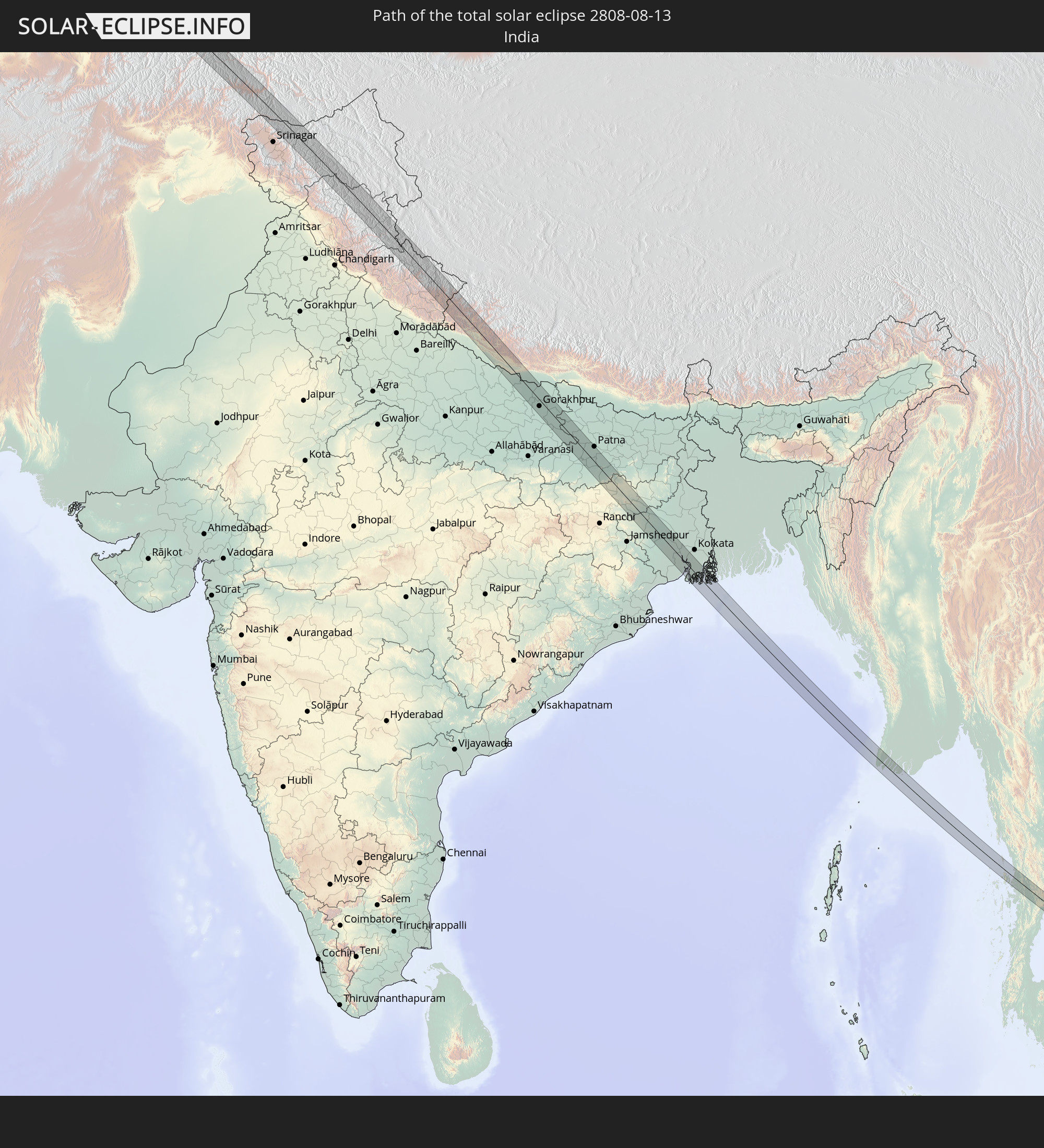
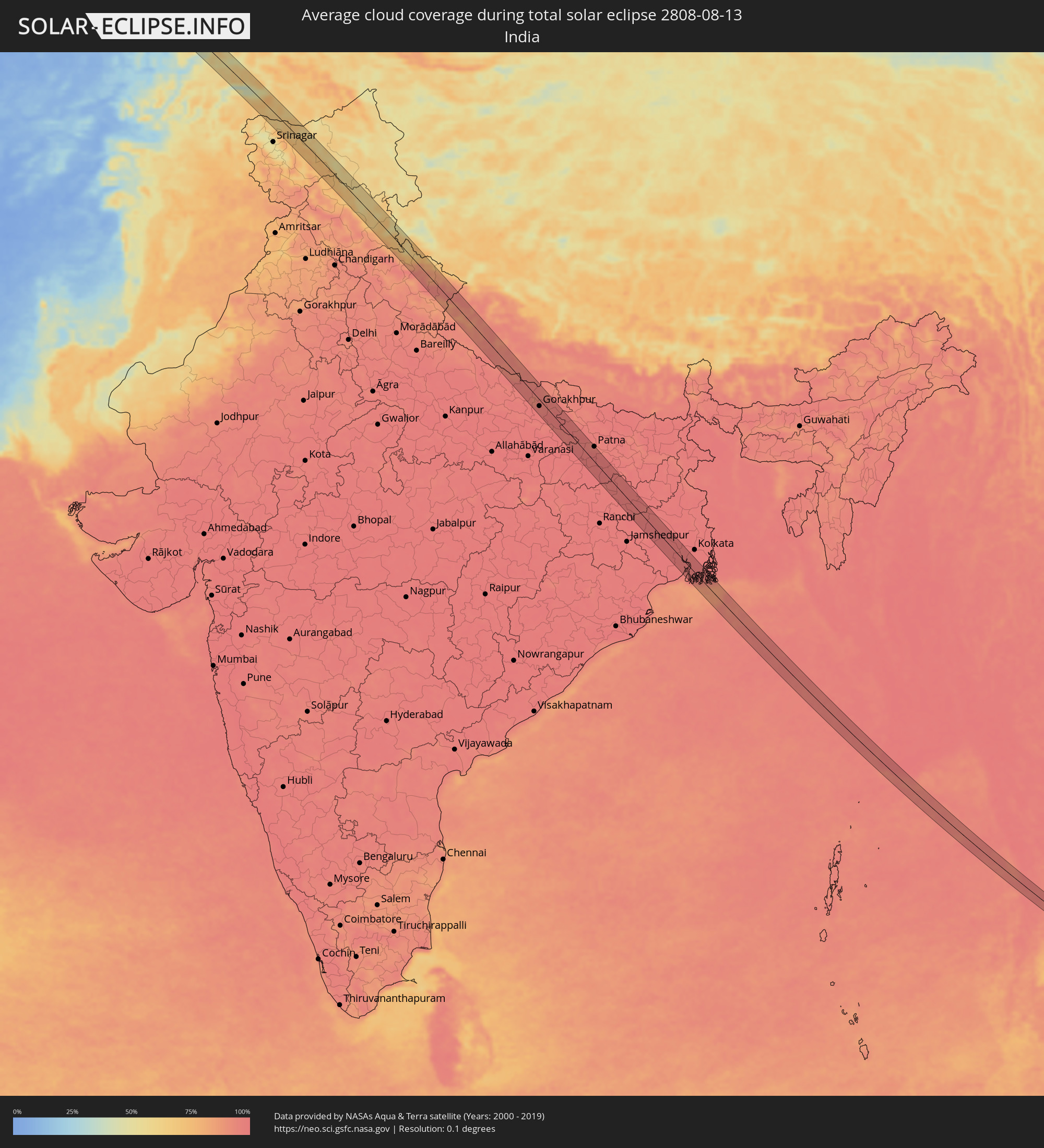 India
India
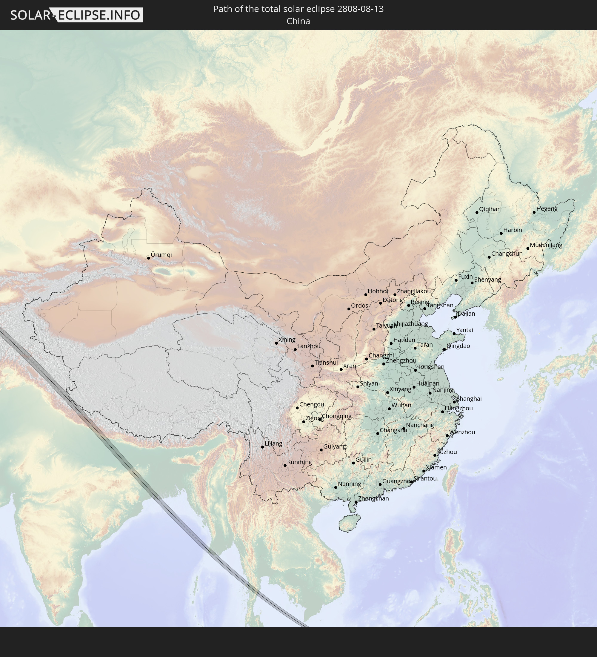
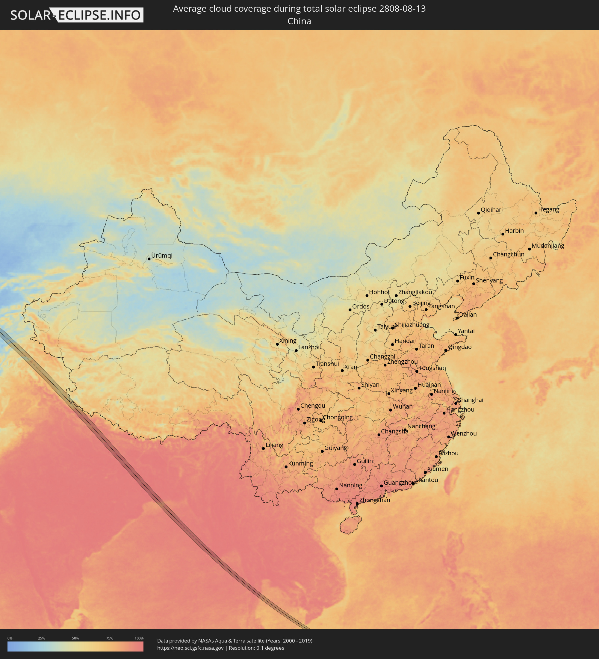 China
China
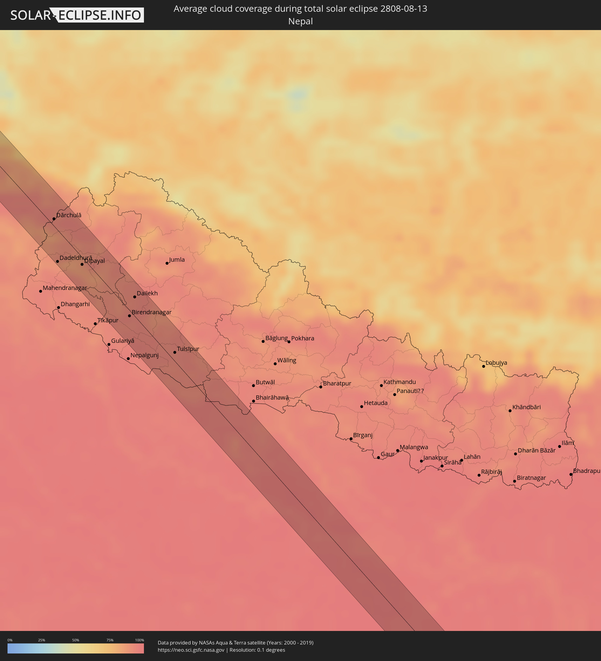 Nepal
Nepal
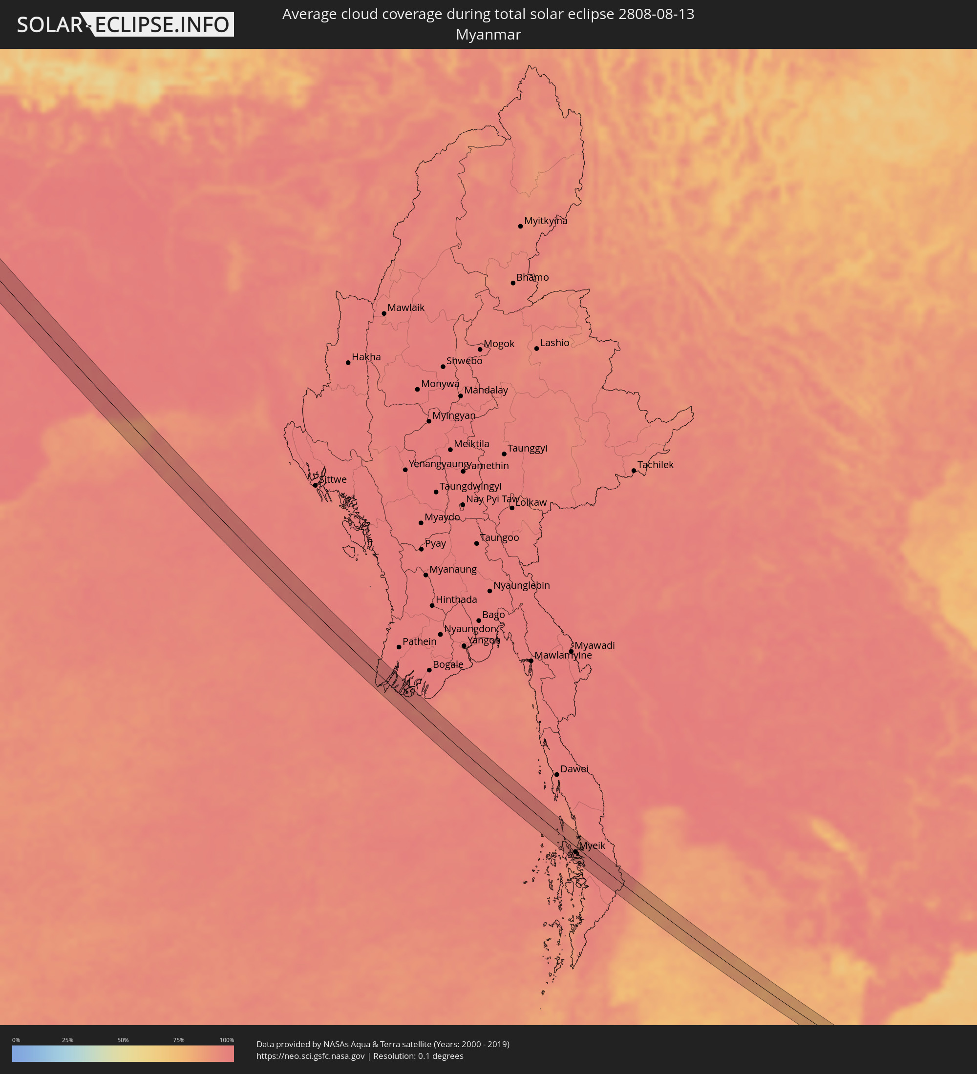 Myanmar
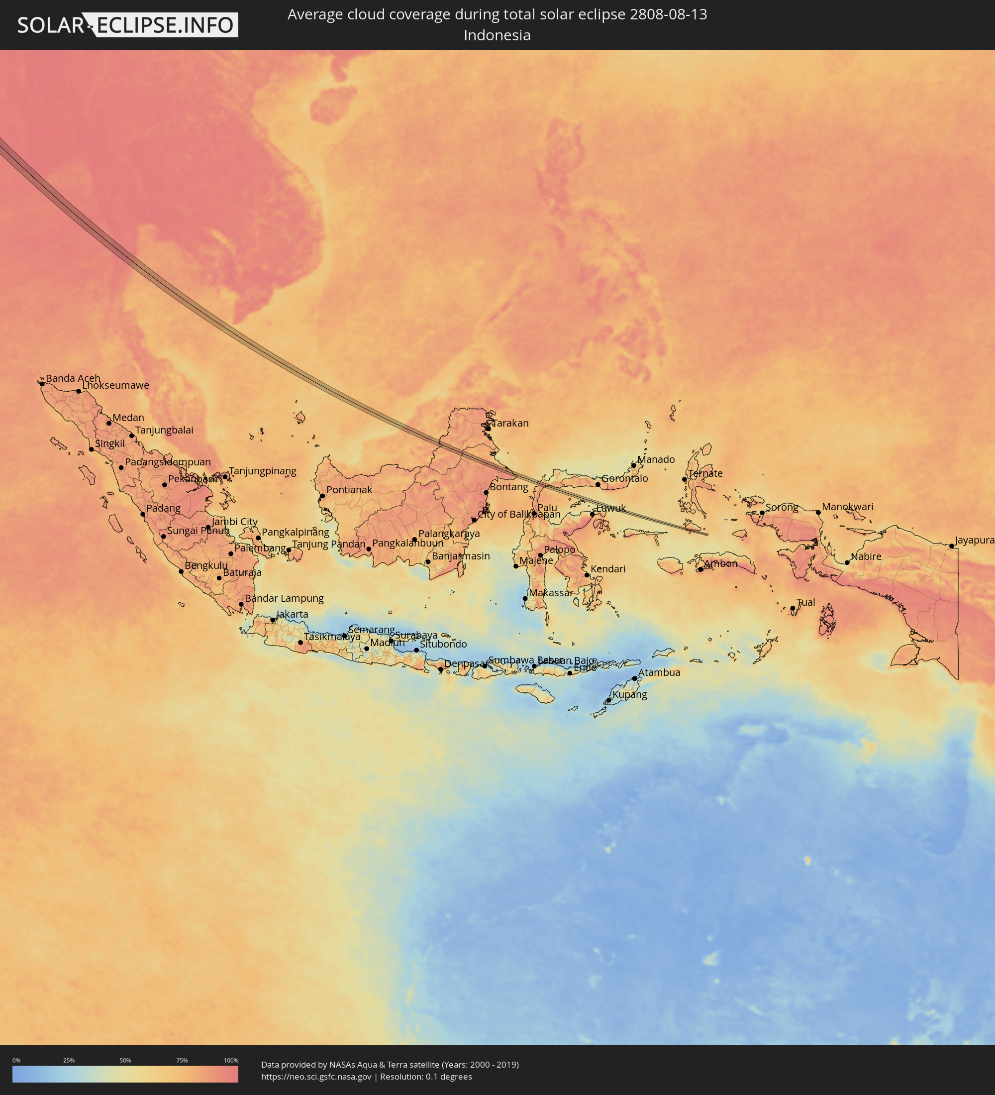 Indonesia
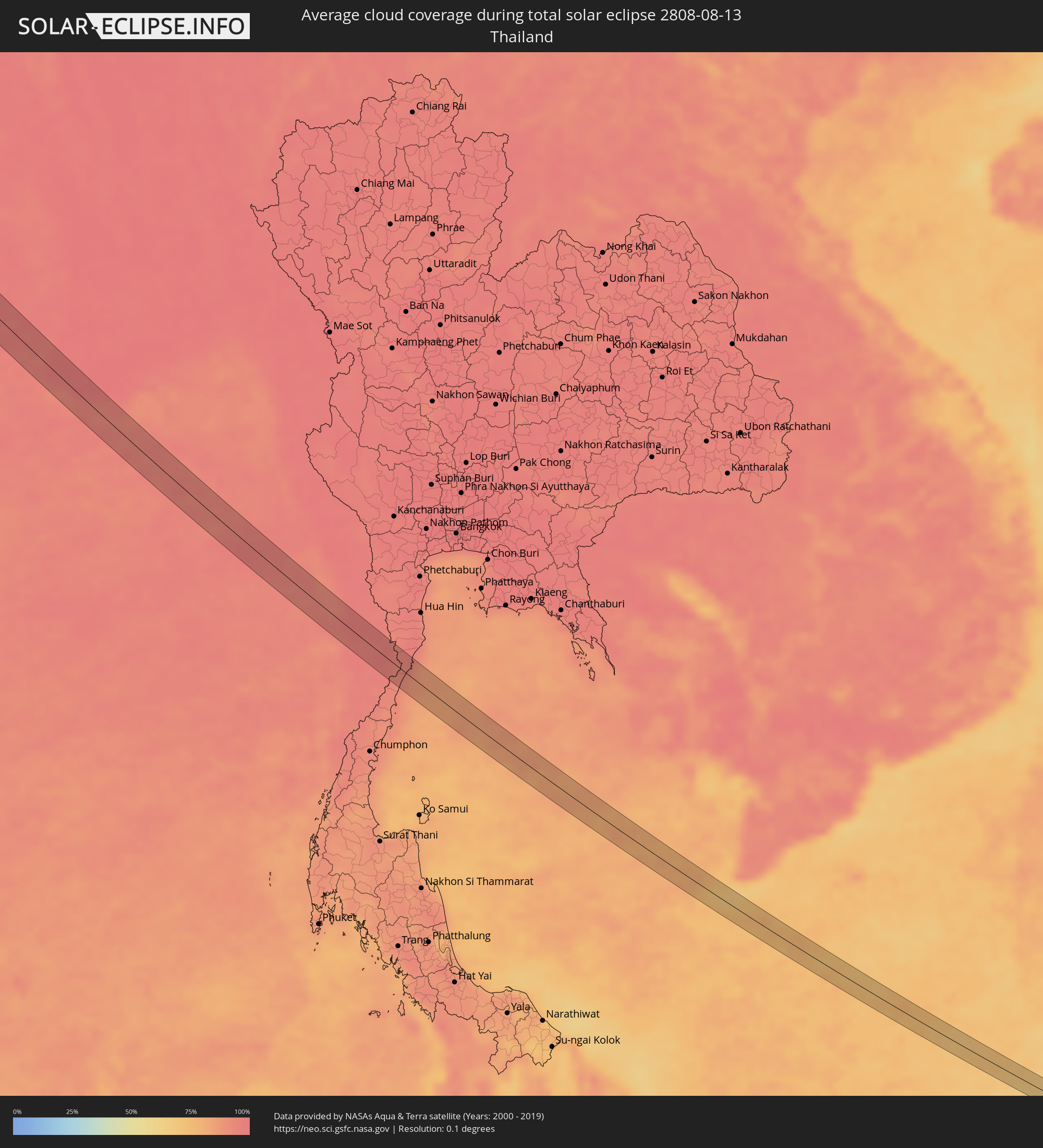 Thailand
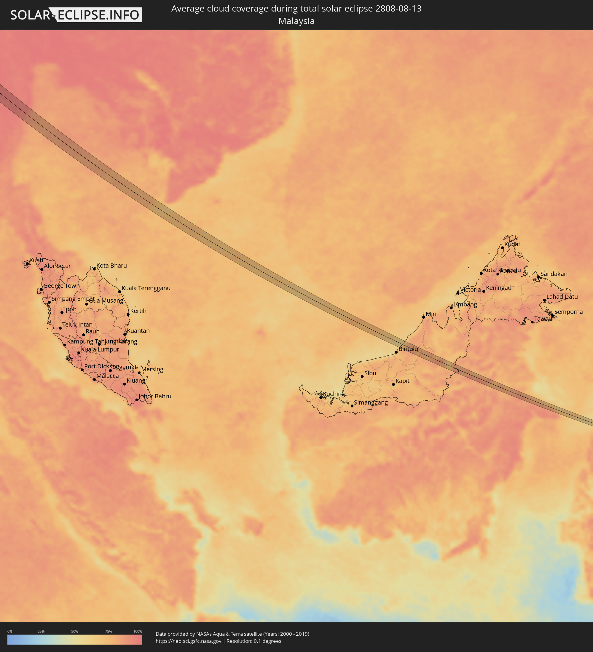 Malaysia
Cities inside the path of the eclipse
The following table shows all locations with a population of more than 5,000 inside the eclipse path. Cities which have more than 100,000 inhabitants are marked bold. A click at the locations opens a detailed map.
| City | Type | Eclipse duration | Local time of max. eclipse | Distance to central line | Ø Cloud coverage |
|
Quimperlé, Brittany
|
total | - | 07:09:54 UTC+01:00 | 7 km | 72% |
|
Hennebont, Brittany
|
total | - | 07:09:51 UTC+01:00 | 6 km | 70% |
|
Rennes, Brittany
|
total | - | 07:10:16 UTC+01:00 | 5 km | 80% |
|
Mayenne, Pays de la Loire
|
total | - | 07:10:33 UTC+01:00 | 5 km | 79% |
|
Alençon, Normandy
|
total | - | 07:10:46 UTC+01:00 | 4 km | 77% |
|
Dreux, Centre
|
total | - | 07:11:15 UTC+01:00 | 5 km | 79% |
|
Saint-Quentin-en-Yvelines, Île-de-France
|
total | - | 07:11:24 UTC+01:00 | 2 km | 77% |
|
Le Vésinet, Île-de-France
|
total | - | 07:11:32 UTC+01:00 | 9 km | 77% |
|
Paris, Île-de-France
|
total | - | 07:11:33 UTC+01:00 | 1 km | 75% |
|
Noisy-le-Grand, Île-de-France
|
total | - | 07:11:35 UTC+01:00 | 3 km | 76% |
|
Meaux, Île-de-France
|
total | - | 07:11:45 UTC+01:00 | 4 km | 78% |
|
Château-Thierry, Hauts-de-France
|
total | - | 07:11:57 UTC+01:00 | 5 km | 79% |
|
Épernay, Grand-Est
|
total | - | 07:12:04 UTC+01:00 | 4 km | 78% |
|
Dudelange, Luxembourg
|
total | - | 07:13:02 UTC+01:00 | 10 km | 76% |
|
Thionville, Grand-Est
|
total | - | 07:12:57 UTC+01:00 | 3 km | 74% |
|
Merzig, Saarland
|
total | - | 07:13:09 UTC+01:00 | 2 km | 76% |
|
Lebach, Saarland
|
total | - | 07:13:13 UTC+01:00 | 9 km | 75% |
|
Sankt Wendel, Saarland
|
total | - | 07:13:21 UTC+01:00 | 6 km | 78% |
|
Alzey, Rheinland-Pfalz
|
total | - | 07:13:55 UTC+01:00 | 12 km | 81% |
|
Worms, Rheinland-Pfalz
|
total | - | 07:13:53 UTC+01:00 | 4 km | 74% |
|
Bensheim, Hesse
|
total | - | 07:14:02 UTC+01:00 | 2 km | 74% |
|
Reinheim, Hesse
|
total | - | 07:14:14 UTC+01:00 | 12 km | 77% |
|
Michelstadt, Hesse
|
total | - | 07:14:09 UTC+01:00 | 7 km | 76% |
|
Wertheim, Baden-Württemberg
|
total | - | 07:14:25 UTC+01:00 | 4 km | 76% |
|
Würzburg, Bavaria
|
total | - | 07:14:37 UTC+01:00 | 6 km | 75% |
|
Bamberg, Bavaria
|
total | - | 07:15:05 UTC+01:00 | 5 km | 76% |
|
Kulmbach, Bavaria
|
total | - | 07:15:30 UTC+01:00 | 11 km | 78% |
|
Bayreuth, Bavaria
|
total | - | 07:15:25 UTC+01:00 | 7 km | 77% |
|
Marktredwitz, Bavaria
|
total | - | 07:15:41 UTC+01:00 | 6 km | 78% |
|
Cheb, Karlovarský
|
total | - | 07:15:53 UTC+01:00 | 0 km | 78% |
|
Sokolov, Karlovarský
|
total | - | 07:16:06 UTC+01:00 | 8 km | 76% |
|
Karlovy Vary, Karlovarský
|
total | - | 07:16:15 UTC+01:00 | 12 km | 79% |
|
Rakovník, Central Bohemia
|
total | - | 07:16:32 UTC+01:00 | 10 km | 77% |
|
Kladno, Central Bohemia
|
total | - | 07:16:45 UTC+01:00 | 9 km | 76% |
|
Kralupy nad Vltavou, Central Bohemia
|
total | - | 07:16:56 UTC+01:00 | 0 km | 75% |
|
Mělník, Central Bohemia
|
total | - | 07:17:07 UTC+01:00 | 11 km | 72% |
|
Letňany, Praha
|
total | - | 07:16:57 UTC+01:00 | 14 km | 76% |
|
Čelákovice, Central Bohemia
|
total | - | 07:17:05 UTC+01:00 | 13 km | 73% |
|
Mladá Boleslav, Central Bohemia
|
total | - | 07:17:23 UTC+01:00 | 14 km | 75% |
|
Nymburk, Central Bohemia
|
total | - | 07:17:15 UTC+01:00 | 12 km | 71% |
|
Jičín, Královéhradecký
|
total | - | 07:17:38 UTC+01:00 | 13 km | 74% |
|
Dvůr Králové nad Labem, Královéhradecký
|
total | - | 07:17:53 UTC+01:00 | 9 km | 74% |
|
Náchod, Královéhradecký
|
total | - | 07:18:03 UTC+01:00 | 5 km | 73% |
|
Kłodzko, Lower Silesian Voivodeship
|
total | - | 07:18:20 UTC+01:00 | 4 km | 75% |
|
Nysa, Opole Voivodeship
|
total | - | 07:18:45 UTC+01:00 | 4 km | 72% |
|
Prudnik, Opole Voivodeship
|
total | - | 07:18:46 UTC+01:00 | 14 km | 72% |
|
Krapkowice, Opole Voivodeship
|
total | - | 07:19:07 UTC+01:00 | 1 km | 72% |
|
Kędzierzyn-Koźle, Opole Voivodeship
|
total | - | 07:19:10 UTC+01:00 | 14 km | 73% |
|
Strzelce Opolskie, Opole Voivodeship
|
total | - | 07:19:21 UTC+01:00 | 3 km | 73% |
|
Pyskowice, Silesian Voivodeship
|
total | - | 07:19:27 UTC+01:00 | 11 km | 74% |
|
Tarnowskie Góry, Silesian Voivodeship
|
total | - | 07:19:38 UTC+01:00 | 7 km | 77% |
|
Zawiercie, Silesian Voivodeship
|
total | - | 07:20:01 UTC+01:00 | 5 km | 77% |
|
Busko-Zdrój, Świętokrzyskie
|
total | - | 07:20:50 UTC+01:00 | 11 km | 74% |
|
Tarnobrzeg, Subcarpathian Voivodeship
|
total | - | 07:21:34 UTC+01:00 | 3 km | 64% |
|
Stalowa Wola, Subcarpathian Voivodeship
|
total | - | 07:21:50 UTC+01:00 | 2 km | 68% |
|
Biłgoraj, Lublin Voivodeship
|
total | - | 07:22:17 UTC+01:00 | 8 km | 69% |
|
Zamość, Lublin Voivodeship
|
total | - | 07:22:48 UTC+01:00 | 12 km | 70% |
|
Novovolyns’k, Volyn
|
total | - | 08:23:29 UTC+02:00 | 11 km | 66% |
|
Luts’k, Volyn
|
total | - | 08:24:24 UTC+02:00 | 16 km | 65% |
|
Rivne, Rivne
|
total | - | 08:25:01 UTC+02:00 | 2 km | 64% |
|
Novohrad-Volyns’kyy, Zhytomyr
|
total | - | 08:26:08 UTC+02:00 | 2 km | 59% |
|
Bucha, Kiev
|
total | - | 08:28:23 UTC+02:00 | 7 km | 58% |
|
Boyarka, Kiev
|
total | - | 08:28:20 UTC+02:00 | 17 km | 61% |
|
Kiev, Kyiv City
|
total | - | 08:28:37 UTC+02:00 | 1 km | 55% |
|
Brovary, Kiev
|
total | - | 08:28:55 UTC+02:00 | 8 km | 57% |
|
Boryspil’, Kiev
|
total | - | 08:28:58 UTC+02:00 | 10 km | 54% |
|
Yahotyn, Kiev
|
total | - | 08:29:42 UTC+02:00 | 12 km | 52% |
|
Okhtyrka, Sumy
|
total | - | 08:32:51 UTC+02:00 | 18 km | 50% |
|
Kharkiv, Kharkiv
|
total | - | 08:34:09 UTC+02:00 | 4 km | 45% |
|
Chuhuyiv, Kharkiv
|
total | - | 08:34:34 UTC+02:00 | 14 km | 46% |
|
Kupjansk, Kharkiv
|
total | - | 08:35:33 UTC+02:00 | 16 km | 47% |
|
Kantemirovka, Voronezj
|
total | - | 09:38:07 UTC+03:00 | 15 km | 39% |
|
Chertkovo, Rostov Oblast
|
total | - | 09:38:24 UTC+03:00 | 15 km | 39% |
|
Novyy Rogachik, Volgograd
|
total | - | 09:43:10 UTC+03:00 | 21 km | 33% |
|
Gumrak, Volgograd
|
total | - | 09:43:35 UTC+03:00 | 3 km | 32% |
|
Gorodishche, Volgograd
|
total | - | 09:43:42 UTC+03:00 | 1 km | 32% |
|
Volgograd, Volgograd
|
total | - | 09:43:44 UTC+03:00 | 7 km | 29% |
|
Krasnoslobodsk, Volgograd
|
total | - | 09:43:50 UTC+03:00 | 7 km | 29% |
|
Volzhskiy, Volgograd
|
total | - | 09:44:06 UTC+03:00 | 6 km | 33% |
|
Srednyaya Akhtuba, Volgograd
|
total | - | 09:44:13 UTC+03:00 | 1 km | 31% |
|
Leninsk, Volgograd
|
total | - | 09:44:39 UTC+03:00 | 6 km | 32% |
|
Znamensk, Astrakhan
|
total | - | 10:45:22 UTC+04:00 | 5 km | 33% |
|
Kapustin Yar, Astrakhan
|
total | - | 10:45:22 UTC+04:00 | 5 km | 33% |
|
Akhtubinsk, Astrakhan
|
total | - | 10:45:58 UTC+04:00 | 18 km | 30% |
|
Verkhniy Baskunchak, Astrakhan
|
total | - | 10:46:43 UTC+04:00 | 10 km | 33% |
|
Shalkar, Atyraū
|
total | - | 11:49:45 UTC+05:00 | 23 km | 29% |
|
Balyqshy, Atyraū
|
total | - | 11:54:19 UTC+05:00 | 7 km | 23% |
|
Atyrau, Atyraū
|
total | - | 11:54:19 UTC+05:00 | 13 km | 23% |
|
Qaraton, Atyraū
|
total | - | 11:57:02 UTC+05:00 | 7 km | 19% |
|
Jizzax, Jizzax
|
total | - | 12:27:04 UTC+05:00 | 18 km | 4% |
|
Obigarm
|
total | - | 12:32:25 UTC+05:00 | 2 km | 21% |
|
Roghun
|
total | - | 12:32:35 UTC+05:00 | 16 km | 21% |
|
Mŭ’minobod, Khatlon
|
total | - | 12:33:57 UTC+05:00 | 31 km | 14% |
|
Khorugh, Gorno-Badakhshan
|
total | - | 12:37:36 UTC+05:00 | 7 km | 20% |
|
Khandūd, Badakhshan
|
total | - | 12:09:51 UTC+04:30 | 9 km | 24% |
|
Dārchulā, Western Region
|
total | - | 13:37:14 UTC+05:30 | 7 km | 90% |
|
Dadeldhurā, Far Western
|
total | - | 13:53:27 UTC+05:45 | 30 km | 91% |
|
Dipayal, Far Western
|
total | - | 13:54:05 UTC+05:45 | 7 km | 86% |
|
Birendranagar, Mid Western
|
total | - | 13:56:32 UTC+05:45 | 5 km | 93% |
|
Dailekh, Mid Western
|
total | - | 13:56:09 UTC+05:45 | 18 km | 94% |
|
Tulsīpur, Mid Western
|
total | - | 13:58:32 UTC+05:45 | 8 km | 92% |
|
Besisahar
|
total | - | 13:58:30 UTC+05:45 | 25 km | 94% |
|
Gorakhpur, Uttar Pradesh
|
total | - | 13:48:01 UTC+05:30 | 13 km | 95% |
|
Deoria, Uttar Pradesh
|
total | - | 13:49:11 UTC+05:30 | 2 km | 97% |
|
Siwān, Bihar
|
total | - | 13:50:37 UTC+05:30 | 20 km | 98% |
|
Arrah, Bihar
|
total | - | 13:52:28 UTC+05:30 | 6 km | 98% |
|
Chāpra, Bihar
|
total | - | 13:52:07 UTC+05:30 | 17 km | 96% |
|
Patna, Bihar
|
total | - | 13:53:03 UTC+05:30 | 32 km | 97% |
|
Bihār Sharīf, Bihar
|
total | - | 13:54:26 UTC+05:30 | 32 km | 98% |
|
Dhanbād, Jharkhand
|
total | - | 13:58:39 UTC+05:30 | 2 km | 96% |
|
Kulti, West Bengal
|
total | - | 13:59:20 UTC+05:30 | 23 km | 97% |
|
Āsansol, West Bengal
|
total | - | 13:59:38 UTC+05:30 | 30 km | 97% |
|
Bānkura, West Bengal
|
total | - | 14:00:42 UTC+05:30 | 3 km | 98% |
|
Haldia, West Bengal
|
total | - | 14:04:30 UTC+05:30 | 6 km | 97% |
|
Kultali, West Bengal
|
total | - | 14:05:13 UTC+05:30 | 4 km | 98% |
|
Bārāsat, West Bengal
|
total | - | 14:04:36 UTC+05:30 | 32 km | 98% |
|
Myeik, Tanintharyi
|
total | - | 15:34:07 UTC+06:30 | 10 km | 94% |
|
Prachuap Khiri Khan, Prachuap Khiri Khan
|
total | - | 16:06:06 UTC+07:00 | 17 km | 92% |