Total solar eclipse of 08/05/2920
| Day of week: | Monday |
| Maximum duration of eclipse: | 04m48s |
| Maximum width of eclipse path: | 248 km |
| Saros cycle: | 160 |
| Coverage: | 100% |
| Magnitude: | 1.066 |
| Gamma: | 0.4991 |
Wo kann man die Sonnenfinsternis vom 08/05/2920 sehen?
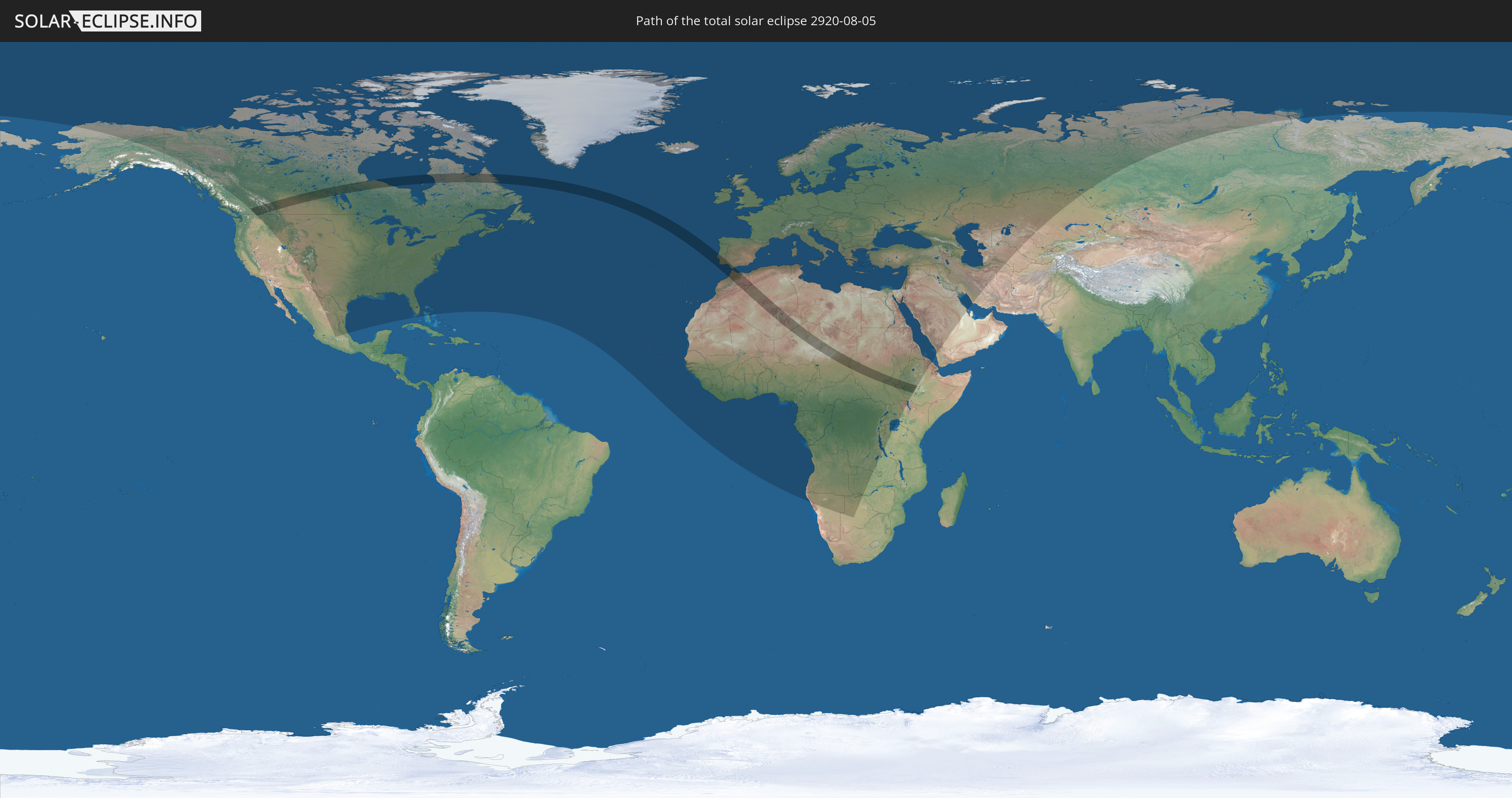
Die Sonnenfinsternis am 08/05/2920 kann man in 118 Ländern als partielle Sonnenfinsternis beobachten.
Der Finsternispfad verläuft durch 12 Länder. Nur in diesen Ländern ist sie als total Sonnenfinsternis zu sehen.
In den folgenden Ländern ist die Sonnenfinsternis total zu sehen
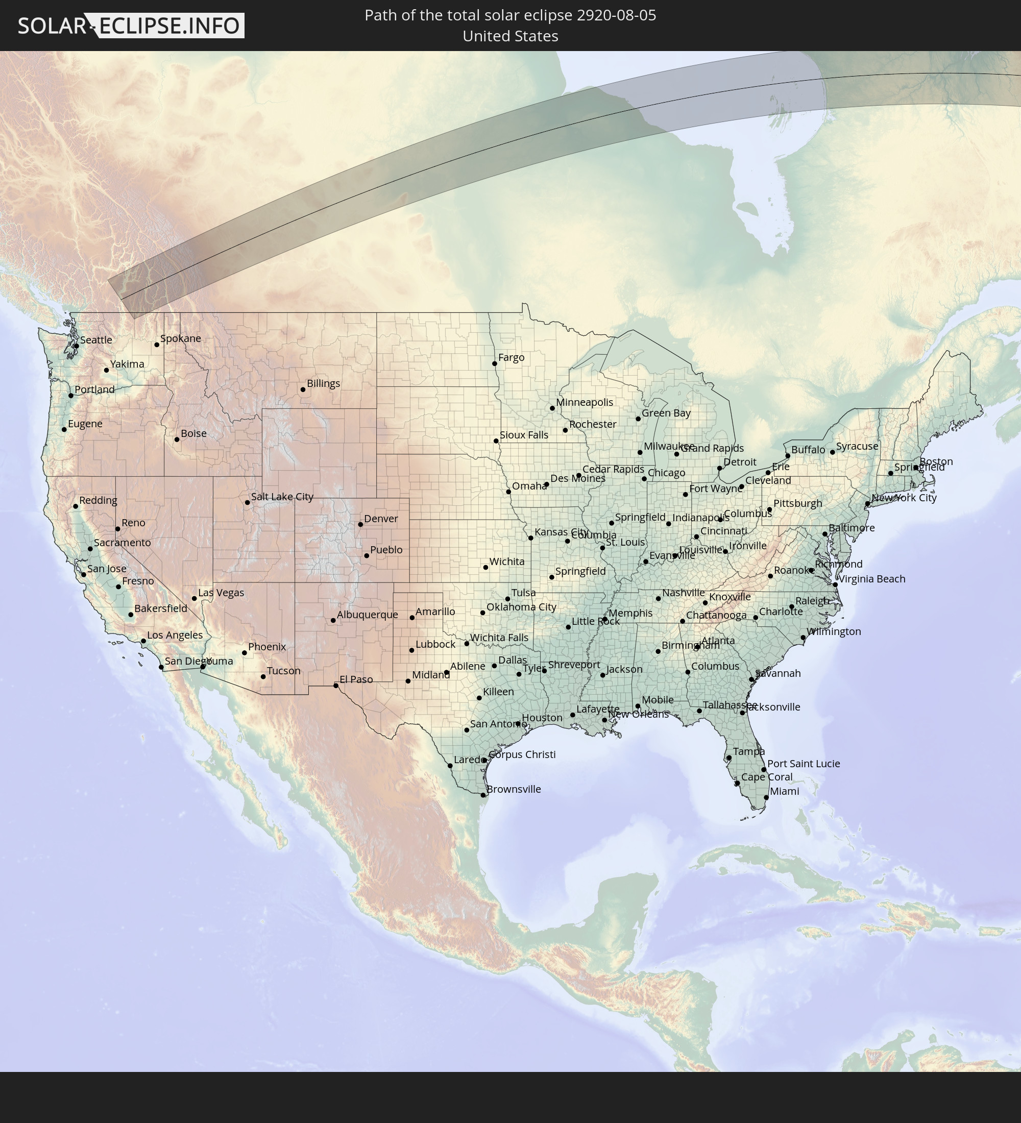 United States
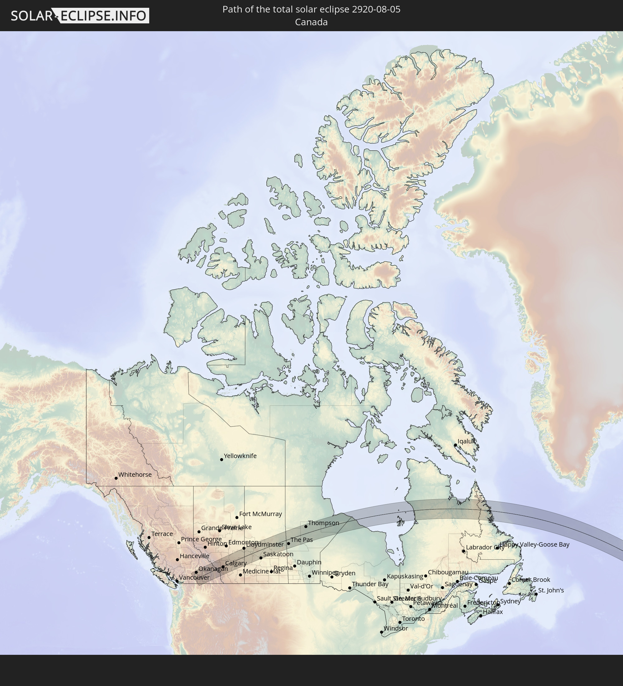 Canada
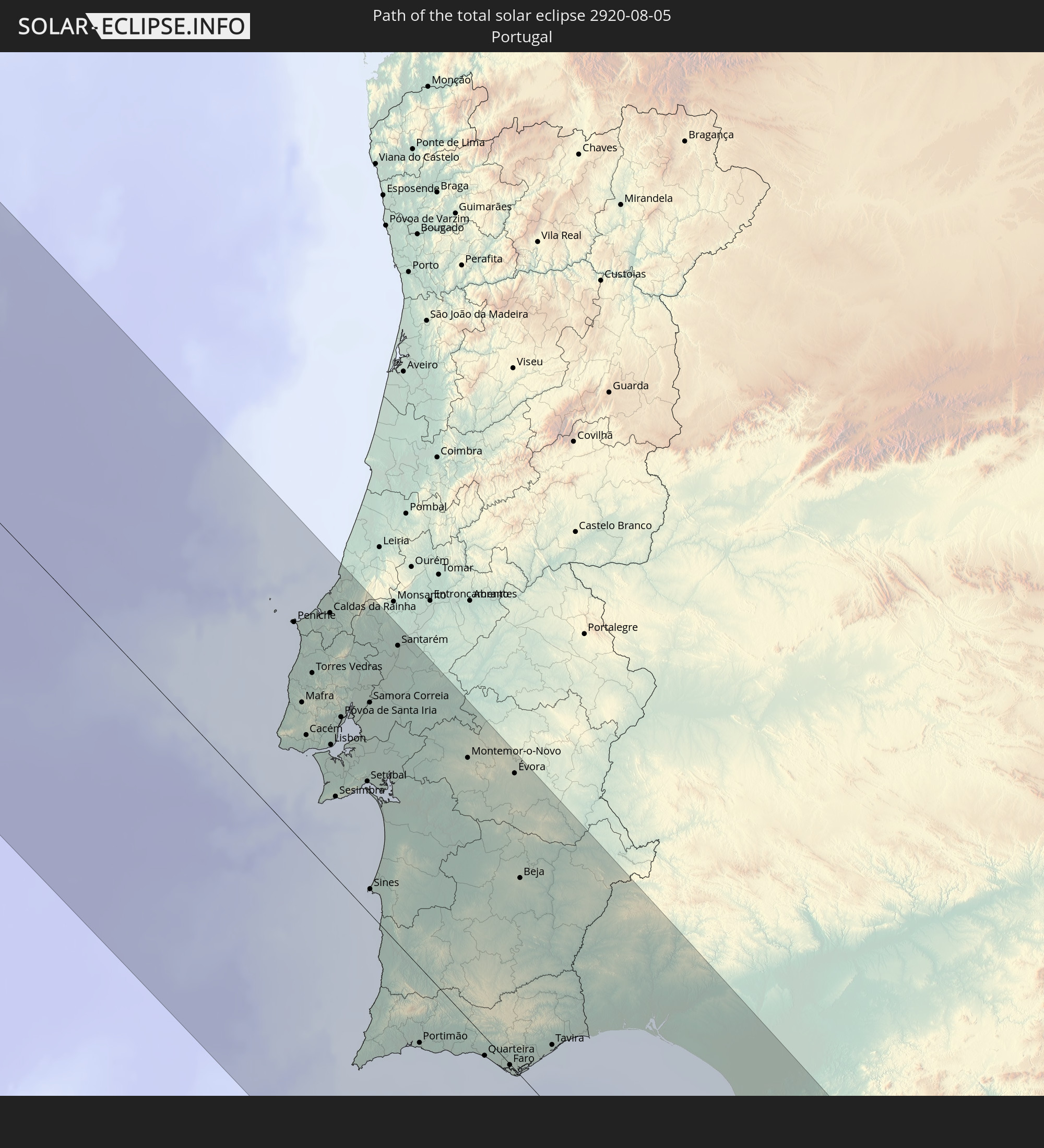 Portugal
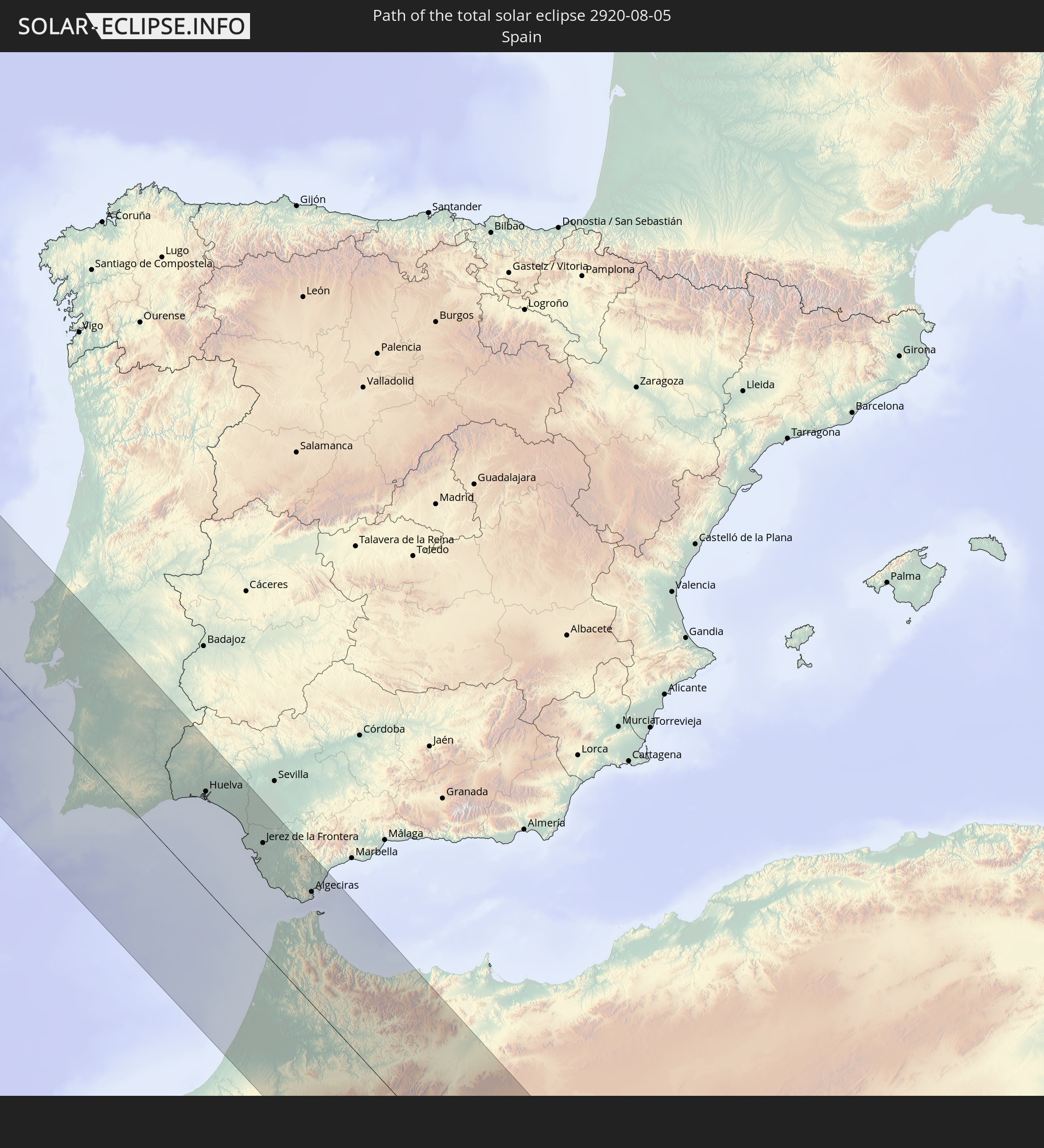 Spain
Spain
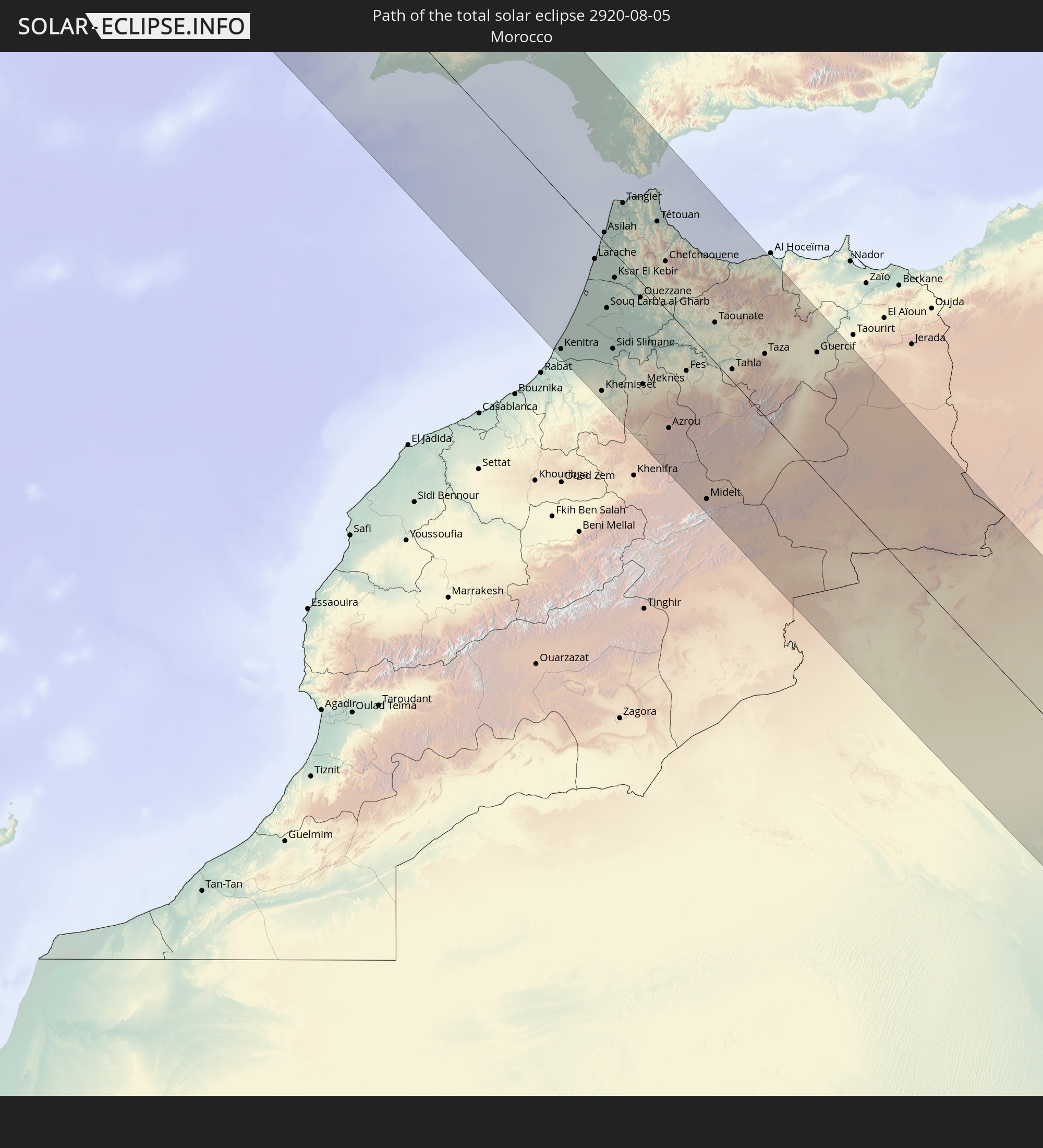 Morocco
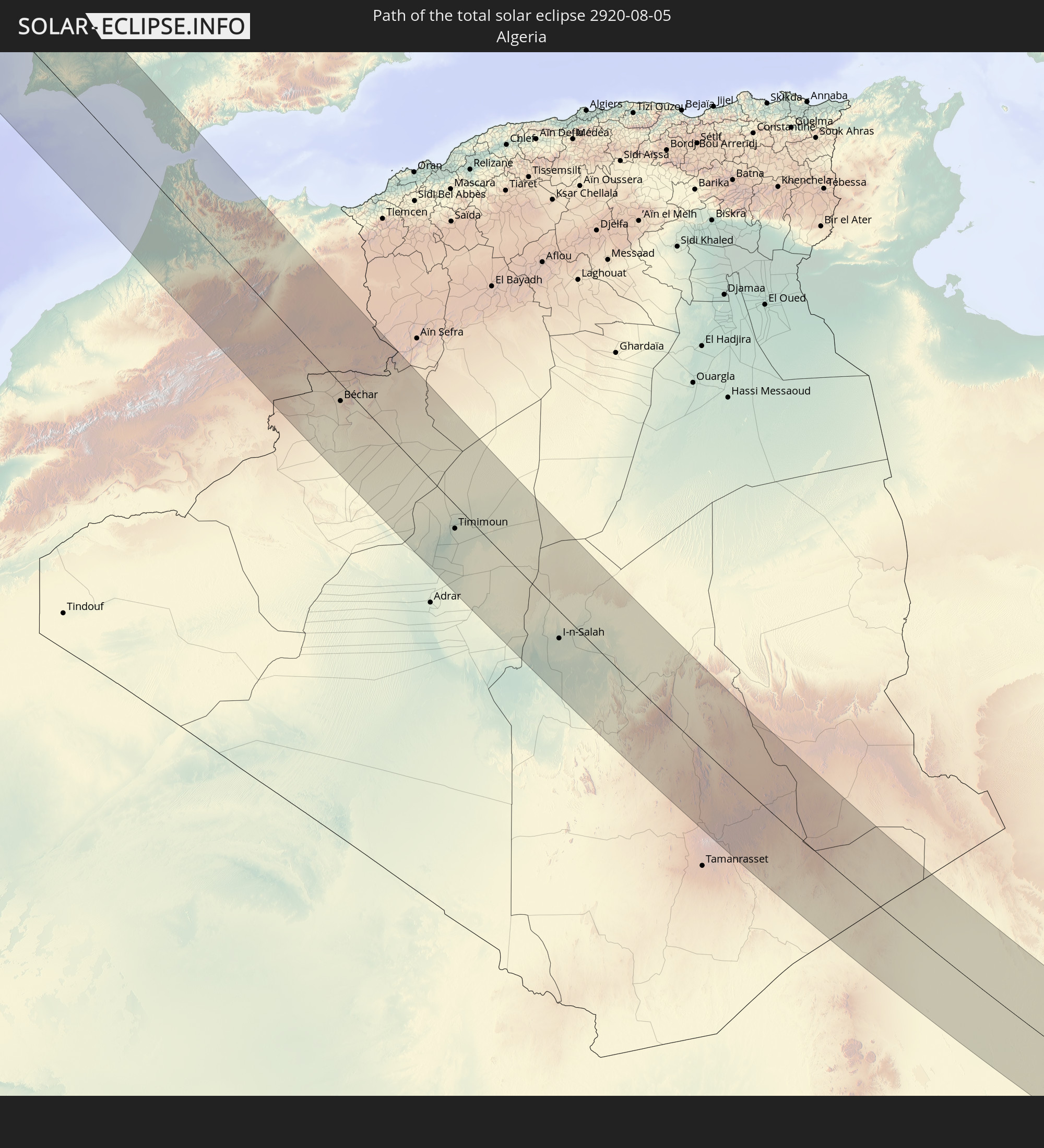 Algeria
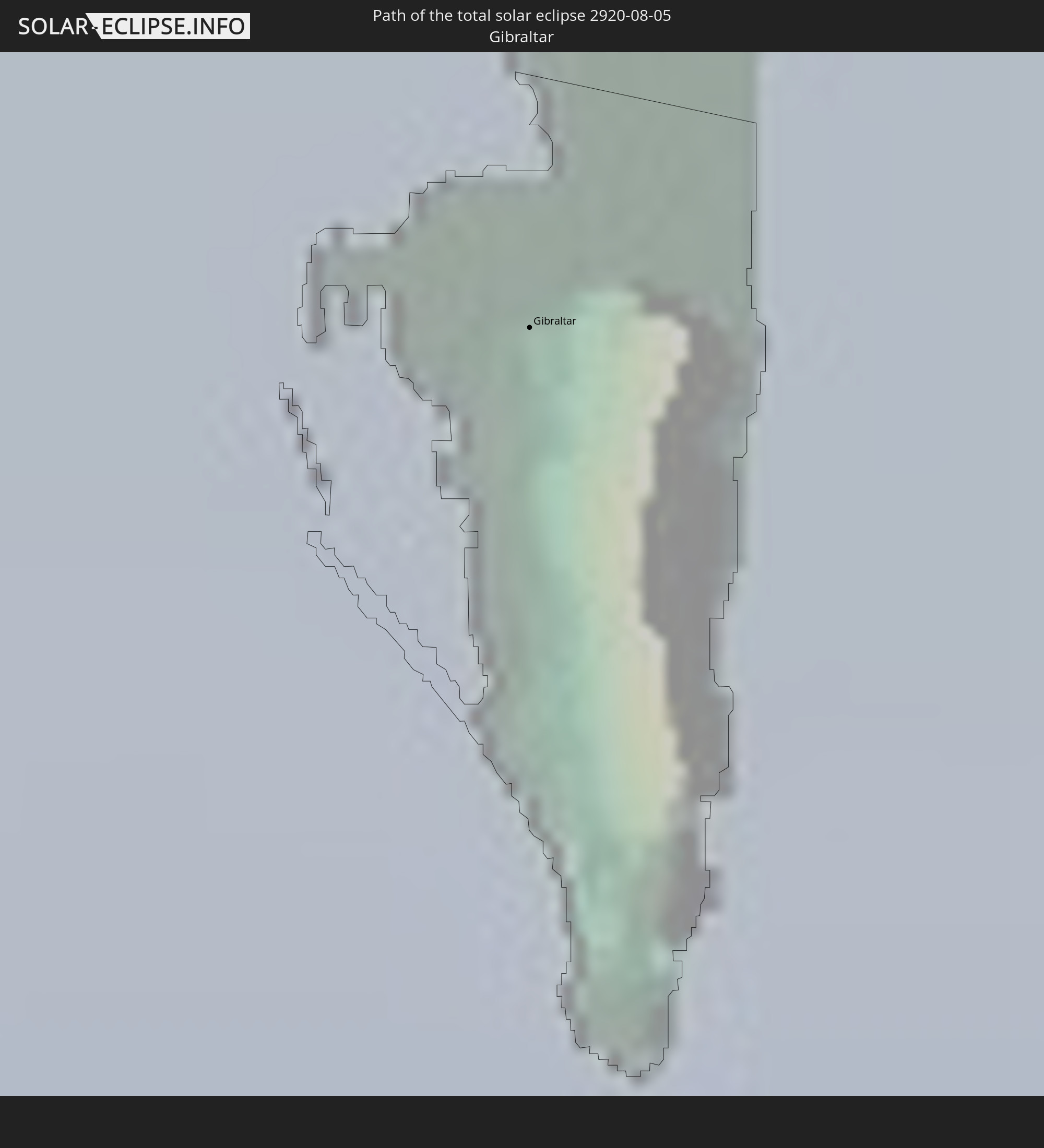 Gibraltar
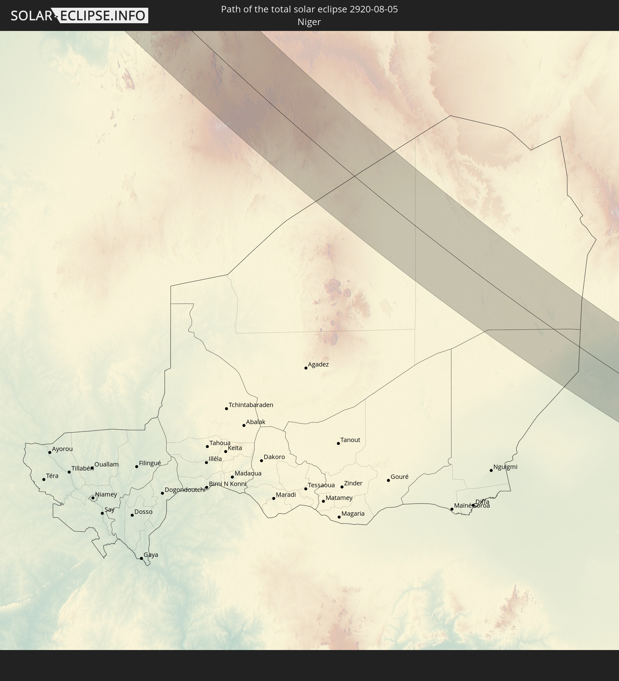 Niger
Niger
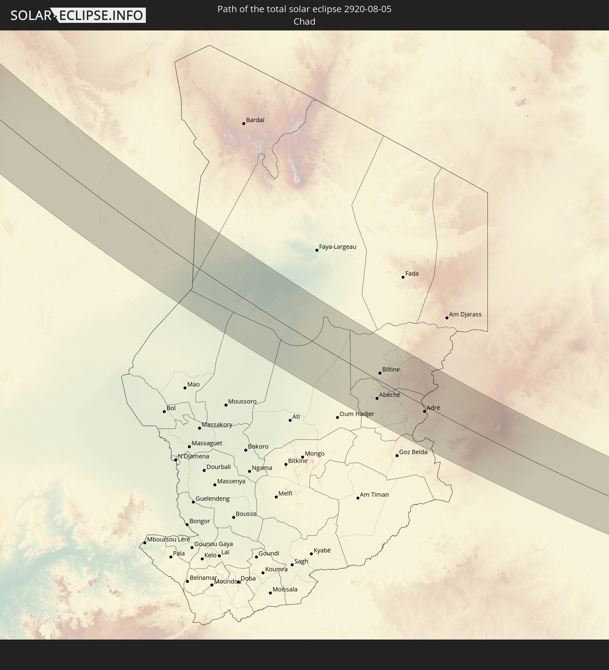 Chad
Chad
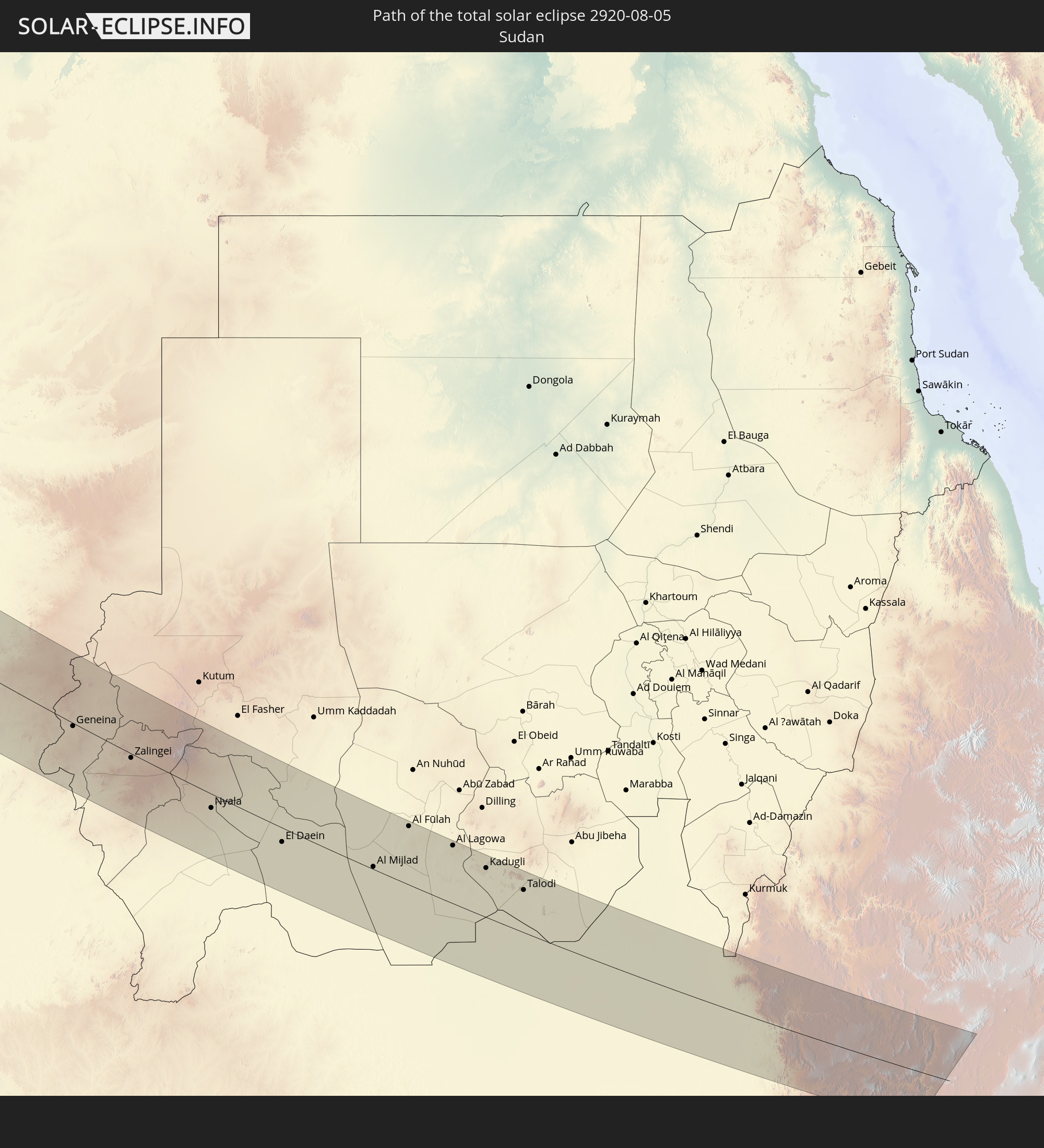 Sudan
Sudan
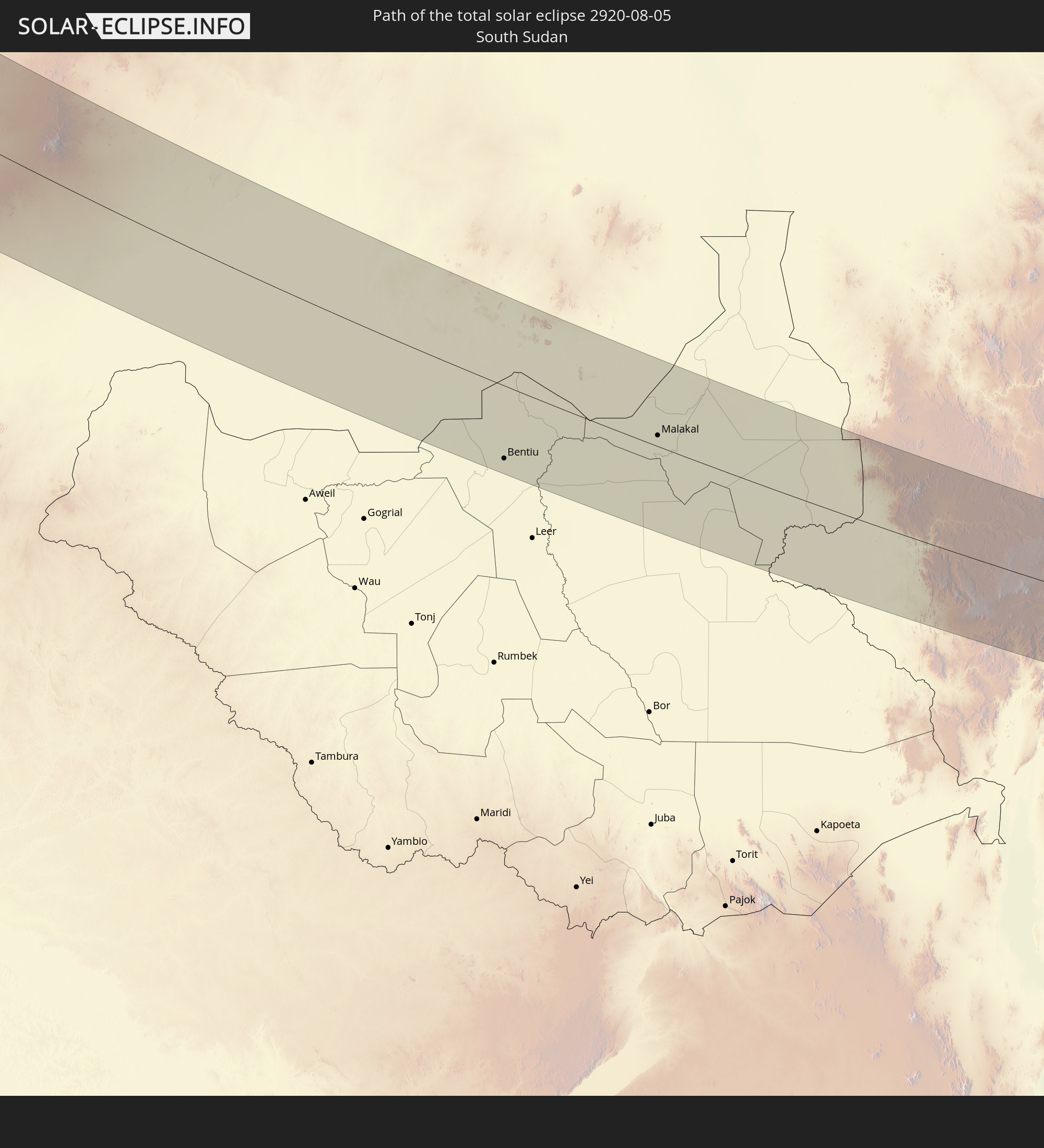 South Sudan
 Ethiopia
In den folgenden Ländern ist die Sonnenfinsternis partiell zu sehen
 Russia
 United States
 Canada
 Mexico
 Greenland
 The Bahamas
 Bermuda
 Saint Pierre and Miquelon
 Portugal
 Cabo Verde
 Iceland
 Spain
Spain
 Senegal
 Mauritania
 The Gambia
 Guinea-Bissau
 Guinea
 Sierra Leone
 Morocco
 Mali
Mali
 Liberia
 Republic of Ireland
 Svalbard and Jan Mayen
 Algeria
 United Kingdom
 Ivory Coast
 Faroe Islands
 Burkina Faso
 Gibraltar
 France
 Isle of Man
 Ghana
Ghana
 Guernsey
 Jersey
 Togo
Togo
 Niger
Niger
 Benin
Benin
 Andorra
 Belgium
 Nigeria
 Netherlands
 Norway
 Equatorial Guinea
 Luxembourg
 Germany
 Switzerland
 São Tomé and Príncipe
 Italy
Italy
 Monaco
 Tunisia
 Denmark
 Cameroon
 Gabon
Gabon
 Libya
Libya
 Liechtenstein
 Austria
 Sweden
 Republic of the Congo
 Angola
 Namibia
 Czechia
 Democratic Republic of the Congo
 San Marino
 Vatican City
 Slovenia
 Chad
Chad
 Croatia
 Poland
 Malta
Malta
 Central African Republic
 Bosnia and Herzegovina
 Hungary
 Slovakia
 Montenegro
 Serbia
 Albania
 Åland Islands
 Greece
 Botswana
 Romania
 Republic of Macedonia
 Finland
 Lithuania
 Latvia
 Estonia
 Sudan
Sudan
 Zambia
 Ukraine
 Bulgaria
 Belarus
 Egypt
Egypt
 Zimbabwe
 Turkey
 Moldova
 Rwanda
 Burundi
 Tanzania
 Uganda
 Cyprus
 Ethiopia
 Kenya
Kenya
 State of Palestine
 Israel
 Saudi Arabia
 Jordan
 Lebanon
 Syria
Syria
 Eritrea
 Iraq
Iraq
 Georgia
 Yemen
Yemen
 Armenia
 Iran
Iran
 Azerbaijan
 Kazakhstan
 Kuwait
 Turkmenistan
 Uzbekistan
How will be the weather during the total solar eclipse on 08/05/2920?
Where is the best place to see the total solar eclipse of 08/05/2920?
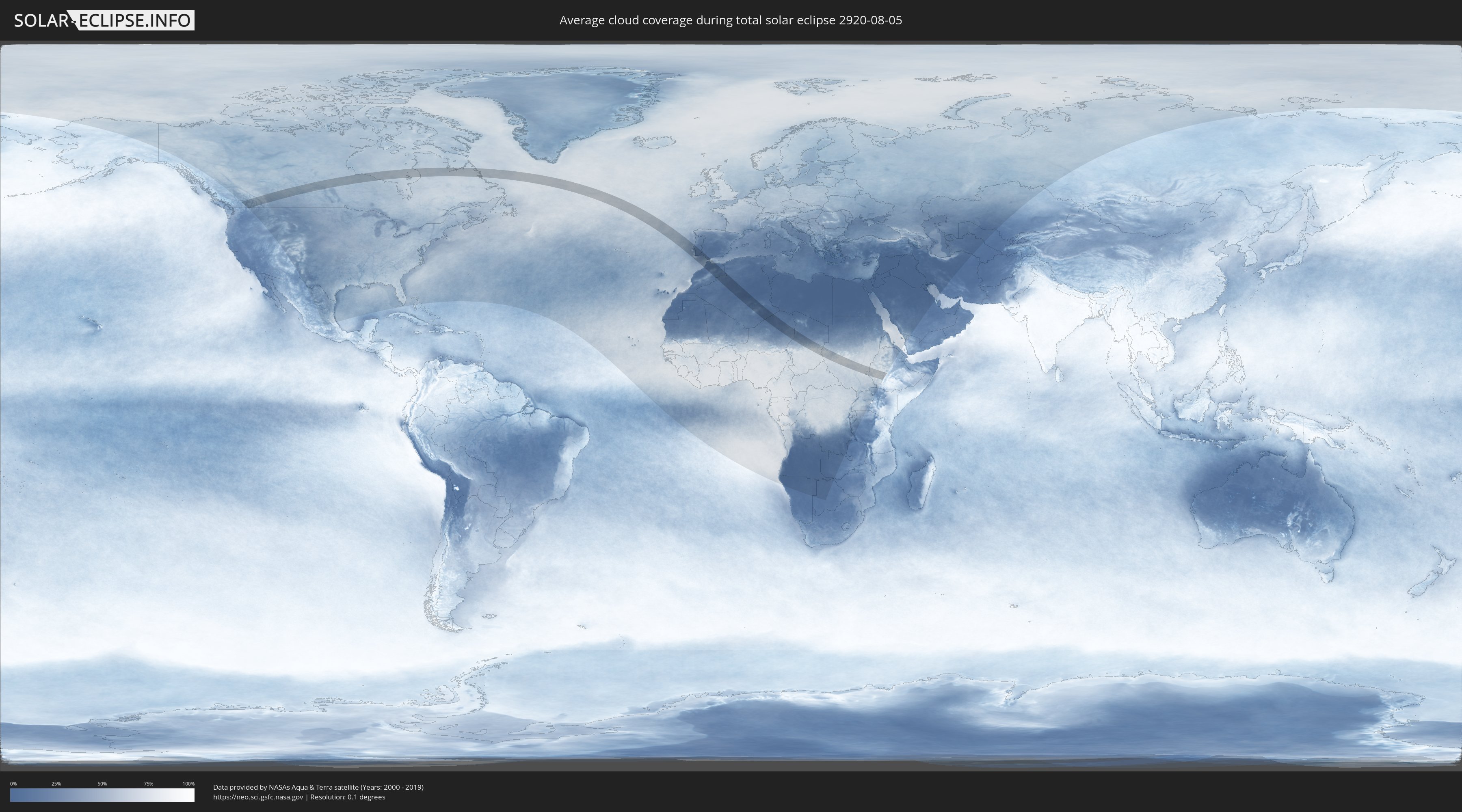
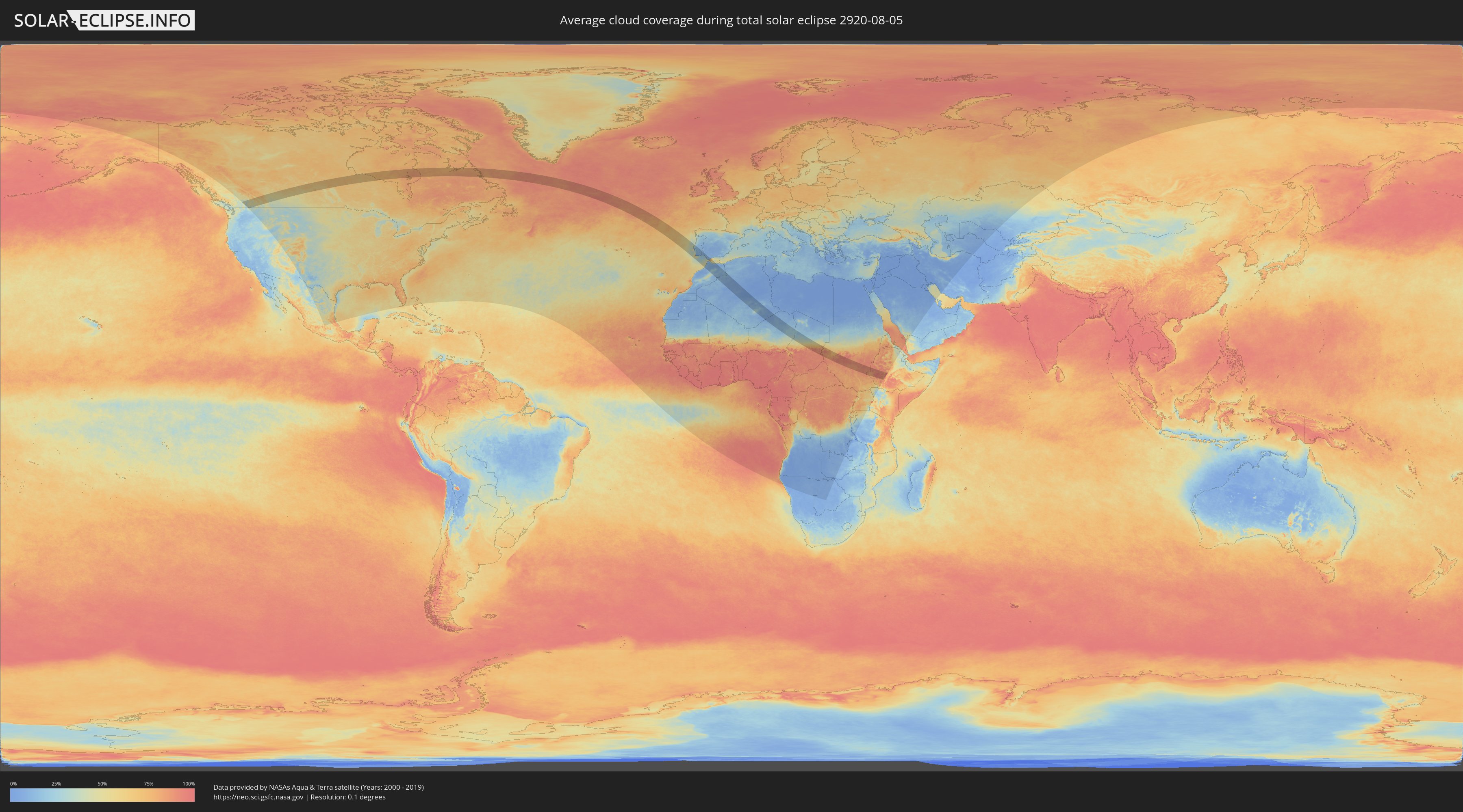
The following maps show the average cloud coverage for the day of the total solar eclipse.
With the help of these maps, it is possible to find the place along the eclipse path, which has the best
chance of a cloudless sky.
Nevertheless, you should consider local circumstances and inform about the weather of your chosen
observation site.
The data is provided by NASAs satellites
AQUA and TERRA.
The cloud maps are averaged over a period of 19 years (2000 - 2019).
Detailed country maps
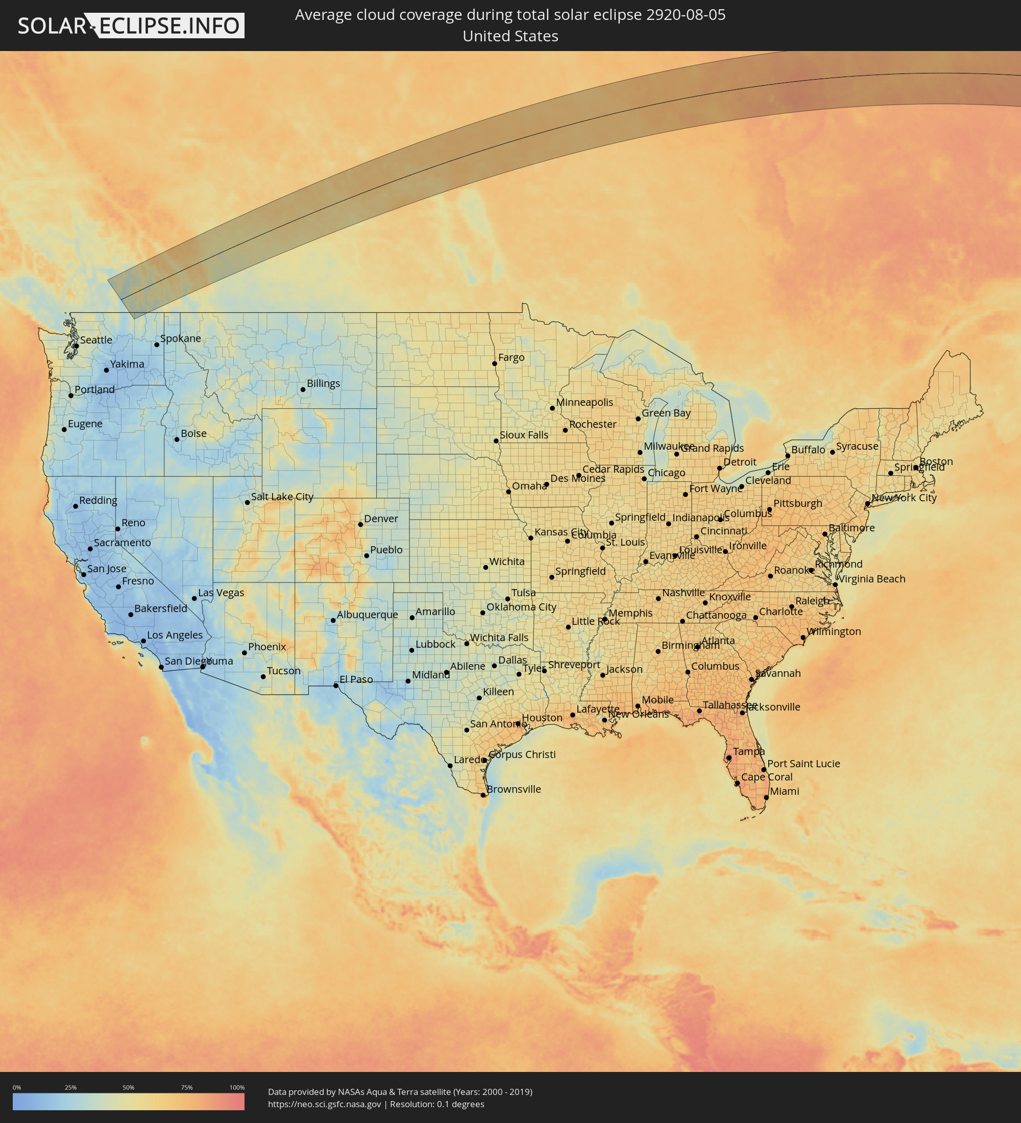 United States
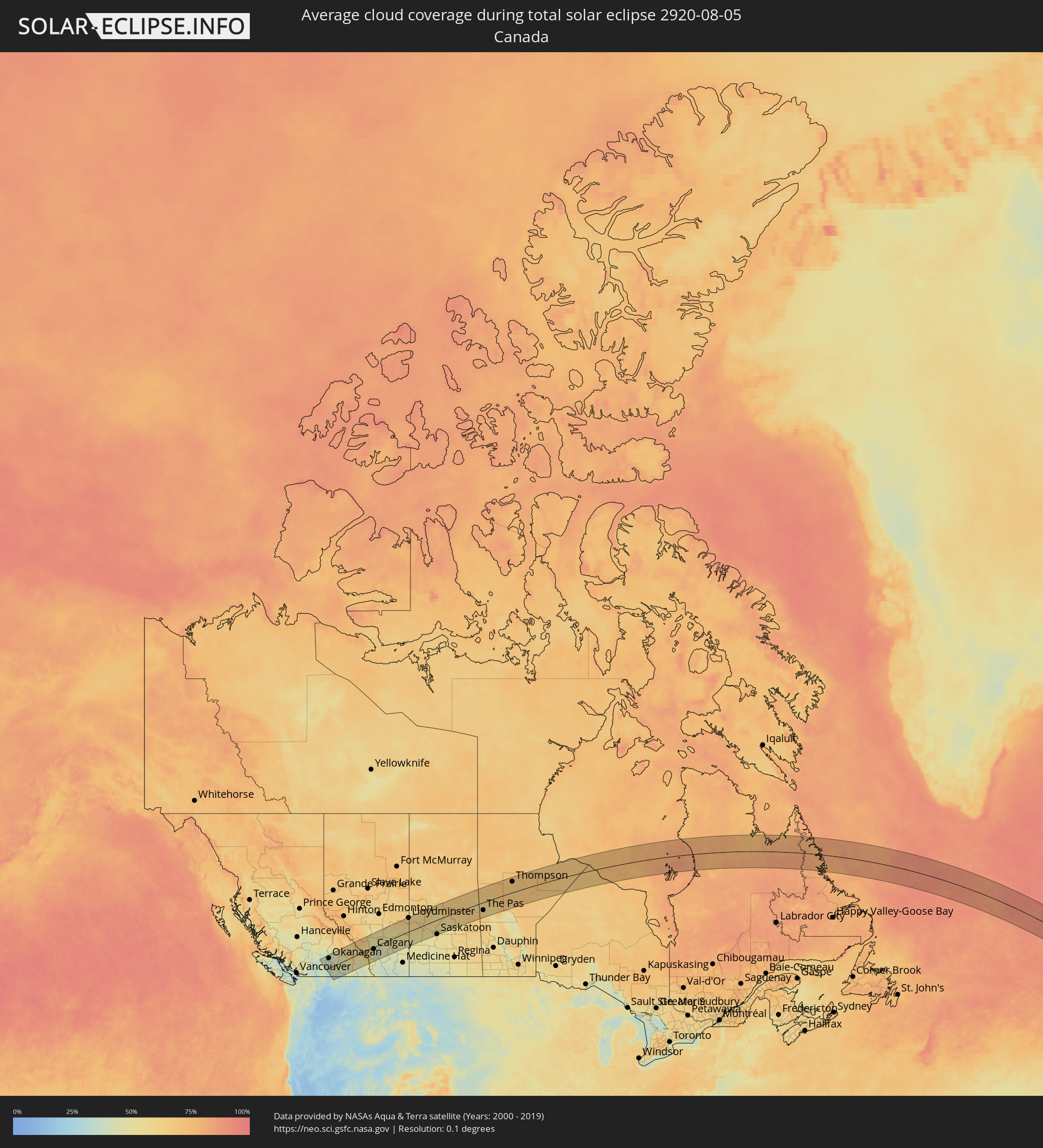 Canada
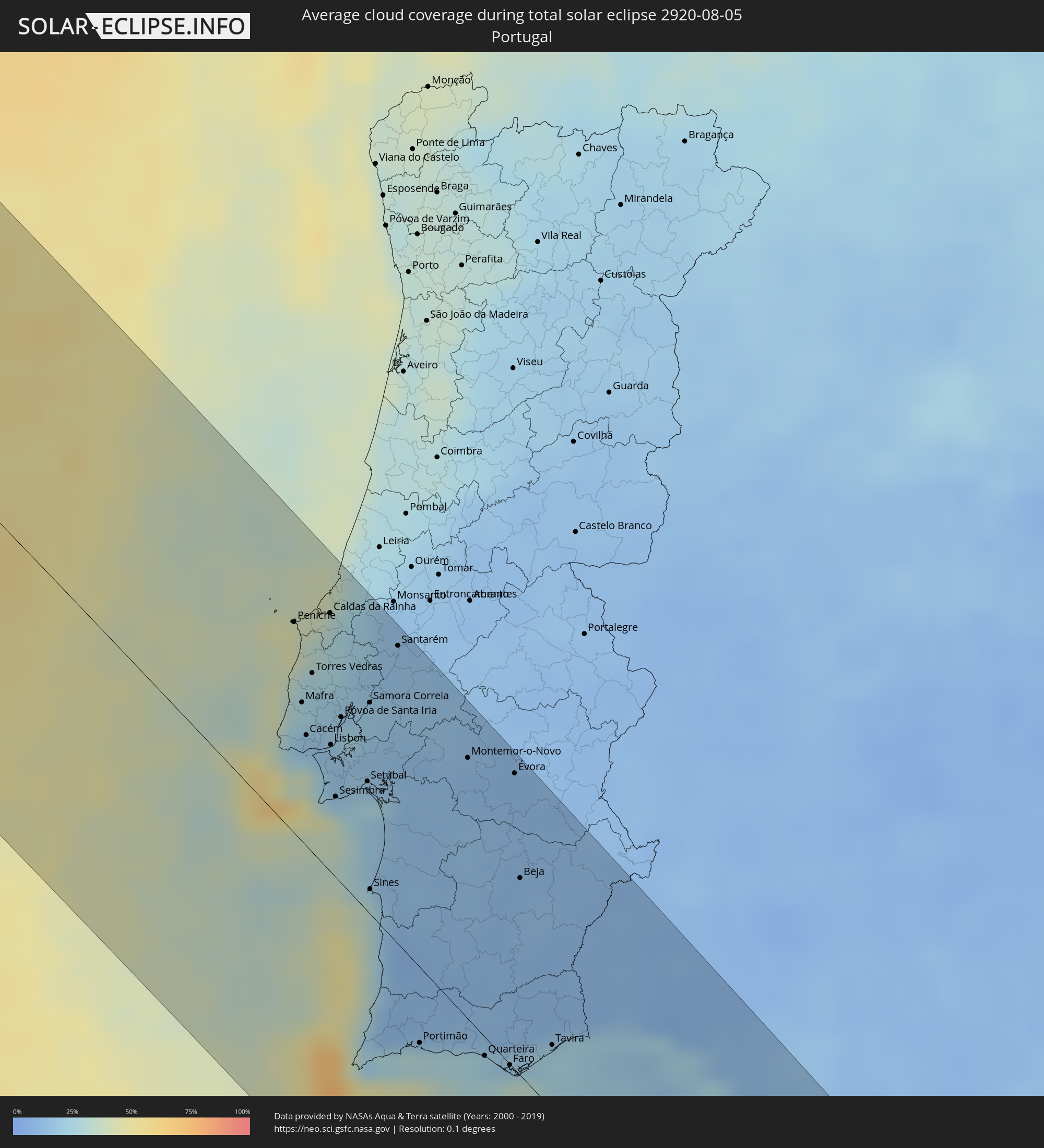 Portugal
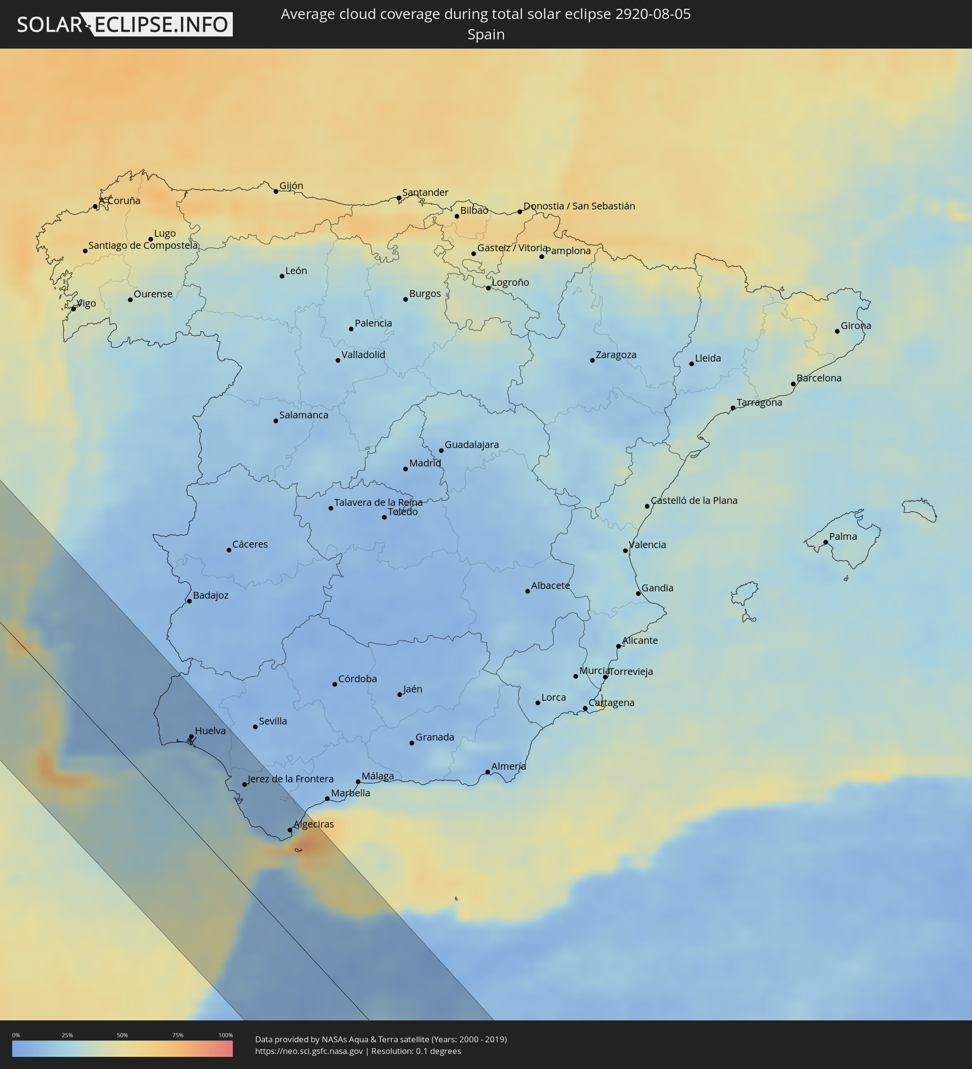 Spain
Spain
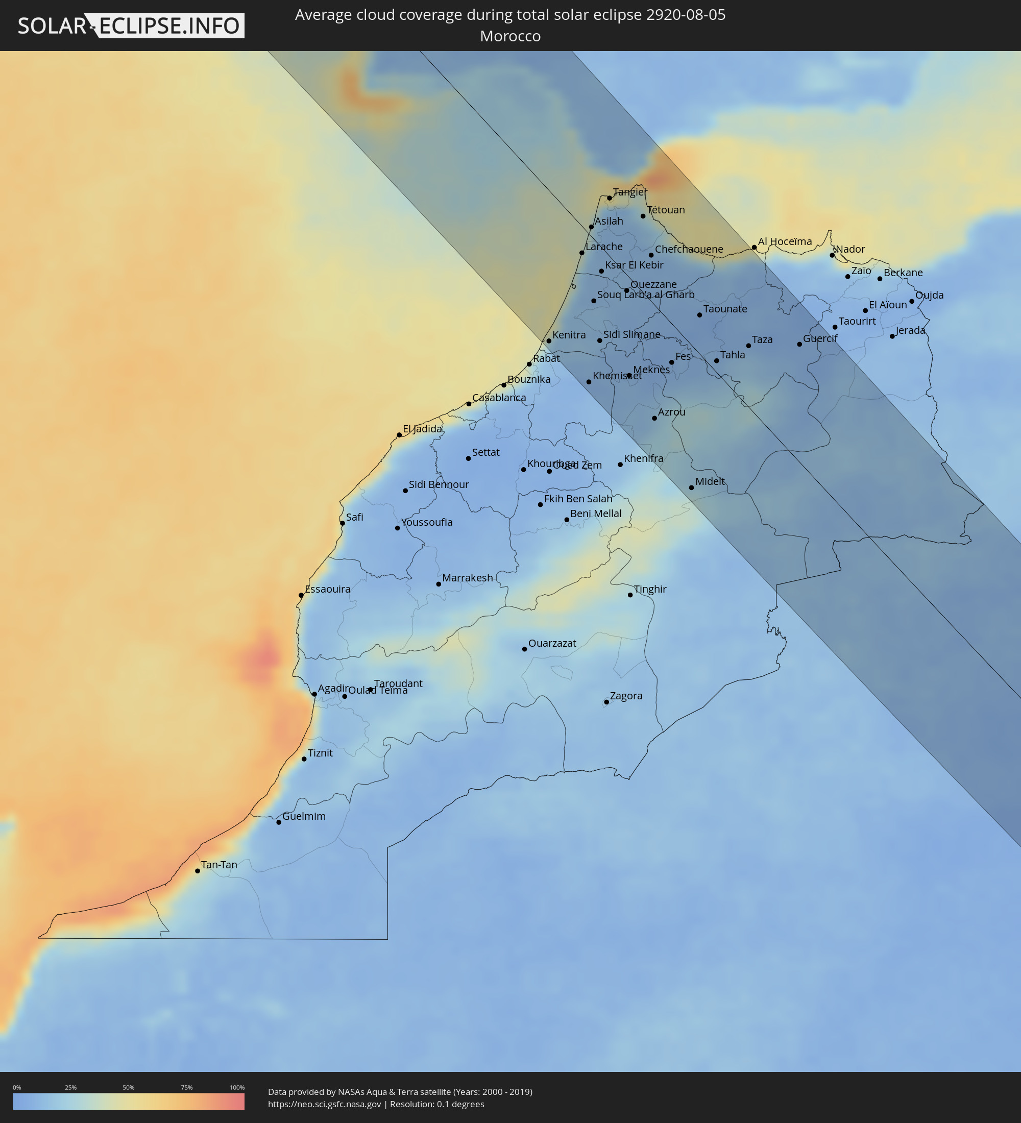 Morocco
 Algeria
 Gibraltar
 Niger
Niger
 Chad
Chad
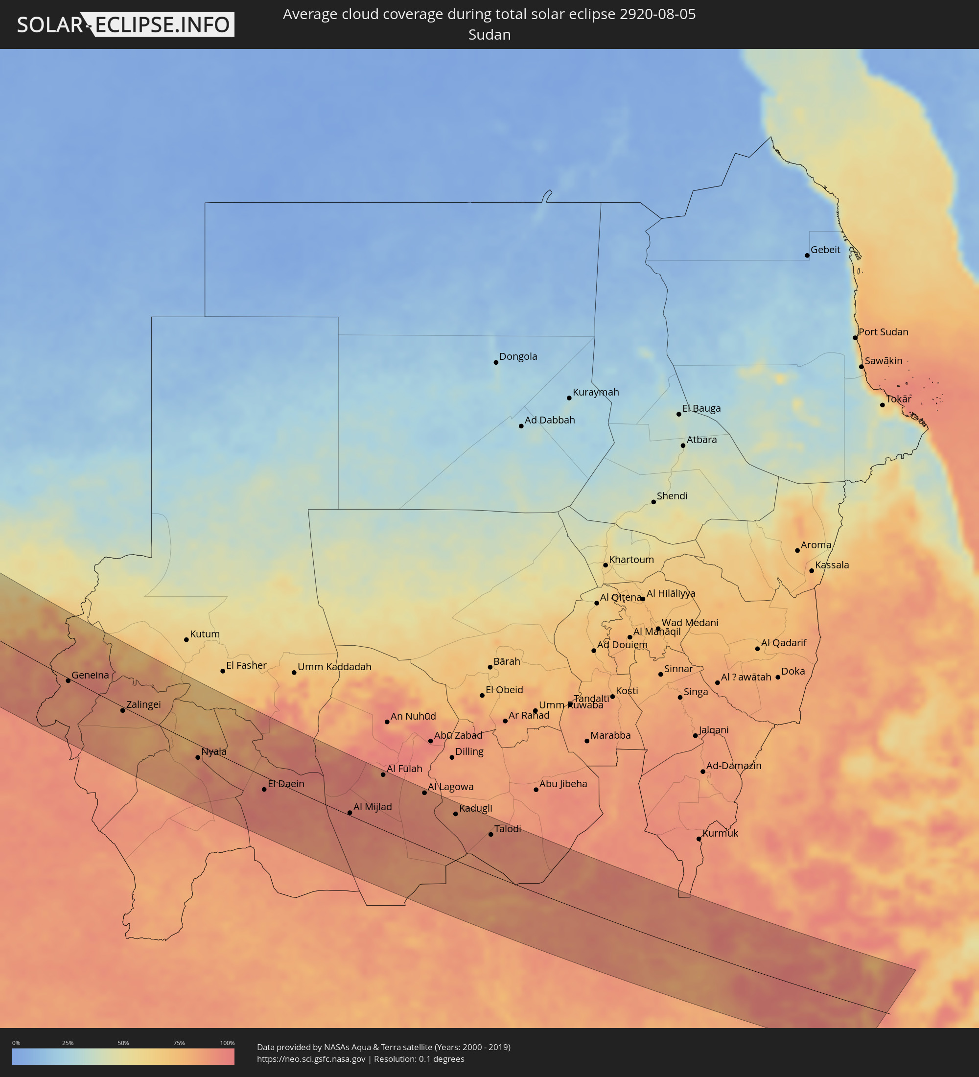 Sudan
Sudan
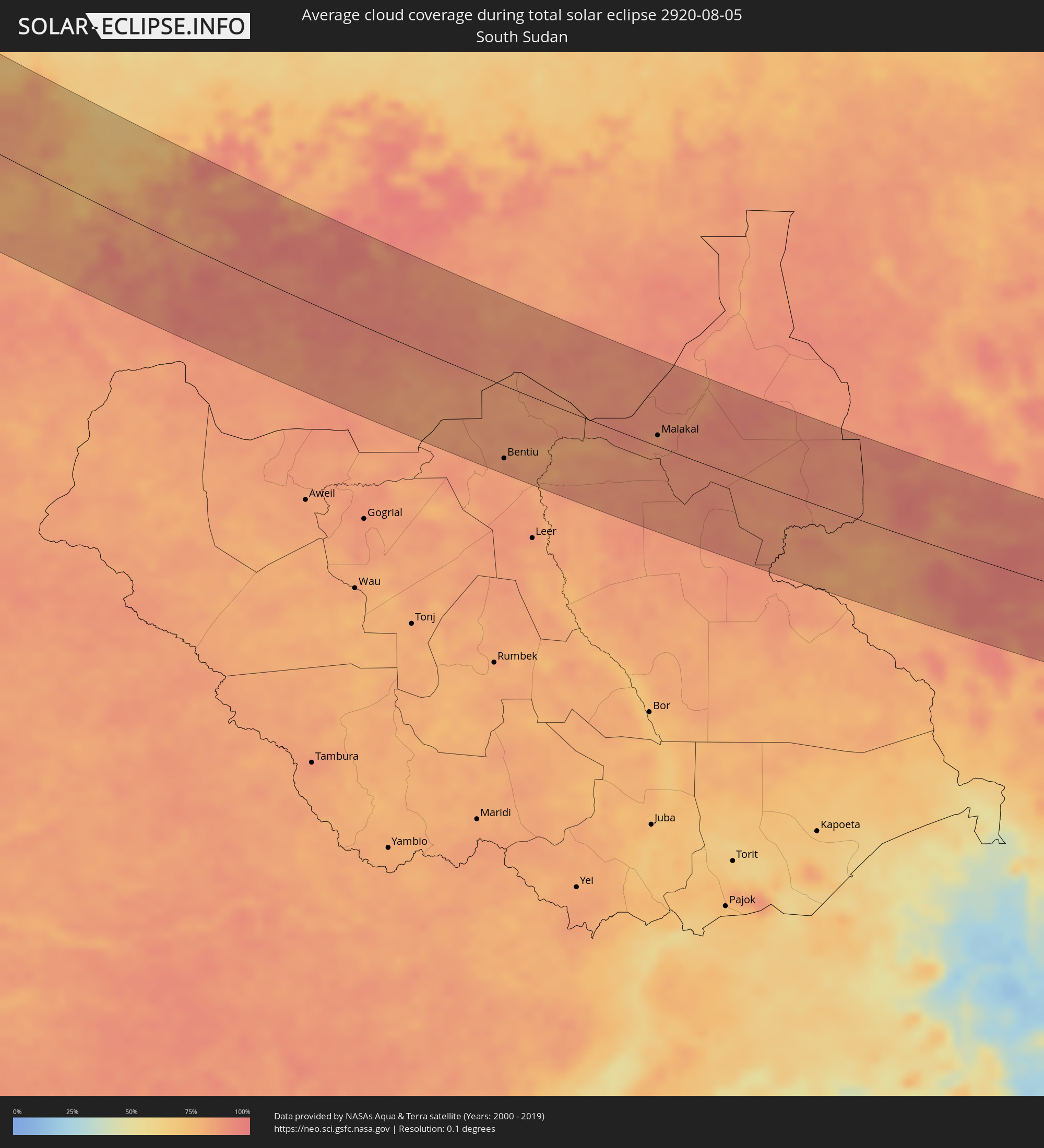 South Sudan
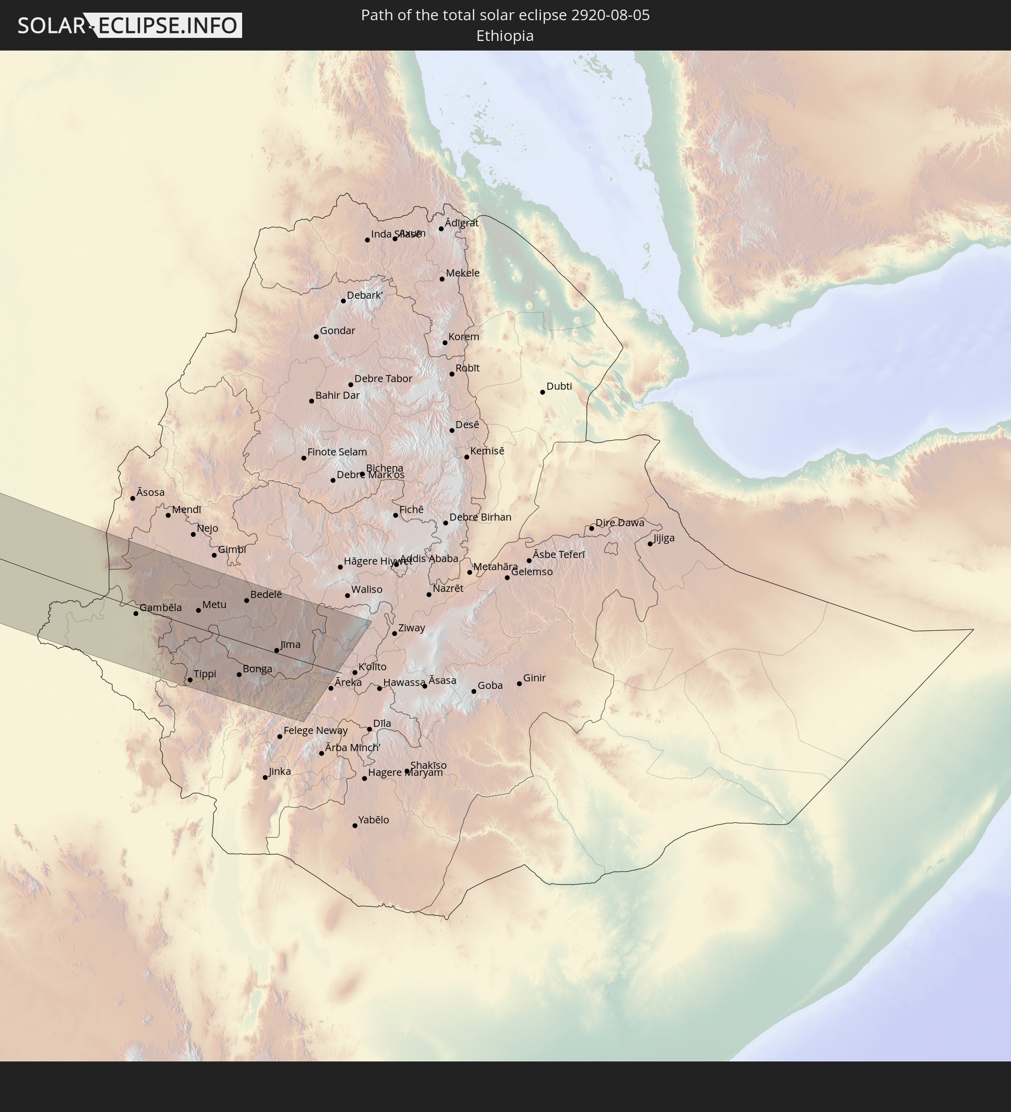
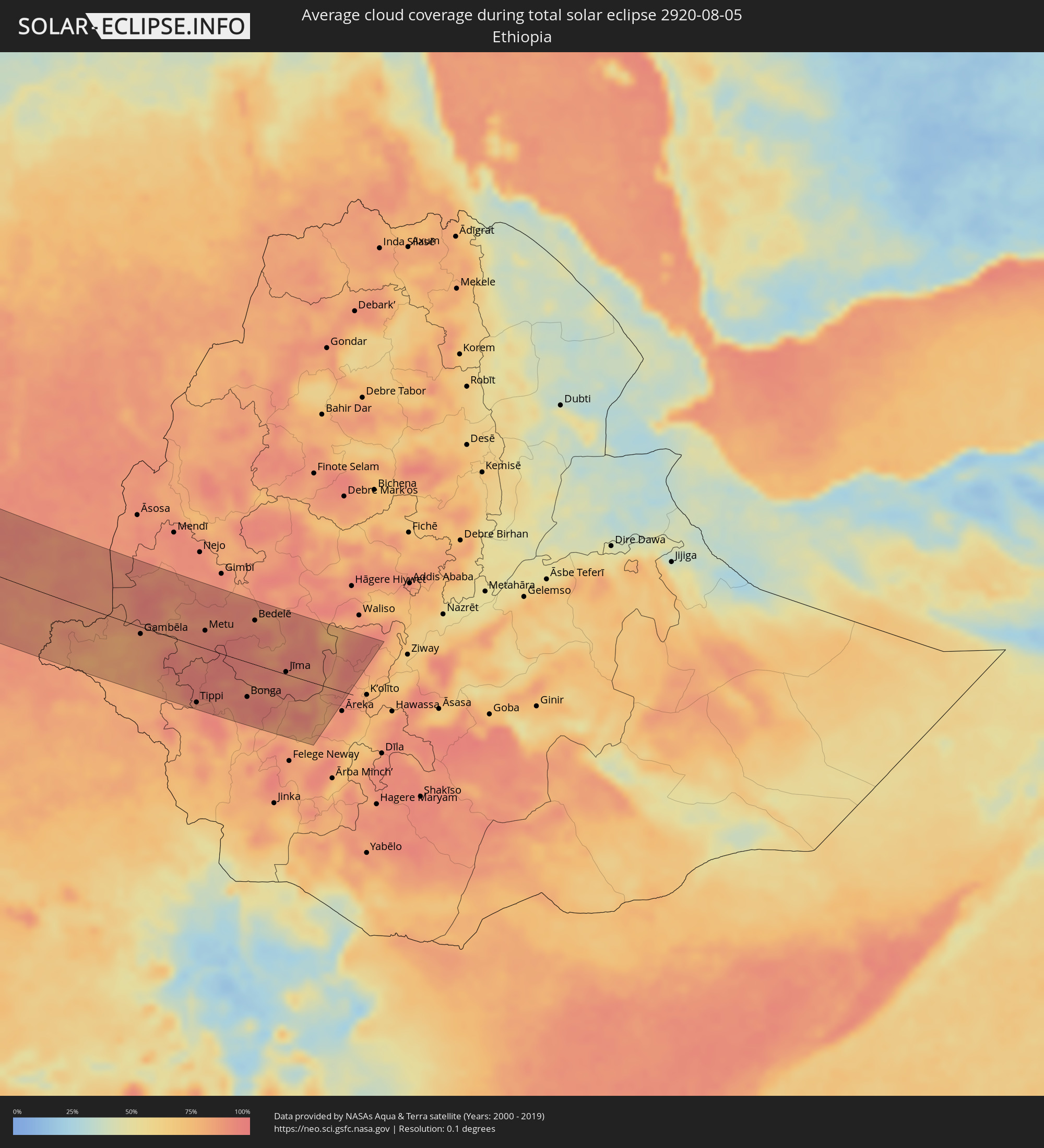 Ethiopia
Cities inside the path of the eclipse
The following table shows all locations with a population of more than 5,000 inside the eclipse path. Cities which have more than 100,000 inhabitants are marked bold. A click at the locations opens a detailed map.
| City | Type | Eclipse duration | Local time of max. eclipse | Distance to central line | Ø Cloud coverage |
|
Penticton, British Columbia
|
total | - | 04:45:16 UTC-08:00 | 6 km | 29% |
|
Kelowna, British Columbia
|
total | - | 04:45:36 UTC-08:00 | 32 km | 30% |
|
Okanagan, British Columbia
|
total | - | 04:46:00 UTC-08:00 | 75 km | 35% |
|
Revelstoke, British Columbia
|
total | - | 04:46:17 UTC-08:00 | 103 km | 48% |
|
Trail, British Columbia
|
total | - | 04:44:25 UTC-08:00 | 103 km | 32% |
|
Castlegar, British Columbia
|
total | - | 04:44:35 UTC-08:00 | 84 km | 35% |
|
Nelson, British Columbia
|
total | - | 04:44:40 UTC-08:00 | 75 km | 41% |
|
Canmore, Alberta
|
total | - | 05:45:44 UTC-07:00 | 26 km | 61% |
|
Cochrane, Alberta
|
total | - | 05:45:40 UTC-07:00 | 10 km | 47% |
|
Calgary, Alberta
|
total | - | 05:45:28 UTC-07:00 | 14 km | 47% |
|
Airdrie, Alberta
|
total | - | 05:45:42 UTC-07:00 | 9 km | 49% |
|
Okotoks, Alberta
|
total | - | 05:45:08 UTC-07:00 | 50 km | 45% |
|
High River, Alberta
|
total | - | 05:44:58 UTC-07:00 | 68 km | 45% |
|
Red Deer, Alberta
|
total | - | 05:46:37 UTC-07:00 | 101 km | 58% |
|
Strathmore, Alberta
|
total | - | 05:45:20 UTC-07:00 | 35 km | 44% |
|
Lloydminster, Saskatchewan
|
total | - | 05:47:11 UTC-07:00 | 99 km | 62% |
|
North Battleford, Saskatchewan
|
total | - | 06:46:31 UTC-06:00 | 3 km | 58% |
|
Saskatoon, Saskatchewan
|
total | - | 06:45:45 UTC-06:00 | 105 km | 56% |
|
Prince Albert, Saskatchewan
|
total | - | 06:46:51 UTC-06:00 | 17 km | 58% |
|
Thompson, Manitoba
|
total | - | 06:50:11 UTC-06:00 | 76 km | 71% |
|
Peniche, Leiria
|
total | - | 14:32:07 UTC+00:00 | 84 km | 44% |
|
Mafra, Lisbon
|
total | - | 14:32:57 UTC+00:00 | 56 km | 20% |
|
Cacém, Lisbon
|
total | - | 14:33:18 UTC+00:00 | 44 km | 16% |
|
Torres Vedras, Lisbon
|
total | - | 14:32:45 UTC+00:00 | 71 km | 26% |
|
Caldas da Rainha, Leiria
|
total | - | 14:32:20 UTC+00:00 | 103 km | 28% |
|
Lisbon, Lisbon
|
total | - | 14:33:36 UTC+00:00 | 51 km | 17% |
|
Sesimbra, Setúbal
|
total | - | 14:34:08 UTC+00:00 | 32 km | 36% |
|
Póvoa de Santa Iria, Lisbon
|
total | - | 14:33:25 UTC+00:00 | 66 km | 19% |
|
Setúbal, Setúbal
|
total | - | 14:34:15 UTC+00:00 | 52 km | 25% |
|
Samora Correia, Santarém
|
total | - | 14:33:31 UTC+00:00 | 84 km | 19% |
|
Sines, Setúbal
|
total | - | 14:35:19 UTC+00:00 | 10 km | 27% |
|
Santarém, Santarém
|
total | - | 14:33:12 UTC+00:00 | 119 km | 14% |
|
Portimão, Faro
|
total | - | 14:37:15 UTC+00:00 | 31 km | 28% |
|
Albufeira, Faro
|
total | - | 14:37:41 UTC+00:00 | 16 km | 26% |
|
Montemor-o-Novo, Évora
|
total | - | 14:34:51 UTC+00:00 | 104 km | 11% |
|
Loulé, Faro
|
total | - | 14:37:53 UTC+00:00 | 3 km | 19% |
|
Faro, Faro
|
total | - | 14:38:12 UTC+00:00 | 0 km | 33% |
|
Évora, Évora
|
total | - | 14:35:23 UTC+00:00 | 118 km | 10% |
|
Beja, Beja
|
total | - | 14:36:27 UTC+00:00 | 79 km | 11% |
|
Tavira, Faro
|
total | - | 14:38:21 UTC+00:00 | 26 km | 24% |
|
Ayamonte, Andalusia
|
total | - | 15:38:29 UTC+01:00 | 49 km | 22% |
|
Lepe, Andalusia
|
total | - | 15:38:39 UTC+01:00 | 65 km | 16% |
|
Cartaya, Andalusia
|
total | - | 15:38:40 UTC+01:00 | 70 km | 16% |
|
Aljaraque, Andalusia
|
total | - | 15:38:50 UTC+01:00 | 78 km | 11% |
|
Punta Umbría, Andalusia
|
total | - | 15:39:04 UTC+01:00 | 75 km | 22% |
|
Huelva, Andalusia
|
total | - | 15:38:57 UTC+01:00 | 83 km | 9% |
|
Kenitra, Gharb-Chrarda-Beni Hssen
|
total | - | 15:45:02 UTC+01:00 | 120 km | 19% |
|
Bollullos par del Condado, Andalusia
|
total | - | 15:39:17 UTC+01:00 | 115 km | 11% |
|
Almonte, Andalusia
|
total | - | 15:39:27 UTC+01:00 | 111 km | 11% |
|
Chipiona, Andalusia
|
total | - | 15:40:32 UTC+01:00 | 76 km | 25% |
|
Sanlúcar de Barrameda, Andalusia
|
total | - | 15:40:33 UTC+01:00 | 85 km | 20% |
|
Cadiz, Andalusia
|
total | - | 15:41:05 UTC+01:00 | 70 km | 32% |
|
Larache, Tanger-Tétouan
|
total | - | 15:43:46 UTC+01:00 | 21 km | 34% |
|
Chiclana de la Frontera, Andalusia
|
total | - | 15:41:28 UTC+01:00 | 72 km | 16% |
|
Jerez de la Frontera, Andalusia
|
total | - | 15:40:58 UTC+01:00 | 92 km | 13% |
|
Conil de la Frontera, Andalusia
|
total | - | 15:41:48 UTC+01:00 | 65 km | 28% |
|
Lebrija, Andalusia
|
total | - | 15:40:36 UTC+01:00 | 114 km | 11% |
|
Khemisset, Rabat-Salé-Zemmour-Zaër
|
total | - | 15:46:28 UTC+01:00 | 119 km | 10% |
|
Souq Larb’a al Gharb, Gharb-Chrarda-Beni Hssen
|
total | - | 15:44:54 UTC+01:00 | 49 km | 16% |
|
Sidi Slimane, Gharb-Chrarda-Beni Hssen
|
total | - | 15:45:48 UTC+01:00 | 76 km | 11% |
|
Barbate de Franco, Andalusia
|
total | - | 15:42:09 UTC+01:00 | 70 km | 31% |
|
Ksar El Kebir, Tanger-Tétouan
|
total | - | 15:44:26 UTC+01:00 | 19 km | 12% |
|
Arcos de la Frontera, Andalusia
|
total | - | 15:41:14 UTC+01:00 | 119 km | 12% |
|
Tangier, Tanger-Tétouan
|
total | - | 15:43:06 UTC+01:00 | 46 km | 17% |
|
Sidi Qacem, Gharb-Chrarda-Beni Hssen
|
total | - | 15:46:08 UTC+01:00 | 65 km | 9% |
|
Tarifa, Andalusia
|
total | - | 15:42:51 UTC+01:00 | 77 km | 63% |
|
Ouezzane, Gharb-Chrarda-Beni Hssen
|
total | - | 15:45:11 UTC+01:00 | 12 km | 11% |
|
Meknès, Meknès-Tafilalet
|
total | - | 15:46:57 UTC+01:00 | 79 km | 11% |
|
Algeciras, Andalusia
|
total | - | 15:42:49 UTC+01:00 | 97 km | 51% |
|
Tétouan, Tanger-Tétouan
|
total | - | 15:43:57 UTC+01:00 | 61 km | 19% |
|
Gibraltar
|
total | - | 15:42:54 UTC+01:00 | 104 km | 73% |
|
Ceuta, Ceuta
|
total | - | 15:43:25 UTC+01:00 | 87 km | 55% |
|
Martil, Tanger-Tétouan
|
total | - | 15:43:59 UTC+01:00 | 70 km | 25% |
|
Chefchaouene, Tanger-Tétouan
|
total | - | 15:44:51 UTC+01:00 | 37 km | 11% |
|
Azrou, Meknès-Tafilalet
|
total | - | 15:48:12 UTC+01:00 | 91 km | 23% |
|
Fes, Fès-Boulemane
|
total | - | 15:47:18 UTC+01:00 | 31 km | 10% |
|
Sefrou, Fès-Boulemane
|
total | - | 15:47:53 UTC+01:00 | 35 km | 19% |
|
Midelt, Meknès-Tafilalet
|
total | - | 15:50:10 UTC+01:00 | 116 km | 28% |
|
Taounate, Taza-Al Hoceima-Taounate
|
total | - | 15:46:45 UTC+01:00 | 31 km | 8% |
|
Taza, Taza-Al Hoceima-Taounate
|
total | - | 15:48:04 UTC+01:00 | 49 km | 14% |
|
Guercif, Taza-Al Hoceima-Taounate
|
total | - | 15:48:46 UTC+01:00 | 95 km | 9% |
|
Béchar, Béchar
|
total | - | 15:54:57 UTC+01:00 | 24 km | 12% |
|
Timimoun, Adrar
|
total | - | 16:01:51 UTC+01:00 | 34 km | 8% |
|
I-n-Salah, Tamanrasset
|
total | - | 16:07:44 UTC+01:00 | 41 km | 4% |
|
Abéché, Ouadaï
|
total | - | 16:38:47 UTC+01:00 | 52 km | 92% |
|
Biltine, Wadi Fira
|
total | - | 16:37:52 UTC+01:00 | 20 km | 85% |
|
Adré, Ouadaï
|
total | - | 16:39:29 UTC+01:00 | 16 km | 92% |
|
Geneina, Western Darfur
|
total | - | 17:39:32 UTC+02:00 | 5 km | 86% |
|
Zalingei, Central Darfur
|
total | - | 17:40:21 UTC+02:00 | 7 km | 87% |
|
Nyala, Southern Darfur
|
total | - | 17:41:32 UTC+02:00 | 24 km | 91% |
|
El Daein, Eastern Darfur
|
total | - | 17:42:17 UTC+02:00 | 25 km | 95% |
|
Al Mijlad, West Kordofan State
|
total | - | 17:42:47 UTC+02:00 | 4 km | 94% |
|
El Fula, West Kordofan State
|
total | - | 17:41:59 UTC+02:00 | 100 km | 91% |
|
Al Fūlah, Southern Kordofan
|
total | - | 17:41:57 UTC+02:00 | 103 km | 90% |
|
Al Lagowa, West Kordofan State
|
total | - | 17:42:19 UTC+02:00 | 103 km | 89% |
|
Kadugli, Southern Kordofan
|
total | - | 17:42:43 UTC+02:00 | 88 km | 85% |
 Bentiu, Unity
|
total | - | 17:44:40 UTC+02:00 | 90 km | 86% |
|
Talodi, Southern Kordofan
|
total | - | 17:43:06 UTC+02:00 | 76 km | 92% |
|
Malakal, Upper Nile
|
total | - | 17:44:10 UTC+02:00 | 14 km | 87% |
|
Gambēla, Gambela
|
total | - | 18:45:00 UTC+03:00 | 12 km | 84% |
|
Dembī Dolo, Oromiya
|
total | - | 18:44:41 UTC+03:00 | 26 km | 91% |
|
Tippi, Southern Nations, Nationalities, and People's Region
|
total | - | 18:45:51 UTC+03:00 | 92 km | 89% |
|
Gorē, Oromiya
|
total | - | 18:44:54 UTC+03:00 | 11 km | 92% |
|
Metu, Oromiya
|
total | - | 18:44:44 UTC+03:00 | 29 km | 92% |
|
Bonga, Southern Nations, Nationalities, and People's Region
|
total | - | 18:45:35 UTC+03:00 | 57 km | 94% |
|
Bedelē, Oromiya
|
total | - | 18:44:24 UTC+03:00 | 72 km | 90% |
|
Āgaro, Oromiya
|
total | - | 18:44:56 UTC+03:00 | 17 km | 87% |
|
Jīma, Oromiya
|
total | - | 18:45:04 UTC+03:00 | 4 km | 89% |