Total solar eclipse of 04/15/2963
| Day of week: | Friday |
| Maximum duration of eclipse: | 03m44s |
| Maximum width of eclipse path: | 273 km |
| Saros cycle: | 154 |
| Coverage: | 100% |
| Magnitude: | 1.0547 |
| Gamma: | 0.7513 |
Wo kann man die Sonnenfinsternis vom 04/15/2963 sehen?
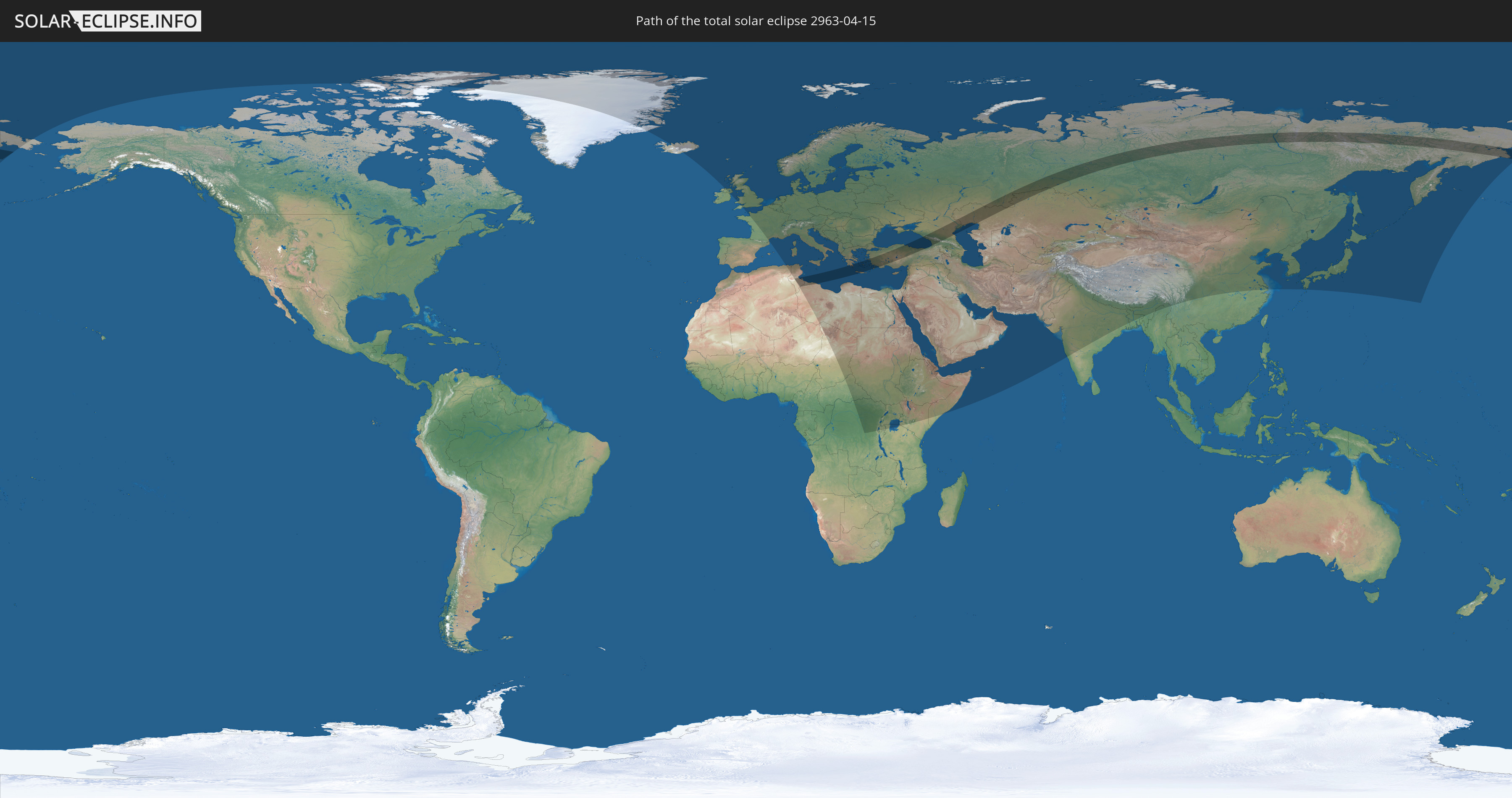
Die Sonnenfinsternis am 04/15/2963 kann man in 101 Ländern als partielle Sonnenfinsternis beobachten.
Der Finsternispfad verläuft durch 7 Länder. Nur in diesen Ländern ist sie als total Sonnenfinsternis zu sehen.
In den folgenden Ländern ist die Sonnenfinsternis total zu sehen
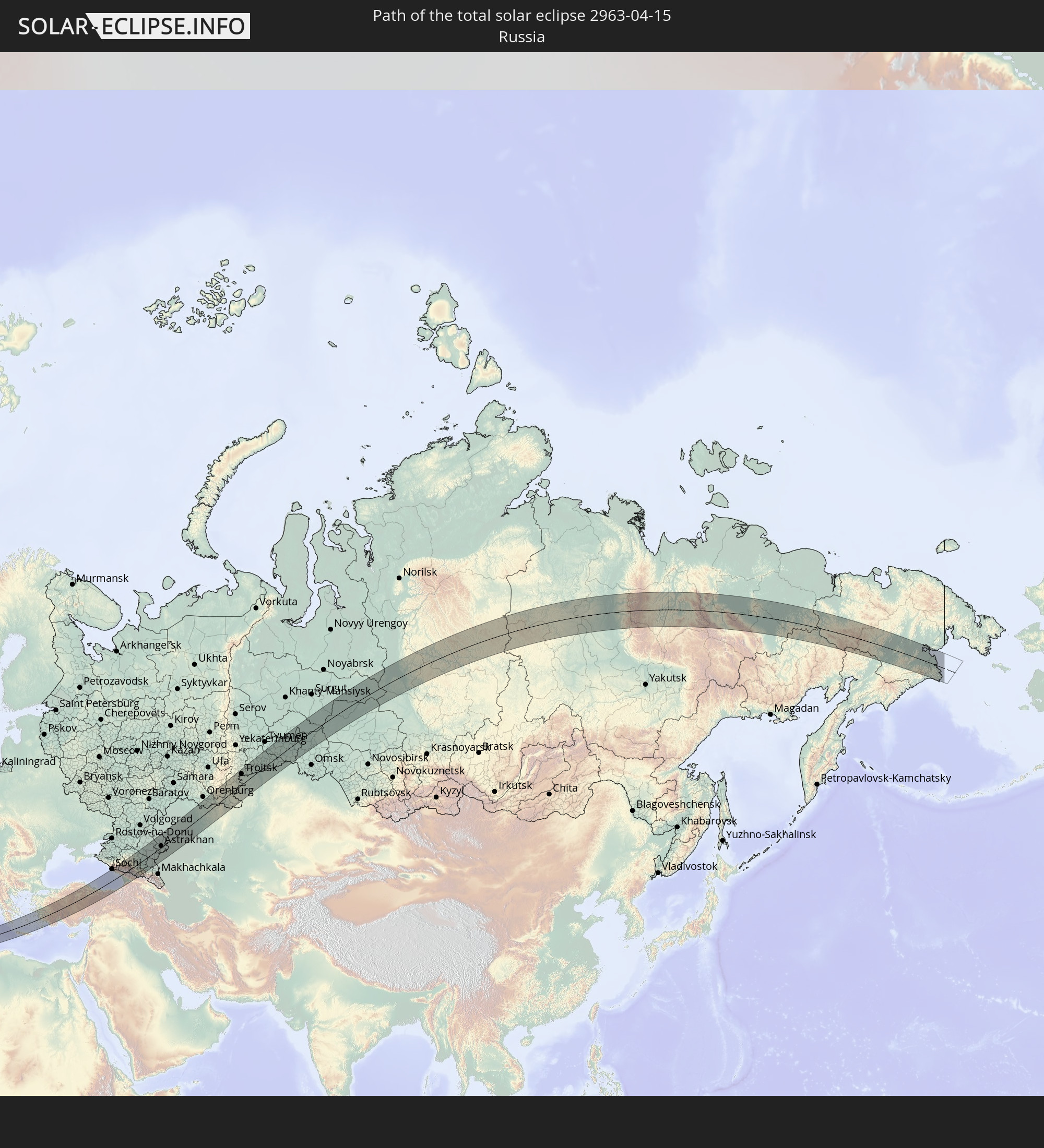 Russia
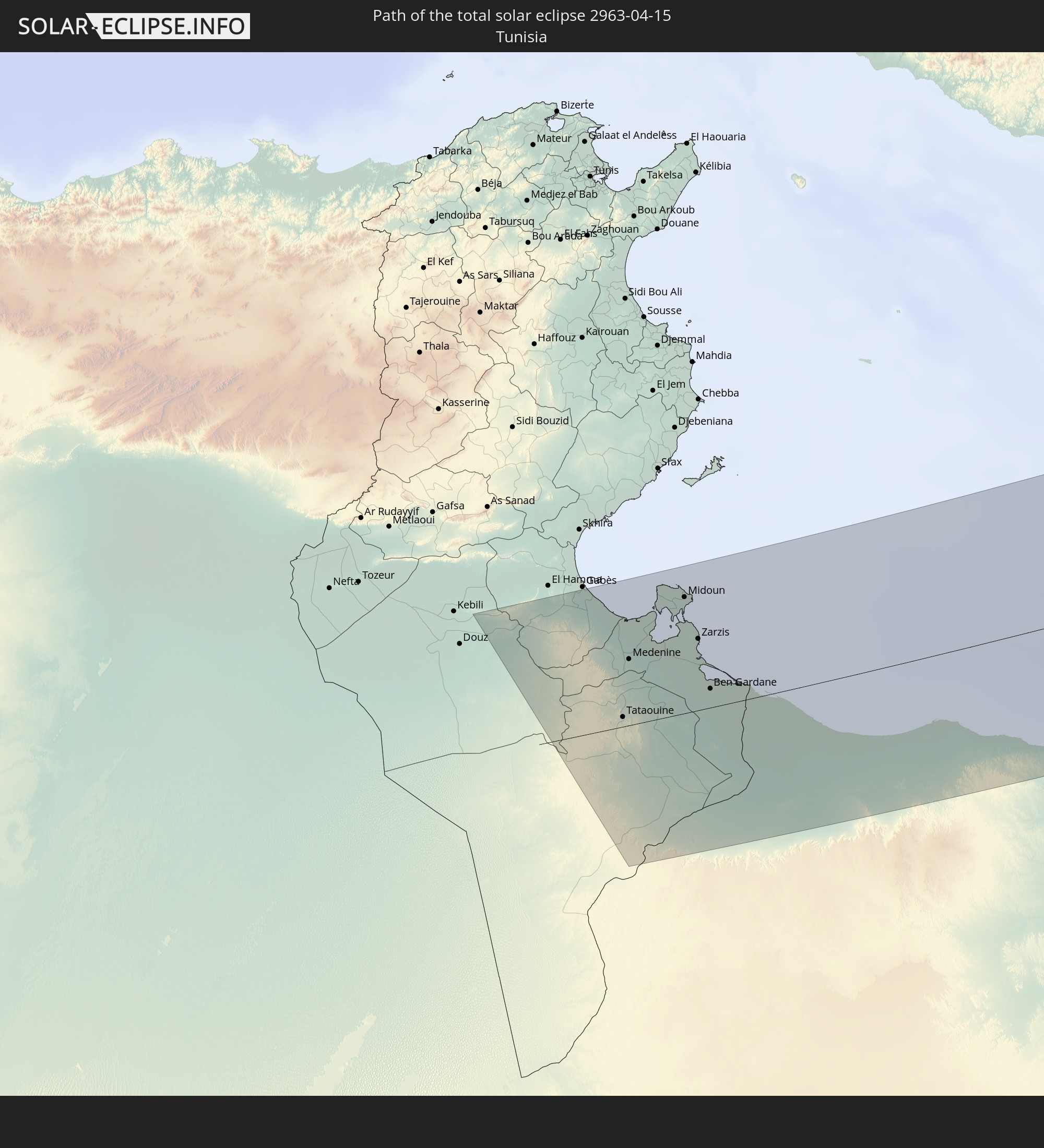 Tunisia
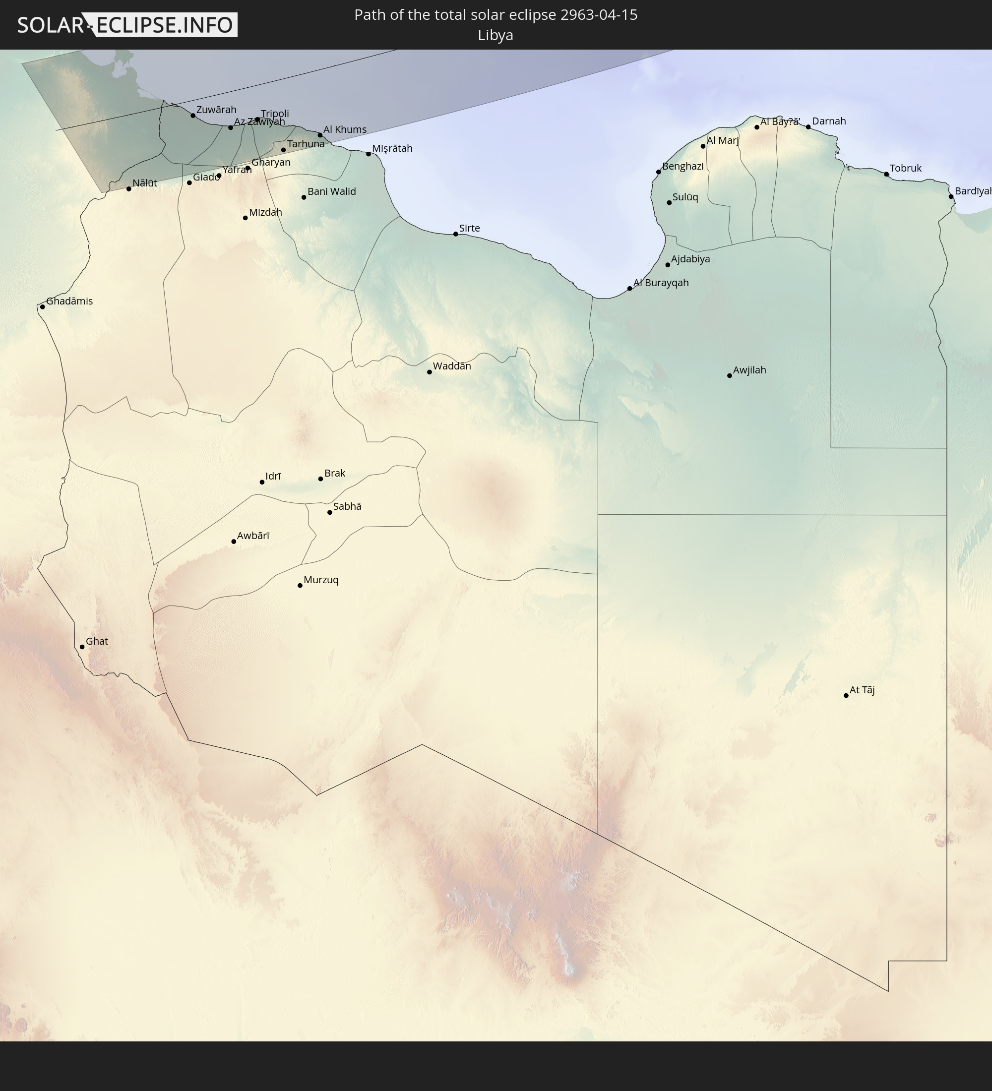 Libya
Libya
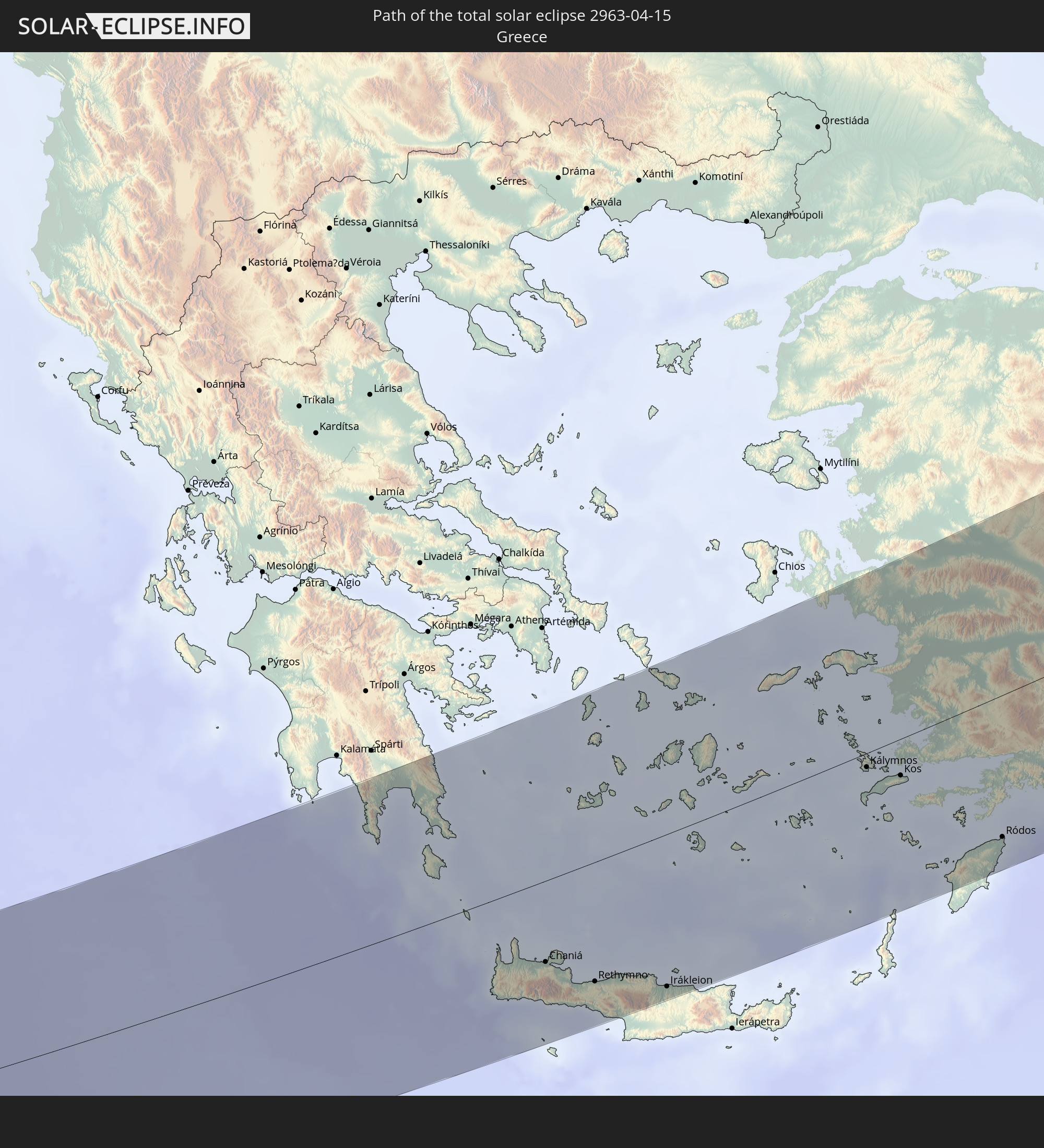 Greece
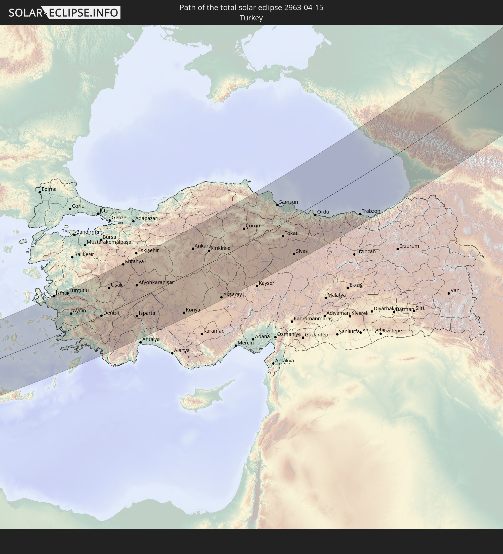 Turkey
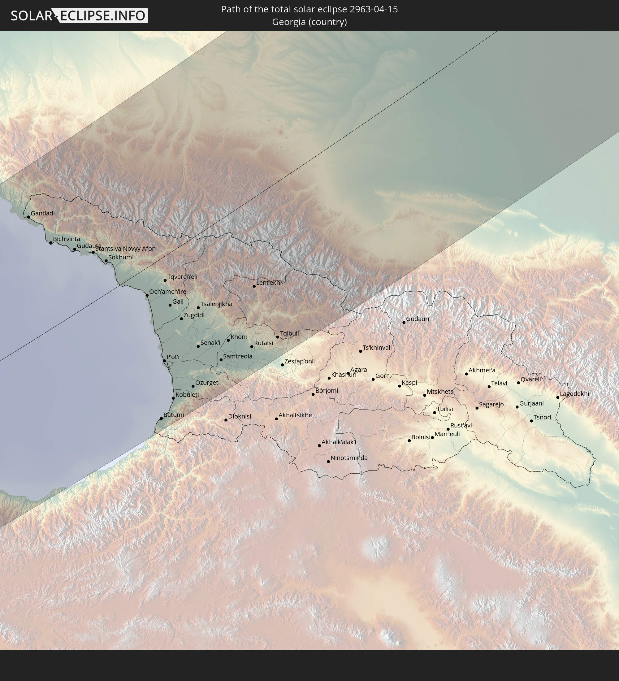 Georgia
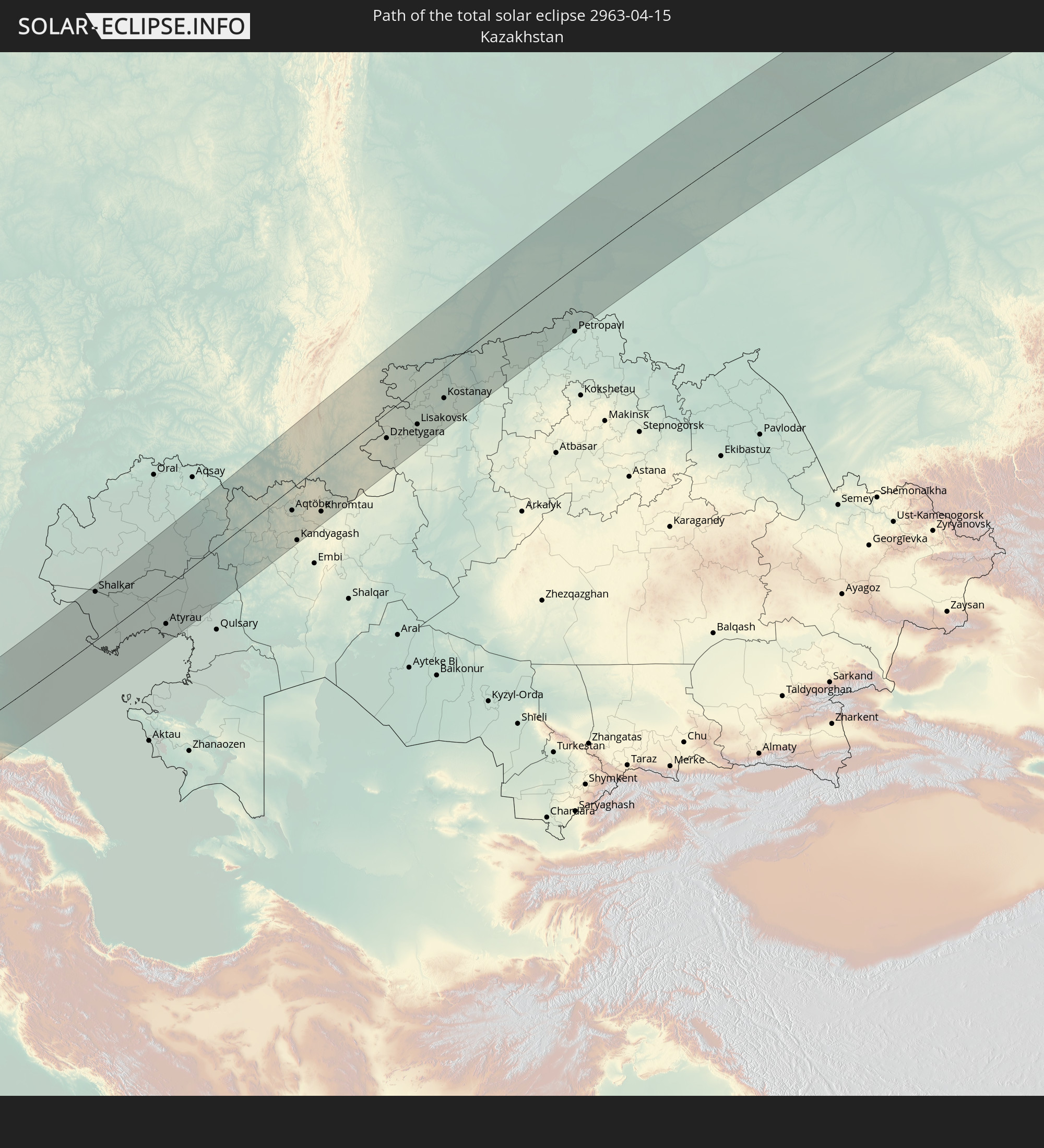 Kazakhstan
In den folgenden Ländern ist die Sonnenfinsternis partiell zu sehen
 Russia
 Canada
 Greenland
 Iceland
 Republic of Ireland
 Svalbard and Jan Mayen
 Algeria
 United Kingdom
 Faroe Islands
 France
 Isle of Man
 Guernsey
 Jersey
 Belgium
 Netherlands
 Norway
 Luxembourg
 Germany
 Switzerland
 Italy
Italy
 Monaco
 Tunisia
 Denmark
 Libya
Libya
 Liechtenstein
 Austria
 Sweden
 Czechia
 Democratic Republic of the Congo
 San Marino
 Vatican City
 Slovenia
 Chad
Chad
 Croatia
 Poland
 Malta
Malta
 Central African Republic
 Bosnia and Herzegovina
 Hungary
 Slovakia
 Montenegro
 Serbia
 Albania
 Åland Islands
 Greece
 Romania
 Republic of Macedonia
 Finland
 Lithuania
 Latvia
 Estonia
 Sudan
Sudan
 Ukraine
 Bulgaria
 Belarus
 Egypt
Egypt
 Turkey
 Moldova
 Rwanda
 Tanzania
 Uganda
 Cyprus
 Ethiopia
 Kenya
Kenya
 State of Palestine
 Israel
 Saudi Arabia
 Jordan
 Lebanon
 Syria
Syria
 Eritrea
 Iraq
Iraq
 Georgia
 Somalia
 Djibouti
 Yemen
Yemen
 Armenia
 Iran
Iran
 Azerbaijan
 Kazakhstan
 Kuwait
 Bahrain
 Qatar
Qatar
 United Arab Emirates
 Oman
Oman
 Turkmenistan
 Uzbekistan
 Afghanistan
 Pakistan
 Tajikistan
 India
India
 Kyrgyzstan
 China
China
 Nepal
Nepal
 Mongolia
 Bangladesh
 Bhutan
 Myanmar
 Japan
Japan
 North Korea
 South Korea
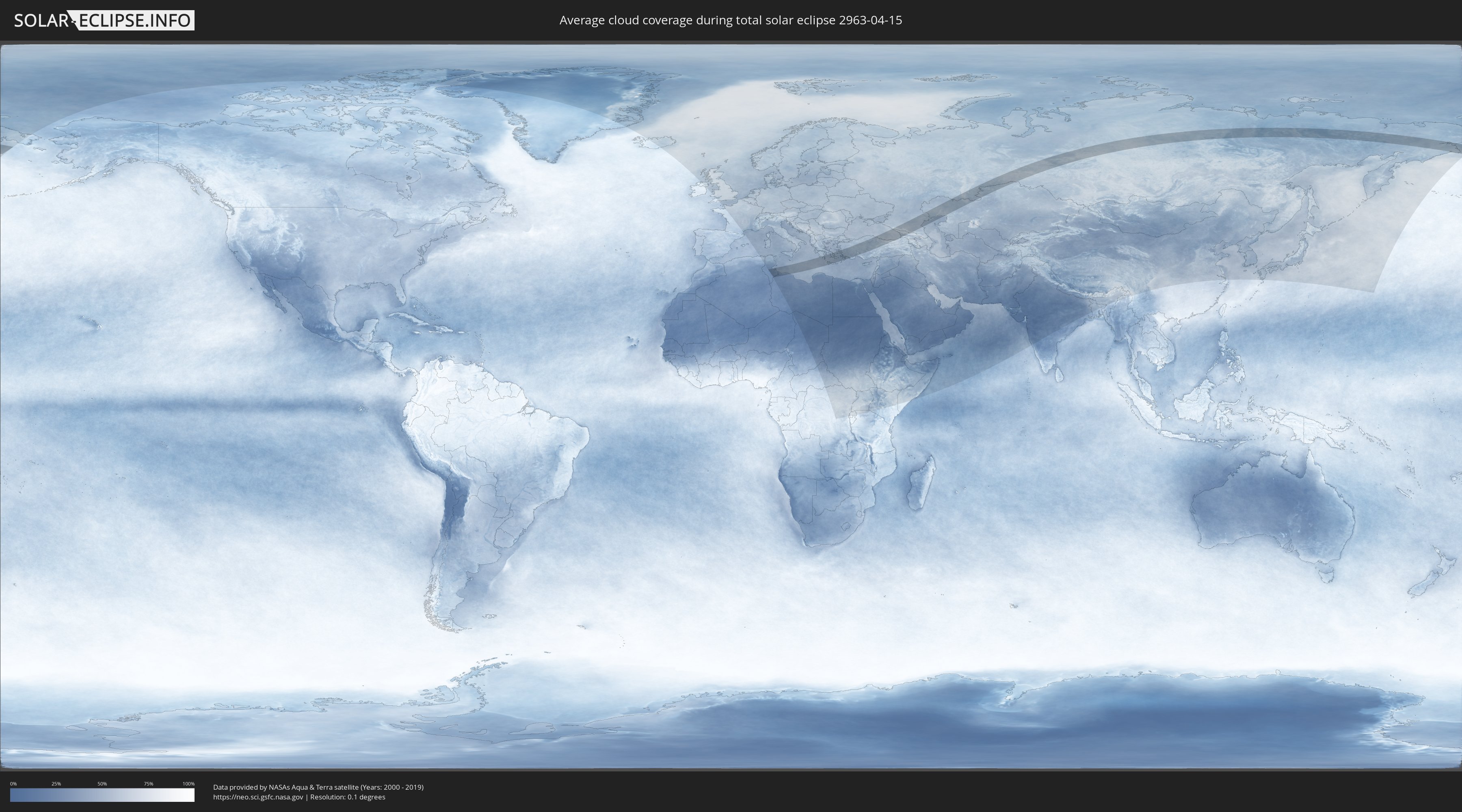
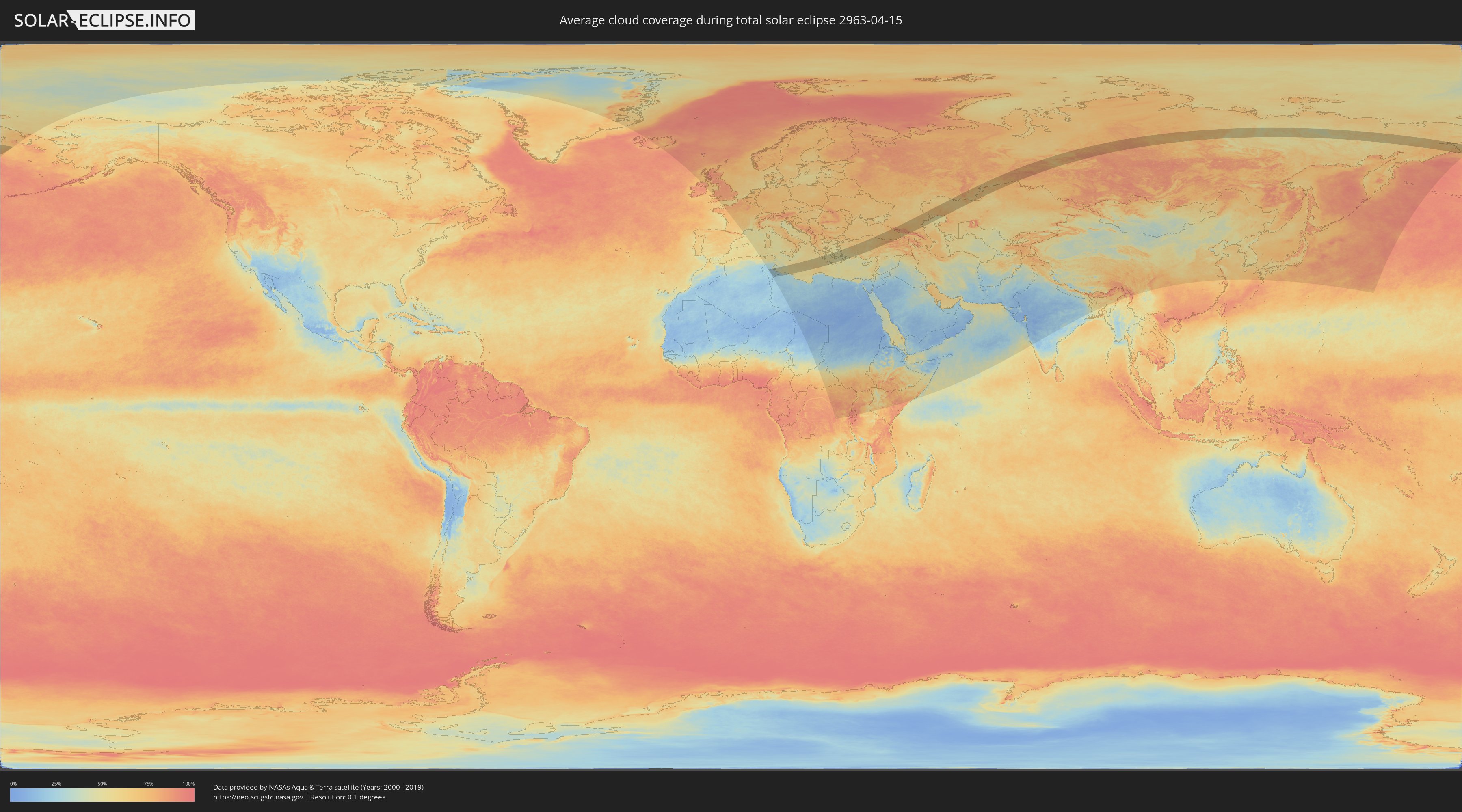
How will be the weather during the total solar eclipse on 04/15/2963?
Where is the best place to see the total solar eclipse of 04/15/2963?
The following maps show the average cloud coverage for the day of the total solar eclipse.
With the help of these maps, it is possible to find the place along the eclipse path, which has the best
chance of a cloudless sky.
Nevertheless, you should consider local circumstances and inform about the weather of your chosen
observation site.
The data is provided by NASAs satellites
AQUA and TERRA.
The cloud maps are averaged over a period of 19 years (2000 - 2019).
Detailed country maps
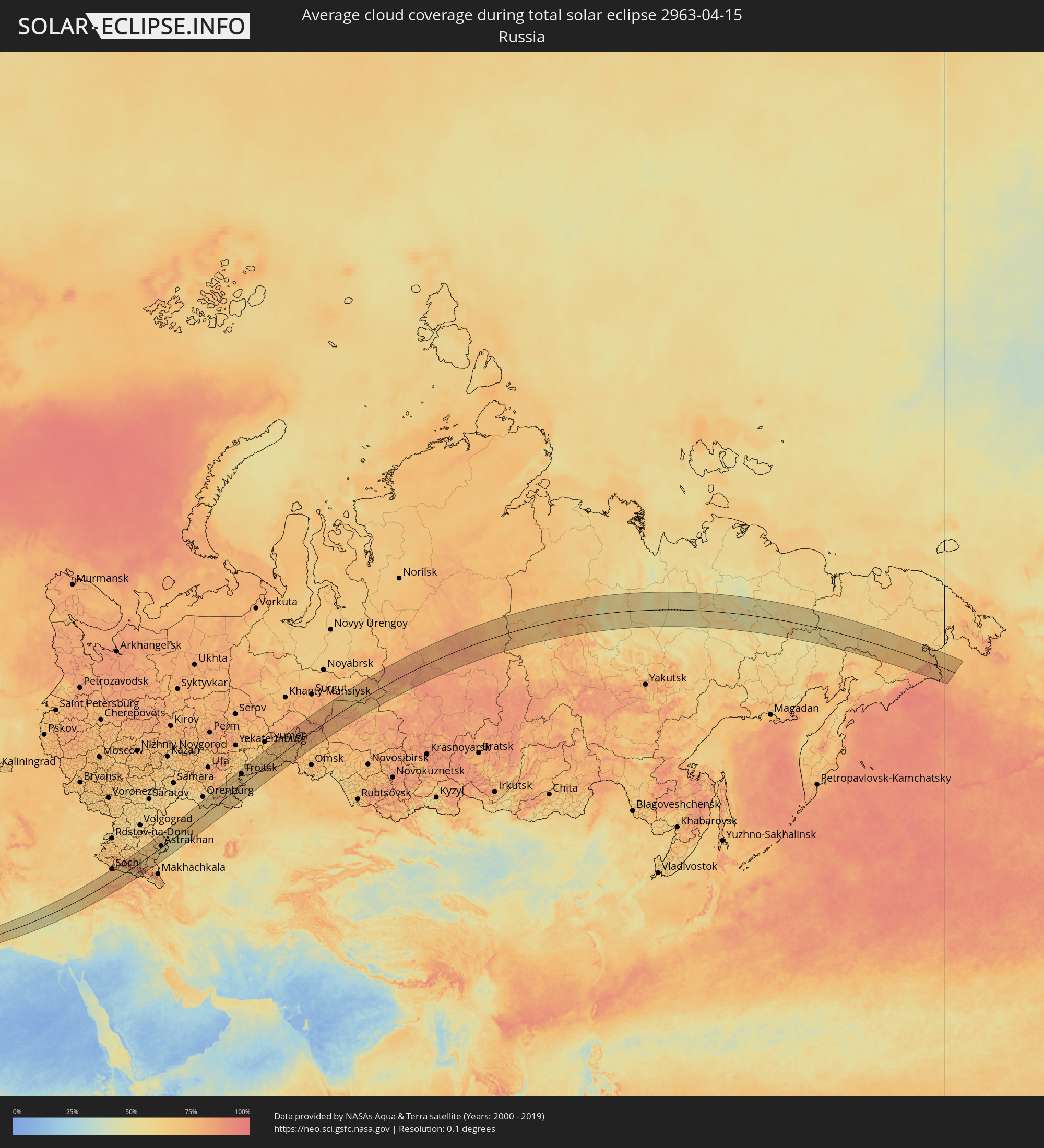 Russia
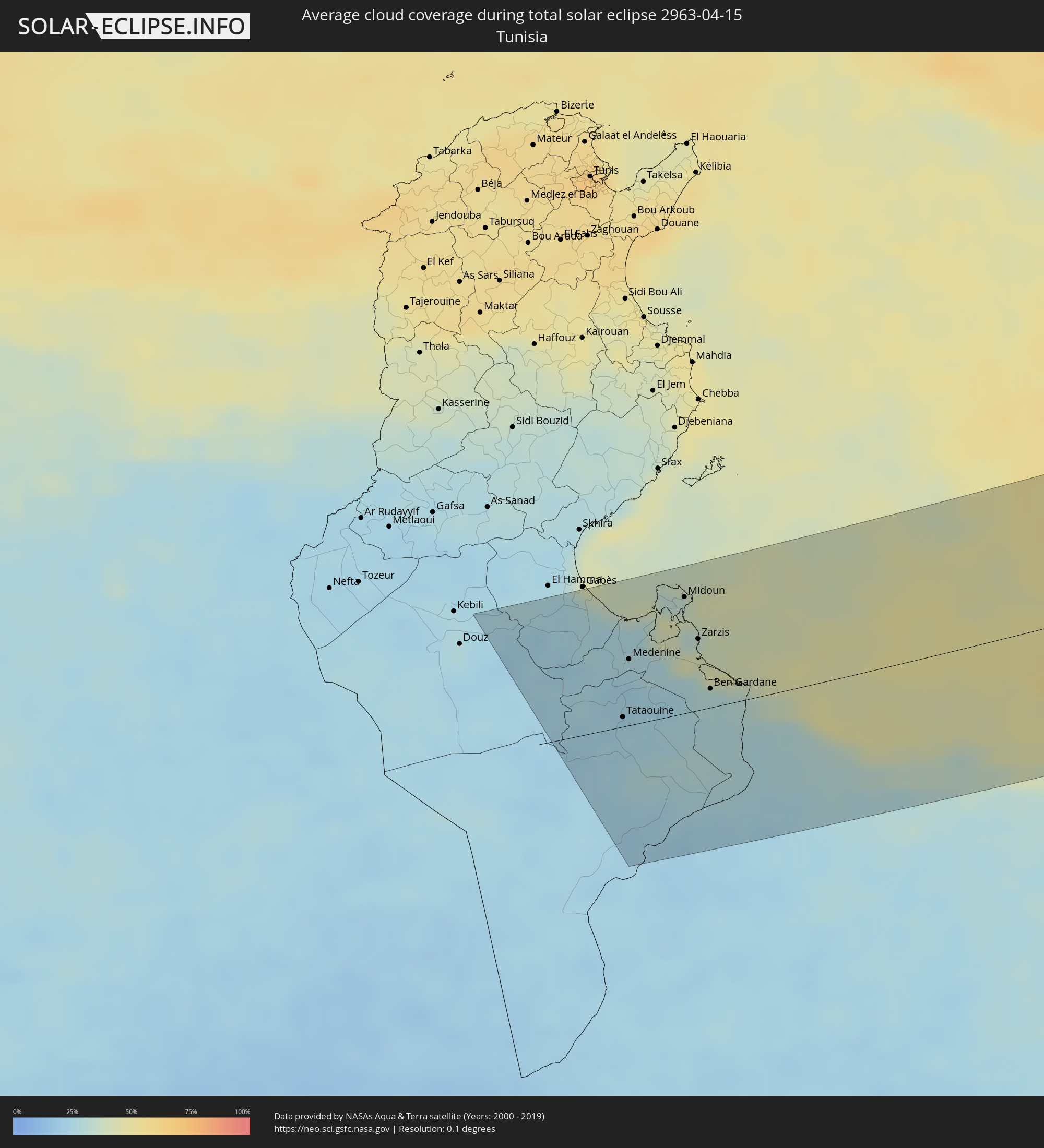 Tunisia
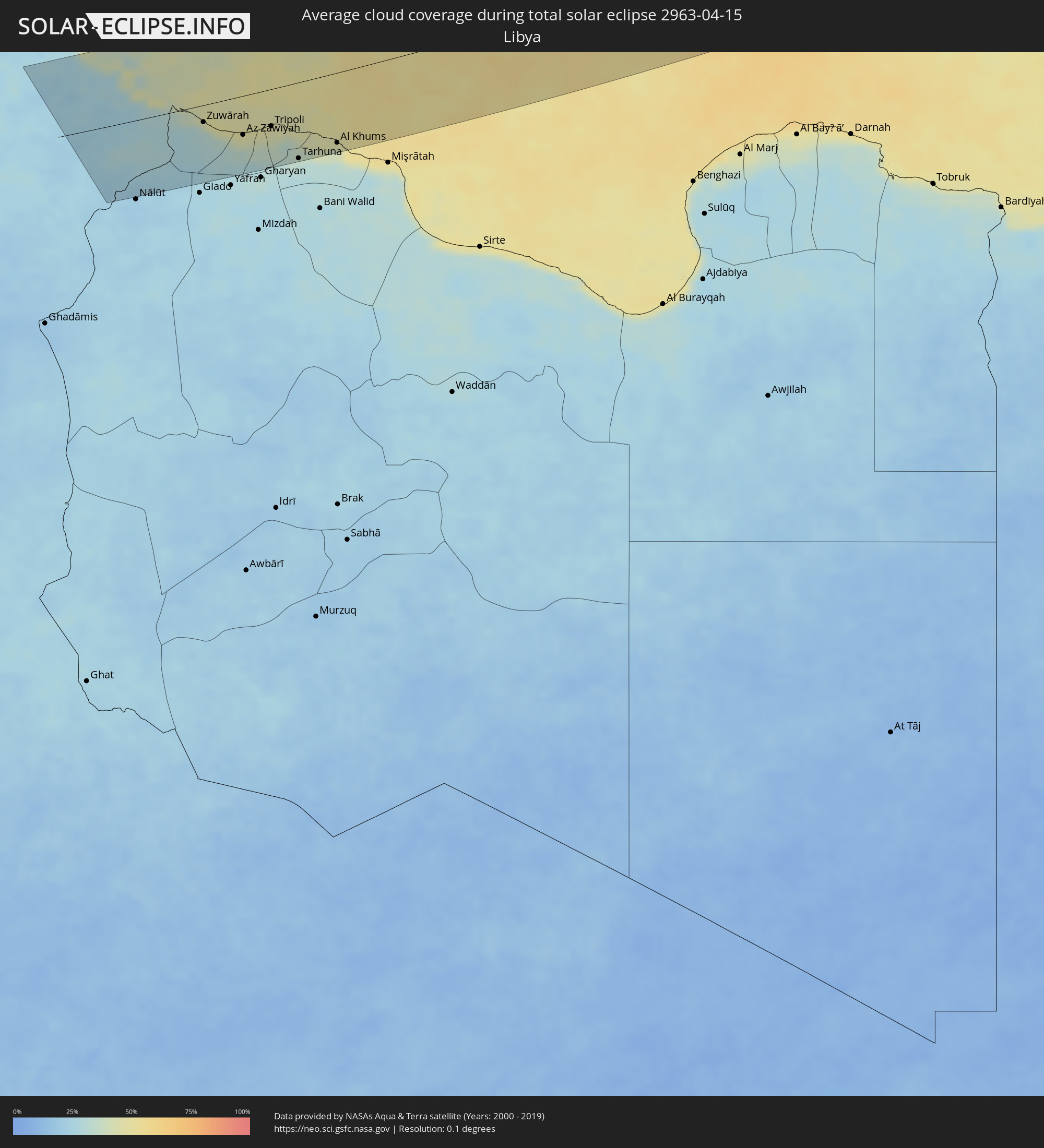 Libya
Libya
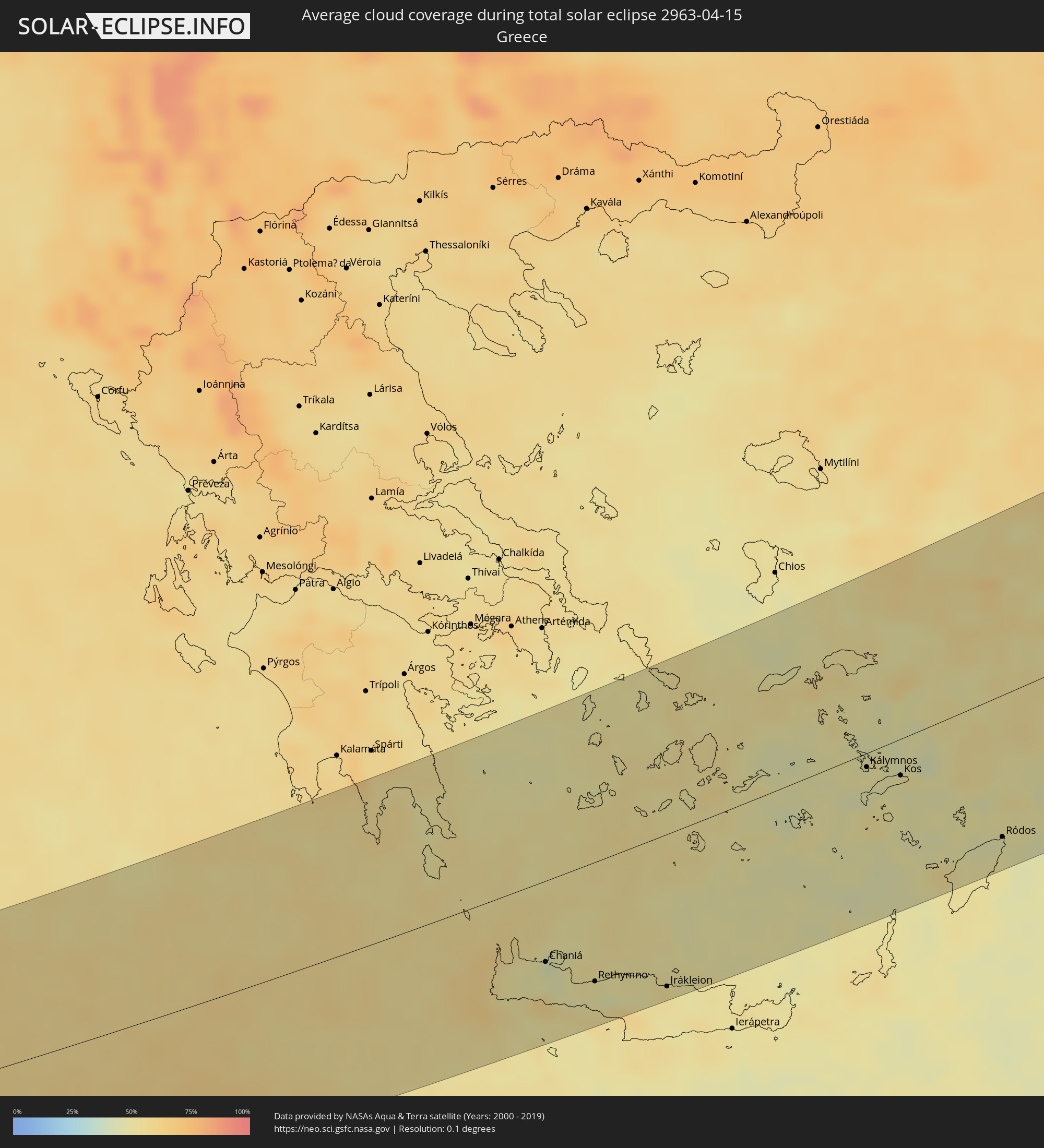 Greece
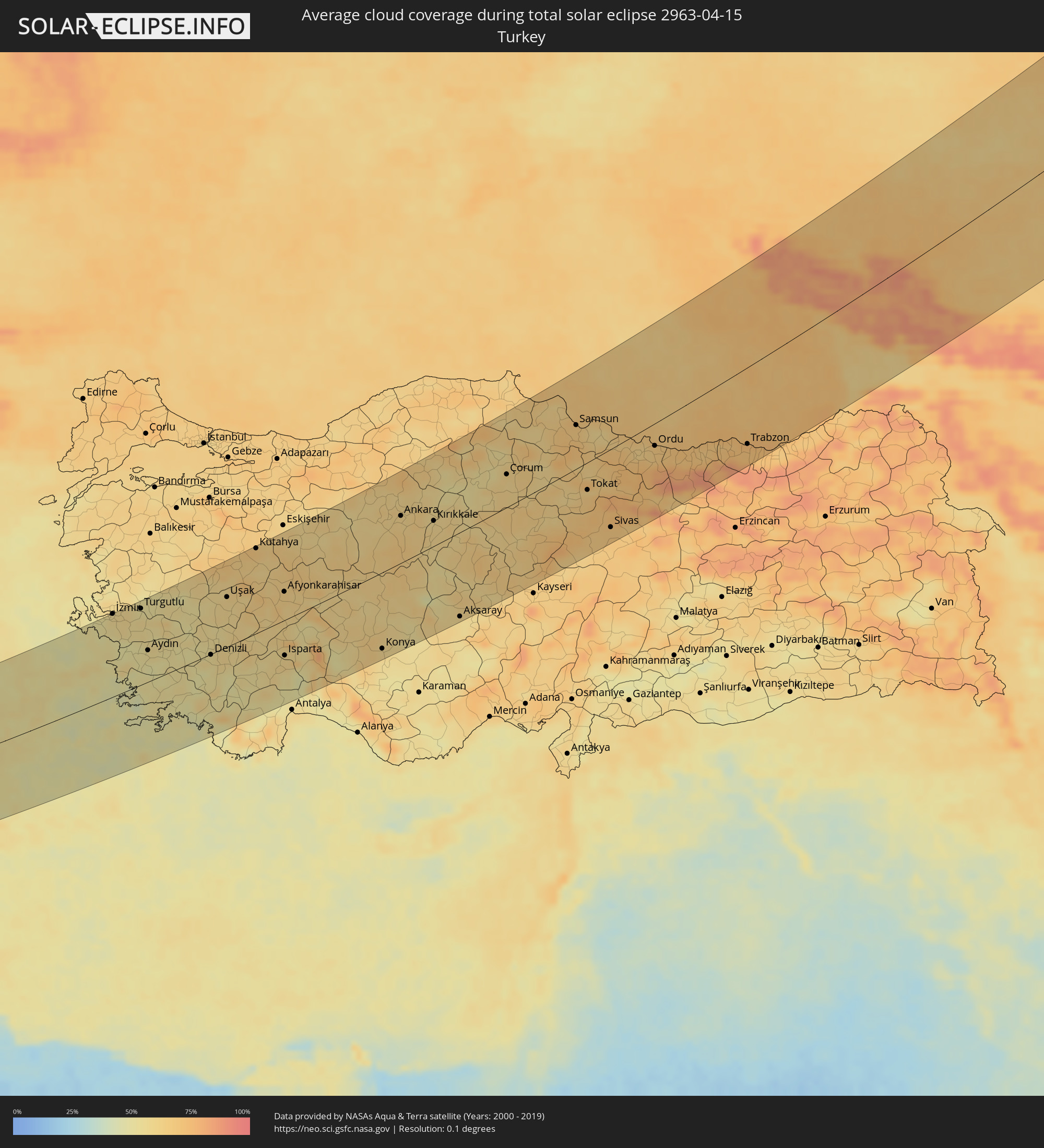 Turkey
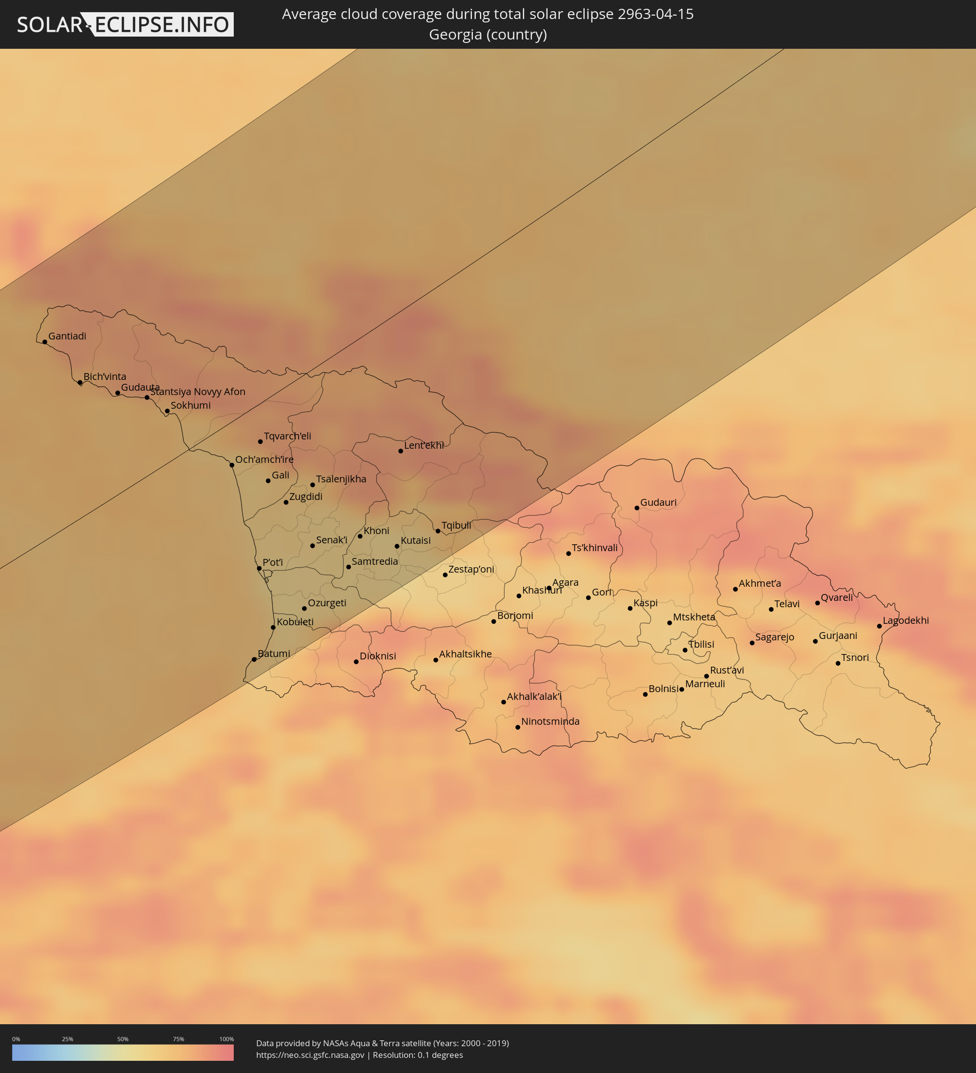 Georgia
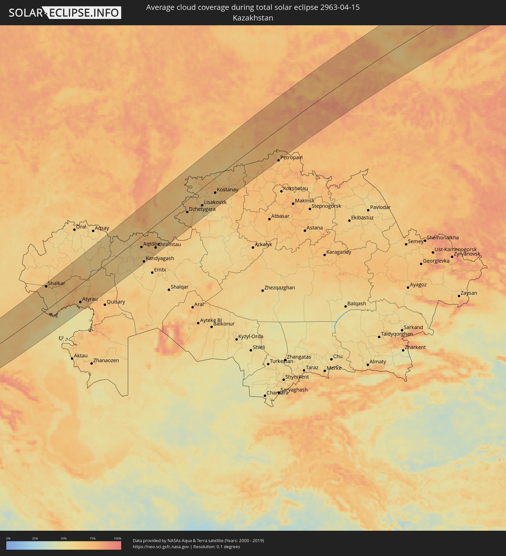 Kazakhstan
Cities inside the path of the eclipse
The following table shows all locations with a population of more than 5,000 inside the eclipse path. Cities which have more than 100,000 inhabitants are marked bold. A click at the locations opens a detailed map.
| City | Type | Eclipse duration | Local time of max. eclipse | Distance to central line | Ø Cloud coverage |
|
Tataouine, Tataouine
|
total | - | 05:56:05 UTC+01:00 | 8 km | 25% |
|
Medenine, Madanīn
|
total | - | 05:56:38 UTC+01:00 | 54 km | 26% |
|
Houmt Souk, Madanīn
|
total | - | 05:57:16 UTC+01:00 | 103 km | 33% |
|
Midoun, Madanīn
|
total | - | 05:57:09 UTC+01:00 | 95 km | 37% |
|
Zarzis, Madanīn
|
total | - | 05:56:43 UTC+01:00 | 62 km | 41% |
|
Ben Gardane, Madanīn
|
total | - | 05:56:12 UTC+01:00 | 28 km | 29% |
|
Zalţan, An Nuqāţ al Khams
|
total | - | 06:55:50 UTC+02:00 | 25 km | 28% |
|
Zuwārah, An Nuqāţ al Khams
|
total | - | 06:55:46 UTC+02:00 | 25 km | 31% |
|
Şabrātah, Az Zāwiyah
|
total | - | 06:55:31 UTC+02:00 | 50 km | 40% |
|
Şurmān, Az Zāwiyah
|
total | - | 06:55:27 UTC+02:00 | 55 km | 44% |
|
Az Zāwīyah, Az Zāwiyah
|
total | - | 06:55:26 UTC+02:00 | 58 km | 45% |
|
Zawiya, Az Zāwiyah
|
total | - | 06:55:26 UTC+02:00 | 59 km | 45% |
|
Al ‘Azīzīyah, Sha‘bīyat al Jafārah
|
total | - | 06:55:05 UTC+02:00 | 90 km | 30% |
|
Tripoli, Tripoli
|
total | - | 06:55:31 UTC+02:00 | 55 km | 43% |
|
Tagiura, Tripoli
|
total | - | 06:55:30 UTC+02:00 | 61 km | 43% |
|
Tarhuna, Al Marqab
|
total | - | 06:54:52 UTC+02:00 | 113 km | 30% |
|
Masallātah, Al Marqab
|
total | - | 06:55:03 UTC+02:00 | 103 km | 41% |
|
Al Khums, Al Marqab
|
total | - | 06:55:04 UTC+02:00 | 103 km | 42% |
|
Mourniés, Crete
|
total | - | 06:59:05 UTC+02:00 | 70 km | 48% |
|
Chaniá, Crete
|
total | - | 06:59:08 UTC+02:00 | 66 km | 48% |
|
Soúda, Crete
|
total | - | 06:59:06 UTC+02:00 | 69 km | 46% |
|
Rethymno, Crete
|
total | - | 06:58:58 UTC+02:00 | 93 km | 48% |
|
Ermoúpolis, South Aegean
|
total | - | 07:02:15 UTC+02:00 | 109 km | 51% |
|
Gázi, Crete
|
total | - | 06:59:00 UTC+02:00 | 116 km | 52% |
|
Irákleion, Crete
|
total | - | 06:59:00 UTC+02:00 | 119 km | 52% |
|
Páros, South Aegean
|
total | - | 07:01:43 UTC+02:00 | 65 km | 53% |
|
Néa Alikarnassós, Crete
|
total | - | 06:59:02 UTC+02:00 | 118 km | 51% |
|
Náxos, South Aegean
|
total | - | 07:01:48 UTC+02:00 | 60 km | 53% |
|
Néon Karlovásion, North Aegean
|
total | - | 07:03:09 UTC+02:00 | 85 km | 54% |
|
Kálymnos, South Aegean
|
total | - | 07:01:53 UTC+02:00 | 12 km | 49% |
|
İzmir, İzmir
|
total | - | 08:04:14 UTC+03:00 | 135 km | 57% |
|
Kos, South Aegean
|
total | - | 07:01:51 UTC+02:00 | 32 km | 47% |
|
Turgutlu, Manisa
|
total | - | 08:04:30 UTC+03:00 | 124 km | 54% |
|
Aydın, Aydın
|
total | - | 08:03:30 UTC+03:00 | 51 km | 50% |
|
Archángelos, South Aegean
|
total | - | 07:00:58 UTC+02:00 | 126 km | 50% |
|
Salihli, Manisa
|
total | - | 08:04:36 UTC+03:00 | 105 km | 55% |
|
Afántou, South Aegean
|
total | - | 07:01:06 UTC+02:00 | 120 km | 51% |
|
Triánta, South Aegean
|
total | - | 07:01:17 UTC+02:00 | 109 km | 49% |
|
Faliraki, South Aegean
|
total | - | 07:01:11 UTC+02:00 | 117 km | 51% |
|
Ródos, South Aegean
|
total | - | 07:01:21 UTC+02:00 | 109 km | 49% |
|
Nazilli, Aydın
|
total | - | 08:03:44 UTC+03:00 | 41 km | 53% |
|
Denizli, Denizli
|
total | - | 08:03:43 UTC+03:00 | 8 km | 55% |
|
Uşak, Uşak
|
total | - | 08:05:16 UTC+03:00 | 81 km | 60% |
|
Kütahya, Kütahya
|
total | - | 08:06:40 UTC+03:00 | 133 km | 66% |
|
Afyonkarahisar, Afyonkarahisar
|
total | - | 08:05:45 UTC+03:00 | 44 km | 63% |
|
Isparta, Isparta
|
total | - | 08:04:08 UTC+03:00 | 60 km | 60% |
|
Polatlı, Ankara
|
total | - | 08:07:40 UTC+03:00 | 65 km | 60% |
|
Konya, Konya
|
total | - | 08:04:59 UTC+03:00 | 119 km | 59% |
|
Ankara, Ankara
|
total | - | 08:08:31 UTC+03:00 | 75 km | 61% |
|
Kırıkkale, Kırıkkale
|
total | - | 08:08:40 UTC+03:00 | 43 km | 61% |
|
Aksaray, Aksaray
|
total | - | 08:06:25 UTC+03:00 | 129 km | 58% |
|
Kırşehir, Kırşehir
|
total | - | 08:07:46 UTC+03:00 | 59 km | 61% |
|
Yozgat, Yozgat
|
total | - | 08:09:11 UTC+03:00 | 26 km | 61% |
|
Çorum, Çorum
|
total | - | 08:10:29 UTC+03:00 | 54 km | 59% |
|
Amasya, Amasya
|
total | - | 08:11:05 UTC+03:00 | 23 km | 60% |
|
Bafra, Samsun
|
total | - | 08:12:41 UTC+03:00 | 108 km | 63% |
|
Turhal, Tokat
|
total | - | 08:10:45 UTC+03:00 | 13 km | 61% |
|
Samsun, Samsun
|
total | - | 08:12:25 UTC+03:00 | 66 km | 66% |
|
Tokat, Tokat
|
total | - | 08:10:52 UTC+03:00 | 44 km | 67% |
|
Sivas, Sivas
|
total | - | 08:10:08 UTC+03:00 | 115 km | 68% |
|
Ünye, Ordu
|
total | - | 08:12:38 UTC+03:00 | 18 km | 64% |
|
Fatsa, Ordu
|
total | - | 08:12:35 UTC+03:00 | 12 km | 62% |
|
Ordu, Ordu
|
total | - | 08:12:42 UTC+03:00 | 37 km | 67% |
|
Giresun, Giresun
|
total | - | 08:12:52 UTC+03:00 | 59 km | 69% |
|
Sochi, Krasnodarskiy
|
total | - | 08:18:18 UTC+03:00 | 138 km | 72% |
|
Trabzon, Trabzon
|
total | - | 08:13:48 UTC+03:00 | 108 km | 70% |
|
Adler, Krasnodarskiy
|
total | - | 08:18:08 UTC+03:00 | 114 km | 75% |
|
Gantiadi
|
total | - | 09:18:08 UTC+04:00 | 104 km | 76% |
|
Gagra, Abkhazia
|
total | - | 09:18:05 UTC+04:00 | 85 km | 76% |
|
Bich’vinta, Abkhazia
|
total | - | 09:17:55 UTC+04:00 | 72 km | 73% |
|
Gudauta, Abkhazia
|
total | - | 09:18:00 UTC+04:00 | 52 km | 71% |
|
Stantsiya Novyy Afon, Abkhazia
|
total | - | 09:18:05 UTC+04:00 | 41 km | 73% |
|
Sokhumi, Abkhazia
|
total | - | 09:18:03 UTC+04:00 | 31 km | 73% |
|
Och’amch’ire, Abkhazia
|
total | - | 09:17:51 UTC+04:00 | 29 km | 65% |
|
Batumi, Ajaria
|
total | - | 09:16:06 UTC+04:00 | 132 km | 66% |
|
P’ot’i, Samegrelo and Zemo Svaneti
|
total | - | 09:17:00 UTC+04:00 | 86 km | 64% |
|
Tqvarch'eli, Abkhazia
|
total | - | 09:18:13 UTC+04:00 | 20 km | 69% |
|
Chakvi, Ajaria
|
total | - | 09:16:18 UTC+04:00 | 127 km | 64% |
|
Gali, Abkhazia
|
total | - | 09:17:53 UTC+04:00 | 43 km | 65% |
|
Kobuleti, Ajaria
|
total | - | 09:16:30 UTC+04:00 | 120 km | 63% |
|
Zugdidi, Samegrelo and Zemo Svaneti
|
total | - | 09:17:46 UTC+04:00 | 60 km | 63% |
|
Khobi, Samegrelo and Zemo Svaneti
|
total | - | 09:17:27 UTC+04:00 | 80 km | 59% |
|
Nevinnomyssk, Stavropol'skiy
|
total | - | 08:21:32 UTC+03:00 | 135 km | 71% |
|
Ozurgeti, Guria
|
total | - | 09:16:50 UTC+04:00 | 122 km | 66% |
|
Cherkessk, Karachayevo-Cherkesiya
|
total | - | 08:20:53 UTC+03:00 | 94 km | 69% |
|
Senak’i, Samegrelo and Zemo Svaneti
|
total | - | 09:17:29 UTC+04:00 | 91 km | 61% |
|
Tsalenjikha, Samegrelo and Zemo Svaneti
|
total | - | 09:18:04 UTC+04:00 | 62 km | 63% |
|
Abasha, Samegrelo and Zemo Svaneti
|
total | - | 09:17:28 UTC+04:00 | 103 km | 61% |
|
Samtredia, Imereti
|
total | - | 09:17:27 UTC+04:00 | 114 km | 60% |
|
Mart’vili, Samegrelo and Zemo Svaneti
|
total | - | 09:17:56 UTC+04:00 | 93 km | 61% |
|
Khoni, Imereti
|
total | - | 09:17:48 UTC+04:00 | 104 km | 61% |
|
Tsqaltubo, Imereti
|
total | - | 09:17:58 UTC+04:00 | 108 km | 59% |
|
Kutaisi, Imereti
|
total | - | 09:17:54 UTC+04:00 | 119 km | 59% |
|
Kislovodsk, Stavropol'skiy
|
total | - | 08:20:48 UTC+03:00 | 34 km | 75% |
|
Lent’ekhi, Racha-Lechkhumi and Kvemo Svaneti
|
total | - | 09:18:50 UTC+04:00 | 75 km | 83% |
|
Yessentuki, Stavropol'skiy
|
total | - | 08:21:07 UTC+03:00 | 41 km | 73% |
|
Tqibuli
|
total | - | 09:18:15 UTC+04:00 | 125 km | 70% |
|
Pyatigorsk, Stavropol'skiy
|
total | - | 08:21:16 UTC+03:00 | 38 km | 73% |
|
Mineralnye Vody, Stavropol'skiy
|
total | - | 08:21:36 UTC+03:00 | 43 km | 71% |
|
Georgiyevsk, Stavropol'skiy
|
total | - | 08:21:44 UTC+03:00 | 25 km | 71% |
|
Nal’chik, Kabardino-Balkariya
|
total | - | 08:20:42 UTC+03:00 | 49 km | 71% |
|
Zelenokumsk, Stavropol'skiy
|
total | - | 08:22:29 UTC+03:00 | 28 km | 68% |
|
Prokhladnyy, Kabardino-Balkariya
|
total | - | 08:21:27 UTC+03:00 | 46 km | 69% |
|
Budënnovsk, Stavropol'skiy
|
total | - | 08:23:21 UTC+03:00 | 48 km | 64% |
|
Staryy Malgobek, Ingushetiya
|
total | - | 08:21:29 UTC+03:00 | 85 km | 68% |
|
Mozdok, North Ossetia
|
total | - | 08:21:53 UTC+03:00 | 71 km | 65% |
|
Vladikavkaz, North Ossetia
|
total | - | 08:20:39 UTC+03:00 | 137 km | 75% |
|
Nazran’, Ingushetiya
|
total | - | 08:21:04 UTC+03:00 | 123 km | 66% |
|
Ordzhonikidzevskaya, Ingushetiya
|
total | - | 08:21:26 UTC+03:00 | 127 km | 66% |
|
Astrakhan, Astrakhan
|
total | - | 09:29:07 UTC+04:00 | 14 km | 64% |
|
Shalkar, Atyraū
|
total | - | 10:32:45 UTC+05:00 | 124 km | 69% |
|
Maloye Ganyushkino, Atyraū
|
total | - | 10:30:35 UTC+05:00 | 23 km | 64% |
|
Makhambet, Atyraū
|
total | - | 10:34:29 UTC+05:00 | 34 km | 74% |
|
Īnderbor, Atyraū
|
total | - | 10:36:10 UTC+05:00 | 38 km | 72% |
|
Balyqshy, Atyraū
|
total | - | 10:33:43 UTC+05:00 | 97 km | 69% |
|
Atyrau, Atyraū
|
total | - | 10:33:49 UTC+05:00 | 94 km | 69% |
|
Dossor, Atyraū
|
total | - | 10:35:33 UTC+05:00 | 106 km | 71% |
|
Maqat, Atyraū
|
total | - | 10:36:04 UTC+05:00 | 111 km | 71% |
|
Miyaly, Atyraū
|
total | - | 10:38:36 UTC+05:00 | 23 km | 66% |
|
Bayganin, Aqtöbe
|
total | - | 10:40:20 UTC+05:00 | 135 km | 58% |
|
Shubarkuduk, Aqtöbe
|
total | - | 10:41:42 UTC+05:00 | 120 km | 60% |
|
Martuk, Aqtöbe
|
total | - | 10:44:19 UTC+05:00 | 25 km | 61% |
|
Aqtöbe, Aqtöbe
|
total | - | 10:44:16 UTC+05:00 | 57 km | 64% |
|
Kandyagash, Aqtöbe
|
total | - | 10:43:11 UTC+05:00 | 135 km | 62% |
|
Batamshinskiy, Aqtöbe
|
total | - | 10:45:49 UTC+05:00 | 75 km | 73% |
|
Novotroitsk, Orenburg
|
total | - | 10:46:53 UTC+05:00 | 24 km | 63% |
|
Khromtau, Aqtöbe
|
total | - | 10:45:30 UTC+05:00 | 109 km | 68% |
|
Gay, Orenburg
|
total | - | 10:47:26 UTC+05:00 | 7 km | 66% |
|
Orsk, Orenburg
|
total | - | 10:47:08 UTC+05:00 | 36 km | 60% |
|
Sibay, Bashkortostan
|
total | - | 10:49:34 UTC+05:00 | 96 km | 71% |
|
Magnitogorsk, Chelyabinsk
|
total | - | 10:51:01 UTC+05:00 | 140 km | 70% |
|
Dzhetygara, Qostanay
|
total | - | 10:51:25 UTC+05:00 | 57 km | 66% |
|
Yuzhnoural’sk, Chelyabinsk
|
total | - | 10:54:46 UTC+05:00 | 136 km | 65% |
|
Troitsk, Chelyabinsk
|
total | - | 10:54:36 UTC+05:00 | 93 km | 63% |
|
Komsomolets, Qostanay
|
total | - | 10:54:36 UTC+05:00 | 43 km | 66% |
|
Lisakovsk, Qostanay
|
total | - | 10:53:21 UTC+05:00 | 83 km | 63% |
|
Tobol, Qostanay
|
total | - | 10:53:39 UTC+05:00 | 70 km | 65% |
|
Fedorovka, Qostanay
|
total | - | 10:55:07 UTC+05:00 | 21 km | 71% |
|
Kachar, Qostanay
|
total | - | 10:54:55 UTC+05:00 | 23 km | 63% |
|
Rudnyy, Qostanay
|
total | - | 10:54:38 UTC+05:00 | 68 km | 64% |
|
Kostanay, Qostanay
|
total | - | 10:55:32 UTC+05:00 | 68 km | 63% |
|
Borovskoy, Qostanay
|
total | - | 10:56:57 UTC+05:00 | 42 km | 67% |
|
Kurgan, Kurgan
|
total | - | 11:00:24 UTC+05:00 | 61 km | 68% |
|
Ishim, Tyumenskaya
|
total | - | 11:05:45 UTC+05:00 | 40 km | 77% |
|
Strezhevoy, Tomsk
|
total | - | 13:18:50 UTC+07:00 | 110 km | 69% |