Annular solar eclipse of 06/26/2978
| Day of week: | Friday |
| Maximum duration of eclipse: | 05m12s |
| Maximum width of eclipse path: | 205 km |
| Saros cycle: | 162 |
| Coverage: | 94.9% |
| Magnitude: | 0.9493 |
| Gamma: | 0.4165 |
Wo kann man die Sonnenfinsternis vom 06/26/2978 sehen?
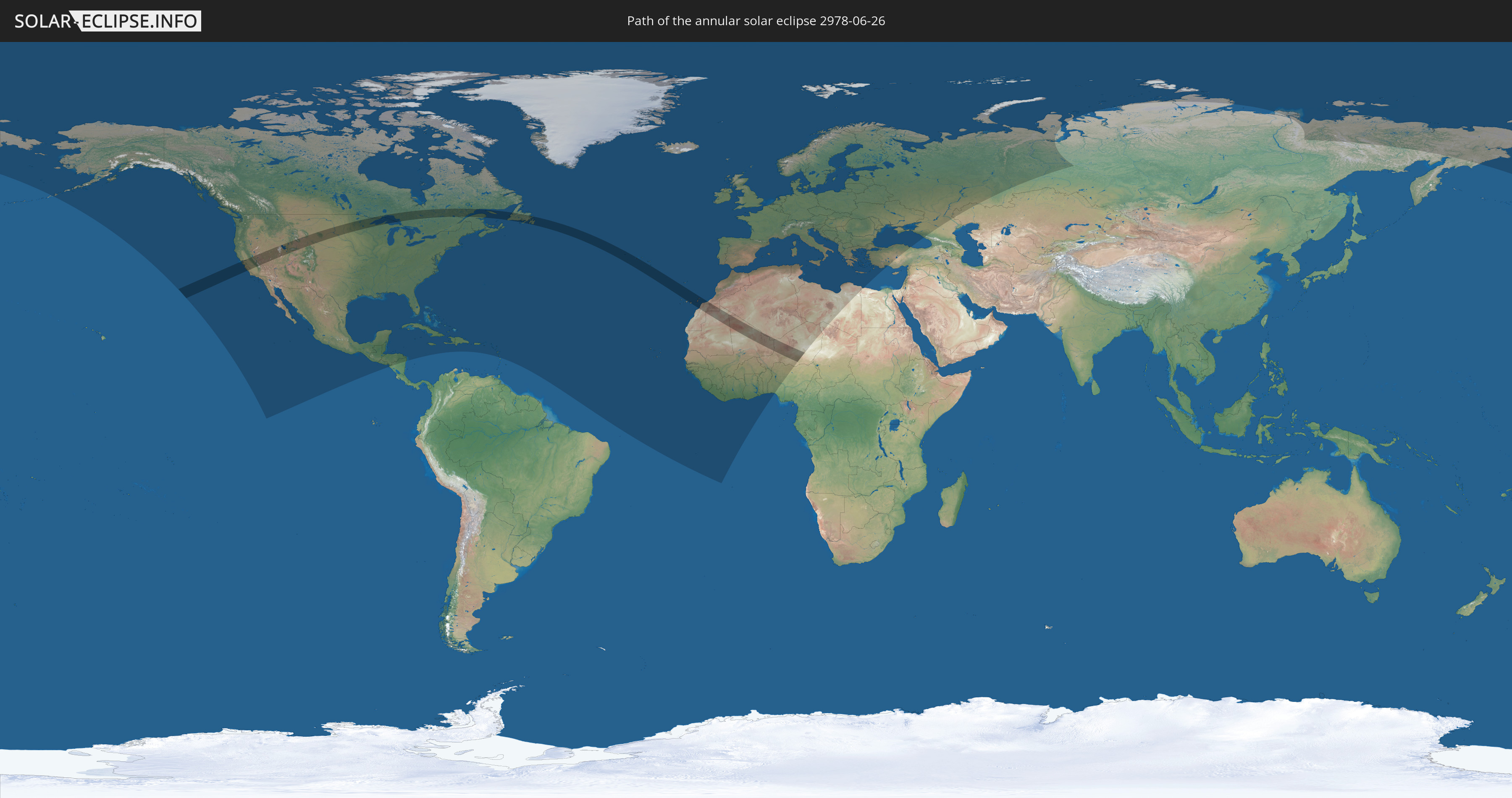
Die Sonnenfinsternis am 06/26/2978 kann man in 106 Ländern als partielle Sonnenfinsternis beobachten.
Der Finsternispfad verläuft durch 9 Länder. Nur in diesen Ländern ist sie als annular Sonnenfinsternis zu sehen.
In den folgenden Ländern ist die Sonnenfinsternis annular zu sehen
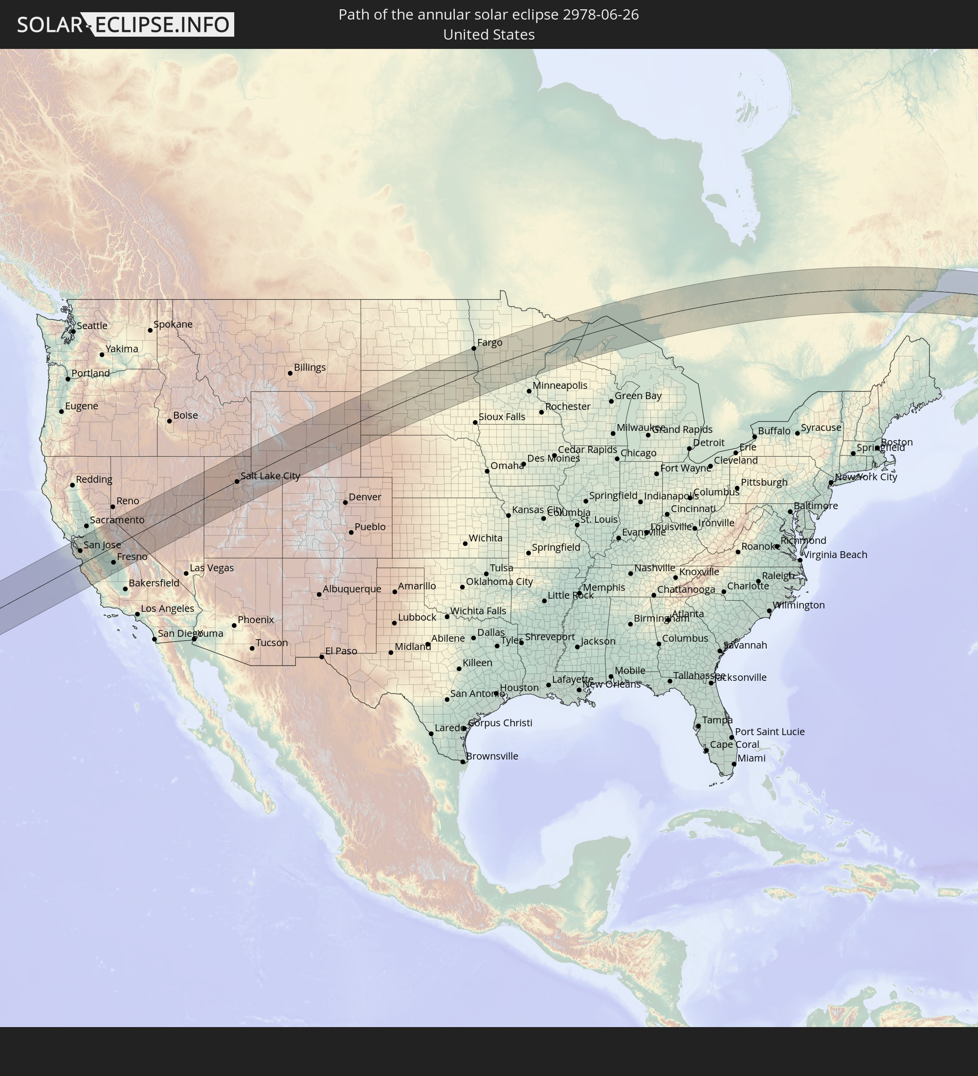 United States
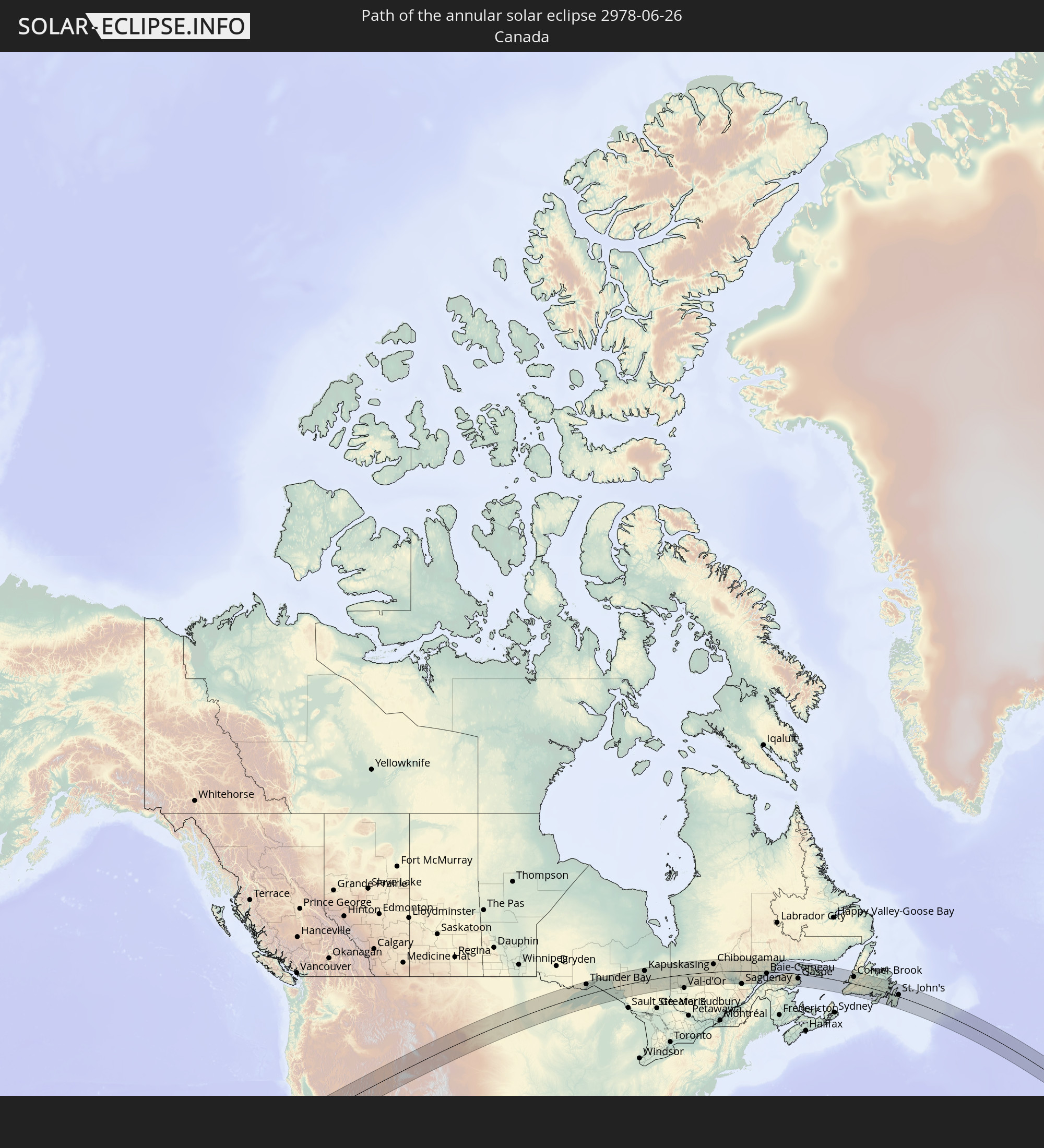 Canada
 Portugal
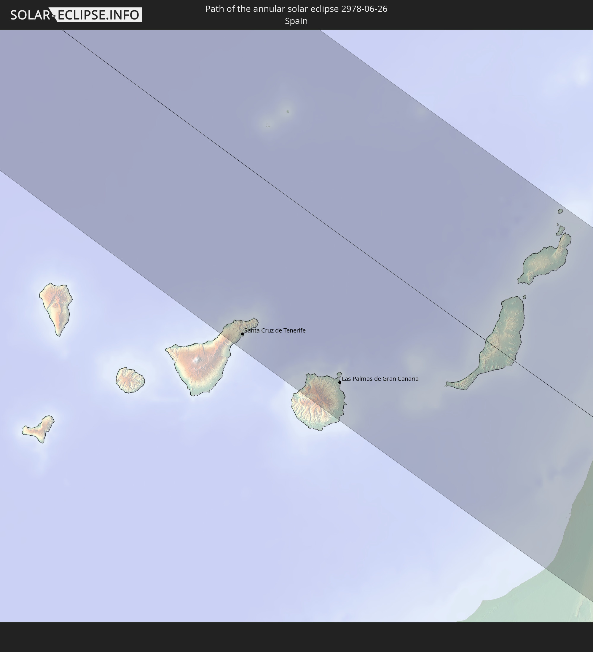 Spain
Spain
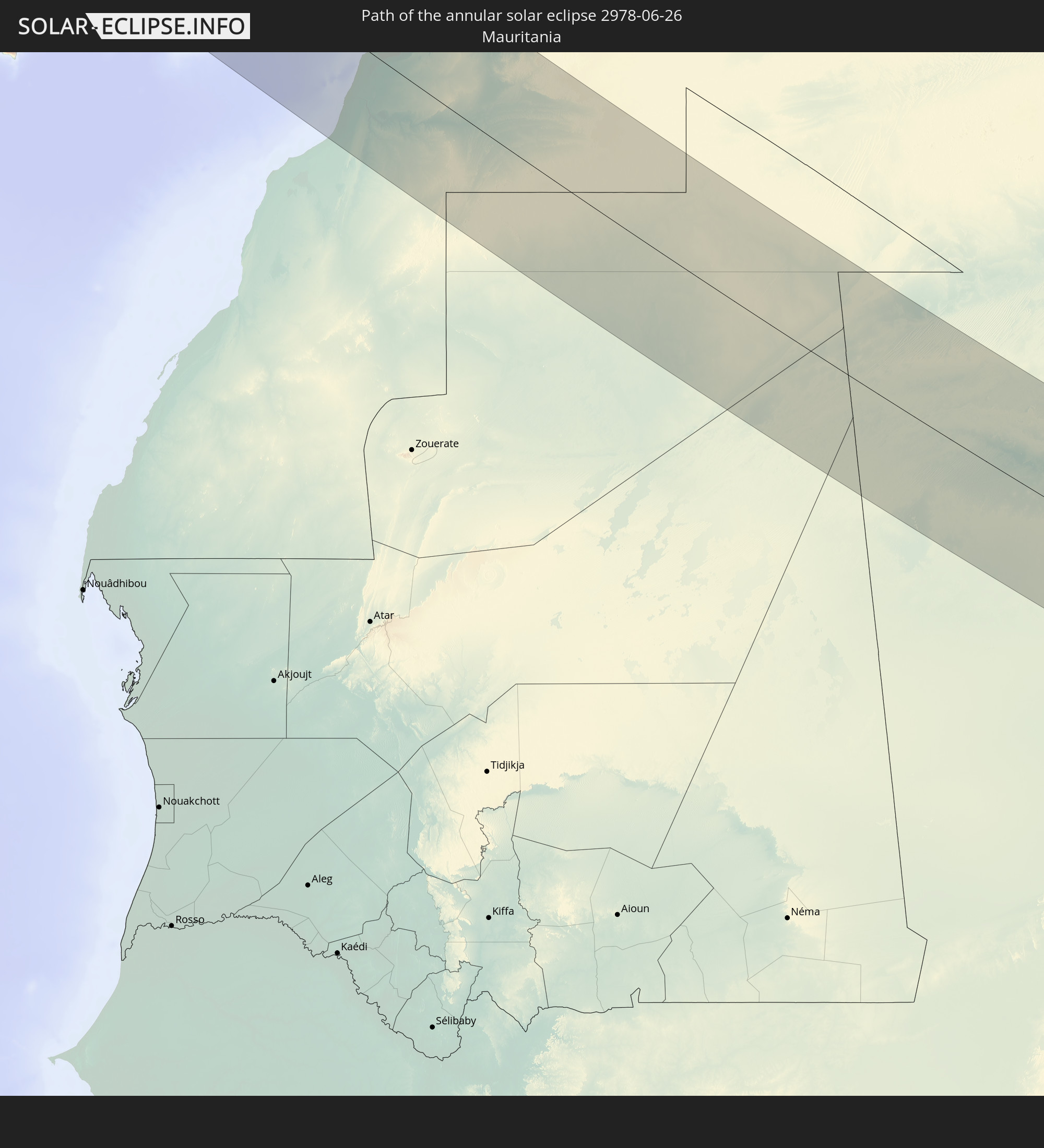 Mauritania
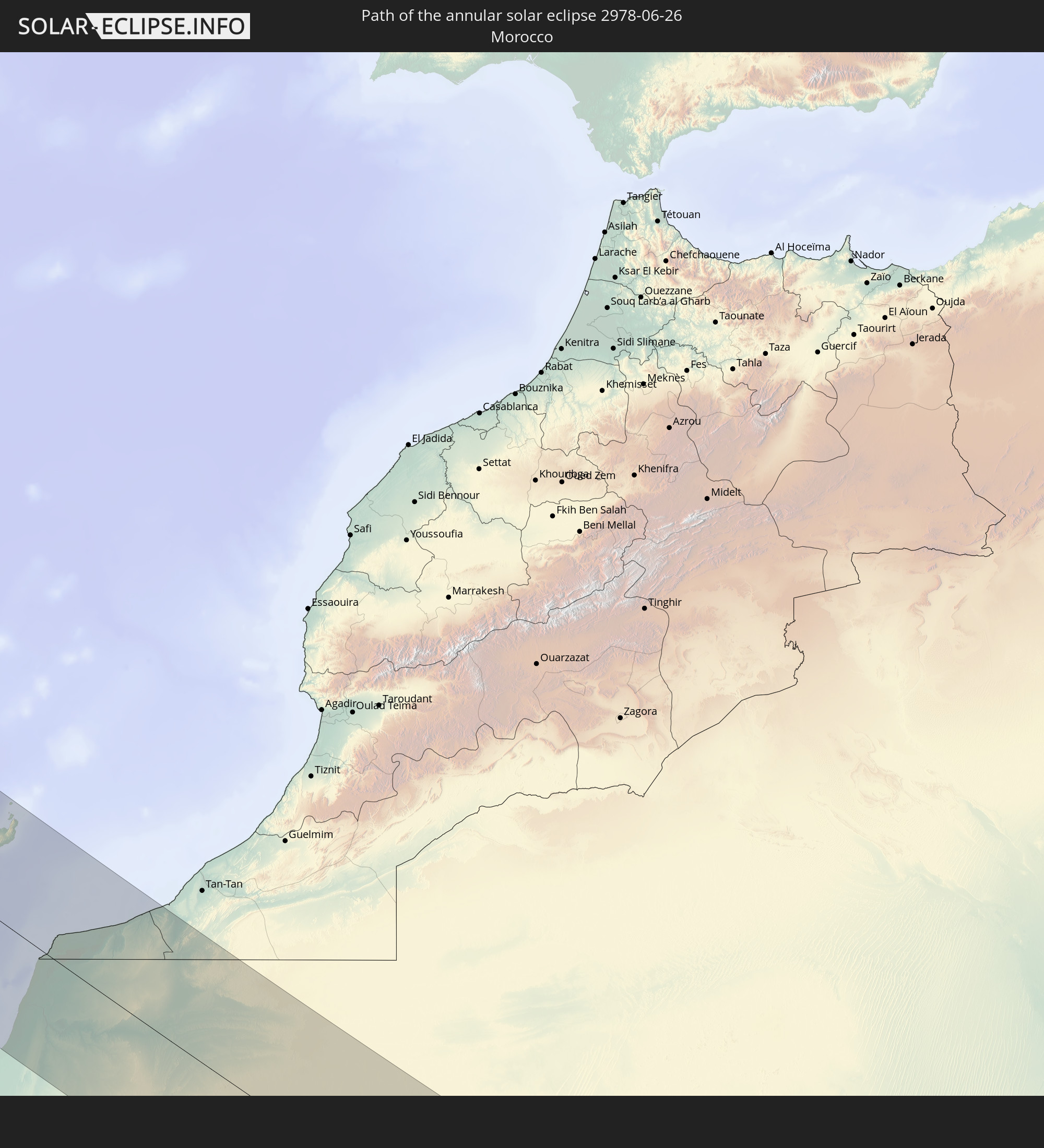 Morocco
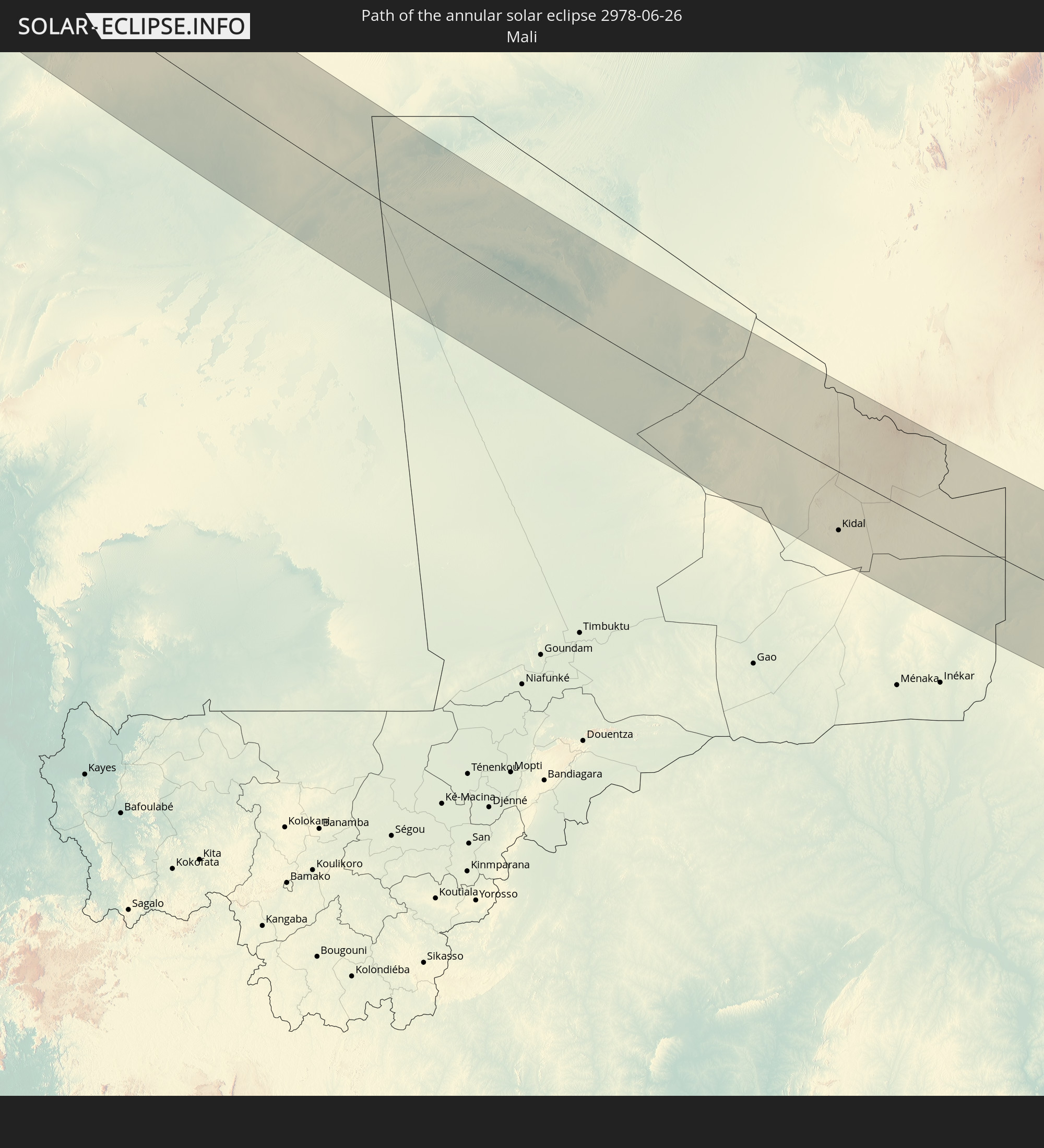 Mali
Mali
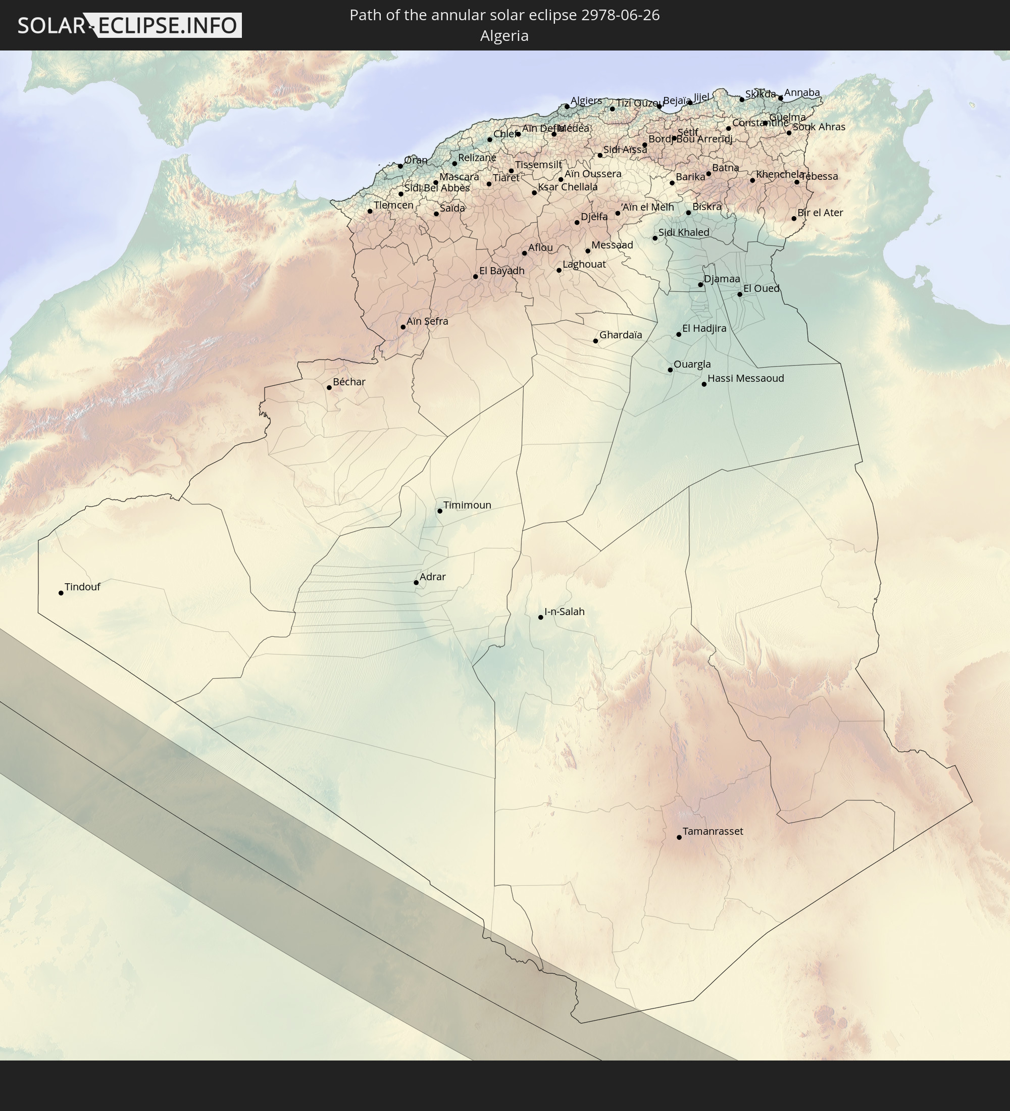 Algeria
 Niger
Niger
In den folgenden Ländern ist die Sonnenfinsternis partiell zu sehen
 Russia
 United States
 United States Minor Outlying Islands
 Canada
 Mexico
 Greenland
 Guatemala
 El Salvador
 Honduras
 Belize
 Nicaragua
 Cuba
Cuba
 Cayman Islands
 The Bahamas
 Jamaica
 Haiti
Haiti
 Turks and Caicos Islands
 Dominican Republic
 Puerto Rico
 United States Virgin Islands
 Bermuda
 British Virgin Islands
 Anguilla
 Collectivity of Saint Martin
 Saint Barthélemy
 Saint Kitts and Nevis
 Antigua and Barbuda
 Montserrat
 Guadeloupe
 Dominica
 Saint Pierre and Miquelon
 Portugal
 Cabo Verde
 Iceland
 Spain
Spain
 Senegal
 Mauritania
 The Gambia
 Guinea-Bissau
 Guinea
 Saint Helena, Ascension and Tristan da Cunha
 Sierra Leone
 Morocco
 Mali
Mali
 Liberia
 Republic of Ireland
 Svalbard and Jan Mayen
 Algeria
 United Kingdom
 Ivory Coast
 Faroe Islands
 Burkina Faso
 Gibraltar
 France
 Isle of Man
 Ghana
Ghana
 Guernsey
 Jersey
 Togo
Togo
 Niger
Niger
 Benin
Benin
 Andorra
 Belgium
 Nigeria
 Netherlands
 Norway
 Luxembourg
 Germany
 Switzerland
 Italy
Italy
 Monaco
 Tunisia
 Denmark
 Libya
Libya
 Liechtenstein
 Austria
 Sweden
 Czechia
 San Marino
 Vatican City
 Slovenia
 Chad
Chad
 Croatia
 Poland
 Malta
Malta
 Bosnia and Herzegovina
 Hungary
 Slovakia
 Montenegro
 Serbia
 Albania
 Åland Islands
 Greece
 Romania
 Republic of Macedonia
 Finland
 Lithuania
 Latvia
 Estonia
 Ukraine
 Bulgaria
 Belarus
 Egypt
Egypt
 Turkey
 Moldova
 Kazakhstan
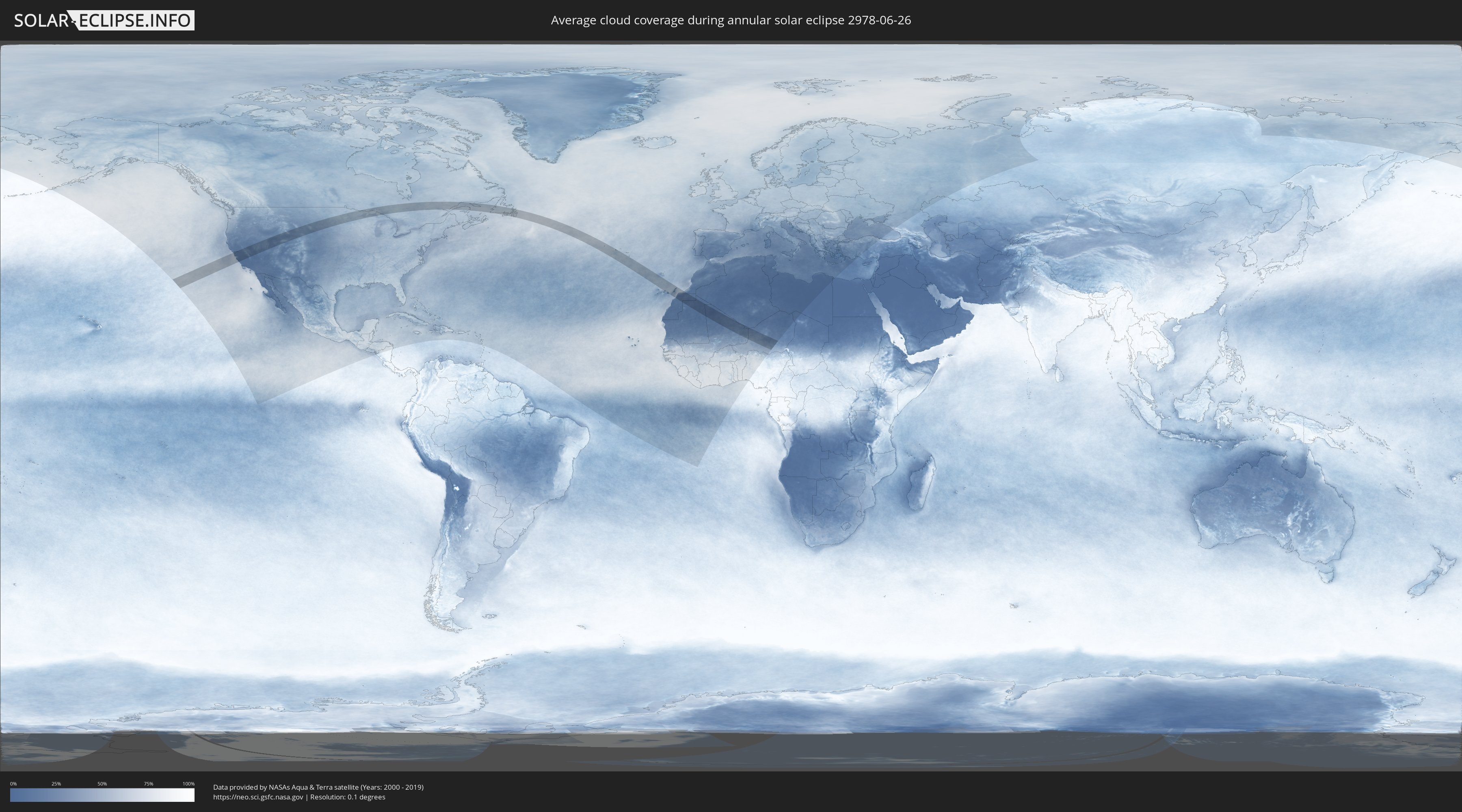
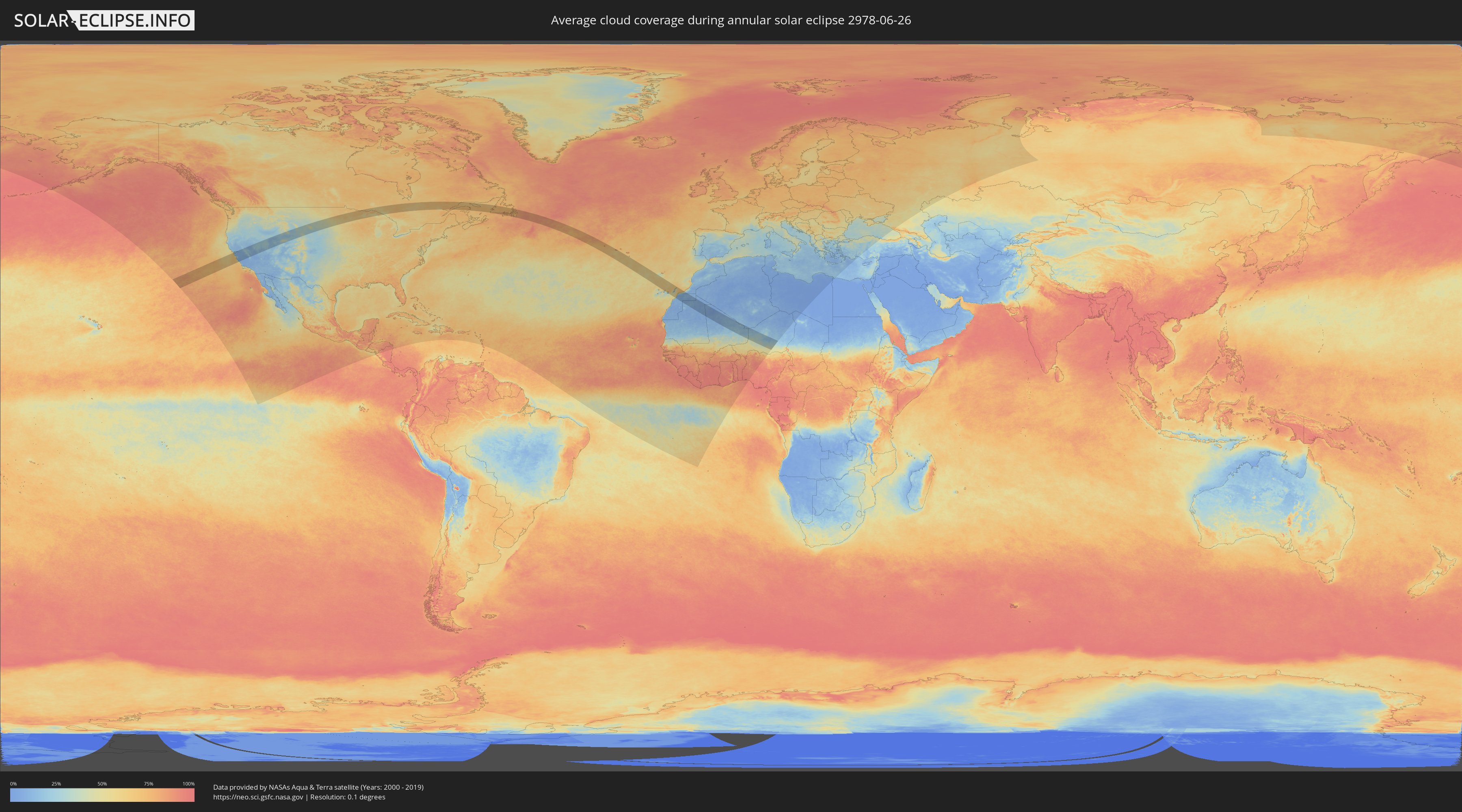
How will be the weather during the annular solar eclipse on 06/26/2978?
Where is the best place to see the annular solar eclipse of 06/26/2978?
The following maps show the average cloud coverage for the day of the annular solar eclipse.
With the help of these maps, it is possible to find the place along the eclipse path, which has the best
chance of a cloudless sky.
Nevertheless, you should consider local circumstances and inform about the weather of your chosen
observation site.
The data is provided by NASAs satellites
AQUA and TERRA.
The cloud maps are averaged over a period of 19 years (2000 - 2019).
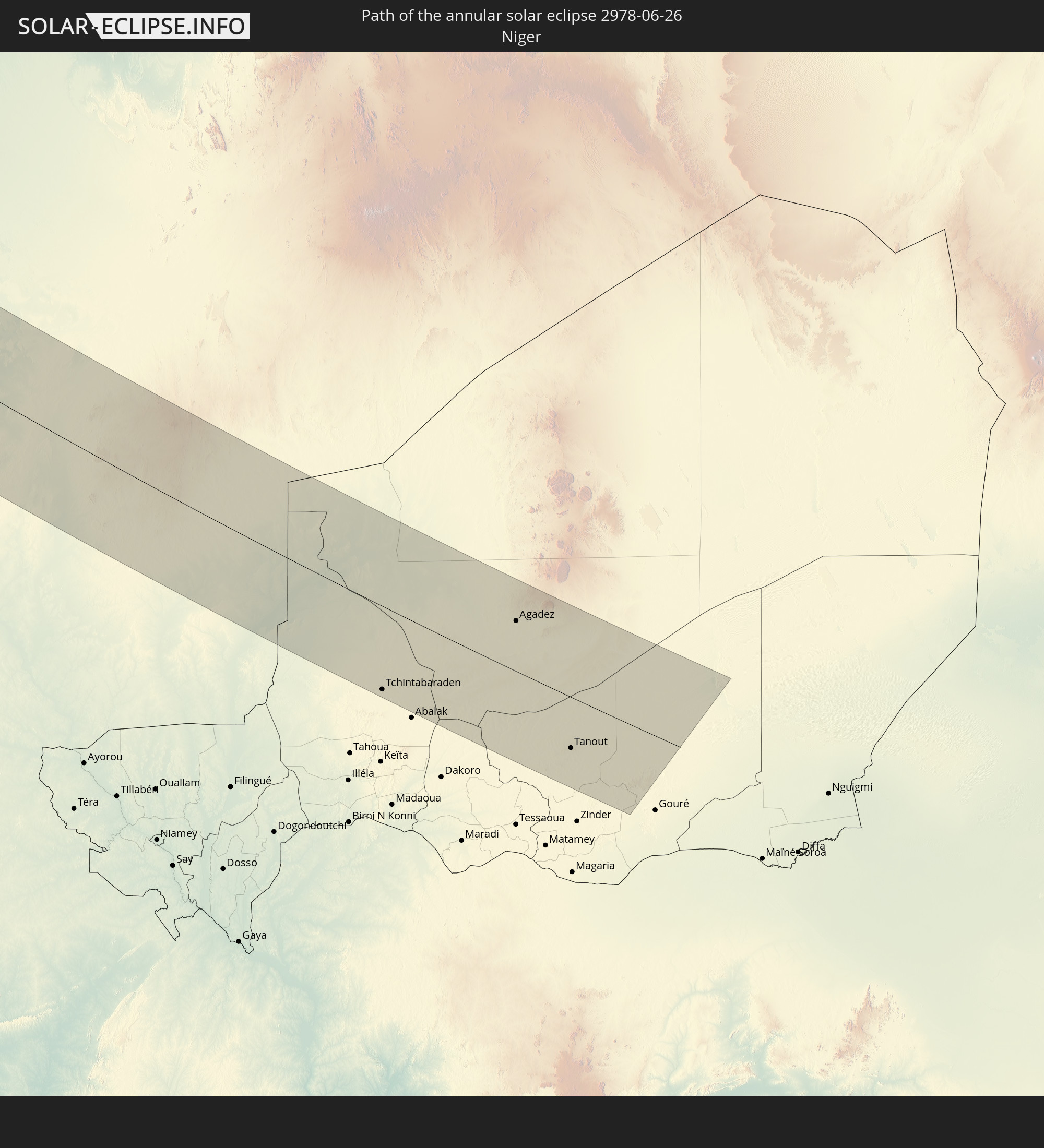
Detailed country maps
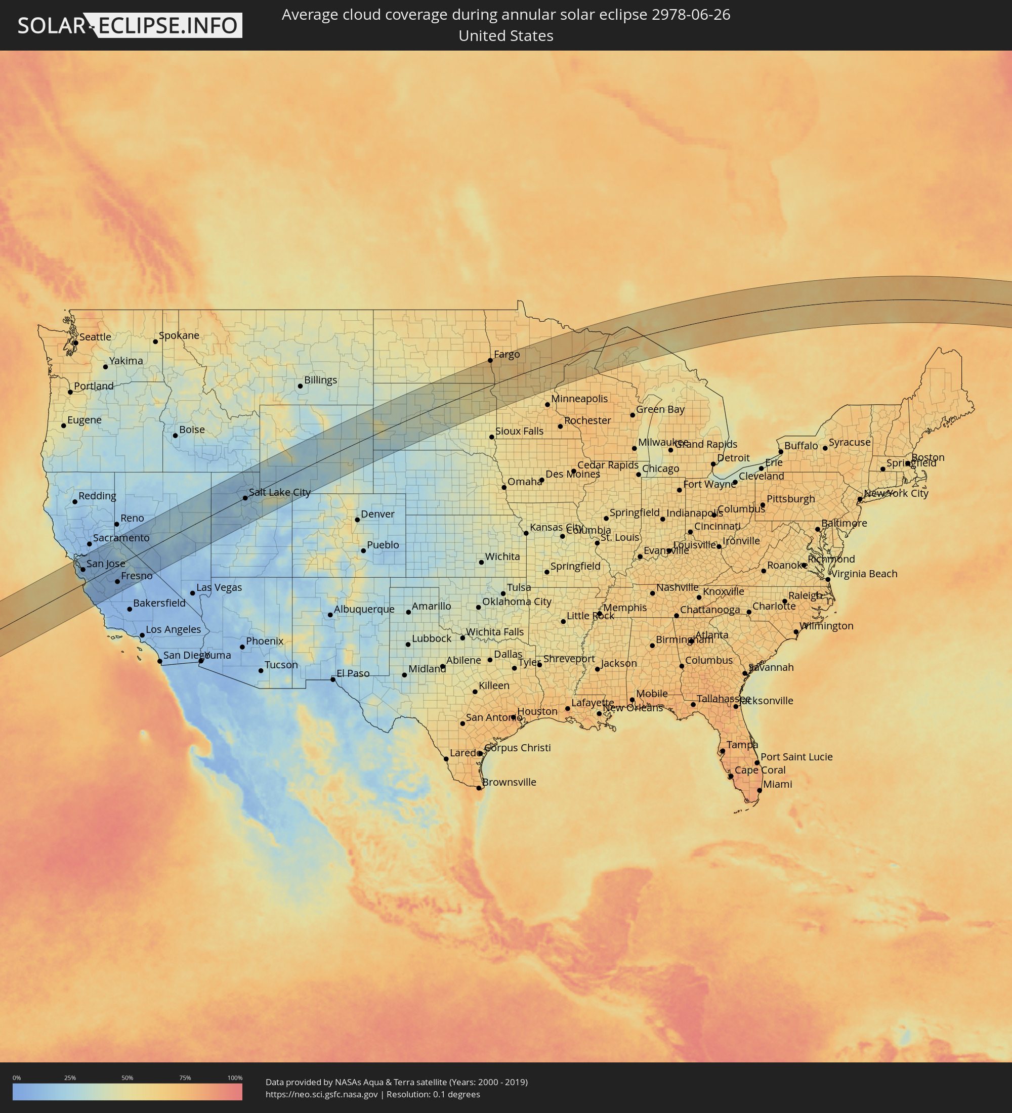 United States
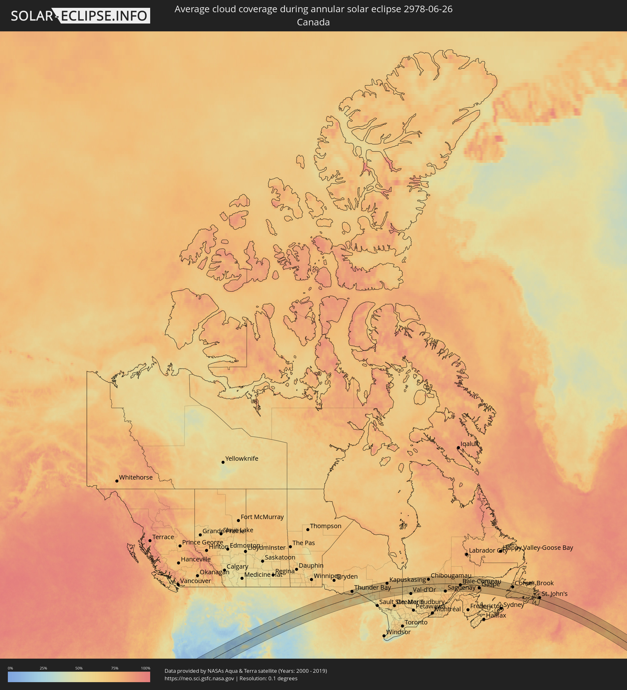 Canada
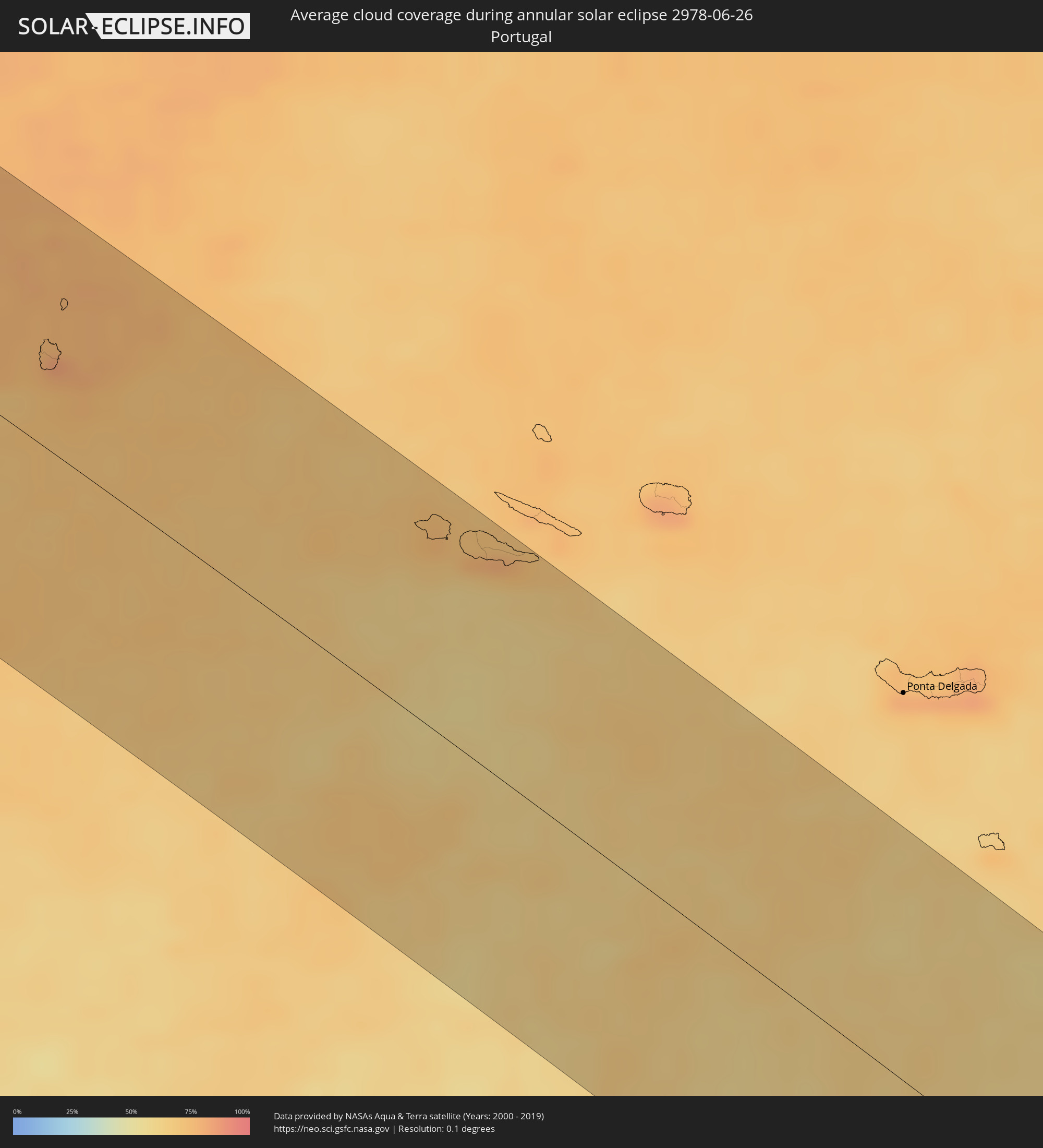 Portugal
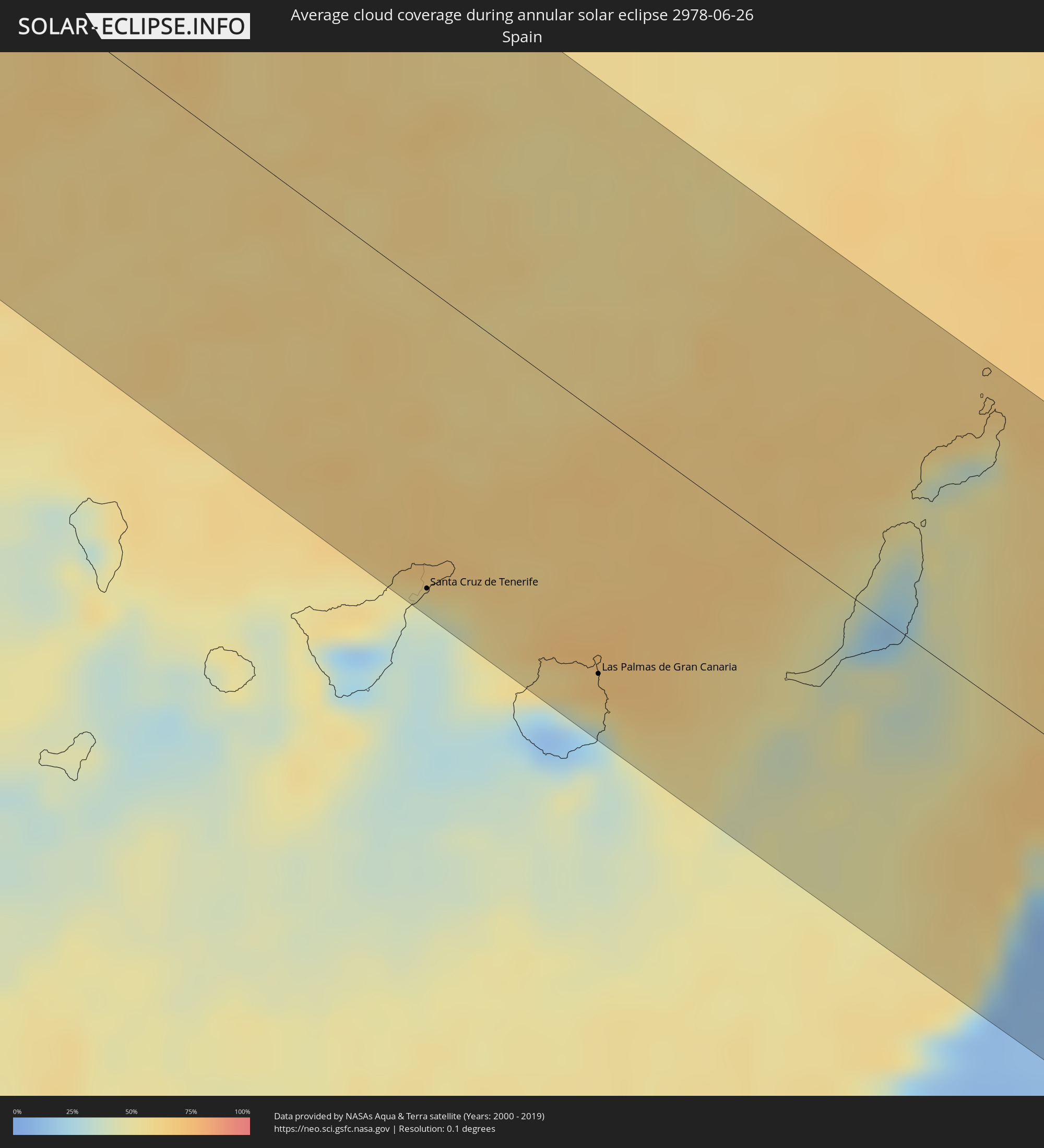 Spain
Spain
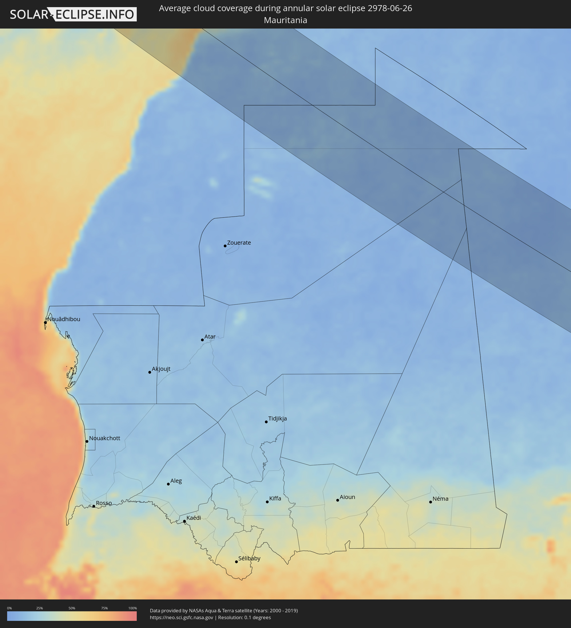 Mauritania
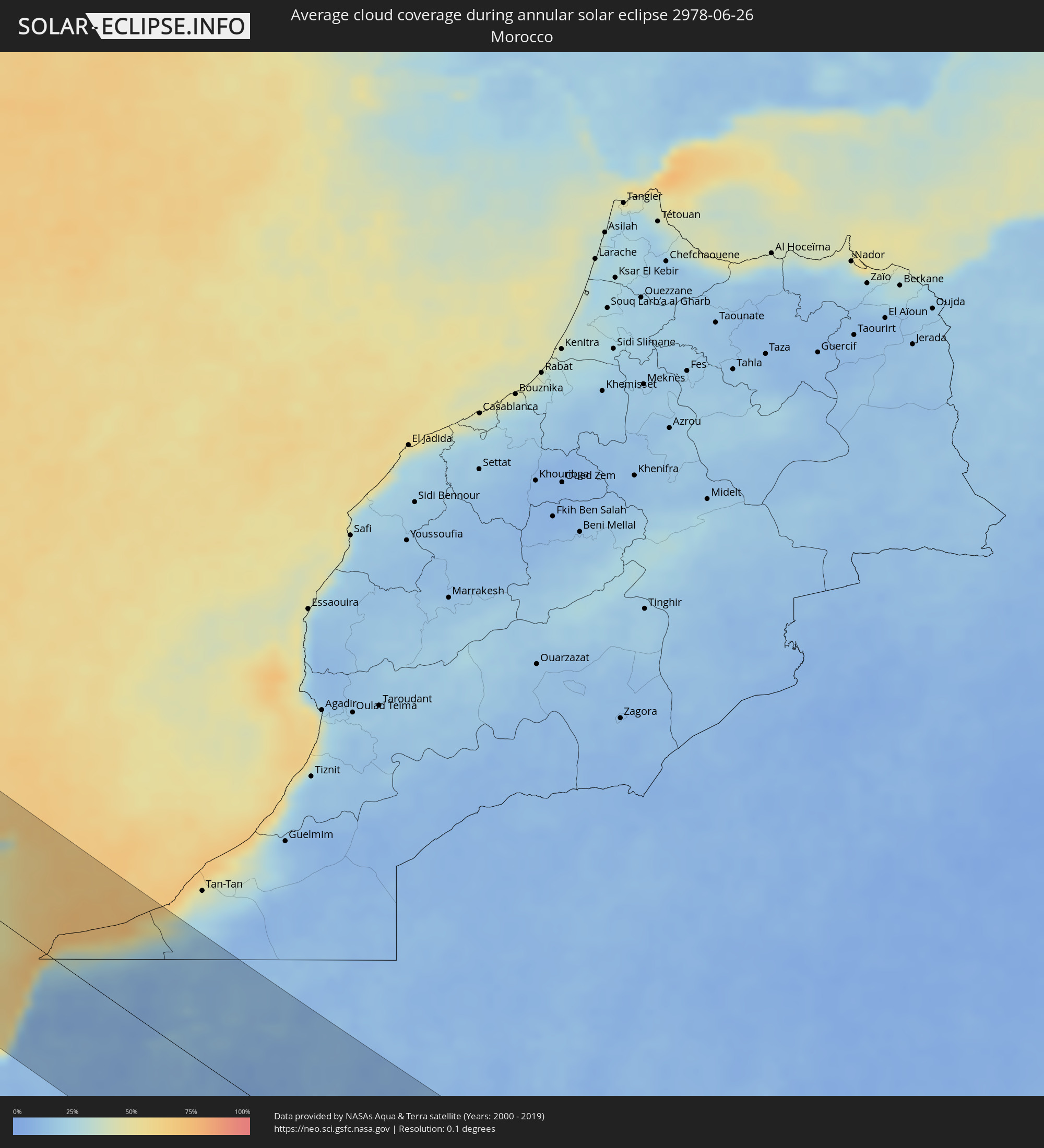 Morocco
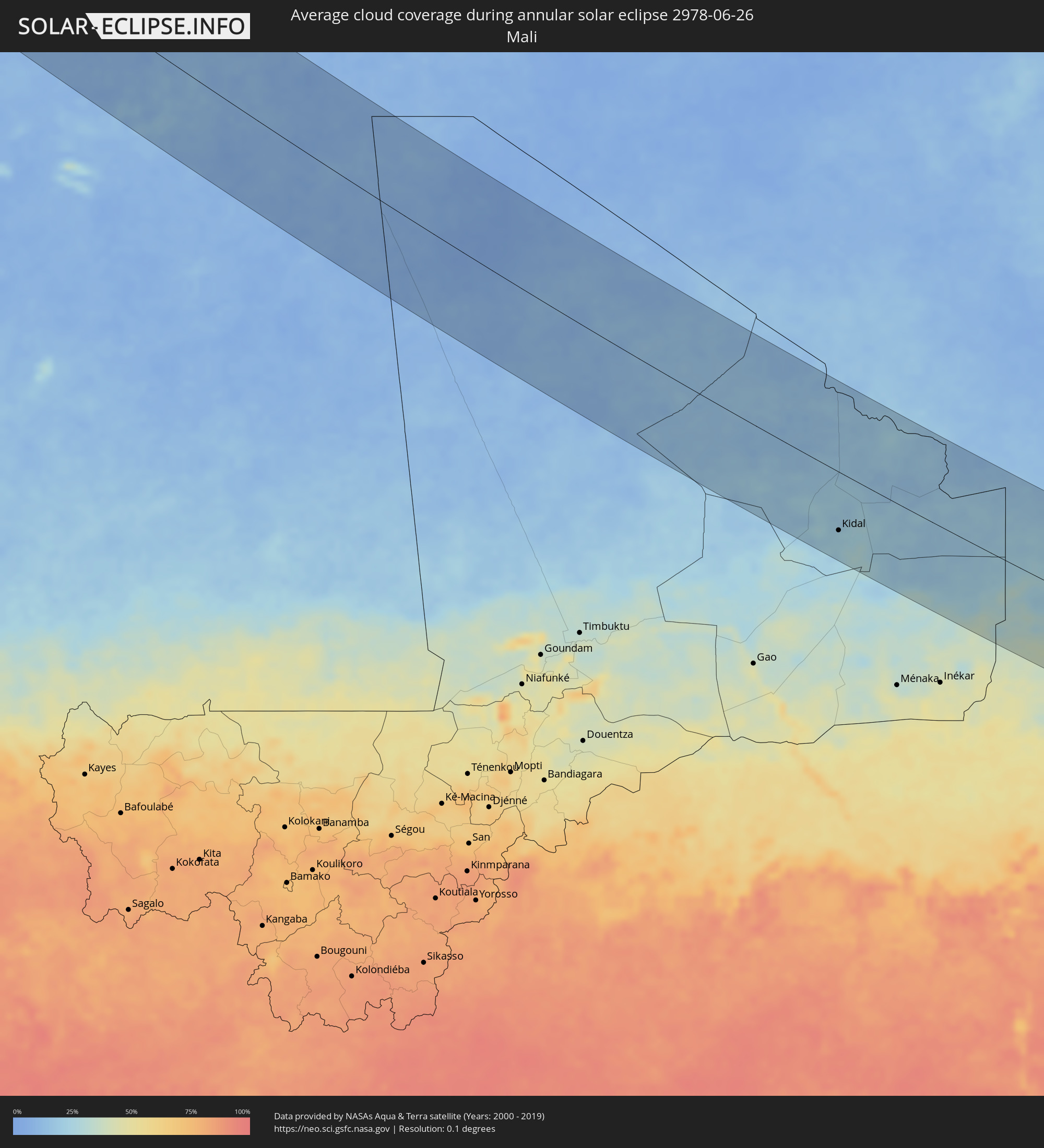 Mali
Mali
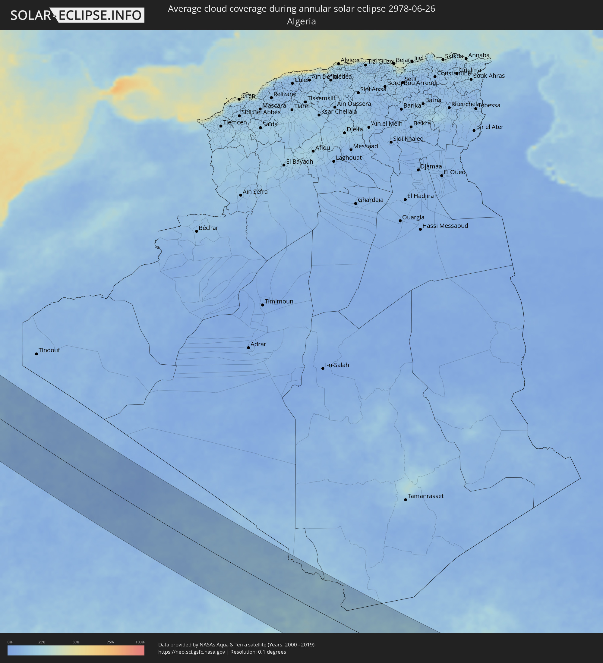 Algeria
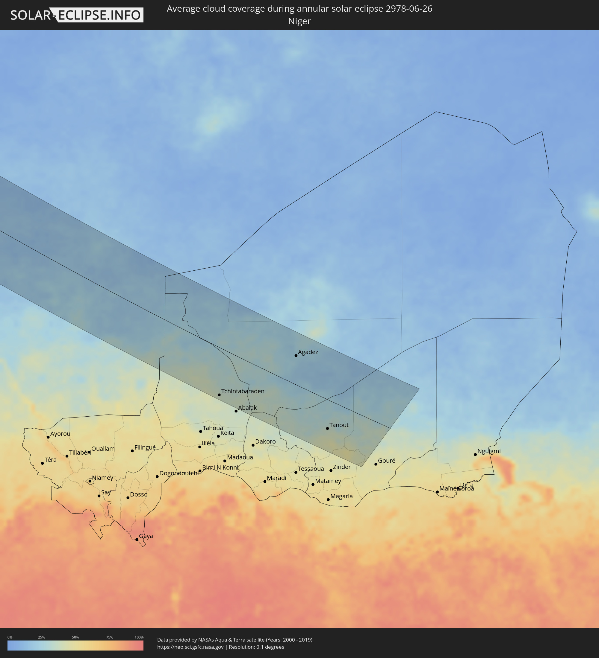 Niger
Niger
Cities inside the path of the eclipse
The following table shows all locations with a population of more than 5,000 inside the eclipse path. Cities which have more than 100,000 inhabitants are marked bold. A click at the locations opens a detailed map.
| City | Type | Eclipse duration | Local time of max. eclipse | Distance to central line | Ø Cloud coverage |
|
San Francisco, California
|
annular | - | 06:19:57 UTC-08:00 | 131 km | 38% |
|
San Mateo, California
|
annular | - | 06:19:40 UTC-08:00 | 106 km | 22% |
|
Berkeley, California
|
annular | - | 06:20:05 UTC-08:00 | 134 km | 27% |
|
Mountain View, California
|
annular | - | 06:19:27 UTC-08:00 | 78 km | 13% |
|
Hayward, California
|
annular | - | 06:19:49 UTC-08:00 | 106 km | 20% |
|
Concord, California
|
annular | - | 06:20:14 UTC-08:00 | 134 km | 13% |
|
Fremont, California
|
annular | - | 06:19:40 UTC-08:00 | 90 km | 25% |
|
San Ramon, California
|
annular | - | 06:19:58 UTC-08:00 | 112 km | 18% |
|
San Jose, California
|
annular | - | 06:19:24 UTC-08:00 | 66 km | 11% |
|
Antioch, California
|
annular | - | 06:20:16 UTC-08:00 | 127 km | 12% |
|
Livermore, California
|
annular | - | 06:19:51 UTC-08:00 | 94 km | 13% |
|
Salinas, California
|
annular | - | 06:18:33 UTC-08:00 | 9 km | 29% |
|
Tracy, California
|
annular | - | 06:19:56 UTC-08:00 | 85 km | 11% |
|
Stockton, California
|
annular | - | 06:20:14 UTC-08:00 | 101 km | 10% |
|
Modesto, California
|
annular | - | 06:19:50 UTC-08:00 | 57 km | 12% |
|
Turlock, California
|
annular | - | 06:19:39 UTC-08:00 | 37 km | 13% |
|
Merced, California
|
annular | - | 06:19:26 UTC-08:00 | 3 km | 11% |
|
Fresno, California
|
annular | - | 06:18:46 UTC-08:00 | 82 km | 8% |
|
Ogden, Utah
|
annular | - | 07:26:54 UTC-07:00 | 44 km | 15% |
|
West Jordan, Utah
|
annular | - | 07:26:01 UTC-07:00 | 18 km | 20% |
|
Salt Lake City, Utah
|
annular | - | 07:26:16 UTC-07:00 | 5 km | 17% |
|
Provo, Utah
|
annular | - | 07:25:35 UTC-07:00 | 66 km | 18% |
|
Rapid City, South Dakota
|
annular | - | 07:36:12 UTC-07:00 | 17 km | 39% |
|
Fargo, North Dakota
|
annular | - | 08:46:03 UTC-06:00 | 109 km | 71% |
|
Duluth, Minnesota
|
annular | - | 08:51:02 UTC-06:00 | 21 km | 62% |
|
Thunder Bay, Ontario
|
annular | - | 09:56:46 UTC-05:00 | 85 km | 66% |
|
Kapuskasing, Ontario
|
annular | - | 10:07:33 UTC-05:00 | 81 km | 71% |
|
Timmins, Ontario
|
annular | - | 10:08:15 UTC-05:00 | 37 km | 69% |
|
Kirkland Lake, Ontario
|
annular | - | 10:10:03 UTC-05:00 | 88 km | 64% |
|
La Sarre, Quebec
|
annular | - | 10:12:03 UTC-05:00 | 25 km | 60% |
|
Rouyn-Noranda, Quebec
|
annular | - | 10:11:50 UTC-05:00 | 89 km | 59% |
|
Amos, Quebec
|
annular | - | 10:13:40 UTC-05:00 | 61 km | 58% |
|
Chibougamau, Quebec
|
annular | - | 10:21:11 UTC-05:00 | 64 km | 70% |
|
Saint-Félicien, Quebec
|
annular | - | 10:23:56 UTC-05:00 | 83 km | 62% |
|
Roberval, Quebec
|
annular | - | 10:24:17 UTC-05:00 | 98 km | 63% |
|
Dolbeau-Mistassini, Quebec
|
annular | - | 10:24:28 UTC-05:00 | 57 km | 63% |
|
Pont Rouge, Quebec
|
annular | - | 10:24:44 UTC-05:00 | 57 km | 63% |
|
Alma, Quebec
|
annular | - | 10:25:24 UTC-05:00 | 95 km | 62% |
|
Mont-Joli, Quebec
|
annular | - | 10:32:08 UTC-05:00 | 87 km | 67% |
|
Baie-Comeau, Quebec
|
annular | - | 10:32:21 UTC-05:00 | 16 km | 71% |
|
Matane, Quebec
|
annular | - | 10:33:30 UTC-05:00 | 57 km | 66% |
|
Sept-Îles, Quebec
|
annular | - | 10:35:53 UTC-05:00 | 101 km | 71% |
|
Chandler, Quebec
|
annular | - | 10:39:11 UTC-05:00 | 93 km | 73% |
|
Gaspé, Quebec
|
annular | - | 10:39:33 UTC-05:00 | 37 km | 72% |
|
Corner Brook, Newfoundland and Labrador
|
annular | - | 12:22:36 UTC-03:30 | 57 km | 71% |
|
Grand Falls-Windsor, Newfoundland and Labrador
|
annular | - | 12:27:07 UTC-03:30 | 97 km | 71% |
|
Bay Roberts, Newfoundland and Labrador
|
annular | - | 12:32:58 UTC-03:30 | 6 km | 75% |
|
Carbonear, Newfoundland and Labrador
|
annular | - | 12:32:57 UTC-03:30 | 21 km | 78% |
|
Conception Bay South, Newfoundland and Labrador
|
annular | - | 12:33:36 UTC-03:30 | 2 km | 73% |
|
St. John's, Newfoundland and Labrador
|
annular | - | 12:34:07 UTC-03:30 | 15 km | 74% |
|
Ribeira Grande, Azores
|
annular | - | 16:59:58 UTC+00:00 | 87 km | 69% |
|
Horta, Azores
|
annular | - | 16:00:01 UTC-01:00 | 92 km | 69% |
|
Madalena, Azores
|
annular | - | 16:00:08 UTC-01:00 | 98 km | 76% |
|
Sauzal, Canary Islands
|
annular | - | 17:30:04 UTC+00:00 | 125 km | 46% |
|
Tacoronte, Canary Islands
|
annular | - | 17:30:03 UTC+00:00 | 124 km | 46% |
|
Tegueste, Canary Islands
|
annular | - | 17:30:02 UTC+00:00 | 115 km | 41% |
|
Santa Cruz de Tenerife, Canary Islands
|
annular | - | 17:30:09 UTC+00:00 | 116 km | 41% |
|
Gáldar, Canary Islands
|
annular | - | 17:31:02 UTC+00:00 | 110 km | 27% |
|
Guia, Canary Islands
|
annular | - | 17:31:04 UTC+00:00 | 110 km | 36% |
|
Teror, Canary Islands
|
annular | - | 17:31:15 UTC+00:00 | 112 km | 46% |
|
Santa Lucía, Canary Islands
|
annular | - | 17:31:30 UTC+00:00 | 125 km | 21% |
|
Vega de San Mateo, Canary Islands
|
annular | - | 17:31:20 UTC+00:00 | 116 km | 24% |
|
Santa Brígida, Canary Islands
|
annular | - | 17:31:19 UTC+00:00 | 112 km | 24% |
|
Valsequillo de Gran Canaria, Canary Islands
|
annular | - | 17:31:24 UTC+00:00 | 116 km | 24% |
|
Las Palmas de Gran Canaria, Canary Islands
|
annular | - | 17:31:15 UTC+00:00 | 101 km | 54% |
|
Pájara, Canary Islands
|
annular | - | 17:31:28 UTC+00:00 | 4 km | 22% |
|
Tuineje, Canary Islands
|
annular | - | 17:31:33 UTC+00:00 | 3 km | 26% |
|
Antigua, Canary Islands
|
annular | - | 17:31:24 UTC+00:00 | 8 km | 17% |
|
La Oliva, Canary Islands
|
annular | - | 17:31:07 UTC+00:00 | 30 km | 30% |
|
Corralejo, Canary Islands
|
annular | - | 17:30:56 UTC+00:00 | 44 km | 33% |
|
Puerto del Rosario, Canary Islands
|
annular | - | 17:31:20 UTC+00:00 | 24 km | 27% |
|
Playa Blanca, Canary Islands
|
annular | - | 17:30:44 UTC+00:00 | 59 km | 45% |
|
Yaiza, Canary Islands
|
annular | - | 17:30:36 UTC+00:00 | 71 km | 38% |
|
Tías, Canary Islands
|
annular | - | 17:30:39 UTC+00:00 | 78 km | 45% |
|
San Bartolomé, Canary Islands
|
annular | - | 17:30:36 UTC+00:00 | 83 km | 45% |
|
Teguise, Canary Islands
|
annular | - | 17:30:31 UTC+00:00 | 91 km | 35% |
|
Nazaret, Canary Islands
|
annular | - | 17:30:33 UTC+00:00 | 89 km | 45% |
|
Arrecife, Canary Islands
|
annular | - | 17:30:41 UTC+00:00 | 84 km | 50% |
 Laayoune Plage
|
annular | - | 18:33:54 UTC+01:00 | 78 km | 27% |
|
Laâyoune / El Aaiún, Oued Ed-Dahab-Lagouira
|
annular | - | 18:33:55 UTC+01:00 | 61 km | 8% |
|
Tarfaya, Laâyoune-Boujdour-Sakia El Hamra
|
annular | - | 18:32:42 UTC+01:00 | 26 km | 40% |
|
Smara, Oued Ed-Dahab-Lagouira
|
annular | - | 18:35:10 UTC+01:00 | 12 km | 13% |
|
Kidal, Kidal
|
annular | - | 17:47:58 UTC+00:00 | 92 km | 23% |
|
Tchintabaraden, Tahoua
|
annular | - | 18:49:48 UTC+01:00 | 131 km | 38% |
|
Agadez, Agadez
|
annular | - | 18:47:58 UTC+01:00 | 79 km | 23% |
|
Alaghsas, Agadez
|
annular | - | 18:47:55 UTC+01:00 | 85 km | 23% |
|
Tanout, Zinder
|
annular | - | 18:49:41 UTC+01:00 | 81 km | 38% |