Total solar eclipse of 04/16/-0108
| Day of week: | Thursday |
| Maximum duration of eclipse: | 04m43s |
| Maximum width of eclipse path: | 286 km |
| Saros cycle: | 56 |
| Coverage: | 100% |
| Magnitude: | 1.0654 |
| Gamma: | 0.6655 |
Wo kann man die Sonnenfinsternis vom 04/16/-0108 sehen?
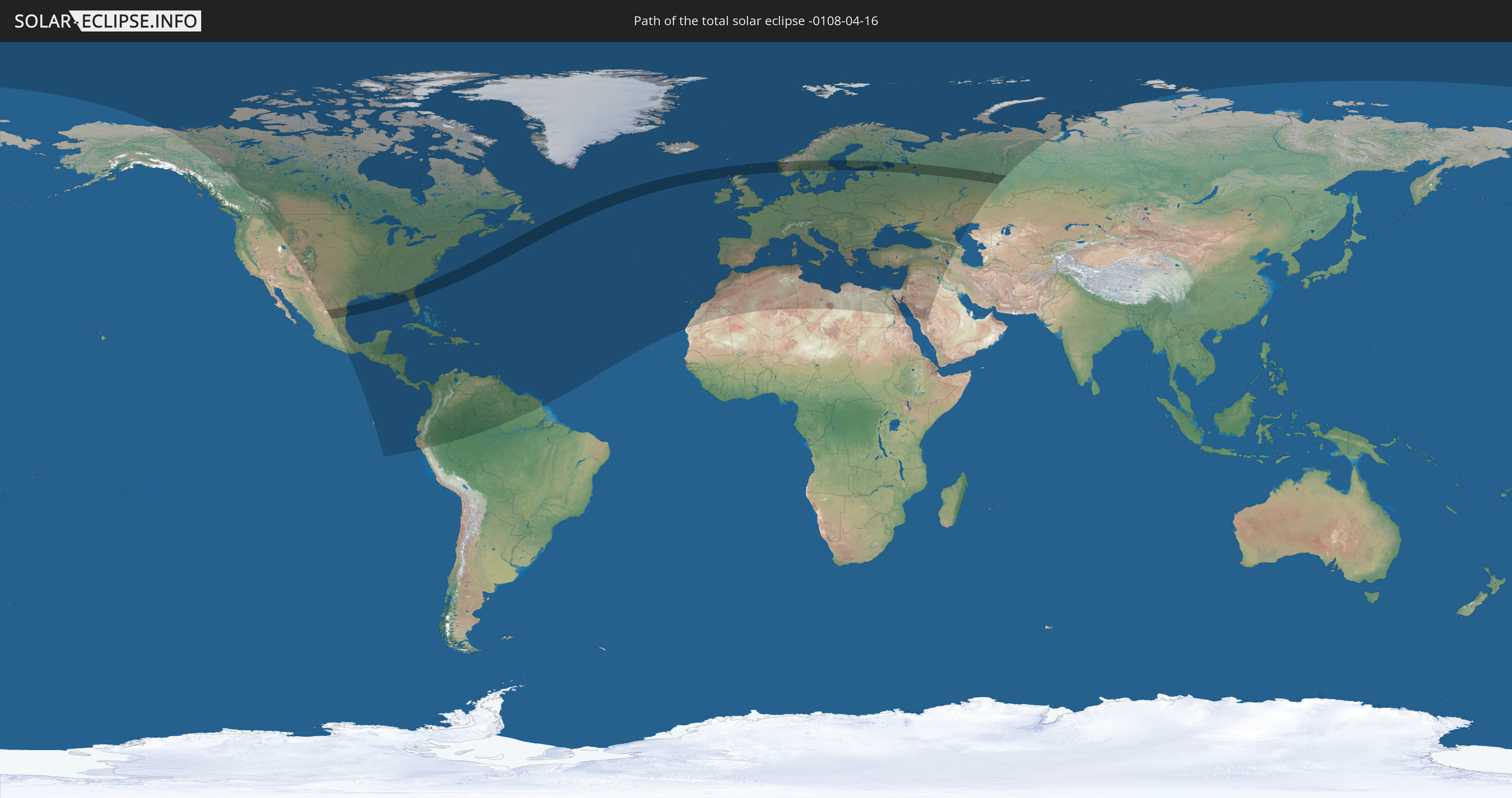
Die Sonnenfinsternis am 04/16/-0108 kann man in 119 Ländern als partielle Sonnenfinsternis beobachten.
Der Finsternispfad verläuft durch 9 Länder. Nur in diesen Ländern ist sie als total Sonnenfinsternis zu sehen.
In den folgenden Ländern ist die Sonnenfinsternis total zu sehen
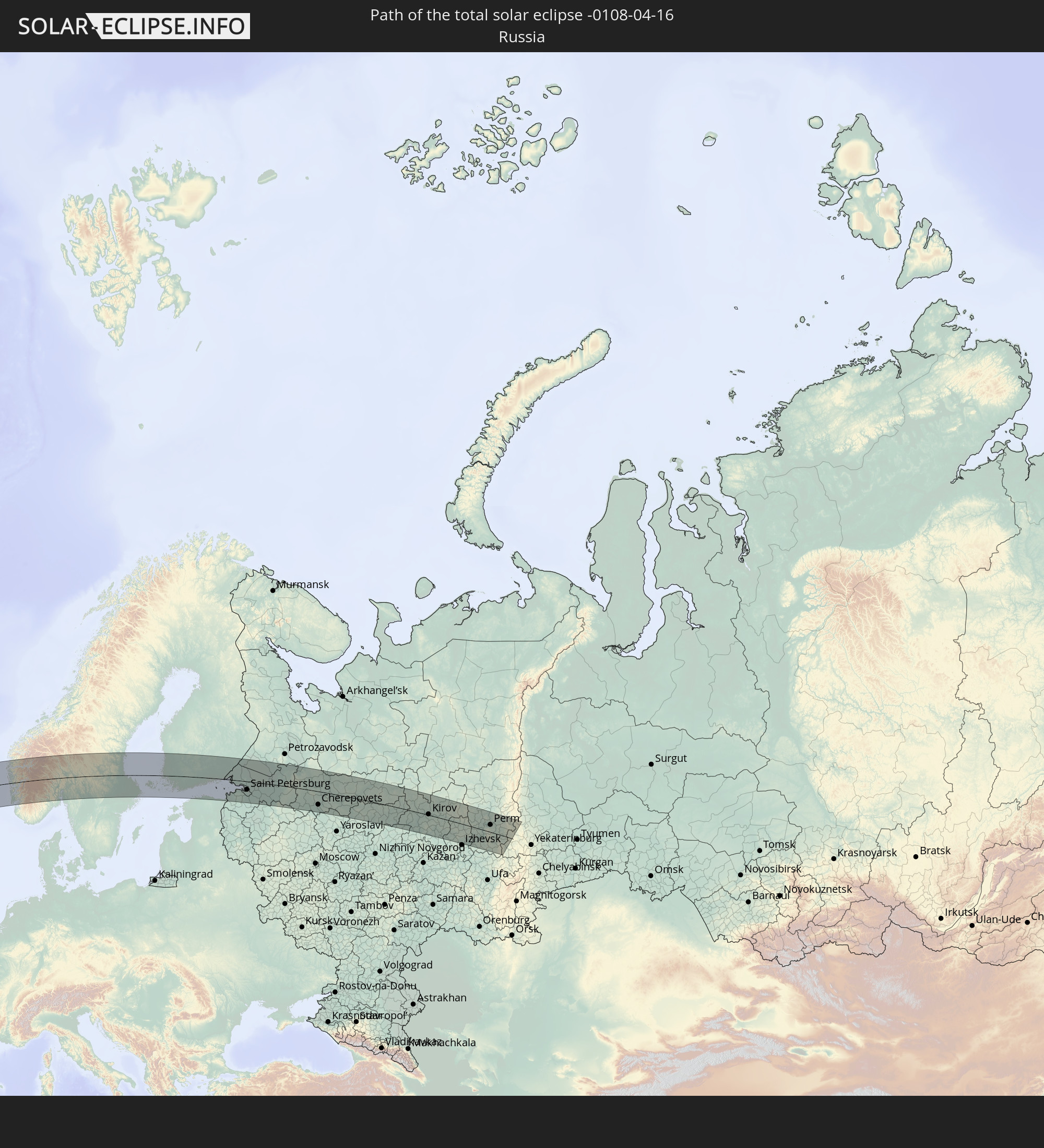 Russia
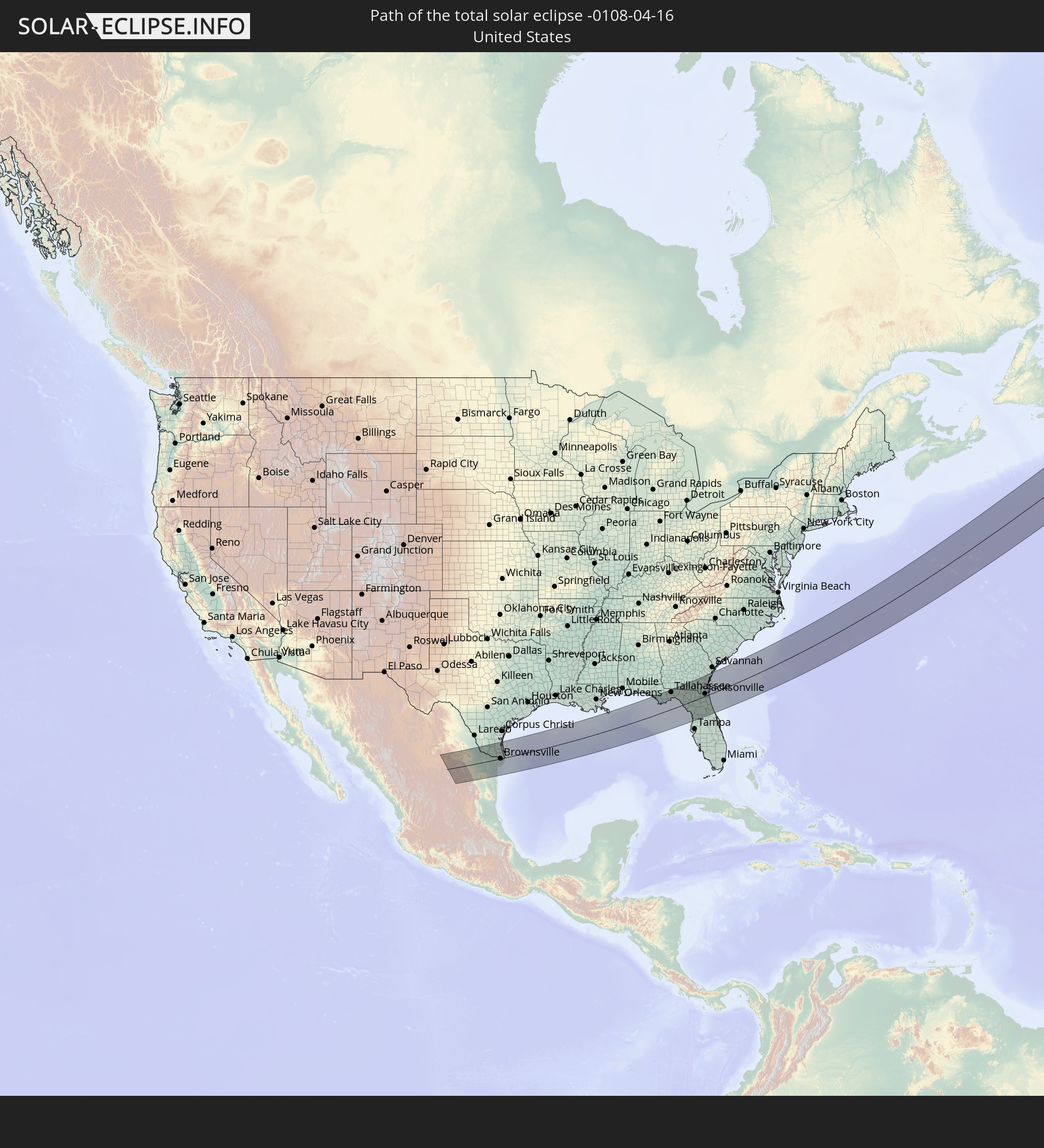 United States
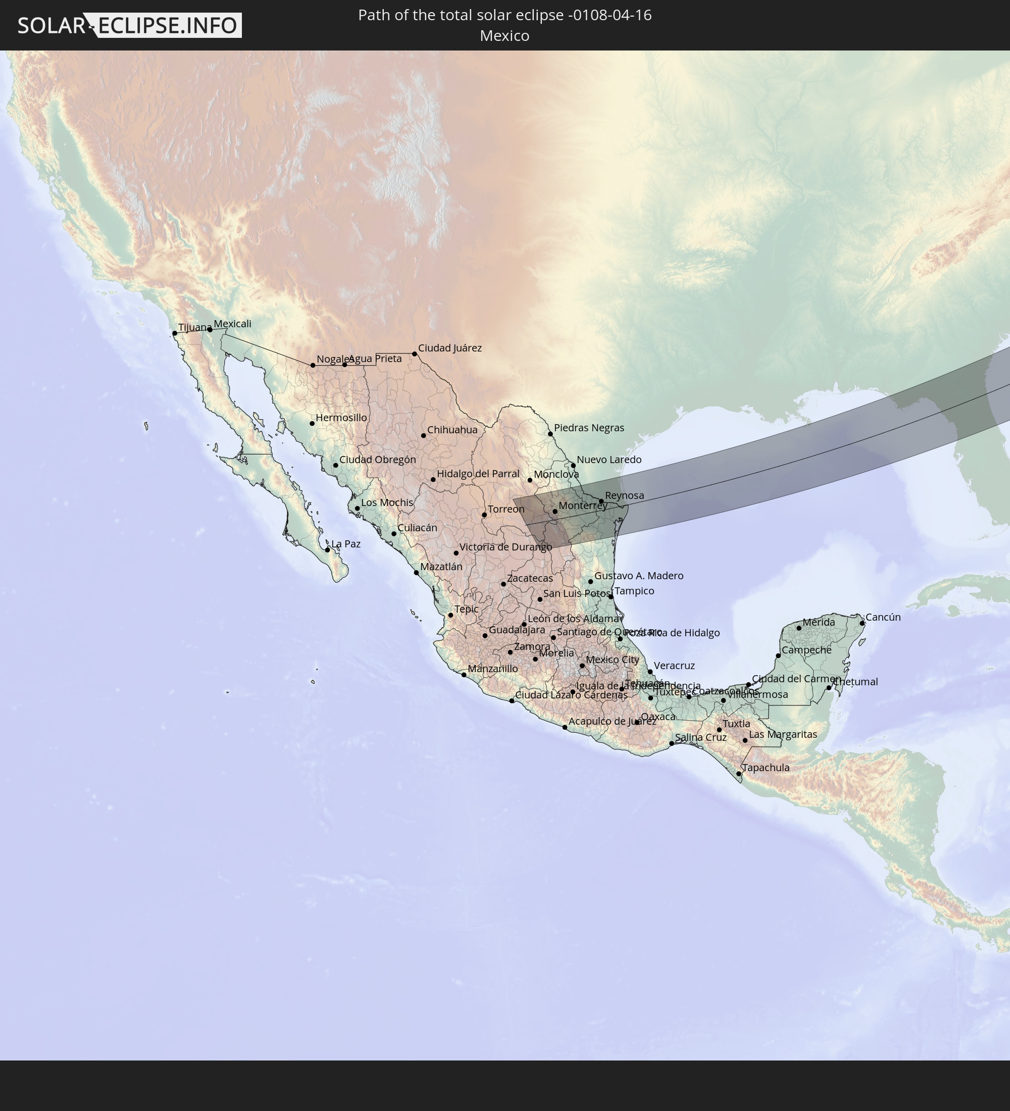 Mexico
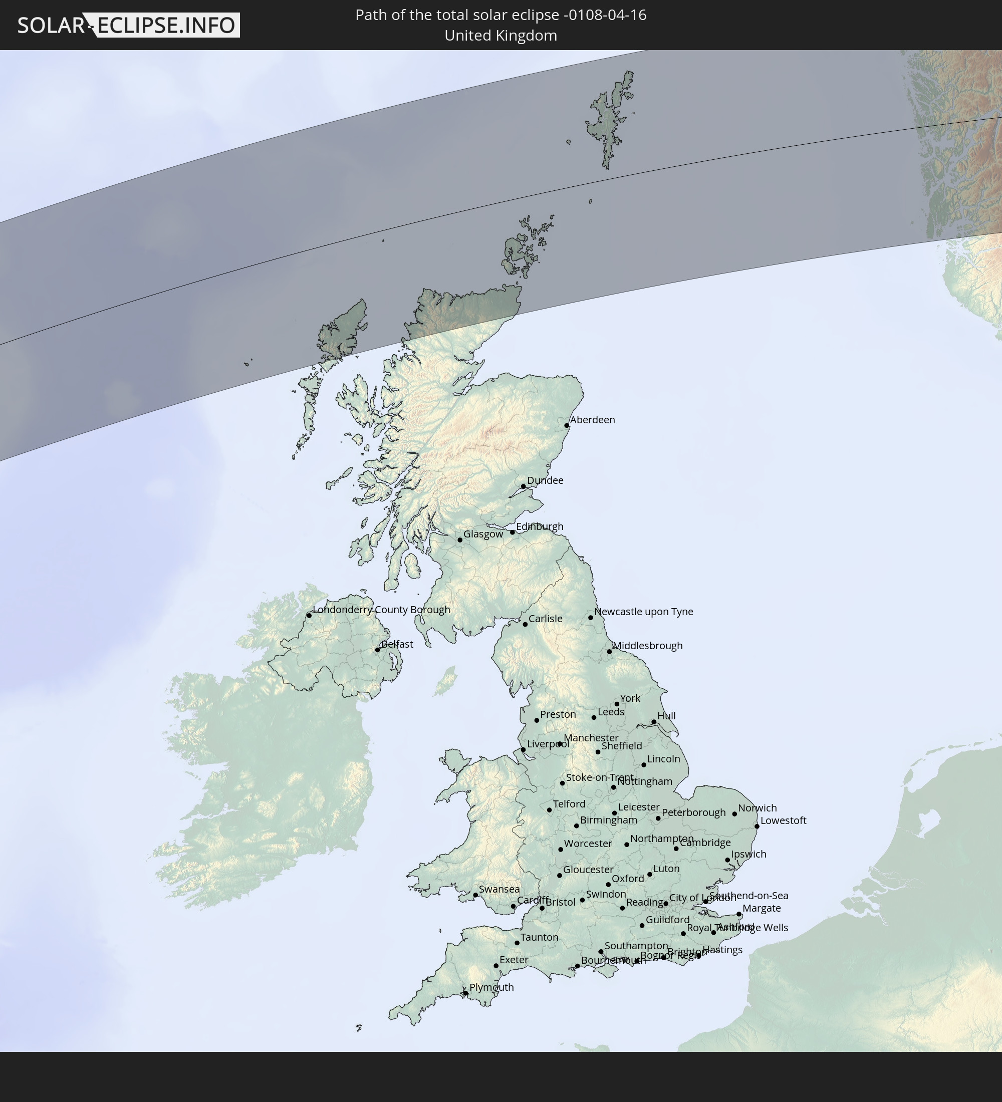 United Kingdom
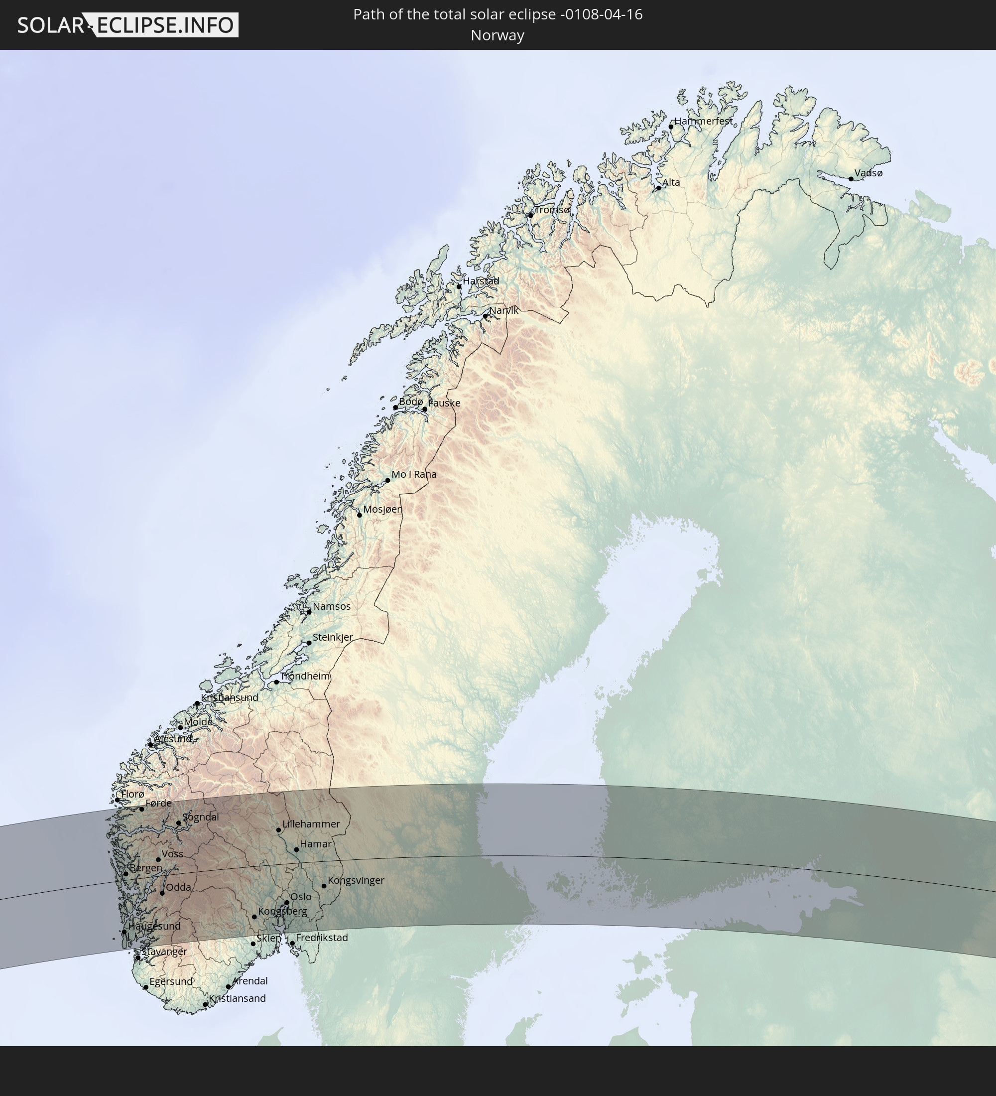 Norway
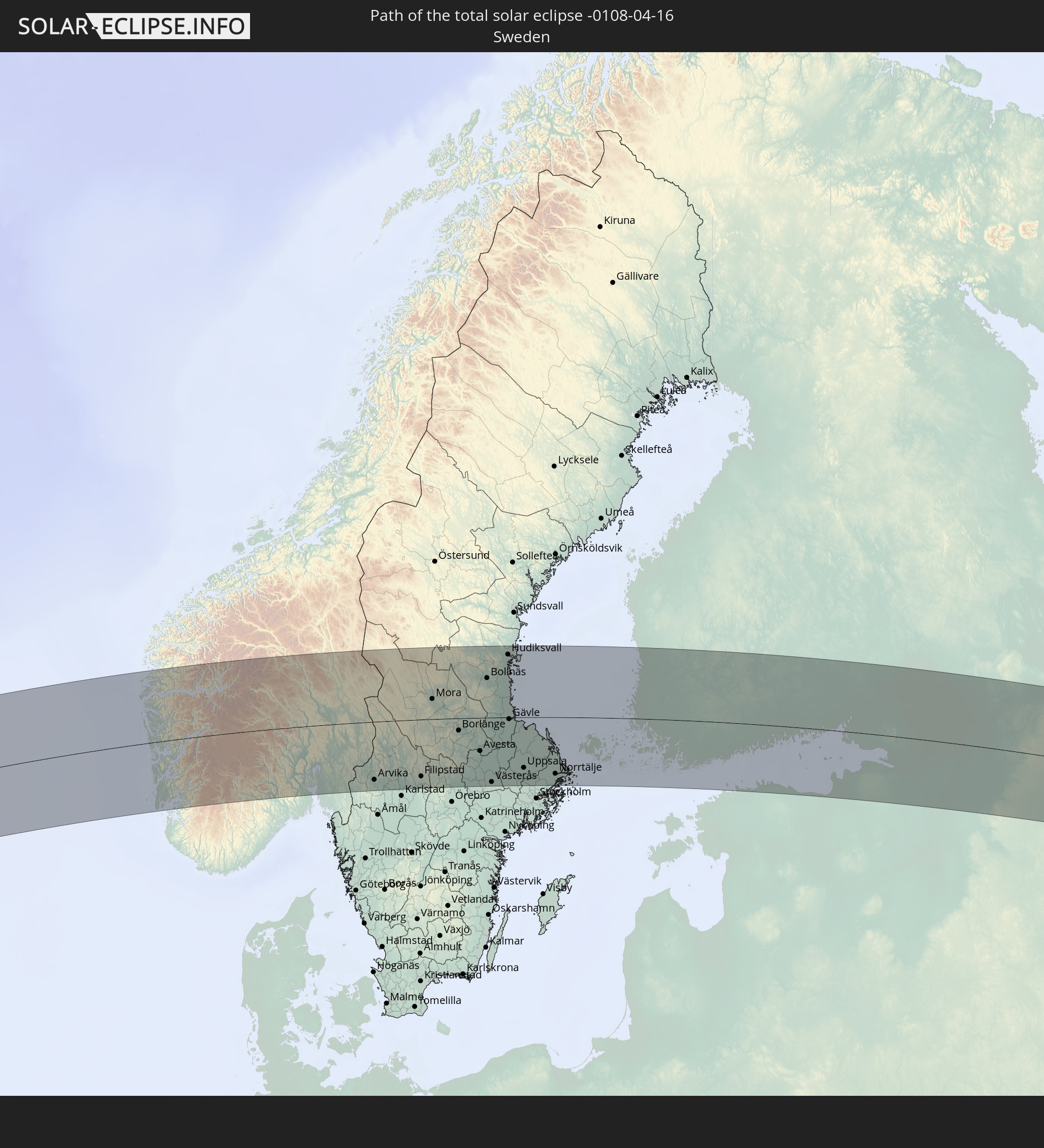 Sweden
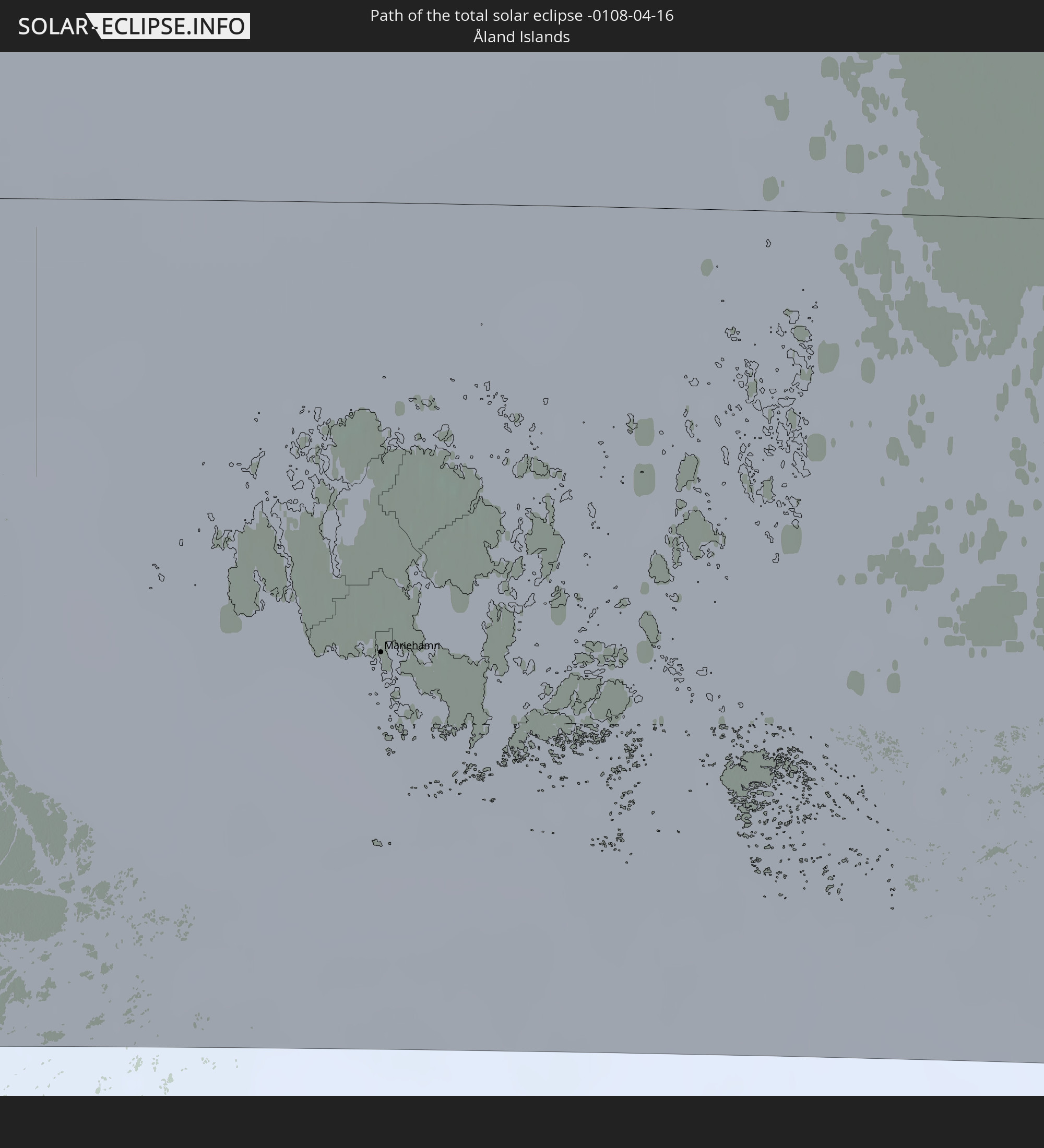 Åland Islands
 Finland
 Estonia
In den folgenden Ländern ist die Sonnenfinsternis partiell zu sehen
 Russia
 United States
 United States Minor Outlying Islands
 Canada
 Mexico
 Greenland
 Guatemala
 Ecuador
 El Salvador
 Honduras
 Belize
 Nicaragua
 Costa Rica
 Cuba
Cuba
 Panama
 Colombia
 Cayman Islands
 Peru
Peru
 The Bahamas
 Jamaica
 Haiti
Haiti
 Brazil
 Venezuela
 Turks and Caicos Islands
 Dominican Republic
 Aruba
Aruba
 Puerto Rico
 United States Virgin Islands
 Bermuda
 British Virgin Islands
 Anguilla
 Collectivity of Saint Martin
 Saint Barthélemy
 Saint Kitts and Nevis
 Antigua and Barbuda
 Montserrat
 Trinidad and Tobago
 Guadeloupe
 Grenada
 Dominica
 Saint Vincent and the Grenadines
 Guyana
 Martinique
 Saint Lucia
 Barbados
 Suriname
 Saint Pierre and Miquelon
 French Guiana
 Portugal
 Iceland
 Spain
Spain
 Mauritania
 Morocco
 Mali
Mali
 Republic of Ireland
 Svalbard and Jan Mayen
 Algeria
 United Kingdom
 Faroe Islands
 Gibraltar
 France
 Isle of Man
 Guernsey
 Jersey
 Andorra
 Belgium
 Netherlands
 Norway
 Luxembourg
 Germany
 Switzerland
 Italy
Italy
 Monaco
 Tunisia
 Denmark
 Libya
Libya
 Liechtenstein
 Austria
 Sweden
 Czechia
 San Marino
 Vatican City
 Slovenia
 Croatia
 Poland
 Malta
Malta
 Bosnia and Herzegovina
 Hungary
 Slovakia
 Montenegro
 Serbia
 Albania
 Åland Islands
 Greece
 Romania
 Republic of Macedonia
 Finland
 Lithuania
 Latvia
 Estonia
 Ukraine
 Bulgaria
 Belarus
 Egypt
Egypt
 Turkey
 Moldova
 Cyprus
 State of Palestine
 Israel
 Saudi Arabia
 Jordan
 Lebanon
 Syria
Syria
 Iraq
Iraq
 Georgia
 Armenia
 Iran
Iran
 Azerbaijan
 Kazakhstan
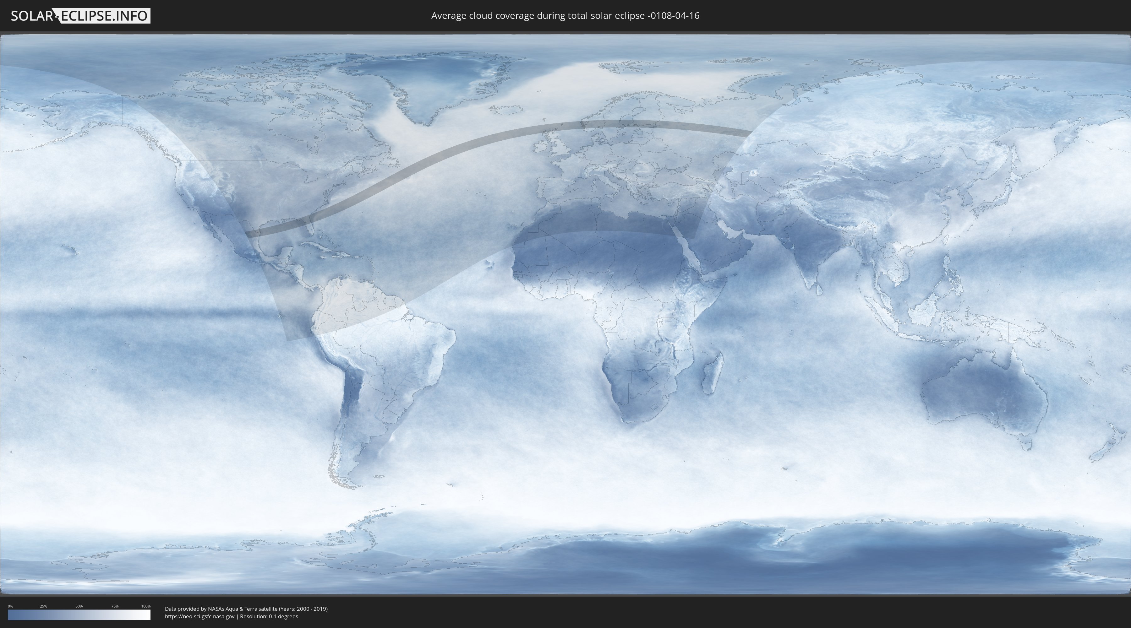
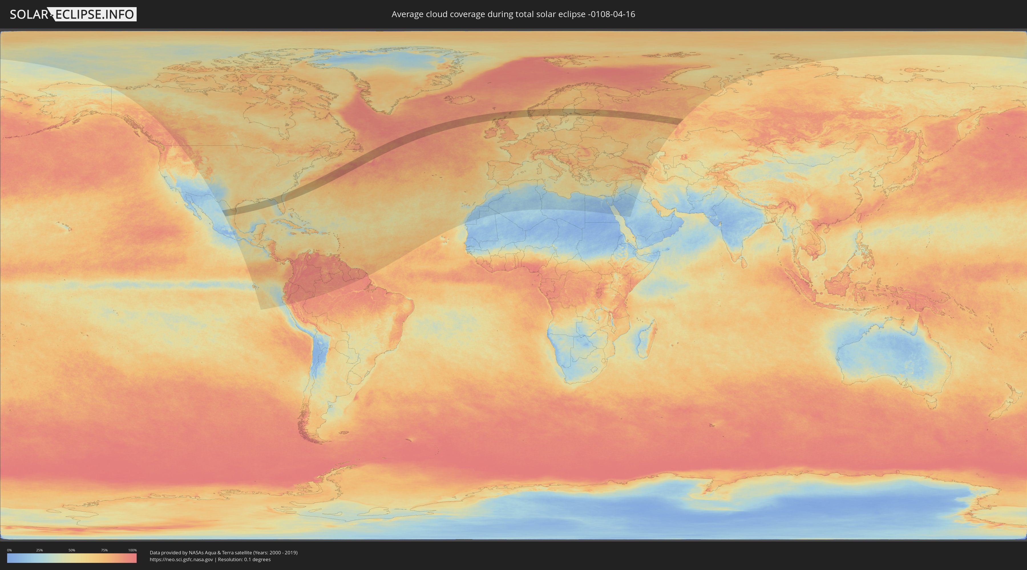
How will be the weather during the total solar eclipse on 04/16/-0108?
Where is the best place to see the total solar eclipse of 04/16/-0108?
The following maps show the average cloud coverage for the day of the total solar eclipse.
With the help of these maps, it is possible to find the place along the eclipse path, which has the best
chance of a cloudless sky.
Nevertheless, you should consider local circumstances and inform about the weather of your chosen
observation site.
The data is provided by NASAs satellites
AQUA and TERRA.
The cloud maps are averaged over a period of 19 years (2000 - 2019).
Detailed country maps
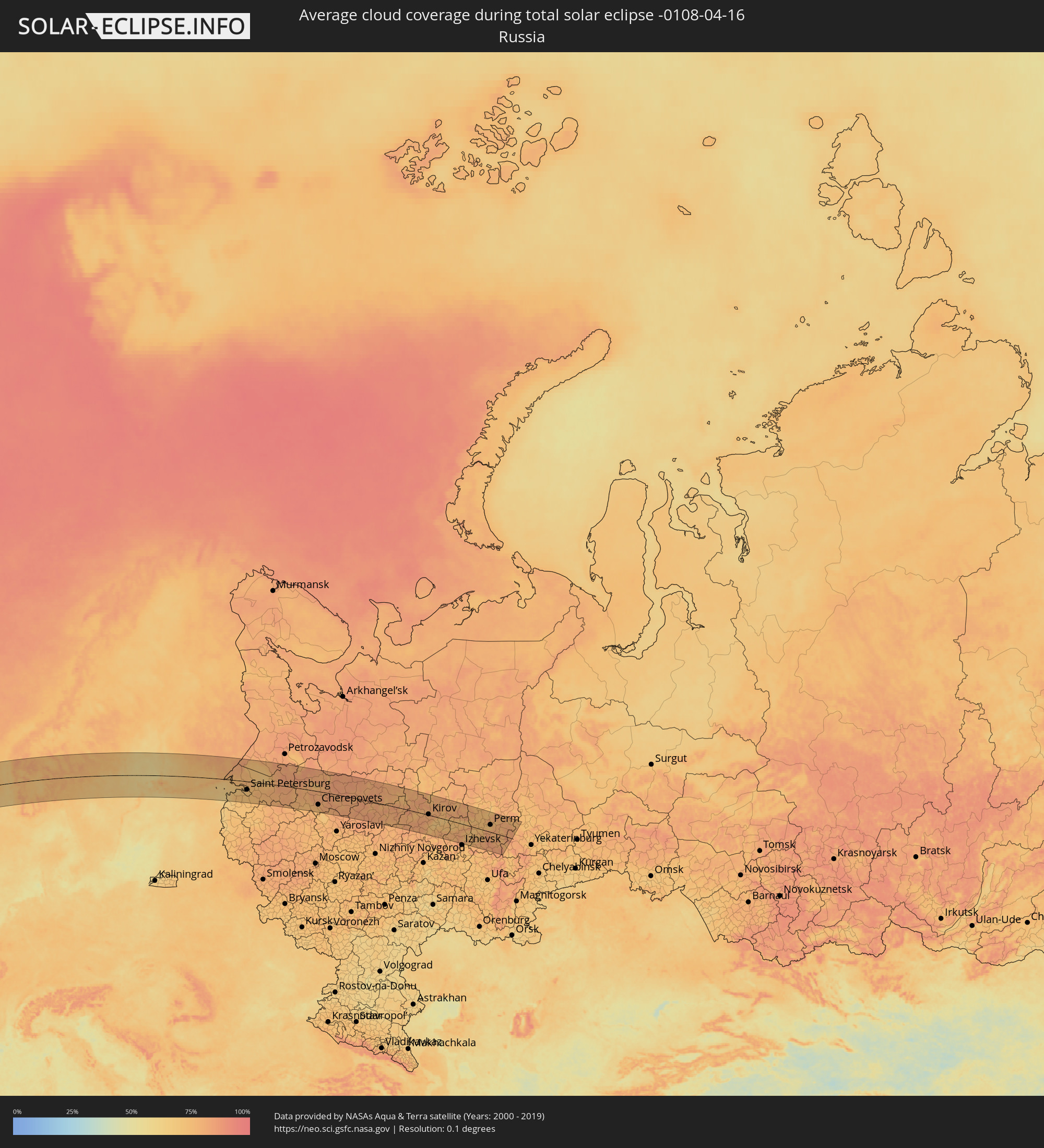 Russia
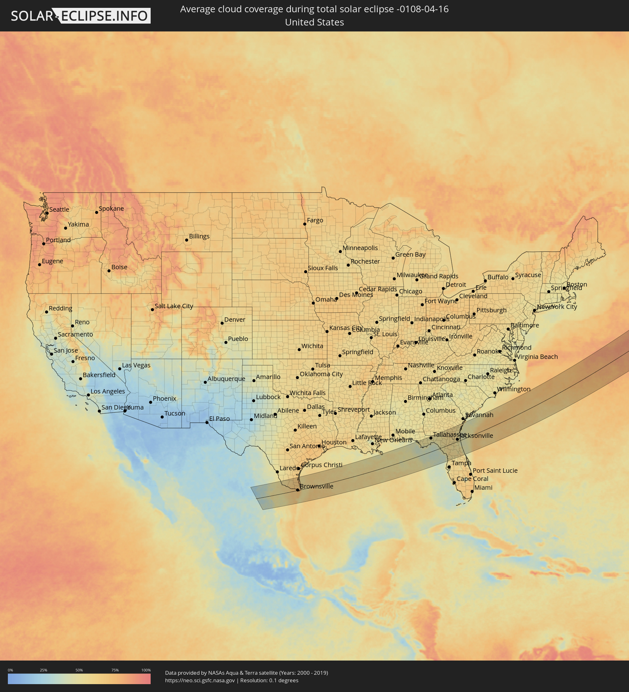 United States
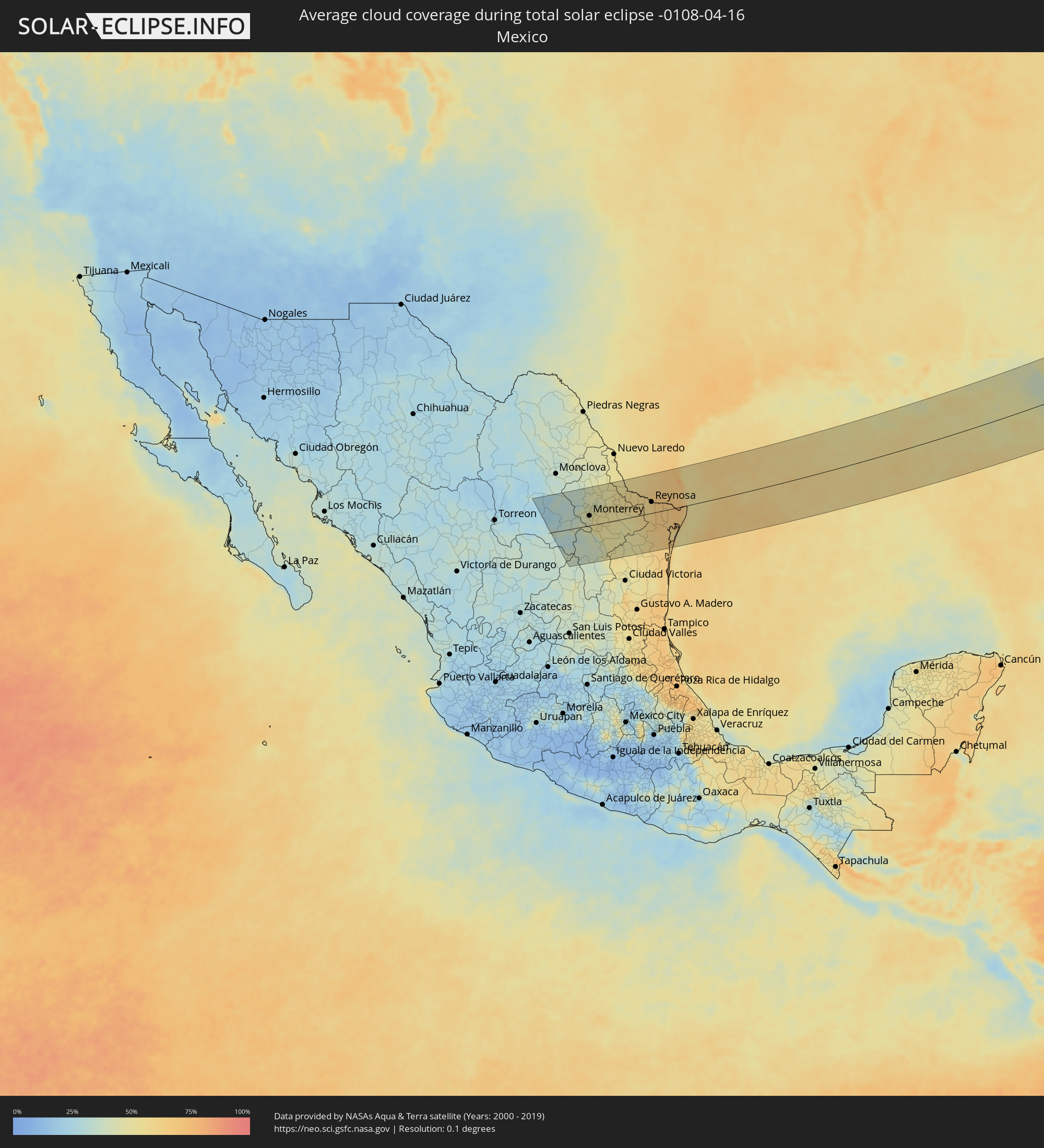 Mexico
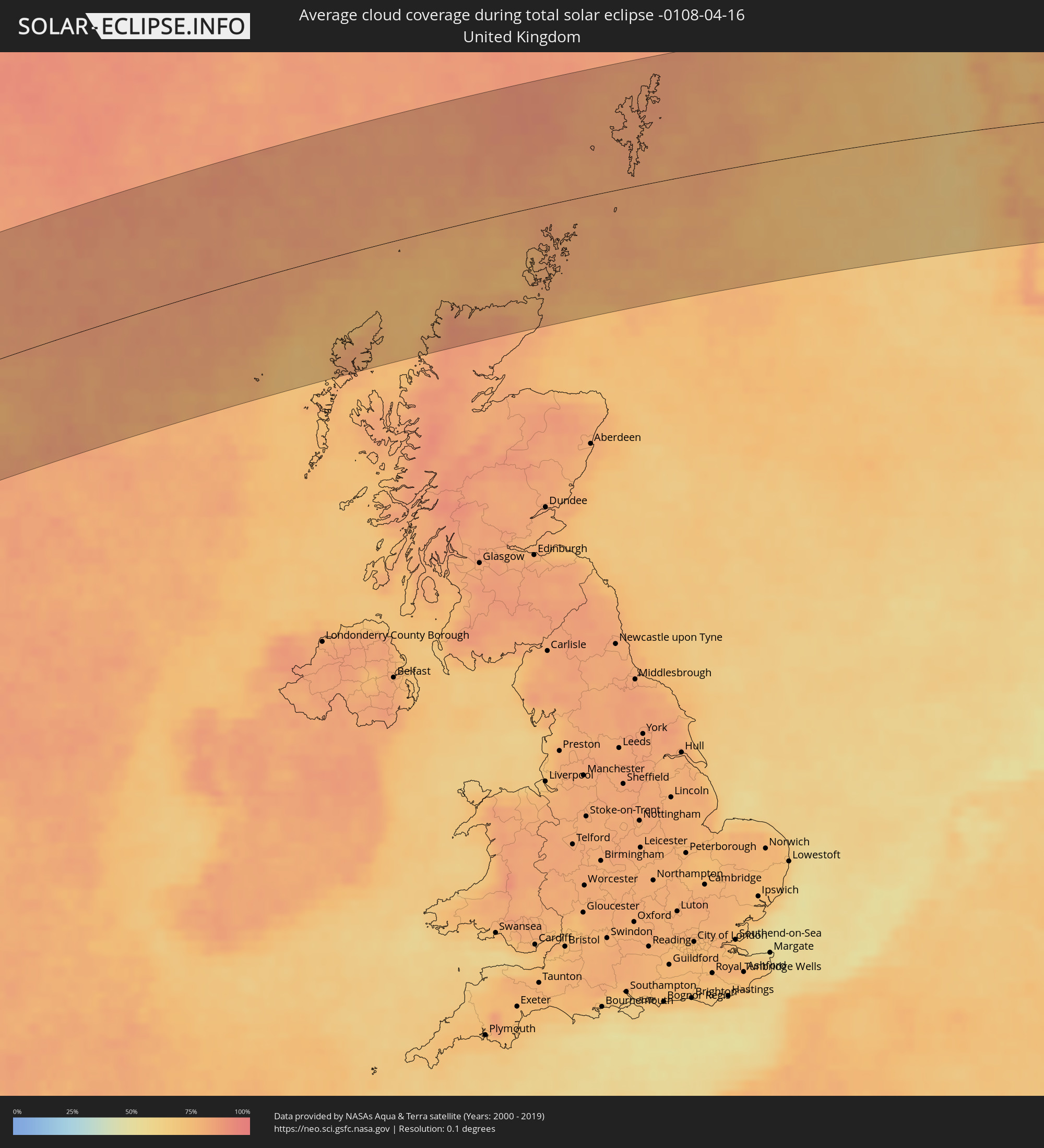 United Kingdom
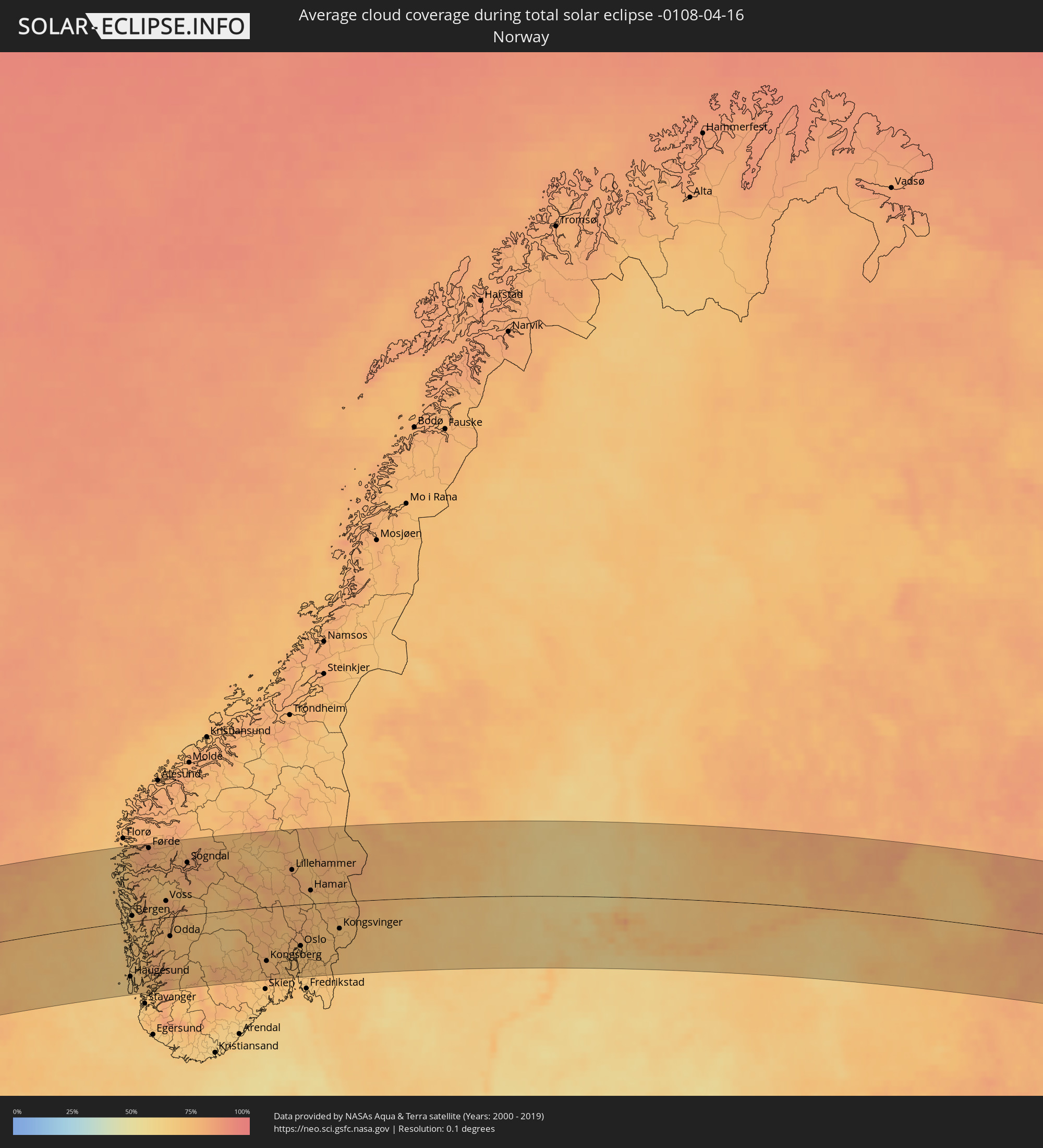 Norway
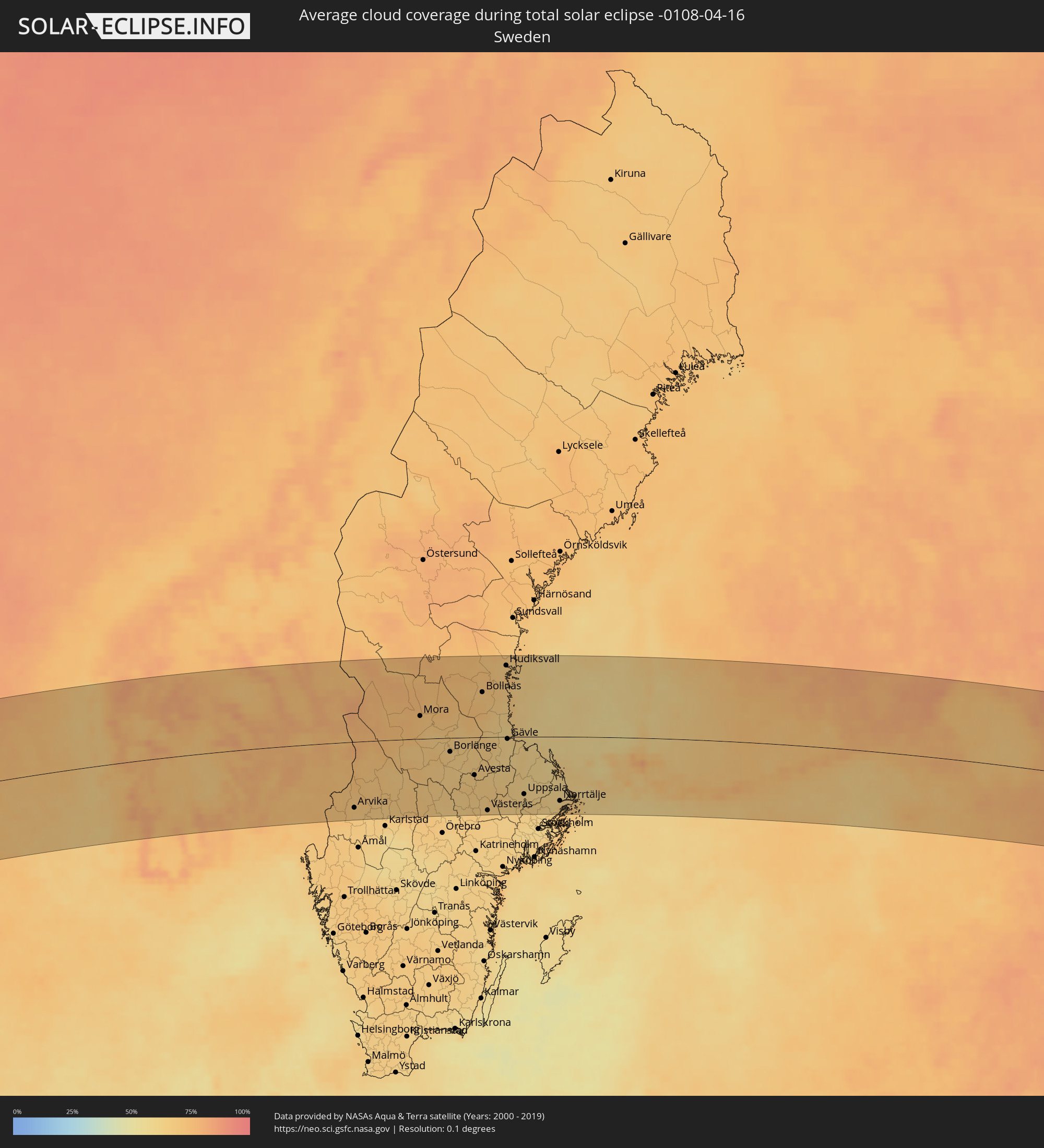 Sweden
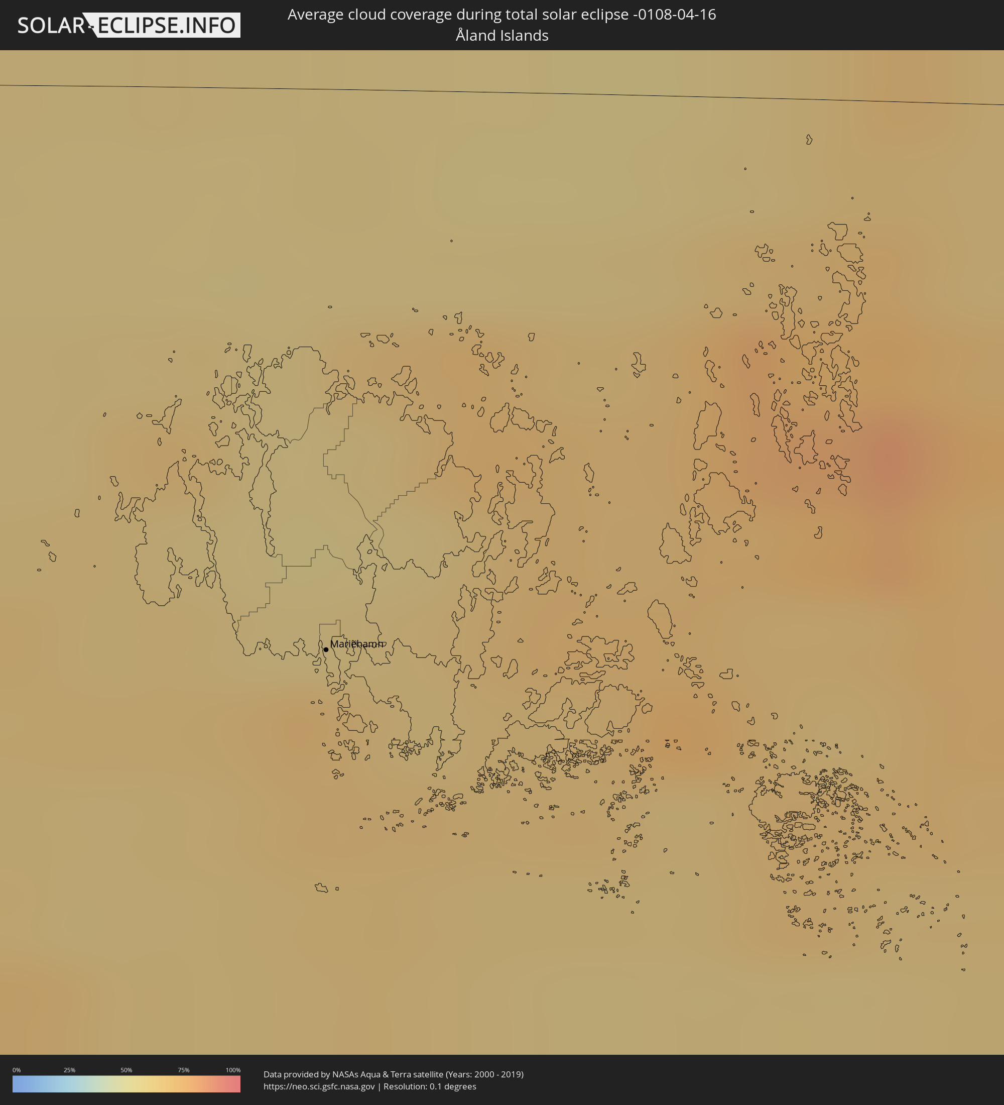 Åland Islands
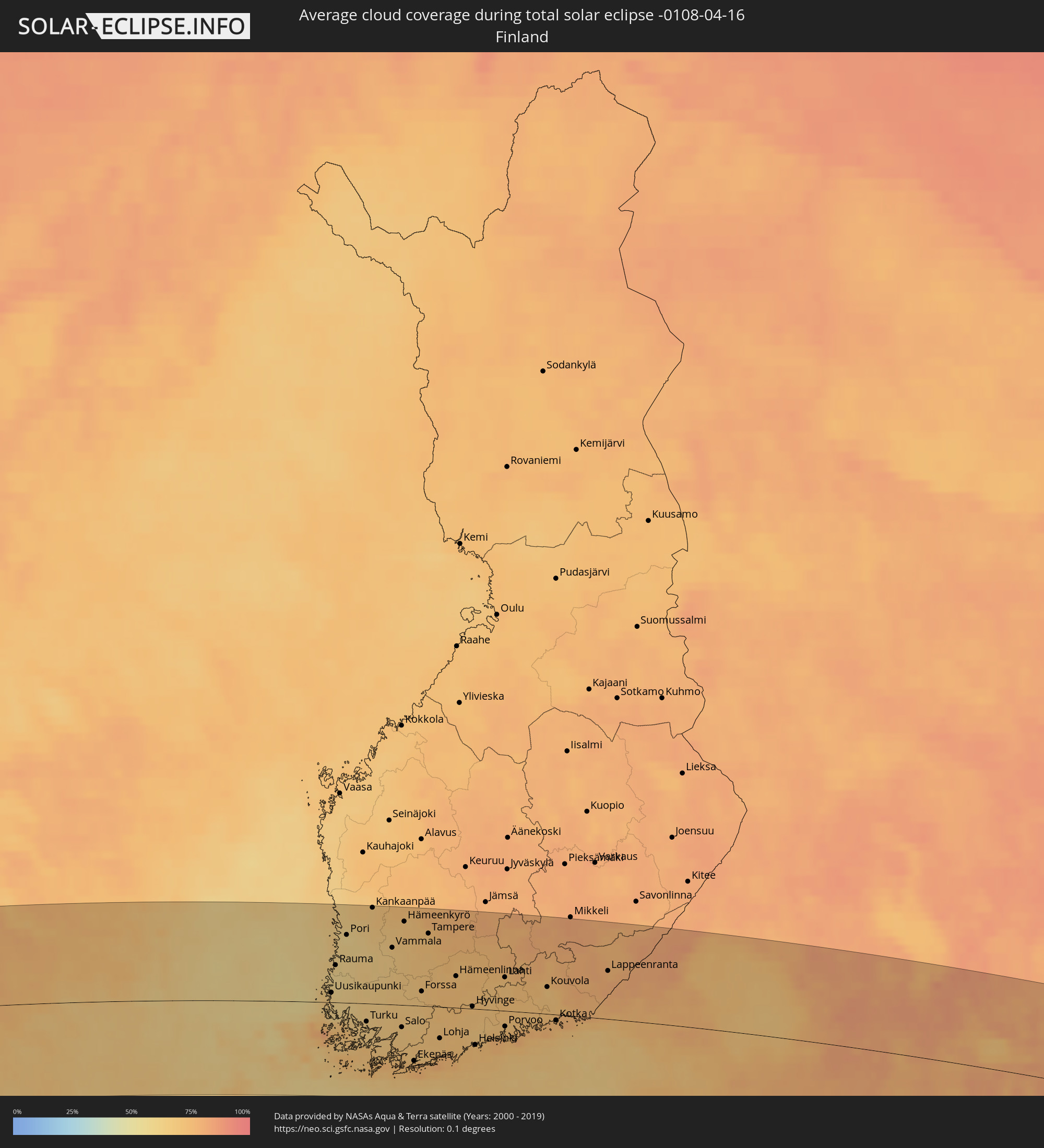 Finland
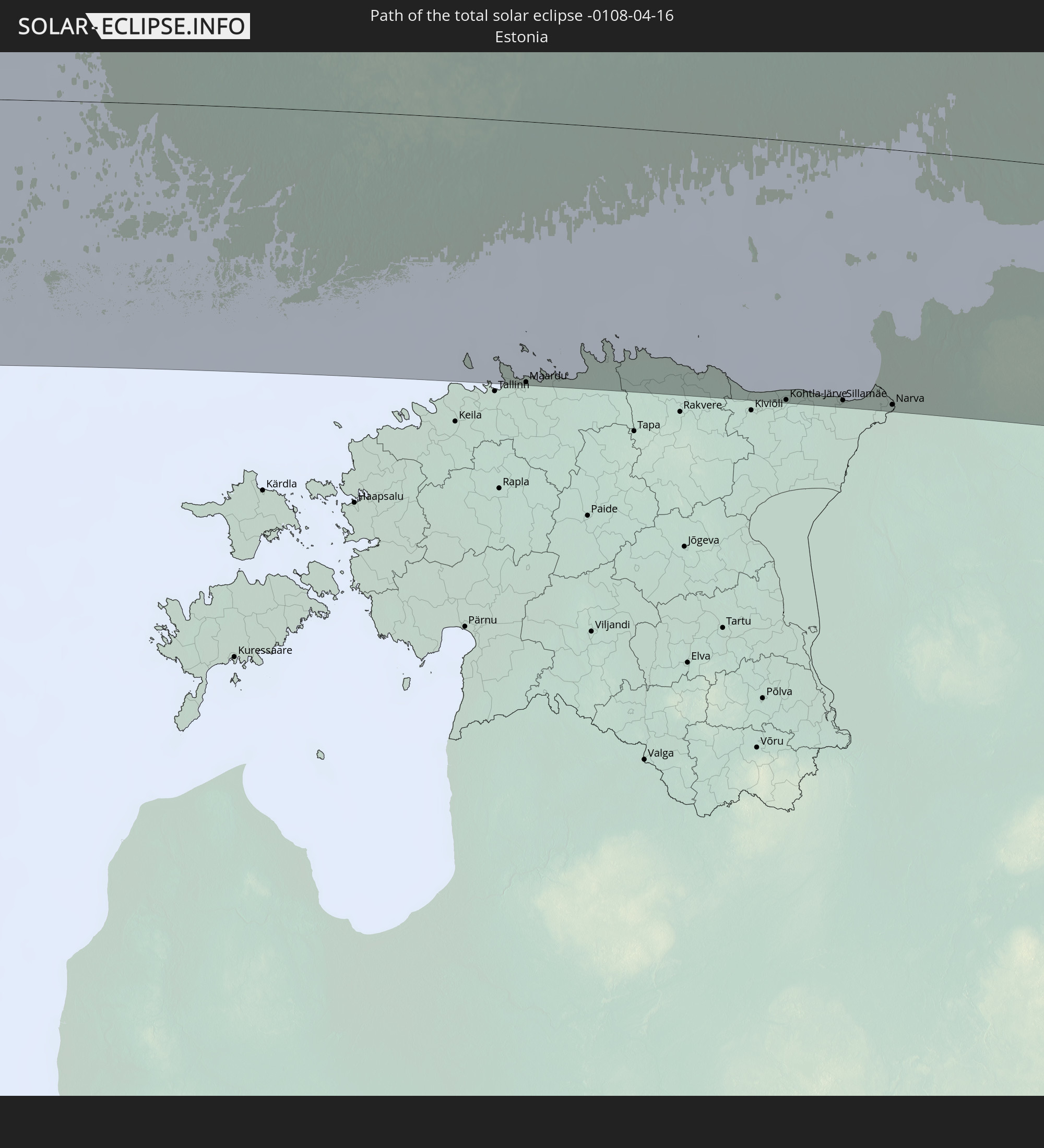
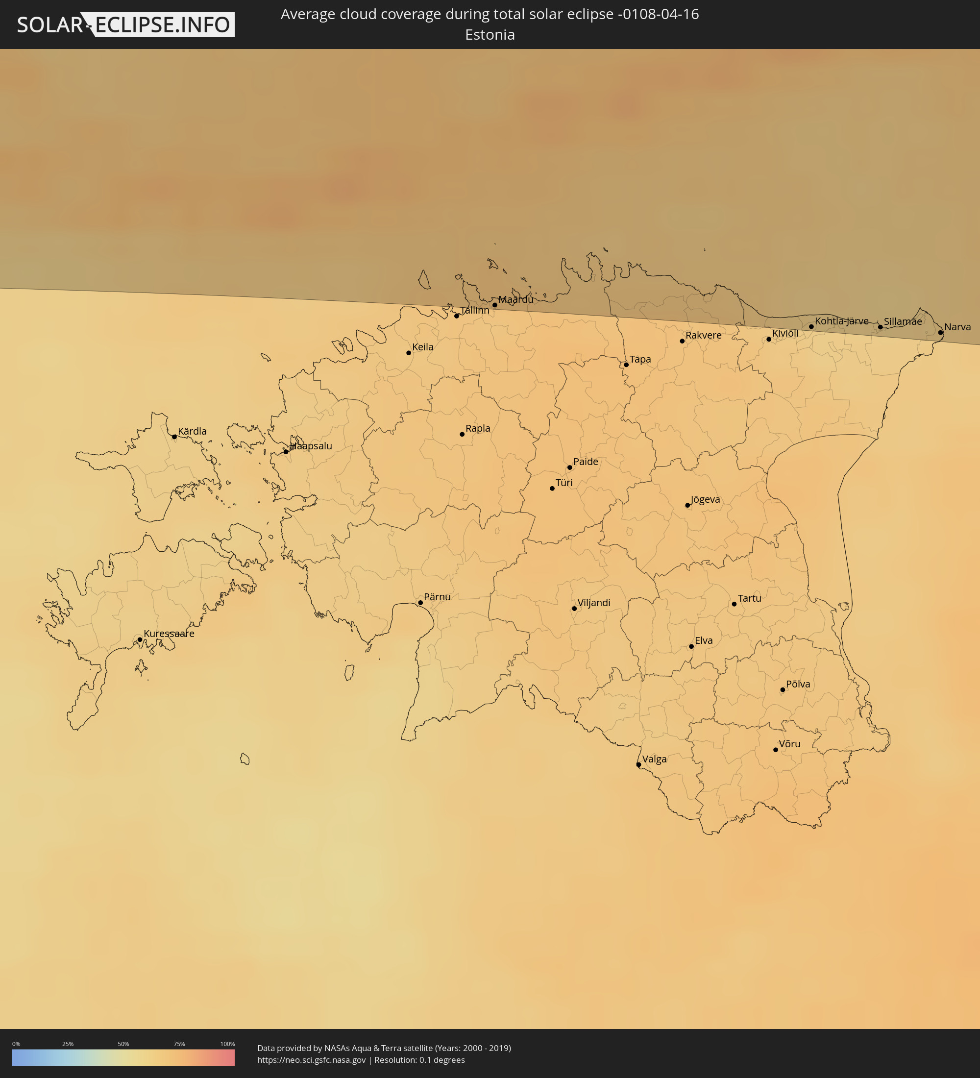 Estonia
Cities inside the path of the eclipse
The following table shows all locations with a population of more than 5,000 inside the eclipse path. Cities which have more than 100,000 inhabitants are marked bold. A click at the locations opens a detailed map.
| City | Type | Eclipse duration | Local time of max. eclipse | Distance to central line | Ø Cloud coverage |
|
Saltillo, Coahuila
|
total | - | 05:51:53 UTC-06:36 | 17 km | 36% |
|
García, Nuevo León
|
total | - | 05:52:17 UTC-06:36 | 52 km | 43% |
|
Mitras Poniente, Nuevo León
|
total | - | 05:52:13 UTC-06:36 | 45 km | 46% |
|
Monterrey, Nuevo León
|
total | - | 05:52:05 UTC-06:36 | 32 km | 47% |
|
Sabinas Hidalgo, Nuevo León
|
total | - | 05:53:04 UTC-06:36 | 120 km | 45% |
|
Ciénega de Flores, Nuevo León
|
total | - | 05:52:24 UTC-06:36 | 59 km | 44% |
|
Apodaca, Nuevo León
|
total | - | 05:52:09 UTC-06:36 | 38 km | 49% |
|
Fraccionamiento Real Palmas, Nuevo León
|
total | - | 05:52:20 UTC-06:36 | 54 km | 47% |
|
Santiago, Nuevo León
|
total | - | 05:51:45 UTC-06:36 | 1 km | 52% |
|
Juárez, Nuevo León
|
total | - | 05:52:01 UTC-06:36 | 24 km | 53% |
|
Allende, Nuevo León
|
total | - | 05:51:33 UTC-06:36 | 18 km | 54% |
|
Cadereyta, Nuevo León
|
total | - | 05:51:55 UTC-06:36 | 15 km | 53% |
|
Montemorelos, Nuevo León
|
total | - | 05:51:25 UTC-06:36 | 31 km | 50% |
|
Hidalgo, Nuevo León
|
total | - | 05:52:12 UTC-06:36 | 38 km | 52% |
|
Linares, Nuevo León
|
total | - | 05:50:58 UTC-06:36 | 72 km | 51% |
|
Ciudad Miguel Alemán, Tamaulipas
|
total | - | 05:52:48 UTC-06:36 | 86 km | 57% |
|
Camargo, Tamaulipas
|
total | - | 05:52:35 UTC-06:36 | 66 km | 57% |
|
Rio Grande City, Texas
|
total | - | 06:29:21 UTC-06:00 | 79 km | 57% |
|
Ciudad Díaz Ordaz, Tamaulipas
|
total | - | 05:52:32 UTC-06:36 | 58 km | 57% |
|
Reynosa, Tamaulipas
|
total | - | 05:52:19 UTC-06:36 | 36 km | 62% |
|
McAllen, Texas
|
total | - | 06:29:04 UTC-06:00 | 48 km | 66% |
|
San Fernando, Tamaulipas
|
total | - | 05:50:46 UTC-06:36 | 102 km | 62% |
|
Río Bravo, Tamaulipas
|
total | - | 05:52:11 UTC-06:36 | 21 km | 66% |
|
Weslaco, Texas
|
total | - | 06:28:59 UTC-06:00 | 38 km | 69% |
|
Valle Hermoso, Tamaulipas
|
total | - | 05:51:45 UTC-06:36 | 19 km | 66% |
|
Harlingen, Texas
|
total | - | 06:29:00 UTC-06:00 | 35 km | 68% |
|
Heroica Matamoros, Tamaulipas
|
total | - | 05:51:59 UTC-06:36 | 3 km | 70% |
|
Brownsville, Texas
|
total | - | 06:28:37 UTC-06:00 | 0 km | 70% |
|
Panama City, Florida
|
total | - | 06:35:30 UTC-06:00 | 136 km | 48% |
|
Tallahassee, Florida
|
total | - | 07:36:20 UTC-05:00 | 119 km | 50% |
|
Valdosta, Georgia
|
total | - | 07:37:16 UTC-05:00 | 126 km | 51% |
|
Waycross, Georgia
|
total | - | 07:38:11 UTC-05:00 | 132 km | 59% |
|
Gainesville, Florida
|
total | - | 07:35:48 UTC-05:00 | 30 km | 55% |
|
Ocala, Florida
|
total | - | 07:35:10 UTC-05:00 | 85 km | 57% |
|
The Villages, Florida
|
total | - | 07:34:51 UTC-05:00 | 118 km | 55% |
|
Leesburg, Florida
|
total | - | 07:34:42 UTC-05:00 | 133 km | 54% |
|
Lakeside, Florida
|
total | - | 07:36:45 UTC-05:00 | 1 km | 53% |
|
Kingsland, Georgia
|
total | - | 07:37:48 UTC-05:00 | 65 km | 56% |
|
Eustis, Florida
|
total | - | 07:34:50 UTC-05:00 | 136 km | 54% |
|
Jacksonville, Florida
|
total | - | 07:37:06 UTC-05:00 | 16 km | 52% |
|
St. Marys, Georgia
|
total | - | 07:37:45 UTC-05:00 | 53 km | 48% |
|
Brunswick, Georgia
|
total | - | 07:38:26 UTC-05:00 | 94 km | 56% |
|
Ponte Vedra Beach, Florida
|
total | - | 07:37:04 UTC-05:00 | 3 km | 44% |
|
DeLand, Florida
|
total | - | 07:35:15 UTC-05:00 | 131 km | 60% |
|
Palm Coast, Florida
|
total | - | 07:36:08 UTC-05:00 | 77 km | 48% |
|
Daytona Beach, Florida
|
total | - | 07:35:38 UTC-05:00 | 123 km | 50% |
|
Isle of Lewis, Scotland
|
total | - | 14:36:07 UTC+00:00 | 101 km | 78% |
|
Stornoway, Scotland
|
total | - | 14:36:07 UTC+00:00 | 102 km | 78% |
|
Thurso, Scotland
|
total | - | 14:38:37 UTC+00:00 | 100 km | 78% |
|
Wick, Scotland
|
total | - | 14:39:07 UTC+00:00 | 122 km | 82% |
|
Orkney, Scotland
|
total | - | 14:38:53 UTC+00:00 | 64 km | 80% |
|
Kirkwall, Scotland
|
total | - | 14:38:53 UTC+00:00 | 64 km | 80% |
|
Lerwick, Scotland
|
total | - | 14:39:39 UTC+00:00 | 42 km | 81% |
|
Shetland, Scotland
|
total | - | 14:39:39 UTC+00:00 | 42 km | 81% |
|
Haugesund, Rogaland
|
total | - | 15:45:22 UTC+01:00 | 98 km | 64% |
|
Bergen, Hordaland
|
total | - | 15:44:31 UTC+01:00 | 10 km | 70% |
|
Leirvik, Hordaland
|
total | - | 15:45:13 UTC+01:00 | 59 km | 70% |
|
Førde, Sogn og Fjordane
|
total | - | 15:43:55 UTC+01:00 | 123 km | 82% |
|
Notodden, Telemark
|
total | - | 15:48:05 UTC+01:00 | 106 km | 73% |
|
Kongsberg, Buskerud
|
total | - | 15:48:14 UTC+01:00 | 96 km | 75% |
|
Drammen, Buskerud
|
total | - | 15:48:32 UTC+01:00 | 90 km | 74% |
|
Hønefoss, Buskerud
|
total | - | 15:48:08 UTC+01:00 | 43 km | 72% |
|
Lillehammer, Oppland
|
total | - | 15:47:17 UTC+01:00 | 61 km | 80% |
|
Moss, Østfold
|
total | - | 15:49:09 UTC+01:00 | 126 km | 70% |
|
Nesoddtangen, Akershus
|
total | - | 15:48:43 UTC+01:00 | 79 km | 73% |
|
Gjøvik, Oppland
|
total | - | 15:47:46 UTC+01:00 | 25 km | 76% |
|
Oslo, Oslo
|
total | - | 15:48:43 UTC+01:00 | 73 km | 73% |
|
Ås, Akershus
|
total | - | 15:49:00 UTC+01:00 | 101 km | 74% |
|
Ski, Akershus
|
total | - | 15:48:58 UTC+01:00 | 95 km | 74% |
|
Brumunddal, Hedmark
|
total | - | 15:47:50 UTC+01:00 | 33 km | 78% |
|
Lillestrøm, Akershus
|
total | - | 15:48:52 UTC+01:00 | 70 km | 73% |
|
Hamar, Hedmark
|
total | - | 15:48:00 UTC+01:00 | 23 km | 72% |
|
Askim, Østfold
|
total | - | 15:49:19 UTC+01:00 | 112 km | 73% |
|
Jessheim, Akershus
|
total | - | 15:48:45 UTC+01:00 | 50 km | 74% |
|
Råholt, Akershus
|
total | - | 15:48:37 UTC+01:00 | 35 km | 73% |
|
Elverum, Hedmark
|
total | - | 15:48:12 UTC+01:00 | 31 km | 76% |
|
Kongsvinger, Hedmark
|
total | - | 15:49:13 UTC+01:00 | 47 km | 72% |
|
Arvika, Värmland
|
total | - | 15:50:08 UTC+01:00 | 108 km | 69% |
|
Kil, Värmland
|
total | - | 15:50:45 UTC+01:00 | 128 km | 66% |
|
Mora, Dalarna
|
total | - | 15:49:48 UTC+01:00 | 37 km | 72% |
|
Ludvika, Dalarna
|
total | - | 15:51:08 UTC+01:00 | 60 km | 65% |
|
Lindesberg, Örebro
|
total | - | 15:51:46 UTC+01:00 | 122 km | 64% |
|
Borlänge, Dalarna
|
total | - | 15:50:53 UTC+01:00 | 23 km | 66% |
|
Falun, Dalarna
|
total | - | 15:50:51 UTC+01:00 | 10 km | 66% |
|
Fagersta, Västmanland
|
total | - | 15:51:37 UTC+01:00 | 77 km | 67% |
|
Avesta, Dalarna
|
total | - | 15:51:40 UTC+01:00 | 62 km | 65% |
|
Hallstahammar, Västmanland
|
total | - | 15:52:18 UTC+01:00 | 121 km | 67% |
|
Bollnäs, Gävleborg
|
total | - | 15:50:24 UTC+01:00 | 72 km | 70% |
|
Västerås, Västmanland
|
total | - | 15:52:29 UTC+01:00 | 121 km | 66% |
|
Sala, Västmanland
|
total | - | 15:52:10 UTC+01:00 | 87 km | 66% |
|
Sandviken, Gävleborg
|
total | - | 15:51:27 UTC+01:00 | 9 km | 66% |
|
Söderhamn, Gävleborg
|
total | - | 15:50:48 UTC+01:00 | 67 km | 66% |
|
Enköping, Uppsala
|
total | - | 15:52:44 UTC+01:00 | 119 km | 65% |
|
Hudiksvall, Gävleborg
|
total | - | 15:50:19 UTC+01:00 | 114 km | 68% |
|
Gävle, Gävleborg
|
total | - | 15:51:34 UTC+01:00 | 3 km | 63% |
|
Bålsta, Uppsala
|
total | - | 15:53:03 UTC+01:00 | 127 km | 65% |
|
Uppsala, Uppsala
|
total | - | 15:52:47 UTC+01:00 | 94 km | 63% |
|
Sävja, Uppsala
|
total | - | 15:52:51 UTC+01:00 | 99 km | 63% |
|
Märsta, Stockholm
|
total | - | 15:53:10 UTC+01:00 | 121 km | 64% |
|
Norrtälje, Stockholm
|
total | - | 15:53:26 UTC+01:00 | 106 km | 62% |
|
Mariehamn, Mariehamns stad
|
total | - | 16:33:27 UTC+01:39 | 67 km | 68% |
|
Rauma, Satakunta
|
total | - | 16:32:55 UTC+01:39 | 49 km | 59% |
|
Pori, Satakunta
|
total | - | 16:32:35 UTC+01:39 | 90 km | 59% |
|
Turku, Southwest Finland
|
total | - | 16:34:04 UTC+01:39 | 24 km | 65% |
|
Salo, Southwest Finland
|
total | - | 16:34:30 UTC+01:39 | 30 km | 68% |
|
Nokia, Pirkanmaa
|
total | - | 16:33:18 UTC+01:39 | 92 km | 71% |
|
Tampere, Pirkanmaa
|
total | - | 16:33:22 UTC+01:39 | 96 km | 70% |
|
Lohja, Uusimaa
|
total | - | 16:35:03 UTC+01:39 | 42 km | 71% |
|
Kangasala, Pirkanmaa
|
total | - | 16:33:32 UTC+01:39 | 93 km | 75% |
|
Vihti, Uusimaa
|
total | - | 16:34:56 UTC+01:39 | 23 km | 72% |
|
Hämeenlinna, Häme
|
total | - | 16:34:16 UTC+01:39 | 42 km | 72% |
|
Espoo, Uusimaa
|
total | - | 16:35:20 UTC+01:39 | 45 km | 73% |
|
Nurmijärvi, Uusimaa
|
total | - | 16:35:04 UTC+01:39 | 16 km | 70% |
|
Hyvinge, Uusimaa
|
total | - | 16:34:52 UTC+01:39 | 3 km | 71% |
|
Helsinki, Uusimaa
|
total | - | 16:35:29 UTC+01:39 | 48 km | 72% |
|
Maardu, Harjumaa
|
total | - | 16:35:34 UTC+01:39 | 125 km | 67% |
|
Vantaa, Uusimaa
|
total | - | 16:35:22 UTC+01:39 | 34 km | 68% |
|
Järvenpää, Uusimaa
|
total | - | 16:35:10 UTC+01:39 | 14 km | 69% |
|
Lahti, Päijänne Tavastia
|
total | - | 16:34:43 UTC+01:39 | 45 km | 71% |
|
Porvoo, Uusimaa
|
total | - | 16:35:28 UTC+01:39 | 21 km | 73% |
|
Kouvola, Kymenlaakso
|
total | - | 16:35:14 UTC+01:39 | 36 km | 69% |
|
Kotka, Kymenlaakso
|
total | - | 16:35:49 UTC+01:39 | 8 km | 75% |
|
Hamina, Kymenlaakso
|
total | - | 16:35:47 UTC+01:39 | 5 km | 76% |
|
Kohtla-Järve, Ida-Virumaa
|
total | - | 16:36:29 UTC+01:39 | 125 km | 62% |
|
Sillamäe, Ida-Virumaa
|
total | - | 16:36:39 UTC+01:39 | 122 km | 63% |
|
Lappeenranta, South Karelia
|
total | - | 16:35:28 UTC+01:39 | 64 km | 77% |
|
Narva, Ida-Virumaa
|
total | - | 16:36:49 UTC+01:39 | 123 km | 63% |
|
Kingisepp, Leningradskaya Oblast'
|
total | - | 17:28:14 UTC+02:30 | 121 km | 65% |
|
Imatra, South Karelia
|
total | - | 16:35:30 UTC+01:39 | 79 km | 79% |
|
Vyborg, Leningradskaya Oblast'
|
total | - | 17:26:34 UTC+02:30 | 28 km | 75% |
|
Sosnovyy Bor, Leningradskaya Oblast'
|
total | - | 17:27:42 UTC+02:30 | 60 km | 69% |
|
Peterhof, St.-Petersburg
|
total | - | 17:27:58 UTC+02:30 | 57 km | 69% |
|
Kurortnyy, Leningradskaya Oblast'
|
total | - | 17:27:37 UTC+02:30 | 26 km | 74% |
|
Gatchina, Leningradskaya Oblast'
|
total | - | 17:28:26 UTC+02:30 | 90 km | 71% |
|
Saint Petersburg, St.-Petersburg
|
total | - | 17:28:01 UTC+02:30 | 49 km | 72% |
|
Kolpino, St.-Petersburg
|
total | - | 17:28:20 UTC+02:30 | 68 km | 71% |
|
Vsevolozhsk, Leningradskaya Oblast'
|
total | - | 17:28:01 UTC+02:30 | 38 km | 72% |
|
Kirishi, Leningradskaya Oblast'
|
total | - | 17:29:06 UTC+02:30 | 92 km | 74% |
|
Volkhov, Leningradskaya Oblast'
|
total | - | 17:28:34 UTC+02:30 | 37 km | 77% |
|
Tikhvin, Leningradskaya Oblast'
|
total | - | 17:29:13 UTC+02:30 | 59 km | 78% |
|
Cherepovets, Vologda
|
total | - | 17:30:42 UTC+02:30 | 78 km | 77% |
|
Vologda, Vologda
|
total | - | 17:30:50 UTC+02:30 | 49 km | 82% |
|
Kirov, Kirov
|
total | - | 17:31:57 UTC+02:30 | 4 km | 79% |
|
Kirovo-Chepetsk, Kirov
|
total | - | 17:31:59 UTC+02:30 | 5 km | 81% |
|
Glazov, Udmurtiya
|
total | - | 18:22:21 UTC+03:20 | 0 km | 74% |
|
Votkinsk, Udmurtiya
|
total | - | 18:23:31 UTC+03:20 | 96 km | 75% |
|
Krasnokamsk, Perm
|
total | - | 19:04:16 UTC+04:02 | 43 km | 72% |
|
Perm, Perm
|
total | - | 19:04:16 UTC+04:02 | 44 km | 74% |
|
Kungur, Perm
|
total | - | 19:04:50 UTC+04:02 | 5 km | 81% |
|
Lys’va, Perm
|
total | - | 19:03:54 UTC+04:02 | 81 km | 79% |
|
Chusovoy, Perm
|
total | - | 19:03:40 UTC+04:02 | 102 km | 78% |