Hybrid solar eclipse of 06/17/-0157
| Day of week: | Thursday |
| Maximum duration of eclipse: | 01m00s |
| Maximum width of eclipse path: | 48 km |
| Saros cycle: | 73 |
| Coverage: | 100% |
| Magnitude: | 1.0121 |
| Gamma: | 0.4943 |
Wo kann man die Sonnenfinsternis vom 06/17/-0157 sehen?
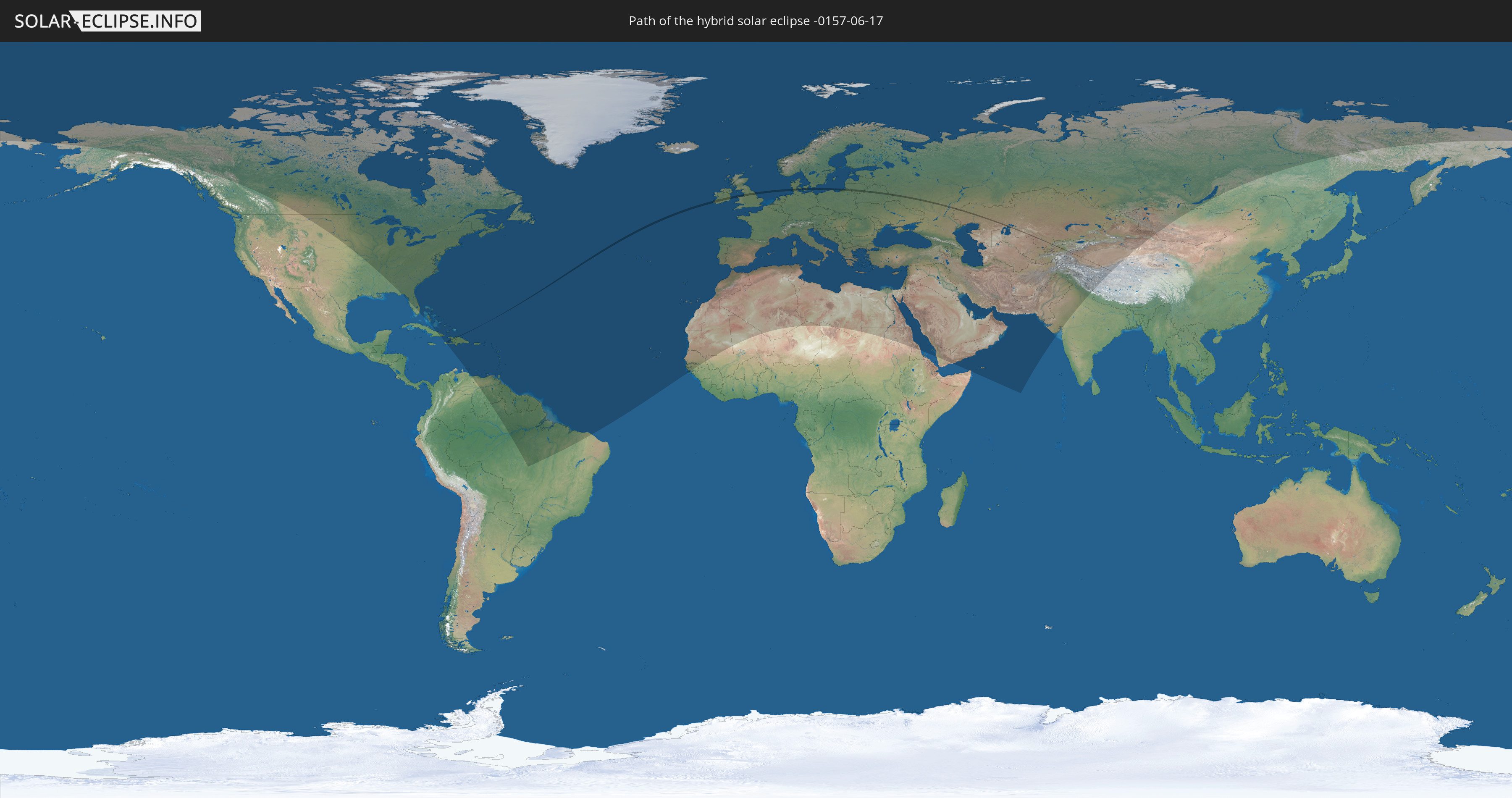
Die Sonnenfinsternis am 06/17/-0157 kann man in 128 Ländern als partielle Sonnenfinsternis beobachten.
Der Finsternispfad verläuft durch 14 Länder. Nur in diesen Ländern ist sie als hybrid Sonnenfinsternis zu sehen.
In den folgenden Ländern ist die Sonnenfinsternis hybrid zu sehen
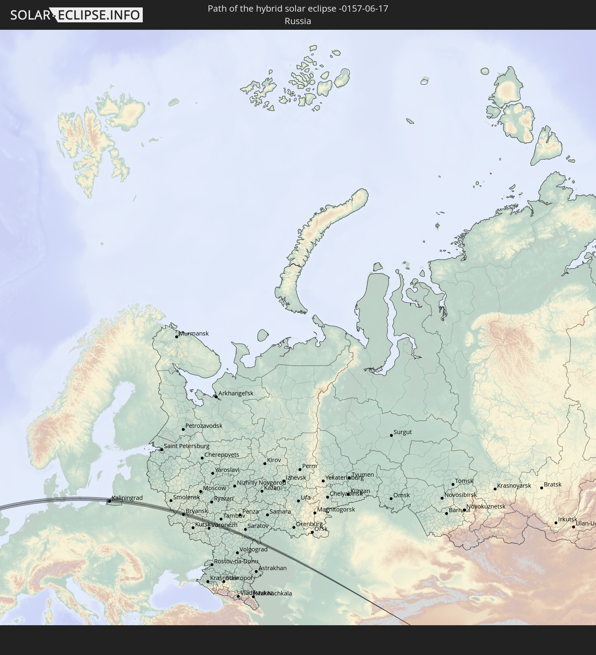 Russia
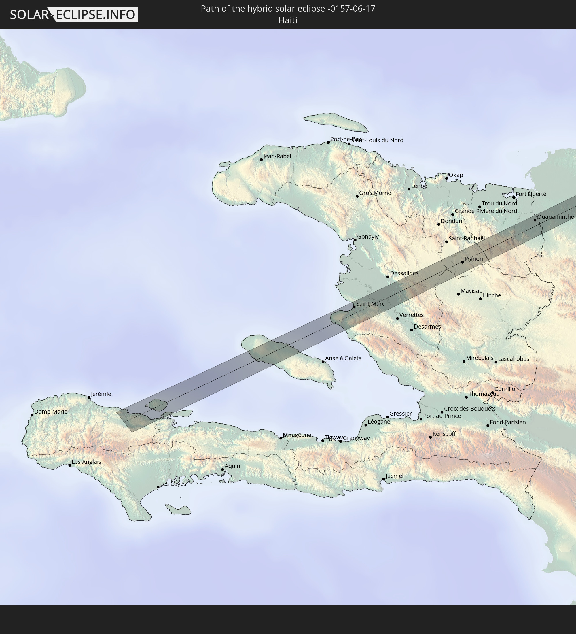 Haiti
Haiti
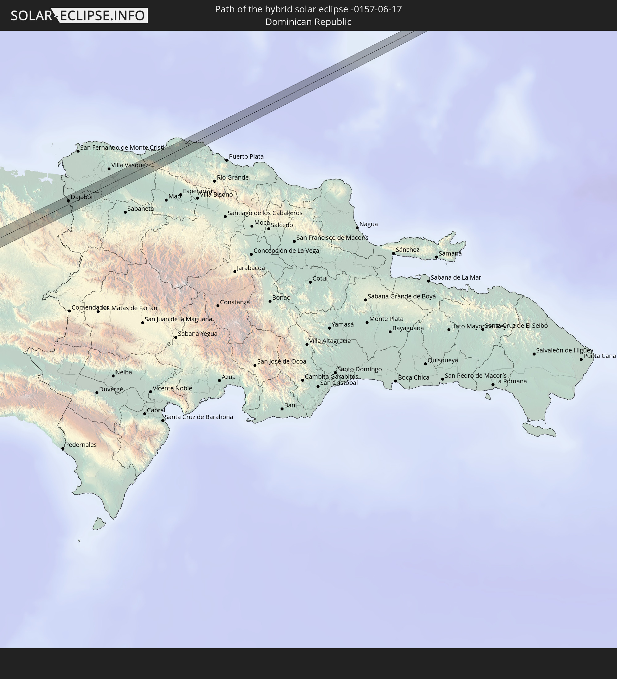 Dominican Republic
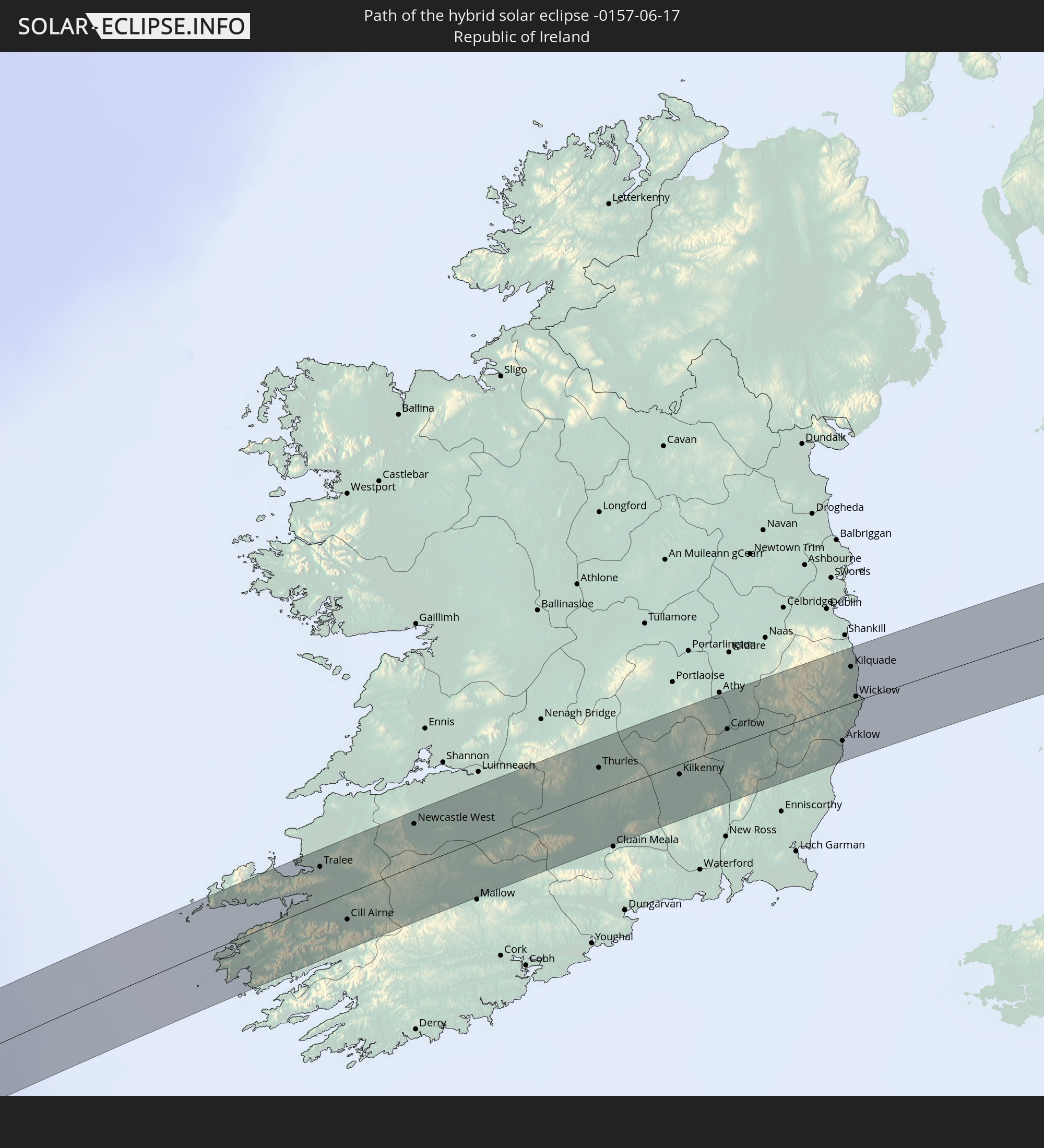 Republic of Ireland
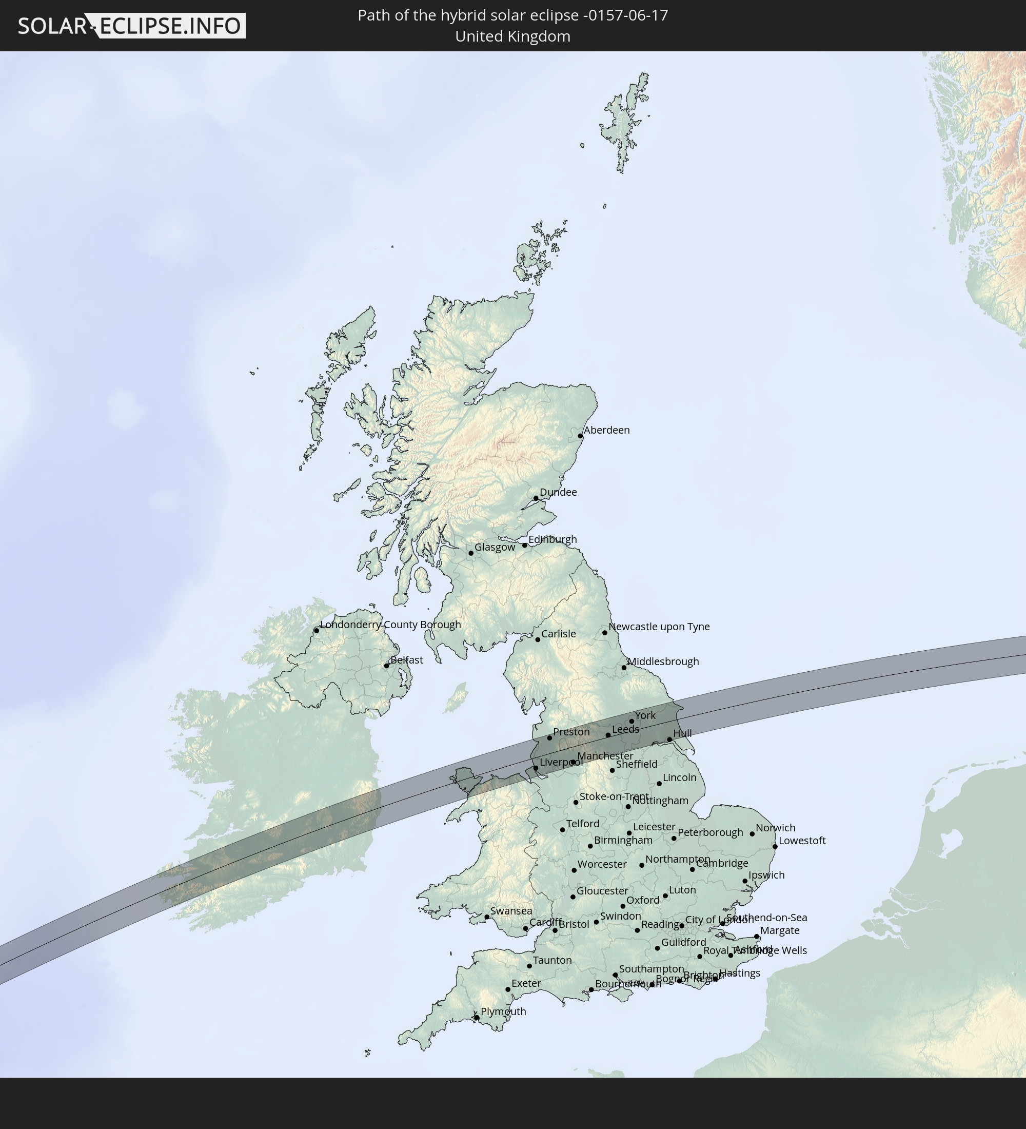 United Kingdom
 Germany
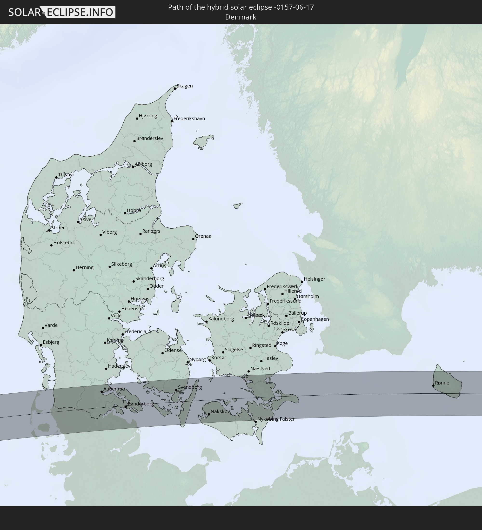 Denmark
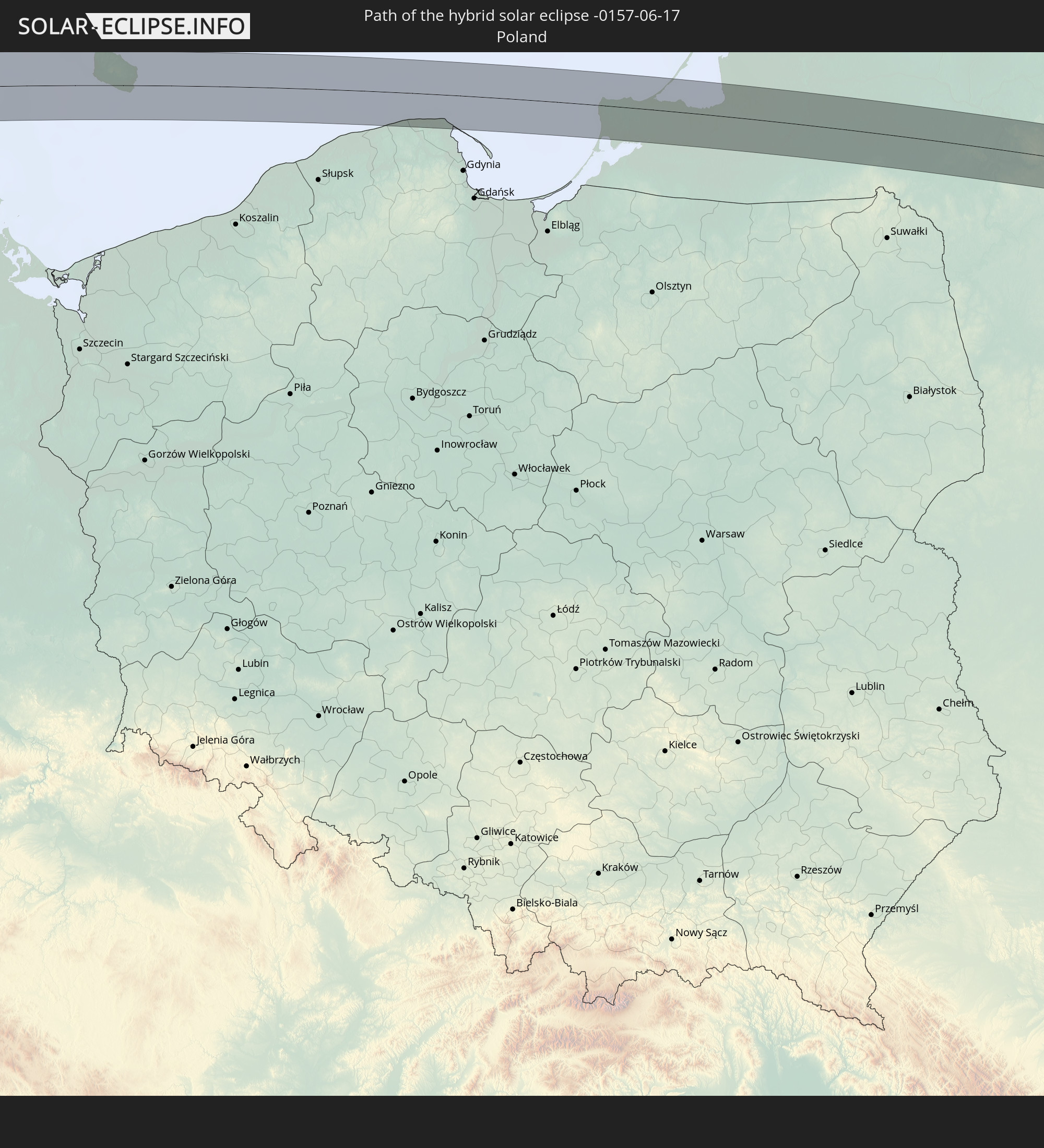 Poland
 Lithuania
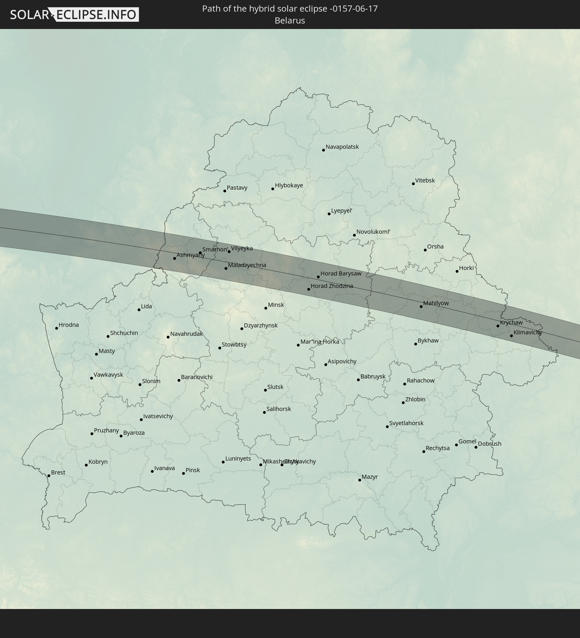 Belarus
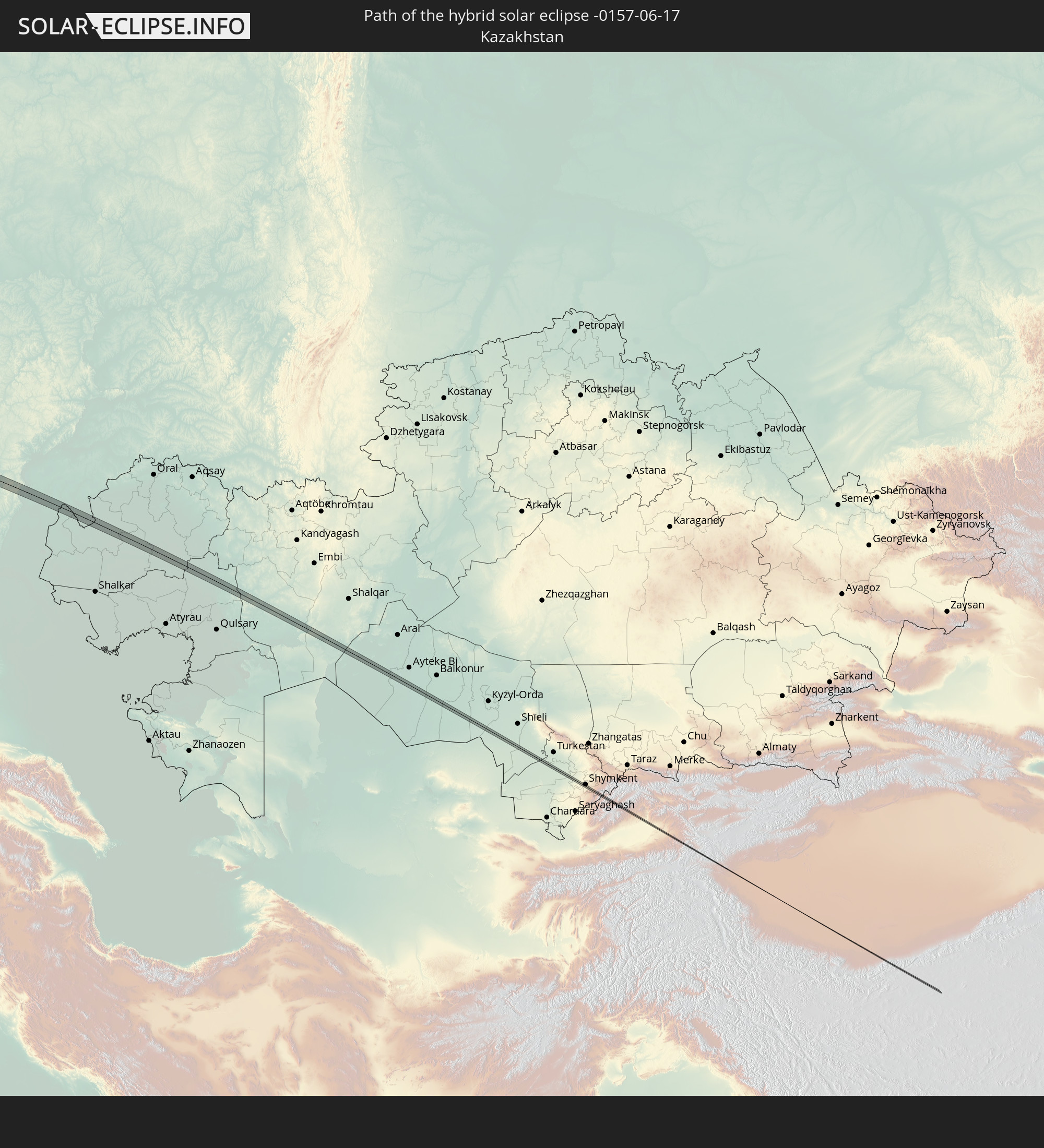 Kazakhstan
 Uzbekistan
 Kyrgyzstan
 China
China
In den folgenden Ländern ist die Sonnenfinsternis partiell zu sehen
 Russia
 United States
 Canada
 Greenland
 Cuba
Cuba
 The Bahamas
 Haiti
Haiti
 Brazil
 Venezuela
 Turks and Caicos Islands
 Dominican Republic
 Puerto Rico
 United States Virgin Islands
 Bermuda
 British Virgin Islands
 Anguilla
 Collectivity of Saint Martin
 Saint Barthélemy
 Saint Kitts and Nevis
 Antigua and Barbuda
 Montserrat
 Trinidad and Tobago
 Guadeloupe
 Grenada
 Dominica
 Saint Vincent and the Grenadines
 Guyana
 Martinique
 Saint Lucia
 Barbados
 Suriname
 Saint Pierre and Miquelon
 French Guiana
 Portugal
 Cabo Verde
 Iceland
 Spain
Spain
 Senegal
 Mauritania
 The Gambia
 Guinea-Bissau
 Morocco
 Mali
Mali
 Republic of Ireland
 Svalbard and Jan Mayen
 Algeria
 United Kingdom
 Faroe Islands
 Gibraltar
 France
 Isle of Man
 Guernsey
 Jersey
 Niger
Niger
 Andorra
 Belgium
 Netherlands
 Norway
 Luxembourg
 Germany
 Switzerland
 Italy
Italy
 Monaco
 Tunisia
 Denmark
 Libya
Libya
 Liechtenstein
 Austria
 Sweden
 Czechia
 San Marino
 Vatican City
 Slovenia
 Chad
Chad
 Croatia
 Poland
 Malta
Malta
 Bosnia and Herzegovina
 Hungary
 Slovakia
 Montenegro
 Serbia
 Albania
 Åland Islands
 Greece
 Romania
 Republic of Macedonia
 Finland
 Lithuania
 Latvia
 Estonia
 Sudan
Sudan
 Ukraine
 Bulgaria
 Belarus
 Egypt
Egypt
 Turkey
 Moldova
 Cyprus
 State of Palestine
 Israel
 Saudi Arabia
 Jordan
 Lebanon
 Syria
Syria
 Eritrea
 Iraq
Iraq
 Georgia
 Somalia
 Yemen
Yemen
 Armenia
 Iran
Iran
 Azerbaijan
 Kazakhstan
 Kuwait
 Bahrain
 Qatar
Qatar
 United Arab Emirates
 Oman
Oman
 Turkmenistan
 Uzbekistan
 Afghanistan
 Pakistan
 Tajikistan
 India
India
 Kyrgyzstan
 China
China
 Mongolia
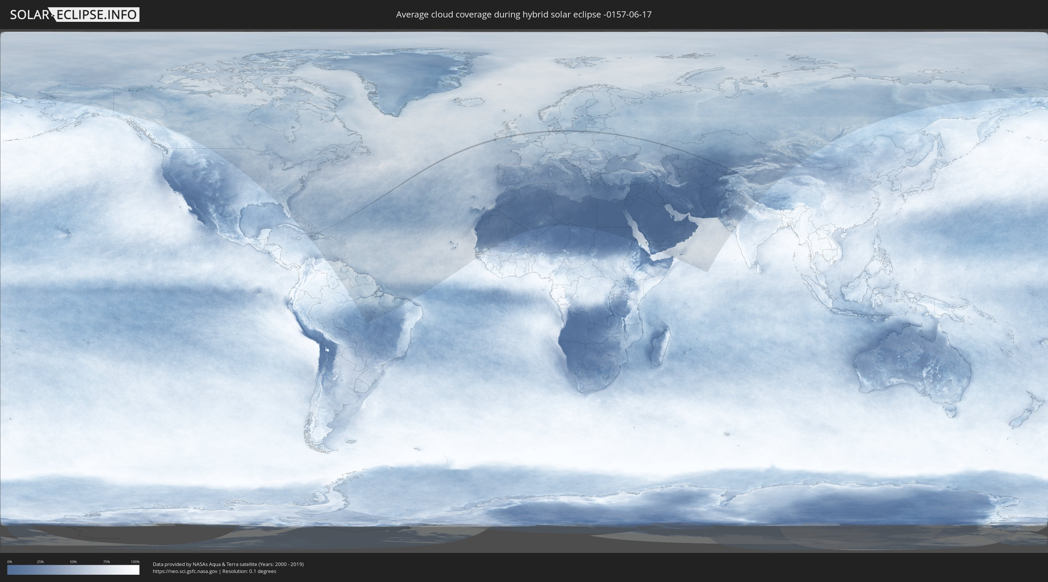
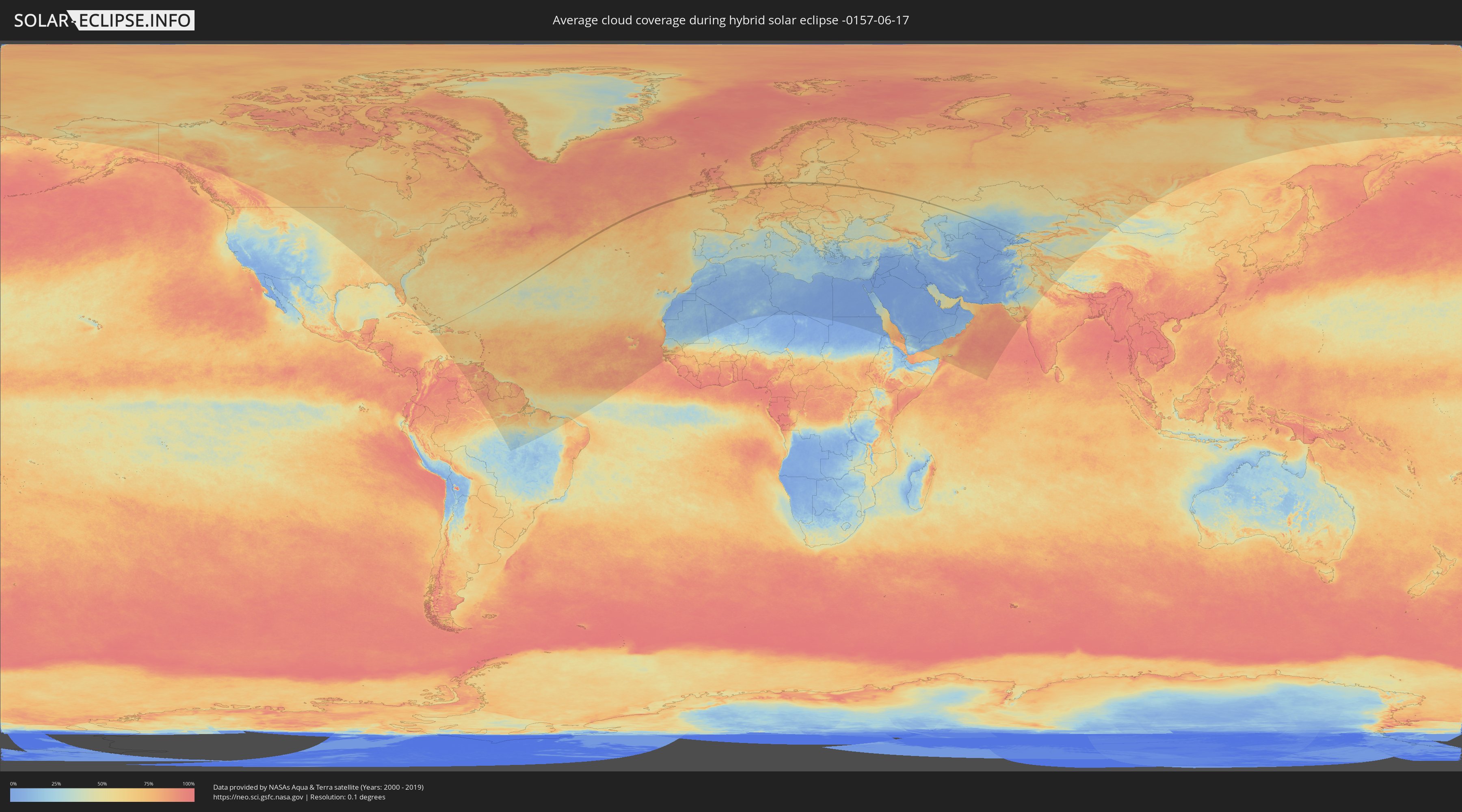
How will be the weather during the hybrid solar eclipse on 06/17/-0157?
Where is the best place to see the hybrid solar eclipse of 06/17/-0157?
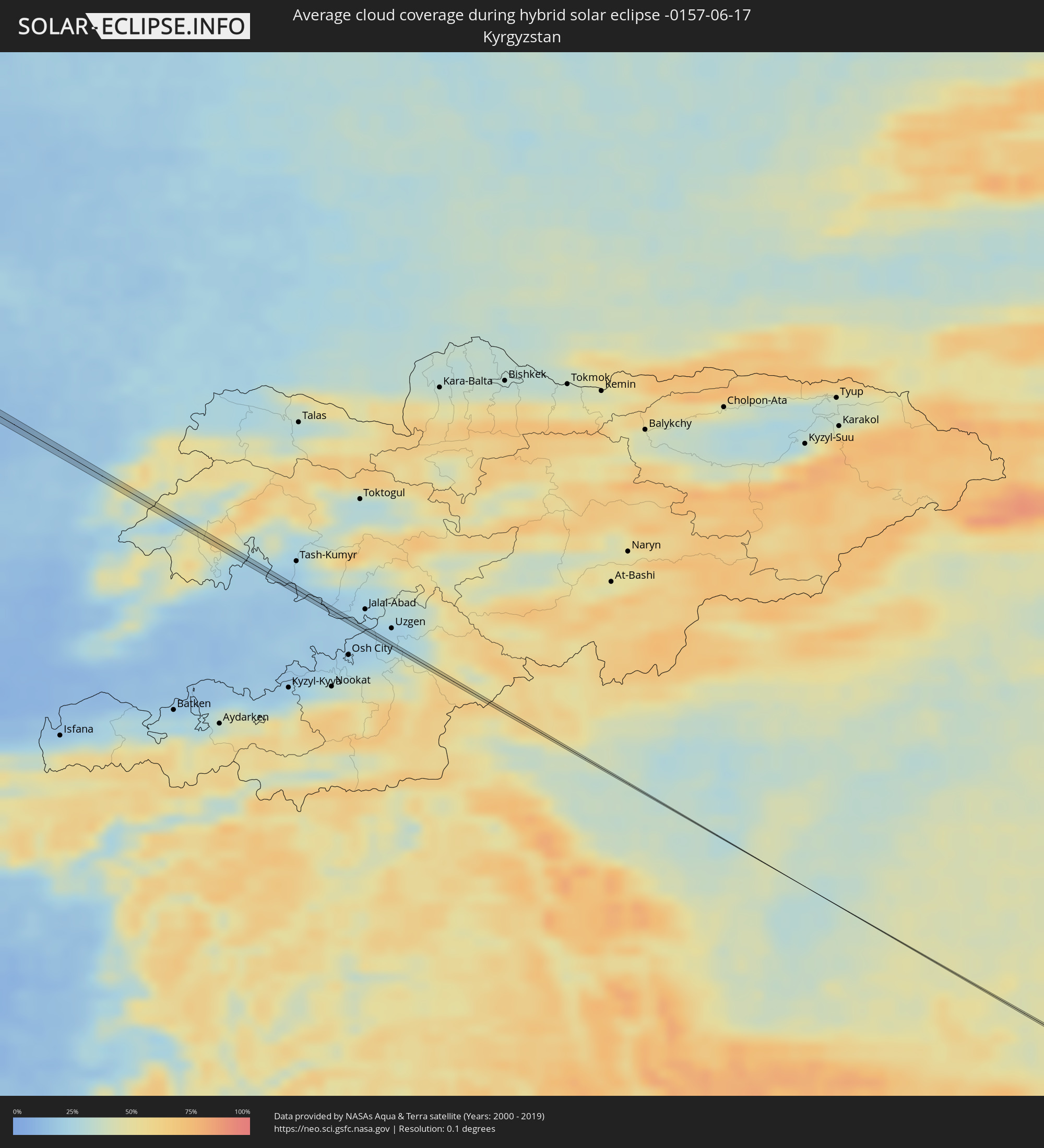
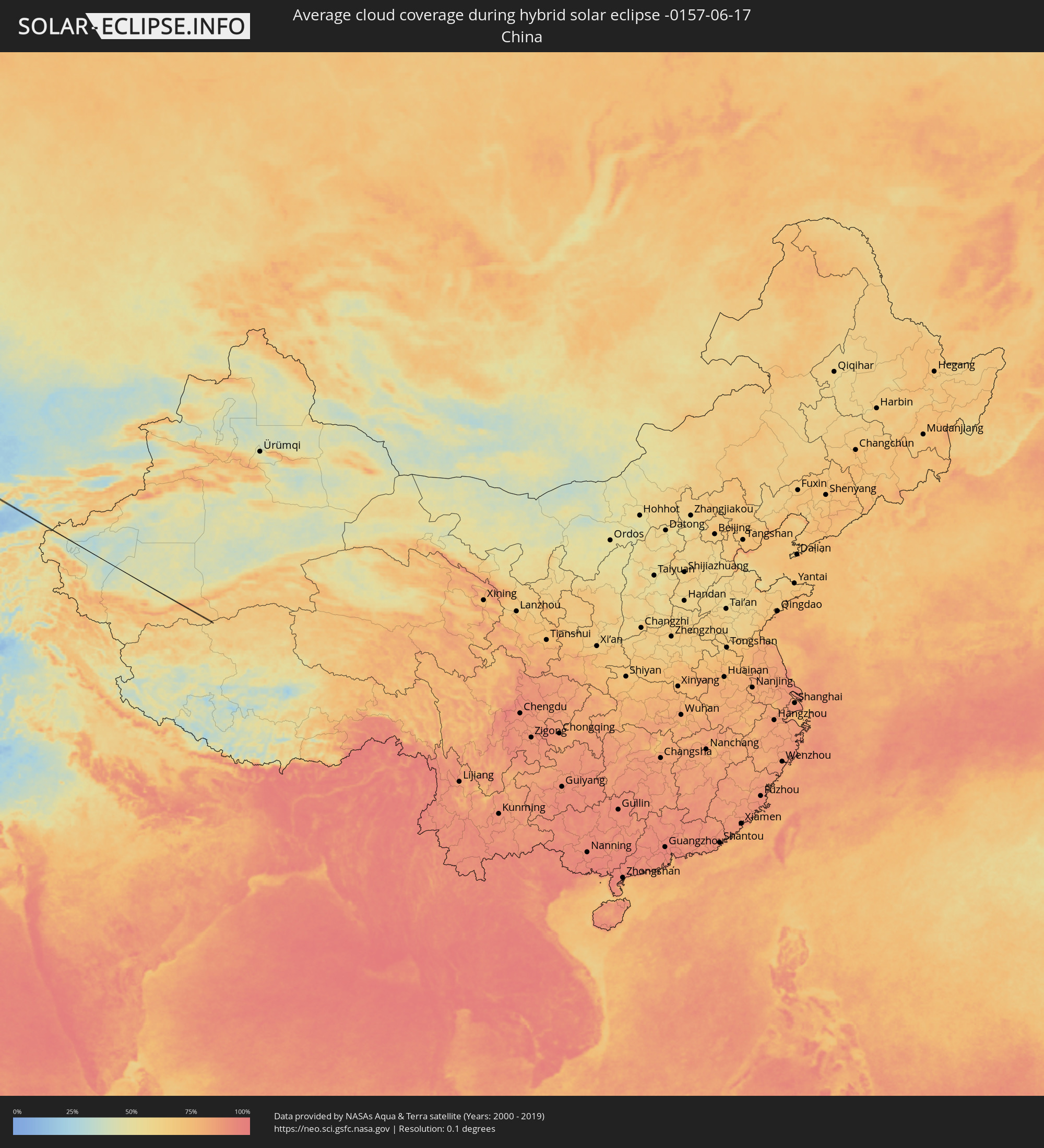
The following maps show the average cloud coverage for the day of the hybrid solar eclipse.
With the help of these maps, it is possible to find the place along the eclipse path, which has the best
chance of a cloudless sky.
Nevertheless, you should consider local circumstances and inform about the weather of your chosen
observation site.
The data is provided by NASAs satellites
AQUA and TERRA.
The cloud maps are averaged over a period of 19 years (2000 - 2019).
Detailed country maps
 Russia
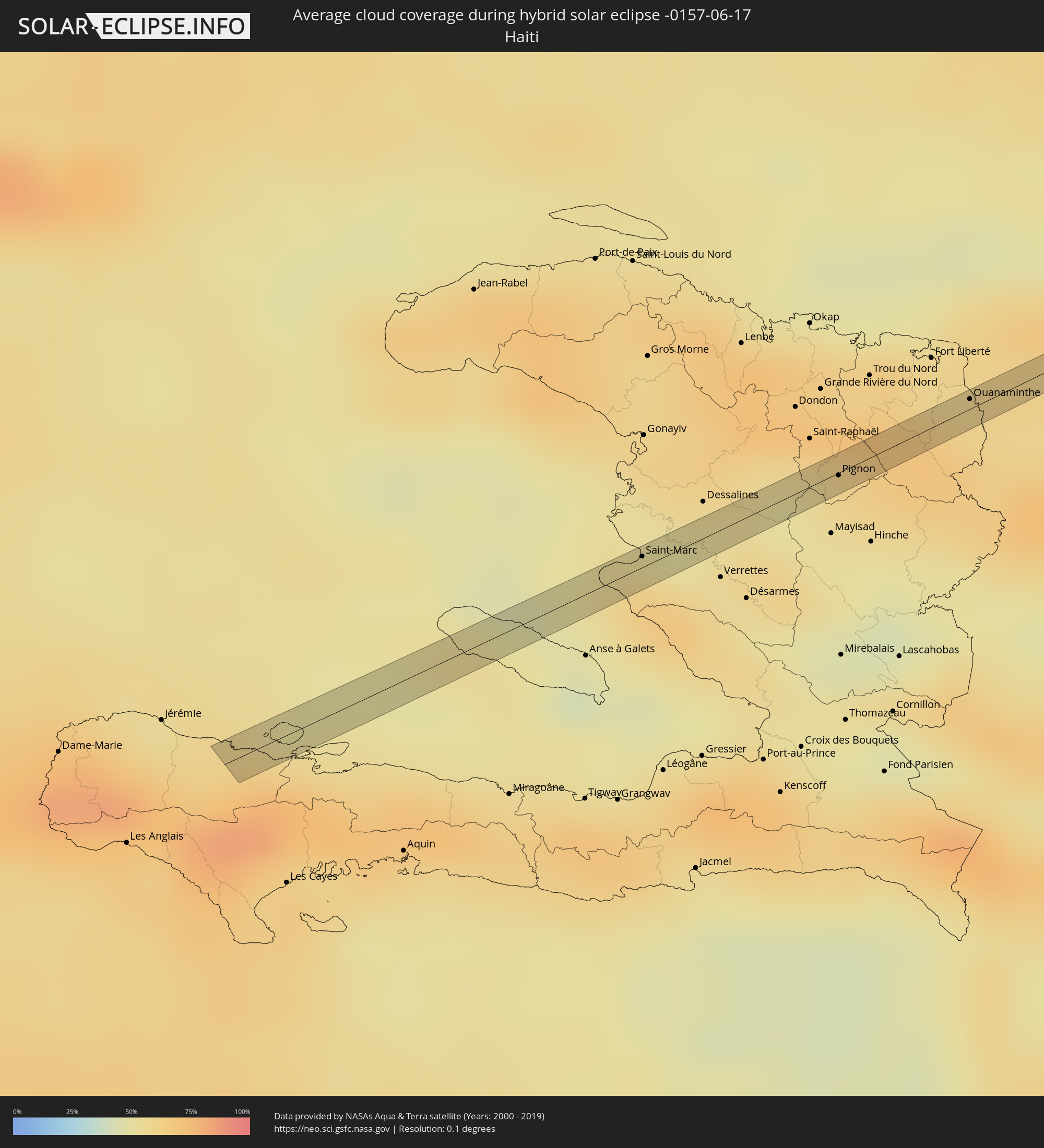 Haiti
Haiti
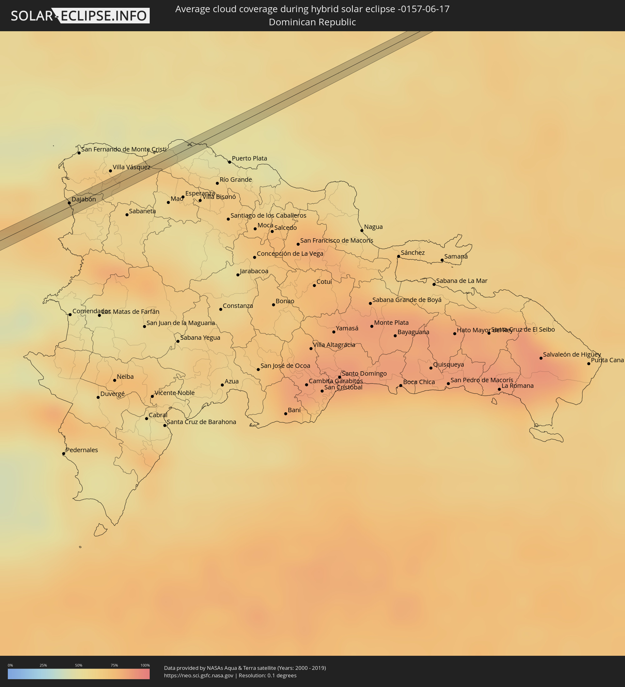 Dominican Republic
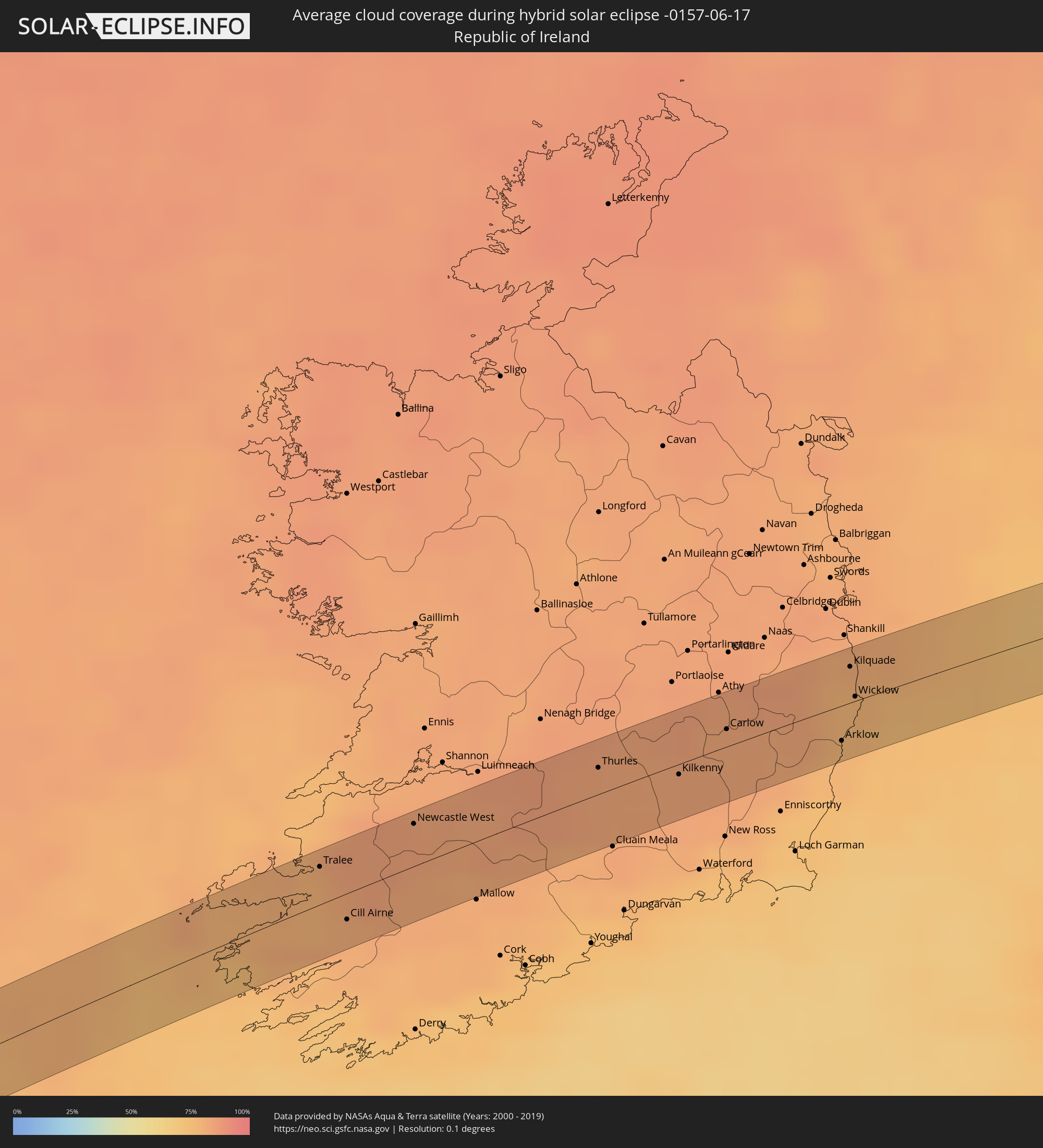 Republic of Ireland
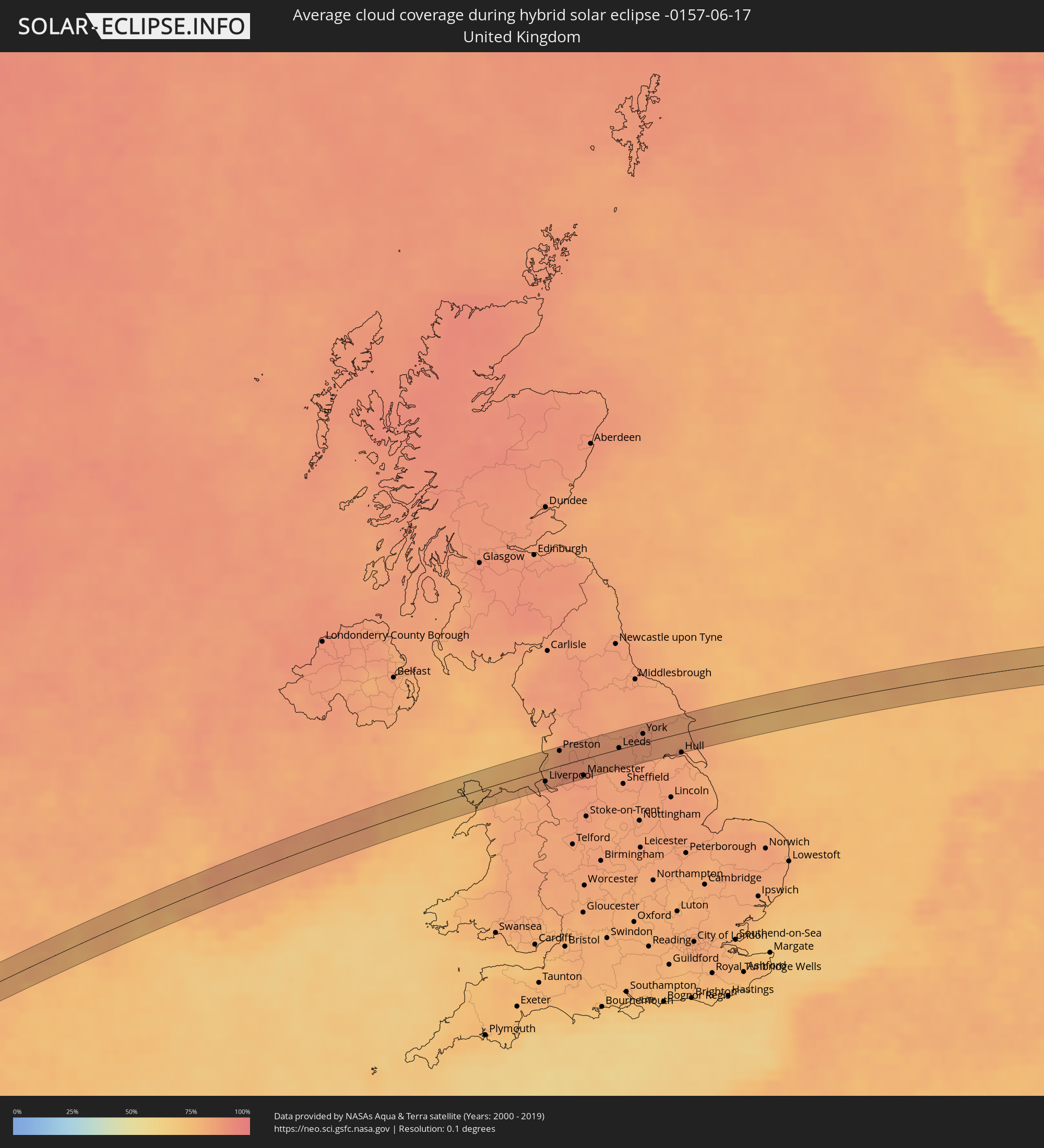 United Kingdom
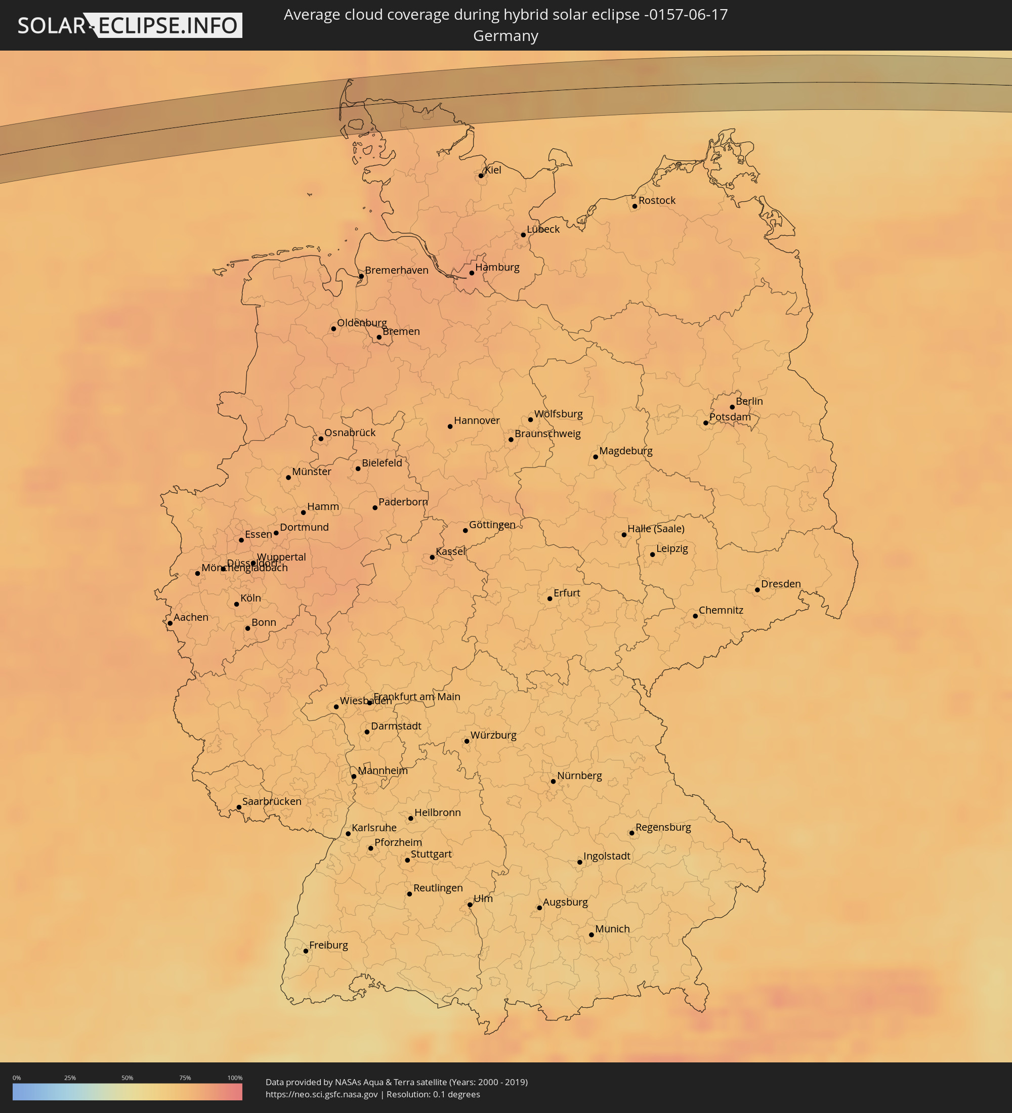 Germany
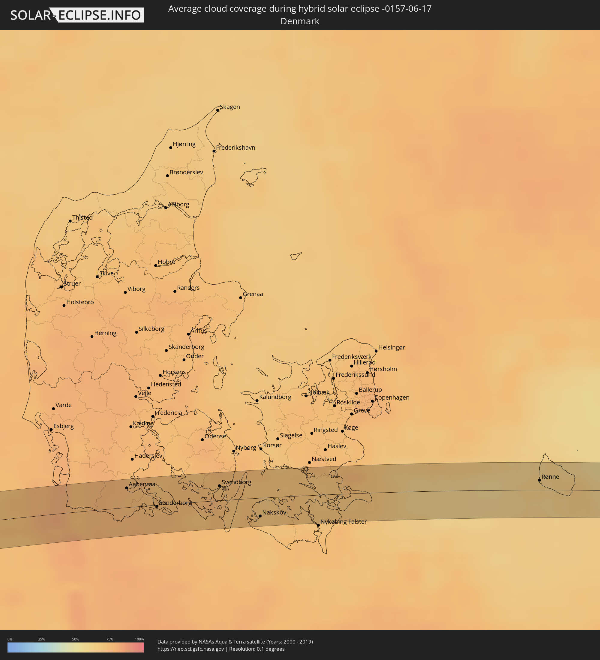 Denmark
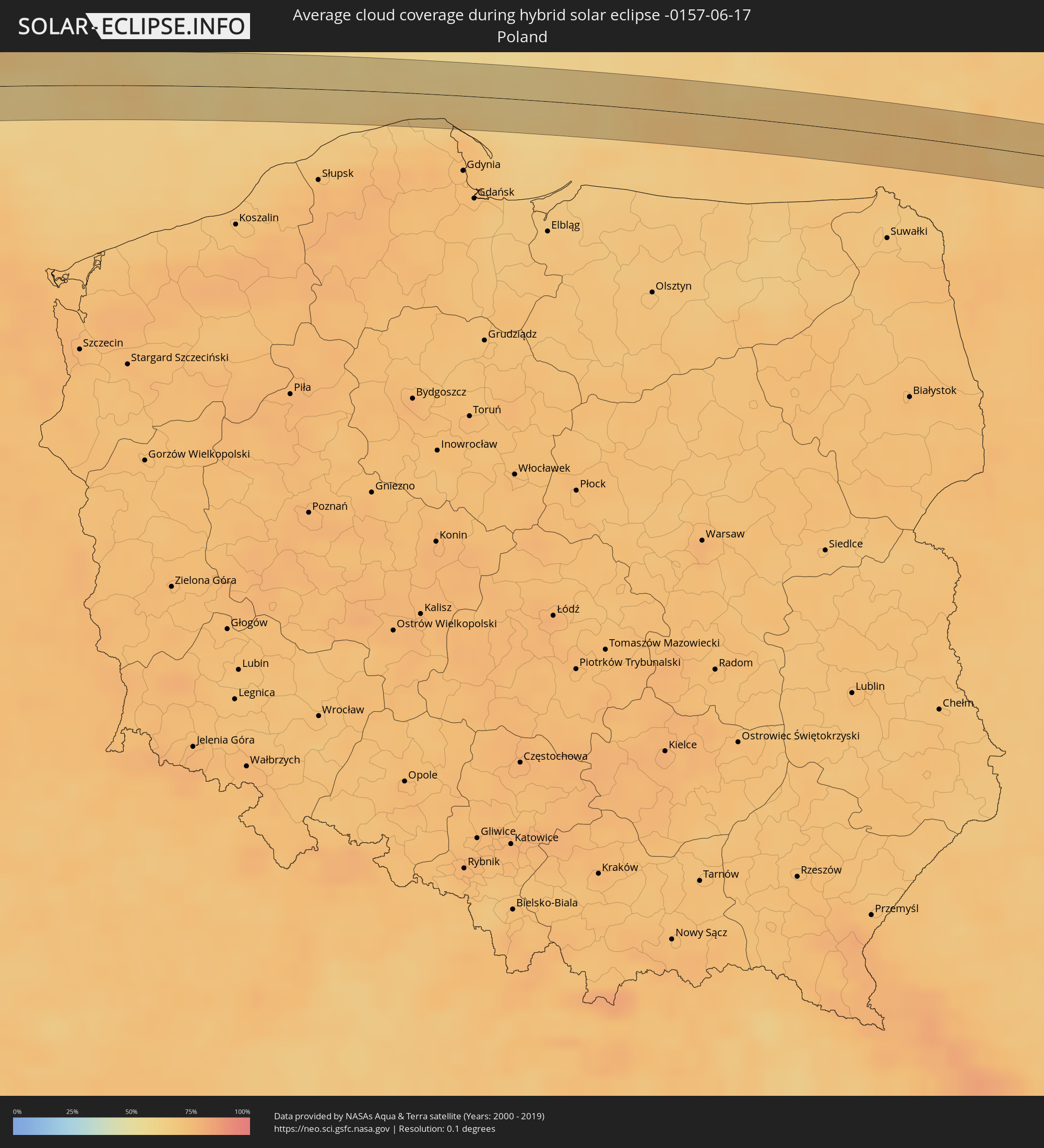 Poland
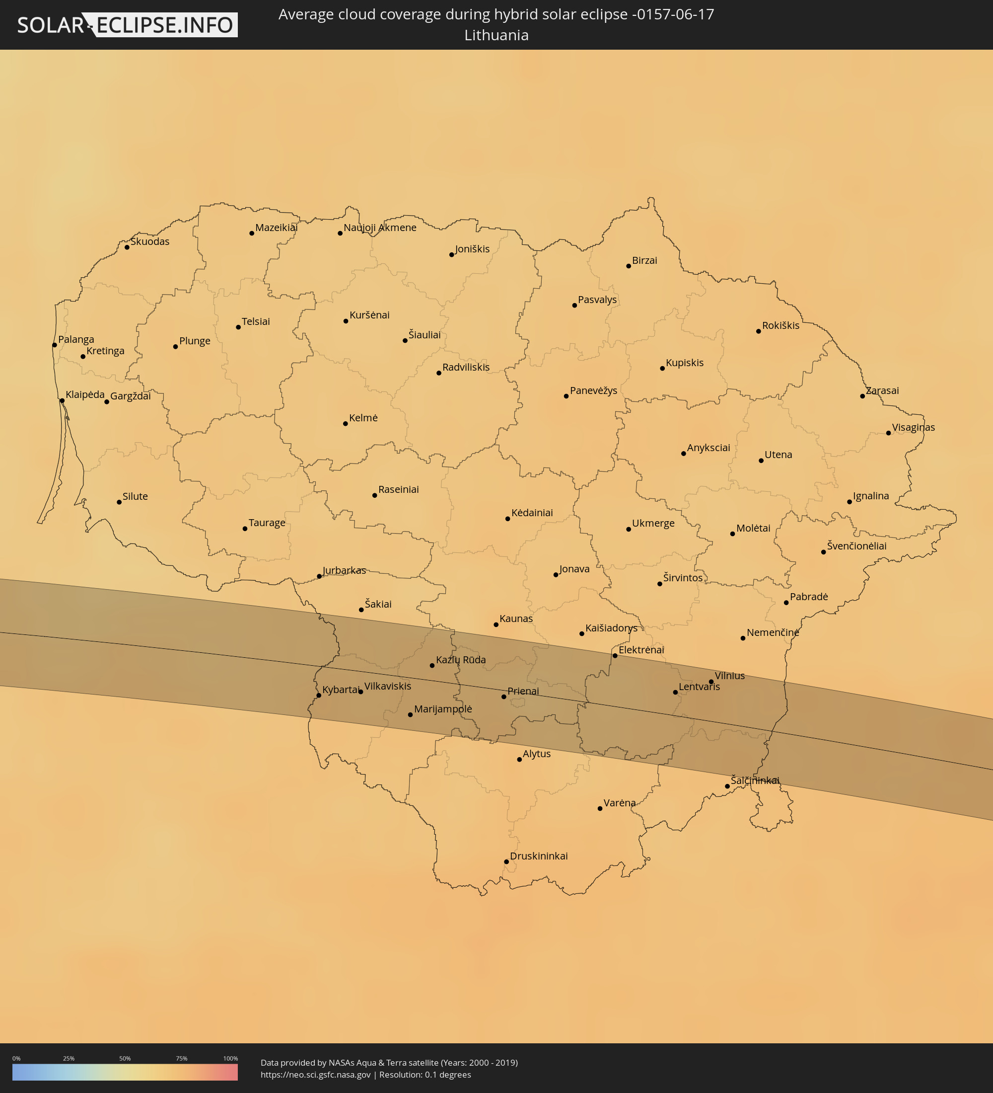 Lithuania
 Belarus
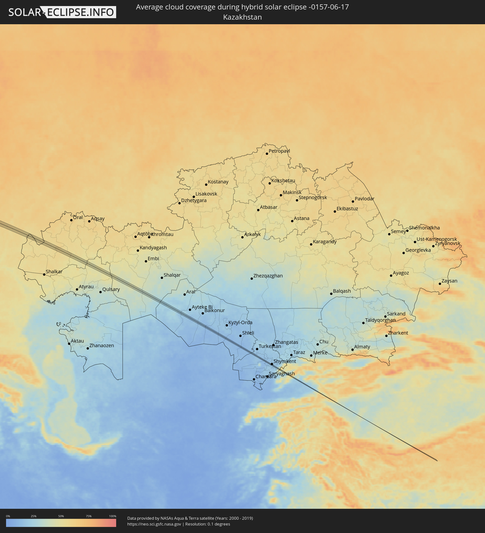 Kazakhstan
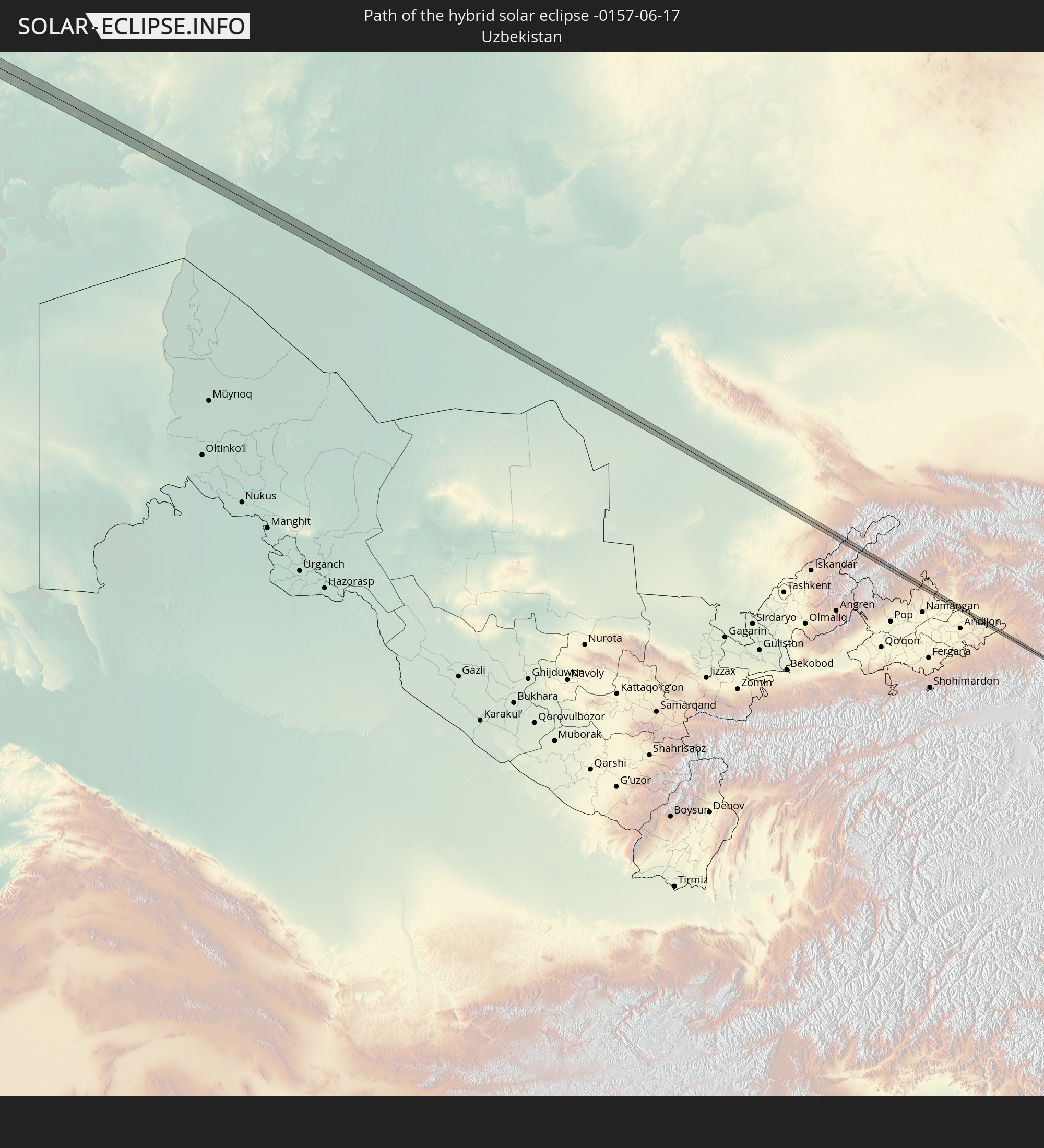
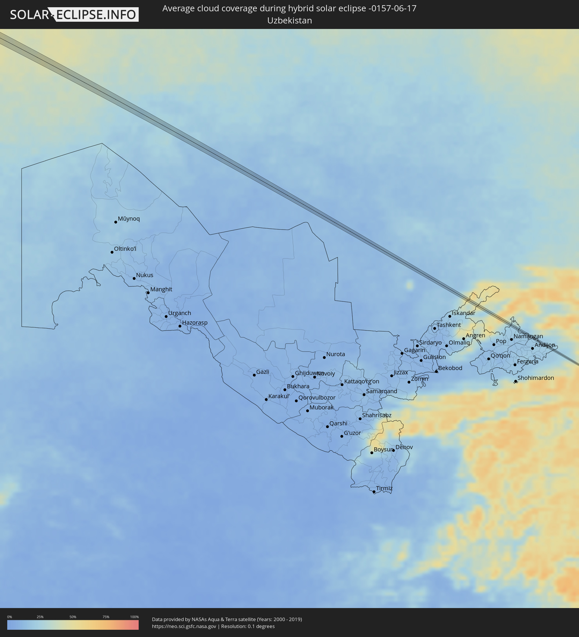 Uzbekistan
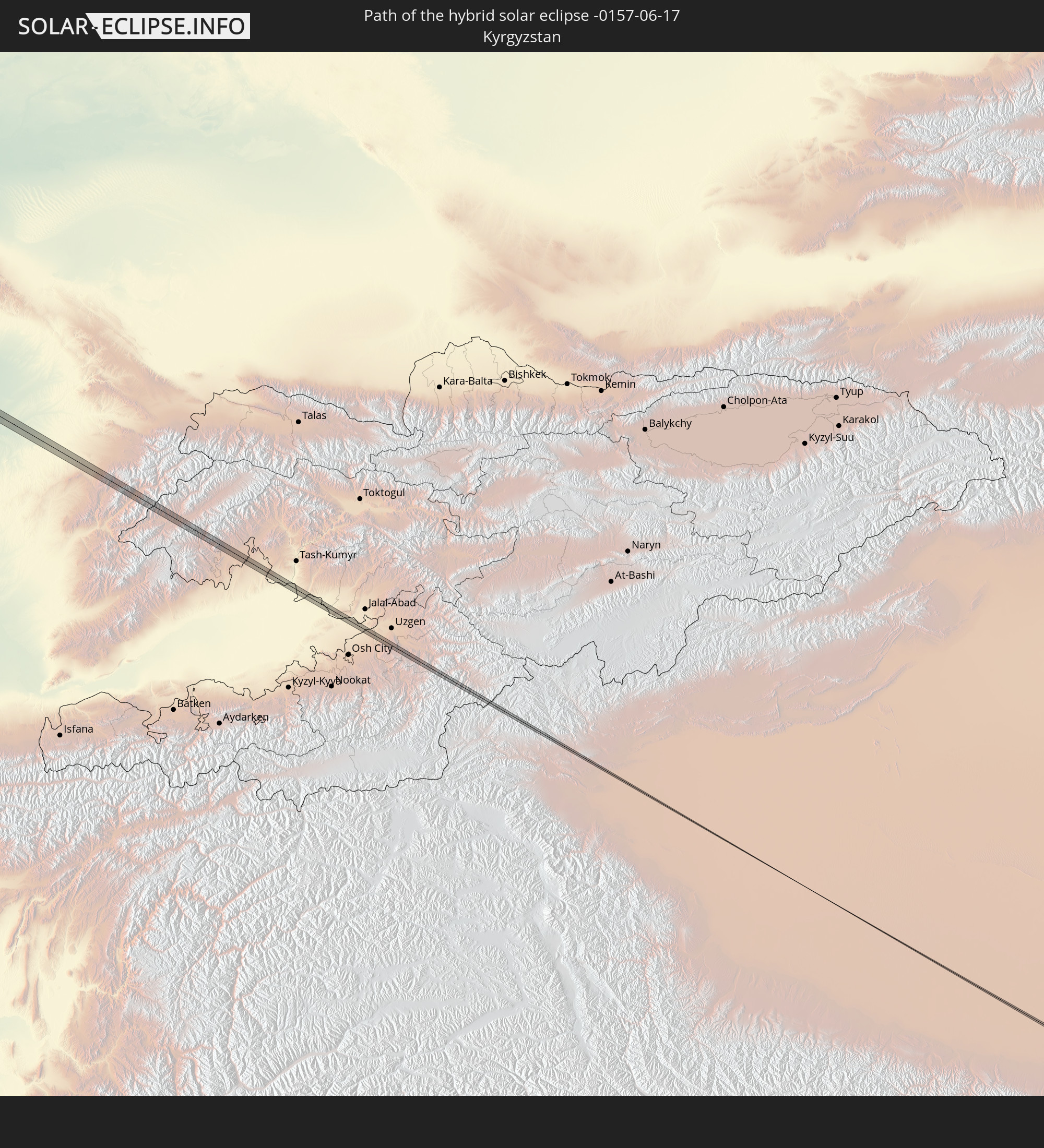
 Kyrgyzstan
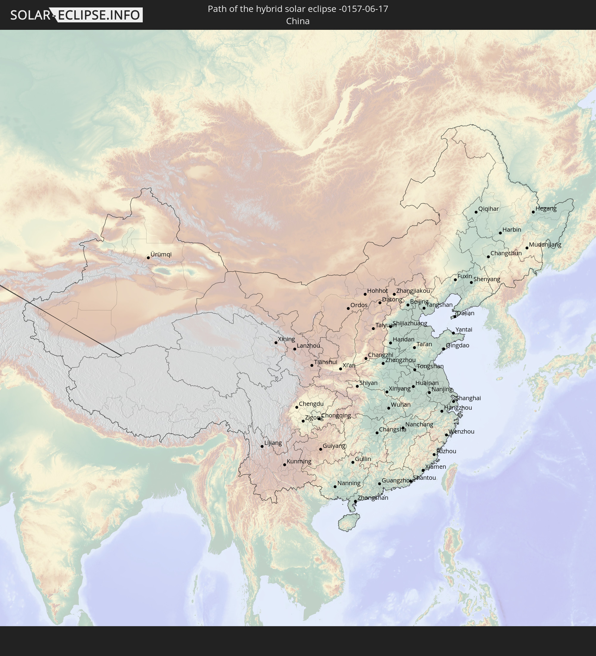
 China
China
Cities inside the path of the eclipse
The following table shows all locations with a population of more than 5,000 inside the eclipse path. Cities which have more than 100,000 inhabitants are marked bold. A click at the locations opens a detailed map.
| City | Type | Eclipse duration | Local time of max. eclipse | Distance to central line | Ø Cloud coverage |
|
Saint-Marc, Artibonite
|
annular | - | 05:28:31 UTC-04:49 | 21 km | 65% |
|
Pignon, Nord
|
annular | - | 05:28:31 UTC-04:49 | 13 km | 55% |
|
Ouanaminthe, Nord-Est
|
annular | - | 05:28:35 UTC-04:49 | 25 km | 62% |
|
Dajabón, Dajabón
|
annular | - | 05:37:35 UTC-04:40 | 23 km | 62% |
|
Las Matas de Santa Cruz, Monte Cristi
|
annular | - | 05:37:38 UTC-04:40 | 5 km | 60% |
|
Tralee, Munster
|
total | - | 11:23:27 UTC-00:25 | 18 km | 79% |
|
Cill Airne, Munster
|
total | - | 11:23:31 UTC-00:25 | 13 km | 80% |
|
Newcastle West, Munster
|
total | - | 11:24:35 UTC-00:25 | 18 km | 83% |
|
Thurles, Munster
|
total | - | 11:26:43 UTC-00:25 | 21 km | 83% |
|
Kilkenny, Leinster
|
total | - | 11:27:32 UTC-00:25 | 17 km | 82% |
|
Carlow, Leinster
|
total | - | 11:28:11 UTC-00:25 | 11 km | 81% |
|
Arklow, Leinster
|
total | - | 11:29:21 UTC-00:25 | 22 km | 77% |
|
Kilquade
|
total | - | 11:29:41 UTC-00:25 | 16 km | 78% |
|
Greystones, Leinster
|
total | - | 11:29:45 UTC-00:25 | 20 km | 78% |
|
Wicklow, Leinster
|
total | - | 11:29:38 UTC-00:25 | 3 km | 77% |
|
Colwyn Bay, Wales
|
total | - | 11:58:48 UTC+00:00 | 12 km | 78% |
|
Rhyl, Wales
|
total | - | 11:59:10 UTC+00:00 | 15 km | 80% |
|
Southport, England
|
total | - | 12:00:07 UTC+00:00 | 12 km | 81% |
|
Liverpool, England
|
total | - | 12:00:01 UTC+00:00 | 15 km | 85% |
|
St Helens, England
|
total | - | 12:00:26 UTC+00:00 | 20 km | 87% |
|
Preston, England
|
total | - | 12:00:39 UTC+00:00 | 20 km | 86% |
|
Bolton, England
|
total | - | 12:00:58 UTC+00:00 | 7 km | 88% |
|
Manchester, England
|
total | - | 12:01:13 UTC+00:00 | 24 km | 88% |
|
Burnley, England
|
total | - | 12:01:24 UTC+00:00 | 18 km | 86% |
|
Rochdale, England
|
total | - | 12:01:25 UTC+00:00 | 15 km | 88% |
|
Keighley, England
|
total | - | 12:01:56 UTC+00:00 | 19 km | 84% |
|
Huddersfield, England
|
total | - | 12:02:00 UTC+00:00 | 16 km | 84% |
|
Leeds, England
|
total | - | 12:02:26 UTC+00:00 | 3 km | 85% |
|
Harrogate, England
|
total | - | 12:02:33 UTC+00:00 | 22 km | 84% |
|
Pontefract, England
|
total | - | 12:02:45 UTC+00:00 | 17 km | 86% |
|
York, England
|
total | - | 12:03:14 UTC+00:00 | 11 km | 85% |
|
Selby, England
|
total | - | 12:03:10 UTC+00:00 | 10 km | 85% |
|
Goole, England
|
total | - | 12:03:26 UTC+00:00 | 20 km | 84% |
|
Beverley, England
|
total | - | 12:04:12 UTC+00:00 | 12 km | 84% |
|
Bridlington, England
|
total | - | 12:04:39 UTC+00:00 | 15 km | 83% |
|
Westerland, Schleswig-Holstein
|
total | - | 13:17:35 UTC+01:00 | 14 km | 79% |
|
Sylt-Ost, Schleswig-Holstein
|
total | - | 13:17:45 UTC+01:00 | 6 km | 80% |
|
Niebüll, Schleswig-Holstein
|
total | - | 13:18:22 UTC+01:00 | 15 km | 76% |
|
Tønder, South Denmark
|
total | - | 13:18:25 UTC+01:00 | 10 km | 77% |
|
Leck, Schleswig-Holstein
|
total | - | 13:18:36 UTC+01:00 | 13 km | 78% |
|
Rødekro, South Denmark
|
total | - | 13:19:03 UTC+01:00 | 22 km | 77% |
|
Handewitt, Schleswig-Holstein
|
total | - | 13:19:07 UTC+01:00 | 19 km | 77% |
|
Harrislee, Schleswig-Holstein
|
total | - | 13:19:11 UTC+01:00 | 14 km | 77% |
|
Aabenraa, South Denmark
|
total | - | 13:19:12 UTC+01:00 | 16 km | 76% |
|
Flensburg, Schleswig-Holstein
|
total | - | 13:19:16 UTC+01:00 | 14 km | 77% |
|
Glücksburg, Schleswig-Holstein
|
total | - | 13:19:25 UTC+01:00 | 9 km | 78% |
|
Nordborg, South Denmark
|
total | - | 13:19:40 UTC+01:00 | 22 km | 74% |
|
Sønderborg, South Denmark
|
total | - | 13:19:47 UTC+01:00 | 13 km | 77% |
|
Faaborg, South Denmark
|
total | - | 13:20:23 UTC+01:00 | 23 km | 75% |
|
Svendborg, South Denmark
|
total | - | 13:20:55 UTC+01:00 | 14 km | 74% |
|
Nakskov, Zealand
|
total | - | 13:21:43 UTC+01:00 | 17 km | 71% |
|
Vordingborg, Zealand
|
total | - | 13:22:48 UTC+01:00 | 6 km | 70% |
|
Rønne, Capital Region
|
total | - | 13:26:42 UTC+01:00 | 15 km | 64% |
|
Władysławowo, Pomeranian Voivodeship
|
total | - | 13:55:55 UTC+01:24 | 21 km | 70% |
|
Svetlogorsk, Kaliningrad
|
total | - | 13:34:07 UTC+01:00 | 10 km | 64% |
|
Pionerskiy, Kaliningrad
|
total | - | 13:34:13 UTC+01:00 | 15 km | 64% |
|
Zelenogradsk, Kaliningrad
|
total | - | 13:34:32 UTC+01:00 | 8 km | 65% |
|
Kaliningrad, Kaliningrad
|
total | - | 13:34:46 UTC+01:00 | 20 km | 66% |
|
Chernyakhovsk, Kaliningrad
|
total | - | 13:36:30 UTC+01:00 | 22 km | 69% |
|
Gusev, Kaliningrad
|
total | - | 13:37:01 UTC+01:00 | 26 km | 68% |
|
Kybartai
|
total | - | 14:01:41 UTC+01:24 | 18 km | 71% |
|
Vilkaviskis
|
total | - | 14:02:01 UTC+01:24 | 9 km | 69% |
|
Marijampolė, Marijampolė County
|
total | - | 14:02:29 UTC+01:24 | 17 km | 70% |
|
Kazlų Rūda, Marijampolė County
|
total | - | 14:02:30 UTC+01:24 | 6 km | 70% |
|
Garliava, Kaunas County
|
total | - | 14:02:54 UTC+01:24 | 20 km | 67% |
|
Prienai
|
total | - | 14:03:10 UTC+01:24 | 4 km | 71% |
|
Elektrėnai, Vilnius County
|
total | - | 14:03:54 UTC+01:24 | 22 km | 66% |
|
Trakai
|
total | - | 14:04:22 UTC+01:24 | 9 km | 70% |
|
Lentvaris, Vilnius County
|
total | - | 14:04:29 UTC+01:24 | 9 km | 72% |
|
Grigiškės
|
total | - | 14:04:30 UTC+01:24 | 14 km | 72% |
|
Pilaitė, Vilnius County
|
total | - | 14:04:36 UTC+01:24 | 19 km | 74% |
|
Lazdynai, Vilnius County
|
total | - | 14:04:39 UTC+01:24 | 17 km | 74% |
|
Justiniškės, Vilnius County
|
total | - | 14:04:37 UTC+01:24 | 21 km | 74% |
|
Pašilaičiai, Vilnius County
|
total | - | 14:04:36 UTC+01:24 | 23 km | 74% |
|
Fabijoniškės, Vilnius County
|
total | - | 14:04:38 UTC+01:24 | 24 km | 74% |
|
Vilkpėdė, Vilnius County
|
total | - | 14:04:42 UTC+01:24 | 19 km | 74% |
|
Šeškinė, Vilnius County
|
total | - | 14:04:40 UTC+01:24 | 22 km | 73% |
|
Naujamiestis, Vilnius County
|
total | - | 14:04:43 UTC+01:24 | 21 km | 73% |
|
Vilnius, Vilnius County
|
total | - | 14:04:43 UTC+01:24 | 22 km | 73% |
|
Rasos, Vilnius County
|
total | - | 14:04:46 UTC+01:24 | 21 km | 73% |
|
Ashmyany, Grodnenskaya
|
total | - | 14:31:46 UTC+01:50 | 7 km | 71% |
|
Astravyets, Grodnenskaya
|
total | - | 14:31:36 UTC+01:50 | 16 km | 72% |
|
Smarhon’, Grodnenskaya
|
total | - | 14:32:15 UTC+01:50 | 9 km | 71% |
|
Maladzyechna, Minsk
|
total | - | 14:32:57 UTC+01:50 | 11 km | 72% |
|
Vilyeyka, Minsk
|
total | - | 14:32:50 UTC+01:50 | 14 km | 73% |
|
Chyst’, Minsk
|
total | - | 14:33:17 UTC+01:50 | 13 km | 72% |
|
Plyeshchanitsy, Minsk
|
total | - | 14:33:58 UTC+01:50 | 21 km | 73% |
|
Lahoysk, Minsk
|
total | - | 14:34:13 UTC+01:50 | 11 km | 72% |
|
Horad Zhodzina, Minsk
|
total | - | 14:34:53 UTC+01:50 | 16 km | 73% |
|
Horad Barysaw, Minsk
|
total | - | 14:34:56 UTC+01:50 | 3 km | 72% |
|
Loshnitsa, Minsk
|
total | - | 14:35:10 UTC+01:50 | 19 km | 70% |
|
Byalynichy, Mogilev
|
total | - | 14:36:32 UTC+01:50 | 17 km | 72% |
|
Mahilyow, Mogilev
|
total | - | 14:37:19 UTC+01:50 | 11 km | 72% |
|
Chavusy, Mogilev
|
total | - | 14:38:07 UTC+01:50 | 8 km | 71% |
|
Krychaw, Mogilev
|
total | - | 14:39:01 UTC+01:50 | 18 km | 69% |
|
Klimavichy, Mogilev
|
total | - | 14:39:24 UTC+01:50 | 14 km | 71% |
|
Kletnya, Brjansk
|
total | - | 15:21:15 UTC+02:30 | 22 km | 70% |
|
Zhukovka, Brjansk
|
total | - | 15:21:35 UTC+02:30 | 16 km | 68% |
|
Sel’tso, Brjansk
|
total | - | 15:22:10 UTC+02:30 | 8 km | 71% |
|
Bryansk, Brjansk
|
total | - | 15:22:34 UTC+02:30 | 12 km | 73% |
|
Belyye Berega, Brjansk
|
total | - | 15:22:55 UTC+02:30 | 17 km | 72% |
|
Karachev, Brjansk
|
total | - | 15:23:20 UTC+02:30 | 13 km | 69% |
|
Orël, Orjol
|
total | - | 15:24:35 UTC+02:30 | 8 km | 72% |
|
Yelets, Lipetsk
|
total | - | 15:27:15 UTC+02:30 | 6 km | 71% |
|
Zadonsk, Lipetsk
|
total | - | 15:27:56 UTC+02:30 | 9 km | 70% |
|
Dobrinka, Lipetsk
|
total | - | 15:29:33 UTC+02:30 | 4 km | 67% |
|
Zherdevka, Tambov
|
total | - | 15:30:48 UTC+02:30 | 7 km | 65% |
|
Balashov, Saratov
|
total | - | 16:22:35 UTC+03:20 | 12 km | 64% |
|
Zhirnovsk, Volgograd
|
total | - | 15:34:31 UTC+02:30 | 17 km | 60% |
|
Aleksandrov Gay, Saratov
|
total | - | 16:28:14 UTC+03:20 | 11 km | 56% |