Total solar eclipse of 09/07/-0227
| Day of week: | Sunday |
| Maximum duration of eclipse: | 02m52s |
| Maximum width of eclipse path: | 134 km |
| Saros cycle: | 60 |
| Coverage: | 100% |
| Magnitude: | 1.0359 |
| Gamma: | 0.4503 |
Wo kann man die Sonnenfinsternis vom 09/07/-0227 sehen?
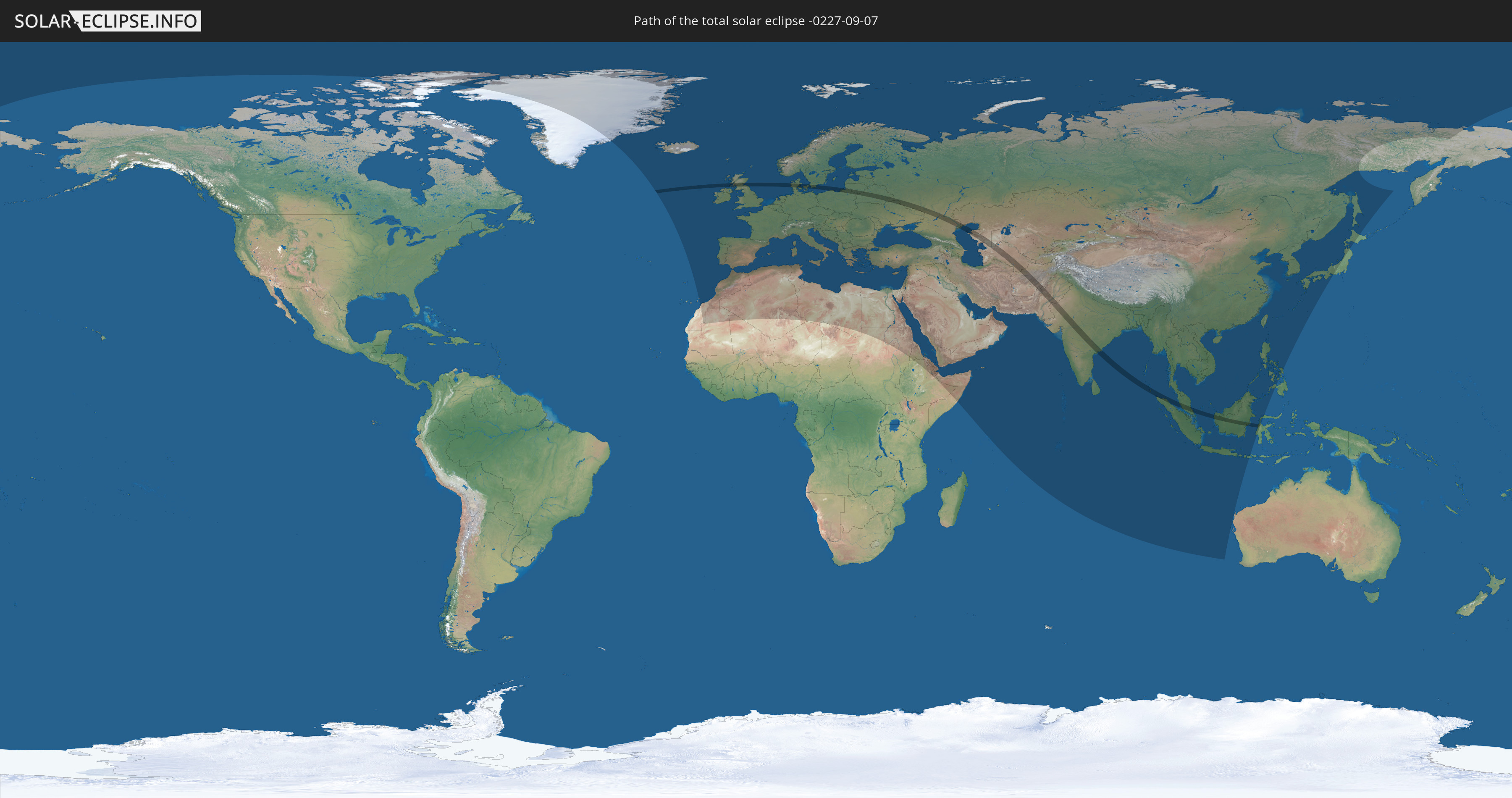
Die Sonnenfinsternis am 09/07/-0227 kann man in 121 Ländern als partielle Sonnenfinsternis beobachten.
Der Finsternispfad verläuft durch 16 Länder. Nur in diesen Ländern ist sie als total Sonnenfinsternis zu sehen.
In den folgenden Ländern ist die Sonnenfinsternis total zu sehen
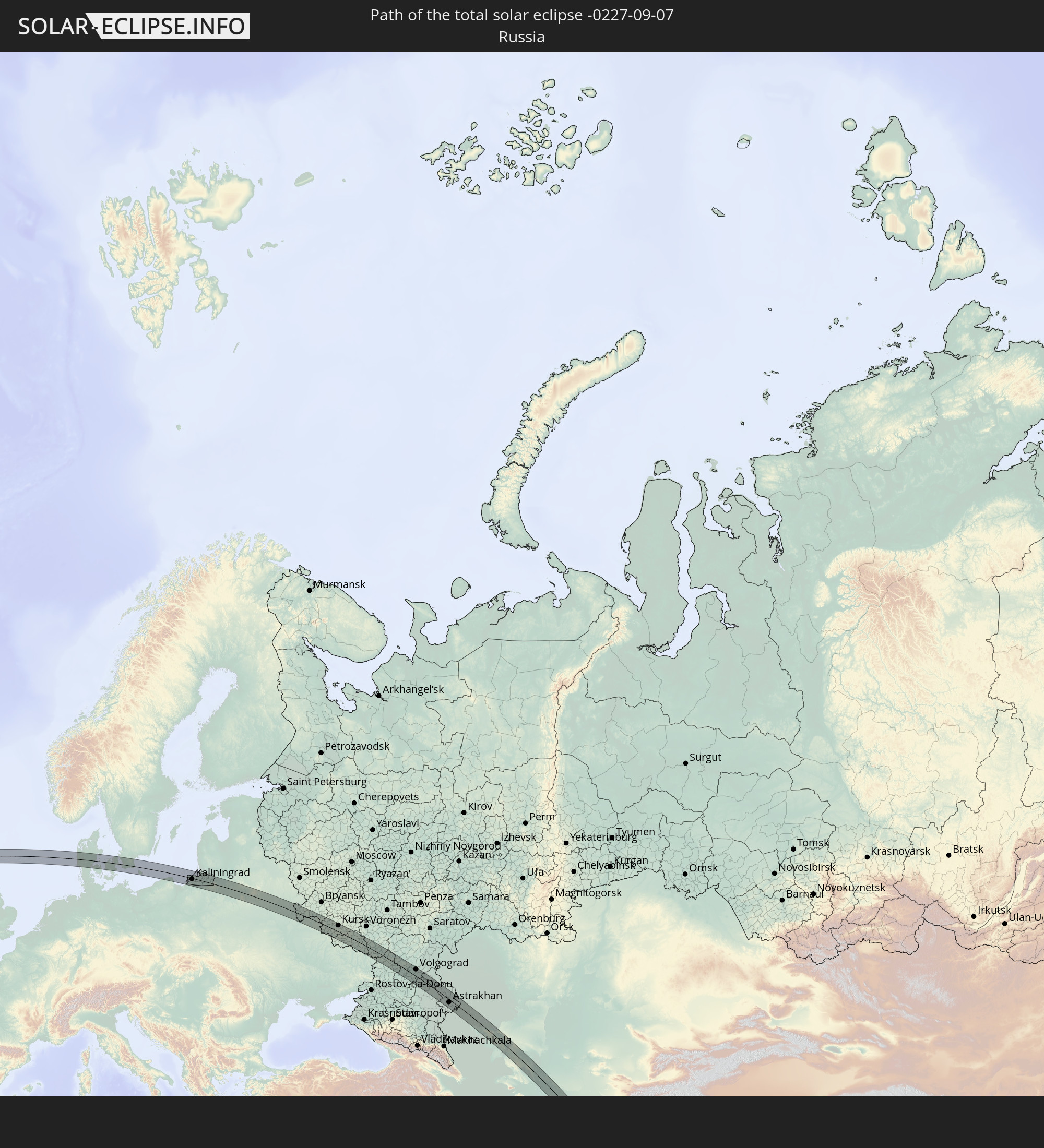 Russia
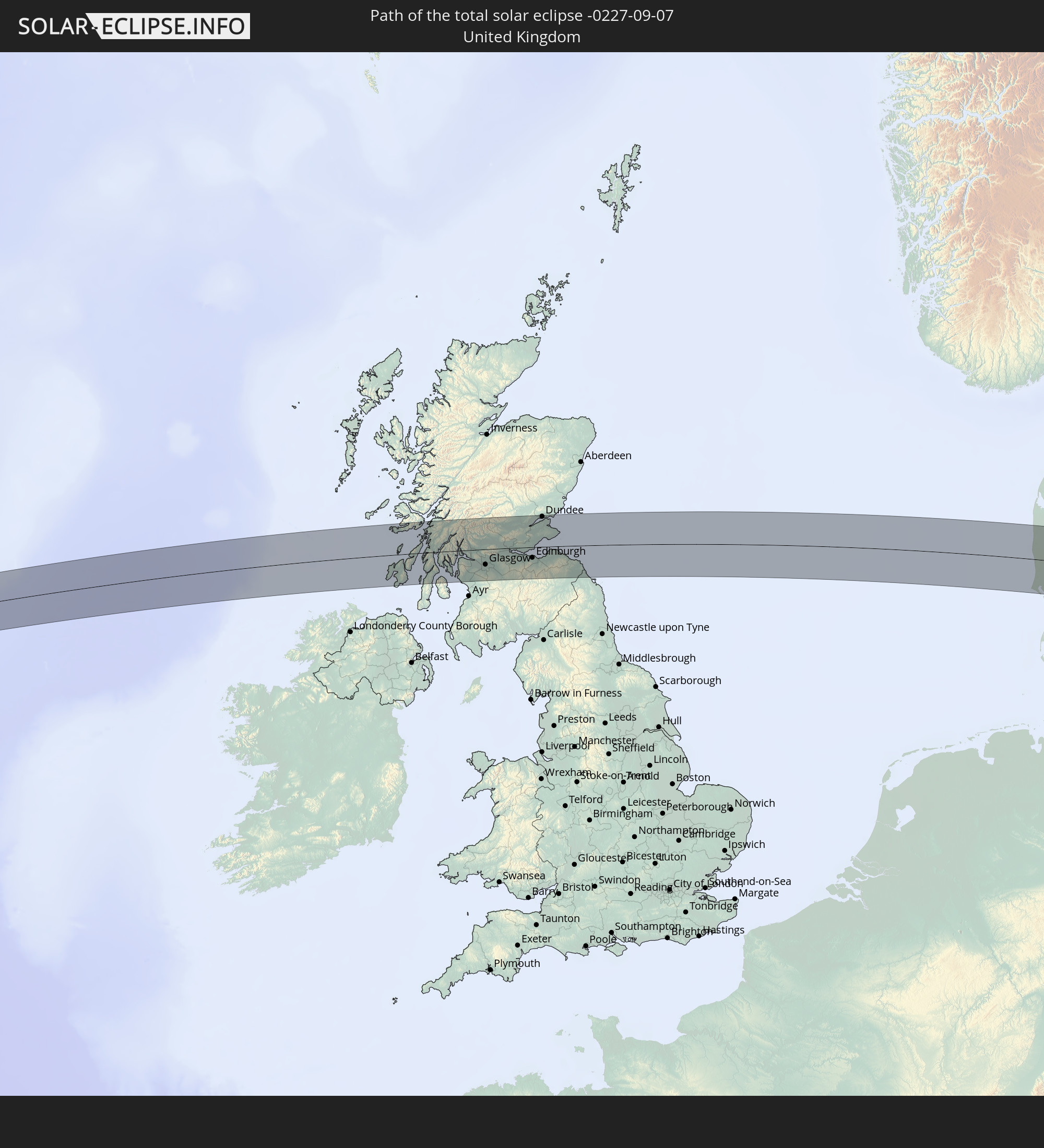 United Kingdom
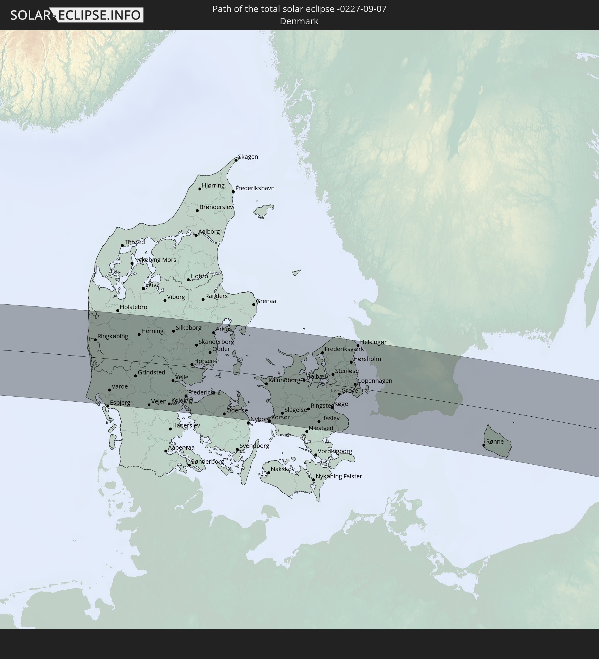 Denmark
 Sweden
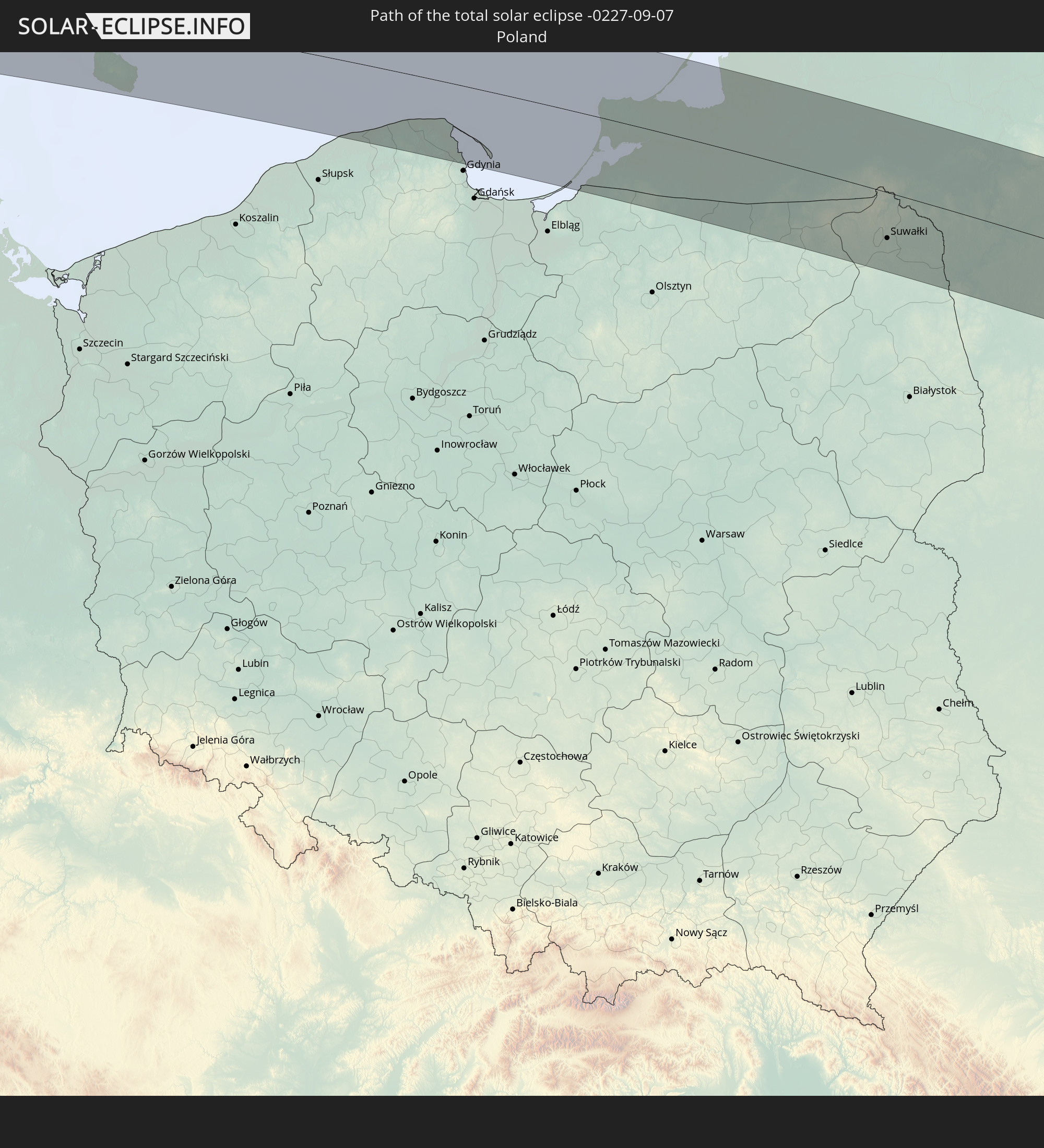 Poland
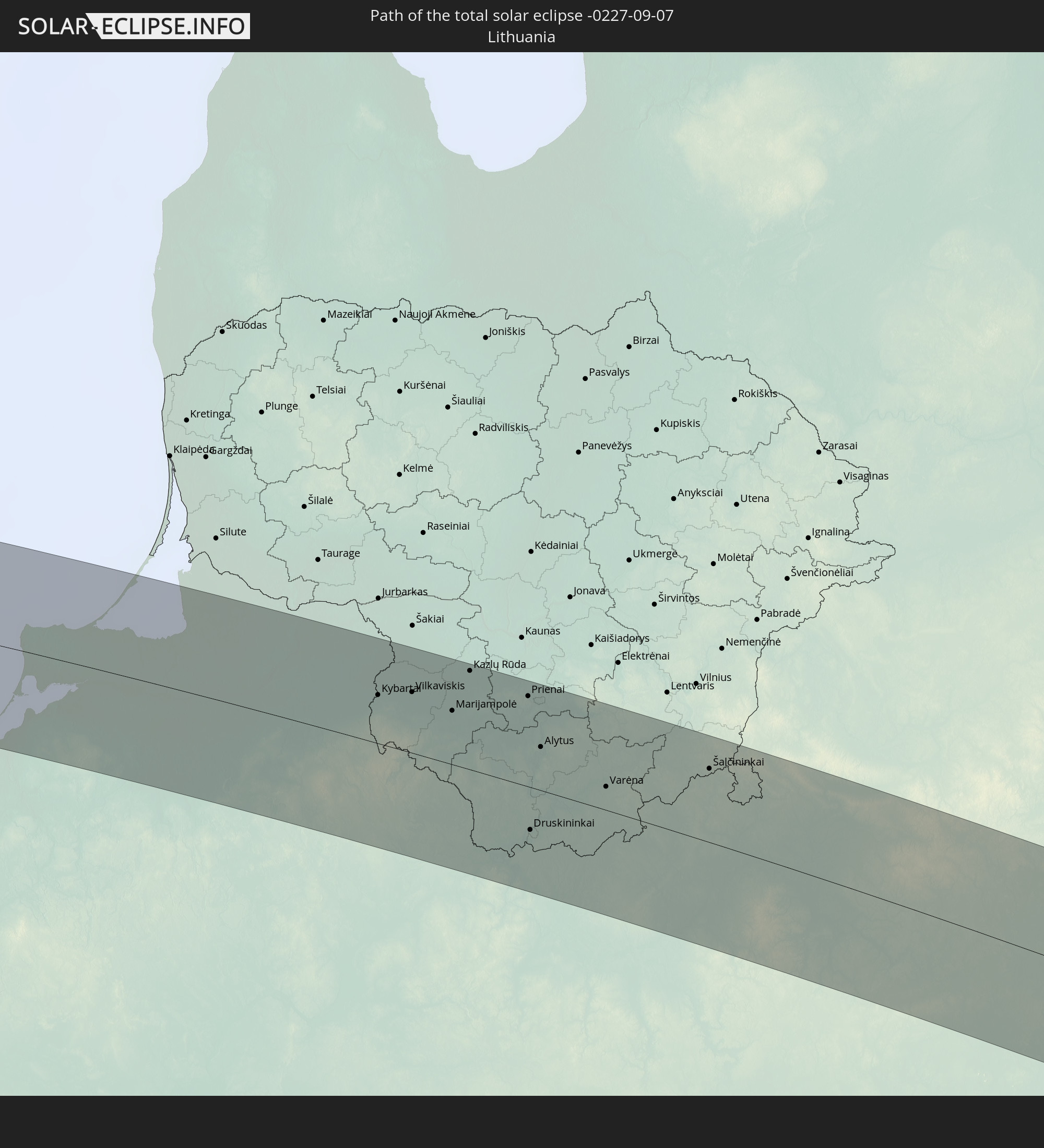 Lithuania
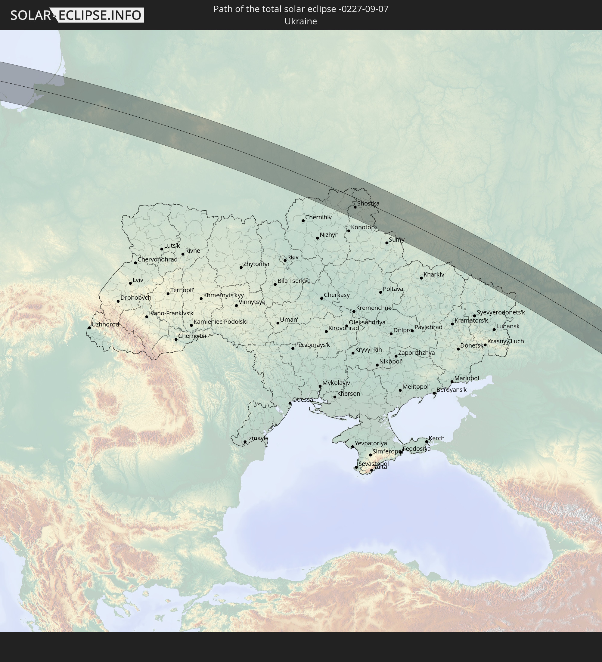 Ukraine
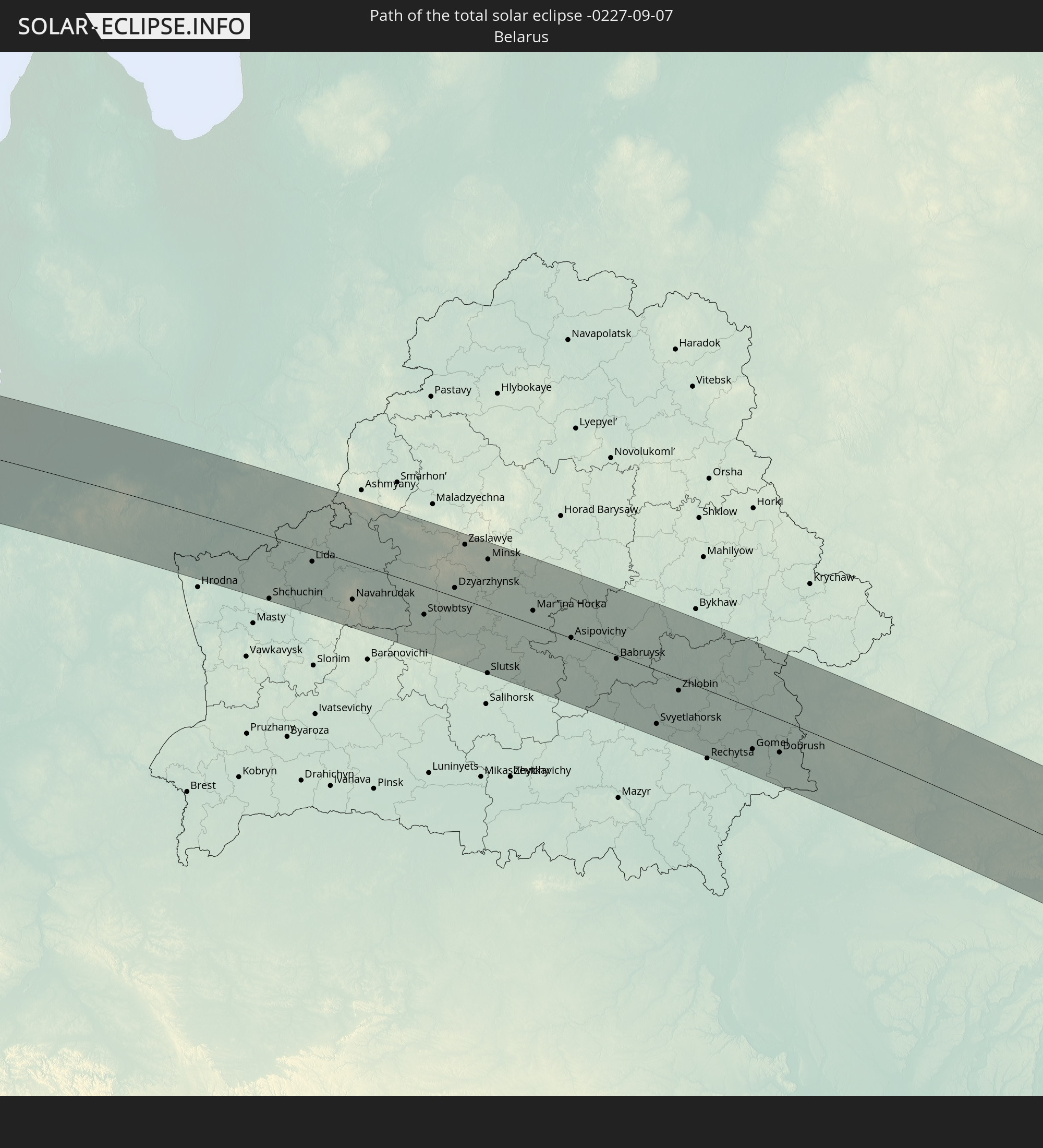 Belarus
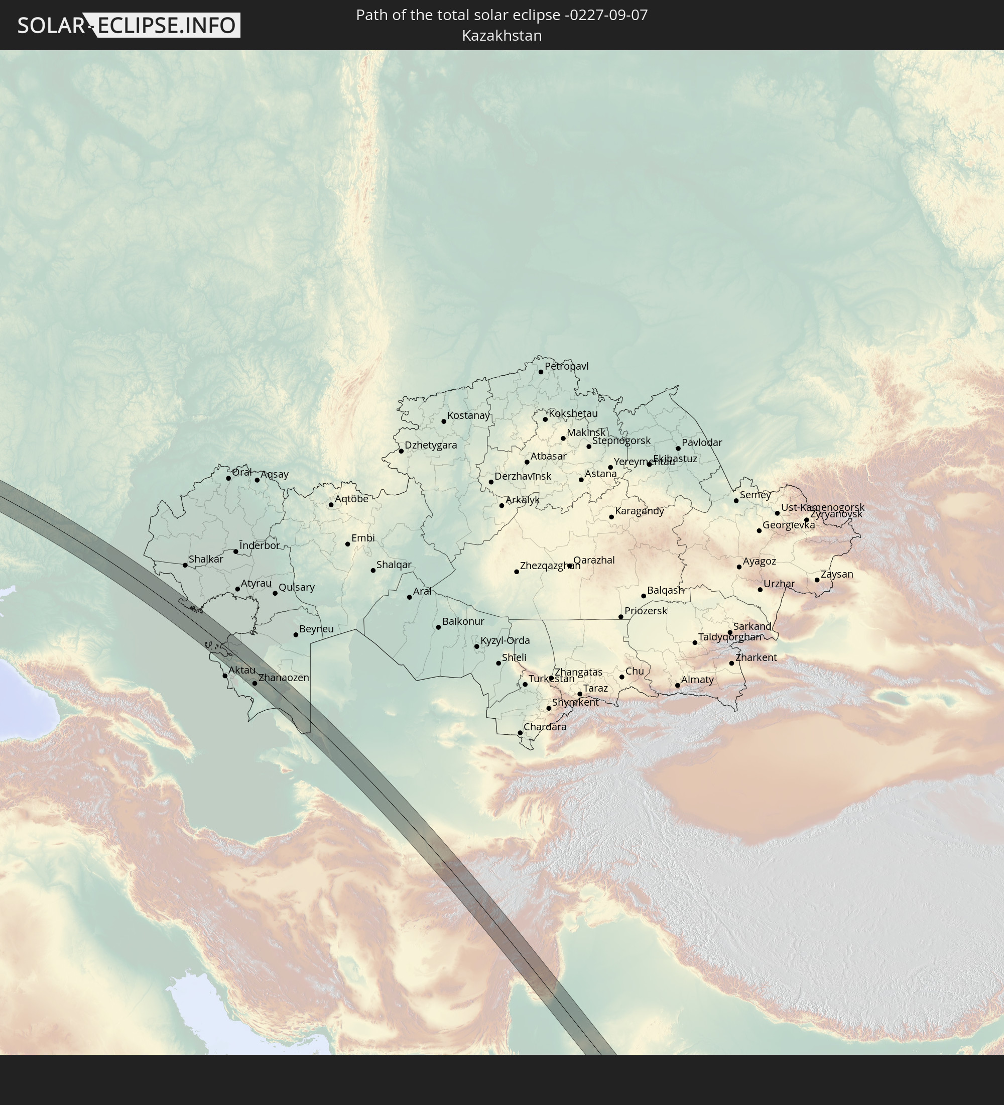 Kazakhstan
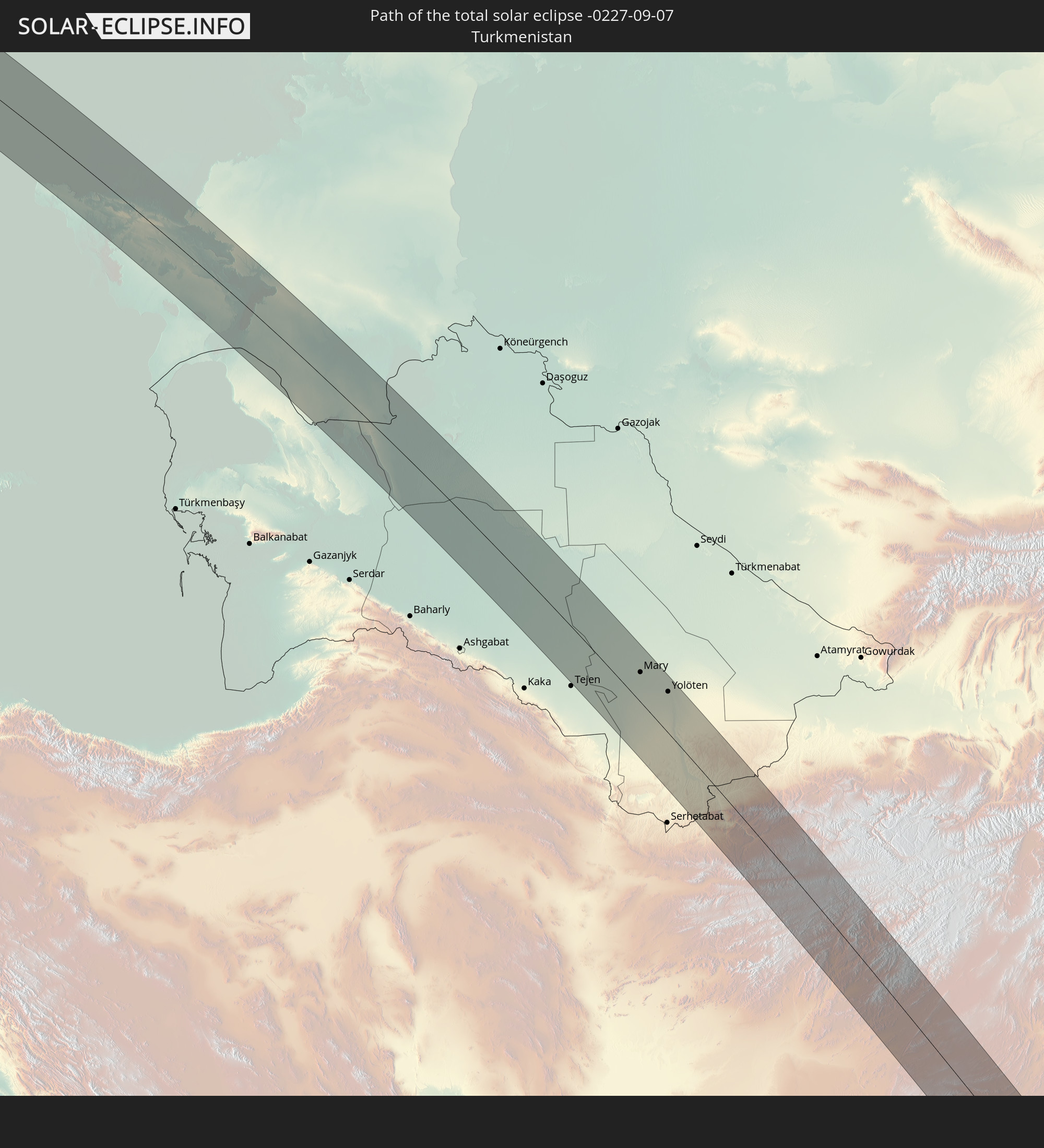 Turkmenistan
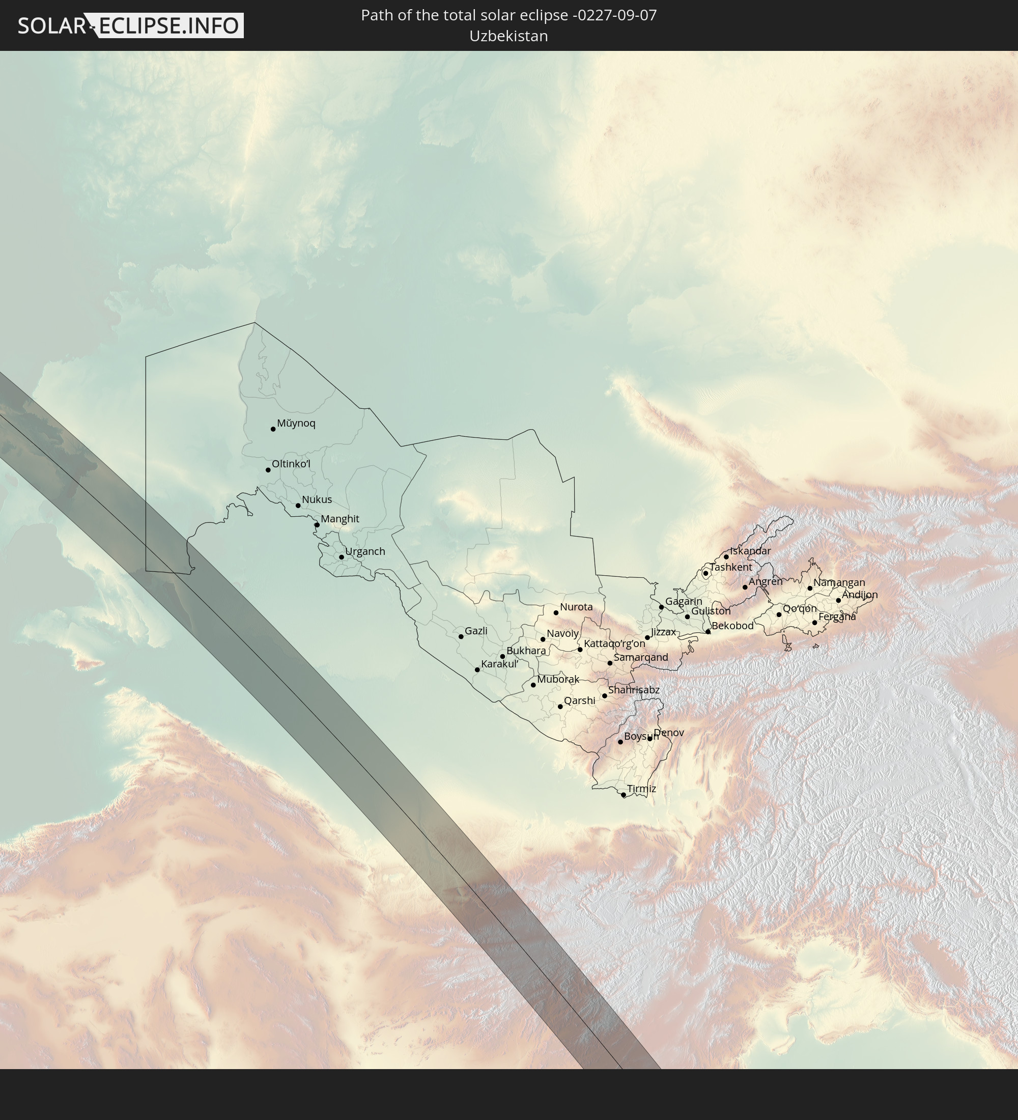 Uzbekistan
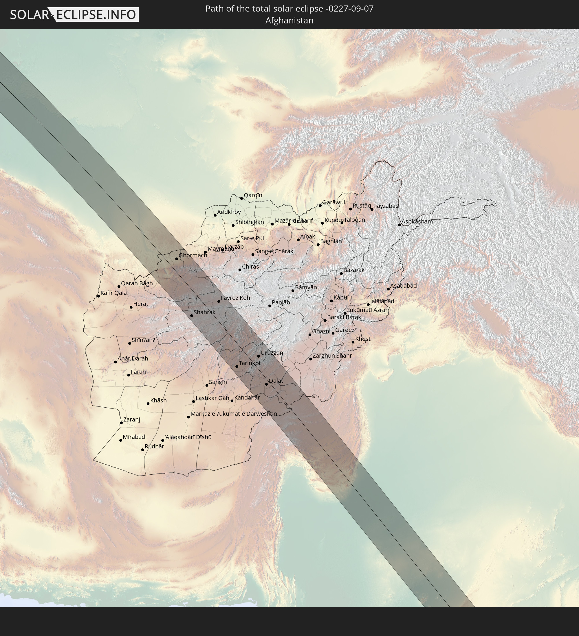 Afghanistan
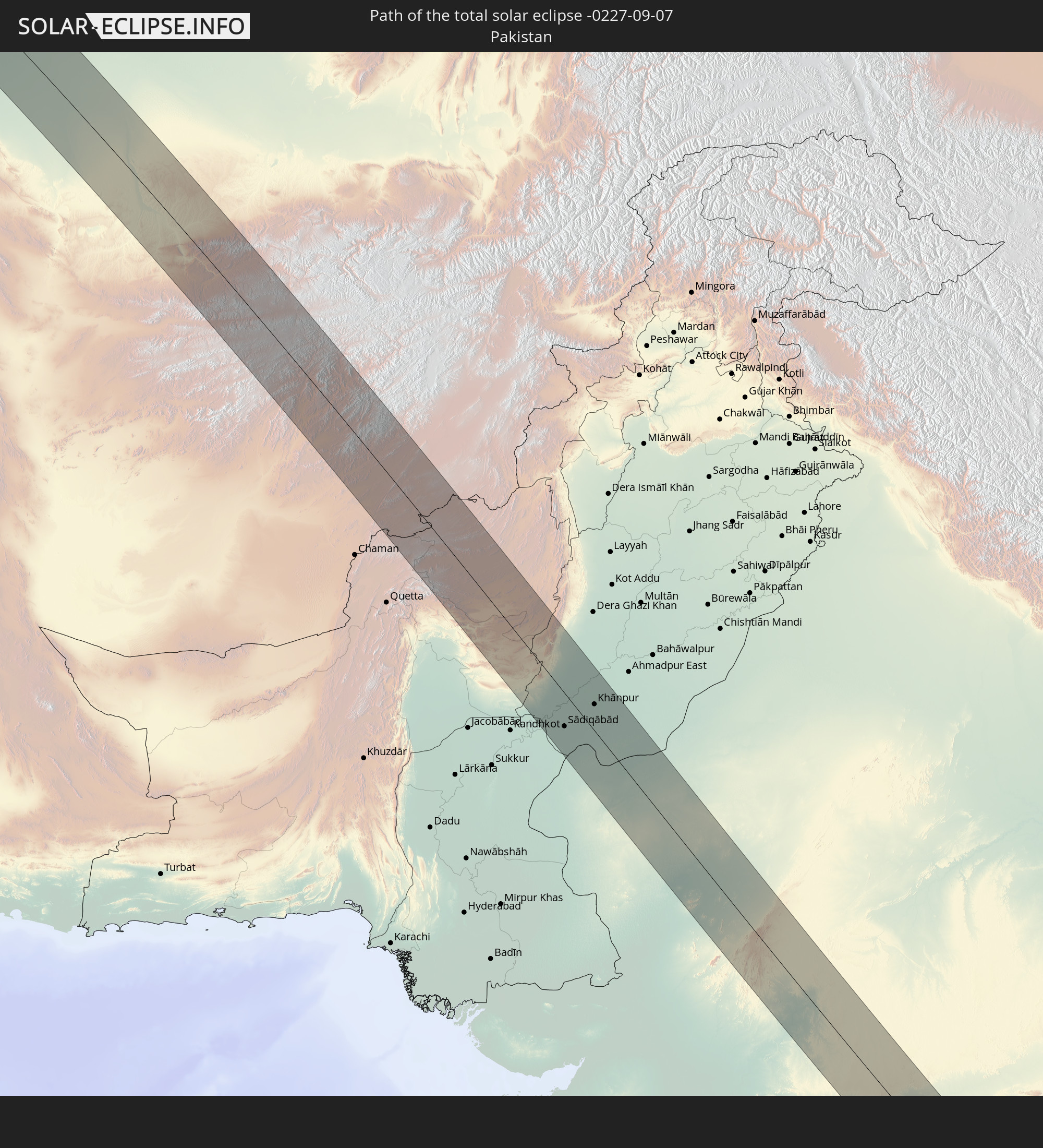 Pakistan
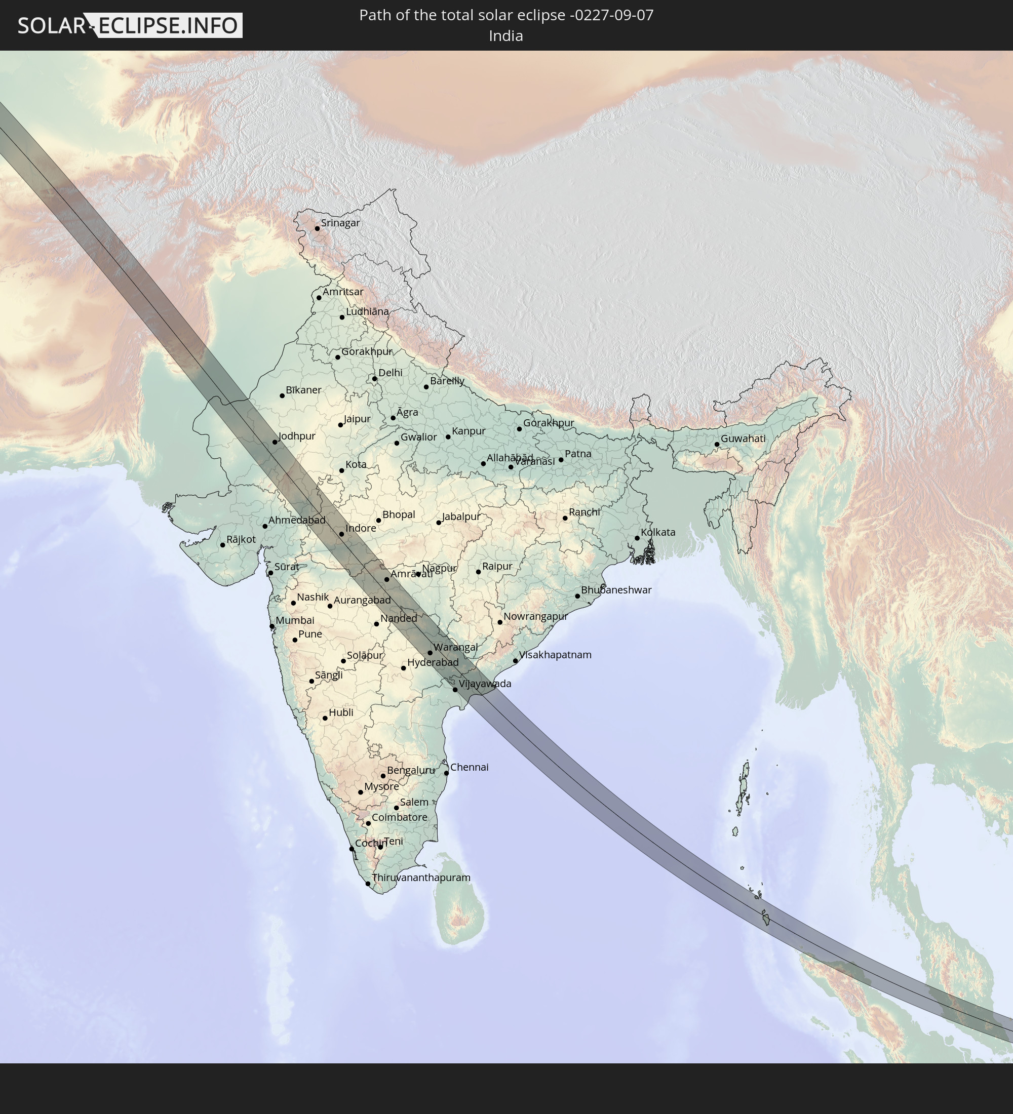 India
India
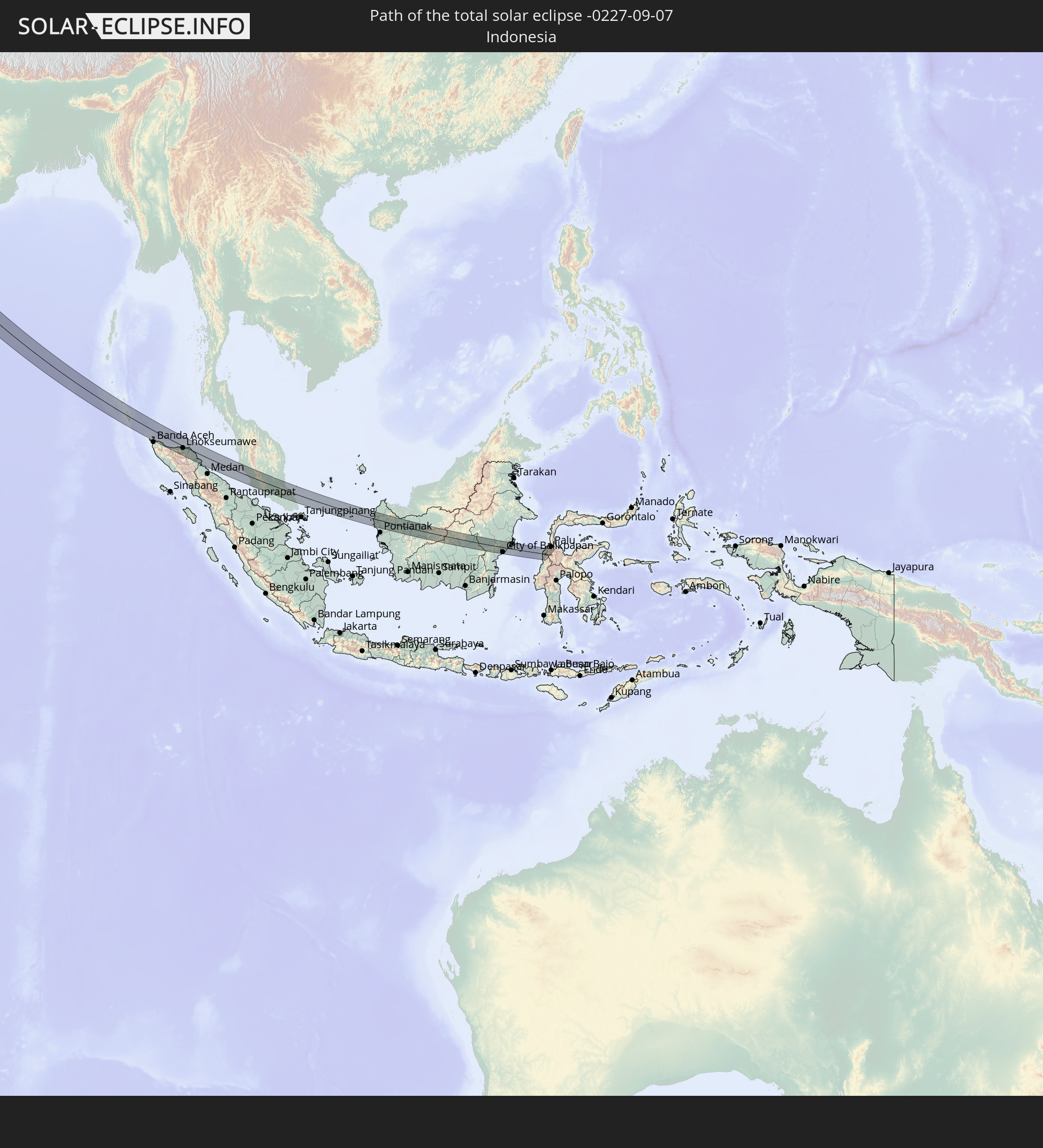 Indonesia
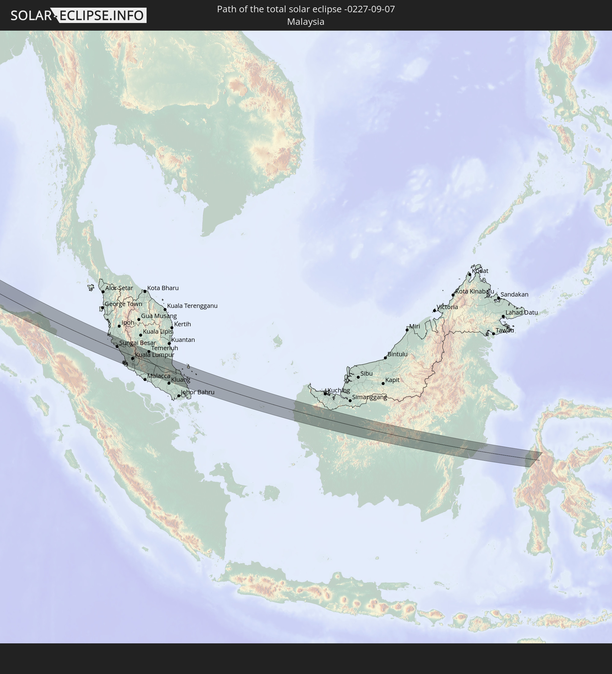 Malaysia
In den folgenden Ländern ist die Sonnenfinsternis partiell zu sehen
 Russia
 Canada
 Greenland
 Portugal
 Iceland
 Spain
Spain
 Mauritania
 Morocco
 Mali
Mali
 Republic of Ireland
 Svalbard and Jan Mayen
 Algeria
 United Kingdom
 Faroe Islands
 Gibraltar
 France
 Isle of Man
 Guernsey
 Jersey
 Andorra
 Belgium
 Netherlands
 Norway
 Luxembourg
 Germany
 Switzerland
 Italy
Italy
 Monaco
 Tunisia
 Denmark
 Libya
Libya
 Liechtenstein
 Austria
 Sweden
 Czechia
 San Marino
 Vatican City
 Slovenia
 Chad
Chad
 Croatia
 Poland
 Malta
Malta
 Bosnia and Herzegovina
 Hungary
 Slovakia
 Montenegro
 Serbia
 Albania
 Åland Islands
 Greece
 Romania
 Republic of Macedonia
 Finland
 Lithuania
 Latvia
 Estonia
 Sudan
Sudan
 Ukraine
 Bulgaria
 Belarus
 Egypt
Egypt
 Turkey
 Moldova
 Cyprus
 Ethiopia
 State of Palestine
 Israel
 Saudi Arabia
 Jordan
 Lebanon
 Syria
Syria
 Eritrea
 Iraq
Iraq
 Georgia
 Somalia
 Djibouti
 Yemen
Yemen
 Armenia
 Iran
Iran
 Azerbaijan
 Seychelles
 Kazakhstan
 Kuwait
 Bahrain
 Qatar
Qatar
 United Arab Emirates
 Oman
Oman
 Turkmenistan
 Uzbekistan
 Afghanistan
 Pakistan
 Tajikistan
 India
India
 Kyrgyzstan
 British Indian Ocean Territory
 Maldives
 China
China
 Sri Lanka
 Nepal
Nepal
 Mongolia
 Bangladesh
 Bhutan
 Myanmar
 Indonesia
 Cocos Islands
 Thailand
 Malaysia
 Laos
Laos
 Vietnam
 Cambodia
 Singapore
 Christmas Island
 Australia
 Macau
Macau
 Hong Kong
 Brunei
 Taiwan
 Philippines
 Japan
Japan
 North Korea
 South Korea
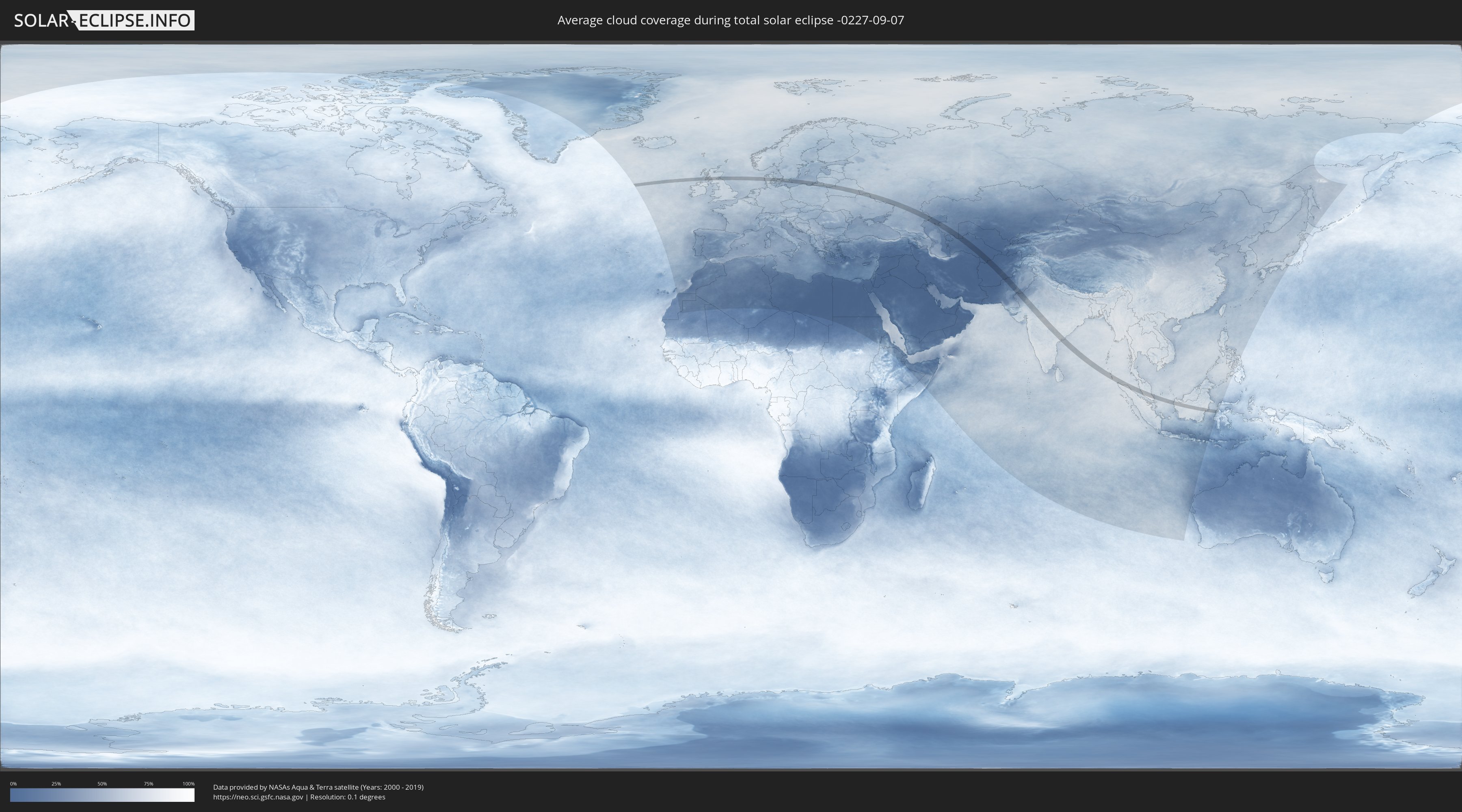
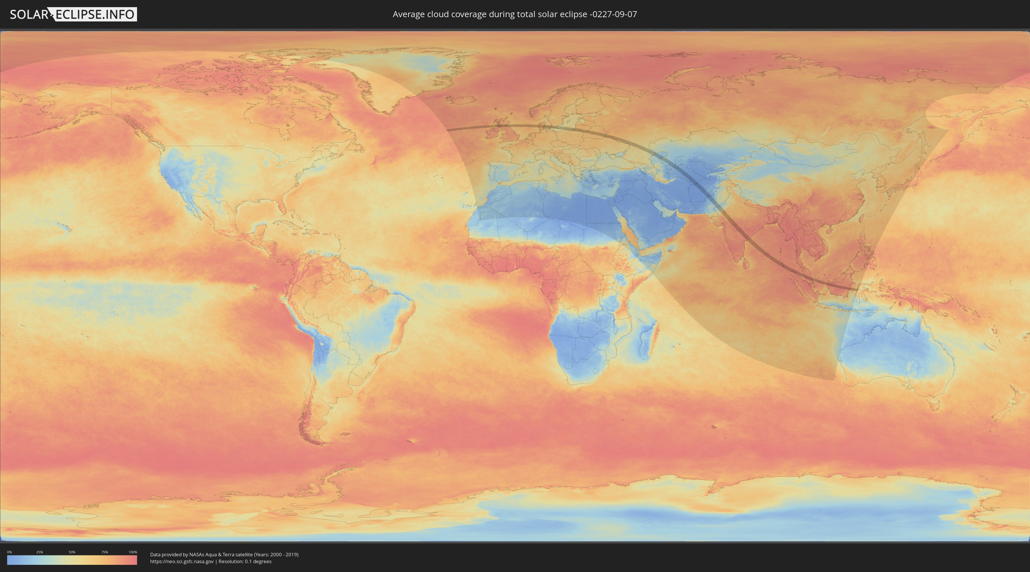
How will be the weather during the total solar eclipse on 09/07/-0227?
Where is the best place to see the total solar eclipse of 09/07/-0227?
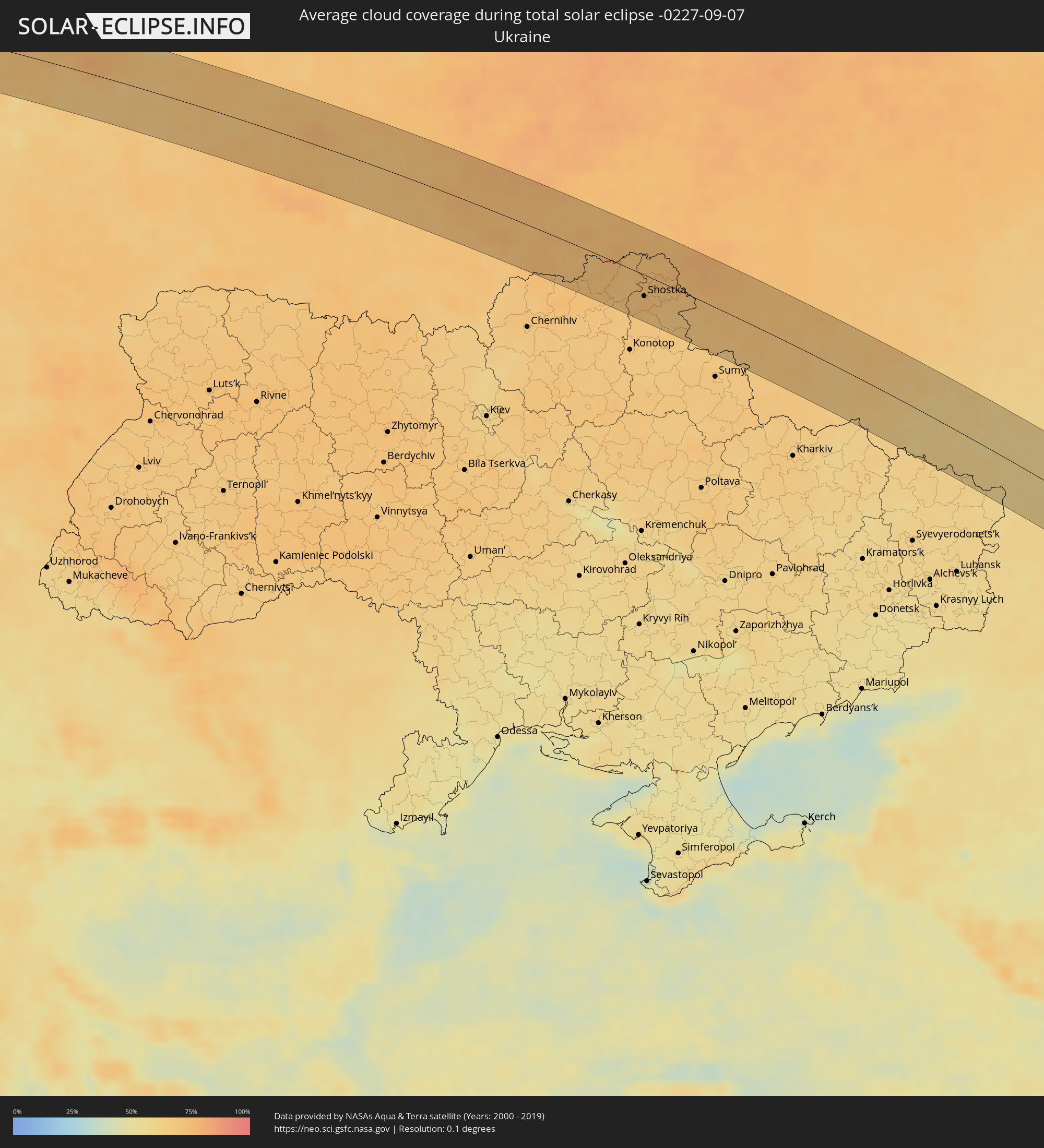
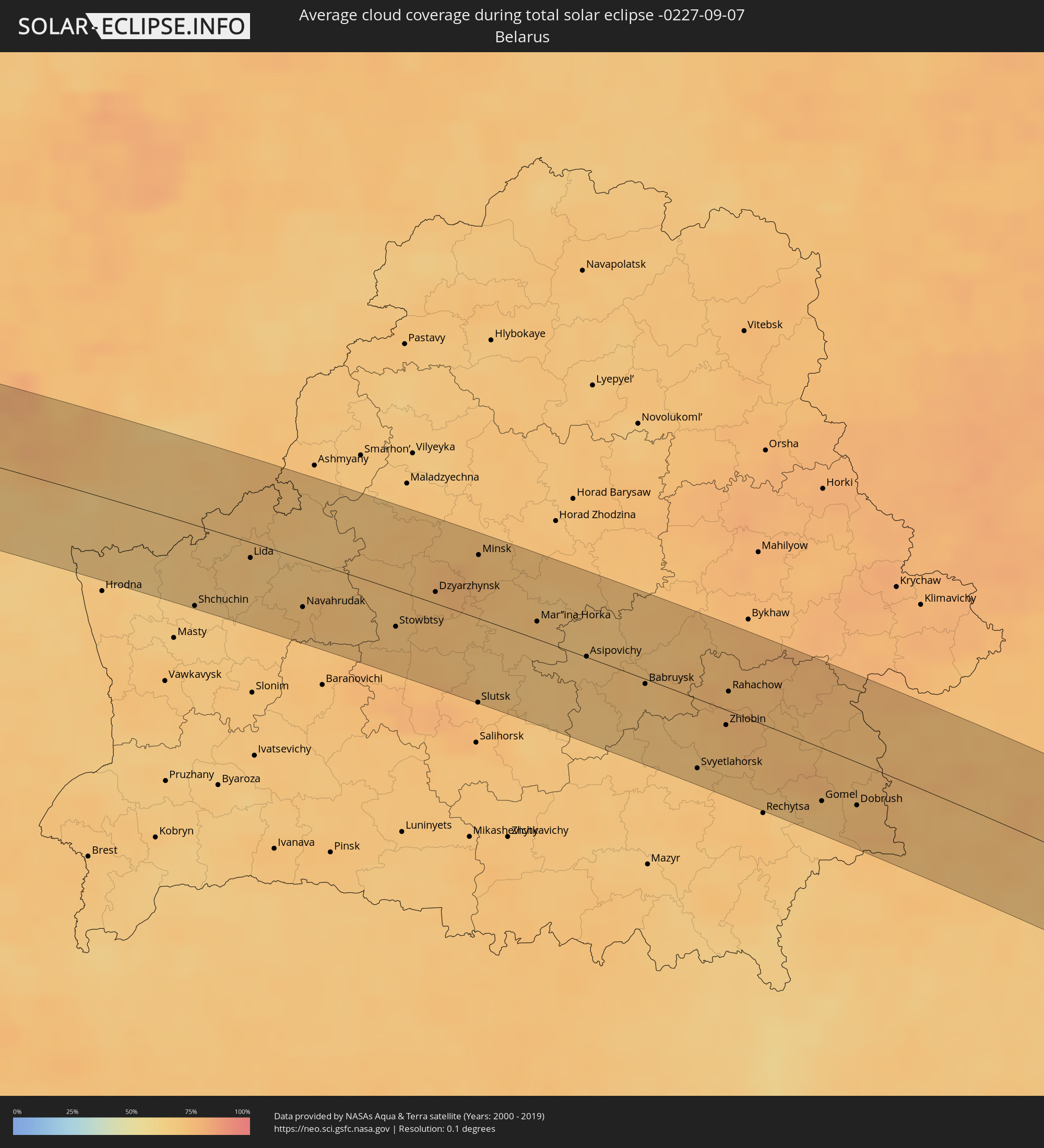
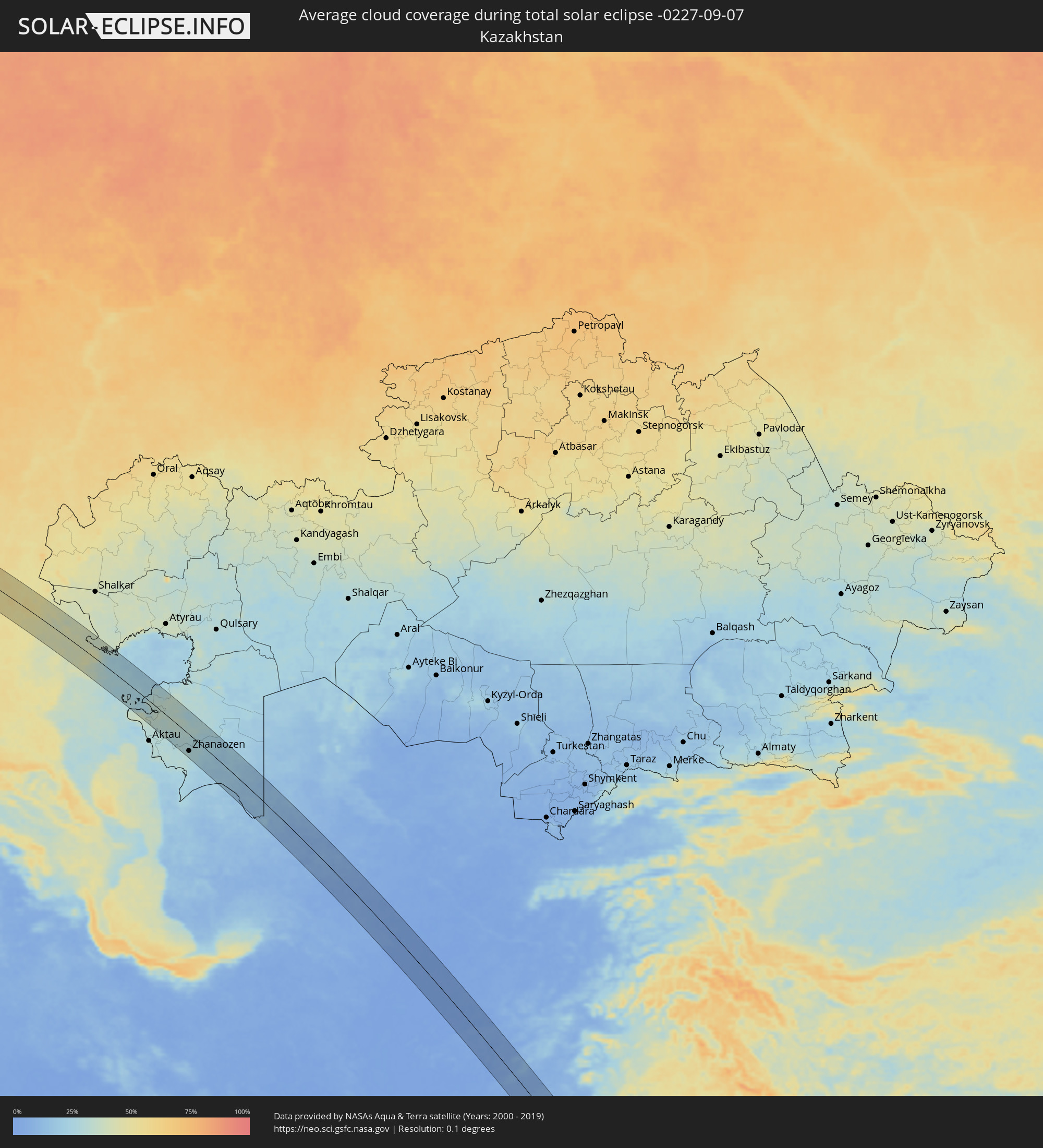
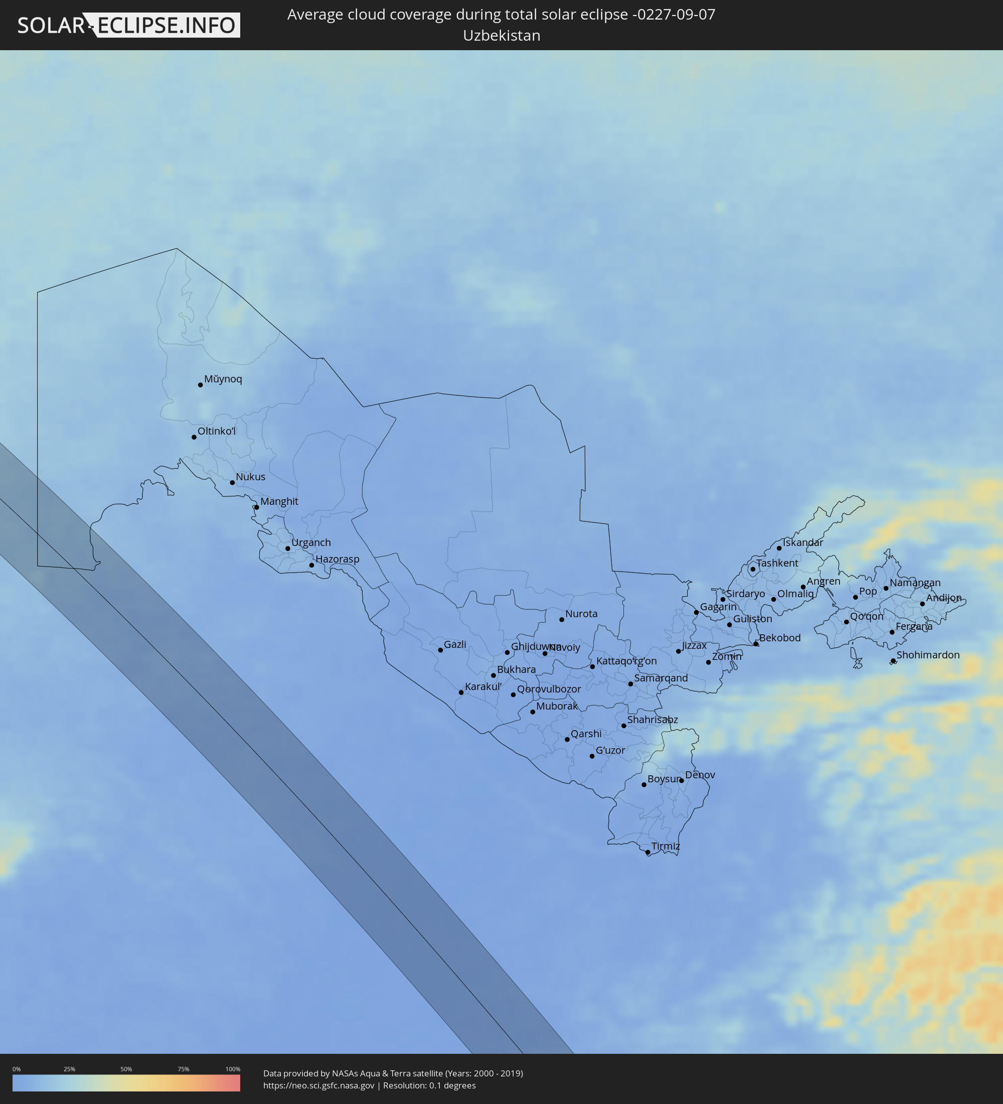
The following maps show the average cloud coverage for the day of the total solar eclipse.
With the help of these maps, it is possible to find the place along the eclipse path, which has the best
chance of a cloudless sky.
Nevertheless, you should consider local circumstances and inform about the weather of your chosen
observation site.
The data is provided by NASAs satellites
AQUA and TERRA.
The cloud maps are averaged over a period of 19 years (2000 - 2019).
Detailed country maps
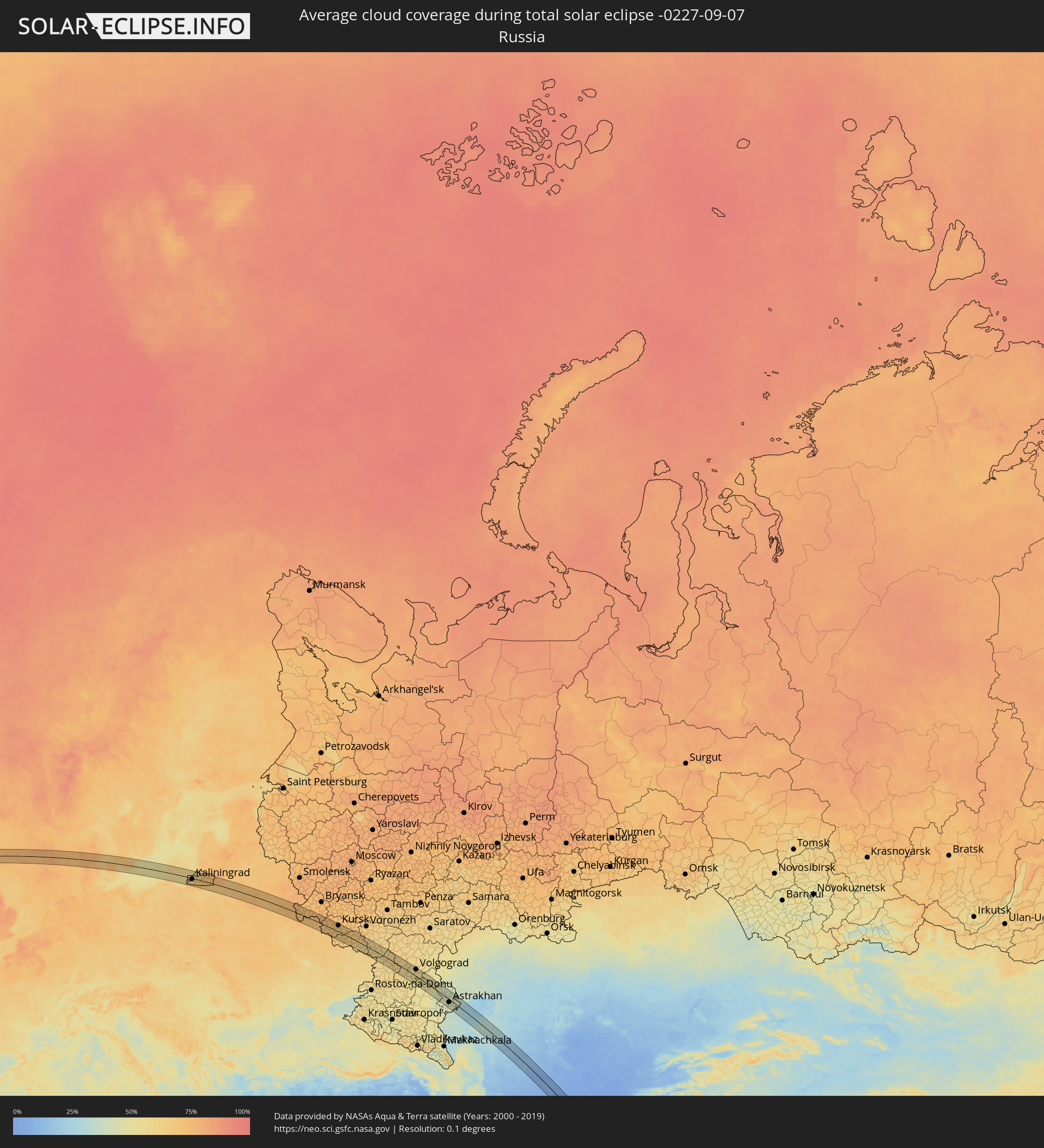 Russia
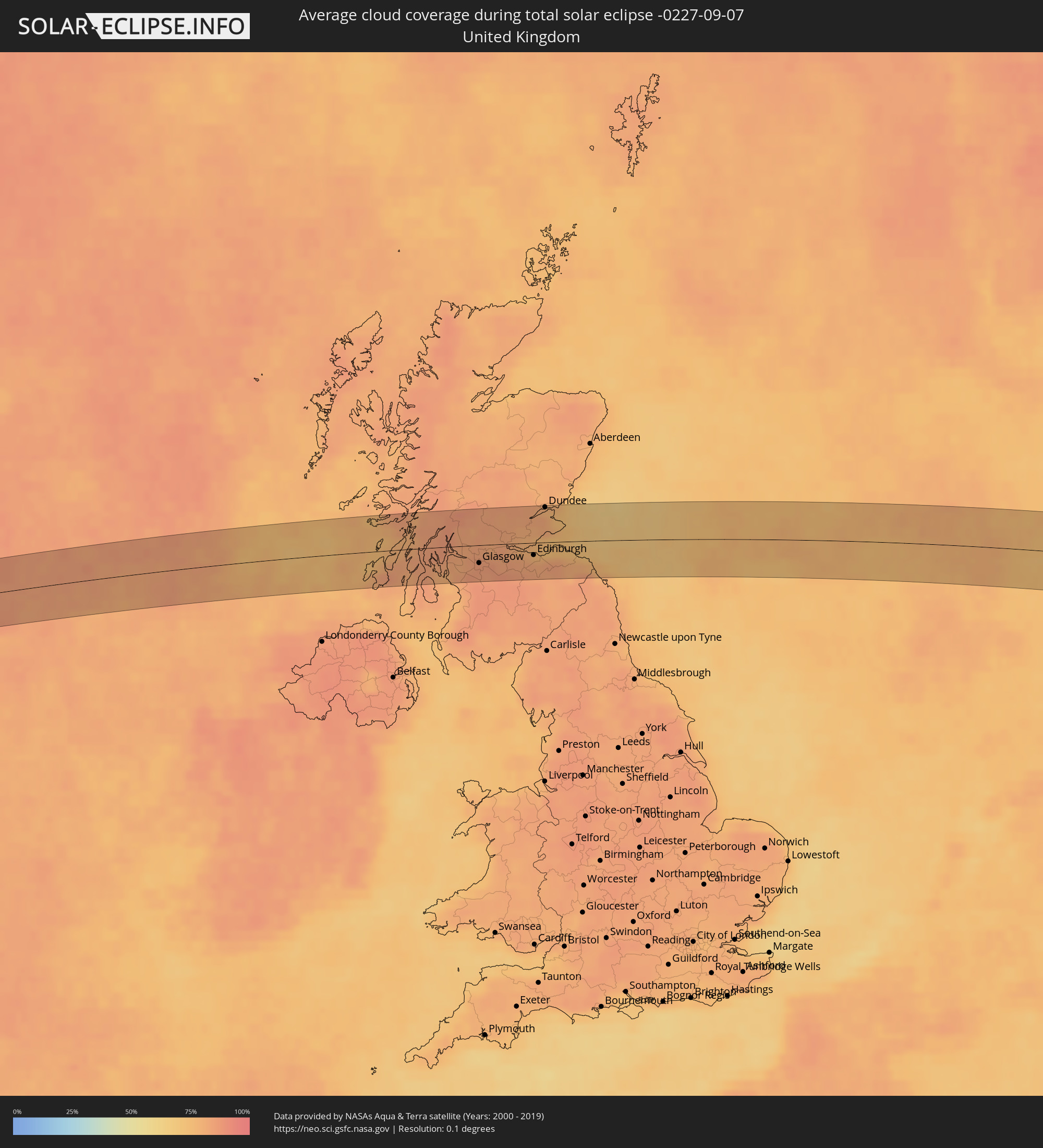 United Kingdom
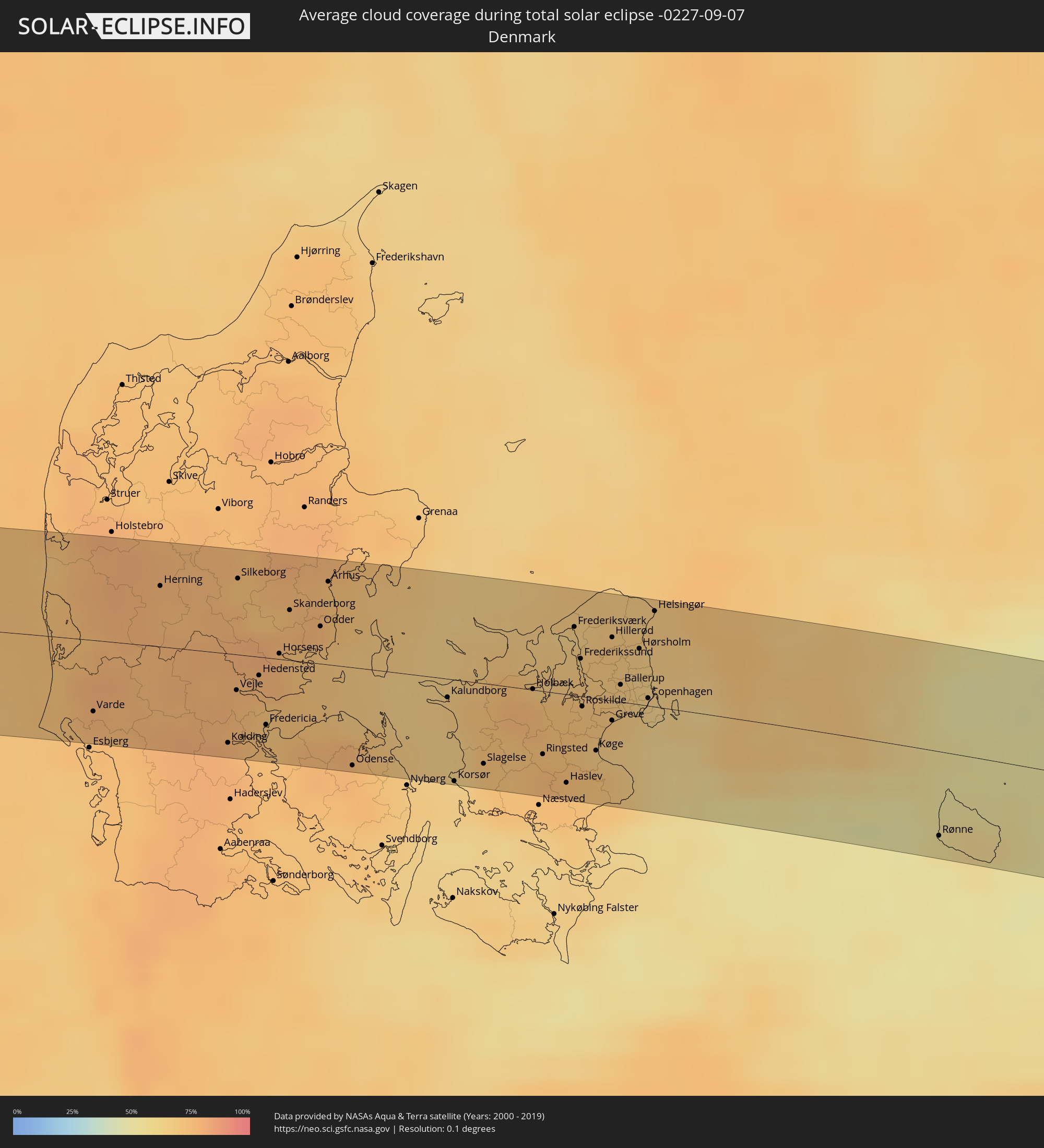 Denmark
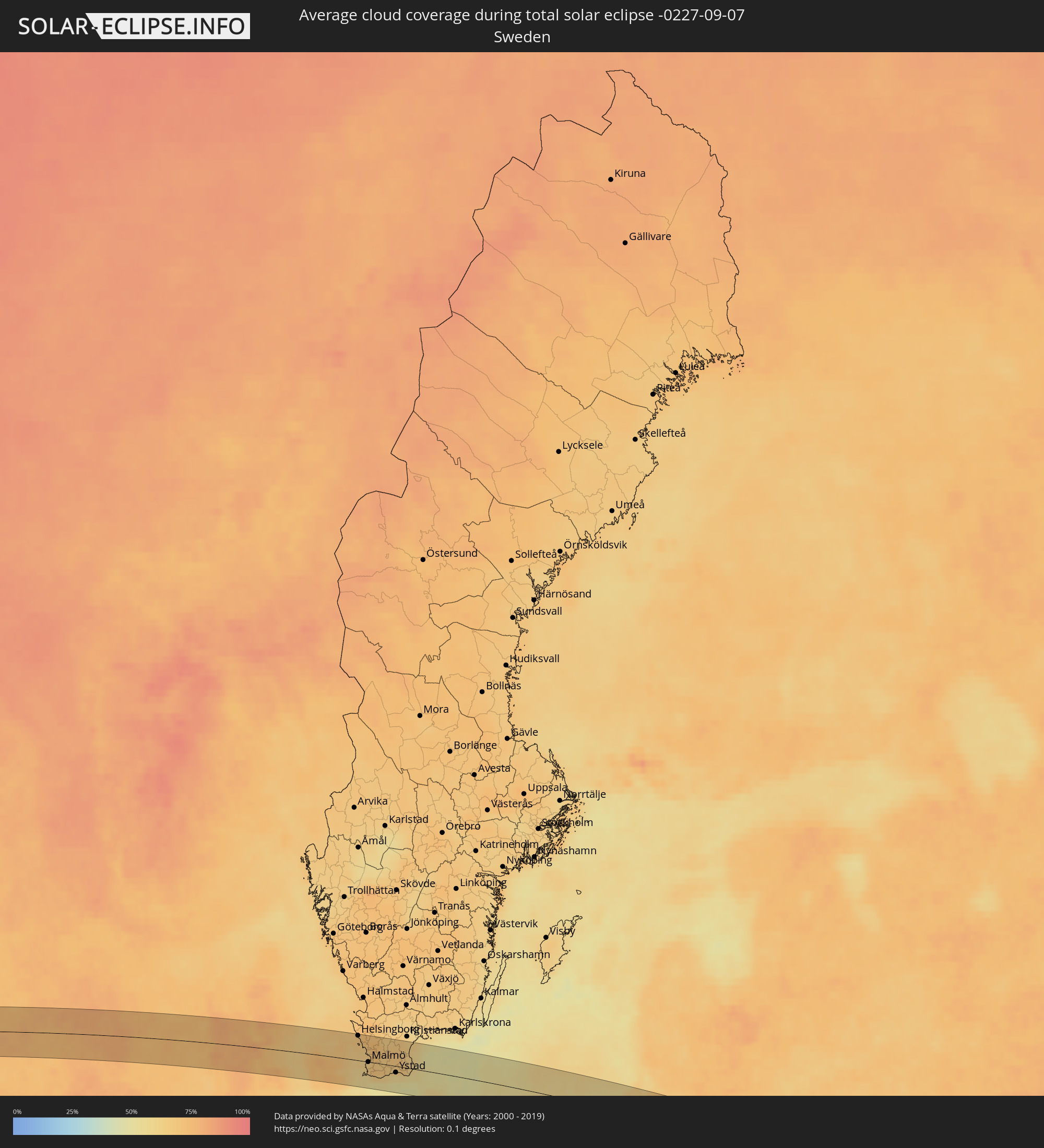 Sweden
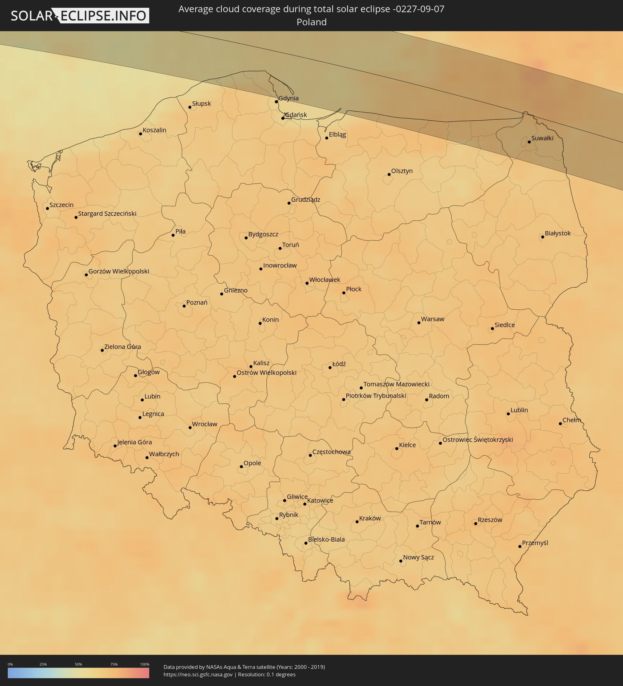 Poland
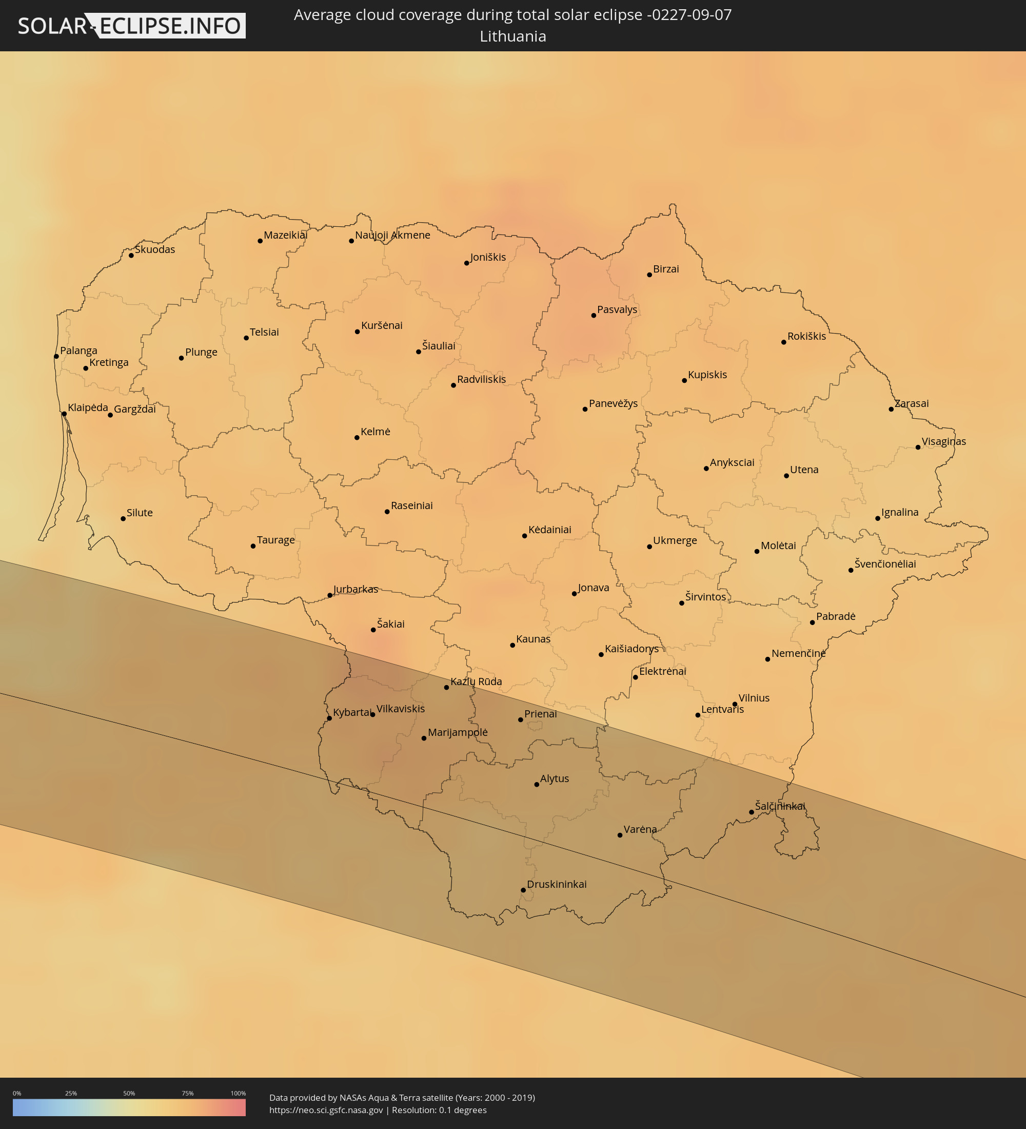 Lithuania
 Ukraine
 Belarus
 Kazakhstan
 Turkmenistan
 Uzbekistan
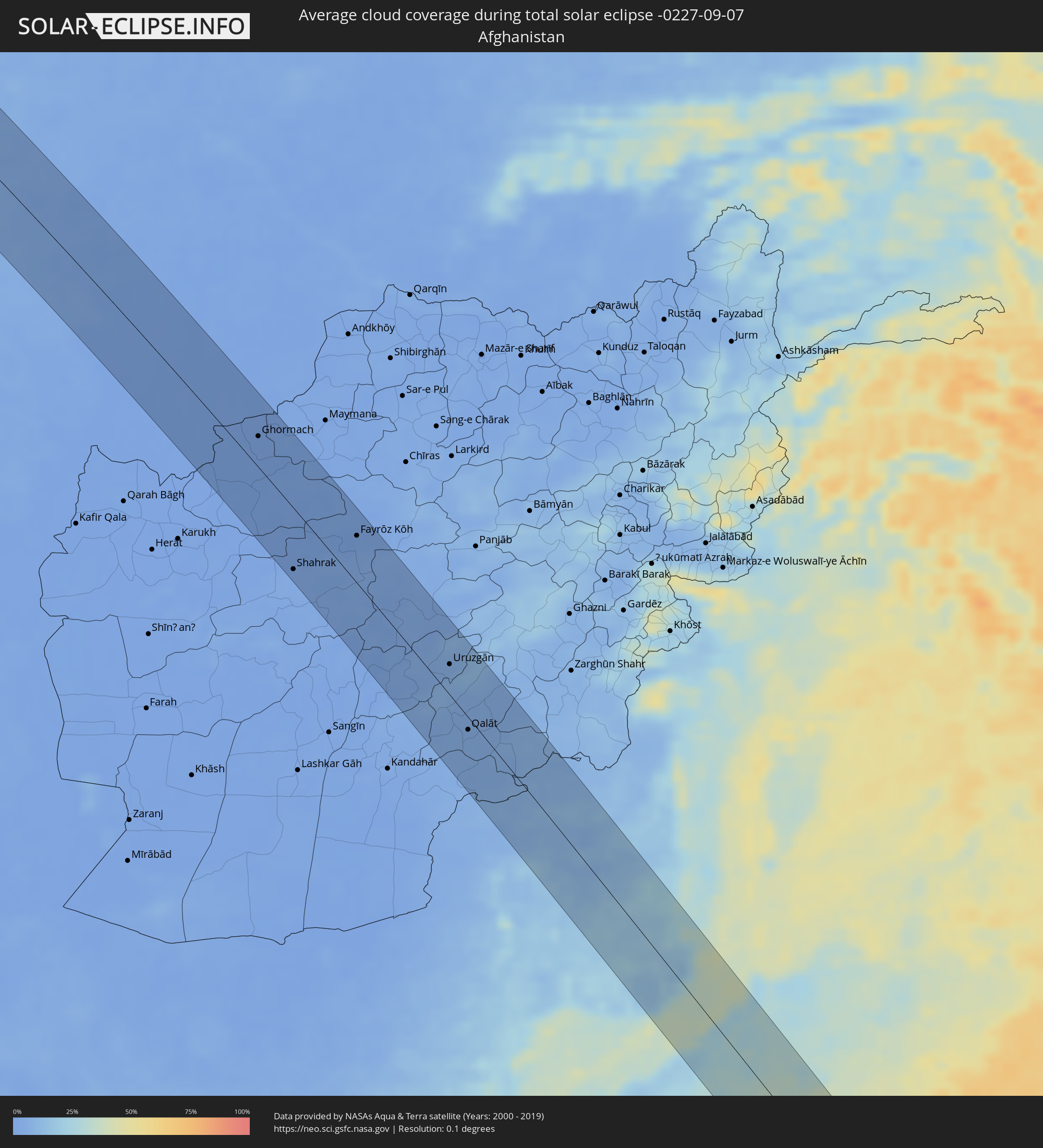 Afghanistan
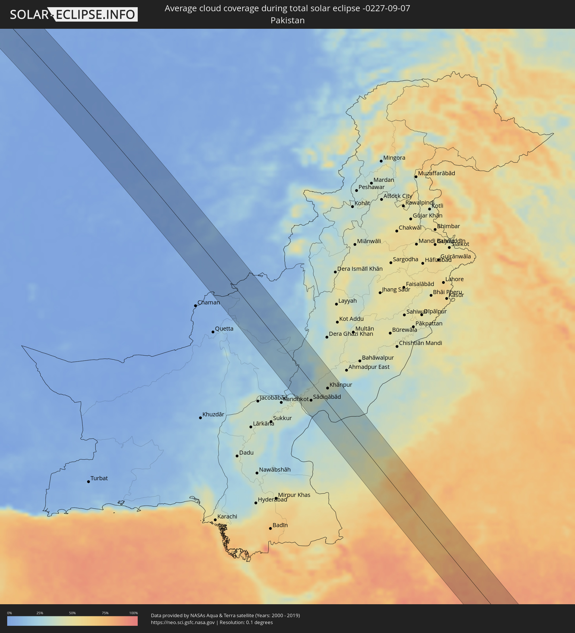 Pakistan
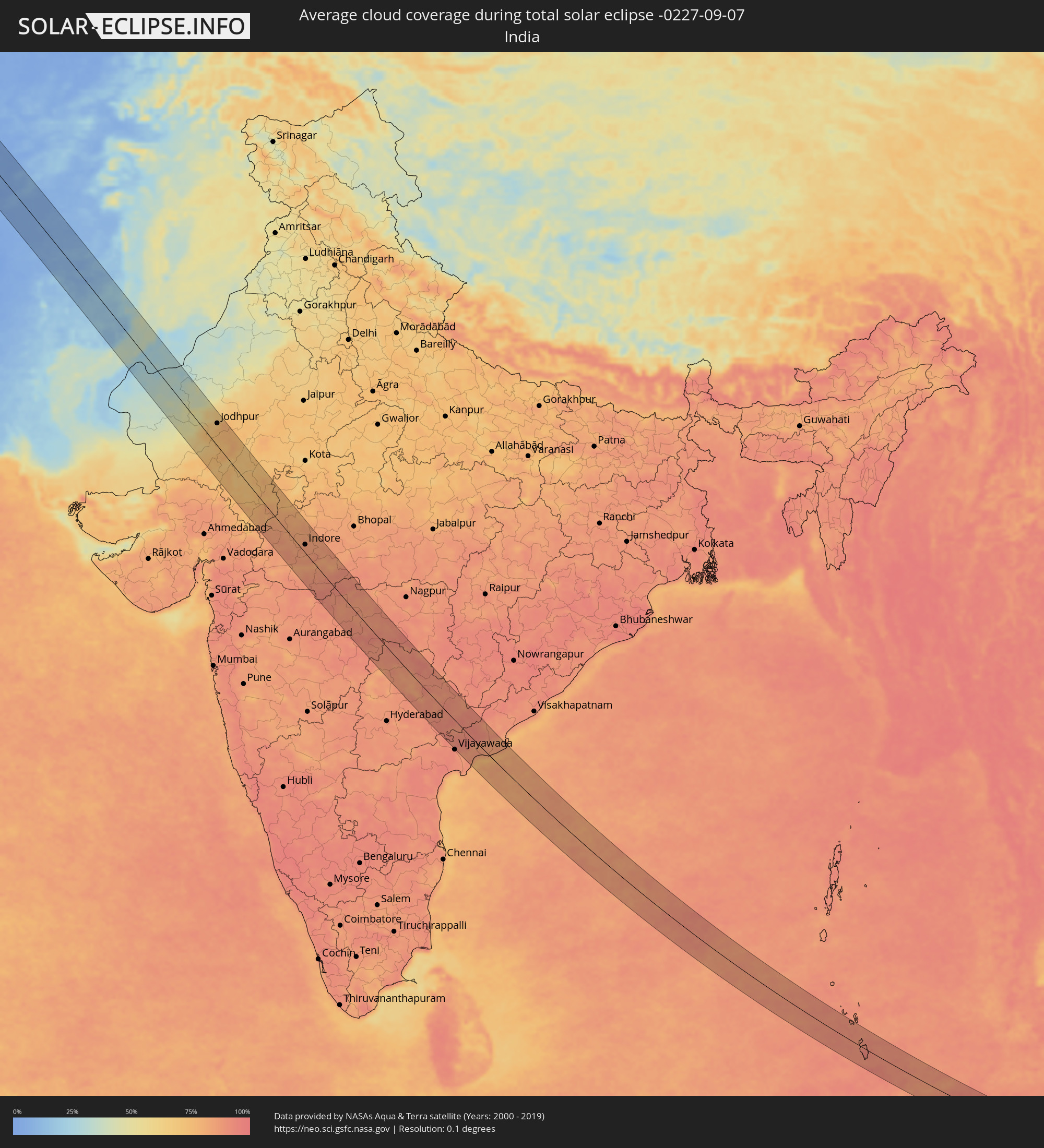 India
India
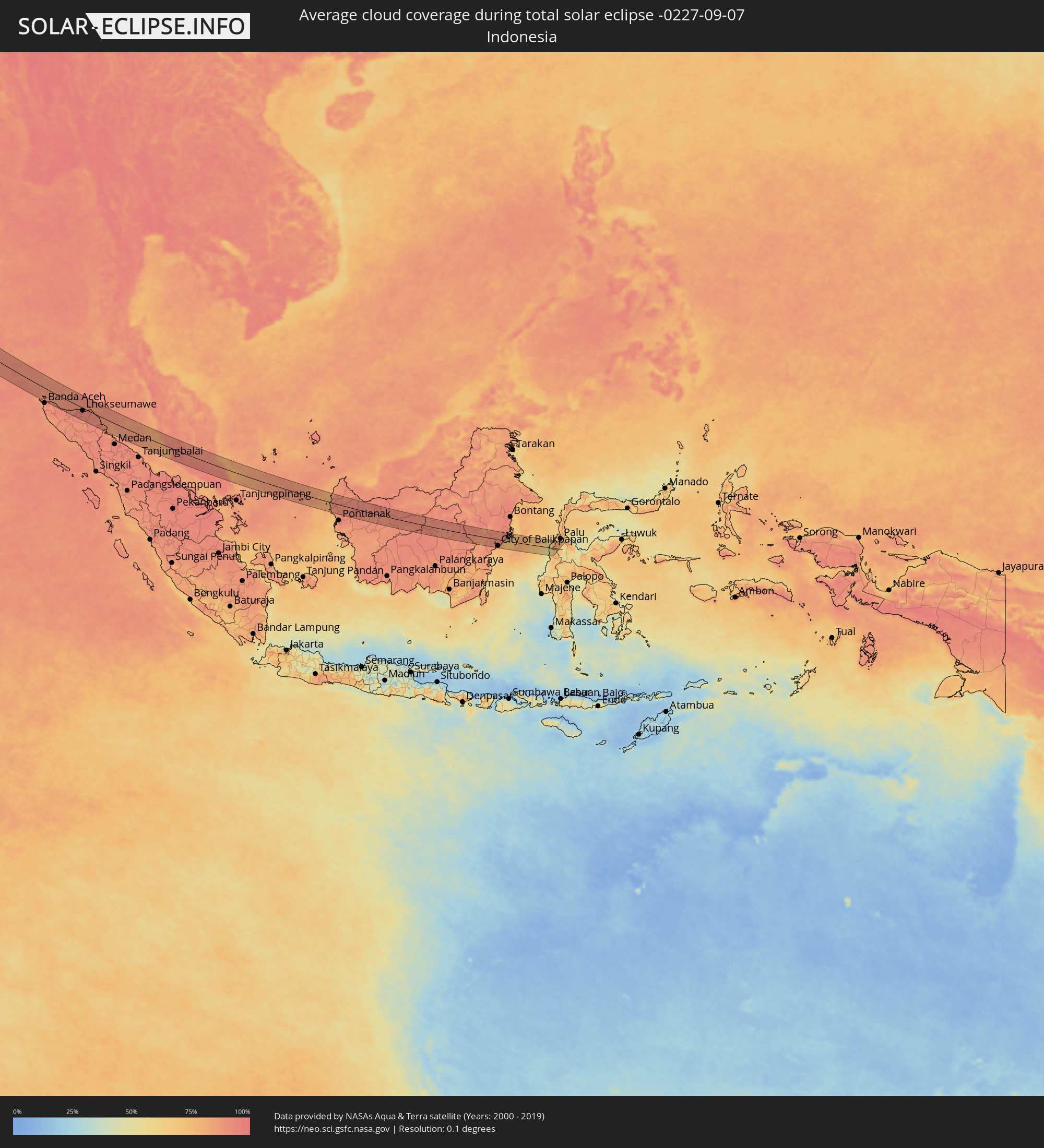 Indonesia
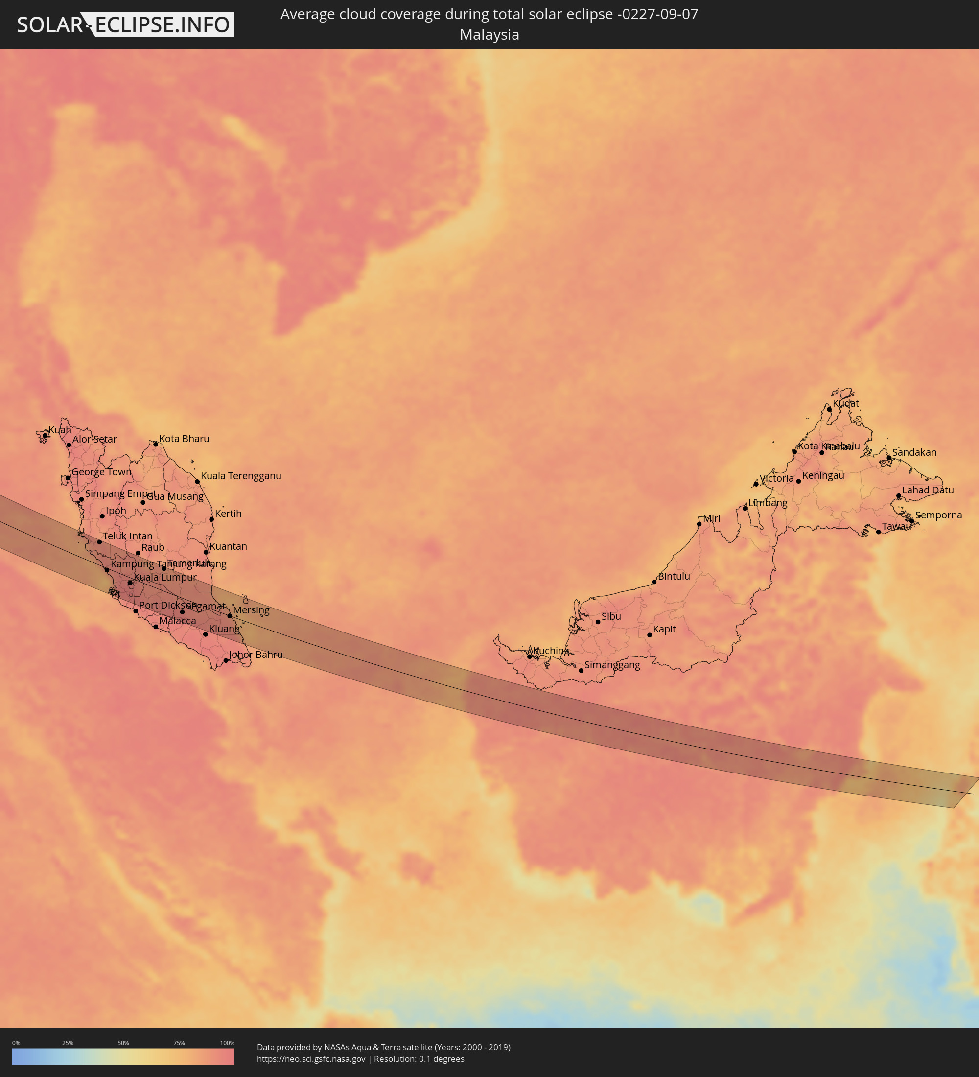 Malaysia
Cities inside the path of the eclipse
The following table shows all locations with a population of more than 5,000 inside the eclipse path. Cities which have more than 100,000 inhabitants are marked bold. A click at the locations opens a detailed map.
| City | Type | Eclipse duration | Local time of max. eclipse | Distance to central line | Ø Cloud coverage |
|
Greenock, Scotland
|
total | - | 06:52:17 UTC+00:00 | 11 km | 82% |
|
Kilwinning, Scotland
|
total | - | 06:52:02 UTC+00:00 | 44 km | 79% |
|
Glasgow, Scotland
|
total | - | 06:52:19 UTC+00:00 | 22 km | 86% |
|
Hamilton, Scotland
|
total | - | 06:52:17 UTC+00:00 | 33 km | 86% |
|
Cumbernauld, Scotland
|
total | - | 06:52:27 UTC+00:00 | 13 km | 86% |
|
Stirling, Scotland
|
total | - | 06:52:37 UTC+00:00 | 6 km | 83% |
|
Polmont, Scotland
|
total | - | 06:52:33 UTC+00:00 | 9 km | 83% |
|
Livingston, Scotland
|
total | - | 06:52:31 UTC+00:00 | 20 km | 83% |
|
Dunfermline, Scotland
|
total | - | 06:52:41 UTC+00:00 | 1 km | 79% |
|
Perth, Scotland
|
total | - | 06:52:59 UTC+00:00 | 35 km | 82% |
|
Edinburgh, Scotland
|
total | - | 06:52:39 UTC+00:00 | 15 km | 78% |
|
Kirkcaldy, Scotland
|
total | - | 06:52:48 UTC+00:00 | 3 km | 75% |
|
Dundee, Scotland
|
total | - | 06:53:09 UTC+00:00 | 42 km | 78% |
|
Berwick-Upon-Tweed, England
|
total | - | 06:52:48 UTC+00:00 | 36 km | 78% |
|
Herning, Central Jutland
|
total | - | 07:57:07 UTC+01:00 | 28 km | 76% |
|
Kolding, South Denmark
|
total | - | 07:56:53 UTC+01:00 | 41 km | 77% |
|
Vejle, South Denmark
|
total | - | 07:57:04 UTC+01:00 | 16 km | 76% |
|
Silkeborg, Central Jutland
|
total | - | 07:57:25 UTC+01:00 | 35 km | 74% |
|
Fredericia, South Denmark
|
total | - | 07:57:04 UTC+01:00 | 31 km | 71% |
|
Horsens, Central Jutland
|
total | - | 07:57:20 UTC+01:00 | 3 km | 74% |
|
Århus, Central Jutland
|
total | - | 07:57:44 UTC+01:00 | 38 km | 73% |
|
Odense, South Denmark
|
total | - | 07:57:16 UTC+01:00 | 45 km | 76% |
|
Roskilde, Zealand
|
total | - | 07:58:19 UTC+01:00 | 5 km | 72% |
|
Køge, Zealand
|
total | - | 07:58:15 UTC+01:00 | 24 km | 66% |
|
Greve, Zealand
|
total | - | 07:58:24 UTC+01:00 | 9 km | 68% |
|
Hørsholm, Capital Region
|
total | - | 07:58:43 UTC+01:00 | 25 km | 66% |
|
Copenhagen, Capital Region
|
total | - | 07:58:36 UTC+01:00 | 3 km | 62% |
|
Helsingør, Capital Region
|
total | - | 07:58:53 UTC+01:00 | 44 km | 69% |
|
Helsingborg, Skåne
|
total | - | 07:58:56 UTC+01:00 | 45 km | 68% |
|
Landskrona, Skåne
|
total | - | 07:58:53 UTC+01:00 | 27 km | 67% |
|
Bunkeflostrand, Skåne
|
total | - | 07:58:43 UTC+01:00 | 9 km | 64% |
|
Malmö, Skåne
|
total | - | 07:58:48 UTC+01:00 | 0 km | 65% |
|
Bjärred, Skåne
|
total | - | 07:58:53 UTC+01:00 | 12 km | 62% |
|
Lomma, Skåne
|
total | - | 07:58:53 UTC+01:00 | 8 km | 67% |
|
Trelleborg, Skåne
|
total | - | 07:58:44 UTC+01:00 | 24 km | 63% |
|
Lund, Skåne
|
total | - | 07:58:58 UTC+01:00 | 13 km | 70% |
|
Svedala, Skåne
|
total | - | 07:58:52 UTC+01:00 | 9 km | 70% |
|
Eslöv, Skåne
|
total | - | 07:59:07 UTC+01:00 | 28 km | 71% |
|
Skurup, Skåne
|
total | - | 07:59:00 UTC+01:00 | 10 km | 69% |
|
Höör, Skåne
|
total | - | 07:59:19 UTC+01:00 | 41 km | 67% |
|
Ystad, Skåne
|
total | - | 07:59:09 UTC+01:00 | 12 km | 56% |
|
Åhus, Skåne
|
total | - | 07:59:44 UTC+01:00 | 46 km | 64% |
|
Bolszewo, Pomeranian Voivodeship
|
total | - | 08:25:22 UTC+01:24 | 49 km | 66% |
|
Wejherowo, Pomeranian Voivodeship
|
total | - | 08:25:24 UTC+01:24 | 50 km | 66% |
|
Reda, Pomeranian Voivodeship
|
total | - | 08:25:28 UTC+01:24 | 48 km | 64% |
|
Władysławowo, Pomeranian Voivodeship
|
total | - | 08:25:36 UTC+01:24 | 28 km | 62% |
|
Puck, Pomeranian Voivodeship
|
total | - | 08:25:34 UTC+01:24 | 35 km | 62% |
|
Kaliningrad, Kaliningrad
|
total | - | 08:03:01 UTC+01:00 | 6 km | 66% |
|
Bartoszyce, Warmian-Masurian Voivodeship
|
total | - | 08:27:01 UTC+01:24 | 50 km | 72% |
|
Węgorzewo, Warmian-Masurian Voivodeship
|
total | - | 08:27:41 UTC+01:24 | 39 km | 61% |
|
Chernyakhovsk, Kaliningrad
|
total | - | 08:03:56 UTC+01:00 | 7 km | 71% |
|
Gołdap, Warmian-Masurian Voivodeship
|
total | - | 08:28:09 UTC+01:24 | 20 km | 70% |
|
Olecko, Warmian-Masurian Voivodeship
|
total | - | 08:28:11 UTC+01:24 | 46 km | 68% |
|
Kybartai
|
total | - | 08:28:38 UTC+01:24 | 24 km | 73% |
|
Suwałki, Podlasie
|
total | - | 08:28:32 UTC+01:24 | 30 km | 68% |
|
Vilkaviskis
|
total | - | 08:28:51 UTC+01:24 | 30 km | 75% |
|
Sejny, Podlasie
|
total | - | 08:28:52 UTC+01:24 | 23 km | 66% |
|
Marijampolė, Marijampolė County
|
total | - | 08:29:03 UTC+01:24 | 26 km | 76% |
|
Kazlų Rūda, Marijampolė County
|
total | - | 08:29:14 UTC+01:24 | 48 km | 74% |
|
Prienai
|
total | - | 08:29:32 UTC+01:24 | 44 km | 71% |
|
Druskininkai, Alytus County
|
total | - | 08:29:19 UTC+01:24 | 21 km | 68% |
|
Alytus, Alytus County
|
total | - | 08:29:31 UTC+01:24 | 21 km | 69% |
|
Varėna, Alytus County
|
total | - | 08:29:52 UTC+01:24 | 12 km | 69% |
|
Shchuchin, Grodnenskaya
|
total | - | 08:55:47 UTC+01:50 | 51 km | 67% |
|
Lida, Grodnenskaya
|
total | - | 08:56:20 UTC+01:50 | 10 km | 71% |
|
Šalčininkai
|
total | - | 08:30:32 UTC+01:24 | 36 km | 72% |
|
Navahrudak, Grodnenskaya
|
total | - | 08:56:40 UTC+01:50 | 30 km | 73% |
|
Dzyarzhynsk, Minsk
|
total | - | 08:57:48 UTC+01:50 | 7 km | 74% |
|
Slutsk, Minsk
|
total | - | 08:58:00 UTC+01:50 | 53 km | 74% |
|
Minsk, Minsk City
|
total | - | 08:58:13 UTC+01:50 | 39 km | 73% |
|
Mar’’ina Horka, Minsk
|
total | - | 08:58:37 UTC+01:50 | 11 km | 70% |
|
Asipovichy, Mogilev
|
total | - | 08:59:00 UTC+01:50 | 0 km | 70% |
|
Babruysk, Mogilev
|
total | - | 08:59:30 UTC+01:50 | 3 km | 70% |
|
Svyetlahorsk, Gomel
|
total | - | 08:59:52 UTC+01:50 | 43 km | 71% |
|
Zhlobin, Gomel
|
total | - | 09:00:11 UTC+01:50 | 9 km | 74% |
|
Rahachow, Gomel
|
total | - | 09:00:14 UTC+01:50 | 12 km | 75% |
|
Gomel, Gomel
|
total | - | 09:01:00 UTC+01:50 | 33 km | 70% |
|
Dobrush, Gomel
|
total | - | 09:01:20 UTC+01:50 | 27 km | 74% |
|
Novozybkov, Brjansk
|
total | - | 09:42:12 UTC+02:30 | 2 km | 72% |
|
Klintsy, Brjansk
|
total | - | 09:42:31 UTC+02:30 | 33 km | 72% |
|
Semenivka, Chernihiv
|
total | - | 09:14:36 UTC+02:02 | 17 km | 73% |
|
Novhorod-Sivers’kyy, Chernihiv
|
total | - | 09:15:16 UTC+02:02 | 16 km | 71% |
|
Shostka, Sumy
|
total | - | 09:15:28 UTC+02:02 | 25 km | 73% |
|
Yampil’, Sumy
|
total | - | 09:15:47 UTC+02:02 | 7 km | 71% |
|
Hlukhiv, Sumy
|
total | - | 09:15:55 UTC+02:02 | 31 km | 67% |
|
Druzhba, Sumy
|
total | - | 09:15:57 UTC+02:02 | 7 km | 71% |
|
Seredyna-Buda, Sumy
|
total | - | 09:16:02 UTC+02:02 | 24 km | 75% |
|
Kurchatov, Kursk
|
total | - | 09:45:55 UTC+02:30 | 18 km | 70% |
|
Kursk, Kursk
|
total | - | 09:46:28 UTC+02:30 | 42 km | 69% |
|
Gubkin, Belgorod
|
total | - | 09:47:57 UTC+02:30 | 39 km | 70% |
|
Staryy Oskol, Belgorod
|
total | - | 09:48:16 UTC+02:30 | 50 km | 69% |
|
Valuyki, Belgorod
|
total | - | 09:48:46 UTC+02:30 | 49 km | 63% |
|
Rossosh’, Voronezj
|
total | - | 09:49:02 UTC+02:30 | 55 km | 64% |
|
Alekseyevka, Belgorod
|
total | - | 09:49:19 UTC+02:30 | 13 km | 61% |
|
Rossosh’, Voronezj
|
total | - | 09:50:25 UTC+02:30 | 1 km | 60% |
|
Volgograd, Volgograd
|
total | - | 09:56:48 UTC+02:30 | 45 km | 56% |
|
Astrakhan, Astrakhan
|
total | - | 10:52:52 UTC+03:20 | 19 km | 41% |
|
Shetpe, Mangghystaū
|
total | - | 11:05:26 UTC+03:25 | 11 km | 33% |
|
Zhanaozen, Mangghystaū
|
total | - | 11:07:20 UTC+03:25 | 42 km | 28% |
|
Mary, Mary
|
total | - | 11:56:31 UTC+03:53 | 34 km | 1% |
|
Murgab
|
total | - | 11:56:53 UTC+03:53 | 36 km | 1% |
|
Bayramaly, Mary
|
total | - | 11:56:59 UTC+03:53 | 58 km | 1% |
|
Yolöten, Mary
|
total | - | 11:57:47 UTC+03:53 | 47 km | 1% |
|
Ghormach, Badghis
|
total | - | 12:09:01 UTC+04:00 | 27 km | 1% |
|
Shahrak, Ghowr
|
total | - | 12:12:39 UTC+04:00 | 54 km | 2% |
|
Fayrōz Kōh, Ghowr
|
total | - | 12:13:23 UTC+04:00 | 42 km | 2% |
|
Tarinkot, Oruzgan
|
total | - | 12:17:46 UTC+04:00 | 48 km | 3% |
|
Nīlī, Daykundi
|
total | - | 12:16:09 UTC+04:00 | 47 km | 4% |
|
Uruzgān, Oruzgan
|
total | - | 12:18:22 UTC+04:00 | 27 km | 6% |
|
Qalāt, Zabul
|
total | - | 12:20:19 UTC+04:00 | 11 km | 6% |
|
Khadan Khāk, Balochistān
|
total | - | 12:52:20 UTC+04:28 | 48 km | 9% |
|
Duki, Balochistān
|
total | - | 12:54:48 UTC+04:28 | 25 km | 10% |
|
Loralai, Balochistān
|
total | - | 12:54:25 UTC+04:28 | 8 km | 9% |
|
Dera Bugti, Balochistān
|
total | - | 12:57:53 UTC+04:28 | 60 km | 19% |
|
Kohlu, Balochistān
|
total | - | 12:56:20 UTC+04:28 | 9 km | 21% |
|
Bārkhān, Balochistān
|
total | - | 12:56:44 UTC+04:28 | 29 km | 20% |
|
Rojhān, Punjab
|
total | - | 12:59:47 UTC+04:28 | 22 km | 33% |
|
Sādiqābād, Punjab
|
total | - | 13:00:48 UTC+04:28 | 35 km | 37% |
|
Rājanpur, Punjab
|
total | - | 12:59:30 UTC+04:28 | 35 km | 31% |
|
Kot Samāba, Punjab
|
total | - | 13:00:49 UTC+04:28 | 8 km | 37% |
|
Zāhir Pīr, Punjab
|
total | - | 13:00:23 UTC+04:28 | 30 km | 34% |
|
Khānpur, Punjab
|
total | - | 13:00:54 UTC+04:28 | 28 km | 37% |
|
Jodhpur, Rajasthan
|
total | - | 14:02:07 UTC+05:21 | 45 km | 68% |
|
Udaipur, Rajasthan
|
total | - | 14:06:35 UTC+05:21 | 20 km | 70% |
|
Ratlām, Madhya Pradesh
|
total | - | 14:11:03 UTC+05:21 | 1 km | 83% |
|
Māndu, Madhya Pradesh
|
total | - | 14:13:30 UTC+05:21 | 43 km | 86% |
|
Ujjain, Madhya Pradesh
|
total | - | 14:12:22 UTC+05:21 | 46 km | 82% |
|
Indore, Madhya Pradesh
|
total | - | 14:13:24 UTC+05:21 | 18 km | 85% |
|
Dewas, Madhya Pradesh
|
total | - | 14:13:12 UTC+05:21 | 53 km | 83% |
|
Punāsa, Madhya Pradesh
|
total | - | 14:15:10 UTC+05:21 | 27 km | 86% |
|
Akola, Maharashtra
|
total | - | 14:19:07 UTC+05:21 | 36 km | 88% |
|
Amrāvati, Maharashtra
|
total | - | 14:19:39 UTC+05:21 | 40 km | 88% |
|
Karīmnagar, Telangana
|
total | - | 14:26:30 UTC+05:21 | 38 km | 85% |
|
Rāmgundam, Telangana
|
total | - | 14:26:11 UTC+05:21 | 14 km | 88% |
|
Warangal, Telangana
|
total | - | 14:27:58 UTC+05:21 | 36 km | 88% |
|
Rājahmundry, Andhra Pradesh
|
total | - | 14:32:37 UTC+05:21 | 55 km | 89% |
|
Sabang, Aceh
|
total | - | 16:50:37 UTC+07:07 | 36 km | 85% |
|
Sigli, Aceh
|
total | - | 16:51:46 UTC+07:07 | 52 km | 91% |
|
Reuleuet, Aceh
|
total | - | 16:52:13 UTC+07:07 | 52 km | 92% |
|
Bireun, Aceh
|
total | - | 16:52:29 UTC+07:07 | 33 km | 91% |
|
Lhokseumawe, Aceh
|
total | - | 16:52:47 UTC+07:07 | 12 km | 90% |
|
Langsa, Aceh
|
total | - | 16:54:15 UTC+07:07 | 44 km | 92% |
|
Teluk Intan, Perak
|
total | - | 16:44:35 UTC+06:55 | 50 km | 89% |
|
Kuala Selangor, Selangor
|
total | - | 16:45:34 UTC+06:55 | 10 km | 90% |
|
Kampong Dungun, Perak
|
total | - | 16:45:46 UTC+06:55 | 21 km | 87% |
|
Klang, Selangor
|
total | - | 16:46:04 UTC+06:55 | 34 km | 95% |
|
Banting, Selangor
|
total | - | 16:46:22 UTC+06:55 | 54 km | 89% |
|
Kampung Baru Subang, Selangor
|
total | - | 16:45:57 UTC+06:55 | 18 km | 96% |
|
Rawang, Selangor
|
total | - | 16:45:45 UTC+06:55 | 1 km | 94% |
|
Kuala Lumpur, Kuala Lumpur
|
total | - | 16:46:02 UTC+06:55 | 13 km | 96% |
|
Putrajaya, Putrajaya
|
total | - | 16:46:17 UTC+06:55 | 34 km | 95% |
|
Semenyih, Selangor
|
total | - | 16:46:20 UTC+06:55 | 26 km | 96% |
|
Bentong Town, Pahang
|
total | - | 16:45:38 UTC+06:55 | 36 km | 92% |
|
Seremban, Negeri Sembilan
|
total | - | 16:46:39 UTC+06:55 | 45 km | 95% |
|
Temerluh, Pahang
|
total | - | 16:45:56 UTC+06:55 | 49 km | 87% |
|
Segamat, Johor
|
total | - | 16:47:16 UTC+06:55 | 32 km | 96% |
|
Sungai Raya, West Kalimantan
|
total | - | 17:02:52 UTC+07:07 | 14 km | 82% |
|
Pemangkat, West Kalimantan
|
total | - | 17:02:22 UTC+07:07 | 38 km | 87% |
|
Singkawang, West Kalimantan
|
total | - | 17:02:39 UTC+07:07 | 11 km | 91% |
|
Balikpapan, East Kalimantan
|
total | - | 17:55:47 UTC+07:57 | 37 km | 73% |
|
City of Balikpapan, East Kalimantan
|
total | - | 17:55:45 UTC+07:57 | 33 km | 84% |