Total solar eclipse of 08/06/-0281
| Day of week: | Friday |
| Maximum duration of eclipse: | 04m18s |
| Maximum width of eclipse path: | 187 km |
| Saros cycle: | 60 |
| Coverage: | 100% |
| Magnitude: | 1.0539 |
| Gamma: | 0.3114 |
Wo kann man die Sonnenfinsternis vom 08/06/-0281 sehen?
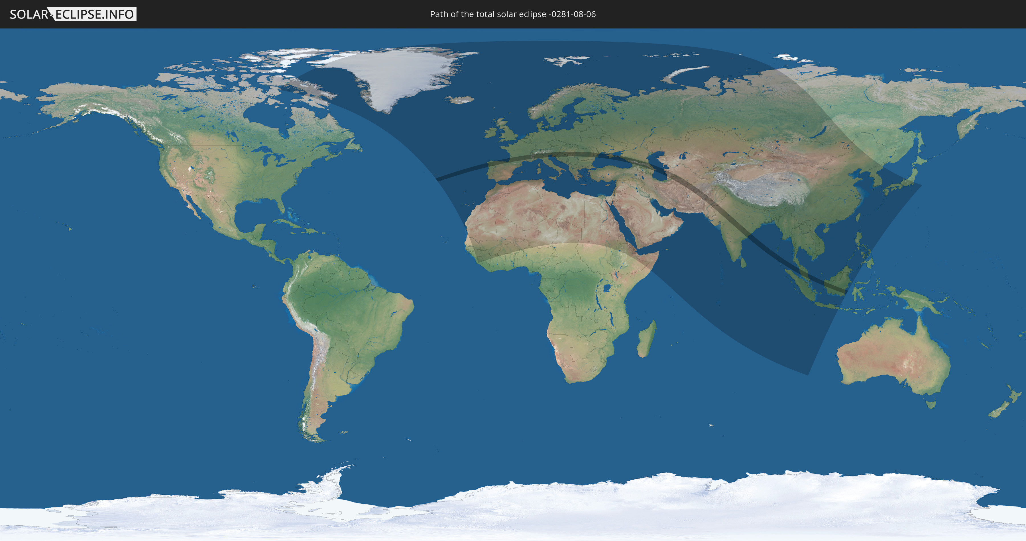
Die Sonnenfinsternis am 08/06/-0281 kann man in 131 Ländern als partielle Sonnenfinsternis beobachten.
Der Finsternispfad verläuft durch 24 Länder. Nur in diesen Ländern ist sie als total Sonnenfinsternis zu sehen.
In den folgenden Ländern ist die Sonnenfinsternis total zu sehen
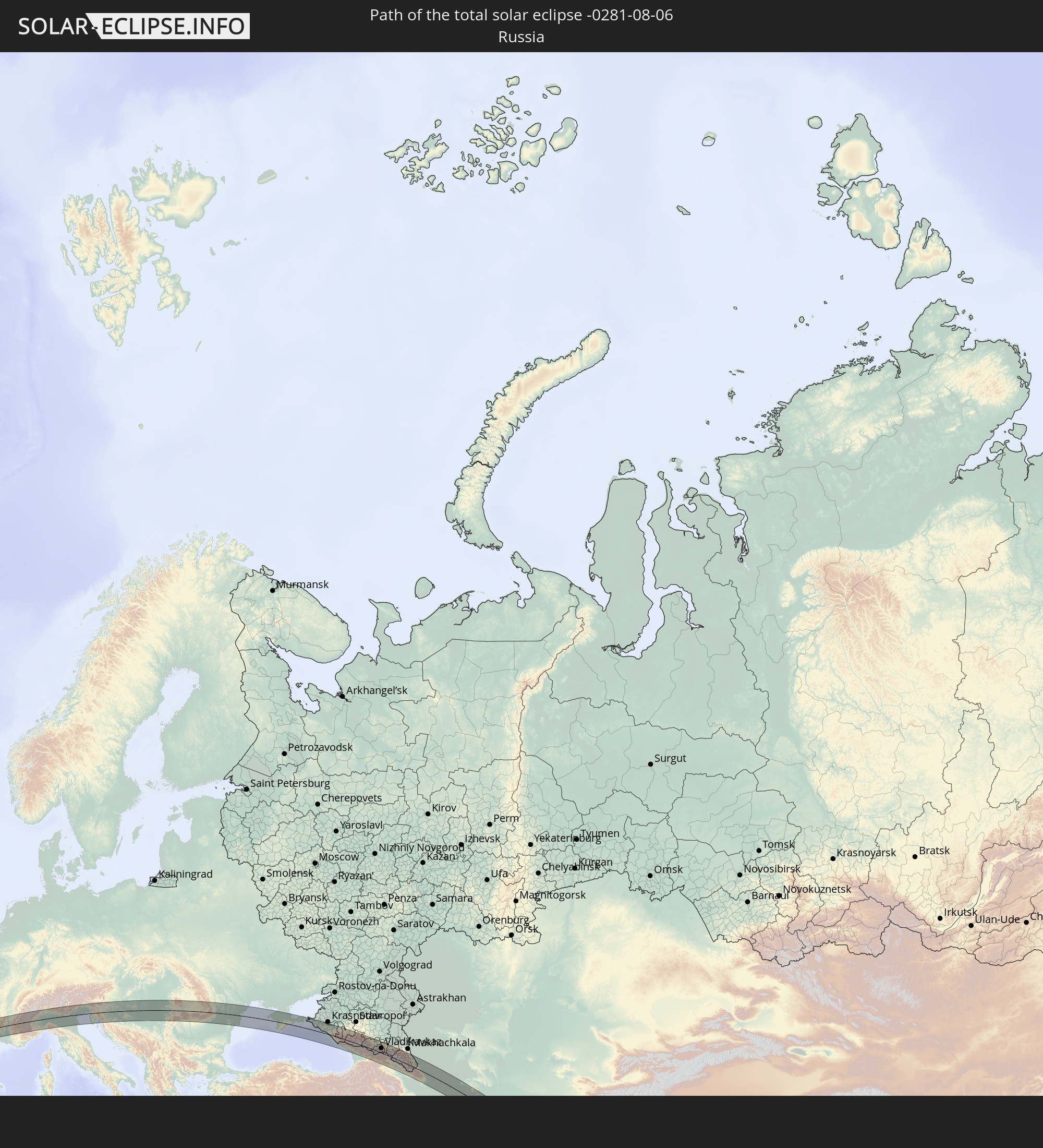 Russia
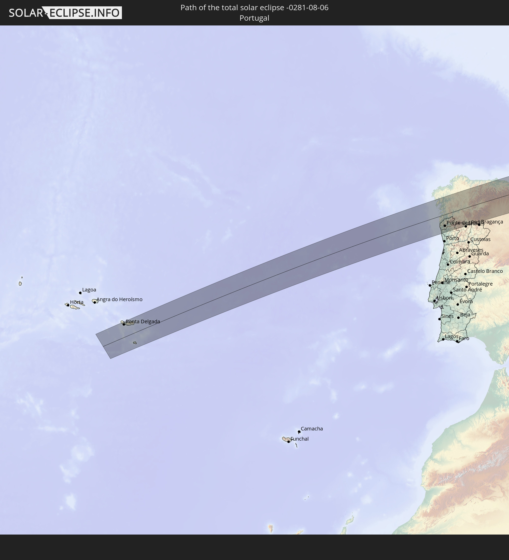 Portugal
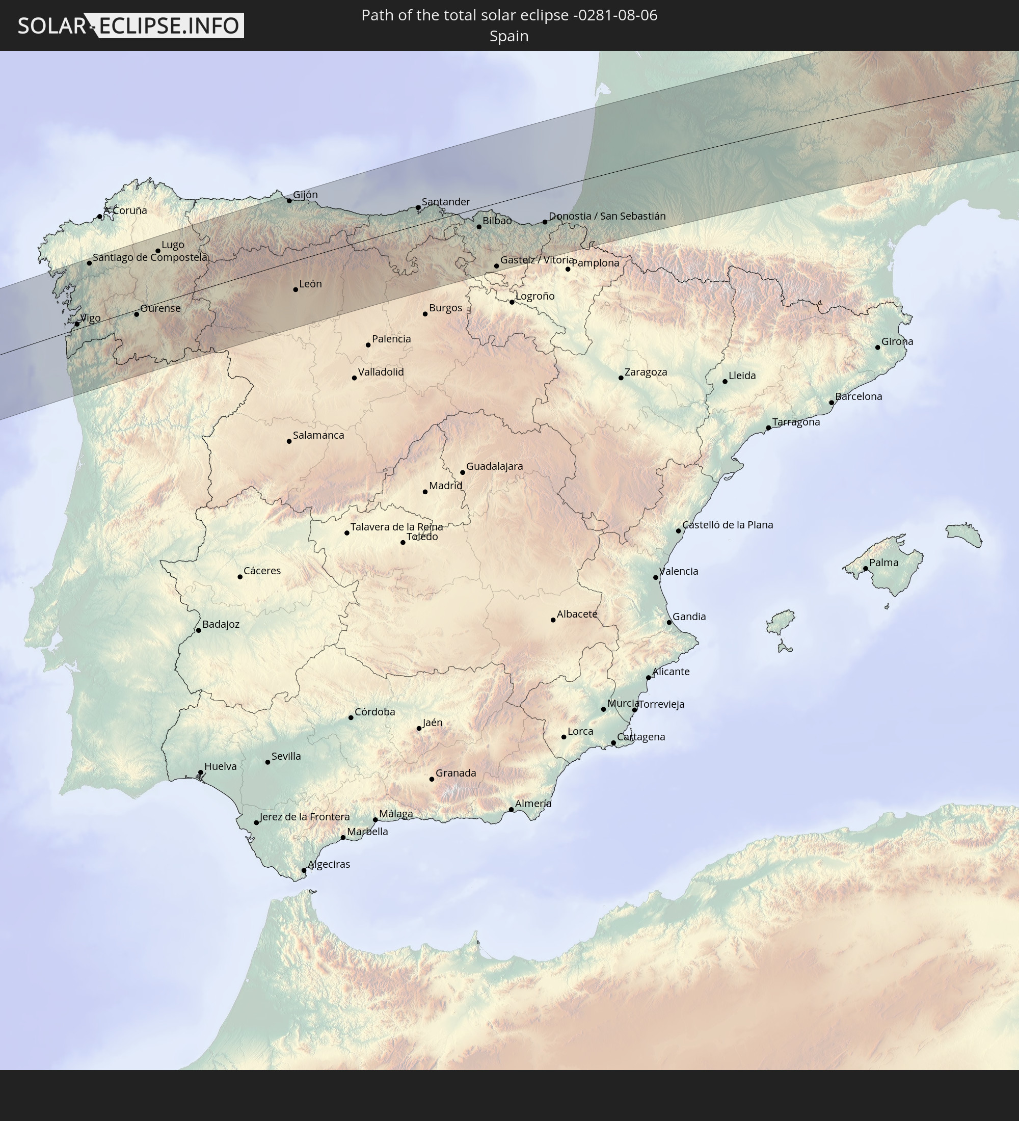 Spain
Spain
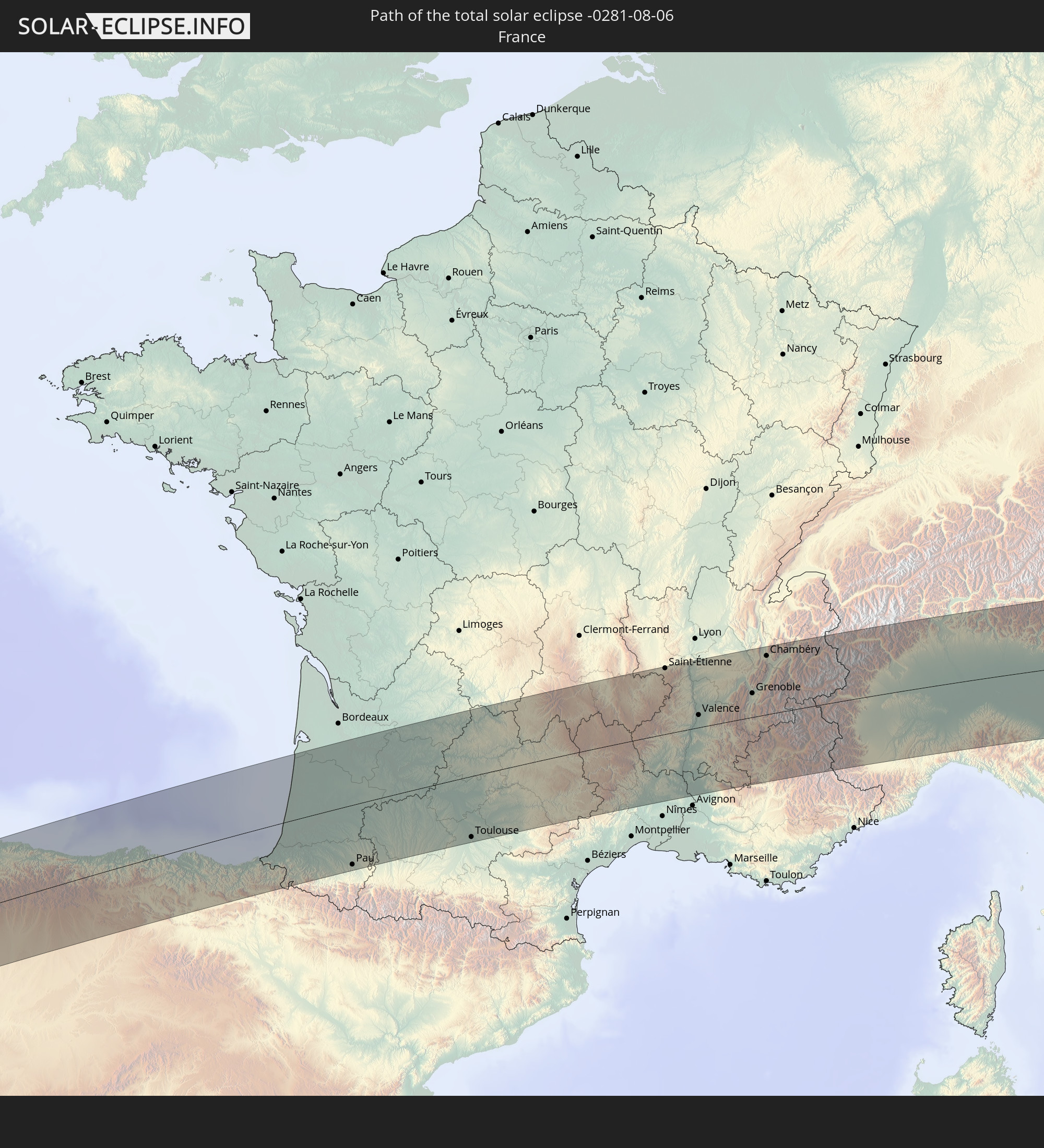 France
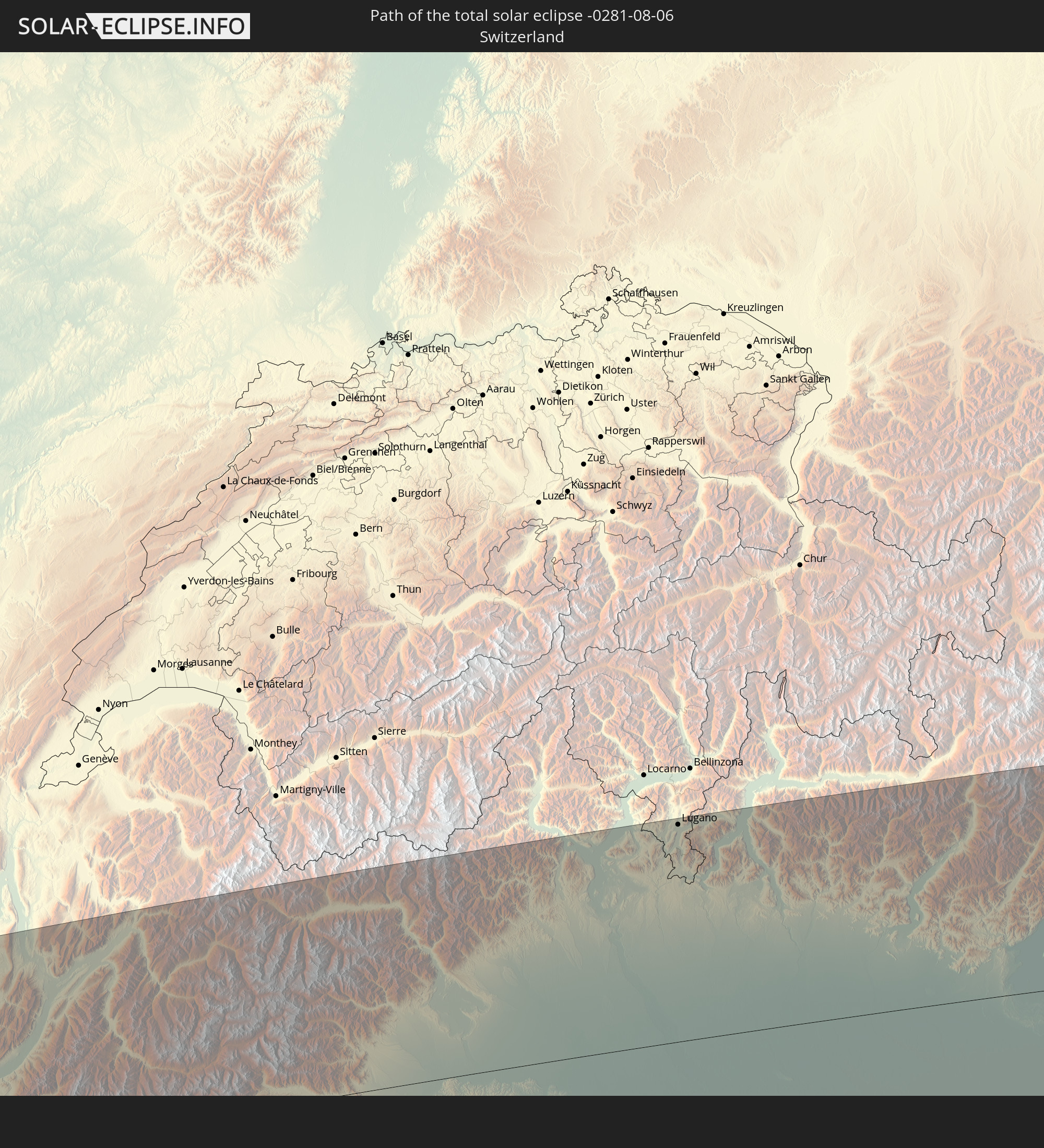 Switzerland
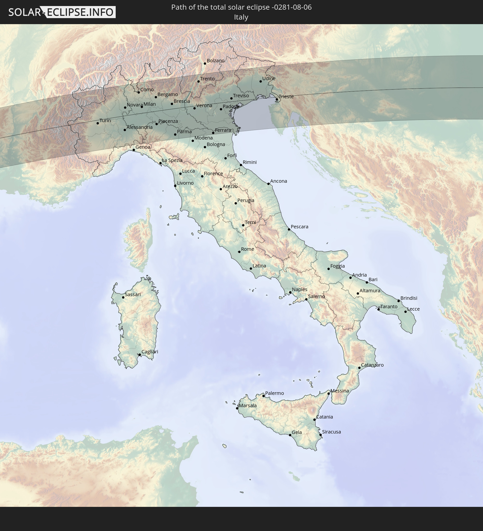 Italy
Italy
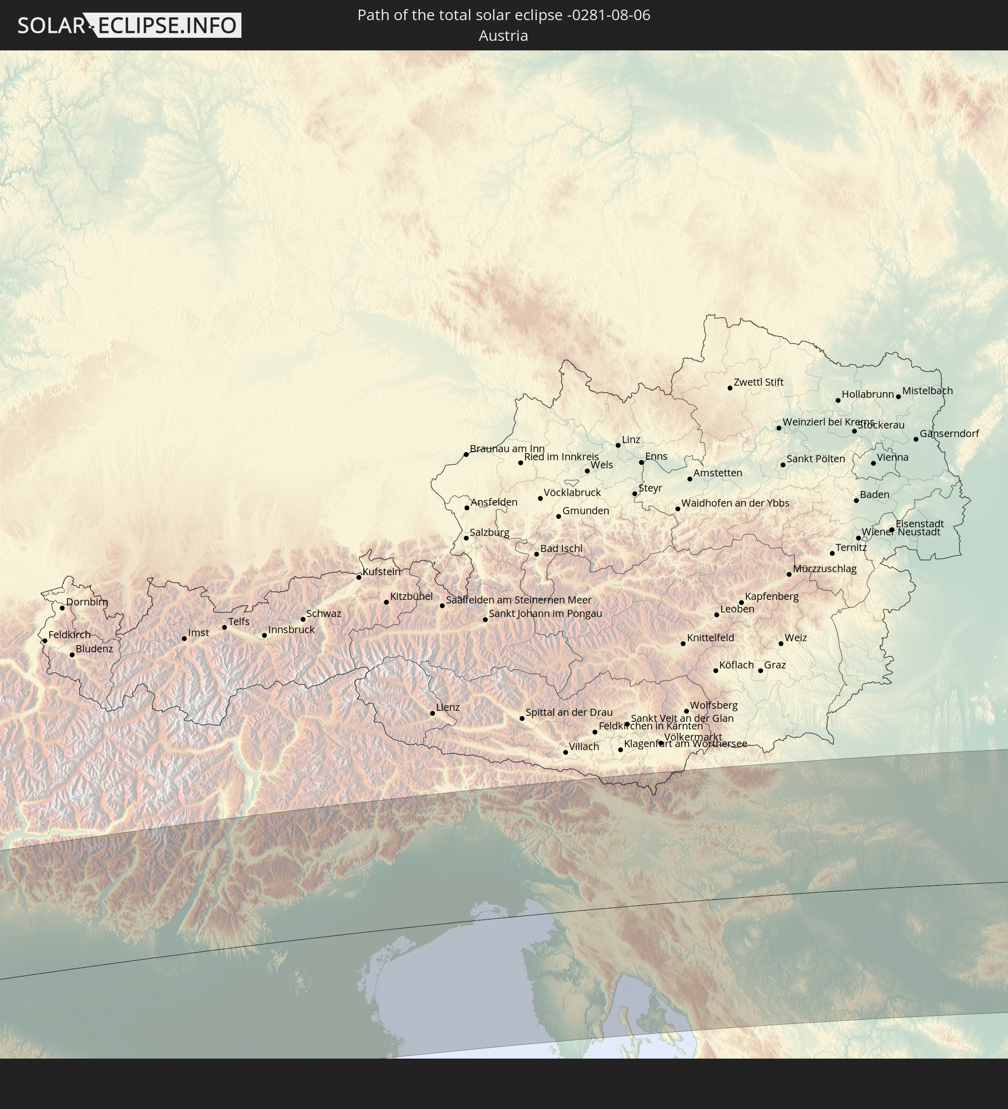 Austria
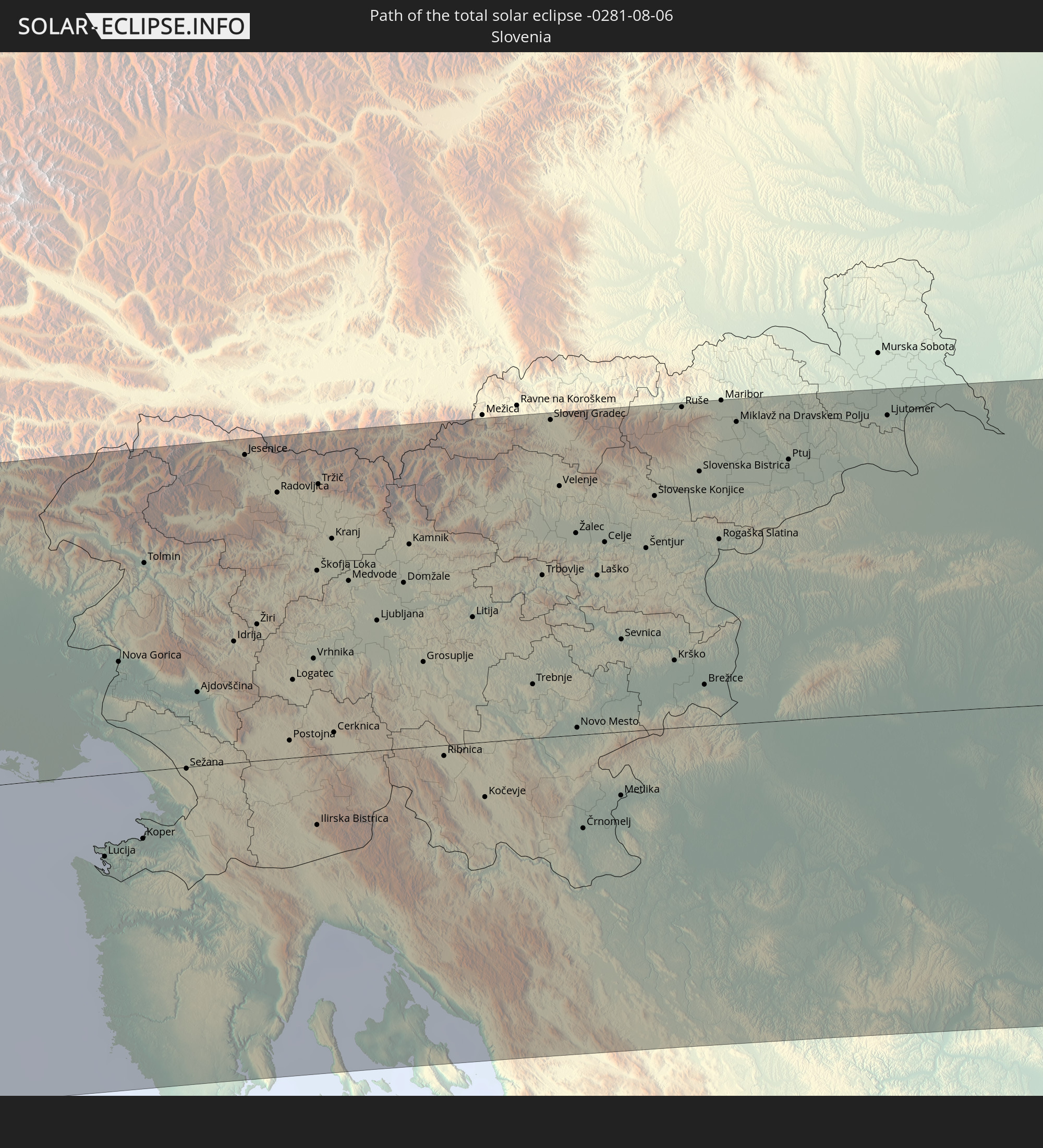 Slovenia
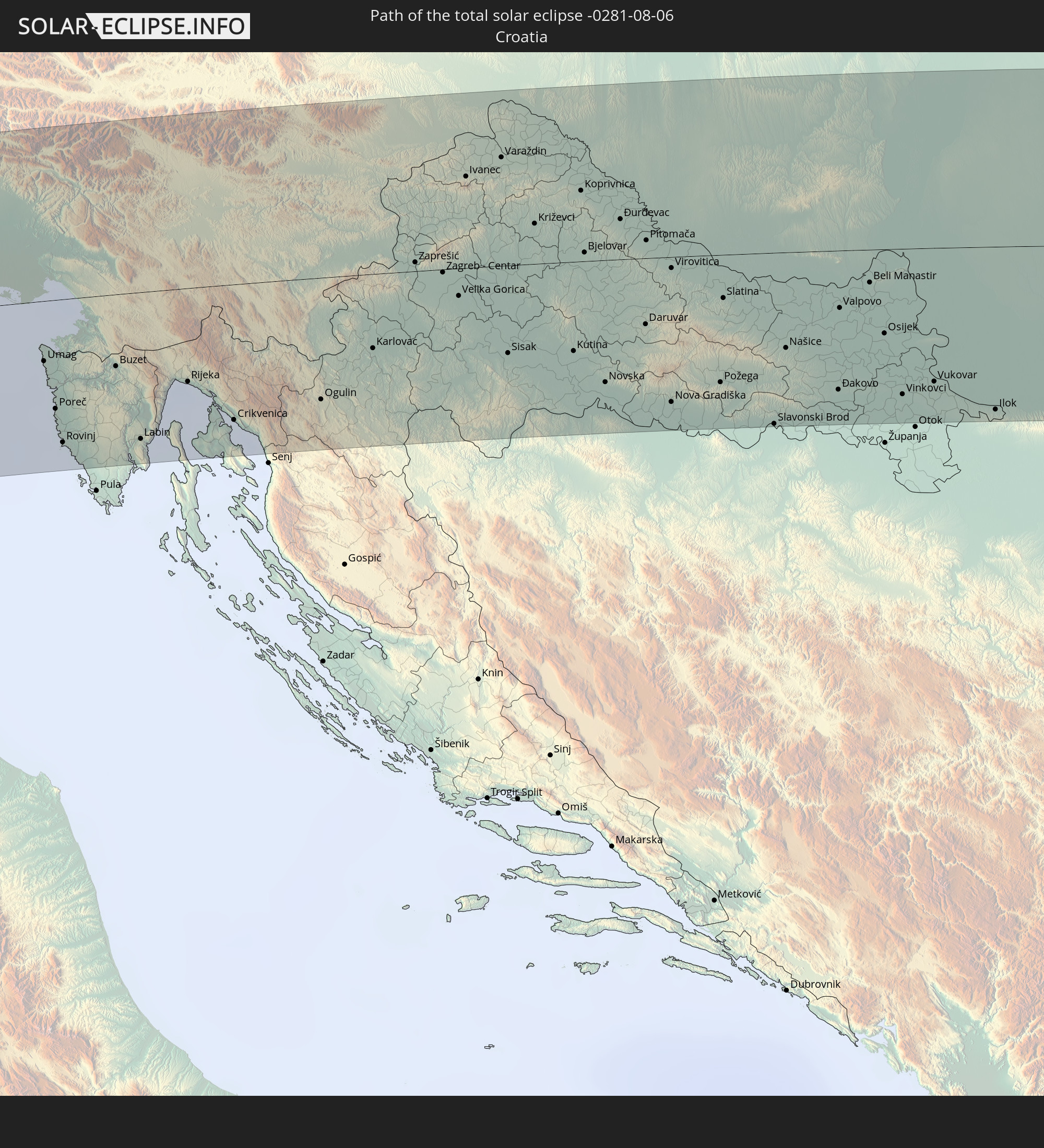 Croatia
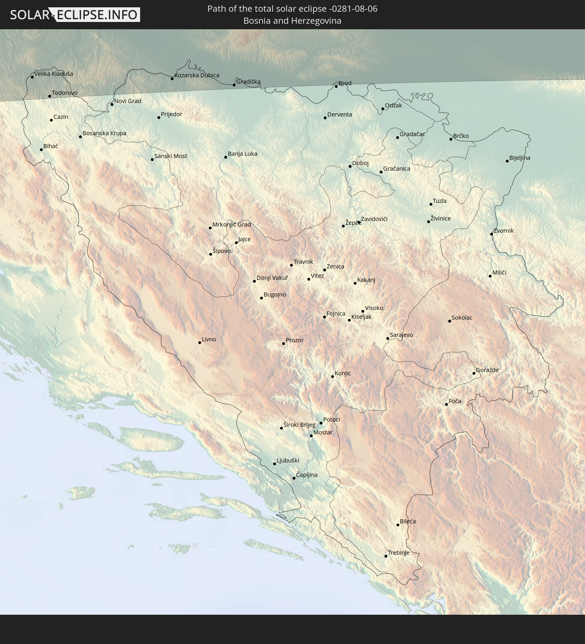 Bosnia and Herzegovina
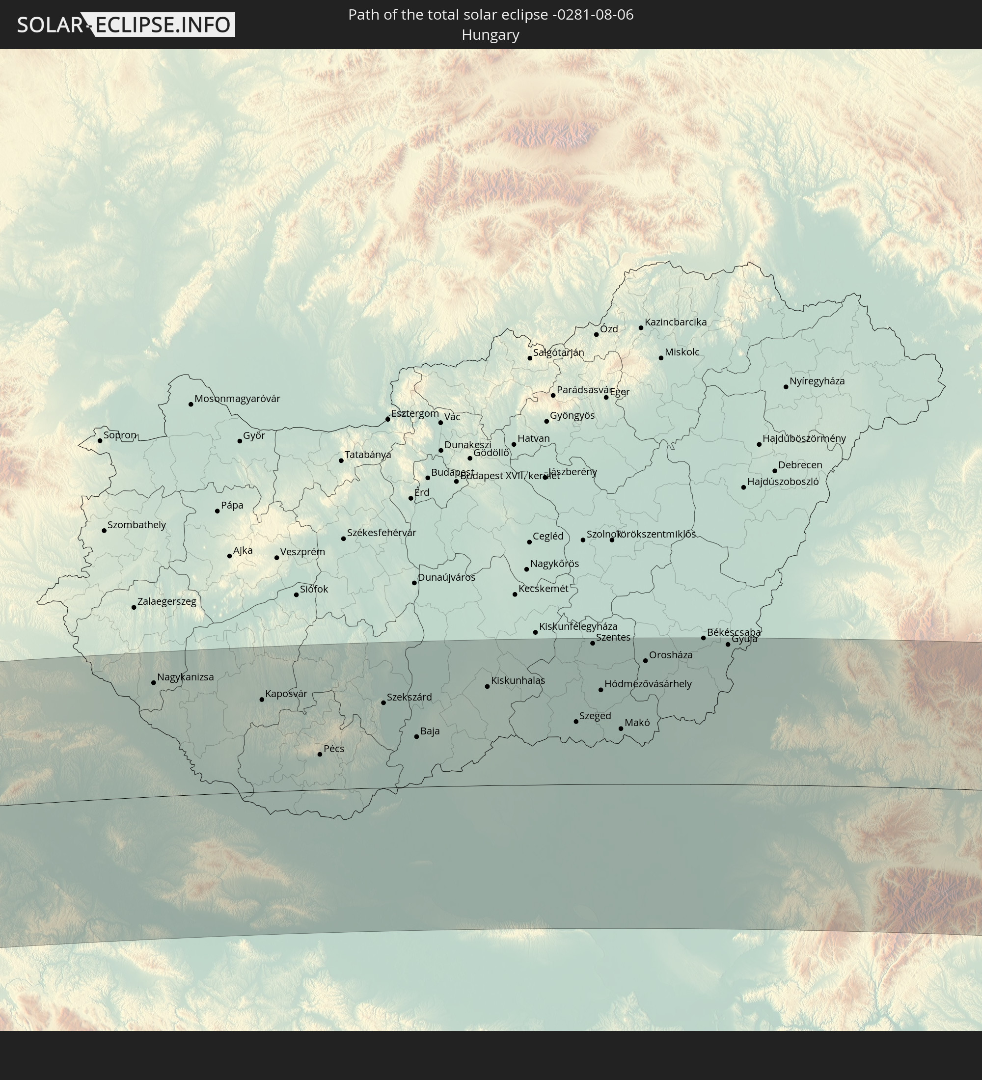 Hungary
 Serbia
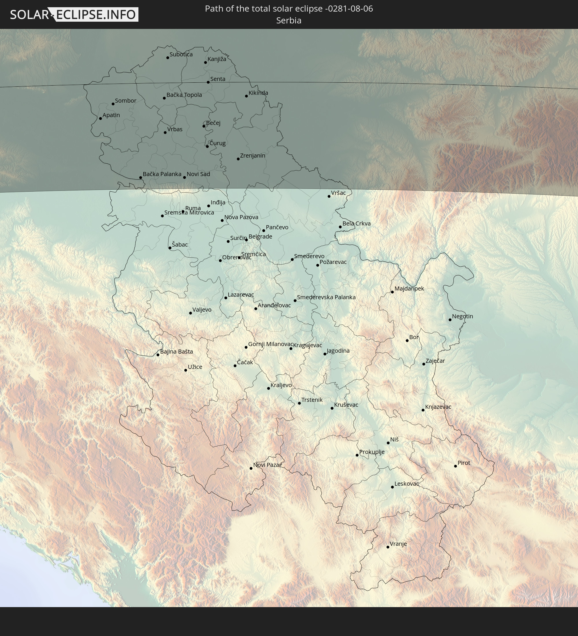
 Romania
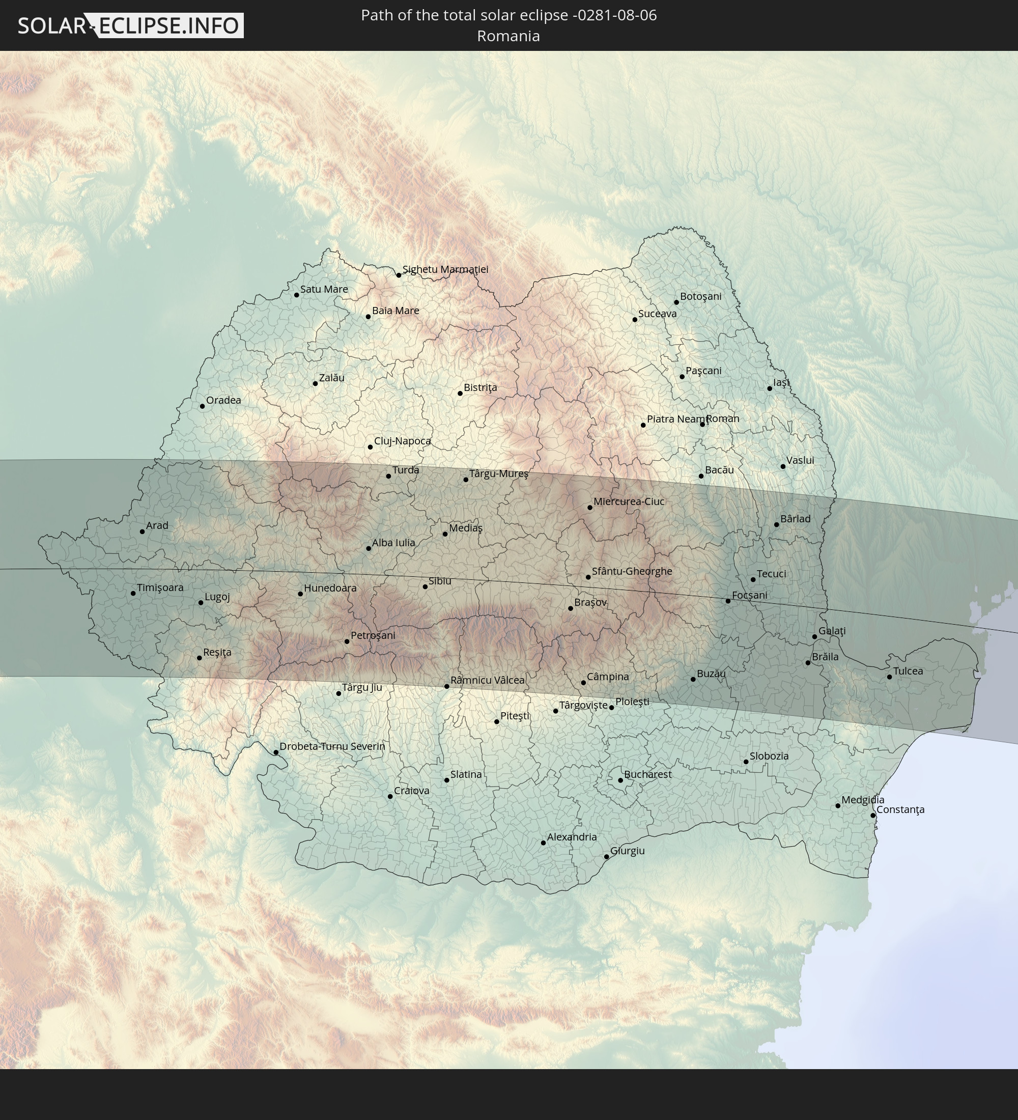
 Ukraine
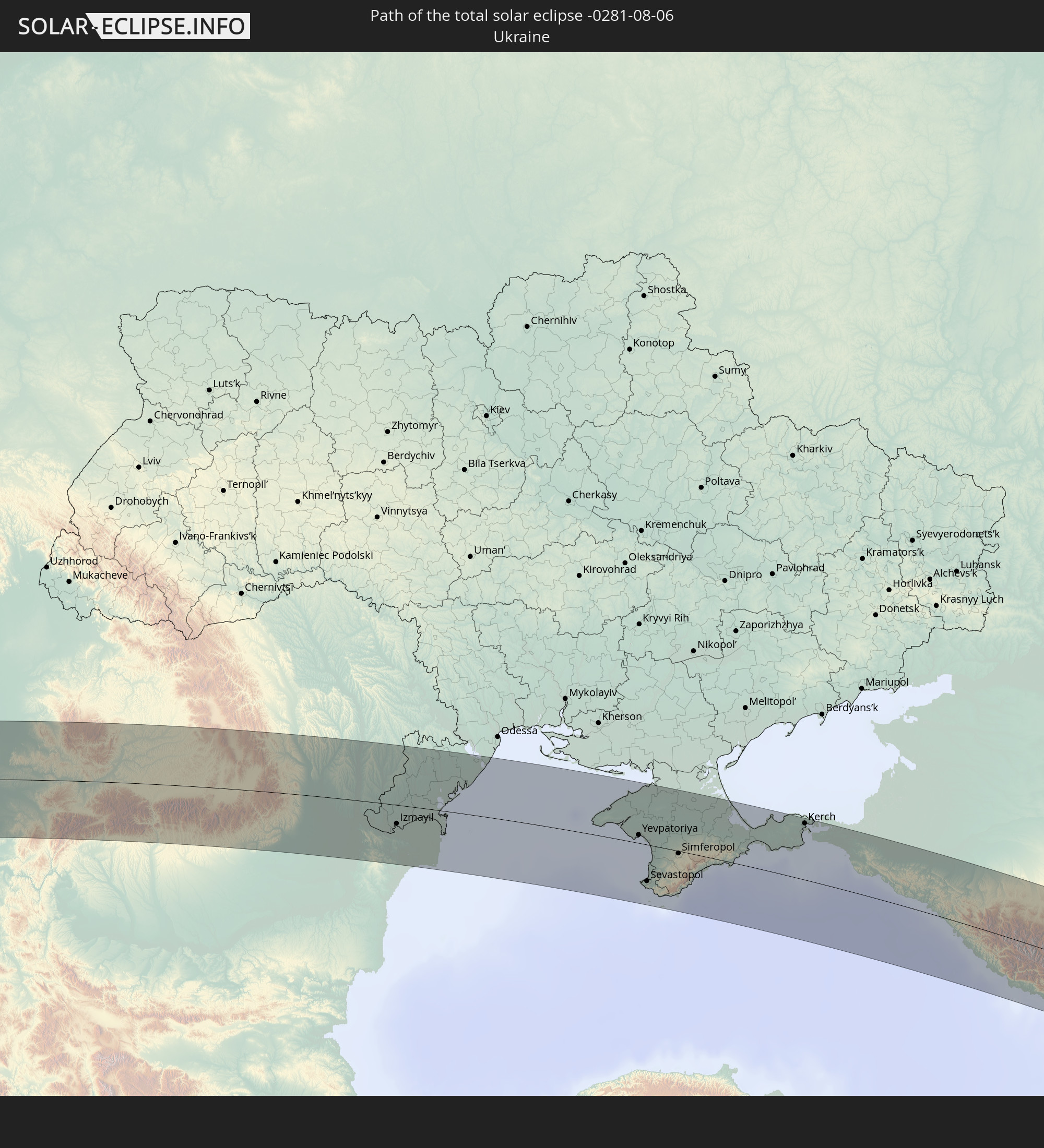
 Moldova
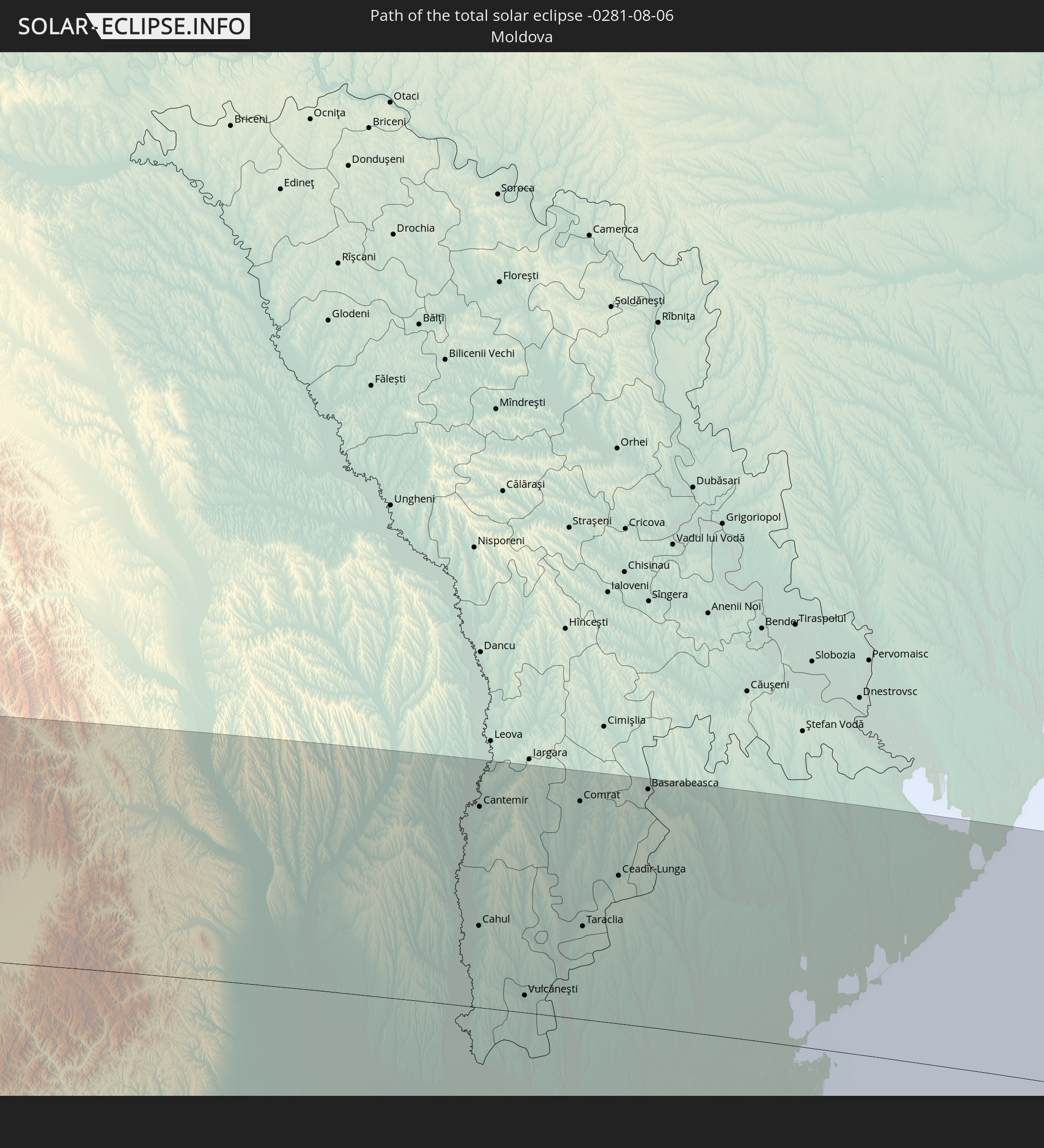
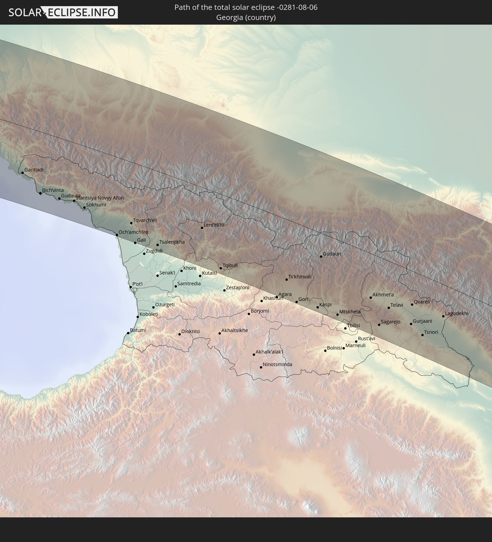 Georgia
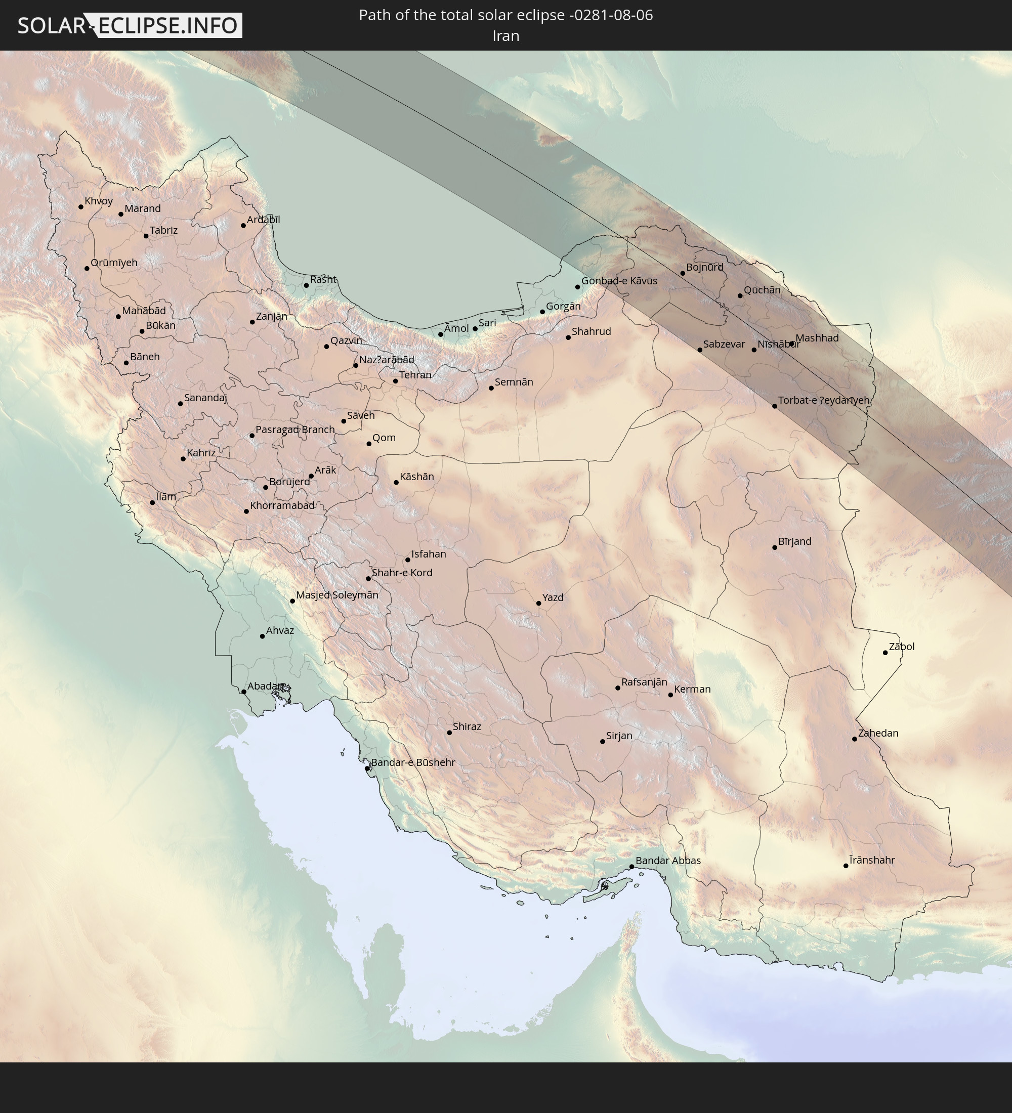 Iran
Iran
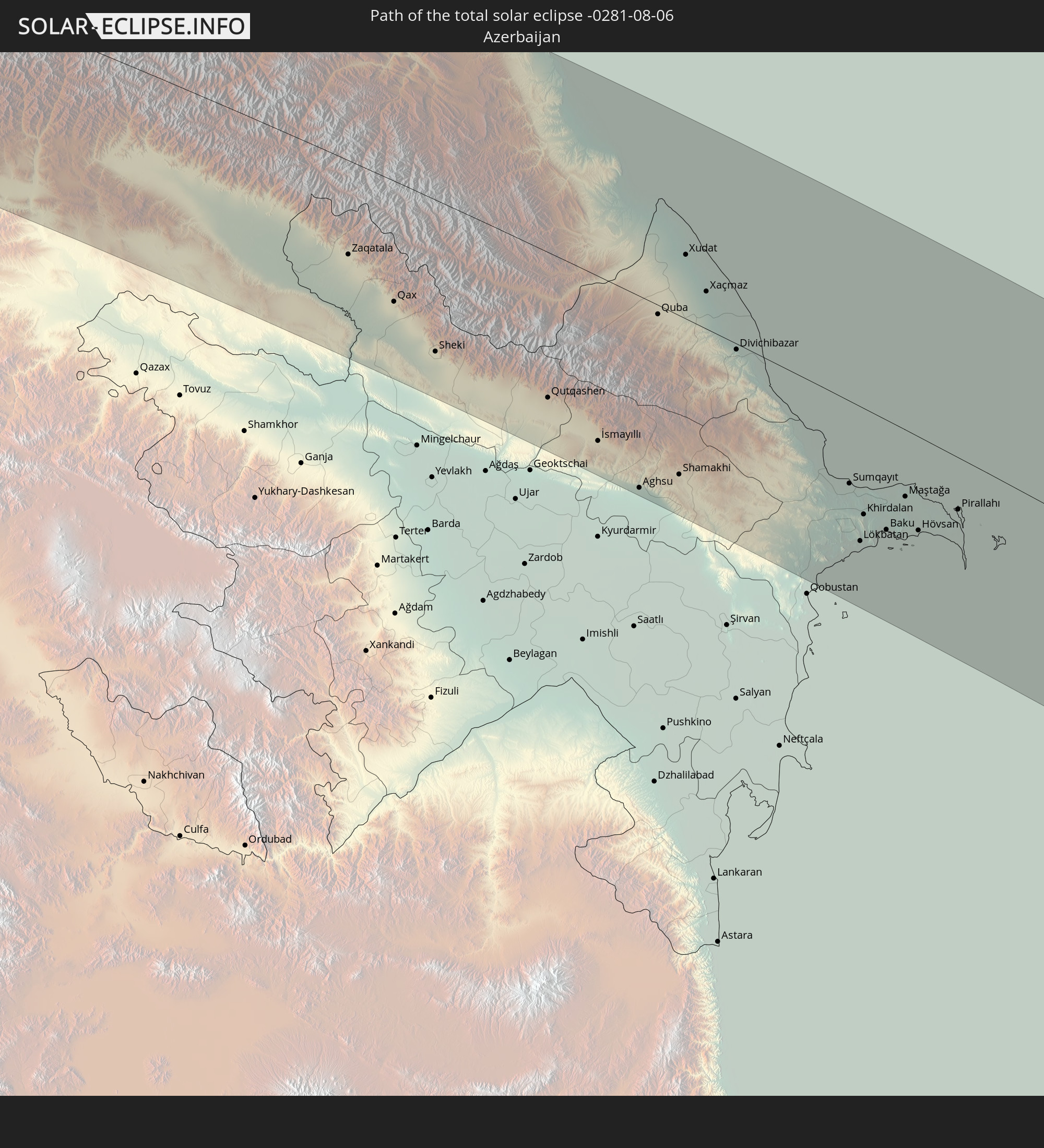 Azerbaijan
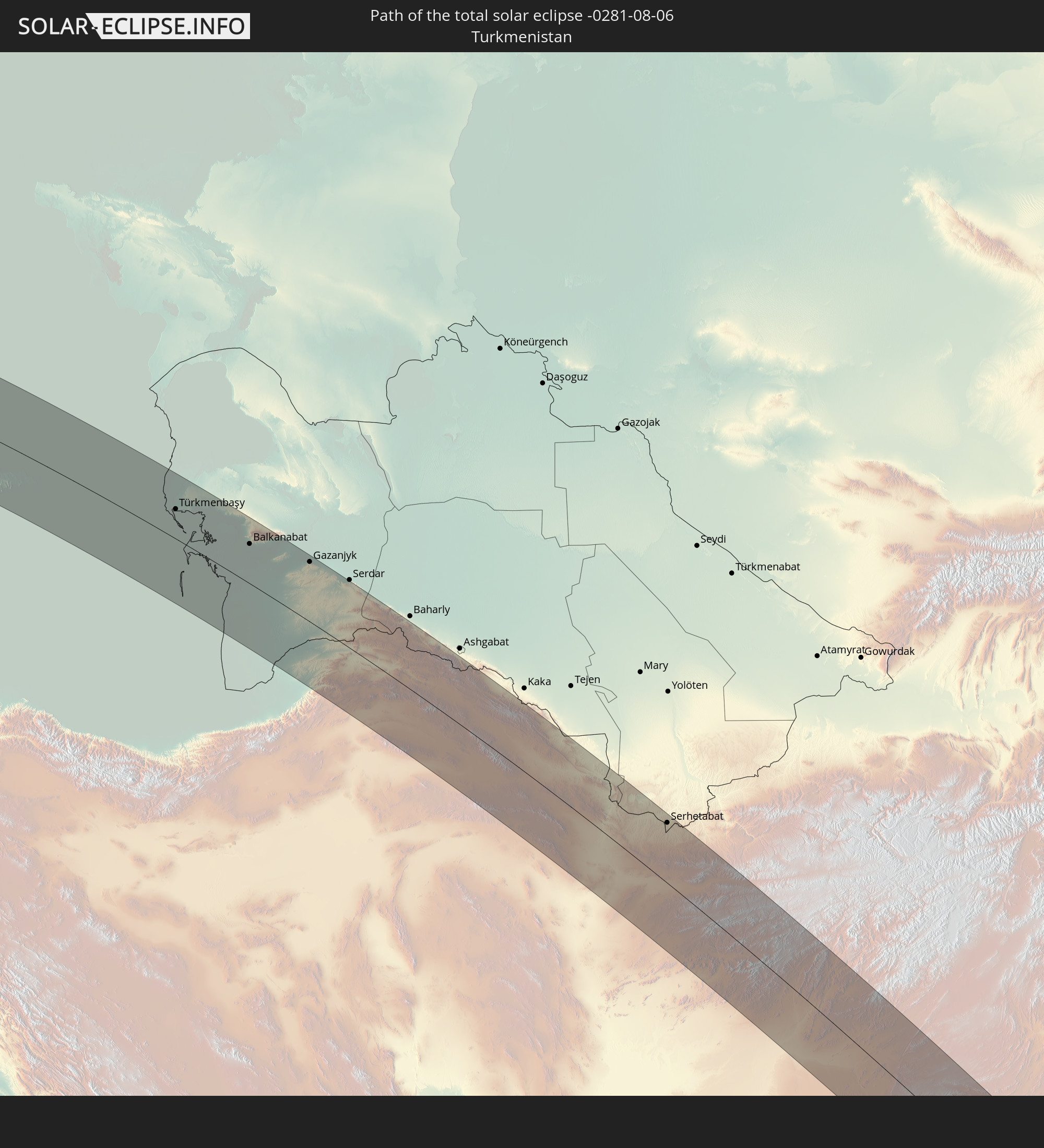 Turkmenistan
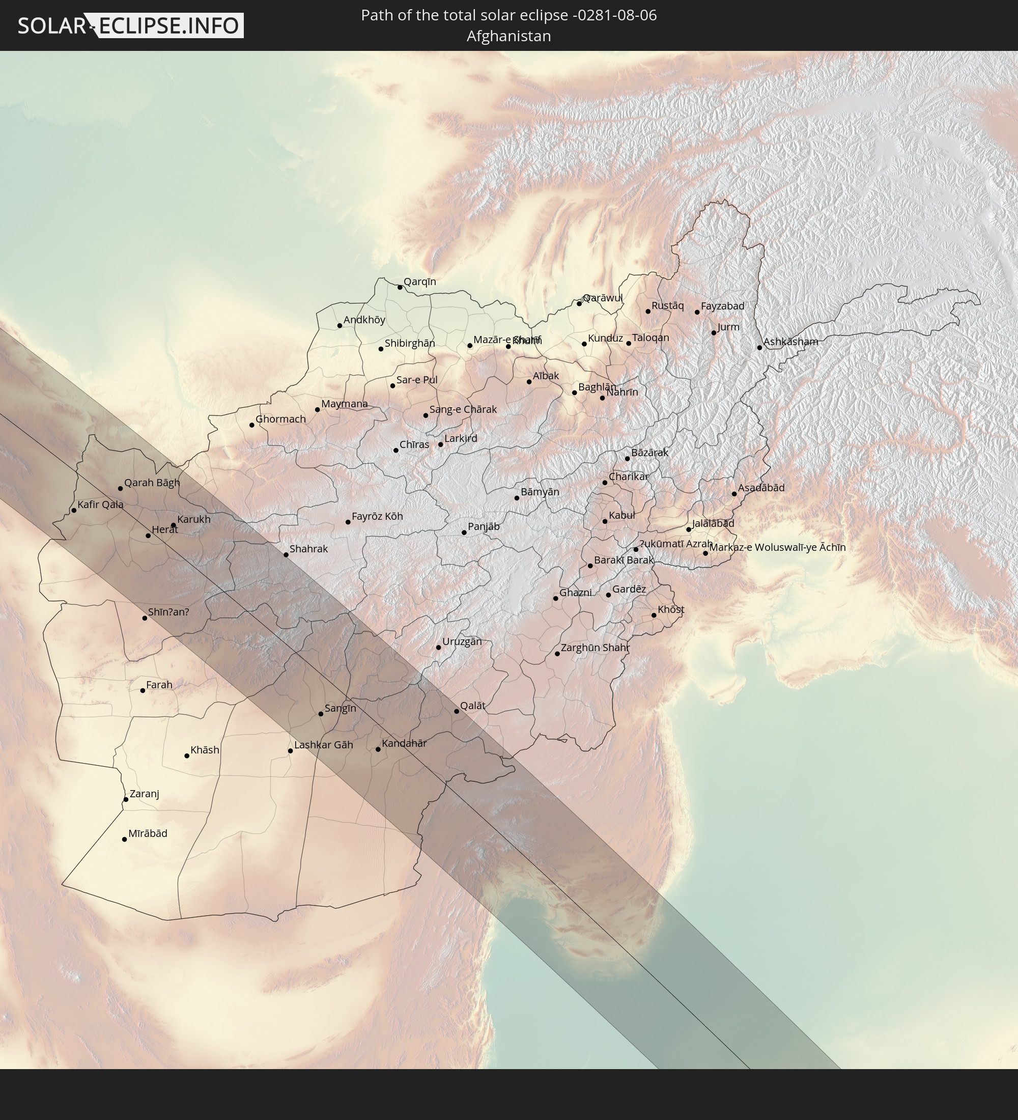 Afghanistan
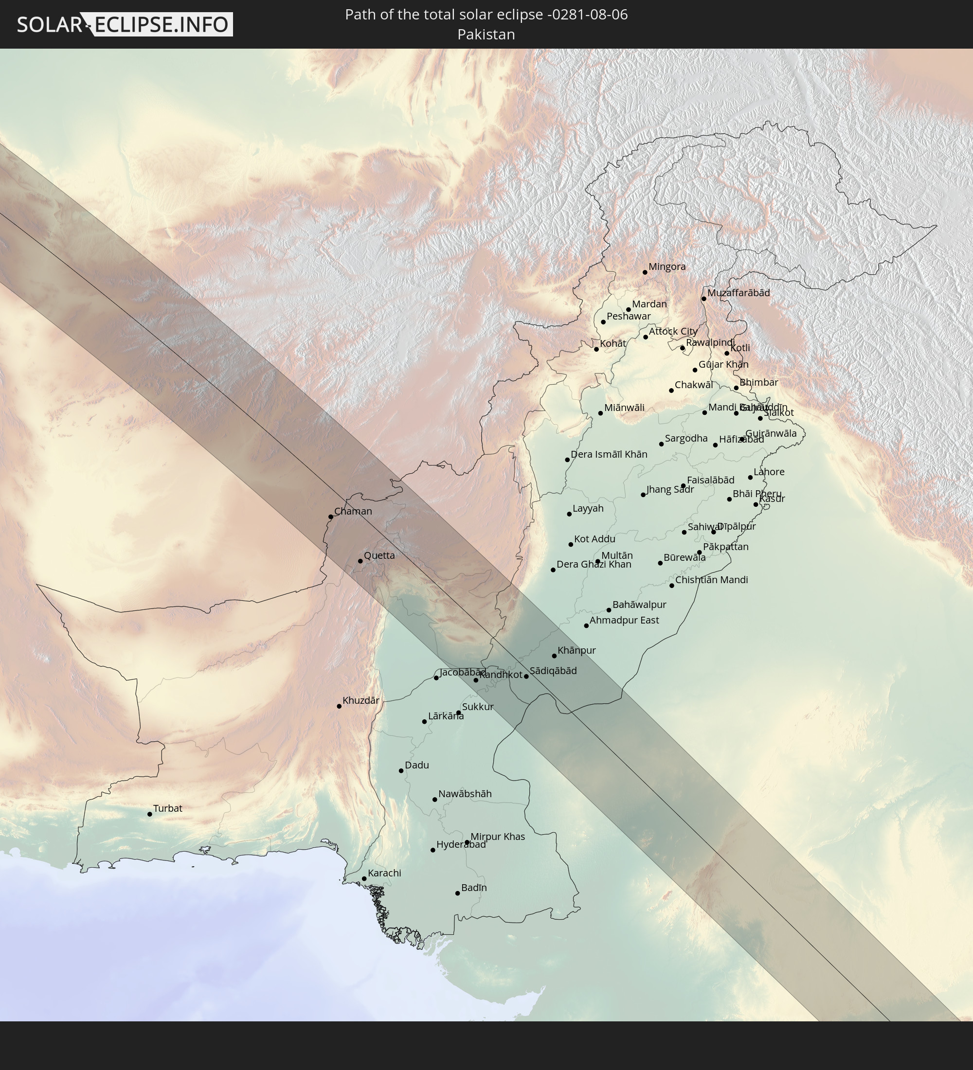 Pakistan
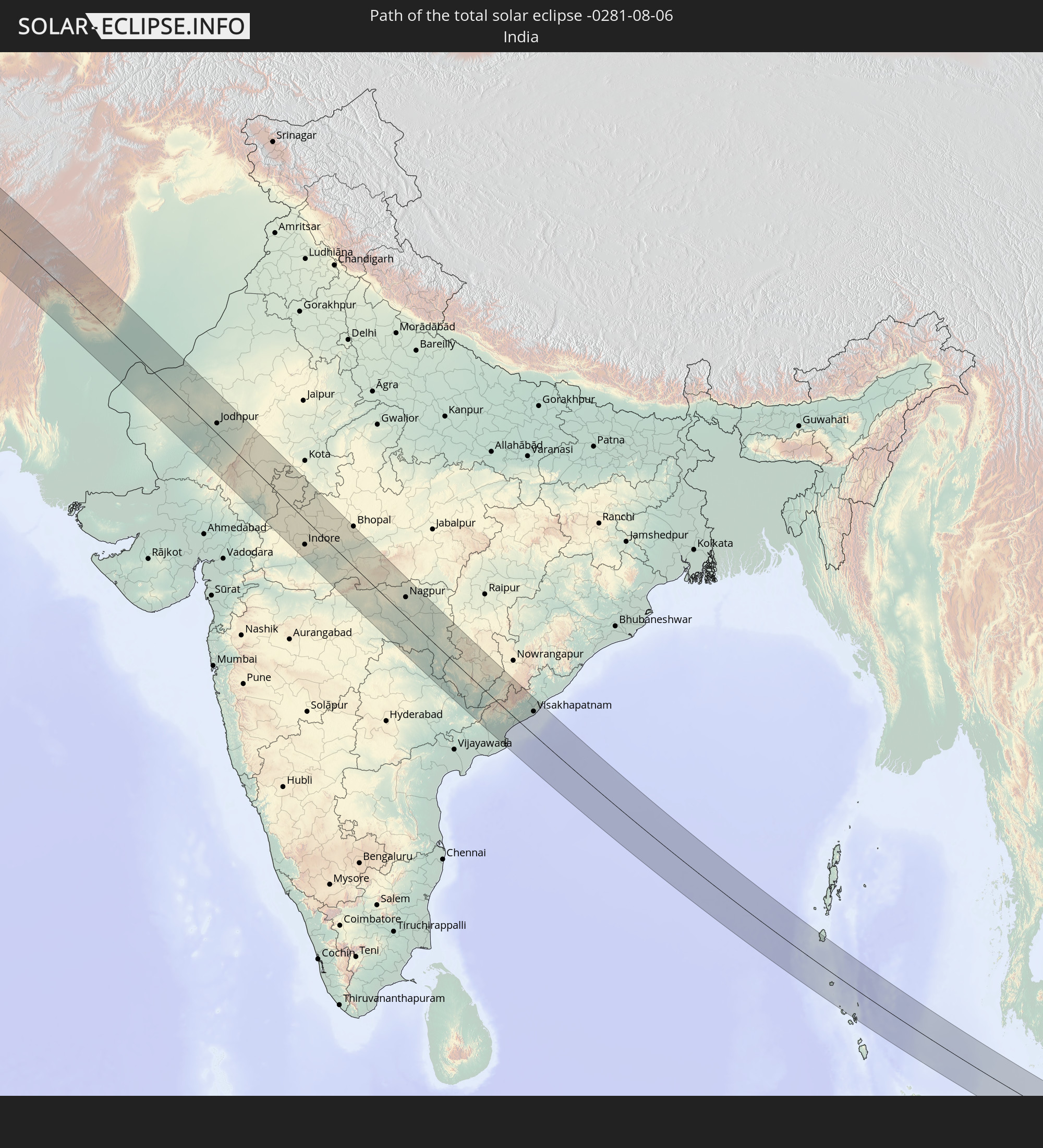 India
India
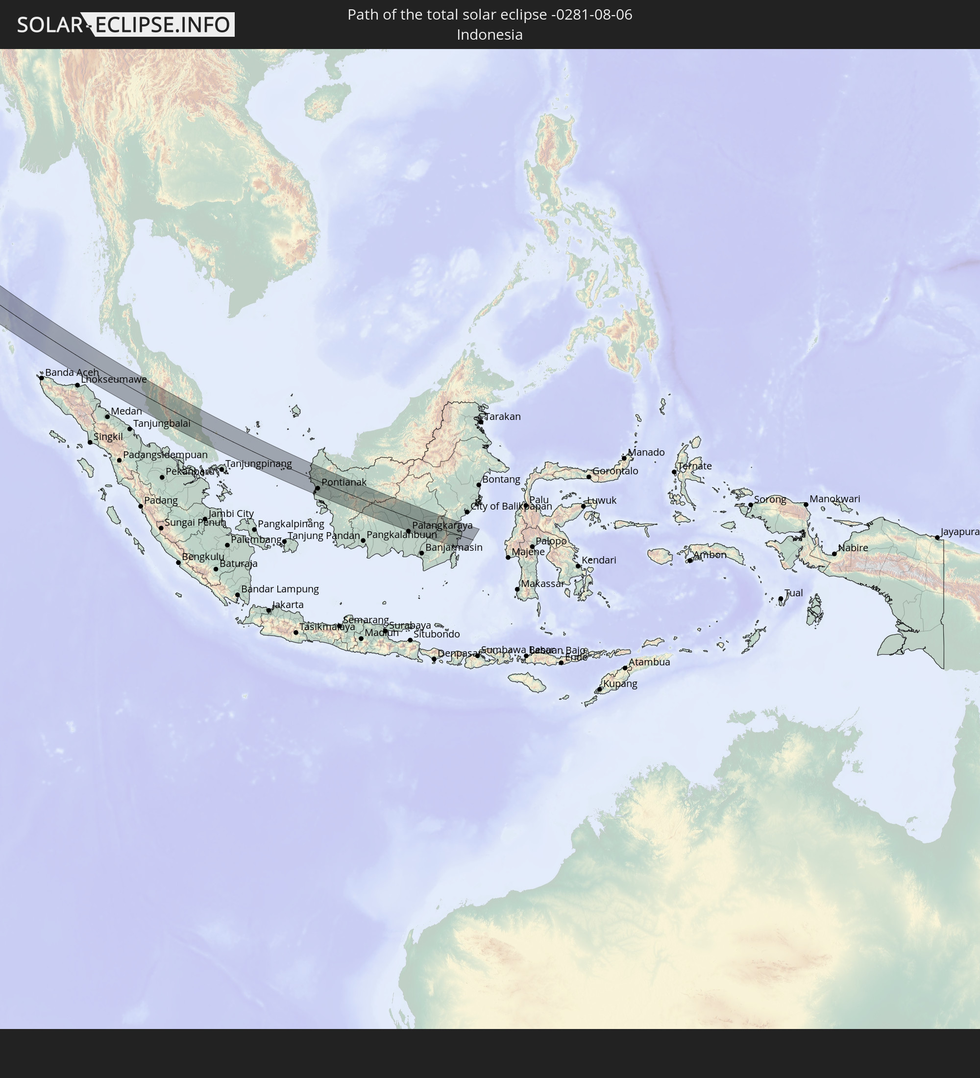 Indonesia
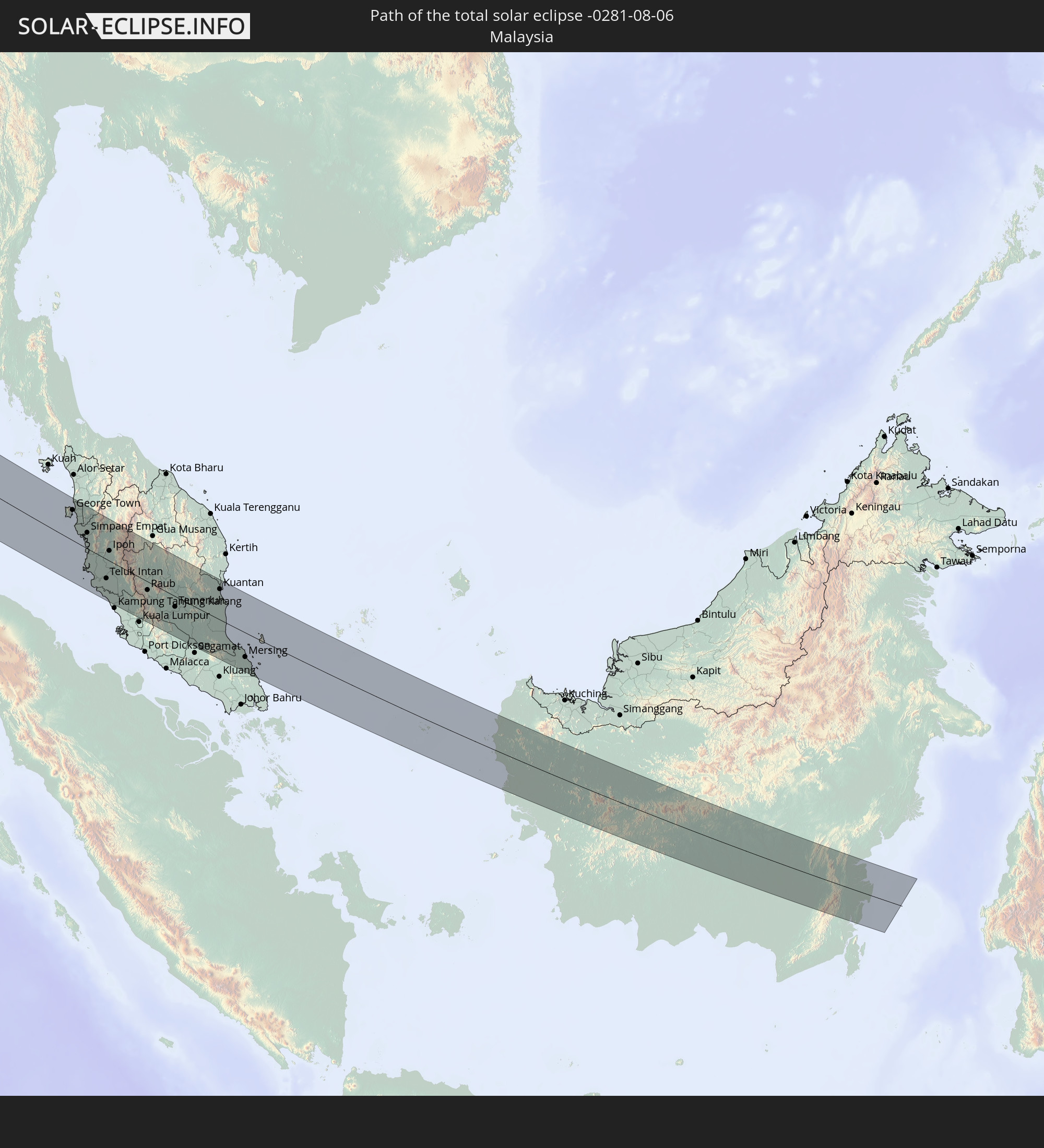 Malaysia
In den folgenden Ländern ist die Sonnenfinsternis partiell zu sehen
 Russia
 Canada
 Greenland
 Portugal
 Iceland
 Spain
Spain
 Senegal
 Mauritania
 The Gambia
 Guinea-Bissau
 Guinea
 Sierra Leone
 Morocco
 Mali
Mali
 Liberia
 Republic of Ireland
 Svalbard and Jan Mayen
 Algeria
 United Kingdom
 Ivory Coast
 Faroe Islands
 Burkina Faso
 Gibraltar
 France
 Isle of Man
 Ghana
Ghana
 Guernsey
 Jersey
 Niger
Niger
 Benin
Benin
 Andorra
 Belgium
 Nigeria
 Netherlands
 Norway
 Luxembourg
 Germany
 Switzerland
 Italy
Italy
 Monaco
 Tunisia
 Denmark
 Libya
Libya
 Liechtenstein
 Austria
 Sweden
 Czechia
 San Marino
 Vatican City
 Slovenia
 Chad
Chad
 Croatia
 Poland
 Malta
Malta
 Bosnia and Herzegovina
 Hungary
 Slovakia
 Montenegro
 Serbia
 Albania
 Åland Islands
 Greece
 Romania
 Republic of Macedonia
 Finland
 Lithuania
 Latvia
 Estonia
 Sudan
Sudan
 Ukraine
 Bulgaria
 Belarus
 Egypt
Egypt
 Turkey
 Moldova
 Cyprus
 Ethiopia
 State of Palestine
 Israel
 Saudi Arabia
 Jordan
 Lebanon
 Syria
Syria
 Eritrea
 Iraq
Iraq
 Georgia
 Somalia
 Djibouti
 Yemen
Yemen
 Armenia
 Iran
Iran
 Azerbaijan
 Kazakhstan
 Kuwait
 Bahrain
 Qatar
Qatar
 United Arab Emirates
 Oman
Oman
 Turkmenistan
 Uzbekistan
 Afghanistan
 Pakistan
 Tajikistan
 India
India
 Kyrgyzstan
 British Indian Ocean Territory
 Maldives
 China
China
 Sri Lanka
 Nepal
Nepal
 Mongolia
 Bangladesh
 Bhutan
 Myanmar
 Indonesia
 Cocos Islands
 Thailand
 Malaysia
 Laos
Laos
 Vietnam
 Cambodia
 Singapore
 Christmas Island
 Macau
Macau
 Hong Kong
 Brunei
 Taiwan
 Philippines
 Japan
Japan
 North Korea
 South Korea
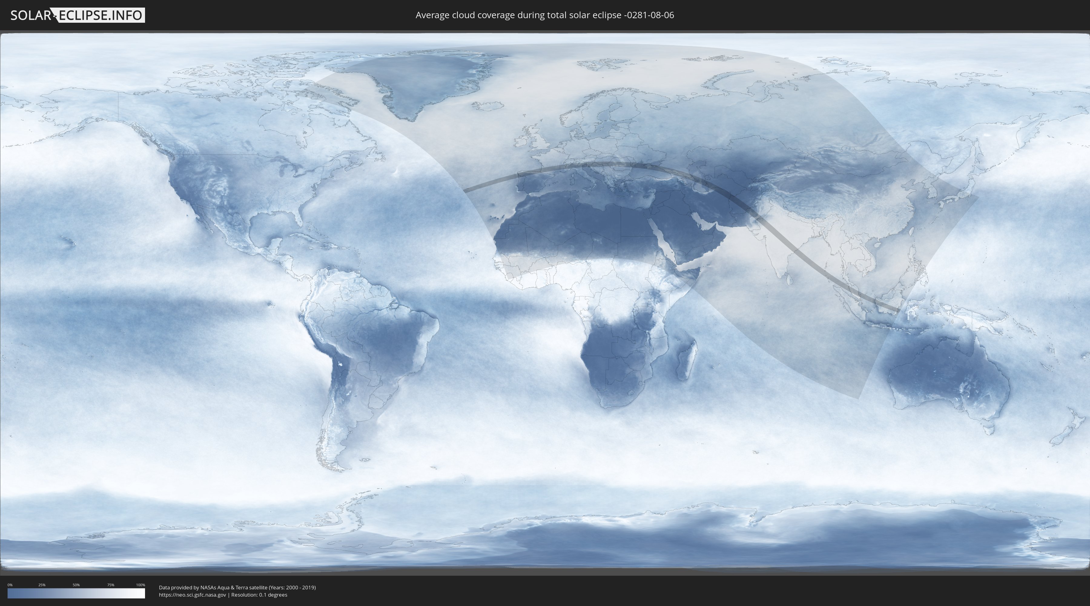
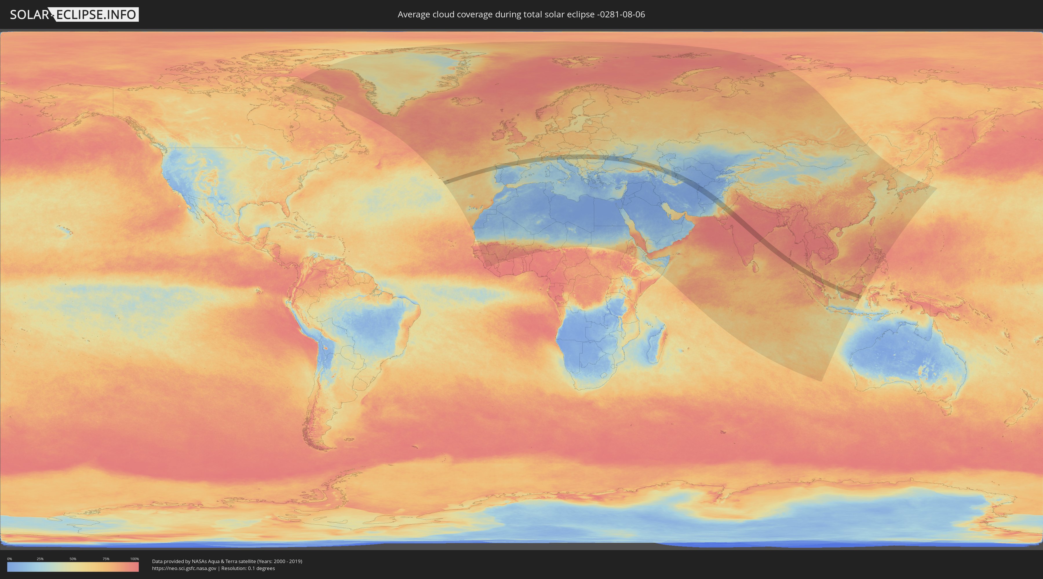
How will be the weather during the total solar eclipse on 08/06/-0281?
Where is the best place to see the total solar eclipse of 08/06/-0281?
The following maps show the average cloud coverage for the day of the total solar eclipse.
With the help of these maps, it is possible to find the place along the eclipse path, which has the best
chance of a cloudless sky.
Nevertheless, you should consider local circumstances and inform about the weather of your chosen
observation site.
The data is provided by NASAs satellites
AQUA and TERRA.
The cloud maps are averaged over a period of 19 years (2000 - 2019).
Detailed country maps
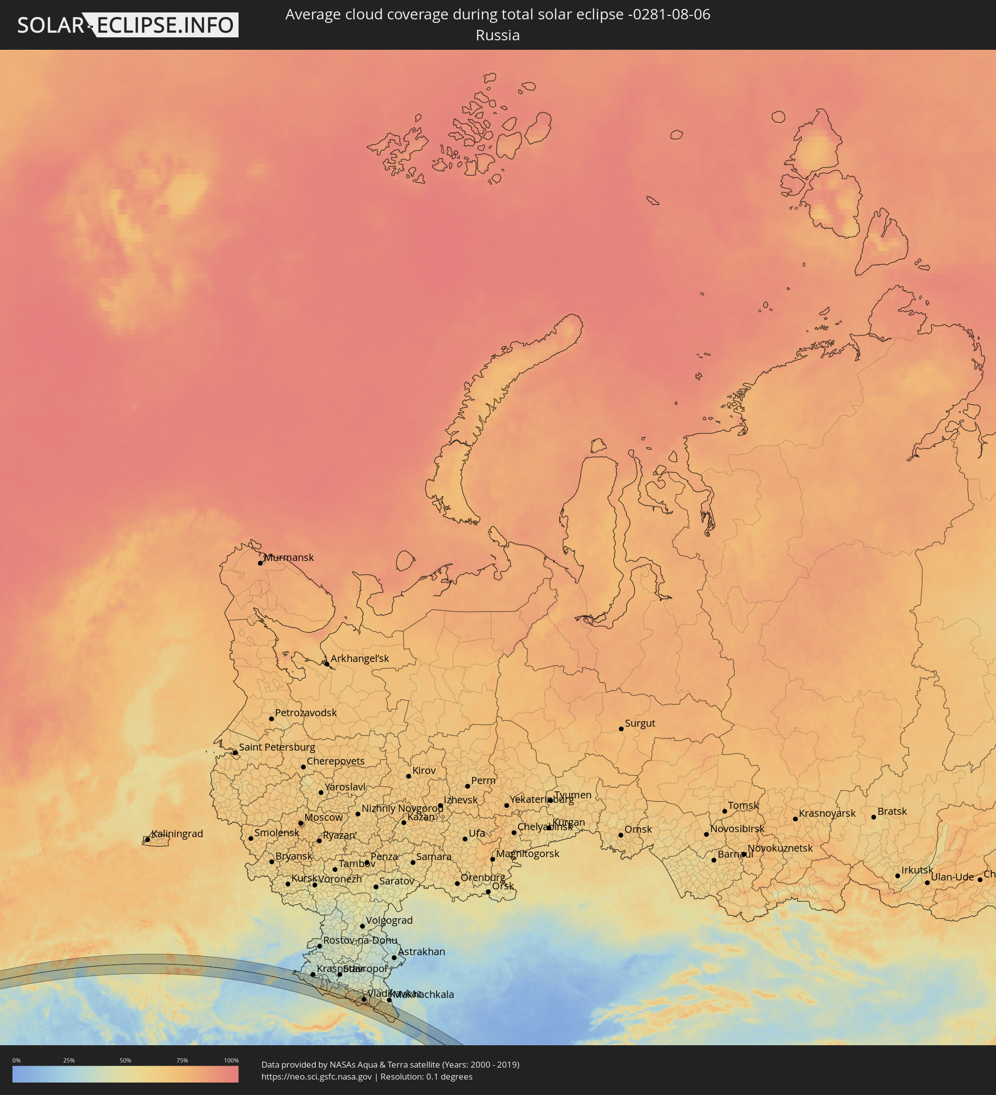 Russia
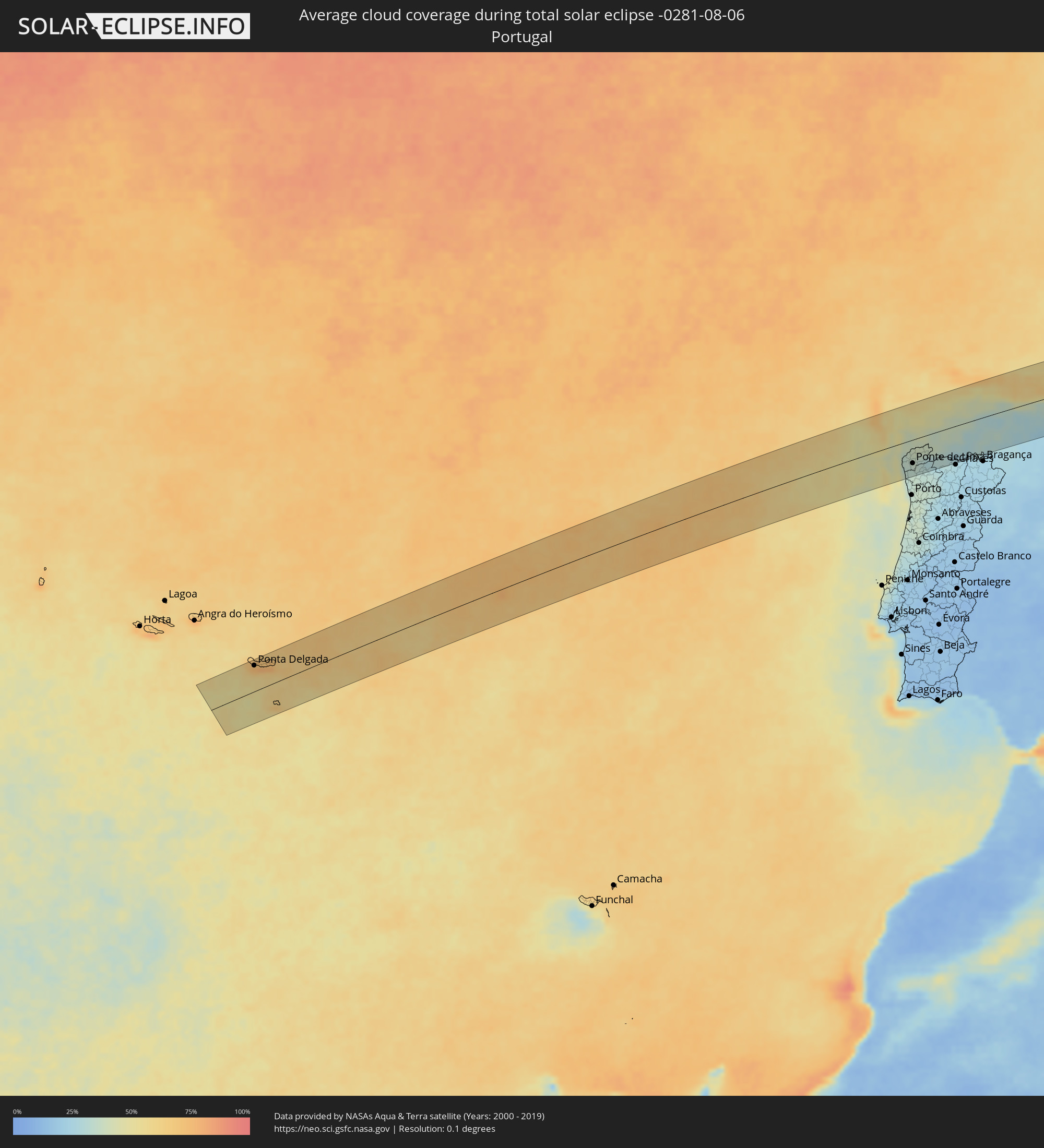 Portugal
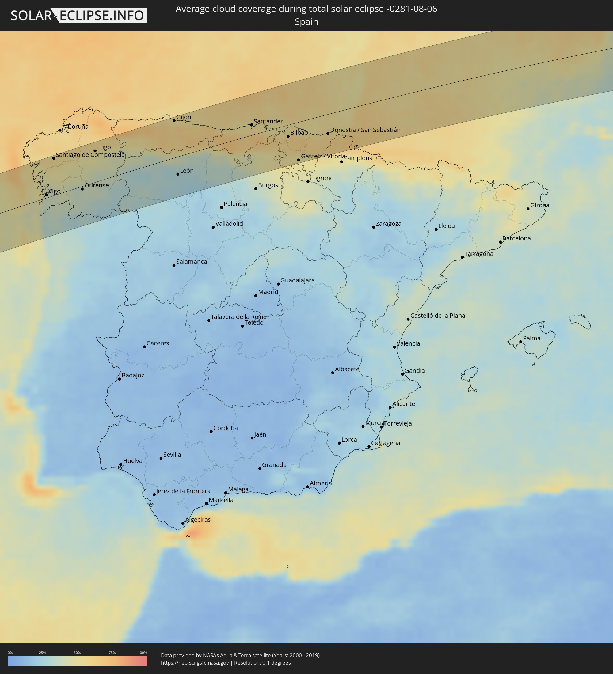 Spain
Spain
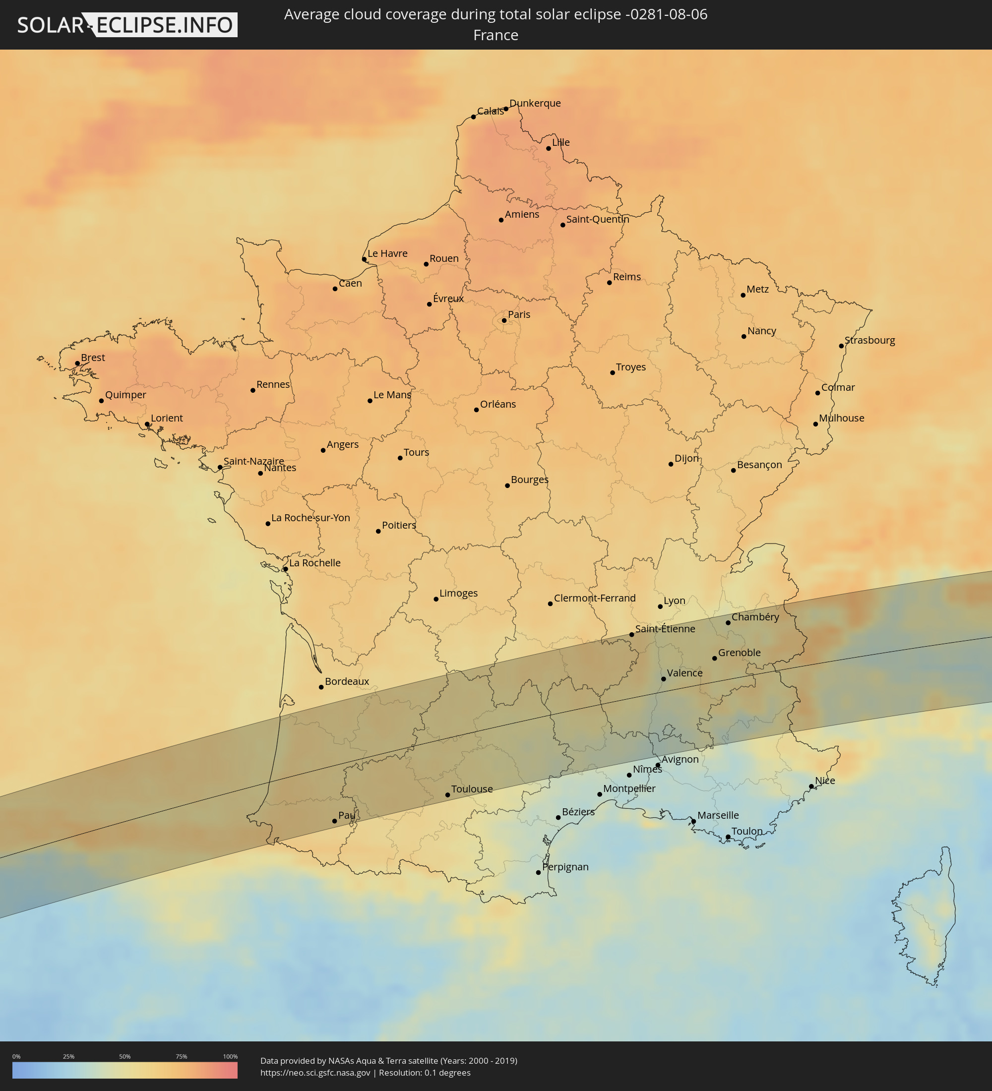 France
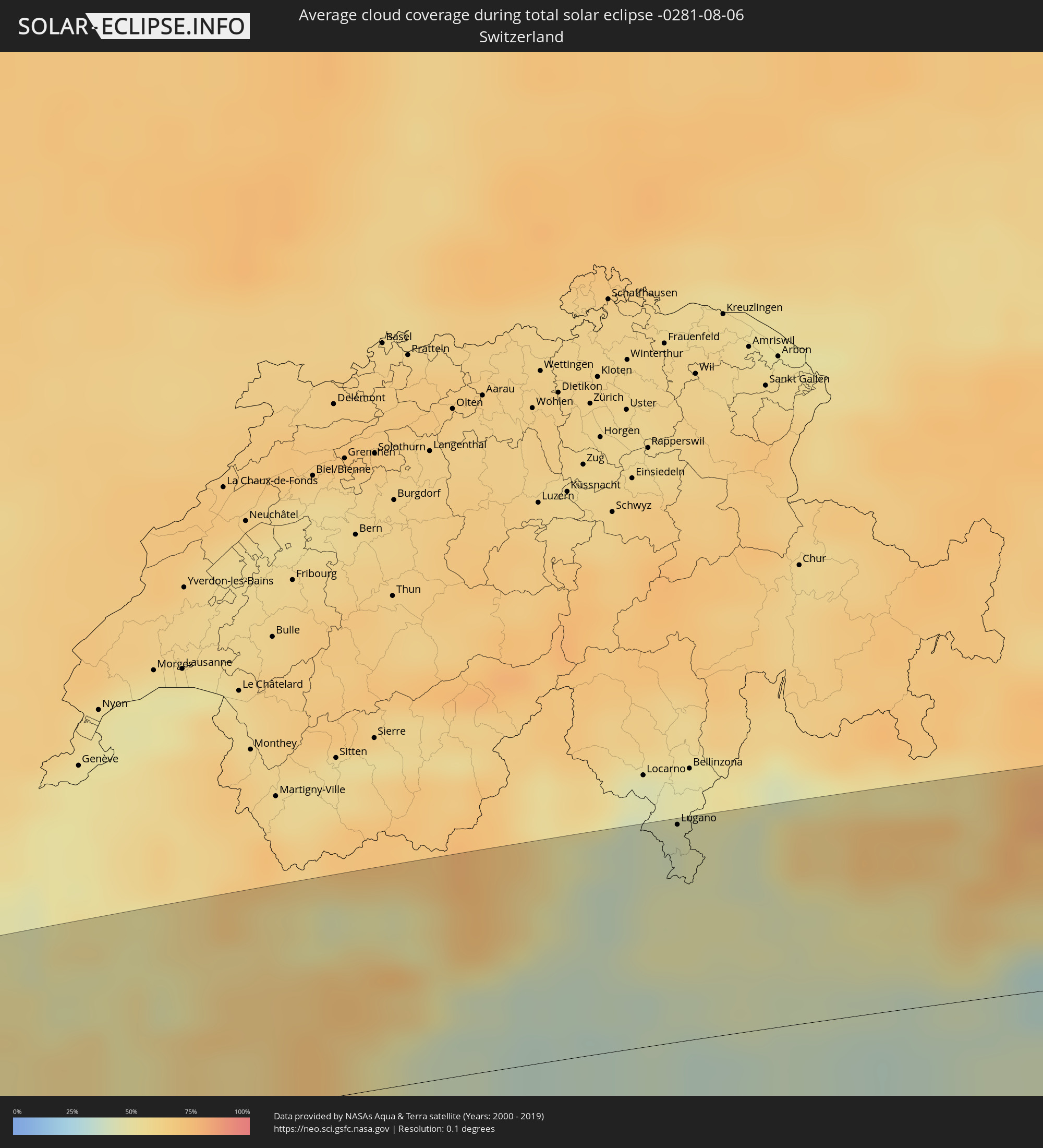 Switzerland
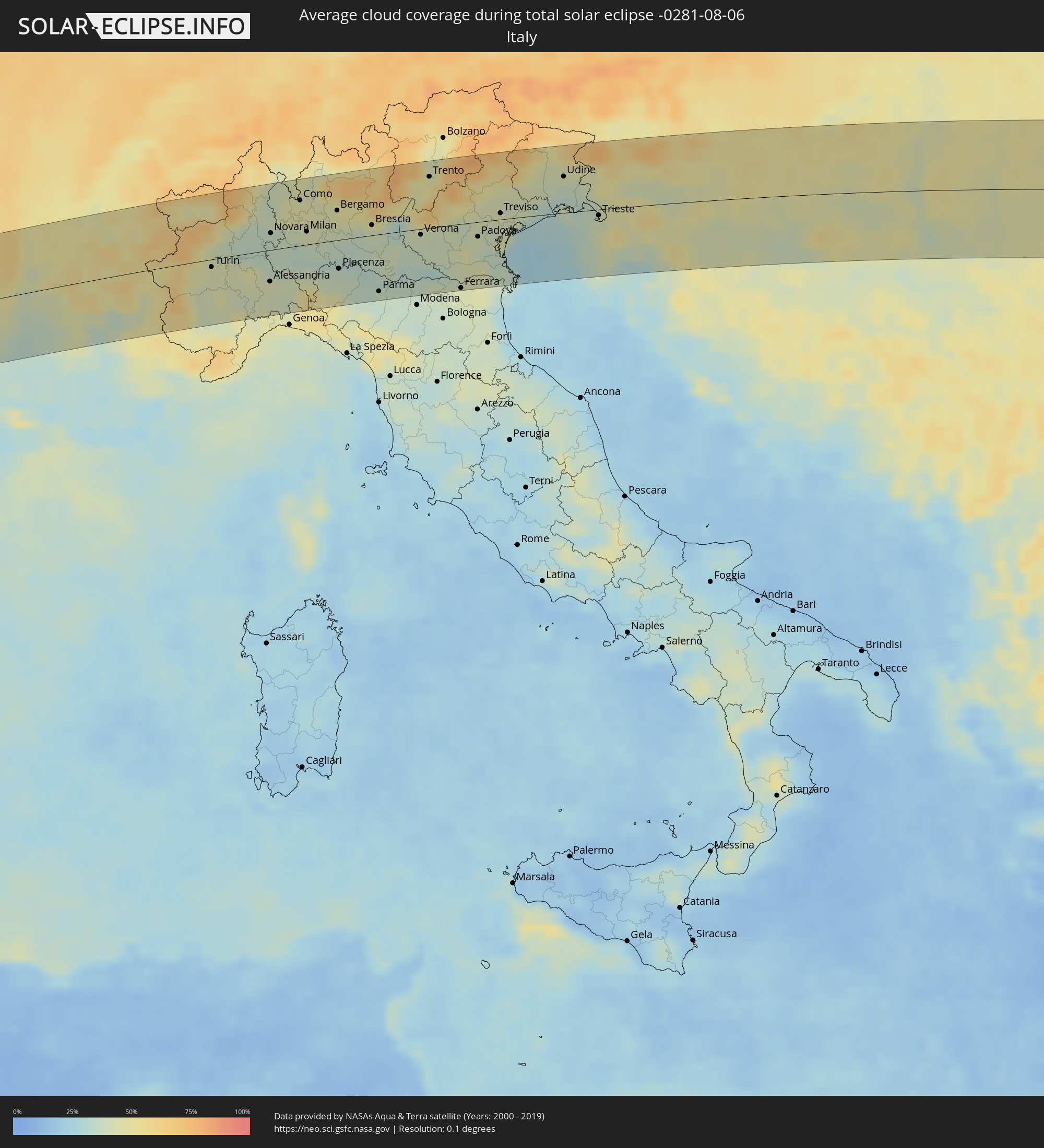 Italy
Italy
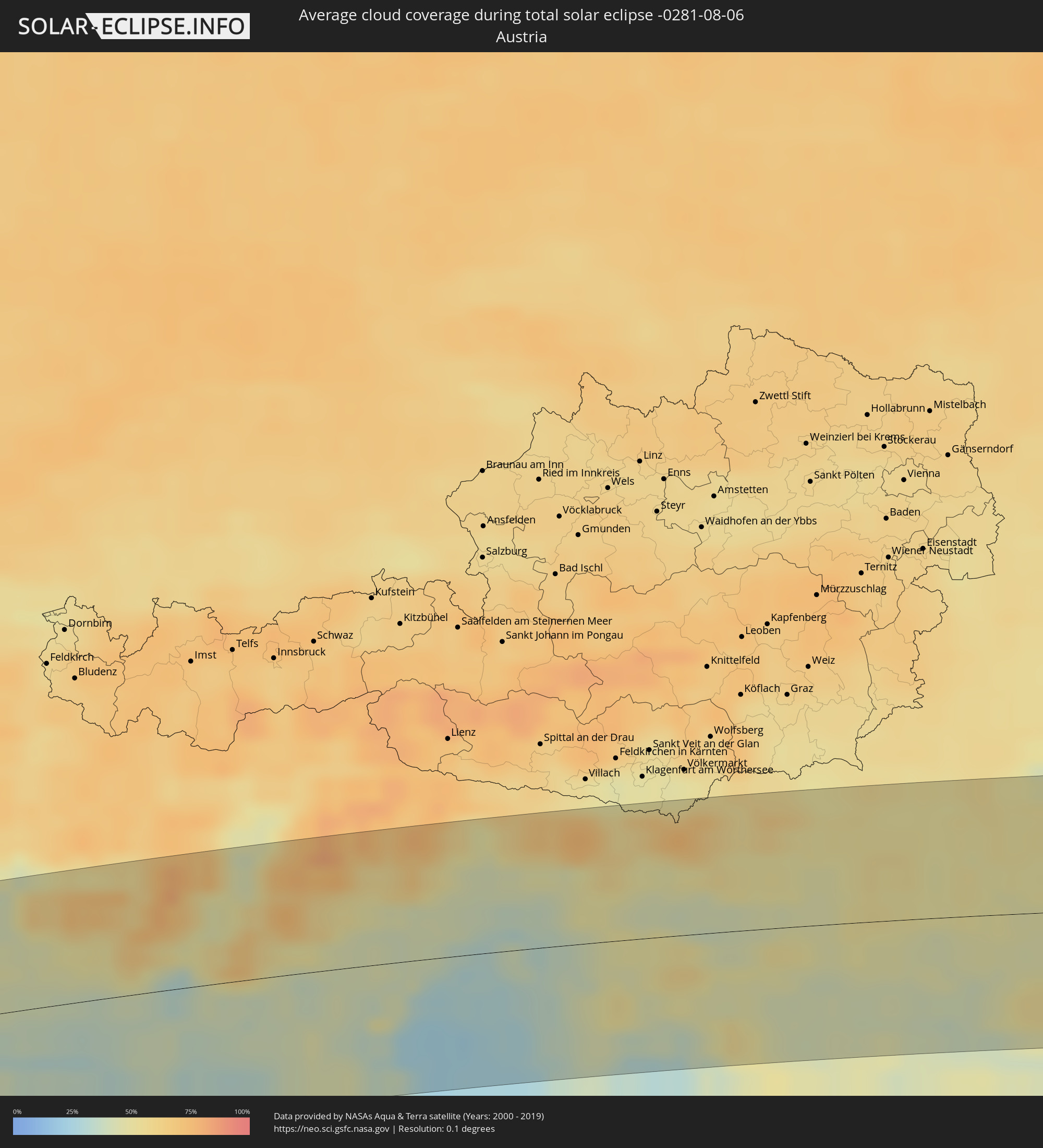 Austria
 Slovenia
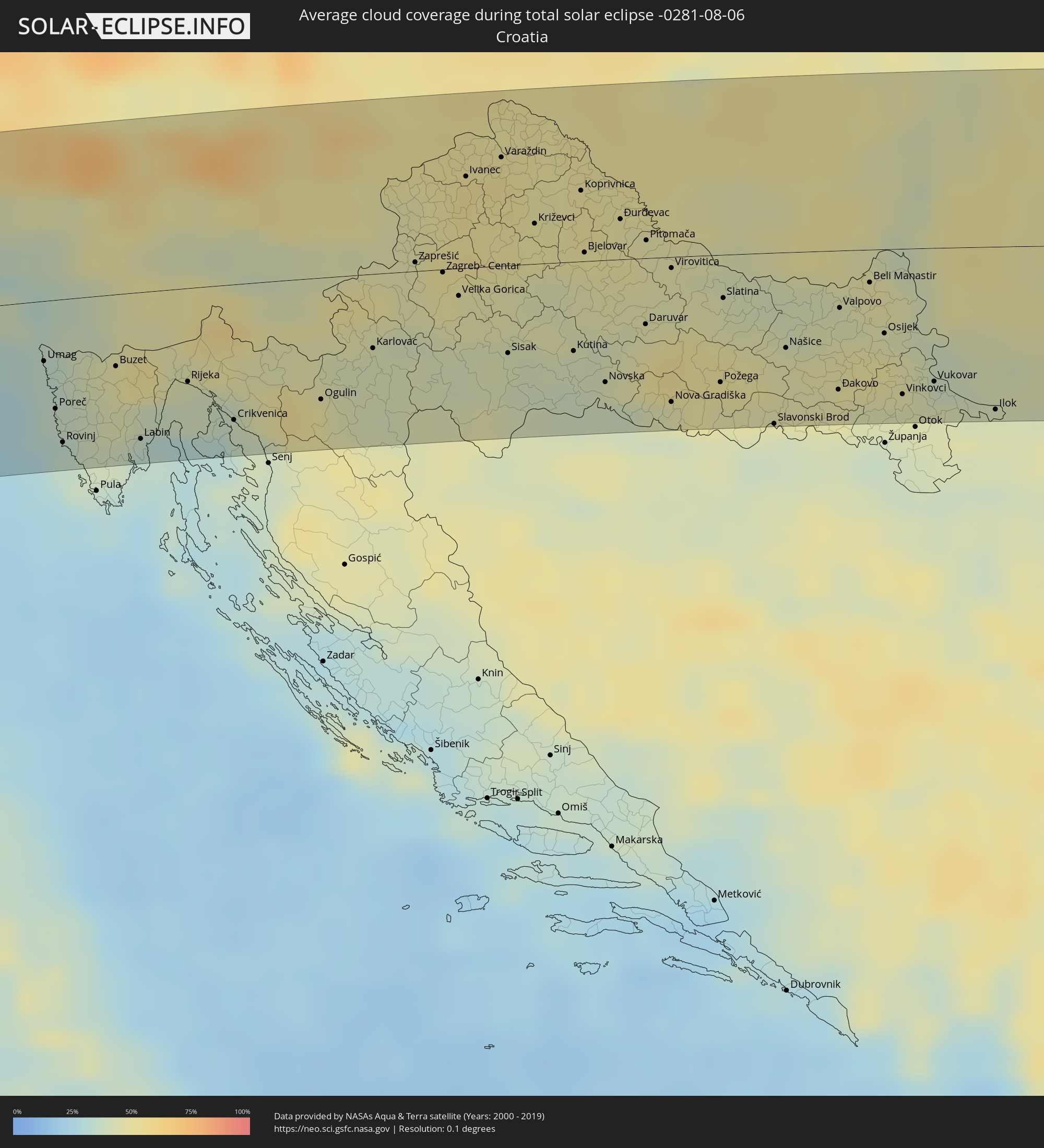 Croatia
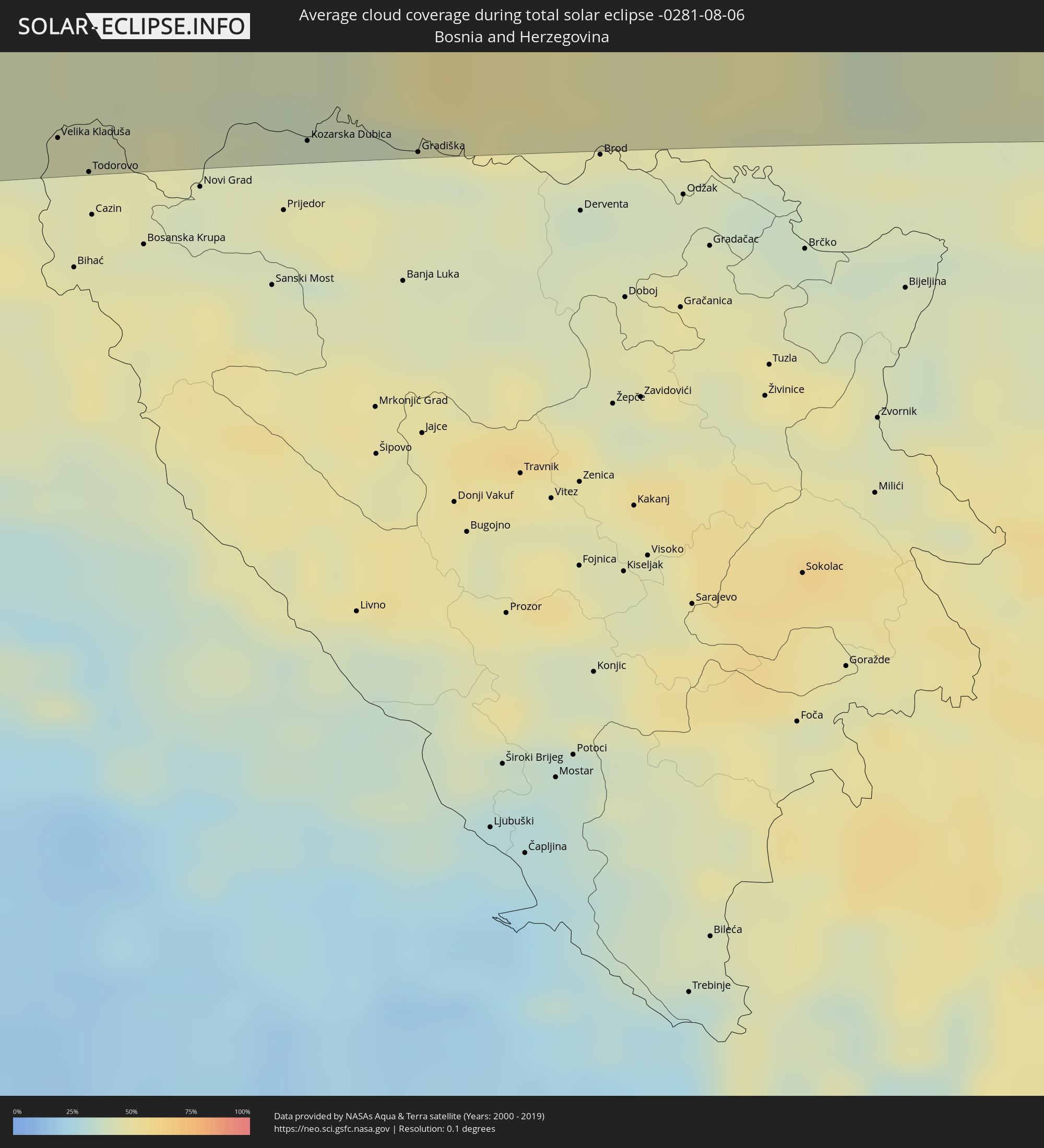 Bosnia and Herzegovina
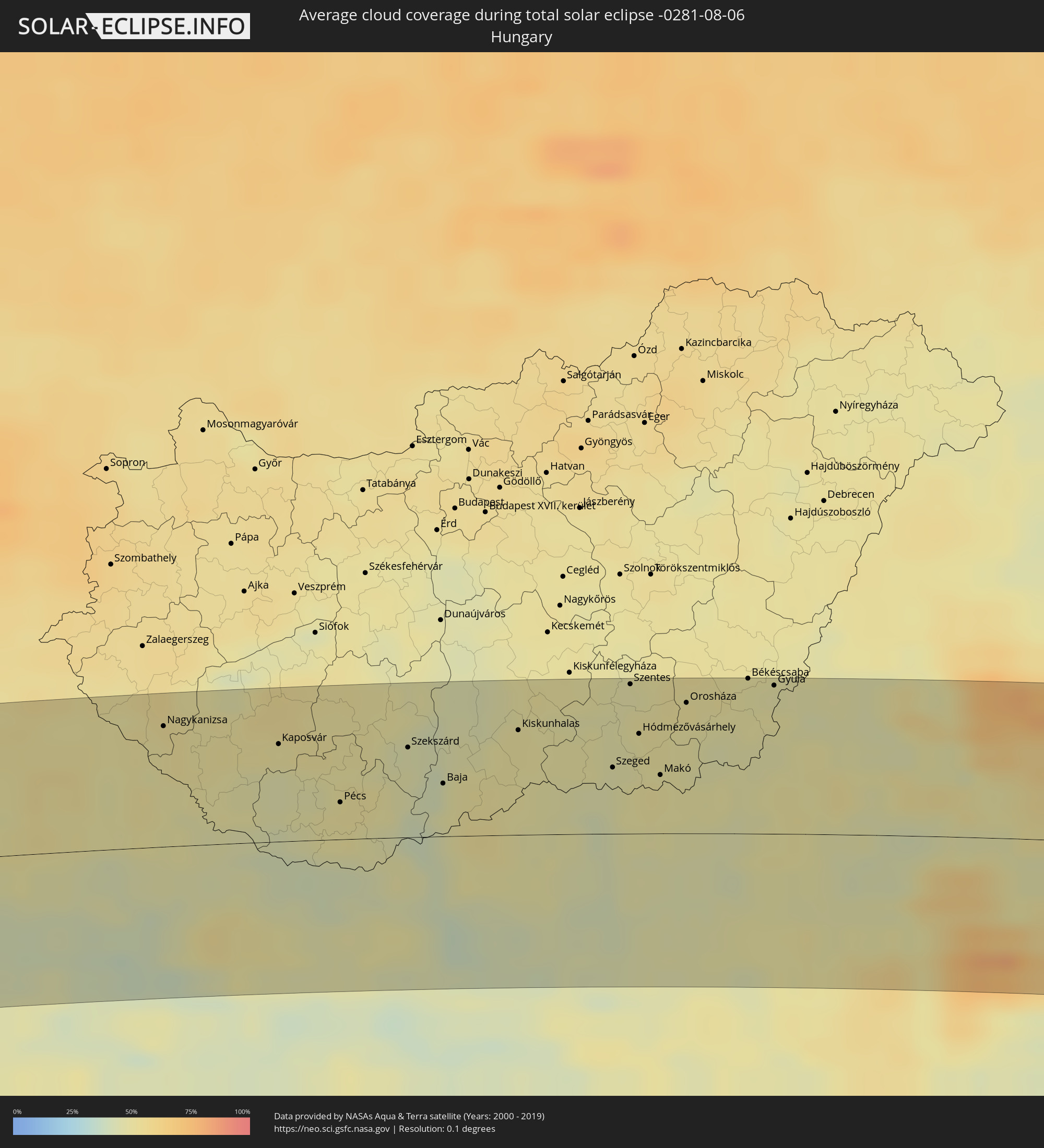 Hungary
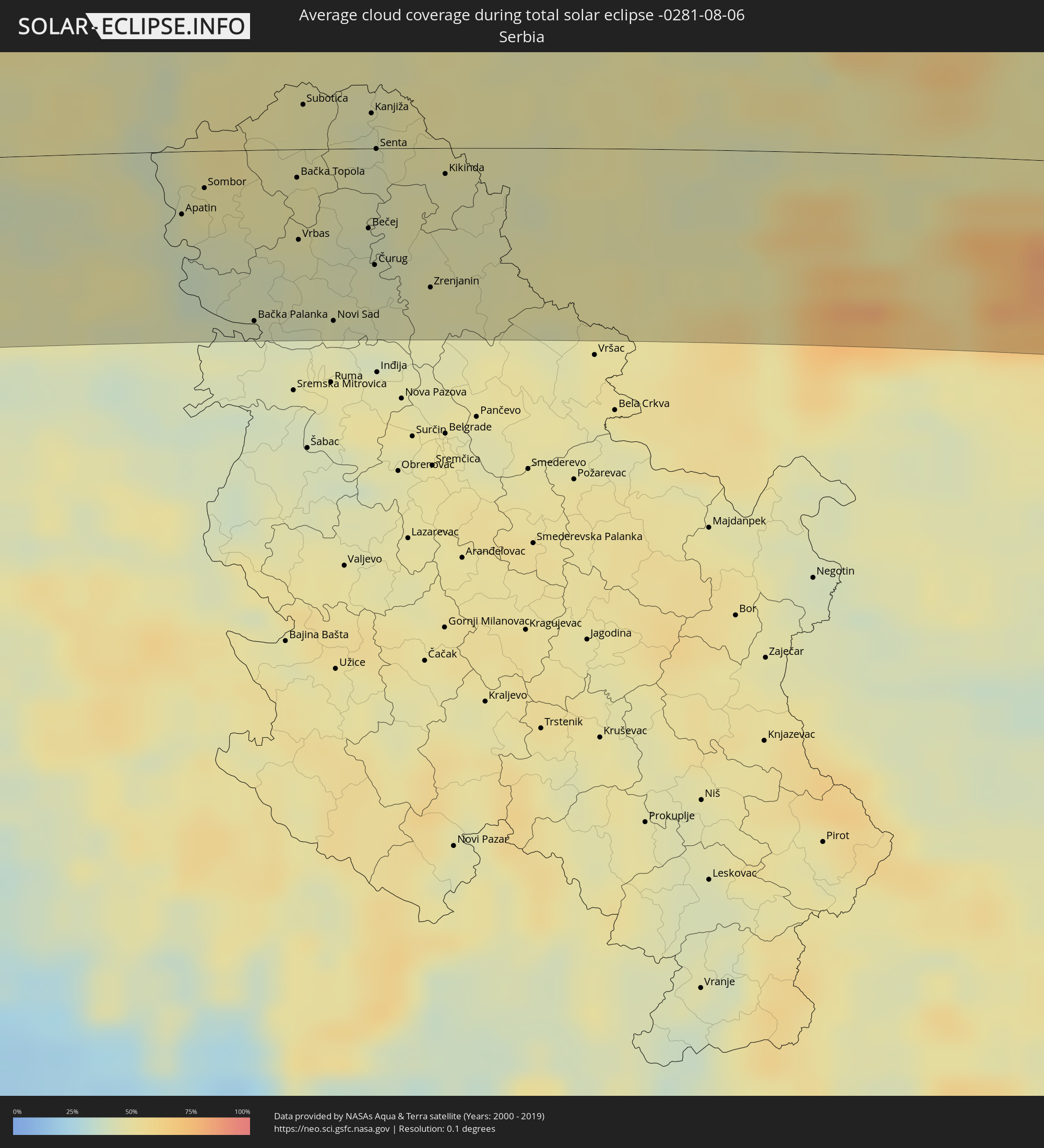 Serbia
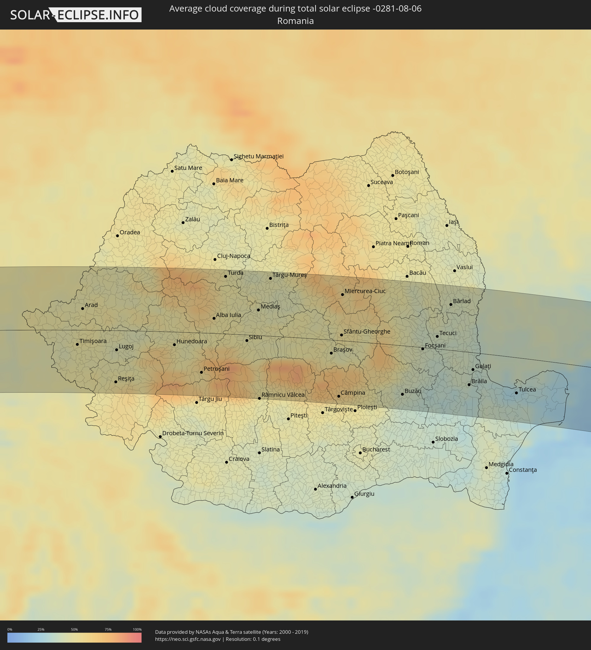 Romania
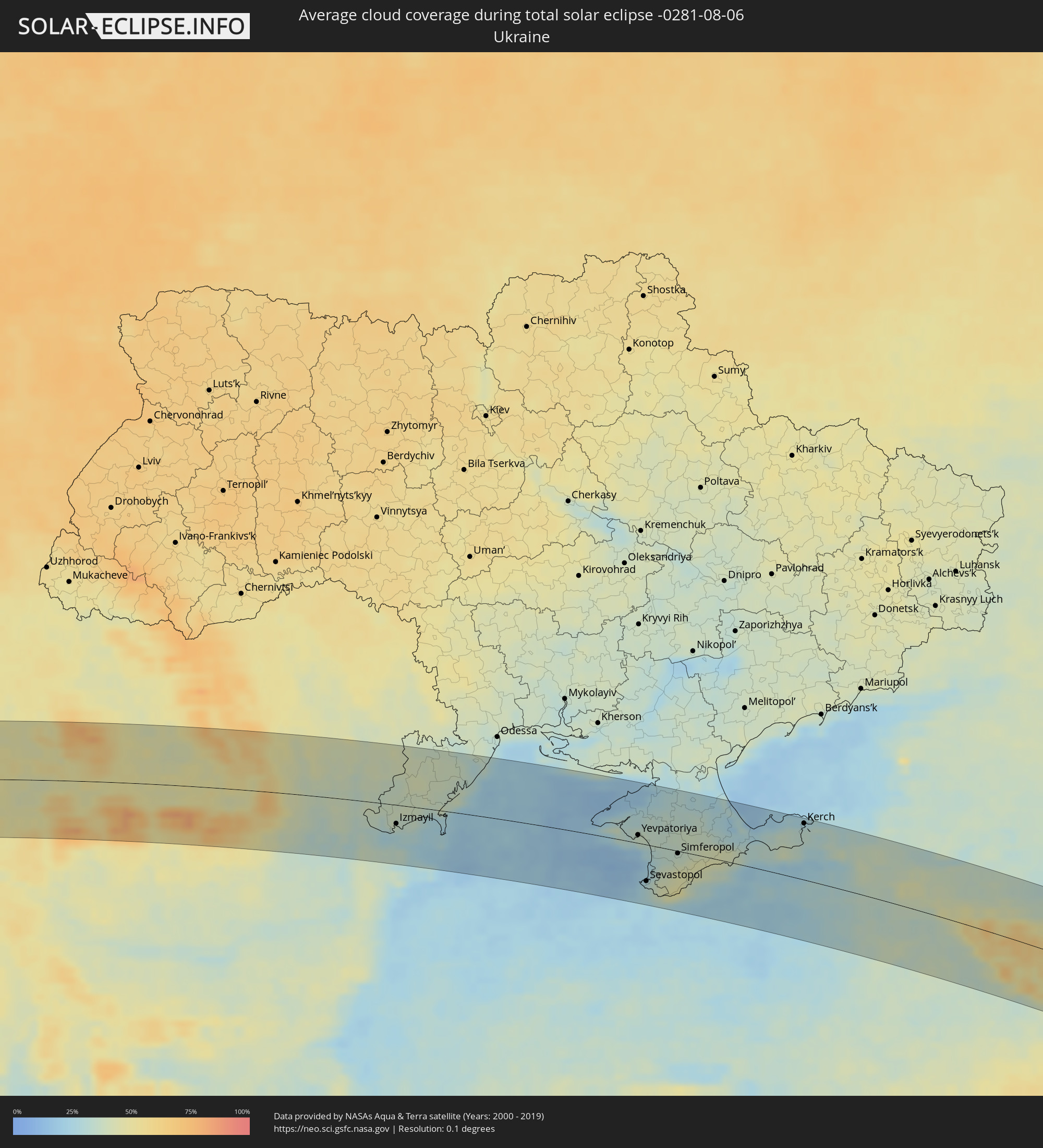 Ukraine
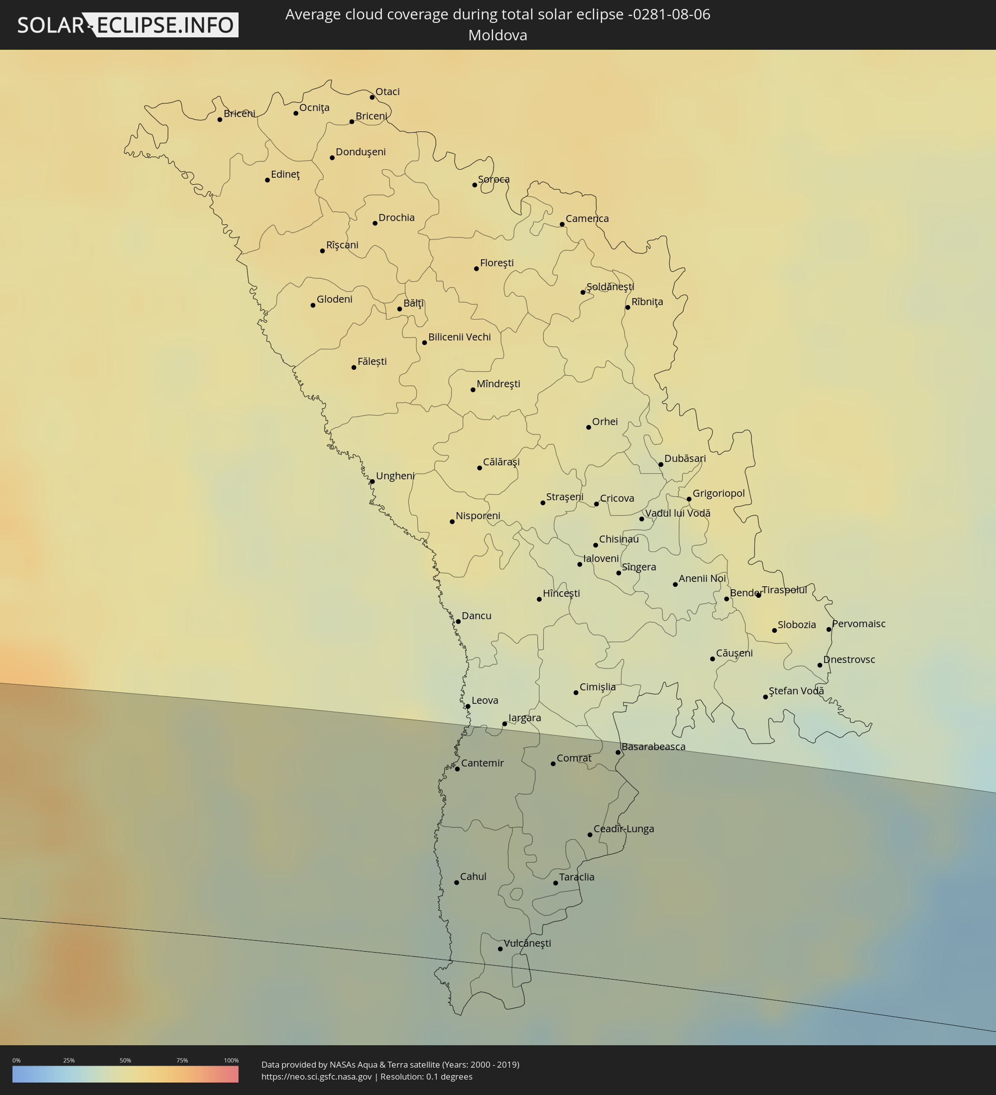 Moldova
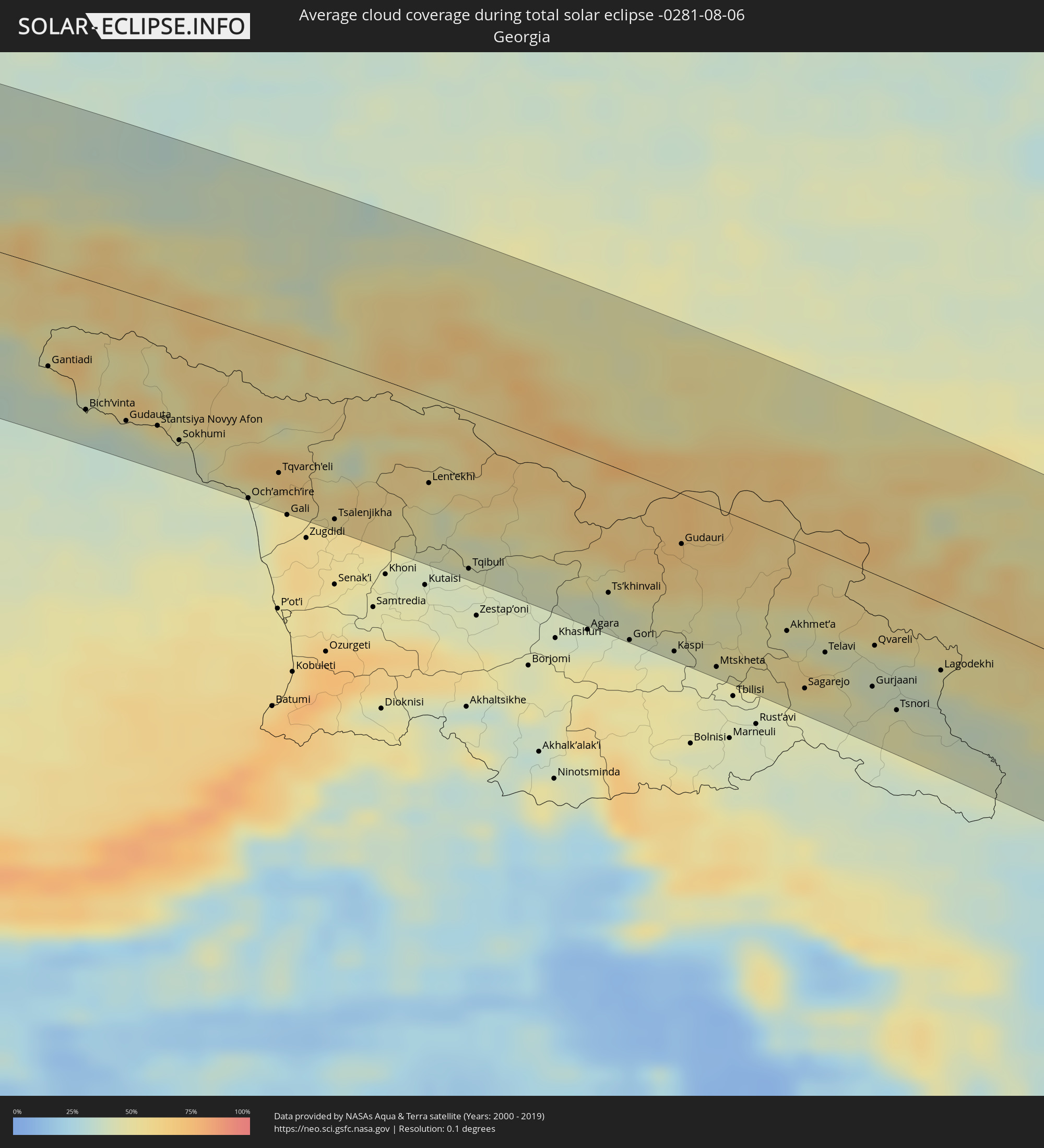 Georgia
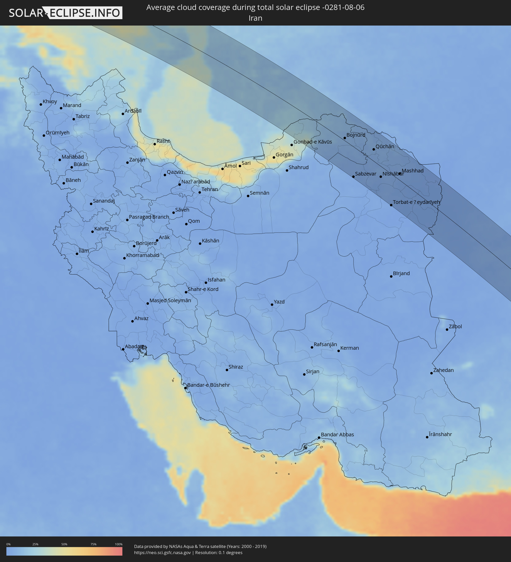 Iran
Iran
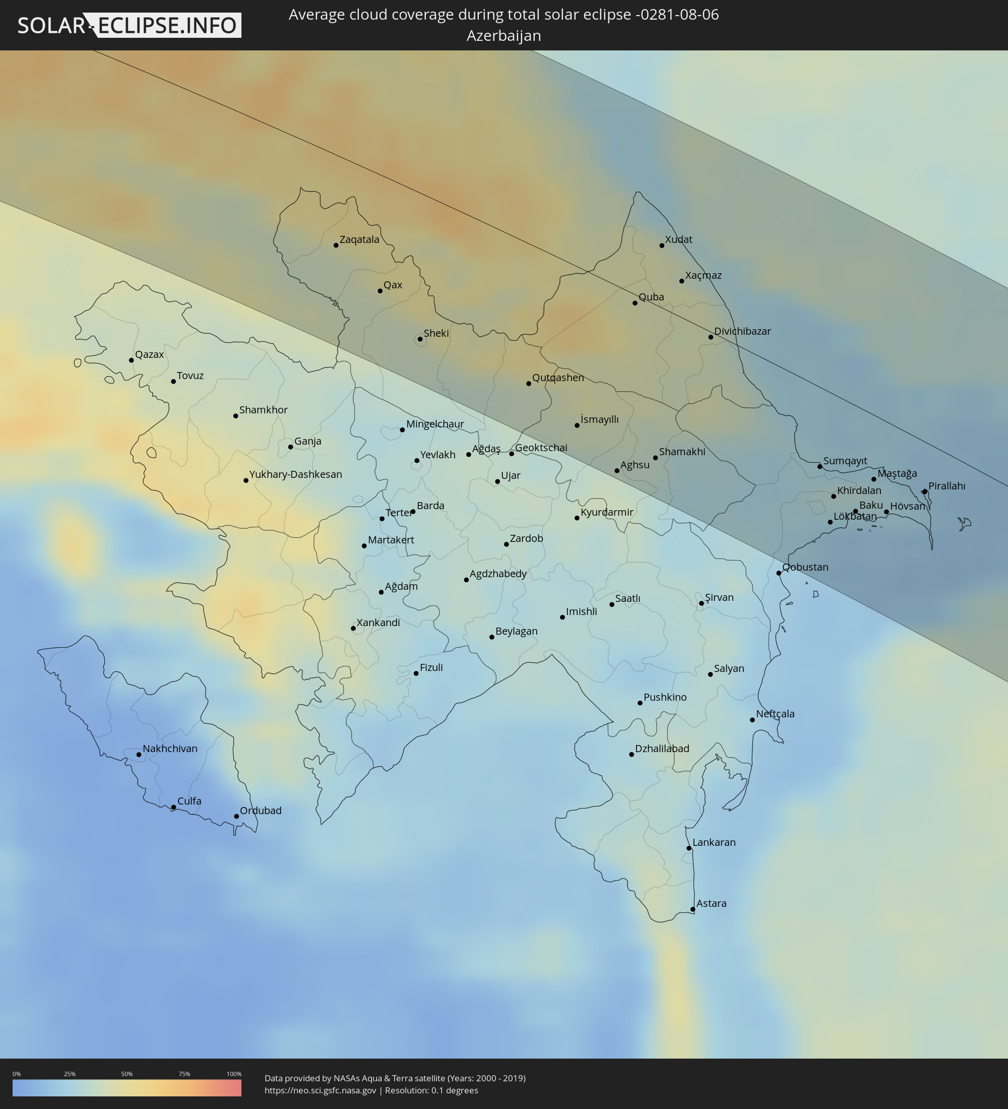 Azerbaijan
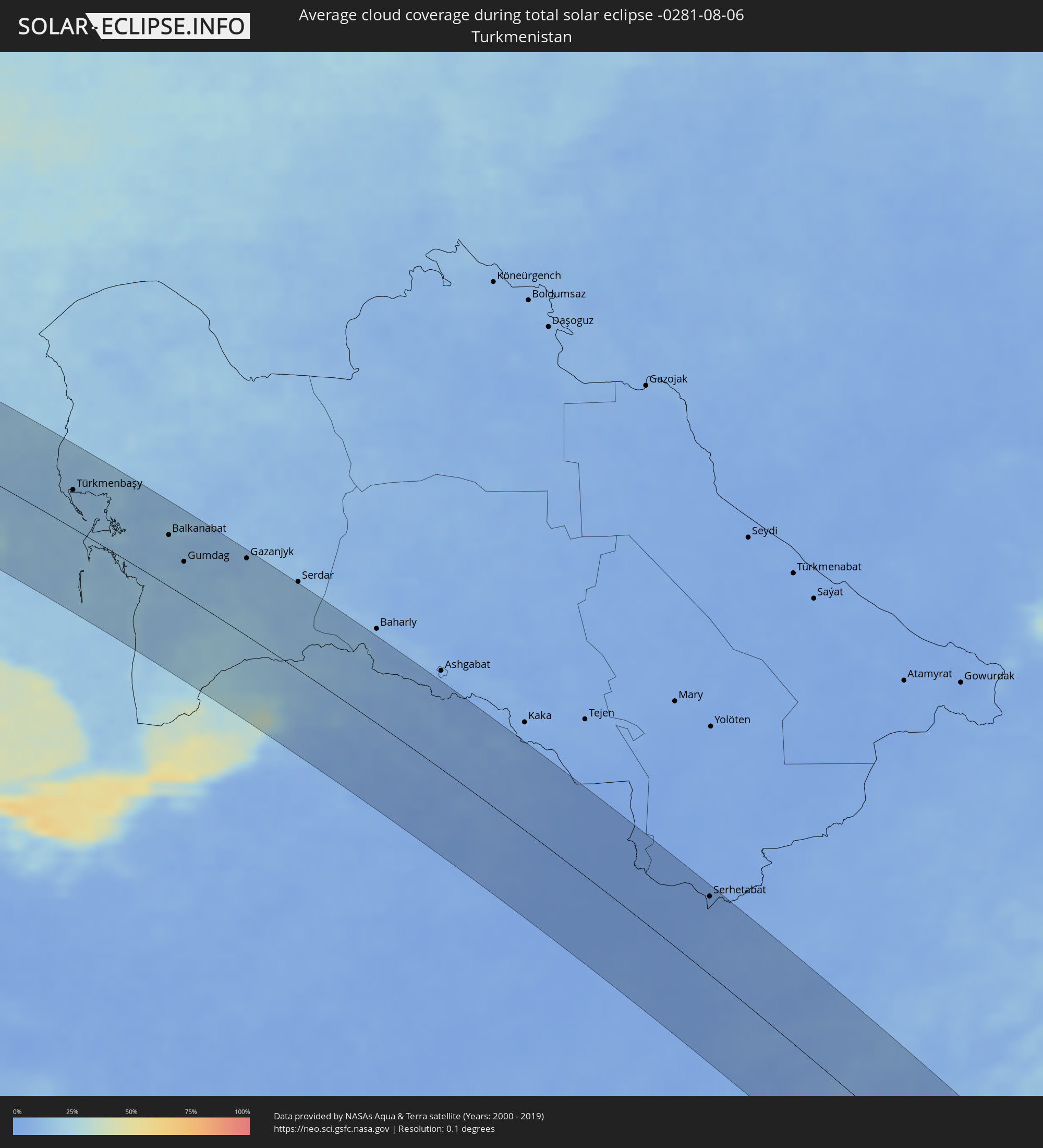 Turkmenistan
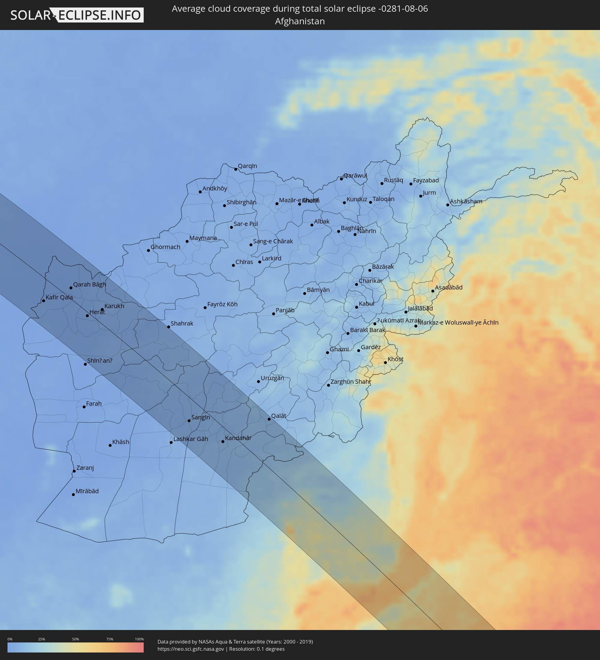 Afghanistan
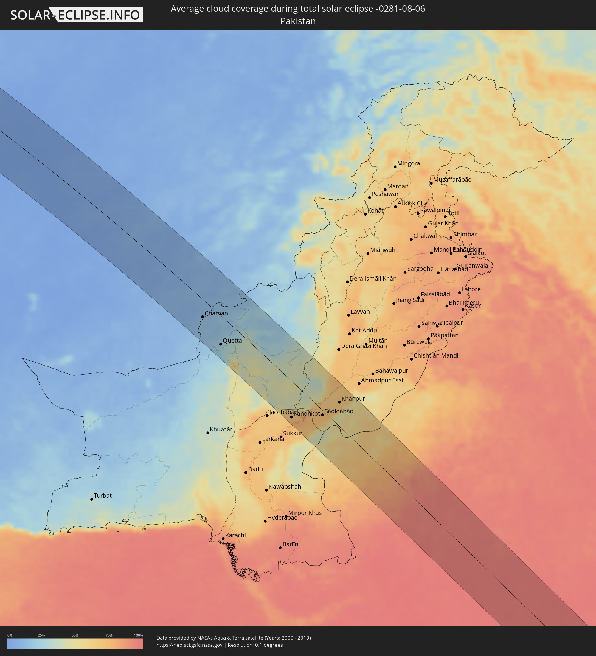 Pakistan
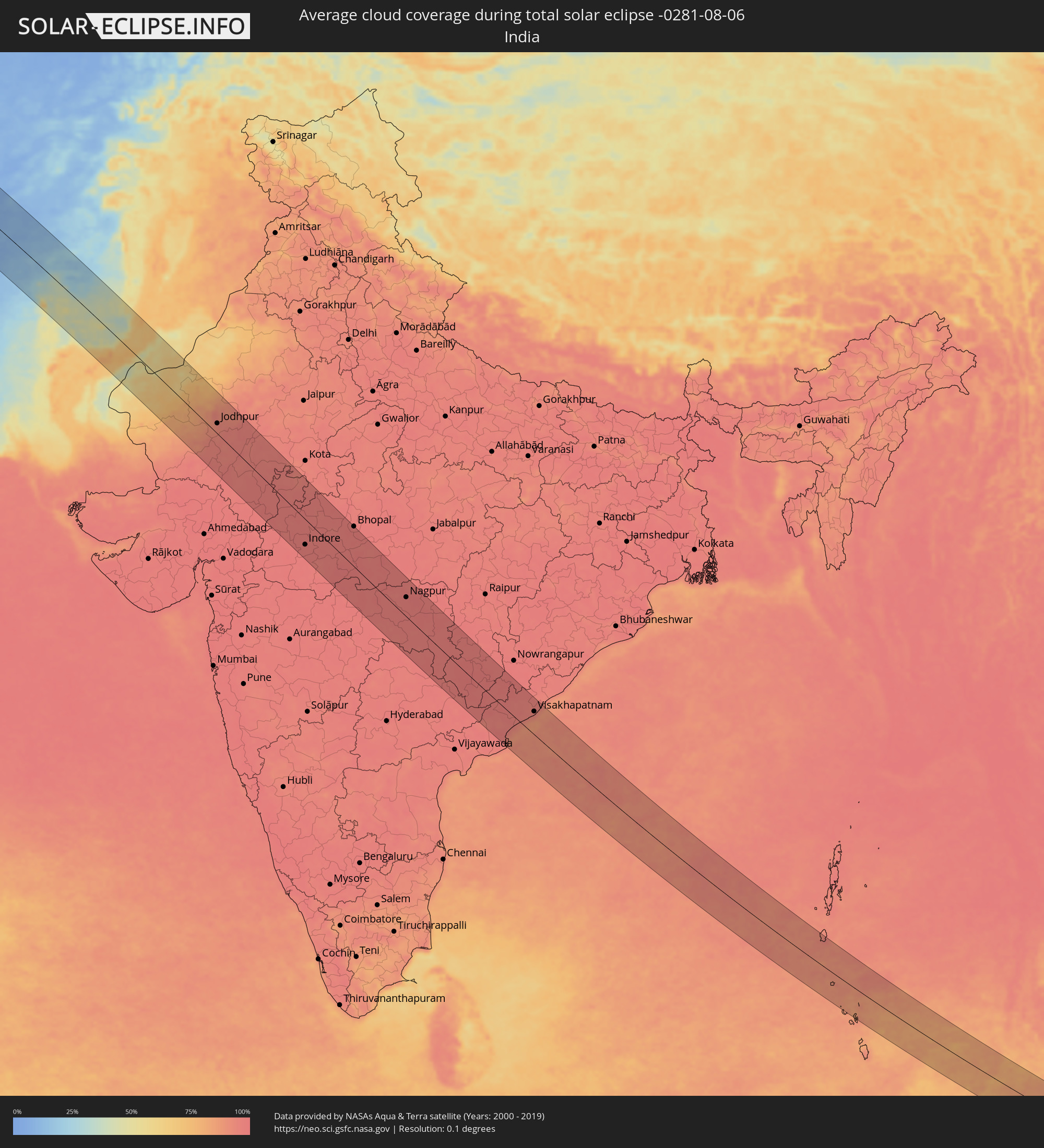 India
India
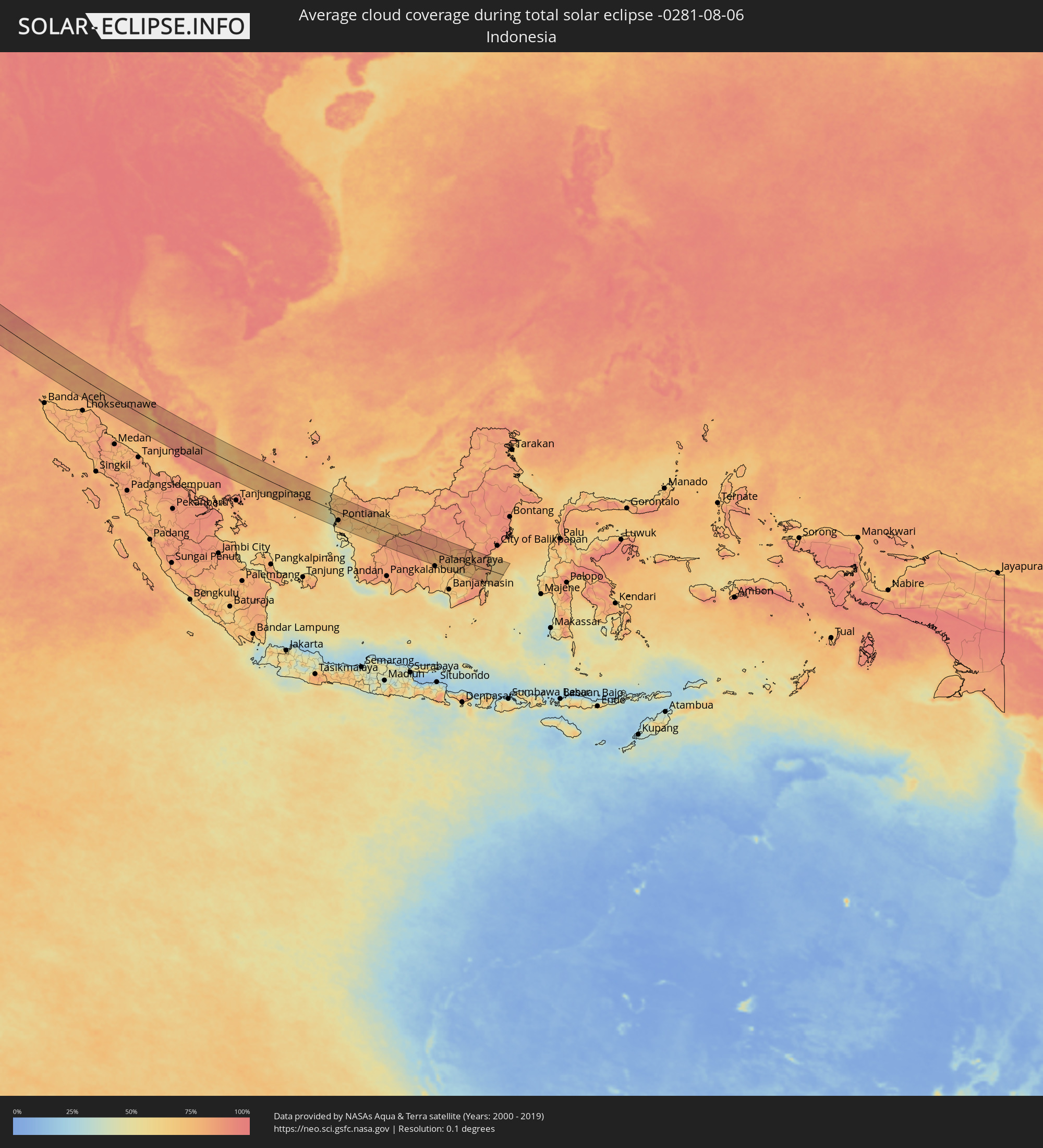 Indonesia
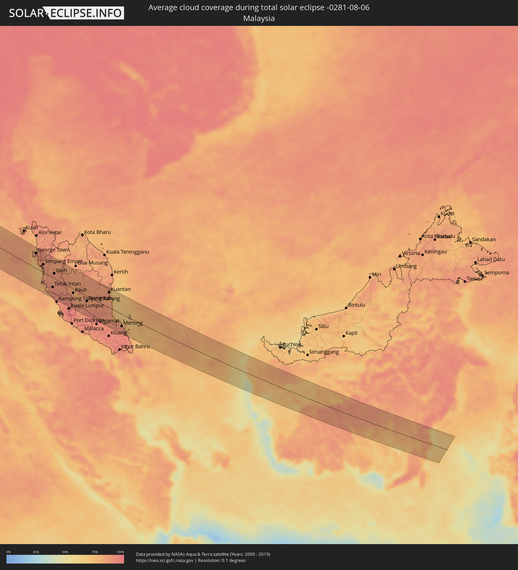 Malaysia
Cities inside the path of the eclipse
The following table shows all locations with a population of more than 5,000 inside the eclipse path. Cities which have more than 100,000 inhabitants are marked bold. A click at the locations opens a detailed map.
| City | Type | Eclipse duration | Local time of max. eclipse | Distance to central line | Ø Cloud coverage |
|
Arrifes, Azores
|
total | - | 04:58:17 UTC-01:54 | 59 km | 74% |
|
Ponta Delgada, Azores
|
total | - | 04:58:15 UTC-01:54 | 55 km | 66% |
|
Viana do Castelo, Viana do Castelo
|
total | - | 06:19:16 UTC-00:36 | 49 km | 36% |
|
Esposende, Braga
|
total | - | 06:19:08 UTC-00:36 | 68 km | 41% |
|
Marinhas, Braga
|
total | - | 06:19:09 UTC-00:36 | 65 km | 39% |
|
Vigo, Galicia
|
total | - | 06:56:30 UTC+00:00 | 5 km | 39% |
|
Ponte de Lima, Viana do Castelo
|
total | - | 06:19:23 UTC-00:36 | 48 km | 33% |
|
Monção, Viana do Castelo
|
total | - | 06:19:41 UTC-00:36 | 18 km | 38% |
|
Mozelos, Viana do Castelo
|
total | - | 06:19:31 UTC-00:36 | 42 km | 32% |
|
Sande, Braga
|
total | - | 06:19:22 UTC-00:36 | 60 km | 32% |
|
Ourense, Galicia
|
total | - | 06:56:48 UTC+00:00 | 6 km | 37% |
|
Oviedo, Asturias
|
total | - | 06:58:18 UTC+00:00 | 54 km | 62% |
|
Gijón, Asturias
|
total | - | 06:58:31 UTC+00:00 | 68 km | 59% |
|
León, Castille and León
|
total | - | 06:57:42 UTC+00:00 | 33 km | 28% |
|
Santander, Cantabria
|
total | - | 06:59:05 UTC+00:00 | 19 km | 55% |
|
Bilbao, Basque Country
|
total | - | 06:59:15 UTC+00:00 | 22 km | 61% |
|
Gasteiz / Vitoria, Basque Country
|
total | - | 06:58:59 UTC+00:00 | 72 km | 48% |
|
Donostia / San Sebastián, Basque Country
|
total | - | 06:59:41 UTC+00:00 | 37 km | 61% |
|
Bayonne, Nouvelle-Aquitaine
|
total | - | 07:09:24 UTC+00:09 | 29 km | 57% |
|
Pau, Nouvelle-Aquitaine
|
total | - | 07:09:45 UTC+00:09 | 71 km | 59% |
|
Montauban, Occitania
|
total | - | 07:11:15 UTC+00:09 | 26 km | 55% |
|
Toulouse, Occitania
|
total | - | 07:10:56 UTC+00:09 | 72 km | 54% |
|
Albi, Occitania
|
total | - | 07:11:36 UTC+00:09 | 50 km | 52% |
|
Saint-Étienne, Auvergne-Rhône-Alpes
|
total | - | 07:14:13 UTC+00:09 | 77 km | 59% |
|
Valence, Auvergne-Rhône-Alpes
|
total | - | 07:14:06 UTC+00:09 | 15 km | 43% |
|
Grenoble, Auvergne-Rhône-Alpes
|
total | - | 07:14:49 UTC+00:09 | 28 km | 50% |
|
Chambéry, Auvergne-Rhône-Alpes
|
total | - | 07:15:18 UTC+00:09 | 69 km | 46% |
|
Turin, Piedmont
|
total | - | 08:06:44 UTC+01:00 | 9 km | 44% |
|
Massagno, Ticino
|
total | - | 08:08:25 UTC+01:00 | 79 km | 41% |
|
Lugano, Ticino
|
total | - | 08:08:26 UTC+01:00 | 79 km | 46% |
|
Viganello, Ticino
|
total | - | 08:08:27 UTC+01:00 | 79 km | 46% |
|
Pregassona, Ticino
|
total | - | 08:08:27 UTC+01:00 | 79 km | 46% |
|
Mendrisio, Ticino
|
total | - | 08:08:20 UTC+01:00 | 63 km | 45% |
|
Chiasso, Ticino
|
total | - | 08:08:21 UTC+01:00 | 58 km | 46% |
|
Milan, Lombardy
|
total | - | 08:08:10 UTC+01:00 | 16 km | 43% |
|
Bergamo, Lombardy
|
total | - | 08:08:43 UTC+01:00 | 36 km | 46% |
|
Brescia, Lombardy
|
total | - | 08:09:01 UTC+01:00 | 12 km | 41% |
|
Parma, Emilia-Romagna
|
total | - | 08:08:32 UTC+01:00 | 70 km | 36% |
|
Verona, Veneto
|
total | - | 08:09:33 UTC+01:00 | 7 km | 40% |
|
Padova, Veneto
|
total | - | 08:10:17 UTC+01:00 | 18 km | 42% |
|
Mestre, Veneto
|
total | - | 08:10:39 UTC+01:00 | 12 km | 39% |
|
Koper, Koper-Capodistria
|
total | - | 08:12:00 UTC+01:00 | 17 km | 40% |
|
Trieste, Friuli Venezia Giulia
|
total | - | 08:12:07 UTC+01:00 | 7 km | 40% |
|
Kranj, Kranj
|
total | - | 08:13:04 UTC+01:00 | 55 km | 48% |
|
Rijeka, Primorsko-Goranska
|
total | - | 08:12:29 UTC+01:00 | 45 km | 39% |
|
Ljubljana, Ljubljana
|
total | - | 08:13:04 UTC+01:00 | 33 km | 45% |
|
Trbovlje, Trbovlje
|
total | - | 08:13:39 UTC+01:00 | 41 km | 51% |
|
Velenje, Velenje
|
total | - | 08:13:50 UTC+01:00 | 64 km | 54% |
|
Novo Mesto, Novo Mesto
|
total | - | 08:13:31 UTC+01:00 | 2 km | 47% |
|
Celje, Celje
|
total | - | 08:13:53 UTC+01:00 | 49 km | 51% |
|
Karlovac, Karlovačka
|
total | - | 08:13:39 UTC+01:00 | 35 km | 42% |
|
Maribor, Maribor
|
total | - | 08:14:29 UTC+01:00 | 83 km | 53% |
|
Velika Kladuša, Federation of Bosnia and Herzegovina
|
total | - | 08:13:42 UTC+01:00 | 70 km | 44% |
|
Mala Kladuša, Federation of Bosnia and Herzegovina
|
total | - | 08:13:43 UTC+01:00 | 76 km | 45% |
|
Ptuj, Ptuj
|
total | - | 08:14:36 UTC+01:00 | 67 km | 51% |
|
Podzvizd, Federation of Bosnia and Herzegovina
|
total | - | 08:13:46 UTC+01:00 | 72 km | 45% |
|
Todorovo, Federation of Bosnia and Herzegovina
|
total | - | 08:13:46 UTC+01:00 | 82 km | 45% |
|
Vrnograč, Federation of Bosnia and Herzegovina
|
total | - | 08:13:50 UTC+01:00 | 73 km | 46% |
|
Zagreb - Centar, City of Zagreb
|
total | - | 08:14:17 UTC+01:00 | 1 km | 49% |
|
Varoška Rijeka, Federation of Bosnia and Herzegovina
|
total | - | 08:13:51 UTC+01:00 | 82 km | 46% |
|
Varaždin, Varaždinska
|
total | - | 08:14:58 UTC+01:00 | 51 km | 54% |
|
Sisak, Sisačko-Moslavačka
|
total | - | 08:14:27 UTC+01:00 | 42 km | 42% |
|
Kozarska Dubica, Republic of Srspka
|
total | - | 08:14:42 UTC+01:00 | 76 km | 42% |
|
Nagykanizsa, Zala
|
total | - | 08:15:42 UTC+01:00 | 65 km | 53% |
|
Gradiška, Republic of Srspka
|
total | - | 08:15:08 UTC+01:00 | 81 km | 44% |
|
Kaposvár, Somogy
|
total | - | 08:16:27 UTC+01:00 | 53 km | 50% |
|
Slavonski Brod, Slavonski Brod-Posavina
|
total | - | 08:15:56 UTC+01:00 | 82 km | 41% |
|
Pécs, Baranya
|
total | - | 08:16:43 UTC+01:00 | 20 km | 51% |
|
Osijek, Osječko-Baranjska
|
total | - | 08:16:53 UTC+01:00 | 40 km | 45% |
|
Szekszárd, Tolna
|
total | - | 08:17:22 UTC+01:00 | 49 km | 45% |
|
Vinkovci, Vukovar-Sirmium
|
total | - | 08:16:51 UTC+01:00 | 70 km | 44% |
|
Baja, Bács-Kiskun
|
total | - | 08:17:32 UTC+01:00 | 29 km | 48% |
|
Vukovar, Vukovar-Sirmium
|
total | - | 08:17:05 UTC+01:00 | 64 km | 43% |
|
Sombor, Vojvodina
|
total | - | 08:17:27 UTC+01:00 | 16 km | 49% |
|
Bačka Palanka, Vojvodina
|
total | - | 08:17:28 UTC+01:00 | 75 km | 42% |
|
Vrbas, Vojvodina
|
total | - | 08:17:55 UTC+01:00 | 39 km | 45% |
|
Subotica, Vojvodina
|
total | - | 08:18:14 UTC+01:00 | 19 km | 47% |
|
Novi Sad, Vojvodina
|
total | - | 08:17:57 UTC+01:00 | 75 km | 45% |
|
Bečej, Vojvodina
|
total | - | 08:18:22 UTC+01:00 | 35 km | 42% |
|
Senta, Vojvodina
|
total | - | 08:18:35 UTC+01:00 | 0 km | 44% |
|
Szeged, Csongrád
|
total | - | 08:18:51 UTC+01:00 | 36 km | 46% |
|
Hódmezővásárhely, Csongrád
|
total | - | 08:19:08 UTC+01:00 | 54 km | 48% |
|
Zrenjanin, Vojvodina
|
total | - | 08:18:38 UTC+01:00 | 61 km | 46% |
|
Kikinda, Vojvodina
|
total | - | 08:18:58 UTC+01:00 | 11 km | 46% |
|
Orosháza, Bekes
|
total | - | 08:19:35 UTC+01:00 | 71 km | 51% |
|
Békéscsaba, Bekes
|
total | - | 08:20:07 UTC+01:00 | 84 km | 48% |
|
Timişoara, Timiş
|
total | - | 09:04:10 UTC+01:44 | 20 km | 48% |
|
Arad, Arad
|
total | - | 09:04:30 UTC+01:44 | 28 km | 50% |
|
Sibiu, Sibiu
|
total | - | 09:07:38 UTC+01:44 | 8 km | 49% |
|
Târgu-Mureş, Mureş
|
total | - | 09:08:26 UTC+01:44 | 76 km | 43% |
|
Braşov, Braşov
|
total | - | 09:09:22 UTC+01:44 | 18 km | 63% |
|
Buzău, Buzău
|
total | - | 09:10:47 UTC+01:44 | 66 km | 38% |
|
Brăila, Brăila
|
total | - | 09:12:21 UTC+01:44 | 44 km | 32% |
|
Galaţi, Galaţi
|
total | - | 09:12:29 UTC+01:44 | 23 km | 34% |
|
Cahul, Cahul
|
total | - | 09:23:24 UTC+01:55 | 28 km | 36% |
|
Cantemir, Cantemir
|
total | - | 09:23:30 UTC+01:55 | 70 km | 40% |
|
Vulcăneşti, Găgăuzia
|
total | - | 09:23:37 UTC+01:55 | 6 km | 39% |
|
Comrat, Găgăuzia
|
total | - | 09:24:06 UTC+01:55 | 76 km | 40% |
|
Taraclia, Taraclia
|
total | - | 09:24:01 UTC+01:55 | 32 km | 37% |
|
Tulcea, Tulcea
|
total | - | 09:13:26 UTC+01:44 | 48 km | 31% |
|
Ceadîr-Lunga, Găgăuzia
|
total | - | 09:24:16 UTC+01:55 | 51 km | 38% |
|
Izmayil, Odessa
|
total | - | 09:31:11 UTC+02:02 | 27 km | 28% |
|
Basarabeasca, Basarabeasca
|
total | - | 09:24:31 UTC+01:55 | 83 km | 40% |
|
Bilhorod-Dnistrovs’kyy, Odessa
|
total | - | 09:33:24 UTC+02:02 | 82 km | 29% |
|
Yevpatoriya, Republic of Crimea
|
total | - | 09:51:30 UTC+02:16 | 12 km | 32% |
|
Sevastopol, Gorod Sevastopol
|
total | - | 09:51:44 UTC+02:16 | 53 km | 28% |
|
Simferopol, Republic of Crimea
|
total | - | 09:52:36 UTC+02:16 | 3 km | 38% |
|
Yalta, Republic of Crimea
|
total | - | 09:52:42 UTC+02:16 | 52 km | 35% |
|
Dzhankoy, Republic of Crimea
|
total | - | 09:53:00 UTC+02:16 | 83 km | 29% |
|
Feodosiya, Republic of Crimea
|
total | - | 09:54:30 UTC+02:16 | 26 km | 31% |
|
Kerch, Republic of Crimea
|
total | - | 09:56:07 UTC+02:16 | 81 km | 32% |
|
Novorossiysk, Krasnodarskiy
|
total | - | 10:12:30 UTC+02:30 | 38 km | 37% |
|
Sochi, Krasnodarskiy
|
total | - | 10:15:56 UTC+02:30 | 38 km | 37% |
|
Maykop, Adygeya
|
total | - | 10:16:13 UTC+02:30 | 78 km | 38% |
|
Sokhumi, Abkhazia
|
total | - | 10:47:10 UTC+02:59 | 70 km | 41% |
|
Och’amch’ire, Abkhazia
|
total | - | 10:48:07 UTC+02:59 | 88 km | 39% |
|
Tqvarch'eli, Abkhazia
|
total | - | 10:48:25 UTC+02:59 | 69 km | 58% |
|
Cherkessk, Karachayevo-Cherkesiya
|
total | - | 10:19:31 UTC+02:30 | 86 km | 37% |
|
Kislovodsk, Stavropol'skiy
|
total | - | 10:20:44 UTC+02:30 | 72 km | 52% |
|
Tqibuli
|
total | - | 10:50:55 UTC+02:59 | 84 km | 43% |
|
Nal’chik, Kabardino-Balkariya
|
total | - | 10:22:27 UTC+02:30 | 54 km | 52% |
|
Ts’khinvali, Shida Kartli
|
total | - | 10:52:41 UTC+02:59 | 68 km | 41% |
|
Gori, Shida Kartli
|
total | - | 10:53:05 UTC+02:59 | 89 km | 41% |
|
Kaspi, Shida Kartli
|
total | - | 10:53:40 UTC+02:59 | 85 km | 47% |
|
Vladikavkaz, North Ossetia
|
total | - | 10:24:29 UTC+02:30 | 37 km | 64% |
|
Nazran’, Ingushetiya
|
total | - | 10:24:32 UTC+02:30 | 60 km | 54% |
|
Sagarejo, Kakheti
|
total | - | 10:55:23 UTC+02:59 | 76 km | 44% |
|
Telavi, Kakheti
|
total | - | 10:55:30 UTC+02:59 | 52 km | 51% |
|
Sheki, Shaki City
|
total | - | 11:19:17 UTC+03:19 | 69 km | 37% |
|
Derbent, Dagestan
|
total | - | 10:31:25 UTC+02:30 | 59 km | 35% |
|
Quba, Quba
|
total | - | 11:21:32 UTC+03:19 | 4 km | 44% |
|
Shamakhi, Şamaxı
|
total | - | 11:22:25 UTC+03:19 | 72 km | 32% |
|
Xaçmaz, Xaçmaz
|
total | - | 11:21:57 UTC+03:19 | 17 km | 44% |
|
Divichibazar, Shabran
|
total | - | 11:22:31 UTC+03:19 | 3 km | 39% |
|
Sumqayıt, Sumqayit
|
total | - | 11:24:18 UTC+03:19 | 37 km | 29% |
|
Baku, Baki
|
total | - | 11:24:55 UTC+03:19 | 50 km | 24% |
|
Maştağa, Baki
|
total | - | 11:24:58 UTC+03:19 | 30 km | 29% |
|
Hövsan, Baki
|
total | - | 11:25:16 UTC+03:19 | 42 km | 25% |
|
Türkmenbaşy, Balkan
|
total | - | 12:04:56 UTC+03:53 | 42 km | 15% |
|
Balkanabat, Balkan
|
total | - | 12:08:03 UTC+03:53 | 55 km | 15% |
|
Gumdag, Balkan
|
total | - | 12:08:49 UTC+03:53 | 37 km | 14% |
|
Gazanjyk, Balkan
|
total | - | 12:10:25 UTC+03:53 | 83 km | 14% |
|
Bojnūrd, Khorāsān-e Shomālī
|
total | - | 11:48:14 UTC+03:25 | 8 km | 8% |
|
Esfarāyen, Khorāsān-e Shomālī
|
total | - | 11:49:07 UTC+03:25 | 20 km | 6% |
|
Sabzevar, Razavi Khorasan
|
total | - | 11:50:41 UTC+03:25 | 90 km | 3% |
|
Shīrvān, Khorāsān-e Shomālī
|
total | - | 11:49:25 UTC+03:25 | 31 km | 5% |
|
Qūchān, Razavi Khorasan
|
total | - | 11:50:52 UTC+03:25 | 34 km | 6% |
|
Nīshābūr, Razavi Khorasan
|
total | - | 11:52:42 UTC+03:25 | 31 km | 3% |
|
Torbat-e Ḩeydarīyeh, Razavi Khorasan
|
total | - | 11:54:54 UTC+03:25 | 93 km | 1% |
|
Mashhad, Razavi Khorasan
|
total | - | 11:53:55 UTC+03:25 | 19 km | 3% |
|
Torbat-e Jām, Razavi Khorasan
|
total | - | 11:57:28 UTC+03:25 | 18 km | 0% |
|
Kafir Qala, Herat
|
total | - | 12:33:27 UTC+04:00 | 44 km | 2% |
|
Kuhsān, Herat
|
total | - | 12:33:42 UTC+04:00 | 38 km | 2% |
|
Qarah Bāgh, Herat
|
total | - | 12:34:15 UTC+04:00 | 20 km | 1% |
|
Herāt, Herat
|
total | - | 12:35:57 UTC+04:00 | 7 km | 1% |
|
Serhetabat, Mary
|
total | - | 12:28:13 UTC+03:53 | 82 km | 1% |
|
Karukh, Herat
|
total | - | 12:36:24 UTC+04:00 | 27 km | 3% |
|
Gereshk, Helmand
|
total | - | 12:44:24 UTC+04:00 | 81 km | 5% |
|
Sangīn, Helmand
|
total | - | 12:44:24 UTC+04:00 | 43 km | 5% |
|
Kandahār, Kandahar
|
total | - | 12:46:41 UTC+04:00 | 28 km | 9% |
|
Chaman, Balochistān
|
total | - | 13:17:23 UTC+04:28 | 38 km | 14% |
|
Qalāt, Zabul
|
total | - | 12:47:46 UTC+04:00 | 89 km | 9% |
|
Quetta, Balochistān
|
total | - | 13:19:36 UTC+04:28 | 62 km | 23% |
|
Sibi, Balochistān
|
total | - | 13:22:13 UTC+04:28 | 59 km | 44% |
|
Kandhkot, Sindh
|
total | - | 13:26:43 UTC+04:28 | 79 km | 75% |
|
Ghotki, Sindh
|
total | - | 13:27:23 UTC+04:28 | 89 km | 71% |
|
Mīrpur Mathelo, Sindh
|
total | - | 13:27:43 UTC+04:28 | 72 km | 70% |
|
Sādiqābād, Punjab
|
total | - | 13:28:04 UTC+04:28 | 10 km | 74% |
|
Rājanpur, Punjab
|
total | - | 13:26:52 UTC+04:28 | 67 km | 60% |
|
Khānpur, Punjab
|
total | - | 13:28:13 UTC+04:28 | 53 km | 68% |
|
Jodhpur, Rajasthan
|
total | - | 14:29:07 UTC+05:21 | 24 km | 93% |
|
Udaipur, Rajasthan
|
total | - | 14:33:17 UTC+05:21 | 64 km | 95% |
|
Ujjain, Madhya Pradesh
|
total | - | 14:38:41 UTC+05:21 | 27 km | 97% |
|
Indore, Madhya Pradesh
|
total | - | 14:39:38 UTC+05:21 | 60 km | 97% |
|
Punāsa, Madhya Pradesh
|
total | - | 14:41:15 UTC+05:21 | 58 km | 97% |
|
Bhopal, Madhya Pradesh
|
total | - | 14:40:36 UTC+05:21 | 95 km | 96% |
|
Amrāvati, Maharashtra
|
total | - | 14:45:20 UTC+05:21 | 66 km | 97% |
|
Nagpur, Maharashtra
|
total | - | 14:46:29 UTC+05:21 | 47 km | 97% |
|
Visakhapatnam, Andhra Pradesh
|
total | - | 14:56:59 UTC+05:21 | 59 km | 94% |
|
George Town, Penang
|
total | - | 16:59:03 UTC+06:55 | 60 km | 88% |
|
Bukit Mertajam, Penang
|
total | - | 16:59:09 UTC+06:55 | 62 km | 92% |
|
Simpang Empat, Perak
|
total | - | 16:59:39 UTC+06:55 | 31 km | 88% |
|
Taiping, Perak
|
total | - | 16:59:47 UTC+06:55 | 27 km | 87% |
|
Teluk Intan, Perak
|
total | - | 17:00:46 UTC+06:55 | 38 km | 90% |
|
Ipoh, Perak
|
total | - | 17:00:10 UTC+06:55 | 20 km | 90% |
|
Rawang, Selangor
|
total | - | 17:01:38 UTC+06:55 | 77 km | 94% |
|
Temerluh, Pahang
|
total | - | 17:01:39 UTC+06:55 | 21 km | 84% |
|
Kuantan, Pahang
|
total | - | 17:01:25 UTC+06:55 | 61 km | 88% |
|
Sungai Raya, West Kalimantan
|
total | - | 17:16:33 UTC+07:07 | 16 km | 58% |
|
Pemangkat, West Kalimantan
|
total | - | 17:16:08 UTC+07:07 | 66 km | 67% |
|
Singkawang, West Kalimantan
|
total | - | 17:16:22 UTC+07:07 | 41 km | 71% |
|
Pontianak, West Kalimantan
|
total | - | 17:17:11 UTC+07:07 | 41 km | 76% |
|
Amuntai, South Kalimantan
|
total | - | 18:08:46 UTC+07:57 | 48 km | 57% |
|
Barabai, South Kalimantan
|
total | - | 18:08:51 UTC+07:57 | 61 km | 68% |